PROSPECTING RPT LEBEL TWP - Ontario · BI.1ce Riwr GrauP. Sc"· Blake Rlwr (Upper Fm .. TbdaIe...
19
. e' • • 2-42304 _. i ( RECEIVED t , , LARDER LAKE MIN IN::" · DlV1SJON Uo(' AUQ_ !_. • t.:' ".- - ,- ..... -. ...... . .-.-----1 Continental-Federal Extension Group LEBEL TOWNSHIP NTS 42 A\l soooo' 42"W 4S010' OS"N OEOSCIENce Ass eSSMENT OFF IC E Prepared By: E. Marion
Transcript of PROSPECTING RPT LEBEL TWP - Ontario · BI.1ce Riwr GrauP. Sc"· Blake Rlwr (Upper Fm .. TbdaIe...

.
e '
•
•
2-42304 _. i ( RECEIVED
t , ,
LARDER LAKE MININ::"· DlV1SJON ~ Uo(' AUQ_
}; ::'-~ft~~ ~~',:: !_. • t.:' '-.~ -. ~--.~~. ".- - ,- .~ ..... -. ...... . .-.-----1
Continental-Federal Extension Group
LEBEL TOWNSHIP NTS 42 A\l
soooo' 42"W 4S010' OS"N
OEOSCIENce AsseSSMENT OFFICE
Prepared By: E. Marion
~~ ~ ~/() 1

INDEX
Property Location ........................................ , ...... , ..................................... , .... 3
• Access ........................................................................................................ 3
Claims ........................................................................................................ 3
General Geology ....... , .................................. '" .................... , ...... '" ................ 3
Claim Geology / Previous Work ......................................... . .. ...................... 3, 5
Present Work ............................................................................................... 5
Area "A", Trench "B" ................................................................................................................... 5
Trench "C", Trench "D", Trench "E", Trench "F", Trench "G" ...................................................... 10
Conclusions ................................................................................................... 16
Bibliography ............................................................................................................................ .i, ii
FIGURES
Fig - 1 Location ....................................................... , .................................... 1
• Fig - 2 Claim Map ........................................................................................... 2
Fig - 3 General Geology .................................................................................. 4
Fig - 4 Claim Geology ................................................................................... 6
Fig - 5 Work Location Map ................................................................................ 7
Fig - 6 Stripped Area "A" ...................................................................................... 8
Fig - 7 Trench "B" .............................................................................................. 9
Fig - 8 Trench "C" ............................................................................................ 11
Fig - 9 Trench liD" .............................................................................................. 12
Fig - 10 Trench "E .............................................................................. '" ............. 13
Fig - 11 Trench "F" ........................................................................................... 14
Fig - 12 Trench "G" ..................... , ....................................................................... 15
• Fig - 6'1.Work Area / Sample Locations ................................................................... back pocket

Kirkland Lake Resident Geologists District
• 1'10'
~ i
•
Scale : 1 :2,000,000
1
." _.
._ --.;.."i, '.
CD L2455 C a N
N
•
i-rj .... ~
UTM Zone 17 1000m grid
573000E
I
Q 1199564
L1893
574000E
~ LZOO9 ."" .....
. 1
1 L200li ..... .
, ............. -: ........................... ~ .. ,: .......... .
L2445
124sns
~
Cool "",er Lake
L.2257
L2450 nlA
3009328
•
\ ..
. ' r - ,00 '7fJOM . ,. f ). I I
..... \ 5335000N
.......... \ ""'"'"'------ .. -
L2378 L2430
~ \
574000E

•
•
•
PROPERTY LOCATION
This property is located in the Larder Lake mining division bordering the north-east comer of the town of Kirkland Lake. The claim group sits mid way between the four and five mile post on the west boundary of Lebel Township with the Teck-Lebel border forming the west boundary ofthe claim group. This is in the Kirkland Lake Resident Geologist district and can be found on NTS 42 A\l with the geographic center being at approximately80000"42'W and 48°10" 05'N.
ACCESS
Turning north off of Highway 66 (Government Road) at Burnside Drive and heading north on this street for 400 meters the street will turn into Foss Lane. Continuing north on Foss Lane for 250 meters will bring you to a dirt road heading east across the tailings area. Continuing east from here for 400 meters will bring you to the south-west comer of the claim group. An old trail wends its way north east across the group and gives access to much of the area.
CLAIMS
The Continental- Federal Extension project consists offive contiguous staked mining claim units totaling approximately 70 hectares recorded on Plan G-0639 of Lebel Township. The claims are as follows: L1239365, L1248775, L1248776, L3009327, and L3009328.
GENERAL GEOLOGY
This area is in the Abitibi Greenstone Belt of the Superior Province, in a region dominated by Archaen mafic to felsic pillowed, massive and agglomeratic volcanics and granitic batholiths with attendant intrusions, with minor clastic interflow and fluvial sediments. The claims lay just north of the Larder - Cadillac Deformation Zone (LCDZ), a major east-west structural control on gold bearing alteration and mineralization, which in much of its length coincides with a folded and deformed sinuous belt of sedimentary rocks of Temiskaming age. To the north of the LCDZ, the Blake River intermediate volcanic rocks form a large east plunging synclinorium which host the Noranda area VMS deposits.
CLAIM GEOLOGYIPREVIOUS WORK
The geology of Lebel Township is discussed at length in Bulletin 150- Geology of Lebel Township, by A. Maclean (1956) and I would refer the interested reader to this publication. The geology of Teck Township directly adjacent to the west oflebel Twp. has been covered extensively by various authors and much information on both townships is in the Resident Geologists office in Kirkland Lake. I believe it would be sufficient to state that the claims lie entirely within Temiskaming sediments and straddle an east-west trending felsic to mafic locally porphyritic syenite intrusion. I have cut a grid and had a continuous reading, walking mag, magnetometer survey performed on much of the claim group.
No information is available on a drill hole located in the grid area at approximately 3+00E at 3+50 south. In 1983, a hole was drilled (F-l) by Federal Kirkland Mines Ltd. in a location mapped 200 meters due west of the previous mentioned drill hole. The hole passed through the local sediments and the odd dike of reddish syenite.!t is possible that the location sketch was not accurate.
To the east of the property, extensive mining and driftwork has been done along gold bearing shears related to the north and south contacts of this intrusion by Continental Kirkland Gold Mines. This property has been drilled by Lac Minerals, Kinross, and now Kirkland Lake Gold as owners,over the last 20 years. The north - south striking, west dipping at 45 degrees, "Post Vein" was targeted and tracled right across the Continental property. This Post vein would strike into my claims on the north shore of
3

•
•
General Geology of the Kirkland Lake Area
20 0 , . " ,
+
+
+
12
Pratllt'Ozoic K_n_ diabase (not shown)
12 Cot.ltGroup Archnn
Granicic rocks
LEGEND
11 Gr.nodioritB. monzoniat, cau-a monzonitll. IV_ita
10 MaIiw co gnaiaic quaru diorite. toMlltll, aandhjemite
Uppal SupenJrOUP 9 a.. TlmisUmi"'ll Grouo. 9b •• Denor-
PorcuDine Comllf.. . 8 Ie. 8n. BI.1ce Riwr GrauP. Sc"· Blake
Rlwr (Upper Fm .. TbdaIe Group)
+
L.S. Jensen
7 7 •• lb. KInojniI Group. 7c Klnojwil Graup. "'Idele Fm .. ".. .. Group)
II lie""'" Lab Grot P. 6b Stoughton ROQUeIMIIIWG,....6c ~ Fm .. Tbd8W Grouo
6 &0 Pon:ucIine GnM' ~Su~
• .. S1tIMi GrauII. 4Ib Hunter Mine Grouo. 4Ic UpcIer FnL. DIIorO Group
3 3e c.a-ine~. 3c Middle Fm. Deloro GfCIUII
2 ,. WIbI __ Group. 2c Lo-.. Fm. Deloro GfOUP
1 1 a Pacaud tuffs"'H*
-, ref.,. to Kl,klend Lake Area.lCIUdillmb of synclinorium (Jensen 1978c, 1979). --b refen to Kirkland Lake Anle • .-tfIlimb of synclinorium (Jensen 1976, 1978b). _··c lWfen to r""",inl Ar. (Pylce. 13801 • •••• (GOOdWin. 19651.
Figure - 3
12
V w CD W :I a
4

•
•
the s aliialke at the area of the #2 post of claim L1248776. The post vein would dip onto my claim L30 9328 at about 1500 feet from surface. No work has been done on my claim group to define this
To the west of my property, a shaft was sunk and much mining and driftwork along the contacts of the a ve mentioned syenite was conducted by Federal Kirkland Gold Mines along gold bearing, contact relat d shears. This former mine property has been drilled a few times over the years and was recently drill d by the owners whom targeted these shears. Channel sampling done 400 meters to the west of my clai boundary has given up to 12 grams per ton over 3 feet on 70 degree to 110 degree trending shears. This reak system may pass under O'Connel Lake, entering the Lake just west of my property boun ary.No extensive program has ever been conducted to connect the dots as it were, between the Fede al- Kirkland workings and the Contintental- Kirkland workings which should in theory be asso iated with the porphyritic syenite mass that cuts my claim group from west to east. Literally dozens of 01 slumped in and overgrown trenchings dot the claim area, but no records are can be found of the resul s.
Although much work was probably done on the Continental - Federal Extension claim group, very ittle submitted assessment work is available.
During the present exploration season manual trenching, hand stripping and chip sampling were perfo ed by D. Vallillee and E. Marion on various areas to assess gold potential. Although there are many old trenches on my property, none of them have been located in the submitted work of the claim area. wo of these trenches were cleaned out to re-examine them. An area of mafic syenite was hand stripp d to. Four new trenches were hand dug to assess a shear vein system discovered by the author.
ith the exception of the Algoman aged mafic syenitic intrusive exposed in Area II A", all rock expos d were Temiskaming aged metasediments. The polymictic conglomerate has a medium to dark green, wacke to tuffaceous wacke matrix and grades rather abruptlY from clast abundant beds to an odd clast acke. No bedding was noted in the grewacke sections.Bright red to brownish red jasper, which are typic of Temiskaming conglomerate, can be seen on all conglomerate exposed. Sand size grains of jasper were also observed in the matrix of the conglomerate and in the wacke. All the sediments young to the outh,
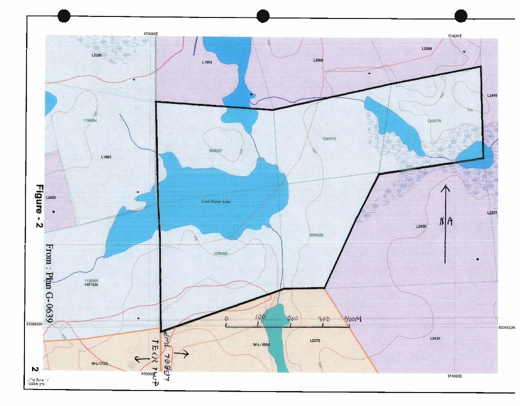
It should be mentioned that all the figures accompanying the following descriptions (figures 6 throu h 12) are not to scale and that astronomical north is intended to be towards the top of the page where applicable. For proper scale and bearings one should refer to the compilation in the back pocket. Geolo for trench figures as per same compilation.
Stripped Area A (see Figure - 6)
d stripping and minor trenching was done to expose the area of a sharp magnetic contrast by a mag survey performed on these claims several years ago.The rock encountered in this area
was a assive, somewhat chloritic, dark greenish to black, fine to medium grained, medium to strongly magne ic, mafic syenite. Minor fine hematized feldspar? observed with hand lens. A fracture set trendi g at about 45 degrees is apparent on the exposed rock. No sample taken.
TrenchB (see Figure - 7)
St . pping and some trenching was done to clean out an old trench in order to check what had been enco ered. The whole trench was on a clast poor conglomerate which could be called a clast bearing greyw ke. No further work reccommended. No sample for assay.
5

.-, /. ':'~T.lO

WORK LOCATION MAP CL # L 1239365 et.al
LEBEL TOWNSHIP o -CLAIM POST FOUND --- - CLAIM LINE )I( SWAMP or MARSH
3009327 #4 9 \ C'"; ---~~--""l-- ~-'-. - ----t
L . 1 !I i
1 1
- 3+00N
,I
k"" 0 w w w w 0 0 + 0 0 + ..-
0 0 0 0 10 0 + + + N N C")
0 40 . . 120 160 200 . . . 80 . 1cm=: 40m
Figure - 5
w o ~ 10
3+005
7
" -~ -
W
N co + N
I
Figure - 6
Stripped Area A 9m L
(Photo looking south west)
- 3 + 85 S
r ',\ ", "
/ ~ I ./ ,/"
8

•
•
Trench C (see Figure - 8)
This also was an old trench which we cleaned out to re check the rock that had been exposed. A large section at the north end of the trench was not to bedrock so we completed this digging. The north end of this trench was across clast poor conglomerate. This changed quickly at the south Y3 of the trench to a clast rich bed about 3 meters thick changing at about 1 meter from the south end of the trench. At the south end of the original trench it was decided to extend about one meter farther south. In this freshly dug section, we exposed a .45 meter shear/crushed section with a branching 5 inch refractured quartz vein on the south contact and a Y2 to 1 inch quartz vein on the north contact. Rusty carbonate alteration noted in sheared material. The vein material bears a striking resemblance to the productive veins of Kirkland Lake. A dark dusting of mineral in the quartz appears be graphite or molybdenite. A representative sample of the vein was taken for assay.
Sample #243636 - Quartz vein material
Trench D (see Figure - 9)
This trench was freshly dug by us to trace the shear exposed on Trench C. This trench encountered clast supported conglomerate in sheared contact with greywacke. About 1 meter south of this shear in the greywacke passes another strong shear. Both shears are rusty and somewhat carbonated. Little pyrite left in rock. A sample of the southern shear was taken for assay.
Sample #243637 - Rusty sheared carbonatized greywacke
Trench E (see Figure - 10)
Following the shearing eastward we dug this next new trench. Clast rich conglomerate in faulted contact with greywacke was exposed. Interestingly, a seven inch quartz carb vein with possible moly/graphit1e was encountered on this fault. Vein is weakly mineralized with pyrite. Odd pyrite in sheared wallrock. Weakly carbonate alteration in the wallrocks. A large sample of the vein material was taken for assay.
An old "JE" size drill casing oriented north at about -60 degree dip is located about 3 meters north east of this tr,ench. (No info available)
Sample #243638 - Quartz vein material
Trench G (see Figure - 11)
This trem:h was dug between Trench E and Trench F. Minor fractured greywacke in fault contact with clast rich conglomerate on the north and south sides was exposed. A Y2 to 1 inch quartz vein follows the south contact. Rusty tight fractures at various orientations in wacke. There is tight shearing and rusty carbonate alteration on either side of the vein to 1 inch wide. No vein observed on the rusty shear at the north contact.
Sample #243639 Quartz vein and sheared wallrock
TrenchF (see Figure - 12)
Furthest east, this trench exposed clast rich conglomerate on north side in fault contact with greywacke. Greywacke is somewhat carbonatized. Rusty tight fractures at random angles cut the greywacke. No veins observer in exposure. It is possible that the vein/shear is a little south of the trench and the trench should be extended farther south. No sample taken.
iD

•
•
•
w Q) I"'-
+ N
'''.
J. L. 3 + 50 S
"
"
".
"
" "-' "
'.
Figure - 8
Trench C 8.7m L x 0.8m W
0.8m -1.5m D
(Photo looking north west)
11

,
•
W
I"en + N
I
I
• L
1)-6 • I
T. L. 3 + 50 S
· v ,
Figure·- 9
Trench 0 4.4 m L x 0.8m W
(Photo looking east)
12

•
--"
, i t (
1 -
. •
; ~ --
D
---1--.L-..,...,~~q. L. 3 + 50 S - '1--
• f
. ~
f-A •
·~7G Quartz Vein
Figure -10
Trench E 6.6m Lx 0.8m W
(Photo looking north)
13

UJ
N "I"'"'""
~ ! -.-i-..... --~1~- T. L. 3 + 50 S
Trench F 3.B Lx O.8m W
(Photo looking south east)
Tight fault contact - conglonlerate to north and wacke to south
Figure - 11 14

_ !E [ =5
+
-.......;;.-_ ...... _----T. L. 3 + 50 S
•
Quartz vein / shear
• Figure -12
Trench G 6.5m Lx 0.8m W
(Photo looking south)
15

•
•
•
CONCLUSIONS
This program successfully exposed shear controlled quartz veining in sheared metasediments that pinches and swells along strike. More extensive stripping and trenching should be done to better evaluate the mineral potential of this location. A few short drill holes could be done to add the third dimension to 1he area of vein exposure.
Ii?

•
•
Bibliography
i Charlewood, G.H .
1964:Geology of Deep Developements on the Main Ore Zone at Kirkland Lake District of Temiskaming, Ontario Department of Mines, Geological Circular No. 11 Accompanied by Sheets A through H,scale 1 inch to 400 feet
Fortescue" J.A.C. and Gleeson, C.F. 1984: An introduction to the Kirkland Lake (KLIP) Basil Till Geochemical and Mineralogical Study (1979-1982), Timiskaming District, Ontario Geological Survey, Map 80 714, Geochemical Series, Compiled 1984
Jensen, L.S. and Langford, F.F 1983 :Geology and Petrogenesis of the Archean Abitibi Belt in the Kirkland Lake Area, O.G.S. Open File Report 5455
Lovell,H.L. 1972: Geology of the Ebyand Otto Area, District of Temiskaming, Ontario Departnent of Mines and Northern Affairs, Geological Report 99, Accompanied by Map 2239, scale 1 inch to 112 mile
Lovell, H.L. and Caine, T.W. 1970:Lake Temiskarning Rift Valley; Ontario Department of Mines Miscellaneous Paper 39
MacLean,A. 1956: Geology of Lebel Township, District of Temiskaming,Ontario Department of Mines, Bulletin 150, Accompanied by Map53a, scale 1 inch to 1,000 feet
Moore, J.e.G.
O.G.S.
O.G.S.
O.G.S.
O.G.S.
1966: Geology of Burt Holmes Area,District of Temiskaming,Ontario Department of Mines Geological Report 44, Accompanied by Map2078, scale 1 inch to 112 mile
1979:Airboume Electromagnetic and Total Intensity Magnetic Survey, Kirkland Lake Area, Morrisette Township, District ofTemiskarning : by Questor Surveys Limited for the Ontario Geological Survey, Prelim.Map P.2258 Geophys. Ser., Scale 1 :20,000, Survey and compilation February and March 1979
1979:Airboume Electromagnetic and Total Intensity Magnetic Survey, Kirkland Lake Area, Bernhardt Township, District of Temiskaming : by Questor Surveys Limited for the Ontario Geological Survey, Prelim. Map P.2257 Geophys. Ser., Scale 1 :20,000, Survey and compilation February and March 1979
1979:Airboume Electromagnetic and Total Intensity Magnetic Survey, Kirkland Lake Area, Teck Township, District of Temiskarning : byQuestor Surveys Limited for the Ontario Geological Survey, Prelim.Map P.2263A North Half, and 2263B South Half ,Geophys. Ser., Scale 1 :20,000, Survey and eompilation February and March 1979
1986: Volcanology and Mineral Deposits, Miscellaneous Paper 129 Ontario Department of Mines and Northern Affairs
1968:Preliminary Map P,466,Geological Series,Bernhardt Township, District of Temiskaming"Geology by R.J. Rupert and H.L Lovell and Assistants,1967, scale 1 inch to 114 mile

•
•
ii
Rupert, R.J., and Lovell, H.L. 1970:Geology of Bernhardt and Morrisette Townships,District ofTemiskaming, Ontario Department of Mines Geological Report 84,Accompanied by Map 2193, scale 1 inch to 1/2 mile
Savage, W.S. 1964:Mineral Resources and Mining Properties in the Kirkland Lake - Larder Lake Area,District of Temiskaming, Ontario Department of Mines Mineral Resource Circular No.3 Accompanied by Chart A Kirkland-Larder Lake Area, scale 1 inch to 2 miles
Ministry of Northern Developement and Mines
O.G.S.
O.G.S.
:Resident Geologist Files, literally hundreds of files of submitted assesment work files covering many claim areas in Bernhardt Township, Eby Township, Grenfell Township,Gauthier Township, Lebel Township, Morrisette Township, Otto Township, Teck Township,
1986: Volcanology and Mineral Deposits, Miscellaneous Paper 129
1979:Airboume Electromagnetic and Total Intensity Magnetic Survey, Kirkland Lake Area, Teck Township, District of Temiskaming : byQuestor Surveys Limited for the Ontario Geological Survey, Prelim.Map P.2263 North Half and South Half ,Geophys. Ser., Scale 1 :20,000, Survey and (compilation February and March 1979
Ontario o,epartment of Mines and Northern Affairs
5
1968:Preliminary Map P.466,Geological Series,Bernhardt Township, District of Temiskaming"Geology by R.J. Rupert and H.L Lovell and Assistants, 1967, scale 1 inch to 114 mile