Prospect No. 3 Hydroelectric Project FERC Project No - PacifiCorp
27
Prospect No. 3 Hydroelectric Project FERC Project No. P-2337 Proposed Study Plans – Cultural Resources December 2013 Prepared by: Historical Research Associates, Inc. Portland, Oregon For Public Review
Transcript of Prospect No. 3 Hydroelectric Project FERC Project No - PacifiCorp

Prospect No. 3 Hydroelectric Project FERC Project No. P-2337
Proposed Study Plans – Cultural Resources December 2013
Prepared by: Historical Research Associates, Inc.
Portland, Oregon
For Public Review
Cultural Resources Study Plan for the Prospect No. 3 Hydroelectric Project
Submitted to:
Submitted by:
Historical Research Associates, Inc. Emily K. Ragsdale, MA, RPA Bradley Bowden, MS, RPA Michele Punke, PhD, RPA
Natalie K. Perrin, MS
Portland, Oregon December 2013

Cultural Resources Study Plan for the Prospect No. 3 Hydroelectric Project
This report was prepared by HRA Principal Investigator Bradley Bowden, MS, Michele Punke, PhD, and Emily K. Ragsdale, MA, who meet the Secretary of the Interior’s professional qualifications standards for archaeology, and Natalie K. Perrin, MS, who meets the Secretary of the Interior’s professional qualifications standards for architectural history. This report is intended for the exclusive use of the Client and its representatives. It contains professional conclusions and recommendations concerning the potential for project-related impacts to archaeological resources based on the results of HRA’s investigation. It should not be considered to constitute project clearance with regard to the treatment of cultural resources or permission to proceed with the project described in lieu of review by the appropriate reviewing or permitting agency. This report should be submitted to the appropriate state and local review agencies for their comments prior to the commencement of the project.
Cultural Resources Study Plan for the Prospect No. 3 Hydroelectric Project i
Table of Contents
1. INTRODUCTION 1
1.1 PROJECT DESCRIPTION 1 1.2 REGULATORY CONTEXT 1 1.3 STUDY PLAN OBJECTIVES 2
2. EXISTING CULTURAL RESOURCES INFORMATION 3
2.1 ENVIRONMENTAL CONTEXT 3 2.1.1 GEOLOGY 3 2.1.2 FLORA 4 2.1.3 FAUNA 4 2.2 PREVIOUS CULTURAL RESOURCES INVESTIGATIONS 5 2.2.1 ARCHAEOLOGICAL STUDIES 5 2.2.2 ETHNOGRAPHIC STUDIES 9 2.2.3 HISTORIC ARCHITECTURAL STUDIES 9 2.3 CULTURAL AND HISTORICAL CONTEXT 10 2.3.1 PREHISTORIC CONTEXT 10 2.3.2 ETHNOGRAPHIC CONTEXT 10 2.3.3 HISTORIC CONTEXT 11
3. EXPECTATIONS OF THE INVESTIGATIONS AND METHODS 12
3.1 EXPECTATIONS 12 3.2 METHODS 12 3.2.1 AREA OF POTENTIAL EFFECTS DEFINITION 12 3.2.2 ARCHAEOLOGICAL METHODS 13 3.2.3 ARCHITECTURAL METHODS 13 3.2.4 TRADITIONAL USE STUDIES METHODS 13 3.2.5 ASSESSMENT OF EFFECTS/HPMP 13
4. SCHEDULE 15
4.1 REPORTING AND REVIEW SCHEDULE 15 4.2 PROGRESS REPORTING AND INFORMATION SHARING 16
5. LEVEL OF EFFORT AND COST 17
6. REFERENCES CITED 18
List of Tables Table 2-1. Previous Archaeological Studies Completed and Resources Recorded within One Mile of the
Project. 6

Cultural Resources Study Plan for the Prospect No. 3 Hydroelectric Project 1
1. Introduction
PacifiCorp Energy (PacifiCorp) is seeking a new operating license for its existing Prospect No. 3 Hydroelectric Project (Project), No. P-2337, with the Federal Energy Regulatory Commission (FERC). The Project is located on the South Fork Rogue River in Jackson County, southwestern Oregon, near the town of Prospect, approximately 45 miles northeast of Medford.
1.1 Project Description
The existing FERC license will expire on December 31, 2018. PacifiCorp filed a Notice of Intent and Pre-Application Document (NOI\PAD) with FERC on July 1, 2013, to initiate the standard FERC “integrated” licensing process. Copies of the NOI\PAD are available on the internet at http://www.pacificorp.com/es/hydro/hl/rr.html#. The PAD contains background information on the Project, maps showing the general locale and project boundary, and a description of existing resource conditions, issues, and proposed studies.
The Project occupies private lands owned by PacifiCorp and federal lands managed by the Rogue River-Siskiyou National Forest (RR-SNF). The 7.2-megawatt Project operates in run-of-river mode with no significant storage capacity. PacifiCorp maintains a water right in perpetuity from the State of Oregon for 150 cubic feet per second (cfs) from the South Fork Rogue River. The Project includes a concrete diversion dam; a 1-acre water impoundment area; a fish passage facility; a 15,894-foot-long conduit system consisting of a concrete lined canal section, a woodstave pipe, a concrete-lined, horseshoe type tunnel, a canal to penstock transition (i.e. forebay) with channel spillway, and a riveted steel penstock; a powerhouse; a concrete tailrace structure with a concrete lined overflow spillway; a woodstave siphon; and a 6.97-mile-long transmission line.
1.2 Regulatory Context
One requirement of the licensing process is the preparation of a cultural resources Study Plan. Under the FERC integrated licensing process, the Study Plan is subject to agency and stakeholder review and comment, and PacifiCorp will respond to any comments received. The cultural resources study plan for the Project meets all requirements of the FERC Integrated Licensing Process (18CFR §5.11), and outlines a process to ensure compliance with Section 106 of the National Historic Preservation Act of 1966 (as amended) (NHPA), the Archaeological Resources Protection Act (ARPA), the Native American Graves Protection Act (NAGPRA), the American Indian Religious Freedom Act (AIRFA), Executive Order 13007, the National Environmental Policy Act (NEPA),
2 Cultural Resources Study Plan for the Prospect No. 3 Hydroelectric Project
the Archaeological and Historic Preservation Act of 1974 (AHPA), Oregon Revised Statutes (ORS) 97.740-07.760, ORS 358.905-358.955, and any other applicable state and federal laws, executive orders, and guidance.
PacifiCorp is initiating consultation with the Confederated Tribes of Siletz, the Confederated Tribes of Grand Ronde, the Cow Creek Band of Umpqua Tribe, the Oregon State Historic Preservation Office (SHPO), and the RR-SNF. When combined with information on Project impacts, the cultural resource studies will form the basis for a Historic Properties Management Plan (HPMP) that will be produced at a later stage of the relicensing work.
1.3 Study Plan Objectives
The study plan objectives include the following.
(1) The study plan will initiate the process of identifying the project Area of Potential Effects (APE). The APE will be solidified through consultation with the Oregon SHPO, appropriate tribes, and agencies.
(2) The study plan will describe the proposed methodology for a historic structures inventory, including background research; field recordation surveys of the hydropower facilities including the diversion dam, water conveyance system, powerhouse transmission line, and associated out-buildings; a historic context statement; evaluation of the buildings and structures for National Register of Historic Places (NRHP)-eligibility; reporting and preparation of associated forms; and filing the information electronically in the Oregon Historic Sites Database.
(3) The study plan will describe the proposed methodology for identifying archaeological resources, including background research, consultation with the SHPO and region’s tribes, context statement for the study area, field investigations, reporting, preparation of associated forms, and filing the information electronically in the Oregon Archaeological Sites Database. The study plan will incorporate geoarchaeological information with the goal of demonstrating an appropriate amount of subsurface investigation.
(4) The study plan will describe the proposed methodology for a Traditional Cultural Properties Study, including background research of ethnographic and ethnohistoric literature, and a context statement for the study area of traditional Indian land and resource use. Consultation will take place with each of the potentially affected tribes (as identified in the PAD) to discuss any concerns they may have about potential project effects on traditional places and resources. It is also recognized that resources identified during these studies might be appropriately classified as sacred sites following Executive Order 13007 and AIRFA.
Cultural Resources Study Plan for the Prospect No. 3 Hydroelectric Project 3
2. Existing Cultural Resources Information
The following environmental and cultural context information is largely borrowed from the Prospect Nos. 1, 2, and 4 relicensing studies, and is intended to represent baseline information from which a more detailed context will be developed. As such, it should be viewed as incomplete and subject to modification during the course of the study plan process and first year studies.
2.1 Environmental Context
2.1.1 Geology
The Project Area is positioned within the High Cascades subprovince of the Cascade Range, which represents a relatively young volcanic physiographic province (Sherrod and Smith 2000). The High Cascades are composed of a series of overlapping shield volcanoes and cones aligned north–south that parallel the alignment of the older, Western Cascades (Orr et al. 1992). The Western Cascades represents the physiographic province to the west that consists of deeply eroded Eocene to Pliocene volcanic and sedimentary rocks (Sherrod and Smith 2000). The surficial geology of the High Cascades in the vicinity of the Project is dominated by volcanic basalt and dacite lava flows, blanketed in some areas by ash, tuff, and other volcaniclastic materials (Smith et al. 1982).
The eastern and western ends of the Project alignment are positioned on Pliocene to early Pleistocene-aged volcanic flows, primarily composed of basalt and andesite. The Project also crosses older Oligocene to Miocene-aged coarse-grained pyroclastic rocks near its western end. The west-central portion of the project area is dominated by ash and tuffaceous sediments emplaced during the eruption of Mount Mazama approximately 7,600 years ago (Bacon 1983; Zdanowicz et al. 1999).
Minor amounts of alluvium and other Holocene-age surficial sediment are present throughout the Project Area, but these deposits have not been mapped at the scale of the available geology maps and data (Sherrod and Smith 2000; Smith et al. 1982). Soils data mapped and described by Johnson (1993) provide the most detailed information about the finer-scale distribution of surficial sediments in the area.
The majority of the Project is positioned within a relatively level basin occupied by the upper reaches of the Rogue River and its tributary streams. Alluvium has been deposited along the banks of these streams and along the margins of the uplands in the form of alluvial fans. Soils mapped in the project area that are associated with alluvial deposits include Barhiskey series soils, which are found primarily along the margins of Barr, Mill, and Red Blanket Creeks in the west-central portion
4 Cultural Resources Study Plan for the Prospect No. 3 Hydroelectric Project
of the Project Area. This alluvial floodplain area, which surrounds the town of Prospect, represents the portion of the Project Area with the highest potential for containing and preserving evidence of human occupation in the past.
The eastern and far western ends of the Project are positioned in a setting of steep-sided hills and plateaus deeply incised by streams that flow into the valley surrounding the town of Prospect to join the main stem of the Rogue River. Soils found in the central and east-central portions of the Project Area include those associated with the Crater Lake series, which formed in volcanic ash- and pumice-rich sediment. Soils found on plateaus and hillslopes include Coyata, Dumont, and Freezener-Geppert series, all of which formed in residuum and colluvium derived from andesitic bedrock. Only small, localized alluvial terraces and deposits are present along these incised streams, so preservation in these areas is unlikely.
2.1.2 Flora
The Project is located at the southern end of the Western Cascade physiographic province (Franklin and Dyrness 1973). This physiographic province includes the Interior Valley vegetation zone that encompasses the Rogue River and the town of Prospect, the Mixed Conifer zone in the surrounding hillsides, and riparian communities along stream banks and rivers.
The Interior Valley vegetation zone is a transition zone with Mixed Oak Woodlands and Pine Communities (Badura and Jahn 1977). Black oak (Quercus kelloggii) and white oak (Quercus garryana) are mixed rather sparsely with ponderosa pine (Pinus ponderosa) and Douglas fir (Pseudotsuga menziesii). Sugar pine (Pinus lambertiana) and incense cedar (Calocedrus decurrens) are only occasionally found. Typical understory is composed of Pacific madrone (Arbutus menziesii), manzanita (Arctostaphylos patula), serviceberry (Amelanchier alnifolia), deerbrush (Ceanothus intergerrimus), buckbrush (Ceanothus cuneatus), snowberry (Symphoricarpus spp.), Oregon grape (Berberis spp.), and poison oak (Rhus diversiloba) (Budy and Elston 1986).
The predominant species in the Mixed Conifer zone include Douglas fir, incense cedar, white fir (Abies concolor), western hemlock (Tsuga heterophylla), Pacific madrone, ponderosa pine, western white pine (Pinus monticola), and sugar pine (Pettigrew and Lebow 1987). Willow (Salix spp.) and black cottonwood (Populus trichocarpa) are found in the riparian areas.
2.1.3 Fauna
The floral diversity of the region provides for varied fauna (Connolly et al. 1994). Common animal species in the area include black-tailed deer (Odocoileus hemionus columbianus), Roosevelt elk (Cervus elaphus roosevelti), black bear (Ursus americanus), mountain lion (Felis concolor), bobcat (Felis rufus), coyote (Canis latrans), beaver (Castor canadensis), upland game birds like ruffled grouse (Bonasa umbellus) and California quail (Callipepla californica), and water fowl such as bufflehead (Bucephala albeola) and
Cultural Resources Study Plan for the Prospect No. 3 Hydroelectric Project 5
hooded merganser (Lophodytes cucullatus). An assortment of fish species is present in the Rogue River and its tributaries. Rainbow trout (Oncorhyncus mykiss), brook trout (Salvelinus fontinalis), brown trout (Salmo trutta), and reticulate sculpin (Cottus perplexus) are found in the North Fork of the Rogue River. The Middle Fork of the Rogue River and Red Blanket Creek support the same species as the North Fork with the exception of brown trout (Salmo trutta). Historically, chinook (Oncorhyncus tshawytscha) may have used portions of the drainages in the Project Vicinity. However, the United States Army Corps of Engineers’ (Corps) William L. Jess Dam and Lost Creek Lake, located approximately 10 miles downstream from the Project, now precludes migration of anadromous species to the project area.
2.2 Previous Cultural Resources Investigations
2.2.1 Archaeological Studies
In general, archaeological studies in southwestern Oregon have been limited. However, beginning in the 1960s, a series of archaeological studies were undertaken in the Lost Creek and Elk Creek watersheds in relation to development in the area by the Corps (Budy and Elston 1986; Budy et al. 1986; Connolly et al. 1994; Davis 1974, 1983; Nilsson and Kelly 1991; Pettigrew and Lebow 1987). These Corps development projects were conducted only a few miles downstream of the Project, and both projects were in environmental settings similar to the current Project—along the margins of creeks in the mountainous uplands of the Upper Rogue River Basin. Data from these projects and other regional studies have guided the development of cultural contexts in the region (Beckham and Minor 1992; Connolly 1986; Hannon and Olmo 1990; Nilsson and Kelly 1991; Pettigrew and Lebow 1987; Winthrop 1993).
A number of archaeological studies have been conducted within 1 mile of the Project Area (Table 2-1). Many of these studies were associated with timber sales and resulted in no archaeological resources discovered. Of the studies that did encounter archaeological resources, 9 of the studies identified resources within 1 mile of the Project Area, but only 2 of these 9 resulted in the identification of resources within the footprint of the proposed Project (the Project Area shown on Figure 2-1 of the PAD). A 2003 archaeological survey conducted for the relicensing of Prospect Nos. 1, 2, and 4 resulted in the discovery of six archaeological isolates, including five historic isolates and one pre-contact isolate, within an area that roughly overlaps with the current Project footprint (PacifiCorp 2003). These resources did not meet the criteria for eligibility for listing in the NRHP and no additional work was recommended.
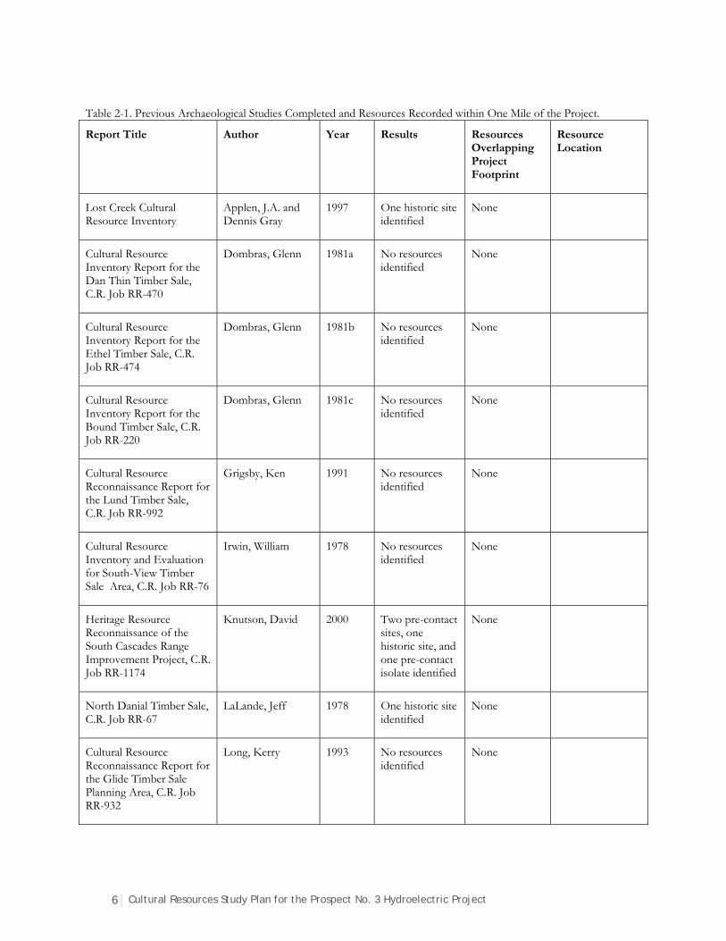
6 Cultural Resources Study Plan for the Prospect No. 3 Hydroelectric Project
Table 2-1. Previous Archaeological Studies Completed and Resources Recorded within One Mile of the Project.
Report Title Author Year Results Resources Overlapping Project Footprint
Resource Location
Lost Creek Cultural Resource Inventory
Applen, J.A. and Dennis Gray
1997 One historic site identified
None
Cultural Resource Inventory Report for the Dan Thin Timber Sale, C.R. Job RR-470
Dombras, Glenn 1981a No resources identified
None
Cultural Resource Inventory Report for the Ethel Timber Sale, C.R. Job RR-474
Dombras, Glenn 1981b No resources identified
None
Cultural Resource Inventory Report for the Bound Timber Sale, C.R. Job RR-220
Dombras, Glenn 1981c No resources identified
None
Cultural Resource Reconnaissance Report for the Lund Timber Sale, C.R. Job RR-992
Grigsby, Ken 1991 No resources identified
None
Cultural Resource Inventory and Evaluation for South-View Timber Sale Area, C.R. Job RR-76
Irwin, William 1978 No resources identified
None
Heritage Resource Reconnaissance of the South Cascades Range Improvement Project, C.R. Job RR-1174
Knutson, David 2000 Two pre-contact sites, one historic site, and one pre-contact isolate identified
None
North Danial Timber Sale, C.R. Job RR-67
LaLande, Jeff 1978 One historic site identified
None
Cultural Resource Reconnaissance Report for the Glide Timber Sale Planning Area, C.R. Job RR-932
Long, Kerry 1993 No resources identified
None
Cultural Resources Study Plan for the Prospect No. 3 Hydroelectric Project 7
Report Title Author Year Results Resources Overlapping Project Footprint
Resource Location
Cultural Resource Inventory and Evaluation for Choice Timber Sale, C.R. Job RR-216
Long, Kerry 1980 No resources identified
None
Cultural Resource Inventory and Evaluation for the Danial Thin Timber Sale, C.R. Job RR-215
Long, Kerry 1979 No resources identified
None
Cultural Resource Reconnaissance Report for the Lion Thin Timber Sale, C.R. Job RR-451
Oberg, Vernon 1980 No resources identified
None
Cultural Resource Reconnaissance Report for the Little River Salvage Timber Sale Planning Area, C.R. Job RR-810
Oberg, Vernon 1987 No resources identified
None
Final Archaeological Survey Technical Report Prospect Nos. 1, 2, and 4, Hydroelectrical Project Relicensing FERC No. 2630
PacifiCorp 2003 Six historic isolates and one pre-contact isolate identified
Iso #1 - Iso #6 T32S, R3E, Sec.29, 30, 31, 34
CR Job RR-302 Green Acres Timber Sale
Parks, Bert 1981 No resources identified
None
Cultural Resources Surveys for Red Blanket Creek Bridge (#07819), Snider Creek Bridge (#07708) and Blackwell Road Railroad Bridge (#00374), Jackson County, Oregon
Ricks, Julie and Kathryn Toepel
2004 One pre-contact isolate identified
None
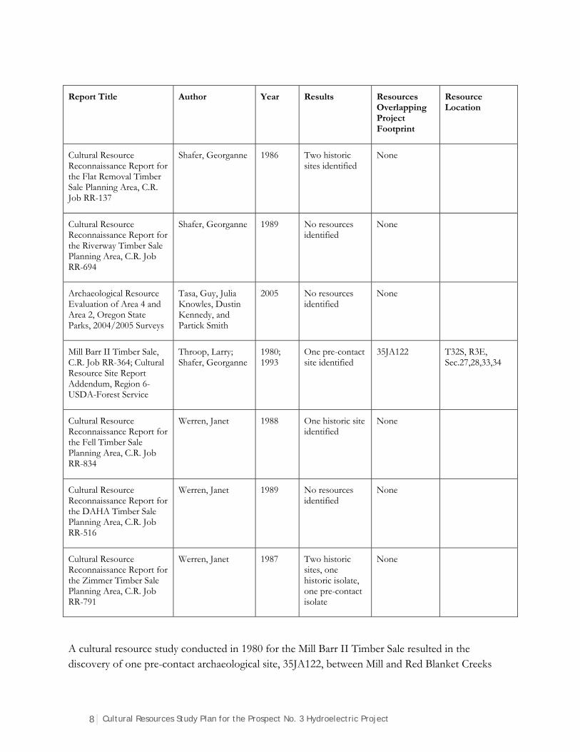
8 Cultural Resources Study Plan for the Prospect No. 3 Hydroelectric Project
Report Title Author Year Results Resources Overlapping Project Footprint
Resource Location
Cultural Resource Reconnaissance Report for the Flat Removal Timber Sale Planning Area, C.R. Job RR-137
Shafer, Georganne 1986 Two historic sites identified
None
Cultural Resource Reconnaissance Report for the Riverway Timber Sale Planning Area, C.R. Job RR-694
Shafer, Georganne 1989 No resources identified
None
Archaeological Resource Evaluation of Area 4 and Area 2, Oregon State Parks, 2004/2005 Surveys
Tasa, Guy, Julia Knowles, Dustin Kennedy, and Partick Smith
2005 No resources identified
None
Mill Barr II Timber Sale, C.R. Job RR-364; Cultural Resource Site Report Addendum, Region 6-USDA-Forest Service
Throop, Larry; Shafer, Georganne
1980; 1993
One pre-contact site identified
35JA122 T32S, R3E, Sec.27,28,33,34
Cultural Resource Reconnaissance Report for the Fell Timber Sale Planning Area, C.R. Job RR-834
Werren, Janet 1988 One historic site identified
None
Cultural Resource Reconnaissance Report for the DAHA Timber Sale Planning Area, C.R. Job RR-516
Werren, Janet 1989 No resources identified
None
Cultural Resource Reconnaissance Report for the Zimmer Timber Sale Planning Area, C.R. Job RR-791
Werren, Janet 1987 Two historic sites, one historic isolate, one pre-contact isolate
None
A cultural resource study conducted in 1980 for the Mill Barr II Timber Sale resulted in the discovery of one pre-contact archaeological site, 35JA122, between Mill and Red Blanket Creeks
Cultural Resources Study Plan for the Prospect No. 3 Hydroelectric Project 9
near the town of Prospect, Oregon (Throop 1980). At the time of its discovery, the site consisted of a surface scatter of lithic tools and debitage that was confined to a roughly 300 by 150-meter area south of Mill and Barr Creeks (LaLande 1980). However, the site boundary was drawn to include a much larger area of land between Mill and Red Blanket Creeks based on the extent of artifacts reported on nearby private lands (Throop 1980). The site was resurveyed in 1993 and additional artifacts were found near to the original discovery (Shafer 1993). Site 35JA122 was not assessed for NRHP eligibility during either the original survey or re-survey of the area. The current boundary of the site overlaps the Project footprint near to where it crosses Barr Creek.
2.2.2 Ethnographic Studies
Although many researchers have worked in the area, Gray’s 1987 work, The Takelma and Their Athapaskan Neighbors, synthesized the data into one location. This report will serve as one of the important pieces of source material for the ethnographic studies. Miller and Seaburg (1990) and Kendal (1990) also contain helpful information. Additionally, the input of the tribes that are being consulted for the Project will be sought to identify additional sources of information to add to the ethnographic context.
2.2.3 Historic Architectural Studies
To date, cultural resource investigations into the built environment of the Prospect No. 3 Hydroelectric Project have been peripheral and in accordance with investigations associated with the Prospect Nos. 1, 2, and 4 Hydroelectric Project (FERC No. 2630). Though the two projects operate under separate FERC licenses, they were constructed concurrently in the early 1930s and are still functionally interconnected.
In 1995, the Oregon SHPO determined that the Prospect Hydroelectric Project appeared to meet the eligibility requirements for listing in the NRHP; in other words, the four developments (Prospects 1, 2, 3, and 4) could be viewed as composing a single historic district. While no formal determination of the Prospect Historic District has been completed, identification of contributing and noncontributing resources for the Prospect Nos. 1, 2, and 4 Hydroelectric Project was completed in 2011. The 2013 Historic Structures Plan for that project also included a brief inventory of resources at Prospect No. 3 (Perrin and Miller 2013:33). No formal survey and/or identification of contributing and/or noncontributing resources has been conducted for the Prospect No. 3 Project.
10 Cultural Resources Study Plan for the Prospect No. 3 Hydroelectric Project
2.3 Cultural and Historical Context
2.3.1 Prehistoric Context
Broad periods of cultural change in Oregon are often characterized using the Willey and Phillips (1958) cultural evolutionary sequence (Beckham and Minor 1992; O’Neill 1989; Winthrop 1993), though the sequence was based primarily on intensively agricultural societies in other parts of North America. In this scheme, early, middle, and late Holocene periods are defined, and in some cases a formative period is also described (Beckham and Minor 1992). Changes in projectile point technology are posited as one basis for these transitions. The early Holocene projectile technology was the spear, middle Holocene hunters used the atlatl and dart, and late Holocene projectile technology incorporated the bow and arrow.
Cultural chronologies proposed by researchers for southwestern Oregon have provided rough estimates regarding the timing and nature of cultural patterns in the region (Beckham and Minor 1992; Connolly 1986, 1991; Pettigrew and Lebow 1987; Winthrop 1993). In general, the timing and rate of shifts from highly mobile, hunter-gatherer-type to more sedentary, semi-permanent village, collector-type subsistence and settlement patterns have been found to be variable across the region. Shifts in typologically diagnostic flaked-stone and ground-stone artifacts have been traced through time and space, often overlapping with major shifts in subsistence and settlement strategies.
2.3.2 Ethnographic Context
The Upper Rogue River has played host to several Native American tribes throughout history. While the Project Area falls primarily within the aboriginal territory of the Upper Takelma, several other groups (including, the Klamath, Molalla, and Cow Creek Band of Umpqua Tribe) have used the general area.
The Takelma have been divided into three separate groups based on language differences (Gray 1987). The Lowland Takelma lived along the banks of the Middle Rogue River where they fished and gathered acorns as well as camas and tarweed for their diet. The Upper Takelma lived directly east of the Lowland Takelma, and relied more on terrestrial resources than riverine resources. North of the Upper Takelma, the Northern Takelma lived on the upper reaches of the Rogue River Valley above Little Butte Creek.
The Cow Creek Band of Umpqua Tribe primarily exploited the natural resources filling the streams and narrow canyons in the southern portion of the Umpqua River Basin. Camps along tributaries to the Umpqua River provided bases for seasonal resource forays (Aikens 1993), possibly extending into the Upper Rogue River watershed. The Cow Creek maintained the hunter-fisher-gatherer lifestyle, with acorns and aquatic resources being the primary food source and camas bulbs, local berries, tarwood seeds, and deer (O’Neill 1989) frequently supplementing their diet.
Cultural Resources Study Plan for the Prospect No. 3 Hydroelectric Project 11
The Klamath Tribes are centered on the Klamath Lakes region east of the Rogue River. Historically, the Klamath crossed the mountains into the Rogue River area to trade and conduct raids. Obsidian from eastern Oregon has been found along the Rogue River, indicating that the Klamath may have been crossing the mountains to trade with their western neighbors.
The Molalla were centered north of the Rogue River within the mountainous upper reaches of the Umpqua watershed. Unlike other tribes in western Oregon, the Molalla relied heavily on terrestrial mammals for their food source (Beckham 1981) because salmon and other resources were not as common within their territory. It is unknown how far south this group traveled, but ethnographic information indicates that they ranged into the Project Area. In fact, ethnographic reports suggest that at least two Molalla camps were located on the Rogue River in the Project Vicinity—one downstream near Flounce Rock and another further upstream on the Middle Fork of the Rogue River.
2.3.3 Historic Context
With the end of the Rogue Indian Wars and discovery and development of the John Day mines in the 1850s, gold miners initiated Euroamerican settlement of Jackson County (Dunn 1993). Timber companies, farmers, and attendant commercial and residential development followed the miners. By 1870, homesteaders and timber interests had formed the Town of Deskin (later renamed Prospect) on the banks of the Rogue River. In addition to its location among vast tracts of marketable sugar pine, the community lay on southern Oregon’s primary thoroughfare, running between the mining community of Jacksonville and the US Army’s Fort Klamath on the east side of the Cascade Range—the Old Fort Road. Settlement proved slow and remained largely limited to scattered ranches, modest tourist facilities (including the extant Prospect Hotel), and logging camps (Emmons 2000).
In 1911, the Gold Hill based Condor Water and Power Company (CWPC) constructed the Prospect Hydroelectric Plant (now Prospect No. 1) on the North Fork of the Rogue River near the town of Prospect. The water-distribution system, powerhouse, and a transmission line from Prospect to CWPC’s Gold Ray plant were completed in 1911. By 1934, CWPC’s successor, Copco, had greatly expanded the Rogue River hydroelectric system, incorporating diversions from the Middle Fork of the Rogue River, Red Blanket Creek and South Fork of the Rogue River, and three new powerhouses (Prospect Nos. 2, 3 and 4).
12 Cultural Resources Study Plan for the Prospect No. 3 Hydroelectric Project
3. Expectations of the Investigations and Methods
3.1 Expectations
As mentioned above, previous archaeological investigations for the Prospect Nos. 1, 2, and 4 relicensing resulted in the identification of a series of isolated finds, most of which were historic, though one was pre-contact. In general, the Project Vicinity can be characterized as having a moderate to high probability of containing prehistoric archaeological resources due to its proximity to the South, Middle, and North forks of the Rogue River and several creeks that adjoin them. The linear nature of the Project, however, and its colocation in places with the Prospect Nos. 1, 2, and 4 Project, suggest that prehistoric resources that may be located within the project boundary have been disturbed or destroyed by historic to modern developments. Historic isolated finds and sites are likely given the age of the facility, and these may or may not be considered contributing resources to a potential historic district. The archaeological survey will seek to ensure that subsurface investigations are appropriately considered recognizing that subsurface surveys were generally employed less frequently during the time of the Prospect Nos. 1, 2, and 4 Project relicensing cultural resources investigations.
It is assumed that the above-ground historic resources investigations will result in the identification of a historic district that includes Prospect Nos. 1, 2, and 4 facilities, and that all Prospect facilities will be managed as a single entity.
Traditional Cultural Properties or sacred sites are not anticipated largely because they were not identified during the Prospect Nos. 1, 2, and 4 Project relicensing cultural resources investigations. Consultation with the appropriate tribes will seek to determine whether there are any resources that were not identified during the Prospect Nos. 1, 2, and 4 Project relicensing cultural resources investigations that should be considered for Prospect No. 3.
3.2 Methods
3.2.1 Area of Potential Effects Definition
Following 36 CFR 800, which details the process for following Section 106 of the NHPA, PacifiCorp will work with the FERC, the SHPO, the United States Forest Service (USFS), the
Cultural Resources Study Plan for the Prospect No. 3 Hydroelectric Project 13
appropriate tribes, the Advisory Council on Historic Preservation (should they choose to participate), additional consulting parties, and the public to identify the project APE. At this stage, it is assumed that the proposed FERC Project boundary as defined in the PAD will be the APE; however, consultation with the appropriate entities will resolve this assumption.
3.2.2 Archaeological Methods
Archaeological survey methods will employ those recommended by the Oregon SHPO (2013) and the USFS. Consultation with the USFS will determine whether they have probability modeling available for this portion of the RR-SNF. If so, methods will be employed to ensure appropriate survey coverage based on the probability of encountering archaeological materials. It is assumed that a combination of pedestrian reconnaissance along transects (spaced no greater than 20 meters apart), shovel scrapes (measuring 1 by 1 meter), and shovel probes (along transects and spaced no greater than 20 meters apart) will be employed. Shovel probes will be no less than 30 centimeters round, and soils will be passed through ⅛-inch hardwire mesh screen. Appropriate permits will be obtained prior to the initiation of any surveys.
3.2.3 Architectural Methods
It is assumed that the Prospect No. 3 Hydroelectric Project is eligible as part of a larger historic district encompassing all Prospect hydroelectric resources designed and constructed in the 1930s (see Section 2.3.3). As such, an Intensive Level Survey (ILS) will be conducted in accordance with the Oregon SHPO’s Guidelines for Historic Resource Surveys in Oregon (2011). The ILS will further document the history of the resources, assess their eligibility for the NRHP, and provide a thorough inventory of recommended contributing and noncontributing resources via submittal of a completed project database and associated maps, photos, and forms. All properties recorded as part of the ILS will be added to the existing inventory of Prospect Hydroelectric Project resources as documented in the Oregon Historic Sites Database.
3.2.4 Traditional Use Studies Methods
Traditional use studies will be developed in consultation with the appropriate tribes.
3.2.5 Assessment of Effects/HPMP
If the inventory identifies historic properties situated within the APE, the effects from Project development and operation to these properties will be assessed by applying the Criteria of Adverse Effect (36 CFR 800.5(a)). If an adverse effect to a National Register listed or eligible resource is anticipated, additional discussion with the stakeholders will be conducted to resolve adverse effects. Per FERC guidance for hydroelectric projects, it is assumed that if adverse effects to historic

14 Cultural Resources Study Plan for the Prospect No. 3 Hydroelectric Project
properties are known or anticipated, a project HPMP will be drafted as a condition to the Project Programmatic Agreement or Memorandum of Agreement. The HPMP will detail a process by which cultural resources issues are addressed throughout the life of the license to ensure compliance with Section 106 of the NHPA.
Cultural Resources Study Plan for the Prospect No. 3 Hydroelectric Project 15
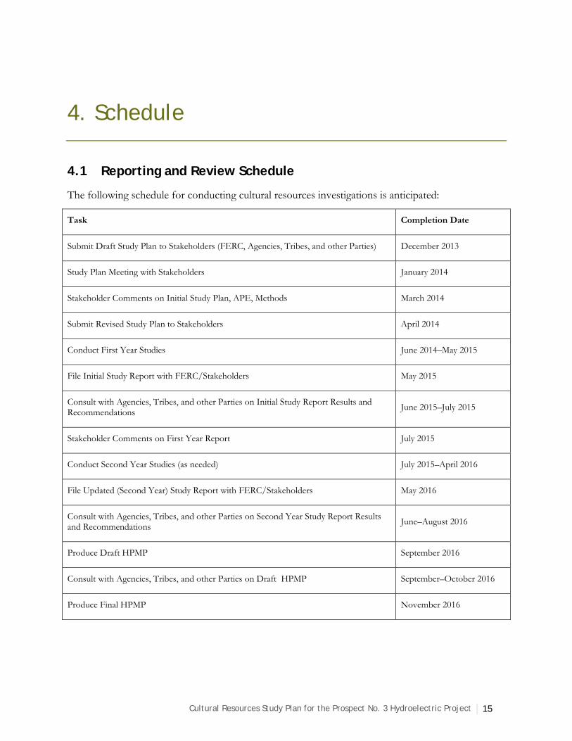
4. Schedule
4.1 Reporting and Review Schedule
The following schedule for conducting cultural resources investigations is anticipated:
Task Completion Date
Submit Draft Study Plan to Stakeholders (FERC, Agencies, Tribes, and other Parties) December 2013
Study Plan Meeting with Stakeholders January 2014
Stakeholder Comments on Initial Study Plan, APE, Methods March 2014
Submit Revised Study Plan to Stakeholders April 2014
Conduct First Year Studies June 2014–May 2015
File Initial Study Report with FERC/Stakeholders May 2015
Consult with Agencies, Tribes, and other Parties on Initial Study Report Results and Recommendations
June 2015–July 2015
Stakeholder Comments on First Year Report July 2015
Conduct Second Year Studies (as needed) July 2015–April 2016
File Updated (Second Year) Study Report with FERC/Stakeholders May 2016
Consult with Agencies, Tribes, and other Parties on Second Year Study Report Results and Recommendations
June–August 2016
Produce Draft HPMP September 2016
Consult with Agencies, Tribes, and other Parties on Draft HPMP September–October 2016
Produce Final HPMP November 2016
16 Cultural Resources Study Plan for the Prospect No. 3 Hydroelectric Project
4.2 Progress Reporting and Information Sharing
The schedule outlined above shows periods during which various stakeholders will be consulted and the time frame that they will have to review and comment on documents. There will be a Study Plan meeting early in 2014 to which agency representatives, tribal representatives, and any other consulting parties will be invited to participate. The goal will be for stakeholders to informally comment on the Study Plan to identify any significant issues that they have with the proposed activities and schedule. Following this meeting, stakeholders will have additional time (through mid-March 2014) to comment on the Study Plan and its associated components. During that time, agencies and tribes will be directly consulted via telephone and/or email to solicit additional input on the Study Plan. The details of what will be undertaken for Traditional Use Studies will be resolved during this time period. A revised Study Plan will be submitted for review in April of 2014, and details of any specific issues identified by stakeholders will also be addressed via telephone and/or email.
Stakeholders will be updated on the results of the first year studies once they are initiated. Upon completion of the archaeological survey, draft resource forms will be completed and submitted to the Oregon SHPO for review. Drafts of these forms can also be distributed to other stakeholders at this time at their request. The need for this level of involvement will be discussed at the Study Plan meeting and periodically during the Study Plan review process. Similarly, the involvement of various stakeholders on the progress of the architectural and traditional use studies will be discussed and solidified during the Study Plan review process.
Stakeholders will likewise be consulted directly via telephone and/or email on the content of the first year studies report prior to its submission for review in May of 2015. In-person meetings with the Oregon SHPO, the RR-SNF Archaeologist, and appropriate tribes may be scheduled as needed during this time. A similar process will follow at the completion of the second year studies, as appropriate.
Appropriate agencies and tribes will have access to locational information regarding identified cultural resources; however, such information will not be disclosed to the public. All technical reporting and technical report electronic documents will contain headings and file names that include “Confidential-Not for Public Disclosure.” When files are submitted electronically to the FERC, cultural resources data will be submitted separately from data that can be publicly disclosed.

Cultural Resources Study Plan for the Prospect No. 3 Hydroelectric Project 17
5. Level of Effort and Cost
The Study Plan process (drafting, revisions, meetings, final version) is anticipated to consume up to 208 hours of labor, and total costs (including direct expenses for travel, etc.) are anticipated to be $21,000. The first year studies and reporting process is anticipated to consume up to 700 hours of labor, and total costs (including direct expenses for travel, etc.) are anticipated to be $64,600. It is not anticipated that second year studies will be needed at this time. Additional cultural resources support for the license application, project management, and various tasks and meetings over the three-year course of the project for could consume up to 300 hours and cost $24,700. These costs are highly dependent on the frequency and duration of consultation with agencies, tribes, and other stakeholders.
18 Cultural Resources Study Plan for the Prospect No. 3 Hydroelectric Project
6. References Cited
Aikens, C. Melvin 1993 Archaeology of Oregon. U.S. Department of the Interior, Portland, Oregon.
Alpen, J.A., and Dennis Gray 1997 Lost Creek Cultural Resource Inventory (BF97-35). Submitted to USDI Bureau of Land
Management, Butte Falls Resource Area, Medford District Office, Medford, Oregon.
Bacon, Charles R. 1983 Eruptive History of Mount Mazama and Crater Lake Caldera, Cascade Range, U.S.A.
Journal of Volcanology and Geothermal Research 18: 57–115.
Badura, George J., and Philip N. Jahn 1977 Soil Resource Inventory for the Rogue River National Forest. USDA Forest Service, Pacific
Northwest Region, Portland Oregon.
Beckham, Stephen Dow, and Rick Minor 1992 Cultural Resource Overview of the Umpqua National Forest, Southwestern Oregon. Heritage
Research Associates, Eugene, Oregon. Submitted to the Umpqua National Forest, Roseburg, Oregon.
Beckham, S. D., R. Minor, and K. A. Toepel 1981 Prehistory and History of BLM Lands in West-Central Oregon: A Cultural Resource Overview.
University of Oregon Anthropological Papers, No. 25. Department of Anthropology and Oregon State Museum of Anthropology, University of Oregon, Eugene.
Budy, Elizabeth, and Robert G. Elston 1986 Data Recovery at Sites 35JA102 and 35JA107, Elk Creek Lake Project, Jackson County, Oregon.
Intermountain Research, Inc. Submitted to US Army Corps of Engineers, Portland District, Portland, Oregon.
Budy, Elizabeth, M. P. Drews, and Robert G. Elston 1986 Test Excavations at Site 35JA59, Elk Creek Lake Project, Jackson County, Oregon.
Intermountain Research, Inc. Submitted to US Army Corps of Engineers, Portland District, Portland, Oregon.
Connolly, Thomas J. 1986 Cultural Stability and Change in the Prehistory of Southwest Oregon and Northern California. Ph.D.
Dissertation, Department of Anthropology, University of Oregon, Eugene, Oregon.
1991 The Standley Site (35DO182): Investigations into the Prehistory of Camas Valley, Oregon. University of Oregon Anthropological Papers No. 43, Department of Anthropology and Oregon State Museum of Anthropology, University of Oregon, Eugene.
Cultural Resources Study Plan for the Prospect No. 3 Hydroelectric Project 19
Connolly, Thomas J., Jane E. Benjamin, Brian L. O’Neill, B. L., and Dennis L. Jenkins 1994 Archaeological Investigations at Two Sites on the Upper Rogue River (35JA189 and
35JA190), Southwest Oregon. University of Oregon Anthropological Papers No. 48, Department of Anthropology and Oregon State Museum of Anthropology, University of Oregon, Eugene.
Davis, Wilbur A. 1974 Lost Creek Archaeology, 1972, Final Report. Department of Anthropology, Oregon State
University, Corvallis.
1983 1973 Lost Creek Archaeology, Jackson County, Oregon, and 1974 Elk Creek Archaeology, Jackson County Oregon, Final Reports. Department of Anthropology, Oregon State University, Corvallis.
Dombras, Glenn 1981a Cultural Resource Inventory Report for the Dan Thin Timber Sale, C.R. Job RR-470. Submitted to
Butte Falls Ranger District, Rogue River National Forest.
1981b Cultural Resource Inventory Report for the Ethel Timber Sale, C.R. Job RR-474. Submitted to Butte Falls Ranger District, Rogue River National Forest.
1981c Cultural Resource Inventory Report for the Bound Timber Sale, C.R. Job RR-220. Submitted to Butte Falls Ranger District, Rogue River National Forest.
Dunn, J. B. (editor) 1993 Land in Common. An Illustrated History of Jackson County, Oregon. Southern Oregon
Historical Society, Medford, Oregon.
Emmons, Ann 2000 Historic Resource Inventory and Assessment, PacifiCorp’s Prospect Hydroelectric Project, Nos. 1, 2,
and 4. FERC No. 2630. Historical Research Associates, Inc., Seattle, Washington. Prepared for Entrix, Seattle, Washington.
Franklin, Jerry, and C. T. Dyrness 1973 Natural Vegetation of Oregon and Washington. USDA, Forest Service, General and Technical
Report PNW-8. Portland, Oregon.
Gray, Dennis J. 1987 The Takelma and Their Athapaskan Neighbors. University of Oregon Anthropological
Papers, No. 37. University of Oregon, Eugene.
Grigsby, Ken 1991 Cultural Resource Reconnaissance Report for the Lund Timber Sale, C.R. Job RR-992. Submitted
to Prospect Ranger District, Rogue River National Forest.
Irwin, William 1978 Cultural Resource Inventory and Evaluation for South-View Timber Sale Area, C.R. Job RR-76.
Submitted to Butte Falls Ranger District, Rogue River National Forest.
Johnson, David R. 1993 Soil Survey of Jackson County Area, Oregon. United States Department of Agriculture, Soil
Conservation Service.
20 Cultural Resources Study Plan for the Prospect No. 3 Hydroelectric Project
Kendall, Daythal L. 1990 Takelma. In Northwest Coast, edited by Wayne Suttles, pp. 589–592. Handbook of North
American Indians, Vol. 7, William C. Sturtevant, general editor, Smithsonian Institution, Washington, D.C.
Knutson, David 2000 Heritage Resource Reconnaissance of the South Cascades Range Improvement Project, C.R. Job RR-
1174. Submitted to Ashland and Butte Falls Ranger Districts, Rogue River National Forest.
LaLande, Jeffrey 1978 North Danial Timber Sale, C.R. Job RR-67. Submitted to Butte Falls Ranger District, Rogue
River National Forest.
1980 Oregon Archaeological Survey Site Form for 35JA122. On file at the Oregon State Historic Preservation Office, Salem, Oregon.
Long, Kerry 1979 Cultural Resource Inventory and Evaluation for the Danial Thin Timber Sale, C.R. Job RR-215.
Submitted to Butte Falls Ranger District, Rogue River National Forest.
1980 Cultural Resource Inventory and Evaluation for Choice Timber Sale, C.R. Job RR-216. Submitted to Butte Falls Ranger District, Rogue River National Forest.
1993 Cultural Resource Reconnaissance Report for the Glide Timber Sale Planning Area, C.R. Job RR-932. Submitted to Butte Falls Ranger District, Rogue River National Forest.
Miller, Jay, and William R. Seaburg 1990 Athapaskans of Southwestern Oregon. In Northwest Coast, edited by Wayne Suttles, pp.
580–588. Handbook of North American Indians, Vol. 7, William C. Sturtevant, general editor, Smithsonian Institution, Washington, D.C.
Nilsson, Elena, and Michael S. Kelly 1991 Prehistory of the Upper Rogue River Region: Archaeological Inventory and Evaluation within the Elk
Creek Lake and Lost Creek Lake Project Areas, Jackson County, Southwest Oregon. Volumes 1 and 2. Mountain Anthropological Research. Submitted to US Army Corps of Engineers, Portland District, Portland, Oregon.
Oberg, Vernon 1980 Cultural Resource Reconnaissance Report for the Lion Thin Timber Sale, C.R. Job RR-451.
Submitted to Butte Falls Ranger District, Rogue River National Forest.
1987 Cultural Resource Reconnaissance Report for the Little River Salvage Timber Sale Planning Area, C.R. Job RR-810. Submitted to Butte Falls Ranger District, Rogue River National Forest.
O’Neill, Brian L. 1989 Archaeological Investigations at the Narrows and Martin Creek Sites, Douglas County, Oregon. U.S.
Department of the Interior, Portland, Oregon.
Oregon State Historic Preservation Office 2011 Guidelines for Historic Resource Surveys in Oregon. Electronic document,
http://www.oregon.gov/oprd/HCD/SHPO/docs/guidelines_for_historic_resource_surveys_2011.pdf, accessed November 20, 2013.
Cultural Resources Study Plan for the Prospect No. 3 Hydroelectric Project 21
Orr, Elizabeth L., William N. Orr, and Ewart M. Baldwin 1992 Geology of Oregon, Fourth Edition. Kendall/Hunt Publishing Company, Dubuque, Iowa.
PacifiCorp 2003 Final Archaeological Survey Technical Report Prospect Nos. 1, 2, and 4, Hydroelectrical Project
Relicensing FERC No. 2630. Submitted to the Federal Energy Regulatory Commission.
Parks, Bert 1981 CR Job RR-302 Green Acres Timber Sale. Submitted to Butte Falls Ranger District, Rogue
River National Forest.
Perrin, Natalie K., and Heather Lee Miller 2013 Historic Structures Plan (with Maintenance & Operations Guidelines for Historic Properties) for
Prospect Hydroelectric Development Nos. 1, 2, and 4. Jackson County, Oregon. FERC No. 2630. Historical Research Associates, Inc., Portland, Oregon. Submitted to PacifiCorp, Portland, Oregon.
Pettigrew, Richard M., and Clay G. LeBow 1987 Data Recovery at Sites 35JA27, 35JA59, and 35JA100, Elk Creek Lake Project, Jackson County,
Oregon. Infotech Research, Inc. Submitted to US Army Corps of Engineers, Portland District, Portland, Oregon.
Ricks, Julie A., and Kathryn Toepel 2004 Cultural Resources Surveys for Red Blanket Creek Bridge (#07819), Snider Creek Bridge (#07708)
and Blackwell Road Railroad Bridge (#00374), Jackson County, Oregon. Heritage Research Associates, Inc. Submitted to Otak, Inc., Lake Oswego, Oregon.
Shafer, Georganne 1986 Cultural Resource Reconnaissance Report for the Flat Removal Timber Sale Planning Area, C.R. Job
RR-137. Submitted to Prospect Ranger District, Rogue River National Forest.
1989 Cultural Resource Reconnaissance Report for the Riverway Timber Sale Planning Area, C.R. Job RR-694. Submitted to Prospect Ranger District, Rogue River National Forest.
1993 Cultural Resource Site Report Addendum for 35JA122, Region 6-USDA-Forest Service.
Sherrod, David, and James G. Smith 2000 Geologic map of upper Eocene to Holocene volcanic and related rocks of the Cascade Range, Oregon.
U.S. Geological Survey Geologic Investigations Map I-2569, 2 sheets, scale 1:500,000.
Smith, J. G., N. J. Page, M. G. Johnson, B. C. Moring, and Floyd Gray 1982 Preliminary geologic map of the Medford 1° by 2° quadrangle, Oregon and California.
U.S. Geological Survey Open-File Report 82-955, scale 1:250,000.
Tasa, Guy L., Julia A. Knowles, Dustin G. Kennedy, and Patrick D. Smith 2005 Archaeological Resource Evaluation of Area 4 and Area 2, Oregon State Parks, 2004/2005 Surveys.
Oregon State Museum of Anthropology Report 2005-223.
Throop, Larry 1980 Mill Barr II Timber Sale, C.R. Job RR-364. Submitted to Prospect Ranger District, Rogue
River National Forest.
22 Cultural Resources Study Plan for the Prospect No. 3 Hydroelectric Project
Werren, Janet 1978 Cultural Resource Reconnaissance Report for the Zimmer Timber Sale Planning Area, C.R. Job RR-
791. Submitted to Butte Falls Ranger District, Rogue River National Forest.
1988 Cultural Resource Reconnaissance Report for the Fell Timber Sale Planning Area, C.R. Job RR-834. Submitted to Butte Falls Ranger District, Rogue River National Forest.
1989 Cultural Resource Reconnaissance Report for the Daha Timber Sale Planning Area, C.R. Job RR-516. Submitted to Butte Falls Ranger District, Rogue River National Forest.
Willey, Gordon R., and Philip Phillips 1958 Method and Theory in American Archaeology. University of Chicago Press, Chicago, Illinois.
Winthrop, Kathryn 1993 Prehistoric Settlement Patterns in Southwest Oregon. Ph.D. dissertation, Department of
Anthropology, University of Oregon, Eugene.
Zdanowicz, Chris M., Gregory A. Zielinski, and Mark S. Germani 1999 Mount Mazama eruption; calendrical age verified and atmospheric impact assessed.
Geology 27(7):621–624.