PROPOSED SCUTTLING OF THE HMAS TOBRUK IN
66
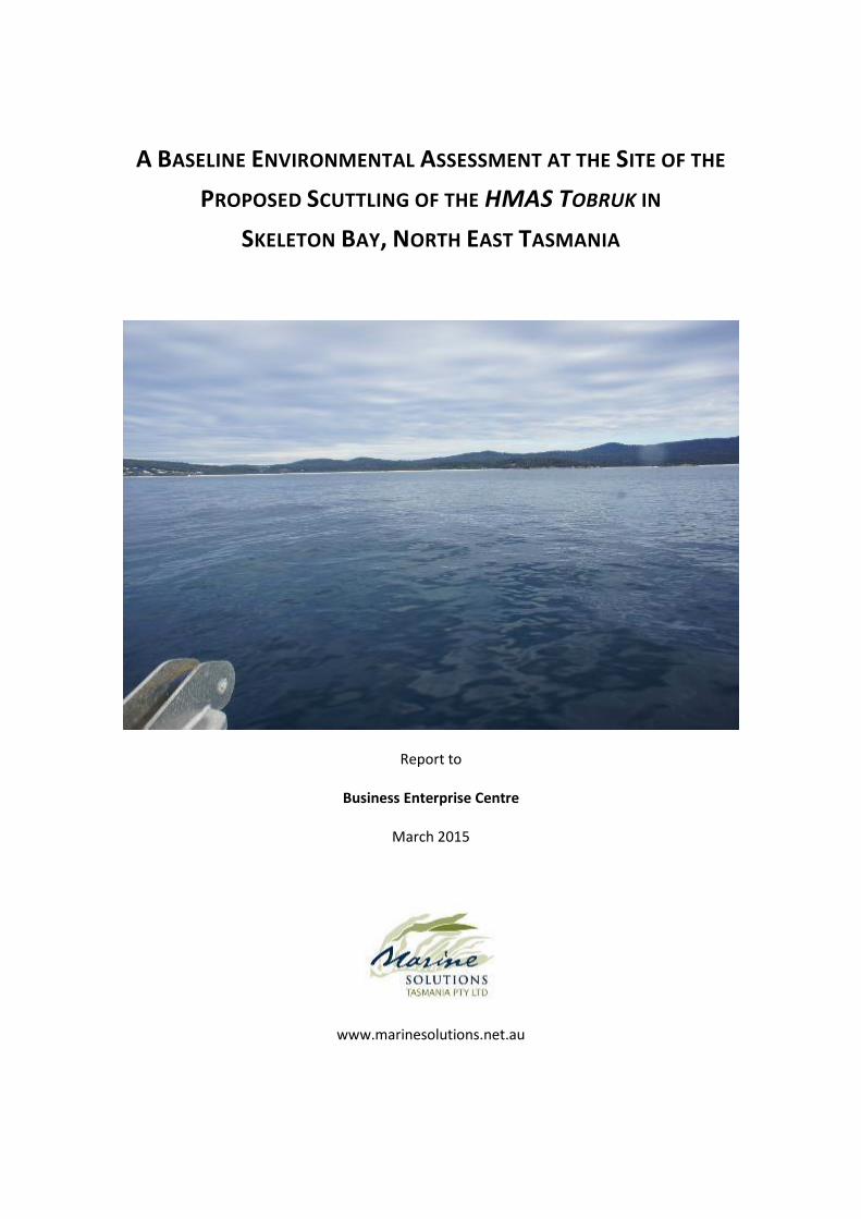
A BASELINE ENVIRONMENTAL ASSESSMENT AT THE SITE OF THE PROPOSED SCUTTLING OF THE HMAS TOBRUK IN SKELETON BAY, NORTH EAST TASMANIA Report to Business Enterprise Centre March 2015 www.marinesolutions.net.au
Transcript of PROPOSED SCUTTLING OF THE HMAS TOBRUK IN
A BASELINE ENVIRONMENTAL ASSESSMENT AT THE SITE OF THE
PROPOSED SCUTTLING OF THE HMAS TOBRUK IN
SKELETON BAY, NORTH EAST TASMANIA
Report to
Business Enterprise Centre
March 2015
www.marinesolutions.net.au
itomkins
Text Box
RTI 17-18-33 Record 2
itomkins
Text Box
RTI 17-18-33 The following has been released in relation to a request for information relating to the proposal to scuttle the ex HMAS Darwin off the east coast of Tasmania. The request was for information relating to any environmental, social or economic assessment or advice regarding the proposal. The following report, prepared for the ex HMAS Tobruk proposal in 2016, was identified as information considered in relation to the ex HMAS Darwin proposal.
Environmental assessment of proposed HMAS Tobruk scuttling site 2
© Marine Solutions 2014. This document should only be used for the specific project and
purposes for which it was commissioned. 1
Version Author Date reviewed Reviewed by
1 of 3 Laura Smith and Mark Jensen
31/07/2014 Laura Smith
2 of 3 Laura Smith and Mark Jensen
04/08/2014 Sam Ibbott
3 of 3 Laura Smith and Mark Jensen
- -
4 of 4 Laura Smith and Mark Jensen
- -
1 Cover photo, above water outlook from the proposed scuttling site, 2014.
Environmental assessment of proposed HMAS Tobruk scuttling site 3
1 Table of Contents
1 Table of Contents ...................................................................................................................... 3
2 Table of Figures ........................................................................................................................ 6
3 Executive Summary ................................................................................................................... 8
4 Introduction ........................................................................................................................... 10
4.1 Purpose and Scope ................................................................................................................... 10
4.2 Legislation ................................................................................................................................. 10
4.3 Proposal .................................................................................................................................... 12
4.4 Location and Study Site ............................................................................................................ 12
5 Habitat Characterisation ......................................................................................................... 14
5.1 Bathymetry ............................................................................................................................... 14
5.2 Subtidal Habitat ........................................................................................................................ 17
5.3 Hydrodynamics ......................................................................................................................... 20
5.4 Sedimentation .......................................................................................................................... 25
5.5 Geology ..................................................................................................................................... 25
6 Matters of National Environmental Significance ...................................................................... 26
6.1 World Heritage Properties........................................................................................................ 26
6.2 National Heritage Places........................................................................................................... 27
6.3 Wetlands of international importance (listed under the Ramsar Convention) ....................... 27
6.4 Listed threatened species and ecological communities ........................................................... 28
6.4.1 Marine Mammals ................................................................................................................. 29
Environmental assessment of proposed HMAS Tobruk scuttling site 4
6.4.2 Syngnathids .......................................................................................................................... 31
6.4.3 Australian Grayling ............................................................................................................... 31
6.5 Migratory species protected under international agreements ................................................ 32
6.6 Commonwealth marine areas .................................................................................................. 33
6.7 The Great Barrier Reef Marine Park ......................................................................................... 33
6.8 Nuclear actions (including uranium mines) .............................................................................. 33
6.9 A water source, in relation to coal seam gas development and large coal mining
development.......................................................................................................................................... 34
7 Introduced Marine Pests ......................................................................................................... 35
8 Fish Count Transects ............................................................................................................... 37
9 Impacts on Sharks and Shark/Human Interactions ................................................................... 42
10 Sediments ............................................................................................................................... 43
10.1 Contaminants ........................................................................................................................... 43
10.2 Jet Probing ................................................................................................................................ 44
10.3 Particle Size Distribution and Settling Times ............................................................................ 46
11 Corrosion and Colonisation ..................................................................................................... 47
12 Water Quality ......................................................................................................................... 48
13 Fisheries/Aquaculture Interactions .......................................................................................... 52
14 Ongoing Monitoring ................................................................................................................ 54
15 Conclusions ............................................................................................................................ 56
16 References .............................................................................................................................. 58
17 Appendices ............................................................................................................................. 61

Environmental assessment of proposed HMAS Tobruk scuttling site 5
Environmental assessment of proposed HMAS Tobruk scuttling site 6
2 Table of Figures
Figure 1 Approximate locations of naval wrecks around Australia (Cole and Abbs 2011). ....................... 12
Figure 2 Recreational facilities surrounding Skeleton Bay ......................................................................... 13
Figure 3 Bathymetric map of the area surrounding the potential scuttling site (top), and reef habitat
overlaid on bathymetry map, shown in brown (bottom). ................................................................ 16
Figure 4 Locations of the towed video surveys conducted in the area of the proposed scuttling site, and
the site of the ADCP deployment (the proposed scuttling site is shown by the white line along
which Video 11 was recorded). ......................................................................................................... 17
Figure 5 Images showing the different compositions of the seabed around the area of the proposed
scuttling site ...................................................................................................................................... 19
Figure 6 Count of different current speeds for top (0-11 m; blue bars), mid (11-22 m; green bars), and
bottom (22-33 m; red bars) waters at the proposed scuttling site .................................................. 23
Figure 7 The mean significant wave height (m) for the duration of the ADCP deployment (28 days) at the
proposed scuttling site. ..................................................................................................................... 24
Figure 8 The minimum and maximum average direction (in degrees) of current flow at the proposed
scuttling site ...................................................................................................................................... 24
Figure 9 Map showing the nearest Ramsar Wetland (bound by blue line) to the proposed scuttling site.
........................................................................................................................................................... 27
Figure 10 Precaution zone definitions as per DEWHA's (2008) guidelines for seismic activity. ................ 31
Figure 11 Map showing locations of fish count transects in the east (Transect 1) and west (Transect 2 ) of
Skeleton Bay ...................................................................................................................................... 37
Figure 12 Total number of fish observed in eastern and western fish transects by size class. ................. 39
Figure 13 Abundance and diversity by family of fishes sighted in West (left) and East (right) Skeleton
Bay. (Note that category "Other" includes families Enoplosidae, Girellidae, Latrididae, Odacidae,
Pomacentridae and Urolophidae). Refer to Appendix 5 for raw data. ............................................ 40
Environmental assessment of proposed HMAS Tobruk scuttling site 7
Figure 14 Map showing locations of the 5 sediment samples collected. .................................................. 43
Figure 15 Map showing jet probe locations within the proposed scuttling site. ...................................... 45
Figure 16 Particle size distribution of a sediment sample from the potential scuttling site. .................... 46
Figure 17 Location of water quality in relation to the proposed scuttling site ......................................... 48
Figure 18 Water quality measurements conducted at five sites in the area of the proposed scuttling site
........................................................................................................................................................... 50
Environmental assessment of proposed HMAS Tobruk scuttling site 8
3 Executive Summary
In June 2014, Marine Solutions was contracted to undertake an environmental feasibility study for the
scuttling of the HMAS Tobruk in Skeleton Bay, north east coast of Tasmania. The HMAS Tobruk is a 127
m naval ship scheduled for decommission in 2015. It is proposed that the scuttled vessel will create a
new artificial reef for the purpose of dive tourism. This report assumes that the vessel hull and interior
will be cleaned to an acceptable level prior to hand-over. The multifaceted survey found no ecological
contraventions to the scuttling of this vessel at Skeleton Bay.
Bathymetry and the spatial extent of reef environment were mapped throughout the survey area. On
the basis of suitable depth and substrate, an approximate potential site for the scuttling of the HMAS
Tobruk was identified. The exact location for scuttling will need to be chosen in consideration of exact
vessel height and detailed analysis of the wave climate. Divers collected photos and video footage of
the seabed at the potential scuttling site.
Biological surveys identified a biodiverse community of fish, invertebrate and algal species. Divers
conducted fish counts along two transects above reefs at each of the east and west of Skeleton Bay,
each measuring 100 m x 10 m (i.e. total area of 4000 m2), recording fish species and size class.
The scuttling of the HMAS Tobruk and its establishment as a dive wreck site is not expected to have a
detrimental impact on any Matters of National Environmental Significance (MNES) investigated herein,
including world heritage properties, national heritage places, wetlands of international importance,
listed threatened species and communities, migratory species and Commonwealth marine areas.
Threatened/protected species sighted during surveys included seals and dolphins. Three additional
protected marine species (all mammals) were identified by the Natural Values Atlas as occurring within
500 m of the potential scuttling site. The scuttling of the HMAS Tobruk is not considered likely to have a
detrimental impact on any threatened or protected species.
Jet probing of the sand at the proposed location indicated no underlying hard substrate in the top 2m of
seabed at the sites tested. Sediments at the proposed scuttling site were medium-grained (90% of
sediment sample was between 0.125 mm and 0.25 mm in grain size) and relatively dense (fast settling),
indicating that any plume generated by a ship contacting the seabed would likely be short-lived.
Based on previous studies it is expected that over time the presence of the wreck on the seabed will
cause elevation of some contaminants in the localised sediments surrounding the ship. Sediment
Environmental assessment of proposed HMAS Tobruk scuttling site 9
samples have been retained, should the project progress and require baseline contaminant testing of
sediments.
Water quality parameters were collected at a number of sites within the study area, providing a pre-
scuttling baseline for future reference. An Acoustic Doppler Current Profiler (ADCP) measured current
velocity and direction over one month. Currents were predominantly low velocity near the sea bed, and
increased closer to the surface which is consistent with many coastal areas. The peak wave direction
recorded during the ADCP deployment was ~95°. The current velocities were congruent with
recreational diving sites.
Should this project proceed to the next stage, a series of further works will be required, including but
not limited to;
A detailed Notice of Intent outlining the project
An application for a seabed lease under the Tasmanian Crown Lands Act 1976
A permit under the Environment Protection (Sea Dumping) Act 1981
Evidence of compliance with the Environment Protection and Biodiversity Conservation Act 1999
A full environmental risk assessment
A diver access/egress plan informed by a naval architect
A feasibility study and business plan
Stakeholder liaison and communication.
The results of our surveys indicate that Skeleton Bay contains a site with suitable depth range to scuttle
a ship the dimensions of the HMAS Tobruk, and sufficient sand depth on the seabed to support the
resting wreck. No major potential ecological contraventions resulting from the scuttling of the HMAS
Tobruk at the proposed site in Skeleton Bay have been identified.
Environmental assessment of proposed HMAS Tobruk scuttling site 10
4 Introduction
4.1 Purpose and Scope
Marine Solutions has been contracted to conduct an environmental feasibility study for the scuttling of
the HMAS Tobruk to form an artificial reef in Skeleton Bay, Tasmania. The document details the
methods and results of the study undertaken, including characterisation of:
- Habitat
- Localised hydrodynamics
- Biological community
- Sediments
- Water quality
4.2 Legislation
The Commonwealth Environmental Protection (Sea Dumping) Act 1981 regulates the dumping of waste
at sea in fulfilment of Australia's obligation under the international London Protocol to prevent marine
pollution by dumping of material at sea. The scuttling of a ship falls under one of seven permissible
categories (category IV: "vessels and platforms or other man-made structures at sea"), as listed in Annex
1 of the Protocol. In order to scuttle a ship, a government-issued permit is required.
All development planning within Tasmania is governed by Tasmania’s Resource Management and
Planning System (RMPS). The seven main statutes that lend legislative effect to the RMPS are:
- Land Use Planning and Approvals Act 1993 (LUPAA);
- Resource Planning and Development Commission Act 1997;
- Resource Management and Planning Appeal Tribunal Act 1993;
- State Policies and Projects Act 1993;
- Environmental Management and Pollution Control Act 1994 (EMPCA);
- Historic Cultural Heritage Act 1995; and
- Major Infrastructure Development Approvals Act 1999.
Environmental assessment of proposed HMAS Tobruk scuttling site 11
Threatened species are protected under the Threatened Species Protection Act 1995 (TSPA, Tasmanian
state legislation) and/or the Environment Protection and Biodiversity Conservation Act 1999 (EPBCA,
Australian Government legislation). Under the TSPA, no listed species is allowed to be collected,
disturbed, damaged or destroyed without a permit. Under the EPBCA, any action with significant
impact on a listed threatened species and/or community is prohibited without approval (EPBCA Section
18 and 18A). In addition to threatened species legislation, the Fisheries (General and Fees) Regulations
2006 under the Living Marine Resources Management Act 1995 (LMRMA) prohibits the
taking/possession of a number of marine species. Additional species are protected by the schedules of
the Wildlife (General) Regulations 2010 (Regulations under the Nature Conservation Act 2002 (NCA)).
Environmental assessment of proposed HMAS Tobruk scuttling site 12
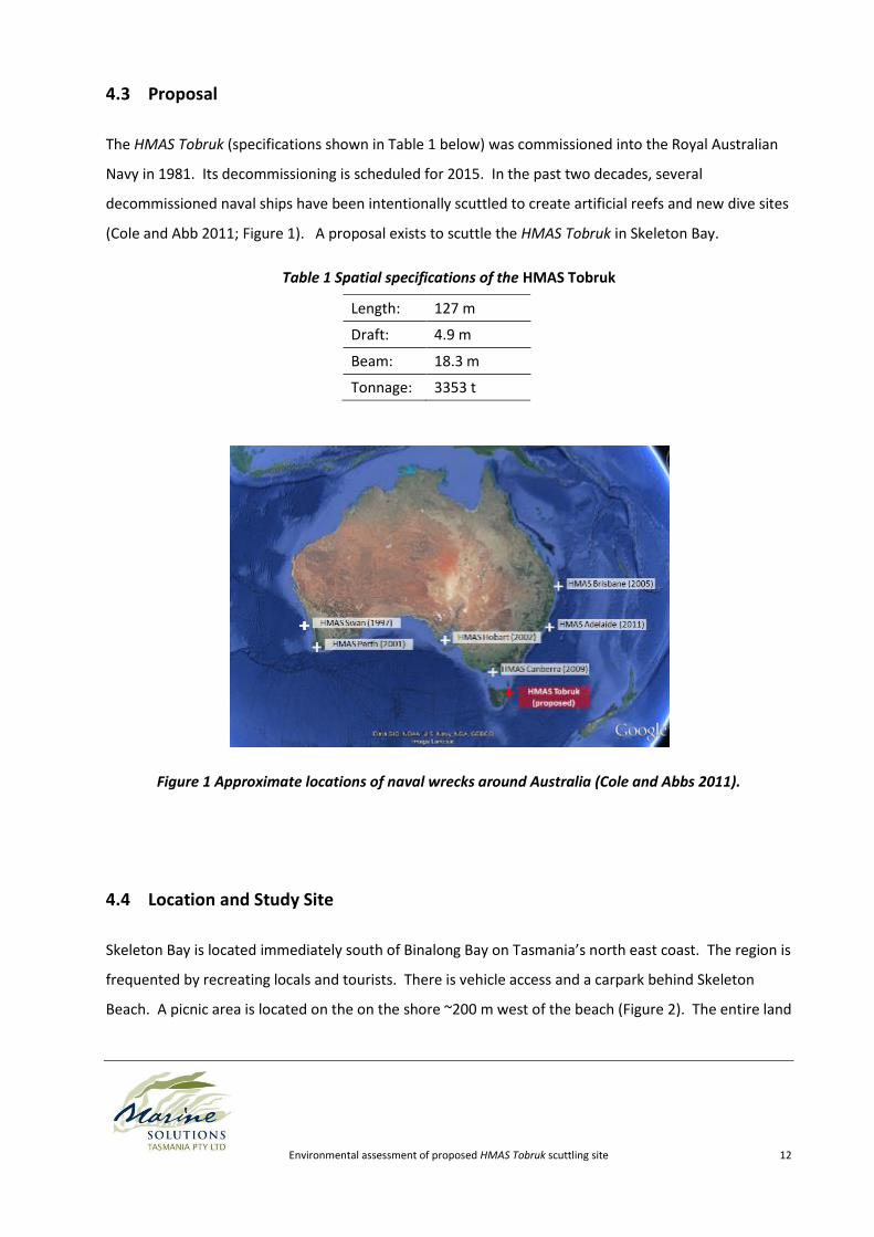
4.3 Proposal
The HMAS Tobruk (specifications shown in Table 1 below) was commissioned into the Royal Australian
Navy in 1981. Its decommissioning is scheduled for 2015. In the past two decades, several
decommissioned naval ships have been intentionally scuttled to create artificial reefs and new dive sites
(Cole and Abb 2011; Figure 1). A proposal exists to scuttle the HMAS Tobruk in Skeleton Bay.
Table 1 Spatial specifications of the HMAS Tobruk
Length: 127 m
Draft: 4.9 m
Beam: 18.3 m
Tonnage: 3353 t
Figure 1 Approximate locations of naval wrecks around Australia (Cole and Abbs 2011).
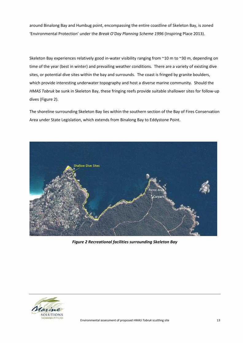
4.4 Location and Study Site
Skeleton Bay is located immediately south of Binalong Bay on Tasmania’s north east coast. The region is
frequented by recreating locals and tourists. There is vehicle access and a carpark behind Skeleton
Beach. A picnic area is located on the on the shore ~200 m west of the beach (Figure 2). The entire land
Environmental assessment of proposed HMAS Tobruk scuttling site 13
around Binalong Bay and Humbug point, encompassing the entire coastline of Skeleton Bay, is zoned
‘Environmental Protection’ under the Break O’Day Planning Scheme 1996 (Inspiring Place 2013).
Skeleton Bay experiences relatively good in-water visibility ranging from ~10 m to ~30 m, depending on
time of the year (best in winter) and prevailing weather conditions. There are a variety of existing dive
sites, or potential dive sites within the bay and surrounds. The coast is fringed by granite boulders,
which provide interesting underwater topography and host a diverse marine community. Should the
HMAS Tobruk be sunk in Skeleton Bay, these fringing reefs provide suitable shallower sites for follow-up
dives (Figure 2).
The shoreline surrounding Skeleton Bay lies within the southern section of the Bay of Fires Conservation
Area under State Legislation, which extends from Binalong Bay to Eddystone Point.
Figure 2 Recreational facilities surrounding Skeleton Bay
Environmental assessment of proposed HMAS Tobruk scuttling site 14
5 Habitat Characterisation
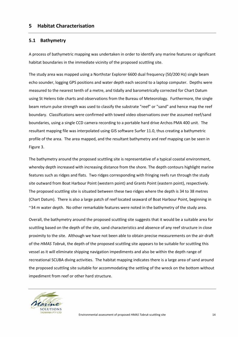
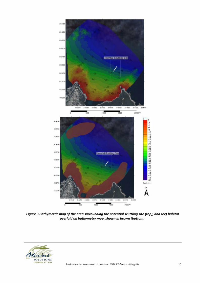
5.1 Bathymetry
A process of bathymetric mapping was undertaken in order to identify any marine features or significant
habitat boundaries in the immediate vicinity of the proposed scuttling site.
The study area was mapped using a Northstar Explorer 6600 dual frequency (50/200 Hz) single beam
echo sounder, logging GPS positions and water depth each second to a laptop computer. Depths were
measured to the nearest tenth of a metre, and tidally and barometrically corrected for Chart Datum
using St Helens tide charts and observations from the Bureau of Meteorology. Furthermore, the single
beam return pulse strength was used to classify the substrate "reef" or "sand" and hence map the reef
boundary. Classifications were confirmed with towed video observations over the assumed reef/sand
boundaries, using a single CCD camera recording to a portable hard drive Archos PMA 400 unit. The
resultant mapping file was interpolated using GIS software Surfer 11.0, thus creating a bathymetric
profile of the area. The area mapped, and the resultant bathymetry and reef mapping can be seen in
Figure 3.
The bathymetry around the proposed scuttling site is representative of a typical coastal environment,
whereby depth increased with increasing distance from the shore. The depth contours highlight marine
features such as ridges and flats. Two ridges corresponding with fringing reefs run through the study
site outward from Boat Harbour Point (western point) and Grants Point (eastern point), respectively.
The proposed scuttling site is situated between these two ridges where the depth is 34 to 38 metres
(Chart Datum). There is also a large patch of reef located seaward of Boat Harbour Point, beginning in
~34 m water depth. No other remarkable features were noted in the bathymetry of the study area.
Overall, the bathymetry around the proposed scuttling site suggests that it would be a suitable area for
scuttling based on the depth of the site, sand characteristics and absence of any reef structure in close
proximity to the site. Although we have not been able to obtain precise measurements on the air-draft
of the HMAS Tobruk, the depth of the proposed scuttling site appears to be suitable for scuttling this
vessel as it will eliminate shipping navigation impediments and also be within the depth range of
recreational SCUBA diving activities. The habitat mapping indicates there is a large area of sand around
the proposed scuttling site suitable for accommodating the settling of the wreck on the bottom without
impediment from reef or other hard structure.
Environmental assessment of proposed HMAS Tobruk scuttling site 15
The final location and orientation for scuttling will need to be chosen in consideration of exact vessel
height and wave climate. Based on the bathymetry, we would recommend the ship be scuttled with the
bow pointing in a west/south westerly direction into Skeleton Bay so that the highest point of the ship
(the superstructure), which is towards the stern, settles in deeper water. The final alignment should be
determined with the aid of wave modelling to ensure the vessel minimises its profile to the prevailing
waves, thus minimising stresses on the hull due to storm surge.
Environmental assessment of proposed HMAS Tobruk scuttling site 16
Figure 3 Bathymetric map of the area surrounding the potential scuttling site (top), and reef habitat overlaid on bathymetry map, shown in brown (bottom).
Environmental assessment of proposed HMAS Tobruk scuttling site 17
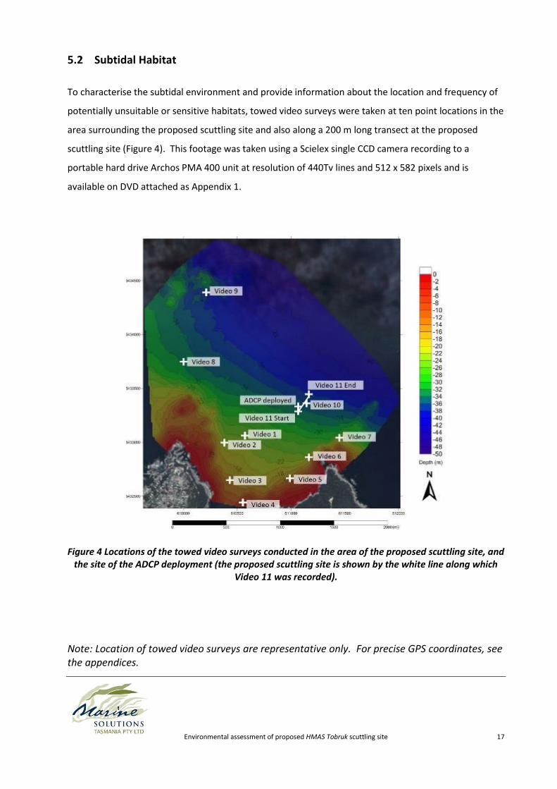
5.2 Subtidal Habitat
To characterise the subtidal environment and provide information about the location and frequency of
potentially unsuitable or sensitive habitats, towed video surveys were taken at ten point locations in the
area surrounding the proposed scuttling site and also along a 200 m long transect at the proposed
scuttling site (Figure 4). This footage was taken using a Scielex single CCD camera recording to a
portable hard drive Archos PMA 400 unit at resolution of 440Tv lines and 512 x 582 pixels and is
available on DVD attached as Appendix 1.
Figure 4 Locations of the towed video surveys conducted in the area of the proposed scuttling site, and the site of the ADCP deployment (the proposed scuttling site is shown by the white line along which
Video 11 was recorded).
Note: Location of towed video surveys are representative only. For precise GPS coordinates, see the appendices.
Environmental assessment of proposed HMAS Tobruk scuttling site 18
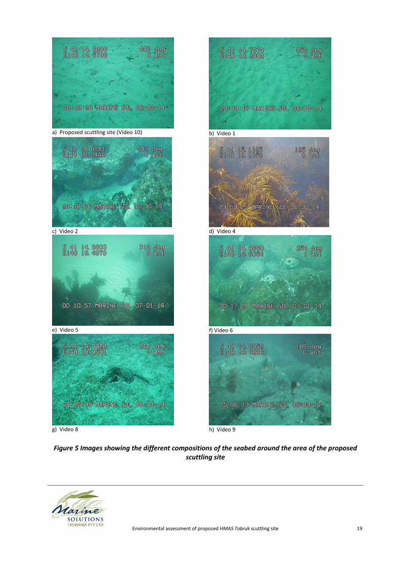
Two major habitat types were recorded, these being soft sediments (sand), and high profile rocky reef.
Predominantly, the rocky shoreline extends subtidally and creates high rugosity rocky reef supporting a
typical complex reef community of algae, invertebrates and fish life. At some distance offshore, the
rocky reef meets a flat sand boundary, and the habitat transitions rapidly to mobile sand. This
transition occurs variously between 3 m and 25 m depth. There is a discrete patch of high profile reef
located North West of the proposed scuttling site, and this can be clearly seen in Figure 3.
Sand was the dominant habitat in the remainder of the survey area, and covered the central part of
Skeleton Bay, and the remaining offshore areas. The reef edge at all the towed video sample locations
was devoid of sand scouring, indicating very little sand movement, but sand corrugations were present
at most towed video locations.
The variety of habitats can clearly be seen in Figure 5, and each video file is available in the Appendix 1.
Environmental assessment of proposed HMAS Tobruk scuttling site 19
a) Proposed scuttling site (Video 10)
b) Video 1
c) Video 2
d) Video 4
e) Video 5
f) Video 6
g) Video 8
h) Video 9
Figure 5 Images showing the different compositions of the seabed around the area of the proposed scuttling site
Environmental assessment of proposed HMAS Tobruk scuttling site 20
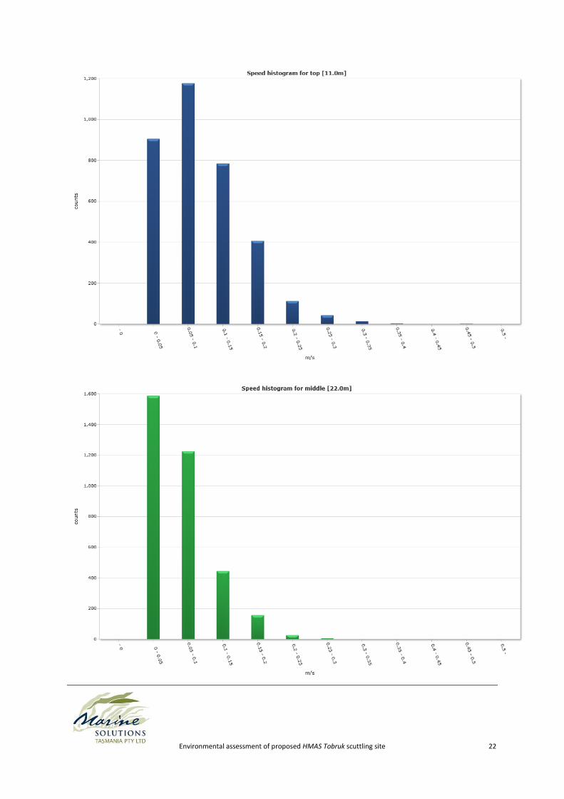
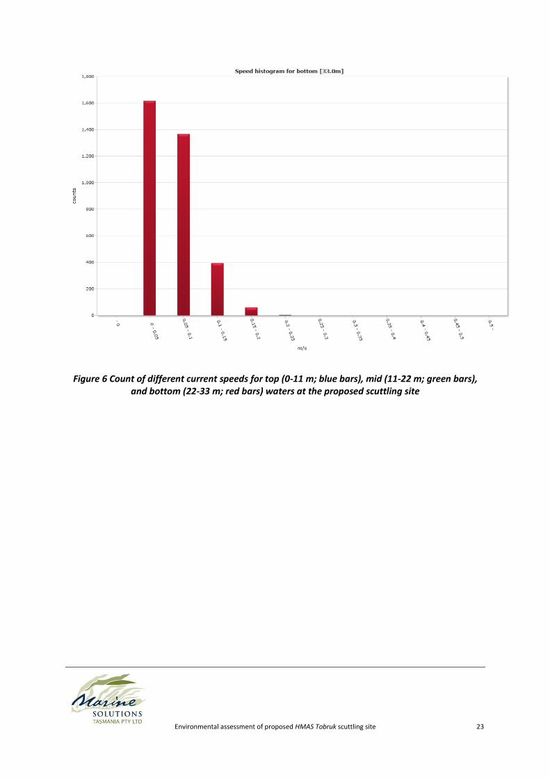
5.3 Hydrodynamics
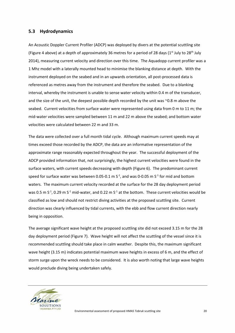
An Acoustic Doppler Current Profiler (ADCP) was deployed by divers at the potential scuttling site
(Figure 4 above) at a depth of approximately 36 metres for a period of 28 days (1st July to 28th July
2014), measuring current velocity and direction over this time. The Aquadopp current profiler was a
1 Mhz model with a laterally mounted head to minimise the blanking distance at depth. With the
instrument deployed on the seabed and in an upwards orientation, all post-processed data is
referenced as metres away from the instrument and therefore the seabed. Due to a blanking
interval, whereby the instrument is unable to sense water velocity within 0.4 m of the transducer,
and the size of the unit, the deepest possible depth recorded by the unit was ~0.8 m above the
seabed. Current velocities from surface water were represented using data from 0 m to 11 m; the
mid-water velocities were sampled between 11 m and 22 m above the seabed; and bottom water
velocities were calculated between 22 m and 33 m.
The data were collected over a full month tidal cycle. Although maximum current speeds may at
times exceed those recorded by the ADCP, the data are an informative representation of the
approximate range reasonably expected throughout the year. The successful deployment of the
ADCP provided information that, not surprisingly, the highest current velocities were found in the
surface waters, with current speeds decreasing with depth (Figure 6). The predominant current
speed for surface water was between 0.05-0.1 m S-1, and was 0-0.05 m S-1 for mid and bottom
waters. The maximum current velocity recorded at the surface for the 28 day deployment period
was 0.5 m S-1, 0.29 m S-1 mid-water, and 0.22 m S-1 at the bottom. These current velocities would be
classified as low and should not restrict diving activities at the proposed scuttling site. Current
direction was clearly influenced by tidal currents, with the ebb and flow current direction nearly
being in opposition.
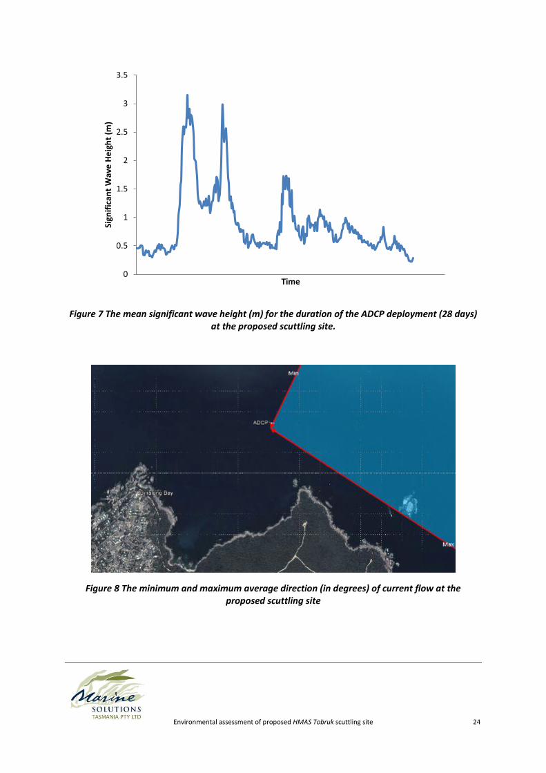
The average significant wave height at the proposed scuttling site did not exceed 3.15 m for the 28
day deployment period (Figure 7). Wave height will not affect the scuttling of the vessel since it is
recommended scuttling should take place in calm weather. Despite this, the maximum significant
wave height (3.15 m) indicates potential maximum wave heights in excess of 6 m, and the effect of
storm surge upon the wreck needs to be considered. It is also worth noting that large wave heights
would preclude diving being undertaken safely.
Environmental assessment of proposed HMAS Tobruk scuttling site 21
The peak wave direction during the ADCP deployment was found to be approximately 95 degrees,
but ranged between 38 degrees and 139 degrees (True) (Figure 8). This is consistent with the site
being protected by Eddystone Point in the north and Grants Point to the south.
Currents here are not thought to be an impediment to the successful sinking of the ship and its
utilisation as a dive wreck. Other dive sites in the area are dived year-round, including St Helens
Rock, Merrick Rock, The Doughboys and Elephant Rock (Jacques 1997), despite being located in
more exposed positions than the proposed scuttling site and therefore likely experiencing stronger
currents.
Given the recorded wave information appears a little more easterly than logic dictates, we would
recommend a 30 year hindcast model of sea conditions at this location to inform the angle at which
the vessel should be scuttled. The peak wave period in this instance was strongly influenced by a
single storm event causing large easterly swells, and the direction of these swells may not be
indicative of the average swell direction at this location. A 30 year hindcast weather model for this
location would be a cost effective method for better understanding the range of likely weather
conditions at this location, and the likely number of days diving may be impacted by large swell
heights. While the east coast of Tasmania is considered a climate change hotspot that may be
subject to rapid change over the coming decades, a 30 year hindcast model represents the best
information available for informing the expected weather conditions.
Environmental assessment of proposed HMAS Tobruk scuttling site 22
Environmental assessment of proposed HMAS Tobruk scuttling site 23
Figure 6 Count of different current speeds for top (0-11 m; blue bars), mid (11-22 m; green bars), and bottom (22-33 m; red bars) waters at the proposed scuttling site
Environmental assessment of proposed HMAS Tobruk scuttling site 24
Figure 7 The mean significant wave height (m) for the duration of the ADCP deployment (28 days) at the proposed scuttling site.
Figure 8 The minimum and maximum average direction (in degrees) of current flow at the proposed scuttling site
0
0.5
1
1.5
2
2.5
3
3.5
Sign
ific
ant
Wav
e H
eig
ht
(m)
Time
Environmental assessment of proposed HMAS Tobruk scuttling site 25
5.4 Sedimentation
In accordance with the ADCP data, large swells are experienced at the proposed scuttling site.
Despite such swells, the seabed-mounted ADCP was still sitting proud of the sand when retrieved by
divers and had not buried, indicating a stable sand environment at this depth (~35 m metres).
Further, the reef edges captured during towed video surveys do not exhibit lines of sand scour which
can indicate sand movement in large swell conditions. Settling time experiments (cross-reference
section 10.3) suggested that the sand at the proposed scuttling site is primarily reworked marine
sediments which fall from suspension readily and are unlikely to remain suspended following
disturbance.
Given the observations made on site, information on current and wave activity, and the nature of
the sand in the area, it is not expected the wreck will accumulate sediment at a rate in excess of
surrounding habitats.
5.5 Geology
The northeast coast of Tasmania is geologically stable. A search of the Minerals Database Tasmania
(2014) indicated that no mineral deposits have been recorded in the Skeleton Bay/Binalong Bay
region. No geological impediments to the scuttling of the vessel at this site are apparent.
Environmental assessment of proposed HMAS Tobruk scuttling site 26
6 Matters of National Environmental Significance
Under the Environmental Protection and Biodiversity Conservation Act 1999, actions that have, or
are likely to have a significant impact on a matter of national environmental significance (MNES)
require approval from the Australian Government Minister for the Environment (the Minister). The
Minister will decide whether assessment and approval is required under the EPBC Act.
There are nine matters of national environmental significance under the EPBC Act (DoE 2014a).
These are:
World heritage properties
National heritage places
Wetlands of international importance (listed under the Ramsar Convention)
Listed threatened species and ecological communities
Migratory species (protected under international agreements)
Commonwealth marine areas
The Great Barrier Reef Marine Park
Nuclear actions (including uranium mines)
A water source, in relation to coal seam gas development and large coal mining
development.
Each is discussed individually in the subsections below.
6.1 World Heritage Properties
A declared World Heritage Property is an area that has been included in the World Heritage List, or
declared by the Minister to be a World Heritage property.
The nearest World Heritage Properties to the proposed scuttling site are Australian Convict Sites at
Maria Island and at Brickendon Estate south of Launceston (DoE 2014b).
No World Heritage Properties will be affected by the proposed activity.

Environmental assessment of proposed HMAS Tobruk scuttling site 27
6.2 National Heritage Places
A National Heritage Place is a place that has been included on the National Heritage List on the basis
of natural, historic and/or indigenous places of outstanding heritage value (DoE 2014a).
The nearest National Heritage Places to the proposed scuttling site are Australian Convict Sites at
Maria Island and at Brickendon Estate south of Launceston (DoE 2014b). Therefore, no National
Heritage Places will be affected by the proposed activity.
6.3 Wetlands of international importance (listed under the Ramsar Convention)
A Wetland of International Importance is an area that has been designated under Article 2 of the
Ramsar Convention or declared by the Minister to be a declared Ramsar wetland under the EPBC Act
(DoE 2014a).
The nearest Ramsar Wetland to the proposed scuttling site is an area of approximately 46 acres near
Stieglitz (DoE 2014b) (Figure 9). This area is geographically sufficiently removed from the proposed
scuttling site that the proposed activity is not expected to have any impact on the wetland.
Figure 9 Map showing the nearest Ramsar Wetland (bound by blue line) to the proposed scuttling site.
Environmental assessment of proposed HMAS Tobruk scuttling site 28
No Wetlands of international importance will be affected by the proposed activity.
6.4 Listed threatened species and ecological communities
There are a number of marine species listed as threatened that may occur in the vicinity of the
proposed scuttling. Threatened species are protected under the Threatened Species Protection Act
1995 (TSPA, Tasmanian state legislation) and/or the Environment Protection and Biodiversity
Conservation Act 1999 (EPBCA, Australian Government legislation). In addition to threatened
species legislation, the Fisheries (General and Fees) Regulations 2006 under the Living Marine
Resources Management Act 1995 (LMRMA) prohibits the taking/possession of a number of marine
species, including Syngnathids (seahorses, seadragons and pipehorses), Handfish, Threefin Blennies,
Limpets/False Limpets of three superfamilies, and five species of shark. Additional species are
protected by the schedules of the Wildlife (General) Regulations 2010 (Regulations under the Nature
Conservation Act 2002 (NCA)), under which a person must not take, buy, sell or have possession of
any protected wildlife or any product of any protected wildlife without a permit.
Under the TSPA, listed species cannot be collected, disturbed, damaged or destroyed without a
permit. Under the EPBCA, any action with significant impact on a listed threatened species and/or
community is prohibited without approval (EPBCA Section 18 and 18A).
Threatened/protected species sighted during surveys included fur seals (most likely Australian fur
seals Arctocephalus pusillus) and dolphins (Delphinus delphis), all of which are protected under the
Environmental Protection and Biodiversity Conservation Act 1999.
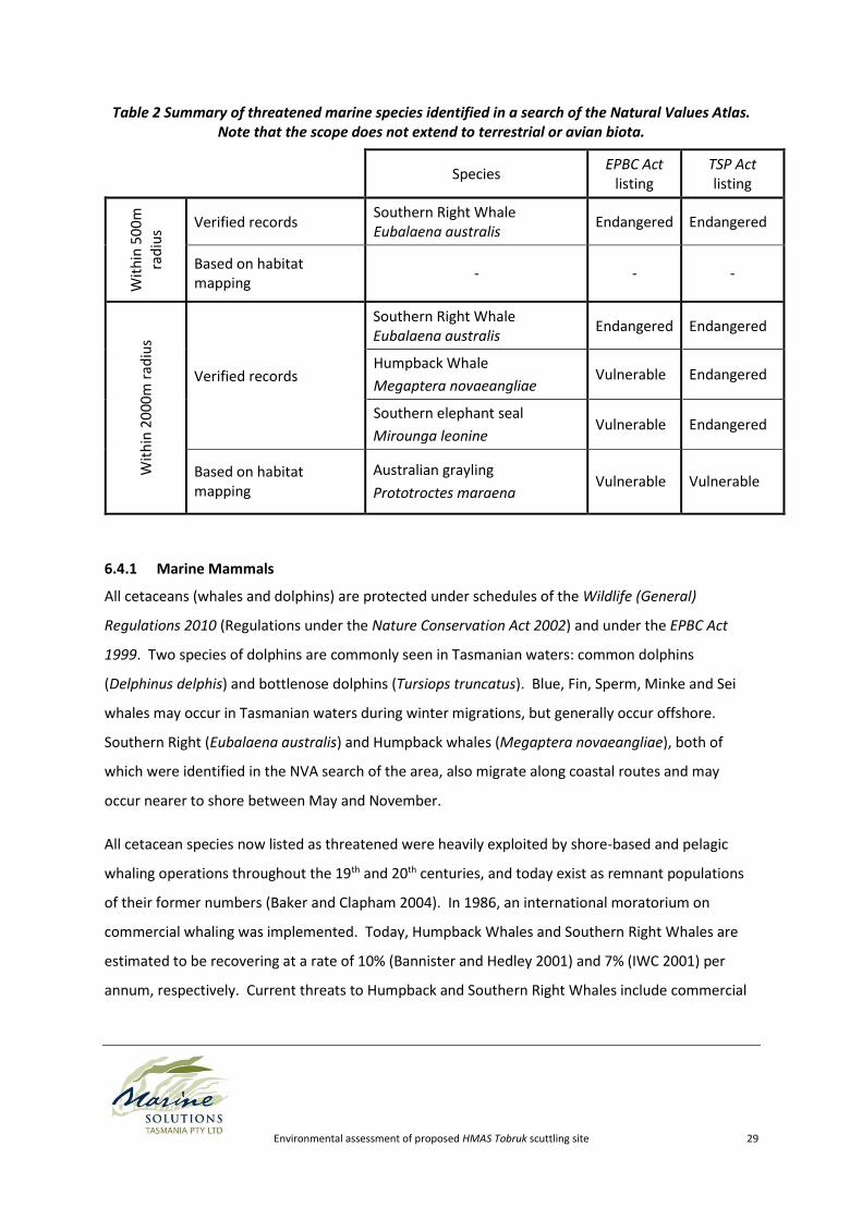
A further three threatened marine species, all mammals, were identified by the Natural Values Atlas
(NVA; DPIPWE 2014) as occurring within 2000 m of the potential scuttling site. Only one of these,
the Southern right whale, was identified occurring within a 500 m radius of the study area. The
results of the NVA search are summarised in Table 2 below. No threatened aquatic communities
were identified within 2000m of the proposed scuttling site.
The sinking of the HMAS Tobruk is considered unlikely to have a detrimental impact on any
threatened or protected species.
Environmental assessment of proposed HMAS Tobruk scuttling site 29
Table 2 Summary of threatened marine species identified in a search of the Natural Values Atlas. Note that the scope does not extend to terrestrial or avian biota.
Species EPBC Act
listing TSP Act listing
Wit
hin
50
0m
ra
diu
s
Verified records Southern Right Whale Eubalaena australis
Endangered Endangered
Based on habitat mapping
- - -
Wit
hin
20
00
m r
adiu
s
Verified records
Southern Right Whale Eubalaena australis
Endangered Endangered
Humpback Whale
Megaptera novaeangliae Vulnerable Endangered
Southern elephant seal
Mirounga leonine Vulnerable Endangered
Based on habitat mapping
Australian grayling
Prototroctes maraena Vulnerable Vulnerable
6.4.1 Marine Mammals
All cetaceans (whales and dolphins) are protected under schedules of the Wildlife (General)
Regulations 2010 (Regulations under the Nature Conservation Act 2002) and under the EPBC Act
1999. Two species of dolphins are commonly seen in Tasmanian waters: common dolphins
(Delphinus delphis) and bottlenose dolphins (Tursiops truncatus). Blue, Fin, Sperm, Minke and Sei
whales may occur in Tasmanian waters during winter migrations, but generally occur offshore.
Southern Right (Eubalaena australis) and Humpback whales (Megaptera novaeangliae), both of
which were identified in the NVA search of the area, also migrate along coastal routes and may
occur nearer to shore between May and November.
All cetacean species now listed as threatened were heavily exploited by shore-based and pelagic
whaling operations throughout the 19th and 20th centuries, and today exist as remnant populations
of their former numbers (Baker and Clapham 2004). In 1986, an international moratorium on
commercial whaling was implemented. Today, Humpback Whales and Southern Right Whales are
estimated to be recovering at a rate of 10% (Bannister and Hedley 2001) and 7% (IWC 2001) per
annum, respectively. Current threats to Humpback and Southern Right Whales include commercial

Environmental assessment of proposed HMAS Tobruk scuttling site 30
whaling/scientific-permit whaling, acoustic pollution, entanglement (e.g. marine debris, fishing
equipment), ship-strike injury and water quality degradation (DSEWPC 2014).
Dolphins are frequently sighted in Skeleton Bay, and would foreseeably be sighted regularly by
divers in the area. Conversely, although Humpback Whales and Southern Right Whales have been
recorded in the region (DPIPWE 2014), the rarity of occurrence means that any interaction between
whales and the wreck would likely be infrequent. Whales generally exhibit an avoidance behaviour
of fixed objects and are therefore not likely to directly contact a wreck.
Two pinniped species breed in Tasmanian waters: the Australian Fur Seal Arctocephalus pusillus and
the New Zealand Fur Seal Arctocephalus forsteri (the latter of which is listed as Rare under state
legislation) (DPIPWE 2012). The New Zealand Fur Seal's distribution is generally restricted to the
south and west of the state, so it is unlikely to occur in the region. Other pinniped species may occur
as wandering vagrant individuals in the area, including the Australian Sea-Lion Neophoca cinerea, the
Southern Elephant Seal Mirounga leonina and the Sub-Antarctic Fur Seal Arctocephalus tropicalis.
The most common pinniped to occur in the area, the Australian Fur Seal, Arctocephalus pusillus is
not listed as threatened but is protected. Historically, sealing until the 1920’s reduced populations
of all Tasmanian seal species. Current processes threatening pinnipeds include entanglement in
fishing equipment, competition for food with commercial fishing operations and incidental capture
by commercial fishing operations (DSEWPC 2014). Seals would foreseeably be sighted regularly by
divers in the area.
The presence of the wreck once sunk is not considered to pose a direct threat to cetacean or
pinniped populations. However, the process of scuttling may detrimentally impact marine mammals
and other noise-sensitive fauna. The main consideration is that underwater detonations may result
in distress and/or barotrauma to animals in the vicinity, which can be lethal (Richardson et al 1995).
An appropriate mitigation would be adherence to government guidelines for seismic activity as
provided in DEWHA's (2008) EPBC Act Policy Statement 2.1, which requires that a Marine Mammal
Observer surveys the area for at least 30 minutes prior to works start-up, and that works are delayed
or ceased, depending on proximity, should marine mammals be sighted. Action guidelines as per
DEWHA (2008) are shown in Figure 10, and are dependent on the sound levels animals are likely to
receive. Peak pressure for linear charges, such as the cutting charges typically used in vessel
scuttling, is 30% to 70% lower than for point source detonations. Impulse strengths are 30% to 55%
lower (Lewis 1996). Therefore, assuming that cutting charges are used to scuttle the vessel, it is
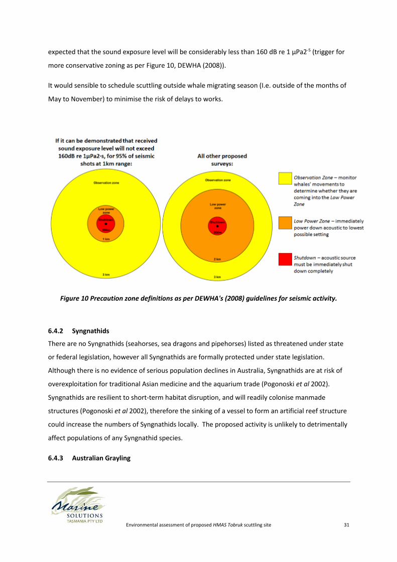
Environmental assessment of proposed HMAS Tobruk scuttling site 31
expected that the sound exposure level will be considerably less than 160 dB re 1 µPa2-S (trigger for
more conservative zoning as per Figure 10, DEWHA (2008)).
It would sensible to schedule scuttling outside whale migrating season (I.e. outside of the months of
May to November) to minimise the risk of delays to works.
Figure 10 Precaution zone definitions as per DEWHA's (2008) guidelines for seismic activity.
6.4.2 Syngnathids
There are no Syngnathids (seahorses, sea dragons and pipehorses) listed as threatened under state
or federal legislation, however all Syngnathids are formally protected under state legislation.
Although there is no evidence of serious population declines in Australia, Syngnathids are at risk of
overexploitation for traditional Asian medicine and the aquarium trade (Pogonoski et al 2002).
Syngnathids are resilient to short-term habitat disruption, and will readily colonise manmade
structures (Pogonoski et al 2002), therefore the sinking of a vessel to form an artificial reef structure
could increase the numbers of Syngnathids locally. The proposed activity is unlikely to detrimentally
affect populations of any Syngnathid species.
6.4.3 Australian Grayling
Environmental assessment of proposed HMAS Tobruk scuttling site 32
The Australian Grayling Prototroctes maraena is native to Tasmania and southeast mainland
Australia. Australian Grayling have a diadromous lifecycle, inhabiting fresh water streams as adults,
and migrating to coastal seas as larvae. Spawning takes place in late spring/early summer (Bryant
and Jackson 1999). Larvae are transported to sea in stream/river currents, and return as migrating
juveniles approximately 4-6 months later (Bryant and Jackson 1999).
The most serious threat facing the Australian Grayling population is habitat alteration resulting in
barriers to migration, such as damming. Pollution of waterways is also considered a threat to their
survival.
Although the Natural Values Atlas identifies potential habitat for the Australian Grayling within 2000
m, none is identified within 500m, nor are there any verified records of this species within the 2000
m radius of this NVA search. Furthermore, the activity of scuttling a vessel is not considered a
potential threat to the species (the main threats being barrier to migration and water pollution).
6.5 Migratory species protected under international agreements
Migratory species are those animals that migrate to Australia and its external territories, or pass
through or over Australian waters during their annual migrations (DoE 2014a).
Listed migratory species2 are those listed in the:
Convention on the Conservation of Migratory Species of Wild Animals (Bonn Convention)
China-Australia Migratory Bird Agreement (CAMBA)
Japan-Australia Migratory Bird Agreement (JAMBA)
Republic of Korea-Australia Migratory Bird Agreement (ROKAMBA)
Refer to Section 6.4.1 (Marine Mammals) for information pertaining to migratory cetaceans.
Note that the scope of this report does not extend to birds. A comprehensive investigation on the
impacts of the scuttling of the HMAS Tobruk and its establishment as a wreck site should be
2 An EPBC-listed migratory species list can be found at http://www.environment.gov.au/cgi-bin/sprat/public/publicshowmigratory.pl
Environmental assessment of proposed HMAS Tobruk scuttling site 33
conducted as a component of the environmental risk assessment required to be undertaken, should
the proposal proceed to the next stage.
6.6 Commonwealth marine areas
A Commonwealth marine area is any part of the sea within Australia’s Exclusive Economic Zone
and/or over the continental shelf of Australia, that is, not State or Territory Waters (DoE 2014a). The
Commonwealth marine area encompasses an area 3 to 200 nautical miles from the coast.
The proposed scuttle site is only ~0.3 nautical miles off the coast, therefore it is spatially distant from
the Commonwealth marine area.
The proposed activity is not expected to impact Commonwealth marine areas.
6.7 The Great Barrier Reef Marine Park
The Great Barrier Reef Marine Park is a world heritage-listed coral reef ecosystem of over 344,000
square kilometres off the coast of Queensland (DoE 2014a). There are no significant biological,
ecological, or environmental links between the Great Barrier Reef Marine Park and the proposed
scuttling location. Therefore, the proposed scuttling is not expected to impact the Great Barrier
Reef Marine Park.
6.8 Nuclear actions (including uranium mines)
Nuclear actions are beyond the scope of this investigation. An investigation into nuclear actions
should be conducted as a component of the full environmental risk assessment required to be
Environmental assessment of proposed HMAS Tobruk scuttling site 34
undertaken, should the proposal proceed to the next stage. To the author’s knowledge, no nuclear
actions3 are occur or are anticipated to occur within the region of the proposed scuttling site.
6.9 A water source, in relation to coal seam gas development and large coal
mining development.
Water resources are beyond the scope of this investigation. An investigation into water sources in
relation to coal seam gas/coal mining development may be conducted as a component of the full
environmental risk assessment required to be undertaken, should the proposal proceed to the next
stage.
3 Definition of nuclear actions is provided at http://www.environment.gov.au/epbc/what-is-protected/nuclear-actions
Environmental assessment of proposed HMAS Tobruk scuttling site 35
7 Introduced Marine Pests
Marine pests are introduced into Australian waters and translocated by a variety of vectors (e.g.
ballast water, biofouling, aquaculture operations, and ocean current movements). Once introduced,
they often thrive as they may lack predators and/or competitors in their new environment
(Whitehead 2008). Pests can have a significant impact on human health, fisheries and aquaculture,
infrastructure, tourism, biodiversity and ecosystem health.
Seven species have been declared as pests under State legislation4. These are:
Northern Pacific sea star (A. amurensis),
European shore crab (Carcinus maenas),
European fan worm (Sabella spallanzanii),
Japanese Wakame (Undaria pinnatifida),
Black striped mussel (Mytilopsis sallei),
European Carp (Cyprinus carpio), and
Green algae (Caulerpa taxifolia).
Many more are recognised as pests by the National Introduced Marine Pest Information System
(NIMPIS 2014).
No introduced pest species were observed at this site throughout surveying, although the study area
is within the known range of Japanese wakame Undaria pinnatifida, European shore crabs Carcinus
maenus and New Zealand screw shells Maoricolpus roseus. It should be ensured that no marine
species are translocated as a result of vessel/equipment movement, by adopting a thorough
cleaning protocol. Hull cleaning can be conducted in-water or by dry docking at a suitable location.
North east Tasmania is not deemed a suitable location for this due to the associated risks of
contamination and marine pest transfer. A qualitative risk assessment for marine pest transfer will
be a critical component of the recommended full environmental risk assessment, prior to the
transport of the vessel to Tasmanian waters. Existing state legislation provides controls by which to
prevent the translocation of marine pest species.
4 Fisheries (General and Fees) Regulations 1996, Part 20: Noxious fish, outlined in the Living Marine Resources Management Act 1995
Environmental assessment of proposed HMAS Tobruk scuttling site 36
The waters around north-east Tasmania are well-recognised as a range extension hotspot (RedMap
2014; Pitt et al 2010; Ling et al 2009). Known processes independent of the proposed scuttling, such
as extension of the East Australian Current, have resulted in a range of marine species exhibiting a
pole-ward range expansion (Pitt et al 2010). This is important to acknowledge in the context of
ongoing monitoring, particularly in the context of differentiating range extending species from
introduced species.
Environmental assessment of proposed HMAS Tobruk scuttling site 37
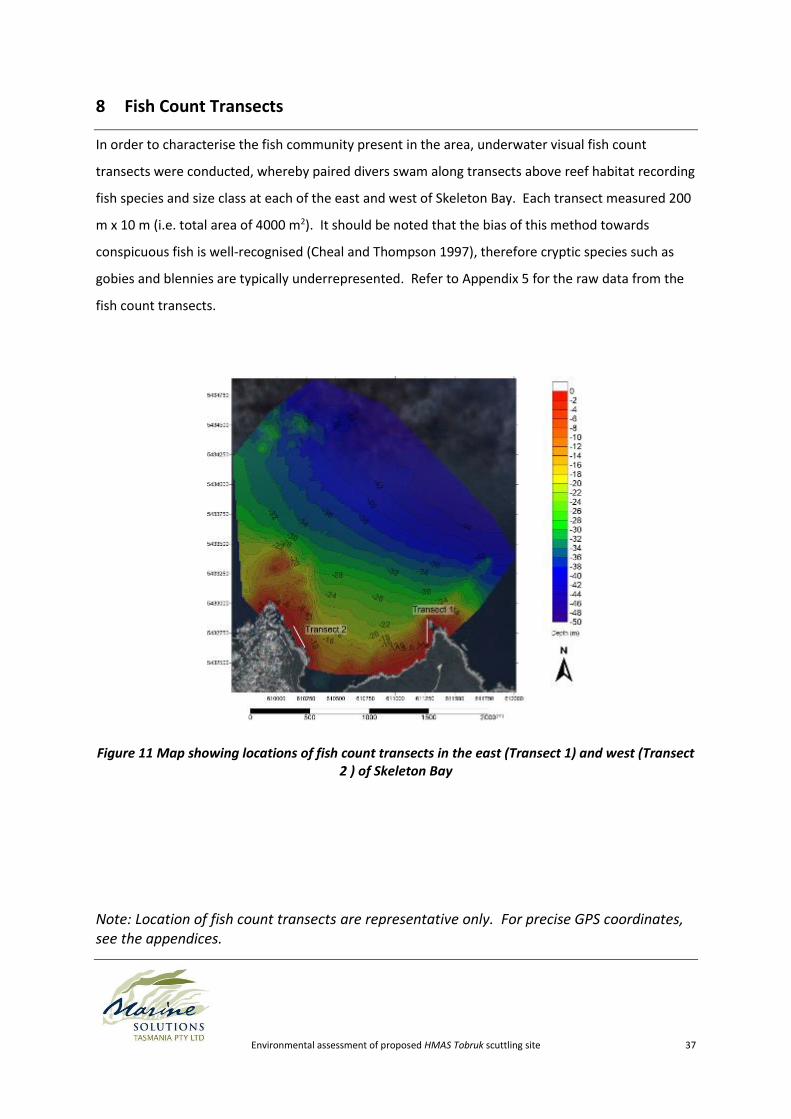
8 Fish Count Transects
In order to characterise the fish community present in the area, underwater visual fish count
transects were conducted, whereby paired divers swam along transects above reef habitat recording
fish species and size class at each of the east and west of Skeleton Bay. Each transect measured 200
m x 10 m (i.e. total area of 4000 m2). It should be noted that the bias of this method towards
conspicuous fish is well-recognised (Cheal and Thompson 1997), therefore cryptic species such as
gobies and blennies are typically underrepresented. Refer to Appendix 5 for the raw data from the
fish count transects.
Figure 11 Map showing locations of fish count transects in the east (Transect 1) and west (Transect 2 ) of Skeleton Bay
Note: Location of fish count transects are representative only. For precise GPS coordinates, see the appendices.
Environmental assessment of proposed HMAS Tobruk scuttling site 38
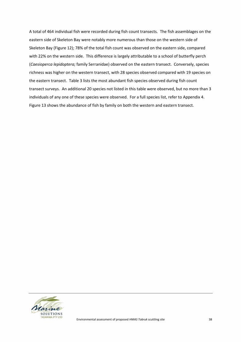
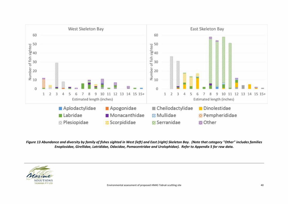
A total of 464 individual fish were recorded during fish count transects. The fish assemblages on the
eastern side of Skeleton Bay were notably more numerous than those on the western side of
Skeleton Bay (Figure 12); 78% of the total fish count was observed on the eastern side, compared
with 22% on the western side. This difference is largely attributable to a school of butterfly perch
(Caesioperca lepidoptera; family Serranidae) observed on the eastern transect. Conversely, species
richness was higher on the western transect, with 28 species observed compared with 19 species on
the eastern transect. Table 3 lists the most abundant fish species observed during fish count
transect surveys. An additional 20 species not listed in this table were observed, but no more than 3
individuals of any one of these species were observed. For a full species list, refer to Appendix 4.
Figure 13 shows the abundance of fish by family on both the western and eastern transect.
Environmental assessment of proposed HMAS Tobruk scuttling site 39
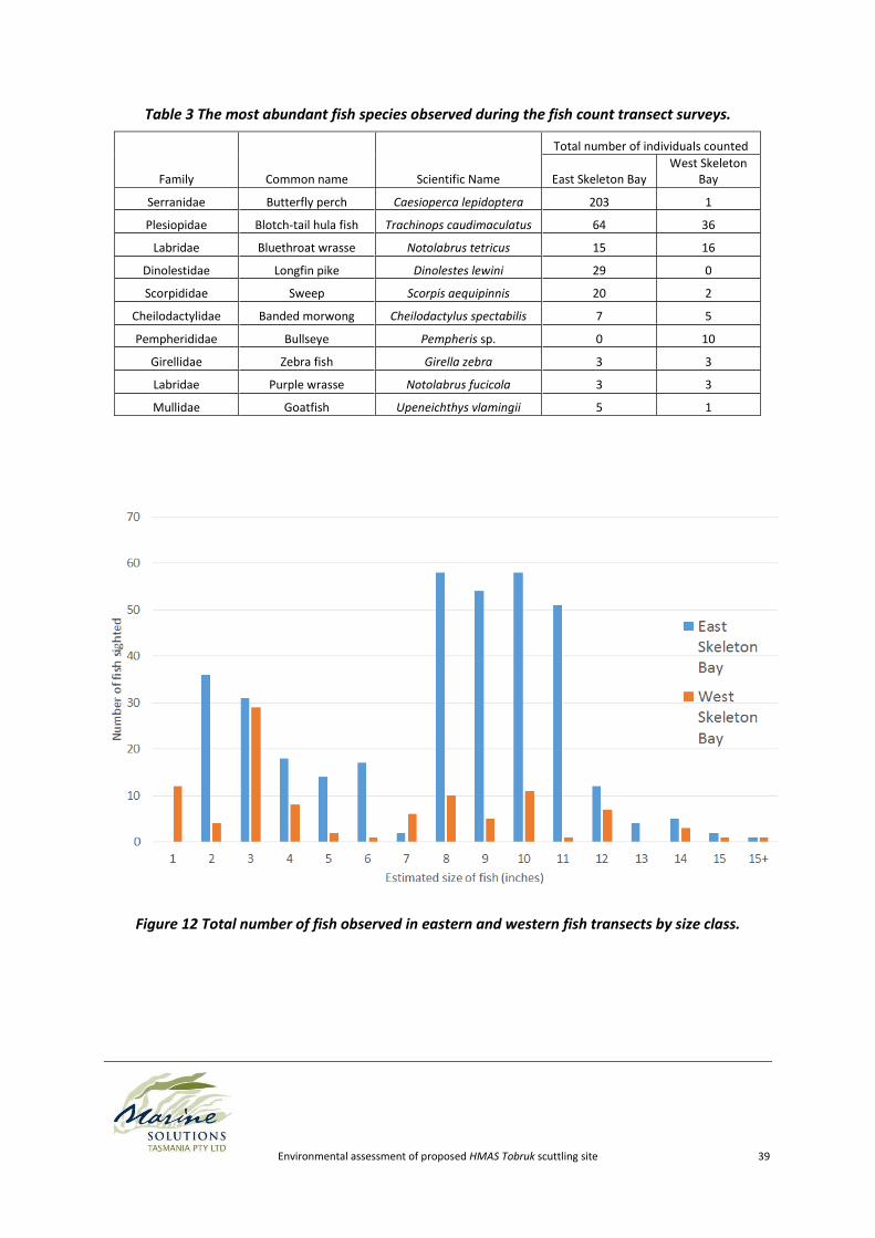
Table 3 The most abundant fish species observed during the fish count transect surveys.
Family Common name Scientific Name
Total number of individuals counted
East Skeleton Bay West Skeleton
Bay
Serranidae Butterfly perch Caesioperca lepidoptera 203 1
Plesiopidae Blotch-tail hula fish Trachinops caudimaculatus 64 36
Labridae Bluethroat wrasse Notolabrus tetricus 15 16
Dinolestidae Longfin pike Dinolestes lewini 29 0
Scorpididae Sweep Scorpis aequipinnis 20 2
Cheilodactylidae Banded morwong Cheilodactylus spectabilis 7 5
Pempherididae Bullseye Pempheris sp. 0 10
Girellidae Zebra fish Girella zebra 3 3
Labridae Purple wrasse Notolabrus fucicola 3 3
Mullidae Goatfish Upeneichthys vlamingii 5 1
Figure 12 Total number of fish observed in eastern and western fish transects by size class.
Environmental assessment of proposed HMAS Tobruk scuttling site 40
Figure 13 Abundance and diversity by family of fishes sighted in West (left) and East (right) Skeleton Bay. (Note that category "Other" includes families Enoplosidae, Girellidae, Latrididae, Odacidae, Pomacentridae and Urolophidae). Refer to Appendix 5 for raw data.
Environmental assessment of proposed HMAS Tobruk scuttling site 41
Fish species were also observed on towed video recordings. Notably, a relatively high density of
gurnards (family Triglidae; possibly Pterygotrigla polyommata or Lepidotrigla vanessa) were
recorded on the sand at the proposed scuttling site (see Appendix 1 Video 11 ~09:54).
Approximately 5 individuals can be seen in 10 seconds of video recording.
Environmental assessment of proposed HMAS Tobruk scuttling site 42
9 Impacts on Sharks and Shark/Human Interactions
Many species of sharks are found around north east Tasmania, a small number of which may be
harmful to humans. In response to concerns raised in public forums, Marine Solutions has been
asked to comment directly on the potential of the HMAS Tobruk to impact on shark behaviour and
shark/human interactions.
The main species of concern relating to potentially dangerous shark/human interactions in Tasmania
is the Great White Shark (Carcharodon carcharias). The Great White Shark can be found in all
marine environments in the southern half of Australia (DEWHA 2009). They are sometimes found in
association with areas of high prey density, such as seal colonies (DEWHA 2009). Tagging studies
have determined that individual Great White Sharks appear to undergo seasonal migrations,
travelling as far north as central Queensland in autumn/winter and returning south in spring (CMAR
2007). While reports of Great White Shark sightings in north-east Tasmanian waters are uncommon,
it is not outside of their known range, and although unlikely, it is possible that individuals may occur
within the vicinity of Skeleton Bay.
While a variety of shark species will invariably visit the area over time, there is no evidence to
suggest that scuttling a wreck will increase the frequency of visits, or the longevity of time the sharks
remain in the area. It has been shown repeatedly using archival and sonic tags that great white
sharks travel large distances, and are not resident in an area (e.g. DSEWPC 2011; Weng et al 2007;
Bruce & Bradford 2008; Bruce et al 2006). The wreck will act as a large area of high rugosity reef,
which is not expected to attract or repel sharks any more or less than any other high rugosity reef, of
which there are already substantial areas in the region.
Many shark species are protected, as their numbers have been declining. The main process
threatening Great White Sharks is commercial fishing. Beach netting and baiting for human
protection is also recognised as a threat to the species, however this is not practised in Tasmanian
waters. It is not thought that scuttling a wreck will be a contributing factor to the processes
threatening shark populations.
Environmental assessment of proposed HMAS Tobruk scuttling site 43
10 Sediments
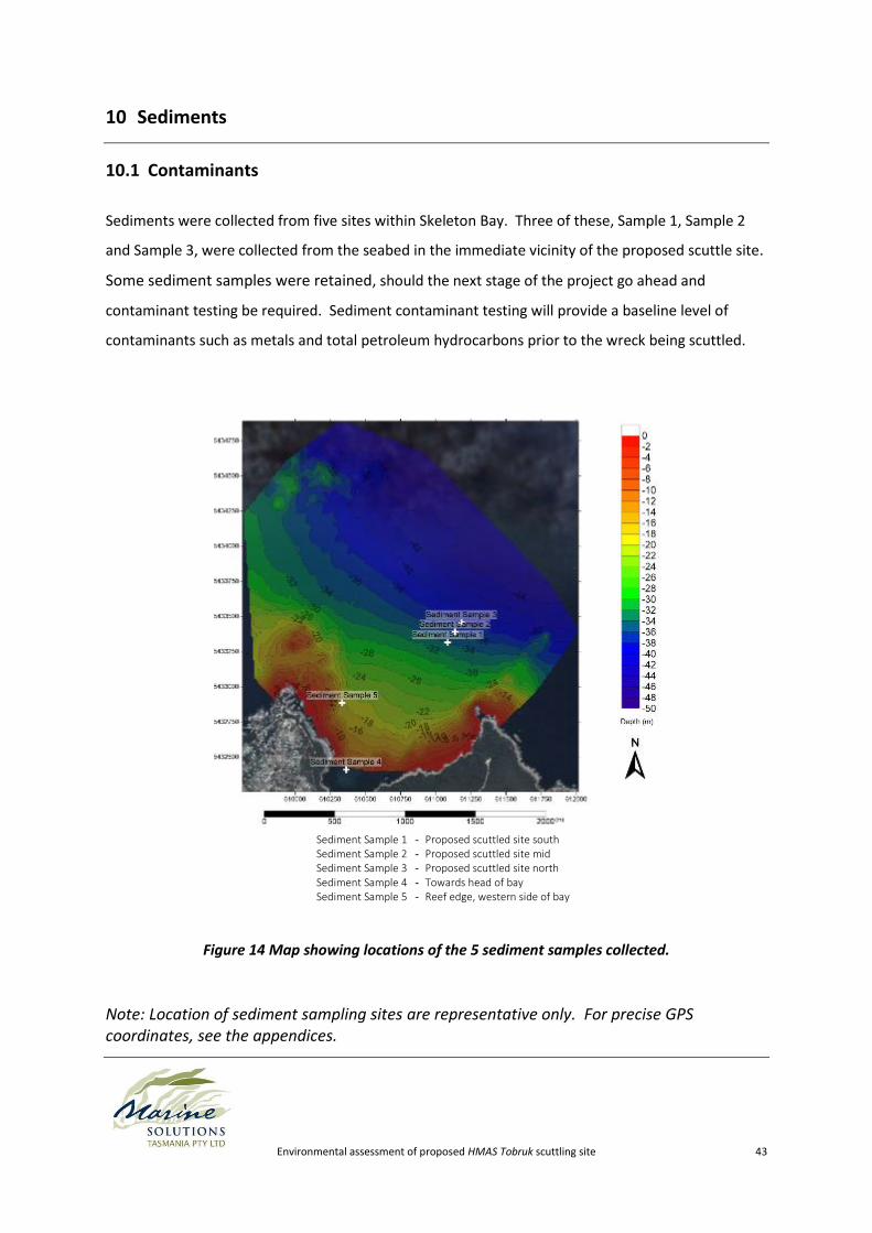
10.1 Contaminants
Sediments were collected from five sites within Skeleton Bay. Three of these, Sample 1, Sample 2
and Sample 3, were collected from the seabed in the immediate vicinity of the proposed scuttle site.
Some sediment samples were retained, should the next stage of the project go ahead and
contaminant testing be required. Sediment contaminant testing will provide a baseline level of
contaminants such as metals and total petroleum hydrocarbons prior to the wreck being scuttled.
Sediment Sample 1 - Proposed scuttled site south Sediment Sample 2 - Proposed scuttled site mid Sediment Sample 3 - Proposed scuttled site north Sediment Sample 4 - Towards head of bay Sediment Sample 5 - Reef edge, western side of bay
Figure 14 Map showing locations of the 5 sediment samples collected.
Note: Location of sediment sampling sites are representative only. For precise GPS coordinates, see the appendices.
Environmental assessment of proposed HMAS Tobruk scuttling site 44
A study of sediments in the vicinity of the Swan (naval vessel scuttled off Western Australia in 1997)
indicated that, although not detectable 5 months post-scuttling, sediment enrichment was evident
in the immediate surrounds 12 months post-scuttling (MacLeod et al 2004). Enrichment of
chromium, copper, iron, lead and zinc was evident after 12 months, but only copper exceeded the
Environment Australia (2002) guidelines. Enrichment was directly attributable to metal corrosion
and degradation of protective paint layers. No enrichment was evident for petroleum hydrocarbons,
aluminium or cadmium. Similar results were observed for the Perth (scuttled in Western Australia in
2001) and the Hobart (scuttled in South Australia in 2002). Enrichment at the levels observed on the
naval vessels the Swan, the Perth and the Hobart are not considered to result in adverse
environmental impacts. Based on such previous studies, metals contamination of the sediments
around the scuttled HMAS Tobruk is not expected to have a large impact on marine life, however,
ongoing long-term monitoring of sediments for metals and TBT should be conducted. It is essential
that all contamination risks are adequately understood prior to scuttling, and that the vessel is
prepared in a manner that ensures the minimisation of negative effects on the marine environment.
Cleaning of the vessel hull of antifoulant prior to its dispatch to northeast Tasmania is considered to
be an essential component of environmental risk mitigation.
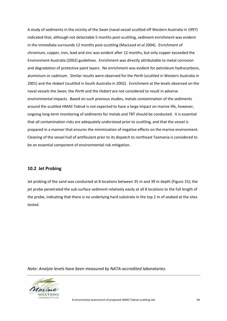
10.2 Jet Probing
Jet probing of the sand was conducted at 8 locations between 35 m and 39 m depth (Figure 15); the
jet probe penetrated the sub-surface sediment relatively easily at all 8 locations to the full length of
the probe, indicating that there is no underlying hard substrate in the top 2 m of seabed at the sites
tested.
Note: Analyte levels have been measured by NATA-accredited laboratories.
Environmental assessment of proposed HMAS Tobruk scuttling site 45
Figure 15 Map showing jet probe locations within the proposed scuttling site.
Note: Location of jet probing sites are representative only. For precise GPS coordinates, see the appendices.
Environmental assessment of proposed HMAS Tobruk scuttling site 46
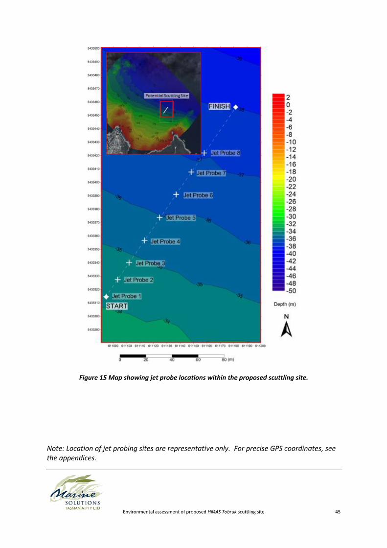
10.3 Particle Size Distribution and Settling Times
As a wreck hits the bottom, sediment disturbance can cause a plume which may impact the
environment. To inform the extent and duration of any potential plume, particle size distribution
and a particle sediment test were conducted.
The particle size distribution showed that 90% of sediments were medium-grained, between 0.125
and 0.25 mm in size (Figure 16).
A particle settlement test revealed that sediments from the potential scuttle site are mostly dense,
settling quickly. Only twenty seconds post-agitation, a large fraction of the total sediment had
settled as a layer on the bottom of the test container. There is also a fraction of fine, easily
suspended sediment, as evidenced by the high turbidity of water remaining at the conclusion of the
experiment (45 minutes post-agitation) (0).
Figure 16 Particle size distribution of a sediment sample from the potential scuttling site.
Environmental assessment of proposed HMAS Tobruk scuttling site 47
11 Corrosion and Colonisation
The vessel will ultimately corrode in the marine environment, and the likely mix of dissimilar metals
may speed corrosion in some areas relative to other areas of the vessel. The rate of deterioration of
metal objects underwater is dependent on the flux of oxygen to the metal surface, and therefore the
water depth, with water movement generally decreasing with increasing depth (MacLeod et al
2004). Based on previous studies of naval wrecks in similar environments, it is expected that
corrosion rates will increase over time in the years immediately following, but will remain slow even
after several years underwater (MacLeod et al 2004).
Serious structural degradation of the HMAS Tobruk resulting in diver safety hazard is considered
unlikely, with other wrecks in Tasmanian waters (e.g. Tasman, Nord) having lasted in excess of 100
years in a reasonably intact state, despite being in a comparable environment. However, ongoing
periodic structural monitoring is required as a measure of prudence (see section 14). Doppler
testing can assess the hull thickness if required. We hypothesize that, given years, the wreck may
become encapsulated by biological foulants, which would cause partial or whole separation of the
anodic and cathodic sites effectively slowing the corrosion rate. Professional advice should be
sought as to the design and implementation of a structural monitoring program.
The vessel will provide hard substrate for the settlement of sessile invertebrates and algae. It is also
expected to attract mobile organisms, including reef fish. Periodically, the hull and superstructure
will corrode to the point where some of this encrusting colonisation material is ‘sloughed’ off to
create drift algae and sponges.
Environmental assessment of proposed HMAS Tobruk scuttling site 48
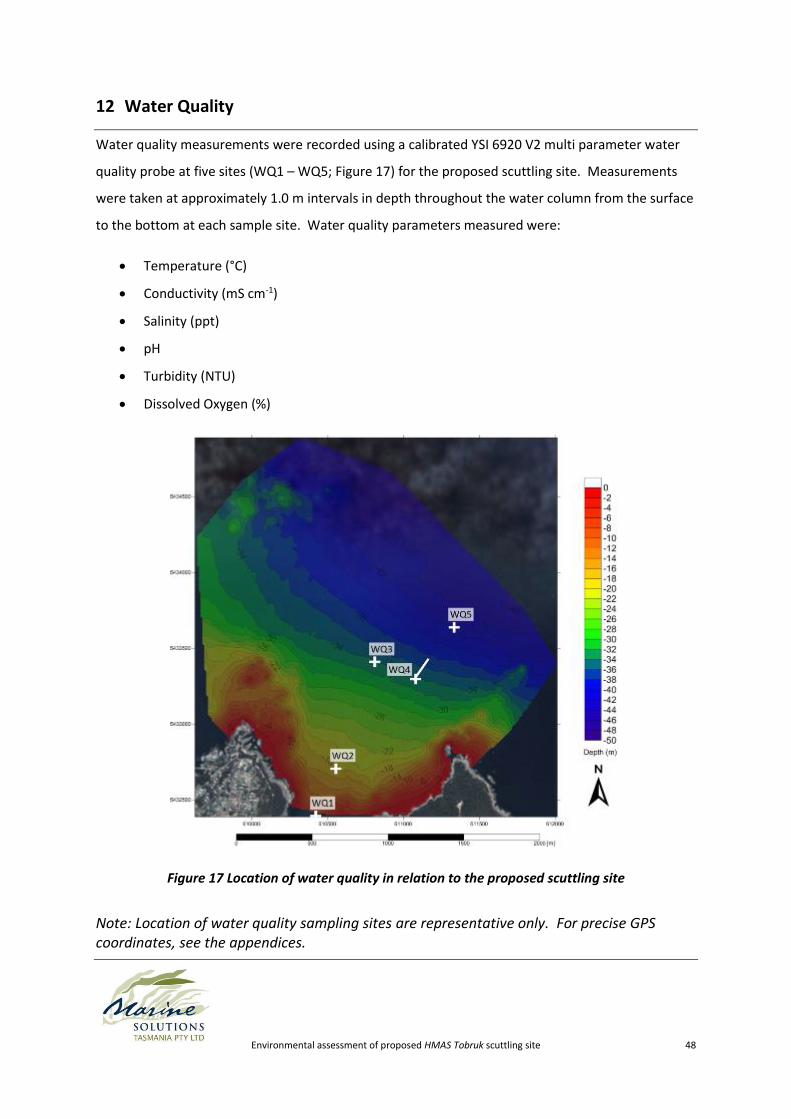
12 Water Quality
Water quality measurements were recorded using a calibrated YSI 6920 V2 multi parameter water
quality probe at five sites (WQ1 – WQ5; Figure 17) for the proposed scuttling site. Measurements
were taken at approximately 1.0 m intervals in depth throughout the water column from the surface
to the bottom at each sample site. Water quality parameters measured were:
Temperature (°C)
Conductivity (mS cm-1)
Salinity (ppt)
pH
Turbidity (NTU)
Dissolved Oxygen (%)
Figure 17 Location of water quality in relation to the proposed scuttling site
Note: Location of water quality sampling sites are representative only. For precise GPS coordinates, see the appendices.
Environmental assessment of proposed HMAS Tobruk scuttling site 49
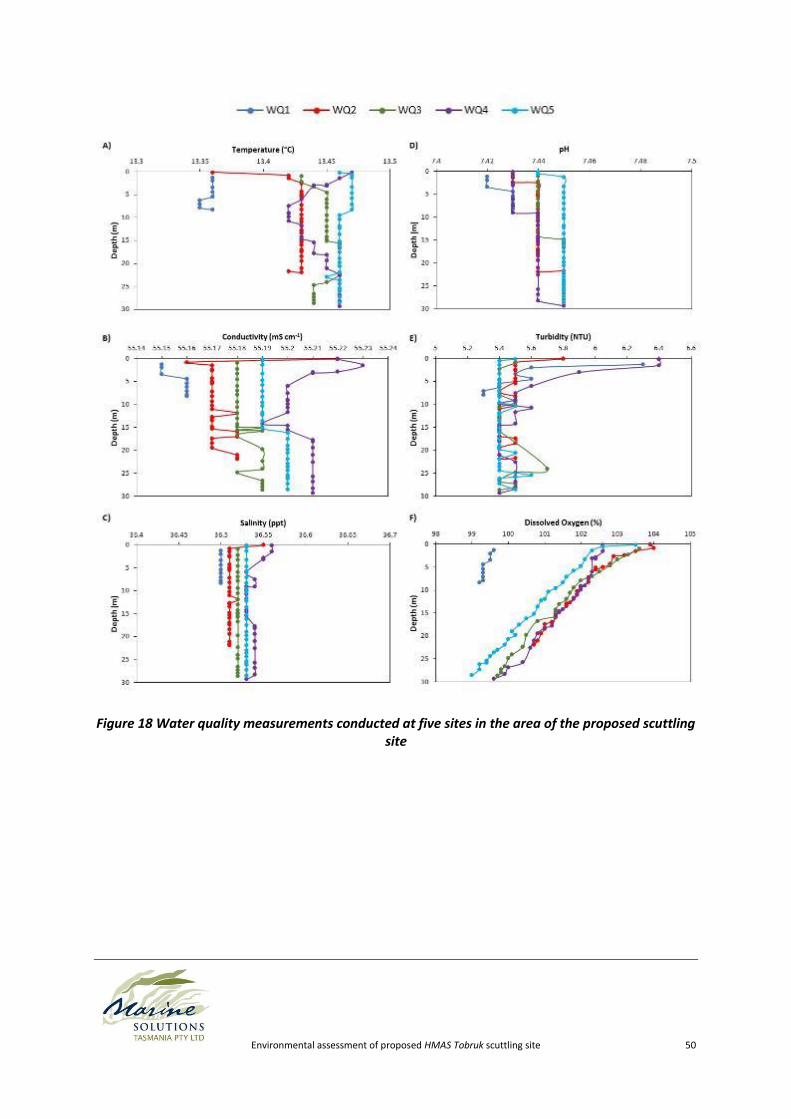
No obvious trends were observed between the five sample sites for conductivity (Figure 18B),
salinity (Figure 18C), or turbidity (Figure 18E). There was some variation in measurements between
the WQ1 sample site and all other sample sites for temperature (Figure 18A), and dissolved oxygen
(Figure 18F). Temperature and dissolved oxygen concentrations were marginally lower at WQ1 than
the other water quality sampling sites. This is due to the shallow nature of the WQ1 site compared
to other sites. There was also a slight difference in pH readings between sample sites, which
appeared to be a consequence of pH readings not stabilising rapidly enough between sample sites,
as the pH progressively increased from the first sample site (site WQ1) to the final sample site (site
WQ5). However, this difference was only very minor, with the difference being 0.03 between the
first and last sample sites.
Environmental assessment of proposed HMAS Tobruk scuttling site 50
Figure 18 Water quality measurements conducted at five sites in the area of the proposed scuttling site
Environmental assessment of proposed HMAS Tobruk scuttling site 51
Water temperatures were relatively stratified, with no major changes in temperature with depth at
most sites apart from measurements taken at the proposed scuttling site (WQ4). The temperature
at WQ4 gradually decreased by 0.04 °C from the surface to 7.5 m depth before increasing again by
0.03 °C between 11 m and the sea floor. This minor difference in temperature may be due to the
sub-surface current experienced by divers near the WQ4 site while retrieving the ADCP.
Conductivity, salinity, and pH remained consistent with depth at all sample sites. There was a slight
decrease in conductivity (55.22 to 55.16 mS cm-1) and salinity (36.55 to 36.51) between the surface
and 1m at WQ2. Conductivity and pH ranged between 55.23 and 55.15 mS cm-1 and 7.45 and 7.42,
respectively over all sites examined. Salinity measurements were between 36.56 and 36.50 ppt for
all sites examined.
Turbidity was similar across all water quality sampling sites, with a slightly higher turbidity in surface
waters across all sites. The higher turbidity on the surface is likely due to the considerable wind
chop experienced on the day of sampling (refer to Appendix 2). Turbidity ranged between 6.4 and
5.3 NTU over all sites examined.
Dissolved oxygen concentrations were higher on the surface at all sampling sites, which is a
consequence of increased aeration caused by wind chop on the water surface on the day of
sampling. As is typical of marine systems, dissolved oxygen concentrations decreased with depth
but still remained at high levels, ranging between 99.0% and 103.9%, for all sites.
Environmental assessment of proposed HMAS Tobruk scuttling site 52
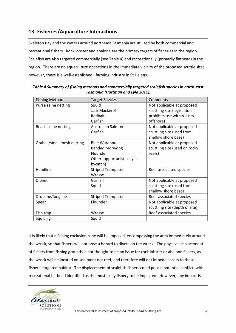
13 Fisheries/Aquaculture Interactions
Skeleton Bay and the waters around northeast Tasmania are utilised by both commercial and
recreational fishers. Rock lobster and abalone are the primary targets of fisheries in the region.
Scalefish are also targeted commercially (see Table 4) and recreationally (primarily flathead) in the
region. There are no aquaculture operations in the immediate vicinity of the proposed scuttle site;
however, there is a well-established ` farming industry in St Helens.
Table 4 Summary of fishing methods and commercially targeted scalefish species in north-east Tasmania (Hartman and Lyle 2011).
Fishing Method Target Species Comments
Purse seine netting Squid Jack Mackerel Redbait Garfish
Not applicable at proposed scuttling site (legislation prohibits use within 1 nm offshore)
Beach seine netting Australian Salmon Garfish
Not applicable at proposed scuttling site (used from shallow shore base)
Graball/small mesh netting Blue Warehou Banded Morwong Flounder Other (opportunistically – bycatch)
Not applicable at proposed scuttling site (used on rocky reefs)
Handline Striped Trumpeter Wrasse
Reef associated species
Dipnet Garfish Squid
Not applicable at proposed scuttling site (used from shallow shore base)
Dropline/longline Striped Trumpeter Reef-associated species
Spear Flounder Not applicable at proposed scuttling site (depth of site)
Fish trap Wrasse Reef-associated species
Squid jig Squid
It is likely that a fishing exclusion zone will be imposed, encompassing the area immediately around
the wreck, so that fishers will not pose a hazard to divers on the wreck. The physical displacement
of fishers from fishing grounds is not thought to be an issue for rock lobster or abalone fishers, as
the wreck will be located on sediment not reef, and therefore will not impede access to these
fishers' targeted habitat. The displacement of scalefish fishers could pose a potential conflict, with
recreational flathead identified as the most likely fishery to be impacted. However, any impact is
Environmental assessment of proposed HMAS Tobruk scuttling site 53
thought to be minimal as the area will be relatively small and is not considered to be high-value to
fishers relative to the wider area of available fishing grounds surrounding the site. There will not be
any impacts on trawl fishers, as under state legislation5, the holder of a general trawling fishing
licence is prohibited from trawling within 1 nautical mile of any part of the coast of Tasmania (except
Ile des Phoques), so there will be no spatial overlap.
Colonisation of fish to the wreck may result in a localised increase of some species’ populations.
There may be a spill-over effect to adjacent reefs outside of the anticipated fishing exclusion zone,
potentially resulting in increased fishing opportunities in the region.
Any broad scale impact from sinking the vessel, or leaks and other contamination post-scuttling,
could have a correspondingly significant effect on fisheries. In particular, TBT antifoulant is widely
recognised as developmentally toxic to molluscs. This report assumes that the vessel hull and
interior will be cleaned to an acceptable level prior to hand-over; therefore such impacts are
expected to be negligible.
5 Fisheries (scalefish) Rules 2004; <http://www.thelaw.tas.gov.au/tocview/index.w3p;cond=;doc_id=%2B91%2B2004%2BAT%40EN%2B20141009000000;histon=;prompt=;rec=;term=>
Environmental assessment of proposed HMAS Tobruk scuttling site 54
14 Ongoing Monitoring
Marine Solutions (2014) has prepared the following document (currently in draft): “Proposed
Monitoring Plan for the Wreck of the HMAS Tobruk in Skeleton Bay, North East Tasmania”, that
addresses information in relation to;
A) The environmental approvals process to scuttle a vessel
B) The pre scuttling planning process
C) The post scuttling environmental and structural monitoring
The plan outlined has been constructed in consideration of other monitoring plans adopted for
similar naval ship scuttling projects in the past, including the HMAS Perth (Western Australia, 2001)
the HMAS Swan (Western Australia, 1997) and the Troy D (Tasmania, 2006). Rough costs have been
provided; however it is emphasised that these are indicative pricings only; accurate pricings are
difficult to estimate at this stage. The relevant monitoring will become evident during the
development of the notice of intent to scuttle, and throughout the approvals process.
Two distinct types of monitoring will likely be required:
1. Environmental monitoring (independent monitoring to assess environmental effects over
the initial 1-5 years).
2. Structural assessment/monitoring (independent structural assessment on an ongoing basis
approximately every 5-10 years. The advice of a suitably qualified engineer should be
sought to determine the appropriate frequency at which such assessments need occur).
Environmental monitoring will include multiple aspects including, but not necessarily limited to:
- photo monitoring of quadrats (primary colonisation)
- logging of fish species identified on the vessel(secondary colonisation)
- photo monitoring of gastropods colonies located on the vessel (secondary colonisation)
- Sediment contamination monitoring
- Water quality monitoring
- Monitoring of adjacent reefs to determine if the wreck has ‘drawn’ fish from the reefs.
By working with the local diving community, a community-based colonisation and ecological
monitoring program can be developed, with considerable merit in terms of both community
Environmental assessment of proposed HMAS Tobruk scuttling site 55
involvement and value-adding to understanding impacts. It is stressed that community-based
programs cannot be relied upon as the sole monitoring mechanism, and must be treated as
complimentary to any monitoring requirement made under permit.
It should be acknowledged that the waters around north-east Tasmania are well-recognised as a
range extension hotspot (RedMap 2014; Pitt et al 2010; Ling et al 2009). Therefore it is reasonable
to predict that species that are not currently known from the area will colonise and/or increase in
abundance in the area, due to processes entirely independent of the proposed scuttling.
Environmental assessment of proposed HMAS Tobruk scuttling site 56
15 Conclusions
The results of our surveys indicate that Skeleton Bay contains an environmentally suitable area for
the scuttling of a vessel the dimensions of the HMAS Tobruk. This is on the basis of:
- Suitable water depth range to avoid shipping navigation impediments, but not so deep as to
preclude recreational SCUBA diving;
- Sufficient sand depth on the seabed to support the resting wreck; and
- Minimal foreseen detrimental impacts on existing Natural Values.
At this stage, we suspect that that the most suitable alignment for the scuttled vessel is an alignment
perpendicular to the seabed depth contours, so as to decrease the amount of surface area of the
vessel exposed to the predominant swells and current. The bow should face the shore, so that the
highest points of the vessel are sitting in deeper water. However, further investigations are
warranted to confirm the peak wave direction at this site
The site chosen is a mobile sand environment spatially removed from the nearest reef, therefore it is
depauperate in fish, algae and invertebrates. There is a risk of detrimental impacts during scuttling
on individuals within close vicinity. However, based on site characteristics, any impact is unlikely to
be large-scale.
One major consideration is the potential impact to marine mammals as a direct result of acoustic
trauma during detonation of explosives used to scuttle the vessel. Guidelines for seismic activity
provided by DEWHA (2008) must be adhered to. To minimise the risk to whales, and the risk of
delays to planned works, scuttling should be avoided between May and November if possible, as
whales are more common in Tasmanian waters throughout these months.
Should this project proceed to the next stage, there are some critical areas of work to be conducted
including but not limited to;
A Notice of Intent outlining the project
An application for a seabed lease under the Crown Lands Act 1976
A permit under the Environment Protection (Sea Dumping) Act 1981
Evidence of compliance with the Environment Protection and Biodiversity conservation Act
1999
Environmental assessment of proposed HMAS Tobruk scuttling site 57
A diver access/egress plan informed by a naval architect
A feasibility study and business plan
A full environmental risk assessment
Stakeholder liaison and communication
A detailed vessel preparation plan to remove all hydrocarbons, plastics, asbestos, electrical
cabling, fuel voids, coffer dams and any other potentially noxious substances/structures
prior to scuttling
A detailed scuttling plan outlining marine mammal, spectator, vessel management etc. on
the day of the scuttling.
In summary, no major potential ecological contraventions resulting from the scuttling of the HMAS
Tobruk at the proposed site in Skeleton Bay have been identified. When compared to other wreck
sites around Australia, and globally, it provides many positive characteristics for a quality dive
experience including;
Spectacular topside scenery
A short boat ride limiting seasickness and allowing multiple trips/day
Good water visibility
Low current velocities
Protected from the prevailing westerly winds
Should this project proceed to the next stage, we have every confidence that the natural values of
the Binalong Bay, Skeleton Bay and Bay of Fires Conservation Area would not be compromised by
the scuttling of the HMAS Tobruk at the proposed location.
Environmental assessment of proposed HMAS Tobruk scuttling site 58
16 References
Baker C.S., Clapham P.J. (2004) Modelling the past and future of whales and whaling. Trends in
Ecology and Evolution 19(7): 365-371.
Bannister J.L., Hedley S.L. (2001) Southern Hemisphere Group IV humpback whales: their status from
recent aerial survey. Memoirs of the Queensland Museum. 47: 587-598.
Bruce B.D., Bradford R.W. (2008) Spatial dynamics and habitat preferences of juvenile white sharks:
identifying critical habitat and options for monitoring recruitment, final report to the
Department of Environment, Water, Heritage and the Arts, Marine Species Recovery Program,
CSIRO, Hobart.
Bruce B.D., Stevens J.D., Malcolm H. (2006) Movements and swimming behaviour of white sharks
(Carcharodon carcharias) in Australian waters, Marine Biology, vol. 150, pp. 161–72.
Bryant S., Jackson J. (1999) Tasmania's threatened fauna handbook: what, where and how to protect
Tasmania's threatened animals, Threatened Species Unit, Parks and Wildlife Service, Tasmania
1999.
Cheal A.J., Thompson A.A. (1997) Comparing visual counts of coral reef fish: implications of transect
width and species selection, Marine Ecology Progress Series 158: 241-248.
Cole C., Abbs C. (2011) Scuttling the ex-HMAS Adelaide as an artificial reef and recreational dive site:
a case study in complexity, Catchments & Lands, Department of Primary Industries,
Newcastle, NSW.
DoE (2014a) What is protected under the EPBC Act? < http://www.environment.gov.au/epbc/what-
is-protected> Date of access: 08/10/2014.
DoE (2014b) Protected Matter Search Tool, < http://www.environment.gov.au/webgis-
framework/apps/pmst/pmst.jsf> date of access: 08/10/2014.
DEWHA (2009) White Shark Issues Paper. [Online]. Canberra, ACT: Australian Government. Available
from:
http://www.environment.gov.au/biodiversity/threatened/publications/recovery/pubs/white-
shark-issues-paper.pdf.
DEWHA (2008) EPBC Act Policy Statement 2.1 - Interaction between offshore seismic exploration
and whales. Australian Government Department of the Environment, Water, Heritage and the
Arts, September 2008.
DPIPWE (2012) Seals of Tasmania, Parks and Wildlife, State of Tasmania. December 2012. Available
at http://www.parks.tas.gov.au/file.aspx?id=6916.
Environmental assessment of proposed HMAS Tobruk scuttling site 59
DPIPWE (2014) Natural Values Report: Authoritative, comprehensive information on Tasmania's
GDA94 610618.0, 5432751.0 falls within: 1:25000 Map: 6043 Binalong.
DSEWPC (2011) Species group report card – sharks. Prepared under the Environmental Protection
and Biodiversity Conservation Act 1999. Commonwealth of Australia 2011.
DSEWPC (2014) EPBCA Act List of Threatened Fauna, <http://www.environment.gov.au/cgi-
bin/sprat/public/publicthreatenedlist.pl> Date of access: 31/07/2014.
Hartmann K., Lyle J. (2011) Tasmanian Scalefish Fishery – 2009-10, Institute of Marine and Antarctic
Studies, March 2011.
Inspiring Place (2011) Bay of Fires Conservation Area and Humbug Point Nature Recreation Area Site
Plan, Prepared for NRM North and the Tasmania Parks and Wildlife Service, September 2011.
International Whaling Commission (IWC) (2001) Report of the workshop on the comprehensive
assessment of right whales: A worldwide comparison. Journal of Cetacean Research and
Management. 1-60.
Jacques M. (1997) Dive Tasmania Including Bass Strait and Macquarie Is., Gemini Publication, ISBN 0
646 30129 2.
Lewis J.A. (1996) Effects of underwater explosions on life in the sea, Ship Structures and Materials
Division, Defence Science and Technology Organisation (DSTO) Aeronautical and Maritime
Research Laboratory, DST-GD-0080.
Ling S.D., Johnson C.R., Ridgway K., Hobday A.J., Haddon M. (2009) Climate driven range extension of
a sea urchin: inferring future trends by analysis of recent population dynamics. Global Change
Biology 15, 719 – 731.
MacLeod I., Morrison P., Richards V., West N. (2004) Corrosion monitoring and the environmental
impact of decommissioned naval vessels as artificial reefs, Proc. Of Metals, 4-8 Oct 2004.
Minerals Database Tasmania (2014)
<http://www.mrt.tas.gov.au/Viewer/Exposure/E3?REQUEST=Entry&PRJ=Mineral_Deposits&D
ELETE_DEFAULT=Y&SID=99137564&MODE=mrt&reload=1> date of access: 08/10/2014.
Pitt N.R., Poloczanska E.S., Hobday A.J. (2010) Climate-driven range changes in Tasmanian intertidal
fauna. Marine and Freshwater Research 61, 963–970.
Pittau F., Gervais B. (2003) That’s Dangerous. Black Dog and Leventhal Publishers, Inc. 2003. ISBN: 1-
57912-350-3.
Pogonoski J.J., Pollard D.A., Paxton J.R. (2002) Conservation Overview and Action Plan for Australian
Threatened and Potentially Threatened Marine and Estuarine Fishes. [Online]. Canberra, ACT:
Environmental assessment of proposed HMAS Tobruk scuttling site 60
Environment Australia. Available
from: http://www.environment.gov.au/system/files/resources/ca415225-5626-461c-a929-
84744e80ee36/files/marine-fish.pdf. Date of access: 31/07/2014.
RedMap (2014) Leaving home in a huff: range shifts in Australian seas. By Yvette Barry (IMAS),
http://www.redmap.org.au/article/leaving-home-in-a-huff-range-shifts-in-australian-seas/
Date of access: 01/08/2014.
Richardson W.J., Greene C.R., Malme C.I., Thomson D.H. (1995) Marine Mammals and Noise.
Academic Press, Inc., USA.
Weng K.C., O'Sullivan J.B., Lowe C.G., Winkler C.E., Dewar H., Block B.A. (2007) Movements,
behaviour and habitat preferences of juvenile white sharks Carcharadon carcharias in the
eastern Pacific. Marine Ecology Progress Series 338: 211–224.
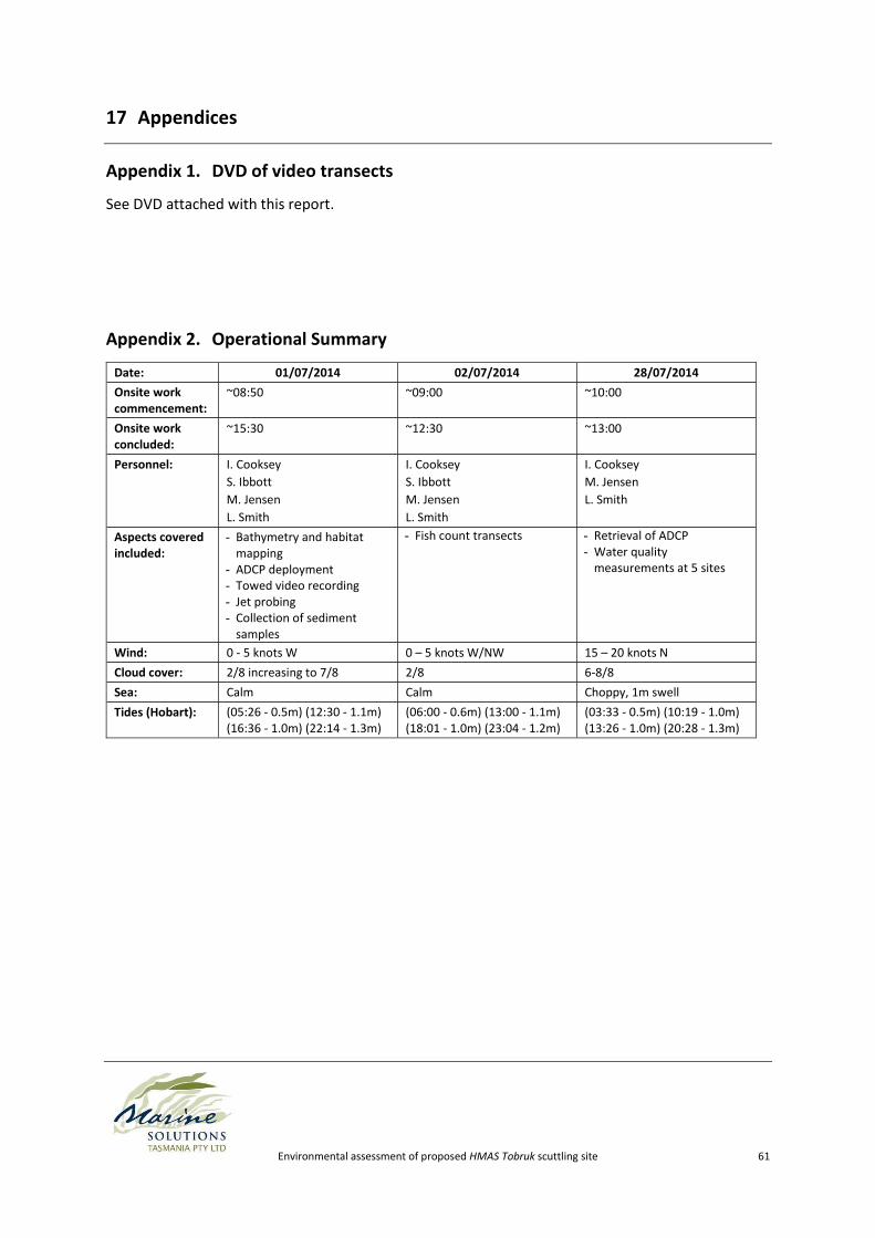
Environmental assessment of proposed HMAS Tobruk scuttling site 61
17 Appendices
Appendix 1. DVD of video transects
See DVD attached with this report.
Appendix 2. Operational Summary
Date: 01/07/2014 02/07/2014 28/07/2014
Onsite work commencement:
~08:50 ~09:00 ~10:00
Onsite work concluded:
~15:30 ~12:30 ~13:00
Personnel: I. Cooksey
S. Ibbott
M. Jensen
L. Smith
I. Cooksey
S. Ibbott
M. Jensen
L. Smith
I. Cooksey
M. Jensen
L. Smith
Aspects covered included:
- Bathymetry and habitat mapping
- ADCP deployment - Towed video recording - Jet probing - Collection of sediment
samples
- Fish count transects - Retrieval of ADCP - Water quality
measurements at 5 sites
Wind: 0 - 5 knots W 0 – 5 knots W/NW 15 – 20 knots N
Cloud cover: 2/8 increasing to 7/8 2/8 6-8/8
Sea: Calm Calm Choppy, 1m swell
Tides (Hobart): (05:26 - 0.5m) (12:30 - 1.1m) (16:36 - 1.0m) (22:14 - 1.3m)
(06:00 - 0.6m) (13:00 - 1.1m) (18:01 - 1.0m) (23:04 - 1.2m)
(03:33 - 0.5m) (10:19 - 1.0m) (13:26 - 1.0m) (20:28 - 1.3m)
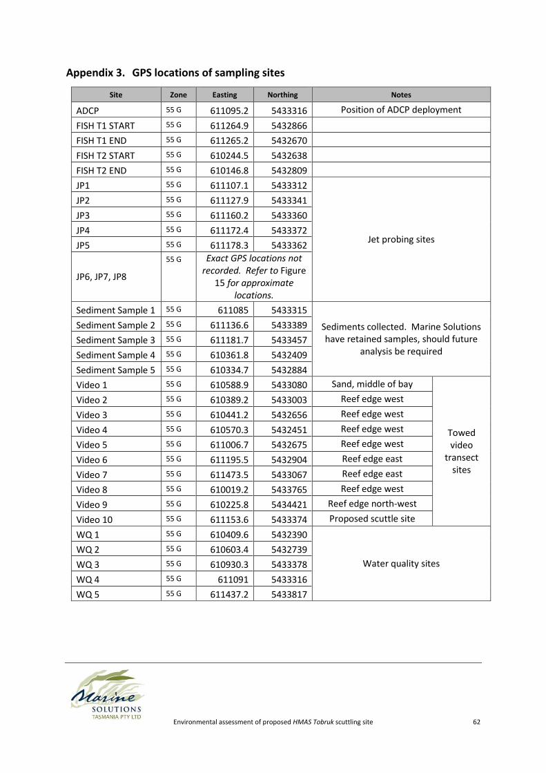
Environmental assessment of proposed HMAS Tobruk scuttling site 62
Appendix 3. GPS locations of sampling sites
Site Zone Easting Northing Notes
ADCP 55 G 611095.2 5433316 Position of ADCP deployment
FISH T1 START 55 G 611264.9 5432866
FISH T1 END 55 G 611265.2 5432670
FISH T2 START 55 G 610244.5 5432638
FISH T2 END 55 G 610146.8 5432809
JP1 55 G 611107.1 5433312
Jet probing sites
JP2 55 G 611127.9 5433341
JP3 55 G 611160.2 5433360
JP4 55 G 611172.4 5433372
JP5 55 G 611178.3 5433362
JP6, JP7, JP8
55 G Exact GPS locations not recorded. Refer to Figure
15 for approximate locations.
Sediment Sample 1 55 G 611085 5433315
Sediments collected. Marine Solutions have retained samples, should future
analysis be required
Sediment Sample 2 55 G 611136.6 5433389
Sediment Sample 3 55 G 611181.7 5433457
Sediment Sample 4 55 G 610361.8 5432409
Sediment Sample 5 55 G 610334.7 5432884
Video 1 55 G 610588.9 5433080 Sand, middle of bay
Towed video
transect sites
Video 2 55 G 610389.2 5433003 Reef edge west
Video 3 55 G 610441.2 5432656 Reef edge west
Video 4 55 G 610570.3 5432451 Reef edge west
Video 5 55 G 611006.7 5432675 Reef edge west
Video 6 55 G 611195.5 5432904 Reef edge east
Video 7 55 G 611473.5 5433067 Reef edge east
Video 8 55 G 610019.2 5433765 Reef edge west
Video 9 55 G 610225.8 5434421 Reef edge north-west
Video 10 55 G 611153.6 5433374 Proposed scuttle site
WQ 1 55 G 610409.6 5432390
Water quality sites
WQ 2 55 G 610603.4 5432739
WQ 3 55 G 610930.3 5433378
WQ 4 55 G 611091 5433316
WQ 5 55 G 611437.2 5433817
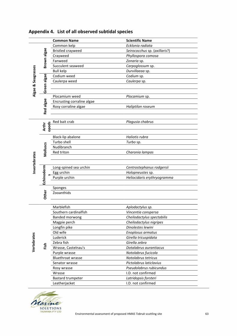
Environmental assessment of proposed HMAS Tobruk scuttling site 63
Appendix 4. List of all observed subtidal species V
ert
eb
rate
s
Fish
Marblefish Aplodactylus sp.
Southern cardinalfish Vincentia conspersa
Banded morwong Cheilodactylus spectabilis
Magpie perch Cheilodactylus nigripes
Longfin pike Dinolestes lewini
Old wife Enoplosus armatus
Luderick Girella tricuspidata
Zebra fish Girella zebra
Wrasse, Castelnau's Dotalabrus aurantiacus
Purple wrasse Notolabrus fucicola
Bluethroat wrasse Notolabrus tetricus
Senator wrasse Pictolabrus laticlavius
Rosy wrasse Pseudolabrus rubicundus
Wrasse I.D. not confirmed
Bastard trumpeter Latridopsis forsteri
Leatherjacket I.D. not confirmed
Common Name Scientific Name
Alg
ae &
Se
agra
sse
s Bro
wn
alg
ae Common kelp Ecklonia radiata
Bristled crayweed Seirococchus sp. (axillaris?)
Crayweed Phyllospora comosa
Fanweed Zonaria sp.
Succulent seaweed Carpoglossum sp.
Bull kelp Durvillaeaa sp.
Gre
en
alg
ae
Codium weed Codium sp.
Caulerpa weed Caulerpa sp.
Re
d a
lgae
Plocamium weed Plocamium sp.
Encrusting corraline algae
Rosy corraline algae Haliptilon roseum
Inve
rte
bra
tes
Art
hr
op
od
s Red bait crab Plagusia chabrus
Mo
llusc
s
Black-lip abalone Haliotis rubra
Turbo shell Turbo sp.
Nudibranch
Red triton Charonia lampas
Ech
ino
de
rm
s
Long-spined sea urchin Centrostephanus rodgersii
Egg urchin Holopneustes sp.
Purple urchin Heliocidaris erythryogramma
Oth
er
Sponges
Zooanthids
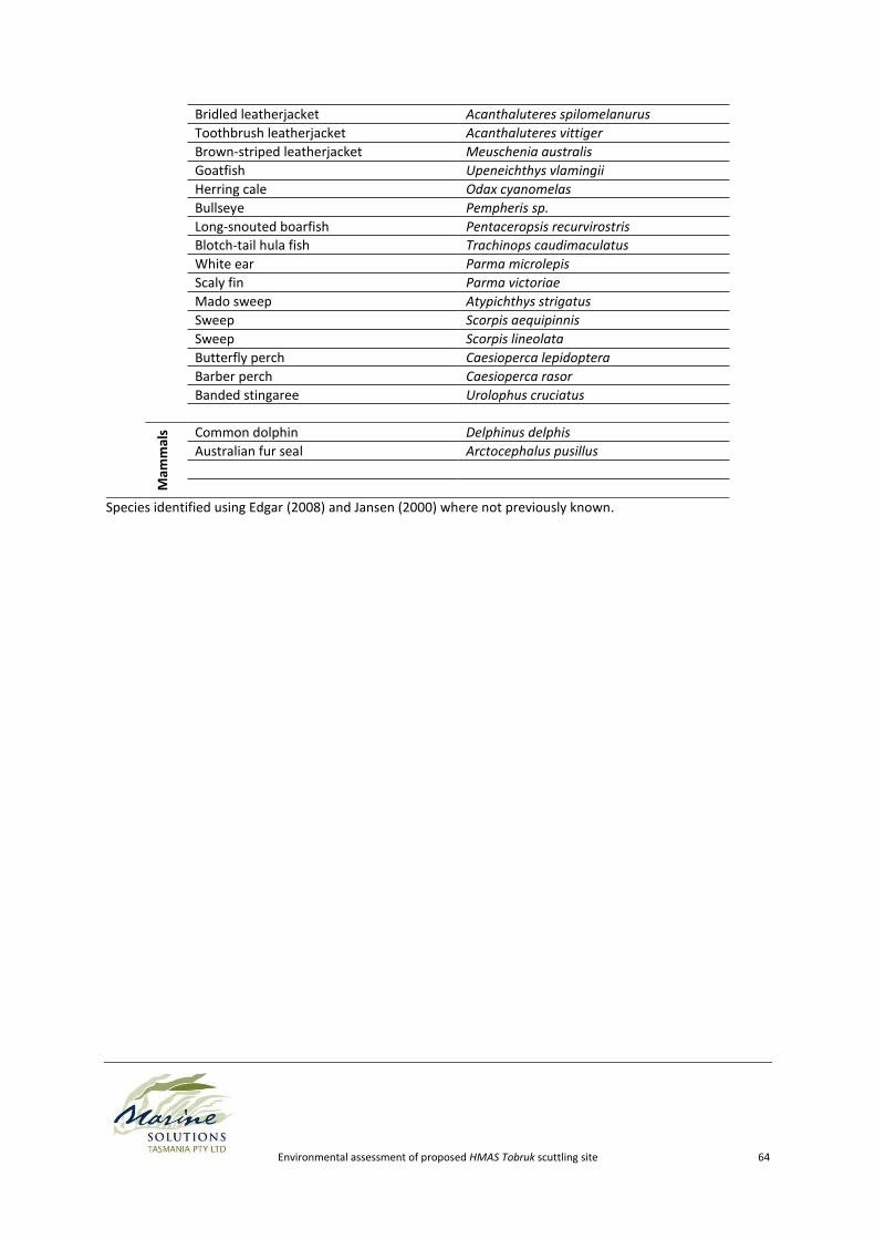
Environmental assessment of proposed HMAS Tobruk scuttling site 64
Bridled leatherjacket Acanthaluteres spilomelanurus
Toothbrush leatherjacket Acanthaluteres vittiger
Brown-striped leatherjacket Meuschenia australis
Goatfish Upeneichthys vlamingii
Herring cale Odax cyanomelas
Bullseye Pempheris sp.
Long-snouted boarfish Pentaceropsis recurvirostris
Blotch-tail hula fish Trachinops caudimaculatus
White ear Parma microlepis
Scaly fin Parma victoriae
Mado sweep Atypichthys strigatus
Sweep Scorpis aequipinnis
Sweep Scorpis lineolata
Butterfly perch Caesioperca lepidoptera
Barber perch Caesioperca rasor
Banded stingaree Urolophus cruciatus
Mam
mal
s Common dolphin Delphinus delphis
Australian fur seal Arctocephalus pusillus
Species identified using Edgar (2008) and Jansen (2000) where not previously known.
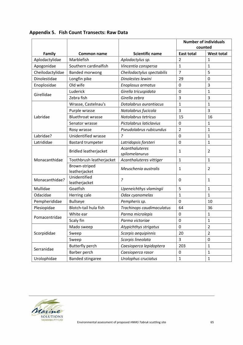
Environmental assessment of proposed HMAS Tobruk scuttling site 65
Appendix 5. Fish Count Transects: Raw Data
Family Common name Scientific name
Number of individuals counted
East total West total
Aplodactylidae Marblefish Aplodactylus sp. 2 1
Apogonidae Southern cardinalfish Vincentia conspersa 1 1
Cheilodactylidae Banded morwong Cheilodactylus spectabilis 7 5
Dinolestidae Longfin pike Dinolestes lewini 29 0
Enoplosidae Old wife Enoplosus armatus 0 3
Girellidae Luderick Girella tricuspidata 0 1
Zebra fish Girella zebra 3 3
Labridae
Wrasse, Castelnau's Dotalabrus aurantiacus 1 1
Purple wrasse Notolabrus fucicola 3 3
Bluethroat wrasse Notolabrus tetricus 15 16
Senator wrasse Pictolabrus laticlavius 0 1
Rosy wrasse Pseudolabrus rubicundus 2 1
Labridae? Unidentified wrasse ? 0 1
Latrididae Bastard trumpeter Latridopsis forsteri 0 1
Monacanthidae
Bridled leatherjacket Acanthaluteres spilomelanurus
1 2
Toothbrush leatherjacket Acanthaluteres vittiger 1 1
Brown-striped leatherjacket
Meuschenia australis 1 2
Monacanthidae? Unidentified leatherjacket
? 0 1
Mullidae Goatfish Upeneichthys vlamingii 5 1
Odacidae Herring cale Odax cyanomelas 1 1
Pempherididae Bullseye Pempheris sp. 0 10
Plesiopidae Blotch-tail hula fish Trachinops caudimaculatus 64 36
Pomacentridae White ear Parma microlepis 0 1
Scaly fin Parma victoriae 0 1
Scorpididae
Mado sweep Atypichthys strigatus 0 2
Sweep Scorpis aequipinnis 20 2
Sweep Scorpis lineolata 3 0
Serranidae Butterfly perch Caesioperca lepidoptera 203 1
Barber perch Caesioperca rasor 0 1
Urolophidae Banded stingaree Urolophus cruciatus 1 1
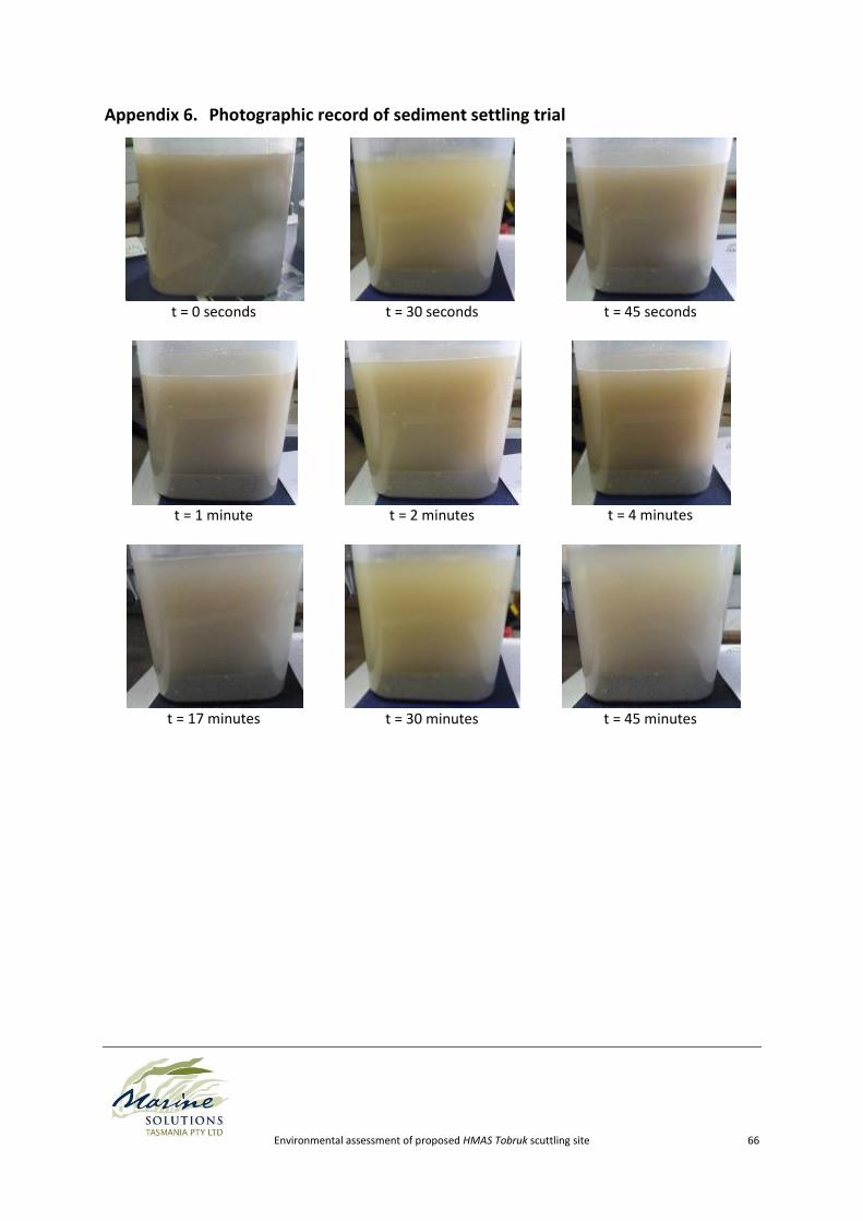
Environmental assessment of proposed HMAS Tobruk scuttling site 66
Appendix 6. Photographic record of sediment settling trial
t = 0 seconds
t = 30 seconds
t = 45 seconds
t = 1 minute
t = 2 minutes
t = 4 minutes
t = 17 minutes
t = 30 minutes
t = 45 minutes