PROPOSED SAND MINE, EASTERN CAPE PROVINCE, … Permit White Kei River CS010616_2… · proposed...
87
PROPOSED SAND MINE, EASTERN CAPE PROVINCE, SOUTH AFRICA FINAL BASIC ASSESSMENT REPORT DMR Ref: EC 30/5/1/3/3/2/1/10337EM Prepared for: HJT Transport CC 28 Bank Street, West Bank, East Londonk, 5218 043 731 1108 Prepared by: EOH Coastal & Environmental Services EAST LONDON 25 Tecoma Street East London 5214 043 726 7809 Also in Grahamstown, Cape Town, Johannesburg, Port Elizabeth and Maputo www.cesnet.co.za July 2016
Transcript of PROPOSED SAND MINE, EASTERN CAPE PROVINCE, … Permit White Kei River CS010616_2… · proposed...
PROPOSED SAND MINE, EASTERN CAPE PROVINCE, SOUTH AFRICA
FINAL BASIC ASSESSMENT REPORT
DMR Ref: EC 30/5/1/3/3/2/1/10337EM
Prepared for:
HJT Transport CC
28 Bank Street, West Bank,
East Londonk, 5218
043 731 1108
Prepared by:
EOH Coastal & Environmental Services
EAST LONDON 25 Tecoma Street
East London 5214
043 726 7809 Also in Grahamstown, Cape Town, Johannesburg, Port Elizabeth and Maputo
www.cesnet.co.za
July 2016
BASIC ASSESSMENT REPORT
And
ENVIRONMENTAL MANAGEMENT PROGRAMME REPORT
SUBMITTED FOR ENVIRONMENTAL AUTHORIZATIONS IN TERMS OF THE NATIONAL
ENVIRONMENTAL MANAGEMENT ACT, 1998 AND THE NATIONAL ENVIRONMENTAL
MANAGEMENT WASTE ACT, 2008 IN RESPECT OF LISTED ACTIVITIES THAT HAVE
BEEN TRIGGERED BY APPLICATIONS IN TERMS OF THE MINERAL AND PETROLEUM
RESOURCES DEVELOPMENT ACT, 2002 (MPRDA) (AS AMENDED).
NAME OF APPLICANT: HJT Transport CC
TEL NO: 043 731 1108 FAX NO: 086 725 8671
POSTAL ADDRESS: PO Box 14156, West Bank, East London, 5218
PHYSICAL ADDRESS: 28 Bank Street, West Bank, Eastern Cape, 5218
FILE REFERENCE NUMBER SAMRAD: EC30/5/1/3/2/10337MP
FILE REFERENCE NUMBER SAMRAD: EC30/5/1/3/2/10337MP
1. IMPORTANT NOTICE
In terms of the Mineral and Petroleum Resources Development Act (Act 28 of 2002 as
amended), the Minister must grant a prospecting or mining right if among others the mining
―will not result in unacceptable pollution, ecological degradation or damage to the
environment‖.
Unless an Environmental Authorisation can be granted following the evaluation of an
Environmental Impact Assessment and an Environmental Management Programme report
in terms of the National Environmental Management Act (Act 107 of 1998) (NEMA), it
cannot be concluded that the said activities will not result in unacceptable pollution,
ecological degradation or damage to the environment.
In terms of section 16(3)(b) of the EIA Regulations, 2014, any report submitted as part of an
application must be prepared in a format that may be determined by the Competent
Authority and in terms of section 17 (1) (c) the competent Authority must check whether the
application has taken into account any minimum requirements applicable or instructions or
guidance provided by the competent authority to the submission of applications.
It is therefore an instruction that the prescribed reports required in respect of applications
for an environmental authorisation for listed activities triggered by an application for a right
or a permit are submitted in the exact format of, and provide all the information required in
terms of, this template. Furthermore please be advised that failure to submit the information
required in the format provided in this template will be regarded as a failure to meet the
requirements of the Regulation and will lead to the Environmental Authorisation being
refused.
It is furthermore an instruction that the Environmental Assessment Practitioner must
process and interpret his/her research and analysis and use the findings thereof to compile
the information required herein. (Unprocessed supporting information may be attached as
appendices). The EAP must ensure that the information required is placed correctly in the
relevant sections of the Report, in the order, and under the provided headings as set out
below, and ensure that the report is not cluttered with un-interpreted information and that it
unambiguously represents the interpretation of the applicant.
2. Objective of the basic assessment process
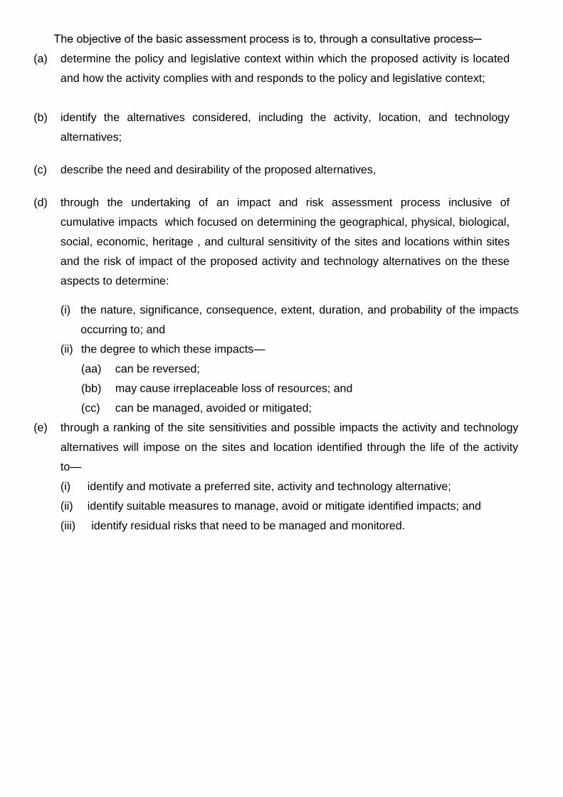
The objective of the basic assessment process is to, through a consultative process─
(a) determine the policy and legislative context within which the proposed activity is located
and how the activity complies with and responds to the policy and legislative context;
(b) identify the alternatives considered, including the activity, location, and technology
alternatives;
(c) describe the need and desirability of the proposed alternatives,
(d) through the undertaking of an impact and risk assessment process inclusive of
cumulative impacts which focused on determining the geographical, physical, biological,
social, economic, heritage , and cultural sensitivity of the sites and locations within sites
and the risk of impact of the proposed activity and technology alternatives on the these
aspects to determine:
(i) the nature, significance, consequence, extent, duration, and probability of the impacts
occurring to; and
(ii) the degree to which these impacts—
(aa) can be reversed;
(bb) may cause irreplaceable loss of resources; and
(cc) can be managed, avoided or mitigated;
(e) through a ranking of the site sensitivities and possible impacts the activity and technology
alternatives will impose on the sites and location identified through the life of the activity
to—
(i) identify and motivate a preferred site, activity and technology alternative;
(ii) identify suitable measures to manage, avoid or mitigate identified impacts; and
(iii) identify residual risks that need to be managed and monitored.
PART A
SCOPE OF ASSSSMENT AND BASIC ASSESSMENT REPORT
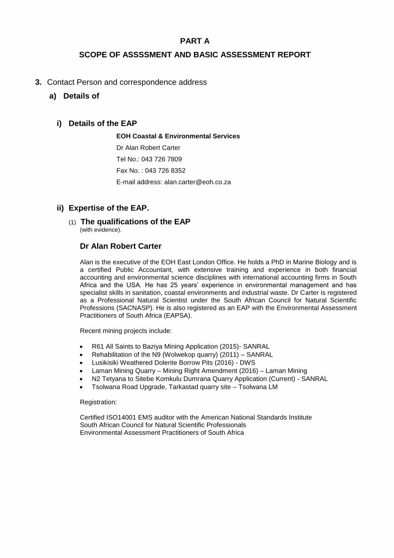
3. Contact Person and correspondence address
a) Details of
i) Details of the EAP
EOH Coastal & Environmental Services
Dr Alan Robert Carter
Tel No.: 043 726 7809
Fax No. : 043 726 8352
E-mail address: [email protected]
ii) Expertise of the EAP.
(1) The qualifications of the EAP (with evidence).
Dr Alan Robert Carter Alan is the executive of the EOH East London Office. He holds a PhD in Marine Biology and is a certified Public Accountant, with extensive training and experience in both financial accounting and environmental science disciplines with international accounting firms in South Africa and the USA. He has 25 years‘ experience in environmental management and has specialist skills in sanitation, coastal environments and industrial waste. Dr Carter is registered as a Professional Natural Scientist under the South African Council for Natural Scientific Professions (SACNASP). He is also registered as an EAP with the Environmental Assessment Practitioners of South Africa (EAPSA). Recent mining projects include:
R61 All Saints to Baziya Mining Application (2015)- SANRAL
Rehabilitation of the N9 (Wolwekop quarry) (2011) – SANRAL
Lusikisiki Weathered Dolerite Borrow Pits (2016) - DWS
Laman Mining Quarry – Mining Right Amendment (2016) – Laman Mining
N2 Tetyana to Sitebe Komkulu Dumrana Quarry Application (Current) - SANRAL
Tsolwana Road Upgrade, Tarkastad quarry site – Tsolwana LM Registration: Certified ISO14001 EMS auditor with the American National Standards Institute South African Council for Natural Scientific Professionals Environmental Assessment Practitioners of South Africa
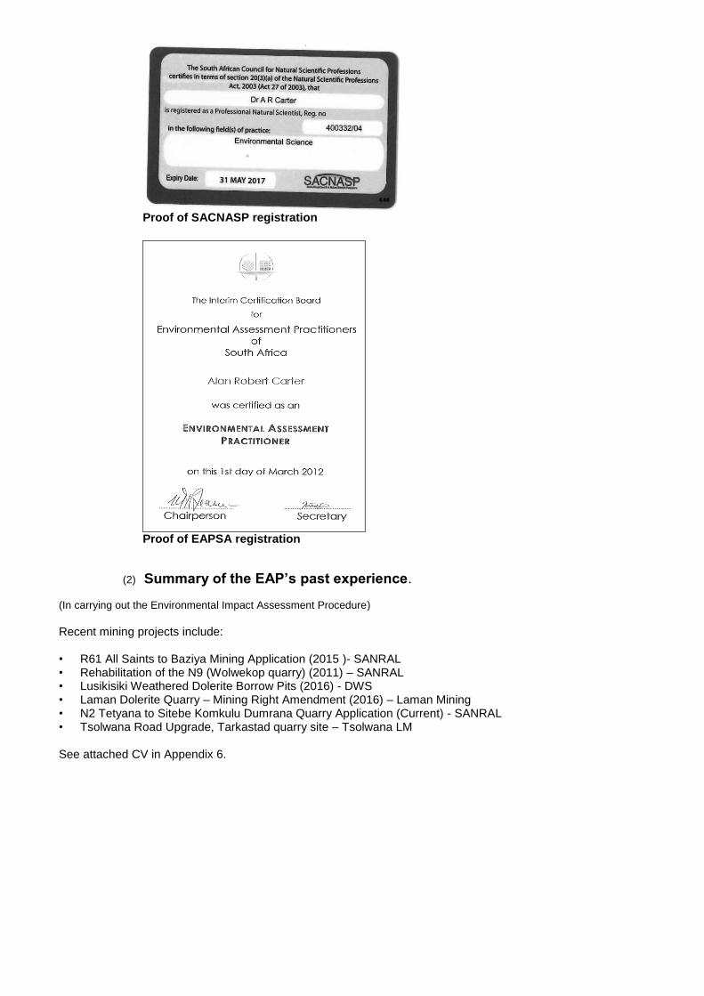
Proof of SACNASP registration
Proof of EAPSA registration
(2) Summary of the EAP’s past experience.
(In carrying out the Environmental Impact Assessment Procedure) Recent mining projects include: • R61 All Saints to Baziya Mining Application (2015 )- SANRAL • Rehabilitation of the N9 (Wolwekop quarry) (2011) – SANRAL • Lusikisiki Weathered Dolerite Borrow Pits (2016) - DWS • Laman Dolerite Quarry – Mining Right Amendment (2016) – Laman Mining • N2 Tetyana to Sitebe Komkulu Dumrana Quarry Application (Current) - SANRAL • Tsolwana Road Upgrade, Tarkastad quarry site – Tsolwana LM See attached CV in Appendix 6.

b) Location of the overall Activity.
Farm Name: Erf 366. State Land (not yet registered), Emalahleni Local Municipality.
Application area (Ha) 4.9 ha
Magisterial district: Kundulu Allotment Area, Emalahleni Local Municipality.
Distance and direction
from nearest town
25km East of Queenstown along the R410 towards Lady Frere
21 digit Surveyor
General Code for each
farm portion
C09100090000036600000 (erven) No farm portions
c) Locality map (show nearest town, scale not smaller than 1:250000).
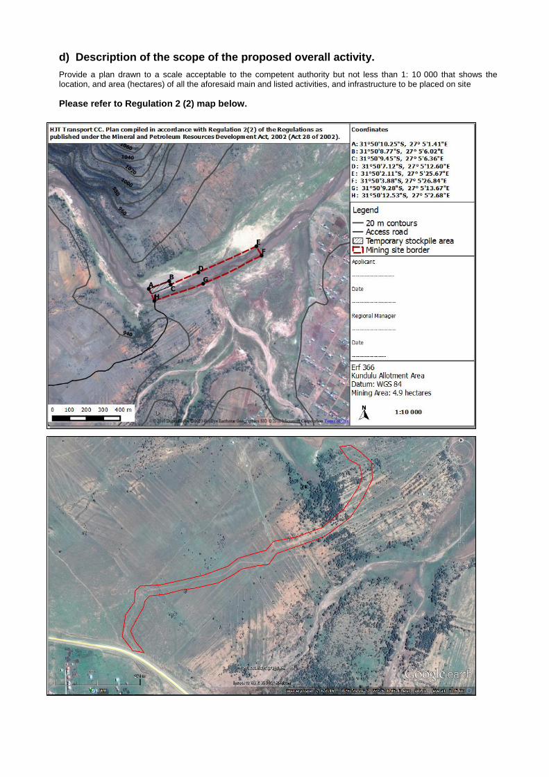
d) Description of the scope of the proposed overall activity.
Provide a plan drawn to a scale acceptable to the competent authority but not less than 1: 10 000 that shows the location, and area (hectares) of all the aforesaid main and listed activities, and infrastructure to be placed on site
Please refer to Regulation 2 (2) map below.
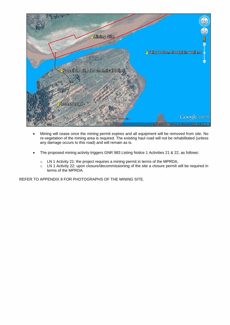
Existing access route to the mining site (indicated in between the red line above).
(i) Listed and specified activities
NAME OF ACTIVITY (E.g. For prospecting - drill site, site camp,
ablution facility, accommodation, equipment
storage, sample storage, site office, access
route etc…etc…etc
E.g. for mining,- excavations, blasting, stockpiles,
discard dumps or dams, Loading, hauling and
transport, Water supply dams and boreholes,
accommodation, offices, ablution, stores,
workshops, processing plant, storm water
control, berms, roads, pipelines, power lines,
conveyors, etc…etc…etc.)
Aerial extent of
the Activity
Ha or m²
LISTED
ACTIVITY
Mark with an
X where
applicable or
affected.
APPLICABLE
LISTING
NOTICE
(GNR 544,
GNR 545 or
GNR 546)
Excavation & Stockpiling 4.9 ha X GNR 983 No 21 Decommissioning 4.9 ha X GNR 983 No 22
(ii) Description of the activities to be undertaken (Describe Methodology or technology to be employed, including the type of commodity to be prospected/ mined and for a linear activity, a description of the route of the activity)
The White Kei River has an intermittent, low flow and the river channel is normally about 30 m wide. During high flow the river channel widens to about 50 m and deposits sand in the flood plain area where the mining site will be located.
The total mining area will be approximately 4.9 hectares in size. Excavation of sand will occur from the floodplain of the White Kei River. Mining depth will be 30-80 cm, removing uncontaminated sand (sand not mixed with silt). A potential 1800 m
3 of sand will be extracted
each month for a period of 2 years (possibly up to 5 years with permit renewals).
The GPS coordinates for the proposed site are as listed below:
A 31°50'10.25"S, 27° 5'1.41"E
B 31°50'8.77"S, 27° 5'6.02"E
C 31°50'9.45"S, 27° 5'6.36"E
D 31°50'7.12"S, 27° 5'12.60"E
E 31°50'2.11"S, 27° 5'25.67"E
F 31°50'3.88"S, 27° 5'26.84"E
G 31°50'9.28"S, 27° 5'13.67"E
H 31°50'12.53"S, 27° 5'2.68"E
HJT Transport CC intends to extract the mineral (sand) by means of an excavator that will temporarily stockpile the sand. This sand is then loaded onto 10m
3 dumper trucks and hauled to
the relevant markets.
Sand stockpiles will be stored at the mining site (on the northern bank of the river) and will not be stockpiled for longer than a maximum of three days, due to the high theft rates in the area and the potential of the river washing stockpiles away during high flow events. All extracted material will be utilised and no residue would be generated.
No topsoil will be stripped and stockpiled for rehabilitation purposes.
The site will be accessed via an existing access road and will run through the river, but no bridge will be constructed. Vehicles will not be able to cross when the river is in full flow, but due to the small scale of the proposed mining operations, a new bridge across the river will not be considered.
Mining will commence on the banks of the river (close enough to the river to mine sand). Wet areas will be avoided. The river channel changes constantly so areas along the banks within the mining footprint that are usually inundated with water will occasionally be dry and will be mineable.
Removal of sand will lower the floor by 30-80cm. The small excavation sides will be profiled to a 1:3 gradient. The floor will have a 1% slope towards the river channel, but will not be free-draining. Due to the natural processes in the river dynamics, sand is deposited at the site on a regular basis, especially after heavy rains, and is therefore a renewable resource. Thus, every flood event, new sand will be deposited on the mined-out areas and mining will commence in the mined-out areas as described above.
Mining should never take place within the stream (wet areas) but must remain on the banks where mining will result in a continuous flat depression. Mining will only take place in dry areas of the stream channel. Prior to mining, the topography of the site is flat with a gentle slope towards the river. Mining will, however, result in a very shallow (30-80cm deep) depression in the landscape with a flat quarry floor that will drain towards the river. Due to the semi-high porosity of the soils in the system, draining will take place by means of sub-surface sheet flow towards the river, thus water drainage will not be influenced by mining activities. It is also anticipated that water accumulation will occur within the extracted areas for short periods of time during flooding, excluding certain areas from mining until the water has subsided, as indicated above.
Potable water will be brought to the site daily. No water will be extracted from the river without obtaining relevant water licences from the Department of Water and Sanitation (DWS).
No workforce will reside onsite, but will commute to work every day.
Considering the limited amount of staff onsite, minimal general waste will be generated. This waste will be removed from site on a daily basis. A single bin with a lid as well as a chemical toilet will be placed as far away from any surface water as possible.
If a chemical toilet is placed onsite it will be placed along the existing access road away from the river and wetland (see figure below). No maintenance yard will be required on site as all vehicles will be maintained offsite.
HJT Transport CC have access to an offsite yard (that they rent) approximately 2km away from the mining site for storing equipment/machinery and any excess mineral stockpiles, etc.
Mining will cease once the mining permit expires and all equipment will be removed from site. No re-vegetation of the mining area is required. The existing haul road will not be rehabilitated (unless any damage occurs to this road) and will remain as is.
The proposed mining activity triggers GNR 983 Listing Notice 1 Activities 21 & 22, as follows:
o LN 1 Activity 21: the project requires a mining permit in terms of the MPRDA, o LN 1 Activity 22: upon closure/decommissioning of the site a closure permit will be required in
terms of the MPRDA. REFER TO APPENDIX 9 FOR PHOTOGRAPHS OF THE MINING SITE.
e) Policy and Legislative Context
APPLICABLE LEGISLATION AND GUIDELINES USED TO COMPILE THE REPORT (a description of the policy and legislative context
within which the development is proposed including an identification of all legislation, policies, plans, guidelines, spatial tools, municipal development planning frameworks and instruments that are applicable to this activity and are to be considered in the assessment process
REFERENCE
WHERE
APPLIED
HOW DOES THIS DEVELOPMENT COMPLY WITH AND RESPOND TO THE LEGISLATION AND POLICY CONTEXT.
(E.g. In terms of the National Water Act a Water Use License has/ has not been applied for)
National Water Act (Act 36 of 1998) Section 21 c & i of the National Water Act.
A water use licence application has been lodged with DWS for the haul road, wetland crossing and mining activity in close proximity to a river & wetland.
Mineral and Petroleum Resources Development Act, 2002 (Act No. 28 of 2002)
Section 27 Application for a mining permit (Section 27 of the MPRDA).
National Environmental Management Act,1998 (Act No. 107 of 1998) and the Environmental Impact Assessment Regulations, 2014
GNR 983 Listing Notice 1 Activity 21 & 22
Application for Environmental Authorisation to mine and remove material within a water course. Decommissioning & mine closure when mining is complete.
National Heritage Resources Act (Act No. 25 of 1999).
No heritage resources will be affected by mining (it was confirmed with the local community that no known graves exist in the mining area). The mining site is located within a river/ floodplain.
Mine Health and Safety Act (Act No. 29 of 1996).
This Act will be applicable during the mining phase of the project and necessary measures should be taken to ensure compliance.
National Environmental Management: Air Quality Act (Act No. 39 of 2004)
This Act will be applicable during construction and mining phases of the project. The necessary measures must be taken to ensure compliance.
Conservation of Agricultural Resources Act (No. 43 of 1983)
If any declared weed and/or invader species listed in terms of this Act is present on site, it must be removed.
Hazardous Substances Act (No. 15 of 1973) Hazardous waste must be managed in a manner that it does not endanger human health or the environment.
National Environmental Management: Waste Act (59 of 2008)
The applicant must ensure that all activities associated with the quarry address waste related matters in compliance with the requirements of the Act.
f) Need and desirability of the proposed activities. (Motivate the need and desirability of the proposed development including the need and desirability of the activity in the context of the preferred location).
The increase in building, construction and road maintenance projects in the vicinity of the mining site triggered the desire of the applicant to trade with the available sand. The proposed mining activity will also contribute to the diversification of activities on the property to include small scale mining, and job creation. Establishment of the sand mine will result in other positive economic spin-offs in the construction industry as well. Once the Mining Permit is granted the applicant will come to an agreement with the local community regarding compensation or benefits from the mining activity. According to the Emalahleni LM IDP (2012 -2017):
“From a spatial planning perspective, focus needs to be placed on areas of identified development potential (mining, agriculture and tourism) and efforts must be aimed at making such areas function optimally by ensuring clear planning and land use management frameworks are in place and basic Levels of Service are developed and maintained there”.
“The LED strategy identifies community services, retail, agriculture, mining and tourism as strategic sectors with potential for growth in line with National, Provincial and Regional Economic Growth Strategy (NSDP, PGDS and REGS, respectively).” In terms of employment: “Underperforming sectors like Agriculture, mining, tourism and manufacturing need to be rejuvenated in order to yield qualitative and quantitative growth benefits in our local economy.”
g) Motivation for the overall preferred site, activities and technology alternative.
Sand for construction is a scarce commodity in the local area. The geology of the area mostly consists of hard sandstone. Limited sites (including this one) are available where sand can be mined as a commodity. The proposed site was identified as the preferred alternative due to the following reasons:
The site offers the mineral sought,
The proposed mining area was defined not to include any wetland or natural riparian ecosystem (layout of the mining site was amended based on the outcomes of the Aquatic Ecological Assessment).
Small portions of grass are present on the northern banks of the mining area. This is periodically washed away/ covered with sand during floods. No other vegetation (alien/endemic) is present in the actual mining area
No overburben removal or stockpiling will be required.
No major rehabilitation will be required after site closure (only removal of all equipment from site and levelling out of slopes).
The mining area can be reached by an existing gravel access road. No new road infrastructure needs to be constructed.
The open cast mining of the area (using an excavator and front end loader) was identified as the most effective method to obtain the desired sand. Due to the small size of the activity and the remote location of the mining area the potential impacts on the surrounding environment, associated with open cast mining, is deemed to be of low significance.
No residual waste as a result of the mining activity will be produced that needs to be treated on site.
Any general waste that may be produced on-site will be contained in sealed refuse bins to be transported to the local municipal landfill site. As maintenance and servicing of the equipment will be done at an off-site workshop the amount of hazardous waste to be produced at the site will be minimal and would only be as a result of accidental leakage. Contaminated soil will be removed to the depth of the spillage and contained in sealed bins until removed from site by a hazardous waste handling contractor to be disposed of at a registered hazardous waste handling site.
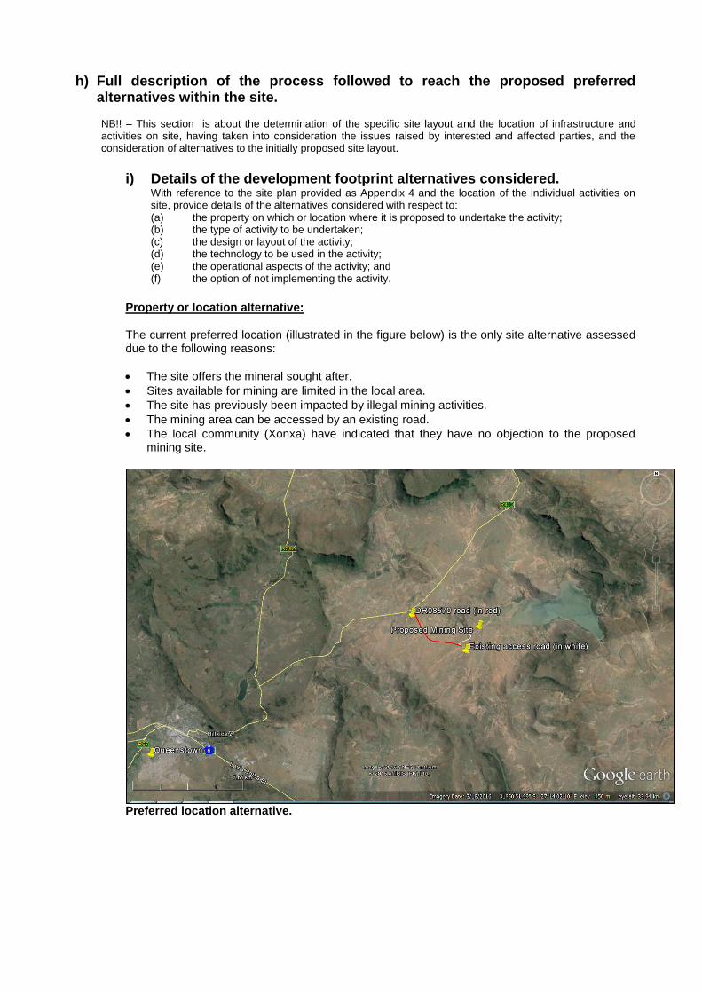
h) Full description of the process followed to reach the proposed preferred alternatives within the site. NB!! – This section is about the determination of the specific site layout and the location of infrastructure and activities on site, having taken into consideration the issues raised by interested and affected parties, and the consideration of alternatives to the initially proposed site layout.
i) Details of the development footprint alternatives considered.
With reference to the site plan provided as Appendix 4 and the location of the individual activities on site, provide details of the alternatives considered with respect to: (a) the property on which or location where it is proposed to undertake the activity; (b) the type of activity to be undertaken; (c) the design or layout of the activity; (d) the technology to be used in the activity; (e) the operational aspects of the activity; and (f) the option of not implementing the activity.
Property or location alternative: The current preferred location (illustrated in the figure below) is the only site alternative assessed due to the following reasons:
The site offers the mineral sought after.
Sites available for mining are limited in the local area.
The site has previously been impacted by illegal mining activities.
The mining area can be accessed by an existing road.
The local community (Xonxa) have indicated that they have no objection to the proposed mining site.
Preferred location alternative.
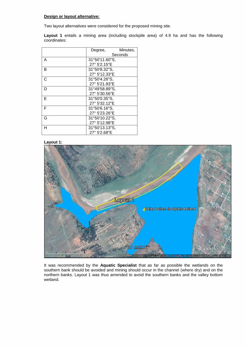
Design or layout alternative: Two layout alternatives were considered for the proposed mining site. Layout 1 entails a mining area (including stockpile area) of 4.9 ha and has the following coordinates:
Degree, Minutes, Seconds
A 31°50'11.60"S, 27° 5'2.15"E
B 31°50'8.32"S, 27° 5'12.33"E
C 31°50'4.26"S, 27° 5'21.93"E
D 31°49'58.89"S, 27° 5'30.56"E
E 31°50'0.35"S, 27° 5'32.12"E
F 31°50'6.16"S, 27° 5'23.26"E
G 31°50'10.22"S, 27° 5'12.98"E
H 31°50'13.13"S, 27° 5'2.68"E
Layout 1:
It was recommended by the Aquatic Specialist that as far as possible the wetlands on the southern bank should be avoided and mining should occur in the channel (where dry) and on the northern banks. Layout 1 was thus amended to avoid the southern banks and the valley bottom wetland.
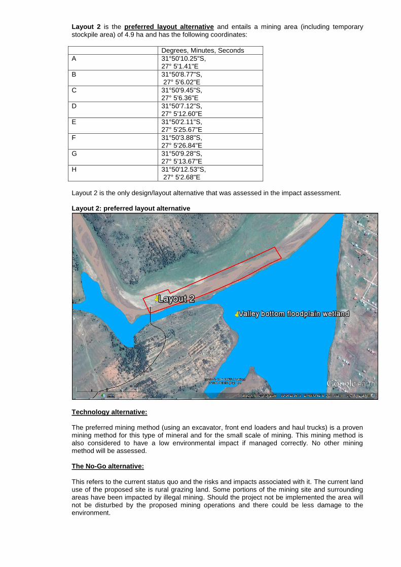
Layout 2 is the preferred layout alternative and entails a mining area (including temporary stockpile area) of 4.9 ha and has the following coordinates:
Degrees, Minutes, Seconds
A 31°50'10.25"S, 27° 5'1.41"E
B 31°50'8.77"S, 27° 5'6.02"E
C 31°50'9.45"S, 27° 5'6.36"E
D 31°50'7.12"S, 27° 5'12.60"E
E 31°50'2.11"S, 27° 5'25.67"E
F 31°50'3.88"S, 27° 5'26.84"E
G 31°50'9.28"S, 27° 5'13.67"E
H 31°50'12.53"S, 27° 5'2.68"E
Layout 2 is the only design/layout alternative that was assessed in the impact assessment.
Layout 2: preferred layout alternative
Technology alternative:
The preferred mining method (using an excavator, front end loaders and haul trucks) is a proven mining method for this type of mineral and for the small scale of mining. This mining method is also considered to have a low environmental impact if managed correctly. No other mining method will be assessed. The No-Go alternative: This refers to the current status quo and the risks and impacts associated with it. The current land use of the proposed site is rural grazing land. Some portions of the mining site and surrounding areas have been impacted by illegal mining. Should the project not be implemented the area will not be disturbed by the proposed mining operations and there could be less damage to the environment.

Disadvantages of the no-go option are that the area could continue to be mined illegally, leading to increased erosion and sedimentation. There might also not be any job creation or benefits to the local community from the mining activity. Advantages of the no-go option are a reduced risk of potential environmental degradation (i.e. water pollution, soil erosion, etc.). The No-Go alternative is assessed further in the impact assessment process.
ii) Details of the Public Participation Process Followed
Describe the process undertaken to consult interested and affected parties including public meetings and one on one consultation. NB the affected parties must be specifically consulted regardless of whether or not they attended public meetings. (Information to be provided to affected parties must include sufficient detail of the intended operation to enable them to assess what impact the activities will have on them or on the use of their land. Refer to Appendix 2 for proof of the public participation process (PPP) followed as well as an Issues and Response Table.
Stakeholders and I&AP‘s were informed of the project by means letters of notification and Background Information Documents (BIDs). A notice board was placed near the mining site and an advert was placed in the Daily Dispatch on 10 March 2016. A public meeting was held on 11 May 2016 with the Xonxa community, representatives from the Emalahleni Local Municipality and the Ward 1 councillor. Proof of the public meeting is available in Appendix 2.
The draft BAR was made available to all I&APs and stakeholders for comment for a period of 30 days (from 2 June 2016 to 4 July 2016). No comments were received.

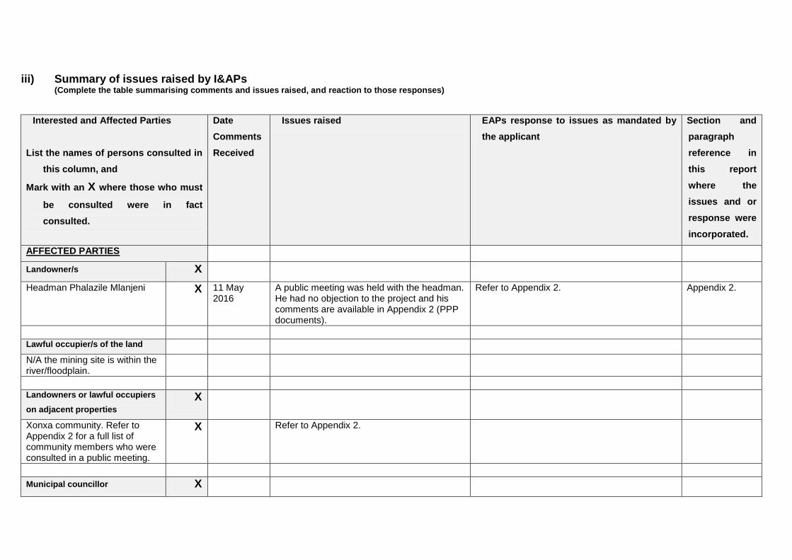
iii) Summary of issues raised by I&APs (Complete the table summarising comments and issues raised, and reaction to those responses)
Interested and Affected Parties
List the names of persons consulted in
this column, and
Mark with an X where those who must
be consulted were in fact
consulted.
Date
Comments
Received
Issues raised EAPs response to issues as mandated by
the applicant
Section and
paragraph
reference in
this report
where the
issues and or
response were
incorporated.
AFFECTED PARTIES
Landowner/s X
Headman Phalazile Mlanjeni X 11 May 2016
A public meeting was held with the headman. He had no objection to the project and his comments are available in Appendix 2 (PPP documents).
Refer to Appendix 2. Appendix 2.
Lawful occupier/s of the land
N/A the mining site is within the river/floodplain.
Landowners or lawful occupiers
on adjacent properties
X
Xonxa community. Refer to Appendix 2 for a full list of community members who were consulted in a public meeting.
X Refer to Appendix 2.
Municipal councillor X
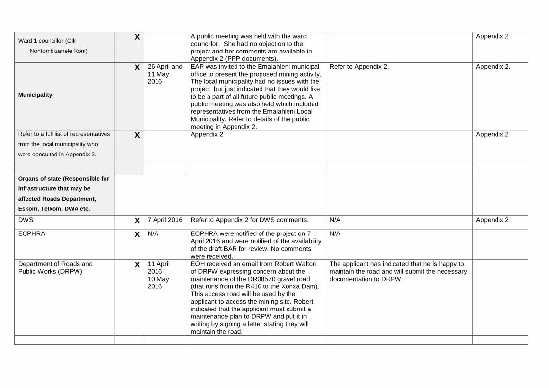
Ward 1 councillor (Cllr
Nontombizanele Koni)
X A public meeting was held with the ward councillor. She had no objection to the project and her comments are available in Appendix 2 (PPP documents).
Appendix 2
Municipality
X 26 April and 11 May 2016
EAP was invited to the Emalahleni municipal office to present the proposed mining activity. The local municipality had no issues with the project, but just indicated that they would like to be a part of all future public meetings. A public meeting was also held which included representatives from the Emalahleni Local Municipality. Refer to details of the public meeting in Appendix 2.
Refer to Appendix 2. Appendix 2.
Refer to a full list of representatives
from the local municipality who
were consulted in Appendix 2.
X Appendix 2 Appendix 2
Organs of state (Responsible for
infrastructure that may be
affected Roads Department,
Eskom, Telkom, DWA etc.
DWS X 7 April 2016 Refer to Appendix 2 for DWS comments. N/A Appendix 2
ECPHRA X N/A ECPHRA were notified of the project on 7 April 2016 and were notified of the availability of the draft BAR for review. No comments were received.
N/A
Department of Roads and Public Works (DRPW)
X 11 April 2016 10 May 2016
EOH received an email from Robert Walton of DRPW expressing concern about the maintenance of the DR08570 gravel road (that runs from the R410 to the Xonxa Dam). This access road will be used by the applicant to access the mining site. Robert indicated that the applicant must submit a maintenance plan to DRPW and put it in writing by signing a letter stating they will maintain the road.
The applicant has indicated that he is happy to maintain the road and will submit the necessary documentation to DRPW.
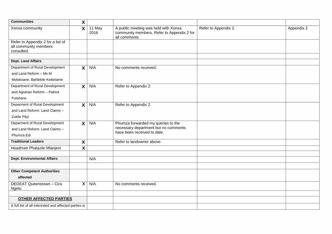
Communities X
Xonxa community X 11 May 2016
A public meeting was held with Xonxa community members. Refer to Appendix 2 for all comments.
Refer to Appendix 2. Appendix 2
Refer to Appendix 2 for a list of all community members consulted.
Dept. Land Affairs Department of Rural Development
and Land Reform – Ms M
Molokoane, Bahlekile Keikelame
X N/A No comments received.
Department of Rural Development
and Agrarian Reform – Patrick
Futshane
X N/A Refer to Appendix 2.
Deparment of Rural Development
and Land Reform: Land Claims –
Zukile Pityi
X N/A Refer to Appendix 2.
Deparment of Rural Development
and Land Reform: Land Claims –
Phumza Edi
X N/A Phumza forwarded my queries to the necessary department but no comments have been received to date.
Traditional Leaders X Refer to landowner above.
Headman Phalazile Mlanjeni X
Dept. Environmental Affairs N/A Other Competent Authorities
affected
DEDEAT Queenstown – Cira Ngetu
X N/A No comments received.
OTHER AFFECTED PARTIES
A full list of all interested and affected parties is
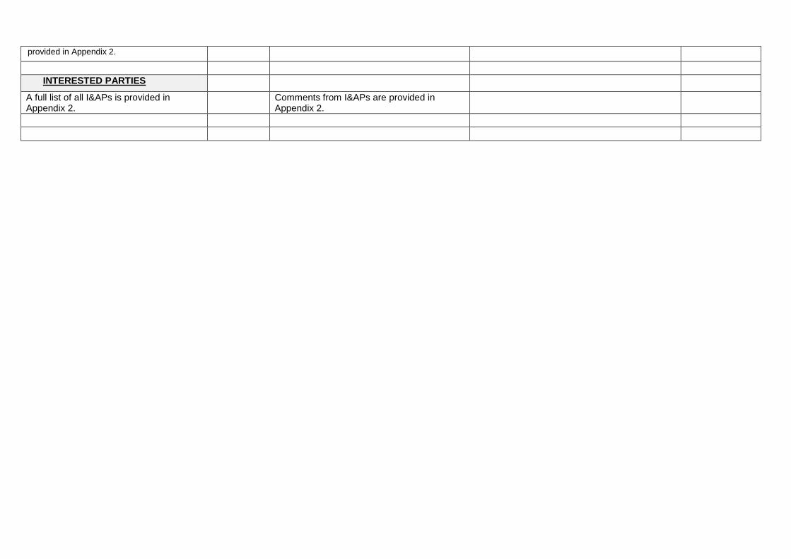
provided in Appendix 2.
INTERESTED PARTIES
A full list of all I&APs is provided in Appendix 2.
Comments from I&APs are provided in Appendix 2.
iv) The Environmental attributes associated with the alternatives.(The
environmental attributed described must include socio-economic, social, heritage, cultural, geographical, physical and biological aspects)
(1) Baseline Environment
(a) Type of environment affected by the proposed activity. (its current geographical, physical, biological, socio- economic, and cultural character).
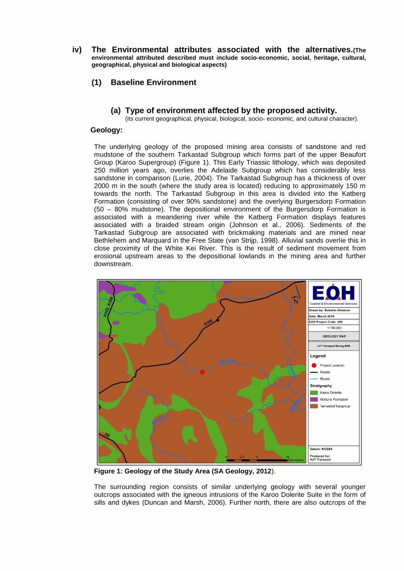
Geology: The underlying geology of the proposed mining area consists of sandstone and red mudstone of the southern Tarkastad Subgroup which forms part of the upper Beaufort Group (Karoo Supergroup) (Figure 1). This Early Triassic lithology, which was deposited 250 million years ago, overlies the Adelaide Subgroup which has considerably less sandstone in comparison (Lurie, 2004). The Tarkastad Subgroup has a thickness of over 2000 m in the south (where the study area is located) reducing to approximately 150 m towards the north. The Tarkastad Subgroup in this area is divided into the Katberg Formation (consisting of over 90% sandstone) and the overlying Burgersdorp Formation (50 – 80% mudstone). The depositional environment of the Burgersdorp Formation is associated with a meandering river while the Katberg Formation displays features associated with a braided stream origin (Johnson et al., 2006). Sediments of the Tarkastad Subgroup are associated with brickmaking materials and are mined near Bethlehem and Marquard in the Free State (van Strijp, 1998). Alluvial sands overlie this in close proximity of the White Kei River. This is the result of sediment movement from erosional upstream areas to the depositional lowlands in the mining area and further downstream.
Figure 1: Geology of the Study Area (SA Geology, 2012). The surrounding region consists of similar underlying geology with several younger outcrops associated with the igneous intrusions of the Karoo Dolerite Suite in the form of sills and dykes (Duncan and Marsh, 2006). Further north, there are also outcrops of the
Molteno Formation which overlies the Tarkastad Subgroup and consists of interbedded siltstone, sandstone and minor conglomerate (Johnson et al., 2006). Soils in the study area are soils with minimal development, usually shallow on hard or weathering rock. There are also soils with a marked clay accumulation.
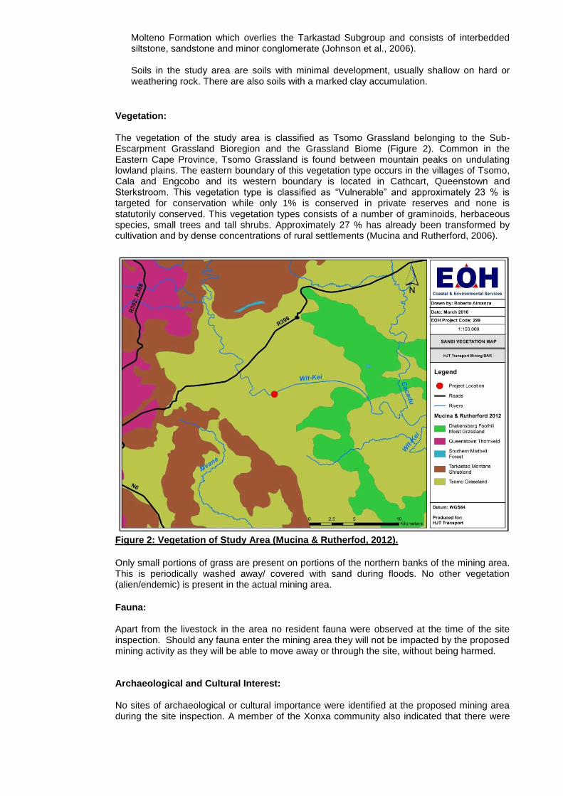
Vegetation:
The vegetation of the study area is classified as Tsomo Grassland belonging to the Sub-Escarpment Grassland Bioregion and the Grassland Biome (Figure 2). Common in the Eastern Cape Province, Tsomo Grassland is found between mountain peaks on undulating lowland plains. The eastern boundary of this vegetation type occurs in the villages of Tsomo, Cala and Engcobo and its western boundary is located in Cathcart, Queenstown and Sterkstroom. This vegetation type is classified as ―Vulnerable‖ and approximately 23 % is targeted for conservation while only 1% is conserved in private reserves and none is statutorily conserved. This vegetation types consists of a number of graminoids, herbaceous species, small trees and tall shrubs. Approximately 27 % has already been transformed by cultivation and by dense concentrations of rural settlements (Mucina and Rutherford, 2006).
Figure 2: Vegetation of Study Area (Mucina & Rutherfod, 2012).
Only small portions of grass are present on portions of the northern banks of the mining area. This is periodically washed away/ covered with sand during floods. No other vegetation (alien/endemic) is present in the actual mining area.
Fauna: Apart from the livestock in the area no resident fauna were observed at the time of the site inspection. Should any fauna enter the mining area they will not be impacted by the proposed mining activity as they will be able to move away or through the site, without being harmed.
Archaeological and Cultural Interest: No sites of archaeological or cultural importance were identified at the proposed mining area during the site inspection. A member of the Xonxa community also indicated that there were
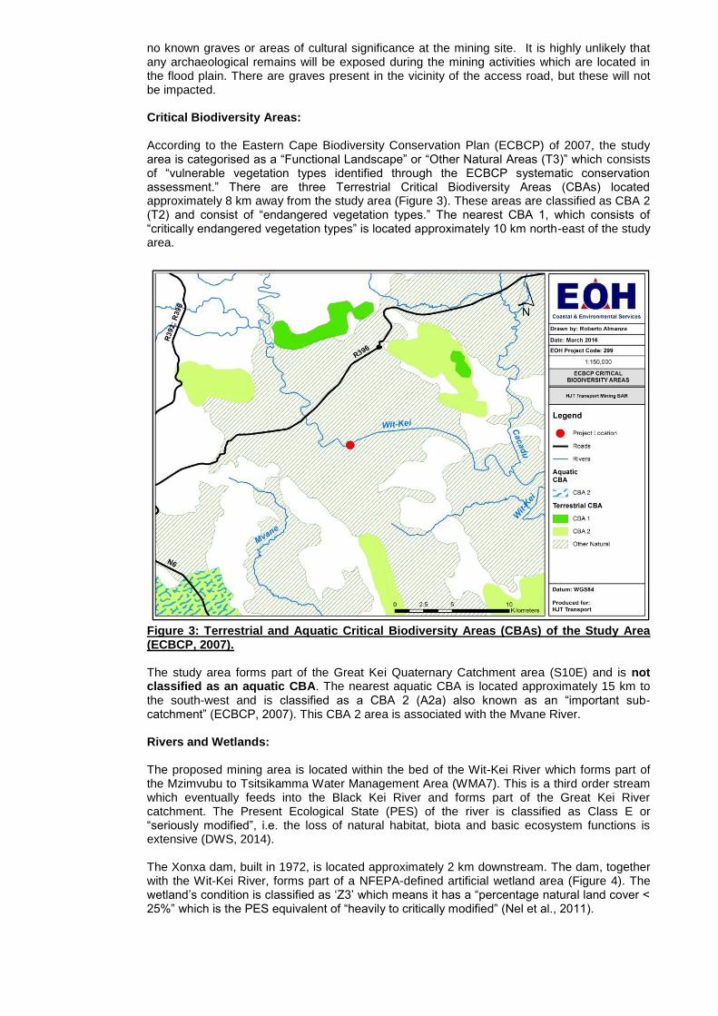
no known graves or areas of cultural significance at the mining site. It is highly unlikely that any archaeological remains will be exposed during the mining activities which are located in the flood plain. There are graves present in the vicinity of the access road, but these will not be impacted. Critical Biodiversity Areas: According to the Eastern Cape Biodiversity Conservation Plan (ECBCP) of 2007, the study area is categorised as a ―Functional Landscape‖ or ―Other Natural Areas (T3)‖ which consists of ―vulnerable vegetation types identified through the ECBCP systematic conservation assessment.‖ There are three Terrestrial Critical Biodiversity Areas (CBAs) located approximately 8 km away from the study area (Figure 3). These areas are classified as CBA 2 (T2) and consist of ―endangered vegetation types.‖ The nearest CBA 1, which consists of ―critically endangered vegetation types‖ is located approximately 10 km north-east of the study area.
Figure 3: Terrestrial and Aquatic Critical Biodiversity Areas (CBAs) of the Study Area (ECBCP, 2007). The study area forms part of the Great Kei Quaternary Catchment area (S10E) and is not classified as an aquatic CBA. The nearest aquatic CBA is located approximately 15 km to the south-west and is classified as a CBA 2 (A2a) also known as an ―important sub-catchment‖ (ECBCP, 2007). This CBA 2 area is associated with the Mvane River. Rivers and Wetlands: The proposed mining area is located within the bed of the Wit-Kei River which forms part of the Mzimvubu to Tsitsikamma Water Management Area (WMA7). This is a third order stream which eventually feeds into the Black Kei River and forms part of the Great Kei River catchment. The Present Ecological State (PES) of the river is classified as Class E or ―seriously modified‖, i.e. the loss of natural habitat, biota and basic ecosystem functions is extensive (DWS, 2014). The Xonxa dam, built in 1972, is located approximately 2 km downstream. The dam, together with the Wit-Kei River, forms part of a NFEPA-defined artificial wetland area (Figure 4). The wetland‘s condition is classified as ‗Z3‘ which means it has a ―percentage natural land cover < 25%‖ which is the PES equivalent of ―heavily to critically modified‖ (Nel et al., 2011).
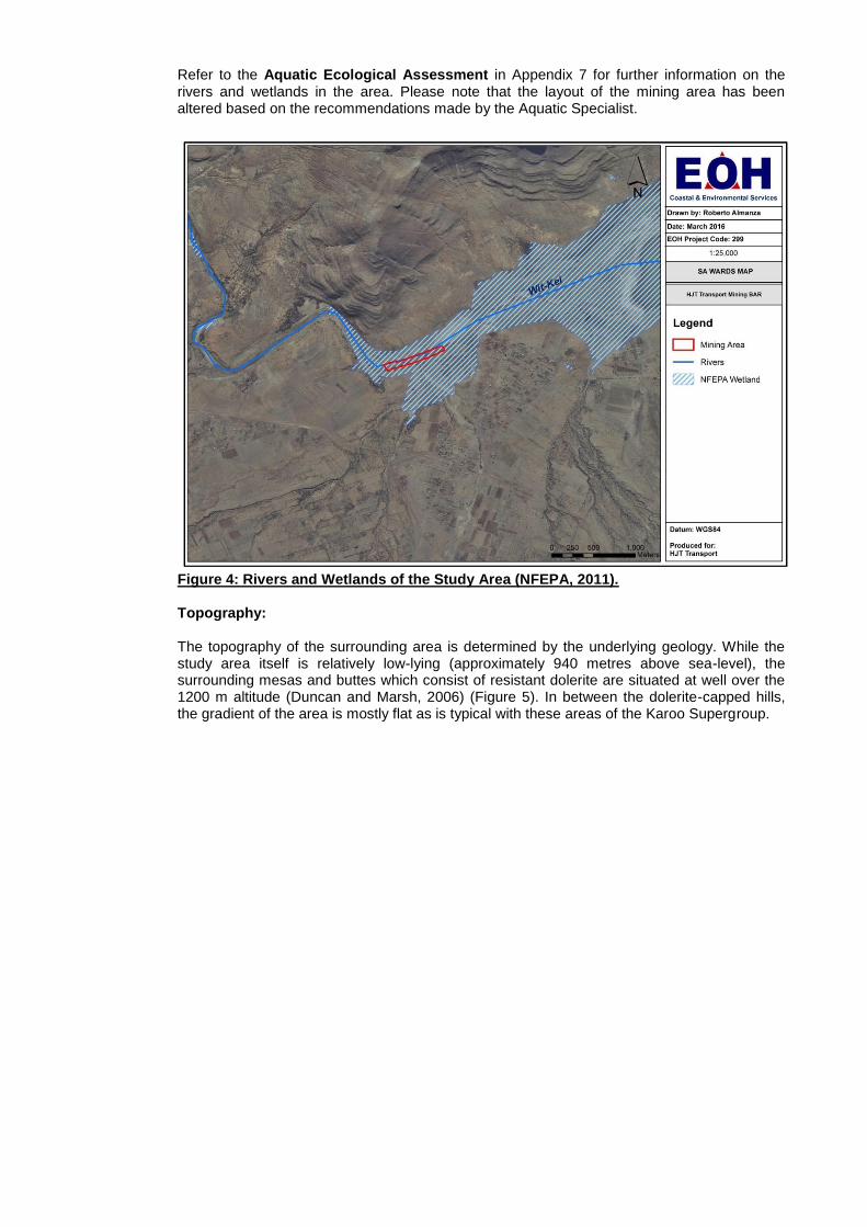
Refer to the Aquatic Ecological Assessment in Appendix 7 for further information on the rivers and wetlands in the area. Please note that the layout of the mining area has been altered based on the recommendations made by the Aquatic Specialist.
Figure 4: Rivers and Wetlands of the Study Area (NFEPA, 2011). Topography: The topography of the surrounding area is determined by the underlying geology. While the study area itself is relatively low-lying (approximately 940 metres above sea-level), the surrounding mesas and buttes which consist of resistant dolerite are situated at well over the 1200 m altitude (Duncan and Marsh, 2006) (Figure 5). In between the dolerite-capped hills, the gradient of the area is mostly flat as is typical with these areas of the Karoo Supergroup.
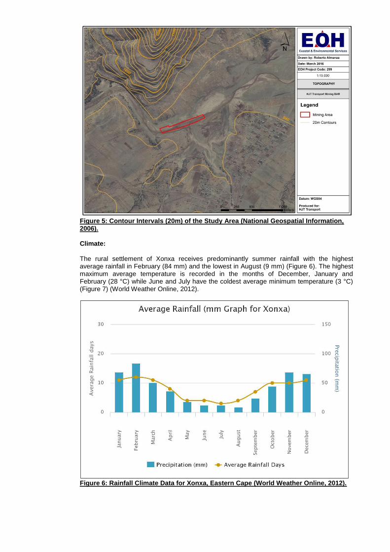
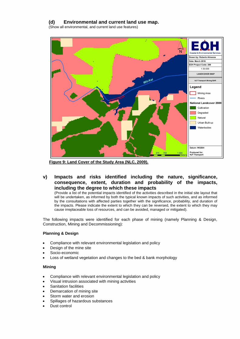
Figure 5: Contour Intervals (20m) of the Study Area (National Geospatial Information, 2006). Climate: The rural settlement of Xonxa receives predominantly summer rainfall with the highest average rainfall in February (84 mm) and the lowest in August (9 mm) (Figure 6). The highest maximum average temperature is recorded in the months of December, January and February (28 °C) while June and July have the coldest average minimum temperature (3 °C) (Figure 7) (World Weather Online, 2012).
Figure 6: Rainfall Climate Data for Xonxa, Eastern Cape (World Weather Online, 2012).
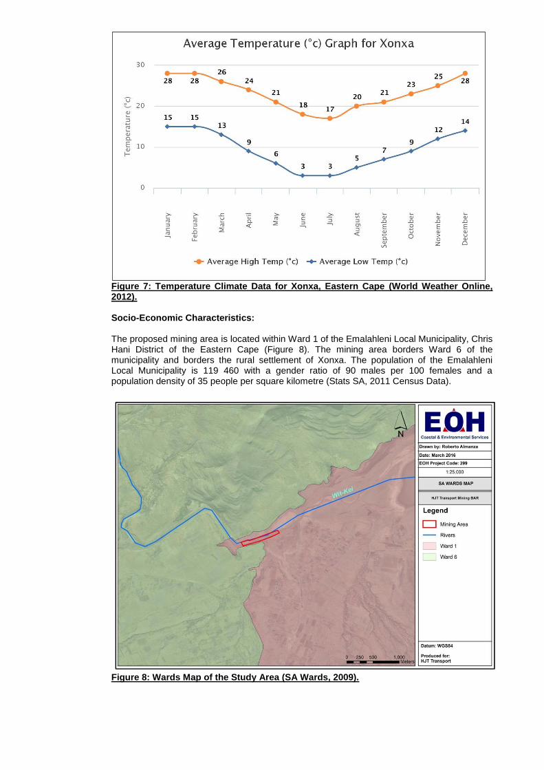
Figure 7: Temperature Climate Data for Xonxa, Eastern Cape (World Weather Online, 2012). Socio-Economic Characteristics: The proposed mining area is located within Ward 1 of the Emalahleni Local Municipality, Chris Hani District of the Eastern Cape (Figure 8). The mining area borders Ward 6 of the municipality and borders the rural settlement of Xonxa. The population of the Emalahleni Local Municipality is 119 460 with a gender ratio of 90 males per 100 females and a population density of 35 people per square kilometre (Stats SA, 2011 Census Data).
Figure 8: Wards Map of the Study Area (SA Wards, 2009).

The official unemployment rate is 46.3 % with 18.8 % of people aged 20 and above receiving no schooling. Only 11 % of the population completed matric and 3.8 % received higher education. There are 31 681 households, of which 56.1 % are formal dwellings. There are, on average, 3 to 4 people per household and only 11.8 % of households have a flush toilet connected to a sewerage line. 8.7 % of houses have piped water and 78.5 % have electricity (Stats SA, 2011 Census Data). 98.5 % of the Emalahleni Local Municipality population is Black African followed by 0.6 % Coloured, 0.6 % White and only 0.1 % Indian / Asian. Xhosa is the first language spoken by 95.2 % of the population with English and Afrikaans spoken by 1.5 % and 1.2 % of the population respectively (Stats SA, 2011 Census Data).
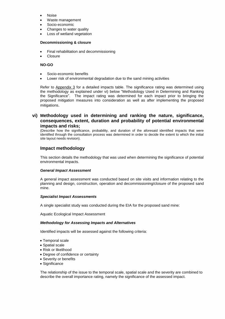
(b) Description of the current land uses.
The National Land Cover (NLC) for the Eastern Cape is based on the National Land Cover project of 2000 sourced from the Department of Agriculture. The study area falls into the NLC categories of ―Waterbodies‖ and ―Degraded‖ areas. The majority of the study area is a ‗waterbody‘ land use which is associated with the perennial river which runs through the study area as well as the artificial dam (Xonxa Dam) located to the east. The study area is surrounded by additional land use zones such as ‗cultivation‘ areas, ‗natural‘ areas‘ and ‗urban built-up‘ areas (NLC, 2009).
(c) Description of specific environmental features and infrastructure on the site. The existing infrastructure within 500 m of the proposed mining area is the small village of Xonxa (300 m) and existing access road to the site, legal & illegal sandmining operations further upstream (1km). The R410 is approximately 4km away from the proposed mining area. The impact of the proposed mining area on the infrastructural features of the surrounding area is deemed to be of low significance as the impact of the mining activities will mostly be concentrated within the 4.9 ha footprint area of the mine. The Bhelothwa Rtodana gravel road (that runs from the R410) will be impacted by haul trucks (this road is currently impacted by other mining vehicles in the area), but HJT Transport have indicated that they will maintain this road. The river transecting the mining area and the artificial wetland on the southern banks of the river was identified as the only specific environmental feature that would require protection. The wetland (except for the river crossing point) will be declared and managed as a no-go area to ensure protection. With the lack of a clearly defined river bank on the northern side of the White Kei River, the river can freely spread out onto the northern floodplains, depositing sand during flood events. Due to this, the floodplain is frequently disturbed and the area is bare, with little vegetation (grasses in places). Only minor stormwater management will likely be required on site (likely just for the haul road). Most cattle & goats are herded to vegetated areas outside the proposed mining site (on the wetland areas on the southern bank) where there is sufficient grass cover and safer access for cattle to drink.
(d) Environmental and current land use map. (Show all environmental, and current land use features)
Figure 9: Land Cover of the Study Area (NLC, 2009).
v) Impacts and risks identified including the nature, significance, consequence, extent, duration and probability of the impacts, including the degree to which these impacts (Provide a list of the potential impacts identified of the activities described in the initial site layout that will be undertaken, as informed by both the typical known impacts of such activities, and as informed by the consultations with affected parties together with the significance, probability, and duration of the impacts. Please indicate the extent to which they can be reversed, the extent to which they may cause irreplaceable loss of resources, and can be avoided, managed or mitigated).
The following impacts were identified for each phase of mining (namely Planning & Design, Construction, Mining and Decommissioning): Planning & Design
Compliance with relevant environmental legislation and policy
Design of the mine site
Socio-economic
Loss of wetland vegetation and changes to the bed & bank morphology Mining
Compliance with relevant environmental legislation and policy
Visual intrusion associated with mining activities
Sanitation facilities
Demarcation of mining site
Storm water and erosion
Spillages of hazardous substances
Dust control
Noise
Waste management
Socio-economic
Changes to water quality
Loss of wetland vegetation Decommissioning & closure
Final rehabilitation and decommissioning
Closure NO-GO
Socio-economic benefits
Lower risk of environmental degradation due to the sand mining activities Refer to Appendix 3 for a detailed impacts table. The significance rating was determined using the methodology as explained under vi) below ―Methodology Used in Determining and Ranking the Significance‖. The impact rating was determined for each impact prior to bringing the proposed mitigation measures into consideration as well as after implementing the proposed
mitigations.
vi) Methodology used in determining and ranking the nature, significance, consequences, extent, duration and probability of potential environmental impacts and risks; (Describe how the significance, probability, and duration of the aforesaid identified impacts that were identified through the consultation process was determined in order to decide the extent to which the initial site layout needs revision).
Impact methodology
This section details the methodology that was used when determining the significance of potential environmental impacts. General Impact Assessment A general impact assessment was conducted based on site visits and information relating to the planning and design, construction, operation and decommissioning/closure of the proposed sand mine. Specialist Impact Assessments A single specialist study was conducted during the EIA for the proposed sand mine: Aquatic Ecological Impact Assessment Methodology for Assessing Impacts and Alternatives Identified impacts will be assessed against the following criteria:
Temporal scale
Spatial scale
Risk or likelihood
Degree of confidence or certainty
Severity or benefits
Significance The relationship of the issue to the temporal scale, spatial scale and the severity are combined to describe the overall importance rating, namely the significance of the assessed impact.
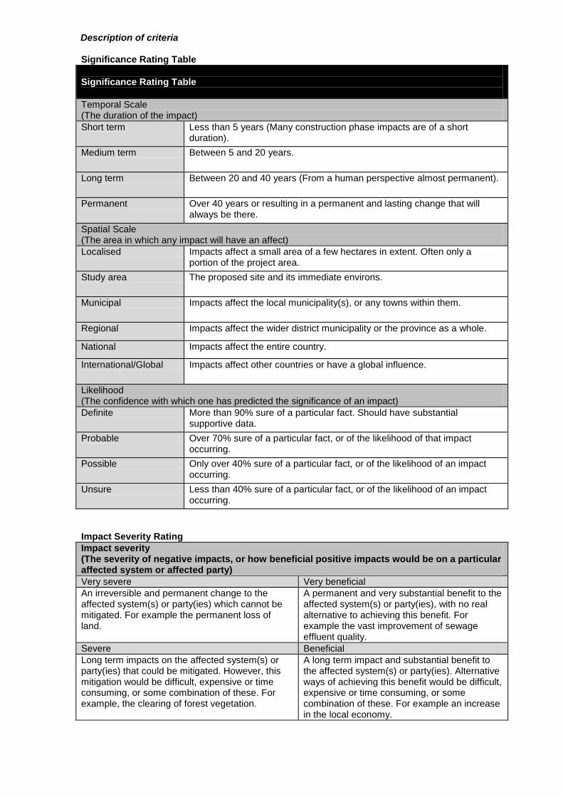
Description of criteria Significance Rating Table
Significance Rating Table
Temporal Scale (The duration of the impact)
Short term Less than 5 years (Many construction phase impacts are of a short duration).
Medium term Between 5 and 20 years.
Long term Between 20 and 40 years (From a human perspective almost permanent).
Permanent Over 40 years or resulting in a permanent and lasting change that will always be there.
Spatial Scale (The area in which any impact will have an affect)
Localised Impacts affect a small area of a few hectares in extent. Often only a portion of the project area.
Study area The proposed site and its immediate environs.
Municipal Impacts affect the local municipality(s), or any towns within them.
Regional Impacts affect the wider district municipality or the province as a whole.
National Impacts affect the entire country.
International/Global Impacts affect other countries or have a global influence.
Likelihood (The confidence with which one has predicted the significance of an impact)
Definite More than 90% sure of a particular fact. Should have substantial supportive data.
Probable Over 70% sure of a particular fact, or of the likelihood of that impact occurring.
Possible Only over 40% sure of a particular fact, or of the likelihood of an impact occurring.
Unsure Less than 40% sure of a particular fact, or of the likelihood of an impact occurring.
Impact Severity Rating
Impact severity (The severity of negative impacts, or how beneficial positive impacts would be on a particular affected system or affected party)
Very severe Very beneficial
An irreversible and permanent change to the affected system(s) or party(ies) which cannot be mitigated. For example the permanent loss of land.
A permanent and very substantial benefit to the affected system(s) or party(ies), with no real alternative to achieving this benefit. For example the vast improvement of sewage effluent quality.
Severe Beneficial
Long term impacts on the affected system(s) or party(ies) that could be mitigated. However, this mitigation would be difficult, expensive or time consuming, or some combination of these. For example, the clearing of forest vegetation.
A long term impact and substantial benefit to the affected system(s) or party(ies). Alternative ways of achieving this benefit would be difficult, expensive or time consuming, or some combination of these. For example an increase in the local economy.
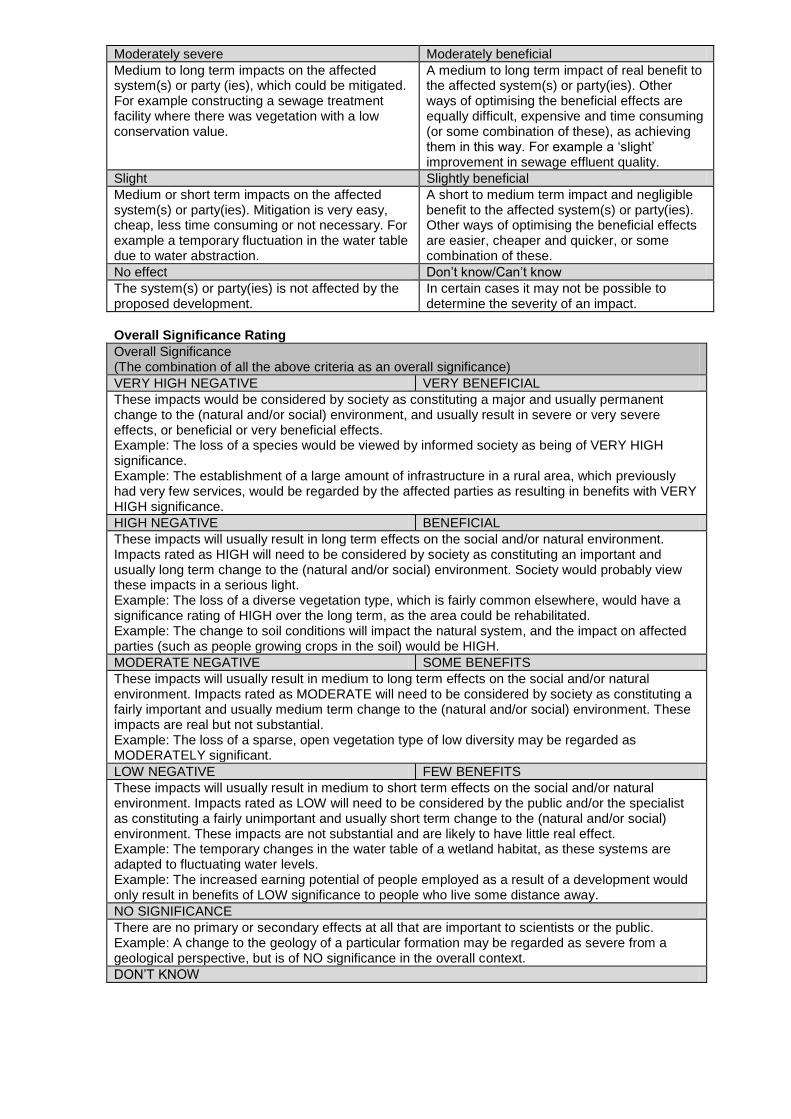
Moderately severe Moderately beneficial
Medium to long term impacts on the affected system(s) or party (ies), which could be mitigated. For example constructing a sewage treatment facility where there was vegetation with a low conservation value.
A medium to long term impact of real benefit to the affected system(s) or party(ies). Other ways of optimising the beneficial effects are equally difficult, expensive and time consuming (or some combination of these), as achieving them in this way. For example a ‗slight‘ improvement in sewage effluent quality.
Slight Slightly beneficial
Medium or short term impacts on the affected system(s) or party(ies). Mitigation is very easy, cheap, less time consuming or not necessary. For example a temporary fluctuation in the water table due to water abstraction.
A short to medium term impact and negligible benefit to the affected system(s) or party(ies). Other ways of optimising the beneficial effects are easier, cheaper and quicker, or some combination of these.
No effect Don‘t know/Can‘t know
The system(s) or party(ies) is not affected by the proposed development.
In certain cases it may not be possible to determine the severity of an impact.
Overall Significance Rating
Overall Significance (The combination of all the above criteria as an overall significance)
VERY HIGH NEGATIVE VERY BENEFICIAL
These impacts would be considered by society as constituting a major and usually permanent change to the (natural and/or social) environment, and usually result in severe or very severe effects, or beneficial or very beneficial effects. Example: The loss of a species would be viewed by informed society as being of VERY HIGH significance. Example: The establishment of a large amount of infrastructure in a rural area, which previously had very few services, would be regarded by the affected parties as resulting in benefits with VERY HIGH significance.
HIGH NEGATIVE BENEFICIAL
These impacts will usually result in long term effects on the social and/or natural environment. Impacts rated as HIGH will need to be considered by society as constituting an important and usually long term change to the (natural and/or social) environment. Society would probably view these impacts in a serious light. Example: The loss of a diverse vegetation type, which is fairly common elsewhere, would have a significance rating of HIGH over the long term, as the area could be rehabilitated. Example: The change to soil conditions will impact the natural system, and the impact on affected parties (such as people growing crops in the soil) would be HIGH.
MODERATE NEGATIVE SOME BENEFITS
These impacts will usually result in medium to long term effects on the social and/or natural environment. Impacts rated as MODERATE will need to be considered by society as constituting a fairly important and usually medium term change to the (natural and/or social) environment. These impacts are real but not substantial. Example: The loss of a sparse, open vegetation type of low diversity may be regarded as MODERATELY significant.
LOW NEGATIVE FEW BENEFITS
These impacts will usually result in medium to short term effects on the social and/or natural environment. Impacts rated as LOW will need to be considered by the public and/or the specialist as constituting a fairly unimportant and usually short term change to the (natural and/or social) environment. These impacts are not substantial and are likely to have little real effect. Example: The temporary changes in the water table of a wetland habitat, as these systems are adapted to fluctuating water levels. Example: The increased earning potential of people employed as a result of a development would only result in benefits of LOW significance to people who live some distance away.
NO SIGNIFICANCE
There are no primary or secondary effects at all that are important to scientists or the public. Example: A change to the geology of a particular formation may be regarded as severe from a geological perspective, but is of NO significance in the overall context.
DON‘T KNOW
In certain cases it may not be possible to determine the significance of an impact. For example, the primary or secondary impacts on the social or natural environment given the available information. Example: The effect of a particular development on people‘s psychological perspective of the environment.
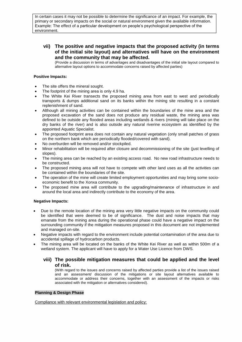
vii) The positive and negative impacts that the proposed activity (in terms
of the initial site layout) and alternatives will have on the environment and the community that may be affected. (Provide a discussion in terms of advantages and disadvantages of the initial site layout compared to alternative layout options to accommodate concerns raised by affected parties)
Positive Impacts:
The site offers the mineral sought.
The footprint of the mining area is only 4.9 ha.
The White Kei River transects the proposed mining area from east to west and periodically transports & dumps additional sand on its banks within the mining site resulting in a constant replenishment of sand.
Although all mining activities can be contained within the boundaries of the mine area and the proposed excavation of the sand does not produce any residual waste, the mining area was defined to be outside any flooded areas including wetlands & rivers (mining will take place on the dry banks of the river) and is also outside any natural riverine ecosystem as identified by the appointed Aquatic Specialist.
The proposed footprint area does not contain any natural vegetation (only small patches of grass on the northern bank which are periodically flooded/covered with sand).
No overburden will be removed and/or stockpiled.
Minor rehabilitation will be required after closure and decommissioning of the site (just levelling of slopes).
The mining area can be reached by an existing access road. No new road infrastructure needs to be constructed.
The proposed mining area will not have to compete with other land uses as all the activities can be contained within the boundaries of the site.
The operation of the mine will create limited employment opportunities and may bring some socio-economic benefit to the Xonxa community.
The proposed mine area will contribute to the upgrading/maintenance of infrastructure in and around the local area and indirectly contribute to the economy of the area.
Negative Impacts:
Due to the remote location of the mining area very little negative impacts on the community could be identified that were deemed to be of significance. The dust and noise impacts that may emanate from the mining area during the operational phase could have a negative impact on the surrounding community if the mitigation measures proposed in this document are not implemented and managed on-site.
Negative impacts with regard to the environment include potential contamination of the area due to accidental spillage of hydrocarbon products.
The mining area will be located on the banks of the White Kei River as well as within 500m of a wetland system. The applicant will have to apply for a Water Use Licence from DWS.
viii) The possible mitigation measures that could be applied and the level
of risk. (With regard to the issues and concerns raised by affected parties provide a list of the issues raised and an assessment/ discussion of the mitigations or site layout alternatives available to accommodate or address their concerns, together with an assessment of the impacts or risks associated with the mitigation or alternatives considered).
Planning & Design Phase Compliance with relevant environmental legislation and policy:

• All relevant legislation and policy must be consulted and the proponent must ensure that the project is compliant with such legislation and policy.
• These should include (but are not restricted to): MPRDA, NEMA, NWA, Local and District Spatial Development Frameworks, Eastern Cape Biodiversity Conservation Plan (ECBCP), Local Municipal bylaws.
Risk will be reduced from HIGH NEGATIVE to LOW NEGATIVE Design of the mine site: • The site must be designed to avoid the river itself (mining will only take place in the current river
channel when water has receded and dry areas can be mined) as well as any wetlands and natural riparian ecosystems as identified by the aquatic specialist.
Risk will remain LOW NEGATIVE Socio-economic: • The proponent must ensure that an agreement (regarding community benefits) is reached
between the developer, the current land users and the municipality prior to any construction or mining activity taking place on site.
Risk will be reduced from MODERATE NEGATIVE to LOW NEGATIVE Loss of wetland vegetation: • The wetlands on the Southern bank of the White Kei River must be avoided and mining must
occur on the northern banks. • The proposed access road footprint should be kept as small as possible and be provided with
suitable stormwater management features (if necessary), that will prevent additional erosion within the terrestrial as well as aquatic habitats.
Risk will be reduced from MODERATE NEGATIVE to LOW NEGATIVE Mining phase Compliance with relevant environmental legislation and policy: • The proponent must ensure that mining is compliant with the relevant legislation and policy. • These should include (but are not restricted to): MPRDA, NWA, NEMA, Local and District Spatial
Development Frameworks, Eastern Cape Biodiversity Conservation Plan (ECBCP), Local Municipal bylaws.
Risk will be reduced from HIGH NEGATIVE to LOW NEGATIVE Visual intrusion associated with mining activities: • Mining activities should only take place during normal work hours (7am to 5pm). • Mining activities must be limited to the designated area and not encroach into surrounding areas. Risk will be reduced from MODERATE NEGATIVE to LOW NEGATIVE Sanitation facilities: • Sanitation facilities must be located more than 50m from any water resources or water drainage
areas. • The facilities must be regularly serviced to reduce the risk of surface or groundwater pollution. Risk will be reduced from MODERATE NEGATIVE to LOW NEGATIVE Demarcation of mining site:
• The boundaries of the quarry site must be adequately demarcated to restrict mining and other activities. All plant, equipment and other materials must remain within the demarcated boundaries during mining activities.
• Ablution facilities must be located at least 50 m away from the banks of the river.
Risk will be reduced from HIGH NEGATIVE to LOW NEGATIVE Storm water: • No mitigation required Risk will remain LOW NEGATIVE Spillages of hazardous substances: • All oils, fuel and other maintenance equipment and supplies must be stored in a secure area
offsite with a compacted surface (HJT Transport have access to an offsite yard for storing equipment.
• Vehicles must be maintained to an acceptable standard to prevent any fuel, oil or lubricant leaks etc).
.• Spill kits must be kept on-site and maintained. • All hazardous material must be stored more than 50m away from any water body. Risk will be reduced from MODERATE NEGATIVE to LOW NEGATIVE Dust control: • Excavations must only be done during agreed working times and permitting weather conditions to
avoid drifting of sand and dust into neighbouring areas. • A speed limit of 30km/h must not be exceeded on dirt roads. • Any complaints or claims emanating from the lack of dust control must be attended to
immediately. Risk will be reduced from MODERATE NEGATIVE to LOW NEGATIVE Noise: • Mining activity and movement of heavy machinery should be limited to normal working hours (7
AM to 5 PM). • Ensure there is a facility for nearby residents to make complaints. These must be addressed and
recorded. Risk will be reduced from MODERATE NEGATIVE to LOW NEGATIVE Waste management: • Sufficient waste containers must be available. • No waste must be buried on site. • Waste must be collected on a regular basis and disposed of at a licensed landfill site Risk will be reduced from MODERATE NEGATIVE to LOW NEGATIVE Socio-economic: • No mitigation required Risk will remain BENEFICIAL Changes to water quality: • The wetlands on the southern bank must be avoided and mining should occur in the channel (when
water recedes) and the northern banks.
• Littering and contamination of water sources during mining must be prevented. • Emergency plans must be in place in case of spillages of diesel and hydraulic fluids. Risk will be reduced from MODERATE NEGATIVE to LOW NEGATIVE Decommissioning & closure Final rehabilitation and decommissioning:
Any remaining sand stockpiles must be removed or levelled.
Site clean-up must be done.
Waste material of any description must be removed entirely from the mining area and disposed of at a registered landfill site.
No waste may be burned or buried on site.
Mined out areas must be profiled and stabilised (if necessary).
The post rehabilitation topography should result in the same slope as prior to mining.
Weeds/alien plants growing on site must be manually removed and deposited at a registered landfill site.
All equipment and other items used during the mining period must be removed from site.
At closure the internal haul road must be left in a good and non-eroded state (as it was prior to mining activities).
The closed site must pose no safety risks.
Rehabilitation must be completed in such a manner that the land can be optimally used post-mining.
Final rehabilitation must be completed within a period specified by the Regional Manager. Risk will be reduced from HIGH NEGATIVE to LOW NEGATIVE Closure: • Closure must comply with the MPRDA (Act 28 of 2002), NEMA (Act 107 of 1998) and the NEMA
Regulations (2014) requirements for mine closure. • A closure plan must be compiled using the guidelines described in Appendix 5 of the NEMA
Regulations (2014) and submitted to DMR. • A closure certificate must be obtained from the Minister of Mineral Resources. Risk will be reduced from HIGH NEGATIVE to LOW NEGATIVE NO-GO phase Socio-economic benefits: • No mitigation required Risk will remain MODERATE NEGATIVE Lower risk of environmental degradation due to the sand mining activities:
• No mitigation required
Risk will remain MODERATE BENEFICIAL
ix) Motivation where no alternative sites were considered.
Alternative sites were not assessed because:
There are no other sites available for sand mining in the local vicinity. Sand as a commodity is only found on river banks (as alluvials). The local community will not allow the developer to mine in any other area along the river.
x) Statement motivating the alternative development location within the overall site. (Provide a statement motivating the final site layout that is proposed)
The open cast mining of the proposed site has been identified as the most cost effective method to produce the desired sand. The proposed method will not produce any residual waste that has to be disposed of. Due to the small nature of the proposed mining activity as well as the remote location, the potential impact on the surrounding environment is deemed to be of low significance. It is proposed that all mining related infrastructure will be contained within the boundary of the mining area. As no permanent infrastructure will be established the layout/position of the temporary infrastructure will be determined by the mining progress and available space within the 4.9 ha mining area. The proposed footprint area does not contain any natural vegetation (only minor grass patches on the northern bank- these are periodically covered with sand during floods) and therefore no overburden will be removed and/or stockpiled. Subsequently no major rehabilitation will be required after closure and decommissioning of the site. Mining will take place on the northern banks of the river to avoid directly impacting the river or the wetland and natural riparian ecosystem on the southern banks. No new access roads or any other road will be required as there is an existing access road to the site. The existing access road will transect a small portion of natural riparian ecosystem as well as the river to access the northern bank, but impact is considered as minimal and no bridge will be constructed (a Water Use Licence is being applied for).
i) Full description of the process undertaken to identify, assess and rank the
impacts and risks the activity will impose on the preferred site (In respect of the final site layout plan) through the life of the activity. (Including (i) a description of all
environmental issues and risks that were identified during the environmental impact assessment process and (ii) an assessment of the significance of each issue and risk and an indication of the extent to which the issue and risk could be avoided or addressed by the adoption of mitigation measures.) During the impact assessment process the following potential impacts were identified of each main activity in each phase. An initial significance rating (listed under v: Impacts and Risks Identified) was determined for each potential impact should the mitigation measures proposed in this document not be implemented on-site. The impact assessment process then continued in identifying mitigation measures to address the impact that the proposed mining activity may have on the surrounding environment.
The significance rating was again determined for each impact using the methodology as explained
under vi) Methodology Used in Determining and Ranking the Significance. The impact ratings listed below was determined for each impact after bringing the proposed mitigation measures into consideration and therefore represents the final layout/activity proposal.
Planning & Design Phase Compliance with relevant environmental legislation and policy: Risk was reduced to LOW NEGATIVE Design of the mine site: Risk remains LOW NEGATIVE
Socio-economic: Risk was reduced to LOW NEGATIVE Loss of wetland vegetation: Risk was reduced to LOW NEGATIVE Mining phase Compliance with relevant environmental legislation and policy: Risk was reduced to LOW NEGATIVE Visual intrusion associated with mining activities: Risk was reduced to LOW NEGATIVE

Sanitation facilities: Risk was reduced to LOW NEGATIVE Demarcation of mining site: Risk was reduced to LOW NEGATIVE Storm water and erosion: Risk remains LOW NEGATIVE Spillages of hazardous substances: Risk was reduced to LOW NEGATIVE Dust control: Risk was reduced to LOW NEGATIVE Noise: Risk was reduced to LOW NEGATIVE Waste management: Risk was reduced to LOW NEGATIVE Socio-economic: Risk remains BEBEFICIAL Changes to water quality: Risk was reduced to LOW NEGATIVE Decommissioning & closure Final rehabilitation and decommissioning: Risk was reduced to LOW NEGATIVE Closure: Risk was reduced to LOW NEGATIVE NO-GO phase Socio-economic benefits: Risk remains MODERATE NEGATIVE Lower risk of environmental degradation due to the sand mining activities: Risk remains MODERATE BENEFICIAL

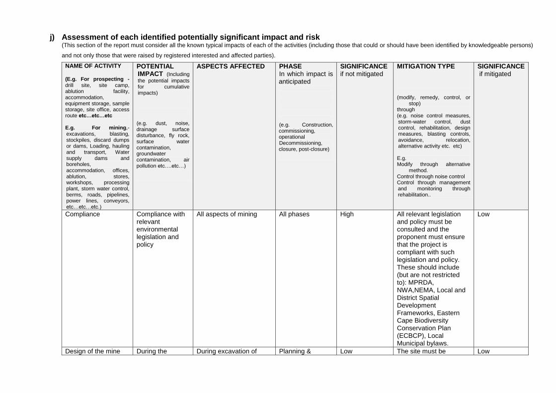
j) Assessment of each identified potentially significant impact and risk (This section of the report must consider all the known typical impacts of each of the activities (including those that could or should have been identified by knowledgeable persons)
and not only those that were raised by registered interested and affected parties).
NAME OF ACTIVITY (E.g. For prospecting - drill site, site camp, ablution facility, accommodation, equipment storage, sample storage, site office, access route etc…etc…etc E.g. For mining,- excavations, blasting, stockpiles, discard dumps or dams, Loading, hauling and transport, Water supply dams and boreholes, accommodation, offices, ablution, stores, workshops, processing plant, storm water control, berms, roads, pipelines, power lines, conveyors, etc…etc…etc.)
POTENTIAL IMPACT (Including
the potential impacts for cumulative impacts) (e.g. dust, noise, drainage surface disturbance, fly rock, surface water contamination, groundwater contamination, air pollution etc….etc…)
ASPECTS AFFECTED PHASE In which impact is anticipated
(e.g. Construction, commissioning, operational Decommissioning, closure, post-closure)
SIGNIFICANCE if not mitigated
MITIGATION TYPE
(modify, remedy, control, or
stop) through (e.g. noise control measures, storm-water control, dust control, rehabilitation, design measures, blasting controls, avoidance, relocation, alternative activity etc. etc) E.g. Modify through alternative
method. Control through noise control Control through management and monitoring through rehabilitation..
SIGNIFICANCE if mitigated
Compliance Compliance with relevant environmental legislation and policy
All aspects of mining All phases High All relevant legislation and policy must be consulted and the proponent must ensure that the project is compliant with such legislation and policy. These should include (but are not restricted to): MPRDA, NWA,NEMA, Local and District Spatial Development Frameworks, Eastern Cape Biodiversity Conservation Plan (ECBCP), Local Municipal bylaws.
Low
Design of the mine During the During excavation of Planning & Low The site must be Low
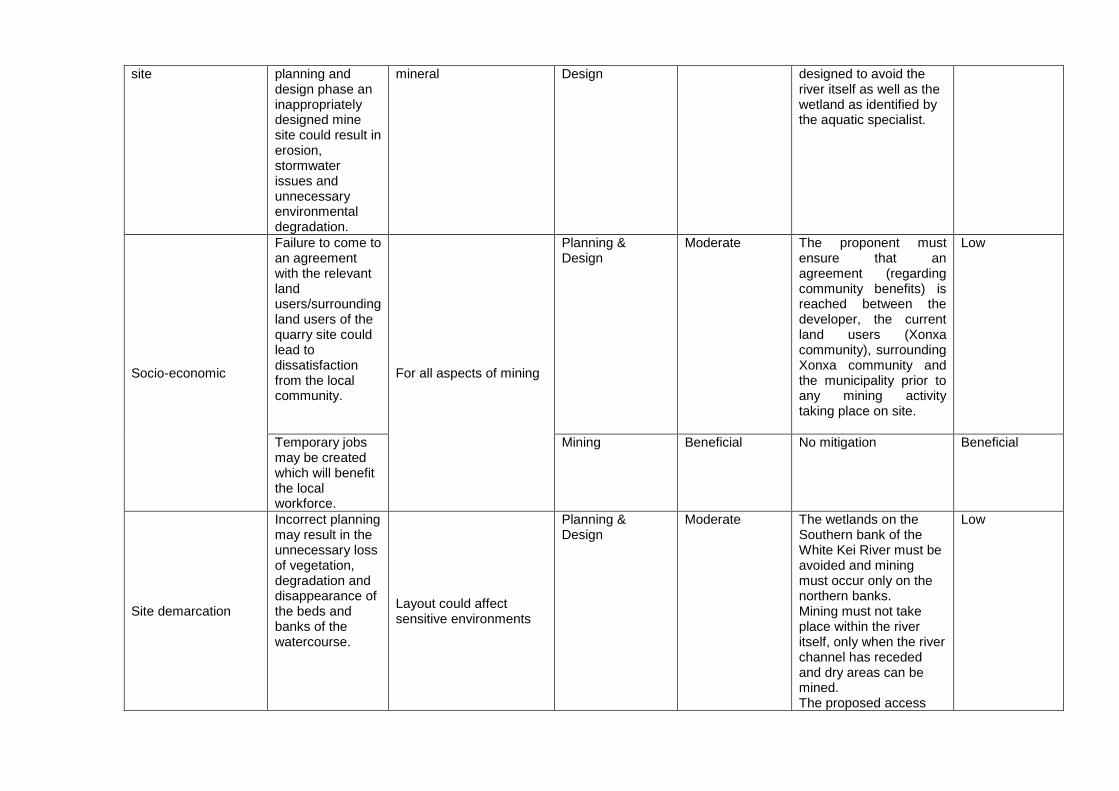
site planning and design phase an inappropriately designed mine site could result in erosion, stormwater issues and unnecessary environmental degradation.
mineral Design designed to avoid the river itself as well as the wetland as identified by the aquatic specialist.
Socio-economic
Failure to come to an agreement with the relevant land users/surrounding land users of the quarry site could lead to dissatisfaction from the local community.
For all aspects of mining
Planning & Design
Moderate The proponent must ensure that an agreement (regarding community benefits) is reached between the developer, the current land users (Xonxa community), surrounding Xonxa community and the municipality prior to any mining activity taking place on site.
Low
Temporary jobs may be created which will benefit the local workforce.
Mining Beneficial No mitigation Beneficial
Site demarcation
Incorrect planning may result in the unnecessary loss of vegetation, degradation and disappearance of the beds and banks of the watercourse.
Layout could affect sensitive environments
Planning & Design
Moderate The wetlands on the Southern bank of the White Kei River must be avoided and mining must occur only on the northern banks. Mining must not take place within the river itself, only when the river channel has receded and dry areas can be mined. The proposed access
Low
road footprint should be kept as small as possible and be provided with suitable stormwater management features (if necessary), that will prevent additional erosion within the terrestrial as well as aquatic habitats.
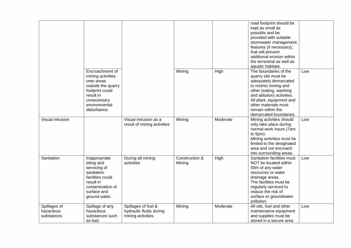
Encroachment of mining activities onto areas outside the quarry footprint could result in unnecessary environmental disturbance.
Mining High The boundaries of the quarry site must be adequately demarcated to restrict mining and other (eating, washing and ablution) activities. All plant, equipment and other materials must remain within the demarcated boundaries.
Low
Visual intrusion Visual intrusion as a result of mining activities
Mining Moderate Mining activities should only take place during normal work hours (7am to 5pm). Mining activities must be limited to the designated area and not encroach into surrounding areas.
Low
Sanitation Inappropriate siting and servicing of sanitation facilities could result in contamination of surface and
ground water.
During all mining activities
Construction & Mining
High Sanitation facilities must NOT be located within 50m of any water resources or water drainage areas. The facilities must be regularly serviced to reduce the risk of surface or groundwater pollution.
Low
Spillages of hazardous substances
Spillage of any hazardous substances such as fuel,
Spillages of fuel & hydraulic fluids during mining activities
Mining Moderate All oils, fuel and other maintenance equipment and supplies must be stored in a secure area
Low
chemicals, etc. could result in ground and surface water contamination
offsite (HTJ Transport have an available offsite site camp) with a compacted surface. Spill kits must be kept on-site and maintained. All hazardous material must be stored more that 50m away from any water body Vehicles must be maintained to an acceptable standard to prevent any fuel, oil or lubricant leaks etc).
Dust control Dust (generated from mining activities and from vehicles traveling on dirt roads) could be a nuisance during windy conditions.
Dust clouds from plant could impact the surrounding environment/communities
Mining Moderate Mining activities should only take place during agreed working times and permitting weather conditions to avoid drifting of sand and dust into neighbouring areas. A speed limit of 30km/h must not be exceeded on dirt roads. Any complaints or claims emanating from dust issues must be attended to immediately. During windy periods un-surfaced and un-vegetated areas should be dampened down if necessary.
Low
Noise During the operational (mining) phase mining activities and movement of heavy vehicles could result in an increase in
Increase in noise levels Mining Moderate Movement of heavy machinery should be limited to normal working hours (7 AM to 5 PM). Ensure there is a facility for nearby residents to make complaints. These must be addressed and
Low
ambient noise levels on site and on surrounding properties.
recorded.
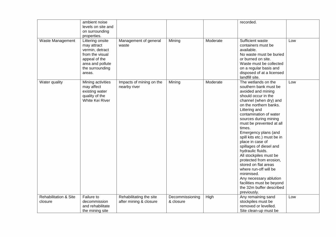
Waste Management Littering onsite may attract vermin, detract from the visual appeal of the area and pollute the surrounding areas.
Management of general waste
Mining Moderate Sufficient waste containers must be available. No waste must be buried or burned on site. Waste must be collected on a regular basis and disposed of at a licensed landfill site.
Low
Water quality Mining activities may affect existing water quality of the White Kei River
Impacts of mining on the nearby river
Mining Moderate The wetlands on the southern bank must be avoided and mining should occur in the channel (when dry) and on the northern banks. Littering and contamination of water sources during mining must be prevented at all times. Emergency plans (and spill kits etc.) must be in place in case of spillages of diesel and hydraulic fluids. All stockpiles must be protected from erosion, stored on flat areas where run-off will be minimised. Any necessary ablution facilities must be beyond the 32m buffer described previously.
Low
Rehabilitation & Site closure
Failure to decommission and rehabilitate the mining site
Rehabilitating the site after mining & closure
Decommissioning & closure
High Any remaining sand stockpiles must be removed or levelled. Site clean-up must be
Low
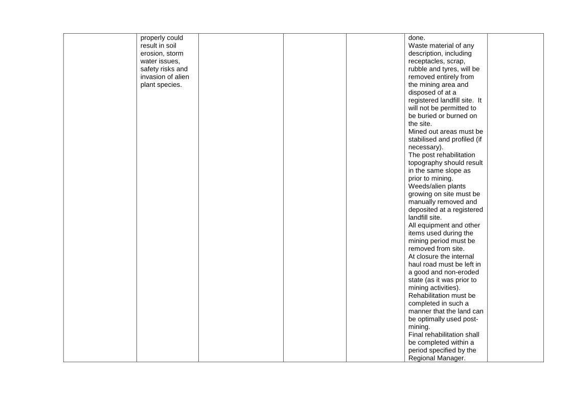
properly could result in soil erosion, storm water issues, safety risks and invasion of alien plant species.
done. Waste material of any description, including receptacles, scrap, rubble and tyres, will be removed entirely from the mining area and disposed of at a registered landfill site. It will not be permitted to be buried or burned on the site. Mined out areas must be stabilised and profiled (if necessary). The post rehabilitation topography should result in the same slope as prior to mining. Weeds/alien plants growing on site must be manually removed and deposited at a registered landfill site. All equipment and other items used during the mining period must be removed from site. At closure the internal haul road must be left in a good and non-eroded state (as it was prior to mining activities). Rehabilitation must be completed in such a manner that the land can be optimally used post-mining. Final rehabilitation shall be completed within a period specified by the Regional Manager.
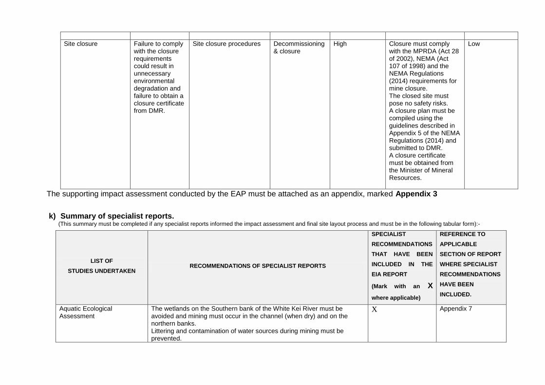
Site closure Failure to comply with the closure requirements could result in unnecessary environmental degradation and failure to obtain a closure certificate from DMR.
Site closure procedures Decommissioning & closure
High Closure must comply with the MPRDA (Act 28 of 2002), NEMA (Act 107 of 1998) and the NEMA Regulations (2014) requirements for mine closure. The closed site must pose no safety risks. A closure plan must be compiled using the guidelines described in Appendix 5 of the NEMA Regulations (2014) and submitted to DMR. A closure certificate must be obtained from the Minister of Mineral Resources.
Low
The supporting impact assessment conducted by the EAP must be attached as an appendix, marked Appendix 3
k) Summary of specialist reports.
(This summary must be completed if any specialist reports informed the impact assessment and final site layout process and must be in the following tabular form):-
LIST OF
STUDIES UNDERTAKEN RECOMMENDATIONS OF SPECIALIST REPORTS
SPECIALIST
RECOMMENDATIONS
THAT HAVE BEEN
INCLUDED IN THE
EIA REPORT
(Mark with an X
where applicable)
REFERENCE TO
APPLICABLE
SECTION OF REPORT
WHERE SPECIALIST
RECOMMENDATIONS
HAVE BEEN
INCLUDED.
Aquatic Ecological Assessment
The wetlands on the Southern bank of the White Kei River must be avoided and mining must occur in the channel (when dry) and on the northern banks. Littering and contamination of water sources during mining must be prevented.
X Appendix 7
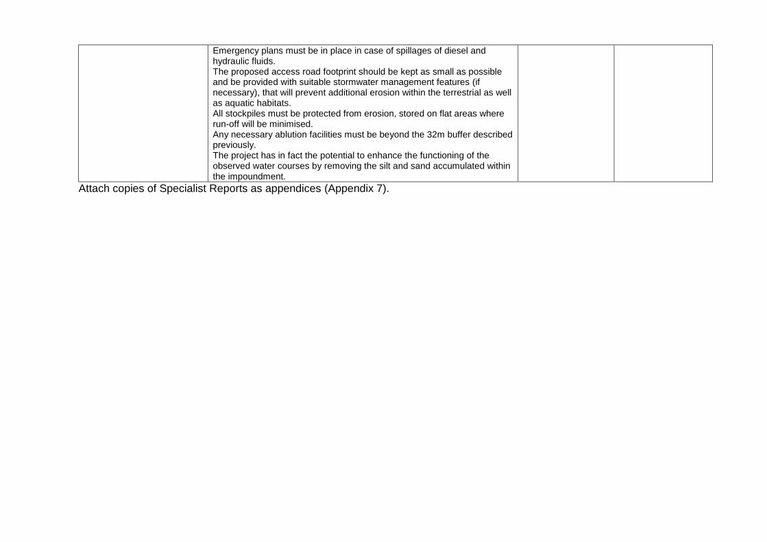
Emergency plans must be in place in case of spillages of diesel and hydraulic fluids. The proposed access road footprint should be kept as small as possible and be provided with suitable stormwater management features (if necessary), that will prevent additional erosion within the terrestrial as well as aquatic habitats. All stockpiles must be protected from erosion, stored on flat areas where run-off will be minimised. Any necessary ablution facilities must be beyond the 32m buffer described previously. The project has in fact the potential to enhance the functioning of the observed water courses by removing the silt and sand accumulated within the impoundment.
Attach copies of Specialist Reports as appendices (Appendix 7).
l) Environmental impact statement
(i) Summary of the key findings of the environmental impact
assessment; The key findings of the environmental impact assessment are the following: The project entails the opencast extraction of sand from an area located on the floodplain/banks of the White Kei River. The area is devoid of overburden and vegetation (only small grass patches are present on the northern bank) and therefore will not require topsoil/overburden stripping and stockpiling. The mine procedure will only entail the mechanical excavation of the sand by means of an excavator, after which it will be loaded onto trucks and transported from site. No blasting, crushing or screening will be necessary on site. The existing road to the mine area can be used to gain access to the site. No new roads are needed. Machinery will access the northern bank by driving through the river. An off-site workshop (currently used by the applicant) will be used for servicing of vehicles thereby reducing the risk of hazardous spills and contamination at the mining site. The proposed mining area will not be visible from any public areas or roads and will therefore only have a visual impact on the immediate surrounding area. The proposed mining area was defined to be located on the northern banks of the White Kei River in order to avoid the artificial wetland located on the southern banks of the river. The project is not expected to have an impact on surrounding portions of river area as mining activities will be contained within the boundaries of the permitted site. Minimal storm water management will be require as surface water will percolate into the highly permeable sand and gravitationally flow to the river. Waste management however needs to be implemented on the site in order to minimise the potential of pollution. The artificial wetland on the southern bank (excluding the existing road transecting this area) needs to be treated and managed as a no-go area (except for the crossing
point into the river) to all mining employees.
(ii) Final Site Map Provide a map at an appropriate scale which superimposes the proposed overall activity and its associated structures and infrastructure on the environmental sensitivities of the preferred site
indicating any areas that should be avoided, including buffers . Attach as Appendix 5. Refer to Appendix 5 for the Final Site Map. Sensitive areas indicated in red on the map.
(iii)Summary of the positive and negative impacts and risks of the
proposed activity and identified alternatives;

Positive impacts associated with the project include:
Job creation for 3 permanent staff and 1 casual worker.
According to the Aquatic Ecological Assessment the project has in fact the potential to enhance the functioning of the observed water courses by removing the silt and sand accumulated within the impoundment.
The proposed mine has the potential to contribute to the upgrading/ maintenance of infrastructure in and around the local area and indirectly contribute the economy of the area.
Negative impacts associated with the project include:
The mining activities to cause noise and dust issues for the surrounding community. But this is easily mitigated.
Negative impacts with regards to the biophysical environment include potential contamination of the area due to spillage of hydrocarbon products.
The mining area will be located on the banks of the White Kei River as well as within 500m of an artificial wetland system.
m) Proposed impact management objectives and the impact management outcomes
for inclusion in the EMPr; Based on the assessment and where applicable the recommendations from specialist reports, the recording of proposed impact management objectives, and the impact management outcomes for the development for inclusion in the EMPr as well as for inclusion as conditions of authorisation.
Impact Relevant phase Responsibility Mitigation
Compliance with relevant environmental legislation and policy
Planning & Design Applicant All relevant legislation and policy must be consulted and the proponent must ensure that the project is compliant with such legislation and policy. These should include (but are not restricted to): MPRDA, NWA, NEMA, Local and District Spatial Development Frameworks, Eastern Cape Biodiversity Conservation Plan (ECBCP), Local Municipal bylaws.
Design of the mine site Planning & Design Applicant The site must be designed to avoid the river itself as well as the wetland as identified by the aquatic specialist.
Socio-economic Planning & Design Applicant The proponent must ensure that an agreement is reached between the developer, the current land users (Xonxa community), surrounding Xonxa community and the municipality prior to any mining activity taking place on site.
Loss of wetland vegetation and changes to the bed and bank morphology
Planning & Design Applicant The wetlands on the Southern bank of the White Kei River must be avoided and mining must occur on the northern banks. Mining must not take place
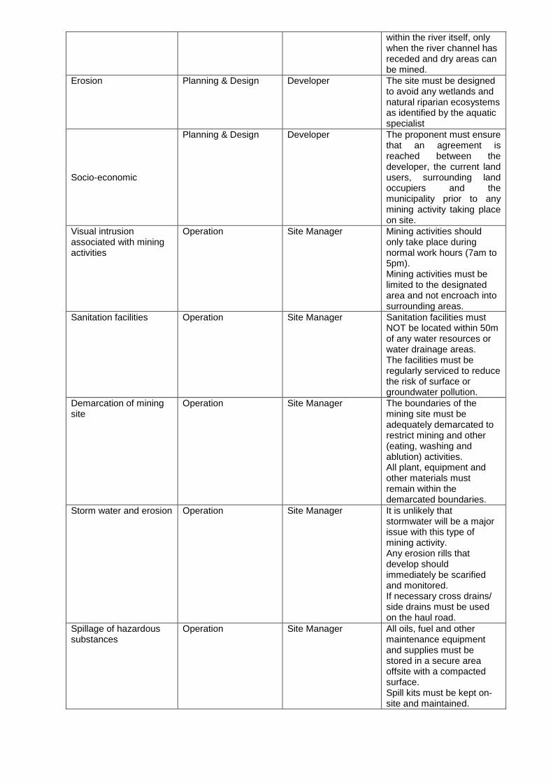
within the river itself, only when the river channel has receded and dry areas can be mined.
Erosion Planning & Design Developer The site must be designed to avoid any wetlands and natural riparian ecosystems as identified by the aquatic specialist
Socio-economic
Planning & Design Developer The proponent must ensure that an agreement is reached between the developer, the current land users, surrounding land occupiers and the municipality prior to any mining activity taking place on site.
Visual intrusion associated with mining activities
Operation Site Manager
Mining activities should only take place during normal work hours (7am to 5pm). Mining activities must be limited to the designated area and not encroach into surrounding areas.
Sanitation facilities Operation Site Manager
Sanitation facilities must NOT be located within 50m of any water resources or water drainage areas. The facilities must be regularly serviced to reduce the risk of surface or groundwater pollution.
Demarcation of mining site
Operation Site Manager
The boundaries of the mining site must be adequately demarcated to restrict mining and other (eating, washing and ablution) activities. All plant, equipment and other materials must remain within the demarcated boundaries.
Storm water and erosion Operation Site Manager
It is unlikely that stormwater will be a major issue with this type of mining activity. Any erosion rills that develop should immediately be scarified and monitored. If necessary cross drains/ side drains must be used on the haul road.
Spillage of hazardous substances
Operation Site Manager
All oils, fuel and other maintenance equipment and supplies must be stored in a secure area offsite with a compacted surface. Spill kits must be kept on-site and maintained.
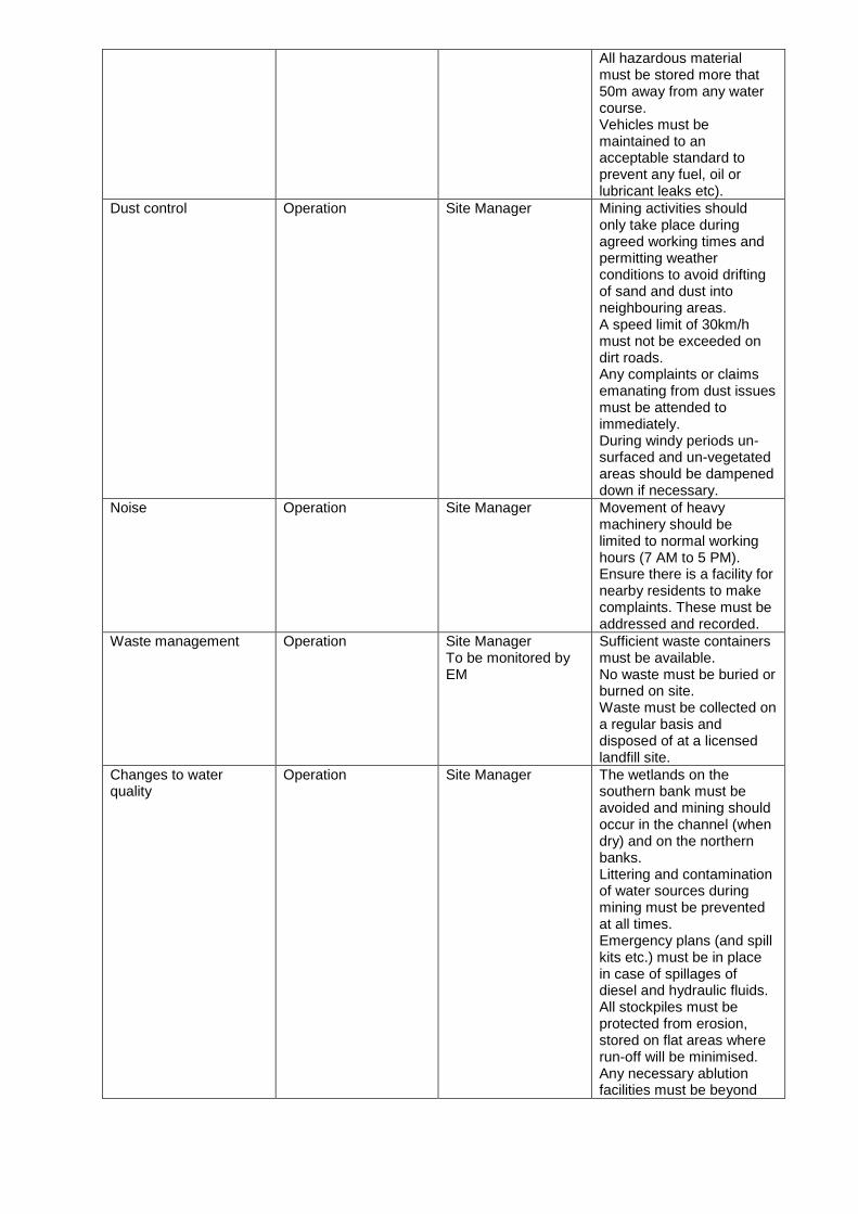
All hazardous material must be stored more that 50m away from any water course. Vehicles must be maintained to an acceptable standard to prevent any fuel, oil or lubricant leaks etc).
Dust control Operation Site Manager
Mining activities should only take place during agreed working times and permitting weather conditions to avoid drifting of sand and dust into neighbouring areas. A speed limit of 30km/h must not be exceeded on dirt roads. Any complaints or claims emanating from dust issues must be attended to immediately. During windy periods un-surfaced and un-vegetated areas should be dampened down if necessary.
Noise Operation Site Manager
Movement of heavy machinery should be limited to normal working hours (7 AM to 5 PM). Ensure there is a facility for nearby residents to make complaints. These must be addressed and recorded.
Waste management Operation Site Manager To be monitored by EM
Sufficient waste containers must be available. No waste must be buried or burned on site. Waste must be collected on a regular basis and disposed of at a licensed landfill site.
Changes to water quality
Operation Site Manager
The wetlands on the southern bank must be avoided and mining should occur in the channel (when dry) and on the northern banks. Littering and contamination of water sources during mining must be prevented at all times. Emergency plans (and spill kits etc.) must be in place in case of spillages of diesel and hydraulic fluids. All stockpiles must be protected from erosion, stored on flat areas where run-off will be minimised. Any necessary ablution facilities must be beyond
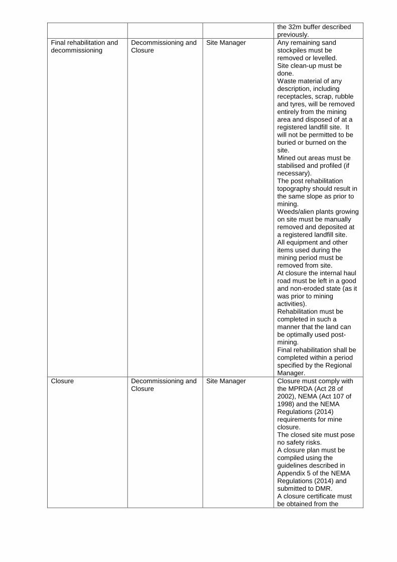
the 32m buffer described previously.
Final rehabilitation and decommissioning
Decommissioning and Closure
Site Manager
Any remaining sand stockpiles must be removed or levelled. Site clean-up must be done. Waste material of any description, including receptacles, scrap, rubble and tyres, will be removed entirely from the mining area and disposed of at a registered landfill site. It will not be permitted to be buried or burned on the site. Mined out areas must be stabilised and profiled (if necessary). The post rehabilitation topography should result in the same slope as prior to mining. Weeds/alien plants growing on site must be manually removed and deposited at a registered landfill site. All equipment and other items used during the mining period must be removed from site. At closure the internal haul road must be left in a good and non-eroded state (as it was prior to mining activities). Rehabilitation must be completed in such a manner that the land can be optimally used post-mining. Final rehabilitation shall be completed within a period specified by the Regional Manager.
Closure Decommissioning and Closure
Site Manager
Closure must comply with the MPRDA (Act 28 of 2002), NEMA (Act 107 of 1998) and the NEMA Regulations (2014) requirements for mine closure. The closed site must pose no safety risks. A closure plan must be compiled using the guidelines described in Appendix 5 of the NEMA Regulations (2014) and submitted to DMR. A closure certificate must be obtained from the
Minister of Mineral Resources.
n) Aspects for inclusion as conditions of Authorisation.
Any aspects which must be made conditions of the Environmental Authorisation
The management objectives listed in this report under Point M above should be considered for inclusion in the environmental authorisation.
o) Description of any assumptions, uncertainties and gaps in knowledge.
(Which relate to the assessment and mitigation measures proposed)
The assumptions made in this document related to the assessment and mitigation measures proposed, stem from site specific information gathered from the applicant, local community, site inspections and background information gathering.
p) Reasoned opinion as to whether the proposed activity should or should not be
authorised
i) Reasons why the activity should be authorized or not. Should the mitigation measures and monitoring programmes proposed in this document be implemented on site, no fatal flaws could be identified that were deemed so severe as to prevent the activity from continuing.
ii) Conditions that must be included in the authorisation
The management objectives listed in this report under Point M should be considered for inclusion in the environmental authorisation.
q) Period for which the Environmental Authorisation is required.
The applicant requests the Environmental Authorisation to be valid for a two year period, the usual period for a mining permit (with possible permit renewals in future).
r) Undertaking
Confirm that the undertaking required to meet the requirements of this section is provided at the end of the EMPr and is applicable to both the Basic assessment report and the Environmental Management Programme report.
The undertaking to meet the requirement as provided at the end of the EMPr is applicable to this section as well as the EMPr.
s) Financial Provision
State the amount that is required to both manage and rehabilitate the environment in respect of rehabilitation.
i) Explain how the aforesaid amount was derived.
An amount for Financial Provision for rehabilitation is provided Section i below.
ii) Confirm that this amount can be provided for from operating expenditure.
(Confirm that the amount, is anticipated to be an operating cost and is provided for as such in the Mining work programme, Financial and Technical Competence Report or Prospecting Work Programme as the case may be).
The mining operation will be self-funded through income generated by sales of the sand mined. HJT Transport will provide DMR with this amount specified in the Financial Provision on finalisation of the Mining Permit.
t) Specific Information required by the competent Authority
i) Compliance with the provisions of sections 24(4)(a) and (b) read with
section 24 (3) (a) and (7) of the National Environmental Management Act (Act 107 of 1998). the EIA report must include the:- (1) Impact on the socio-economic conditions of any directly affected
person. (Provide the results of Investigation, assessment, and evaluation of the impact of the mining,
bulk sampling or alluvial diamond prospecting on any directly affected person including the landowner, lawful occupier, or, where applicable, potential beneficiaries of any land restitution claim, attach the investigation report as an Appendix .
The mining site does not contain significant grazing land. There are only minor patches of grass on the northern bank of the mining area. The site boundaries will not impact on existing grazing land but may have an impact on stock drinking water accessibility. Stock will be able to access & cross the river at various points both upstream & downstream from the proposed mining site. Due to the remote location of the proposed mining area very few negative impacts on the community were identified. The dust and noise impacts that may emanate from the mining area during the operational phase could have a negative impact on the land users if the mitigation measures proposed in this document are not implemented and managed on-site. However, due to the small size of the proposed mining activity these impacts are deemed to be of low significance. The operation of the mine will however also have a number of positive impacts such as job creation and other social economic benefits (to be finalised with the local community once the permit is authorised). The sand to be removed from the mining area will be used for the upgrading of roads in the area, and possible upgrading of roads closer to the mining area as well as possible housing development in the local area. The proposed mine will therefore contribute to the upgrading/maintenance of infrastructure in and around Xonxa. Should this application be approved it will also assist the landowners and lawful users in diversification of the land use of the property.
(2) Impact on any national estate referred to in section 3(2) of the National
Heritage Resources Act. (Provide the results of Investigation, assessment, and evaluation of
the impact of the mining, bulk sampling or alluvial diamond prospecting on any national estate referred to in section 3(2) of the National Heritage Resources Act, 1999 (Act No. 25 of 1999) with the exception of the national estate contemplated in section 3(2)(i)(vi) and (vii) of that Act, attach the investigation report as Appendix 2.19.2 and confirm that the applicable mitigation is reflected in 2.5.3; 2.11.6.and
2.12.herein). No sites of archaeological or cultural importance were identified at the proposed mining area during the site inspection. A member of the Xonxa community also indicated that there were no known graves or areas of cultural significance at the mining site. It is highly unlikely that any archaeological remains will be exposed during the mining activities which are located in the flood plain. No comment has been received from ECPHRA to date, and they were provided with the opportunity to comment on the draft BAR.
u) Other matters required in terms of sections 24(4)(a) and (b) of the Act.
(the EAP managing the application must provide the competent authority with detailed, written proof of an investigation as required by section 24(4)(b)(i) of the Act and motivation if no reasonable or feasible alternatives, as contemplated in sub-regulation 22(2)(h), exist. The EAP must attach such motivation as Appendix 7).
Alternatives considered for this project are available at the beginning of the document (section i).

PART B
ENVIRONMENTAL MANAGEMENT PROGRAMME REPORT
1) Draft environmental management programme.
a) Details of the EAP, (Confirm that the requirement for the provision of the details and expertise of the EAP
are already included in PART A, section 1(a) herein as required).
The details and expertise of Dr Alan Carter of EOH Coastal & Environmental Services the EAP on this
project have been included in Part A Section 1(a)
b) Description of the Aspects of the Activity (Confirm that the requirement to describe the aspects
of the activity that are covered by the draft environmental management programme is already included in PART
A, section (1)(h) herein as required).
The aspects of the activity that are covered by the draft environmental management programme have
been described and included in Part A, section (1)(h)
c) Composite Map (Provide a map (Attached as an Appendix) at an appropriate scale which superimposes the proposed activity, its associated structures, and infrastructure on the environmental sensitivities of the preferred site, indicating any areas that any areas that should be avoided, including buffers)
As mentioned under Part A, section (1)(L)(ii) this map has been compiled and is attached as Appendix
5 to this document.
d) Description of Impact management objectives including management
statements
i) Determination of closure objectives. (ensure that the closure objectives are informed
by the type of environment described)
The decommissioning will involve removal of all machinery/equipment from site. The small
excavation sides will be profiled to a 1:3 gradient. All material stockpiles will be removed
from the site or levelled. Since no vegetation or topsoil will be stored at the site, the site will
not be seeded. All alien vegetation will be removed, if any establish.
The applicant will comply with the minimum closure objectives as prescribed by DMR and
detailed below.
Rehabilitation:
Mining areas must be levelled out daily.
No erosion rills must be allowed to develop.
Weed/alien vegetation clearing must take place continuously during mining (if
required).
Final rehabilitation and closure:
Any remaining sand stockpiles must be removed or levelled.
Site clean-up must be done.
No erosion must be allowed on the river bank, mine site or haul road.
Waste material of any description, including receptacles, scrap, rubble, etc. must be
removed from the mining area and disposed of at a registered landfill site. It will not be
permitted to be buried or burned on site.
Mined out areas must be stabilised and profiled (if necessary).
The post rehabilitation topography should result in the same slope as prior to mining.
Weeds/alien plants growing on site must be manually removed and deposited at a
registered landfill site.
All equipment and other items used during the mining period must be removed from
site.
At closure the internal haul road must be left in a good and non-eroded state (as it was
prior to mining activities).
The closed site must pose no safety risks.
Rehabilitation must be completed in such a manner that the land can be optimally used
post-mining.
Final rehabilitation must be completed within a period specified by the Regional
Manager.
Closure must comply with the MPRDA (Act 28 of 2002), NEMA (Act 107 of 1998) and
the NEMA Regulations (2014) requirements for mine closure.
A closure plan must be compiled using the guidelines described in Appendix 5 of the
NEMA Regulations (2014) and submitted to DMR.
A closure certificate must be obtained from the Minister of Mineral Resources.
ii) Volumes and rate of water use required for the operation.
Water will only be used for dust suppression purposes (if required) as the mining method
does not require any washing or related process water. The applicant will obtain water for
dust suppression purposes (if necessary) from a municipal source. No water will be
abstracted from a natural watercourse. Potable drinking water required will be brought to
site daily.
iii) Has a water use licence has been applied for?
A water use license has been applied for in terms of Section 21 c and i of the National
Water Act. Refer to Appendix A (section 1.12) for proof of WUL application submission.
DWS has been engaged throughout the EIA process.
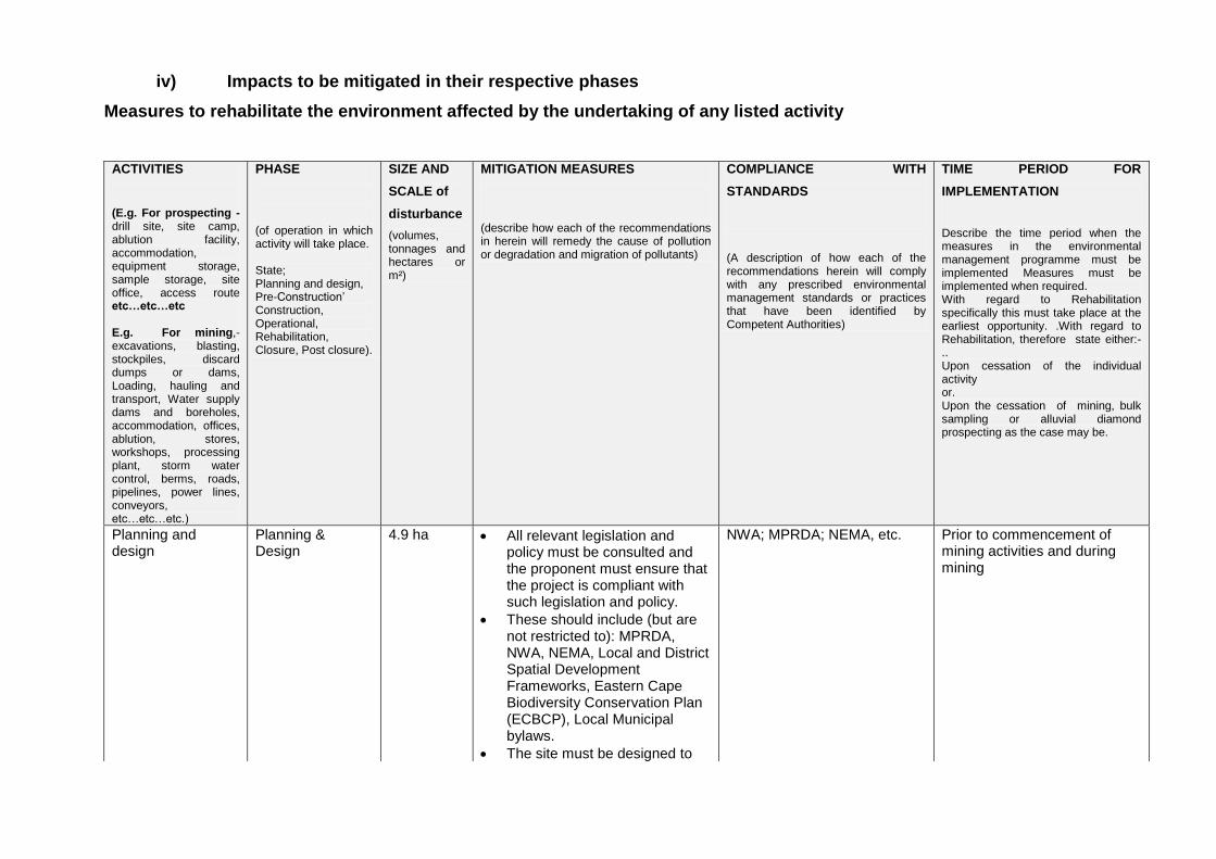
iv) Impacts to be mitigated in their respective phases
Measures to rehabilitate the environment affected by the undertaking of any listed activity
ACTIVITIES
(E.g. For prospecting - drill site, site camp, ablution facility, accommodation, equipment storage, sample storage, site office, access route etc…etc…etc E.g. For mining,- excavations, blasting, stockpiles, discard dumps or dams, Loading, hauling and transport, Water supply dams and boreholes, accommodation, offices, ablution, stores, workshops, processing plant, storm water control, berms, roads, pipelines, power lines, conveyors, etc…etc…etc.)
PHASE
(of operation in which activity will take place. State; Planning and design, Pre-Construction‘ Construction, Operational, Rehabilitation, Closure, Post closure).
SIZE AND
SCALE of
disturbance
(volumes, tonnages and hectares or m²)
MITIGATION MEASURES
(describe how each of the recommendations in herein will remedy the cause of pollution or degradation and migration of pollutants)
COMPLIANCE WITH
STANDARDS
(A description of how each of the recommendations herein will comply with any prescribed environmental management standards or practices that have been identified by Competent Authorities)
TIME PERIOD FOR
IMPLEMENTATION
Describe the time period when the measures in the environmental management programme must be implemented Measures must be implemented when required. With regard to Rehabilitation specifically this must take place at the earliest opportunity. .With regard to Rehabilitation, therefore state either:-.. Upon cessation of the individual activity or. Upon the cessation of mining, bulk sampling or alluvial diamond prospecting as the case may be.
Planning and design
Planning & Design
4.9 ha All relevant legislation and policy must be consulted and the proponent must ensure that the project is compliant with such legislation and policy.
These should include (but are not restricted to): MPRDA, NWA, NEMA, Local and District Spatial Development Frameworks, Eastern Cape Biodiversity Conservation Plan (ECBCP), Local Municipal bylaws.
The site must be designed to
NWA; MPRDA; NEMA, etc.
Prior to commencement of mining activities and during mining

avoid the river itself as well as the wetland as identified by the aquatic specialist.
The proponent must ensure that an agreement (regarding community benefits) is reached between the developer, the current land users (Xonxa community), surrounding Xonxa community and the municipality prior to any mining activity taking place on site.
The wetlands on the Southern bank of the White Kei River must be avoided and mining must occur on the northern banks.
Mining must not take place within the river itself, only when the river channel has receded and dry areas can be mined.
Excavation
Mining 4.9 ha All relevant legislation and policy must be consulted and the proponent must ensure that the project is compliant with such legislation and policy.
These should include (but are not restricted to): MPRDA, NWA, NEMA, Local and District Spatial Development Frameworks, Eastern Cape Biodiversity Conservation Plan (ECBCP), Local Municipal bylaws.
Mining activities should only take place during normal work hours (7am to 5pm).
Mining activities must be limited to the designated area and not encroach into surrounding areas.
Health & Safety Act NWA NEMA Regulations MPRDA NEM: AQA
For the duration mining
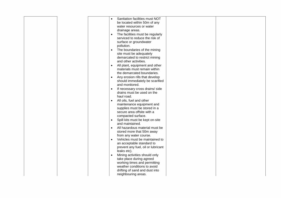
Sanitation facilities must NOT be located within 50m of any water resources or water drainage areas.
The facilities must be regularly serviced to reduce the risk of surface or groundwater pollution.
The boundaries of the mining site must be adequately demarcated to restrict mining and other activities.
All plant, equipment and other materials must remain within the demarcated boundaries.
Any erosion rills that develop should immediately be scarified and monitored.
If necessary cross drains/ side drains must be used on the haul road.
All oils, fuel and other maintenance equipment and supplies must be stored in a secure area offsite with a compacted surface.
Spill kits must be kept on-site and maintained.
All hazardous material must be stored more that 50m away from any water course.
Vehicles must be maintained to an acceptable standard to prevent any fuel, oil or lubricant leaks etc).
Mining activities should only take place during agreed working times and permitting weather conditions to avoid drifting of sand and dust into neighbouring areas.
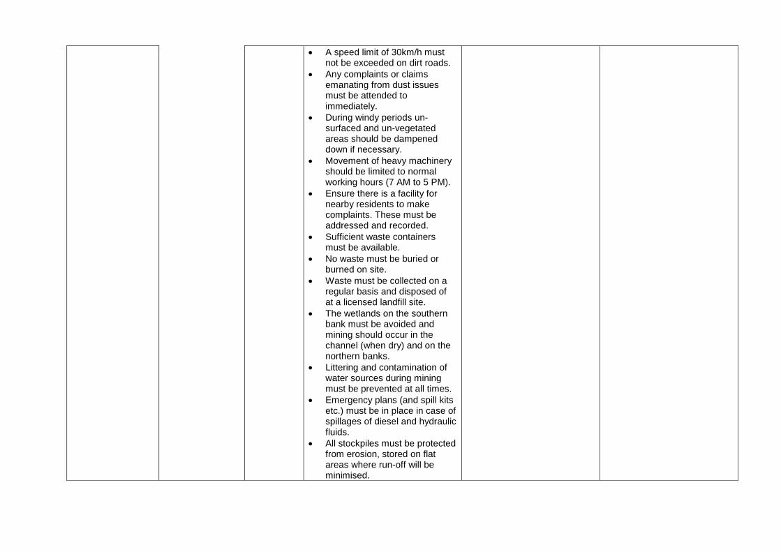
A speed limit of 30km/h must not be exceeded on dirt roads.
Any complaints or claims emanating from dust issues must be attended to immediately.
During windy periods un-surfaced and un-vegetated areas should be dampened down if necessary.
Movement of heavy machinery should be limited to normal working hours (7 AM to 5 PM).
Ensure there is a facility for nearby residents to make complaints. These must be addressed and recorded.
Sufficient waste containers must be available.
No waste must be buried or burned on site.
Waste must be collected on a regular basis and disposed of at a licensed landfill site.
The wetlands on the southern bank must be avoided and mining should occur in the channel (when dry) and on the northern banks.
Littering and contamination of water sources during mining must be prevented at all times.
Emergency plans (and spill kits etc.) must be in place in case of spillages of diesel and hydraulic fluids.
All stockpiles must be protected from erosion, stored on flat areas where run-off will be minimised.
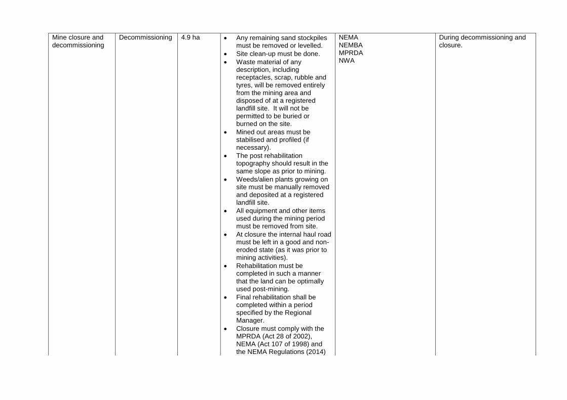
Mine closure and decommissioning
Decommissioning 4.9 ha Any remaining sand stockpiles must be removed or levelled.
Site clean-up must be done.
Waste material of any description, including receptacles, scrap, rubble and tyres, will be removed entirely from the mining area and disposed of at a registered landfill site. It will not be permitted to be buried or burned on the site.
Mined out areas must be stabilised and profiled (if necessary).
The post rehabilitation topography should result in the same slope as prior to mining.
Weeds/alien plants growing on site must be manually removed and deposited at a registered landfill site.
All equipment and other items used during the mining period must be removed from site.
At closure the internal haul road must be left in a good and non-eroded state (as it was prior to mining activities).
Rehabilitation must be completed in such a manner that the land can be optimally used post-mining.
Final rehabilitation shall be completed within a period specified by the Regional Manager.
Closure must comply with the MPRDA (Act 28 of 2002), NEMA (Act 107 of 1998) and the NEMA Regulations (2014)
NEMA NEMBA MPRDA NWA
During decommissioning and closure.
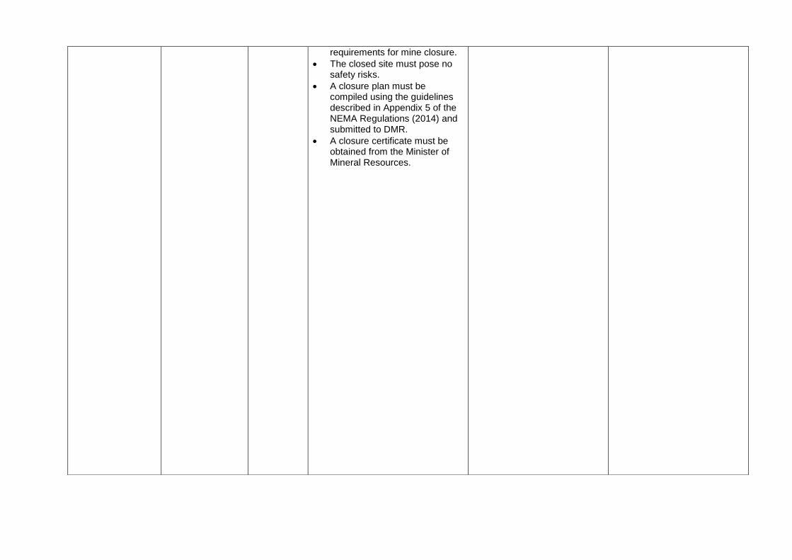
requirements for mine closure.
The closed site must pose no safety risks.
A closure plan must be compiled using the guidelines described in Appendix 5 of the NEMA Regulations (2014) and submitted to DMR.
A closure certificate must be obtained from the Minister of Mineral Resources.
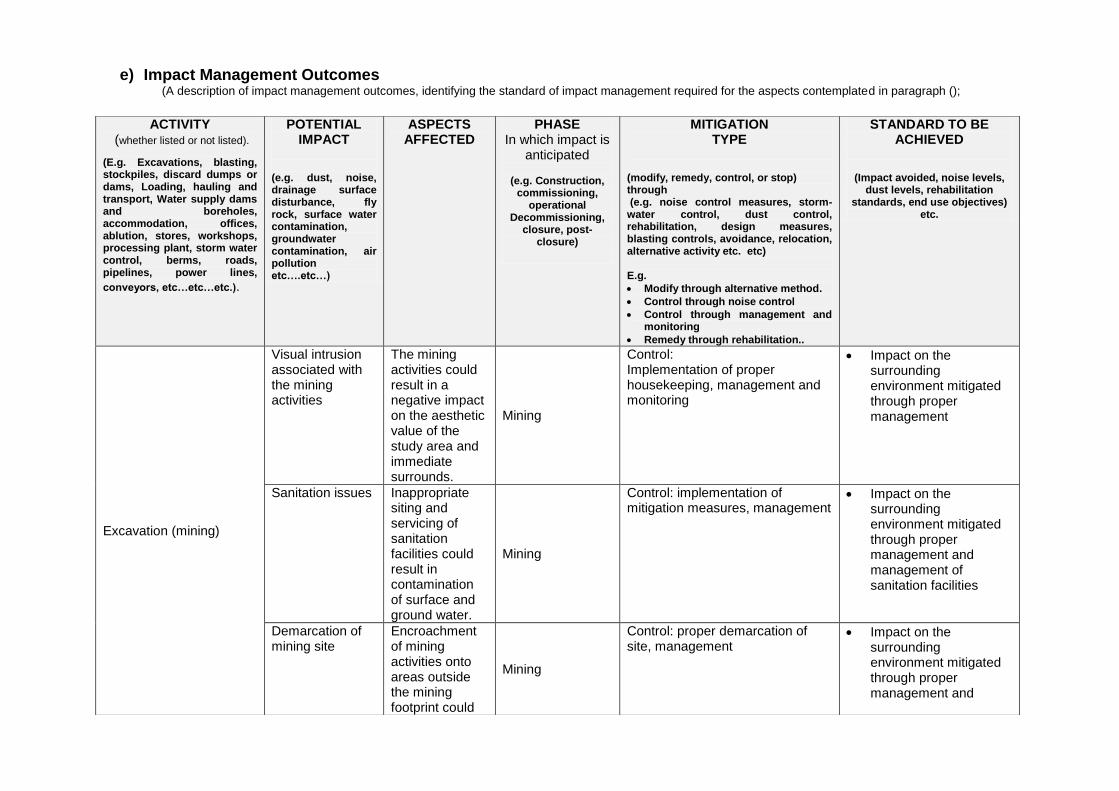
e) Impact Management Outcomes (A description of impact management outcomes, identifying the standard of impact management required for the aspects contemplated in paragraph ();
ACTIVITY
(whether listed or not listed).
(E.g. Excavations, blasting, stockpiles, discard dumps or dams, Loading, hauling and transport, Water supply dams and boreholes, accommodation, offices, ablution, stores, workshops, processing plant, storm water control, berms, roads, pipelines, power lines,
conveyors, etc…etc…etc.).
POTENTIAL IMPACT
(e.g. dust, noise, drainage surface disturbance, fly rock, surface water contamination, groundwater contamination, air pollution etc….etc…)
ASPECTS AFFECTED
PHASE In which impact is
anticipated
(e.g. Construction, commissioning,
operational Decommissioning,
closure, post-closure)
MITIGATION TYPE
(modify, remedy, control, or stop) through (e.g. noise control measures, storm-water control, dust control, rehabilitation, design measures, blasting controls, avoidance, relocation, alternative activity etc. etc) E.g.
Modify through alternative method.
Control through noise control
Control through management and monitoring
Remedy through rehabilitation..
STANDARD TO BE ACHIEVED
(Impact avoided, noise levels, dust levels, rehabilitation
standards, end use objectives) etc.
Excavation (mining)
Visual intrusion associated with the mining activities
The mining activities could result in a negative impact on the aesthetic value of the study area and immediate surrounds.
Mining
Control: Implementation of proper housekeeping, management and monitoring
Impact on the surrounding environment mitigated through proper management
Sanitation issues Inappropriate siting and servicing of sanitation facilities could result in contamination of surface and ground water.
Mining
Control: implementation of mitigation measures, management
Impact on the surrounding environment mitigated through proper management and management of sanitation facilities
Demarcation of mining site
Encroachment of mining activities onto areas outside the mining footprint could
Mining
Control: proper demarcation of site, management
Impact on the surrounding environment mitigated through proper management and
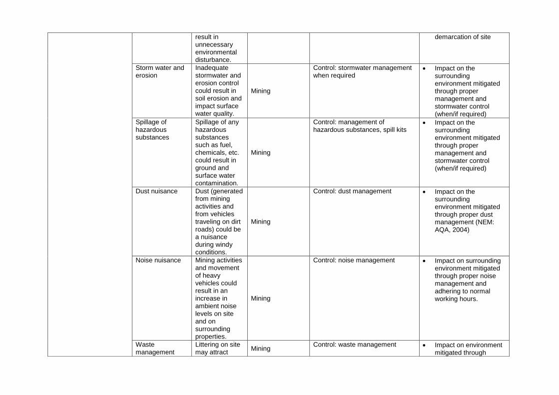
result in unnecessary environmental disturbance.
demarcation of site
Storm water and erosion
Inadequate stormwater and erosion control could result in soil erosion and impact surface water quality.
Mining
Control: stormwater management when required
Impact on the surrounding environment mitigated through proper management and stormwater control (when/if required)
Spillage of hazardous substances
Spillage of any hazardous substances such as fuel, chemicals, etc. could result in ground and surface water contamination.
Mining
Control: management of hazardous substances, spill kits
Impact on the surrounding environment mitigated through proper management and stormwater control (when/if required)
Dust nuisance Dust (generated from mining activities and from vehicles traveling on dirt roads) could be a nuisance during windy conditions.
Mining
Control: dust management Impact on the surrounding environment mitigated through proper dust management (NEM: AQA, 2004)
Noise nuisance Mining activities and movement of heavy vehicles could result in an increase in ambient noise levels on site and on surrounding properties.
Mining
Control: noise management Impact on surrounding environment mitigated through proper noise management and adhering to normal working hours.
Waste management
Littering on site may attract
Mining Control: waste management Impact on environment
mitigated through
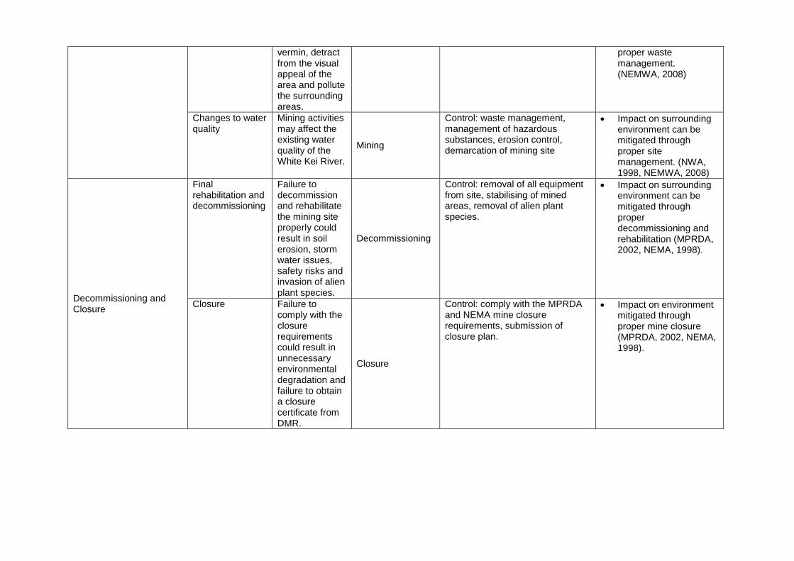
vermin, detract from the visual appeal of the area and pollute the surrounding areas.
proper waste management. (NEMWA, 2008)
Changes to water quality
Mining activities may affect the existing water quality of the White Kei River.
Mining
Control: waste management, management of hazardous substances, erosion control, demarcation of mining site
Impact on surrounding environment can be mitigated through proper site management. (NWA, 1998, NEMWA, 2008)
Decommissioning and Closure
Final rehabilitation and decommissioning
Failure to decommission and rehabilitate the mining site properly could result in soil erosion, storm water issues, safety risks and invasion of alien plant species.
Decommissioning
Control: removal of all equipment from site, stabilising of mined areas, removal of alien plant species.
Impact on surrounding environment can be mitigated through proper decommissioning and rehabilitation (MPRDA, 2002, NEMA, 1998).
Closure Failure to comply with the closure requirements could result in unnecessary environmental degradation and failure to obtain a closure certificate from DMR.
Closure
Control: comply with the MPRDA and NEMA mine closure requirements, submission of closure plan.
Impact on environment mitigated through proper mine closure (MPRDA, 2002, NEMA, 1998).

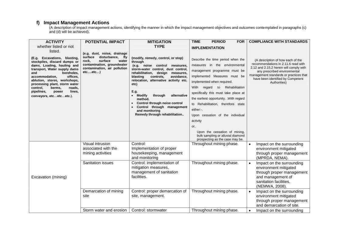
f) Impact Management Actions (A description of impact management actions, identifying the manner in which the impact management objectives and outcomes contemplated in paragraphs (c) and (d) will be achieved).
ACTIVITY
whether listed or not listed.
(E.g. Excavations, blasting, stockpiles, discard dumps or dams, Loading, hauling and transport, Water supply dams and boreholes, accommodation, offices, ablution, stores, workshops, processing plant, storm water control, berms, roads, pipelines, power lines,
conveyors, etc…etc…etc.).
POTENTIAL IMPACT (e.g. dust, noise, drainage surface disturbance, fly rock, surface water contamination, groundwater contamination, air pollution etc….etc…)
MITIGATION TYPE
(modify, remedy, control, or stop) through (e.g. noise control measures, storm-water control, dust control, rehabilitation, design measures, blasting controls, avoidance, relocation, alternative activity etc. etc) E.g.
Modify through alternative method.
Control through noise control
Control through management and monitoring
Remedy through rehabilitation..
TIME PERIOD FOR
IMPLEMENTATION
Describe the time period when the
measures in the environmental
management programme must be
implemented Measures must be
implemented when required.
With regard to Rehabilitation
specifically this must take place at
the earliest opportunity. .With regard
to Rehabilitation, therefore state
either:-.
Upon cessation of the individual
activity
or.
Upon the cessation of mining, bulk sampling or alluvial diamond prospecting as the case may be.
COMPLIANCE WITH STANDARDS
(A description of how each of the recommendations in 2.11.6 read with
2.12 and 2.15.2 herein will comply with any prescribed environmental
management standards or practices that have been identified by Competent
Authorities)
Excavation (mining)
Visual intrusion associated with the mining activities
Control: Implementation of proper housekeeping, management and monitoring
Throughout mining phase. Impact on the surrounding environment mitigated through proper management (MPRDA, NEMA).
Sanitation issues Control: implementation of mitigation measures, management of sanitation facilities.
Throughout mining phase. Impact on the surrounding environment mitigated through proper management and management of sanitation facilities. (NEMWA, 2008).
Demarcation of mining site
Control: proper demarcation of site, management.
Throughout mining phase. Impact on the surrounding environment mitigated through proper management and demarcation of site.
Storm water and erosion Control: stormwater Throughout mining phase. Impact on the surrounding
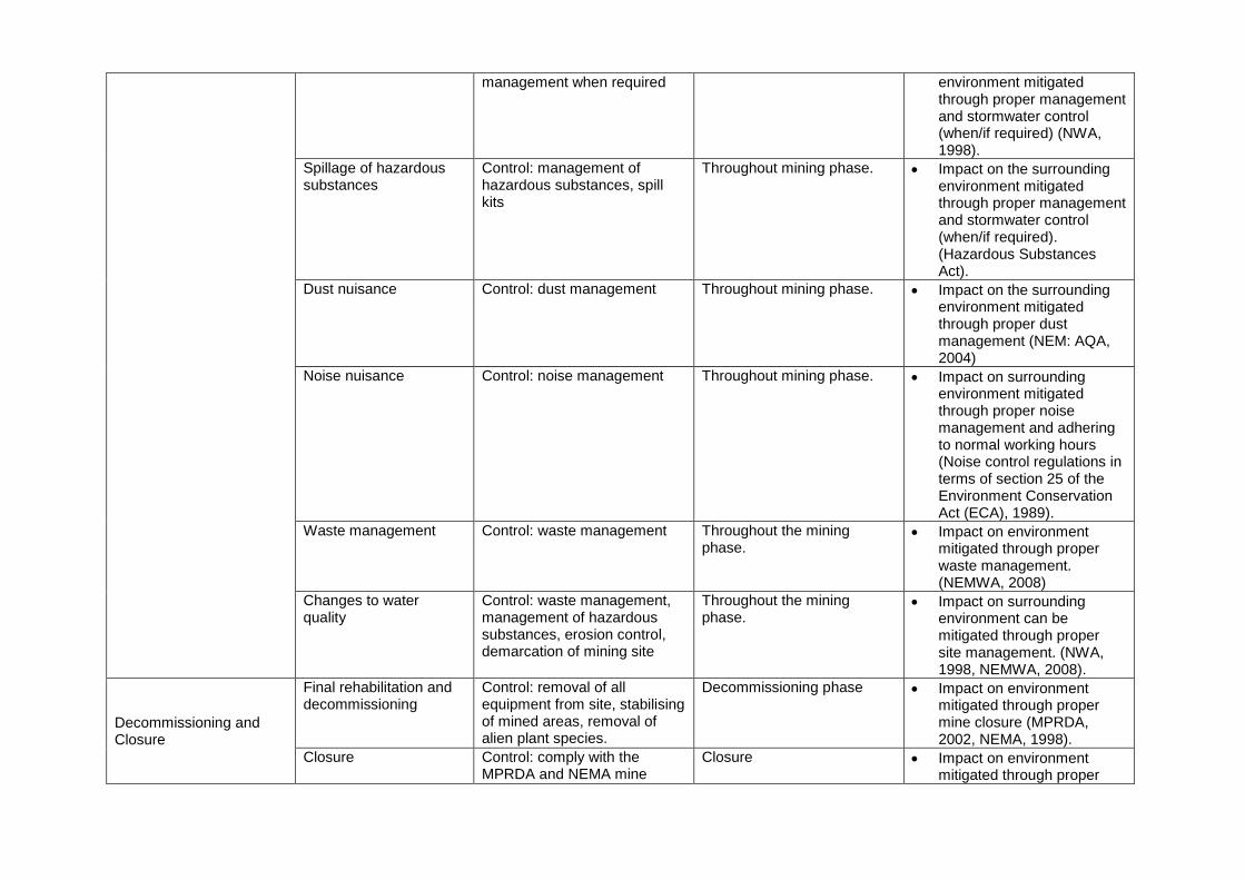
management when required environment mitigated through proper management and stormwater control (when/if required) (NWA, 1998).
Spillage of hazardous substances
Control: management of hazardous substances, spill kits
Throughout mining phase. Impact on the surrounding environment mitigated through proper management and stormwater control (when/if required). (Hazardous Substances Act).
Dust nuisance Control: dust management Throughout mining phase. Impact on the surrounding environment mitigated through proper dust management (NEM: AQA, 2004)
Noise nuisance Control: noise management Throughout mining phase. Impact on surrounding environment mitigated through proper noise management and adhering to normal working hours (Noise control regulations in terms of section 25 of the Environment Conservation Act (ECA), 1989).
Waste management Control: waste management Throughout the mining phase.
Impact on environment mitigated through proper waste management. (NEMWA, 2008)
Changes to water quality
Control: waste management, management of hazardous substances, erosion control, demarcation of mining site
Throughout the mining phase.
Impact on surrounding environment can be mitigated through proper site management. (NWA, 1998, NEMWA, 2008).
Decommissioning and Closure
Final rehabilitation and decommissioning
Control: removal of all equipment from site, stabilising of mined areas, removal of alien plant species.
Decommissioning phase Impact on environment mitigated through proper mine closure (MPRDA, 2002, NEMA, 1998).
Closure Control: comply with the MPRDA and NEMA mine
Closure Impact on environment mitigated through proper
closure requirements, submission of closure plan.
mine closure (MPRDA, 2002, NEMA, 1998).

i) Financial Provision
(1) Determination of the amount of Financial Provision.
(a) Describe the closure objectives and the extent to which they have been aligned to the baseline environment described under the Regulation. Upon cessation of the mining activities the area will be rehabilitated. The very small excavation sides will be profiled to a 1:3 gradient (if necessary). All waste materials and other materials will be removed from site. The applicant will comply with the minimum closure objectives as prescribed by DMR.
(b) Confirm specifically that the environmental
objectives in relation to closure have been consulted with landowner and interested and affected parties. The Draft Basic Assessment Report, includes all the environmental objectives in relation to closure and was made available for perusal of I&AP‘s and stakeholders. No comments were received. The mining project was also discussed with the relevant I&APs during the public meeting.
(c) Provide a rehabilitation plan that describes and shows the scale and aerial extent of the main mining activities, including the anticipated mining area at the time of closure. The requested rehabilitation plan is explained below. Upon closure of the mine all machinery and equipment will be removed. The small excavation sides will be profiled to 1:3 to ensure safety and prevent erosion. No permanent structures will remain upon closure of the site. The rehabilitated area will be the affected area as is indicated in Appendix 1 (section 1.2).
(d) Explain why it can be confirmed that the rehabilitation plan is compatible with the closure objectives.
The decommissioning phase will entail the rehabilitation of the mining site. Upon cessation of the mining activities, the area will be fully rehabilitated. The rehabilitation of the mining area will comply with the minimum closure objectives as prescribed by DMR and detailed below, and therefore is deemed to be compatible:
Rehabilitation
Mining areas must be levelled out daily.
No erosion rills must be allowed to develop.
Weed/alien vegetation clearing must take place continuously
during mining (if required).
Final rehabilitation and closure
The affected rehabilitation area will be mining area as
indicated in the Regulation
Any remaining sand stockpiles must be removed or levelled.
Site clean-up must be done.
Waste material of any description, including receptacles, scrap, rubble and tyres, will be removed entirely from the mining area and disposed of at a registered landfill site. It will not be permitted to be buried or burned on the site.
Mined out areas must be stabilised and profiled (if
necessary).
The post rehabilitation topography should result in the same
slope as prior to mining.
Weeds/alien plants growing on site must be manually
removed and deposited at a registered landfill site.
All equipment and other items used during the mining period
must be removed from site.
At closure the internal haul road must be left in a good and
non-eroded state (as it was prior to mining activities).
The closed site must pose no safety risks.
Rehabilitation must be completed in such a manner that the
land can be optimally used post-mining.
Final rehabilitation must be completed within a period
specified by the Regional Manager.
Closure must comply with the MPRDA (Act 28 of 2002),
NEMA (Act 107 of 1998) and the NEMA Regulations (2014)
requirements for mine closure.
A closure plan must be compiled using the guidelines
described in Appendix 5 of the NEMA Regulations (2014)
and submitted to DMR.
A closure certificate must be obtained from the Minister of
Mineral Resources.
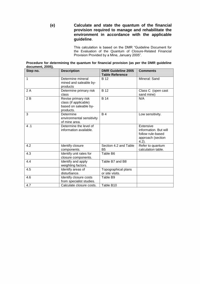
(e) Calculate and state the quantum of the financial
provision required to manage and rehabilitate the environment in accordance with the applicable guideline. This calculation is based on the DMR ―Guideline Document for the Evaluation of the Quantum of Closure-Related Financial Provision Provided by a Mine, January 2005‖.
Procedure for determining the quantum for financial provision (as per the DMR guideline document, 2005).
Step no. Description DMR Guideline 2005 Table Reference
Comments
1 Determine mineral mined and saleable by-products
B 12 Mineral: Sand
2 A Determine primary risk class
B 12 Class C (open cast sand mine)
2 B Revise primary risk class (if applicable) based on saleable by-products.
B 14 N/A
3 Determine environmental sensitivity of mine area.
B 4 Low sensitivity.
4 .1 Determine the level of information available.
Extensive information. But will follow rule-based approach (section 4.2).
4.2 Identify closure components.
Section 4.2 and Table B5
Refer to quantum calculation table.
4.3 Identify unit rates for closure components.
Table B6
4.4 Identify and apply weighting factors.
Table B7 and B8
4.5 Identify areas of disturbance.
Topographical plans or site visits.
4.6 Identify closure costs from specialist studies.
Table B9
4.7 Calculate closure costs. Table B10

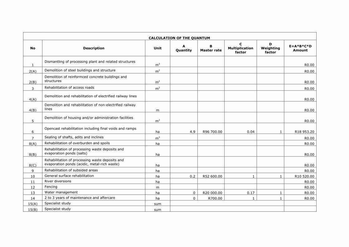
CALCULATION OF THE QUANTUM
No Description Unit A
Quantity B
Master rate
C Multiplication
factor
D Weighting
factor
E=A*B*C*D Amount
1 Dismantling of processing plant and related structures
m3 R0.00
2(A) Demolition of steel buildings and structure m2 R0.00
2(B)
Demolition of reinformced concrete buildings and structures m2 R0.00
3 Rehabilitation of access roads m2 R0.00
4(A) Demolition and rehabilitation of electrified railway lines
R0.00
4(B)
Demolition and rehabilitation of non-electrified railway lines m R0.00
5 Demolition of housing and/or administration facilities
m2 R0.00
6 Opencast rehabilitation including final voids and ramps
ha 4.9 R96 700.00 0.04 1 R18 953.20
7 Sealing of shafts, adits and inclines m3 R0.00
8(A) Rehabilitation of overburden and spoils ha R0.00
8(B)
Rehabilitation of processing waste deposits and evaporation ponds (salts) ha R0.00
8(C)
Rehabilitation of processing waste deposits and evaporation ponds (acidic, metal-rich waste) ha R0.00
9 Rehabilitation of subsided areas ha R0.00
10 General surface rehabilitation ha 0.2 R52 600.00 1 1 R10 520.00
11 River diversions ha R0.00
12 Fencing m R0.00
13 Water management ha 0 R20 000.00 0.17 1 R0.00
14 2 to 3 years of maintenance and aftercare ha 0 R700.00 1 1 R0.00
15(A) Specialist study sum
15(B) Specialist study sum

SUBTOTAL 1 R29 473.20
1 Weighting factor 2 (0%, 5% or 10%) R 1 473.66
2 Preliminary and General 12,5% of subtotal 1 R3 684.15
3 Administration and supervisionn costs 6,0% of subtotal 1 R1 768.39
4 Engineering drawings and specifications 2,0% of subtotal 1 R589.46
5 Engineering and procurement of specialist work 2,5% of subtotal 1 R736.83
6 Development of closure plan 2,5% of subtotal 1 R736.83
7 Final groundwater modelling** 2,5% of subtotal 1
8 Contingency 10,0% of subtotal 1 R2 947.32
SUBTOTAL 2 R11 936.65
VAT (14%) R5 797.38
GRAND TOTAL (SUBTOTAL 1 + SUBTOTAL 2 + VAT) R47 207.22

(f) Confirm that the financial provision will be
provided as determined. Herewith I, the person, whose name is stated below confirm that I am the person authorised to act as representative of the applicant. I herewith confirm that the company will provide the amount that will be determined by the Regional Manager in accordance with the prescribed guidelines.

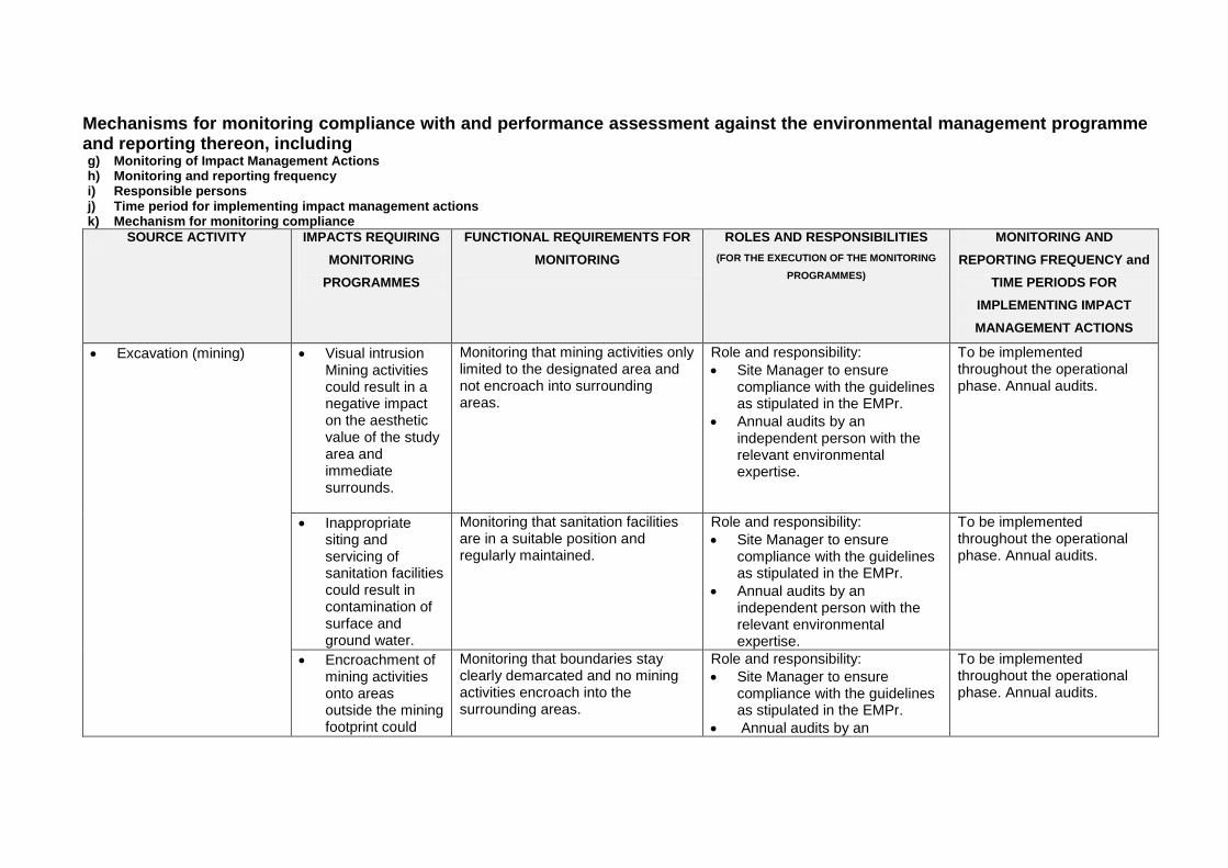
Mechanisms for monitoring compliance with and performance assessment against the environmental management programme and reporting thereon, including g) Monitoring of Impact Management Actions h) Monitoring and reporting frequency i) Responsible persons j) Time period for implementing impact management actions k) Mechanism for monitoring compliance
SOURCE ACTIVITY IMPACTS REQUIRING
MONITORING
PROGRAMMES
FUNCTIONAL REQUIREMENTS FOR
MONITORING
ROLES AND RESPONSIBILITIES
(FOR THE EXECUTION OF THE MONITORING
PROGRAMMES)
MONITORING AND
REPORTING FREQUENCY and
TIME PERIODS FOR
IMPLEMENTING IMPACT
MANAGEMENT ACTIONS
Excavation (mining) Visual intrusion Mining activities could result in a negative impact on the aesthetic value of the study area and immediate surrounds.
Monitoring that mining activities only limited to the designated area and not encroach into surrounding areas.
Role and responsibility:
Site Manager to ensure compliance with the guidelines as stipulated in the EMPr.
Annual audits by an independent person with the relevant environmental expertise.
To be implemented throughout the operational phase. Annual audits.
Inappropriate siting and servicing of sanitation facilities could result in contamination of surface and ground water.
Monitoring that sanitation facilities are in a suitable position and regularly maintained.
Role and responsibility:
Site Manager to ensure compliance with the guidelines as stipulated in the EMPr.
Annual audits by an independent person with the relevant environmental expertise.
To be implemented throughout the operational phase. Annual audits.
Encroachment of mining activities onto areas outside the mining footprint could
Monitoring that boundaries stay clearly demarcated and no mining activities encroach into the surrounding areas.
Role and responsibility:
Site Manager to ensure compliance with the guidelines as stipulated in the EMPr.
Annual audits by an
To be implemented throughout the operational phase. Annual audits.

result in unnecessary environmental disturbance.
independent person with the relevant environmental expertise.
Inadequate stormwater and erosion control could result in soil erosion and impact surface water quality.
Monitoring that erosion rills don‘t develop and monitoring of stormwater on the haul road.
Role and responsibility:
Site Manager to ensure compliance with the guidelines as stipulated in the EMPr.
Annual audits by an independent person with the relevant environmental expertise.
To be implemented throughout the operational phase. Annual audits.
Spillage of any hazardous substances such as fuel, chemicals, etc. could result in ground and surface water contamination.
Monitoring of hazardous substances, vehicle maintenance and spill kits.
Role and responsibility:
Site Manager to ensure compliance with the guidelines as stipulated in the EMPr.
Annual audits by an independent person with the relevant environmental expertise.
To be implemented throughout the operational phase. Annual audits.
Dust (generated from mining activities and from vehicles traveling on dirt roads) could be a nuisance during windy conditions.
Monitoring of dust and complaints related to dust.
Role and responsibility:
Site Manager to ensure compliance with the guidelines as stipulated in the EMPr.
Annual audits by an independent person with the relevant environmental expertise.
To be implemented throughout the operational phase. Annual audits.
Mining activities and movement of heavy vehicles could result in an increase in ambient noise levels on site and
Monitoring of noise and complaints relating to noise.
Role and responsibility:
Site Manager to ensure compliance with the guidelines as stipulated in the EMPr.
Annual audits by an independent person with the relevant environmental
To be implemented throughout the operational phase. Annual audits.
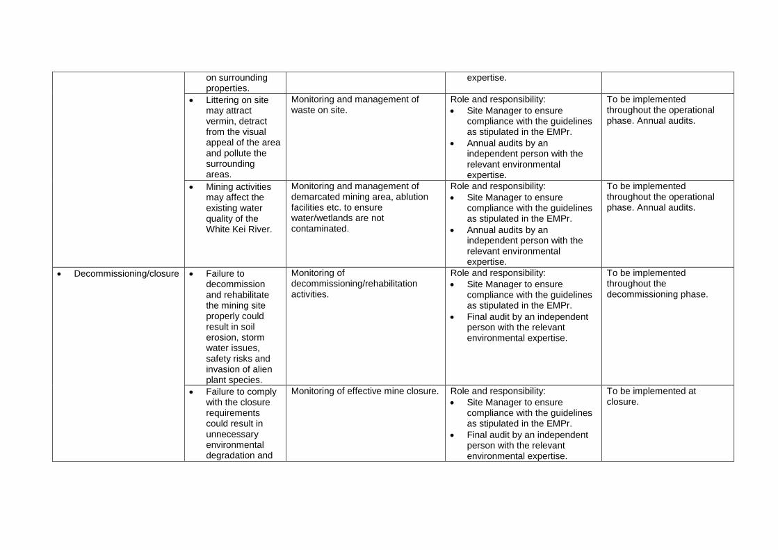
on surrounding properties.
expertise.
Littering on site may attract vermin, detract from the visual appeal of the area and pollute the surrounding areas.
Monitoring and management of waste on site.
Role and responsibility:
Site Manager to ensure compliance with the guidelines as stipulated in the EMPr.
Annual audits by an independent person with the relevant environmental expertise.
To be implemented throughout the operational phase. Annual audits.
Mining activities may affect the existing water quality of the White Kei River.
Monitoring and management of demarcated mining area, ablution facilities etc. to ensure water/wetlands are not contaminated.
Role and responsibility:
Site Manager to ensure compliance with the guidelines as stipulated in the EMPr.
Annual audits by an independent person with the relevant environmental expertise.
To be implemented throughout the operational phase. Annual audits.
Decommissioning/closure Failure to decommission and rehabilitate the mining site properly could result in soil erosion, storm water issues, safety risks and invasion of alien plant species.
Monitoring of decommissioning/rehabilitation activities.
Role and responsibility:
Site Manager to ensure compliance with the guidelines as stipulated in the EMPr.
Final audit by an independent person with the relevant environmental expertise.
To be implemented throughout the decommissioning phase.
Failure to comply with the closure requirements could result in unnecessary environmental degradation and
Monitoring of effective mine closure. Role and responsibility:
Site Manager to ensure compliance with the guidelines as stipulated in the EMPr.
Final audit by an independent person with the relevant environmental expertise.
To be implemented at closure.
failure to obtain a closure certificate from DMR.

l) Indicate the frequency of the submission of the performance assessment/ environmental audit report.
In terms of the National Environmental Management Act (Act 107 of 1998; NEMA) and its amendment, section 24 P (3) (b), the holder of a mining permit must submit an audit report annually to the Minister responsible for mineral resources. An annual audit will be conducted by an independent competent person (with the relevant environmental expertise) and the audit report submitted to DMR.
m) Environmental Awareness Plan
(1) Manner in which the applicant intends to inform his or her employees of
any environmental risk which may result from their work. Once mining of the proposed area starts, a copy of the Environmental Management Programme report will be handed to the site manager during the site establishment meeting. Issues such as fire principals and hazardous waste handling will be discussed.
An induction meeting will be held with all the site workers to inform them of the Basic Rules of Conduct with regards to the environment. Site owner and site manager must also familiarise themselves with the Mine Health and Safey Act (1996) and ensure compliance with the Act.
(2) Manner in which risks will be dealt with in order to avoid pollution or the
degradation of the environment. The site manager must ensure that he/she understands the EMPr document and its requirements and commitments before any mining takes place. The site manager must continuously monitor compliance with the EMPr. An independent person with the relevant environmental experience must audit compliance with the EMPr at least annually. All the mitigation measures listed in the Impact Assessment and EMPr must be adhered to in order to prevent environmental degradation. The following list represents the basic steps towards environmental awareness, which all mining employees should consider when carrying out their tasks. Site Management:
Stay within boundaries of site – do not enter adjacent properties.
Keep tools and material securely stored offsite.
Use toilets provided – report full or leaking toilets.
Water Management and Erosion:
Report any erosion.
Check that no equipment is causing hydrocarbon spills.
Do not swim in or drink from the river.
Waste Management:
Take care of your own waste.
Place waste in containers and always close lid.
Don‘t burn waste.
Pick-up any litter.
Hazardous Waste Management (Petrol, Oil, Diesel, Grease):
Never mix general waste with hazardous waste.
Use only sealed, non-leaking containers.
Keep all containers closed and store only in approved areas.
Stop leaks and spills, if safe.
Immediately report the spill to the site manager/supervision.
Locate spill kit/supplies and use to clean-up, if safe.
Place spill clean-up waste in proper containers.
Label containers and move to approved storage area to be disposed at a registered landfill site.
Discoveries:
Includes – Archaeological finds, Cultural artefacts, Contaminated water, Pipes, Containers, Tanks and drums, any buried structures.
Stop work immediately.
Notify site manager/supervisor . Air Quality:
Wear protection when working in very dusty areas.
Implement dust control measures:
Water roads and work areas during excessively windy days (if required).
Obey speed limit. Driving and Noise:
Use only approved access roads.
Respect speed limits.
Only use turn-around areas – no crisscrossing through undisturbed areas.
Avoid causing unnecessary loud noises.
Report or repair noisy vehicles. Vegetation and Animal life:
Do not remove any plants or trees without approval of the site manager.
Do not collect fire wood.
Do not catch, kill, harm, sell or play with any animal, reptile, bird or amphibian on site.
Report any animal trapped in the work area.
Do not set snares or raid nests for eggs or young. Fire Management:
Do not light any fires on site.
Put cigarette butts in a rubbish bin.
Do not smoke near any fuel or chemicals.
Know the position of firefighting equipment.
Report all fires.
Don‘t burn waste or vegetation.
n) Specific information required by the Competent Authority
(Among others, confirm that the financial provision will be reviewed annually).
The applicant undertakes to annually review and update (if necessary) the financial provision calculation, for review and approval by DMR.
2) UNDERTAKING The EAP herewith confirms a) the correctness of the information provided in the reports
b) the inclusion of comments and inputs from stakeholders and I&APs ;
c) the inclusion of inputs and recommendations from the specialist reports where
relevant; and
d) that the information provided by the EAP to interested and affected parties and any responses by the EAP to comments or inputs made by interested and affected parties are correctly reflected herein.
Signature of the environmental assessment practitioner: EOH Coastal and Environmental Services
Name of company: July 2016
Date:
-END-
X
X
X
X