Proposed Remedial Action Plan - Depew Village Landfill OU 2 · PROPOSED REMEDIAL ACTION PLAN PAGE 1...
22
PROPOSED REMEDIAL ACTION PLAN DEPEW VILLAGE LANDFILL SITE Operable Unit No. 02 Village of Depew, Erie County, New York Site No. 915105 October 2009 Prepared by: Division of Environmental Remediation New York State Department of Environmental Conservation
Transcript of Proposed Remedial Action Plan - Depew Village Landfill OU 2 · PROPOSED REMEDIAL ACTION PLAN PAGE 1...

PROPOSED REMEDIAL ACTION PLANDEPEW VILLAGE LANDFILL SITE
Operable Unit No. 02 Village of Depew, Erie County, New York
Site No. 915105
October 2009
Prepared by:
Division of Environmental RemediationNew York State Department of Environmental Conservation

DEPEW VILLAGE LANDFILL, OU-02, No. 915105 October 2009PROPOSED REMEDIAL ACTION PLAN PAGE 1
PROPOSED REMEDIAL ACTION PLANDEPEW VILLAGE LANDFILL SITE
Operable Unit No. 02Village of Depew, Erie County, New York
Site No. 915105October 2009
SECTION 1: SUMMARY AND PURPOSE OF THE PROPOSED PLAN
The New York State Department of Environmental Conservation (the Department), in consultation with theNew York State Department of Health (NYSDOH), is proposing a remedy for the Depew Village Landfill,Operable Unit No. 02. The presence of hazardous waste has created significant threats to human healthand/or the environment that are addressed by this proposed remedy. As more fully described in Sections3 and 5 of this document, the operation of a former municipal solid waste incinerator and landfill at the sitehave resulted in the disposal of hazardous wastes, including ash material containing heavy metals. Thesewastes have contaminated the soils and sediments at the site, and have resulted in:
• a significant threat to human health associated with potential exposure to contaminated soils andsediments.
• a significant environmental threat associated with the current and potential impacts of contaminantsto the Cayuga Creek ecosystem.
To eliminate or mitigate these threats, the Department proposes sediment excavation from Cayuga Creek,soil removal from the flood plain and the Zurbrick Road slope, off-site disposal and streambankstabilization.
The proposed remedy, discussed in detail in Section 8, is intended to attain the remediation goals identifiedfor this site in Section 6. The remedy must conform with officially promulgated standards and criteria thatare directly applicable, or that are relevant and appropriate. The selection of a remedy must also take intoconsideration guidance, as appropriate. Standards, criteria and guidance are hereafter called SCGs.
This Proposed Remedial Action Plan (PRAP) identifies the preferred remedy, summarizes the otheralternatives considered, and discusses the reasons for this preference. The Department will select a finalremedy for the site only after careful consideration of all comments received during the public commentperiod.
The Department has issued this PRAP as a component of the Citizen Participation Plan developed pursuantto the New York State Environmental Conservation Law and Title 6 of the Official Compilation of Codes,Rules and Regulations of the State of New York (6 NYCRR) Part 375. This document is a summary of theinformation that can be found in greater detail in the June 2009, “Remedial Investigation/Feasibility Study(RI/FS) for Operable Unit 2 of the Depew Village Landfill Site”, and other relevant documents. The publicis encouraged to review the project documents, which are available at the following repositories:
Village of DepewMunicipal Building85 Manitou StreetDepew, NY 14043(716) 683-1400Contact: Elizabeth Melock

DEPEW VILLAGE LANDFILL, OU-02, No. 915105 October 2009PROPOSED REMEDIAL ACTION PLAN PAGE 2
NYSDEC Buffalo Office270 Michigan AvenueBuffalo, NY 14203(716) 851-7220Appointment requested; contact David Locey.
NYSDEC Central Office625 Broadway, 12th FloorAlbany, NY 12233-7013(518) 402-9767Appointment requested; contact Randy Hough, Project Manager.
The Department seeks input from the community on all PRAPs. A public comment period has been set fromNovember 2 through December 1, 2009 to provide an opportunity for public participation in the remedyselection process. A public meeting is scheduled for Tuesday, November 17th, 2009 at the Village of DepewMunicipal Building beginning at 7:00 pm.
At the meeting, the results of the RI/FS will be presented along with a summary of the proposed remedy.After the presentation, a question-and-answer period will be held, during which verbal or written commentsmay be submitted on the PRAP. Written comments may also be sent to Mr. Hough at the above addressthrough December 1, 2009.
The Department may modify the proposed remedy or select another of the alternatives presented in thisPRAP, based on new information or public comments. Therefore, the public is encouraged to review andcomment on all of the alternatives identified here.
Comments will be summarized and addressed in the responsiveness summary section of the Record ofDecision (ROD). The ROD is the Department’s final selection of the remedy for this site.
SECTION 2: SITE LOCATION AND DESCRIPTION
The Depew Village Landfill site is located in the Village of Depew, Town of Cheektowaga, in Erie County(Figure 1). The site’s general location is in a suburban setting.
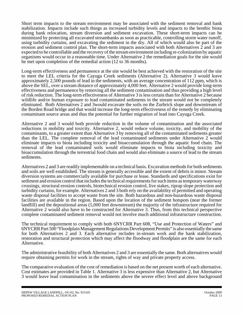
Operable Unit (OU) No. 02, which is the subject of this document, includes a section of the Cayuga Creekenvironment (surface water, sediments and floodplain soils) and a segment of stream bank located belowZurbrick Road (Figure 2).
An operable unit represents a portion of the site remedy that for technical or administrative reasons can beaddressed separately to eliminate or mitigate a release, threat of release or exposure pathway resulting fromthe site contamination.
Cayuga Creek is a Class C stream and a major tributary of the Buffalo River, which ultimately empties intoLake Erie. The creek has a drainage area of approximately 112 square miles above the site. The stream atand around the site is characterized by alluvial deposits, a well defined floodplain and floodway, ameandering channel, and a streambed consisting of riffle/pool sequences and point sand bar deposits withinthe active channel. Bedrock at and around the site consists of fractured and jointed Onondaga limestone,which also forms the bed of Cayuga Creek. Average flowrate in the stream is approximately 110 cubicfeet/second. A mixture of public and private lands border the stream at the site area. Property boundariesin the area extend to the stream centerline.
The Zurbrick Road slope area is comprised of two property parcels, one owned by Erie County (1.12 acres)and the other owned the Village of Depew (0.35 acres). Contaminated fill materials appear to have beendumped down the slope in order to help stabilize the area.

DEPEW VILLAGE LANDFILL, OU-02, No. 915105 October 2009PROPOSED REMEDIAL ACTION PLAN PAGE 3
The remaining operable unit for this site is: Operable Unit No. 01, which consists of approximately 20 acresof area contained within the banks of the Cayuga Creek on the peninsula south of the Village of DepewDPW facility. OU-01 includes the footprint of the former landfill, excluding the Erie County OverflowRetention Facility (ORF) and associated structures which sit in the middle of the peninsula. The northernboundary of OU-01 (extending west to east) is identified as a combination of the southern perimeter of theDPW parking lot across to the tree-line that abuts the mowed fields in the northeast, continuing to the bankof Cayuga Creek. Zurbrick Road is located to south of the former landfill across Cayuga Creek (Figure 2).
Other sites in the area which are being addressed under the Department’s remedial programs include: theLand Reclamation (915070) and the Old Land Reclamation (915129) sites which are located approximatelyone-half mile downstream and the NL Industries (V00353) site which is located approximately one and one-half miles to the north.
SECTION 3: SITE HISTORY
3.1: Operational/Disposal History
The Depew Village Landfill was operated by the Village of Depew between 1940 and 1961. Duringoperations the landfill received approximately 10,000 tons per year of municipal solid waste and/or otherunknown waste streams. Much of the wastes were processed through the incinerator that was once locatedon-site, with the resulting ash disposed of in the landfill. Site hazardous waste contamination, includingheavy metals and in particular lead, was concentrated in the ash fill. Fill materials were placed along thecreek shoreline below the bankfull flow elevations (roughly the mean high water level for this stream)making them available for erosion. The former landfill was not lined or properly covered and closed.
3.2: Remedial History
In 1983, the Department first listed the site as a Class 2a site in the Registry of Inactive Hazardous WasteDisposal Sites in New York (the Registry). Class 2a was a temporary classification assigned to a site thathad inadequate and/or insufficient data for inclusion in any of the other classifications. Also in 1983, ErieCounty acquired 14.5 acres of the peninsula area for the ORF project. During ORF constructionapproximately 60,000 cubic yards of fill was removed from the site and disposed of in the BFI Landfill inTonawanda, New York. No chemical analysis was performed.
In 1985, the Erie County Department of Environment and Planning prepared a “Hazardous Waste SiteProfile Report”, which concluded that no hazardous waste was disposed at the site.
In 1988, the Department conducted a Phase I Investigation at the site. This report recommended conductinga Phase II Investigation.
In 1990, the Department de-listed the site from the Registry of Inactive Hazardous Waste Disposal Sites,based upon the fact that no documented evidence of hazardous waste disposal could be found.
In 2001, the Village of Depew entered into a Section 14 (1946 Flood Control Act), Project CooperationAgreement (PCA) with the U.S. Army Corps of Engineers (USACOE) to perform an EmergencyStreambank Protection Project on a section of Cayuga Creek below Zurbrick Road, south of the site. As partof this project, the design called for excavating soils on the peninsula tip, in order to maintain the requiredstream bed width, and use of these soils on the opposite bank as fill. During the excavation, the USACOEcontractor noticed the presence of fill materials and conducted sampling and analysis. The analysis indicatedtotal lead concentrations as high as 86,000 parts per million in the soils and in addition the samples failedthe Environmental Protection Agency’s (EPA), Toxicity Characteristics Leaching Procedure (TCLP) forlead, making the material hazardous. With the determination of the presence of hazardous waste and inaccordance with the PCA, the USACOE ceased operations on the streambank stabilization project.

DEPEW VILLAGE LANDFILL, OU-02, No. 915105 October 2009PROPOSED REMEDIAL ACTION PLAN PAGE 4
In 2002, the Village of Depew entered the Department’s Voluntary Cleanup Program (VCP) and the sitewas designated as V00609-9.
In 2003, a Site Investigation was conducted by the Village’s consultant which focused on the 1.3 acre areaat the tip of the peninsula.
In 2004, the Site Investigation / Remedial Report (SI/RR) was generated. This report confirmed the presenceof hazardous wastes and it also indicated that the lead contamination most likely extends to the north,beyond the registry area on the peninsula tip. The Village of Depew opted out of the VCP, the VoluntaryCleanup Agreement was terminated and the Department listed the site as a Class 2 site in the Registry ofInactive Hazardous Waste Disposal Sites in New York. A Class 2 site is a site where hazardous wastepresents a significant threat to the public health and/or the environment and action is required.
In early 2007, the Department finalized a Site Boundary Modification Package, which increased the site sizefrom 1.3 to 20 acres in the Registry of Inactive Hazardous Waste Disposal Sites. The site boundarymodification was based upon the extent of the lead contamination as determined from the RI results. Themodified site boundary includes the majority of the footprint of the original landfill. In addition, OU-02 wascreated based upon the fact that the sediments in the stream around the landfill were determined to becontaminated above Department guidance values, however the downstream extent of the impacts had notbeen delineated and thus a separate RI/FS was initiated.
The RI/FS for OU-01 was completed in 2006 and the Record of Decision (ROD) was signed in March of2008. The ROD selected stream bank soil removal, stream bank stabilization, a soil cover, passive landfillgas venting, monitoring and institutional controls as the remedy for this operable unit. Work on the OU-01remedy has been deferred pending completion of the RI/FS and the selection of a remedy for OU-02.
SECTION 4: ENFORCEMENT STATUS
Potentially Responsible Parties (PRPs) are those who may be legally liable for contamination at a site. Thismay include past or present owners and operators, waste generators, and haulers. The PRPs for the site, documented to date, include: the Village of Depew and Erie County.
The PRPs declined to implement the RI/FS at the site when requested by the Department. After the remedyis selected, the PRPs will again be contacted to assume responsibility for the remedial program. If anagreement cannot be reached with the PRPs, the Department will evaluate the site for further action underthe State Superfund. The PRPs are subject to legal actions by the state for recovery of all response coststhe state has incurred.
SECTION 5: SITE CONTAMINATION
A remedial investigation/feasibility study (RI/FS) has been conducted to evaluate the alternatives foraddressing the significant threats to human health and/or the environment.
5.1: Summary of the Remedial Investigation
The purpose of the RI was to define the nature and extent of any contamination resulting from previousactivities at the site. The RI was conducted between September 2007and June 2008. The field activities andfindings of the investigation are described in the RI report.
Cayuga Creek surface water, sediments and floodplain soils were investigated over a study area distanceof approximately 13,000 feet downstream of the former landfill. In addition, a sampling grid was setup onthe slope below Zurbrick Road for soil sample collection in this area.
5.1.1: Standards, Criteria, and Guidance (SCGs)

DEPEW VILLAGE LANDFILL, OU-02, No. 915105 October 2009PROPOSED REMEDIAL ACTION PLAN PAGE 5
To determine whether the surface waters, soils, and sediments contain contamination at levels of concern,data from the investigation were compared to the following SCGs:
• Surface water SCGs are based on the Department’s “Ambient Water Quality Standards andGuidance Values”.
• Soil SCGs are based on the Department’s Soil Cleanup Objectives (“6NYCRR Part 375,Environmental Remediation Programs, Subpart 375-6”) .
• Sediment criteria are based on the Department’s “Technical Guidance for Screening ContaminatedSediments.”
• Location specific SCGs must also be considered during remedy selection. Article 15 and Article 16of the Environmental Conservation Law (ECL) are location specific SCGs applicable to the site.Therefore all work within the streambed and banks must meet the requirements of 6NYCRR Part608, “Use and Protection of Waters” and all work within the floodplain must meet the requirementsof 6NYCRR Part 500, “Floodplain Management Regulations Development Permits”.
Based on the RI results, in comparison to the SCGs and potential public health and environmental exposureroutes, certain media and areas of the site require remediation. These are summarized in Section 5.1.2.More complete information can be found in the RI report. 5.1.2: Nature and Extent of Contamination This section describes the findings of the investigation for all environmental media that were investigated.
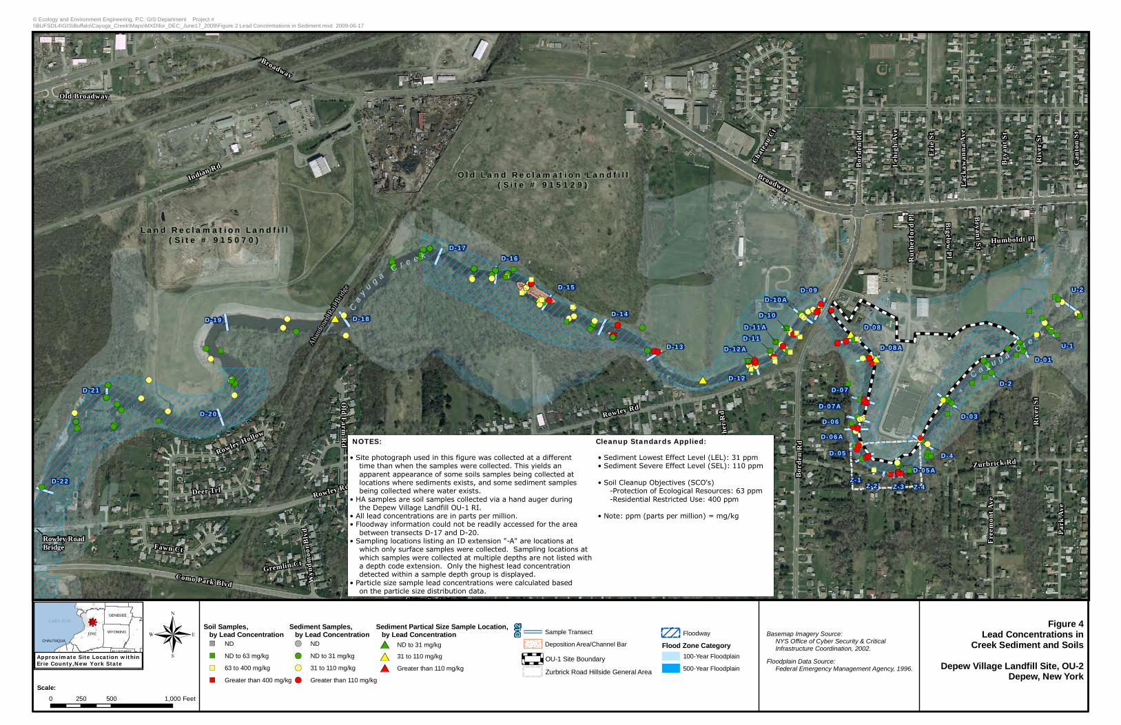
As described in the RI report, many soil, surface water and sediment samples were collected to characterizethe nature and extent of contamination. As seen in Figures 3 and 4, the main categories of contaminants thatexceed their SCGs are inorganics (metals). For comparison purposes, where applicable, SCGs are providedfor each medium.
Chemical concentrations are reported in parts per billion (ppb) for water and parts per million (ppm) for soiland sediment.
Figures 3 and 4 summarize the degree of contamination for the contaminants of concern in soils andsediments and compares the data with the SCGs for the site. The following are the media which wereinvestigated and a summary of the findings of the investigation.
Surface/Subsurface Soil
Soil SCGs include a number of soil cleanup objectives (SCOs) based upon the threat that is to be eliminatedor mitigated to protect public health and the environment. Because the soils around the site are being erodedand deposited into the Cayuga Creek ecological resource, the Protection of Ecological Resources SoilCleanup Objectives are being utilized at this site. A total of twenty-four soil samples were collected from the slope below Zurbrick Road. Lead concentrationsin this area ranged from approximately 20 to 55,000 ppm. It was estimated that the Zurbrick Road slopecontains approximately 4,500 cubic yards of contaminated soils and fill materials above the Protection ofEcological Resources Soil Cleanup Objective of 63 ppm for lead. A large part of the volume of this materialis at or below the bankfull flow elevation and thus available for erosion into the stream (Figure 3).
A total of 48 soil samples were collected and analyzed from the floodplain/upland areas along the stream.Soil contamination above the Protection of Ecological Resources SCO of 63 ppm was detected in an areaextending from the Borden Road bridge downstream approximately 600 feet on the south bank of thestream. The estimated volume of contaminated soils in this area is 8,200 cubic yards.

DEPEW VILLAGE LANDFILL, OU-02, No. 915105 October 2009PROPOSED REMEDIAL ACTION PLAN PAGE 6
Surface/subsurface soil contamination identified during the RI/FS will be addressed in the remedy selectionprocess.
Surface Water
Thirteen individual unfiltered surface water samples were collected in the creek proper around anddownstream of the landfill and four sets of surface water samples were collected from tributaries enteringthe stream. Laboratory analysis included methodologies for low level lead. Lead concentrations in thesurface water ranged from 0.6 to 2.0 ug/L. The site specific water quality standard for lead is 7.2 ug/L. Thestream was generally at or below average flowrate during surface water sample collection.
No site-related surface water contamination of concern was identified during the RI/FS. Therefore, noremedial alternatives need to be evaluated for surface water.
Sediments
The sediment guidance includes two different criteria for screening sediments contaminated with metals.The Lowest Effect Level (LEL), is that level which can be tolerated by the majority of the benthic organismsand the Severe Effect Level (SEL), which is that level at which pronounced disturbance of the sedimentdwelling community can be expected. A sediment is considered to be contaminated if either of these criteriais exceeded. If both criteria are exceeded, the sediment is severely impacted. If only the LEL is exceeded,the impact is considered to be moderate. The LEL for lead is 31 ppm and the SEL is 110 ppm.
Sediments were screened for total lead over a stream distance of approximately 13,000 feet around anddownstream of the former landfill. Approximately 15 background sediment samples were collected upstreamof the landfill with an average lead concentration of 23 ppm, which is close to the LEL of 31 ppm. After thedownstream extent of the contamination was determined, sediment sample collection was narrowed to thedeposition areas where contamination was found above the lead LEL. A total of 148 sediment samples werecollected, with the majority analyzed for total lead only.Lead contamination downstream was found to beas high as 425 times (46,800 ppm) the SEL guidance value. Although lead is the primary contaminant ofconcern at the site, sediment guidance values were also exceeded for antimony, arsenic, copper, nickel,silver, cadmium, iron, mercury, manganese and zinc. Sediments at eight locations were also collected forparticle size distribution. The resulting gravel, medium sands, fine sands and clay/silt fractions from theparticle size distribution were analyzed separately for lead. Based upon this analysis, it was determined thatmost of the lead contamination is contained within the fine sands and clay/silt fractions, which makes up60% of the sediment volume.
Approximately 8,500 cubic yards of sediments are contaminated above the lead LEL, with approximately50% above the SEL. Significant sediment contamination above the SEL extends over a distance of 5,800feet around and downstream of the former landfill (to the transect D16 area). Sporadic levels of leadcontaminated sediments slightly above the LEL, but well below the SEL are also found downstream oftransect D16, however there are no major sediment deposits in these areas. The majority of this sedimentcontamination between transects D03 and D16 is contained in the sand bar/riffle deposit areas (Figure 4).
Sediment contamination identified during the RI/FS will be addressed in the remedy selection process.
5.2: Interim Remedial Measures
An interim remedial measure (IRM) is conducted at a site when a source of contamination or exposurepathway can be effectively addressed before completion of the RI/FS.
There were no IRMs performed at this site during the RI/FS.
5.3: Summary of Human Exposure Pathways:

DEPEW VILLAGE LANDFILL, OU-02, No. 915105 October 2009PROPOSED REMEDIAL ACTION PLAN PAGE 7
This section describes the types of human exposures that may present added health risks to persons at oraround the site. A more detailed discussion of the human exposure pathways can be found in Section 7 ofthe RI report. An exposure pathway describes the means by which an individual may be exposed tocontaminants originating from a site. An exposure pathway has five elements: [1] a contaminant source,[2] contaminant release and transport mechanisms, [3] a point of exposure, [4] a route of exposure, and [5]a receptor population.
The source of contamination is the location where contaminants were released to the environment (anywaste disposal area or point of discharge). Contaminant release and transport mechanisms carrycontaminants from the source to a point where people may be exposed. The exposure point is a locationwhere actual or potential human contact with a contaminated medium may occur. The route of exposureis the manner in which a contaminant actually enters or contacts the body (e.g., ingestion, inhalation, ordirect contact). The receptor population is the people who are, or may be, exposed to contaminants at apoint of exposure.
An exposure pathway is complete when all five elements of an exposure pathway exist. An exposurepathway is considered a potential pathway when one or more of the elements currently does not exist, butcould in the future.
Currently, the public could be exposed to surficial soil contamination if they venture on to the ZurbrickRoad slope. Any excavation in this area would expose the public to lead contaminated fill materials throughdermal contact and inhalation of contaminated dust particles.
Recreational users of Cayuga Creek could be exposed to contaminated sediments through direct contactparticularly during periods of low flow when contamination is exposed.
There is evidence of trespassing on the Zurbrick Road slope and the stream in the area is used forrecreational purposes.
5.4: Summary of Environmental Assessment
This section summarizes the assessment of existing and potential future environmental impacts presentedby the site. Environmental impacts include existing and potential future exposure pathways to fish andwildlife receptors, as well as damage to natural resources such as aquifers and wetlands.
The Fish and Wildlife Impact Analysis, which is included in the RI report, presents a detailed discussionof the existing and potential impacts from the site to fish and wildlife receptors.
The following environmental exposure pathways and ecological risks have been identified:
• Terrestrial wildlife direct contact/ingestion with the contaminants present in the surface andsubsurface soils;
• Sediments in Cayuga Creek contain levels of lead up to 425 times the sediment SEL. These levelsare known to affect the survival of benthic organisms and to bioaccumulate in fish and other biota.This results in reduced availability of food for forage species and in reproductive effects in fish,terrestrial wildlife and birds.
In addition to the ecological resources of Cayuga Creek, other habitats and cover types in the area include:floodplain forest, emergent wetlands, wetlands, beech-maple forest/successional woods, successional oldfields and natural stream cover types.
SECTION 6: SUMMARY OF THE REMEDIATION GOALS

DEPEW VILLAGE LANDFILL, OU-02, No. 915105 October 2009PROPOSED REMEDIAL ACTION PLAN PAGE 8
Goals for the remedial program have been established through the remedy selection process stated in 6NYCRR Part 375. At a minimum, the remedy selected must eliminate or mitigate all significant threatsto public health and/or the environment presented by the hazardous waste disposed at the site through theproper application of scientific and engineering principles.
The remediation goals for this site are to eliminate or reduce to the extent practicable:
• Ingestion/direct contact with contaminated soils and sediments;
• Impacts to biota from ingestion/direct contact with soil causing toxicity or impacts frombioaccumulation through the terrestrial food chains;
• Impacts to biota from ingestion/direct contact with sediment causing toxicity or impacts frombioaccumulation through the aquatic food chain;
• The release of contaminants from the site into the surface water and sediments of Cayuga Creekthrough erosion;
Further, the remediation goals for the site include attaining to the extent practicable:
• The Department’s Soil Cleanup Objectives (SCOs) for the Protection of Ecological Resources inthe surface, subsurface, and bank soils along Cayuga Creek (“NYSDEC Regulations 6 NYCRRSubpart 375-6, Remedial Program Soil Cleanup Objectives”);
• The Department’s, “Technical Guidance for Screening Contaminated Sediments”, Lowest EffectLevel criteria for the contaminated sediments based upon the fact that the LEL concentrationgenerally represents background conditions (upstream) for lead.
SECTION 7: SUMMARY OF THE EVALUATION OF ALTERNATIVES
The selected remedy must be protective of human health and the environment, be cost-effective, complywith other statutory requirements, and utilize permanent solutions, alternative technologies or resourcerecovery technologies to the maximum extent practicable. Potential remedial alternatives for the DepewVillage Landfill, Operable Unit No. 02 were identified, screened and evaluated in the FS report which isavailable at the document repositories established for this site.
Based upon site conditions, including the geomorphology of Cayuga Creek, the streams highly energeticand variable flow along with the type of contaminants present (metals which do not naturally degrade), onlyone remedial technology, dredging/excavation was considered for the sediments in the Detailed Analysisof Alternatives of the FS report. The other sediment remedial technologies including, monitored naturalrecovery, in-situ capping and in-situ treatment were screened out.
A summary of the remedial alternatives that were considered for this site is discussed below. The presentworth represents the amount of money invested in the current year that would be sufficient to cover allpresent and future costs associated with the alternative. This enables the costs of remedial alternatives tobe compared on a common basis. As a convention, a time frame of 30 years and an interest rate of 5% isused to evaluate present worth costs for alternatives with an indefinite duration. This does not imply thatoperation, maintenance, or monitoring would cease after 30 years if remediation goals are not achieved.
7.1: Description of Remedial Alternatives
The following potential remedies were considered to address the contaminated soils and sediments at thesite.

DEPEW VILLAGE LANDFILL, OU-02, No. 915105 October 2009PROPOSED REMEDIAL ACTION PLAN PAGE 9
Alternative 1: No Action with Continued Monitoring
The No Action Alternative is evaluated as a procedural requirement and as a basis for comparison. Itrequires continued monitoring only, allowing the site to remain in an unremediated state. This alternativewould leave the site in its present condition and would not provide any additional protection to humanhealth or the environment. Sediment and aquatic biota monitoring would occur annually.
Present Worth: . . . . . . . . . . . . . . . . . . . . . . . . . . . . . . . . . . . . . . . . . . . . . . . . . . . . . . . . . . . . . . . $170,000Capital Cost: . . . . . . . . . . . . . . . . . . . . . . . . . . . . . . . . . . . . . . . . . . . . . . . . . . . . . . . . . . . . . . . . . . . . . . $0Annual Costs:(Monitoring, Years 1-30): . . . . . . . . . . . . . . . . . . . . . . . . . . . . . . . . . . . . . . . . . . . . . . . . . . . . . . . $11,000
Alternative 2: Sediment Excavation and Soil Removal, Off-Site Disposal, StreambankStabilization
Present Worth: . . . . . . . . . . . . . . . . . . . . . . . . . . . . . . . . . . . . . . . . . . . . . . . . . . . . . . . . . . . . . . $8,600,000Capital Cost: . . . . . . . . . . . . . . . . . . . . . . . . . . . . . . . . . . . . . . . . . . . . . . . . . . . . . . . . . . . . . . . $8,600,000
This alternative involves the removal of all contaminated sediments above the Lowest Effect Level fromtransect D03 to D16 (approximately 50% of which is also above the SEL) based upon the fact that the LELconcentration generally represents background conditions upstream of the site. This alternative would alsoinclude the removal of sections of upland soils adjacent to the stream above the Protection of EcologicalResources SCO of 63 ppm. Standard excavation techniques would be utilized to remove the sediments andsoils and these would be disposed off-site at a permitted facility.
Figure 5 shows the extent of the contaminated sediments to be removed as well as the location of the banksoils to be excavated downstream of the Borden road bridge and on the slope below Zurbrick Road. It alsoshows the infrastructure associated with the alternative including access roads, staging areas and possibletemporary stream crossings.
The streambank soil contamination will be remediated first, in order to eliminate this source of leadcontamination to the stream sediments. In the area downstream of the Borden Road bridge soils up to thebankfull flow elevation will be excavated utilizing conventional equipment. The average depth ofexcavation would be approximately 1.5 feet from the top of the streambed to the bankfull flow elevation,which would result in a total estimated volume of impacted soil of 8,200 cubic yards to be removed. Allexcavated material would be replaced with clean fill. Streambank stabilization and restoration measureswould be performed in the remediated area to provide for the re-establishment of the riparian habitat. Bankstabilization and restoration would be designed to protect the streambank without reducing flood waterconveyance consistent with 6 NYCRR Part 608. Bank stabilization measures would include combinationsof non-structural measures (slope grading and re-vegetating), bioengineering (brush matting, tree root wads),bio-technical (erosion control mats, live stakes), and structural (riprap, boulders, weirs) features whereapplicable.
The contaminated soils on the Zurbrick Road slope will be excavated utilizing conventional equipment.Approximately 4,500 cubic yards of contaminated materials are present here. The specific details of theapproach to the excavation on the Zurbrick Road slope, as well as the methodologies to be utilized tocontrol and/or divert the stream flow will be determined during the design stage. All soils would betransported off-site and disposed of in a permitted disposal facility.
Once the contaminated soils are removed from the Zurbrick Road slope then the Village of Depew and theU.S. Army Corps of Engineers would construct structural streambank protection on this slope under theirexisting Project Cooperation Agreement. Structural streambank protection would be utilized on this slopebecause of seepage and the erosion forces on the outside bend of the stream. A riprap revetment would beconstructed in accordance with “New York Standards and Specifications for Erosion and Sediment

DEPEW VILLAGE LANDFILL, OU-02, No. 915105 October 2009PROPOSED REMEDIAL ACTION PLAN PAGE 10
Controls” and the Corps design. The design would include the requirement for backfilling the area withclean fill materials and sloping the area as required. The structural protection would extend approximately370 feet along the streambank and would extend vertically approximately halfway up the slope. Thestructure would include a minimum 2 foot toe and be keyed into the bank both up and downstream. The areaabove the structural protection would be fertilized and seeded. Inspection and maintenance of the revetmentwould be the responsibility of the Village, the Corps and/or their contractors. Construction of the revetmentwould change the alignment of the stream which would require the tip of the peninsula on the north shoreto be removed in order to maintain flow capacity. Approximately 3,200 cubic yards of contaminated soilswould be removed from the stream shoreline and stockpiled upland on the landfill. These soils would behandled during the remedial action at OU-01. Streambank stabilization and restoration measures in this areawould be similar to those outlined above for the area downstream of the Borden Road bridge.
Sediment remediation would occur over a stream distance of approximately1mile and include all materialon the streambed. The streambed is defined as the physical confine of the average water flow or the areakept clear of terrestrial vegetation. Remedial activities would be conducted during periods of low streamflow. Stream flow will be controlled by channelizing the flow, using a flow-thru temporary dam or byisolating a section of the stream. The details of the specific approach to control stream flow would bedetermined during remedial design. Controlling the stream flow would allow excavation of the sedimentsin a dry area which would minimize the need for dewatering of the material. To the extent practical thesediments will be screened utilizing a mobile soil screening machine to isolate the sand, silt and clayfractions which contain the lead contamination. Sediments which are fine gravel size and larger would bereturned to the stream. The sand, silt and clay fractions represent 60 % of the total sediment volume of 8,500cubic yards to be remediated. Thus, after screening the volume of contaminated material would beapproximately 5,100 cubic yards. After the sediments are screened, they would be transported off-site anddisposed of in a permitted disposal facility. All work within the stream would be in accordance with 6NYCRR Part 608.
The stabilized and restored streambanks would be periodically inspected for erosion, sloughs, breaks in thedrainage pattern and for plant establishment, by the applicable contractor as per the construction contract.
The design and complete implementation of this alternative would take approximately 12 to 36 months fromthe selection of the remedy.
Alternative 3: Selected Sediment Excavation, Soil Removal, Off-Site Disposal, Bank Stabilizationand Continued Monitoring
Present Worth: . . . . . . . . . . . . . . . . . . . . . . . . . . . . . . . . . . . . . . . . . . . . . . . . . . . . . . . . . . . . . . $6,500,000Capital Cost: . . . . . . . . . . . . . . . . . . . . . . . . . . . . . . . . . . . . . . . . . . . . . . . . . . . . . . . . . . . . . . . $6,200,000Annual Costs:(Monitoring and Inspections,Years 1-30): . . . . . . . . . . . . . . . . . . . . . . . . . . . . . . . . . . . . . . . . . . . $15,000
Under Alternative 3 the sediment contamination in the streambed above the LEL located between transectsD06 and D09 and at selected depositional areas downstream to transect D16 would be removed, as wouldsections of creek bank soils above the Protection of Ecological Resources SCO of 63 ppm for lead.Excavation techniques using conventional construction equipment would be utilized to remove thesediments and soils and these would be disposed off-site at a permitted facility.
Figure 6 shows the extent of the contaminated sediments to be removed between the DO6 and D09 transectsas well as the downstream selected depositional areas. The location of the bank soils to be excavateddownstream of the Borden road bridge and on the slope below Zurbrick Road are the same as Alternative2. It also shows the infrastructure associated with this alternative including access roads, staging area andpossible temporary stream crossings.
The soil removal activities downstream of the Borden Road bridge and at the Zurbrick Road slope as wellas the bank stabilization, restoration and structural protection would be consistent with that described in

DEPEW VILLAGE LANDFILL, OU-02, No. 915105 October 2009PROPOSED REMEDIAL ACTION PLAN PAGE 11
Alternative 2.
Complete sediment remediation would occur over a continuous stream distance of approximately 1,200 feetand at specific deposition areas that contain point bars. Approximately 25% (2,100 cubic yards) of thecontaminated sediment volume would be removed under this alternative. The deposition areas are spreadout over a distance of 1 mile downstream. Thus, as with Alternative 2 the necessary infrastructure over thisdistance would be created to support the removal. As with Alternative 2, remedial activities would beconducted during periods of low stream flow. Stream flow will be controlled by channelizing the flow, usinga flow-thru temporary dam or by isolating a section of the stream. The details of the specific approach tocontrol stream flow would be determined during remedial design. Controlling the stream flow would allowexcavation of the sediments in a dry area which would minimize the need for dewatering of the material.Consistent with Alternative 2, the sediments will be screened utilizing a mobile soil screening machine toisolate the sand, silt and clay fractions which contain the lead contamination. Sediments which are finegravel size and larger would be returned to the stream. After the sediments are screened, they would betransported off-site and disposed of in a permitted disposal facility. All work within the stream would bein accordance with 6 NYCRR Part 608.
Sediment and aquatic biota monitoring would occur annually from transects D03 to D16. The stabilized andrestored streambanks would be periodically inspected for erosion, sloughs, breaks in the drainage patternand for plant establishment, by the applicable contractor as per the construction contract.
The design and complete implementation of this alternative would take approximately 12 to 36 months fromthe selection of the remedy.
7.2 Evaluation of Remedial Alternatives
The criteria to which potential remedial alternatives are compared are defined in 6 NYCRR Part 375, whichgoverns the remediation of inactive hazardous waste disposal sites in New York. A detailed discussion ofthe evaluation criteria and comparative analysis is included in the FS report.
The first two evaluation criteria are termed “threshold criteria” and must be satisfied in order for analternative to be considered for selection.
1. Protection of Human Health and the Environment. This criterion is an overall evaluation of eachalternative’s ability to protect public health and the environment.
2. Compliance with New York State Standards, Criteria, and Guidance (SCGs). Compliance with SCGsaddresses whether a remedy will meet environmental laws, regulations, and other standards and criteria. Inaddition, this criterion includes the consideration of guidance which the Department has determined to beapplicable on a case-specific basis.
The next five “primary balancing criteria” are used to compare the positive and negative aspects of each ofthe remedial strategies.
3. Short-term Effectiveness. The potential short-term adverse impacts of the remedial action upon thecommunity, the workers, and the environment during the construction and/or implementation are evaluated.The length of time needed to achieve the remedial objectives is also estimated and compared against theother alternatives.
4. Long-term Effectiveness and Permanence. This criterion evaluates the long-term effectiveness of theremedial alternatives after implementation. If wastes or treated residuals remain on-site after the selectedremedy has been implemented, the following items are evaluated: 1) the magnitude of the remaining risks,2) the adequacy of the engineering and/or institutional controls intended to limit the risk, and 3) thereliability of these controls.

DEPEW VILLAGE LANDFILL, OU-02, No. 915105 October 2009PROPOSED REMEDIAL ACTION PLAN PAGE 12
5. Reduction of Toxicity, Mobility or Volume. Preference is given to alternatives that permanently andsignificantly reduce the toxicity, mobility or volume of the wastes at the site.
6. Implementability. The technical and administrative feasibility of implementing each alternative areevaluated. Technical feasibility includes the difficulties associated with the construction of the remedy andthe ability to monitor its effectiveness. For administrative feasibility, the availability of the necessarypersonnel and materials is evaluated along with potential difficulties in obtaining specific operatingapprovals, access for construction, institutional controls, and so forth.
7. Cost-Effectivness. Capital costs and annual operation, maintenance, and monitoring costs are estimatedfor each alternative and compared on a present worth basis. Although cost-effectiveness is the lastbalancing criterion evaluated, where two or more alternatives have met the requirements of the other criteria,it can be used as the basis for the final decision. The costs for each alternative are presented in Table 1.
This final criterion is considered a “modifying criterion” and is taken into account after evaluating thoseabove. It is evaluated after public comments on the Proposed Remedial Action Plan have been received.
8. Community Acceptance - Concerns of the community regarding the RI/FS reports and the PRAP areevaluated. A responsiveness summary will be prepared that describes public comments received and themanner in which the Department will address the concerns raised. If the selected remedy differssignificantly from the proposed remedy, notices to the public will be issued describing the differences andreasons for the changes.
SECTION 8: SUMMARY OF THE PROPOSED REMEDY
The Department is proposing Alternative 2, Sediment Excavation and Soil Removal, Off-Site Disposal, andBank Stabilization as the remedy for this site. The elements of this remedy are described at the end of thissection.
The proposed remedy is based on the results of the RI and the evaluation of alternatives presented in the FS.
Alternative 2 is being proposed because, as described below, it satisfies the threshold criteria of protectionof human health and the environment as well as meeting and complying with SCGs. In addition it satisfiesthe primary balancing criteria described in Section 7.2. It would achieve the remediation goals for the siteby complete removal of the contaminated sediments above the LEL criteria, based upon the fact that thisconcentration generally represents background conditions upstream of the site and the complete removalof soils along a section of the streambank and on the Zurbrick Road slope which are above the applicableSCO.
Alternative 1(No Action) does not include actions to contain, remove or treat contaminants that pose acurrent or potential threat to human health and the environment. Alternative 1 would not be protective ofthe environment.
Alternative 1would result in the least short-term impacts because minimal action would be taken to disturbthe contaminated media. Alternatives 2 and 3 both would involve short-term risks of exposure to on-siteconstruction workers and the community. Short term impacts for the site area and surrounding communitywould be associated with the construction of the infrastructure including access roads, staging areas, andwaterway crossings, along with increased equipment traffic and its associated noise. These short termimpacts could be mitigated through the implementation of a health and safety plan, utilization of an erosionand sediment control plan, engineering controls and by prompt site restoration. Based upon the volume ofmaterials to be excavated under Alternative 2, this action would have the greatest short term impacts at thesite and the surrounding community.
DEPEW VILLAGE LANDFILL, OU-02, No. 915105 October 2009PROPOSED REMEDIAL ACTION PLAN PAGE 13
Short term impacts to the stream environment may be associated with the sediment removal and bankstabilization. Impacts include such things as increased turbidity levels and impacts to the benthic biotaduring bank relocation, stream diversion and sediment excavation. These short-term impacts can beminimized by protecting all excavated streambanks as soon as practicable, controlling storm water runoff,using turbidity curtains, and excavating the sediment in the dry. All of which would also be part of theerosion and sediment control plan. The short-term impacts associated with both Alternatives 2 and 3 areexpected to be controllable and the recovery of the stream environment including re-colonization by aquaticorganisms would occur in a reasonable time. Under Alternative 2 the remediation goals for the site wouldbe met upon completion of the remedial action (12 to 36 months).
Long-term effectiveness and permanence at the site would be best achieved with the restoration of the siteto meet the LEL criteria for the Cayuga Creek sediments (Alternative 2). Alternative 3 would leaveapproximately 2,500 pounds of lead in the sediments, with an average concentration of 112 ppm, which isabove the SEL, over a stream distance of approximately 4,000 feet. Alternative 2 would provide long-termeffectiveness and permanence by removing all the sediment contamination and thus providing a high levelof risk reduction. The long-term effectiveness of Alternative 3 is less certain than for Alternative 2 becausewildlife and/or human exposure to lead contaminated sediments in the stream would not be completelyeliminated. Both Alternatives 2 and 3would excavate the soils on the Zurbrick slope and downstream ofthe Borden Road bridge and that would increase the long-term effectiveness of the remedy by eliminatingcontaminant source areas and thus the potential for further migration of lead into Cayuga Creek.
Alternative 2 and 3 would both provide reduction in the volume of contamination and the associatedreductions in mobility and toxicity. Alternative 2, would reduce volume, toxicity, and mobility of thecontaminants, to a greater extent than Alternative 3 by removing all of the contaminated sediments greaterthan the LEL. The complete removal of the lead contaminated sediments under Alternative 2 wouldeliminate impacts to biota including toxicity and bioaccumulation through the aquatic food chain. Theremoval of the lead contaminated soils would eliminate impacts to biota including toxicity andbioaccumulation through the terrestrial food chain and would also eliminate a source of lead to the streamsediments.
Alternatives 2 and 3 are readily implementable on a technical basis. Excavation methods for both sedimentsand soils are well established. The stream is generally accessible and the extent of debris is minor. Streamdiversion systems are commercially available for purchase or lease. Standards and specifications exist forsediment and erosion control that includes the technical requirements for such items as temporary waterwaycrossings, structural erosion controls, biotechnical erosion control, live stakes, riprap slope protection andturbidity curtains, for example. Alternatives 2 and 3 both rely on the availability of permitted and operatingwaste disposal facilities to accept waste from the site. Both hazardous and non-hazardous waste disposalfacilities are available in the region. Based upon the location of the sediment hotspots (near the formerlandfill) and the depositional areas (5,000 feet downstream) the majority of the infrastructure required forAlternative 2 would also have to be constructed for Alternative 3. Thus, from this technical perspectivecomplete contaminated sediment removal would not involve much additional infrastructure construction.
The technical requirement to comply with both 6NYCRR Part 608, “Use and Protection of Waters” and6NYCRR Part 500 “Floodplain Management Regulations Development Permits” is also essentially the samefor both Alternatives 2 and 3. Each alternative includes in-stream work and the bank stabilization,restoration and structural protection which may affect the floodway and floodplain are the same for eachAlternative.
The administrative feasibility of both Alternatives 2 and 3 are essentially the same. Both alternatives wouldrequire obtaining permits for work in the stream, rights of way and private property access.
The comparative evaluation of the cost of remediation is based on the net present worth of each alternative.Cost estimates are provided in Table 1. Alternative 3 is less expensive than Alternative 2, but Alternative3 would leave lead contamination in the sediments above the severe effect level and above background

DEPEW VILLAGE LANDFILL, OU-02, No. 915105 October 2009PROPOSED REMEDIAL ACTION PLAN PAGE 14
concentrations.
The estimated present worth cost to implement and construct the remedy is $ 8,600,000.
The elements of the proposed remedy are as follows:
1. A remedial design program would be implemented to provide the details necessary for theconstruction, operation, maintenance, and monitoring of the remedial program. This remedial designprogram would be coupled with the OU-01 remedy design and include a hydrologic and hydraulicstudy incorporating the bank stabilization, restoration and structural protection of both remedies. Thedesign would include the requirement that all soil excavations for both OU-01 and OU-02 wouldprecede the sediment remediation.
2. Approximately 8,200 cubic yards of contaminated soils would be excavated from a 600 foot sectionof streambank west of the Borden Road bridge. The depth of the excavation would be approximately1.5 feet and would be conducted from the baseflow elevation up to the bankfull flow elevation. Bankstabilization and restoration would be designed to protect the streambank without reducing floodwater conveyance consistent with 6 NYCRR Part 608. Bank stabilization measures in this areawould include combinations of non-structural measures (slope grading and re-vegetating),bioengineering (brush matting, tree root wads), bio-technical (erosion control mats, live stakes)features where applicable.
3. Approximately 4,500 cubic yards of contaminated soils on the Zurbrick Road slope will beexcavated and disposed off-site. The Village of Depew and the U.S. Army Corps of Engineers undertheir existing Project Cooperation Agreement would construct structural streambank protection inthe form of a riprap revetment to protect this slope that would extend approximately 370 feet alongthe bank. The revetment would be constructed in accordance with the Corps design. Inspection ofthe streambank protection for stability, erosion and scour would be the responsibility of the Village,Corps and/or their contractors.
4. Approximately 8,500 cubic yards of contaminated sediments above the Lowest Effect Levelsediment criteria would be excavated from a 1 mile section of the stream starting on the east sideof the former landfill at transect D03 and extending downstream to transect D16.
5. To the extent practical the sediments will be excavated in the dry and processed through a screeningsystem to segregate contaminated sand, silt and clay fractions. Sediments which are fine gravel sizeand larger would be returned to the stream. The contaminated material will be disposed off-site.

DEPEW VILLAGE LANDFILL, OU-02, No. 915105 October 2009PROPOSED REMEDIAL ACTION PLAN PAGE 15
Table 1Remedial Alternative Costs
Remedial Alternative Capital Cost Annual Costs Total Present Worth
Alternative 1:No Action with Monitoring
$0 $11,000 $170,000
Alternative 2:Sediment Excavation and SoilRemoval, Off-Site Disposal,
Streambank Stabilization
$8,600,000 $0 $8,600,000
Alternative 3:Sediment Hotspot Excavation, Soil
Removal, Off-Site Disposal,Streambank Stabilization and
Continued Monitoring
$6,200,000 $15,000 $6,500,000

Stiglmeier Park
Firemens Park
Land Reclamation 915070
Old Land Reclamation 915129
Reinstein WoodsWetlands
John Stiglmeier Park
Wetlands
Wetlands
DEPEW
CHEEKTOWAGA
LANCASTER
DEPEW VILLAGE LANDFILLSITE #915105 FIGURE 1
0 750 1,500 2,250 3,000375Feet
Zurbrick RdRowley Rd
Como Park Blvd
Broadway
Tran
sit R
d
Tran
sit R
d
Ruth
erfo
rd P
lace
SITE LOCATION
CAYUGA CREEK
−
.SITE LOCATION MAP
1 inch equals 1,144 feet
CAYUGA CREEK
ZURBRICK ROAD SLOPEOU-02
Z UR BRICK ROAD
FIGURE 20 500 1,000 1,500 2,000250FeetOPERABLE UNIT NO. 02
RI STUDY AREADEPEW VILLAGE LANDFILL
SITE #915105 1 inch equals 937 feet
.
OU-01

Zubrick Road
Cayuga Creek
D-2
OU-1 Landfill Tip
DL-HAE2Lead: 879 J
DL-HAH2Lead: 20.1 J
DL-HAG1Lead: 1430 J
DL-HAF1Lead: 2160 J
DL2-SS-Z3A-SU-ALead: 69.0 J
DL2-SS-Z3B-SU-ALead: 73.8 J
DL2-SS-Z3C-SU-ALead: 66.9 J
DL2-SS-Z3D-SU-ALead: 1260 J
DL2-SS-Z2D-SF-ALead: 3480 J
DL2-SS-Z1D-SC-ALead: 216
DL2-SS-Z2C-SF-ALead: 55100
DL2-SS-Z1C-SC-ALead: 2390
DL2-SS-Z1A-SC-ALead: 168
DL2-SS-Z2A-SF-ALead: 29.6
DL2-SS-Z2B-SF-ALead: 76.6
DL2-SS-Z2E-SF-ALead: 1210
DL2-SS-Z2F-SF-ALead: 1370
DL2-SS-Z2G-SF-ALead: 43.9
DL2-SS-Z1B-SC-ALead: 404
GUARD RAILWEST END
GUARD RAILEAST END
TUBOUTFALL
ERIE WYOMING
GENESEE
CHAUTAQUA
CATTARAUGUS ALLEGANY
Lake Erie
© Ecology & Environment Engineering P.C. GIS DepartmentL:\Buffalo\Cayuga_Creek\Maps\MXD\Draft_RI_Report\Sep2008\Section_5\Figure 5-2 Zubrick Road Results.mxd
Figure 3Lead Concentrations in theZubrick Road Hillside Soils
Depew Village Landfill OU-2Depew, New York
Source: NYS Office of Cyber Security & Critical Infrastructure Coordination, 2002.
0 50 10025Feet
Scale
Approximate Site Location withinErie County,New York State
Hand Auger Soil Sample, by Lead Concentration*
Soil Sample, by Lead Concentration
*Collected During OU-1 RI
NDND, ≤ 63 mg/kg63, ≤400 mg/kg> 400 mg/kg
NDND, ≤ 63 mg/kg63, ≤400 mg/kg> 400 mg/kgZubrick Road Hillside Area
Approximate Boundary
OU-1 Site Boundary Direction of Creek FlowPhysical FeatureElevation Bench Mark
Ca y u g a C r e e k
Rowley RoadBridge
C a y u g a C r e e k
Abandon
ed Ra
il Brid
ge U-2
Broadway
Como Park Blvd
Bryant St
Keich
er R
d
Old Farm Rd
Chatea
u Ct
Marywood Dr
Humboldt Pl
Lehi
gh A
ve
Erie
St
Ely Rd
Bord
en R
d
Fawn Ct
Felber LnRowley Rd
Ruth
erfo
rd P
l
Free
mont
Ave
Bigelow Pl
Bord
en R
d
Rowley Rd
Hono
rine D
r
Cant
on St
Brya
nt S
t
Rive
r St
Rive
r St
Lack
awan
na A
ve
Mar
ywoo
d Dr
Broadway
Old Broadway
Indian Rd
Rowley Hollow
Deer Trl
Park
Ave
Zurbrick Rd
Old Stone Rd
Wyn
dmoo
r Blvd
Gremlin Ct
Como Park Blvd
Z-4Z-2
D-12
D-12A
D-11AD-11
D-05A
D-05
D-06A
U-1D-08A
D-08
D-06
D-10A
D-07
D-10
D-03D-07A
D-09
D-4
D-01
D-2
Z-1Z-3
D-13
D-22
D-15
D-18
D-16
D-20
D-21
D-14D-19
D-17
ERIE WYOMING
GENESEE
CHAUTAQUA
CATTARAUGUS
ALLEGANY
Lake Erie Figure 4 Lead Concentrations in
Creek Sediment and Soils
Depew Village Landfill Site, OU-2Depew, New York
0 500 1,000250 Feet
Floodplain Data Source: Federal Emergency Management Agency, 1996.
Approximate Site Location withinErie County,New York State
Old Land Reclamat ion Landf i l l(Site # 915129)
Land Reclamation Landfi l l(Site # 915070)
Basemap Imagery Source: NYS Office of Cyber Security & Critical Infrastructure Coordination, 2002.
Scale:
OU-1 Site Boundary
Zurbrick Road Hillside General Area
D12 Sample Transect
Deposition Area/Channel Bar
© Ecology and Environment Engineering, P.C. GIS Department Project #\\BUFSDL4\GIS\Buffalo\Cayuga_Creek\Maps\MXD\for_DEC_June17_2009\Figure 2 Lead Concentrations in Sediment.mxd 2009-06-17
Sediment Partical Size Sample Location, by Lead Concentration
31 to 110 mg/kg
Greater than 110 mg/kg
ND to 31 mg/kg
Sediment Samples, by Lead Concentration
ND
Greater than 110 mg/kg
ND to 31 mg/kg
31 to 110 mg/kg
Soil Samples, by Lead Concentration
ND
ND to 63 mg/kg
63 to 400 mg/kg
Greater than 400 mg/kg
Floodway
Flood Zone Category100-Year Floodplain
500-Year Floodplain
NOTES: Cleanup Standards Applied:• Site photograph used in this figure was collected at a different time than when the samples were collected. This yields an apparent appearance of some soils samples being collected at locations where sediments exists, and some sediment samples being collected where water exists.• HA samples are soil samples collected via a hand auger during the Depew Village Landfill OU-1 RI.• All lead concentrations are in parts per million.• Floodway information could not be readily accessed for the area between transects D-17 and D-20.• Sampling locations listing an ID extension "-A" are locations at which only surface samples were collected. Sampling locations at which samples were collected at multiple depths are not listed with a depth code extension. Only the highest lead concentration detected within a sample depth group is displayed.• Particle size sample lead concentrations were calculated based on the particle size distribution data.
• Sediment Lowest Effect Level (LEL): 31 ppm • Sediment Severe Effect Level (SEL): 110 ppm • Soil Cleanup Objectives (SCO's) -Protection of Ecological Resources: 63 ppm -Residential Restricted Use: 400 ppm • Note: ppm (parts per million) = mg/kg

C ayu
ga C re e k
B or d
en R d
O l d L a n d R e c l a m a t i o n L a n d f i l l( S i t e # 9 1 5 1 2 9 )
Bord
en Ro
ad Br
idge
Upstream OU-2Study Area Terminus
Depew Vi l lage Landf i l lOU-1
C a y u g a
Thickness: 2"
Thickness: 2"
Thickness: 1"
Thickness: 2"
Thickness: 2"
Thickness: 3"
Thickness: 3"
Thickness: 3"
Thickness: 2"
Thickness: 1"
Thickness: 12"
Thickness: 5"
Thickness: 7"
Thickness: 36"
Thickness: 36"
Thickness: 28"
See Appendix E forZurbrick Road Hillside Details
Thickness: 18"C re e k
STAGINGAREA
STAGINGAREA
Access Road Continues Northto Broadway Road (Approx. 500’)
Brya
nt St
Keich
er Rd
Zurbrick Rd
Rowley Rd
Humboldt Pl
Free
mont
Ave
Felber Ln
Ruth
erfo
rd Pl
Bige
low Pl
Mar
ywoo
d Dr
TemporaryAccess Waterway
Crossing
TemporaryAccess Waterway
Crossing
TemporaryAccess WaterwayCrossing
D13
D15
D16
D14
D-12D-12A
D-11A
D-11
D-05A
D-05
D-06A
D-08A
D-08
D-06
D-10A
D-2
D-07
D-10
D-03
D-07A
D-09
D-4
ERIE WYOMING
GENESEE
CHAUTAQUA
CATTARAUGUS
ALLEGANY
Lake Erie Figure 5
Alternative 2 - ContaminatedSediment and Soil Removal to
Pre-Disposal ConditionsDepew Village Landfill Site, OU-2
Depew, New York
0 250 500125 Feet
Basemap Source:*Federal Emergency Management Agency, 1996. *NYS Office of Cyber Security & Critical Infrastructure Coordination, 2002.Approximate Site Location within
Erie County,New York State
Temporary AccessWaterway Crossing
Access Road
Staging Area
OU-1 Site Boundary
Zurbrick Road Hillside AreaApproximate Boundary
Parcel Boundary
Contaminated Sediment to be Removed
Contaminated Soil to be RemovedFlood Zone Category
100-Year Floodplain
500-Year Floodplain
Note: Sediment and depositional area thicknesses shown are approximated based on measurements collected during the OU-2 sampling events.
© Ecology & Environment Engineering, P.C. GIS Department Project #\\BUFSDL4\GIS\Buffalo\Cayuga_Creek\Maps\MXD\Contamination_Extent\Jan2009\Figure 10-1 Contamination_Extent.mxd 12/15/2008
D12
Sample Transect
Depositional Area

Cayu
ga C r ee k
Bord
en Rd
O l d L a n d R e c l a m a t i o n L a n d f i l l( S i t e # 9 1 5 1 2 9 )
Bord
en Ro
ad Br
idge
Upstream OU-2Study Area Terminus
Depew Vi l lage Landfi l lOU-1
C a y u g a
Thickness: 2"
Thickness: 2"
Thickness: 1"
Thickness: 2"
Thickness: 2"
Thickness: 3"
Thickness: 3"
Thickness: 3"
Thickness: 2"
Thickness: 1"
Thickness: 12"
Thickness: 5"
Thickness: 7"
Thickness: 36"
Thickness: 36"
Thickness: 28"
See Appendix E forZurbrick Road Hillside Details
Thickness: 18"C r e e k
STAGINGAREA
Access Road Continues Northto Broadway Road (Approx. 500’)
Brya
nt St
Keich
er Rd
Zurbrick Rd
Rowley Rd
Humboldt Pl
Free
mont
Ave
Felber Ln
Ruth
erfo
rd Pl
Bige
low Pl
Marywood Dr
TemporaryAccess Waterway
Crossing
D13
D15
D16
D14
D-12D-12A
D-11A
D-11
D-05A
D-05
D-06A
D-08A
D-08
D-06
D-10A
D-2
D-07
D-10
D-03
D-07A
D-09
D-4
ERIE WYOMING
GENESEE
CHAUTAQUA
CATTARAUGUS
ALLEGANY
Lake Erie Figure 6
Alternative 3 - Hot SpotSediment Removal and Soil Removal
Depew Village Landfill Site, OU-2Depew, New York
0 250 500125 Feet
Approximate Site Location withinErie County,New York State
Temporary AccessWaterway Crossing
Access Road
Staging Area
OU-1 Site Boundary
Parcel Boundary
Zurbrick Road Hillside AreaApproximate Boundary
Extent of Contaminated Sediment
Contaminated Sediments to be Removed
Contaminated Soil to be Removed
Flood Zone Category100-Year Floodplain
500-Year FloodplainNote: Sediment and depositional area thicknesses shown are approximated based on measurements collected during the OU-2 sampling events.
© E
colo
gy &
Env
ironm
ent E
ngin
eerin
g, P
.C. G
IS D
epar
tmen
t P
roje
ct #
\\BU
FSD
L4\G
IS\B
uffa
lo\C
ayug
a_C
reek
\Map
s\M
XD
\Con
tam
inat
ion_
Exte
nt\M
ay20
09\F
igur
e 10
-1 C
onta
min
atio
n_E
xten
t.mxd
06/
05/2
009
D12
Sample Transect
Contaminated Depositional Area to be Removed
Basemap Source:*Federal Emergency Management Agency, 1996.*NYS Office of Cyber Security & Critical Infrastructure