Proposed Reconstruction and Expansion of Jamaica Bus Depot...
146
DRAFT SCOPING DOCUMENT For the Proposed Reconstruction and Expansion of Jamaica Bus Depot Draft Environmental Impact Statement Project Location: Jamaica, Queens, New York May 2016 Prepared for: MTA New York City Transit 2 Broadway, New York, New York Prepared by: STV Incorporated 225 Park Avenue South, New York, New York
Transcript of Proposed Reconstruction and Expansion of Jamaica Bus Depot...
DRAFT SCOPING DOCUMENT
For the
Proposed Reconstruction and Expansion of
Jamaica Bus Depot
Draft Environmental Impact Statement
Project Location:
Jamaica, Queens, New York
May 2016
Prepared for:
MTA New York City Transit 2 Broadway, New York, New York
Prepared by:
STV Incorporated 225 Park Avenue South, New York, New York
Reconstruction and Expansion of Jamaica Bus Depot Draft Scoping Document
i
TABLE OF CONTENTS
A. INTRODUCTION ..................................................................................................................................... 1
B. PROJECT BACKGROUND ........................................................................................................................ 2
Interim Measures ................................................................................................................ 5
C. PROJECT PURPOSE, NEED, AND DESCRIPTION...................................................................................... 5
Purpose and Need............................................................................................................... 5
Proposed Action .................................................................................................................. 5
Proposed Project Requirements and Goals ........................................................................ 6
D. DEPOT CANDIDATE ALTERNATIVES ....................................................................................................... 6
1. CANDIDATE ALTERNATIVE A – PRINCIPALLY OPEN PARKING ........................................................... 7
Depot Building .................................................................................................................... 7
Parking ................................................................................................................................ 7
Bus Circulation .................................................................................................................... 8
Construction........................................................................................................................ 8
Costs .................................................................................................................................... 8
2. CANDIDATE ALTERNATIVE B – PARTIALLY OPEN PARKING ............................................................. 11
Depot Building .................................................................................................................. 11
Parking .............................................................................................................................. 11
Bus Circulation .................................................................................................................. 11
Construction...................................................................................................................... 11
Costs .................................................................................................................................. 12
3. CANDIDATE ALTERNATIVE D – PRINCIPALLY ENCLOSED PARKING ................................................. 15
Depot Building .................................................................................................................. 15
Parking .............................................................................................................................. 15
Bus Circulation .................................................................................................................. 15
Construction...................................................................................................................... 15
Costs .................................................................................................................................. 16
E. ADDITIONAL PROJECT COMPONENTS AND CONSIDERATIONS .......................................................... 19
1. BUS QUEUING STRATEGIES (OPERATIONS) .................................................................................... 19
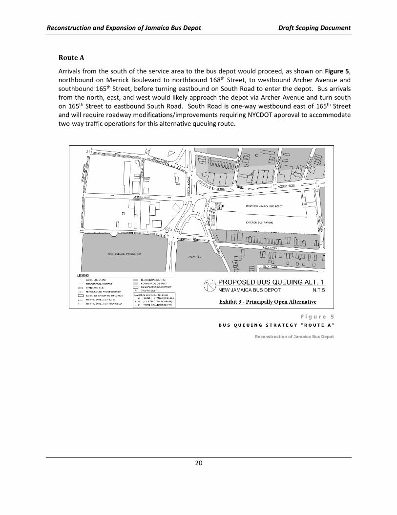
Route A ............................................................................................................................. 20
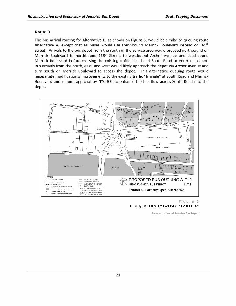
Route B .............................................................................................................................. 21
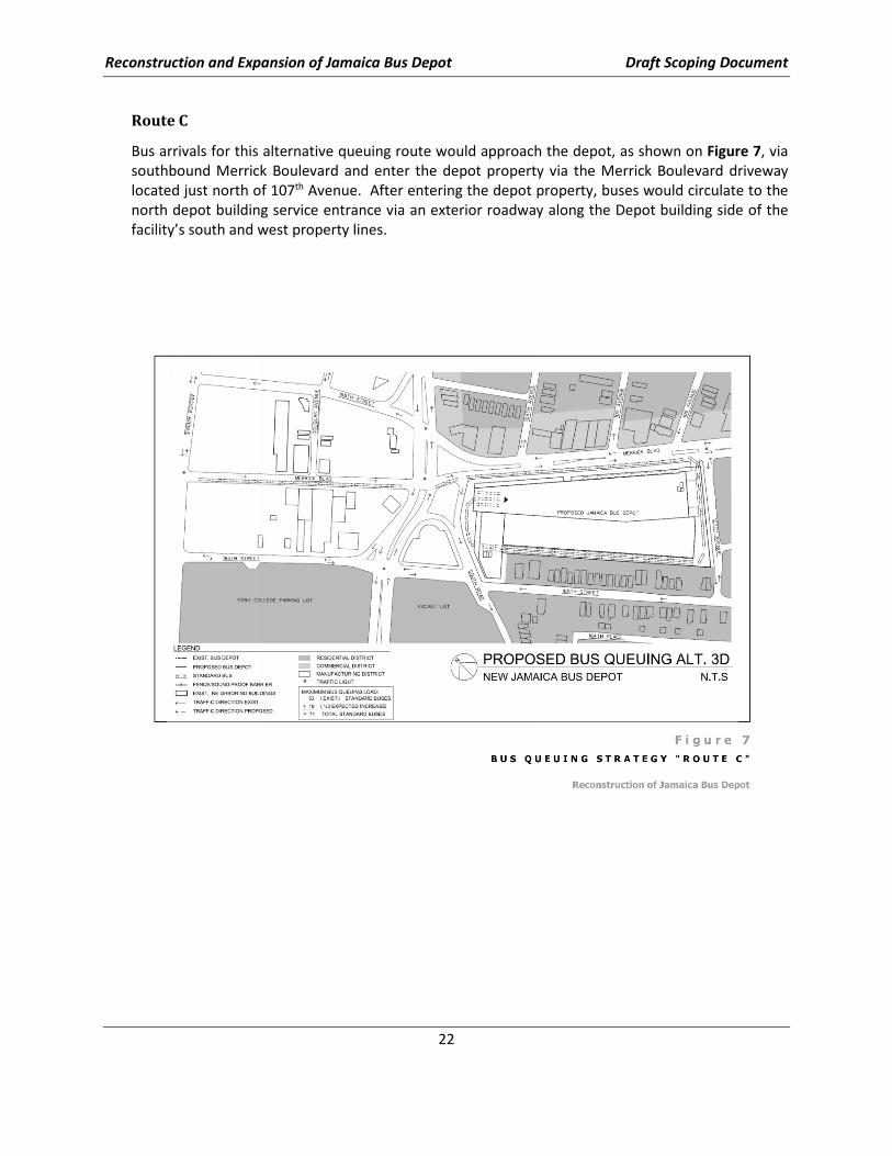
Route C .............................................................................................................................. 22
2. TEMPORARY BUS STORAGE (CONSTRUCTION PERIOD) .................................................................. 23
3. MANAGEMENT OF HISTORIC ON-SITE OIL SPILL ............................................................................. 24
F. POTENTIAL SIGNIFICANT ADVERSE EFFECTS/IMPACTS OF THE PROJECT ........................................... 26
G. METHODOLOGIES FOR PREPARING THE DRAFT ENVIRONMENTAL IMPACT STATEMENT ................. 26
Discussion of Project Description ......................................................................................................... 27
Discussion of Alternatives Analysis ...................................................................................................... 27
Discussion/Evaluation of Traffic, Parking, Transit and Pedestrians ..................................................... 27
Traffic Operations ............................................................................................................. 27
Discussion/Evaluation of Socioeconomic Conditions, Community Disruption, Displacement and
Relocation ............................................................................................................................................. 33
Reconstruction and Expansion of Jamaica Bus Depot Draft Scoping Document
ii
Discussion/Evaluation of Land Use, Zoning, and Public Policy ............................................................. 36
Discussion/Evaluation of Open Space/Parkland and Recreational Facilities ....................................... 38
Discussion/Evaluation of Community Facilities and Services............................................................... 38
Discussion/Evaluation of Community Character/Urban Design and Visual Resources ....................... 38
Discussion/Evaluation for Historic and Cultural Resources ................................................................. 39
Discussion/Evaluation of Air Quality .................................................................................................... 41
Operational Impacts ......................................................................................................... 41
Discussion/Evaluation of Noise and Vibration ..................................................................................... 42
Mobile Source Noise & Vibration (Construction & Operations) ....................................... 42
Stationary Source Noise & Vibration ................................................................................ 43
Cumulative Impacts .......................................................................................................... 45
Mitigation Measures ......................................................................................................... 45
Discussion/Evaluation of Infrastructure, Energy and Solid Waste ....................................................... 45
Discussion/Evaluation of Natural Resources ........................................................................................ 45
Discussion/Evaluation of Contaminated and Hazardous Materials and Waste Management ............ 46
Discussion/Evaluation of Coastal Zone Consistency ............................................................................ 46
Discussion/Evaluation of Safety and Security ...................................................................................... 47
Discussion/Evaluation of Environmental Justice .................................................................................. 47
Discussion/Evaluation of Cumulative Effects ....................................................................................... 48
Discussion/Evaluation of Mitigation..................................................................................................... 48
Discussion/Evaluation of Other Study Categories ................................................................................ 48
Section 4(f) ........................................................................................................................ 48
Air Quality Permit ............................................................................................................. 49
Climate Change/Resiliency ............................................................................................... 49
Geology & Soils ................................................................................................................. 50
Construction Impacts ........................................................................................................ 50
Unavoidable Adverse Impacts .......................................................................................... 50
Growth-Inducing Aspects of the Proposed Action ........................................................... 50
Irreversible and Irretrievable Commitments of Resources .............................................. 50
H. PUBLIC AND AGENCY INVOLVEMENT ................................................................................................. 50
I. PROTOCOL FOR PARTICIPATION IN PUBLIC SCOPING MEETING ........................................................ 51
Appendix A: Alternative Sites Investigation
Appendix B: Identification, Description, and Comparative Evaluation of Alternative Depot Concepts
Appendix C: SEQRA Environmental Assessment Form
Appendix D: Positive Declaration

Reconstruction and Expansion of Jamaica Bus Depot Draft Scoping Document
iii
LIST OF FIGURES
FIGURE 1: PROJECT LOCATION AND STUDY AREA ......................................................................................... 3
FIGURE 2A: ALTERNATIVE A (“PRINCIPALLY OPEN”) – PLAN ........................................................................... 9
FIGURE 2B: ALTERNATIVE A (“PRINCIPALLY OPEN”) – MASSING DIAGRAM ..................................................... 10
FIGURE 3A: ALTERNATIVE B (“PARTIALLY OPEN”) – PLAN............................................................................. 13
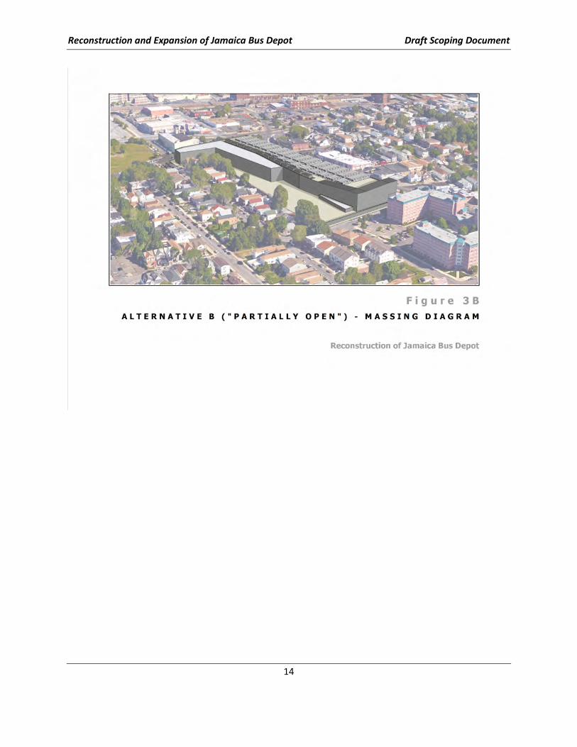
FIGURE 3B: ALTERNATIVE B (“PARTIALLY OPEN”) – MASSING DIAGRAM ........................................................ 14
FIGURE 4A: ALTERNATIVE D (“PRINCIPALLY ENCLOSED”) – PLAN ................................................................... 17
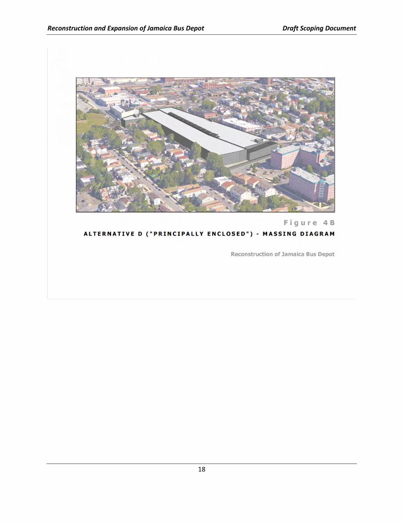
FIGURE 4B: ALTERNATIVE D (“PRINCIPALLY ENCLOSED”) – MASSING DIAGRAM ............................................... 18
FIGURE 5: BUS QUEUING STRATEGY “ROUTE A” ....................................................................................... 20
FIGURE 6: BUS QUEUING STRATEGY “ROUTE B” ....................................................................................... 21
FIGURE 7: BUS QUEUING STRATEGY “ROUTE C” ....................................................................................... 22
FIGURE 8: ESTIMATED HISTORIC EXTENT OF PRODUCT PLUME .................................................................... 25
FIGURE 9: TRAFFIC STUDY AREA (BUS FACILITY OPERATIONS) ..................................................................... 31
FIGURE 10: PARKING STUDY AREA ............................................................................................................ 32
FIGURE 11: SOCIOECONOMIC STUDY AREA ................................................................................................ 35
FIGURE 12: LAND USE STUDY AREA .......................................................................................................... 37
FIGURE 13: HISTORIC DISTRICTS ............................................................................................................... 40
FIGURE 14: NOISE ASSESSMENT LOCATIONS ............................................................................................... 44
Reconstruction and Expansion of Jamaica Bus Depot Draft Scoping Document
1
A. INTRODUCTION
The MTA NYCT (NYCT) Jamaica Bus Depot (JBD) was constructed in 1939 and continues to provide
operating/maintenance (O&M) services for up to 200 buses per day. However, the JBD does not reflect
current generation technology and requires improvement; and, the existing bus depot structure
requires extensive repair and upgrades in order to meet current bus operation demands. Further, bus
storage at the site is limited to only approximately 150 buses, thus necessitating parking of buses on the
streets in the neighborhood. Given this condition and the potential for up to 300 buses to require
servicing and parking in the near future, NYCT has proposed1 in its MTA Capital Program 2015-2019:
“…$298 million to reconstruct the Jamaica Bus Depot. The project will address
numerous functional deficiencies at the current depot…such as poor layout,
inadequate work areas, and insufficient capacity. The project will help NYCT to
reduce its reliance on outdoor street parking for buses, improving
neighborhood conditions for the nearby residents.”
This proposal reflects the culmination of years of NYCT attempts to address the existing site limitations.
These attempts have included:
• Investigating the potential purchase opportunities of eleven different properties in the region
that NYCT believed had the potential to serve as a replacement for the existing JBD (see
Appendix A). None of these opportunities materialized; thus, NYCT has concluded that
reconstruction at the existing JBD is the only viable approach to pursue.
• Purchasing properties adjacent to the existing JBD to provide development potential at the
existing site.
• Identifying and evaluating a variety of concept designs to maximize the potential to utilize the
existing site for current and future bus service/storage demands and to minimize capital costs of
construction.
• Synthesizing the best features of a variety of concept designs into Candidate Alternatives (see
Appendix B) characterized as:
o principally open parking
o partially open parking
o principally enclosed parking
Co-laterally, NYCT has initiated:
o efforts to secure temporary bus storage space to accommodate JBD buses while re-
construction at the site is underway;
o evaluation of alternative queuing routes to/from the reconstructed JBD; and,
o discussion with New York State Department of Environmental Conservation (NYSDEC) to
develop a remediation plan for the petroleum spill at the site that can proceed as an
integral part of the reconstruction and operation of the new JBD.
1 MTA Capital Program 2015-2019, as proposed to the MTA Board October 28, 2015.
Reconstruction and Expansion of Jamaica Bus Depot Draft Scoping Document
2
NYCT envisions the start of construction in 2018 utilizing the Design-Build approach so that construction
time and cost are minimized. NYCT will be performing a State Environmental Quality Review Act
(SEQRA) environmental impact analysis to determine the significance of the impacts and mitigation
measures to address any impacts, if significant. An Environmental Assessment Form (EAF) (see
Appendix C) was prepared for the project and determined that the project may have significant
effects/impacts on the environment. The Proposed action will be classified as an Unlisted Action under
SEQRA (6 NYCRR Part 217.4(9)) and is not included in statewide or individual agency lists of Type I or
Type II actions. A positive declaration has been issued (see Appendix D) and a draft and final
Environmental Impact Statement (DEIS/FEIS) will be prepared in accordance will all applicable state law
and regulations. As stated in SEQRA (6 NYCRR 617):
“The basic purpose of SEQRA is to incorporate the consideration of environmental
factors into the existing planning, review and decision-making processes of state,
regional and local government agencies at the earliest possible time. To accomplish
this goal, SEQR requires that all agencies determine whether the actions they
directly undertake, fund or approve may have a significant impact on the
environment, and, if it is determined that the action may have a significant adverse
impact, prepare or request an environmental impact statement.”
Although scoping is not required under SEQRA (see 6 NYCRR 617.8(a)), NYCT has chosen to implement
scoping and initiated the Public Scoping process with the publication of this Draft Scoping Document.
The Draft Scoping Document provides the public and agencies with an initial opportunity to comment on
the DEIS process, including the project’s purpose and need, alternatives considered, and the study
areas/methodologies to be used in the analyses. Public comments on the Draft Scoping Document are
invited during a public meeting to be held at Junior High School 8 (IS 8) Richard S. Grossley at 108-35
167th Street, Queens, NY 11433 on June 15, 2016 from 6-8 PM, and also in written form through July 8,
2016.
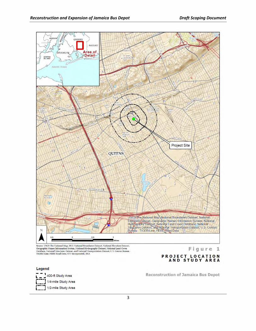
B. PROJECT BACKGROUND
The JBD is located at 165-18 South Road, Jamaica NY 11433 on Queens Block 10164 Lots 46, 80, 84, 97,
and 103 and can be accessed from Merrick Boulevard, 107th Avenue, and South Road (see Figure 1). The
depot has remained in operation since its construction in 1939 and, through the formation of Regional
Bus Operations (RBO), the JBD has operated as a critical component of the Queens Division depot
network. It is one of eight depots in Queens intended to provide storage and servicing of the Queens
Division bus fleet.
The JBD services the buses on nine local routes (Q3, Q4, Q5, Q17, Q30, Q42, Q77, Q84, and Q85); none
of these local routes is a “local limited-stop” route. (The “Q” designation refers to the primary borough
served by that particular route.) The Q5 and the Q85 both have stops in Nassau County, at the Green
Reconstruction and Expansion of Jamaica Bus Depot Draft Scoping Document
3
Reconstruction and Expansion of Jamaica Bus Depot Draft Scoping Document
4
Acres Mall in Valley Stream. While providing local service, the Q4, Q5, Q17, and Q85 are also MTA
Regional Bus Routes. The JBD currently serves no articulated local route or select bus service route (or
“express service” route, as such routes typically connect Midtown Manhattan or Lower Manhattan with
outer-borough areas lacking rail or subway service).
The Jamaica Bus Depot was constructed in 1939 and was expanded eastwardly to add a bus wash area
and provide additional storage area in 1950. In 1968, Transportation Offices and locker rooms were
constructed on the north side of the facility on an upper mezzanine level. Neither the original 1939
Jamaica Depot nor the 1968 Transportation locker room construction project envisioned the need to
accommodate the large and growing number of operating employees working at this depot.
As a result of changing service demands and operational needs, the existing depot facility presents
several critical functional deficiencies. These deficiencies have arisen as the demand for services have
increased, necessitating a larger fleet, and as opportunities for improved bus stock have allowed MTA to
invest in newer buses. Modern buses include larger buses than those for which the 1939 depot was
designed. Modern buses also are designed to operate differently – such as relying upon clean diesel and
hybrid-electric buses. As a result, the service needs and the configuration of work space within a depot
have evolved.
The JBD fleet size is currently 196 buses, and the facility provides storage for only 150 buses;
consequently, after being serviced, nearly 50 buses must park off NYCT property to be stored overnight
(parked) on surrounding streets, where they are then “started-up” each morning. Moreover, as the JBD
was constructed in 1939, it is not appropriately configured to provide the most efficient servicing of the
current types of buses and, specifically, cannot service articulated buses, thereby limiting the service
that can be provided for the bus routes it supports. The JBD’s transportation and maintenance
employee amenities are also in poor condition and in need of renovation; and, the depot does not meet
the United Bus Depot Design Guidelines and current code standards, such as Americans with Disabilities
Act of 1990 (ADA) Accessibility Guidelines (ADAAG). The current depot cannot be expected to serve the
forecast number of buses necessary to provide the density of bus service in this section of the City, nor
could it handle new demands resulting from service changes that are not part of current forecasts (i.e.,
resulting from changes in depot/route assignment reconfigurations). As part of the broader network of
Queens depots, the existing JBD also cannot provide emergency bus storage during exceptional
circumstances (such as severe storm events), which has proven to be of particular importance since
Superstorm Sandy.
Reconstruction and Expansion of Jamaica Bus Depot Draft Scoping Document
5
Interim Measures
In order to provide some additional on-site bus storage at the depot, to the extent possible, while
waiting for reconstruction to start, NYCT has acquired Lots 41, 53, 60, 61, 63, 66, 68, and 72 on Block
10164, which abut the existing facility. These properties will be able to store approximately 50
additional buses. It is expected that such storage will become available during 2017.
C. PROJECT PURPOSE, NEED, AND DESCRIPTION
Purpose and Need
The purpose of the project is to develop a reconstructed Jamaica Bus Depot (JBD) that:
• Can manage the operation/maintenance and on-site bus storage of up to 300 Standard Bus
Equivalents (SBEs) to: serve the projected bus assignments at this depot; allow additional
capacity due to the density of bus service in this section of the city and the long range outlook
for new service demands; and, to accommodate potential route/depot assignment
reconfigurations.
• Demonstrates the maximum potential from among the Candidate Alternatives, to minimize
adverse effects/impacts based on integrated consideration of engineering, economic and
environmental factors; and,
• Initiates construction in 2018, completes construction in 2022 and provides the opportunity for
some degree of beneficial use of the facility to the extent feasible at the earliest time.
The need for the project results from:
• The antiquated O&M technology at the existing JBD that has to be upgraded to provide
appropriate operation and maintenance services for more than the current limit of
approximately 200 buses per day;
• The limited bus storage space at the existing JBD which can only accommodate 150 buses, thus
requiring NYCT routinely to park up to 50 buses on the neighborhood streets, and, adversely
affecting the community;
• The long term inability of NYCT to secure a new property(ies) in the region to manage the
current and estimated future bus demand capacity; and,
• The opportunity provided by the MTA 2015-2019 Capital Program to commence this project.
Proposed Action
NYCT proposes to:
• Select a Preferred Alternative from among three (3) Candidate Alternative site design concepts
that have been developed as a result of extensive engineering and economic planning within
NYCT (see Appendix B) through the SEQRA process
• Allow award of a Design-Build contract in 2018 that would result in the operation of the
reconstructed JBD in the year 2022
• Select, with input from NYCDOT, a preferred queuing route for the buses from among three (3)
Candidate Alternative Routes developed by NYCT and described herein
Reconstruction and Expansion of Jamaica Bus Depot Draft Scoping Document
6
• Identify a preferred location(s) for the temporary storage of buses during the depot re-
construction period
• Develop a petroleum spill remediation plan for Spill No. 9010039 that exists at the site, which
plan will be implemented coincident with JBD construction and operation and be consistent
with NYSDEC Consent Order requirements
Upon the close of the SEQRA process and acceptance of its “Findings” by the MTA Board, NYCT will
reconstruct and operate the reconstructed JBD.
Proposed Project Requirements and Goals
The Preferred JBD Alternative site design would accommodate articulated buses and would also meet
the following key design criteria, which are fundamental to ensuring that the proposed, reconstructed
depot design meets the overall project purpose and need:
• parking for 300 standard bus equivalents (SBEs),
• 15 maintenance bays,
• 1 chassis wash station,
• 3 fueling lanes,
• 3 bus wash lanes, and
• 2 interior wash stations
• administrative spaces for Maintenance and Transportation divisions
• adequate storage spaces for equipment
The Preferred Alternative site design would also represent that alternative which, from among the
Candidate Alternatives, demonstrates the greatest potential to minimize, based on integrated
consideration, engineering, economic and environmental effects/impacts from among the Candidate
Alternatives.
The preferred bus queuing route, spill remediation plan and temporary (during construction) bus
storage location(s) plan will also represent the greatest potential to minimize, based on integrated
considerations, engineering, economic, and environmental effects/impact.
Construction is anticipated to begin in 2018 and complete in 2022. As indicated in the detailed
descriptions of the proposed depot Candidate Alternatives in Section D, construction duration would
vary among the alternatives.
D. DEPOT CANDIDATE ALTERNATIVES
Once NYCT determined that it could not secure a new depot location in the region and that
reconstruction at the current site was its only recourse, NYCT undertook a rigorous evaluation process
to identify and evaluate various depot design concepts. This evaluation, “Identification, Description, and
Comparative Analysis of Alternative Design Concepts,” is presented in Appendix B.
NYCT identified and critically evaluated over fifteen service (e.g. bus washing, maintenance, fueling)
sequencing opportunities and resulted with seven (7) Potential Alternatives based on available
conceptual design information. The seven (7) final alternatives provide the best required bus depot
configuration. These preferred alternatives were further evaluated and the three alternatives that were
Reconstruction and Expansion of Jamaica Bus Depot Draft Scoping Document
7
selected in that process for further evaluation in the EIS were assigned names that represent their
distinguishing environmental aspects, and are as follows:
• ALTERNATIVE A is referenced herein as PRINCIPALLY OPEN PARKING (most bus parking would
be outdoors in unenclosed space);
• ALTERNATIVE B is referenced herein as the PARTIALLY OPEN PARKING (some bus parking would
be provided outdoors in unenclosed space, with the remainder provided indoors, within
enclosed and climate-controlled space);
• ALTERNATIVE D is referenced herein as PRINCIPALLY ENCLOSED PARKING (most bus parking
would be provided indoors, within enclosed and climate-controlled space).
The Candidate Alternatives allow for a reasonable range of conceptual depot design alternatives to be
considered for comparative engineering, economic, and environmental evaluation in the DEIS.
Specifically, a range of bus storage capacity, costs, and potential environmental effects (preliminarily
represented by the extent of indoor/outdoor bus parking) are captured by these Candidate Alternatives,
which are described below in narrative and graphic form.
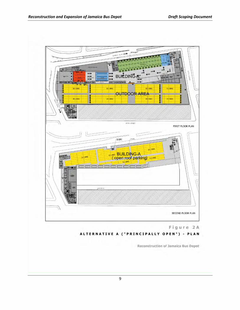
1. CANDIDATE ALTERNATIVE A – PRINCIPALLY OPEN PARKING
This Candidate Alternative would meet the following design criteria:
Depot Building
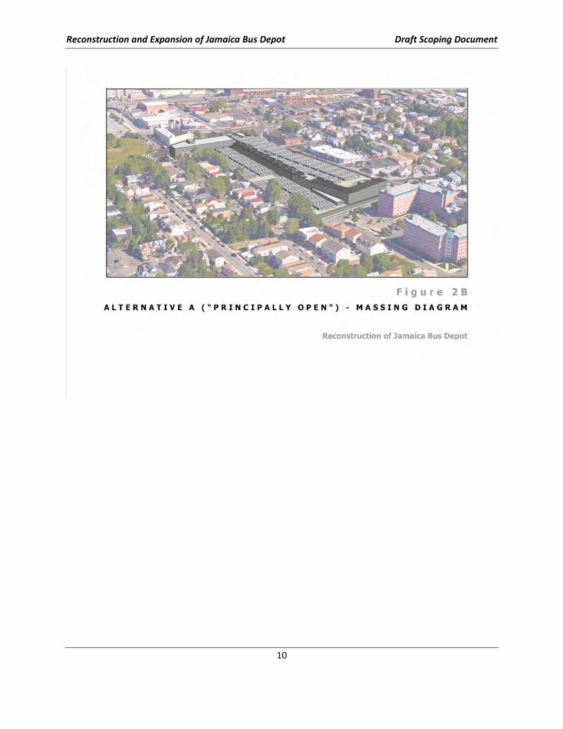
Candidate Alternative A would be a new one-story depot building positioned along Merrick
Boulevard, and extend southward from South Road to 107th Avenue (see Figures 2A and 2B2).
• It would provide approximately 125,000 square feet (sf) on the first floor. About 7,600 sf of
administrative space would be provided on the first and second levels and 19,700 sf on the
third level, near South Road.
• The roof level height would be about 25 feet above the ground floor. A ramp at the south
end of the depot building would connect the ground floor to the rooftop parking level.
• Alternative A provides three fueling lanes, three bus wash lanes, two interior bus wash
stations, one chassis wash station, and 15 maintenance bays.
Parking
Candidate Alternative A would provide a total of 305 SBE parking spaces:
• 18 spaces would be indoors on the first level,
• 170 would be outdoors on the west side of the property, and
• 117 spaces would be outdoors, on the unenclosed roof level.
Thus, it would meet the bus capacity target of 300 SBE.
2 Plans and massing diagrams are presented for diagrammatic purposes only.
Reconstruction and Expansion of Jamaica Bus Depot Draft Scoping Document
8
Bus Circulation
Buses would enter the depot from South Road and first refuel within the fueling lanes and perform
revenue extraction, then proceed to the bus wash area, followed by either the maintenance or
parking areas. The proposed bus depot has several bus exits. On the east side of the building, a
driveway approximately midblock between South Road and 107th Avenue provides a bus exit onto
Merrick Boulevard. Buses may also exit at the west side of the building to the outdoor parking area.
Buses exit the outdoor parking area at South Road, located at the north end of the site, and at 107th
Avenue, which is an emergency exit located at the south end of the site. Alternative A would also
have an entrance driveway from Merrick Boulevard just north of 107th Avenue.
Construction
Operations within the existing depot building would not be interrupted during the 42-month
construction period. The one-story structure would have minimal construction conflicts with the
existing depot building and require modest construction phasing.
Costs
Construction costs are estimated to be approximately $298,000,000, while annual energy costs are
estimated to be $1,100,000.
Reconstruction and Expansion of Jamaica Bus Depot Draft Scoping Document
9
Reconstruction and Expansion of Jamaica Bus Depot Draft Scoping Document
10
Reconstruction and Expansion of Jamaica Bus Depot Draft Scoping Document
11
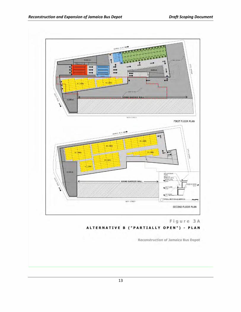
2. CANDIDATE ALTERNATIVE B – PARTIALLY OPEN PARKING
This Candidate Alternative would meet the following design criteria:
Depot Building
Candidate Alternative B would include (see Figures 3A and 3B).
• One building that would provide approximately 161,000 sf of depot space for maintenance
and bus parking on the first level. The second floor would provide 160,000 sf of indoor
parking and the rooftop would provide 82,000 sf of outdoor parking.
• An administrative building at the northwest corner of the property would provide about
11,000 sf of administrative space on the first and second levels and 22,000 sf on the third
level.
• The roof level height would be about 45 feet above the ground floor. A ramp at the south
end of the depot building would connect the ground floor to the second level and rooftop
parking.
• Candidate Alternative B provides three fueling lanes, three bus wash lanes, two interior bus
wash stations, one chassis wash station, and 15 maintenance bays.
Parking
Candidate Alternative B would provide a total of 320 SBE parking spaces:
• 64 indoor spaces on the first floor,
• 148 indoor spaces on the second floor, and
• 108 outdoor spaces on the roof.
Thus, Candidate Alternative B would meet the bus capacity of 300 SBEs and would also provide
significant supplementary emergency bus parking capacity on the depot grounds.
Bus Circulation
Buses would enter the depot from South Road and first refuel within the fueling lanes and perform
revenue extraction, then proceed to the bus wash area, followed by either the maintenance or
parking areas. The proposed bus depot has several bus exits. On the east side of the building is a
driveway approximately midblock between South Road and 107th Avenue that provides a bus exit
onto Merrick Boulevard. Buses may also exit the depot at the north end onto South Road. Buses
may exit the outdoor parking area at 107th Avenue via an emergency exit located at the south end of
site. A ramp to the second level and rooftop parking areas is provided at the southwest end of the
building.
Construction
Operations within the existing depot building would not be interrupted during construction. Given
the slightly larger building footprint as compared to Candidate Alternative A and that construction
would be undertaken in the space occupied by the existing bus depot building, the construction
duration for Alternative B would be expected to be approximately 46 months.

Reconstruction and Expansion of Jamaica Bus Depot Draft Scoping Document
12
Costs
Construction costs are estimated to be approximately $415,000,000, while annual energy costs are
estimated to be $1,500,000.
Reconstruction and Expansion of Jamaica Bus Depot Draft Scoping Document
13
Reconstruction and Expansion of Jamaica Bus Depot Draft Scoping Document
14
Reconstruction and Expansion of Jamaica Bus Depot Draft Scoping Document
15
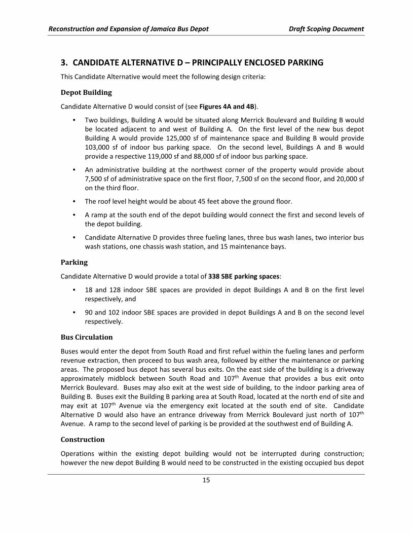
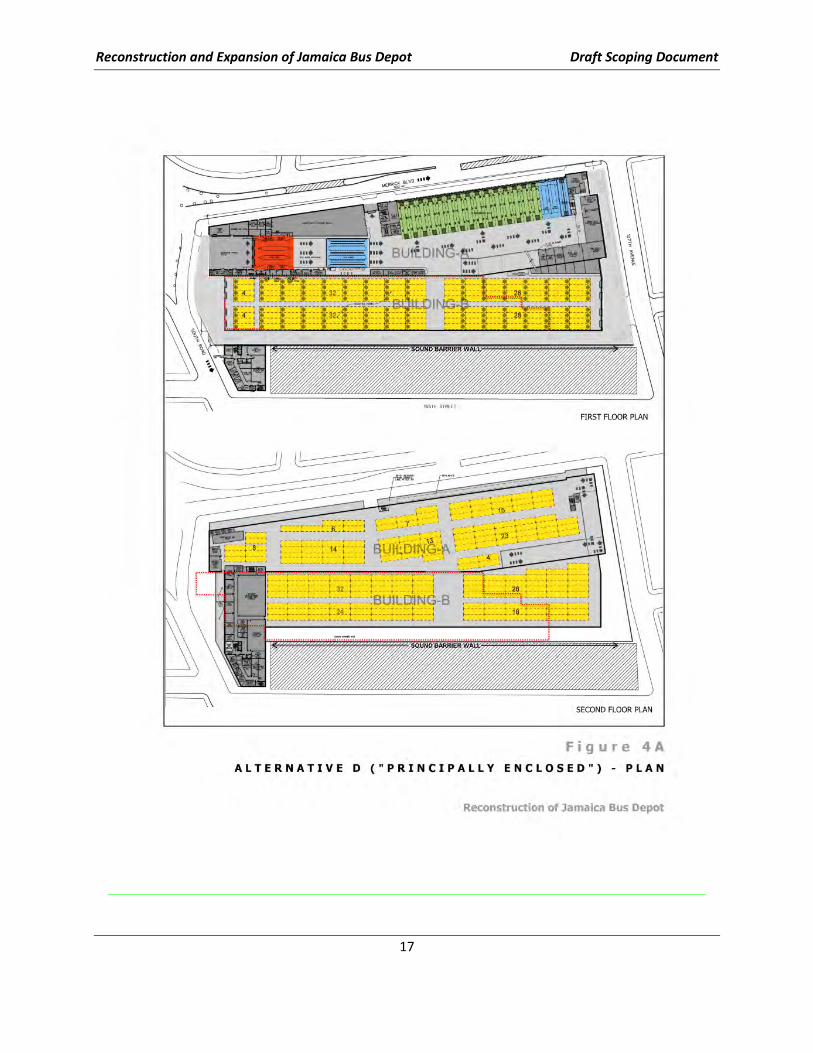
3. CANDIDATE ALTERNATIVE D – PRINCIPALLY ENCLOSED PARKING
This Candidate Alternative would meet the following design criteria:
Depot Building
Candidate Alternative D would consist of (see Figures 4A and 4B).
• Two buildings, Building A would be situated along Merrick Boulevard and Building B would
be located adjacent to and west of Building A. On the first level of the new bus depot
Building A would provide 125,000 sf of maintenance space and Building B would provide
103,000 sf of indoor bus parking space. On the second level, Buildings A and B would
provide a respective 119,000 sf and 88,000 sf of indoor bus parking space.
• An administrative building at the northwest corner of the property would provide about
7,500 sf of administrative space on the first floor, 7,500 sf on the second floor, and 20,000 sf
on the third floor.
• The roof level height would be about 45 feet above the ground floor.
• A ramp at the south end of the depot building would connect the first and second levels of
the depot building.
• Candidate Alternative D provides three fueling lanes, three bus wash lanes, two interior bus
wash stations, one chassis wash station, and 15 maintenance bays.
Parking
Candidate Alternative D would provide a total of 338 SBE parking spaces:
• 18 and 128 indoor SBE spaces are provided in depot Buildings A and B on the first level
respectively, and
• 90 and 102 indoor SBE spaces are provided in depot Buildings A and B on the second level
respectively.
Bus Circulation
Buses would enter the depot from South Road and first refuel within the fueling lanes and perform
revenue extraction, then proceed to bus wash area, followed by either the maintenance or parking
areas. The proposed bus depot has several bus exits. On the east side of the building is a driveway
approximately midblock between South Road and 107th Avenue that provides a bus exit onto
Merrick Boulevard. Buses may also exit at the west side of building, to the indoor parking area of
Building B. Buses exit the Building B parking area at South Road, located at the north end of site and
may exit at 107th Avenue via the emergency exit located at the south end of site. Candidate
Alternative D would also have an entrance driveway from Merrick Boulevard just north of 107th
Avenue. A ramp to the second level of parking is be provided at the southwest end of Building A.
Construction
Operations within the existing depot building would not be interrupted during construction;
however the new depot Building B would need to be constructed in the existing occupied bus depot

Reconstruction and Expansion of Jamaica Bus Depot Draft Scoping Document
16
and would require intricate construction phasing. Construction duration would be approximately 48
months.
Costs
Construction costs are estimated to be approximately $456,000,000, while annual energy costs are
estimated to be $1,900,000.
Reconstruction and Expansion of Jamaica Bus Depot Draft Scoping Document
17
Reconstruction and Expansion of Jamaica Bus Depot Draft Scoping Document
18
Reconstruction and Expansion of Jamaica Bus Depot Draft Scoping Document
19
E. ADDITIONAL PROJECT COMPONENTS AND CONSIDERATIONS
1. BUS QUEUING STRATEGIES (OPERATIONS)
In addition to the three Candidate Alternative Depot Design Concepts, three Candidate Alternative
Bus Queuing Strategies will be evaluated in the EIS. As currently envisioned, any of the three bus
queuing strategies could serve any of the three depot Candidate Alternatives. Each of the three
Candidate Alternative Depot Design Concepts would have bus arrivals at the northeast side of the
depot (on South Road, near Merrick Boulevard), thus, operations of the proposed depot would not
in any case depend on the selection of a particular queuing strategy, nor would the depot
operations differ in accordance with the different queuing strategies.
Queuing strategies will be examined in the EIS as a discrete type of project component. However, as
is described in Section G, “Methodologies for Preparing the Draft Environmental Impact Statement,”
of this draft Scoping Document, the Discussion/Evaluation of Cumulative Effects will consider the
combined effects of all project components for each alternative. Thus, to the extent that the
potential effects associated with queuing strategies differ among the three analyzed, the differences
would be, for each case, associated with the alternative as cumulative effect, as one part of the
cumulative effects assessment.
The three alternative bus queuing strategies, are referenced herein as “Route A,” “Route B,” and
“Route C,” and are described following:
Reconstruction and Expansion of Jamaica Bus Depot Draft Scoping Document
20
Route A
Arrivals from the south of the service area to the bus depot would proceed, as shown on Figure 5,
northbound on Merrick Boulevard to northbound 168th Street, to westbound Archer Avenue and
southbound 165th Street, before turning eastbound on South Road to enter the depot. Bus arrivals
from the north, east, and west would likely approach the depot via Archer Avenue and turn south
on 165th Street to eastbound South Road. South Road is one-way westbound east of 165th Street
and will require roadway modifications/improvements requiring NYCDOT approval to accommodate
two-way traffic operations for this alternative queuing route.
Reconstruction and Expansion of Jamaica Bus Depot Draft Scoping Document
21
Route B
The bus arrival routing for Alternative B, as shown on Figure 6, would be similar to queuing route
Alternative A, except that all buses would use southbound Merrick Boulevard instead of 165th
Street. Arrivals to the bus depot from the south of the service area would proceed northbound on
Merrick Boulevard to northbound 168th Street, to westbound Archer Avenue and southbound
Merrick Boulevard before crossing the existing traffic island and South Road to enter the depot.
Bus arrivals from the north, east, and west would likely approach the depot via Archer Avenue and
turn south on Merrick Boulevard to access the depot. This alternative queuing route would
necessitate modifications/improvements to the existing traffic “triangle” at South Road and Merrick
Boulevard and require approval by NYCDOT to enhance the bus flow across South Road into the
depot.
Reconstruction and Expansion of Jamaica Bus Depot Draft Scoping Document
22
Route C
Bus arrivals for this alternative queuing route would approach the depot, as shown on Figure 7, via
southbound Merrick Boulevard and enter the depot property via the Merrick Boulevard driveway
located just north of 107th Avenue. After entering the depot property, buses would circulate to the
north depot building service entrance via an exterior roadway along the Depot building side of the
facility’s south and west property lines.

Reconstruction and Expansion of Jamaica Bus Depot Draft Scoping Document
23
2. TEMPORARY BUS STORAGE (CONSTRUCTION PERIOD)
The three depot Candidate Alternatives have been conceived, and their respective construction
staging planned, so that the existing depot facility would remain operational (i.e., capable of
servicing buses) throughout the construction period. Although it may be possible to store some
buses on the project site during less intensive periods of construction, there remains the need to
store approximately 170 buses off-site throughout the duration of construction for the three
Candidate Alternatives. Thus, a critical component of the proposed action is the need to rely on off-
site (off-street) bus storage throughout the construction period and, therefore, a temporary bus
location(s) must be identified in advance of beginning construction. Further, because the
construction period would be expected to last approximately four years and the temporary bus
storage would require moving buses between the depot and the off-site parking locations(s), the
related impacts/effects of travel and use of the off-site locations site will also be analyzed in the EIS.
NYCT has determined that the off-site bus storage must be sited within an approximate five-mile
radius of the JBD. This radius is defined according to the need to provide timely maneuvering of
buses between the depot and the temporary bus storage location(s), thus minimizing the logistical
and economic complications of bus “deadheading” and employee movement and without
compromising routine bus services.
NYCT has retained outside consultants to identify and secure such property nearby. To date, NYCT
has not identified suitable candidate locations for temporary bus storage. If a suitable location is
identified during the preparation of the EIS, impacts related to the usage of the temporary location
will be address in the EIS. If a location has not been identified prior to the completion the EIS, NYCT
will supplement the EIS prior to the acquisition of the location.
Reconstruction and Expansion of Jamaica Bus Depot Draft Scoping Document
24
3. MANAGEMENT OF HISTORIC ON-SITE OIL SPILL
The property upon which the current depot properties resides is contaminated with petroleum that
resulted from a spill incident at the JBD (New York State Department of Environmental Conservation
Spill #9010039), and was initially reported to the NYSDEC in December of 1990. This spill “case”
remains “open” (i.e., the spill contamination has not been remediated) and includes subsequent
spills that have occurred at the site as well as a potential off-site source, located immediately north
of the JBD.
NYCT has conducted numerous investigations at the depot site, within the publicly accessible
roadbeds, and elsewhere in the vicinity to evaluate the extent of contaminated material in the sub-
surface and to identify possible in-situ remedial measures to address petroleum-impacted soil and
groundwater. NYCT has been operating a “pump-and-treat” remediation system at the JBD to
recover the combined heating oil and diesel fuel release since 1995. This work is being administered
under NYSDEC Global Consent Order CO2-20000101-3341 (May 2001), and includes monitoring of
groundwater quality.
Site investigations performed to date have delineated the majority of contamination within the
boundaries of the current and potential reconstructed JBD property. These investigations have also
identified three additional segments of contamination located to the west, north and east of the site
(see Figure 8).
If the proposed project were not to be advanced, the May 2001 NYSDEC Global Consent Order CO2-
20000101-3341 would remain applicable and in effect. A plan to address on site as well as off-site
contamination would be developed with the NYSDEC and integrated with the proposed
reconstruction work plan for the JBD should the proposed action advance.
At present, several opportunities exist for remediating the existing contamination on the project
site, and NYCT has initiated consultation with NYSDEC to develop a recommended remediation. It is
currently envisioned that different remediation methods may better suit different depot designs
and component areas of the spill.
For the purposes of this Scoping Document, an appropriate remediation strategy is presumed to be
determined for the three alternative depot designs under consideration. Therefore, the EIS
methodology applicable to the study of the potential presence of on-site contamination (Section G,
“Methodologies for Preparing the Draft Environmental Impact Statement,” of this Draft Scoping
Document, the Discussion/Evaluation of Contaminated and Hazardous Materials and Waste
Management) is believed appropriate.
It is also noted, with regard to NYSDEC consultation and associated public outreach (conducted
apart from this Public Scoping and Environmental Impact Statement Process), NYCT may advance an
alternative method of remediation to be effected in the situation that the proposed project were
not to be constructed (and associated remediation not implemented). Were this to be the case, the
Contaminated and Hazardous Materials and Waste Management component of the EIS would
address this new information as the condition in the future without the proposed action (and the
methodology described for the respective analysis in Section G of this Scoping Document would
remain applicable and sufficient).

Reconstruction and Expansion of Jamaica Bus Depot Draft Scoping Document
25
Reconstruction and Expansion of Jamaica Bus Depot Draft Scoping Document
26
F. POTENTIAL SIGNIFICANT ADVERSE EFFECTS/IMPACTS OF THE
PROJECT
The potential effects/impacts of the JBD reconstruction will be determined during the course of the
DEIS/EIS process consistent with the “Methodologies” identified in Section G. As of this writing, it is
believed that the potential for significant adverse effects/impacts of the project’s construction and
operation could include:
• Noise and vibration
• Air quality
• Traffic/parking/transit/pedestrian movements
• Community disruption
• Urban design/visual resources
• Contaminated/hazardous materials and waste management
• Safety/security
• Environmental justice
• Cumulative effects
G. METHODOLOGIES FOR PREPARING THE DRAFT ENVIRONMENTAL
IMPACT STATEMENT
The Draft Environmental Impact Statement (DEIS) will be prepared to assess the environmental
effects/impacts of the Candidate Alternatives. All of the technical areas described below will be
addressed. The analysis will focus on one peak construction year and one analysis year for the Build
Condition.
Future development in the project area will be identified in order to assess the cumulative
effects/impacts of the Proposed Action. This will include other anticipated public and private
developments, as well as background growth. This information will be used to compare the
effects/impacts for each of the DEIS technical areas of the Proposed Action in the peak Construction
Analysis Year and Build Year to conditions without the Proposed Action (“No-Action” alternative, e.g.
“No-Build” condition).
Basically, the DEIS will contain:
• A description of the Proposed Action and its environmental setting;
• A description of the No-Action alternative;
• An assessment of the short-term (construction-related) and long-term operation related
effects/impacts of the Proposed Action in the technical areas described in the following pages.
The analyses will include future known and reasonably anticipated developments.
• A discussion of reasonable alternatives to the Proposed Action, including the No-Action
Alternative (future conditions without implementation of the Proposed Action);
Reconstruction and Expansion of Jamaica Bus Depot Draft Scoping Document
27
• Identification of any potential significant adverse environmental impacts that could not be
avoided with the implementation of the Proposed Action;
• A description and evaluation of the measures proposed to mitigate any anticipated significant
adverse environmental impacts of the Proposed Action; and
• Identification of any irreversible and irretrievable commitments of resources that will be
involved in the Proposed Action, should it be implemented.
The DEIS will address the technical study topics identified in the following paragraphs and pages.
Discussion of Project Description
The DEIS will introduce the reader to the project and set the context for assessing impacts. In this
chapter, the Candidate Alternatives will be described in sufficient detail to provide the public and
decision-makers with a clear understanding of the full range of regulatory actions/processes required.
The project description will encompass:
• A description of the Proposed Action;
• A detailed description of each Candidate Alternative; and
• A description of the engineering process that resulted in the identification of the Candidate
Alternatives, as well as purpose and need for the action.
Discussion of Alternatives Analysis
The DEIS will provide a discussion of the alternative analysis and feasibility evaluation work that
preceded and continued during the preparation of the DEIS. Construction and operating level features
of each of the three Candidate Alternatives will be presented.
Discussion/Evaluation of Traffic, Parking, Transit and Pedestrians
Traffic Operations
There are several reasons why traffic movements for buses in the vicinity of the depot are difficult. First,
the irregular street configuration with major streets that meet at odd angles creates some very short
blocks and makes traffic operations and vehicle maneuvering problematic. Second, the current need for
on- and off-street parking for NYCT employees and out-of-service buses can result in added traffic
circulation in the area. Of course, the high volume of buses that begin and end their routes along
Merrick Boulevard adds to operational challenges. Finally, traffic circulation will intensify as the number
of buses using the depot is projected to increase.
Given these circumstances, the traffic study area will focus on intersections that must function as a
system for reasonable/acceptable traffic operations to prevail. The extent of potential traffic impacts
during construction will depend on project phasing, materials storage, and bus storage needs requiring
off-site space. Pedestrian and in-service bus transit conditions are not likely to be affected significantly
after the new depot is constructed and in operation. However, maintaining these services with possible
reduced-width sidewalks and relocated bus stops will require detailed analyses for Maintenance and
Protection of Traffic (“MPT”) planning and effects analysis.
Reconstruction and Expansion of Jamaica Bus Depot Draft Scoping Document
28
Baseline Conditions
NYCT will document existing traffic conditions and estimate future conditions for the No-Build
Alternative as a baseline against which the effects of each Build alternative can be measured. The key
elements of analyses include: determining the scope of the area within which traffic impacts could
potentially occur; analyzing key intersections within that area; and determining and analyzing the
time periods in which the impacts would likely be most severe.
The work program will be conducted using the methodologies outlined in the New York City
Environmental Quality Review (CEQR) Technical Manual, and begin with the identification of the
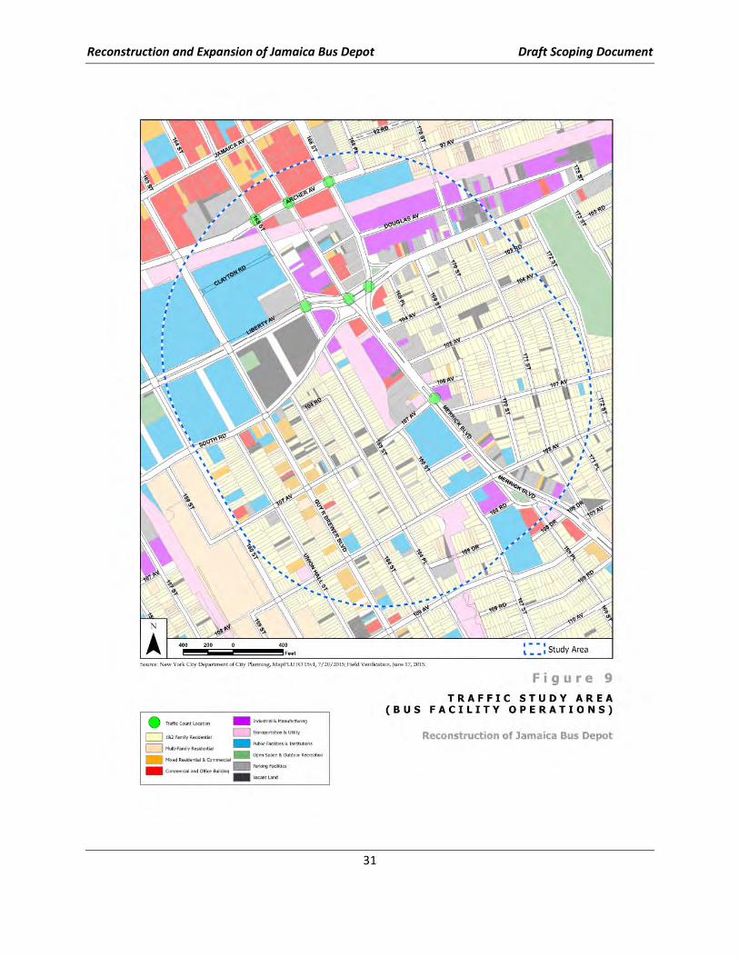
traffic/transportation study area. The study area for the Depot project would be the area
approximately bounded by Archer Avenue on the north, Merrick Boulevard/168th Street to the east,
107th Avenue to the south, and 165th Street to the west. Within the area, traffic volumes can be
diverted off affected streets and back to their original routes. Quantitative analyses will be required at
seven (7) intersections, including:
• Merrick Boulevard at 107th Avenue
• Merrick Boulevard at Liberty Avenue
• Liberty Avenue at 165th Street
• Liberty Avenue at 168th Street
• Archer Avenue at 165th Street
• Archer Avenue at 168th Street
• Archer Avenue at Merrick Boulevard
Data Collection & Analysis
NYCT will analyze morning and evening peak-hour existing, No-Build, and Build traffic conditions.
Vehicular analyses will be conducted using the methodologies outlined in the 2000 Highway Capacity
Manual (HCM2000), and levels of service will be reported. Traffic analyses will be evaluated against
CEQR Technical Manual criteria to determine if the proposed action will result in significant adverse
traffic impacts during the period of construction.
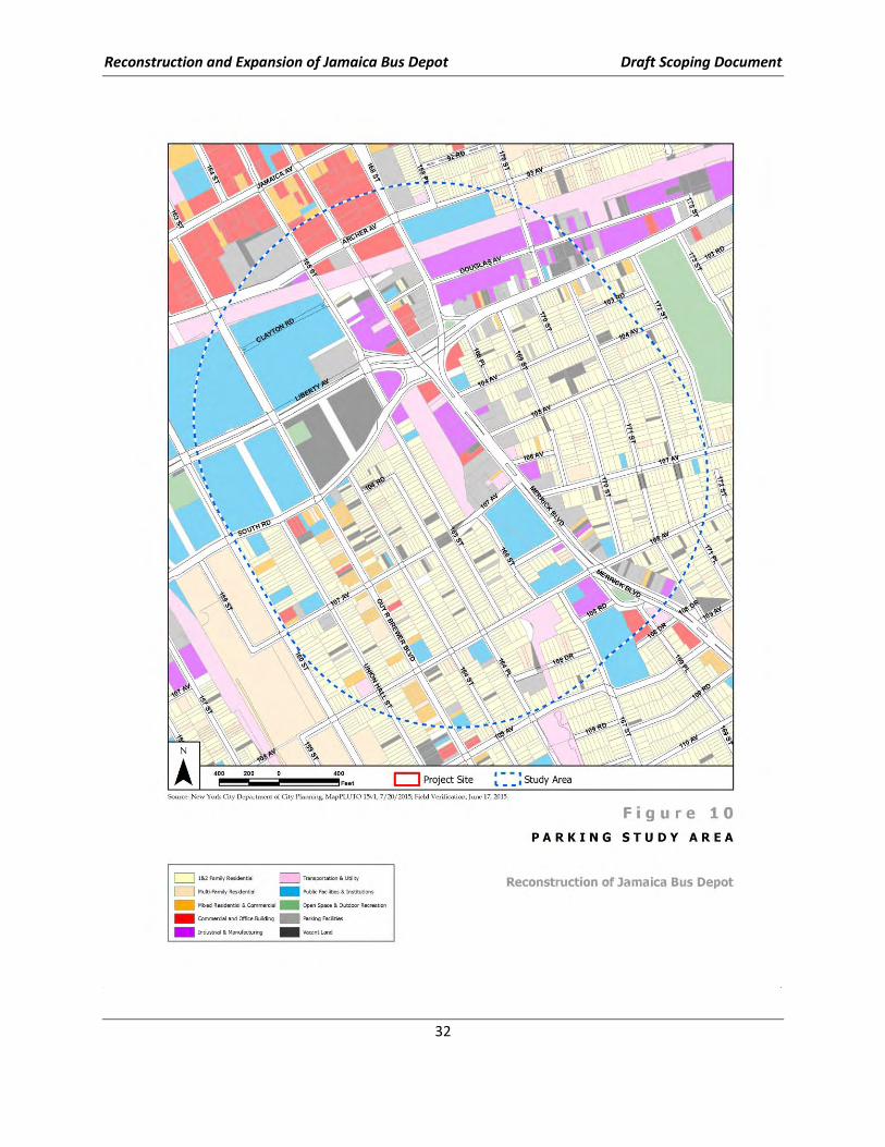
For the analysis of parking conditions, an estimate will be made of the number of on-street parking
spaces that could be eliminated by each of the three depot Candidate Alternatives. A quantitative
analysis of the area within ¼-mile (a typical walkable radius emanating from the depot site block) of
each Candidate Alternative will be then be conducted to determine the impact of parking conditions in
the area. These displaced on-street vehicles will be assumed to park on-street elsewhere, thus adding to
the overall new on-street parking demand.
The following describes the subtasks for traffic and parking data collection. NYCT will:
• Collect 24-hour automatic traffic recorder (ATR) count data in the project study area for a nine-
day period (includes two weekends), summarized in 15-minute intervals, and used to identify
the temporal distribution of traffic in the vicinity of the possible alternatives. ATR counts are to
be conducted at the following locations:
o Merrick Boulevard between Liberty Avenue and 107th Avenue
Reconstruction and Expansion of Jamaica Bus Depot Draft Scoping Document
29
o Liberty Avenue between Guy R. Brewer Boulevard and 165th Street
• Collect turning movement and sample vehicle classification count data at intersections selected
for detailed analyses, simultaneous with ATR counts, on one representative midweek day (either
Tuesday, Wednesday, or Thursday) during the AM and PM peak periods when bus activity is
most intense (see Figure 9). (To support air and noise quality analyses, travel speed-and-delay
runs are to be conducted along Liberty Avenue and Merrick Boulevard coincident with the basic
traffic count program.)
• Collect parking data during the morning and afternoon peak periods when restrictions are and
are not in effect. Inventory of the supply and peak/off-peak utilization of all off- and on-street
parking locations within ¼-mile (a typical walkable radius) of the depot, but confined to the
area, north to south between Archer Avenue and 109th Avenue, and 171st and 160th streets east
to west (see Figure 10).
• Inventory physical conditions of the street network, including lane, roadway, crosswalk, and
sidewalk widths, traffic controls, traffic signal timings and phasings, turning movement
restrictions, posted parking restrictions, traffic flow conditions (e.g., effective roadway widths),
and parking conditions (e.g., use of curb parking).
• Request on-record traffic signal timing information from NYCDOT.
• Determine existing traffic volumes in the study area during the morning and evening peak
hours.
• Determine future traffic volumes during the morning and evening peak hours as a result of
background traffic growth and other proposed projects, if any, in the study area (No-Build
conditions). Planned roadway improvements that would affect a change in traffic operations in
the study area (e.g., intersection widening, a new traffic signal) will be obtained from NYCDOT
and the NYC Department of City Planning (NYCDCP) and incorporated into the development of
the No-Build traffic volumes.
Assessment of Traffic Impacts
The future traffic and parking conditions will be quantitatively assessed to determine the potential
impacts for the depot reconstruction and planned number of buses upon opening and during
construction. For inaugural day conditions, NYCT will perform the following:
• Document the volume of employees and buses to be generated by the depot expansion during
the weekday peak analysis hours. Analyses will focus on what constitutes a reasonable worst-
case condition for that 2022 opening Build year, in terms of how many additional buses above
the number currently using the Depot will be included as the incremental bus trip overlay.
• Determine the percentage of NYCT employees traveling to and from the depot by car and other
modes. This information will be obtained via sample surveys to be performed by NYCT bus
depot staff, on-record quantitative information, if available, or other similar bus depot studies.
• Determine the major travel routes expected to be used by employee vehicular traffic en route to
and from the depot, and assign project-generated traffic to these routes and through the
various intersections being analyzed. These assignments will be determined through on-record
employee home zip codes or prevailing traffic patterns.
Reconstruction and Expansion of Jamaica Bus Depot Draft Scoping Document
30
• Determine future Build traffic volumes based on the aggregate assignment of employee trips
and added bus route trips to/from the depot to the street network, and calculate levels of
service with the depot expansion completed. Based on a comparison of future No-Build and
Build conditions, analyses will determine, for the weekday morning and evening peak hours,
whether changes in expected traffic conditions would be significant enough to require
mitigation.
• For the construction condition analysis, determine the volumes of traffic expected to be
diverted off streets affected by each project Candidate Alternative, the likely alternate
queuing routes they would be reasonably expected to use, and their impacts on study area
intersections. NYCT will analyze the worst-case construction phase.
Mitigation Measures
NYCT will develop and evaluate improvements needed to mitigate any significant impacts to traffic and
parking. It is anticipated that traffic mitigation measures may be low-cost, easily implemented solutions,
such as signal timing changes.
If analysis determines that there would be a significant impact to available street parking associated
with the depot reconstruction, this would require mitigation, such as changes to on-street parking
restrictions.
MPT during Construction
NYCT will develop conceptual Maintenance and Protection of Traffic (MPT) schemes and drawings for
each Candidate Alternative based on the traffic analysis of construction conditions. MPT plans will follow
NYCDOT requirements and will be coordinated with respective agencies. Base plans for the MPT
drawings will be developed from available resources, including NYCDOT right-of-way plans and GIS
mapping.
NYCT will determine diversion traffic routes and volumes for each of the three depot reconstruction
Candidate Alternatives during the morning and evening peak hours. Physical changes to the roadway
network due to the proposed project will be reflected in the Build volumes.
Reconstruction and Expansion of Jamaica Bus Depot Draft Scoping Document
31
Reconstruction and Expansion of Jamaica Bus Depot Draft Scoping Document
32
Reconstruction and Expansion of Jamaica Bus Depot Draft Scoping Document
33
Transit and Pedestrians
NYCT will conduct a transit and pedestrian analysis of the study area addressing the potential for
significant impacts for both the Build condition and the Construction condition. According to
CEQR/NYCDOT guidelines, if a proposed action (i.e., the Build condition) generates fewer than 200 new
transit trips during peak hours, it does not have the potential to generate significant impacts on the
area’s transit network. Similarly, if a proposed action does not generate 200 new pedestrian trips during
peak hours, it also does not have the potential to generate significant impacts on the area’s sidewalks,
crosswalks or corner reservoir areas.
The net increase in bus transit trips or pedestrian trips is not expected to exceed CEQR thresholds; thus,
additional quantitative analyses would not be required. Subway analyses are also not included because
the closest station, Archer Avenue Station, is not likely to be affected by the depot
reconstruction/operation.
The Existing Conditions section will identify the subway and bus routes that currently serve the area,
their area of coverage and frequency of service, and provide a general description of the sidewalks and
pedestrian crossing elements (e.g., signalized, stop-sign controlled). The remainder of the Transit and
Pedestrians Chapter will describe expected route changes and/or service changes, while also describing
why the proposed action would not generate significant impacts for the Build condition.
For Construction Conditions, the EIS will describe sidewalk closings or narrowings that would be needed
to accommodate reconstruction of the bus depot and construction vehicle staging, if such closings or
narrowings are needed. NYCT expects the MPT plans to provide the minimum width of sidewalks and
not close sidewalks or crosswalks; if so, no quantitative impact analyses would be performed. The
Construction Impacts chapter will identify how pedestrian access to adjacent land uses will be
maintained. Should the NYCDOT Office of Construction Mitigation and Control (OCMC) or NYCDOT’s
CEQR Division determine that sidewalk conditions warrant a full quantitative analysis (counts and level-
of-service analyses), such analyses would be performed.
Discussion/Evaluation of Socioeconomic Conditions, Community Disruption,
Displacement and Relocation
This section analyzes potential effects from the construction and operation of the Proposed Project on
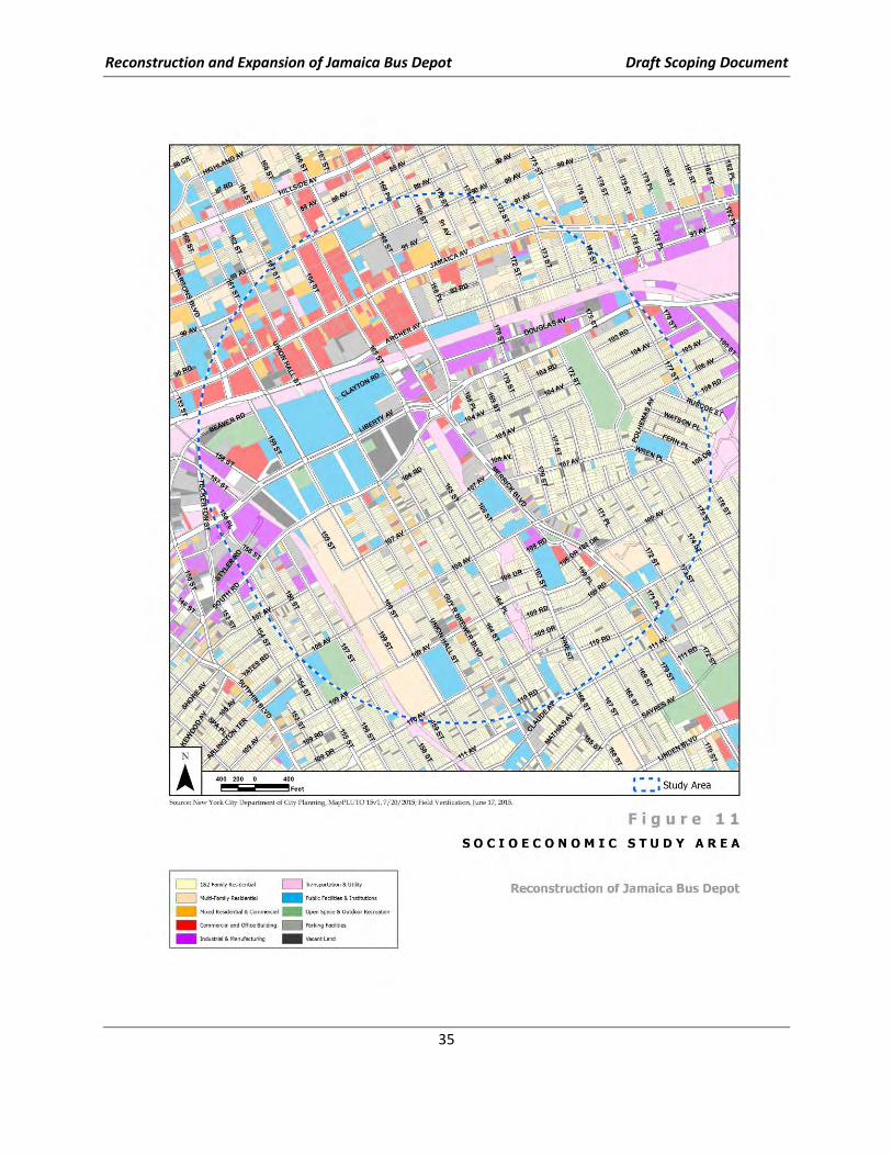
businesses and residences within the study area (see Figure 11). This will include the queuing of trucks
along routes, potential impacts to roads, sidewalks, and access to transit.
In order to conduct the analysis, information on Construction schedules, levels and duration of
construction activities and locations (i.e., road or sidewalk closures), and proposed off-site parking
locations will be developed. Information on current traffic volumes along with projected traffic for
construction and ongoing operations, and location of sidewalks, crosswalks, corners to access transit
would be relocated, closed or narrowed (during construction and/or permanently); information on
effects to bus stops or routes will be obtained from the Transportation Chapter of the EIS.
The analysis would include the following:
• Review of data/reports related to business operations and residents’ access to and from their
homes
• Survey of businesses along Merrick Boulevard and 165th Street from Archer Avenue to 108th
Avenue
Reconstruction and Expansion of Jamaica Bus Depot Draft Scoping Document
34
o Prepare an inventory of existing buildings - businesses type/use, occupancy, year built
o Map current loading, entrances/exits, parking locations and condition of sidewalks
o Conduct analysis of arrivals/departures/deliveries to area businesses (the selection of
peak hour(s) for analysis will be determined during field visit)
• Residential Survey
o Survey boundary delineated according to proposed truck routes
o Information on type of building and year built for all residential structures in the study
area
o Impacts on travel time for residents to access transit and rerouting by vehicle to main
arterials
• Report on findings
Reconstruction and Expansion of Jamaica Bus Depot Draft Scoping Document
35
Reconstruction and Expansion of Jamaica Bus Depot Draft Scoping Document
36
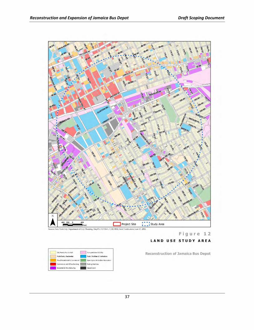
Discussion/Evaluation of Land Use, Zoning, and Public Policy
This analysis will consider the potential effect of the construction and operation of the Proposed Project,
including the related queuing routes, on land use, zoning, and public policy in the study area (see Figure
12). Although the downtown Jamaica neighborhood to the north of the project site predominately
contains commercial and transportation uses, and large institutional uses such as York College, the
immediately surrounding neighborhood in other directions is characterized by residential uses
comprised of single-family homes. The exception is Merrick Boulevard, which is lined with auto-related
and commercial uses. Directly across from the site to the south (across 107th Avenue) is a large senior
housing development, Greater Allen Cathedral Senior Residents. Current land uses on the site and in
the surrounding area will be identified using the City’s Primary Land Use Tax Lot Output (PLUTO). A site
visit will be undertaken to verify land uses.
Because the site is located within a 2010 City-sponsored area-wide rezoning undertaken by the NYCDCP
- the South Jamaica Rezoning (CEQR No. 11DCP041Q) - the analysis will take into account the projections
identified in the previous rezoning analysis and analyze the effects on future land uses and development
sites, as appropriate. Coordination with NYCDCP and the Mayor’s Office of Environmental Coordination
(MOEC) will occur to determine if there are other planned city-sponsored or private-applicant projects in
the surrounding area, including rezonings, special permits or variances as well as known as-of-right
projects. This analysis will also assess the consistency of the Proposed Project with Queens Community
Board 12 plans, as well as other public policies such as the South Jamaica Empire Zone, and the Jamaica
Industrial Business Zone.
Reconstruction and Expansion of Jamaica Bus Depot Draft Scoping Document
37
Reconstruction and Expansion of Jamaica Bus Depot Draft Scoping Document
38
Discussion/Evaluation of Open Space/Parkland and Recreational Facilities
Operation of the reconstructed bus depot would not introduce new residential population or a
substantial number of workers to the site; therefore, no increased demand for open space resources
and facilities in the vicinity of the project would be anticipated. Further, the project would not result in
direct effects to parks or recreational resources, such as through acquisition. An inventory of public
parks and recreational facilities will be prepared in coordination with the land use study. To the extent
that indirect effects may be possible, such as through changes in traffic and parking, air quality or noise
conditions, either with the reconstructed bus depot in operation or during its construction, these
potential effects would be referenced and explained qualitatively.
Discussion/Evaluation of Community Facilities and Services
New residential population would not be introduced to the area with the reconstructed depot, and
additional employees that could be necessary to operate increased numbers of buses would not be of
sufficient numbers to create substantial demand on the community facilities and services in the
community. Community facilities, such as hospitals, schools and day care centers, and houses of
worship, will be inventoried in coordination with the land use study. The air quality and noise analyses
findings, where community facilities near the site may be of particular concern as sensitive receptors,
will be referenced and discussed qualitatively.
By removing bus parking from the streets and improving bus maneuvering at the reconstructed depot,
the project is expected to improve the accessibility of emergency services (NYPD, FDNY) to the
neighborhood. This potential benefit to emergency services in the area would be discussed qualitatively
in the EIS, as appropriate, pending results of traffic and parking analyses.
Construction period impacts to emergency services, as determined in traffic and parking, air quality, and
noise analyses will be referenced as appropriate. Potential conflict with emergency service provision
during construction would be avoided as part of the MPT plans, and potential service disruptions
associated with construction activities would be minimized through the MPT plans. Construction-period
impacts and mitigation measures identified in the air quality, noise, and traffic and parking analyses, as
related to community facilities and services, will be referenced and discussed qualitatively.
Discussion/Evaluation of Community Character/Urban Design and Visual
Resources
This project represents an opportunity for a beneficial improvement over the existing condition with
respect to bus and non-bus vehicular operations, and with an improved visual character for the new
facility. MTA will identify/depict specific aesthetic aspects of the Candidate Alternatives using massing
diagrams and sketches in the DEIS/EIS, which would likely include visual buffering and streetscape
enhancements.
Given that the intent of the project is to contain activities on the project site, the visual quality of the
surrounding streetscapes would be expected to be improved, as will be discussed in the EIS. As an
important example, improvements to bus operations and increased parking capacity within a
reconstructed depot would reduce the on-street bus parking that currently diminishes the quality of the
pedestrian environment and community character.
Reconstruction and Expansion of Jamaica Bus Depot Draft Scoping Document
39
An inventory of potential visual resources, including parks and open spaces and historic architectural
resources, will be conducted in coordination with those subject area analyses and anticipated
improvements to visual and aesthetic quality will be noted. To the extent that other analyses may
estimate impacts that may relate to community character, such as traffic and parking, pedestrian
accessibility, air quality or noise impacts, such impacts and their proposed mitigation would be
referenced and discussed qualitatively in terms of potential effect to community character.
Discussion/Evaluation for Historic and Cultural Resources
The New York State Office of Parks, Recreation and Historic Preservation (OPRHP), which serves as the
State Historic Preservation Office (SHPO), has precise procedures for the implementation of cultural
resource evaluations (New York Archaeological Council Standards, 1994; New York Archaeological
Council Handbook, 2000; OPRHP Format Guidelines, 2005). Cultural Resource Technical Reports,
typically known as Phase I studies, include both documentary research and a pedestrian inspection of
the project parcel. The project impact analysis for archaeology is restricted to those land areas that will
be directly impacted by the project action, referred to as the Area of Potential Effect (APE). However,
the project impact analysis for buildings and structures must take into consideration the historical and
visual context of all the lots that may be required for acquisition for the reconstructed bus depot and
provide for a photographic record of the immediate project vicinity (see Figure 13).
A series of tasks will be undertaken to clarify the level of potential sensitivity for the proposed
reconstructed depot. The first archaeological task will be a screening to establish the potential for on-
site archaeological resources. In cases where project lands, or a portion of a project has been extensively
disturbed (e.g., water main installation), the disturbance will be documented by the archaeological
research team. No further archaeological tasks will be necessary in locations where there is evidence of
100% disturbance.
NYCT will produce a stand-alone technical report that evaluates the historic resources and
archaeological sensitivity of the project APE to the Phase I standards of OPRHP. Such a report will
include the results of the research and will be augmented by photographs and a series of historical
maps. The report will conclude either “no impact” or “further study needed.”
NYCT will prepare the technical report for submission to OPRHP, adhering to the agency’s new
electronic format and submission requirements. Often, this technical report serves as an unabridged
appendix of the DEIS submission. The technical report will be summarized in the respective chapter of
DEIS text, together with findings and results of agency review.

Reconstruction and Expansion of Jamaica Bus Depot Draft Scoping Document
40
Reconstruction and Expansion of Jamaica Bus Depot Draft Scoping Document
41
Discussion/Evaluation of Air Quality
Ambient air quality may be affected by pollutants produced by motor vehicles, referred to as “mobile
sources,” by fixed facilities, usually referenced as “stationary sources>” or by a combination of both.
An air quality assessment determines both a proposed project’s effects on ambient air quality as well
as the effects of ambient air quality on the project itself. Air quality analyses will be conducted,
following the procedures outlined in the CEQR Technical Manual, and the NYSDOT Environmental
Procedures Manual (“EPM”) to determine whether the proposed reconstruction of the JBD would
result in ambient air quality levels which exceed standards or health-related guideline values.
The key air quality issues that would be addressed are:
• The potential for increased bus volumes and the potential redistribution of bus traffic associated
with the reconstructed depot and queuing routes to result in significant mobile source (vehicle-
related) air quality impacts
• The potential for emissions from the HVAC systems and on-site bus emissions of the proposed
bus depot to significantly impact existing land uses
• The potential for emissions from construction-related vehicles and activities to significantly
impact existing land uses
Existing and one future No-Build and Build scenario will be evaluated during the project’s peak time
periods for each of the three Candidate Alternatives.
Operational Impacts
Mobile Source Analysis
Emissions generated by an increase in project-generated traffic at congested intersections have the
potential to add mobile-source pollutants at nearby sensitive land uses. The primary air quality issue
related to the proposed project is whether the traffic generated (bus and passenger car) during peak
traffic periods would cause or exacerbate a violation of the 1- and 8-hour national ambient air quality
standard (NAAQS) for carbon monoxide (CO) and for the 24-hour PM10 standard. A determination
would also be made as to whether the number of project-generated vehicles exceeds the PM2.5 criteria
established by the NYSDEC and New York City Department of Environmental Protection (NYCDEP). The
NYSDOT EPM methodology will be used for screening purposes in selecting the locations for detailed
analysis and in evaluating each of the three proposed alternatives.
Based on NYSDOT EPM screening criteria, up to three intersections will undergo a detailed CO, PM10
and PM2.5 analyses. CO concentrations will be assessed in detail at two worst-case intersection
locations and one worst-case intersection will be selected to determine potential PM10 and PM2.5
impacts as a result of the proposed project.
A detailed microscale mobile source analysis using NYSDOT EPM procedures will be conducted to
estimate potential impacts near congested locations. This analysis will employ the U.S. Environmental
Protection Agency (EPA) CAL3QHC (Version 2) dispersion model and the latest EPA emission factor
algorithm the MOVES2014 model.
Estimated 1- and 8-hour CO levels and 24-hour PM10 levels will be compared with federal National
Ambient Air Quality Standards (NAAQS). Analyses will examine the possibility of incorporating mitigation
Reconstruction and Expansion of Jamaica Bus Depot Draft Scoping Document
42
measures in order to attain ambient air quality standards at sites that are anticipated to exceed air
quality guidelines.
A detailed analysis will be conducted and PM2.5 concentration increments for the 24-hour and annual
periods will be compared with the NYSDEC guidance criteria to determine whether a significant impact
may occur under the Build conditions. A Tier 1 analysis during the project’s peak hour will be prepared.
Stationary Source Analysis
Emissions from the HVAC systems and on-site bus emissions of the reconstructed JBD may affect air
quality levels at nearby existing sensitive land uses in the study area. The impacts of these emissions
would be a function of fuel type, stack height, building size (gross floor area), and location of each
emission source relative to a nearby sensitive receptor site. Emissions from boilers, paint booths,
generators, and bus operations (movement and idling) within the facility will be calculated using AP-42,
manufacturer’s data and MOVES2014 based on operational and equipment data provided by NYCT. The
analyses of the potential impacts will address the NAAQS, in particular the 1-hour and annual standards
for nitrogen dioxide (NO2) and sulfur dioxide (SO2), and the 24-hour PM10/PM2.5 and annual standards
for PM2.5. The analysis will be performed using the EPA’s AERMOD model, based on the latest
appropriate EPA guidance, and will consider plume impingement conditions (i.e., when the wind blows
from the stacks and site toward buildings) and wake effects (i.e., when the wind blows from buildings
toward the stacks and site). The recent five years of meteorological data will be used for these
simulation analyses. Estimated values will be compared with NAAQS for NO2, SO2, PM2.5, and PM10.
Discussion/Evaluation of Noise and Vibration
Both temporary and long-term increases in noise and vibration levels in the immediate vicinity of the
reconstructed JBD could result from activities related to its reconstruction and operation. Three
Candidate Alternatives for the project reconstruction will be evaluated and, during the construction
period, NYCT will continue to maintain operations at the existing facility. The principal issues of concern
with respect to the reconstruction and operation of the depot would include;
• Mobile and stationary noise from off-site construction-related bus traffic diversions and other
construction-related vehicles
• Stationary noise and vibration from on-site construction equipment and activities, and
• Mobile and stationary noise and vibration from the operation of the reconstructed depot
As a result, mobile and stationary project-related noise and vibration sources from the depot will be
assessed.
The noise and vibration assessments will be conducted according to the guidance contained in the 2006
FTA Manual entitled Transit Noise and Vibration Impact Assessment (FTA Manual), as well as elements
of the CEQR Technical Manual and its most recently posted updates. The refinement of the noise and
vibration assessment methodologies will be effected using the specific information about future bus
operations at the reconstructed JBD.
Mobile Source Noise and Vibration (Construction and Operations)
During the reconstruction period, potential diversions of local traffic (including buses still based and
serviced at the depot) and the off-site movement of construction vehicles (particularly heavy truck trips)
Reconstruction and Expansion of Jamaica Bus Depot Draft Scoping Document
43
could result in a significant increase in noise levels along access roads that currently experience lower
peak-hour traffic volume. In addition, once the depot is operational, an increase in vehicle trips due to
increased bus capacity and the potential redistribution of bus trips (due to the differing Candidate
Alternative designs and queuing routes) from the depot could also result in a significant increase in noise
levels along access roads that currently experience lower peak-hour traffic volume. Therefore, a general
noise assessment, as per the FTA Manual, will be conducted for each of the three Candidate Alternatives
for both the reconstruction and operational scenarios to determine the potential for impact.
To determine sensitive locations which have the greatest potential to be adversely affected, noise
screening will be conducted by using both the FTA Manual distance screening procedure for bus
storage/maintenance and related access roads, and the CEQR Technical Manual procedures.
Based on the anticipated noise screening results, noise modeling will be conducted using general
assessment noise prediction algorithms contained within the FTA Manual. The noise assessment will
consider existing, No-Build, and Build conditions.
In support of the noise assessment, traffic noise monitoring will be conducted for the Candidate
Alternatives at up to five locations to establish baseline noise conditions surrounding the project area.
Of the five locations, up to two locations will be monitored for a full 24-hour period (see Figure 14).
Monitoring would be conducted at noise-sensitive locations that would most likely experience increases
due to either the reconstruction or operations-related traffic increases. Appropriate traffic counts will
also be performed as needed.
A qualitative rather than quantitative assessment of off-site vibration-related mobile sources will be
sufficient, following the FTA Manual, because buses, as rubber-wheeled vehicles, do not create
significant vibration. To exercise an approximate standard of care, NYCT would coordinate with York
College to determine the proximity of sensitive research instrumentation to the depot, and likely
construction routes to/from the site.
Stationary Source Noise and Vibration
Construction-Related Noise Impacts
Noise from the construction site would result from machinery, equipment, vehicles, and associated
activities. The Federal Highway Administration’s (FHWA) Roadway Construction Noise Model, or an
appropriately developed noise spreadsheet model, will be used to determine noise equipment source
levels for the peak construction period, and to assess the potential for noise impact at sensitive
receptors near the project construction site. Modeled results would be compared to existing noise levels
and the FTA construction noise criteria. The extent and duration of potential noise impacts at each
potentially affected noise receptor location during each phase of construction will be considered.
Results will be reported at no more than three representative locations for each of the depot Candidate
Alternatives.
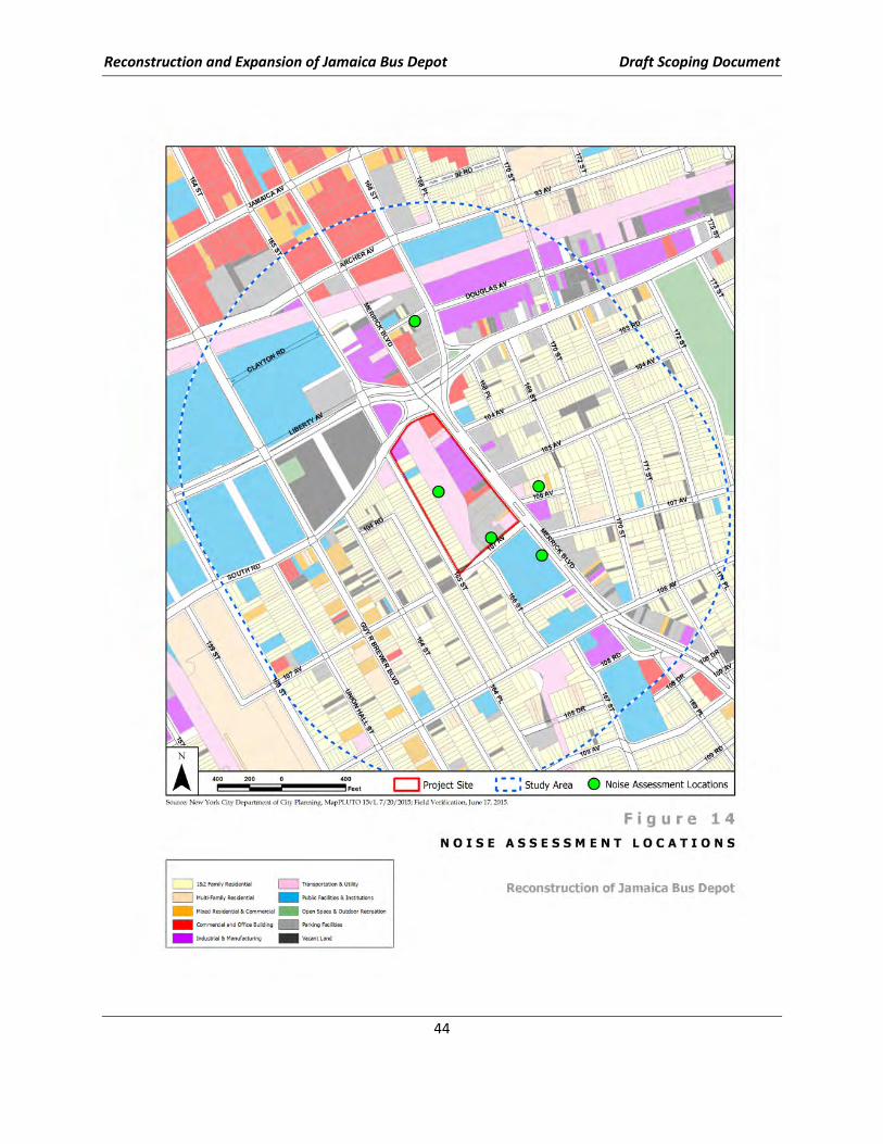
Reconstruction and Expansion of Jamaica Bus Depot Draft Scoping Document
44
Reconstruction and Expansion of Jamaica Bus Depot Draft Scoping Document
45
Construction-Related Vibration Impacts
Potential impacts from construction-related vibration will be assessed with respect to both human
annoyance and building damage. As with the noise assessment, the FTA construction criteria will be
used for the analyses. Construction schedule, phasing, activity and equipment data developed by NYCT
for the noise assessment will also be utilized for the vibration assessment, noting in particular activities
such as impact pile driving and blasting which represent the two worst vibration causing activities.
Particular consideration will be given to locations nearby historic buildings within the project area that
would be close to the construction site and or activities. Vibration monitoring will not be conducted
since FTA methodology does not use existing levels to assess impacts. Results will be reported at up to
three representative locations for each of the depot Candidate Alternatives.
Site Noise & Vibration from Depot Operations
The principal source of on-site noise for the fully operational JBD would be from the exterior and interior
bus movement and maintenance activities. Therefore, a general noise assessment will be conducted
following FTA Manual procedures for bus storage and maintenance facilities. The assessment will be
conducted for each of the three Candidate Alternatives. In addition to the bus and maintenance noise,
noise from HVAC and other systems may be of concern. This noise will be assessed in context with the
New York City Noise Code and the expected mechanical noise emissions. Results will be reported at no
more than three locations for each of the three depot Candidate Alternatives.
Cumulative Impacts
The results of the on-site and off-site noise assessments will be combined, as appropriate, for both the
construction and operational scenarios to determine overall noise impacts at sensitive receptors in the
study area. Results will be reported for each of the three depot Candidate Alternatives.
Mitigation Measures
Estimated impacts from the noise and vibration analyses will be addressed in terms of the available
NYCT control measures. Specific control measures would be identified and the effectiveness of these
measures quantified based on fundamental noise attenuation principles and assessment procedures
provided in the FTA Manual.
Discussion/Evaluation of Infrastructure, Energy, and Solid Waste
The proposed depot reconstruction would rely on existing utilities and infrastructure and not be
expected to create a significant new demand for public services, such as electricity. The analysis will
quantify the demands for energy use and conservation and solid waste generation using the
methodology supplied in the CEQR Technical Manual. NYCT will characterize potential service
disruptions that may occur during the construction period and identify in the EIS what these disruptions
could be and what efforts NYCT would take to minimize them.
Discussion/Evaluation of Natural Resources
A natural resources assessment considers species in the context of the surrounding environment,
habitat or ecosystem, and examines a project’s potential to impact those resources. An assessment will
Reconstruction and Expansion of Jamaica Bus Depot Draft Scoping Document
46
be performed if one or more natural resource is present on or near the project site and disturbance of
that resource could be caused by the proposed project. Although it is unlikely that suitable habitat for
rare, threatened or endangered species would be present on the project site, a preliminary screening of
available information will be conducted to confirm whether natural resources may be in the vicinity.
The physical and biological components of the site will be identified, including geology and soil
composition, groundwater levels, surface water quality, floodplains, wetlands, vegetation, wildlife
habitats and threatened/endangered animals and plants. Information pertaining to biological resources
will be obtained from the NYSDEC Natural Heritage program, as well as secondary sources of
information for New York City, as identified in the CEQR Technical Manual.
Discussion/Evaluation of Contaminated and Hazardous Materials and Waste
Management
Per CEQR, the goal of the contaminated and hazardous materials assessment will be to determine
whether the proposed action would potentially lead to increased exposure of people or the general
environment to hazardous materials and whether the potential exposure would be expected to lead to
significant public health impacts or environmental damage. Additionally, the presence of hazardous or
contaminated materials at the project site can significantly impact the cost and schedule of the project.
NYCT has performed extensive soil and groundwater investigations, including post-remediation
sampling, at the JBD from approximately 2002 to the present. There is ongoing environmental
monitoring being administered under NYSDEC Global Consent Order, and an active pump and treat
remediation system. A Phase I Environmental Site Assessment (ESA) prepared for the adjacent eight
properties for potential acquisition (which was executed in February 2012) identified several recognized
environmental concerns.
A Phase I ESA will be conducted for the entire site of the proposed new/reconstructed depot in
accordance with CEQR and the current ASTM Standard (E 1527-13) to determine if there is a reasonable
potential for the site area to be impacted with hazardous materials.
The Hazardous Material Chapter of the EIS will summarize the information contained in the Phase I ESA
to describe existing conditions in the project area; identify historic land uses with potential to have
released hazardous materials; describe potential site-specific environmental impacts; provide
recommendations for additional investigations if warranted; and describe how potential impacts would
be avoided during construction and operation of the Proposed Action, such as through engineering
controls, a Remedial Action Plan (RAP) and/or Construction Health and Safety Plan (CHASP).
As described earlier in the document, NYSDEC Spill #9010039 exists at the JBD reconstruction site and
discussions are underway with NYSDEC concerning (see Chapter E, Paragraph III) means and methods to
develop integrated spill remediation/construction-operation plans for the site
Discussion/Evaluation of Coastal Zone Consistency
The project site is not located in either the New York State or New York City-designated Coastal Zone;
therefore, no coastal zone consistency assessment is required. This will be noted in the project
description.
Reconstruction and Expansion of Jamaica Bus Depot Draft Scoping Document
47
Discussion/Evaluation of Safety and Security
For this analysis, the safety and security considerations associated with the construction and operation
of the proposed reconstructed JBD will be identified and evaluated. This evaluation will consider all
relevant guidance, policies and procedures including:
• FTA Guidance,
• NYS Building Code,
• NYC Building Code (Advisory),
• National Fire Protection Association (NFPA), and
• NYCT Design Guidelines.
The construction evaluation will detail NYCT policies and procedures for construction projects that are
included in relevant Health and Safety Plans (HASPs). HASPs provide policies and procedures that ensure
the safety of construction workers and the surrounding population during the reconstruction of the JBD.
The operational evaluation will summarize the policies and procedures for bus depots that ensure safe
operation, and maintain a secure facility. This includes the standard procedures for bus depot
operations, relevant building codes and standards, and NYCT bus depot design guidelines.
Discussion/Evaluation of Environmental Justice
This analysis will consider the effects of this project on environmental justice in minority and low-
income populations in accordance with CP-29 Environmental Justice and Permitting, issued by the
NYSDEC on March 19, 2003, Executive Order 12898, Federal Actions to Address Environmental Justice in
Minority and Low-Income Populations, and United States Department of Transportation (USDOT) Order
5610.2, Environmental Justice in Minority Populations and Low-Income Populations. The Environmental
Justice analysis will also include the requirements for a Fixed Fee Impact Analysis as required by Chapter
III, Part 2(f) of FTA Circular 4702.1. NYSDEC’s Environmental Justice Policy defines a minority community
as a contiguous area with multiple census block groups, having a minority population equal to or greater
than 51.1 percent of the total population (in an urban area) and a low-income community as one where
the low income population (i.e., persons living below the poverty threshold) is equal to or greater than
23.59 percent of the total population.
The analysis includes the following:
• Identify the areas where the project may cause adverse impacts either during construction or
operation (i.e., the study areas);
• Compile minority and low-income data for the census block groups within the study areas and
identify minority and low-income populations;
• Identify the project’s potential adverse impacts on minority and low-income populations;
• Evaluate the project’s potential adverse effects on minority and low-income populations relative
to its overall effects to determine whether any potential adverse impacts on those communities
would be significant and disproportionately high;
• Discuss mitigation measures for any identified disproportionate adverse impacts; and
Reconstruction and Expansion of Jamaica Bus Depot Draft Scoping Document
48
• Describes the public outreach and participation process for effectively engaging minority and
low-income populations in the decision-making process.
Information on the study area will be gathered and field reconnaissance will be performed to address
land use, environmental justice, and socioeconomic conditions, community disruption/displacement and
relocation analyses, which will result in efficiencies in budget and schedule.
Discussion/Evaluation of Cumulative Effects
A cumulative effects assessment will be provided at a level of detail sufficient for the public and
decision-makers to understand interrelationships of potential beneficial and/or negative effects
associated with the reconstruction and operation of the depot. Impacts estimated through the other
separate technical analyses supporting the DEIS/EIS, including those impacts that would be mitigated or
would not be significant, will be considered together, thus providing the opportunity to explore whether
project impacts may accumulate to create a broader effect. It is anticipated that this portion of the
cumulative effects discussion would mirror that of potential changes to community character, a
separate chapter of the EIS wherein the combined effects of potential air quality, noise, traffic and
parking, and visual and aesthetic quality impacts would be considered together with regard to potential
effects on community character.
In addition, the assessment will ascertain the relationship of the depot reconstruction project to other
projects that have recently occurred or are reasonably foreseeable and expected to occur in proximity
to the depot (i.e., within the study areas or regions analyzed for the various technical analyses
conducted for this EIS).
Discussion/Evaluation of Mitigation
The DEIS/EIS will include a stand-alone mitigation chapter presenting required mitigation by analysis
topic. If certain project features are to be incorporated (e.g., screening, landscaping, noise baffling) that
are intended to avoid impacts that would otherwise require mitigation, these will be included as part of
the project description, and an impact determination might become avoidable.
Discussion/Evaluation of Other Study Categories
Section 4(f)
Discussion of Section 4(f) issues will be provided, though detailed Section 4(f) assessment is provided.
Inventories of potential Section 4(f) resources, including both parklands and historic resources, will be
referenced. A discussion of 4(f) “uses” of such properties will be provided as appropriate, whether
permanent as part of facility operation conditions (unlikely with this project), or temporary, as may
result during construction, particularly if there would be changes to access or use associated with
construction activities. Both the Open Space/Park Land and Recreational Facilities and the Cultural
Resources chapters will support the Section 4(f) discussion, as will the Cultural Resources Report that
will be prepared to support this DEIS/EIS.
Reconstruction and Expansion of Jamaica Bus Depot Draft Scoping Document
49
Air Quality Permit
A new Air Resource Emissions Permit from the NYSDEC will be prepared in accordance with 6 NYCRR
Part 201. The appropriate application for the facility will be completed and submitted to NYSDEC. It is
anticipated that the reconstructed JBD will increase its utilization up to a nominal inaugural amount of
250 buses and up to 300 standard bus equivalents (SBEs) from the existing nominal 200 SBEs as the
upper limit of permitted emissions. This is an increase of 50 to 100 SBEs over the current permit and, as
such, no Title 5 application for an expansion in emissions is expected to be conducted.
NYCT will:
• Calculate emission sources from facility-wide operations including boilers, paint booths,
generators, and bus operations (movement and idling) within the facility.
• Determine which permit is required for the reconstructed JBD. This will be based on the
determination of current and future emission estimates, versus emission allowance in the
existing permit. It is likely that a NYSDEC facility permit will be required.
• Prepare an application for an Air Resources Permit from NYSDEC.
• Coordinate with NYSDEC on issues related to the permit.
Climate Change/Resiliency
Increased greenhouse gas (GHG) emissions are changing the global climate, which is predicted to lead to
wide-ranging effects on the environment, including rising sea levels, increases in temperature, and
changes in precipitation levels. Although this is occurring on a global scale, the environmental effects of
climate change are also likely to be felt at the local level. GHG emissions generated by the proposed
project will be quantified using the guidelines provided in NYSDEC’s Guide for Assessing Energy Use and
Greenhouse Gas Emissions in an Environmental Impact Statement. The assessment will examine GHG
emissions from the proposed project’s operations, mobile source, and construction as outlined below:
• Sources of GHG emissions from the proposed project will be identified. The pollutants for
analysis will be discussed, as well as the various City, State, and federal goals, policy, regulations,
standards and benchmarks for GHG emissions
• Fuel consumption from buildings will be estimated based on the calculations of estimated
energy use due to the proposed project
• GHG emissions associated with project-related traffic will be estimated using data from the
transportation analysis. A calculation of Vehicle Miles Traveled (VMT) will be prepared
• The types of construction materials and equipment proposed will be discussed along with
opportunities for alternative approaches that may serve to reduce GHG emissions associated
with construction
A qualitative discussion of stationary and mobile sources of GHG emissions will be provided in
conjunction with a discussion of goals for reducing GHG emissions to determine if the proposed project
is consistent with the state’s GHG reduction goals.

Reconstruction and Expansion of Jamaica Bus Depot Draft Scoping Document
50
Geology & Soils
This chapter of the DEIS/EIS will describe the soils, geology and groundwater resources in the
environment surrounding the depot as well as any impacts and proposed measures to mitigate impacts
if there are any. A review of maps and records of the United States Geological Survey (USGS) and the
Natural Resources Conservation Service will be conducted to identify the site’s elevation, topography,
and underlying bedrock geology and soils. Historical geological reports and prior subsurface
investigations and Environmental Site Investigations prepared by NYCT will also be reviewed to analyze
hydrology, and to identify groundwater levels and flow direction at the depot area. It is notable that the
proposed project is located above the Brooklyn-Queens Sole Source Aquifer system, and while this is not
a source of drinking water, its presence and potential effects will be described in the DEIS/EIS.
Construction Impacts
Potential construction period impacts will be discussed for each of the topical categories, for which the
proposed analyses and assumptions were previously described. However, the environmental
documentation will provide for consolidated review of potential construction period effects in a
separate Construction Impacts chapter. This chapter will also provide the singular description of
construction activities, such as phasing, staging plans, equipment, off-site parking, etc. that would be
utilized.
Unavoidable Adverse Impacts
If the implementation of the project is estimated to result in significant adverse impacts, regardless of
the mitigation employed or where mitigation is not possible, such impacts will be described.
Growth-Inducing Aspects of the Proposed Action
The potential for the proposed action to induce growth will be assessed and summarized.
Irreversible and Irretrievable Commitments of Resources
The extent to which the proposed action will foreclose future options to utilize resources or the extent
to which it will involve trade-offs between short-term environmental gains and long-term losses will be
addressed, as will potential short-term losses compared to long-term benefits.
H. PUBLIC AND AGENCY INVOLVEMENT
A Public Scoping Meeting will be held on June 15, 2016, at Junior High School 8 (IS 8) Richard S. Grossley
at 108-35 167th Street, Queens, NY 11433 during which a presentation on the development and features
of the proposed Candidate Alternatives under consideration and scope of DEIS analyses will be given.
The public will have the opportunity to review the materials presented including the Draft Scoping
Document and provide comments through July 8, 2016. Those comments will be addressed and
incorporated as appropriate into the Final Scoping Document, which will be issued to the public.
Once the preliminary DEIS is completed and NYCT determines that the document is ready for public
circulation and comment, NYCT will prepare a Notice of Completion, publish the notice in the
Environmental Notice Bulletin and local newspapers, and distribute the DEIS. A copy of the DEIS will be
posted on the MTA website consistent with NYSDEC procedures (617.12 6NYCRR). A Public Hearing will
be held to give the public an opportunity to comment on the DEIS. NYCT will maintain a record of all
comments received during the DEIS public hearing and the comment period regarding the DEIS.
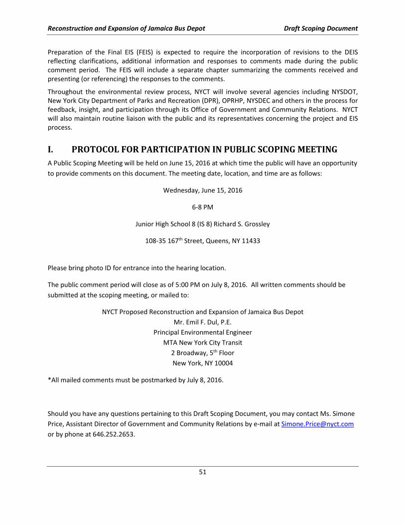
Reconstruction and Expansion of Jamaica Bus Depot Draft Scoping Document
51
Preparation of the Final EIS (FEIS) is expected to require the incorporation of revisions to the DEIS
reflecting clarifications, additional information and responses to comments made during the public
comment period. The FEIS will include a separate chapter summarizing the comments received and
presenting (or referencing) the responses to the comments.
Throughout the environmental review process, NYCT will involve several agencies including NYSDOT,
New York City Department of Parks and Recreation (DPR), OPRHP, NYSDEC and others in the process for
feedback, insight, and participation through its Office of Government and Community Relations. NYCT
will also maintain routine liaison with the public and its representatives concerning the project and EIS
process.
I. PROTOCOL FOR PARTICIPATION IN PUBLIC SCOPING MEETING
A Public Scoping Meeting will be held on June 15, 2016 at which time the public will have an opportunity
to provide comments on this document. The meeting date, location, and time are as follows:
Wednesday, June 15, 2016
6-8 PM
Junior High School 8 (IS 8) Richard S. Grossley
108-35 167th Street, Queens, NY 11433
Please bring photo ID for entrance into the hearing location.
The public comment period will close as of 5:00 PM on July 8, 2016. All written comments should be
submitted at the scoping meeting, or mailed to:
NYCT Proposed Reconstruction and Expansion of Jamaica Bus Depot
Mr. Emil F. Dul, P.E.
Principal Environmental Engineer
MTA New York City Transit
2 Broadway, 5th Floor
New York, NY 10004
*All mailed comments must be postmarked by July 8, 2016.
Should you have any questions pertaining to this Draft Scoping Document, you may contact Ms. Simone
Price, Assistant Director of Government and Community Relations by e-mail at [email protected]
or by phone at 646.252.2653.

Reconstruction and Expansion of Jamaica Bus Depot Draft Scoping Document
This page intentionally blank.

Reconstruction and Expansion of Jamaica Bus Depot Draft Scoping Document
APPENDIX A: Alternative Sites Investigation

Reconstruction and Expansion of Jamaica Bus Depot Draft Scoping Document
This page intentionally blank.
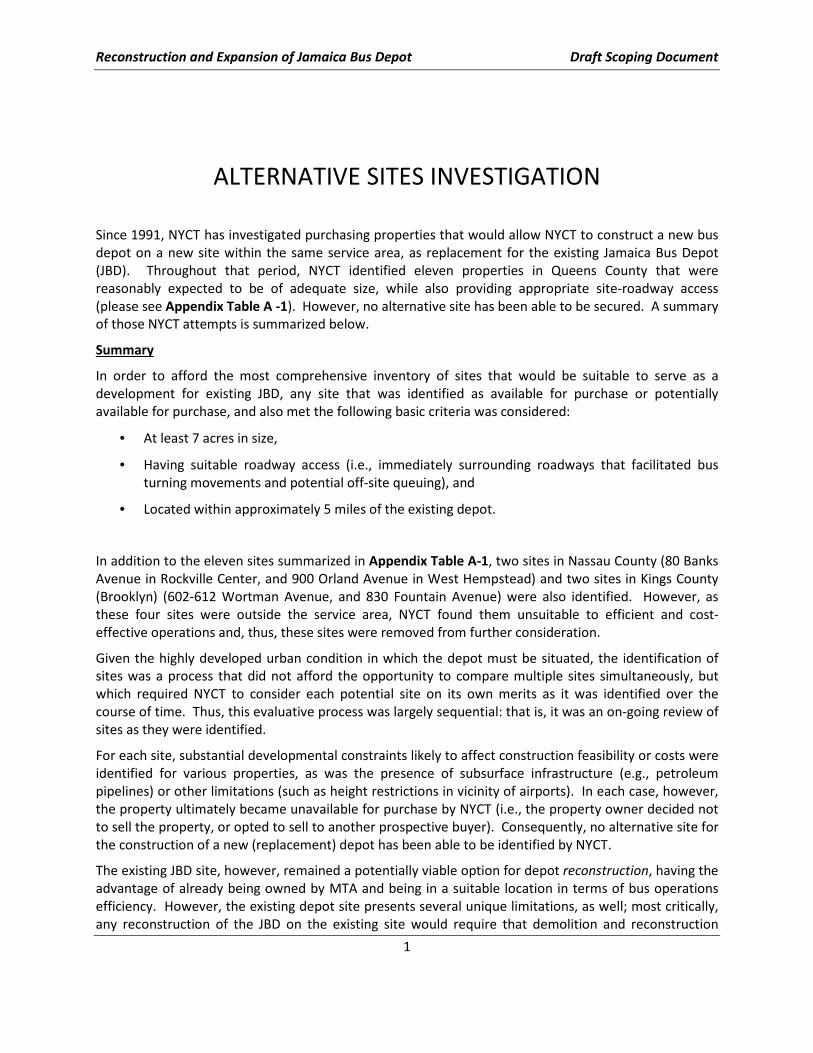
Reconstruction and Expansion of Jamaica Bus Depot Draft Scoping Document
1
ALTERNATIVE SITES INVESTIGATION
Since 1991, NYCT has investigated purchasing properties that would allow NYCT to construct a new bus
depot on a new site within the same service area, as replacement for the existing Jamaica Bus Depot
(JBD). Throughout that period, NYCT identified eleven properties in Queens County that were
reasonably expected to be of adequate size, while also providing appropriate site-roadway access
(please see Appendix Table A -1). However, no alternative site has been able to be secured. A summary
of those NYCT attempts is summarized below.
Summary
In order to afford the most comprehensive inventory of sites that would be suitable to serve as a
development for existing JBD, any site that was identified as available for purchase or potentially
available for purchase, and also met the following basic criteria was considered:
• At least 7 acres in size,
• Having suitable roadway access (i.e., immediately surrounding roadways that facilitated bus
turning movements and potential off-site queuing), and
• Located within approximately 5 miles of the existing depot.
In addition to the eleven sites summarized in Appendix Table A-1, two sites in Nassau County (80 Banks
Avenue in Rockville Center, and 900 Orland Avenue in West Hempstead) and two sites in Kings County
(Brooklyn) (602-612 Wortman Avenue, and 830 Fountain Avenue) were also identified. However, as
these four sites were outside the service area, NYCT found them unsuitable to efficient and cost-
effective operations and, thus, these sites were removed from further consideration.
Given the highly developed urban condition in which the depot must be situated, the identification of
sites was a process that did not afford the opportunity to compare multiple sites simultaneously, but
which required NYCT to consider each potential site on its own merits as it was identified over the
course of time. Thus, this evaluative process was largely sequential: that is, it was an on-going review of
sites as they were identified.
For each site, substantial developmental constraints likely to affect construction feasibility or costs were
identified for various properties, as was the presence of subsurface infrastructure (e.g., petroleum
pipelines) or other limitations (such as height restrictions in vicinity of airports). In each case, however,
the property ultimately became unavailable for purchase by NYCT (i.e., the property owner decided not
to sell the property, or opted to sell to another prospective buyer). Consequently, no alternative site for
the construction of a new (replacement) depot has been able to be identified by NYCT.
The existing JBD site, however, remained a potentially viable option for depot reconstruction, having the
advantage of already being owned by MTA and being in a suitable location in terms of bus operations
efficiency. However, the existing depot site presents several unique limitations, as well; most critically,
any reconstruction of the JBD on the existing site would require that demolition and reconstruction
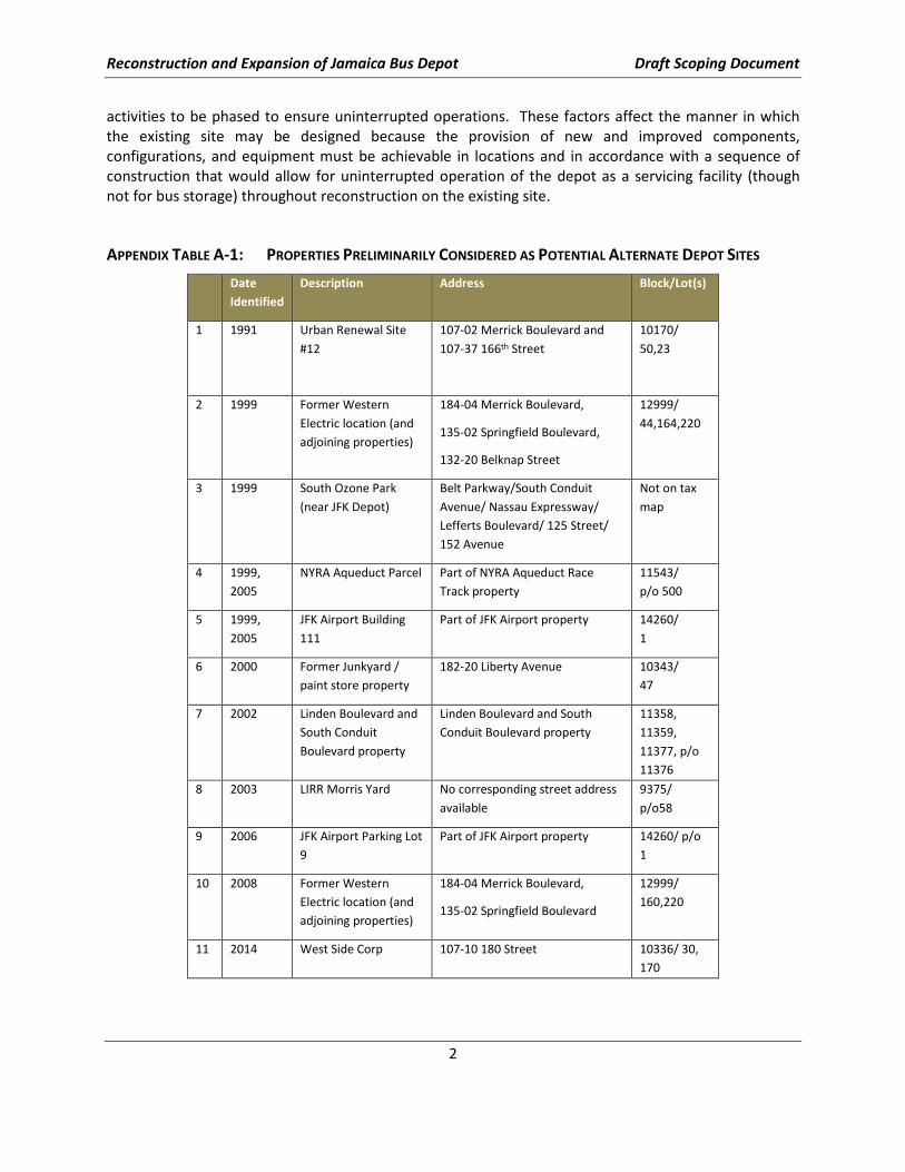
Reconstruction and Expansion of Jamaica Bus Depot Draft Scoping Document
2
activities to be phased to ensure uninterrupted operations. These factors affect the manner in which
the existing site may be designed because the provision of new and improved components,
configurations, and equipment must be achievable in locations and in accordance with a sequence of
construction that would allow for uninterrupted operation of the depot as a servicing facility (though
not for bus storage) throughout reconstruction on the existing site.
APPENDIX TABLE A-1: PROPERTIES PRELIMINARILY CONSIDERED AS POTENTIAL ALTERNATE DEPOT SITES
Date
Identified
Description Address Block/Lot(s)
1 1991 Urban Renewal Site
#12
107-02 Merrick Boulevard and
107-37 166th Street
10170/
50,23
2 1999 Former Western
Electric location (and
adjoining properties)
184-04 Merrick Boulevard,
135-02 Springfield Boulevard,
132-20 Belknap Street
12999/
44,164,220
3 1999 South Ozone Park
(near JFK Depot)
Belt Parkway/South Conduit
Avenue/ Nassau Expressway/
Lefferts Boulevard/ 125 Street/
152 Avenue
Not on tax
map
4 1999,
2005
NYRA Aqueduct Parcel Part of NYRA Aqueduct Race
Track property
11543/
p/o 500
5 1999,
2005
JFK Airport Building
111
Part of JFK Airport property 14260/
1
6 2000 Former Junkyard /
paint store property
182-20 Liberty Avenue 10343/
47
7 2002 Linden Boulevard and
South Conduit
Boulevard property
Linden Boulevard and South
Conduit Boulevard property
11358,
11359,
11377, p/o
11376
8 2003 LIRR Morris Yard No corresponding street address
available
9375/
p/o58
9 2006 JFK Airport Parking Lot
9
Part of JFK Airport property 14260/ p/o
1
10 2008 Former Western
Electric location (and
adjoining properties)
184-04 Merrick Boulevard,
135-02 Springfield Boulevard
12999/
160,220
11 2014 West Side Corp 107-10 180 Street 10336/ 30,
170
Reconstruction and Expansion of Jamaica Bus Depot Draft Scoping Document
APPENDIX B: Identification, Description, and Comparative Analysis of
Alternative Design Concepts
Reconstruction and Expansion of Jamaica Bus Depot Draft Scoping Document
This page intentionally blank.
Identification, Description, and
Comparative Analysis of Alternative
Design Concepts for the
Reconstruction and Expansion of
Jamaica Bus Depot Jamaica, Queens
May 2016
Prepared for:
Prepared by:
STV Incorporated

This page intentionally blank.
MTA New York City Transit Reconstruction and Expansion of Jamaica Bus Depot
Identification, Description, and Comparative Analysis of Alternative Design Concepts
i
TABLE OF CONTENTS
I. INTRODUCTION ......................................................................................................................1
II. BACKGROUND INFORMATION .................................................................................................1
MTA Regional Bus Operations ......................................................................................................................... 1
Bus Fleet .......................................................................................................................................................... 2
Bus Depots ...................................................................................................................................................... 2
Jamaica Bus Depot .......................................................................................................................................... 3
Proposed Project ............................................................................................................................................. 4
III. KEY FEATURES OF POTENTIAL ALTERNATIVES CONSIDERED ......................................................5
IV. DESCRIPTION OF POTENTIAL ALTERNATIVES ............................................................................8
A. Potential Alternative A ............................................................................................................................. 8
B. Potential Alternative B ........................................................................................................................... 11
C. Potential Alternative C ........................................................................................................................... 14
D. Potential Alternative D ........................................................................................................................... 17
E. Potential Alternative E ........................................................................................................................... 20
F. Potential Alternative F ........................................................................................................................... 23
G. Potential Alternative G ........................................................................................................................... 26
V. COMPARATIVE ANALYSIS OF POTENTIAL ALTERNATIVES ........................................................ 29
VI. SELECTION OF CANDIDATE ALTERNATIVES ............................................................................. 30
LIST OF TABLES
TABLE II-1: QUEENS BUS DEPOTS ............................................................................................................... 3
TABLE III-1: POTENTIAL ALTERNATIVES – SUMMARY OF KEY FEATURES ............................................................. 6
TABLE V-1: POTENTIAL ALTERNATIVES – SUMMARY OF CHARACTERISTICS ....................................................... 30
LIST OF FIGURES
FIGURE IV-1: ALTERNATIVE A DEPOT PLAN .................................................................................................. 10
FIGURE IV-2: ALTERNATIVE B DEPOT PLAN ................................................................................................... 13
FIGURE IV-3: ALTERNATIVE C DEPOT PLAN ................................................................................................... 16
FIGURE IV-4: ALTERNATIVE D DEPOT PLAN .................................................................................................. 19
FIGURE IV-5: ALTERNATIVE E DEPOT PLAN ................................................................................................... 22
FIGURE IV-6: ALTERNATIVE F DEPOT PLAN ................................................................................................... 25
FIGURE IV-7: ALTERNATIVE G DEPOT PLAN .................................................................................................. 28

MTA New York City Transit Reconstruction and Expansion of Jamaica Bus Depot
Identification, Description, and Comparative Analysis of Alternative Design Concepts
ii
This page intentionally blank.
MTA New York City Transit Reconstruction and Expansion of Jamaica Bus Depot
Identification, Description, and Comparative Analysis of Alternative Design Concepts
1
I. INTRODUCTION
In mid-2014, MTA NYCT initiated engineering and economic planning for a reconstructed Jamaica Bus
Depot (JBD) at the existing JBD site. Focusing on the potential servicing needs for a nominal 300 buses, an
array of different service sequencing opportunities within the site were identified for such service
elements as: bus washing; maintenance; and, fueling. MTA NYCT engineers/architects/operation/ cost
control staff were involved, and over fifteen (15) concepts evolved. These were then critically compared
and resulted in seven (7) being selected as Potential Alternatives which NYCT believed would represent a
reasonable array of reconstruction opportunities to evaluate in terms of: taking maximum
engineering/operations advantage of the site; utilizing current and emerging servicing technology;
demonstrating an array of associated costs/capacities; and, reflecting a diversity of potential
environmental effects/impacts related to their operating feature.
The seven Potential Alternatives were then evaluated further and three (3) basic “emblematic” concepts
emerged which are the Candidate Alternatives to be evaluated in the EIS process. The “emblematic”
characteristics of these Candidate Alternatives address:
• Storage capacity
• Investment cost
• Operating energy costs
• Type of bus storage:
o Principally open
o Partially open
o Principally enclosed
Upon completion of the planned SEQRA Scoping process, the resultant Candidate Alternatives will be
further analyzed and compared in the Environmental Impact Statement (EIS) process; that process will
include engineering, economic, and environmental considerations related to both construction and
operating features and characteristics of the Candidate Alternatives and, when appropriate, identification
of a Preferred Alternative.
The Preferred Alternative which results from the EIS process will be the basis for a Design-Build contract
which will result in the construction/operation of the new depot.
The following sections present:
• Discussions of each of the Potential Alternatives
• Comparative analysis of the Potential Alternatives
• Resulting Candidate Alternatives A, B, and D
II. BACKGROUND INFORMATION
MTA Regional Bus Operations
The MTA is a public benefit corporation responsible for transportation throughout twelve counties in New
York State, including all five boroughs of New York City (as well as two counties in Connecticut). The MTA
established the MTA Regional Bus Operations (RBO) in 2008 as its surface transit division, in effect,
MTA New York City Transit Reconstruction and Expansion of Jamaica Bus Depot
Identification, Description, and Comparative Analysis of Alternative Design Concepts
2
bringing under its control and consolidating most of public bus service operations in New York City. RBO
provides service in New York City and part of Nassau County, Long Island, to the east.
The MTA has continued to streamline operations, though RBO operations remain distinguished as either
“MTA New York City Bus,” referring to most routes in the City, or “MTA Bus,” referring to service previously
administered by New York City Department of Transportation (NYCDOT) and operated by seven
companies prior to RBO.
Bus Fleet
The RBO fleet consists of over 5,750 buses of various types and models, all accessible pursuant to the
guidelines of the Americans with Disabilities Act of 1990 (e.g., “ADA-accessible”). Within the current fleet,
approximately 5,000 buses are diesel-fueled, and approximately 750 buses are powered by natural gas.
Bus Depots
Bus depots are facilities necessary to perform regular maintenance and cleaning of buses, as well as
collection of revenue from the bus fareboxes. Depots are also used to store (e.g., park) buses when not
in use. Depots range in age and exist in various configurations. For example, some depots, were originally
“car barns” for streetcars; others were built later, specifically to serve buses. As the depot functions
evolved, the facilities evolved, in some cases, by rehabilitating existing depot buildings or constructing
additions, or by demolishing existing depot buildings and constructing new facilities in their place or at
new locations. In addition to the historic uses of the depot facilities currently operated by MTA, variations
in depot designs, configurations, capacities, and functionality also reflect differing site constraints and the
MTA need to provide specialized functions at some depot locations to support overall operations. For
example, some depots, such as Eastchester Depot in the Bronx, provide “reserve storage” for out-of-
services buses.
RBO maintains 29 bus depots, including 21 that serve MTA New York City Bus and eight that serve MTA
Bus. Three central maintenance facilities, the Grand Avenue Central Maintenance Facility in Maspeth,
Queens and the Zerega Avenue Central Maintenance Facility in the Bronx and the East New York Complex
in Brooklyn are responsible for major overhaul and heavy maintenance of the fleet.
The Queens Division of RBO relies on eight depots, including the existing Jamaica Depot facility, as is
described in Table II-1, “Queens Bus Depots”:
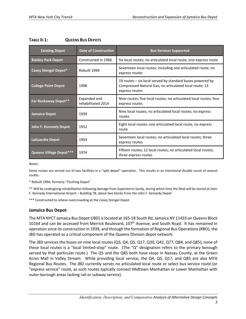
MTA New York City Transit Reconstruction and Expansion of Jamaica Bus Depot
Identification, Description, and Comparative Analysis of Alternative Design Concepts
3
TABLE II-1: QUEENS BUS DEPOTS
Existing Depot Date of Construction Bus Services Supported
Baisley Park Depot Constructed in 1966 Six local routes; no articulated local route; one express route
Casey Stengel Depot* Rebuilt 1994 Seventeen local routes; including one articulated route; no
express routes
College Point Depot 1998
19 routes – six local served by standard buses powered by
Compressed Natural Gas; no articulated local route; 13
express routes
Far Rockaway Depot** Expanded and
rehabilitated 2014
Nine routes; five local routes; no articulated local routes; four
express routes
Jamaica Depot 1939 Nine local routes; no articulated local routes; no express
routes
John F. Kennedy Depot 1952 Eight local routes; one articulated local route; no express
route
LaGuardia Depot 1954 Seventeen local routes; no articulated local routes; three
express routes
Queens Village Depot*** 1974 Fifteen routes; 12 local routes; no articulated local routes;
three express routes
Notes:
Some routes are served out of two facilities in a “split depot” operation. This results in an intentional double count of several
routes.
* Rebuilt 1994; formerly “Flushing Depot”
** Will be undergoing rehabilitation following damage from Superstorm Sandy, during which time the fleet will be stored at John
F. Kennedy International Airport – Building 78, about two blocks from the John F. Kennedy Depot
*** Constructed to relieve overcrowding at the Casey Stengel Depot
Jamaica Bus Depot
The MTA NYCT Jamaica Bus Depot (JBD) is located at 165-18 South Rd, Jamaica NY 11433 on Queens Block
10164 and can be accessed from Merrick Boulevard, 107th Avenue, and South Road. It has remained in
operation since its construction in 1939, and through the formation of Regional Bus Operations (RBO), the
JBD has operated as a critical component of the Queens Division depot network.
The JBD services the buses on nine local routes (Q3, Q4, Q5, Q17, Q30, Q42, Q77, Q84, and Q85); none of
these local routes is a “local limited-stop” route. (The “Q” designation refers to the primary borough
served by that particular route.) The Q5 and the Q85 both have stops in Nassau County, at the Green
Acres Mall in Valley Stream. While providing local service, the Q4, Q5, Q17, and Q85 are also MTA
Regional Bus Routes. The JBD currently serves no articulated local route or select bus service route (or
“express service” route, as such routes typically connect Midtown Manhattan or Lower Manhattan with
outer-borough areas lacking rail or subway service).
MTA New York City Transit Reconstruction and Expansion of Jamaica Bus Depot
Identification, Description, and Comparative Analysis of Alternative Design Concepts
4
The Jamaica Bus Depot was constructed in 1939 and was expanded eastwardly to add a bus wash area
and provide additional storage area in 1950. In 1968, Transportation Offices and locker rooms were
constructed on the north side of the facility on an upper mezzanine level. Neither the original 1939 design
nor the 1968 Transportation locker room construction project envisioned the need to accommodate the
large and growing number of operating employees working at this depot.
As a result of changing service demands and operational needs, the existing depot facility presents several
critical functional deficiencies. These deficiencies have arisen as the demand for services have increased,
necessitating a larger fleet, and as opportunities for improved bus stock have allowed MTA to invest in
newer buses. Modern buses include larger buses than those for which the 1939 depot was designed.
Modern buses also are designed differently – such as relying upon clean diesel, hybrid-electric, and
compressed natural gas buses. As a result, the service needs and the configuration of work space within
a depot have evolved.
The JBD fleet size is currently 196 buses, and the facility provides storage for only 150 buses; consequently,
after being serviced, nearly 50 buses must park off MTA NYCT property to be stored overnight (parked)
on surrounding streets, where they are then started-up each morning. Moreover, as the JBD was
constructed in 1939, it is not appropriately configured to provide the most efficient servicing of the current
types of buses, and specifically, it cannot service articulated buses, thereby limiting the service that can
be provided on the bus routes it supports. The JBD’s transportation and maintenance employee amenities
are also in poor condition and in need of renovation, and the depot does not meet the United Bus Depot
Design Guidelines and current code standards, such as Americans with Disabilities Act of 1990 (ADA)
Accessibility Guidelines (ADAAG). The current depot cannot be expected to handle forecast numbers of
buses necessary to handle the density of bus service in this section of the City, nor could it handle new
demands resulting from service changes that are not part of current forecasts (i.e., resulting from changes
in depot/route assignment reconfigurations). As part of the broader network of Queens depots, the
existing JBD also cannot provide emergency bus storage during exceptional circumstances (such as severe
storm events), which has proven to be of particular importance since Superstorm Sandy.
Proposed Project
MTA NYCT has sought various locations to relocate the depot; however, no appropriate alternative sites
have resulted. As an interim measure to address storage needs, to the extent possible, MTA NYCT
acquired Lots 41, 53, 60, 61, 63, 66, 68, and 72 on Block 10164, surrounding the existing facility.
Following the determination that the existing depot site is the only site available for a depot serving
current routes, a series of planning exercises was conducted by MTA NYCT to determine whether it was
feasible to construct a suitably designed depot facility that would ensure the uninterrupted operations of
the current facility.
As a result of the planning efforts, seven alternative facility designs were conceived that could allow for
construction of the depot in phases, while keeping the existing depot fully functional. As envisioned
during this schematic design process, the seven depot design alternatives would accommodate
articulated buses, and would also meet the following key design criteria, which are fundamental to
ensuring that the proposed depot design meets the overall project purpose and need:
• Parking for 300 standard bus equivalents (SBEs),
• 15 maintenance bays,
• 1 chassis wash station,
• 3 fuel lanes,
• 3 bus wash lanes, and
MTA New York City Transit Reconstruction and Expansion of Jamaica Bus Depot
Identification, Description, and Comparative Analysis of Alternative Design Concepts
5
• 2 interior wash stations.
III. KEY FEATURES OF POTENTIAL ALTERNATIVES CONSIDERED
Table III-1, “Alternatives – Summary of Key Features,” provides an overview of the key design elements
that are discussed in greater detail in subsequent sections.
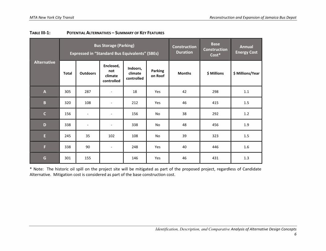
MTA New York City Transit Reconstruction and Expansion of Jamaica Bus Depot
Identification, Description, and Comparative Analysis of Alternative Design Concepts
6
TABLE III-1: POTENTIAL ALTERNATIVES – SUMMARY OF KEY FEATURES
Alternative
Bus Storage (Parking)
Expressed in “Standard Bus Equivalents” (SBEs)
Construction
Duration
Base
Construction
Cost*
Annual
Energy Cost
Total Outdoors
Enclosed,
not
climate
controlled
Indoors,
climate
controlled
Parking
on Roof Months $ Millions $ Millions/Year
A 305 287 - 18 Yes 42 298 1.1
B 320 108 - 212 Yes 46 415 1.5
C 156 - - 156 No 38 292 1.2
D 338 - - 338 No 48 456 1.9
E 245 35 102 108 No 39 323 1.5
F 338 90 - 248 Yes 40 446 1.6
G 301 155 146 Yes 46 431 1.3
* Note: The historic oil spill on the project site will be mitigated as part of the proposed project, regardless of Candidate
Alternative. Mitigation cost is considered as part of the base construction cost.
MTA New York City Transit Reconstruction and Expansion of Jamaica Bus Depot
Identification, Description, and Comparative Analysis of Alternative Design Concepts
7
This page intentionally blank.
MTA New York City Transit Reconstruction and Expansion of Jamaica Bus Depot
Identification, Description, and Comparative Analysis of Alternative Design Concepts
8
IV. DESCRIPTION OF POTENTIAL ALTERNATIVES
A. Potential Alternative A
This depot design alternative would be expected to meet all design criteria, as described following:
Depot Building
Potential Alternative A would be a new one-story depot building positioned along Merrick Boulevard, and
extending southward to 107th Avenue.
• It would provide approximately 125,000 square feet (sf) on the first floor (see Figure IV-1).
Approximately 7,600 sf of administrative space would be provided on the first and second levels
and 19,700 sf on the second level, near South Road.
• The roof level height would be about 25 feet above the ground floor. A ramp at the south end of
the depot building would connect the ground floor to the rooftop parking level.
• Potential Alternative A provides three fueling lanes, three bus wash lanes, two interior bus wash
stations, one chassis wash station, and 15 maintenance bays.
Parking
Potential Alternative A would provide a total of 305 SBE parking spaces:
• 18 spaces would be indoors on the first level,
• 170 would be outdoors on the west side of the property, and
• 117 spaces would be outdoors, on the unenclosed roof level.
Bus Circulation
Buses would enter the depot from South Road and first refuel within the fueling lanes, then proceed to
bus wash area, followed by the maintenance and parking areas. The proposed bus depot has several bus
exits. On the east side of the building, a driveway approximately midblock between South Road and 107th
Avenue provides a bus exit onto Merrick Boulevard. Buses may also exit at the west side of the building
to the outdoor parking area. Buses exit the outdoor parking area at South Road, located at the north end
of the site and 107th Avenue and an emergency exit is located at the south end of the site. Alternative A
would also have an entrance driveway from Merrick Boulevard just north of 107th Avenue.
Construction
Operations within the existing depot building would not be interrupted during construction. It is noted
that the one-story structure and minimal construction conflicts with the existing depot building would
result in a construction duration of approximately 42 months.
MTA New York City Transit Reconstruction and Expansion of Jamaica Bus Depot
Identification, Description, and Comparative Analysis of Alternative Design Concepts
9
Costs
Construction costs are estimated to be approximately $298,000,000, while annual operations energy costs
are estimated to be $1,100,000.
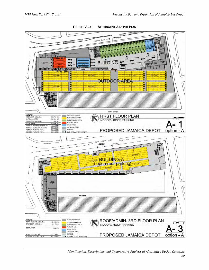
MTA New York City Transit Reconstruction and Expansion of Jamaica Bus Depot
Identification, Description, and Comparative Analysis of Alternative Design Concepts
10
FIGURE IV-1: ALTERNATIVE A DEPOT PLAN
MTA New York City Transit Reconstruction and Expansion of Jamaica Bus Depot
Identification, Description, and Comparative Analysis of Alternative Design Concepts
11
B. Potential Alternative B
This depot design alternative would be expected to meet all design criteria, as described following:
Depot Building
Potential Alternative B would be a new two-story depot building along Merrick Boulevard that would
provide maintenance services and indoor parking on Level 1, indoor parking on Level 2, and outdoor
parking on the roof (see Figure IV-2).
• The first floor would consist of approximately 161,000 sf of depot area and 11,000 sf of
administrative space on the first and second levels. The second floor would provide 160,000 sf of
depot area and 22,000 sf of administrative space on the third level.
• The roof parking area would be approximately 82,000 sf and the roof height would be about 45
feet above ground level. Ramps at the south end of the depot building would connect the ground
floor to the second floor and rooftop parking.
• Potential Alternative B provides three fueling lanes, three bus wash lanes, two interior bus wash
stations, one chassis wash station, and 15 maintenance bays. In addition, a large 128,000 sf area
outside of the depot building on the south and west sides of the property allow for operational
flexibility at the site.
Parking
Potential Alternative B would provide a total of 320 SBE parking spaces:
• 64 spaces would be indoors on the first level,
• 148 would be indoors on the second level, and
• 108 spaces would be outdoors, on the unenclosed roof level.
Bus Circulation
Buses would enter the depot from South Road and first refuel within the fueling lanes, then proceed to
bus wash area, followed by the maintenance and parking areas. The proposed bus depot has several bus
exits. On the east side of the building is a driveway approximately midblock between South Road and 107th
Avenue that provides a bus exit onto Merrick Boulevard. Buses may also exit the depot at the north end
onto South Road. Buses may exit the outdoor parking area at 107th Avenue via an emergency exit located
at the south end of site. A ramp to the second level and rooftop parking areas is provided at the south-
west end of the building.
Construction
Operations within the existing depot building would not be interrupted during construction, as
construction would be phased to allow the construction of a new depot to be constructed in areas
occupied by the existing bus depot building. This phasing complexity is expected to result in a construction
duration of approximately 46 months.

MTA New York City Transit Reconstruction and Expansion of Jamaica Bus Depot
Identification, Description, and Comparative Analysis of Alternative Design Concepts
12
Costs
Construction costs are estimated to be approximately $415,000,000, while annual energy costs are
estimated to be $1,500,000.
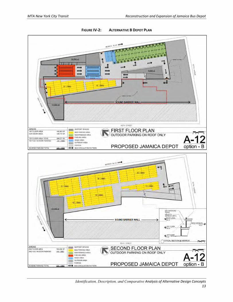
MTA New York City Transit Reconstruction and Expansion of Jamaica Bus Depot
Identification, Description, and Comparative Analysis of Alternative Design Concepts
13
FIGURE IV-2: ALTERNATIVE B DEPOT PLAN
MTA New York City Transit Reconstruction and Expansion of Jamaica Bus Depot
Identification, Description, and Comparative Analysis of Alternative Design Concepts
14
C. Potential Alternative C
This depot design alternative would not meet the critical design criterion for storage of 300 SBEs;
however, it would be expected to meet all other design criteria, as described following:
Depot Building
Potential Alternative C would be similar to Alternative A except that it would provide indoor parking within
a new building (see Figure IV-3).
• The first level of the depot would consist of two buildings, the 125,000 sf Building A along Merrick
Boulevard that would be the maintenance building and the 103,000 sf Building B, which would
provide indoor parking for 132 SBEs west of the maintenance building.
• An administrative building at the northwest corner of the property would provide approximately
7,500 sf of administrative space on the first floor, 7,500 sf on the second floor, and 25,000 sf on
the third floor.
• The roof level height would be about 25 feet above the ground floor, and there would be not
rooftop bus parking.
• Potential Alternative C provides three fueling lanes, three bus wash lanes, two interior bus wash
stations, one chassis wash station, and 15 maintenance bays.
Parking
Potential Alternative C would provide a total of 156 SBE parking spaces:
• 24 spaces would be indoors within Building A, and
• 132 spaces would be indoors within Building B.
Bus Circulation
Buses would enter the depot from South Road and first refuel within the fueling lanes, then proceed to
the bus wash area, followed by the maintenance and parking areas. The proposed bus depot has several
bus exits. On the east side of the building is a driveway approximately midblock between South Road and
107th Avenue that provides a bus exit onto Merrick Boulevard. Buses may also exit at the west side of the
building to the indoor parking area of Building “B”. Buses exit Building “B” parking area at South Road,
located at the north end of the site and may exit at 107th Avenue via the emergency exit located at the
south end of the site. Potential Alternative C would also have an entrance driveway from Merrick
Boulevard just north of 107th Avenue.
Construction
Operations within the existing depot building would not be interrupted during construction, though
Building B (the new indoor bus storage building) would be constructed in the space currently occupied by
the existing depot building. This phasing complexity is expected to result in a construction duration of
approximately 38 months.
MTA New York City Transit Reconstruction and Expansion of Jamaica Bus Depot
Identification, Description, and Comparative Analysis of Alternative Design Concepts
15
Costs
Construction costs are estimated to be approximately $292,000,000, while annual energy costs are
estimated to be $1,200,000.
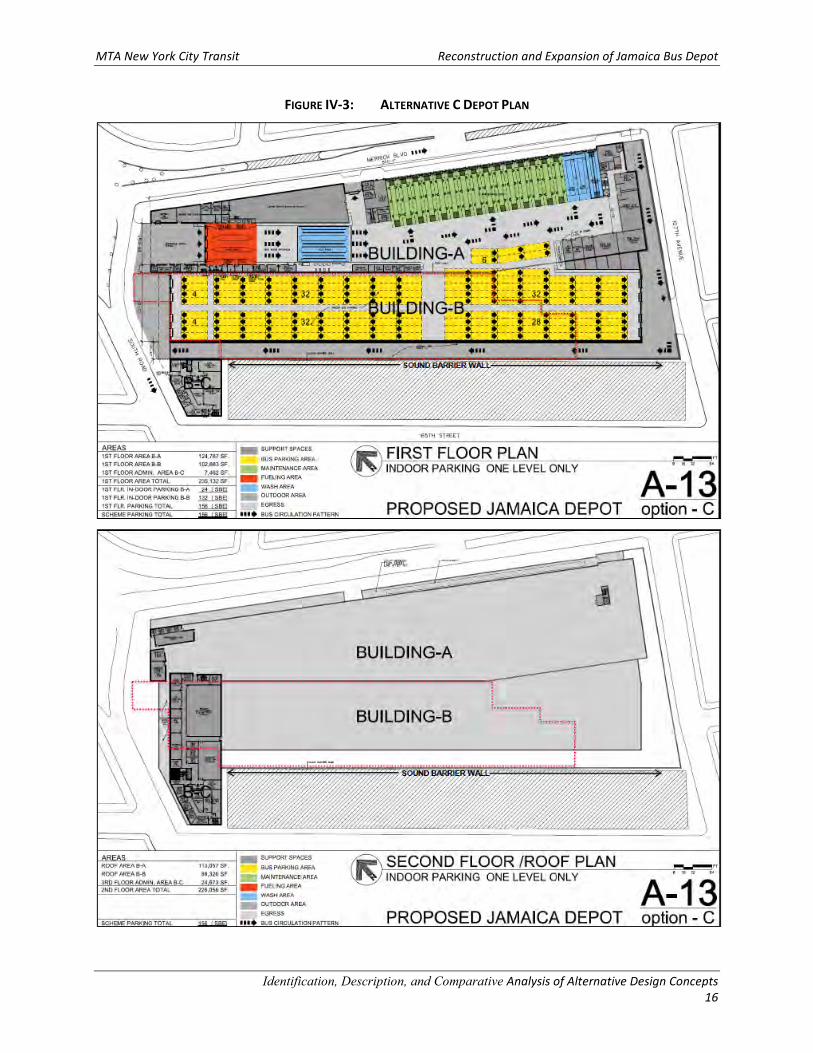
MTA New York City Transit Reconstruction and Expansion of Jamaica Bus Depot
Identification, Description, and Comparative Analysis of Alternative Design Concepts
16
FIGURE IV-3: ALTERNATIVE C DEPOT PLAN
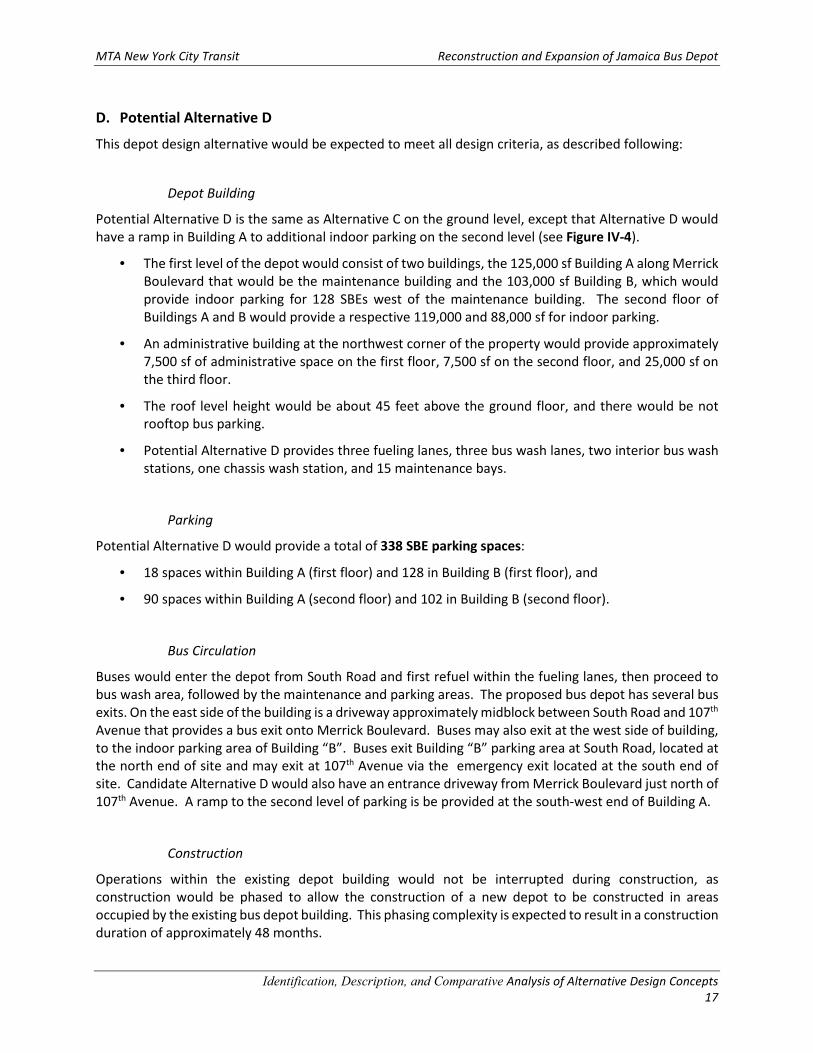
MTA New York City Transit Reconstruction and Expansion of Jamaica Bus Depot
Identification, Description, and Comparative Analysis of Alternative Design Concepts
17
D. Potential Alternative D
This depot design alternative would be expected to meet all design criteria, as described following:
Depot Building
Potential Alternative D is the same as Alternative C on the ground level, except that Alternative D would
have a ramp in Building A to additional indoor parking on the second level (see Figure IV-4).
• The first level of the depot would consist of two buildings, the 125,000 sf Building A along Merrick
Boulevard that would be the maintenance building and the 103,000 sf Building B, which would
provide indoor parking for 128 SBEs west of the maintenance building. The second floor of
Buildings A and B would provide a respective 119,000 and 88,000 sf for indoor parking.
• An administrative building at the northwest corner of the property would provide approximately
7,500 sf of administrative space on the first floor, 7,500 sf on the second floor, and 25,000 sf on
the third floor.
• The roof level height would be about 45 feet above the ground floor, and there would be not
rooftop bus parking.
• Potential Alternative D provides three fueling lanes, three bus wash lanes, two interior bus wash
stations, one chassis wash station, and 15 maintenance bays.
Parking
Potential Alternative D would provide a total of 338 SBE parking spaces:
• 18 spaces within Building A (first floor) and 128 in Building B (first floor), and
• 90 spaces within Building A (second floor) and 102 in Building B (second floor).
Bus Circulation
Buses would enter the depot from South Road and first refuel within the fueling lanes, then proceed to
bus wash area, followed by the maintenance and parking areas. The proposed bus depot has several bus
exits. On the east side of the building is a driveway approximately midblock between South Road and 107th
Avenue that provides a bus exit onto Merrick Boulevard. Buses may also exit at the west side of building,
to the indoor parking area of Building “B”. Buses exit Building “B” parking area at South Road, located at
the north end of site and may exit at 107th Avenue via the emergency exit located at the south end of
site. Candidate Alternative D would also have an entrance driveway from Merrick Boulevard just north of
107th Avenue. A ramp to the second level of parking is be provided at the south-west end of Building A.
Construction
Operations within the existing depot building would not be interrupted during construction, as
construction would be phased to allow the construction of a new depot to be constructed in areas
occupied by the existing bus depot building. This phasing complexity is expected to result in a construction
duration of approximately 48 months.

MTA New York City Transit Reconstruction and Expansion of Jamaica Bus Depot
Identification, Description, and Comparative Analysis of Alternative Design Concepts
18
Costs
Construction costs are estimated to be approximately $456,000,000, while annual energy costs are
estimated to be $1,900,000.
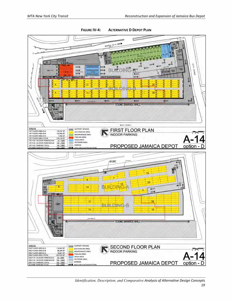
MTA New York City Transit Reconstruction and Expansion of Jamaica Bus Depot
Identification, Description, and Comparative Analysis of Alternative Design Concepts
19
FIGURE IV-4: ALTERNATIVE D DEPOT PLAN
MTA New York City Transit Reconstruction and Expansion of Jamaica Bus Depot
Identification, Description, and Comparative Analysis of Alternative Design Concepts
20
E. Potential Alternative E
This depot design alternative would not meet the critical design criterion for storage of 300 SBEs;
however, it would be expected to meet all other design criteria, as described following:
Depot Building
Potential Alternative E would be similar to Potential Alternative D except that the existing bus depot
building would be rehabilitated to provide unconditioned bus parking west of the new depot (see Figure
IV-5).
• The first level of the new bus depot building would provide 128,000 sf of maintenance space and
indoor parking for 18 SBEs and the second floor of the new building would provide 119,000 sf of
indoor parking. The existing depot building would provide 95,000 sf of space for unconditioned
bus parking on the first level. Additional outdoor parking for 35 SBEs would be provided south of
the existing building.
• An administrative building at the northwest corner of the property would provide approximately
7,500 sf of administrative space on the first floor, 7,500 sf on the second floor, and 20,000 sf on
the third floor.
• The roof level height would be about 45 feet above the ground floor.
• A ramp at the south end of the depot building would connect the ground floor to the rooftop
parking level.
• Potential Alternative E provides three fueling lanes, three bus wash lanes, two interior bus wash
stations, one chassis wash station, and 15 maintenance bays.
Parking
Potential Alternative E would provide a total of 245 SBE parking spaces:
• 18 and 90 indoor SBE spaces are provided in the new building depot on the first and second levels
respectively,
• The existing bus depot building would accommodate 102 unconditioned indoor SBE spaces, and
• 35 unenclosed, outdoor spaces.
Bus Circulation
Buses would enter the depot from South Road and first refuel within the fueling lanes, then proceed to
bus wash area, followed by the maintenance and parking areas. The proposed bus depot has several bus
exits. On the east side of the building is a driveway approximately midblock between South Road and
107th Avenue that provides a bus exit onto Merrick Boulevard. Buses may also exit at the west side of
building, to the indoor parking area of Building “B”. Buses exit Building “B” parking area at South Road,
located at the north end of site and may exit at 107th Avenue via the emergency exit located at the south
end of site. Potential Alternative E would also have an entrance driveway from Merrick Boulevard just
north of 107th Avenue. A ramp to the second level of parking would be provided toward the southwest
corner of Building A.
MTA New York City Transit Reconstruction and Expansion of Jamaica Bus Depot
Identification, Description, and Comparative Analysis of Alternative Design Concepts
21
Construction
Operations within the existing depot building would not be interrupted during construction, and the
existing bus depot building would be rehabilitated to serve as an unconditioned parking structure.
Construction duration would be approximately 39 months.
Costs
Construction costs are estimated to be approximately $323,000,000, while annual energy costs are
estimated to be $1,500,000.
MTA New York City Transit Reconstruction and Expansion of Jamaica Bus Depot
Identification, Description, and Comparative Analysis of Alternative Design Concepts
22
FIGURE IV-5: ALTERNATIVE E DEPOT PLAN
MTA New York City Transit Reconstruction and Expansion of Jamaica Bus Depot
Identification, Description, and Comparative Analysis of Alternative Design Concepts
23
F. Potential Alternative F
This depot design alternative would be expected to meet all design criteria, as described following:
Depot Building
Potential Alternative F would be similar to Potential Alternative D except that the second level parking in
Building A would be outdoor roof parking and not indoor parking (see Figure IV-6).
• The first level of the depot would consist of two buildings, the 125,000 sf Building A along Merrick
Boulevard that would be the maintenance building and the 103,000 sf Building B, which would
provide indoor parking for 128 SBEs west of the maintenance building. The second floor of
Buildings A would provide 119,000 sf of outdoor parking and the second level of Building B would
provide 88,000 sf for indoor parking.
• An administrative building at the northwest corner of the property would provide approximately
7,500 sf of administrative space on the first floor, 7,500 sf on the second floor, and 20,000 sf on
the third floor.
• The roof level height would be about 45 feet above the ground floor for Building B and 25 feet
above ground floor for Building A.
• Potential Alternative F provides three fueling lanes, three bus wash lanes, two interior bus wash
stations, one chassis wash station, and 15 maintenance bays.
Parking
Potential Alternative F would provide a total of 338 SBE parking spaces:
• 18 indoor spaces within Building A (first floor) and 128 indoor spaces in Building B (first floor),
• 90 outdoor spaces would be provided on the second floor of Building A, and
• 102 indoor spaces would be in Building B.
Bus Circulation
Buses would enter the depot from South Road and first refuel within the fueling lanes, then proceed to
bus wash area, followed by the maintenance and parking areas. The proposed bus depot has several bus
exits. On the east side of the building is a driveway approximately midblock between South Road and 107th
Avenue that provides a bus exit onto Merrick Boulevard. Buses may also exit at the west side of building
to the indoor parking area of Building “B”. Buses exit Building “B” parking area at South Road, located at
the north end of site and may exit at 107th Avenue via the emergency exit located at the south end of
site. Potential Alternative F would also have an entrance driveway from Merrick Boulevard just north of
107th Avenue. A ramp to the second level of parking would be provided in the southwest corner of Building
A.
MTA New York City Transit Reconstruction and Expansion of Jamaica Bus Depot
Identification, Description, and Comparative Analysis of Alternative Design Concepts
24
Construction
Operations within the existing depot building would not be interrupted during construction. Given its size
and that it would consist of two buildings levels and rooftop parking, Alternative F would be expected to
require a construction duration of approximately 40 moths.
Costs
Construction costs are estimated to be approximately $446,000,000, while annual energy costs are
estimated to be $1,600,000.
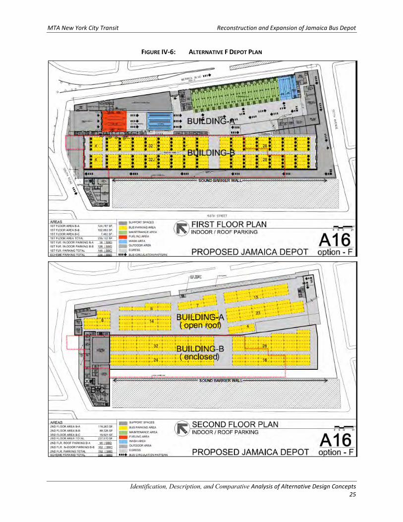
MTA New York City Transit Reconstruction and Expansion of Jamaica Bus Depot
Identification, Description, and Comparative Analysis of Alternative Design Concepts
25
FIGURE IV-6: ALTERNATIVE F DEPOT PLAN
MTA New York City Transit Reconstruction and Expansion of Jamaica Bus Depot
Identification, Description, and Comparative Analysis of Alternative Design Concepts
26
G. Potential Alternative G
This depot design alternative would be expected to meet all design criteria, as described following:
Depot Building
Potential Alternative G would be similar to Potential Alternatives D and F except that the second level
parking in Buildings A and B would be outdoor roof parking rather than indoor parking (see Figure IV-7).
• The first level of the depot would consist of two buildings, the 125,000 sf Building A along Merrick
Boulevard that would be the maintenance building and the 103,000 sf Building B, which would
provide indoor parking west of the maintenance building. The second floors of Buildings A and B
would provide 119,000 and 88,000 sf of outdoor rooftop parking, respectively.
• An administrative building at the northwest corner of the property would provide approximately
7,500 sf of administrative space on the first floor, 7,500 sf on the second floor, and 20,000 sf on
the third floor.
• The roof level height would be about 45 feet above the ground floor for Buildings A and B.
• Potential Alternative G provides three fueling lanes, three bus wash lanes, two interior bus wash
stations, one chassis wash station, and 15 maintenance bays.
Parking
Potential Alternative G would provide a total of 301 SBE parking spaces:
• 18 indoor spaces in Building A (first floor),
• 128 indoor spaces in Building B (first floor),
• 128 outdoor spaces on the second floor of Building A, and
• 27 outdoor spaces on the second floor of Building B.
Bus Circulation
Buses would enter the depot from South Road and first refuel within the fueling lanes, then proceed to
bus wash area, followed by the maintenance and parking areas. The proposed bus depot has several bus
exits. On the east side of the building is a driveway approximately midblock between South Road and 107th
Avenue that provides a bus exit onto Merrick Boulevard. Buses may also exit at the west side of building
to the indoor parking area of Building “B”. Buses exit Building “B” parking area at South Road, located at
the north end of site and may exit at 107th Avenue via the emergency exit located at the south end of
site. Potential Alternative G would also have an entrance driveway from Merrick Boulevard just north of
107th Avenue. A ramp to the second level of parking would be provided in the southwest corner of Building
A.
MTA New York City Transit Reconstruction and Expansion of Jamaica Bus Depot
Identification, Description, and Comparative Analysis of Alternative Design Concepts
27
Construction
Operations within the existing depot building would not be interrupted during construction. Given the
large building footprint and that construction would be undertaken in the space occupied by the existing
bus depot building, the construction duration for Alternative G would be expected to be approximately
46 months.
Costs
Construction costs are estimated to be approximately $431,000,000, while annual energy costs are
estimated to be $1,300,000.
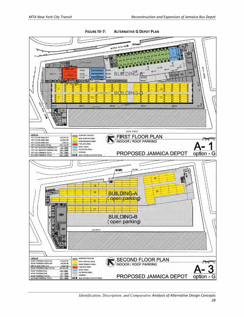
MTA New York City Transit Reconstruction and Expansion of Jamaica Bus Depot
Identification, Description, and Comparative Analysis of Alternative Design Concepts
28
FIGURE IV-7: ALTERNATIVE G DEPOT PLAN
MTA New York City Transit Reconstruction and Expansion of Jamaica Bus Depot
Identification, Description, and Comparative Analysis of Alternative Design Concepts
29
V. COMPARATIVE ANALYSIS OF POTENTIAL ALTERNATIVES
The seven Potential Alternatives were evaluated further based on “emblematic” characteristics to identify
Candidate Alternatives that will be analyzed and compared in the EIS process. The group of
characteristics included:
• Storage Capacity
• Investment Cost
• Operating Energy Costs
• Extent of Indoor/Outdoor Bus Storage
These characteristics have been identified to develop a representative and consistent basis to allow for
comparison of the engineering, economic, and environmental effects of the alternatives. The Storage
Capacity characteristic reflects the engineering/operations efficiency of each potential alternative to
maximize on-site depot space utilization. The Investment and Operating Energy Costs reflect the potential
capital and ongoing economic costs for the alternatives. The Extent of Indoor/Outdoor Bus Storage
reflects the potential for bus operations and depot reconstruction to affect the environment and sensitive
receptors. More specifically, different Extent of Indoor/Outdoor Bus Storage could be expected to result
in different levels of effects/impacts on area receptors as related to: air quality; noise; vibration; visual
impact; lighting; shadows; traffic; etc. features of the alternatives. The assessment of this group of
characteristics allows for the development of a reasonable range of alternatives to be considered for
further comparative engineering, economic, and environmental evaluation in the DEIS.
The following identifies and compares the key features and distinguishing characteristics of the seven
Potential Alternatives as presented in Table V-1.
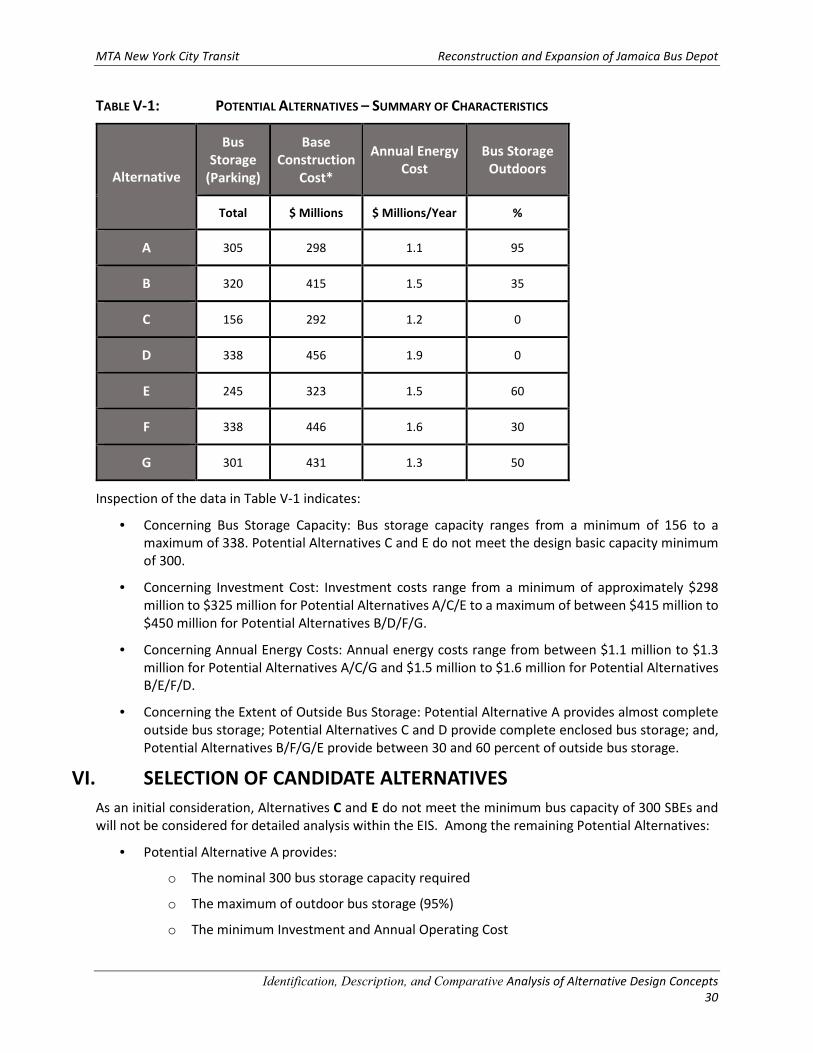
MTA New York City Transit Reconstruction and Expansion of Jamaica Bus Depot
Identification, Description, and Comparative Analysis of Alternative Design Concepts
30
TABLE V-1: POTENTIAL ALTERNATIVES – SUMMARY OF CHARACTERISTICS
Alternative
Bus
Storage
(Parking)
Base
Construction
Cost*
Annual Energy
Cost
Bus Storage
Outdoors
Total $ Millions $ Millions/Year %
A 305 298 1.1 95
B 320 415 1.5 35
C 156 292 1.2 0
D 338 456 1.9 0
E 245 323 1.5 60
F 338 446 1.6 30
G 301 431 1.3 50
Inspection of the data in Table V-1 indicates:
• Concerning Bus Storage Capacity: Bus storage capacity ranges from a minimum of 156 to a
maximum of 338. Potential Alternatives C and E do not meet the design basic capacity minimum
of 300.
• Concerning Investment Cost: Investment costs range from a minimum of approximately $298
million to $325 million for Potential Alternatives A/C/E to a maximum of between $415 million to
$450 million for Potential Alternatives B/D/F/G.
• Concerning Annual Energy Costs: Annual energy costs range from between $1.1 million to $1.3
million for Potential Alternatives A/C/G and $1.5 million to $1.6 million for Potential Alternatives
B/E/F/D.
• Concerning the Extent of Outside Bus Storage: Potential Alternative A provides almost complete
outside bus storage; Potential Alternatives C and D provide complete enclosed bus storage; and,
Potential Alternatives B/F/G/E provide between 30 and 60 percent of outside bus storage.
VI. SELECTION OF CANDIDATE ALTERNATIVES
As an initial consideration, Alternatives C and E do not meet the minimum bus capacity of 300 SBEs and
will not be considered for detailed analysis within the EIS. Among the remaining Potential Alternatives:
• Potential Alternative A provides:
o The nominal 300 bus storage capacity required
o The maximum of outdoor bus storage (95%)
o The minimum Investment and Annual Operating Cost
MTA New York City Transit Reconstruction and Expansion of Jamaica Bus Depot
Identification, Description, and Comparative Analysis of Alternative Design Concepts
31
• Potential Alternative D provides:
o Approximately 10% greater than the nominal minimum of 300 bus storage capacity
o Complete enclosed bus storage
o The maximum Investment and Annual Operating Cost
• Potential Alternatives B/F/G provide:
o Bus storage capacity varying between the nominal 300 and 15% more than the nominally
required Bus Storage Capacity
o Outside storage for between 30% and 50% of outdoor bus storage capacity
o Investment Costs between $415 million and $446 million and Annual Operating Costs
between $1.3 million and $1.6 million
Given the foregoing:
• Potential Alternatives C and E are not recommended for consideration as candidates.
• Potential Alternatives A and D are chosen for consideration as candidates because they represent
alternatives with the most outdoor bus storage (Potential Alternative A) and the most enclosed
bus storage (Potential Alternative D).
• Potential Alternative B is considered as a candidate from among Potential Alternatives B/F/G
because Potential Alternative B provides a combination of outdoor and enclosed parking and is
the only alternative that would have a structure that consists of a single building with three levels
of parking (two indoor levels and one rooftop outdoor level). Comparatively, Alternatives F and
G are basically variations of Alternative D and each would consist of two building structures, each
with two levels of parking. More specifically:
o Alternative F is essentially the same as Alternative D except that half of the 2nd level of
Alternative F would be open rooftop parking and half indoor parking.
o Alternative G is essentially the same as Alternative D except that the entire 2nd level of
Alternative G would be all open, rooftop parking.
o Given that Alternatives A and B include outdoor and rooftop parking scenarios similar to
Alternatives F and G (but that Alternative D presents a larger building footprint and volume),
the environmental effects of the bus storage variations of Alternatives F and G would also be
identified through the detailed analysis of Alternatives A, B, and D.
Therefore, Potential Alternatives A, B, and D have been selected to provide a reasonable array of outdoor
bus storage types (principally open parking, partially open parking, and principally enclosed parking) which
would allow for a comparative environmental evaluation along with engineering and economic
characteristics in the DEIS.

MTA New York City Transit Reconstruction and Expansion of Jamaica Bus Depot
Identification, Description, and Comparative Analysis of Alternative Design Concepts
32
Summary
The following Candidate Alternatives have been selected for EIS analysis:
1. Candidate Alternative A represents a single building (one-story) option that provides
predominantly outdoor parking (and rooftop parking). This alternative represents a Principally
Open Parking concept and will be evaluated in detail within the EIS.
2. Candidate Alternative B represents a single building (two-story) option that provides a
combination of indoor parking (levels 1 and 2) and outdoor parking (rooftop parking). This
alternative represents a Partially Open Parking concept and will be evaluated in detail within the
EIS.
3. Candidate Alternative D represents a two building option (2 two-story buildings) that consists of
a larger overall building footprint and volume, and all indoor parking. This alternative represents
a Principally Enclosed Parking concept and will be evaluated in detail within the EIS.

Reconstruction and Expansion of Jamaica Bus Depot Draft Scoping Document
APPENDIX C: SEQRA Environmental Assessment Form
Reconstruction and Expansion of Jamaica Bus Depot Draft Scoping Document
This page intentionally blank.
Page 1 of 13
Full Environmental Assessment Form Part 1 - Project and Setting
Instructions for Completing Part 1
Part 1 is to be completed by the applicant or project sponsor. Responses become part of the application for approval or funding, are subject to public review, and may be subject to further verification.
Complete Part 1 based on information currently available. If additional research or investigation would be needed to fully respond to any item, please answer as thoroughly as possible based on current information; indicate whether missing information does not exist,or is not reasonably available to the sponsor; and, when possible, generally describe work or studies which would be necessary toupdate or fully develop that information.
Applicants/sponsors must complete all items in Sections A & B. In Sections C, D & E, most items contain an initial question thatmust be answered either “Yes” or “No”. If the answer to the initial question is “Yes”, complete the sub-questions that follow. If the answer to the initial question is “No”, proceed to the next question. Section F allows the project sponsor to identify and attach any additional information. Section G requires the name and signature of the project sponsor to verify that the information contained in Part 1is accurate and complete.
A. Project and Sponsor Information.
Name of Action or Project:
Project Location (describe, and attach a general location map):
Brief Description of Proposed Action (include purpose or need):
Name of Applicant/Sponsor: Telephone:
E-Mail:
Address:
City/PO: State: Zip Code:
Project Contact (if not same as sponsor; give name and title/role): Telephone:
E-Mail:
Address:
City/PO: State: Zip Code:
Property Owner (if not same as sponsor): Telephone: E-Mail:
Address:
City/PO: State: Zip Code:
Reconstruction and Expansion of Jamaica Bus Depot
Queens Block 10164, Lot Nos. 41, 46, 53, 60, 61, 63, 66, 68, 72, 74, 76, 79, 80, 84, 89, 90, 95, 97, 103 (19 total lots). See Part 1, Attachment 1, Figure 1 - Site Location Map
See Part 1, Attachment 1: Description of the Proposed Action.
MTA - New York City Transit (NYCT)See Below
See Below
2 Broadway
New York NY 10004
Emil F. Dul, P.E., Principal Environmental Engineer646-252-2405
2 Broadway, 5th Floor
New York NY 10004
Page 2 of 13
B. Government Approvals
B. Government Approvals Funding, or Sponsorship. (“Funding” includes grants, loans, tax relief, and any other forms of financialassistance.)
Government Entity If Yes: Identify Agency and Approval(s) Required
Application Date (Actual or projected)
a. City Council, Town Board, Yes Noor Village Board of Trustees
b. City, Town or Village Yes No Planning Board or Commission
c. City Council, Town or Yes No Village Zoning Board of Appeals
d. Other local agencies Yes No
e. County agencies Yes No
f. Regional agencies Yes No
g. State agencies Yes No
h. Federal agencies Yes No
i. Coastal Resources.i. Is the project site within a Coastal Area, or the waterfront area of a Designated Inland Waterway? Yes No
ii. Is the project site located in a community with an approved Local Waterfront Revitalization Program? Yes No iii. Is the project site within a Coastal Erosion Hazard Area? Yes No
C. Planning and Zoning
C.1. Planning and zoning actions. Will administrative or legislative adoption, or amendment of a plan, local law, ordinance, rule or regulation be the Yes No only approval(s) which must be granted to enable the proposed action to proceed?
If Yes, complete sections C, F and G.If No, proceed to question C.2 and complete all remaining sections and questions in Part 1
C.2. Adopted land use plans.
a. Do any municipally- adopted (city, town, village or county) comprehensive land use plan(s) include the site Yes No where the proposed action would be located?
If Yes, does the comprehensive plan include specific recommendations for the site where the proposed action Yes No would be located? b. Is the site of the proposed action within any local or regional special planning district (for example: Greenway Yes No
Brownfield Opportunity Area (BOA); designated State or Federal heritage area; watershed management plan;or other?)
If Yes, identify the plan(s): _______________________________________________________________________________________________________
________________________________________________________________________________________________________ ________________________________________________________________________________________________________
c. Is the proposed action located wholly or partially within an area listed in an adopted municipal open space plan, Yes Noor an adopted municipal farmland protection plan?
If Yes, identify the plan(s): ________________________________________________________________________________________________________ ________________________________________________________________________________________________________ ________________________________________________________________________________________________________
*
*The project site is located within New York City, which has an approved LWRP (February 2016); however the site is not within or adjacent to New YorkCity's LWRP program boundaries. Therefore, the proposed projected is not subject to the local LWRP.
✔ (1)MTA Board Approval,(2)NYSDOT, NYCDOT, NYCDEP - Stormwater / Sewers
Proposed for 2016
✔
✔✔
✔
✔
✔
Jamaica Bay Watershed Protection Plan (developed pursuant to Local Law 71 of 2005)
✔
Page 3 of 13
C.3. Zoning
a. Is the site of the proposed action located in a municipality with an adopted zoning law or ordinance. Yes NoIf Yes, what is the zoning classification(s) including any applicable overlay district?
__________________________________________________________________________________________________________________________________________________________________________________________________________________
b. Is the use permitted or allowed by a special or conditional use permit? Yes No
c. Is a zoning change requested as part of the proposed action? Yes No If Yes,
i. What is the proposed new zoning for the site? ___________________________________________________________________
C.4. Existing community services.
a. In what school district is the project site located? ________________________________________________________________
b. What police or other public protection forces serve the project site? _________________________________________________________________________________________________________
c. Which fire protection and emergency medical services serve the project site?__________________________________________________________________________________________________________
d. What parks serve the project site?____________________________________________________________________________________________________________________________________________________________________________________________________________________
D. Project Details
D.1. Proposed and Potential Development
a. What is the general nature of the proposed action (e.g., residential, industrial, commercial, recreational; if mixed, include allcomponents)?_________________________________________________________________________________________________________
b. a. Total acreage of the site of the proposed action? _____________ acres b. Total acreage to be physically disturbed? _____________ acres c. Total acreage (project site and any contiguous properties) owned
or controlled by the applicant or project sponsor? _____________ acres
c. Is the proposed action an expansion of an existing project or use? Yes No i. If Yes, what is the approximate percentage of the proposed expansion and identify the units (e.g., acres, miles, housing units,
square feet)? % ____________________ Units: ____________________d. Is the proposed action a subdivision, or does it include a subdivision? Yes No If Yes,
i. Purpose or type of subdivision? (e.g., residential, industrial, commercial; if mixed, specify types) ________________________________________________________________________________________________________
ii. Is a cluster/conservation layout proposed? Yes No iii. Number of lots proposed? ________iv. Minimum and maximum proposed lot sizes? Minimum __________ Maximum __________
e. Will proposed action be constructed in multiple phases? Yes No i. If No, anticipated period of construction: _____ months
ii. If Yes:Total number of phases anticipated _____ Anticipated commencement date of phase 1 (including demolition) _____ month _____ year Anticipated completion date of final phase _____ month _____year Generally describe connections or relationships among phases, including any contingencies where progress of one phase maydetermine timing or duration of future phases: _______________________________________________________________ ____________________________________________________________________________________________________ ____________________________________________________________________________________________________
**
*With the acquisition of lots 74,76, 79, 89, 90, and 95 on Block 10164, the existing Jamaica Bus Depot site would be enlarged from approximately 5.8acres to approximately 6.6 acres to accommodate a capacity increase of approximately 100 buses, which would be an approximate 50 percent increaseover current processing capacity (approximately 200 buses).
N/A - MTA is not subject to city zoning
✔
New York City Zoning Districts M1-1 (Lot Nos. 46, 53, 60, 61, 63, 66, 68, 72, 74, 76, 79, 80, 84, 89, 90, 95, 97, 103) and R5D (Lot No. 41)
✔
New York City School District No. 28
New York City Police Department (Precinct 103)
New York City Fire Department (Engine 275)
Detective Keith L. Williams Park and the Latimer Playground
6.66.6
5.8*
✔
14 Acres*
✔
✔
✔42-48
**Construction activities would commence in 2018 and be completed by December 2022. The bus depot reconstruction schedule is contingent upon NYCT identifying a location(s) to relocate existing buses during construction; these buses currently park within the depot and on the nearby streets in the area at off-site(s) location(s).
Transportation - MTA Bus Depot Reconstruction / Expansion
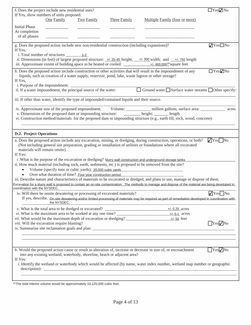
Page 4 of 13
f. Does the project include new residential uses? Yes No If Yes, show numbers of units proposed.
One Family Two Family Three Family Multiple Family (four or more)
Initial Phase ___________ ___________ ____________ ________________________At completion of all phases ___________ ___________ ____________ ________________________
g. Does the proposed action include new non-residential construction (including expansions)? Yes No If Yes,
i. Total number of structures ___________ii. Dimensions (in feet) of largest proposed structure: ________height; ________width; and _______ length
iii. Approximate extent of building space to be heated or cooled: ______________________ square feet
h. Does the proposed action include construction or other activities that will result in the impoundment of any Yes No liquids, such as creation of a water supply, reservoir, pond, lake, waste lagoon or other storage?
If Yes, i. Purpose of the impoundment: ________________________________________________________________________________
ii. If a water impoundment, the principal source of the water: Ground water Surface water streams Other specify:_________________________________________________________________________________________________________
iii. If other than water, identify the type of impounded/contained liquids and their source._________________________________________________________________________________________________________
iv. Approximate size of the proposed impoundment. Volume: ____________ million gallons; surface area: ____________ acres v. Dimensions of the proposed dam or impounding structure: ________ height; _______ length
vi. Construction method/materials for the proposed dam or impounding structure (e.g., earth fill, rock, wood, concrete):________________________________________________________________________________________________________
D.2. Project Operations a. Does the proposed action include any excavation, mining, or dredging, during construction, operations, or both? Yes No
(Not including general site preparation, grading or installation of utilities or foundations where all excavatedmaterials will remain onsite)
If Yes:i .What is the purpose of the excavation or dredging? _______________________________________________________________
ii. How much material (including rock, earth, sediments, etc.) is proposed to be removed from the site?Volume (specify tons or cubic yards): ____________________________________________Over what duration of time? ____________________________________________________
iii. Describe nature and characteristics of materials to be excavated or dredged, and plans to use, manage or dispose of them. ________________________________________________________________________________________________________ ________________________________________________________________________________________________________
iv. Will there be onsite dewatering or processing of excavated materials? Yes No If yes, describe. ___________________________________________________________________________________________ ________________________________________________________________________________________________________
v. What is the total area to be dredged or excavated? _____________________________________acresvi. What is the maximum area to be worked at any one time? _______________________________ acres
vii. What would be the maximum depth of excavation or dredging? __________________________ feetviii. Will the excavation require blasting? Yes No ix. Summarize site reclamation goals and plan: _____________________________________________________________________
________________________________________________________________________________________________________ ________________________________________________________________________________________________________
b. Would the proposed action cause or result in alteration of, increase or decrease in size of, or encroachment Yes No into any existing wetland, waterbody, shoreline, beach or adjacent area?
If Yes: i. Identify the wetland or waterbody which would be affected (by name, water index number, wetland map number or geographic
description): _______________________________________________________________________________________________________________________________________________________________________________________________________
**The total interior volume would be approximately 10,125,000 cubic feet.
✔
✔
1-2+/- 25-45 +/- 300 +/- 750
+/- 460,000*
✔
✔
Slurry wall construction and underground storage tanks
20,000 cubic yardsFour-year construction period
Excavation for a slurry wall is proposed to contain an on-site contamination. The methods to manage and dispose of the material are being developed incoordination with the NYSDEC.
✔On-site dewatering and/or limited processing of materials may be required as part of remediation developed in coordination withthe NYSDEC.
+/- 0.25+/- 0.1+/- 50
✔
✔
**T
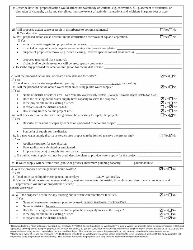
Page 5 of 13
ii. Describe how the proposed action would affect that waterbody or wetland, e.g. excavation, fill, placement of structures, oralteration of channels, banks and shorelines. Indicate extent of activities, alterations and additions in square feet or acres:____________________________________________________________________________________________________________________________________________________________________________________________________________________________________________________________________________________________________________________________________________________________________________________________________________________________________
iii. Will proposed action cause or result in disturbance to bottom sediments? Yes NoIf Yes, describe: __________________________________________________________________________________________
iv. Will proposed action cause or result in the destruction or removal of aquatic vegetation? Yes No If Yes:
a of vegetation proposed to be removed ___________________________________________________________ acreage of aquatic vegetation remaining after project completion ________________________________________
purpose of proposed removal (e.g. beach clearing, invasive species control, boat access): ________________________________________________________________________________________________________________________________
proposed method of plant removal: ________________________________________________________________________if chemical/herbicide treatment will be used, specify product(s): _________________________________________________
v. Describe any proposed reclamation/mitigation following disturbance: __________________________________________________________________________________________________________________________________________________________
c. Will the proposed action use, or create a new demand for water? Yes No If Yes:
i. Total anticipated water usage/demand per day: __________________________ gallons/dayii. Will the proposed action obtain water from an existing public water supply? Yes No
If Yes:Name of district or service area: _________________________________________________________________________Does the existing public water supply have capacity to serve the proposal? Yes No Is the project site in the existing district? Yes No Is expansion of the district needed? Yes No Do existing lines serve the project site? Yes No
iii. Will line extension within an existing district be necessary to supply the project? Yes No If Yes:
Describe extensions or capacity expansions proposed to serve this project: ____________________________________________________________________________________________________________________________________________ Source(s) of supply for the district: ________________________________________________________________________
iv. Is a new water supply district or service area proposed to be formed to serve the project site? Yes No If, Yes:
Applicant/sponsor for new district: ________________________________________________________________________Date application submitted or anticipated: __________________________________________________________________Proposed source(s) of supply for new district: _______________________________________________________________
v. If a public water supply will not be used, describe plans to provide water supply for the project: ____________________________________________________________________________________________________________________________________
vi. If water supply will be from wells (public or private), maximum pumping capacity: _______ gallons/minute.
d. Will the proposed action generate liquid wastes? Yes No If Yes:
i. Total anticipated liquid waste generation per day: _______________ gallons/dayii. Nature of liquid wastes to be generated (e.g., sanitary wastewater, industrial; if combination, describe all components and
approximate volumes or proportions of each): ____________________________________________________________________________________________________________________________________________________________________________________________________________________________________________________________________________________
iii. Will the proposed action use any existing public wastewater treatment facilities? Yes No If Yes:
Name of wastewater treatment plant to be used: _____________________________________________________________Name of district: ______________________________________________________________________________________Does the existing wastewater treatment plant have capacity to serve the project? Yes No
Is the project site in the existing district? Yes No Is expansion of the district needed? Yes No
*Based on factors of (1)15 gallons per day (gpd) per employee (NYSDEC Design Standards for Wastewater Treatment Works Intermediate Sized Sewerage Facilities [1998]) anda projected 250 employees using the proposed bus depot daily, and (2) 40 gpd per vehicle for car washes (Environmental Engineering 5th Edition, Salvato et. al. [2003]) and 340projected buses being washed once daily at the proposed bus depot. This estimate represents the projected total daily demand based on these generation factors.**Based on a factor of 15 gpd per employee (NYSDEC Design Standards for Wastewater Treatment Works Intermediate Sized Sewerage Facilities [1998]) and a projected 250employees using the proposed bus depot daily. This estimate represents the projected total daily demand based on these generation factors.
✔
17,350*✔
New York City Water Supply System - Catskill / Delaware Water Distribution Area✔✔
✔✔
✔
✔
✔
3,750**
Sanitary wastewater
✔
Jamaica Wastewater Treatment Plant
Jamaica✔✔
✔
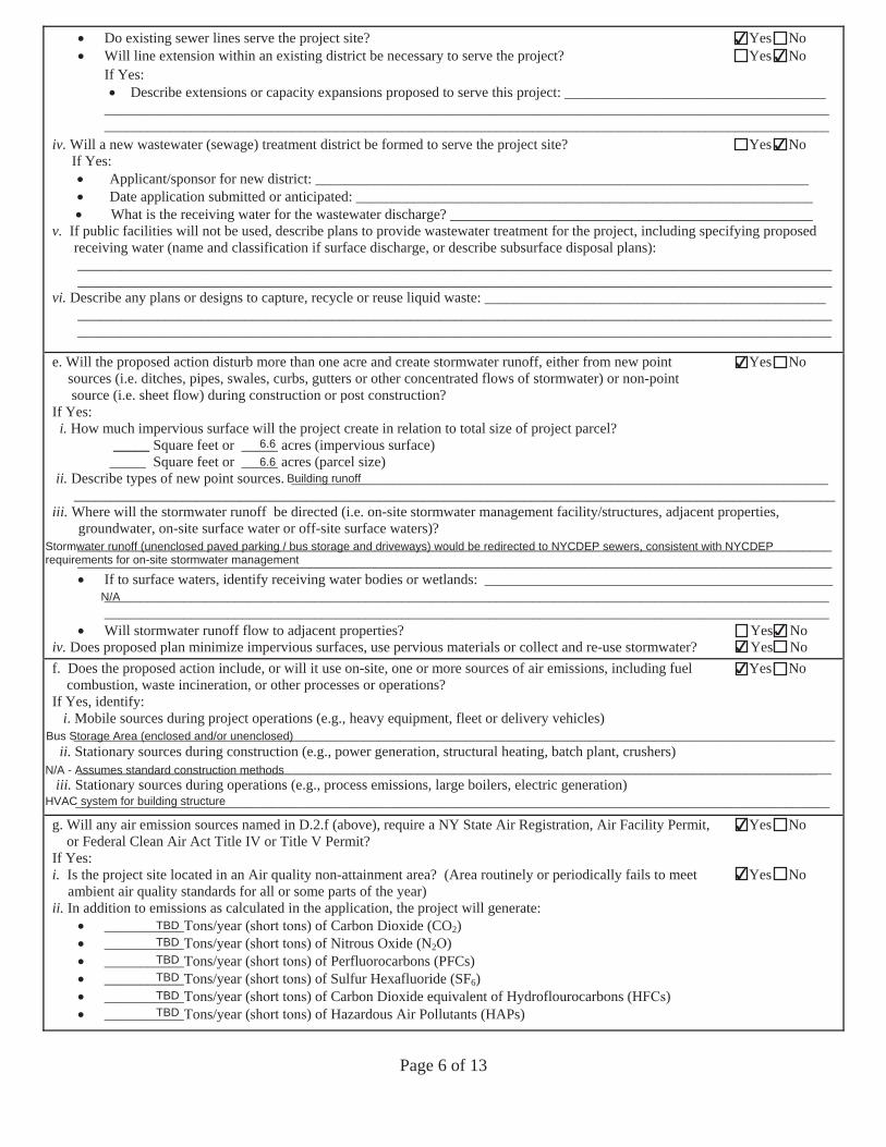
Page 6 of 13
Do existing sewer lines serve the project site? Yes No Will line extension within an existing district be necessary to serve the project? Yes No If Yes:
Describe extensions or capacity expansions proposed to serve this project: ________________________________________________________________________________________________________________________________________ ____________________________________________________________________________________________________
iv. Will a new wastewater (sewage) treatment district be formed to serve the project site? Yes No If Yes:
Applicant/sponsor for new district: ____________________________________________________________________Date application submitted or anticipated: _______________________________________________________________What is the receiving water for the wastewater discharge? __________________________________________________
v. If public facilities will not be used, describe plans to provide wastewater treatment for the project, including specifying proposed receiving water (name and classification if surface discharge, or describe subsurface disposal plans): ________________________________________________________________________________________________________ ________________________________________________________________________________________________________
vi. Describe any plans or designs to capture, recycle or reuse liquid waste: _______________________________________________ ________________________________________________________________________________________________________ ________________________________________________________________________________________________________
e. Will the proposed action disturb more than one acre and create stormwater runoff, either from new point Yes No sources (i.e. ditches, pipes, swales, curbs, gutters or other concentrated flows of stormwater) or non-point
source (i.e. sheet flow) during construction or post construction? If Yes:
i. How much impervious surface will the project create in relation to total size of project parcel?_____ Square feet or _____ acres (impervious surface)
_____ Square feet or _____ acres (parcel size) ii. Describe types of new point sources. __________________________________________________________________________
_________________________________________________________________________________________________________iii. Where will the stormwater runoff be directed (i.e. on-site stormwater management facility/structures, adjacent properties,
groundwater, on-site surface water or off-site surface waters)? ________________________________________________________________________________________________________
________________________________________________________________________________________________________ If to surface waters, identify receiving water bodies or wetlands: ________________________________________________________________________________________________________________________________________________________________________________________________________________________________________________________Will stormwater runoff flow to adjacent properties? Yes No
iv. Does proposed plan minimize impervious surfaces, use pervious materials or collect and re-use stormwater? Yes No f. Does the proposed action include, or will it use on-site, one or more sources of air emissions, including fuel Yes No
combustion, waste incineration, or other processes or operations?If Yes, identify:
i. Mobile sources during project operations (e.g., heavy equipment, fleet or delivery vehicles)_________________________________________________________________________________________________________
ii. Stationary sources during construction (e.g., power generation, structural heating, batch plant, crushers)________________________________________________________________________________________________________
iii. Stationary sources during operations (e.g., process emissions, large boilers, electric generation)________________________________________________________________________________________________________
g. Will any air emission sources named in D.2.f (above), require a NY State Air Registration, Air Facility Permit, Yes No or Federal Clean Air Act Title IV or Title V Permit?
If Yes:i. Is the project site located in an Air quality non-attainment area? (Area routinely or periodically fails to meet Yes No
ambient air quality standards for all or some parts of the year)ii. In addition to emissions as calculated in the application, the project will generate:
___________Tons/year ( ) of Carbon Dioxide (CO2)___________Tons/year ( ) of Nitrous Oxide (N2 )___________Tons/year ( ) of Perfluorocarbons (PFCs)___________Tons/year ( ) of Sulfur Hexafluoride (SF6)___________Tons/year ( ) of Carbon Dioxide equivalent of Hydroflo rocarbons (H )___________Tons/year ( ) of Hazardous Air Pollutants (HAPs)
✔✔
✔
✔
6.66.6
Building runoff
Stormwater runoff (unenclosed paved parking / bus storage and driveways) would be redirected to NYCDEP sewers, consistent with NYCDEPrequirements for on-site stormwater management
N/A
✔✔
✔
Bus Storage Area (enclosed and/or unenclosed)
N/A - Assumes standard construction methods
HVAC system for building structure
✔
✔
TBDTBDTBDTBDTBDTBD
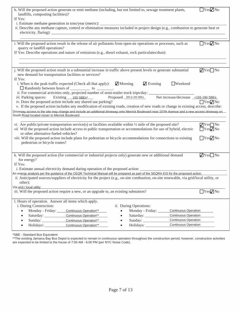
Page 7 of 13
h. Will the proposed action generate or emit methane (including, but not limited to, sewage treatment plants, Yes No landfills, composting facilities)?
If Yes:i. Estimate methane generation in tons/year (metric): ________________________________________________________________
ii. Describe any methane capture, control or elimination measures included in project design (e.g., combustion to generate heat orelectricity, flaring): _________________________________________________________________________________________________________________________________________________________________________________________________
i. Will the proposed action result in the release of air pollutants from open-air operations or processes, such as Yes No quarry or landfill operations?
If Yes: Describe operations and nature of emissions (e.g., diesel exhaust, rock particulates/dust): _________________________________________________________________________________________________________ _________________________________________________________________________________________________________
j. Will the proposed action result in a substantial increase in traffic above present levels or generate substantial Yes No new demand for transportation facilities or services?
If Yes:i. When is the peak traffic expected (Check all that apply): Morning Evening Weekend
Randomly between hours of __________ to ________.ii. For commercial activities only, projected number of semi-trailer truck trips/day: _______________________
iii. Parking spaces: Existing _____________ Proposed ___________ Net increase/decrease _____________iv. Does the proposed action include any shared use parking? Yes No v. If the proposed action includes any modification of existing roads, creation of new roads or change in existing access, describe:
________________________________________________________________________________________________________________________________________________________________________________________________________________________________________________________________________________________________________________________
vi. Are public/private transportation service(s) or facilities available within ½ mile of the proposed site? Yes No vii Will the proposed action include access to public transportation or accommodations for use of hybrid, electric Yes No
or other alternative fueled vehicles? viii. Will the proposed action include plans for pedestrian or bicycle accommodations for connections to existing Yes No
pedestrian or bicycle routes?
k. Will the proposed action (for commercial or industrial projects only) generate new or additional demand Yes No for energy?
If Yes:i. Estimate annual electricity demand during operation of the proposed action: ____________________________________________
_________________________________________________________________________________________________________ii. Anticipated sources/suppliers of electricity for the project (e.g., on-site combustion, on-site renewable, via grid/local utility, or
other):________________________________________________________________________________________________________
iii. Will the proposed action require a new, or an upgrade to, an existing substation? Yes No
l. Hours of operation. Answer all items which apply.i. During Construction: ii. During Operations:
Monday - Friday: _________________________ Monday - Friday: ____________________________Saturday: ________________________________ Saturday: ___________________________________Sunday: _________________________________ Sunday: ____________________________________Holidays: ________________________________ Holidays: ___________________________________
*SBE - Standard Bus Equivalent**The existing Jamaica Bay Bus Depot is expected to remain in continuous operation throughout the construction period; however, construction activitiesare expected to be limited to the house of 7:00 AM - 6:00 PM (per NYC Noise Code).
✔
✔
✔
✔ ✔
150 SBEs* 305 to 340 SBEs +155-190 SBEs✔
Driveway access to the site may change and include an additional driveway onto Merrick Boulevard near 107th Avenue and a new access driveway onSouth Road located closer to Merrick Boulevard
✔✔
✔
✔
An energy analysis per the guidance of the CEQR Technical Manual will be prepared as part of the SEQRA EIS for the proposed action.
Via grid / local utility✔
Continuous Operation**Continuous Operation**Continuous Operation**Continuous Operation**
Continuous OperationContinuous OperationContinuous OperationContinuous Operation
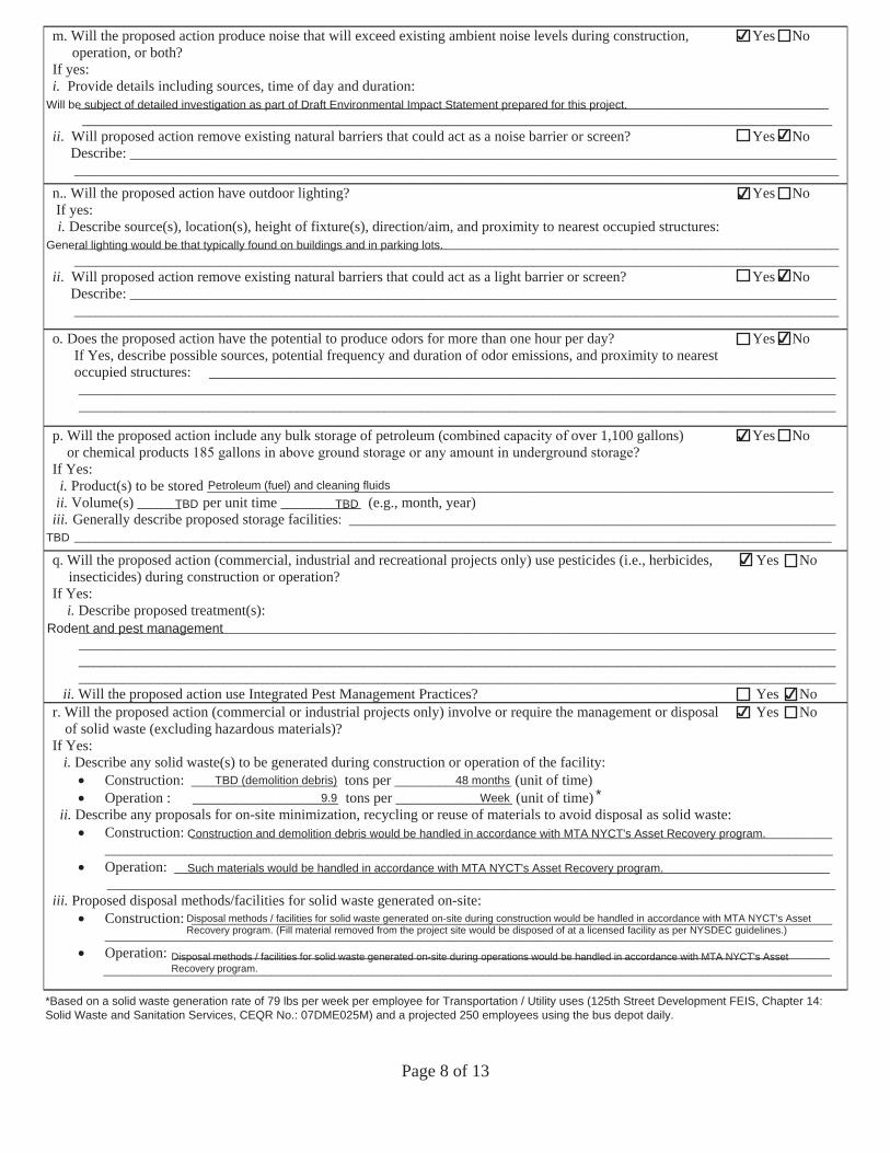
Page 8 of 13
m. Will the proposed action produce noise that will exceed existing ambient noise levels during construction, Yes No operation, or both?
If yes: i. Provide details including sources, time of day and duration:
_______________________________________________________________________________________________________ _______________________________________________________________________________________________________
ii. Will proposed action remove existing natural barriers that could act as a noise barrier or screen? Yes No Describe: _________________________________________________________________________________________________ _________________________________________________________________________________________________________
n.. Will the proposed action have outdoor lighting? Yes No If yes: i. Describe source(s), location(s), height of fixture(s), direction/aim, and proximity to nearest occupied structures:
_________________________________________________________________________________________________________ _________________________________________________________________________________________________________
ii. Will proposed action remove existing natural barriers that could act as a light barrier or screen? Yes No Describe: _________________________________________________________________________________________________ _________________________________________________________________________________________________________
o. Does the proposed action have the potential to produce odors for more than one hour per day? Yes No If Yes, describe possible sources, potential frequency and duration of odor emissions, and proximity to nearest occupied structures: ______________________________________________________________________________________
________________________________________________________________________________________________________ ________________________________________________________________________________________________________
p. Yes No Will the proposed action include any bulk storage of petroleum ( over 1,100 gallons) or chemical products ?
If Yes: i. Product(s) to be stored ______________________________________________________________________________________
ii. Volume(s) ______ per unit time ___________ (e.g., month, year)iii. Generally describe proposed storage facilities ___________________________________________________________________
________________________________________________________________________________________________________
q. Will the proposed action (commercial, industrial and recreational projects only) use pesticides (i.e., herbicides, Yes No insecticides) during construction or operation?
If Yes:i. Describe proposed treatment(s):
________________________________________________________________________________________________________________________________________________________________________________________________________________________________________________________________________________________________________________________________________________________________________________________________________________________________
ii. Will the proposed action use Integrated Pest Management Practices? Yes No r. Will the proposed action (commercial or industrial projects only) involve or require the management or disposal Yes No
of solid waste (excluding hazardous materials)?If Yes:
i. Describe any solid waste(s) to be generated during construction or operation of the facility:Construction: ____________________ tons per ________________ (unit of time)Operation : ____________________ tons per ________________ (unit of time)
ii. Describe any proposals for on-site minimization, recycling or reuse of materials to avoid disposal as solid waste:Construction: ____________________________________________________________________________________________________________________________________________________________________________________________Operation: ______________________________________________________________________________________________________________________________________________________________________________________________
iii. Proposed disposal methods/facilities for solid waste generated on-site:Construction: ____________________________________________________________________________________________________________________________________________________________________________________________Operation: ______________________________________________________________________________________________________________________________________________________________________________________________
*Based on a solid waste generation rate of 79 lbs per week per employee for Transportation / Utility uses (125th Street Development FEIS, Chapter 14:Solid Waste and Sanitation Services, CEQR No.: 07DME025M) and a projected 250 employees using the bus depot daily.
*
✔
Will be subject of detailed investigation as part of Draft Environmental Impact Statement prepared for this project.
✔
✔
General lighting would be that typically found on buildings and in parking lots.
✔
✔
✔
Petroleum (fuel) and cleaning fluidsTBD TBD
TBD
✔
Rodent and pest management
✔✔
TBD (demolition debris)9.9
48 monthsWeek
Construction and demolition debris would be handled in accordance with MTA NYCT's Asset Recovery program.
Such materials would be handled in accordance with MTA NYCT's Asset Recovery program.
Disposal methods / facilities for solid waste generated on-site during construction would be handled in accordance with MTA NYCT's AssetRecovery program. (Fill material removed from the project site would be disposed of at a licensed facility as per NYSDEC guidelines.)
Disposal methods / facilities for solid waste generated on-site during operations would be handled in accordance with MTA NYCT's AssetRecovery program.
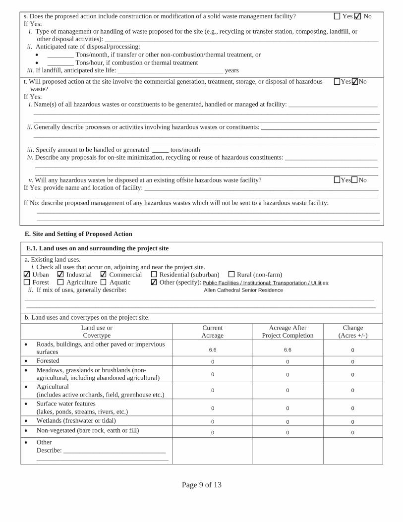
Page 9 of 13
s. Does the proposed action include construction or modification of a solid waste management facility? Yes No If Yes:
i. Type of management or handling of waste proposed for the site (e.g., recycling or transfer station, composting, landfill, orother disposal activities): ___________________________________________________________________________________
ii. Anticipated rate of disposal/processing:________ Tons/month, if transfer or other non-combustion/thermal treatment, or________ Tons/hour, if combustion or thermal treatment
iii. If landfill, anticipated site life: ________________________________ years
t. Will proposed action at the site involve the commercial generation, treatment, storage, or disposal of hazardous Yes No waste?
If Yes:i. Name(s) of all hazardous wastes or constituents to be generated, handled or managed at facility: ___________________________
__________________________________________________________________________________________________________________________________________________________________________________________________________________
ii. Generally describe processes or activities involving hazardous wastes or constituents: ____________________________________________________________________________________________________________________________________________________________________________________________________________________________________________________
iii. Specify amount to be handled or generated _____ tons/monthiv. Describe any proposals for on-site minimization, recycling or reuse of hazardous constituents: ____________________________
________________________________________________________________________________________________________________________________________________________________________________________________________________
v. Will any hazardous wastes be disposed at an existing offsite hazardous waste facility? Yes No If Yes: provide name and location of facility: _______________________________________________________________________ ________________________________________________________________________________________________________ If No: describe proposed management of any hazardous wastes which will not be sent to a hazardous waste facility:
________________________________________________________________________________________________________ ________________________________________________________________________________________________________
E. Site and Setting of Proposed Action
E.1. Land uses on and surrounding the project site
a. Existing land uses.i. Check all uses that occur on, adjoining and near the project site.
Urban Industrial Commercial Residential (suburban) Rural (non-farm) Forest Agriculture Aquatic Other (specify): ____________________________________ ii. If mix of uses, generally describe:
__________________________________________________________________________________________________________ __________________________________________________________________________________________________________
b. Land uses and covertypes on the project site.Land use or Covertype
Current Acreage
Acreage After Project Completion
Change (Acres +/-)
Roads, buildings, and other paved or impervioussurfacesForestedMeadows, grasslands or brushlands (non-agricultural, including abandoned agricultural)Agricultural(includes active orchards, field, greenhouse etc.) Surface water features(lakes, ponds, streams, rivers, etc.) Wetlands (freshwater or tidal)Non-vegetated (bare rock, earth or fill)
OtherDescribe: _______________________________ ________________________________________
Allen Cathedral Senior Residence
✔
✔
✔ ✔ ✔✔ Public Facilities / Institutional; Transportation / Utilities;
6.6 6.6 0
0 0 0
0 0 0
0 0 0
0 0 0
0 0 0
0 0 0
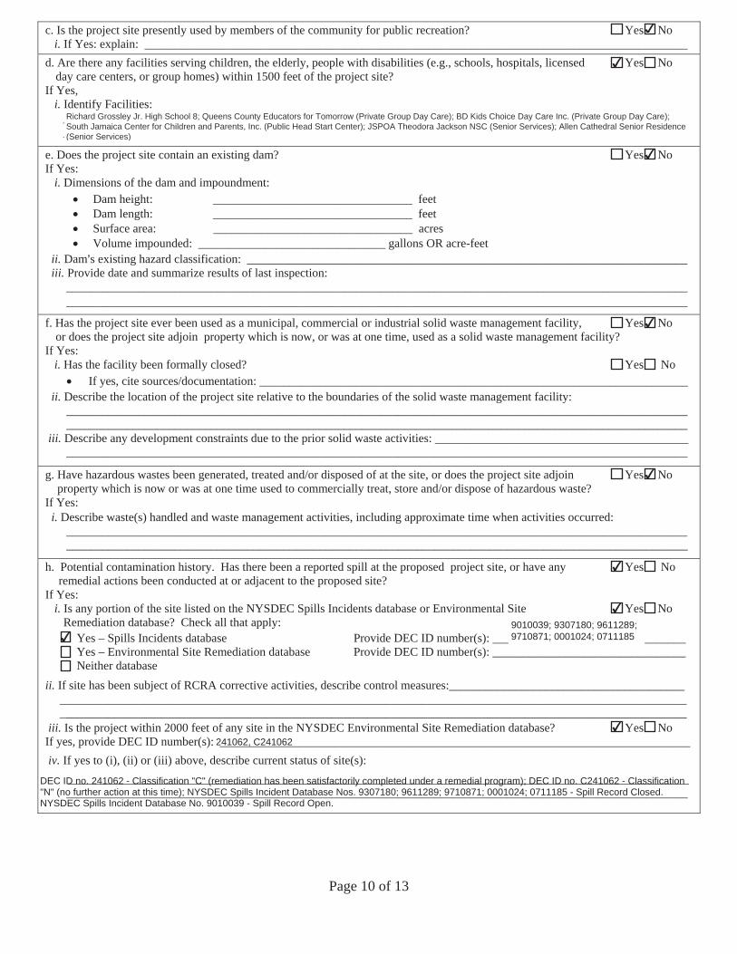
Page 10 of 13
c. Is the project site presently used by members of the community for public recreation? Yes No i. If Yes: explain: __________________________________________________________________________________________
d. Are there any facilities serving children, the elderly, people with disabilities (e.g., schools, hospitals, licensed Yes No day care centers, or group homes) within 1500 feet of the project site?
If Yes, i. Identify Facilities:
________________________________________________________________________________________________________________________________________________________________________________________________________________
e. Does the project site contain an existing dam? Yes No If Yes:
i. Dimensions of the dam and impoundment:Dam height: _________________________________ feet Dam length: _________________________________ feet Surface area: _________________________________ acres Volume impounded: _______________________________ gallons OR acre-feet
ii. Dam=s existing hazard classification: _________________________________________________________________________iii. Provide date and summarize results of last inspection:
_______________________________________________________________________________________________________ _______________________________________________________________________________________________________
f. Has the project site ever been used as a municipal, commercial or industrial solid waste management facility, Yes No or does the project site adjoin property which is now, or was at one time, used as a solid waste management facility?
If Yes:i. Has the facility been formally closed? Yes No
If yes, cite sources/documentation: _______________________________________________________________________ii. Describe the location of the project site relative to the boundaries of the solid waste management facility:
______________________________________________________________________________________________________________________________________________________________________________________________________________
iii. Describe any development constraints due to the prior solid waste activities: _________________________________________________________________________________________________________________________________________________
g. Have hazardous wastes been generated, treated and/or disposed of at the site, or does the project site adjoin Yes Noproperty which is now or was at one time used to commercially treat, store and/or dispose of hazardous waste?
If Yes:i. Describe waste(s) handled and waste management activities, including approximate time when activities occurred:
_______________________________________________________________________________________________________ _______________________________________________________________________________________________________
h. Potential contamination history. Has there been a reported spill at the proposed project site, or have any Yes No remedial actions been conducted at or adjacent to the proposed site?
If Yes: i. Is any portion of the site listed on the NYSDEC Spills Incidents database or Environmental Site Yes No
Remediation database? Check all that apply: Yes – Spills Incidents database Provide DEC ID number(s): ________________________________ Yes – Environmental Site Remediation database Provide DEC ID number(s): ________________________________ Neither database
ii. If site has been subject of RCRA corrective activities, describe control measures:_______________________________________________________________________________________________________________________________________________________________________________________________________________________________________________________
iii. Is the project within 2000 feet of any site in the NYSDEC Environmental Site Remediation database? Yes No If yes, provide DEC ID number(s): ______________________________________________________________________________ iv. If yes to (i), (ii) or (iii) above, describe current status of site(s):
_______________________________________________________________________________________________________ _______________________________________________________________________________________________________
9010039; 9307180; 9611289;9710871; 0001024; 0711185
Richard Grossley Jr. High School 8; Queens County Educators for Tomorrow (Private Group Day Care); BD Kids Choice Day Care Inc. (Private Group Day Care);South Jamaica Center for Children and Parents, Inc. (Public Head Start Center); JSPOA Theodora Jackson NSC (Senior Services); Allen Cathedral Senior Residence(Senior Services)
✔
✔
✔
✔
✔
✔
✔
✔
✔241062, C241062
DEC ID no. 241062 - Classification "C" (remediation has been satisfactorily completed under a remedial program); DEC ID no. C241062 - Classification"N" (no further action at this time); NYSDEC Spills Incident Database Nos. 9307180; 9611289; 9710871; 0001024; 0711185 - Spill Record Closed.NYSDEC Spills Incident Database No. 9010039 - Spill Record Open.
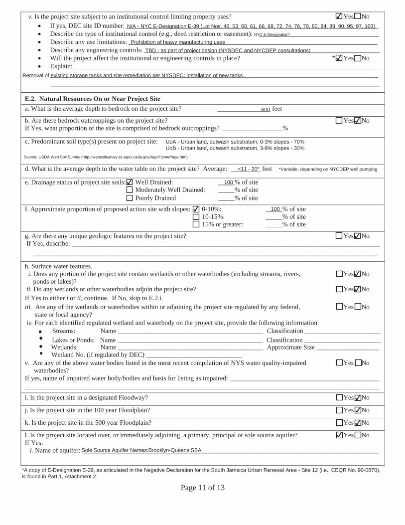
Page 11 of 13
v. Is the project site subject to an institutional control limiting property uses? Yes No If yes, DEC site ID number: ____________________________________________________________________________Describe the type of institutional control (e.g., deed restriction or easement): ____________________________________Describe any use limitations: ___________________________________________________________________________Describe any engineering controls: _______________________________________________________________________Will the project affect the institutional or engineering controls in place? Yes No Explain: _______________________________________________________________________________________________________________________________________________________________________________________________
___________________________________________________________________________________________________
E.2. Natural Resources On or Near Project Site a. What is the average depth to bedrock on the project site? ________________ feet
b. Are there bedrock outcroppings on the project site? Yes No If Yes, what proportion of the site is comprised of bedrock outcroppings? __________________%
c. Predominant soil type(s) present on project site: ___________________________ __________% ___________________________ __________% ____________________________ __________%
d. What is the average depth to the water table on the project site? Average: _________ feet
e. Drainage status of project site soils: Well Drained: _____% of ite Moderately Well Drained: _____% of site Poorly Drained _____% of ite
f. Approximate proportion of proposed action site with slopes: 0-10%: _____% of site 10-15%: _____% of site 15% or greater: _____% of site
g. Are there any unique geologic features on the project site? Yes No If Yes, describe: _____________________________________________________________________________________________
________________________________________________________________________________________________________
h. Surface water features.i. Does any portion of the project site contain wetlands or other waterbodies (including streams, rivers, Yes No
ponds or lakes)?ii. Do any wetlands or other waterbodies adjoin the project site? Yes No
If Yes to either i or ii, continue. If No, skip to E.2.i. iii. Are any of the wetlands or waterbodies within or adjoining the project site regulated by any federal, Yes No
state or local agency? iv. For each identified wetland and waterbody on the project site, provide the following information
Streams: Name ____________________________________________ Classification _______________________ Lakes or Ponds: Name ____________________________________________ Classification _______________________Wetlands: Name ____________________________________________ Approximate Size ___________________ Wetland No. (if regulated by DEC) _____________________________
v. Are any of the above water bodies listed in the most recent compilation of NYS water quality-impaired Yes No waterbodies?
If yes, name of impaired water body/bodies and basis for listing as impaired: _____________________________________________ ___________________________________________________________________________________________________________
i. Is the project site in a designated Floodway? Yes No
j. Is the project site in the 100 year Floodplain? Yes No
k. Is the project site in the 500 year Floodplain? Yes No
l. Is the project site located over, or immediately adjoining, a primary, principal or sole source aquifer? Yes No If Yes:
i. Name of aquifer: _________________________________________________________________________________________
*
*Variable, depending on NYCDEP well pumping
*A copy of E-Designation E-39, as articulated in the Negative Declaration for the South Jamaica Urban Renewal Area - Site 12 (i.e., CEQR No. 90-0870),is found in Part 1, Attachment 2.
✔
N/A - NYC E-Designation E-39 (Lot Nos. 46, 53, 60, 61, 66, 68, 72, 74, 76, 79, 80, 84, 89, 90, 95, 97, 103)NYC E-Designation*
Prohibition of heavy manufacturing usesTBD - as part of project design (NYSDEC and NYCDEP consultations)
✔
Removal of existing storage tanks and site remediation per NYSDEC; installation of new tanks.
600
✔
Urban Land (UoA, UoB) 100
<11 - 20*
✔ 100
✔ 100
✔
✔
✔
✔
✔
✔
✔
Sole Source Aquifer Names:Brooklyn-Queens SSA
UoA - Urban land, outwash substratum, 0-3% slopes - 70%UoB - Urban land, outwash substratum, 3-8% slopes - 30%
Source: USDA Web Soil Survey (http://websoilsurvey.sc.egov.usda.gov/App/HomePage.htm)
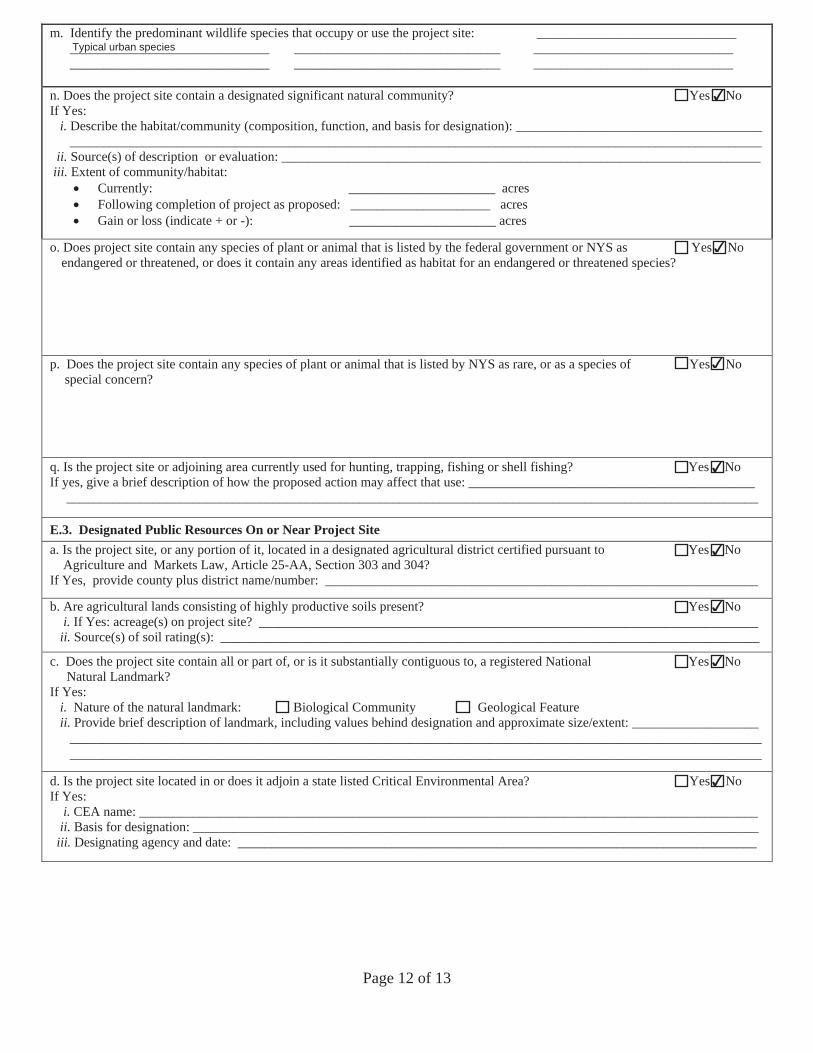
Page 12 of 13
m. Identify the predominant wildlife species that occupy or use the project site: ______________________________ ______________________________ _______________________________ ______________________________ ______________________________ _______________________________ ______________________________
n. Does the project site contain a designated significant natural community? Yes No If Yes:
i. Describe the habitat/community (composition, function, and basis for designation): _____________________________________ ________________________________________________________________________________________________________
ii. Source(s) of description or evaluation: ________________________________________________________________________iii. Extent of community/habitat:
Currently: ______________________ acres Following completion of project as proposed: _____________________ acresGain or loss (indicate + or -): ______________________ acres
o. Does project site contain any species of plant or animal that is listed by the federal government or NYS as Yes No endangered or threatened, or does it contain any areas identified as habitat for an endangered or threatened species?
p. Does the project site contain any species of plant or animal that is listed by NYS as rare, or as a species of Yes Nospecial concern?
q. Is the project site or adjoining area currently used for hunting, trapping, fishing or shell fishing? Yes No If yes, give a brief description of how the proposed action may affect that use: ___________________________________________
________________________________________________________________________________________________________
E.3. Designated Public Resources On or Near Project Site a. Is the project site, or any portion of it, located in a designated agricultural district certified pursuant to Yes No
Agriculture and Markets Law, Article 25-AA, Section 303 and 304?If Yes, provide county plus district name/number: _________________________________________________________________
b. Are agricultural lands consisting of highly productive soils present? Yes No i. If Yes: acreage(s) on project site? ___________________________________________________________________________
ii. Source(s) of soil rating(s): _________________________________________________________________________________
c. Does the project site contain all or part of, or is it substantially contiguous to, a registered National Yes No Natural Landmark?
If Yes:i. Nature of the natural landmark: Biological Community Geological Featureii. Provide brief description of landmark, including values behind designation and approximate size/extent: ___________________
________________________________________________________________________________________________________ ________________________________________________________________________________________________________
d. Is the project site located in or does it adjoin a state listed Critical Environmental Area? Yes No If Yes:
i. CEA name: _____________________________________________________________________________________________ii. Basis for designation: _____________________________________________________________________________________
iii. Designating agency and date: ______________________________________________________________________________
Typical urban species
✔
✔
✔
✔
✔
✔
✔
✔
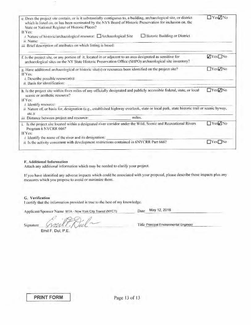

EEAF Mapper Summary Report Tuesday, March 29, 2016 12:00 PM
Disclaimer: The EAF Mapper is a screening tool intended to assist project sponsors and reviewing agencies in preparing an environmental assessment form (EAF). Not all questions asked in the EAF are answered by the EAF Mapper. Additional information on any EAF question can be obtained by consulting the EAF Workbooks. Although the EAF Mapper provides the most up-to-date digital data available to DEC, you may also need to contact local or other data sources in order to obtain data not provided by the Mapper. Digital data is not a substitute for agency determinations.
B.i.i [Coastal or Waterfront Area] No
B.i.ii [Local Waterfront Revitalization Area] Yes
C.2.b. [Special Planning District] Digital mapping data are not available or are incomplete. Refer to EAF Workbook.
E.1.h [DEC Spills or Remediation Site - Potential Contamination History]
Digital mapping data are not available or are incomplete. Refer to EAF Workbook.
E.1.h.i [DEC Spills or Remediation Site - Listed]
Digital mapping data are not available or are incomplete. Refer to EAF Workbook.
E.1.h.i [DEC Spills or Remediation Site - Environmental Site Remediation Database]
Digital mapping data are not available or are incomplete. Refer to EAF Workbook.
E.1.h.iii [Within 2,000' of DEC Remediation Site]
Yes
E.1.h.iii [Within 2,000' of DEC Remediation Site - DEC ID]
241062, C241062
E.2.g [Unique Geologic Features] No
E.2.h.i [Surface Water Features] No
E.2.h.ii [Surface Water Features] No
E.2.h.iii [Surface Water Features] No
E.2.h.v [Impaired Water Bodies] No
E.2.i. [Floodway] No
E.2.j. [100 Year Floodplain] No
E.2.k. [500 Year Floodplain] No
E.2.l. [Aquifers] Yes
E.2.l. [Aquifer Names] Sole Source Aquifer Names:Brooklyn-Queens SSA
E.2.n. [Natural Communities] No
1Full Environmental Assessment Form - EAF Mapper Summary Report
E.2.o. [Endangered or Threatened Species] No
E.2.p. [Rare Plants or Animals] No
E.3.a. [Agricultural District] No
E.3.c. [National Natural Landmark] No
E.3.d [Critical Environmental Area] No
E.3.e. [National Register of Historic Places] Digital mapping data are not available or are incomplete. Refer to EAF Workbook.
E.3.f. [Archeological Sites] Yes
E.3.i. [Designated River Corridor] No
2Full Environmental Assessment Form - EAF Mapper Summary Report
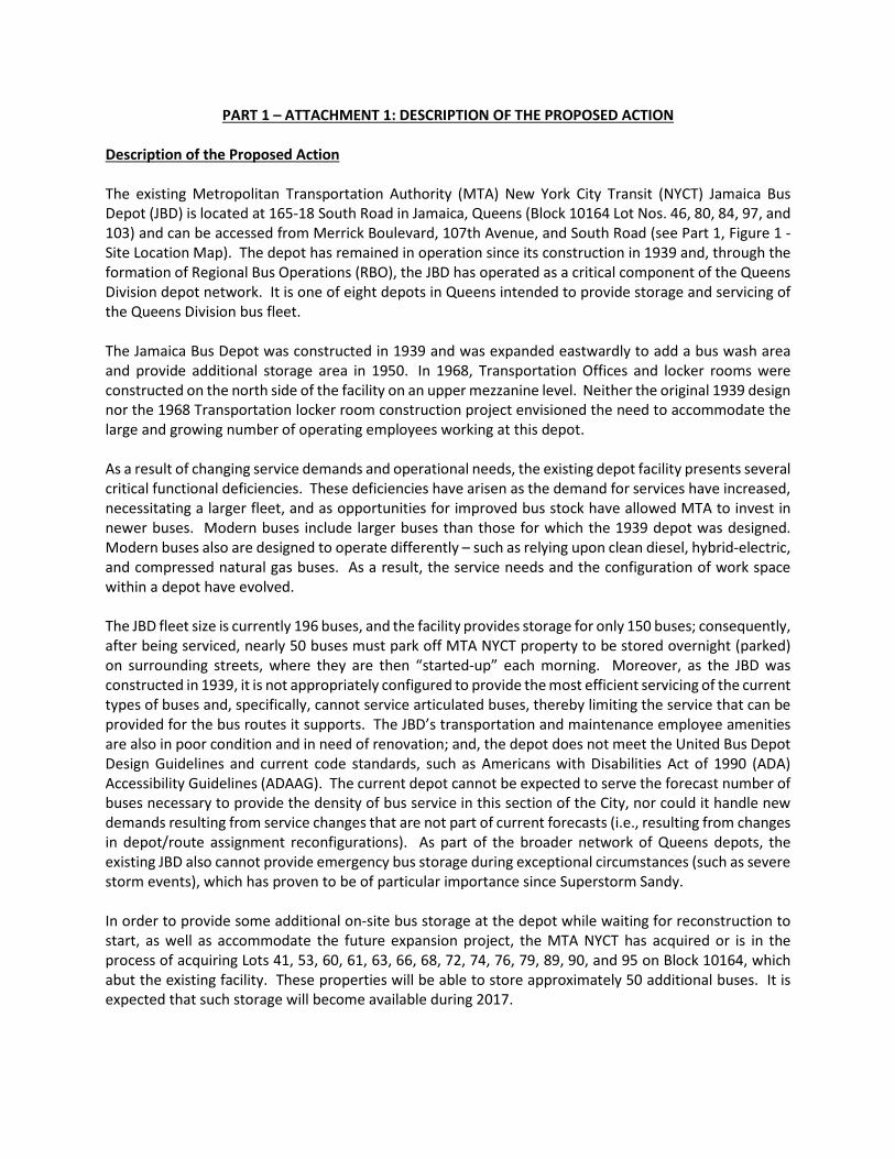
PART 1 – ATTACHMENT 1: DESCRIPTION OF THE PROPOSED ACTION Description of the Proposed Action The existing Metropolitan Transportation Authority (MTA) New York City Transit (NYCT) Jamaica Bus Depot (JBD) is located at 165-18 South Road in Jamaica, Queens (Block 10164 Lot Nos. 46, 80, 84, 97, and 103) and can be accessed from Merrick Boulevard, 107th Avenue, and South Road (see Part 1, Figure 1 - Site Location Map). The depot has remained in operation since its construction in 1939 and, through the formation of Regional Bus Operations (RBO), the JBD has operated as a critical component of the Queens Division depot network. It is one of eight depots in Queens intended to provide storage and servicing of the Queens Division bus fleet. The Jamaica Bus Depot was constructed in 1939 and was expanded eastwardly to add a bus wash area and provide additional storage area in 1950. In 1968, Transportation Offices and locker rooms were constructed on the north side of the facility on an upper mezzanine level. Neither the original 1939 design nor the 1968 Transportation locker room construction project envisioned the need to accommodate the large and growing number of operating employees working at this depot. As a result of changing service demands and operational needs, the existing depot facility presents several critical functional deficiencies. These deficiencies have arisen as the demand for services have increased, necessitating a larger fleet, and as opportunities for improved bus stock have allowed MTA to invest in newer buses. Modern buses include larger buses than those for which the 1939 depot was designed. Modern buses also are designed to operate differently – such as relying upon clean diesel, hybrid-electric, and compressed natural gas buses. As a result, the service needs and the configuration of work space within a depot have evolved. The JBD fleet size is currently 196 buses, and the facility provides storage for only 150 buses; consequently, after being serviced, nearly 50 buses must park off MTA NYCT property to be stored overnight (parked) on surrounding streets, where they are then “started-up” each morning. Moreover, as the JBD was constructed in 1939, it is not appropriately configured to provide the most efficient servicing of the current types of buses and, specifically, cannot service articulated buses, thereby limiting the service that can be provided for the bus routes it supports. The JBD’s transportation and maintenance employee amenities are also in poor condition and in need of renovation; and, the depot does not meet the United Bus Depot Design Guidelines and current code standards, such as Americans with Disabilities Act of 1990 (ADA) Accessibility Guidelines (ADAAG). The current depot cannot be expected to serve the forecast number of buses necessary to provide the density of bus service in this section of the City, nor could it handle new demands resulting from service changes that are not part of current forecasts (i.e., resulting from changes in depot/route assignment reconfigurations). As part of the broader network of Queens depots, the existing JBD also cannot provide emergency bus storage during exceptional circumstances (such as severe storm events), which has proven to be of particular importance since Superstorm Sandy. In order to provide some additional on-site bus storage at the depot while waiting for reconstruction to start, as well as accommodate the future expansion project, the MTA NYCT has acquired or is in the process of acquiring Lots 41, 53, 60, 61, 63, 66, 68, 72, 74, 76, 79, 89, 90, and 95 on Block 10164, which abut the existing facility. These properties will be able to store approximately 50 additional buses. It is expected that such storage will become available during 2017.
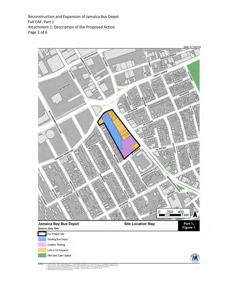
Reconstruction and Expansion of Jamaica Bus Depot Full EAF, Part 1 Attachment 1: Description of the Proposed Action Page 2 of 6
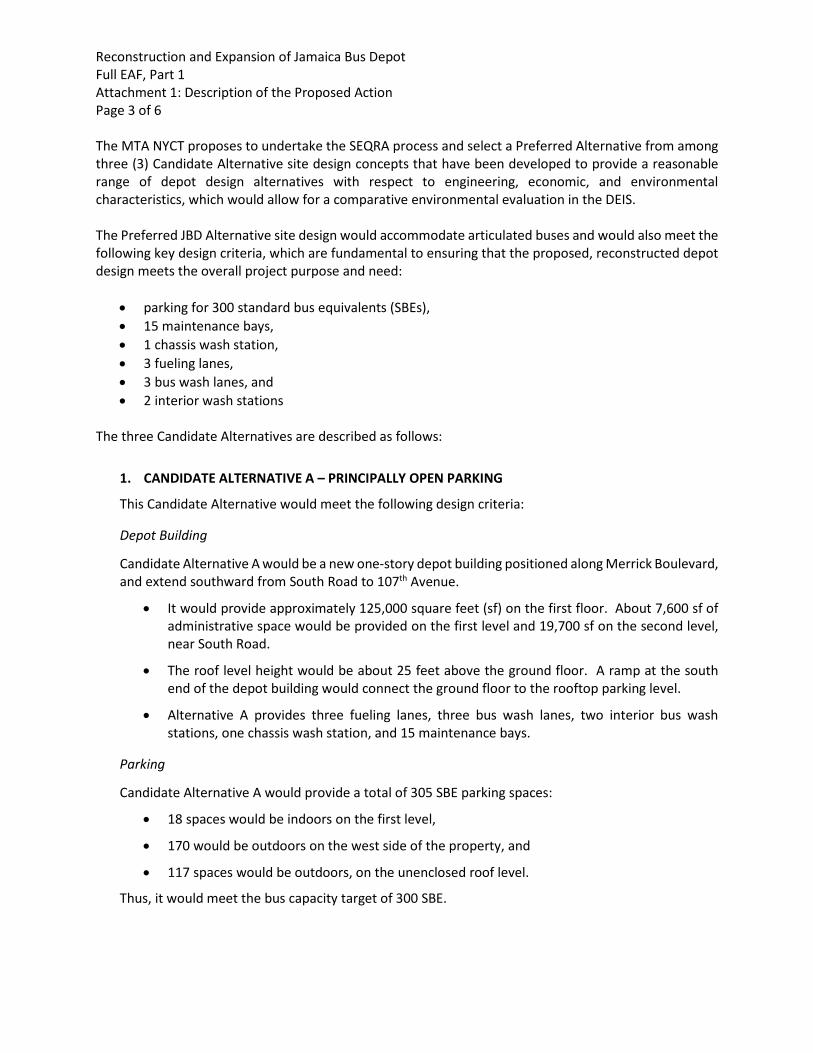
Reconstruction and Expansion of Jamaica Bus Depot Full EAF, Part 1 Attachment 1: Description of the Proposed Action Page 3 of 6
The MTA NYCT proposes to undertake the SEQRA process and select a Preferred Alternative from among three (3) Candidate Alternative site design concepts that have been developed to provide a reasonable range of depot design alternatives with respect to engineering, economic, and environmental characteristics, which would allow for a comparative environmental evaluation in the DEIS.
The Preferred JBD Alternative site design would accommodate articulated buses and would also meet the following key design criteria, which are fundamental to ensuring that the proposed, reconstructed depot design meets the overall project purpose and need:
• parking for 300 standard bus equivalents (SBEs),• 15 maintenance bays,• 1 chassis wash station,• 3 fueling lanes,• 3 bus wash lanes, and• 2 interior wash stations
The three Candidate Alternatives are described as follows:
1. CANDIDATE ALTERNATIVE A – PRINCIPALLY OPEN PARKING
This Candidate Alternative would meet the following design criteria:
Depot Building
Candidate Alternative A would be a new one-story depot building positioned along Merrick Boulevard, and extend southward from South Road to 107th Avenue.
• It would provide approximately 125,000 square feet (sf) on the first floor. About 7,600 sf ofadministrative space would be provided on the first level and 19,700 sf on the second level,near South Road.
• The roof level height would be about 25 feet above the ground floor. A ramp at the southend of the depot building would connect the ground floor to the rooftop parking level.
• Alternative A provides three fueling lanes, three bus wash lanes, two interior bus washstations, one chassis wash station, and 15 maintenance bays.
Parking
Candidate Alternative A would provide a total of 305 SBE parking spaces:
• 18 spaces would be indoors on the first level,
• 170 would be outdoors on the west side of the property, and
• 117 spaces would be outdoors, on the unenclosed roof level.
Thus, it would meet the bus capacity target of 300 SBE.
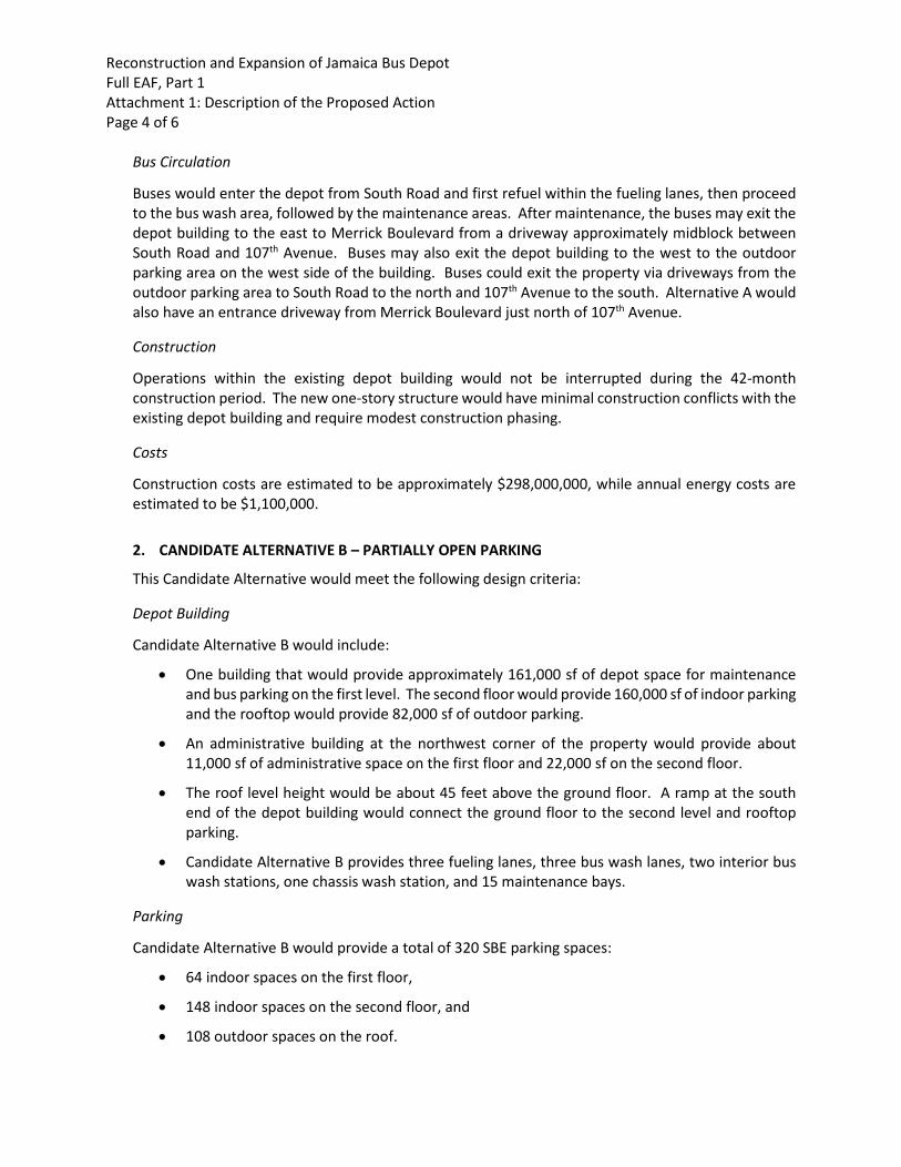
Reconstruction and Expansion of Jamaica Bus Depot Full EAF, Part 1 Attachment 1: Description of the Proposed Action Page 4 of 6
Bus Circulation
Buses would enter the depot from South Road and first refuel within the fueling lanes, then proceed to the bus wash area, followed by the maintenance areas. After maintenance, the buses may exit the depot building to the east to Merrick Boulevard from a driveway approximately midblock between South Road and 107th Avenue. Buses may also exit the depot building to the west to the outdoor parking area on the west side of the building. Buses could exit the property via driveways from the outdoor parking area to South Road to the north and 107th Avenue to the south. Alternative A would also have an entrance driveway from Merrick Boulevard just north of 107th Avenue.
Construction
Operations within the existing depot building would not be interrupted during the 42-month construction period. The new one-story structure would have minimal construction conflicts with the existing depot building and require modest construction phasing.
Costs
Construction costs are estimated to be approximately $298,000,000, while annual energy costs are estimated to be $1,100,000.
2. CANDIDATE ALTERNATIVE B – PARTIALLY OPEN PARKING
This Candidate Alternative would meet the following design criteria:
Depot Building
Candidate Alternative B would include:
• One building that would provide approximately 161,000 sf of depot space for maintenance and bus parking on the first level. The second floor would provide 160,000 sf of indoor parking and the rooftop would provide 82,000 sf of outdoor parking.
• An administrative building at the northwest corner of the property would provide about 11,000 sf of administrative space on the first floor and 22,000 sf on the second floor.
• The roof level height would be about 45 feet above the ground floor. A ramp at the south end of the depot building would connect the ground floor to the second level and rooftop parking.
• Candidate Alternative B provides three fueling lanes, three bus wash lanes, two interior bus wash stations, one chassis wash station, and 15 maintenance bays.
Parking
Candidate Alternative B would provide a total of 320 SBE parking spaces:
• 64 indoor spaces on the first floor,
• 148 indoor spaces on the second floor, and
• 108 outdoor spaces on the roof.
Reconstruction and Expansion of Jamaica Bus Depot Full EAF, Part 1 Attachment 1: Description of the Proposed Action Page 5 of 6
Thus, Candidate Alternative B would meet the bus capacity of 300 SBEs and would also provide significant supplementary emergency bus parking capacity on the depot grounds.
Bus Circulation
Buses would enter the depot from South Road and first refuel within the fueling lanes, then proceed to the bus wash area, followed by the maintenance areas. After maintenance, the buses may exit the depot building to the east to Merrick Boulevard from a driveway approximately midblock between South Road and 107th Avenue. Buses may also exit the depot building to the west to access the outdoor emergency bus parking area. Buses would exit the property via driveways from the depot building to South Road to the north. A ramp to the second level and rooftop parking areas is provided at the south end of the building.
Construction
Operations within the existing depot building would not be interrupted during construction. Given the slightly larger building footprint of the new structure, as compared to Candidate Alternative A, and that construction would be undertaken in the space occupied by the existing bus depot building, the construction duration for Alternative B would be expected to be approximately 46 months.
Costs
Construction costs are estimated to be approximately $415,000,000, while annual energy costs are estimated to be $1,500,000.
3. CANDIDATE ALTERNATIVE D – PRINCIPALLY ENCLOSED PARKING
This Candidate Alternative would meet the following design criteria:
Depot Building
Candidate Alternative D would consist of:
• Two buildings, Building A would be situated along Merrick Boulevard and Building B would be located adjacent to and west of Building A. On the first level of the new bus depot Building A would provide 125,000 sf of maintenance space and Building B would provide 103,000 sf of indoor bus parking space. On the second level, Buildings A and B would, respectively, provide 119,000 sf and 88,000 sf of indoor bus parking space.
• An administrative building at the northwest corner of the property would provide about 7,500 sf of administrative space on the first floor, 7,500 sf on the second floor, and 20,000 sf on the third floor.
• The roof level height would be about 45 feet above the ground floor.
• A ramp at the south end of the depot building would connect the first and second levels of the depot building.
• Candidate Alternative D provides three fueling lanes, three bus wash lanes, two interior bus wash stations, one chassis wash station, and 15 maintenance bays.
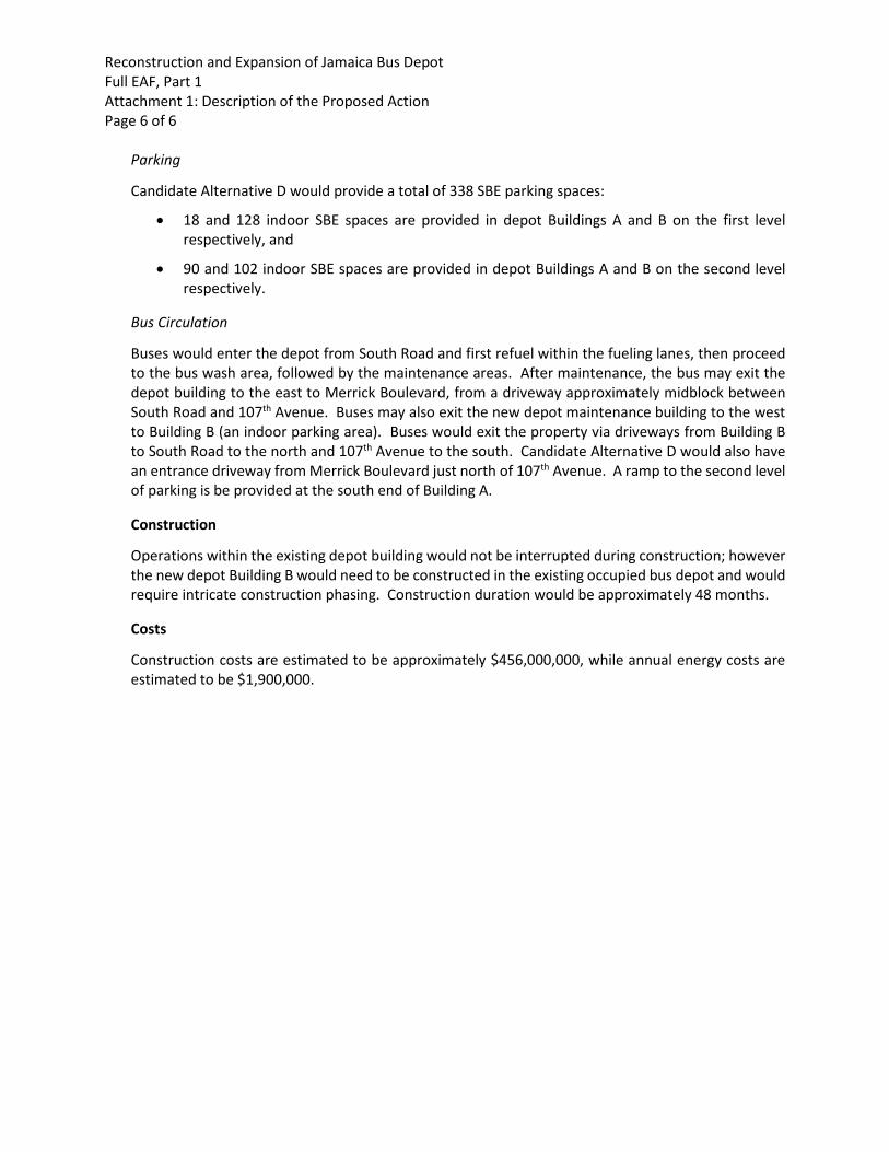
Reconstruction and Expansion of Jamaica Bus Depot Full EAF, Part 1 Attachment 1: Description of the Proposed Action Page 6 of 6
Parking
Candidate Alternative D would provide a total of 338 SBE parking spaces:
• 18 and 128 indoor SBE spaces are provided in depot Buildings A and B on the first level respectively, and
• 90 and 102 indoor SBE spaces are provided in depot Buildings A and B on the second level respectively.
Bus Circulation
Buses would enter the depot from South Road and first refuel within the fueling lanes, then proceed to the bus wash area, followed by the maintenance areas. After maintenance, the bus may exit the depot building to the east to Merrick Boulevard, from a driveway approximately midblock between South Road and 107th Avenue. Buses may also exit the new depot maintenance building to the west to Building B (an indoor parking area). Buses would exit the property via driveways from Building B to South Road to the north and 107th Avenue to the south. Candidate Alternative D would also have an entrance driveway from Merrick Boulevard just north of 107th Avenue. A ramp to the second level of parking is be provided at the south end of Building A.
Construction
Operations within the existing depot building would not be interrupted during construction; however the new depot Building B would need to be constructed in the existing occupied bus depot and would require intricate construction phasing. Construction duration would be approximately 48 months.
Costs
Construction costs are estimated to be approximately $456,000,000, while annual energy costs are estimated to be $1,900,000.
PART 1, ATTACHMENT 2:
E-DESIGNATION E-39 TEXT

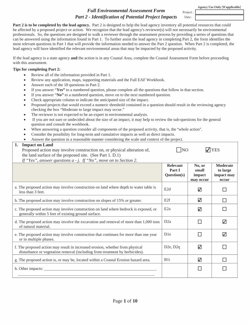
Page 1 of 10
Full Environmental Assessment FormPart 2 - Identification of Potential Project Impacts
Part 2 is to be completed by the lead agency. Part 2 is designed to help the lead agency inventory all potential resources that could be affected by a proposed project or action. We recognize that the lead agency=s reviewer(s) will not necessarily be environmental professionals. So, the questions are designed to walk a reviewer through the assessment process by providing a series of questions that can be answered using the information found in Part 1. To further assist the lead agency in completing Part 2, the form identifies the most relevant questions in Part 1 that will provide the information needed to answer the Part 2 question. When Part 2 is completed, the lead agency will have identified the relevant environmental areas that may be impacted by the proposed activity.
If the lead agency is a state agency and the action is in any Coastal Area, complete the Coastal Assessment Form before proceeding with this assessment. Tips for completing Part 2:
Review all of the information provided in Part 1.Review any application, maps, supporting materials and the Full EAF Workbook.Answer each of the 18 questions in Part 2.If you answer “Yes” to a numbered question, please complete all the questions that follow in that section.If you answer “No” to a numbered question, move on to the next numbered question.Check appropriate column to indicate the anticipated size of the impact.Proposed projects that would exceed a numeric threshold contained in a question should result in the reviewing agencychecking the box “Moderate to large impact may occur.”The reviewer is not expected to be an expert in environmental analysis.If you are not sure or undecided about the size of an impact, it may help to review the sub-questions for the general
question and consult the workbook.When answering a question consider all components of the proposed activity, that is, the Awhole [email protected] the possibility for long-term and cumulative impacts as well as direct impacts.Answer the question in a reasonable manner considering the scale and context of the project.
1. Impact on LandProposed action may involve construction on, or physical alteration of, NO YES the land surface of the proposed site. (See Part 1. D.1)If “Yes”, answer questions a - j. If “No”, move on to Section 2.
Relevant Part I
Question(s)
No, or small
impact may occur
Moderate to large
impact may occur
a. The proposed action may involve construction on land where depth to water table isless than 3 feet.
E2d
b. The proposed action may involve construction on slopes of 15% or greater. E2f
c. The proposed action may involve construction on land where bedrock is exposed, orgenerally within 5 feet of existing ground surface.
E2a
d. The proposed action may involve the excavation and removal of more than 1,000 tonsof natural material.
D2a
e. The proposed action may involve construction that continues for more than one yearor in multiple phases.
D1e
f. The proposed action may result in increased erosion, whether from physicaldisturbance or vegetation removal (including from treatment by herbicides).
D2e, D2q
g. The proposed action is, or may be, located within a Coastal Erosion hazard area. B1i
h. Other impacts: __________________________________________________________________________________________________________________________
✔
✔
✔
✔
✔
✔
✔
✔
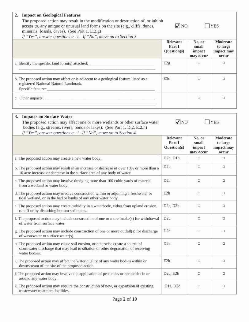
Page 2 of 10
2. Impact on Geological FeaturesThe proposed action may result in the modification or destruction of, or inhibit access to, any unique or unusual land forms on the site (e.g., cliffs, dunes, NO YES minerals, fossils, caves). (See Part 1. E.2.g) If “Yes”, answer questions a - c. If “No”, move on to Section 3.
Relevant Part I
Question(s)
No, or small
impact may occur
Moderate to large
impact may occur
a. Identify the specific land form(s) attached: ________________________________ ___________________________________________________________________
E2g
b. The proposed action may affect or is adjacent to a geological feature listed as a registered National Natural Landmark. Specific feature: _____________________________________________________
E3c
c. Other impacts: ______________________________________________________ ___________________________________________________________________
3. Impacts on Surface WaterThe proposed action may affect one or more wetlands or other surface water NO YES bodies (e.g., streams, rivers, ponds or lakes). (See Part 1. D.2, E.2.h) If “Yes”, answer questions a - l. If “No”, move on to Section 4.
Relevant Part I
Question(s)
No, or small
impact may occur
Moderate to large
impact may occur
a. The proposed action may create a new water body. D2b, D1h
b. The proposed action may result in an increase or decrease of over 10% or more than a 10 acre increase or decrease in the surface area of any body of water.
D2b
c. The proposed action may involve dredging more than 100 cubic yards of material from a wetland or water body.
D2a
d. The proposed action may involve construction within or adjoining a freshwater or tidal wetland, or in the bed or banks of any other water body.
E2h
e. The proposed action may create turbidity in a waterbody, either from upland erosion, runoff or by disturbing bottom sediments.
D2a, D2h
f. The proposed action may include construction of one or more intake(s) for withdrawal of water from surface water.
D2c
g. The proposed action may include construction of one or more outfall(s) for discharge of wastewater to surface water(s).
D2d
h. The proposed action may cause soil erosion, or otherwise create a source of stormwater discharge that may lead to siltation or other degradation of receiving water bodies.
D2e
i. The proposed action may affect the water quality of any water bodies within or downstream of the site of the proposed action.
E2h
j. The proposed action may involve the application of pesticides or herbicides in or around any water body.
D2q, E2h
k. The proposed action may require the construction of new, or expansion of existing, wastewater treatment facilities.
D1a, D2d
✔
✔
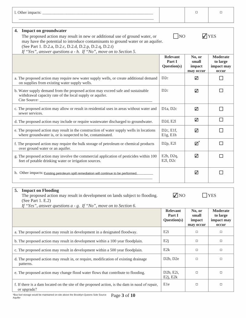
Page 3 of 10
l. Other impacts: __________________________________________________________________________________________________________________________
4. Impact on groundwaterThe proposed action may result in new or additional use of ground water, or NO YES may have the potential to introduce contaminants to ground water or an aquifer. (See Part 1. D.2.a, D.2.c, D.2.d, D.2.p, D.2.q, D.2.t) If “Yes”, answer questions a - h. If “No”, move on to Section 5.
Relevant Part I
Question(s)
No, or small
impact may occur
Moderate to large
impact may occur
a. The proposed action may require new water supply wells, or create additional demandon supplies from existing water supply wells.
D2c
b. Water supply demand from the proposed action may exceed safe and sustainablewithdrawal capacity rate of the local supply or aquifer.Cite Source: ________________________________________________________
D2c
c. The proposed action may allow or result in residential uses in areas without water andsewer services.
D1a, D2c
d. The proposed action may include or require wastewater discharged to groundwater. D2d, E2l
e. The proposed action may result in the construction of water supply wells in locationswhere groundwater is, or is suspected to be, contaminated.
D2c, E1f, E1g, E1h
f. The proposed action may require the bulk storage of petroleum or chemical productsover ground water or an aquifer.
D2p, E2l
g. The proposed action may involve the commercial application of pesticides within 100feet of potable drinking water or irrigation sources.
E2h, D2q, E2l, D2c
h. Other impacts: ________________________________________________________________________________________________________________________
5. Impact on FloodingThe proposed action may result in development on lands subject to flooding. NO YES (See Part 1. E.2)If “Yes”, answer questions a - g. If “No”, move on to Section 6.
Relevant Part I
Question(s)
No, or small
impact may occur
Moderate to large
impact may occur
a. The proposed action may result in development in a designated floodway. E2i
b. The proposed action may result in development within a 100 year floodplain. E2j
c. The proposed action may result in development within a 500 year floodplain. E2k
d. The proposed action may result in, or require, modification of existing drainagepatterns.
D2b, D2e
e. The proposed action may change flood water flows that contribute to flooding. D2b, E2i, E2j, E2k
f. If there is a dam located on the site of the proposed action, dam E1e
*
*Bus fuel storage would be maintained on-site above the Brooklyn-Queens Sole SourceAquifer
✔
✔
✔
✔
✔
✔
✔
✔
Existing petroleum spill remediation will continue to be performed. ✔
✔
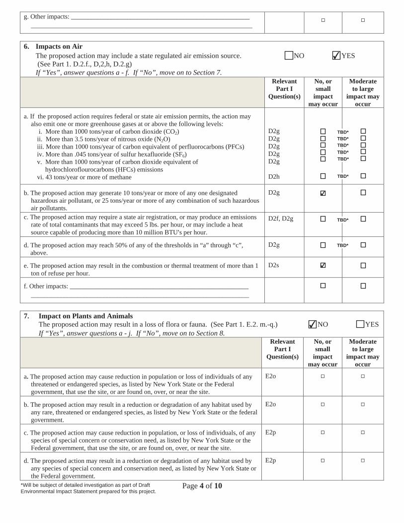
Page 4 of 10
g. Other impacts: _________________________________________________________________________________________________________________________
6. Impacts on AirThe proposed action may include a state regulated air emission source. NO YES (See Part 1. D.2.f., D,2,h, D.2.g) If “Yes”, answer questions a - f. If “No”, move on to Section 7.
Relevant Part I
Question(s)
No, or small
impact may occur
Moderate to large
impact may occur
a. If the proposed action requires federal or state air emission permits, the action mayalso emit one or more greenhouse gases at or above the following levels:
i. More than 1000 tons/year of carbon dioxide (CO2)ii. More than 3.5 tons/year of nitrous oxide (N2 )iii. More than 1000 tons/year of carbon equivalent of perfluorocarbons (PFCs)iv. More than .045 tons/year of sulfur hexafluoride (SF6)v. More than 1000 tons/year of carbon dioxide equivalent of
hydrochlorofl urocarbons (HFCs) emissionsvi. 43 tons/year or more of methane
D2g D2g D2g D2gD2g
D2h
b. The proposed action may generate 10 tons/year or more of any one designatedhazardous air pollutant, or 25 tons/year or more of any combination of such hazardousair pollutants.
D2g
c. The proposed action may require a state air registration, or may produce an emissionsrate of total contaminants that may exceed 5 lbs. per hour, or may include a heatsource capable of producing more than 10 million BTU=s per hour.
D2f, D2g
d. The proposed action may reach 50% of any of the thresholds in “a” through “c”,above.
D
e. The proposed action may result in the combustion or thermal treatment of more than 1ton of refuse per hour.
D2s
f. Other impacts: ________________________________________________________________________________________________________________________
7. Impact on Plants and AnimalsThe proposed action may result in a loss of flora or fauna. (See Part 1. E.2. m.-q.) NO YES If “Yes”, answer questions a - j. If “No”, move on to Section 8.
RelevantPart I
Question(s)
No, or small
impact may occur
Moderate to large
impact may occur
a. The proposed action may cause reduction in population or loss of individuals of anythreatened or endangered species, as listed by New York State or the Federalgovernment, that use the site, or are found on, over, or near the site.
E2o
b. The proposed action may result in a reduction or degradation of any habitat used byany rare, threatened or endangered species, as listed by New York State or the federalgovernment.
E2o
c. The proposed action may cause reduction in population, or loss of individuals, of anyspecies of special concern or conservation need, as listed by New York State or theFederal government, that use the site, or are found on, over, or near the site.
E2p
d. The proposed action may result in a reduction or degradation of any habitat used byany species of special concern and conservation need, as listed by New York State orthe Federal government.
E2p
TBD*
*Will be subject of detailed investigation as part of DraftEnvironmental Impact Statement prepared for this project.
TBD*TBD*TBD*TBD*
TBD*
TBD*
TBD*
✔
✔
✔
✔
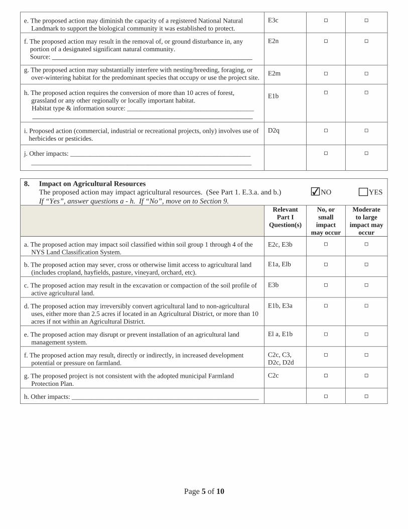
Page 5 of 10
e. The proposed action may diminish the capacity of a registered National NaturalLandmark to support the biological community it was established to protect.
E3c
f. The proposed action may result in the removal of, or ground disturbance in, anyportion of a designated significant natural community.Source: ____________________________________________________________
E2n
g. The proposed action may substantially interfere with nesting/breeding, foraging, orover-wintering habitat for the predominant species that occupy or use the project site. E2m
h. The proposed action requires the conversion of more than 10 acres of forest,grassland or any other regionally or locally important habitat.Habitat type & information source: ________________________________________________________________________________________________________
E1b
i. Proposed action (commercial, industrial or recreational projects, only) involves use ofherbicides or pesticides.
D2q
j. Other impacts: ________________________________________________________________________________________________________________________
8. Impact on Agricultural ResourcesThe proposed action may impact agricultural resources. (See Part 1. E.3.a. and b.) NO YES If “Yes”, answer questions a - h. If “No”, move on to Section 9.
Relevant Part I
Question(s)
No, or small
impact may occur
Moderate to large
impact may occur
a. The proposed action may impact soil classified within soil group 1 through 4 of theNYS Land Classification System.
E2c, E3b
b. The proposed action may sever, cross or otherwise limit access to agricultural land(includes cropland, hayfields, pasture, vineyard, orchard, etc).
E1a, Elb
c. The proposed action may result in the excavation or compaction of the soil profile ofactive agricultural land.
E3b
d. The proposed action may irreversibly convert agricultural land to non-agriculturaluses, either more than 2.5 acres if located in an Agricultural District, or more than 10acres if not within an Agricultural District.
E1b, E3a
e. The proposed action may disrupt or prevent installation of an agricultural landmanagement system.
El a, E1b
f. The proposed action may result, directly or indirectly, in increased developmentpotential or pressure on farmland.
C2c, C3, D2c, D2d
g. The proposed project is not consistent with the adopted municipal FarmlandProtection Plan.
C2c
h. Other impacts: ________________________________________________________
✔
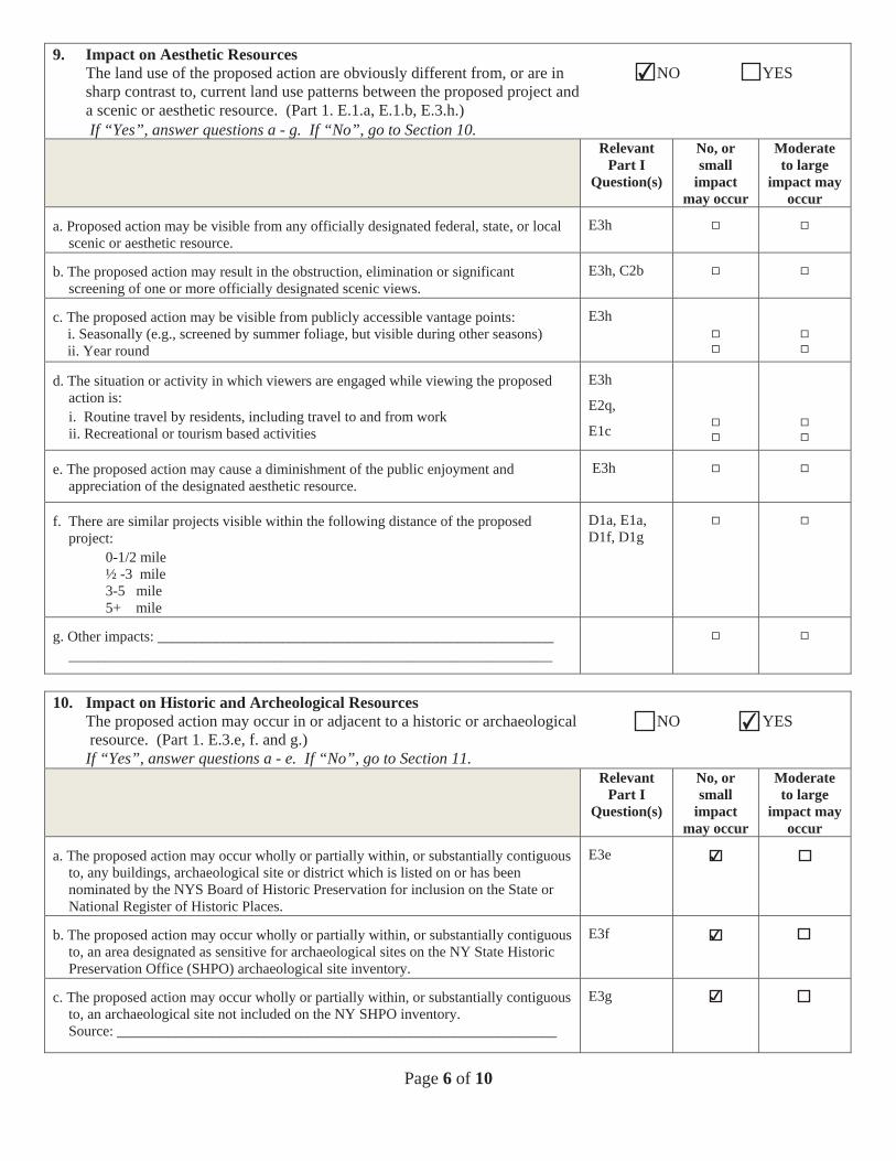
Page 6 of 10
9. Impact on Aesthetic ResourcesThe land use of the proposed action are obviously different from, or are in NO YES sharp contrast to, current land use patterns between the proposed project anda scenic or aesthetic resource. (Part 1. E.1.a, E.1.b, E.3.h.)If “Yes”, answer questions a - g. If “No”, go to Section 10.
Relevant Part I
Question(s)
No, or small
impact may occur
Moderate to large
impact may occur
a. Proposed action may be visible from any officially designated federal, state, or localscenic or aesthetic resource.
E3h
b. The proposed action may result in the obstruction, elimination or significantscreening of one or more officially designated scenic views.
E3h, C2b
c. The proposed action may be visible from publicly accessible vantage points:i. Seasonally (e.g., screened by summer foliage, but visible during other seasons)ii. Year round
E3h
d. The situation or activity in which viewers are engaged while viewing the proposedaction is:i. Routine travel by residents, including travel to and from workii. Recreational or tourism based activities
E3h
E2q,
E1c
e. The proposed action may cause a diminishment of the public enjoyment andappreciation of the designated aesthetic resource.
E3h
f. There are similar projects visible within the following distance of the proposedproject:
0-1/2 mile ½ -3 mile 3-5 mile 5+ mile
D1a, E1a, D1f, D1g
g. Other impacts: ________________________________________________________________________________________________________________________
10. Impact on Historic and Archeological ResourcesThe proposed action may occur in or adjacent to a historic or archaeological NO YES resource. (Part 1. E.3.e, f. and g.)
If “Yes”, answer questions a - e. If “No”, go to Section 11.Relevant
Part I Question(s)
No, or small
impact may occur
Moderate to large
impact may occur
a. The proposed action may occur wholly or partially within, or substantially contiguousto, any buildings, archaeological site or district which is listed on or has beennominated by the NYS Board of Historic Preservation for inclusion on the State orNational Register of Historic Places.
E3e
b. The proposed action may occur wholly or partially within, or substantially contiguousto, an area designated as sensitive for archaeological sites on the NY State HistoricPreservation Office (SHPO) archaeological site inventory.
E3f
c. The proposed action may occur wholly or partially within, or substantially contiguousto, an archaeological site not included on the NY SHPO inventory.Source: ____________________________________________________________
E3g
✔
✔
✔
✔
✔
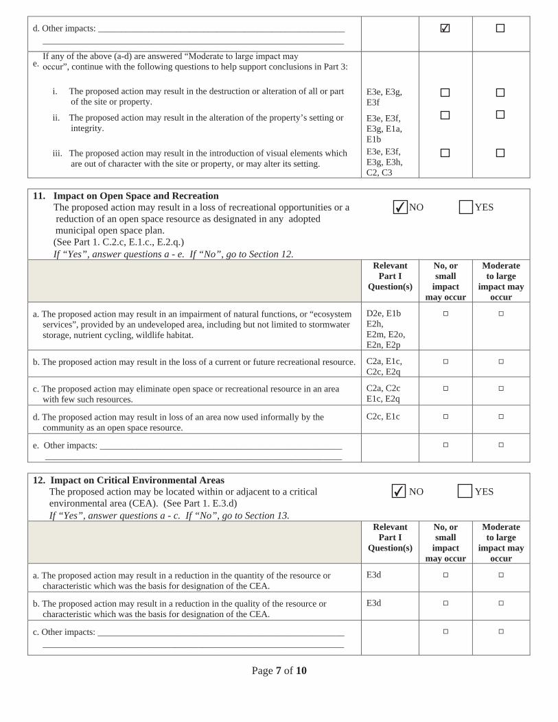
Page 7 of 10
d. Other impacts: ________________________________________________________________________________________________________________________
e.If any of the above (a-d) are answered “
”, continue with the following questions to help support conclusions in Part 3:
i. The proposed action may result in the destruction or alteration of all or partof the site or property.
ii. The proposed action may result in the alteration of the property’s setting orintegrity.
iii. The proposed action may result in the introduction of visual elements whichare out of character with the site or property, or may alter its setting.
E3e, E3g, E3f
E3e, E3f, E3g, E1a, E1bE3e, E3f, E3g, E3h,C2, C3
11. Impact on Open Space and RecreationThe proposed action may result in a loss of recreational opportunities or a NO YES reduction of an open space resource as designated in any adoptedmunicipal open space plan.(See Part 1. C.2.c, E.1.c., E.2.q.)If “Yes”, answer questions a - e. If “No”, go to Section 12.
Relevant Part I
Question(s)
No, or small
impact may occur
Moderate to large
impact may occur
a. The proposed action may result in an impairment of natural functions, or “ecosystemservices”, provided by an undeveloped area, including but not limited to stormwaterstorage, nutrient cycling, wildlife habitat.
D2e, E1b E2h,E2m, E2o, E2n, E2p
b. The proposed action may result in the loss of a current or future recreational resource. C2a, E1c, C2c, E2q
c. The proposed action may eliminate open space or recreational resource in an areawith few such resources.
C2a, C2c E1c, E2q
d. The proposed action may result in loss of an area now used informally by thecommunity as an open space resource.
C2c, E1c
e. Other impacts: ______________________________________________________________________________________________________________________
12. Impact on Critical Environmental AreasThe proposed action may be located within or adjacent to a critical NO YES environmental area (CEA). (See Part 1. E.3.d)If “Yes”, answer questions a - c. If “No”, go to Section 13.
Relevant Part I
Question(s)
No, or small
impact may occur
Moderate to large
impact may occur
a. The proposed action may result in a reduction in the quantity of the resource orcharacteristic which was the basis for designation of the CEA.
E3d
b. The proposed action may result in a reduction in the quality of the resource orcharacteristic which was the basis for designation of the CEA.
E3d
c. Other impacts: ________________________________________________________________________________________________________________________
✔
✔
✔
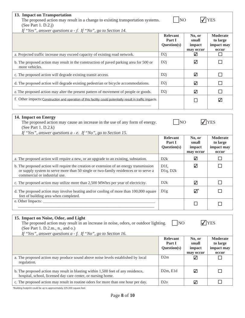
Page 8 of 10
13. Impact on TransportationThe proposed action may result in a change to existing transportation systems. NO YES (See Part 1. D.2.j)If “Yes”, answer questions a - . If “No”, go to Section 14.
Relevant Part I
Question(s)
No, or small
impact may occur
Moderate to large
impact may occur
a. Projected traffic increase may exceed capacity of existing road network. D2j
b. The proposed action may result in the construction of paved parking area for 500 ormore vehicles.
D2j
c. The proposed action will degrade existing transit access. D2j
d. The proposed action will degrade existing pedestrian or bicycle accommodations. D2j
. The proposed action may alter the present pattern of movement of people or goods. D2j
. Other impacts: ________________________________________________________________________________________________________________________
14. Impact on EnergyThe proposed action may cause an increase in the use of any form of energy. NO YES (See Part 1. D.2.k)If “Yes”, answer questions a - e. If “No”, go to Section 15.
Relevant Part I
Question(s)
No, or small
impact may occur
Moderate to large
impact may occur
a. The proposed action will require a new, or an upgrade to an existing, substation. D2k
b. The proposed action will require the creation or extension of an energy transmissionor supply system to serve more than 50 single or two-family residences or to serve acommercial or industrial use.
D1f, D1q, D2k
c. The proposed action may utilize more than 2,500 MWhrs per year of electricity. D2k
d. The proposed action may involve heating and/or cooling of more than 100,000 squarefeet of building area when completed.
D1g
e. Other Impacts: ____________________________________________________________________________________________________________________________
15. Impact on Noise, Odor, and LightThe proposed action may result in an increase in noise, odors, or outdoor lighting. NO YES (See Part 1. D.2.m., n., and o.)If “Yes”, answer questions a - f. If “No”, go to Section 16.
Relevant Part I
Question(s)
No, or small
impact may occur
Moderate to large
impact may occur
a. The proposed action may produce sound above noise levels established by localregulation.
D2m
b. The proposed action may result in blasting within 1,500 feet of any residence,hospital, school, licensed day care center, or nursing home.
D2m, E1d
c. The proposed action may result in routine odors for more than one hour per day. D2o
*
*Building footprint could be up to approximately 225,000 square feet.
✔
✔
✔
✔
✔
✔
✔Construction and operation of this facility could potentially result in traffic impacts.
✔
✔
✔
✔
✔
✔
✔
✔
✔
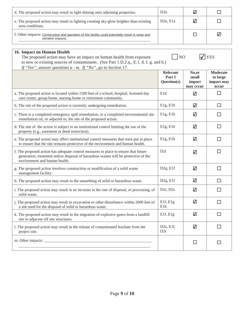
Page 9 of 10
d. The proposed action may result in light shining onto adjoining properties. D2n
e. The proposed action may result in lighting creating sky-glow brighter than existingarea conditions.
D2n, E1a
f. Other impacts: ________________________________________________________________________________________________________________________
16. Impact on Human HealthThe proposed action may have an impact on human health from exposure NO YES to new or existing sources of contaminants. (See Part 1.D.2.q., E.1. d. f. g. and h.)If “Yes”, answer questions a - m. If “No”, go to Section 17.
Relevant Part I
Question(s)
No,or small
impact may cccur
Moderate to large
impact may occur
a. The proposed action is located within 1500 feet of a school, hospital, licensed daycare center, group home, nursing home or retirement community.
E1d
b. The site of the proposed action is currently undergoing remediation. E1g, E1h
c. There is a completed emergency spill remediation, or a completed environmental siteremediation on, or adjacent to, the site of the proposed action.
E1g, E1h
d. The site of the action is subject to an institutional control limiting the use of theproperty (e.g. easement deed restriction)
E1g, E1h
e. The proposed action may affect institutional control measures that were put in placeto ensure that the site remains protective of the environment and human health.
E1g, E1h
f. The proposed action has adequate control measures in place to ensure that futuregeneration, treatment and/or disposal of hazardous wastes will be protective of theenvironment and human health.
D2t
g. The proposed action involves construction or modification of a solid wastemanagement facility.
D2q, E1f
h. The proposed action may result in the unearthing of solid or hazardous waste. D2q, E1f
i. The proposed action may result in an increase in the rate of disposal, or processing, ofsolid waste.
D2r, D2s
j. The proposed action may result in excavation or other disturbance within 2000 feet ofa site used for the disposal of solid or hazardous waste.
E1f, E1g E1h
k. The proposed action may result in the migration of explosive gases from a landfillsite to adjacent off site structures.
E1f, E1g
l. The proposed action may result in the release of contaminated leachate from theproject site.
D2s, E1f, D2r
m. Other impacts: ________________________________________________________________________________________________________________________
✔
✔
✔Construction and operation of this facility could potentially result in noise andvibration impacts.
✔
✔
✔
✔
✔
✔
✔
✔
✔
✔
✔
✔
✔
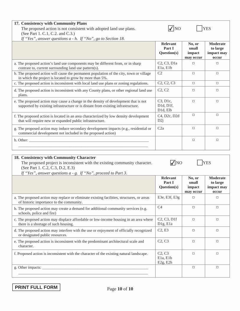
Page 10 of 10
17. Consistency with Community Plans The proposed action is not consistent with adopted land use plans. NO YES (See Part 1. C.1, C.2. and C.3.) If “Yes”, answer questions a - h. If “No”, go to Section 18.
Relevant Part I
Question(s)
No, or small
impact may occur
Moderate to large
impact may occur
a. The proposed action’s land use components may be different from, or in sharp contrast to, current surrounding land use pattern(s).
C2, C3, D1a E1a, E1b
b. The proposed action will cause the permanent population of the city, town or village in which the project is located to grow by more than 5%.
C2
c. The proposed action is inconsistent with local land use plans or zoning regulations. C2, C2, C3
d. The proposed action is inconsistent with any County plans, or other regional land use plans.
C2, C2
e. The proposed action may cause a change in the density of development that is not supported by existing infrastructure or is distant from existing infrastructure.
C3, D1c, D1d, D1f, D1d, Elb
f. The proposed action is located in an area characterized by low density development that will require new or expanded public infrastructure.
C4, D2c, D2d D2j
g. The proposed action may induce secondary development impacts (e.g., residential or commercial development not included in the proposed action)
C2a
h. Other: _____________________________________________________________ __________________________________________________________________
18. Consistency with Community Character The proposed project is inconsistent with the existing community character. NO YES (See Part 1. C.2, C.3, D.2, E.3)
If “Yes”, answer questions a - g. If “No”, proceed to Part 3.Relevant
Part I Question(s)
No, or small
impact may occur
Moderate to large
impact may occur
a. The proposed action may replace or eliminate existing facilities, structures, or areas of historic importance to the community.
E3e, E3f, E3g
b. The proposed action may create a demand for additional community services (e.g. schools, police and fire)
C4
c. The proposed action may displace affordable or low-income housing in an area where there is a shortage of such housing.
C2, C3, D1f D1g, E1a
d. The proposed action may interfere with the use or enjoyment of officially recognized or designated public resources.
C2, E3
e. The proposed action is inconsistent with the predominant architectural scale and character.
C2, C3
f. Proposed action is inconsistent with the character of the existing natural landscape. C2, C3 E1a, E1b E2g, E2h
g. Other impacts: ______________________________________________________ __________________________________________________________________
✔
✔
PRINT FULL FORM
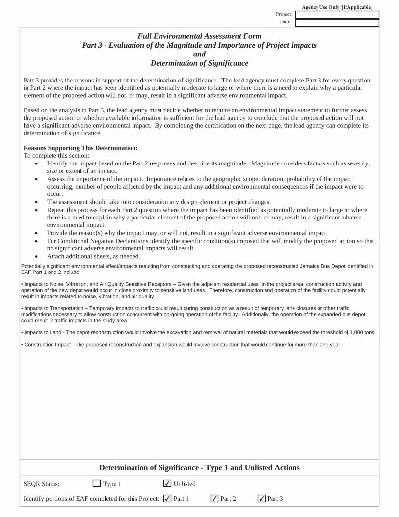
Full Environmental Assessment Form Part 3 - Evaluation of the Magnitude and Importance of Project Impacts
andDetermination of Significance
Part 3 provides the reasons in support of the determination of significance. The lead agency must complete Part 3 for every question in Part 2 where the impact has been identified as potentially moderate to large or where there is a need to explain why a particular element of the proposed action will not, or may, result in a significant adverse environmental impact.
Based on the analysis in Part 3, the lead agency must decide whether to require an environmental impact statement to further assessthe proposed action or whether available information is sufficient for the lead agency to conclude that the proposed action will not have a significant adverse environmental impact. By completing the certification on the next page, the lead agency can complete its determination of significance.
Reasons Supporting This Determination: To complete this section:
Identify the impact based on the Part 2 responses and describe its magnitude. Magnitude considers factors such as severity,size or extent of an impact. Assess the importance of the impact. Importance relates to the geographic scope, duration, probability of the impactoccurring, number of people affected by the impact and any additional environmental consequences if the impact were to occur.The assessment should take into consideration any design element or project changes.Repeat this process for each Part 2 question where the impact has been identified as potentially moderate to large or wherethere is a need to explain why a particular element of the proposed action will not, or may, result in a significant adverseenvironmental impact.Provide the reason(s) why the impact may, or will not, result in a significant adverse environmental impactFor Conditional Negative Declarations identify the specific condition(s) imposed that will modify the proposed action so thatno significant adverse environmental impacts will result.Attach additional sheets, as needed.
Determination of Significance - Type 1 and Unlisted Actions
SEQR Status: Type 1 Unlisted
Identify portions of EAF completed for this Project: Part 1 Part 2 Part 3 ✔
✔
✔ ✔
Potentially significant environmental effect/impacts resulting from constructing and operating the proposed reconstructed Jamaica Bus Depot identified inEAF Part 1 and 2 include:
• Impacts to Noise, Vibration, and Air Quality Sensitive Receptors – Given the adjacent residential uses in the project area, construction activity andoperation of the new depot would occur in close proximity to sensitive land uses. Therefore, construction and operation of the facility could potentiallyresult in impacts related to noise, vibration, and air quality.
• Impacts to Transportation – Temporary impacts to traffic could result during construction as a result of temporary lane closures or other trafficmodifications necessary to allow construction concurrent with on-going operation of the facility. Additionally, the operation of the expanded bus depotcould result in traffic impacts in the study area.
• Impacts to Land - The depot reconstruction would involve the excavation and removal of natural materials that would exceed the threshold of 1,000 tons.
• Construction Impact - The proposed reconstruction and expansion would involve construction that would continue for more than one year.
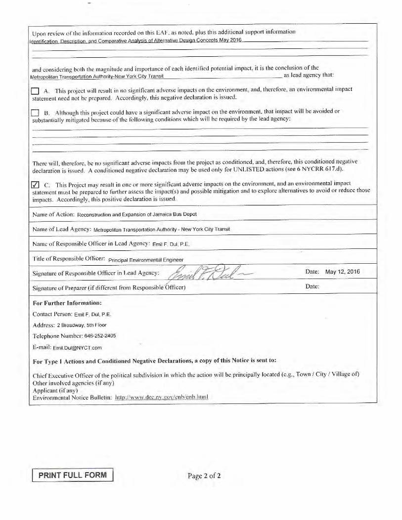
Reconstruction and Expansion of Jamaica Bus Depot
This page intentionally blank.

Reconstruction and Expansion of Jamaica Bus Depot Draft Scoping Document
APPENDIX D: Positive Declaration

Reconstruction and Expansion of Jamaica Bus Depot Draft Scoping Document
This page intentionally blank.
State Environmental Quality Review Act
POSITIVE DECLARATION
Notice of Intent to Prepare a Draft Environmental Impact Statement (DEIS)
Date Issued: May 18th, 2016
Proposed Action: Reconstruction and Expansion of the Jamaica Bus Depot at 165-18 South Road in
Jamaica, Queens
SEQR Classification: Unlisted
Lead Agency:
Metropolitan Transportation Authority – New York City Transit
2 Broadway, 5th Floor
New York, NY 10004
Emil F. Dul, P.E.
Principal Environmental Engineer
646.252.2405
REGULATORY FRAMEWORK
This document is a Positive Declaration prepared pursuant to the New York State Environmental Quality
Review Act (SEQRA) 6 NYCRR 617.12, Article 8 of the Environmental Conservation Law. The Proposed
Action consists of reconstruction and expansion of the existing Jamaica Bus Depot, located at 165-18 South
Road in Jamaica, Queens. The Metropolitan Transportation Authority (MTA) and its affiliate, New York
City Transit (NYCT) are exempt from complying with SEQRA when a proposed transit project is to be
constructed on property that was previously used for a transit or transportation purpose, or on an
insubstantial addition to such property contiguous thereto. NYS Public Authorities Law 1266-c(11). The
construction and operation of the Proposed Action would be exempt from SEQRA because the property
upon which the project is to be constructed is currently being used for transit purposes. However, because
the project may cause one or more significant impacts to the environment and may have temporary
environmental effects offsite resulting from the relocation of buses during construction, MTA NYCT will
follow the procedures developed under SEQRA when performing its environmental review of the
Proposed Action.
The Proposed Action is classified as an Unlisted Action under SEQRA. An Unlisted action is one that is
not included in statewide or individual agency lists of Type I or Type II actions.
PROPOSED ACTION DESCRIPTION AND BACKGROUND
The existing MTA NYCT Jamaica Bus Depot (JBD) is located at 165-18 South Road in Jamaica, Queens
(Block 10164 Lot Nos. 46, 80, 84, 97, and 103) and can be accessed from Merrick Boulevard, 107th Avenue,
and South Road (see Figure 1 – Project Location and Study Area). The depot has remained in operation
since its construction in 1939 and, through the formation of Regional Bus Operations (RBO), the JBD has
MTA New York City Transit Proposed Reconstruction and Expansion of Jamaica Bus Depot
SEQRA Positive Declaration
2
operated as a critical component of the Queens Division depot network. It is one of eight depots in Queens
intended to provide storage and servicing of the Queens Division bus fleet.
The Jamaica Bus Depot was constructed in 1939 and was expanded eastwardly to add a bus wash area and
provide additional storage area in 1950. In 1968, Transportation Offices and locker rooms were constructed
on the north side of the facility on an upper mezzanine level. Neither the original 1939 design nor the 1968
Transportation locker room construction project envisioned the need to accommodate the large and
growing number of operating employees working at this depot.
As a result of changing service demands and operational needs, the existing depot facility presents several
critical functional deficiencies. These deficiencies have arisen as the demand for services have increased,
necessitating a larger fleet, and as opportunities for improved bus stock have allowed MTA to invest in
newer buses. Modern buses include larger buses than those for which the 1939 depot was designed.
Modern buses also are designed to operate differently – such as relying upon clean diesel, hybrid-electric,
and compressed natural gas buses. As a result, the service needs and the configuration of work space
within a depot have evolved.
The JBD fleet size is currently 196 buses, and the facility provides storage for only 150 buses; consequently,
after being serviced, nearly 50 buses must park off MTA NYCT property to be stored overnight (parked)
on surrounding streets, where they are then “started-up” each morning. Moreover, as the JBD was
constructed in 1939, it is not appropriately configured to provide the most efficient servicing of the current
types of buses and, specifically, cannot service articulated buses, thereby limiting the service that can be
provided for the bus routes it supports. The JBD’s transportation and maintenance employee amenities
are also in poor condition and in need of renovation; and, the depot does not meet the United Bus Depot
Design Guidelines and current code standards, such as Americans with Disabilities Act of 1990 (ADA)
Accessibility Guidelines (ADAAG). The current depot cannot be expected to serve the forecast number of
buses (300) necessary to provide the density of bus service in this section of the City, nor could it handle
new demands resulting from service changes that are not part of current forecasts (i.e., resulting from
changes in depot/route assignment reconfigurations). As part of the broader network of Queens depots,
the existing JBD also cannot provide emergency bus storage during exceptional circumstances (such as
severe storm events), which has proven to be of particular importance since Superstorm Sandy.
Over more than a decade (see Alternative Sites Investigation in Appendix A), MTA NYCT sought to secure
property offsite to construct a new depot. Their effort was not successful. Hence, the decision by NYCT to
reconstruct the depot at the existing site resulted.
In order to provide some additional on-site bus storage at the depot while waiting for reconstruction to
start, as well as accommodate the future expansion project, the MTA NYCT has acquired or is in the process
of acquiring Lots 41, 53, 60, 61, 63, 66, 68, and 72 on Block 10164, which abut the existing facility. These
properties will be able to store approximately 50 additional buses. It is expected that such storage will
become available during 2017.
ALTERNATIVES UNDER CONSIDERATION
The evaluation of alternative configurations of the reconstructed bus depot involved multiple stages. First,
MTA NYCT reviewed a broad range of alternative concepts and eliminated those that would clearly not
meet the need for the project or would be infeasible because of extraordinary engineering and operational
implications. The most promising seven (7) alternatives were then subject to further analysis of engineering
/ operation, economic, and environmental factors in the Identification, Description, and Comparative

MTA New York City Transit Proposed Reconstruction and Expansion of Jamaica Bus Depot
SEQRA Positive Declaration
3
Analysis of Design Concepts (Appendix B to the Draft Scoping Document), and three Candidate
Alternatives have been selected. The MTA NYCT proposes to undertake the SEQRA process and select a
Preferred Alternative from among three (3) Candidate Alternative site design concepts identified in the
Comparative Analysis that provides a reasonable range of depot design alternatives with respect to
engineering, economic, and environmental characteristics, which would allow for a comparative
environmental evaluation in the DEIS. The three alternatives are as follows:
1. CANDIDATE ALTERNATIVE A – PRINCIPALLY OPEN PARKING
Alternative A would be a new one-story depot building positioned along Merrick Boulevard, and
extend southward from South Road to 107th Avenue, which would have a depot building
approximately 125,000 sf in size, with two levels of parking. There would be a total of 305 spaces, with
170 outdoors at grade, and 125 spaces in the depot building (18 on the first level and 117 on the
unenclosed roof). The construction period would be approximately 42 months.
2. CANDIDATE ALTERNATIVE B – PARTIALLY OPEN PARKING
Alternative B would consist of a 321,000 sf depot building, with 320 bus parking spaces, and three
levels of parking. There would be 64 indoor spaces on the first floor, 148 indoor spaces on the second
floor, and 108 outdoor spaces on the roof. Construction would last approximately 46 months.
3. CANDIDATE ALTERNATIVE D – PRINCIPALLY ENCLOSED PARKING
Alternative D would have two, two-level buildings, Building A which would be situated along Merrick
Boulevard and Building B which would be located adjacent to and west of Building A. This alternative
would provide 338 parking spaces, with 146 parking spaces on the first levels and 192 on the second
levels combined between the two buildings. Construction would last approximately 48 months.
From among the array of alternatives, the three Candidate Alternatives will be the focus of a Draft
Environmental Impact Statement (EIS). A final decision on the alternatives to advance to the Draft EIS will
be provided in the Final Scoping Document, after review and consideration of public input during the
SEQRA scoping process. For more information on the alternatives analysis process, refer to the Draft
Scoping Document and Appendix B (Identification, Description, and Comparative Analysis of Design
Concepts report).
POTENTIAL IMPACTS
Potential significant environmental effects/impacts resulting from reconstruction and expansion of the bus
depot identified in the Environmental Assessment Form (EAF) include:
• Impacts to Noise, Vibration, and Air Quality Sensitive Receptors – Given the adjacent residential
uses in the project area, construction activity and operation of the new depot would occur in close
proximity to sensitive land uses. Therefore, construction and operation of the facility could
potentially result in impacts related to noise, vibration, and air quality.
• Impacts to Transportation – Temporary impacts to traffic could result during construction as a
result of temporary lane closures or other traffic modifications necessary to allow construction
concurrent with the on-going operation of the facility. Additionally, the operation of the expanded
bus depot has the potential to result in traffic impacts in the study area.
• Impact on Land – The depot reconstruction would involve the excavation and removal of natural
materials that would exceed the threshold of 1,000 tons.
MTA New York City Transit Proposed Reconstruction and Expansion of Jamaica Bus Depot
SEQRA Positive Declaration
4
• Construction Impact – The proposed reconstruction and expansion would involve construction
that would continue for more than one year.
DETERMINATION TO PREPARE AN ENVIRONMENTAL IMPACT STATEMENT
Considering the potential impacts outlined above, MTA NYCT, acting as lead state agency for SEQRA, has
determined that the Proposed Action may cause one or more significant impacts to the environment and a
Draft Environmental Impact Statement (DEIS) will be prepared. The Draft and Final Environmental Impact
Statement (DEIS/FEIS) will be prepared in accordance with Article 8 of the New York State Environmental
Conservation Law and in compliance with all applicable state laws and regulations.
PUBLIC SCOPING
A Draft Scoping Document outlining the content of the DEIS has been prepared. The purpose of the Draft
Scoping Document is to provide the public and state and local agencies with an initial opportunity to
comment on the DEIS process, including the project’s purpose and need, alternatives considered, and the
study areas/methodologies to be used in the analyses. Appendix B to the Draft Scoping Document is the
Identification, Description, and Comparative Analysis of Alternative Design Concepts report which
describes the engineering, economic, and environmental implications of the alternatives. The Draft Scoping
Document and the EAF for the Proposed Action may be downloaded at www.mta.info or obtained in hard
copy from the MTA-NYCT at the address listed below.
A public scoping meeting will be held on June 15th, 2016, at which time the public will have an opportunity
to provide comments on the Draft Scoping document. The meeting date, location, and time are as follows:
Wednesday June 15, 2016
6-8 PM
Junior High School 8 (IS 8) Richard S. Grossley
108-35 167th Street, Queens, NY 11433
* Please bring Photo ID for entrance into the meeting location.
The public comment period will close as of 5:00 PM on July 8, 2016. All written comments should be
submitted at the scoping meeting or mailed** to:
Mr. Emil F. Dul, P.E.
Principal Environmental Engineer
MTA New York City Transit
2 Broadway, 5th Floor
New York, NY 10004
** All mailed comments must be postmarked by July 8, 2016
MTA New York City Transit Proposed Reconstruction and Expansion of Jamaica Bus Depot
SEQRA Positive Declaration
5
Should you have any questions pertaining to this Positive Declaration, you may contact Ms. Simone Price,
Assistant Director of Government and Community Relations by e-mail at [email protected] or at
656.252.2653.
Emil F. Dul, P.E.
Principal Environmental Engineer
MTA NYCT Capital Program Management
Encl. Figure 1 – Project Location and Study Area
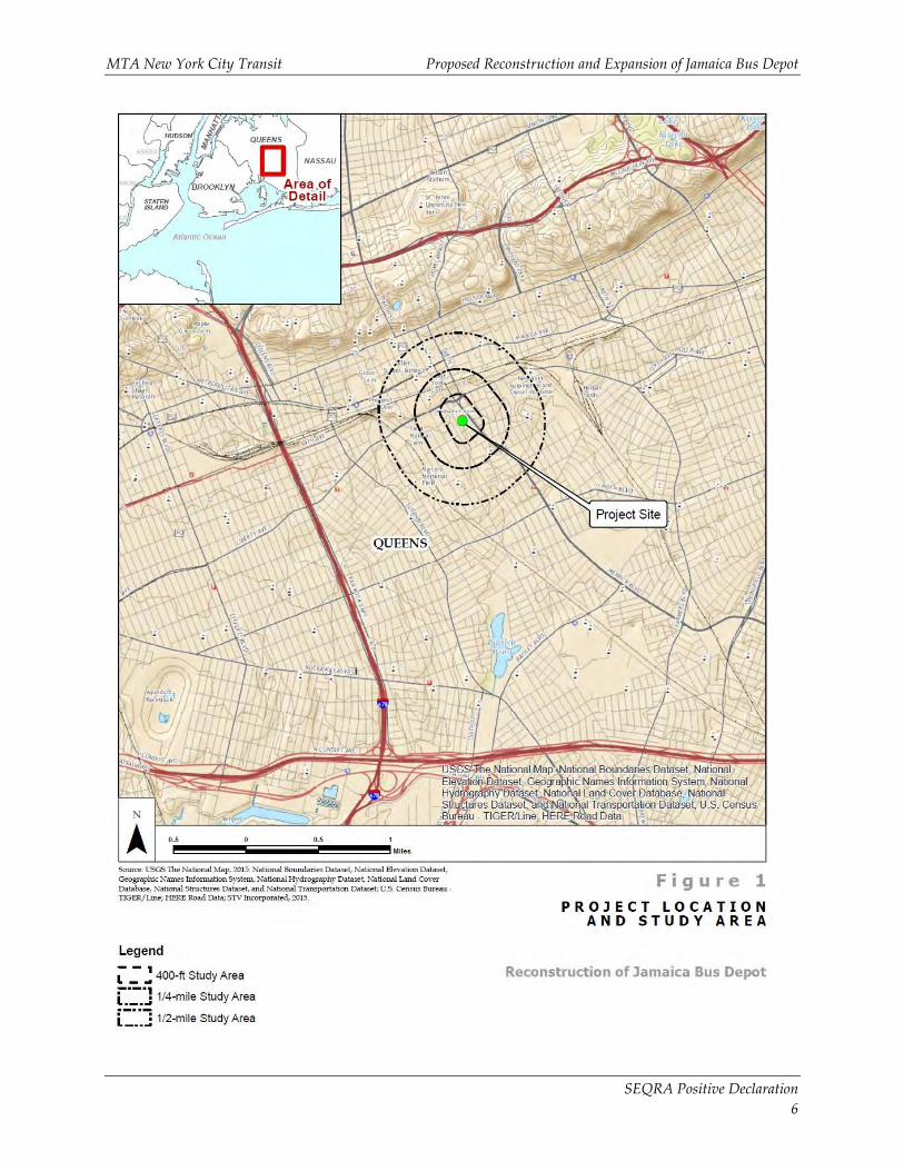
MTA New York City Transit Proposed Reconstruction and Expansion of Jamaica Bus Depot
SEQRA Positive Declaration
6