PROPOSED INFINITE PLAN 8 GRAHAMSTOWN … 8 GRAHAMSTOWN WIND ENERGY … · PROPOSED INFINITE PLAN 8...
18
Agricultural Specialist Report Coastal & Environmental Services 1 Infinite Plan 8 Wind Energy Project PROPOSED INFINITE PLAN 8 GRAHAMSTOWN WIND FARM, EASTERN CAPE PROVINCE OF SOUTH AFRICA ENVIRONMENTAL IMPACT ASSESSMENT AGRICULTURAL RESOURCES DESKTOP ASSESSMENT 13 December 2011 EAP isi-Xwiba Consulting (C J Bradfield) Postnet Suite # 30, Private Bag X 7055 Queenstown 5320 CLIENT Coastal & Environmental Services PO Box 934 Grahamstown 6139 Contact : Mr H. Newcombe Tel: 083 441 1189 Tel: (046) 622 2364 Fax2E-mail: 0866 184 327 Fax : (046) 622 6564 Email: [email protected] Email: [email protected]
-
Upload
phungthuan -
Category
Documents
-
view
216 -
download
0
Transcript of PROPOSED INFINITE PLAN 8 GRAHAMSTOWN … 8 GRAHAMSTOWN WIND ENERGY … · PROPOSED INFINITE PLAN 8...
Agricultural Specialist Report
Coastal & Environmental Services 1 Infinite Plan 8 Wind Energy Project
PROPOSED INFINITE PLAN 8 GRAHAMSTOWN WIND FARM, EASTERN CAPE PROVINCE OF SOUTH AFRICA
ENVIRONMENTAL IMPACT ASSESSMENT
AGRICULTURAL RESOURCES DESKTOP ASSESSMENT
13 December 2011
EAP
isi-Xwiba Consulting (C J Bradfield)
Postnet Suite # 30,
Private Bag X 7055
Queenstown
5320
CLIENT
Coastal & Environmental Services
PO Box 934
Grahamstown
6139
Contact : Mr H. Newcombe
Tel: 083 441 1189 Tel: (046) 622 2364
Fax2E-mail: 0866 184 327 Fax : (046) 622 6564
Email: [email protected] Email: [email protected]
Agricultural Specialist Report
Coastal & Environmental Services 2 Infinite Plan 8 Wind Energy Project
PROJECT DETAILS
TITLE Infinite8 Grahamstown Wind Park - Agricultural Resources Desktop
Assessment
AUTHOR Chris Bradfield
CLIENT Coastal & environmental Services
REPORT NUMBER FINAL
..........................................
CHRIS BRADFIELD
Agricultural Specialist Report
Coastal & Environmental Services 3 Infinite Plan 8 Wind Energy Project
TABLE OF CONTENTS 1 INTRODUCTION & BACKGROUND ...................................................................................... 4 1.1 INTRODUCTION ............................................................................................................. 4 1.2 TERMS OF REFERENCE FOR THE EAP ....................................................................... 4 1.3 ASSUMPTIONS AND LIMITATIONS ............................................................................... 4 1.4 INDEPENDENCE ............................................................................................................ 4
2 PROJECT INFORMATION ..................................................................................................... 5 2.1 PROJECT INFORMATION .............................................................................................. 5 2.2 CATCHMENT AREA ....................................................................................................... 5 2.3 DESCRIPTION OF THE NATURAL RESOURCES ......................................................... 6
3 LAND USE AND CAPABILITY ............................................................................................... 9 3.1 LAND USE ...................................................................................................................... 9 3.2 LAND CAPABILITY ......................................................................................................... 9
4 IMPACT ASSESSMENT AND MITIGATIONS ...................................................................... 11 4.1 IMPACT ON THE AGRICULTURAL RESOURCES ....................................................... 11
5 REFERENCES...................................................................................................................... 15
TABLE OF FIGURES Map 1: Locality of Turbines ...................................................................................................................................... 5 Map 2: Geological Map 3326 Grahamstown .......................................................................................................... 6 Map 3: Generalised Soil Patterns ........................................................................................................................... 6 Map 4: Vegetation Biomes ....................................................................................................................................... 7 Map 5: Land Capability ............................................................................................................................................ 9 Map 6: AGIS - Potential Grazing Capacity, 2007 ................................................................................................. 10 Map 7: Agricultural Development Programme for the Eastern Cape Region, 1986 .......................................... 10

Agricultural Specialist Report
Coastal & Environmental Services 4 Infinite Plan 8 Wind Energy Project
1 INTRODUCTION & BACKGROUND
1.1 INTRODUCTION
Coastal & Environmental Services have been commissioned by Infinite 8 to undertake a Scoping
and EIR for the construction of wind turbines on three farms within the Makana Municipal area.
isi-Xwiba Consulting cc (C J Bradfield) has been appointed by CES to compile a desktop
assessment of the natural agricultural resources on the three farms. This specialist study of the
natural agricultural resources will support the Scoping Report (Phase 1) of the EIA process.
It is planned to erect 27 turbines on the farms known as Gilead, Tower Hill and Peynes Kraal.
These farms are owned by three individual landowners and total an area of ±2 550 hectare. The
turbines will generate a planned 67.5 MW.
1.2 TERMS OF REFERENCE FOR THE EAP
isi-Xwiba Consulting CC (Mr Chris Bradfield) is appointment to compile a desktop assessment of
the natural agricultural resources on the study area.
1.3 ASSUMPTIONS AND LIMITATIONS
It is assumed in undertaking this investigation and compiling this report, that the information
provided by the applicant and other role-players is accurate. Although isi-Xwiba Consulting CC
exercises due care and diligence in rendering services and preparing documents, isi-Xwiba
Consulting CC accepts no liability in anyway whatsoever, and the client by receiving this document
indemnifies isi-Xwiba Consulting CC and its members, agents and employees against all actions,
claims, demands, losses, liabilities, costs, damages and expenses arising from or in connection
with services rendered, directly or indirectly by isi-Xwiba Consulting CC and by the use of the
information contained in this document.
1.4 INDEPENDENCE
The requirement for independence of the consultant is to reduce the potential for bias in the
environmental process. isi-Xwiba Consulting and its employees do not have any current interest in
secondary or downstream developments that may arise out of the authorisation of the proposed
project. Individual project members do not have any personal or business interests in the
development except as part of their functions as employees of isi-Xwiba Consulting. The
independent person, Mr Chris Bradfield appointed to compile this audit report is registered as a
Professional Natural Scientist with the South African Council for Natural Scientific Professions.
Agricultural Specialist Report
Coastal & Environmental Services 5 Infinite Plan 8 Wind Energy Project
2 PROJECT INFORMATION
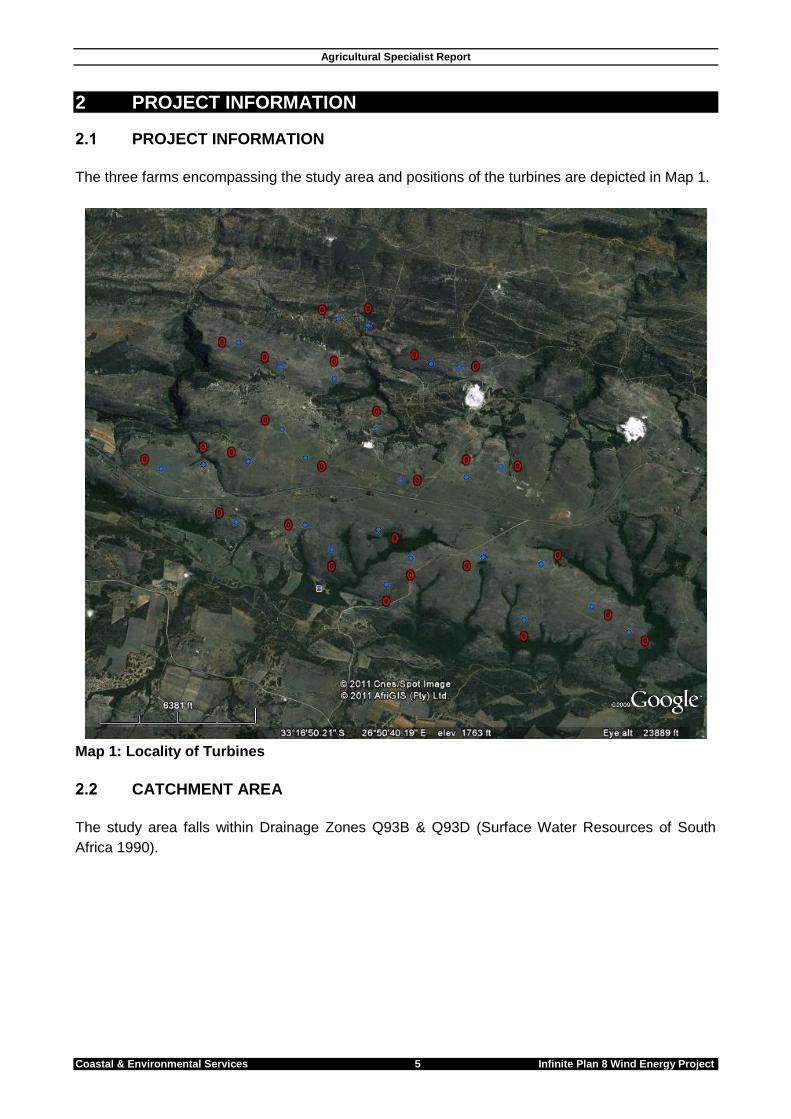
2.1 PROJECT INFORMATION
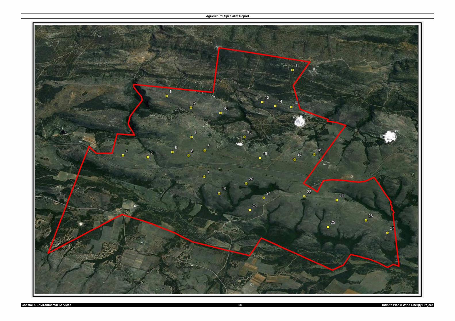
The three farms encompassing the study area and positions of the turbines are depicted in Map 1.
Map 1: Locality of Turbines
2.2 CATCHMENT AREA
The study area falls within Drainage Zones Q93B & Q93D (Surface Water Resources of South
Africa 1990).
Agricultural Specialist Report
Coastal & Environmental Services 6 Infinite Plan 8 Wind Energy Project
2.3 DESCRIPTION OF THE NATURAL RESOURCES
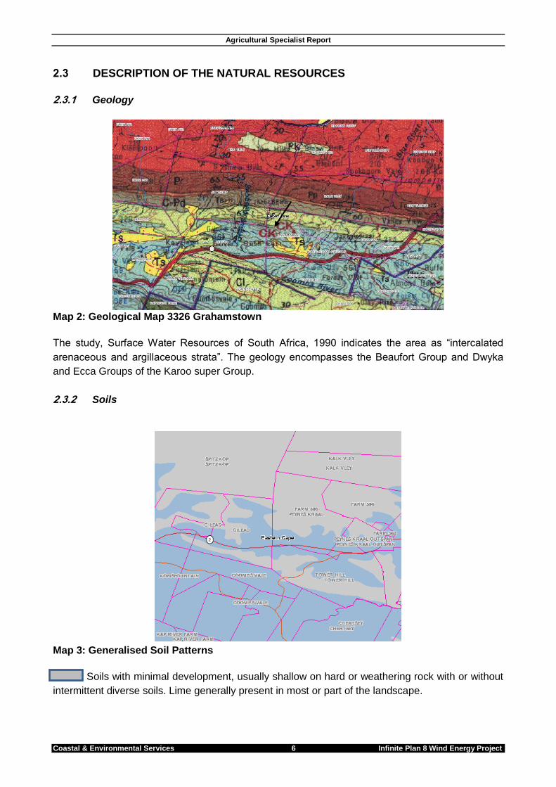
2.3.1 Geology
Map 2: Geological Map 3326 Grahamstown
The study, Surface Water Resources of South Africa, 1990 indicates the area as “intercalated
arenaceous and argillaceous strata”. The geology encompasses the Beaufort Group and Dwyka
and Ecca Groups of the Karoo super Group.
2.3.2 Soils
Map 3: Generalised Soil Patterns
Soils with minimal development, usually shallow on hard or weathering rock with or without
intermittent diverse soils. Lime generally present in most or part of the landscape.
Agricultural Specialist Report
Coastal & Environmental Services 7 Infinite Plan 8 Wind Energy Project
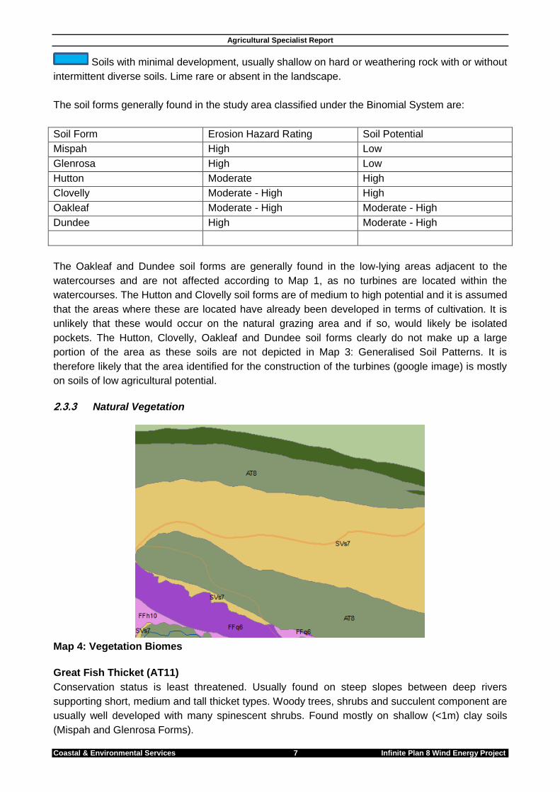
Soils with minimal development, usually shallow on hard or weathering rock with or without
intermittent diverse soils. Lime rare or absent in the landscape.
The soil forms generally found in the study area classified under the Binomial System are:
Soil Form Erosion Hazard Rating Soil Potential
Mispah High Low
Glenrosa High Low
Hutton Moderate High
Clovelly Moderate - High High
Oakleaf Moderate - High Moderate - High
Dundee High Moderate - High
The Oakleaf and Dundee soil forms are generally found in the low-lying areas adjacent to the
watercourses and are not affected according to Map 1, as no turbines are located within the
watercourses. The Hutton and Clovelly soil forms are of medium to high potential and it is assumed
that the areas where these are located have already been developed in terms of cultivation. It is
unlikely that these would occur on the natural grazing area and if so, would likely be isolated
pockets. The Hutton, Clovelly, Oakleaf and Dundee soil forms clearly do not make up a large
portion of the area as these soils are not depicted in Map 3: Generalised Soil Patterns. It is
therefore likely that the area identified for the construction of the turbines (google image) is mostly
on soils of low agricultural potential.
2.3.3 Natural Vegetation
Map 4: Vegetation Biomes
Great Fish Thicket (AT11)
Conservation status is least threatened. Usually found on steep slopes between deep rivers
supporting short, medium and tall thicket types. Woody trees, shrubs and succulent component are
usually well developed with many spinescent shrubs. Found mostly on shallow (<1m) clay soils
(Mispah and Glenrosa Forms).
Agricultural Specialist Report
Coastal & Environmental Services 8 Infinite Plan 8 Wind Energy Project
Kowie Thicket (AT8)
Conservation status is least threatened. Usually found on mainly steep and north-facing gradients,
which are usually drier. The tall thickets are dominated by euphorbias and aloes with a thick
undergrowth composed of thorny shrubs, woody lianas and shrubby succulents. The moister south
facing slopes support thorny thickets dominated by low evergreen trees with fewer succulent
shrubs and trees.
Bhisho Thornveld (SVs7)
Conservation status is least threatened. Usually found on undulating to moderately steep slopes.
This is open savannah characterised by small trees with a short to medium, dense sour grass
usually dominated by Themeda triandra when in good condition.
2.3.4 Water Sources The Mean Annual Precipitation is 500 to 600 mm and the Mean Annual Evaporation (S-Pan) 1400 to 1600 mm. The Coombs River is in close proximity to the study area. Tower Hill farm drains into the Coombs River. Drainage from Gilead Farm leads into the Bobbejaansrivier and drainage from Peynes Kraal appears to lead into the Gqora stream. A number of earth dams are noted, most likely being for stock water. There are certain to be boreholes providing water to farm homesteads and reservoirs for stockwater purposes.
Agricultural Specialist Report
Coastal & Environmental Services 9 Infinite Plan 8 Wind Energy Project
3 LAND USE AND CAPABILITY
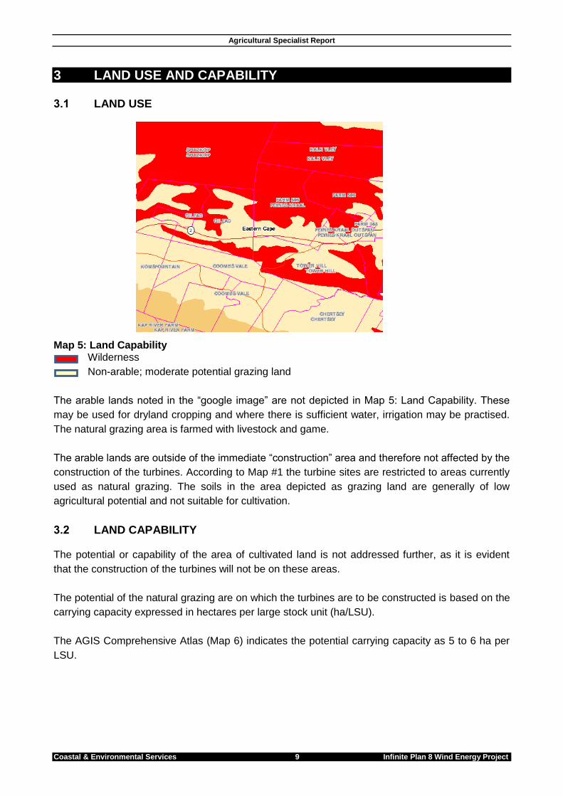
3.1 LAND USE
Map 5: Land Capability Wilderness
Non-arable; moderate potential grazing land
The arable lands noted in the “google image” are not depicted in Map 5: Land Capability. These
may be used for dryland cropping and where there is sufficient water, irrigation may be practised.
The natural grazing area is farmed with livestock and game.
The arable lands are outside of the immediate “construction” area and therefore not affected by the
construction of the turbines. According to Map #1 the turbine sites are restricted to areas currently
used as natural grazing. The soils in the area depicted as grazing land are generally of low
agricultural potential and not suitable for cultivation.
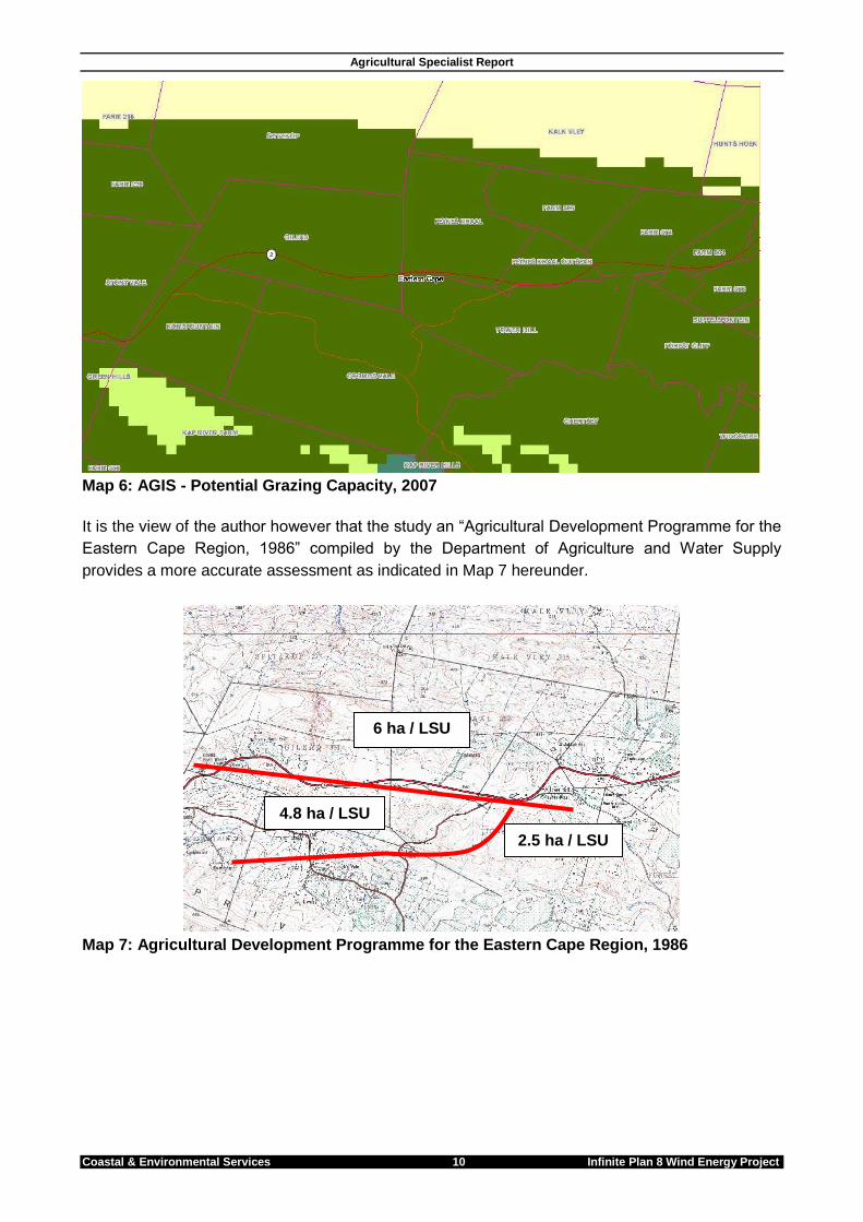
3.2 LAND CAPABILITY The potential or capability of the area of cultivated land is not addressed further, as it is evident
that the construction of the turbines will not be on these areas.
The potential of the natural grazing are on which the turbines are to be constructed is based on the
carrying capacity expressed in hectares per large stock unit (ha/LSU).
The AGIS Comprehensive Atlas (Map 6) indicates the potential carrying capacity as 5 to 6 ha per
LSU.
Agricultural Specialist Report
Coastal & Environmental Services 10 Infinite Plan 8 Wind Energy Project
Map 6: AGIS - Potential Grazing Capacity, 2007
It is the view of the author however that the study an “Agricultural Development Programme for the
Eastern Cape Region, 1986” compiled by the Department of Agriculture and Water Supply
provides a more accurate assessment as indicated in Map 7 hereunder.
Map 7: Agricultural Development Programme for the Eastern Cape Region, 1986
6 ha / LSU
4.8 ha / LSU
2.5 ha / LSU
Agricultural Specialist Report
Coastal & Environmental Services 11 Infinite Plan 8 Wind Energy Project
4 IMPACT ASSESSMENT AND MITIGATIONS
4.1 IMPACT ON THE AGRICULTURAL RESOURCES
Impact 1: Possible change of use of agricultural land
Revision of statement
Cause and Comment
The construction of infrastructure for the erection of the turbines will impact on the current land use. The client has advised that the total area impacted upon by construction is 11.79 ha, itemised as follows:
Roads 86406.96 m²
Foundations 1039.08 m²
Hard-standings 30375 m²
Buildings 100 m²
Total (m²) 117921.04 m²
Total (ha) 11.79 ha
The project may require an authorisation in terms of the “change of use of agricultural land” and possible re-zoning and such a decision would be made by the Department of Agriculture – Eastern Cape.
Mitigation and Management
The report writer has been advised that livestock are known to become used to the use/operation
of the turbines and should be able to utilise grazing up to the footprint areas of the turbines.
Existing cultivated arable lands are not impacted upon so production can continue on these. The
total impacted area of 11.79 ha of the 2,500 ha, calculated as a percentage is 0.004716% of the
study area. The 11.79 ha can be considered as natural grazing area. Assuming an average of 6 ha
per Large Stock Unit one can assume that the current carrying capacity will be reduced by 2 LSU.
This can be considered as insignificant in terms of the overall carrying capacity of the remaining
2,488 ha.
It is recommended that the positioning of the turbines be discussed with staff of the Department
of Agriculture to align the project with the Conservation of Agricultural Resources Act.
Significance Statement
RA
TIN
G
Temporal Scale
Spatial Scale
Severity of Impact
Risk or Likelihood
Total
Without
Mitigation Permanent 4
Study
area 2 Moderate 2
May
occur 2 10
With
Mitigation Short term 1
Study
area 2 Slight 1
May
occur 2 6
Overall Significance without mitigation Moderate
Overall Significance with mitigation Low
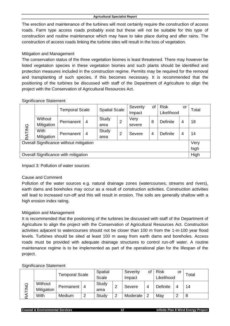
Impact 2: Loss of vegetation
Cause and Comment
Agricultural Specialist Report
Coastal & Environmental Services 12 Infinite Plan 8 Wind Energy Project
The erection and maintenance of the turbines will most certainly require the construction of access
roads. Farm type access roads probably exist but these will not be suitable for this type of
construction and routine maintenance which may have to take place during and after rains. The
construction of access roads linking the turbine sites will result in the loss of vegetation.
Mitigation and Management
The conservation status of the three vegetation biomes is least threatened. There may however be
listed vegetation species in these vegetation biomes and such plants should be identified and
protection measures included in the construction regime. Permits may be required for the removal
and transplanting of such species, if this becomes necessary. It is recommended that the
positioning of the turbines be discussed with staff of the Department of Agriculture to align the
project with the Conservation of Agricultural Resources Act.
Significance Statement
RA
TIN
G
Temporal Scale Spatial Scale Severity of
Impact
Risk or
Likelihood Total
Without
Mitigation Permanent 4
Study
area 2
Very
severe 8 Definite 4 18
With
Mitigation Permanent 4
Study
area 2 Severe 4 Definite 4 14
Overall Significance without mitigation Very
high
Overall Significance with mitigation High
Impact 3: Pollution of water sources
Cause and Comment
Pollution of the water sources e.g. natural drainage zones (watercourses, streams and rivers),
earth dams and boreholes may occur as a result of construction activities. Construction activities
will lead to increased run-off and this will result in erosion. The soils are generally shallow with a
high erosion index rating.
Mitigation and Management
It is recommended that the positioning of the turbines be discussed with staff of the Department of
Agriculture to align the project with the Conservation of Agricultural Resources Act. Construction
activities adjacent to watercourses should not be closer than 100 m from the 1-in-100 year flood
levels. Turbines should be sited at least 100 m away from earth dams and boreholes. Access
roads must be provided with adequate drainage structures to control run-off water. A routine
maintenance regime is to be implemented as part of the operational plan for the lifespan of the
project.
Significance Statement
RA
TIN
G
Temporal Scale Spatial
Scale
Severity of
Impact
Risk or
Likelihood Total
Without
Mitigation Permanent 4
Study
area 2 Severe 4 Definite 4 14
With Medium 2 Study 2 Moderate 2 May 2 8
Agricultural Specialist Report
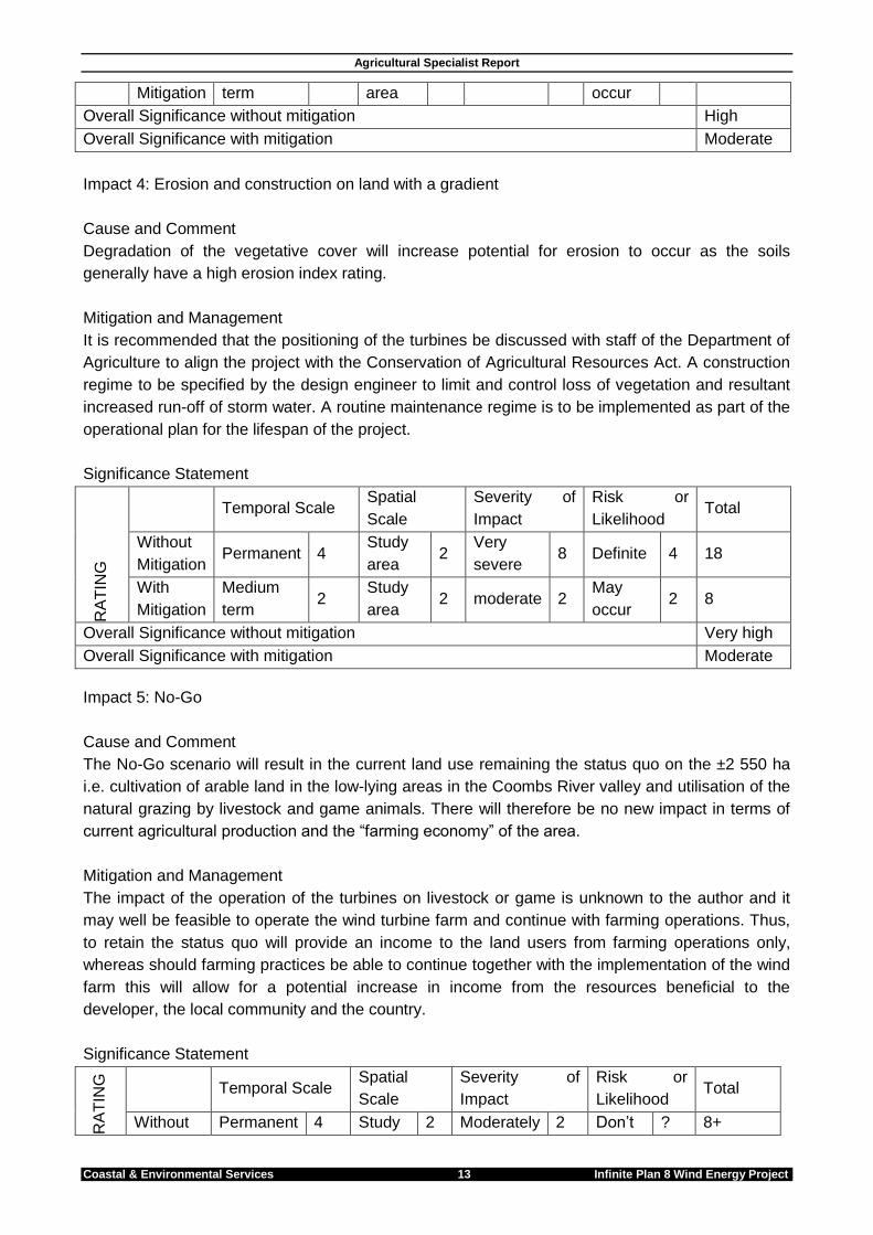
Coastal & Environmental Services 13 Infinite Plan 8 Wind Energy Project
Mitigation term area occur
Overall Significance without mitigation High
Overall Significance with mitigation Moderate
Impact 4: Erosion and construction on land with a gradient
Cause and Comment
Degradation of the vegetative cover will increase potential for erosion to occur as the soils
generally have a high erosion index rating.
Mitigation and Management
It is recommended that the positioning of the turbines be discussed with staff of the Department of
Agriculture to align the project with the Conservation of Agricultural Resources Act. A construction
regime to be specified by the design engineer to limit and control loss of vegetation and resultant
increased run-off of storm water. A routine maintenance regime is to be implemented as part of the
operational plan for the lifespan of the project.
Significance Statement
RA
TIN
G
Temporal Scale Spatial
Scale
Severity of
Impact
Risk or
Likelihood Total
Without
Mitigation Permanent 4
Study
area 2
Very
severe 8 Definite 4 18
With
Mitigation
Medium
term 2
Study
area 2 moderate 2
May
occur 2 8
Overall Significance without mitigation Very high
Overall Significance with mitigation Moderate
Impact 5: No-Go
Cause and Comment
The No-Go scenario will result in the current land use remaining the status quo on the ±2 550 ha
i.e. cultivation of arable land in the low-lying areas in the Coombs River valley and utilisation of the
natural grazing by livestock and game animals. There will therefore be no new impact in terms of
current agricultural production and the “farming economy” of the area.
Mitigation and Management
The impact of the operation of the turbines on livestock or game is unknown to the author and it
may well be feasible to operate the wind turbine farm and continue with farming operations. Thus,
to retain the status quo will provide an income to the land users from farming operations only,
whereas should farming practices be able to continue together with the implementation of the wind
farm this will allow for a potential increase in income from the resources beneficial to the
developer, the local community and the country.
Significance Statement
RA
TIN
G
Temporal Scale
Spatial
Scale
Severity of
Impact
Risk or
Likelihood Total
Without Permanent 4 Study 2 Moderately 2 Don’t ? 8+

Agricultural Specialist Report
Coastal & Environmental Services 14 Infinite Plan 8 Wind Energy Project
Mitigation area beneficial know
With
Mitigation Permanent 4
Study
area 2
Moderately
beneficial 2
Don’t
know ? 8+
Overall Significance without mitigation Moderate
Overall Significance with mitigation Moderate
Agricultural Specialist Report
Coastal & Environmental Services 15 Infinite Plan 8 Wind Energy Project
5 REFERENCES
Surface Water Resources of South Africa, 1990
AGIS Comprehensive Atlas
The Vegetation Map of South Africa, Lesotho and Swaziland, 2006 Ladislav Mucina and Michael
C. Rutherford
Agricultural Development Programme for the Eastern Cape Region, 1986 Department of
Agriculture and Water Supply
Eastern Cape Biodiversity Conservation Plan
Soil Classification Working Group (1977) A Binomial System for South Africa, Department of
Agricultural Technical Services, Republic of South Africa ISBN 062103831 8
Guidelines for Resource Use, 1988 Department of Agriculture and Water Supply, Eastern Cape
Region
Agricultural Specialist Report
Coastal & Environmental Services 16 Infinite Plan 8 Wind Energy Project
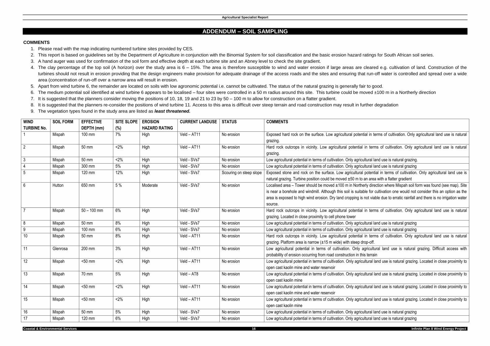
ADDENDUM – SOIL SAMPLING COMMENTS
1. Please read with the map indicating numbered turbine sites provided by CES.
2. This report is based on guidelines set by the Department of Agriculture in conjunction with the Binomial System for soil classification and the basic erosion hazard ratings for South African soil series.
3. A hand auger was used for confirmation of the soil form and effective depth at each turbine site and an Abney level to check the site gradient.
4. The clay percentage of the top soil (A horizon) over the study area is 6 – 15%. The area is therefore susceptible to wind and water erosion if large areas are cleared e.g. cultivation of land. Construction of the
turbines should not result in erosion providing that the design engineers make provision for adequate drainage of the access roads and the sites and ensuring that run-off water is controlled and spread over a wide
area (concentration of run-off over a narrow area will result in erosion.
5. Apart from wind turbine 6, the remainder are located on soils with low agronomic potential i.e. cannot be cultivated. The status of the natural grazing is generally fair to good.
6. The medium potential soil identified at wind turbine 6 appears to be localised – four sites were controlled in a 50 m radius around this site. This turbine could be moved ±100 m in a Northerly direction
7. It is suggested that the planners consider moving the positions of 10, 18, 19 and 21 to 23 by 50 – 100 m to allow for construction on a flatter gradient.
8. It is suggested that the planners re-consider the positions of wind turbine 11. Access to this area is difficult over steep terrain and road construction may result in further degradation
9. The vegetation types found in the study area are listed as least threatened.
WIND
TURBINE No.
SOIL FORM EFFECTIVE
DEPTH (mm)
SITE SLOPE
(%)
EROSION
HAZARD RATING
CURRENT LANDUSE STATUS COMMENTS
1 Mispah 100 mm 7% High Veld – AT11 No erosion Exposed hard rock on the surface. Low agricultural potential in terms of cultivation. Only agricultural land use is natural
grazing.
2 Mispah 50 mm <2% High Veld – AT11 No erosion Hard rock outcrops in vicinity. Low agricultural potential in terms of cultivation. Only agricultural land use is natural
grazing.
3 Mispah 50 mm <2% High Veld - SVs7 No erosion Low agricultural potential in terms of cultivation. Only agricultural land use is natural grazing.
4 Mispah 300 mm 5% High Veld - SVs7 No erosion Low agricultural potential in terms of cultivation. Only agricultural land use is natural grazing
5 Mispah 120 mm 12% High Veld - SVs7 Scouring on steep slope Exposed stone and rock on the surface. Low agricultural potential in terms of cultivation. Only agricultural land use is
natural grazing. Turbine position could be moved ±50 m to an area with a flatter gradient
6 Hutton 650 mm 5 % Moderate Veld - SVs7 No erosion Localised area – Tower should be moved ±100 m in Northerly direction where Mispah soil form was found (see map). Site
is near a borehole and windmill. Although this soil is suitable for cultivation one would not consider this an option as the
area is exposed to high wind erosion. Dry land cropping is not viable due to erratic rainfall and there is no irrigation water
source.
7 Mispah 50 – 100 mm 6% High Veld - SVs7 No erosion Hard rock outcrops in vicinity. Low agricultural potential in terms of cultivation. Only agricultural land use is natural
grazing. Located in close proximity to cell phone tower
8 Mispah 50 mm 8% High Veld - SVs7 No erosion Low agricultural potential in terms of cultivation. Only agricultural land use is natural grazing
9 Mispah 100 mm 6% High Veld - SVs7 No erosion Low agricultural potential in terms of cultivation. Only agricultural land use is natural grazing
10 Mispah 50 mm 8% High Veld – AT11 No erosion Hard rock outcrops in vicinity. Low agricultural potential in terms of cultivation. Only agricultural land use is natural
grazing. Platform area is narrow (±15 m wide) with steep drop-off.
11 Glenrosa 200 mm 3% High Veld – AT11 No erosion Low agricultural potential in terms of cultivation. Only agricultural land use is natural grazing. Difficult access with
probability of erosion occurring from road construction in this terrain
12 Mispah <50 mm <2% High Veld – AT11 No erosion Low agricultural potential in terms of cultivation. Only agricultural land use is natural grazing. Located in close proximity to
open cast kaolin mine and water reservoir
13 Mispah 70 mm 5% High Veld – AT8 No erosion Low agricultural potential in terms of cultivation. Only agricultural land use is natural grazing. Located in close proximity to
open cast kaolin mine
14 Mispah <50 mm <2% High Veld – AT11 No erosion Low agricultural potential in terms of cultivation. Only agricultural land use is natural grazing. Located in close proximity to
open cast kaolin mine and water reservoir
15 Mispah <50 mm <2% High Veld – AT11 No erosion Low agricultural potential in terms of cultivation. Only agricultural land use is natural grazing. Located in close proximity to
open cast kaolin mine
16 Mispah 50 mm 5% High Veld - SVs7 No erosion Low agricultural potential in terms of cultivation. Only agricultural land use is natural grazing
17 Mispah 120 mm 6% High Veld - SVs7 No erosion Low agricultural potential in terms of cultivation. Only agricultural land use is natural grazing
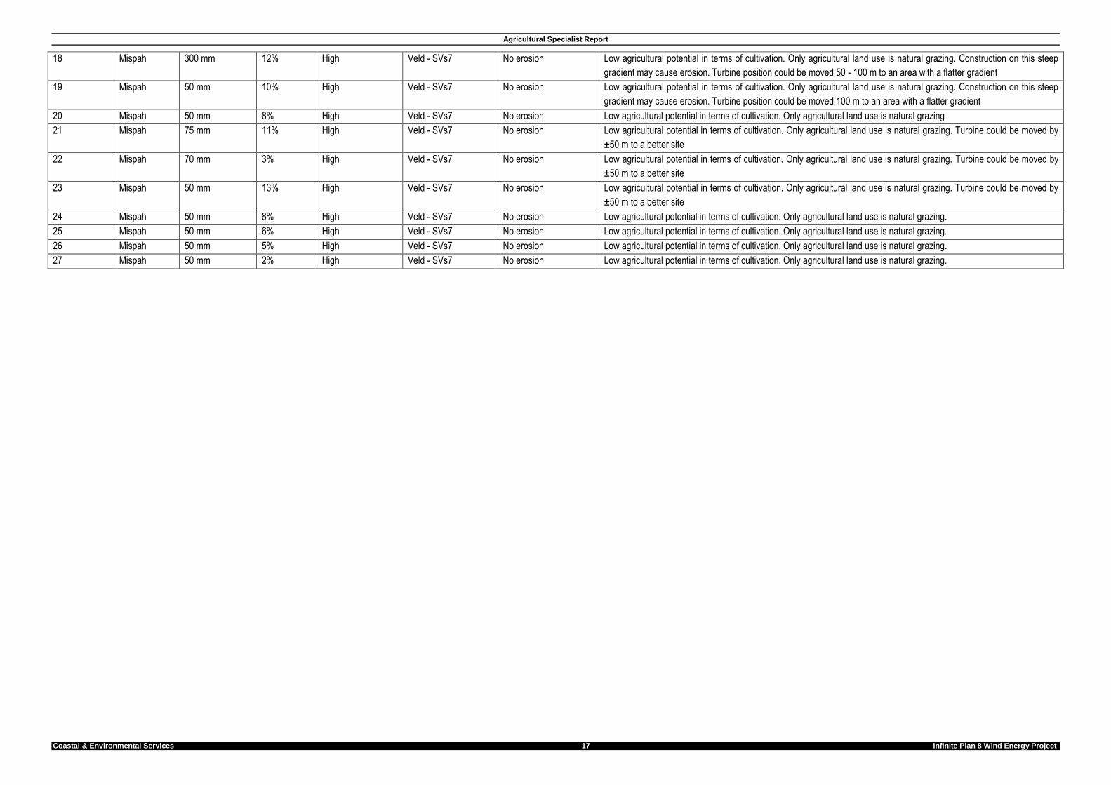
Agricultural Specialist Report
Coastal & Environmental Services 17 Infinite Plan 8 Wind Energy Project
18 Mispah 300 mm 12% High Veld - SVs7 No erosion Low agricultural potential in terms of cultivation. Only agricultural land use is natural grazing. Construction on this steep
gradient may cause erosion. Turbine position could be moved 50 - 100 m to an area with a flatter gradient
19 Mispah 50 mm 10% High Veld - SVs7 No erosion Low agricultural potential in terms of cultivation. Only agricultural land use is natural grazing. Construction on this steep
gradient may cause erosion. Turbine position could be moved 100 m to an area with a flatter gradient
20 Mispah 50 mm 8% High Veld - SVs7 No erosion Low agricultural potential in terms of cultivation. Only agricultural land use is natural grazing
21 Mispah 75 mm 11% High Veld - SVs7 No erosion Low agricultural potential in terms of cultivation. Only agricultural land use is natural grazing. Turbine could be moved by
±50 m to a better site
22 Mispah 70 mm 3% High Veld - SVs7 No erosion Low agricultural potential in terms of cultivation. Only agricultural land use is natural grazing. Turbine could be moved by
±50 m to a better site
23 Mispah 50 mm 13% High Veld - SVs7 No erosion Low agricultural potential in terms of cultivation. Only agricultural land use is natural grazing. Turbine could be moved by
±50 m to a better site
24 Mispah 50 mm 8% High Veld - SVs7 No erosion Low agricultural potential in terms of cultivation. Only agricultural land use is natural grazing.
25 Mispah 50 mm 6% High Veld - SVs7 No erosion Low agricultural potential in terms of cultivation. Only agricultural land use is natural grazing.
26 Mispah 50 mm 5% High Veld - SVs7 No erosion Low agricultural potential in terms of cultivation. Only agricultural land use is natural grazing.
27 Mispah 50 mm 2% High Veld - SVs7 No erosion Low agricultural potential in terms of cultivation. Only agricultural land use is natural grazing.
Agricultural Specialist Report
Coastal & Environmental Services 18 Infinite Plan 8 Wind Energy Project