PROPOSED DECISION DOCUMENT - New York State … DECISION DOCUMENT ... Brownfield Cleanup Program...
12
PROPOSED DECISION DOCUMENT Tecumseh Phase I Business Park Brownfield Cleanup Program Lackawanna, Erie County Site No. C915197 December 2011 Prepared by Division of Environmental Remediation New York State Department of Environmental Conservation
Transcript of PROPOSED DECISION DOCUMENT - New York State … DECISION DOCUMENT ... Brownfield Cleanup Program...
PROPOSED DECISION DOCUMENT
Tecumseh Phase I Business Park Brownfield Cleanup Program
Lackawanna, Erie County Site No. C915197 December 2011
Prepared by Division of Environmental Remediation
New York State Department of Environmental Conservation
PROPOSED DECISION DOCUMENT
Tecumseh Phase I Business Park Lackawanna, Erie County
Site No. C915197 December 2011
SECTION 1: SUMMARY AND PURPOSE OF THE PROPOSED PLAN The New York State Department of Environmental Conservation (the Department), in consultation with the New York State Department of Health (NYSDOH), is proposing a remedy for the above referenced site. The disposal of contaminants at the site has resulted in threats to public health and the environment that would be addressed by the remedy proposed by this Proposed Decision Document (PDD). The disposal or release of contaminants at this site, as more fully described in Section 6 of this document, has contaminated various environmental media. Contaminants include hazardous waste and/or petroleum. The New York State Brownfield Cleanup Program (BCP) is a voluntary program. The goal of the BCP is to enhance private-sector cleanups of brownfields and to reduce development pressure on "greenfields." A brownfield site is real property, the redevelopment or reuse of which may be complicated by the presence or potential presence of a contaminant. The Department has issued this document in accordance with the requirements of New York State Environmental Conservation Law and Title 6 of the Official Compilation of Codes, Rules and Regulations of the State of New York; (6 NYCRR) Part 375. This document is a summary of the information that can be found in the site-related reports and documents in the document repository identified below. SECTION 2: CITIZEN PARTICIPATION The Department seeks input from the community on all Proposed Decision Documents. This is an opportunity for public participation in the remedy selection process. The public is encouraged to review the reports and documents, which are available at the following repository: Lackawanna Public Library Attn: Jennifer Hoffman 560 Ridge Road Lackawanna, NY 14218 Phone: (716)823-0360 A public comment period has been set from: 12/12/2011 to 1/26/2012
PROPOSED DECISION DOCUMENT December 2011 Tecumseh Phase I Business Park, Site No. C915197 Page 1
Written comments may be sent through 1/26/2012 to: Maurice Moore NYS Department of Environmental Conservation Division of Environmental Remediation 270 Michigan Ave Buffalo, NY 14203-2915 [email protected] The proposed remedy may be modified based on new information or public comments. Therefore, the public is encouraged to review and comment on the proposed remedy identified herein. Receive Site Citizen Participation Information By Email Please note that the Department's Division of Environmental Remediation (DER) is "going paperless" relative to citizen participation information. The ultimate goal is to distribute citizen participation information about contaminated sites electronically by way of county email listservs. Information will be distributed for all sites that are being investigated and cleaned up in a particular county under the State Superfund Program, Environmental Restoration Program, Brownfield Cleanup Program, Voluntary Cleanup Program, and Resource Conservation and Recovery Act Program. We encourage the public to sign up for one or more county listservs at http://www.dec.ny.gov/chemical/61092.html SECTION 3: SITE DESCRIPTION AND HISTORY Location: The Tecumseh Phase I Business Park (Phase I or site) is located at 1958 Hamburg Turnpike in the City of Lackawanna, New York. Situated in an industrial area, the site is one parcel of a larger property identified on the Erie County Tax maps as SBL 141.11-1.111 that once was the Bethlehem Steel Company (BSC). The site is located to the west of Route 5, south and east of Gateway Metroport, and north of Tecumseh Phase II Business Park Sites. Site Features: The mostly rectangular property is approximately 5500 feet long, averages 1500 feet wide and is approximately 102 acres in size. The generally flat, slag filled site is vegetated with natural grasses, shrubs and poplar trees typical of a primary shrub-young forest ecosystem. Remnants of former steel manufacturing buildings and foundations are prevalent. An active rail spur which parallels the access road traverses the eastern side of the site. The larger BSC site is fenced with vehicle access limited to one automatic gate. Zoning/Use(s): The site is vacant. The site is zoned Commercial/Industrial and a site Master Development Plan exists. Surrounding uses include: vacant former industrial land, shipping, and a storage and transport facility.
PROPOSED DECISION DOCUMENT December 2011 Tecumseh Phase I Business Park, Site No. C915197 Page 2
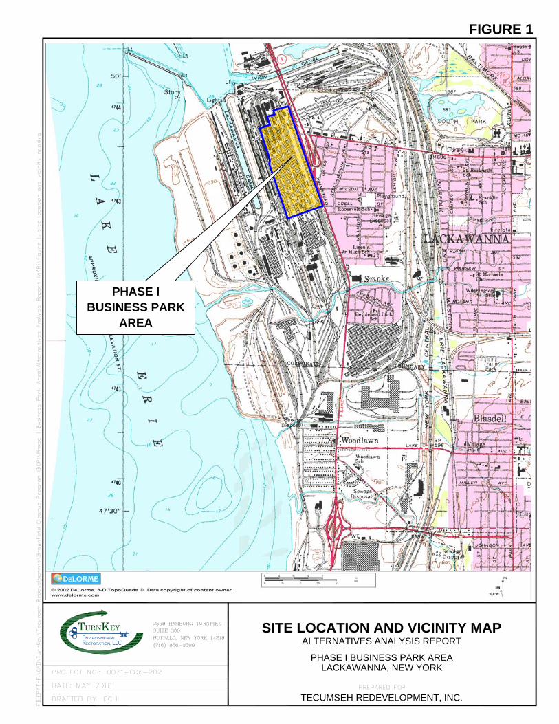
Historical Use(s): The site was formerly a portion of BSC’s steel making operations. Prior uses of the site included the manufacture of steel, until production was discontinued at the site in 1983. Specific processes and steel making facilities performed on or proximate to the parcel included: • Open Hearth Furnaces • Blooming Mill • Billet Preparation Mills • Roughing Mills • Rail Mills • Foundry • Water Treatment Plant Future Use anticipates commercial, industrial and passive recreational opportunities. Geology/Hydrology: The entire site is mostly filled land with between two to eight feet of steel and iron-making slag as well as other fill material being used for backfill. Underlying the fill material are lacustrine silts and clays. Bedrock is Middle Devonian, consisting of Levanna shale and Stafford limestone of the Hamilton Group and Skaneateles Formation. Bedrock is located about 60 feet deep near the eastern border of the site. Due to the nature of the slag/soil fill there is very little ponding of stormwater or surface runoff as most of the precipitation seeps into the highly permeable slag/soil fill. Any surface waters flow into the North Water Return Trench which parallels the property, flowing northerly until emptying into the Union Ship Canal. Groundwater is between 5 and 6 feet below ground surface trending westerly and northerly toward the Buffalo Outer Harbor and Lake Erie. An existing deed restriction prohibits use of groundwater for potable purposes or non-potable purposes without treatment. Public water is supplied by the Erie County Water Authority. A site location map is attached as Figure 1. SECTION 4: LAND USE AND PHYSICAL SETTING The Department may consider the current, intended, and reasonably anticipated future land use of the site and its surroundings when evaluating a remedy for soil remediation. For this site, alternatives (or an alternative) that restrict(s) the use of the site to commercial use (which allows for industrial use) as described in Part 375-1.8(g) are/is being evaluated in addition to an alternative which would allow for unrestricted use of the site.
PROPOSED DECISION DOCUMENT December 2011 Tecumseh Phase I Business Park, Site No. C915197 Page 3
A comparison of the results of the investigation to the appropriate standards, criteria and guidance values (SCGs) for the identified land use and the unrestricted use SCGs for the site contaminants is available in the remedial investigation (RI) Report. SECTION 5: ENFORCEMENT STATUS The Applicant(s) under the Brownfield Cleanup Agreement is a/are Volunteer(s). The Applicant(s) does/do not have an obligation to address off-site contamination. However, the Department has determined that this site does not pose a significant threat to public health or the environment. SECTION 6: SITE CONTAMINATION 6.1: Summary of the Remedial Investigation A remedial investigation (RI) serves as the mechanism for collecting data to: • characterize site conditions; • determine the nature of the contamination; and • assess risk to human health and the environment. The RI is intended to identify the nature (or type) of contamination which may be present at a site and the extent of that contamination in the environment on the site, or leaving the site. The RI reports on data gathered to determine if the soil, groundwater, soil vapor, indoor air, surface water or sediments may have been contaminated. Monitoring wells are installed to assess groundwater and soil borings or test pits are installed to sample soil and/or waste(s) identified. If other natural resources are present, such as surface water bodies or wetlands, the water and sediment may be sampled as well. Based on the presence of contaminants in soil and groundwater, soil vapor will also be sampled for the presence of contamination. Data collected in the RI influence the development of remedial alternatives. The RI report is available for review in the site document repository and the results are summarized in section 6.4. 6.1.1: Standards, Criteria, and Guidance (SCGs) The remedy must conform to promulgated standards and criteria that are directly applicable or that are relevant and appropriate. The selection of a remedy must also take into consideration guidance, as appropriate. Standards, Criteria and Guidance are hereafter called SCGs. To determine whether the contaminants identified in various media are present at levels of concern, the data from the RI were compared to media-specific SCGs. The Department has developed SCGs for groundwater, surface water, sediments, and soil. The NYSDOH has developed SCGs for drinking water and soil vapor intrusion. For a full listing of all SCGs see: http://www.dec.ny.gov/regulations/61794.html 6.1.2: RI Information
PROPOSED DECISION DOCUMENT December 2011 Tecumseh Phase I Business Park, Site No. C915197 Page 4
PROPOSED DECISION DOCUMENT December 2011 Tecumseh Phase I Business Park, Site No. C915197 Page 5
The analytical data collected on this site includes data for: - groundwater - soil The data have identified contaminants of concern. A "contaminant of concern" is a contaminant that is sufficiently present in frequency and concentration in the environment to require evaluation for remedial action. Not all contaminants identified on the property are contaminants of concern. The nature and extent of contamination and environmental media requiring action are summarized below. Additionally, the RI Report contains a full discussion of the data. The contaminant(s) of concern identified at this site is/are: arsenic chromium lead mercury cyanides(soluble cyanide salts) benzo(a)pyrene dibenz[a,h]anthracene benzo(b)fluoranthene
benz(a)anthracene indeno(1,2,3-cd)pyrene barium iron manganese magnesium sodium
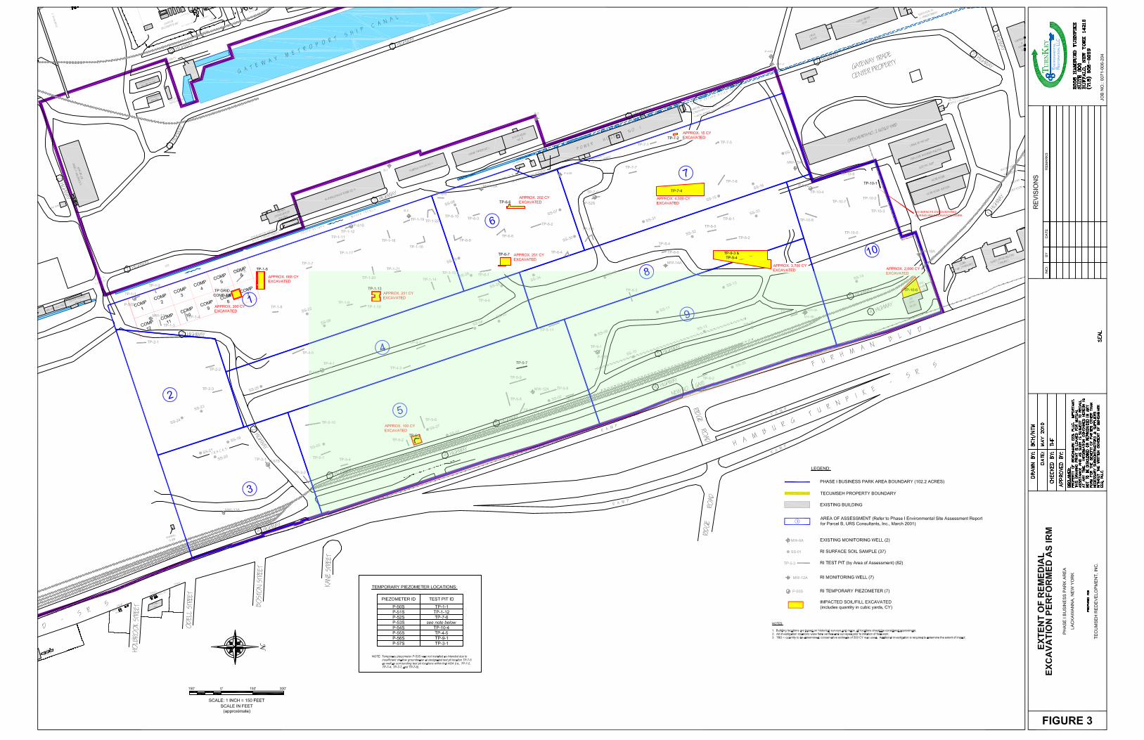
The contaminant(s) of concern exceed the applicable SCGs for: - groundwater - soil 6.2: Interim Remedial Measures An interim remedial measure (IRM) is conducted at a site when a source of contamination or exposure pathway can be effectively addressed before issuance of the Decision Document. The following IRM(s) has/have been completed at this site based on conditions observed during the RI. IRM - Soil Excavation and UST removal During the investigations several test pit areas throughout the site noted impacts from petroleum. Two test pit areas were impacted with coal tar residuals and one test pit area contained lead contaminated soils. Additionally two underground storage tanks (USTs) were discovered in the northeast corner of the site. Remedial activities were completed as IRMs at the Site in accordance with an approved IRM Work Plan. Remedial activities starting in April 2009 were substantially complete in August 2009. The IRM activities included:
PROPOSED DECISION DOCUMENT December 2011 Tecumseh Phase I Business Park, Site No. C915197 Page 6
• excavation and bio-remediation of approximately 12,000 cubic yards of petroleum impacted fill; • excavation and appropriate off-site disposal of an estimated 100 cubic yards of soils impacted by lead and an additional 45 cubic yards of coal tar-impacted soil/fill; • removal of two former petroleum USTs and remediation of impacted soils; and • backfill of excavations with reclaimed slag material under a NYSDEC issued Beneficial Use Determination. 6.3: Summary of Human Exposure Pathways This human exposure assessment identifies ways in which people may be exposed to site-related contaminants. Chemicals can enter the body through three major pathways (breathing, touching or swallowing). This is referred to as exposure. The site is completely fenced, which restricts public access. However, persons who enter the site could contact contaminants in the soil by walking on the site, digging, or otherwise disturbing the soil. Limited soil removal actions have been completed. People are not drinking the contaminated groundwater because the area is served by a public water supply that is not affected by this contamination. 6.4: Summary of Environmental Assessment This section summarizes the assessment of existing and potential future environmental impacts presented by the site. Environmental impacts may include existing and potential future exposure pathways to fish and wildlife receptors, wetlands, groundwater resources, and surface water. The RI report presents a detailed discussion of any existing and potential impacts from the site to fish and wildlife receptors. Based upon investigations conducted to date, the primary contaminants of concern for soils at the Tecumseh Phase I site include metals, and Semi-Volatile Organic Compounds (SVOCs). The nature and extent of metals contamination is consistent with the former site use as a steel manufacturing facility. Widespread exceedances of unrestricted use site cleanup objectives (SCOs) are common in the soil and fill, mostly in the upper two feet of soils. However, when compared to the commercial SCOs, only arsenic is found to exceed the SCOs (16 ppm) in a large number of the samples. Arsenic is found ranging from 2.4J1 ppm to 152J ppm with the average of 25.3 ppm exceeds the commercial SCOs in 20 of 49 samples. Cadmium, ranging from not detected (ND) to 94.9 ppm was found to exceed commercial SCOs (9.3 ppm) in only four samples. Lead, from ND – 10,200 ppm, exceeds commercial SCO (1000 ppm) in only five samples. Mercury from 0.031 to 12.0 exceeds the commercial SCOs (2.8 ppm) in 7 of 49 samples. Cyanide only exceeded the commercial (27 ppm) SCOs in only one sample. 1 A ”J” value is an estimated value given when a sample result is less than the sample quantitation limit but greater than zero.
SVOCs are widespread in soils throughout the Phase I Business Park. Most of the contaminants are polyaromatic hydrocarbons (PAHs) and are usually associated with the burning of fossil fuels and heavy rail use. SVOC contamination also results from use of lubricating and cooling oils which were ubiquitous at the former steel mill. SVOC contamination is usually greater within or near surface soils, but typically decreases with depth, unless there is definitive evidence of source material such as stained soils, odors or visible impacts. Although many SVOC compounds are present in soils throughout the site only five (5) compounds exceed the commercial SCOs in more than twenty-five (25) percent of the samples. Of these five compounds, benzo(a)pyrene with sample results from ND to 50 ppm averaging 8.5 ppm exceeds the commercial SCO of 1 ppm eighty-six(86) percent of the time. Dibenzo(a,h)anthracene, resulting from ND to 8.6J exceeded the commercial SCO of 0.56 ppm about one-half the time. Benzo(b)fluoranthene, (SCO 5.6 ppm) from ND to 86 ppm and benzo(a)anthracene (SCO 5.6 ppm) from 0.33J to 50 ppm exceeded the commercial SCOs in a little less than one-half the time. Finally, indeno(1,2,3-cd)pyrene, from ND to 30 ppm exceeds the commercial SCO of 5.6 ppm in about one in four samples. Polychlorinated biphenyls (PCBs) were found to exceed the commercial SCOs (1.0 ppm) ranging from ND to 4.2 ppm in only three samples. No volatile organic compounds (VOCs) were found to exceed the commercial or unrestricted SCOs in soil. Sampling at the site indicates groundwater quality has been compromised. VOCs, SVOCs and PCBS were not found to exceed groundwater quality standards at any location. Groundwater sampled at Monitoring well MW-12A groundwater was found to contain barium at 8.7 ppm, (1.0 ppm standard ), iron at 248 ppm (0.3 ppm standard), magnesium (2,260 ppm) manganese (74.3 ppm) and sodium (44,000 ppm). Additionally at MW-12A, pH (9.69) was greater than the groundwater quality standard of 6.5 to 8.5. 6.5: Summary of the Remediation Objectives The objectives for the remedial program have been established through the remedy selection process stated in 6 NYCRR Part 375. The goal for the remedial program is to restore the site to pre-disposal conditions to the extent feasible. At a minimum, the remedy shall eliminate or mitigate all significant threats to public health and the environment presented by the contamination identified at the site through the proper application of scientific and engineering principles. The remedial action objectives for this site are: Groundwater RAOs for Public Health Protection • Prevent ingestion of groundwater with contaminant levels exceeding drinking water standards.
PROPOSED DECISION DOCUMENT December 2011 Tecumseh Phase I Business Park, Site No. C915197 Page 7
Soil RAOs for Public Health Protection • Prevent ingestion/direct contact with contaminated soil. RAOs for Environmental Protection • Prevent migration of contaminants that would result in groundwater or surface water contamination. • Prevent impacts to biota from ingestion/direct contact with soil causing toxicity or impacts from bioaccumulation through the terrestrial food chain. SECTION 7: ELEMENTS OF THE PROPOSED REMEDY The alternatives developed for the site and evaluation of the remedial criteria are presented in the alternative analysis. The remedy is selected pursuant to the remedy selection criteria set forth in DER-10, Technical Guidance for Site Investigation and Remediation and 6 NYCRR Part 375. The remedy proposed is a Track 4: Restricted use with site-specific soil cleanup objectives remedy. The elements of the proposed remedy, as shown in Figure 2, are as follows: 1. A remedial design program will be implemented to provide the details necessary for the construction, operation, maintenance, and monitoring of the remedial program. Green remediation principals and techniques will be implemented to the extent feasible in the design, implementation, and site management of the remedy as per DER-31. The major green remediation components are as follows; • Considering the environmental impacts of treatment technologies and remedy stewardship over the long term; • Reducing direct and indirect greenhouse gas and other emissions; • Increasing energy efficiency and minimizing use of non-renewable energy; • Conserving and efficiently managing resources and materials; • Reducing waste, increasing recycling and increasing reuse of materials which would otherwise be considered a waste. 2. A site cover will be required to allow for commercial use of the site. The cover will consist either of the structures such as buildings, pavement, sidewalks comprising the site development or a soil cover in areas where the upper one foot of exposed surface soil will exceed the applicable soil cleanup objectives (SCOs). Where the soil cover is required it will be a minimum of one foot of soil, meeting the SCOs for cover material as set forth in 6 NYCRR Part 375-6.7(d) for commercial use. The soil cover will be placed over a demarcation layer, with the upper six
PROPOSED DECISION DOCUMENT December 2011 Tecumseh Phase I Business Park, Site No. C915197 Page 8
PROPOSED DECISION DOCUMENT December 2011 Tecumseh Phase I Business Park, Site No. C915197 Page 9
inches of the soil of sufficient quality to maintain a vegetation layer. Any fill material brought to the site will meet the requirements for the identified site use as set forth in 6 NYCRR Part 375-6.7(d). 3. Imposition of an institutional control in the form of an environmental easement is required for the controlled property that: • allows the use and development of the controlled property for commercial and industrial uses as defined by Part 375-1.8(g), although land use is subject to local zoning laws; • restricts the use of groundwater as a source of potable or process water, without necessary water quality treatment as determined by the NYSDOH or County DOH; • requires compliance with the Department approved Site Management Plan; and • requires the remedial party or site owner to complete and submit to the Department a periodic certification of institutional and engineering controls in accordance with Part 375-1.8 (h)(3.) 4. A Site Management Plan is required, which includes, but not limited to, the following: • an Institutional and Engineering Control Plan that identifies all use restrictions for the site noted above and details the steps necessary to ensure the following controls remain in place and effective; • an Excavation Plan which details the provisions for management of future excavations in areas of remaining contamination; • a Monitoring Plan to ensure groundwater quality and to assess the performance and effectiveness of the site cover; • provisions for the management and inspection of the identified engineering controls; • maintaining site access controls and Department notification; and • the steps necessary for the periodic reviews and certification of the institutional and/or engineering controls.
Kestoration,nvironmental
TALTERNATIVES ANALYSIS REPORT
TECUMSEH REDEVELOPMENT, INC.
PHASE I BUSINESS PARK AREALACKAWANNA, NEW YORK
SITE LOCATION AND VICINITY MAP
FIGURE 1
PHASE I BUSINESS PARK
AREA
mfmoore
Polygon
mfmoore
Text Box
Elements of the Selected Remedy Figure 2
mfmoore
Rectangle
mfmoore
Rectangle
mfmoore
Text Box
Areas requiring one foot of soil cover or alternative. Entire parcel subject to prohibition of groundwater use, groundwater monitoring and requires a Site Management Plan (SMP).
mfmoore
Line
mfmoore
Line
mfmoore
Line
mfmoore
Line
mfmoore
Line
mfmoore
Line
mfmoore
Line
mfmoore
Line
mfmoore
Line
mfmoore
Line
mfmoore
Line
mfmoore
Line
mfmoore
Line
mfmoore
Line
mfmoore
Line
mfmoore
Line
mfmoore
Line
mfmoore
Line
mfmoore
Line
mfmoore
Line
mfmoore
Line
mfmoore
Line
mfmoore
Line
mfmoore
Line
mfmoore
Line
mfmoore
Line
mfmoore
Line
mfmoore
Line
mfmoore
Line
mfmoore
Line
mfmoore
Line