PROPOSED ABALONE HOLDING AND PROCESSING FACILITY …
60
PROPOSED ABALONE HOLDING AND PROCESSING FACILITY FOR PORT NOLLOTH SEA FARMS RANCHING (PTY) LTD Anchor Environmental Consulting Report No, 1786/2 PRE-APPLICATION BASIC ASSESSMENT REPORT Anchor Environmental Consulting Report No, 1786/1
Transcript of PROPOSED ABALONE HOLDING AND PROCESSING FACILITY …

PROPOSED ABALONE HOLDING AND PROCESSING FACILITY FOR
PORT NOLLOTH SEA FARMS RANCHING (PTY) LTD
Anchor Environmental Consulting Report No, 1786/2
PRE-APPLICATION BASIC ASSESSMENT REPORT
Anchor Environmental Consulting Report No, 1786/1


PROPOSED ABALONE HOLDING AND PROCESSING FACILITY FOR
PORT NOLLOTH SEA FARMS RANCHING (PTY) LTD
Pre-Application Basic Assessment Report
August 2018
Report Prepared by: Anchor Environmental Consultants (Pty) Ltd.
8 Steenberg House, Silverwood Close, Tokai 7945, South Africa www.anchorenvironmental.co.za
Authors: Vera Massie, Ken Hutchings and Barry Clark Citation: Massie V, Hutchings K and Clark B, 2018. Proposed Abalone Holding and Processing Facility for Port Nolloth Sea Farms Ranching (Pty) Ltd Kleinzee, Northern Cape – Pre-application Basic Assessment Report. Supporting documentation for the Basic Assessment process conducted in terms of the National Environmental Management Act (No. 107 of 1998). August 2018.
Cover Photo: Port Nolloth Sea Farms Ranching (Pty) Ltd


BASIC ASSESSMENT REPORT
1
Project applicant: Port Nolloth Sea Farms Ranching (Pty) Ltd Business reg. no. /ID. no.: 2009/024403/07 Contact person: Quiryn Snethlage Postal address: PO Box 1540
NorthCliff 2115 Johannesburg
Telephone: 0278770937 Cell: Fax:
082 565 3421 E-mail: [email protected] N/A
Prepared by:
Environmental Assessment Practitioner/Firm:
Anchor Environmental Consultants (Pty) Ltd.
Business reg. no. /ID. no.: 2014/03/8279/07 Contact person: Vera Massie Postal address: Suite 8, Steenberg House, Steenberg Office Park, Silverwood Close,
Tokai, 7945 Telephone: 021 701 3420 Cell:
Fax: 082 724 5329
E-mail: [email protected] 021 701 5280
(For official use only) File Reference Number:
Application Number: Date Received:

BASIC ASSESSMENT REPORT
2
Basic Assessment Report in terms of the Environmental Impact Assessment Regulations, 2014, promulgated in terms of the National Environmental Management Act, 1998 (Act No. 107 of
1998), as amended. Kindly note that: 1. This basic assessment report is a stand/ard report that may be required by a competent authority
in terms of the EIA Regulations, 2014 and is meant to streamline applications. Please make sure that it is the report used by the particular competent authority for the activity that is being applied for.
2. This report format is current as of 08 December 2014. It is the responsibility of the applicant to ascertain whether subsequent versions of the form have been published or produced by the competent authority
3. The report must be typed within the spaces provided in the form. The size of the spaces provided is not necessarily indicative of the amount of information to be provided. The report is in the form of a table that can extend itself as each space is filled with typing.
4. Where applicable tick the boxes that are applicable in the report. 5. An incomplete report may be returned to the applicant for revision. 6. The use of “not applicable” in the report must be done with circumspection because if it is used in
respect of material information that is required by the competent authority for assessing the application, it may result in the rejection of the application as provided for in the regulations.
7. This report must be handed in at offices of the relevant competent authority as determined by each authority.
8. No faxed or e-mailed reports will be accepted. 9. The signature of the EAP on the report must be an original signature. 10. The report must be compiled by an independent environmental assessment practitioner. 11. Unless protected by law, all information in the report will become public information on receipt by
the competent authority. Any interested and affected party should be provided with the information contained in this report on request, during any stage of the application process.
12. A competent authority may require that for specified types of activities in defined situations only parts of this report need to be completed.
13. Should a specialist report or report on a specialised process be submitted at any stage for any part of this application, the terms of reference for such report must also be submitted.

BASIC ASSESSMENT REPORT
3
SECTION A: ACTIVITY INFORMATION Has a specialist been consulted to assist with the completion of this section? YES NO If YES, please complete the form entitled “Details of specialist and declaration of interest” for the specialist appointed and attach in Appendix I. 1. ACTIVITY DESCRIPTION a) Describe the project associated with the listed activities applied for Port Nolloth Sea Farms Ranching (Pty) Ltd (hereinafter referred to as PNSFR) ranches abalone in the Northern Cape Concession Area NC 3 and is in need of an abalone holding and processing facility to support the abalone ranching business. The northern boundary of the concession area is situated just south of Kleinzee (29°40'43.90"S 17° 3'3.50"E) and extends 44 km to the south (30° 2'52.04"S, 17°10'39.69"E) (Figure 1). PNSFR is currently in the process of registering as an Operation Phakisa: Oceans Economy (Aquaculture) project1 and have completed stage one of the application process (the letter from the Department of Agriculture, Forestry and Fisheries (DAFF) is attached to the Basic Assessment Report in Appendix J). The proposed holding and processing facility is situated approximately 6 km south of Kleinzee on State Land (Figure 1). PNSFR had leased this land from De Beers Namaqualand Mines up until four years ago when ownership was transferred to the state. Port Nolloth Sea Farms Ranching (Pty) Ltd ranches abalone in the Northern Cape Concession Area 3 (Figure 1) and is in need of an abalone holding and processing facility to support the abalone ranching business. The proposed development site is situated approximately 6 km south of Kleinzee on state land measuring 2.22 ha in size (Figure 1). The proposed facility will have the capacity to hold six tonnes of abalone. Juvenile abalone sized 10-12 mm will be sourced from Abagold Ltd. in Hermanus and will be acclimatized and reared in flow-through holding tanks for a few months at the proposed holding facility until they are ready to be seeded (size 20 mm). Concurrently, harvested abalone will also be kept in the holding tanks until enough abalone have been harvested for one shipment to the market. The proposed abalone holding tank facility layout is shown in Figure 2. As part of this development, the seawater intake infrastructure will be repaired (a pump house and intake lines already exist due to previous mining activities in the area). Effluent originating from flow-through abalone tanks is known to be very clean with low concentrations of nutrients and waste products. It is therefore proposed that the effluent outfall channel will be open for effective maintenance and that the effluent is discharged at the high water mark as is the practice with many other abalone aquaculture facilities. A processing facility is also proposed, where abalone can be de-shelled, gutted, dried or frozen and
1 Aquaculture is one of the sectors which form part of Operation Phakisa under the Ocean’s Economy in South Africa. Operation Phakisa is an initiative of the South African government which aims to implement priority economic and social programmes better, faster and more effectively. Operation Phakisa was launched by the President of the Republic in October 2014. The sector offers significant potential for rural development, especially for marginalised coastal communities. Kleinzee is a derelict mining town and unemployment is high in this area. The proposed development will provide employment opportunities for the local and regional communities.

BASIC ASSESSMENT REPORT
4
packed for export. The abalone waste will amount to approximately 3 200 kg per year and will be discarded at a registered landfill site. Amenities (three small accommodation units and ablutions) for employees and security staff will be constructed. In addition to a demarcation fence around the leased area, a security fence will be erected around the abalone holding tanks. Electricity will be provided by De Beers via the existing servitude. PNSFR proposes to install an electricity transformer in the south-eastern corner of the proposed site (Figure 2). The abalone holding facility relies on fresh seawater supply to operate successfully and has minimal potable water requirements, which will be supplied by PNSFR as required. The establishment of the abalone facility is an important job-creation and economic contributor to the local economy of Kleinzee.
Figure 1: Location of the proposed Port Nolloth Sea Farms Ranching abalone holding and processing facility south of Kleinzee, Northern Cape.

BASIC ASSESSMENT REPORT
5
Figure 2: Proposed site layout of the proposed Port Nolloth Sea Farms Ranching abalone holding and processing facility south of Kleinzee, Northern Cape.

BASIC ASSESSMENT REPORT
6
b) Provide a detailed description of the listed activities associated with the project as applied for.
Listed activity as described in GN 734, 735 and 736
Description of project activity
LN1 GN R. 327, 2017 8. The development and related operation of hatcheries or agri-industrial facilities outside industrial complexes where the development footprint covers an area of 2 000 square metres or more.
Keinzee Mariculture intends to build 40 holding tanks as well as a processing facility where abalone will be de-shelled, gutted, dried and packed for export.
LN1 GN R. 327, 2017 17. Development- (i) in the sea; (ii) in an estuary; (iii) within the littoral active zone; (iv) in front of a development setback; or (v) if no development setback exists, within a
distance of 100 metres inland of the high water mark of the sea or an estuary, whichever is the greater;
in respect of- (c) embankments; (d) rock revetments or stabilising structures
including stabilising walls; (e) infrastructure or structures with a
development footprint of 50 square metres or more.
PNSFR intends to construct an abalone holding and processing facility, as well as infrastructure associated with the facility (i.e. diver’s cottage, blower room, packaging room etc.). This infrastructure will be built within the littoral active zone, and within 100 metres inland of the high water mark. The extent of the infrastructure will exceed 50 m2.
LN1 GN R. 327, 2017 19A. The infilling or depositing of any material of more than 5 cubic metres into, or the dredging, excavation, removal or moving of soil, sand, shells, shell grit, pebbles or rock of more than 5 cubic metres from - (i) the seashore; (iii) the littoral active zone, an estuary or a
distance of 100 metres inland of the high-water mark of the sea or an estuary, whichever distance is the greater.
(iv) the sea; (Exclusions are not applicable)
PNSFR intends to build a new abalone holding facility, processing facility, abalone holding tanks, amenities for employees and security staff and to upgrade effluent outfall infrastructure. The construction of the infrastructure will involve the excavation and depositing of material on the seashore, in the littoral active zone/within 100 m of the high water mark and the sea. The threshold of 5 cubic metres will be exceeded.
LN1 GN R. 327, 2017 34. The expansion to existing facilities or infrastructure for any process or activity where such expansion will result in the need for a permit or license or an amended permit or license in terms of national or provincial legislation governing the release of emissions,
The existing seawater intake and effluent outfall infrastructure will be expanded by installing a new suction cage and additional pipelines The abalone holding facility will discharge effluent from the abalone holding tanks, which will require a Coastal Waters Discharge Permit.

BASIC ASSESSMENT REPORT
7
effluent or pollution (exclusions do not apply) LN1 GN R. 327, 2017 54. The expansion of facilities- (i) in the sea; (ii) in an estuary; (iii) within the littoral active zone; (iv) in front of a development setback; or (v) if no development setback exists, within a
distance of 100 metres inland of the high water mark of the sea or an estuary, whichever is the greater;
in respect of- (c) embankments; (d) rock revetments or stabilising structures
including stabilising walls; (e) buildings where the building is expanded
by 50 square metres or more; or (f) infrastructure with a development footprint
of 50 square metres or more.
PNSFR intends to construct an abalone holding and processing facility, as well as infrastructure associated with the facility (i.e. diver’s cottage, blower room, packaging room, effluent outfall channel etc.). This infrastructure will be built within the littoral active zone, and within 100 metres inland of the high water mark. The extent of the infrastructure will exceed 50 m2.
LN 3 R. 324, 2017 14. The development of – (ii) infrastructure or structures with a physical
footprint of 10 square metres or more; Where such development occurs – (b) in front of a development setback; g. Northern Cape ii. Outside urban areas: (cc) Areas seawards of the development
setback line or within 1 kilometre from the high-water mark of the sea if no such development setback line is determined;
Exclusions are not applicable.
The entire development will be situated within 1 km of the high water mark. No setback line exists in this region.
LN 3 R. 324, 2017 23. The expansion of – (ii) infrastructure or structures where the
physical footprint is expanded by 10 square metres or more;
Where such development occurs – (b) in front of a development setback adopted
in the prescribed manner; g. Northern Cape Outside urban areas: (cc) Areas seawards of the development
setback line or within 1 kilometre from the high-water mark of the sea if no such development setback line is determined
Exclusions are not applicable.
The entire development will be situated within 1 km of the high water mark. No setback line exists in this region.

BASIC ASSESSMENT REPORT
8
2. FEASIBLE AND REASONABLE ALTERNATIVES “alternatives”, in relation to a proposed activity, means different means of meeting the general purpose and requirements of the activity, which may include alternatives to— (a) the property on which or location where it is proposed to undertake the activity; (b) the type of activity to be undertaken; (c) the design or layout of the activity; (d) the technology to be used in the activity; (e) the operational aspects of the activity; and (f) the option of not implementing the activity. Describe alternatives that are considered in this application as required by Appendix 1 (3)(h), Regulation 2014.Alternatives should include a consideration of all possible means by which the purpose and need of the proposed activity (NOT PROJECT) could be accomplished in the specific instance taking account of the interest of the applicant in the activity. The no-go alternative must in all cases be included in the assessment phase as the baseline against which the impacts of the other alternatives are assessed. The determination of whether site or activity (including different processes, etc.) or both is appropriate needs to be informed by the specific circumstances of the activity and its environment. After receipt of this report the, competent authority may also request the applicant to assess additional alternatives that could possibly accomplish the purpose and need of the proposed activity if it is clear that realistic alternatives have not been considered to a reasonable extent. Indicate the position of the activity using the latitude and longitude of the centre point of the site for each alternative site. The co-ordinates should be in degrees, minutes and seconds. The projection that must be used in all cases is the WGS84 spheroid in a national or local projection. a) Site alternatives
Alternative 1 (preferred alternative) Description: Lat (DDMMSS) Long (DDMMSS) A large stretch of this coastline has been declared State Land and PNSF Ranching has obtained permission from the Department of Public Works to conduct an EIA for this site. This site is situated conveniently and accessible with respect to PNSF Ranching’s concession area for abalone ranching. Finally existing pump houses installed by De Beers can be used for the proposed development. Thus, no alternatives sites have been considered.
29°43'46.40"S 17° 3'38.16"E
Alternative 2 Description: N/A Lat (DDMMSS) Long (DDMMSS)
Alternative 3 Description: N/A Lat (DDMMSS) Long (DDMMSS)

BASIC ASSESSMENT REPORT
9
In the case of linear activities: Alternative: Latitude (S): Longitude (E): Alternative S1 (preferred) • Starting point of the activity N/A N/A • Middle/Additional point of the activity • End point of the activity Alternative S2 (if any) • Starting point of the activity • Middle/Additional point of the activity • End point of the activity Alternative S3 (if any) • Starting point of the activity • Middle/Additional point of the activity • End point of the activity For route alternatives that are longer than 500m, please provide an addendum with co-ordinates taken every 250 meters along the route for each alternative alignment. In the case of an area being under application, please provide the co-ordinates of the corners of the site as indicated on the lay-out map provided in Appendix A of this form. Northwest 29°43'43.10"S 17° 3'38.09"E Northeast 29°43'43.31"S 17° 3'40.22"E Southwest 29°43'48.11"S 17° 3'40.73"E Southeast 29°43'48.82"S 17° 3'33.66"E
b) Lay-out alternatives
Alternative 1 (preferred alternative) Description Lat (DDMMSS) Long (DDMMSS) The total extent of the proposed development site is only 2.22 ha. Layout alternatives have not been considered due to limited amount of space and the pre-existing seawater intake infrastructure.
N/A N/A
Alternative 2 Description Lat (DDMMSS) Long (DDMMSS)
Alternative 3 Description Lat (DDMMSS) Long (DDMMSS)

BASIC ASSESSMENT REPORT
10
c) Technology alternatives
Alternative 1 (preferred alternative) Flow-through system: The holding tanks will primarily be used for acclimating juvenile abalone to the environment into which they will be seeded. Accordingly, a flow-through (or open) system where seawater is continuously replaced will be the most suitable technology for the proposed facility. Recirculation systems are particularly recommended when freshwater is used for aquaculture. For landbased marine aquaculture, however, seawater is not the limiting resource. Instead, electricity requirements are extremely high as seawater is pumped onto land. Partial recirculation systems are therefore often considered for land-based marine aquaculture facilities to reduce electricity requirements. In this case, partial recirculation would result in the warming of the seawater, which would hinder acclimation of juvenile abalone to colder water temperatures unless the water is chilled during recirculation. The electricity needed for chilling seawater would likely to be equivalent to that of pumping seawater through a flow-through system. Furthermore, the effluent arising from a flow-through system is much cleaner than that originating from a recirculated system. It is in the interest of PNSFR to ensure that the effluent is as clean as possible, as juvenile abalones are seeded in the area where the outfall is situated. Finally, apart from the same reasons described above, the biosecurity risks for a fully recirculated system are very high and therefore this type of system does not pose a feasible alternative for this development. For the reasons described above, no technology alternatives have been considered.
Alternative 2 N/A
Alternative 3 N/A d) Other alternatives (e.g. scheduling, demand, input, scale and design alternatives)
Alternative 1 (preferred alternative) None available
Alternative 2 N/A
Alternative 3 N/A e) No-go alternative Abalone holding tanks are a vital component of a successful ranching business and the no-go alternative implies that PNSFR will not be able to expand their abalone ranching business effectively. Abalone ranching will remain at the level that it is currently despite the growing demand for abalone. Bio-physical environmental impacts would continue as currently observed. The no-go alternative would also mean that PNSFR would not be able to create new jobs for continued socio-economic development in the area.

BASIC ASSESSMENT REPORT
11
Paragraphs 3 – 13 below should be completed for each alternative. 3. PHYSICAL SIZE OF THE ACTIVITY a) Indicate the physical size of the preferred activity/technology as well as alternative
activities/technologies (footprints): Alternative: Size of the activity: Alternative A12 (preferred activity alternative) 2470 m2 Alternative A2 (if any) m2 Alternative A3 (if any) m2 or, for linear activities: Alternative: Length of the activity: Alternative A1 (preferred activity alternative) m Alternative A2 (if any) m Alternative A3 (if any) m b) Indicate the size of the alternative sites or servitudes (within which the above footprints
will occur): Alternative: Size of the site/servitude: Alternative A1 (preferred activity alternative) 22 241 m2 Alternative A2 (if any) m2 Alternative A3 (if any) m2 4. SITE ACCESS Does ready access to the site exist? YES NO If NO, what is the distance over which a new access road will be built m Describe the type of access road planned: N/A
Include the position of the access road on the site plan and required map, as well as an indication of the road in relation to the site. 5. LOCALITY MAP An A3 locality map must be attached to the back of this document, as Appendix A. The scale of the locality map must be relevant to the size of the development (at least 1:50 000. For linear activities of more than 25 kilometres, a smaller scale e.g. 1:250 000 can be used. The scale must be indicated on the map.). The map must indicate the following: 2 “Alternative A..” refer to activity, process, technology or other alternatives.

BASIC ASSESSMENT REPORT
12
• an accurate indication of the project site position as well as the positions of the alternative sites, if
any; • indication of all the alternatives identified; • Closest town(s;) • road access from all major roads in the area; • road names or numbers of all major roads as well as the roads that provide access to the site(s); • all roads within a 1km radius of the site or alternative sites; and • a north arrow; • a legend; and • locality GPS co-ordinates (Indicate the position of the activity using the latitude and longitude of the
centre point of the site for each alternative site. The co-ordinates should be in degrees and decimal minutes. The minutes should have at least three decimals to ensure adequate accuracy. The projection that must be used in all cases is the WGS84 spheroid in a national or local projection).
6. LAYOUT/ROUTE PLAN A detailed site or route plan(s) must be prepared for each alternative site or alternative activity. It must be attached as Appendix A to this document. The site or route plans must indicate the following: • the property boundaries and numbers of all the properties within 50 metres of the site; • the current land use as well as the land use zoning of the site; • the current land use as well as the land use zoning each of the properties adjoining the site or sites; • the exact position of each listed activity applied for (including alternatives); • servitude(s) indicating the purpose of the servitude; • a legend; and • a north arrow. 7. SENSITIVITY MAP The layout/route plan as indicated above must be overlain with a sensitivity map that indicates all the sensitive areas associated with the site, including, but not limited to: • watercourses; • the 1:100 year flood line (where available or where it is required by DWS); • ridges; • cultural and historical features; • areas with indigenous vegetation (even if it is degraded or infested with alien species); and • critical biodiversity areas. The sensitivity map must also cover areas within 100m of the site and must be attached in Appendix A.

BASIC ASSESSMENT REPORT
13
8. SITE PHOTOGRAPHS Colour photographs from the centre of the site must be taken in at least the eight major compass directions with a description of each photograph. Photographs must be attached under Appendix B to this report. It must be supplemented with additional photographs of relevant features on the site, if applicable. 9. FACILITY ILLUSTRATION A detailed illustration of the activity must be provided at a scale of at least 1:200 as Appendix C for activities that include structures. The illustrations must be to scale and must represent a realistic image of the planned activity. The illustration must give a representative view of the activity. 10. ACTIVITY MOTIVATION Motivate and explain the need and desirability of the activity (including demand for the activity): Operation Phakisa Operation Phakisa was initiated in August 2013 (“phakisa” meaning “hurry up” in Sesotho. The name highlights the urgency of delivery). This operation is meant to address national key priority areas such as poverty, crime and unemployment. A study of the economic potential of South Africa’s oceans indicated that the immense potential of this untapped resource has not fully taken advantage of. The oceans have the potential to contribute up to 177 billion rand to the gross domestic product (GDP) and create just over one million jobs by 2033. Aquaculture is one of four critical areas to explore and further unlock the potential of South Africa’s vast coastline. The Aquaculture work stream has underlined the high growth potential of South Africa’s aquaculture sector due to increasing demand for fish. While aquaculture contributes to almost half of the global fish supply, it contributes less than 1% of South Africa’s fish supply. The sector offers significant potential for rural development, especially for marginalised coastal communities. Kleinsee is a derelict mining town and unemployment is high in this area. The proposed development will provide employment opportunities for the local and regional communities. PNSFR is currently in the process of registering as an Operation Phakisa: Oceans Economy (Aquaculture) project. 1. Is the activity permitted in terms of the property’s existing
land use rights? YES NO Please explain
Ownership of the land was transferred from De Beers to the Department of Public Works (DPW) four years ago. The site has not yet been zoned. However, PNSFR has obtained permission from the Department of Public Works to conduct the environmental impact assessment process (See letter attached in Appendix J) and if environmental authorisation is granted will lease the land from the DPW.

BASIC ASSESSMENT REPORT
14
2. Will the activity be in line with the following? (a) Provincial Spatial Development Framework (PSDF) YES NO Please explain
The PSDF 2012 identified Kleinzee as a Category 1 Settlement, i.e. High Development Potential and Low Human Needs, which means that Kleinzee is considered a high priority area for investment and infrastructure development. Recommended investment types include infrastructural capital and large-scale monetary capital. The proposed abalone holding facility 6 km south of Kleinzee will provide additional employment to the area.
St(b) Urban edge / Edge of Built environment for the area YES NO Please
explain A detailed precinct plan and/or detailed design framework need to be drafted for Kleinzee in order to provide direction for development and growth in the area. The urban edge has therefore not yet been delineated for Kleinzee. The development is taking place in an area previously mined out by De Beers just outside the town of Kleinzee.
(c) Integrated Development Plan (IDP) and Spatial Development Framework (SDF) of the Local Municipality (e.g. would the approval of this application compromise the integrity of the existing approved and credible municipal IDP and SDF?).
YES NO Please explain
Integrated Development Plan (IDP) (2012-2017): The Key Performance Area (KPA) 2 is Local Economic Development. The proposed development will contribute to local development. Spatial Development Framework (SDF) of 2014: A number of mines have reached the end of their production capacity and have been decommissioned. This has had a significant negative impact on the economy and has left many people unemployed. The mined out land is suitable for wind energy production. No agriculture land use is possible in this area due to the sparse vegetation (sheep farming requires denser vegetation) and water scarcity. Land-based aquaculture of marine organisms has not been identified as a land use in the SDF (only sea based culture is mentioned). The PNSFR development is, however, in line with the SDF in that it is a suitable land use with the capacity to provide additional income and employment to the town of Kleinzee and surrounds.
(d) Approved Structure Plan of the Municipality YES NO Please explain
No approved Structure Plan in place.

BASIC ASSESSMENT REPORT
15
(e) An Environmental Management Framework (EMF) adopted by the Department (e.g. Would the approval of this application compromise the integrity of the existing environmental management priorities for the area and if so, can it be justified in terms of sustainability considerations?)
YES NO Please explain
The Namakwa District Municipality has finalised an EMF and Strategic Environmental Management Plan (March 2011) (it is unclear whether this plan was adopted). The EMF recognises that the coastal area in this region has been severely disturbed by mining activities, especially around the town of Kleinzee. However, immediately south of Kleinzee, the area is considered of very high environmental sensitivity. This is where the proposed development is situated). The map in Appendix B of the 2011 EMF is of very poor quality and it is impossible to ascertain whether the site is situated within the Sensitivity Zone category E (Low) or B (Very High). Development should be facilitated in this area whilst ensuring compliance with existing legislation and best practice approaches. Abalone ranching and other aquaculture activities are not mentioned as a development type in the Environmental Management Framework.
(f) Any other Plans (e.g. Guide Plan) YES NO Please explain
N/A 3. Is the land use (associated with the activity being applied for)
considered within the timeframe intended by the existing approved SDF agreed to by the relevant environmental authority (i.e. is the proposed development in line with the projects and programmes identified as priorities within the credible IDP)?
YES NO Please explain
Land-based aquaculture of marine organisms has not been identified as a land use in the SDF (only sea based culture is mentioned). The PNSFR development is, however, in line with the SDF in that it is a suitable land use with the capacity to provide additional income and employment to the town of Kleinzee and surrounds. 4. Does the community/area need the activity and the associated
land use concerned (is it a societal priority)? (This refers to the strategic as well as local level (e.g. development is a national priority, but within a specific local context it could be inappropriate.)
YES NO Please explain
A number of mines have reached the end of their production capacity and have been decommissioned. This has had a significant negative impact on the economy and has left many people unemployed and has forced people to relocate to find work. The PNSFR development has the capacity to provide additional employment to the people of Kleinzee and surrounds. In 2011, Kleinzee was home to 728 people of which 86.3% were of working age. The unemployment rate in the local municipality is 22.9% with youth unemployment at 30.1%. The proposed development will provide 12 jobs during the construction phase and 8 jobs during the operational phase.

BASIC ASSESSMENT REPORT
16
5. Are the necessary services with adequate capacity currently available (at the time of application), or must additional capacity be created to cater for the development? (Confirmation by the relevant Municipality in this regard must be attached to the final Basic Assessment Report as Appendix I.)
YES NO Please explain
Services were put in place for a fully operational mining town and all services are therefore currently underutilised. De Beers Diamond Mining runs the Kleinsee Sewage Works, which is currently underutilised. PNSFR intends to install septic tanks, which will be emptied regularly by the Kleinsee Sewage Works (Letter attached in Appendix J). De Beers is currently in the process of registering access servitude rights, in favour of PNSFR, over the farms; Farm 654 and Sand Kop, Farm 322. These rights, which will be recorded against the property title deeds, will provide PNSFR with unrestricted access to their facility (Letter attached in Appendix J). The abalone holding facility relies on fresh seawater supply to operate successfully and has minimal potable water requirements, which is supplied by PNSFR as required.
6. Is this development provided for in the infrastructure planning of the municipality, and if not what will the implications be on the infrastructure planning of the municipality (priority and placement of services and opportunity costs)? (Comment by the relevant Municipality in this regard must be attached to the final Basic Assessment Report as Appendix I.)
YES NO Please explain

BASIC ASSESSMENT REPORT
17
7. Is this project part of a national programme to address an issue of national concern or importance? YES NO Please
explain PNSFR is currently in the process of registering as an Operation Phakisa: Oceans Economy (Aquaculture) project. Operation Phakisa was initiated in August 2013 (“phakisa” meaning “hurry up” in Sesotho. The name highlights the urgency of delivery). This operation is meant to address national key priority areas such as poverty, crime and unemployment. Operation Phakisa is a results-driven approach, involving setting clear plans and targets, on-going monitoring of progress and making these results public. Operation Phakisa is initially implemented in two sectors, the ocean economy and health. Operation Phakisa represents a new spirit of moving faster in meeting government’s targets. South African Government’s starting point was that South Africa is surrounded by a vast ocean which has not fully taken advantage of the immense potential of this untapped resource. The oceans have the potential to contribute up to 177 billion rand to the gross domestic product (GDP) and create just over one million jobs by 2033. Aquaculture is one of four critical areas to explore and further unlock the potential of South Africa’s vast coastline. The Aquaculture work stream has underlined the high growth potential of South Africa’s aquaculture sector due to increasing demand for fish. While aquaculture contributes to almost half of the global fish supply, it contributes less than 1% of South Africa’s fish supply. The sector offers significant potential for rural development, especially for marginalised coastal communities. This work stream has identified eight initiatives to spur the growth of the sector. One initiative will address the selection and implementation of 24 projects across South Africa by 2019. These projects are expected to grow the aquaculture sector’s revenue from about half a billion rand today, to almost R1.4 billion in 2019. Three further aquaculture initiatives relate to the creation of an enabling regulatory environment, including the establishment of an Inter-Departmental Authorisations Committee. The committee will co-ordinate aquaculture applications and approvals. The intention is to reduce processing time from the current periods of about 890 days to 240 days in future. Other initiatives focus on funding support, increasing the skills pool and awareness and improving access to markets. The proposed project will ensure that abalone ranching will continue to grow, contributing to economic growth and employment of Kleinzee and surrounds.
8. Do location factors favour this land use (associated with the activity applied for) at this place? (This relates to the contextualisation of the proposed land use on this site within its broader context.)
YES NO Please explain
PNSFR is ranching abalone within the legally assigned concession area NC 3. The northern boundary of the concession area is situated just south of Kleinzee (29°40'43.90"S 17° 3'3.50"E) and extends 44 km south (30° 2'52.04"S, 17°10'39.69"E). The proposed site for the abalone holding tanks is located 6 km south of Kleinzee, which is strategically important for this business. Furthermore, De Beers constructed a pump house and seawater intake infrastructure (including electricity supply) for diamond mining in the area.

BASIC ASSESSMENT REPORT
18
9. Is the development the best practicable environmental option for this land/site? YES NO Please
explain De Beers constructed a pump house and seawater intake infrastructure (including electricity supply) for diamond mining in the area. This area is no longer mined and this infrastructure is suitable for the establishment of the abalone holding facility. The surrounding area (except for an undisturbed area south of the development site) is mined out and heavily disturbed and is only suitable for a few land-use types, including wind energy, conservation and land-based aquaculture (note: marine organisms, not freshwater organisms due to water scarcity). This development is the best practicable environmental option for this land/site. Repairing the existing seawater intake infrastructure is economically smart with minimal environmental impacts, while providing additional employment opportunities to the underdeveloped area.
10. Will the benefits of the proposed land use/development outweigh the negative impacts of it? YES NO Please
explain Expanding the existing infrastructure is economically smart with minimal environmental impacts, while providing additional income and employment opportunities to the underdeveloped area.
11. Will the proposed land use/development set a precedent for similar activities in the area (local municipality)? YES NO Please
explain Several other abalone ranching concession areas are currently under discussion. Other abalone holding facilities may be required for the business to become viable.
12. Will any person’s rights be negatively affected by the proposed activity/ies? YES NO Please
explain The proposed development site is situated landward of the concession area 15 as determined by the Policy for the Allocation and Management of Commercial Harvesting Rights in the Seaweed Sector: 2005. The proposed development site constitutes one of the access points for the harvesting of kelp. However, it is important to note that the concession area is currently not allocated for commercial harvest. Furthermore, there are a number of other access points north and south and loss of access as a result of this development is considered insignificant. No person’s rights will therefore be negatively affected by the proposed activity.
13. Will the proposed activity/ies compromise the “urban edge” as defined by the local municipality? YES NO Please
explain The urban edge has not yet been delineated.
14. Will the proposed activity/ies contribute to any of the 17 Strategic Integrated Projects (SIPS)? YES NO Please
explain 5. Saldanha-Northern Cape Development Corridor: Development of aquaculture industry, providing employment to local communities. 6. Green Energy in support of the South African economy 11. Agri-Logistics and Rural Infrastructure

BASIC ASSESSMENT REPORT
19
15. What will the benefits be to society in general and to the local communities? Please explain
The project will contribute to economic growth and promote export of abalone products. The project will empower local communities through skills development, and provide job opportunities which will increase incomes of households.
16. Any other need and desirability considerations related to the proposed activity? Please explain
N/A
17. How does the project fit into the National Development Plan for 2030? Please explain
• Important issues such as poverty and unemployment are highlighted in the National Development Plan; therefore this project has the potential for poverty alleviation through creating job opportunities for local communities.
• Raising economic growth, promoting exports and making the economy more labour absorbing
• Earn foreign exchange through exports. 18. Please describe how the general objectives of Integrated Environmental Management as
set out in section 23 of NEMA have been taken into account. The general objectives of Integrated Environmental Management (IEM) as set out in section 23 (2) of NEMA are as follows:
• Promote the integration of the principles of environmental management set out in section 2 into the making of all decisions which may have a significant effect on the environment,
• Identify, predict and evaluate the actual and potential impact on the environment, socio-economic conditions and cultural heritage, the risks and consequences and alternatives and options for mitigation of activities, with a view to minimizing negative impacts, maximising benefits; and promoting compliance with the principles of environmental management set out in section 2;
• Ensure that the effects of activities on the environment receive adequate consideration before actions are taken in connection with them;
• Ensure adequate and appropriate opportunity for public participation in decisions that may affect the environment;
• Ensure the consideration of environmental attributes in management and decision making which may have a significant effect on the environment; and
• Identify and employ the modes of environmental management best suited to ensuring that a particular activity is pursued in accordance with the principles of environmental management
The listed objectives have been taken into account in this BAR in order to ensure sound environmental management in the implementation of the proposed project. Potential impacts on the environment, cultural heritage and socioeconomic interests have been identified and mitigation measures proposed. Public participation will be conducted in terms of the Environmental impact regulations. Environmental Impact Assessment Regulations, 2014 (as amended in 2017).

BASIC ASSESSMENT REPORT
20
19. Please describe how the principles of environmental management as set out in section 2 of NEMA have been taken into account. • Participation of interested and affected parties has been taken into account through public
participation process and decisions will take into account the interests of all interested and affected parties.
• Negative impacts on the environment and on people’s rights will be minimised / prevented • Mitigation measures required to prevent or minimise potential impacts are recommend in the
BAR • Socioeconomic interests have been considered and evaluated • Continued environmental responsibility will be guided by Environmental Management
Program for the construction, operation and decommissioning phases 11. APPLICABLE LEGISLATION, POLICIES AND/OR GUIDELINES List all legislation, policies and/or guidelines of any sphere of government that are applicable to the application as contemplated in the EIA regulations, if applicable: Title of legislation, policy or guideline
Applicability to the project Administering authority
Date
The constitution – Bill of Rights (Chapter 2)
Section 24: Everyone has the right to an environment that is not harmful to their health or wellbeing; to have the environment protected for the benefit of present and future generations.
Constitutional Court 1996
Marine Living Resources Act 18 of 1998 (MLRA)
This Act recognises the need to utilise marine living resources to achieve economic growth, human resource development, capacity building within fisheries and mariculture branches, employment creation and a sound ecological balance consistent with the development objectives of the national government.
DAFF
1998

BASIC ASSESSMENT REPORT
21
National Environmental Management Act 107 of 1998 (NEMA)
NEMA creates the fundamental legal framework that gives effect to the environmental right. This Act makes provision for fair decision making and identifies activities that may not commence without Environmental Authorisation.
DEA
1998
NEMA EIA Regulations, 2014 (Government Notice No. 982)
The development has a number of potential environmental impacts and triggers activities listed in Listing Notice 1 and 3. These regulations serve to regulate the procedures and criteria for preparation, evaluation, processing and consideration of decisions on applications for environmental authorisations for the commencement of activities subjected to environmental impact assessment in order to mitigate detrimental impacts on the environment. The proposed project triggers activities that are listed in LN1 as well as LN3 in EIA Regulations.
DEA
2014
The National Environmental Management: Integrated Coastal Management Act, 2008 (Act 24 of 2008)
This Act establishes a system of integrated coastal and estuarine management in the Republic, including norms, standards and policies, in order to promote the conservation of the coastal environment and maintain the natural attributes of coastal landscapes and seascapes and to ensure that development and the use of natural resources within the coastal zone is socially and economically justifiable and economically sustainable.
DEA
2008
National Environmental Management: Biodiversity
NEM:BA involves the management and
DEA
2004

BASIC ASSESSMENT REPORT
22
Act 10 of 2004 (NEM:BA) conservation of biological diversity as well as the use of indigenous biological resources, including fish and shellfish, sustainably.
Threatened or Protected Species Regulations, 2007
NEM:BA was consulted as the proposed development involves Haliotis midae which is listed as a protected species
DEA
2007
National Heritage Resources Act (Act 25 of 1999)
Section 38 of the NHRA requires that any person who intends to undertake certain categories of development must notify the relevant heritage agencies and furnish details of the location, nature and extent of the proposed development. Section 38 also makes provision for the assessment of heritage impacts as part of an EIA process. As the proposed development is undergoing an Environmental Authorisation (EA) application process in terms of NEMA, it is incumbent on the developer to ensure that a Heritage Impact Assessment (HIA) is done as per section 38(3) and 38(8) of the National Heritage Resources Act, Act 25 of 1999 (NHRA). This must include an archaeological component and any other applicable heritage components. The HIA must be conducted as part of the EA Application in terms of NEMA and the 2017 NEMA EIA Regulations.
SAHRA 1999
Integrated Environmental Management Guidelines
These guidelines documents serve as reference for conducting EIA processes in South Africa.
DEA 2014
National Development Plan for 2030
The NDP aims to eliminate poverty and reduce inequality by 2030 by drawing on the energies of South Africa’s people, growing an inclusive
National Planning Commission

BASIC ASSESSMENT REPORT
23
economy, building capabilities, enhancing the capacity of the state and promoting leadership and partnerships throughout society.
National Aquaculture Policy Framework (NAPF)
Globally, aquaculture is the fastest growing food production sector in the world, growing at an annual rate of 8-10% per annum for the last two decades. Aquaculture’s role and contribution to food security is central to addressing poverty, unemployment and inequality. However, the aquaculture sector in South Africa is growing sub-optimally. One of the objectives of the NAPF is therefore to promote good governance for the aquaculture sector which will enable the industry to develop to its full potential within a supportive regulatory framework.
DAFF 2013
The Northern Cape Provincial Spatial Development Framework.
The PSDF 2012 identified Kleinsee as a Category 1 Settlement, i.e. High Development Potential and Low Human Needs, which means that Kleinsee is considered a high priority area for investment and infrastructure development. Recommended investment types include infrastructural capital and large-scale monetary capital.
2012 Northern Cape Provincial Government
Nama Khoi Local Municipality Integrated Development Plan (IDP) (2012-2017)
The Key Performance Area (KPA) 2 is Local Economic Development. The proposed development will contribute to local development.
2012-2017 Nama Khoi Municipality
Nama Khoi Local Municipality Spatial Development Framework (SDF) of 2014
A number of mines have reached the end of their production capacity and have been decommissioned. This has had a significant negative impact on the economy and
2014 Nama Khoi Municipality

BASIC ASSESSMENT REPORT
24
has left many people unemployed. The mined out land is suitable only for a limited number of land uses due to the sparse vegetation (sheep farming requires denser vegetation) and water scarcity. The holding of abalone on land to assist the abalone ranching business (or as a broader category land-based aquaculture of marine organisms) has not been identified as a land use in the SDF (only sea based culture is mentioned). The PNSR development is, however, in line with the SDF in that it is a suitable land use with the capacity to provide additional income and employment to the town of Kleinsee and surrounds.
12. WASTE, EFFLUENT, EMISSION AND NOISE MANAGEMENT a) Solid waste management Will the activity produce solid construction waste during the construction/initiation phase? YES NO
If YES, what estimated quantity will be produced per month? ±1 m3 How will the construction solid waste be disposed of (describe)? Construction solid waste will be disposed of at the Dreyers Pan Waste Management Facility.
Where will the construction solid waste be disposed of (describe)? At municipal/private mining waste sites. Although Kleinsee was declared a municipal town several years ago, De Beers are still responsible for the administration of the waste sites.
Will the activity produce solid waste during its operational phase? YES NO If YES, what estimated quantity will be produced per month? ±1 m3 How will the solid waste be disposed of (describe)? Domestic solid waste will be disposed of at the De Beers owned Dreyers Pan Waste Management Facility. Day to day abalone waste will be disposed of at the licenced Tweepad Soft Scrap Waste Management Facility (Permit No 16/2/7/F300/C2/Z1/P438) (De Beers owned, letter attached in Appendix J).

BASIC ASSESSMENT REPORT
25
If the solid waste will be disposed of into a municipal waste stream, indicate which registered landfill site will be used. At Dreyers Pan Waste Management Facility (Licence No 12/3/10/L6/5). Although Kleinsee was declared a municipal town several years ago, De Beers are still responsible for the administration of the waste sites.
Where will the solid waste be disposed of if it does not feed into a municipal waste stream (describe)? N/A
If the solid waste (construction or operational phases) will not be disposed of in a registered landfill site or be taken up in a municipal waste stream, then the applicant should consult with the competent authority to determine whether it is necessary to change to an application for scoping and EIA. Can any part of the solid waste be classified as hazardous in terms of the NEM:WA? YES NO If YES, inform the competent authority and request a change to an application for scoping and EIA. An application for a waste permit in terms of the NEM:WA must also be submitted with this application. Is the activity that is being applied for a solid waste handling or treatment facility? YES NO If YES, then the applicant should consult with the competent authority to determine whether it is necessary to change to an application for scoping and EIA. An application for a waste permit in terms of the NEM:WA must also be submitted with this application. b) Liquid effluent Will the activity produce effluent, other than normal sewage, that will be disposed of in a municipal sewage system? YES NO If YES, what estimated quantity will be produced per month? m3 Will the activity produce any effluent that will be treated and/or disposed of onsite? YES NO If YES, the applicant should consult with the competent authority to determine whether it is necessary to change to an application for scoping and EIA.
Will the activity produce effluent that will be treated and/or disposed of at another facility? YES NO If YES, provide the particulars of the facility: Facility name: Contact person:
Postal address:
Postal code: Telephone: Cell: E-mail: Fax: Describe the measures that will be taken to ensure the optimal reuse or recycling of waste water, if any: N/A

BASIC ASSESSMENT REPORT
26
c) Emissions into the atmosphere Will the activity release emissions into the atmosphere other that exhaust emissions and dust associated with construction phase activities?
YES NO
If YES, is it controlled by any legislation of any sphere of government? YES NO If YES, the applicant must consult with the competent authority to determine whether it is necessary to change to an application for scoping and EIA. If NO, describe the emissions in terms of type and concentration: N/A
d) Waste permit Will any aspect of the activity produce waste that will require a waste permit in terms of the NEM:WA? YES NO If YES, please submit evidence that an application for a waste permit has been submitted to the competent authority e) Generation of noise Will the activity generate noise? YES NO If YES, is it controlled by any legislation of any sphere of government? YES NO Describe the noise in terms of type and level: Construction phase: Standard construction noise, no blasting required. Operational phase: Noise will be generated by fans and blowers used to enhance dissolved oxygen in production water. These fans and blowers will be placed inside semi-closed buildings lined with styrofoam to mitigate the impacts. (Note that fans and blowers require an air intake and buildings cannot be fully enclosed). Employees and delivery trucks will also contribute to noise emissions.
13. WATER USE Please indicate the source(s) of water that will be used for the activity by ticking the appropriate box(es):
Municipal The abalone holding facility
relies on fresh seawater supply to operate successfully and has
minimal potable water requirements, which is supplied
by PNSFR as required.
Water board Groundwater River,
stream, dam or lake
Other The activity will not use
water
If water is to be extracted from groundwater, river, stream, dam, lake or any other natural feature, please indicate the volume that will be extracted per month: litres
Does the activity require a water use authorisation (general authorisation or water use license) from the Department of Water Affairs? YES NO If YES, please provide proof that the application has been submitted to the Department of Water Affairs.

BASIC ASSESSMENT REPORT
27
14. ENERGY EFFICIENCY Describe the design measures, if any, which have been taken to ensure that the activity is energy efficient: All electric equipment required for the operation (e.g. fans, blowers) have been specked for optimum efficiency.
Describe how alternative energy sources have been taken into account or been built into the design of the activity, if any: N/A

BASIC ASSESSMENT REPORT
28
SECTION B: SITE/AREA/PROPERTY DESCRIPTION Important notes: 1. For linear activities (pipelines, etc) as well as activities that cover very large sites, it may be
necessary to complete this section for each part of the site that has a significantly different environment. In such cases please complete copies of Section B and indicate the area, which is covered by each copy No. on the Site Plan.
Section B Copy No. (e.g. A): 2. Paragraphs 1 - 6 below must be completed for each alternative. 3. Has a specialist been consulted to assist with the completion of this section? YES NO If YES, please complete the form entitled “Details of specialist and declaration of interest” for each specialist thus appointed and attach it in Appendix I. All specialist reports must be contained in Appendix D. Property description/physical address:
Province Northern Cape District Municipality
Namakwa District Municipality
Local Municipality Nama Khoi Local Municipality Ward Number(s) Ward 5: Matjieskloof, Kleinzee Farm name and number
N/A Not yet zoned and numbered
Portion number SG Code N/A
Where a large number of properties are involved (e.g. linear activities), please attach a full list to this application including the same information as indicated above.
Current land-use zoning as per local municipality IDP/records:
Ownership of the land was transferred from De Beers to the Department of Public Works (DPW) four years ago. The site has not yet been zoned. However, PNSFR has obtained permission from the Department of Public Works to conduct the environmental impact assessment process (See letter attached in Appendix J) and if environmental authorisation is granted will lease the land from the DPW.
In instances where there is more than one current land-use zoning, please attach a list of current land use zonings that also indicate which portions each use pertains to, to this application.
Is a change of land-use or a consent use application required? YES NO

BASIC ASSESSMENT REPORT
29
1. GRADIENT OF THE SITE Indicate the general gradient of the site. Alternative S1: Flat 1:50 – 1:20 1:20 – 1:15 1:15 – 1:10 1:10 – 1:7,5 1:7,5 – 1:5 Steeper
than 1:5 Alternative S2 (if any): Flat 1:50 – 1:20 1:20 – 1:15 1:15 – 1:10 1:10 – 1:7,5 1:7,5 – 1:5 Steeper
than 1:5 Alternative S3 (if any): Flat 1:50 – 1:20 1:20 – 1:15 1:15 – 1:10 1:10 – 1:7,5 1:7,5 – 1:5 Steeper
than 1:5 2. LOCATION IN LANDSCAPE Indicate the landform(s) that best describes the site: 2.1 Ridgeline 2.4 Closed valley 2.7 Undulating plain / low hills 2.2 Plateau 2.5 Open valley 2.8 Dune 2.3 Side slope of hill/mountain 2.6 Plain 2.9 Seafront 2.10 At sea X 3. GROUNDWATER, SOIL AND GEOLOGICAL STABILITY OF THE SITE Is the site(s) located on any of the following? Alternative S1: Alternative S2
(if any): Alternative S3
(if any): Shallow water table (less than 1.5m deep) YES NO YES NO YES NO Dolomite, sinkhole or doline areas YES NO YES NO YES NO Seasonally wet soils (often close to water bodies) YES NO YES NO YES NO
Unstable rocky slopes or steep slopes with loose soil YES NO YES NO YES NO
Dispersive soils (soils that dissolve in water) YES NO YES NO YES NO Soils with high clay content (clay fraction more than 40%) YES NO YES NO YES NO
Any other unstable soil or geological feature YES NO YES NO YES NO An area sensitive to erosion YES NO YES NO YES NO If you are unsure about any of the above or if you are concerned that any of the above aspects may be an issue of concern in the application, an appropriate specialist should be appointed to assist in the completion of this section. Information in respect of the above will often be available as part of the project information or at the planning sections of local authorities. Where it exists, the 1:50 000 scale Regional Geotechnical Maps prepared by the Council for Geo Science may also be consulted.

BASIC ASSESSMENT REPORT
30
4. GROUNDCOVER Indicate the types of groundcover present on the site. The location of all identified rare or endangered species or other elements should be accurately indicated on the site plan(s). Natural veld - good conditionE
Natural veld with scattered aliensE
Natural veld with heavy alien infestationE
Veld dominated by alien speciesE
Gardens
Sport field Cultivated land Paved surface
Building or other structure
Bare soil (Note: Diamond mining activities and subsequent seaweed harvesting in the area have caused predominantly bare soils. Scattered indigenous vegetation remains).
If any of the boxes marked with an “E “is ticked, please consult an appropriate specialist to assist in the completion of this section if the environmental assessment practitioner doesn’t have the necessary expertise. 5. SURFACE WATER Indicate the surface water present on and or adjacent to the site and alternative sites? Perennial River YES NO UNSURE Non-Perennial River YES NO UNSURE Permanent Wetland YES NO UNSURE Seasonal Wetland YES NO UNSURE Artificial Wetland YES NO UNSURE Estuarine / Lagoonal wetland YES NO UNSURE
If any of the boxes marked YES or UNSURE is ticked, please provide a description of the relevant watercourse. N/A
6. LAND USE CHARACTER OF SURROUNDING AREA Indicate land uses and/or prominent features that currently occur within a 500m radius of the site and give description of how this influences the application or may be impacted upon by the application: Natural area Littoral active zone and subtidal environment. These features will
Dam or reservoir Polo fields
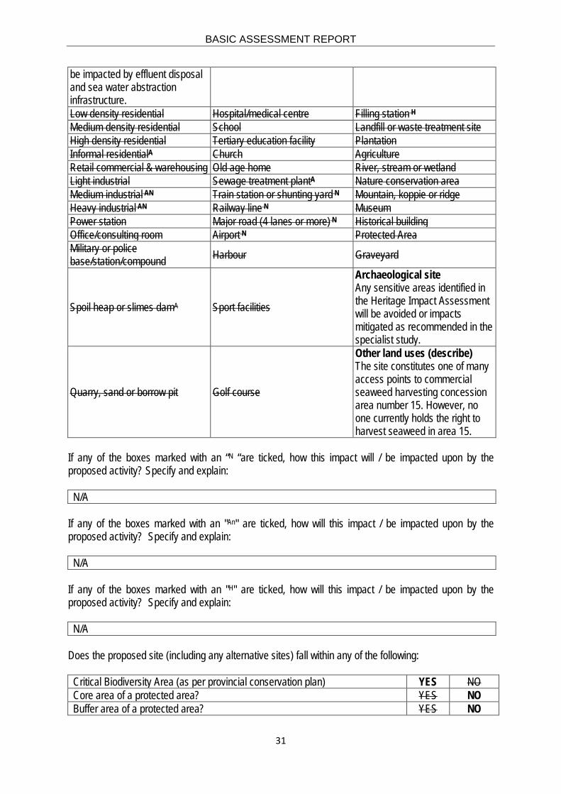
BASIC ASSESSMENT REPORT
31
be impacted by effluent disposal and sea water abstraction infrastructure. Low density residential Hospital/medical centre Filling station H Medium density residential School Landfill or waste treatment site High density residential Tertiary education facility Plantation Informal residentialA Church Agriculture Retail commercial & warehousing Old age home River, stream or wetland Light industrial Sewage treatment plantA Nature conservation area Medium industrial AN Train station or shunting yard N Mountain, koppie or ridge Heavy industrial AN Railway line N Museum Power station Major road (4 lanes or more) N Historical building Office/consulting room Airport N Protected Area Military or police base/station/compound Harbour Graveyard
Spoil heap or slimes damA Sport facilities
Archaeological site Any sensitive areas identified in the Heritage Impact Assessment will be avoided or impacts mitigated as recommended in the specialist study.
Quarry, sand or borrow pit Golf course
Other land uses (describe) The site constitutes one of many access points to commercial seaweed harvesting concession area number 15. However, no one currently holds the right to harvest seaweed in area 15.
If any of the boxes marked with an “N “are ticked, how this impact will / be impacted upon by the proposed activity? Specify and explain: N/A
If any of the boxes marked with an "An" are ticked, how will this impact / be impacted upon by the proposed activity? Specify and explain: N/A
If any of the boxes marked with an "H" are ticked, how will this impact / be impacted upon by the proposed activity? Specify and explain: N/A
Does the proposed site (including any alternative sites) fall within any of the following: Critical Biodiversity Area (as per provincial conservation plan) YES NO Core area of a protected area? YES NO Buffer area of a protected area? YES NO

BASIC ASSESSMENT REPORT
32
Planned expansion area of an existing protected area? YES NO Existing offset area associated with a previous Environmental Authorisation? YES NO Buffer area of the SKA? YES NO
If the answer to any of these questions was YES, a map indicating the affected area must be included in Appendix A. 7. CULTURAL/HISTORICAL FEATURES Are there any signs of culturally or historically significant elements, as defined in section 2 of the National Heritage Resources Act, 1999, (Act No. 25 of 1999), including Archaeological or paleontological sites, on or close (within 20m) to the site? If YES, explain:
YES NO
Uncertain
A field assessment of the proposed development site was undertaken by ACRM in January 2018 in which the following observations were made:
• Traces of archaeological resources of low (Grade IIIC) significance were recorded in the 2.0 ha footprint area, but the remains occur in a severely disturbed and degraded context. A few quartz stone flakes and some indigenous Cape Coastal pottery were also found.
• In-situ shell midden deposits of medium (Grade IIIB) significance were recorded inside and immediately outside of the proposed development site, south of the boundary fence in the south western portion of the proposed development site.
A specialist report has been included in Appendix D of the BAR.
If uncertain, conduct a specialist investigation by a recognised specialist in the field (archaeology or palaeontology) to establish whether there is such a feature(s) present on or close to the site. Briefly explain the findings of the specialist: See above.
Will any building or structure older than 60 years be affected in any way? YES NO Is it necessary to apply for a permit in terms of the National Heritage Resources Act, 1999 (Act 25 of 1999)? YES NO If YES, please provide proof that this permit application has been submitted to SAHRA or the relevant provincial authority. 8. SOCIO-ECONOMIC CHARACTER a) Local Municipality Please provide details on the socio-economic character of the local municipality in which the proposed site(s) are situated. Level of unemployment: StatsSA 2011 Census Overall unemployment rate: 22.9% Youth unemployment rate: 30.1%

BASIC ASSESSMENT REPORT
33
Economic profile of local municipality: The following information has been extracted from the 2011 Population Census, available on the Statistics South Africa website (http://www.statssa.gov.za). The Nama Khoi Local Municipality (LM) covers a geographical area of 14,921 km2 which is approximately 12% of Namakwa’s total. The Municipality has a total population of 47 041 with a density of 3 people per km2 and a household density of 1.1 households per km2. The most significant portion of Namakwa’s population (43%) re-sides in this Municipality. The average population growth rate between 2001 and 2011 was 0.47% for the Nama Khoi LM. In 2011, Kleinzee’s population was 728, which constitutes 1.5% of the population in the Nama Khoi LM. The population of the LM is comprised of 24% young people (0-14 years) 66.9% working age people (15-64), and 8.2% elderly people (65+). The Nama Khoi gender distribution is 49.3% males and 50.7% females. In 2007, the child support grant was the most accessed grant with 48.6%, followed by the Old Age Pension with 32.4% (Nama Khoi IDP 2011-2017). At that time, approximately 3.1% of the population is receiving some form of government grant. This results in a social dependency on the government which in return places strain on the government budget for other services (Nama Khoi IDP 2011-2017). The lack of good roads and far distances between markets puts a huge constraint on development. In 2009, the majority of the Nama Khoi LM’s population was employed in the following sectors: General government (21.7%), Community, social and personal services (17.3%) Wholesale & retail trade, catering and accommodation (17.3%) Mining (16%) The majority of the population in Vioolsdrift are employed in agriculture. In the other settlements the majority of people are employed in mining and government services. (Nama Khoi IDP 2011-2017). The reliance in the mining and government sector is not very sustainable. Wholesale and retail trade only features in the LM mainly because of Springbok. In 2007, the majority of the Nama Khoi LM’s population was employed in the following occupations:
• Elementary occupations (21.4%) • Craft and related trades workers (11.9%) • Service workers, shop and market sales workers (11.4%)
This indicates that there are limited professional skills in the area. The 2011 Population Census showed that 55.2% of households in the Nama Khoi LM fall within the poverty level (low income group), 39.7 % belong to the middle income group and 4.8% to the high income group. The majority of households within the Nama Khoi LM have access to services (i.e. water, electricity, sanitation, and refuse removal) (Nama Khoi IDP 2011-2017). Even though this is a good indication of the service delivery in the area it does not mean that these services are provided constantly. Access to water is a major issue in the Nama Khoi LM (as in the entire Northern Cape) due to low rainfall (boreholes are considered unreliable for the same reasons). More needs to be done to secure and save the water sources and increase their capacity so that water is available every day. The increase in the number of households, particularly in the rural areas where there are minimal services has increased backlogs in electricity provision, housing needs, roads, access to water and sanitation need (Nama Khoi IDP 2011-2017).
Level of education: StatsSA 2011 Census No schooling aged 20+: 2.2% Higher education aged 20+: 7.9% Matric aged 20+: 20%
BASIC ASSESSMENT REPORT
34
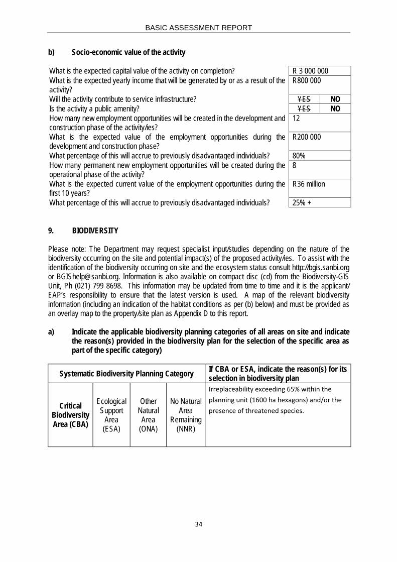
b) Socio-economic value of the activity What is the expected capital value of the activity on completion? R 3 000 000 What is the expected yearly income that will be generated by or as a result of the activity?
R800 000
Will the activity contribute to service infrastructure? YES NO Is the activity a public amenity? YES NO How many new employment opportunities will be created in the development and construction phase of the activity/ies?
12
What is the expected value of the employment opportunities during the development and construction phase?
R200 000
What percentage of this will accrue to previously disadvantaged individuals? 80% How many permanent new employment opportunities will be created during the operational phase of the activity?
8
What is the expected current value of the employment opportunities during the first 10 years?
R36 million
What percentage of this will accrue to previously disadvantaged individuals? 25% + 9. BIODIVERSITY Please note: The Department may request specialist input/studies depending on the nature of the biodiversity occurring on the site and potential impact(s) of the proposed activity/ies. To assist with the identification of the biodiversity occurring on site and the ecosystem status consult http://bgis.sanbi.org or [email protected]. Information is also available on compact disc (cd) from the Biodiversity-GIS Unit, Ph (021) 799 8698. This information may be updated from time to time and it is the applicant/ EAP’s responsibility to ensure that the latest version is used. A map of the relevant biodiversity information (including an indication of the habitat conditions as per (b) below) and must be provided as an overlay map to the property/site plan as Appendix D to this report. a) Indicate the applicable biodiversity planning categories of all areas on site and indicate
the reason(s) provided in the biodiversity plan for the selection of the specific area as part of the specific category)
Systematic Biodiversity Planning Category If CBA or ESA, indicate the reason(s) for its selection in biodiversity plan
Critical Biodiversity Area (CBA)
Ecological Support
Area (ESA)
Other Natural Area
(ONA)
No Natural Area
Remaining (NNR)
Irreplaceability exceeding 65% within the planning unit (1600 ha hexagons) and/or the presence of threatened species.

BASIC ASSESSMENT REPORT
35
b) Indicate and describe the habitat condition on site
Habitat Condition
Percentage of habitat
condition class (adding up to 100%)
Description and additional Comments and Observations
(including additional insight into condition, e.g. poor land management practises, presence of quarries,
grazing, harvesting regimes etc).
Natural %
Near Natural (includes areas with
low to moderate level of alien invasive
plants)
%
10
Degraded (includes areas
heavily invaded by alien plants)
% 70
Transformed (includes cultivation,
dams, urban, plantation, roads,
etc.)
%
20
c) Complete the table to indicate:
(i) the type of vegetation, including its ecosystem status, present on the site; and (ii) whether an aquatic ecosystem is present on site.
Terrestrial Ecosystems Aquatic Ecosystems
Ecosystem threat status as per the
National Environmental Management:
Biodiversity Act (Act No. 10 of 2004)
Critical Wetland (including rivers, depressions, channelled and unchanneled wetlands, flats,
seeps pans, and artificial wetlands)
Estuary Coastline Endangered Vulnerable
Least Threatened YES NO UNSURE YES NO YES NO

BASIC ASSESSMENT REPORT
36
d) Please provide a description of the vegetation type and/or aquatic ecosystem present on site, including any important biodiversity features/information identified on site (e.g. threatened species and special habitats)
The study site is situated within the Succulent Karoo Biome, which spans most of the arid coastal lowland of the Northern Cape. The Succulent Karoo Biome covers a flat to gently undulating plain, with some hilly and “broken” veld at altitudes mostly below 800 m above sea level (Mucina et al 2006). The Namaqualand coast is about 30 km wide, a generally flat plain, consisting of sandy material of aeolian origin (Mucina et al. 2006). The Succulent Karoo Biome is characterised by low winter rainfall and extreme summer aridity. Desiccating, hot, Berg Winds may occur throughout the year and during summer temperatures in excess of 40°C are common. Rainfall varies between 20 and 290 mm per year. Consequently, coastal vegetation mostly relies on fog for water supply. Temperatures rarely drop below zero degrees (Mucina et al. 2006). The Succulent Karoo is the world’s only entirely arid region diversity hotspot (Mittermeier et al. 2000, Myers et al 2000) and is home to more than 6300 plant species of which 26% are strict endemics and 14% are near endemics that have the centre of their distribution in this biome; 17% are listed as Red Data species (Driver et al 2003). Most of the endemic species are either succulents or geophytes (Driver & Maze 2002, Driver et al. 2003). The Succulent Karoo Biome is not considered an endangered ecosystem type. The vegetation is dominated by dwarf, succulent shrubs, of which the ‘vygies’ (Aizoaceae) and Stonecrops (Crassulaceae) are particularly prominent. Mass flowering displays of annuals (mainly Daisies Asteraceae) occur in spring, often on degraded or fallow lands. Grasses are rare, except in some sandy areas, and are of the C3 type. The number of plant species mostly succulents - is very high and unparalleled elsewhere in the world for an arid area of this size (Mucina et al 2006). Mole rats, lizards, tortoises and a variety of invertebrates, including monkey beetles, scorpions, bee flies, bees and masarid and vespid wasps (Vernon 1999) have high endemism in the Succulent Karoo Biome (Mucina et al. 2006). More than 250 bird species and nearly 80 mammal species, 132 reptile and amphibian species and an unknown number of insects inhabit this biome (WWF 2017). Most wild animals are small, like the Bat-Eared Fox, Suricate (Meerkat) and Barking Gecko. Many animals are nocturnal or hide in burrows in the ground during the day to avoid the hot, dry conditions. Termites are thought to have created heuweltjies, raised mounds of calcium-rich soil, which often support distinctive plant communities. These heuweltjies are iconic landscape features in the region (Armstrong and Siegfried 1990; Midgley 2002). The predominant vegetation type at the study site is the Namaqualand Seashore Vegetation, which is a very narrow strip (approximately 250 m wide) above the high tide zone along the sea from the Holgat River to just south of the Olifants River. The vegetation type is characterised by a slightly sloping beach made up of coastal rocky formations supporting sparse vegetation. The vegetation is composed of succulent hummock-forming and spreading dwarf shrubs and herbs on the beach, in shell beds and on low dunes. Leaf succulent chenopod shrubs are dominant on coastal cliffs and shell beds (Mucina et al 2006). A significant portion of this narrow coastal strip has been transformed by diamond mining and prospecting related activities, including the study area. Strip-mining for diamonds is destructive in the northern coastal regions and rehabilitation of impacted areas is slow and often not entirely successful. Furthermore, as evident at the study site kelp collection and vehicle tracks to the beach constitute a

BASIC ASSESSMENT REPORT
37
disturbance in places accessible to the public (most of the area is still inaccessible due to ongoing mining). Acacia cyclops locally invades the dunes (Mucina et al 2006). The Succulent Karoo Ecosystem Programme (SKEP) has been developed to conserve this region and only a small percentage of this vegetation type is currently protected in the Groen-Spoeg National Park. No special biodiversity features were identified on the site. It is important to note that the Strandveld Conservation Trust has purchased a portion of land from the state, which abuts the southern border of the proposed development site. The Strandveld Conservation Trust is currently in the process of declaring this land a private nature reserve. The applicant (Quiryn Snethlage) currently serves, in his personal capacity, as the chairman of this trust. The land south of the proposed development site is comparatively undisturbed and has rehabilitation potential.

BASIC ASSESSMENT REPORT
38
SECTION C: PUBLIC PARTICIPATION 1. ADVERTISEMENT AND NOTICE Publication name KENNISGEWING VIR OPENBARE DEELNAMEPROSES Voorgestelde
perlemoen hou- en verwerkingsfasiliteit vir Port Nolloth Sea Farms Ranching (Pty) Ltd.
Date published 17 August 2018 Site notice position Latitude Longitude
29°43'47.77"S 17° 3'36.50"E Date placed 15 June 2018
Include proof of the placement of the relevant advertisements and notices in Appendix E1. 2. DETERMINATION OF APPROPRIATE MEASURES Provide details of the measures taken to include all potential I&APs as required by Regulation 41(2)(e) and 41(6) of GN 733. Pre-application:
o All documents will be made available on Anchor Environmental’s website at https://anchorenvironmental.co.za/public-documents
o All registered stakeholders will be notified via email of a commenting period of 30 days. o An advertisement in Afrikaans was placed in the local newspaper “Die Namakwalander” on 17
August 2018 (Appendix E1); and o Notice boards in English and Afrikaans were fixed at the existing cottage on the proposed
development site (Appendix E1). o Registered letters will be sent to selected stakeholders as per Regulation 41(2)(b) (Appendix
E2 and E4). o A stakeholder list was compiled and will be maintained (Appendix E5, email addresses are not
included to protect the privacy of the stakeholder); o A Background Information Documents (BID) will be placed in public places including the post
office, shops, and information centre in Kleinzee (English) (Appendix E7);
Post-application
o All documents will be made available on Anchor Environmental’s website at https://anchorenvironmental.co.za/public-documents
o All registered stakeholders will be notified via email of a commenting period of 30 days (Appendix E3, email addresses are not included to protect the privacy of the stakeholder);
o The Draft BAR will be couriered to the competent authority in form of two hard copies and an electronic copy on CD;
o One hardcopy Draft BAR and electronic copies on 10 CDs will be made available to the public in Kleinzee.
o Notification of registered stakeholders of DEA’s decision.

BASIC ASSESSMENT REPORT
39
Key stakeholders (other than organs of state) identified in terms of Regulation 41(2)(b) of GN 733 Title, Name and Surname
Affiliation/ key stakeholder status Contact details (tel number or e-mail address)
Paulus van Reenen Nama-Khoi Municipality [email protected]
William MacDonald De Beers [email protected]
Abegail Makgato West Coast Resources [email protected]
Carmen Abrahams National Department of Public Works [email protected]
Francois Gerber National Department of Public Works [email protected]
Quiryn Snethlage Chairman of the Strandveld Conservation Trust
Include proof that the key stakeholder received written notification of the proposed activities as Appendix E2. This proof may include any of the following: • e-mail delivery reports; • registered mail receipts; • courier waybills; • signed acknowledgements of receipt; and/or • or any other proof as agreed upon by the competent authority. 3. ISSUES RAISED BY INTERESTED AND AFFECTED PARTIES TO BE COMPLETED FOR THE FINAL DRAFT BAR Summary of main issues raised by I&APs Summary of response from EAP
4. COMMENTS AND RESPONSE REPORT The practitioner must record all comments received from I&APs and respond to each comment before the Draft BAR is submitted. The comments and responses must be captured in a comments and response report as prescribed in the EIA regulations and be attached to the Final BAR as Appendix E3.

BASIC ASSESSMENT REPORT
40
5. AUTHORITY PARTICIPATION Authorities and organs of state identified as key stakeholders: Title, Name and Surname
Affiliation Stakeholder status Contact details (tel number of e-mail address)
Postal address
DEA: Biodiversity and Conservation
Shonisani Munzhedzi
DG [email protected] Private Bag X6101 KIMBERLEY 8300
Nama Khoi Municipality
Samantha Titus Municipal Manager [email protected] PO Box 17, Springbok 8249
Namakwa District Municipality
Chris Fortuin Municipal Manager [email protected] Private Bag X20, SPRINGBOK, 8240
Department of Agriculture, Forestry and Fisheries
Zimasa Jika Acting Director: Sustainable Aquaculture Development
[email protected] 17 Baker St, Rosebank, 2196 Johannesburg, South Africa
Department of Environmental Affairs: Oceans and Coasts
Chief Director: Integrated Coastal Management
0027 21 819 2414 Private Bag X2, Vlaeberg Cape Town 8018
South African Heritage Resources Agency
Phillip Hine Acting Manager: Archaeology, Palaeontology and Meteorites Unit
0027 21 462 4502 220 E Pier Rd, V & A Waterfront, Cape Town, 8001
South African Biodiversity Institute
Moshibudi Rampedi Chief Executive Officer 027 21 799 8800 PO Box 4637, Cape Town 8001
Include proof that the Authorities and Organs of State received written notification of the proposed activities as appendix E4. In the case of renewable energy projects, Eskom and the SKA Project Office must be included in the list of Organs of State. 6. CONSULTATION WITH OTHER STAKEHOLDERS (TO BE COMPLETED FOR THE DRAFT
BAR) Note that, for any activities (linear or other) where deviation from the public participation requirements may be appropriate, the person conducting the public participation process may deviate from the requirements of that sub-regulation to the extent and in the manner as may be agreed to by the competent authority.

BASIC ASSESSMENT REPORT
41
Proof of any such agreement must be provided, where applicable. Application for any deviation from the regulations relating to the public participation process must be submitted prior to the commencement of the public participation process. A list of registered I&APs must be included as appendix E5. Copies of any correspondence and minutes of any meetings held must be included in Appendix E6. SECTION D: IMPACT ASSESSMENT The assessment of impacts must adhere to the minimum requirements in the EIA Regulations, 2014 and should take applicable official guidelines into account. The issues raised by interested and affected parties should also be addressed in the assessment of impacts. 1. IMPACTS THAT MAY RESULT FROM THE PLANNING AND DESIGN, CONSTRUCTION,
OPERATIONAL, DECOMMISSIONING AND CLOSURE PHASES AS WELL AS PROPOSED MANAGEMENT OF IDENTIFIED IMPACTS AND PROPOSED MITIGATION MEASURES
Provide a summary and anticipated significance of the potential direct, indirect and cumulative impacts that are likely to occur as a result of the planning and design phase, construction phase, operational phase, decommissioning and closure phase, including impacts relating to the choice of site/activity/technology alternatives as well as the mitigation measures that may eliminate or reduce the potential impacts listed. This impact assessment must be applied to all the identified alternatives to the activities identified in Section A(2) of this report. A complete impact assessment in terms of Regulation 19(3) of GN 733 must be included as Appendix F. ALTERNATIVE 1 (PREFERRED ALTERNATIVE) Note that no feasible alternatives have been identified. Potential impacts are denoted by first listing the phase of the development (i.e. CP = Construction Phase; OP = Operation Phase) followed by the impact category:
• Marine Ecology = ME • Terrestrial Biodiversity = TB • Socio-Economy= SE • Heritage = HR
Impacts are numbered consecutively and separately for the construction and operation phases.

BASIC ASSESSMENT REPORT
42
PLANNING AND DESIGN PHASE IMPACTS Impact summary Significance
Proposed mitigation (Note that non-essential mitigation measures have been italicised)
Direct impacts: None identified
N/A N/A Note that some mitigation measures must be implemented during the planning/design phase (i.e. planning and design considerations) to ensure that construction and operational impacts can be mitigated effectively. These are listed where appropriate.
Indirect impacts: None identified
N/A
Cumulative impacts: None identified
N/A
CONSTRUCTION PHASE IMPACTS Marine ecological impacts: Direct impacts
Impact summary Significance Proposed mitigation (Note that non-essential mitigation measures have been italicised)
CP-ME Impact 1: Loss of intertidal habitat and biota
Very low without mitigation
• Limit time taken to complete construction activities in the coastal zone.
• Constrain spatial extent of impacts to the minimum required. CP-ME Impact 2: Effects of increased turbidity on marine biota.
Insignificant without mitigation
• Cover excavated soil to prevent wind induced erosion.
CP-ME Impact 3: Effects of chemical contamination on marine biota.
Low without and Insignificant with mitigation
• Contingency plans in the event of accidental spills must be prepared.
• All fuel and oil is to be stored with adequate spill protection. • No leaking vehicles or vessels are permitted on site.
CP-ME Impact 4: Waste generation and disposal during construction.
Medium without and Low with mitigation
• Inform all staff about sensitive marine species and the suitable disposal of construction waste.
• Suitable handling and disposal protocols must be clearly explained and sign boarded.
• Reduce, reuse, and recycle. • Filter water on start-up of plant to remove plastic debris.
Indirect impacts: None identified Cumulative impacts: None identified
Terrestrial biodiversity impacts (including bird and bats): Direct impacts
Impact summary Significance Proposed mitigation (Note that non-essential mitigation measures have been italicised)
CP-TB Impact 1: Significant loss of vegetation and loss of listed or protected plant species.
Very low without and insignificant with mitigation
• Avoid south central rocky outcrop within the development site as far as possible.
• Vegetation clearing should be kept to a minimum.
CP-TB Impact 2: Alien plant invasion risk.
Low without and insignificant with mitigation
• Cleared areas which are not surfaced or required for operation should be re-vegetated with seed or plants of locally occurring species.
• Regular monitoring for alien plants within the development during construction.
• Early removal of alien plants using appropriate methods for the species.
• No muddy and dirty equipment should be brought onto site as this is likely to carry seed of alien species.
• If sand or other natural materials for building are required and

BASIC ASSESSMENT REPORT
43
Terrestrial biodiversity impacts (including bird and bats): Direct impacts
Impact summary Significance Proposed mitigation (Note that non-essential mitigation measures have been italicised)
brought onto site, the stored heaps should be monitored for the growth and germination of alien species and should be regularly cleared during construction.
CP-TB Impact 3: Negative impact on fauna.
Very low without and insignificant with mitigation
• All construction staff should undergo an environmental induction from the ECO or other suitably qualified persons.
• Any fauna directly threatened by the construction activities should be removed to a safe location by the ECO or other suitably qualified person.
• The collection, hunting or harvesting of any plants or animals at the site should be strictly forbidden. Personnel should not be allowed to wander off the construction site.
• All hazardous materials should be stored in the appropriate manner to prevent contamination of the site. Any accidental chemical, fuel and oil spills that occur at the site should be cleaned up in the appropriate manner as related to the nature of the spill.
• No unauthorised persons should be allowed onto the site. • All construction vehicles should adhere to a low speed limit to
avoid collisions with susceptible species such as snakes and tortoises.
CP-TB Impact 4: Disruption of landscape connectivity and loss of function of Critical Biodiversity Area.
Very low without and insignificant with mitigation
• The construction footprint should be kept as small as possible and vegetation should be allowed to persist in areas not used for abalone holding and processing activities.
• Fauna outside the construction area should not be disturbed. • If the site must be lit at night, this should be done with low-UV
type lights (such as most LEDs), which do not attract insects. • The fence around the abalone holding and processing facility and
around the perimeter of the entire site should be built such that tortoises and small animals can safely pass through and traverse the site. As such the fence should not be electrified within 30 cm of the ground.
• No driving within the coastal zone without a permit except on existing roads.
Indirect impacts: None identified Cumulative impacts: Terrestrial biodiversity in the area where the proposed PNSFR abalone holding site is situated was severely disturbed by open cast mining for alluvial diamonds over the last 100 years. The vegetation and therefore the habitat for faunal communities have been recovering very slowly, even in areas that have been netted to assist rehabilitation. Cumulative effects should be assessed in terms of the size of the area that will no longer contribute towards rehabilitation of this vegetation type rather than the removal of poor quality habitat. Terrestrial biodiversity at the site does currently not contribute to biodiversity targets of this biome, especially due to its small size (<2.5 ha) and strategic role as an access point to the sea (previously utilised by De Beers and now by kelp collectors and PNSFR). Notwithstanding, recommendations have been made to avoid as far as possible, development on the rocky outcrop on the southern central border of the site, which forms part of the Rooiklippies that gives the area its name. Considering the above, this development is very unlikely to contribute significantly to the cumulative loss of the Namaqualand Seashore Vegetation type and to reduce rehabilitation potential.

BASIC ASSESSMENT REPORT
44
Socio-economic impacts: Direct impacts
Impact summary Significance Proposed mitigation (Note that non-essential mitigation measures have been italicised)
CP-SE Impact 1: Significance of investment into the local, regional and national economy (positive impact)
Low without and with mitigation
• Procure goods and services from local, provincial or South African suppliers as far as possible, giving preference to Black Economic Empowerment (BEE) suppliers.
CP-SE Impact 2: Increased employment, income and skills development.
Very low without and with mitigation
• Use local and regional labour (Nama Khoi Municipality, Namakwa District Municipality)
• Preferentially employ previously disadvantaged individuals. CP-SE Impact 3: Restriction in access to the sea by other users
Very low without mitigation
• No mitigation measures are available.
Indirect impacts: None identified Cumulative impacts: Cumulatively, the construction of the PNSFR abalone holding and processing facility will contribute towards employment in the area.
Impacts on heritage resources: Direct impacts
Impact summary Significance Proposed mitigation (Note that non-essential mitigation measures have been italicised)
CP-HR Impact 1: Significance of impact on archaeological resources
Low to potentially high without mitigation and insignificant with mitigation
• The Environmental Control Officer/Environmental Site Manager must be briefed by the archaeologist prior to construction activities commencing.
• Shovel testing (Site 8221) must be conducted prior to construction by a professional archaeologist in terms of a permit from SAHRA, to determine significance of archaeological deposits.
• Site 8171 must be declared as a ‘No-Go area’. An archaeologist must demarcate the No-Go area prior to the construction of the abalone holding facility.
• Sensitive archaeological resources have been found at Site 8181, which lies outside of the site boundaries. The fence alongside should act as a barrier to entry where vulnerable and threatened archaeological sites are known to occur. A temporary fence (e.g. construction tape) must be erected if the fence has not been repaired when construction of the abalone holding and processing facility commences.
• Should any unmarked human burials/remains or ostrich eggshell water flask caches for example, be uncovered, or exposed during construction activities, these must immediately be reported to the South African Heritage Resources Agency (Ms Natasha Higgit 021 462 4502). Burials, etc. must not be removed or disturbed until inspected by the archaeologist.
• The above recommendations must be included in the Environmental Management Plan (EMP) for the proposed development.
Indirect impacts: None identified Cumulative impacts: Low without and with mitigation measures.

BASIC ASSESSMENT REPORT
45
OPERATIONAL PHASE IMPACTS Marine ecological impacts: Direct impacts
Impact summary Significance Proposed mitigation (Note that non-essential mitigation measures have been italicised)
OP-ME Impact 1: Impacts of seawater abstraction.
Very low without mitigation
• No mitigation required
OP-ME Impact 2a: Elevated suspended solids in the water column.
Low without and very low with mitigation
• Best management practice with regards to feed ratios. • Effluent produced during tank cleaning and from the processing
facility must be filtered mechanically before the effluent is discharged.
• Effluent quality should be monitored as per the CWDP/GDA specifications.
• If CWDP/GDA limits for TSS cannot be met, PNSFR must consider additional mitigation measures to extract suspended solids.
OP-ME Impact 2b: Eutrophication caused by increased nutrients in the outfall stream.
Low without and Very low with mitigation
• Best management practice with regards to feed ratios. • Effluent produced during tank cleaning and from the processing
facility must be filtered mechanically before the effluent is discharged.
• Effluent quality should be monitored as per the CWDP/GDA specifications.
• If CWDP/GDA limits for TSS cannot be met, PNSFR must consider additional mitigation measures to extract suspended solids.
OP-ME Impact 2c: The effect of increased seawater temperature on marine biota
Very low without mitigation
• No mitigation required other than water temperature monitoring, which is a requirement of the CWDP/GDA.
OP-ME Impact 2d: Chemical pollution arising from holding and processing facility.
Low without and very low with mitigation
• Use only approved veterinary chemicals when absolutely necessary.
• Where effective, use environmentally friendly alternatives. • Use the most efficient drug delivery mechanisms that minimise the
concentrations of biologically active ingredients entering the marine environment.
• Use the lowest effective dose of therapeutants. • Effluent quality should be monitored as per the CWDP/GDA
specifications.
OP-ME Impact 3: Waste generation during operational phase (domestic, biological, production).
Medium without and low with mitigation
• Inform all staff about sensitive marine species and the suitable disposal of construction waste.
• Suitable handling and disposal protocols must be clearly explained and sign boarded.
• Reduce, reuse, and recycle. • Filter water on start-up of plant to remove plastic debris.
OP-ME Impact 4: Deterioration of receiving water quality due to mechanically removed, decomposing fouling organisms.
Very low without mitigation
• No mitigation required.
Indirect impacts: None identified Cumulative impacts: Existing pressures on the marine and coastal environment in this area are the decades of supra-tidal and sub-tidal diamond mining, existing aquaculture and ranching operations and very low levels of commercial and recreational fishing and tourism. Cumulative impacts are considered to be insignificant for the following reasons:
1. Habitat loss is negligible and is confined to the project’s effluent outfall construction, which has a very small footprint and cumulatively does not contribute to ongoing habitat loss associated with the mining industry in the area;
2. Effluent originating from flow-through abalone tanks is known to be very clean with low concentrations of

BASIC ASSESSMENT REPORT
46
Marine ecological impacts: Direct impacts
Impact summary Significance Proposed mitigation (Note that non-essential mitigation measures have been italicised)
nutrients and waste products. The effluent discharged by Diamond Coast Aquaculture (Pty) Ltd approximately 1 km north of Kleinzee constitutes the only other effluent discharge in this area. The assimilation capacity of the marine environment in this area is considered high and the PNSFR flow-through abalone holding and processing facility therefore does not contribute cumulatively to the deterioration of the receiving environment in this area.
Terrestrial biodiversity impacts: Direct impacts
Impact summary Significance Proposed mitigation (Note that non-essential mitigation measures have been italicised)
OP-TB Impact 1: Significant loss of vegetation and loss of listed or protected plant species.
Very low without and insignificant with mitigation
• Avoid south central rocky outcrop within the development site as far as possible.
• Vegetation clearing should be kept to a minimum. • Herbicides should be avoided and manual clearing methods should
be used wherever possible. • Precautions should be taken to prevent the spread of fire onto or
off the site.
OP-TB Impact 2: Alien plant invasion risk.
Very low without and insignificant with mitigation
• Regular monitoring for alien plants within the development during operation.
• All alien plants present at the site should be controlled at least biannually using the best practice methods for the species present.
OP-TB Impact 3: Salinisation of soils and loss of plant diversity.
Medium without and very low with mitigation
• Seawater intake and effluent outfall infrastructure, seawater storage, as well as abalone holding tanks and associated pipes must be sealed to prevent seawater leakage.
• Tanks and pipes must be regularly checked for leakages.
OP-TB Impact 4: Negative impact on fauna.
Very low without and with mitigation
• If the site must be lit at night, this should be done with low-UV type lights (such as most LEDs), which do not attract insects.
• All staff should undergo an environmental induction from the ECO or other suitably qualified persons.
• The collection, hunting or harvesting of any plants or animals at the site should be strictly forbidden. All hazardous materials should be stored in the appropriate manner to prevent contamination of the site. Any accidental chemical, fuel and oil spills that occur at the site should be cleaned up in the appropriate manner as related to the nature of the spill.
• No unauthorised persons should be allowed onto the site. • All vehicles should adhere to a low speed limit to avoid collisions
with susceptible species such as snakes and tortoises.
OP-TB Impact 5: Disruption of landscape connectivity and loss of function of Critical Biodiversity Area.
Low without and Very low with mitigation
• The development footprint should be kept as small as possible and vegetation should be allowed to persist in areas not used for abalone holding and processing activities.
• Maintenance vehicles and personnel must only drive/walk on demarcated roads and pathways.
• Fauna outside the construction area should not be disturbed. • The fence around the abalone holding and processing facility and
around the perimeter of the entire site should be maintained in good condition to ensure that fauna is not harmed.
• If the site must be lit at night, this should be done with low-UV type lights (such as most LEDs), which do not attract insects.
• No driving within the coastal zone without a permit except on existing roads.
Indirect impacts: None identified Cumulative impacts: Same as construction phase.

BASIC ASSESSMENT REPORT
47
Socio-economic impacts: Direct impacts
Impact summary Significance Proposed mitigation or benefit enhancing measures (Note that non-essential mitigation measures have been italicised)
OP-SE Impact 1: Significance of investment into the local, regional and national economy (positive impact)
High without and with mitigation
• Procure goods and services from local, provincial or South African suppliers as far as possible, giving preference to Black Economic Empowerment (BEE) suppliers.
• Procure ancillary services for goods and services purchased overseas from South African companies as far as possible (e.g. installation, customisation and maintenance).
OP-SE Impact 2: Increased employment, income and skills development. (positive impact)
Low without and Medium with mitigation
• Use local and regional labour (Nama Khoi Municipality, Namakwa District Municipality)
• Preferentially employ previously disadvantaged individuals.
OP-SE Impact 3: Disease transmission to abalone farms in the area
Medium without and Low with mitigation
• Maintain strict bio-security measures. • All organisms obtained from hatcheries must be sourced only
from certified disease, pathogen and parasite free sources. • Ensure all abalone undergoes a health examination prior to
stocking. • Regularly inspect stock for disease and/parasites as part of a
formalised stock health monitoring programme and take necessary action to eliminate pathogens through the use of therapeutic chemicals or improved farm management. Maintain comprehensive records of all pathogens and parasites detected as well as logs detailing the efficacy of treatments applied. These records should be made publically available to facilitate rapid responses by other operators to future outbreaks.
• Treat adjacent holding tanks simultaneously even if infections have not yet been detected.
• Keep facilities clean. • Farms to adhere to industry standards (i.e. abalone farming
standards and monitoring programmes). • All organisms introduced to the facility should be isolated in a
quarantine system for a period of six weeks and subject to regular health inspections to monitor for disease.
• Culture facilities must be designed to have multiple redundancy exclusion barriers or screens fine enough to contain the organisms being cultured.
OP-SE Impact 4: Restriction in access to the sea by other users
Low without mitigation measures
• No mitigation measures available
Indirect impacts: None identified Cumulative impacts: Same as construction with regards to employment opportunities.

BASIC ASSESSMENT REPORT
48
DECOMMISSIONING PHASE IMPACTS The PNSFR abalone holding and processing facility does not have a specified life span. Partial or full decommissioning of the farm may or may not occur. Potential impacts associated with the decommissioning phase include:
• Conditional need for rehabilitation of terrestrial and coastal environment • Loss of jobs
The foreseen activities associated with the decommissioning of the PNSFR abalone holding and processing facility will not trigger additional listed activities to those identified in this BAR. Any disturbance of vegetation or habitat is considered to be low. The EMPr compels PNSFR to ensure that decommissioning is conducted in an environmentally responsible manner. An impact assessment for the decommissioning phase has therefore not been completed here. Rehabilitation should be conducted as detailed in the EMPr unless the Department of Public Works (DPW) assumes responsibility for rehabilitation. NO-GO ALTERNATIVE Marine Ecological Impacts: The nearshore and coastal environment has been disturbed by diamond mining activities over the last 100 years. The impact on the marine environment by the proposed PNSFR abalone holding and processing facility is minimal. If the development does not go ahead these minimal impacts on the marine environment will not occur and the status quo will be maintained. However, socio-economic benefits of aquaculture expansion would not be realised in turn. Terrestrial Biodiversity Impacts: Terrestrial biodiversity in the area where the proposed PNSFR abalone holding site is situated was severely disturbed by open cast mining for alluvial diamonds over the last 100 years. The vegetation and therefore the habitat for faunal communities have been recovering very slowly, even in areas that have been netted to assist rehabilitation. If the development does not go ahead the status quo will be maintained. The status quo does not contribute towards achieving biodiversity goals for this vegetation type, especially when considering that this site has been and will be used as a strategic access point to the sea. Socio-economic impacts: The No-Go alternative entails no change in the status quo and PNSFR will continue to experience limitations in terms of the amount of abalone that can be seeded, harvested and sold. No significant socio-economic benefits (i.e. employment) are associated with the No-Go alternative. Negative socio-economic impacts are low to very low and avoiding those will not justify the loss of potential employment to the Kleinzee area where unemployment is very high. Impacts on archaeological resources: The No-Go alternative entails no change to the status quo. Provided that the recommendations of the HIA are implemented during the construction phase, no significant impact will occur on archaeological resources.

BASIC ASSESSMENT REPORT
49
2. ENVIRONMENTAL IMPACT STATEMENT Taking the assessment of potential impacts into account, please provide an environmental impact statement that summarises the impact that the proposed activity and its alternatives may have on the environment after the management and mitigation of impacts have been taken into account, with specific reference to types of impact, duration of impacts, likelihood of potential impacts actually occurring and the significance of impacts. Alternative A (preferred alternative)
The potential impacts are summarized in the tables below.
Potential impacts are denoted by first listing the phase of the development (i.e. CP = Construction Phase; OP = Operation Phase) followed by the impact category:
o Marine Ecology = ME o Terrestrial Biodiversity = TB o Socio-Economy= SE o Heritage = HE
Impacts are numbered consecutively and separately for the construction and operation phases.
After mitigation, most negative impacts have been rated as INSIGNIFICANT (8) and VERY LOW (12). Waste disposal, disease and parasite transmission, and restriction of access during the operational phase have been rated as LOW. Positive socio-economic impacts, including the investment into the local, regional and national economy and increased employment, income and skills development during the construction phase have been rated as LOW and VERY LOW respectively and as HIGH and MEDIUM for the operational phase.
The heritage impact assessment (HIA) (Appendix D) showed that with mitigation measures the impact on terrestrial archaeological resources is considered to INSIGNIFICANT.
No-go alternative (compulsory) Marine Ecological Impacts: The nearshore and coastal environment has been disturbed by diamond mining activities over the last 100 years. The impact on the marine environment by the proposed PNSFR abalone holding and processing facility is minimal. If the development does not go ahead these minimal impacts on the marine environment will not occur and the status quo will be maintained. However, socio-economic benefits of aquaculture expansion would not be realised in turn. Terrestrial Biodiversity Impacts: Terrestrial biodiversity in the area where the proposed PNSFR abalone holding site is situated was severely disturbed by open cast mining for alluvial diamonds over the last 100 years. The vegetation and therefore the habitat for faunal communities have been recovering very slowly, even in areas that have been netted to assist rehabilitation. If the development does not go ahead the status quo will be maintained. The status quo does not contribute towards achieving biodiversity goals for this vegetation type, especially when considering that this site has been and will be used as a strategic access point to the sea. Socio-economic impacts: The No-Go alternative entails no change in the status quo and PNSFR will continue to experience limitations in terms of the amount of abalone that can be seeded, harvested and sold. No significant socio-economic benefits (i.e. employment) are associated with the No-Go alternative. Negative socio-economic impacts are low to very low and avoiding those will not justify the loss of potential employment to the Kleinzee area where unemployment is very high.

BASIC ASSESSMENT REPORT
50
Impacts on archaeological resources: The No-Go alternative entails no change to the status quo. Provided that the recommendations of the HIA are implemented during the construction phase, no significant impact will occur on archaeological resources.

BASIC ASSESSMENT REPORT
51
CONSTRUCTION PHASE Impact identified Extent Intensity Duration Consequence Probability Significance Status Confidence
CP-ME1: Loss of intertidal habitat and biota within the construction footprint.
Local Low Short-term Very low Definite Very low -ve Medium
CP-ME2: Effects of increased turbidity on marine biota. Local Low Short-term Very low Possible Insignificant -ve High
CP-ME3: Harmful chemicals (hydrocarbon spills originating from storage areas and construction vehicles).
Local Low Medium-term Very low Possible Insignificant -ve High
CP-ME4: Waste disposal (construction waste generated on site). Regional Low Long-term Medium Possible Low -ve High
CP-TB1: Significant loss of vegetation and loss of listed or protected plant species.
Local Low Short-term Very low Improbable Insignificant -ve High
CP-TB2: Alien plant invasion risk and impacts on biodiversity Local Low Short-term Very low Improbable Insignificant -ve High
CP-TB3: Negative impact on fauna Local Low Short-term Very low Possible Insignificant -ve High
CP-TB4: Disruption of landscape connectivity and loss of function of Critical Biodiversity Area
Local Low Short-term Very low Possible Insignificant -ve High
CP-SE1: Significance of investment into the local, regional and national economy
National Low Short-term Low Definitely Low +ve Medium
CP-SE2: Increased employment, income and skills development. Regional Low Short-term Very low Probable Very low +ve Medium
CP-SE3: Restriction in access to the sea by other users. Local Low Short-term Very low Definite Very low -ve High
CP-HE1: Assessment of archaeological impacts. Local Low Short-term Very low Improbable Insignificant -ve High

BASIC ASSESSMENT REPORT
52
OPERATION PHASE Impact identified Extent Intensity Duration Consequence Probability Significance Status Confidence
OP-ME1: Seawater abstraction (impingement and entrainment of biota).
Local Low Long-term Low Improbable Very low -ve High
OP-ME2a: Elevated suspended solids in the water column due to particulate matter (uneaten food and faeces) I the effluent stream.
Local Low Long-term Low Possible Very low -ve Low
OP-ME2b: Eutrophication caused by nutrients in effluent stream. Local Low Long-term Low Possible Very low -ve Medium
OP-ME2c: Increased water temperature due to sun warming in the abalone holding tanks.
Local Low Long-term Low Improbable Very low -ve Medium
OP-ME6: Chemical pollution due to water treatment and use of therapeutic chemicals in the aquaculture facilities.
Local Low Long-term Low Possible Very low -ve Low
OP-ME3: Impaired water and sediment quality due to mechanically removed, decomposing fouling organisms.
Local Low Long-term Very low Possible Very low -ve High
OP-TB1: Significant loss of vegetation and loss of listed or protected plant species.
Local Low Short-term Very low Improbable Insignificant -ve High
OP-TB2: Alien plant invasion risk and impacts on biodiversity Local Low Short-term Very low Improbable Insignificant -ve High
OP-TB3: Salinisation of soils and loss of plant diversity Local Low Long-term Low Improbable Very low -ve High
OP-TB4: Negative impact on fauna. Local Low Long-term Low Improbable Very low -ve High
OP-TB5: Disruption of landscape connectivity and loss of function of Critical Biodiversity Area
Local Low Long-term Low Possible Very low -ve High
OP-SE1: Investment in the local, regional and national economy National Low Long-term High Probable High +ve Medium
OP-SE2: Increased employment, income and skills development Regional Low Long-term Medium Probable Medium +ve Medium
OP-SE3: Disease transmission to abalone farms in the area Local High Medium-term Low Improbable Low -ve High
OP-SE4: Restriction in access to the sea by other users Local Low Long-term Low Definite Low -ve High

BASIC ASSESSMENT REPORT
53
SECTION E. RECOMMENDATION OF PRACTITIONER (TO BE COMPLETED AND SIGNED FOR THE DRAFT BAR) Is the information contained in this report and the documentation attached hereto sufficient to make a decision in respect of the activity applied for (in the view of the environmental assessment practitioner)?
YES NO
If “NO”, indicate the aspects that should be assessed further as part of a Scoping and EIA process before a decision can be made (list the aspects that require further assessment). N/A
If “YES”, please list any recommended conditions, including mitigation measures that should be considered for inclusion in any authorisation that may be granted by the competent authority in respect of the application. A wide range of mitigation measures are listed in the impact assessment (Section D and Appendix F) and the EMPr, which should form part of the environmental authorization.
Is an EMPr attached? YES NO The EMPr must be attached as Appendix G. The details of the EAP who compiled the BAR and the expertise of the EAP to perform the Basic Assessment process must be included as Appendix H. If any specialist reports were used during the compilation of this BAR, please attach the declaration of interest for each specialist in Appendix I. Any other information relevant to this application and not previously included must be attached in Appendix J. ________________________________________ NAME OF EAP ________________________________________ _________________ SIGNATURE OF EAP DATE

BASIC ASSESSMENT REPORT
54
SECTION F: APPENDIXES The following appendixes must be attached: Appendix A: Maps Appendix B: Photographs Appendix C: Facility illustration(s) Appendix D: Specialist reports (including terms of reference) Appendix E: Public Participation Appendix F: Impact Assessment Appendix G: Environmental Management Programme (EMPr) Appendix H: Details of EAP and expertise Appendix I: Specialist’s declaration of interest Appendix J: Additional Information

BASIC ASSESSMENT REPORT
55