Proposal - northillneighbourhoodplan.orgnorthillneighbourhoodplan.org/files/Heritage WG Final...
26
V.2 051216 Northill Parish Heritage Group 1. The Vision A place where the attractive and rural nature of its various settlements will continue to be maintained by preserving and protecting our historic sites and buildings; including our village greens, our medieval fishponds, historic Maypole and Old Smithy. 2. The Heritage Objective HE01 – To secure village greens and maintain their upkeep and quality ensuring that all members of our community are able to use and enjoy the facilities. HE02 – To preserve and protect our medieval fishponds, historic Maypole and Old Smithy and raise their profile in our community. 3. Introduction As part of the Neighbourhood Plan initiative, this report attempts to identify heritage sites within Northill Parish which we propose should be preserved and protected. There is evidence of Roman occupation in the area and earliest known settlements in the parish date back to Saxon times although there have been several Roman artefacts discovered as well as evidence of Roman roads and habitation. There are also important historical relics dating from medieval times and numerous, mainly 17 th – 18 th C buildings, which have helped create the attractive villages, hamlets and village greens which characterise the Parish. The responses from the public have emphasised the high degree of awareness of and concern for the local historic environment. 4. Heritage Report Summary After taking account of the responses from the local Workshops and Householder survey, and other information, we present below our proposed listing of such heritage assets. This includes buildings already Listed with Historic England, registered Parks and scheduled monuments. There are several buildings and sites, however, not under specific protection and we would strongly recommend these should either be subject to formal Listing applications or failing this, to form the basis of a “Local List” of “non-designated assets” as suggested in the Government’s Planning Practice Guidance (paragraph 39). 1
Transcript of Proposal - northillneighbourhoodplan.orgnorthillneighbourhoodplan.org/files/Heritage WG Final...

V.2 051216
Northill Parish Heritage Group
1. The Vision
A place where the attractive and rural nature of its various settlements will continue to be maintained by preserving and protecting our historic sites and buildings; including our village greens, our medieval fishponds, historic Maypole and Old Smithy.
2. The Heritage ObjectiveHE01 – To secure village greens and maintain their upkeep and quality ensuring that all members of our community are able to use and enjoy the facilities.HE02 – To preserve and protect our medieval fishponds, historic Maypole and Old Smithy and raise their profile in our community.
3. Introduction
As part of the Neighbourhood Plan initiative, this report attempts to identify heritage sites within Northill Parish which we propose should be preserved and protected.
There is evidence of Roman occupation in the area and earliest known settlements in the parish date back to Saxon times although there have been several Roman artefacts discovered as well as evidence of Roman roads and habitation. There are also important historical relics dating from medieval times and numerous, mainly 17th – 18th C buildings, which have helped create the attractive villages, hamlets and village greens which characterise the Parish.
The responses from the public have emphasised the high degree of awareness of and concern for the local historic environment.
4. Heritage Report Summary
After taking account of the responses from the local Workshops and Householder survey, and other information, we present below our proposed listing of such heritage assets. This includes buildings already Listed with Historic England, registered Parks and scheduled monuments.
There are several buildings and sites, however, not under specific protection and we would strongly recommend these should either be subject to formal Listing applications or failing this, to form the basis of a “Local List” of “non-designated assets” as suggested in the Government’s Planning Practice Guidance (paragraph 39).
We have also made suggestions regarding raising local awareness of specific heritage sites and their significance by enabling better public accessibility and improving signage.
5. Relevant Organisations
The primary organisation responsible for overseeing heritage protection is Historic England which maintains lists of buildings, monuments, parks & gardens. Natural England and the Environment Agency, may also be involved.
Others important landscapes may be on local registers or can be identified through advice from County Garden Trusts and the Woodland Trust. In addition, the Greensands Trust can provide advice and funding for specific projects.
1

V.2 051216
6. Evidence
The response from residents of Northill Parish, via the Consultation Workshops and the Household Survey, indicated significant strength of feeling for the preservation of local community assets, covering both those of historical interest and of amenity value.
The following chart summarises the results of part of the Household Survey asking respondents to select, from a list, those buildings/facilities which should be nominated as assets of community value:
Post OfficeVillage HallsNorthill Pub
Parish ChurchesParish Schools
Peter Maudlin PavillionParish Sports Facilities
Ickwell SmithyMedievil Fish Ponds
Thorncote Green
0 10 20 30 40 50 60 70 80 90
Household Survey: % of respondants selecting follow-ing as "Assets of Community Value"
Similarly, when asked whether “Conservation of historic buildings” should be included in the Neighbourhood Plan, 65% replied positively, whilst the response to the same question for “Supporting the conservation and maintenance of the landscape”, generated a positive response from 68% of those surveyed.
The Public Consultation Workshops, which preceded the Household Survey, also highlighted concerns over the preservation and protection of specific buildings/sites, with the following being mentioned: Ickwell Bury, Medieval Fishponds, Northill Pub, the previous Methodist Chapel in Upper Caldecote, Ickwell Maypole, Northill Pond, Ickwell War Memorial and Upper Caldecote Almshouses. In addition, there were more general comments, covering groups such as: village greens, thatched cottages, churches, listed buildings, old buildings and woods.
Northill Parish Council has adopted a Green Infrastructure Plan (GIP) for the parish. The GIP was endorsed by CBC and NPC and following the GIP workshops the following sites were identified for Local Green Space Designation as set out by the NPPF guidelines:Ickwell Green Caldecote GreenThorncote Green Flitton Scar Fish pond area within Home Wood Ickwell Bury parkland Land east of Ickwell Green and west of Palmers Spinney
7. Analysis
Feedback from Parishioners via the Working Groups and survey demonstrated widespread interest in safeguarding not only those buildings already recognised as being of exceptional historic value
2

V.2 051216
and officially listed, but also other buildings which were considered to be ‘assets of community value’. Some of these, however, could not be considered of historic interest, but rather amenities (such as the post office, schools and sports facilities). Nevertheless, within this category there were examples where it appears there was both an amenity and historical aspect to the community asset, in which case we have included them in our listing (Ickwell village hall, for example).
Others, nevertheless, could claim to be of sufficient historic significance to be worthy of some form of recognition and protection. Not all of these are likely to meet the criteria for full Historic England listing but in these cases, we believe they should be included in a ‘local list’ of ‘non-designated heritage assets’ as suggested in the Government’s Planning Practice Guidance (paragraph 39).
Non-designated heritage assets are described as ‘buildings, monuments, sites, places, areas or landscapes identified by local planning authorities as having a degree of significance meriting consideration in planning decisions but which are not formally designated’.
On the basis of the examples specifically identified by the public and following our own discussions and research, we have included additional buildings/sites which we consider worthy of recognition and protection and which are thus listed in the report. In this respect we have drawn upon the Historic Environment Records (HER), maintained by Central Bedfordshire Council in addition to Bedford Borough Council website for Archives and Records.
The HER listings included numerous sites of archaeological importance, such as earthworks, crop marks and sites of archaeological discoveries (such as Roman coins) which had no physical manifestation and/or were not visible on the ground. We therefore felt unable to select these as historic assets for inclusion in the report.
The main criteria we thus employed in the selection process were: the extent of public support for recognition; the historical significance (particularly from the local aspect); rarity; accessibility/visibility and architectural appeal.
i) Listed Buildings-
There are a reported 73 entries ( Appendix 1 to this report ) for Northill Parish on the Heritage list for England (Historic England). Most of these are the easily identifiable houses, many in the form of thatched cottages and generally dating from 17th- 18thC. There are also several farm buildings which are less apparent and the two major churches, one of which (St Mary’s in Northill) has a Grade I listing.
These are clearly a key part of the architectural landscape of the parish and highly regarded by the public, as emphasised by the responses from the Working Groups and Household survey.
Since these are listed as being of special architectural/historic interest, they are protected under statutory laws and we have not included these individually in the report. Most of these buildings are, moreover, easily visible and any deterioration in their upkeep should be discernible. Others are not, however (farm buildings for example) and the Parish is reliant on the appropriate officials to ensure that these are not allowed to fall into disrepair.
We did try and ascertain how many of the current listing were considered to be “at risk”, but this did not prove possible. We did have concerns over one particular listed property: the Old Budna farmhouse (EHB ID No: 37979), which is described as “Circa 1600 with C19 alterations”.
3

V.2 051216
Observing this building from the road (it is set back) suggests poor maintenance and possible structural damage.
Whereas we recognise that owners of listed properties have a responsibility to preserve them we note that comments were made during the Public Consultation Workshops to the effect that the requirements of our Local Authorities in heritage issues need to be realistic in terms of affordability. In this context, specific mention was made of the apparent requirement for the use straw when rethatching rather than longer-lasting reed.
ii) The Harvey Memorial Almshouses Upper Caldecote
These five almsehouse cottages were erected in 1876 by Elizabeth Harvey, in memory of Edmund Harvey (died 1870) and Susan Harvey (died 1899). They were intended to house poor widows and single women of the village and are now owned and maintained by a charitable trust established in 1956. Three of the five trustees are elected by Northill Parish Council and one each by All Saints Church and the Methodist Church, Upper Caldecote.
The buildings, although being modified by the addition of modern windows, prior to 2000, retain much of their original features particularly, we believe, in the interior. They are built of yellow gault brick, with red clay roof tiles and decorative fishscale tiles. There is an inscription, between the ground and first floor central gable, which states the building’s origin and includes a stone coat-of-arms of the Harvey family of Ickwell Bury.
Proposal
These almshouses, the only examples in the Parish, were specifically mentioned in the householder survey/Consultation Workshops as being worthy of preservation and protection and we believe there is a case for an application to be made for Grade II listing by Historic England. In addition, we would recommend that steps efforts are made to ensure that the adjoining small wood is preserved.
Fig 1: The Harvey Memorial Almshouses, Upper Caldecote (contemporary photo)
4

V.2 051216
iii) Methodist Chapels
Whereas the two major churches in the parish, St Mary’s in Northill and All Saints in Upper Caldecote are listed buildings (the former being designated as Grade I), there are three chapels/ex-chapels dating from the middle of the 19thC through the early 20thC which are not.
From around the middle of the 18thC onwards, it became easier for non-conformists to register places of worship when it became possible to do this through the archdeaconry Registrar, rather than the Quarter Sessions. This coincides with the first confirmed registration in the Parish, which was the Wesleyan chapel in Hitchin Road, Upper Caldecote. It was made in 1856 by Thomas Wood of Biggleswade, the minister. The chapel was renovated in 1887 when a schoolroom was added and in 1901, a license to hold marriages was granted. It was closed when a new, larger chapel was completed in Biggleswade Road, Upper Caldecote in 1909.
Fig 2: The original Wesleyan Chapel in Hitchin Road, Upper Caldecote (now an antique shop)
It was in 1907 that the chapel trustees purchased a piece of land in Biggleswade road and commissioned a 200 seat new chapel which was completed in 1909. It was designed by Thomas Cockrill and built by Charles Wright of Langford, who also built the Wesleyan chapel in Northill. The Biggleswade Road chapel is still in use today.
Fig 3: Biggleswade Road Chapel, Upper Caldecote (1977)
The Sand Lane chapel, meanwhile had been completed in 1902, the land having been conveyed by
5

V.2 051216
James Matthews.
Declining numbers, probably not helped by competition from the larger chapel in Upper Caldecote, finally led to Sand Lane chapel closing in 1965.
Although the trustees applied for permission to demolish the building and erect a dwelling on the site, this was refused by the County Planning Officer. The chapel was subsequently offered for sale to Northill Parochial Church Council for £600 in May 1966 and was finally conveyed to Northill church for use as a hall in October 1967.
It is currently in use a village hall.
Fig 4: Sand Lane Chapel, Northill
Proposal
It is not certain whether these three buildings would meet the criteria for Listing with Historic England but they are of some historical importance, reflecting the religious heritage of the Parish. In addition, it could be argued that they should also be considered of some architectural worth, reflecting the style of such buildings in the Victorian era.
Furthermore., it should also be emphasised that the Sand Lane chapel is in regular use as an alternative village hall for Northill and therefore has a clear amenity value. Moreover, it is evident from the Neighbourhood Plan workshops and Household survey that the public regard these as community assets worthy of preservation.
We would therefore suggest that Listed building status be sought for all these chapels. Failing this, they should be included in a “local list” of “non-designated heritage assets”. In addition, considerations should be given to creating signage at each site detailing the historical importance of the buildings within the Methodist movement in the Parish.
iv) The Old Vicarage, Upper Caldecote
The All Saint’s Vicarage in Upper Caldecote was built as a house for the curate in 1873, following the completion of a new chapel for the village (now the church) in 1867. The site for the curate’s house, next to the church, was given by John Harvey of Ickwell Bury to The Grocer’s Company (Patrons of Northill). Early in 1874 the Company conveyed the site to The Rector of Northill, Francis Pott as well as John Harvey and Joseph Henry Warner, Master of the Grocers’ Company to act as trustees.
6

V.2 051216
Proposal
This building is not currently listed and has no protection that we are aware of. Since It is privately owned and surrounded by a high fence, its condition is not known. It is nevertheless of some significance in the history of All Saint’s church and of Upper Caldecote and is itself of a striking design.
We would suggest the council considers the possibility of investigating whether this building could be the subject of a listing application or being included in a “local list” of “non-designated heritage assets”.
Fig 5: The Old Vicarage, Upper Caldecote (2010)
v) The Old Beer House, Upper Caldecote
In the mid/late 1800s, there were five, known, licensed premises situated in Upper Caldecote. All have since closed but of the remaining buildings, the Old Beerhouse, in Biggleswade Road, is the most striking and seems to have retained much of its original features. This was known to be owned by Wells & Winch, the Biggleswade brewers, at least as early as 1876 although the date on the building itself is 1777. By 1959 it had closed and is now a private house. It was sold in 2011 and at that time it appears to have retained many of the original interior features although new windows, of an apparent sympathetic nature, had been installed, sometime between 2007 and 2011.
Proposal
This attractive building has some historic significance as a reminder of the lost pubs of Upper Caldecote. As such and in view of its age, relative preservation and its attractiveness, we would recommend an application is made to Historic England for listing.
7

V.2 051216
Fig 6: The Old Beerhouse, Biggleswade Road, Upper Caldecote (2007)
vi) Ickwell Village Hall
The public response from both the Consultation Workshops and the householders survey emphasized the importance of the preservation of the village halls. The strength of feeling almost certainly mainly reflects their perceived amenity value of these halls but we believe in the case of Ickwell village hall there are additional, historical reasons, for supporting preservation. It is thought to be the site of the village wheelwright, which had commercial links to the Smithy on the Green.
In 1957 the Charity of Colonel George Hayward Wells provided for a scheme for a Village Club within the Village Hall for the use of the inhabitants of the Parish of Northill for meetings, lectures, classes, recreation and leisure-time occupation, with the object of improving the conditions of life for the inhabitants of the Parish. The land and building are held upon trust for these purposes.
ProposalWhilst the Management Committee are tasked with ensuring that the village hall is used for the purposes listed above, the actual building does not have listed building protection and it seems doubtful that a listing would be granted. We would recommend, therefore, that it is included in a “local list” of “non-designated heritage assets” and that any plans for changes to the building’s appearance are scrutinized carefully by the planning committee.
The building is in any event within a conservation area and is prominently placed on the corner of Ickwell green. We feel that the regular use of the facilities by a diverse range of interests, combined with the nature of structure of the Management Committee, should help ensure a good level of protection.
8

V.2 051216
Fig 7: Ickwell Village Hall (contemporary photo)
vii) The Old Smithy, Ickwell
This is situated on Ickwell Green and is a Grade 11 Listed property of special interest. Once a forge it is said in the listing to be 19th C & to have been built on the site of the Smithy where Thomas Tompion once worked. It is built of brick with a slate roof & roughcast render.
Preservation of the Smithy was specifically mentioned in the Neighbourhood Plan public consultation process and was identified by over 40% of respondents in the Householder survey as an “Asset of Community Values”.
The smithy is now owned by Northill Parish Council but utilised by Ickwell & Old Warden Football Club. Maintained by the Club but assisted by grants & donations.
Proposal
The building shows clear signs of external damage caused, it would appear, by balls being kicked or hit against it. This could be partly as a result of the lack of any designated play areas for the children from the village. The Old Smithy’s preservation for future generations as both an historic building and a public amenity would be assisted by grants availability from all sources, including the Parish Council. We also believe it would help secure the good upkeep of the building if there were a greater awareness of its historic importance. This could be achieved by installing some discreet nearby signage, summarising its role as the village smithy and its importance in village community and also its possible link to the Tompion family. Any such signage could be included within the existing village hall notice board located close by.
9

V.2 051216
Fig 8: The Old Smithy, Ickwell showing damage to the walls (contemporary photo)
viii) Victorian Post Box, the Old Smithy
This is situated in the outer wall of the listed building, The Old Smithy, on Ickwell Green. This has suffered vandalism with both the metal collection time notices ripped off. According to the Listing Officer of Historic England Cambridge it has protection by being built within the wall of a listed building (The Old Smithy) and Historic England have a general agreement with Royal Mail that they will not remove such historic boxes. Therefore, it is not capable of being listed further by Historic England.
Proposal
Royal Mail has been asked by a member of this committee to appropriately replace the metal collection time notices of which there were two, a general one & another smaller one at the top showing the last collection time. (A copy of the letter is annexed.) No response having been received other than the placement of temporary local stickers, the Parish Council is invited to follow this up.
Fig 9: The Victorian Post Box at the Smithy, Ickwell (contemporary photo)
10

V.2 051216
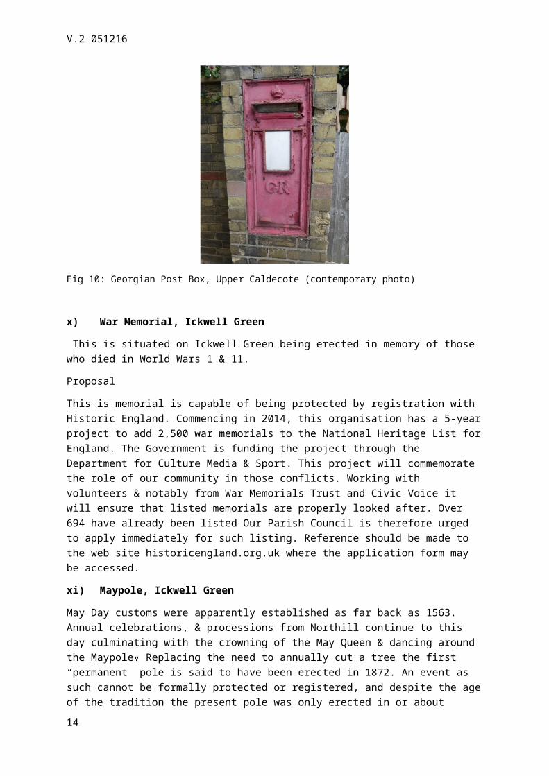
ix) Georgian Post Box, Upper Caldecote
This is situated in Hitchin Road, Upper Caldecote but does not appear to be currently in use. Historic England has an agreement with Royal Mail not to remove their historic boxes. However, in theory it may be possible to list it in that it seems to be sited on private land & is not attached to the boundary of a Listed Building.
Proposal Consider further an application for listing with Historic England as e.g. an item of historic Street Furniture or that it is included in a “local list” of “non-designated heritage assets”.
Fig 10: Georgian Post Box, Upper Caldecote (contemporary photo)
x) War Memorial, Ickwell Green
This is situated on Ickwell Green being erected in memory of those who died in World Wars 1 & 11.
Proposal
This is memorial is capable of being protected by registration with Historic England. Commencing in 2014, this organisation has a 5-year project to add 2,500 war memorials to the National Heritage List for England. The Government is funding the project through the Department for Culture Media & Sport. This project will commemorate the role of our community in those conflicts. Working with volunteers & notably from War Memorials Trust and Civic Voice it will ensure that listed memorials are properly looked after. Over 694 have already been listed Our Parish Council is therefore urged to apply immediately for such listing. Reference should be made to the web site historicengland.org.uk where the application form may be accessed.
xi) Maypole, Ickwell Green
May Day customs were apparently established as far back as 1563. Annual celebrations, & processions from Northill continue to this day culminating with the crowning of the May Queen & dancing around the Maypole. Replacing the need to annually cut a tree the first “permanent” pole is said to have been erected in 1872. An event as such cannot be formally protected or registered, and
11

V.2 051216
despite the age of the tradition the present pole was only erected in or about 1995.Historic England have expressed the view that it is therefore not capable of being listed. The upkeep of the Maypole for future generations therefore lies within the Parish & presently with the May Day Committee. Since 1945 they have organised the celebrations & cared for it. The expenses of keeping the custom alive are ever increasing with the need for insurance, roads closure, provision of toilet facilities etc.
Proposal
The encouragement of the activities of the May Day Committee with the availability of grants from all sources including the Parish Council such funds being essential to the Maypole’s presence as a permanent centrepiece within Ickwell & as a focus of annual celebration within the community.
xii) The Village Greens
Northill Parish is particularly fortunate since its village greens largely escaped the numerous Enclosure Acts of the 19th century. As a result, the parish is well endowed with village greens, with Ickwell, Northill, Thorncote, Hatch and Upper Caldecote retaining, to a greater or lesser extent, common land in the form of a green.
Evidence from the householder survey and Working Group reports emphasized how important the preservations of these greens are to the local inhabitants. All these greens are registered with Defra (The Department for Environment Food and Rural Affairs) as common land and as such enjoy special statutory protection, mainly under The Commons Act 2006. This means that consent is generally needed from the Secretary of State for any restricted works on the greens. This includes any such works which restrict or prevent access, such as constructing buildings, fences, walls, digging ditches, but also includes the resurfacing of land with tarmac and similar materials.
Proposal
We do, therefore, feel confident about the preservation of the greens but would also like assurance that their characters remain intact, the public continue to enjoy them and they continue to be well maintained. All these lie within the auspices of the Parish Council and we would like, in particular, to make the following specific comments relating to some of the greens:
Ickwell green has special prominence as the home of the annual Maypole Festival as well as being frequently used for organised sporting activities, with both a cricket and football club being based there. This often involves a significant number of people and vehicles visiting the site with, on some occasions, cars and other vehicles being parked on the green. Whereas we recognise this can create difficulties in the upkeep and maintenance of the green, we would urge the Parish Council not to succumb to the pressure of “urbanising” the green with tarmacked paths/tracks around the perimeter or hardstanding car parks.
Northill green includes a pond, which has some historic importance and considerable amenity value, but we would question whether it is being adequately maintained since it appears to be overgrown with pondweed. We are aware of drainage issues relating to this pond, and can only urge the parish Council to explore possible sources of funding, such as the Greensands Trust, to undertake remedial work which would improve the appearance of the pond.
xiii) Ickwell Bury and Ickwell Park
12

V.2 051216
The original manor house, Ickwell Bury, was built in 1683 by John Harvey and remained in the family for 250 years, until it was sold in 1924. From about 1900 to 1937 the building was used as a school. Shortly after this, the empty house caught fire and was largely destroyed.
The estate was subsequently acquired by Colonel George Hayward Wells, then chairman of brewers Charles Wells, who built the house which now stands. After his death, it was owned by Bedford School, which for a while leased the building out, but in 2006 the estate was sold and is now privately owned.
The origins of the present village of Ickwell thus lie with Ickwell Bury manor. Although the current main building is relatively young and not considered of sufficient architectural significance to justify listing, much of what remains of the previous manor house has been scheduled as Grade II. These include:
The stable block, built in 1683 in an L shape of red brick and a hipped clay tile roof; A weathervane, restored in 1970, which once bore the Harvey coat of arms, shown still on
the 18thC entrance archway; Barns & outbuildings the 17th C & 19th C; An octagonal dovecote (listed grade II*), built in 1683; A thatched bee house, timber-framed and weather-boarded on a red brick plinth; A sundial made of dressed limestone forming an obelisk over 4ft high, probably dating from
1803, commemorating the raising of the Bedfordshire Yeomanry Horse & Artillery in anticipation of a possible invasion by Napoleon.
13
V.2 051216
In addition, there is a 17thC clock, which has been attributed to Thomas Tompion, the so-called father of English clockmaking, who was born in the Parish. Although its authenticity is subject to some doubt, it is still a clock of great historic value. We are not sure, however, whether this is, de facto, listed as part of the curtilage of the other historic assets on this site.
The Parkland surrounding the Bury was registered under the Historic Buildings and Ancient Monuments Act 1953 and within the Register of Historic Parks and Gardens of English Heritage. It is noted for its historic interest, in particular for its 17th/18th C walled garden surrounded by late 18th/19th C pleasure grounds with lake and landscape park associated with the previous manor house.
Proposal Whereas most of the entries for Northill Parish on the Historic England Heritage List are highly visible to the public this is clearly not the case for these listings. Public awareness of them is thus inevitably reduced. Furthermore, the issue of access to the parkland has regularly been raised by local people in various consultations/workshops. We understand that there have been discussions involving the current owners of Ickwell Bury house and park, the CBC Landscape Planner, the Greensand Trust and other local nature conservation bodies over conservation repairs and seeking uses for the redundant buildings on site.
We would therefore urge Northill Parish Council to become involved in this dialogue with a view to exploring the possibility of allowing some degree of managed public access to the park, especially the lake and historic buildings listed above. This could, for example, take the form of an annual “open day”. In return, the council could perhaps assist in obtaining funding (from Greensand Trust, for example) to improving the landscape of the park. The avenue of trees, for example, which are included in the registered parkland, could perhaps be enhanced under such an arrangement.
Notwithstanding this, if the 17th C clock is not protected under one of the existing listings at Ickwell Bury, we would propose a that an application for listing in its own right should be put forward to Historic England. In addition, we would propose that the Ickwell bury building itself should be included in a “local list” of “non-designated heritage assets”.
xiv) Historical Artefacts in St Mary Virgin Church, NorthillThere is a small collection of historic artefacts housed in in a room over the porch at Northill church. This room was once used to house a curate and later used as a school room. The collection includes old farming implements, local memorabilia, old parish magazines, engraved leather buckets and stained glass windows (probably from Ickwell Bury). Although probably not of great value, these represent a unique collection of local historical artefacts which illustrate previous lifestyles, occupations and activities in the area.
Proposal
There seems to be little public knowledge of this collection and whereas it is probably of insufficient size and significance to warrant being put on permanent display, we would suggest that its existence is highlighted in the form of signage and/or in pamphlets and occasional access to the items could be arranged through liaising with St Mary’s Church.
xv) Deadman’s Cross (HER 14131)
14

V.2 051216
This refers to the location on the south corner of Sheerhatch Wood, at a four-way intersection of Bedford Road, Northill Road, a trackway (bridleway) heading south and the road north to Moggerhanger. This is also the point where four Parishes meet and is at the centre of the Wixamtree Hundred. Although there is no decisive evidence to confirm this, there are indications and it is generally believed, that this was the meeting place of the Wixamtree Hundred, the regional council which dated back to Saxon times and which comprised the parishes of Blunham, Cardington, Cople, Northill, Southill, Old Warden and Willington.
Wixamtree means Wihstan’s tree and this site is also known as Deadman’s Oak and indeed, until recently, an oak tree stood on this spot. Deadman’s oak is also the subject of legends, purportedly having grown from the blood of a murderer – perhaps indicating that a gallows was located here.
Proposal
There thus seems to be a strong probability that this is indeed a site of considerable local importance and although there are no visible signs of its previous usage, we feel it would be beneficial if this were highlighted in the form of local signage. It might also enhance the location if a replacement oak tree were planted, helping to maintain the longstanding tradition.
xvi) Medieval Fish Ponds, Home Wood (HER 429)
This site of undoubted historical significance is already scheduled under the Ancient Monuments and Archaeological Areas Act 1979 as being considered of national importance. The fish ponds are believed to have been part of the medieval estate of Northill Manor, with some evidence of a ‘motte and bailey’ defence system and a managed rabbit warren within the site. The practice of using artificial fishponds dates from Medieval times and peaked in the 12th century. This is an unusually good example, being described as ‘exceptionally well preserved’ by the then Forestry Commission when it completed the management plan for the site. It thus offers a rare opportunity to view the design and layout of artificial fishponds and rabbit warrens which could be around one thousand years old.
Proposal
Whereas this historic site is recognised and protected, with access by the public via a permitted right of way, connecting to a public footpath, it appeared, when the site was visited in May 2016, that it suffers from being overgrown with vegetation. This significantly impairs the visitor’s ability to appreciate the layout of the ponds, which is critical to understanding the farming process.
Signage at the site itself is detailed, clear and well-designed but we feel a somewhat more substantial sign should be installed on the public footpath, where it connects with the permitted path, leading to the fishponds. New signage at the two intersection should perhaps have the word “medieval” included, rather than just “fishponds”.
Regarding the excessive vegetation around the site itself, we would suggest an approach should be made to the Forest Enterprise to clear away some of the undergrowth to enable the public to view the full extent of the ponds from the point where the descriptive signage is situated. This could be achieved by local volunteers and would have minimal cost.
15

V.2 051216
Fig 11: Part of the Medieval Fishponds (contemporary photo)
xvii) Home Wood and College Wood (HER 13205 and 13204)
Home wood is itself an ancient woodland which contains a number of linear banks, where several historical artefacts have been discovered.
College Wood, situated just north of Home Wood, also has ancient woodland origins and contains linear earthwork banks, some ridge and furrow and the remains of three separate buildings, two of which are believed to be medieval in origin.
Both woods are managed by the Forest Enterprise but Home Wood has been designated as part of a Registered Park (which also includes Ickwell Bury) by Historic England. This should afford it better protection and help ensure its preservation. It appears, however, that College Wood does not appear to be part of the Registered Park and is thus less well protected. In addition, there are no designated footpaths crossing the wood and public access is thus denied.
Proposal
We feel that whereas since Home Wood contains the medieval fish ponds and is served by footpaths, management of the wood is easily visible, College Wood could be more at risk since it is not accessible to the public. We would therefore suggest that The Parish Council explores the possibility of establishing managed public access to College Wood, perhaps through a permitted footpath. This could be accompanied by appropriate signage identifying the historic significance of the wood. In addition, it might be worthwhile contacting the Woodland Trust, or similar such charitable organisation, to make them aware of the nature of the wood and perhaps provide advice on obtaining funding for such facilities. Clearly any such moves could only be pursued after discussion with Forest Enterprise and the owner of College Wood.
xviii) College and Sand Lane ponds (HER 15372 & 15371)
Both these ponds are believed to be medieval in origin and could therefore be important historical evidence of the earliest known settlement on the Northill site. They are both situated on private land
16

V.2 051216
however and their exact status cannot be verified by us. It appears, moreover, that Sand Lane pond is on a site which recently received planning permission for a single dwelling and the Planning Application stated that ‘an outbuilding has been erected over part of the pond’. Similarly, the college pond is situated on land which was recently put up for sale, possibly with a view to some sort of development (whether this was successful is not known).
Proposal
We would recommend that these likely medieval ponds receive some form of protection to maintain their existing form. Whether the ponds are substantive or significant enough to be registered as Ancient Monuments is not certain but we would suggest this is considered and if not, they should be included in a “local list” of “non-designated heritage assets”.
xix) Remains of navigation lock and wharf on the River Ivel (HER: 15181 & 15297)
Driven by the need to move large volumes of heavy, bulky goods across the country arising from the 18th century industrial revolution, a scheme to make the river Ivel navigable was initiated in the 1750s. This included construction of numerous wharfs, locks and towpaths between Temsford, at the confluence with the Great Ouse, south to Biggleswade. This was subsequently extended further south to Shefford. By the mid- 19th century, however, traffic on the system was in decline, partly because of the competition from the railways, and the enterprise was wound up in 1876.
Very little of the industrial heritage relating to this era survives but within the Northill Parish, there are two examples: the remains of a wharf, northeast of Manor Farm and a lock, a short distance north of here.
Proposal
These are both barely visible, overgrown with vegetation and have no signage. The remains of a lock are easily accessible from the footpath which runs north from Biggleswade town but the wharf is on the west side of the river, on the opposite bank to the footpath, presumably on private land.
We would suggest that efforts are made to preserve these last vestiges of a major navigation scheme in the parish and that they are made more accessible to the public. In addition, signage should be installed on the footpath, which would enable the public to be more aware of the industrial history of the Parish. We also recommend that they be included in a “local list” of “non-designated heritage assets”.
Fig 12: Remains of Navigation lock on River Ivel (contemporary photo)
17

V.2 051216
xx) Others
There are several other buildings which we feel should be subject to some form of listing or protection since they are of sufficient significance in term of Northill Parish history and are representative of the types of building which the public responses indicate should be preserved. We have, however, only been able to uncover minimal background history to these buildings and therefore are only briefly listing them below.
a) The Old Farmhouse, Thornton Green (HER 5808)
This is believed to be 17th C in origin, with 18th C features. Much of the building appears to be original and in good condition.
Fig 13: The Old Farmhouse, Thornton Green (contemporary photo)
We believe this building should be subject to an application for Listing. If this is not possible, it should be considered for inclusion in a “local list” of “non-designated heritage assets”.
xxi) Home Farm Barns, Ickwell
The two remaining barns of Home Farm date from the late 17th C and as such represent a significant feature of the building and farming legacy of Ickwell. We are aware that these barns are the subject of Planning Approval (dated December 2014), which aimed to maintain the character of the barns, but at the time of writing no development work had commenced and the state of the barns seem to have deteriorated.
Due to their apparent fragile state, notwithstanding the current Panning Approval, we would suggest that efforts are made to obtain a full listing for the barns to help ensure their survival.
Fig 14: Home Farm Barns (contemporary photo)
18

V.2 051216
xxii) 1 Ickwell Road, Upper Caldecote
Little is known about this cottage, which is not listed, but is believed to date from at least the 17 th C. It seems to have retained many of its early features and has been sympathetically maintained.
Fig 15: 1 Ickwell Road, Upper Caldecote (contemporary photo)
We believe this building should be subject to an application for Listing. If this is not possible, it should be considered for inclusion in a “local list” of “non-designated heritage assets”.
xxiii) The Old Brew House, Northill
The age of this building is uncertain but it is another example of the brewing heritage of the area and, in view of its attractive appearance and the apparent original features, we would recommend an application is made to Historic England for listing.
Fig 16: The Old Brew House, Northill
Conclusions
Northill Parish is rich in heritage assets many of which are already registered with Historic England. On the basis of the results of the local Workshops, Householder Survey and additional research, we have highlighted the following:
Eleven buildings in the Parish which we consider should be subject to an application for listing with Historic England.
19

V.2 051216
Three items of “street furniture” which we believe requires some form of recognition and preservation.
A War Memorial which we suggest should be the subject of an application for listing by Historic England.
Five village greens which require careful maintenance and preservation. A parkland and two ancient woods which we suggest should be more accessible by the
public. Three fishponds of mediaeval origin which should be preserved. Two remnants of the industrial heritage of the Parish. One location of historic importance which we recommend is recognised and signposted. A collection of historical artefacts of which we believe there should be greater awareness.
If the recommended applications for Historic England listings are not achievable we recommend these heritage assets are included on a “local list” of “non-designated heritage assets” along with the “street furniture”, fishponds and remnants of the industrial heritage.
The main proposal contained in the report relate to preserving these assets but we also recognise that public awareness of and access to, these assets is also important. To this end, we believe that improved signage at the sites and better coverage of the local amenities and historic assets could be achieved through pamphlets and enhanced interaction with local schools and other organisations.
Appendix 1: Listed Buildings in Northill Parish
NEEDS LANDSCAPE PAGE INSERTING HERE WITH LISTED BUILDINGS SPREADSHEET
20