Proposal
36
Iiiii ENBE Final Project- Better Future Town Report Lee Ning 0320125 FNBE August Ms. Ida Mazlan Mirage A Floating Town
Transcript of Proposal

Iiiii
ENBE Final Project- Better Future
Town Report
Lee Ning
0320125
FNBE August
Ms. Ida Mazlan
Mirage A Floating Town

Content
1. Introduction 1
2. Investigation of town 2-5
3. Investigation and data collection of an
ancient floating town 6-11
4. Investigation and data collection of a
present floating town 12-19
5. Investigation and data collection of a
future floating town 20-22
6. Description of Town Mirage 23-32
7. Conclusion 33
8. References 34

Introduction
This is report of my final project for Elements of Natural & Built
Environment (ENBE). The title of this project is “Better Town of Future”.
In this project, we have to pretend that we are the mayor of the town and
plan for the town. We are to propose a better future town with different
themes for each group. Our group has chosen “A Floating on Water
Town” as the theme of our town.
We are required to consider the geometrical shape, form, pattern,
hierarchy, system and structure of our town. Besides that, our town
should include the transportation, networking, infrastructure, utilities,
services and amenities. We also have to consider the zoning of the town.
For this project, we have to study the ancient, present and future town
which are related to our theme in order to create a better future floating
town.

Investigation of
Town
Definition of town
Town is an urban with a name, defined boundaries, and local government
that is larger than a village and generally smaller than a city.
Usually, the size of a town is about 20 to 40k𝑚2 and its population is
between 150,000 to 300,000.
History brief of town
The word town shares an origin with the German word Zaun, the Dutch
word tuin, and the Old Norse tun. The German word Zaun comes closest
to the original meaning of the word: a fence of any material. An early
borrowing from Celtic *dunom (cf. Old Irish dun, Welsh din "fortress,
fortified place, camp," dinas "city;"
In English and Dutch, the meaning of the word took on the sense of the
space which these fences enclosed. In England, a town was a small city
that could not afford or was not allowed to build walls or other larger
fortifications, and built a palisade or stockade instead. In the Netherlands,
this space was a garden, more specifically those of the wealthy, which

had a high fence or a wall around them (like the garden of palace Het Loo
in Apeldoorn, which was the example for the privy garden of William
and Mary at Hampton Court). In Old Norse tun means a (grassy) place
between farmhouses, and is still used in a similar meaning in modern
Norwegian.
In Old English and Early and Middle Scots, the word ton, toun, etc. could
refer to kinds of settlements as diverse as agricultural estates and holdings,
partly picking up the Norse sense (as in the Scots word fermtoun) at one
end of the scale, to fortified municipality at the other. If there was any
distinction between toun (fortified municipality) and burgh (unfortified
municipality) as claimed by some[who?], it did not last in practice as
burghs and touns developed. For example "Edina Burgh" or "Edinburgh"
(called a city today) was built around a fort and eventually came to have a
defensive wall.
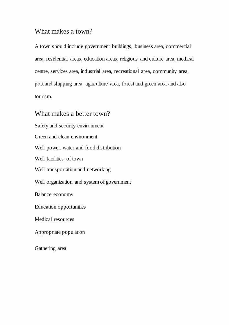
What makes a town?
A town should include government buildings, business area, commercial
area, residential areas, education areas, religious and culture area, medical
centre, services area, industrial area, recreational area, community area,
port and shipping area, agriculture area, forest and green area and also
tourism.
What makes a better town?
Safety and security environment
Green and clean environment
Well power, water and food distribution
Well facilities of town
Well transportation and networking
Well organization and system of government
Balance economy
Education opportunities
Medical resources
Appropriate population
Gathering area
Description of future town
Due to the drastic development of technology, the future town will be
more concentrate to the environmental issues. Therefore, I boldly
assumed that the concept of the future town will be the renewable energy.
This is because the resources on the earth will be used up one day, so we
have to explore the other ways to obtain energy. Examples of the
renewable energy are solar energy, wind power, hydroelectric power and
biomass.
Besides the power supply, the transportation of a future town will also
use the green vehicles. For example, bicycle, MRT as the public transport
and also solar car. This is to make a clean environment and a zero
pollution town.

Investigation
and
Collecting
Data of Town

Ancient town-
Wuzhen, China
Plan view of Wuzhen, China
Description of Wuzhen, China
Located in the centre of six ancient towns south of the Yangtze River in
China, Wuzhen (Black Town) is a scenic town full of canals navigated by
water taxis reminiscent of those in Venice. Known as Wuzhen Water
Town, the historic town is said to have been populated for at least 7,000
years and bears ancient stone bridges and wooden carvings. It lies within
the triangle formed by Hangzhou, Suzhou and Shanghai. Covering an
area of 71.19 km2, Wuzhen has a total population of 60,000, of which
12,000 are permanent residents

History of Wuzhen, China
Among all the beautiful water towns south of the Yangtze River, Wuzhen
has become especially noted for its history and culture. Original ancient
town scenery like bridges, waterways and houses are well-preserved.
According to historical records, Xinchun Village in the East Village
district of Wuzhen has relics from the Neolithic Period, belonging to the
Majiabin civilization, 7000 years ago. Here you can find a legacy from
Warring States Period (475-221 BC) and hear stories of the Taiping
Heavenly Kingdom (1851-1864). 161 first-degree scholars and 64
imperial scholars came from this town from the Song Dynasty (960-1279)
to the Qing Dynasty (1644-1911). Many famous officials and intellectuals
built their villas here.

What makes this town significant?
Bridge in bridge
This twin bridge was created by two ancient bridges, one of which is
Tongji Bridge crossing the river from east to west and the other is called
Renji Bridge running from south to north and joining the former at one
end. Either of two bridges can be seen through the arch of the other,
hence the name. Having been rebuilt five times, Tongji Bridge is a 28.4-
meter-long (93.1ft) and 3.5-meters-wide (11.4ft) one-curvature arch
bridge, with a span of 11.8 meters (38.7ft). Renji Bridge, which has also
experienced historical repairs, has a length of 22.6 meters (74.1ft), a
width of 2.8 meters (9.2ft) and a span of 8.5 meters (27.9ft).

Concept of buildings in Wuzhen, China
As its name ("Black Town") suggests, most decorated archways in
Wuzhen are black. There is an "East Village (dong zha)" and a "West
Village (xi zha)" in Wuzhen. East Village is mainly for tourism. However,
in order not to make it too commercialized, all the houses except for
several spots beside the roads are closed. West Village is a district mainly
for tourist accommodation. There are all kinds of inns and hotels here.
West Village is best seen at night. It is said that the lighting here is
wonderful.
Most of the buildings were built during the Ming and Qing dynasties
(1368-1912). Wuzhen Water Town has been listed by UNESCO into the
reserve list of world cultural heritages.

How the buildings were built?
Some of the houses beside the river were built on pillars to lift them
above the surface of the waterway. Wooden or stone pillars are fixed into
the waterway bed, crossbeams are fixed to the pillars, and wooden boards
are fixed on to form floors. This architectural feature is called a “water
pavilion”. This is part of the original architecture of Wuzhen. The water
pavilion is really “on the waterway”. There are often windows on the
three sides of this feature, facing the waterway, through which people can
have a wonderful view of the watery scenery.
Conclusion
Over the past thousand years, Wuzhen has not changed its name, water
system or way of life and the entire town is one of China’s most
important cultural relics. This means that Wuzhen, a town has been
started from 7000 years ago has very sustainable buildings. This also
prove that an art work never go behind the times.
What information on element from this town can be used
in future town?
High sustainability of buildings
A well transporting and networking system of town
Landmark or significant buildings in a town
Remain of culture and religious in a town

Present Town-
Lindau, Germany
Lindau is a Bavarian major town and an island on the eastern side
of Lake Constance, the freshwater lake called Bodensee in German. It is
the capital of the Landkreis or rural district of Lindau, very closely
situated near Austria (Vorarlberg) and Switzerland(Ostschweiz). Lindau
is part of Bavarian Swabia. The Coat of Arms of Lindau town is a Lime
tree. The historic town of Lindau is located on an 0.68-square-kilometre
(0.26 sq mi) island, which is connected with the mainland by a road-
traffic bridge and a railway dam leading to Lindau station.The total area
of this town is 33.18 𝑘𝑚2and the population is about 25,000.

History of Lindau, Germany
The name Lindau was first mentioned by a monk from St. Gallen in a
document of 882, stating that Adalbert, count of Raetia, had founded a
nunnery on the island. However remains of an early Roman settlement
dating back to the 1st century have been found in the district of Aeschach.
In 1180 the St. Stephan's church was founded. In 1224 the Franciscans
founded a monastery on the island. In 1274/75 Lindau became an
Imperial Free City under King Rudolph I. The terminology 'city' here
means German Große Kreisstadt, which is an exception due to Lindau's
rather small population of c. 24454 only. In 1430, about 15 of Lindau's
Jews were burned at the stake after being accused of murdering a
Christian child.[2][3] In 1528, Lindau accepted the Protestant
Reformation. Lindau first followed the Tetrapolitan Confession, and then
the Augsburg Confession. After the Thirty Years' War, in 1655 the first
Lindauer Kinderfest (children's festival) was held in memory of the war
time.

After the dissolution of the Holy Roman Empire, Lindau lost its status as
an Imperial Free City in 1802. The city went to Karl August von
Bretzenheim who gave Lindau and monastery to the Kingdom of Austria
in 1804. In 1805 Austria returned Lindau to Bavaria.
In 1853 a dam was built to connect the railway from Munich to the island.
In 1856 a new harbour was built, with its characteristic landmark, the lion
sculpture, together with Bavaria's only lighthouse.
In 1922 the independent districts of Aeschach, Hoyren and Reutin
merged with the district. After World War II, Lindau fell under French
administration and went firstly to Württemberg-Hohenzollern and then to
the State of Baden-Württemberg. In 1955, Lindau returned to Bavaria.
Lindau is located near the meeting point of the Austrian, German and
Swiss borders. It nestles on the lake in front of Austria's Pfänder
mountain. Lindau is popular with sightseers and holidaymakers for its
medieval town centre and pleasant location on Lake Constance. Since
1951, the Nobel Laureate Meetings at Lindau[4] attracts many Nobel
prize winners to Lindau every year. A congress of medical physics is also
held yearly.
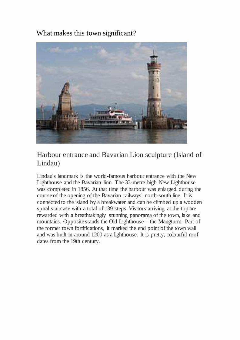
What makes this town significant?
Harbour entrance and Bavarian Lion sculpture (Island of
Lindau)
Lindau's landmark is the world-famous harbour entrance with the New Lighthouse and the Bavarian lion. The 33-metre high New Lighthouse
was completed in 1856. At that time the harbour was enlarged during the course of the opening of the Bavarian railways' north-south line. It is
connected to the island by a breakwater and can be climbed up a wooden spiral staircase with a total of 139 steps. Visitors arriving at the top are
rewarded with a breathtakingly stunning panorama of the town, lake and mountains. Opposite stands the Old Lighthouse – the Mangturm. Part of
the former town fortifications, it marked the end point of the town wall and was built in around 1200 as a lighthouse. It is pretty, colourful roof
dates from the 19th century.

Church of St. Peter (War Memorial Church)
The ancient Peterskirche is the oldest church in the entire Bodensee
region - an area that does not suffer from a shortage of old churches and
dates back to about 1000 AD. The Romanesque architecture of the
building is exquisitely stark, and the interior is a haven of tranquillity.
One of the interior walls features the only known fresco by Hans Holbein
the Elder dating from the 15th century.
Peterskirche has been used as a war memorial since 1928, and there are
simple but moving memorials to war casualties from a number of armed
conflicts
Utility of Lindau, Germany
Lindau's local utility provider is called Stadtwerke Lindau. The business
includes electricity, water, telecommunications, public baths, and other
products. The provider tries to improve in all branches, particular also to
integrate and deploy green-energy amongst homes, but also by buying
renewables only.
Economy of Lindau, Germany
In former times an important trading route from Nuremberg to Italy
passed through Lindau; the lake fishery has also played a big role in the
economy of the city. In the 19th century Lindau was an important
location for textile industries. Nowadays Lindau has a well-established
industrial and touristic economy, including Restaurants, Hotels and
B&B's. For families it is also popular to stay at a Ferienwohnung
(Holiday apartment), which you find everywhere in the area. Lindau has a
very low unemployment rate, likely due to the economy mix and good
trade near the Rhine-Valley. Today, there are a lot of small amongst some
industrial companies.
Property, redevelopment and other major projects across
town in Lindau, Germany New train station
Train electrification project for tracks to Munich (connecting
Munich and Zurich
Lindau Inselhalle
Multi-storey car park
It is worth to mention that Lindau is currently planning several major
redevelopment projects across. The vast amount of projects can be
followed through local news sources spotting construction site signs. The
following is a list of objects that are in focus of redevelopment. Some of
the items like the new train station is in planning since decades. All dates
and planning should be frequently looked up in news source due to high
amount of changes that projects face with costs, construction issues a
stakeholders.

Transportation in Lindau, Germany
Railway
Lindau has a main station (for the next years still on the Island,
reactivating of the old one on Reutin's mainland is planned) the Lindauer
Hbf (short for Hauptbahnhof), with trains usually from/to Friedrichshafen,
Munich, Ulm and Augsburg direction or Bregenz with OBB, Austria and
further like Zurich by SBB.
Bus - - Stadtbus Lindau
Lindau's bus system is called Stadtbus Lindau, which departs
conveniently from all station every 30 Minutes and runs until 22.30 daily,
with special exceptions at events. The bus system is a very helpful way of
getting around town for people of all ages, provided by the Lindauer
Stadtwerke, which is the main local utility provider.
Beside that the RBA and the Zweiländer-line of Austrias "Landbus
Unterland" offer their services. Recently long-distance coaches have
started running lines to further away German cities an being an
alternative to the Railway by Deutsche Bahn.
Road
Lindau is connected to the Autobahn A96 (E43). Main roads (German
Bundesstraße) include B31 and B12. The A96 will merge into the
Austrian Autobahn A14 starting right after the boarding with the c. 7 km
long Pfändertunnel. The tunnel has been under reconstruction and
expansion into a 2-pipe system (opened in 2013) for a total of 4 lanes in
the last years to compensate for traffic going North and South.

Conclusion
Lindau is a present town from past centuries which is under
redevelopment due to the change of the world. However these changes
are to make Lindau a better town.
What information on element from this town can be used
in future town?
Variety of transport systems
Balance of economy
Redevelopment of town
Utility of town
Landmarks in town

Future Town-
Lilypad
Why should we have this kind of town?
According to the GIEC (Intergovernmental group on the evolution of the
climate), the ocean level should rise from 20 to 90 cm during the 21st
Century with a status quo by 50 cm (versus 10 cm in the 20th Century).
To solve this problem, architect Vincent Callebaut came up with this
eco-textural marvel, Lilypad that could serve as a luxurious future retreat
for 50,000 inhabitants seeking refuge from rising waters due to global
warming. He believes the world will be desperately seeking shelter from
the devastations of climate change, and hopes the auto-sufficient
amphibious city will serve as a luxurious solution.

Side Elevation of Lilypad
Cross-sectional view of town

Design Concept
Lilypad is a floating on water town. The whole structure is covered in
green walls and roofs, the top portion covered in grasses with the inner
portion featuring a palm oasis, and the under portion serving as a bed for
natural sea planktons and oceanic plant. The floating city concept is
designed to be constantly in motion along with the water currents, though
remaining closer to the sea coast
Lilypad is a design inspired by biomimicry, which was designed to look
like a waterlily, is intended to be a zero emission city afloat in the ocean.
Through a number of technologies (solar, wind, tidal, biomass), it is
envisioned that the project would be able to not only produce it’s own
energy, but be able to process CO2 in the atmosphere and absorb it into
its titanium dioxide skin.
The constructional particulars of the Lilipad floating metropolis add to its
uniqueness. The architect has designed the drifting Lilypad Floating City
metropolis in such a way that the petals of the lily will provide housing
and other amenities to the people. The support structure for the drifting
city will be through its centre, designed as a Laguna and which will
provide the city’s fuel and energy requirements.
Conclusion
The Lilypad floating city still remains a future prospect at present.
However if the present climatic and weather trends are taken into account,
it is quite possible that the Lilypad metropolis will soon the light of the
day. Though it may not be what the world wants or desires, the threat of
global warming has forced mankind to come up with solutions like that of
the floating city concept.
What information on element from this town can be used
in future town?
Modernisation of the town

Case Study on a
Floating Town-
Town Mirage My town is a town on an island which seems floating on
water.
Location: Malaysia
Size: 33𝑘𝑚2 Population: 70,000-100,000
Advantages of a town on island Water provide a source of food and transportation
Beautiful scene
Remote apart from outside world
Natural water barrier protection
Fertile soil
Disadvantage of a town on island
Transportation to contact with outside world
Irregular climate
Limited population
Higher expenses due to import items from other places
Lack of working opportunities

Why is an island?
The reasons that I chose island to be my town is the beautiful scene of beaches and the water. For example, I can use water for transporting
system to contact with the outside world. Besides that, since water is a renewable energy, I can use the tide to generate energy. Last but not least,
I can get the water resource just everywhere, as I may purify the sea water to become drinkable.
Why is it called Mirage? Mirage is a naturally occurring optical phenomenon in which light rays are bent to produce a displaced image of distant objects or the sky. The
word comes to English via the French mirage, from the Latin mirari, meaning "to look at, to wonder at". This is the same root as for "mirror"
and "to admire". So, I named this town as mirage as this is a future town that we are to look and to wonder.

Master plan of Mirage

Zoning of town

Transporting system
MRT(Magnetic-Levitated
Train) system
To provide a quick and efficient
transporting system, I design
the route by using the
combination of circle and secant
system.
Road system
To provide a conveiniency for
people to go out with own
transport or public transport like
taxi and bus.
Cycling path beside road
Provide a safety route for bicycle.

Vehicles
MRT Solar Bus
Solar Car Bicycle
Boat

Landmark & Tourism in my town
Statue of Justice
At the centre of the town
In front of the court
Highest statue in the town
Reserve Forest
Jungle trekking & jungle activities for
tourist
Eco- tourism
Stadium
A place to held some special event
and attract tourist

Power supply
Solar house
Hydroelectric energy

Water supply
Sea water purification system

3D view of town Mirage

Conclusion
By doing this project, I realized that the main purpose to plan a town is
put the suitable facilities or buildings in a right area. So, the zoning area
of a town is very important. It related every single thing in the town, for
instance, the transportation, the convenience for people to approach the
place and the aim for that area.
From the research of the ancient, present and future town, I saw the
wisdom of our ascendants and the modernisation of our generation. In the
research of ancient town, I saw how people tried to create a town by
using their cultures and techniques. While from the future town, I saw
how people are trying to survive and be seasoned with the environment.
In the conclusion, we have to earn the experiences of our ascendants and
innovate the ideas to this modern world.

Reference
http://www.gonomad.com/destinations-xxx/2096-the-water-town-of-
wuzhen-the-venice-of-china
http://www.wuzhen.com.cn/english/index.asp
http://www.travelchinaguide.com/attraction/zhejiang/hangzhou/wuzhen.h
tm
http://en.lindau-tourismus.de/holiday-themes/places-to-see-and-
tours/historical-buildings.html
http://www.virtualtourist.com/travel/Europe/Germany/Bavaria/Lindau-
41493/TravelGuide-Lindau.html
http://www.beautifullife.info/urban-design/lilypad/
http://www.marineinsight.com/marine/marine-news/headline/the-lilipad-
floating-city-concept-amazing-alternate-ecosystem/
http://thedesigninspiration.com/articles/the-future-floating-city-lilypad/
http://hugeuniverse.ethereal.org/?p=108
http://inhabitat.com/lilypad-floating-cities-in-the-age-of-global-warming/