Property Vegetation Management Plan Rowanlea Quarry… · Property Vegetation Management Plan...
29
© Biosis September 2012 – Leading ecology and heritage consultants 1 Property Vegetation Management Plan Rowanlea Quarry, QLD. Prepared for Ausrocks Pty Ltd 9 October 2014
Transcript of Property Vegetation Management Plan Rowanlea Quarry… · Property Vegetation Management Plan...

© Biosis September 2012 – Leading ecology and heritage consultants 1
Property Vegetation Management Plan
Rowanlea Quarry, QLD. Prepared for Ausrocks Pty Ltd
9 October 2014
© Biosis 2014 – Leaders in Ecology and Heritage Consulting 2
Biosis Pty Ltd
This document is and shall remain the property of Biosis Pty Ltd. The document may only be used for the
purposes for which it was commissioned and in accordance with the Terms of the Engagement for the
commission. Unauthorised use of this document in any form whatsoever is prohibited.
Disclaimer:
Biosis Pty Ltd has completed this assessment in accordance with the relevant federal, state and local
legislation and current industry best practice. The company accepts no liability for any damages or loss
incurred as a result of reliance placed upon the report content or for any purpose other than that for which it
was intended.
Biosis offices
AUSTRALIAN CAPITAL TERRITORY
Canberra
Unit 16 / 2 Yallourn Street
Fyshwick ACT 2609
Phone: (02) 6228 1599
Fax: (02) 6280 8752
Email: [email protected]
NEW SOUTH WALES
Sydney
18–20 Mandible Street
Alexandria NSW 2015
Phone: (02) 9690 2777
Fax: (02) 9690 2577
Email: [email protected]
Wollongong
8 Tate Street
Wollongong NSW 2500
Phone: (02) 4229 5222
Fax: (02) 4229 5500
Email: [email protected]
QUEENSLAND
Brisbane
72a Wickham Street
Fortitude Valley QLD 4006
Phone: (07) 3831 7400
Fax: (07) 3831 7411
Email: [email protected]
VICTORIA
Ballarat
506 Macarthur Street
Ballarat VIC 3350
Phone: (03) 5331 7000
Fax: (03) 5331 7033
Email: [email protected]
Melbourne (Head Office)
38 Bertie Street
Port Melbourne VIC 3207
Phone: (03) 9646 9499
Fax: (03) 9646 9242
Email: [email protected]
Wangaratta
26a Reid Street (PO Box 943)
Wangaratta VIC 3677
Phone: (03) 5721 9453
Fax: (03) 5721 9454
Email: [email protected]
Report to: Ausrocks Pty Ltd
Prepared by: Dr Monica Campbell
Biosis project no.: 18858
Version/date Internal review by Date sent to client
Draft 01
Final
Robert Speirs
Monica Campbell
08/10/2014
09/10/2014
File name: 18858.Rowanlea Quarry. PVMP.FINAL.20141009.docx
Citation: Biosis Pty Ltd (2014) Property Vegetation Management Plan,
Rowanlea Quarry, QLD. Draft report to Ausrocks Pty Ltd. Author: Campbell,
M.L. Biosis Pty Ltd, Brisbane. Project no. 18858
Acknowledgements
Biosis Pty Ltd acknowledges the contribution of the following people
and organisations in undertaking this study:
• Carl Morandy, Ausrocks
The following Biosis Pty Ltd staff were involved in this project:
• Robert Speirs for technical input and review

© Biosis 2014 – Leaders in Ecology and Heritage Consulting III
Contents
1. Introduction .................................................................................................................................................... 4
2. Purpose and Extent of Assessable Vegetation Clearance ...................................................................... 6
2.1 Purpose of assessable vegetation clearance ...................................................................................................................... 6
2.2 Extent of assessable vegetation clearance ......................................................................................................................... 6
3. State Development Assessment Provisions .............................................................................................. 9
List of Figures
Figure 1: Property locality ............................................................................................................................................... 4
Figure 2: Property cadastral information ...................................................................................................................... 5
Figure 3: Category B vegetation mapped within the property ................................................................................... 7
Figure 4: Boundary of Category B vegetation as mapped by Ausrocks using a DGPS. ........................................... 7
Figure 5: Vegetation Clearing Plan ................................................................................................................................. 8
Appendices
Appendix 1: Ausrocks Resource Advice
Appendix 2: Current RVM Map and VMS Map
Appendix 3: Vegetation Clearing Measures

© Biosis 2014 – Leaders in Ecology and Heritage Consulting 4
1. Introduction
Biosis has been engaged by Ausrocks Pty Ltd (Ausrocks) to prepare a Property Vegetation Management Plan
(PVMP) in support of a Material Change of Use (MCU) application to establish extractive industry operations
across Lot 39 CAR3462 and Lot 23 CAR3425 (the property). The property is located approximately 28
kilometres north-west of Goondiwindi in the Brigalow Belt Bioregion and currently falls with the Goondiwindi
Local Government Area (LGA) (Figure 1).
Figure 1: Property locality
The property encompasses approximately 785.73ha, however only approximately 27.85 ha (or 3.5%) of the
property (most of which is located in Lot 39), is being considered for establishment of extractive industry
operations (Figure 2). The majority of the property supports generally flat grazing and cropping land that
drains to Tooee Creek in the southern portion of the property. The central portion of Lot 39 also supports a
ridgeline of deposited sand running in a north-west to south-east trend. The property has been used for
grazing and cultivation for many years and as a result areas of remnant native woody vegetation are
restricted to the riparian zone associated with Tooee Creek and the sandy ridgeline in Lot 39.
Property
© Biosis 2014 – Leaders in Ecology and Heritage Consulting 5
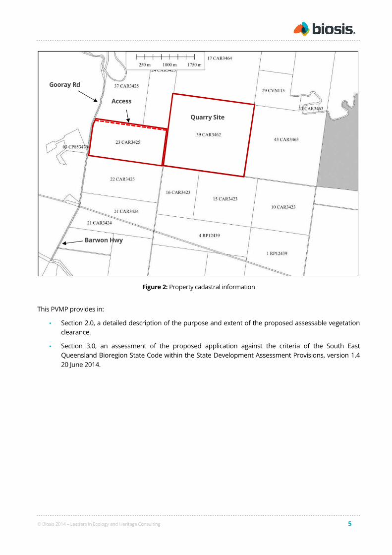
Figure 2: Property cadastral information
This PVMP provides in:
• Section 2.0, a detailed description of the purpose and extent of the proposed assessable vegetation
clearance.
• Section 3.0, an assessment of the proposed application against the criteria of the South East
Queensland Bioregion State Code within the State Development Assessment Provisions, version 1.4
20 June 2014.
Barwon Hwy
Gooray Rd
Quarry Site
Access

© Biosis 2014 – Leaders in Ecology and Heritage Consulting 6
2. Purpose and Extent of Assessable Vegetation Clearance
2.1 Purpose of assessable vegetation clearance
The proposed assessable clearance of vegetation within the property is for the purpose of extracting resource
from the ridgeline of deposited sand in the central portion of the property. The Goondiwindi LGA is expected
have a significant increase in demand for various sand products if local gas pipeline construction work
commences and the proposed quarry has the potential to provide a valuable resource for these projects.
Ausrocks have prepared a letter of advice regarding the suitability and availability of the sand resource within
the property (refer Appendix 1).
The proposed Environmentally Relevant Activities (ERAs) for the site are as follows;
• ERA 16 2 (a) Extracting rock or other material (up to 100,000t per year)
• ERA 16 3 (a) Screening rock or other material (up to 100,000t per year)
It is noted that clearing native vegetation for extractive industry constitutes a relevant purpose pursuant to
Section 22A of the Vegetation Management Act 1999 (VM Act).
2.2 Extent of assessable vegetation clearance
A field inspection of the property by an ecologist has not been completed, as such for the purposes of this
PVMP the Regulated Vegetation Management Map (RVM Map) and Vegetation Management Supporting Map
(VMS Map) (refer Appendix 2) are being treated as an accurate representation of the on-ground vegetation
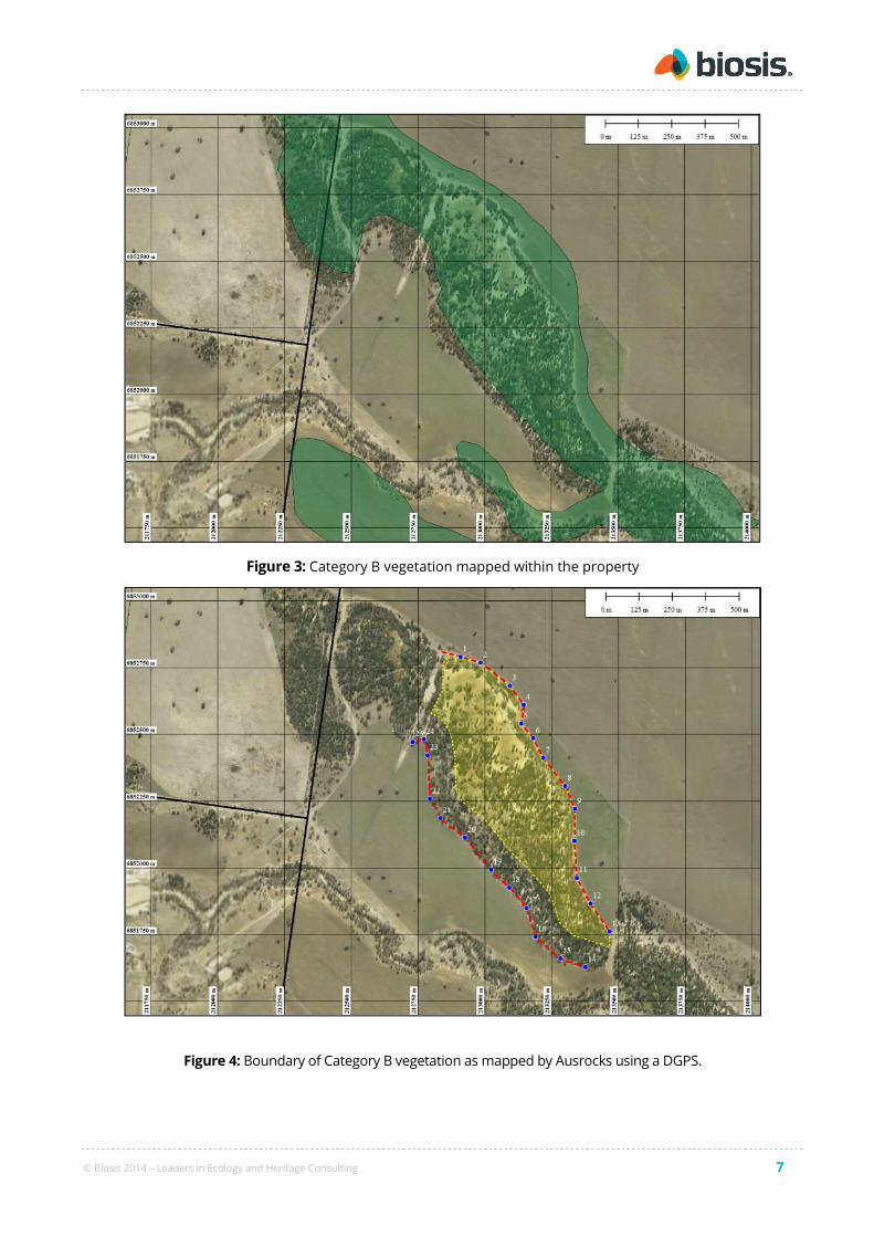
community types. However, based on a review of aerial photography and observations made in the field by
Ausrocks, there is a margin of error in the mapped boundary of RE 11.3.19 on the RVM Map compared to the
on-ground extent as illustrated in Figure 3 below. Ausrocks have marked the edge of RE 11.3.19 on the
ground using a Differential GPS and Figure 4 provides the accurate on-ground boundaries of this vegetation
community. It is noted that RVM Maps are created at a 1:100,000 scale, are only accurate to +/- 100 m and
require ground-truthing at the property scale. As such, for the purposes of this PVMP the mapped
boundaries provided by Ausrocks will be relied upon to assess the merits of the proposal.
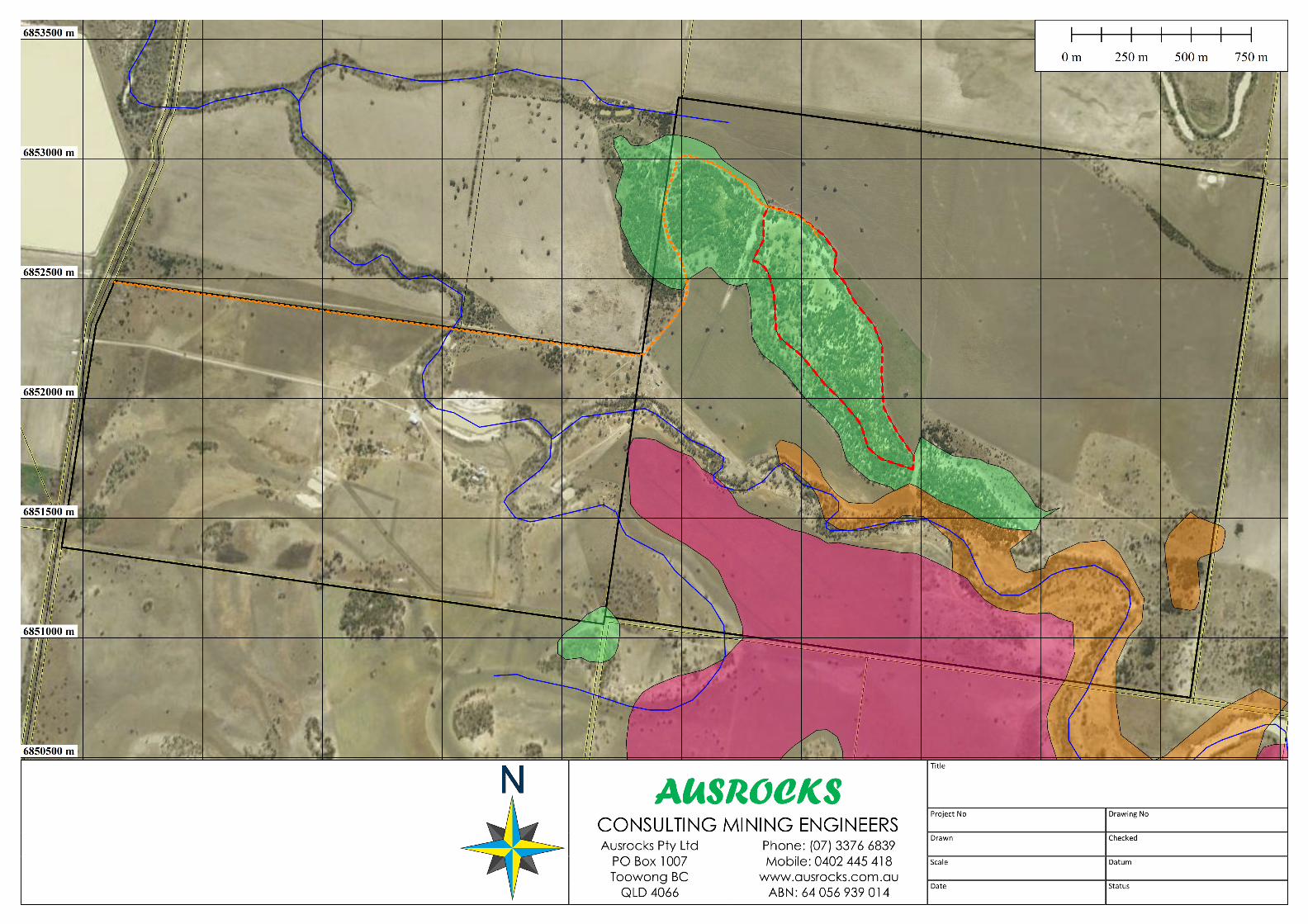
Figure 5 illustrates the location and extent of the proposed clearing footprint within which all quarry and
associated infrastructure will be located in relation to the ground-truthed RVM Mapping for the property.
With reference to this figure, the quarry footprint is wholly located within mapped remnant Least Concern
vegetation consisting of Regional Ecosystem (RE) 11.3.19 which is briefly described as 'Callitris glaucophylla,
Corymbia spp. and/or Eucalyptus melanophloia open forest to woodland on Cainozoic alluvial plains'. The
proposal does not involve the clearance of any mapped areas of Category B vegetation containing Of Concern
or Endangered REs.
With reference to the above and the Sustainable Planning Act 2009, there are no exemptions for clearing native
vegetation that apply to the current proposal (refer Schedule 24 of the Sustainable Planning Regulation 2009
(SP Reg)). This PVMP will therefore address the assessable clearance of approximately 27.85 ha of Category B
vegetation containing a Least Concern RE (i.e. RE 11.3.9) that is assessable under the provisions of the
Vegetation Management Act 1999.
© Biosis 2014 – Leaders in Ecology and Heritage Consulting 7
Figure 3: Category B vegetation mapped within the property
Figure 4: Boundary of Category B vegetation as mapped by Ausrocks using a DGPS.

© Biosis 2014 – Leaders in Ecology and Heritage Consulting 9
3. State Development Assessment Provisions
The State Development Assessment Provisions, Version 1.4, 20 June 2014 (SDAP) are an outcome of the
introduction of the State Assessment and Referral Agency (SARA), a key element of the reform of
Queensland’s planning system. The SDAP set out the matters of interest to the state for development
assessment, where the chief executive administering SPA, being the Director-General of Department of State
Development, Infrastructure and Planning (DSDIP), is responsible for assessing or deciding development
applications. The SDAP are prescribed in the SP Reg, and contains the matters the chief executive may have
regard to when assessing a development application as either an assessment manager or a referral agency.
The proposal is assessable development pursuant to SPA and as such the Queensland Vegetation
Management State Code (the Code) provided within Module 8: Native vegetation clearing of the SDAP applies.
The purpose of the code is to regulate the clearing of native vegetation within Queensland to:
1) Conserve remnant vegetation that is—
a) An endangered regional ecosystem
b) An of concern regional ecosystem
c) A least concern regional ecosystem
2) Conserve vegetation in declared areas
3) Ensure clearing does not cause land degradation
4) Prevent loss of biodiversity
5) Maintain ecological processes
6) Manage environmental effects of the clearing to achieve (1) through (5)
7) Reduce greenhouse gas emissions.
The Code provides 'criteria for assessment' that direct an applicant to the relevant provisions of the Code.
Pursuant to Table 8.1.1 and Table 8.1.2 of the Code, the criteria for assessment that are relevant to the
current application are:
• Performance Outcome (PO) 1 – PO 2 of Table 8.1.3: General
• PO1- PO9 of Table 8.1.5: Extractive Industry.
An assessment of the proposal against the above specified elements of the Code are provided in Table 1 and
Table 2 below.
© Biosis 2014 – Leaders in Ecology and Heritage Consulting 10
Table 1. Vegetation Management State Code Assessment – Table 8.1.3: General
Performance Outcome Acceptable Outcome Response Comment
Clearing to avoid and minimise impacts
PO1
Clearing only occurs where the
applicant has demonstrated that the
development has first avoided, and
then minimised the impacts of
development.
No acceptable outcome
(AO) prescribed
The proposal satisfies
PO1.
The proposed 27.85 ha of assessable vegetation clearance is for the
purposes of extracting resource from the bulk deposit of fine and coarse
sands in the central portion of the property. This sand ridgeline is a novel
geological feature in the landscape that was most likely deposited during
a historic flood or similar event. Similar resources are rare in the
Goondiwindi region.
Test pits have been taken to establish the extent of suitable resource
within the property and these tests have confirmed that the extent of the
sand deposits coincide with the mapped extent of the Category B
vegetation containing Least Concern RE. Furthermore, portions of the
property mapped as Category X vegetation do not support suitable sand
resources for extraction (refer Appendix 1). .
Given the above, the proposal is consistent with the purpose and intent of
PO1, as there is no suitable alternative site for the extension of the quarry
footprint.
Clearing on land where compliance notice, enforcement notice, exchange area or offsets exists
PO2
Clearing in an area that is subject to any
of the following:
(1) a restoration notice, or
(2) a compliance notice containing
conditions about the restoration
of vegetation, or
No acceptable outcome
(AO) prescribed
The proposal satisfies
PO2.
The proposed clearing within the property will not take place in areas
subject to any of the notices listed under PO2.
© Biosis 2014 – Leaders in Ecology and Heritage Consulting 11
Performance Outcome Acceptable Outcome Response Comment
(3) a Land Act notice, or
(4) a trespass notice if the trespass
related act under the Land Act
1994 for the notice is the clearing
of vegetation on the relevant
land, or
(5) an enforcement notice under the
Sustainable Planning Act 2009
issued for a vegetation clearing
offence, or
(6) an exchange area, or
(7) an environmental offsets
(8) must not be inconsistent with
the notice or impact on the
exchange area, unless a better
environmental outcome can be
achieved, or inconsistent with
the environmental offsets or
another agreement related to
the environmental offsets.
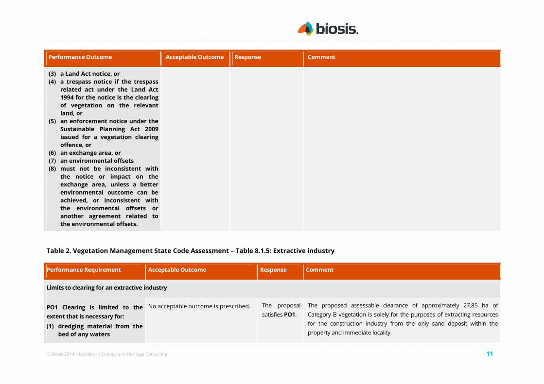
Table 2. Vegetation Management State Code Assessment – Table 8.1.5: Extractive industry
Performance Requirement Acceptable Outcome Response Comment
Limits to clearing for an extractive industry
PO1 Clearing is limited to the
extent that is necessary for:
(1) dredging material from the
bed of any waters
No acceptable outcome is prescribed. The proposal
satisfies PO1.
The proposed assessable clearance of approximately 27.85 ha of
Category B vegetation is solely for the purposes of extracting resources
for the construction industry from the only sand deposit within the
property and immediate locality.

© Biosis 2014 – Leaders in Ecology and Heritage Consulting 12
Performance Requirement Acceptable Outcome Response Comment
(2) extracting, from a pit or
quarry, rock, sand, clay,
gravel, loam or other
material
(3) screening, washing, grinding,
milling, sizing or separating
material extracted from a
pit or quarry
(4) carrying out work that is the
natural and ordinary
consequence of carrying out
work mentioned in
subparagraphs (1), (2) and (3)
above.
It is proposed to use semi-mobile (ATCO style) buildings for the site office
and staff amenities, which will be placed within the extraction footprint
illustrated in Figure 5.
The main access for the quarrying operation will be from Gooray Road
along an existing track through Lot 23 CAR3425 on the western boundary
of Lot 39 CAR3462. There will be no clearance of Category B vegetation for
the purposes of widening this existing track and facilitating access to the
proposed quarry.
The proposal therefore satisfies PO1.
Clearing is staged
PO2 Clearing:
(1) is staged in line with
operational needs that
restrict clearing to the
current operational area
(2) is limited to the area from
which material will be
extracted, and any
reasonably associated
infrastructure, within the
term of the development
approval
(3) cannot occur until all
required permits are
obtained.
No acceptable outcome is prescribed. The proposal
satisfies PO2.
The proposed assessable clearance of Category B vegetation will take
place in a staged and orderly manner. It is intended to conduct extractive
industry operations in three stages, moving from the north-western end
of the proposed quarry pit to the south-east. Vegetation clearance will
take place in line with operational staging and broad-sale clearance of the
proposed quarry footprint will not be permitted.
Vegetation clearing protection measures have been prepared to reduce
the risk of damage to areas of retained remnant vegetation within the
property. These measures are provided in Appendix 3 for DNRM's review
and approval.
The proponent is currently seeking all of the relevant approvals required
to lawfully undertake extractive industry activities on the property. There
is no intention to undertake any assessable vegetation clearance within

© Biosis 2014 – Leaders in Ecology and Heritage Consulting 13
Performance Requirement Acceptable Outcome Response Comment
the property until all relevant permits have been acquired.
The proposal is therefore consistent with PO2.
Wetlands
PO3
Maintain the current extent of
vegetation associated with any
natural wetland to protect:
(1) water quality by filtering
sediments, nutrients and
other pollutants
(2) aquatic habitat
(3) terrestrial habitat.
AO3.1
Clearing does not occur in, or within 100
metres of any natural wetland.
The proposal
complies with
AO3.1 and
therefore
satisfies PO3.
The proposed assessable clearance of 27.85 ha of Category B vegetation
will not occur in or within 100 m of vegetation that supports plants or is
associated with plants that are adapted to and dependent on living in wet
conditions for at least part of their lifecycle, and that is a mapped wetland
on the vegetation management wetlands map (refer Appendix 2).
The proposal therefore satisfies PO3 through achieving compliance with
AO3.1.
AO3.2
(1) Clearing only occurs within 100
metres of any natural wetland
where:
(2) the clearing does not occur within
50 metres of the of the natural
wetland, or
(3) the widths stipulated by Table 1
are not exceeded.
N/A
The proposal satisfies PO3 through achieving compliance with AO3.1.
AO3.3
Where it can be demonstrated that
clearing cannot be avoided, and the
extent of clearing has been minimised,
an environmental offset is provided for
any significant residual impact from
N/A
The proposal satisfies PO3 through achieving compliance with AO3.1.

© Biosis 2014 – Leaders in Ecology and Heritage Consulting 14
Performance Requirement Acceptable Outcome Response Comment
clearing of vegetation associated with a
natural wetland.1
Watercourses
PO4
Maintain the current extent of
vegetation associated with any
watercourse to protect:
(1) bank stability by protecting
against bank erosion
(2) water quality by filtering
sediments, nutrients and
other pollutants
(3) aquatic habitat
(4) terrestrial habitat.
AO4.1
Clearing does not occur:
(1) in any watercourse
(2) within the relevant distance
stipulated in Table 2 of the
defining bank of any watercourse.
OR
The proposal
complies with
AO4.1.
With reference to Figure 5, the proposed assessable clearance of Category
B vegetation will take place at a minimum distance of 248 m from the
mapped stream order 1 watercourses in the southern portion of the
property. This is well outside the minimum distance of 25 m from the
high bank stipulated in Table 2 of the Code for a stream order 2
watercourse in a non-coastal bioregion.
The proposal therefore satisfies PO4 through achieving compliance with
AO4.1.
AO4.2
Clearing only occurs within any
watercourse or within the relevant
distance stipulated by Table 2 of the
defining bank of any watercourse where:
(1) the clearing does not occur within
5 metres of the defining bank, or
(2) the widths stipulated by Table 1 is
not exceeded.
OR
N/A The proposal therefore satisfies PO4 through achieving compliance with
AO4.1.
AO4.3
Where it can be demonstrated that
clearing cannot be avoided, and the
extent of clearing has been minimised,
an environmental offset is provided for
N/A The proposal therefore satisfies PO4 through achieving compliance with
AO4.1.

© Biosis 2014 – Leaders in Ecology and Heritage Consulting 15
Performance Requirement Acceptable Outcome Response Comment
any significant residual impact from
clearing of vegetation associated with
any watercourse.
Connectivity
PO5
In consideration of vegetation on
the subject lot(s) and in the
landscape adjacent to the subject
lot(s), vegetation is retained that:
(1) is of sufficient size and
configured in a way that
maintains ecosystem
functioning
(2) remains in the landscape
despite threatening
processes.
AO5.1
Clearing occurs in accordance with
Table 3.
For non-coastal Bioregions and
subregions -
Clearing does not:
1) occur in areas of vegetation that are
less than 50 hectares
2) reduce the extent of vegetation to
less than 50 hectares
3) occur in areas of vegetation less
than 200 metres wide
4) reduce the width of vegetation to
less than 200 metres
5) occur where the extent of
vegetation on the subject lot(s) is
reduced to or less than 30 per cent
of the total area of the lot(s).
The proposal
is unable to
achieve
compliance
with AO5.1.
The property supports approximately 185.93 ha of Category B
vegetation, which covers approximately 23.6% of the total property area.
The proposal will necessitate the clearance of approximately 27.85 ha
(or 15%) of Category B vegetation for the purposes of extracting
available resources. With reference to Figure 5, it is noted that:
• The property is located within the Brigalow Belt Bioregion that is
identified by the Code as being a non-coastal bioregion.
• The proposed assessable clearance of Category B vegetation will not
occur in an area of Category B vegetation that is currently less than 50
ha in area.
• The proposal will not reduce the extent of mapped Category B
Vegetation within the property to less than 50 ha (i.e. 158.08 ha of
Category B vegetation will be retained).
• The proposal will not reduce the total extent of Category B vegetation
within the property to less than 30% of its current extent (i.e. 85% of
Category B vegetation will be retained).
However, the proposal will result in an area of Category B vegetation along
the western boundary of the proposed quarry being reduced to
approximately 100 m in width. As such, the proposal does not strictly
comply with AO5.1 and must satisfy PO5 through alternative measures. In
this regard, the proposal does maintain connectivity and ecosystem
functioning of retained Category B vegetation through the following
© Biosis 2014 – Leaders in Ecology and Heritage Consulting 16
Performance Requirement Acceptable Outcome Response Comment
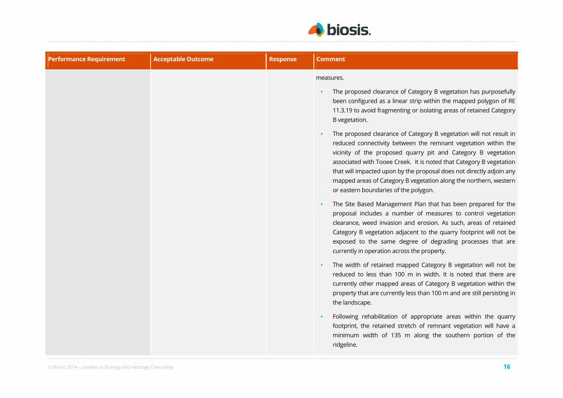
measures.
• The proposed clearance of Category B vegetation has purposefully
been configured as a linear strip within the mapped polygon of RE
11.3.19 to avoid fragmenting or isolating areas of retained Category
B vegetation.
• The proposed clearance of Category B vegetation will not result in
reduced connectivity between the remnant vegetation within the
vicinity of the proposed quarry pit and Category B vegetation
associated with Tooee Creek. It is noted that Category B vegetation
that will impacted upon by the proposal does not directly adjoin any
mapped areas of Category B vegetation along the northern, western
or eastern boundaries of the polygon.
• The Site Based Management Plan that has been prepared for the
proposal includes a number of measures to control vegetation
clearance, weed invasion and erosion. As such, areas of retained
Category B vegetation adjacent to the quarry footprint will not be
exposed to the same degree of degrading processes that are
currently in operation across the property.
• The width of retained mapped Category B vegetation will not be
reduced to less than 100 m in width. It is noted that there are
currently other mapped areas of Category B vegetation within the
property that are currently less than 100 m and are still persisting in
the landscape.
• Following rehabilitation of appropriate areas within the quarry
footprint, the retained stretch of remnant vegetation will have a
minimum width of 135 m along the southern portion of the
ridgeline.

© Biosis 2014 – Leaders in Ecology and Heritage Consulting 17
Performance Requirement Acceptable Outcome Response Comment
• Retained remnant Category B vegetation will still have the attributes
of a mappable feature pursuant to the Queensland Herbarium's
methodology for mapping remnant vegetation.
Given the above facts and circumstances, the proposal is consistent with
the purpose and intent of PO5.
Salinity
PO6
Clearing does not contribute to
land degradation through:
(1) waterlogging, or
(2) the salinisation of
groundwater, surface water
or soil.
AO6.1
Clearing does not occur in or within 200
metres of a discharge area or recharge
area.
OR
The proposal
complies with
AO6.1 and
therefore
satisfies PO6.
The proposed assessable clearance of 27.85 ha of Category B vegetation
within the property will not occur in or within 200 m any of the discharge
areas described in the Salinity Management Handbook, Second edition,
Queensland’s Department of Environment and Resource Management,
2011 (‘the Handbook’). The Handbook describes discharge areas as ‘areas
where the net movement of water is out of the groundwater. They generally
occur where there is some hydrologic restriction to downslope water
transmission causing water to flow toward the soil surface where it discharges
from the groundwater.’ The following geomorphological features are
identified by the Handbook as being typical discharge areas:
• Toeslopes
• Permanent streams
• Permanent waterholes, lakes and swamps;
• Playa lakes; and
• Areas of poorly incised drainage.
The proposal therefore satisfies PO6 through complying with AO6.1.
AO6.2 N/A The proposal satisfies PO6 through complying with AO6.1.
© Biosis 2014 – Leaders in Ecology and Heritage Consulting 18
Performance Requirement Acceptable Outcome Response Comment
Clearing is less than:
(1) 2 hectares, or
(2) 10 metres wide
Conserving remnant vegetation that are endangered regional ecosystems and of concern regional ecosystems
PO7
Maintain the current extent of
endangered regional ecosystems
and of concern regional
ecosystems.
AO7.1
Clearing does not occur in
(1) an endangered regional
ecosystem, or
(2) an of concern regional ecosystem.
The proposal
complies with
AO7.1.
The proposal will necessitate the clearance of approximately 27.85 ha of
Category B vegetation containing the Least Concern RE 11.3.19. There
will be no clearance within mapped category B vegetation containing an
Of Concern or Endangered RE.
The proposal therefore satisfies PO7 through complying with AO7.1.
AO7.2
Clearing in an endangered regional
ecosystem or an of concern regional
ecosystem does not exceed the width or
area prescribed in Table 1.
OR
N/A The proposal satisfies PO7 through complying with AO7.1.
AO7.3
Where it can be demonstrated that
clearing cannot be avoided, and the
extent of clearing has been minimised,
an environmental offset is provided for
any significant residual impact from the
clearing of endangered regional
ecosystems and of concern regional
ecosystems.1
N/A The proposal satisfies PO7 through complying with AO7.1.
© Biosis 2014 – Leaders in Ecology and Heritage Consulting 19
Performance Requirement Acceptable Outcome Response Comment
Essential habitat
PO8
Maintain the current extent of
vegetation in essential habitat.
AO8.1
Clearing does not occur in an area of
essential habitat.
OR
The proposal
complies with
AO8.1.
The property does not contain any vegetation identified as supporting
Essential Habitat on the RVM and VMS Maps (refer Figure 5 and Appendix
2). As such, the proposal does not involve and clearance of vegetation
within an area of Essential Habitat.
The proposal therefore satisfies PO8 through complying with AO8.1.
AO8.2
Clearing in essential habitat does not
exceed the width or area prescribed in
Table 1.
OR
N/A The proposal satisfies PO8 through complying with AO8.1.
AO8.3
Clearing only occurs where an area of
essential habitat is isolated and small in
size and at risk from threatening
processes, for the prescribed species.
N/A The proposal satisfies PO8 through complying with AO8.1.
AO8.4
Where it can be demonstrated that
clearing cannot be avoided, and the
extent of clearing has been minimised,
an environmental offset is provided for
any significant residual impact from the
clearing of essential habitat1
N/A The proposal satisfies PO8 through complying with AO8.1.
© Biosis 2014 – Leaders in Ecology and Heritage Consulting 20
Performance Requirement Acceptable Outcome Response Comment
Acid sulfate soils
PO9
Clearing activities do not result
in the disturbance of acid sulfate
soils or changes to the hydrology
of the location that will either:
(1) aerate horizons containing
iron sulfides, or
(2) mobilise acid or metals.
AO9.1
Clearing does not occur in land zone
1, land zone 2 or land zone 3.
OR
The proposal
does not
comply with
AO9.1.
The proposal does involve the assessable clearance of Category B
vegetation within land zone 3 (i.e. RE 11.3.19).
The proposal does not comply with AO9.1.
AO9.2
Clearing in land zone 1, land zone 2 or
land zone 3 in areas below the 5 metre
Australian Height Datum only occurs
where:
(1) it does not involve mechanical
clearing
(2) the acid sulfate soils are managed
consistent with the State Planning
Policy, and with the Soil
Management Guidelines in the
Queensland Acid Sulfate Soil
Technical Manual, Department of
Natural Resources and Mines,
2002.
OR
The proposal
complies with
AO9.2.
The proposed assessable clearance of Category B vegetation will occur
within land zone 3, but given the location of the property there will be no
mechanical clearing or excavation below 5 m AHD.
The proposal satisfies AO9 through complying with AO 9.2.
AO9.3
The application is a development
application where a local government
is the assessment manager.
N/A Goondiwindi Regional Council is the assessment managers for the MCU
application.
The proposal satisfies PO9 through complying with AO9.3.
1 Applications for development should identify whether there is likely to be a significant residual impact and a need for an environmental offset having regard to the relevant Queensland Environmental Offsets Policy.

© Biosis 2014 – Leaders in Ecology and Heritage Consulting 21
Appendix 1: Ausrocks Resource Advice

Alan Robertson
Director
0402 445 418
Adebayo Bayooke
Senior Mining Engineer
0450 320 600
Carl Morandy
Mining Engineer
0404 778 394
Nick Virisheff
Technical Officer
0430 125 801
Ausrocks Pty Ltd ABN 64 056 939 014
All Correspondence to:
PO Box 1007, Toowong BC QLD 4066
Telephone (07) 3376 6839
Email [email protected]
www.ausrocks.com.au
Office:
Unit 17, 71 Jijaws Street
Sumner Park QLD 4074
07 October 2014
RE: Quarry Material Suitability - Rowanlea Quarry
To Whom it may concern,
The Extractive Industry proposed on Lot 39 CAR3462 requires the clearance of remnant vegetation to access the sand resource. This letter outlines the process that was undertaken to determine the designated extraction area within the site. Ausrocks personnel are experienced in identifying material suitable for quarrying and determining its quality and quantity. In mid 2014 a site visit was undertaken to determine, by visual inspection and surface samples, areas that were likely to contain extractive material suitable for quarrying. It was identified that there is a significant quantity of sand material within the central ridgeline which also contains remnant vegetation. It was also identified that there was a distinct change in geology at the base of the ridgeline which determined the boundary of the resource. The surrounding non-remnant land is identified as good quality cropping land with no sand present as shown in the photos below;
A test pit was carried out prior to the site visit and a quantity of material was used for trial blending with roadbase and as a thermal sand. The material was identified as being suitable for both these uses and that there is minimal supply of this type of material in the region. During the site visit a sample was collected and later submitted for petrographic analysis. The ‘Rowanlea Sand’ was identified as being “physically suitable for use in concrete” and would qualify “for engineering purposes as a fine to medium quartz sand” (Geochempet 2014).
Based on Differential GPS survey results and site observations the sand resource is heavily biased to the northern part of the ridgeline. Therefore the extraction area has been designed along the northern part of the ridgeline leaving a 100m wide section of remnant vegetation to provide connectivity. Once rehabilitated the minimum width will be approximately 135m along the southern part of the ridgeline.
Ausrocks have been involved with the Rowanlea Quarry Project since its inception and have liaised with Justin Sutton and Monica Campbell (Ecologist) to determine the Extraction Area boundaries. Ausrocks have completed more than 25 quarry development applications in the last 4 years with each requiring varying degrees of resource assessment
Sand Resource Area
(Remnant) Surrounding Cropping Land
(Non - Remnant)

Alan Robertson
Director
0402 445 418
Adebayo Bayooke
Senior Mining Engineer
0450 320 600
Carl Morandy
Mining Engineer
0404 778 394
Nick Virisheff
Technical Officer
0430 125 801
prior to submission. Generally, quarry projects do not require a formalised resource assessment process (such as JORC for mining projects) and for smaller projects the capital outlay required to prepare a formal resource report is prohibitive. Due to Ausrocks’ experience with quarry projects of this scale, it can be summarised that all efforts have been made to identify available quarry resources on the subject site and it can be concluded that no alternative sites outside of remnant vegetation are available on the property.
Kind Regards
Carl Morandy Mining Engineer

© Biosis 2014 – Leaders in Ecology and Heritage Consulting 24
Appendix 2: Current RVM and VMS Maps
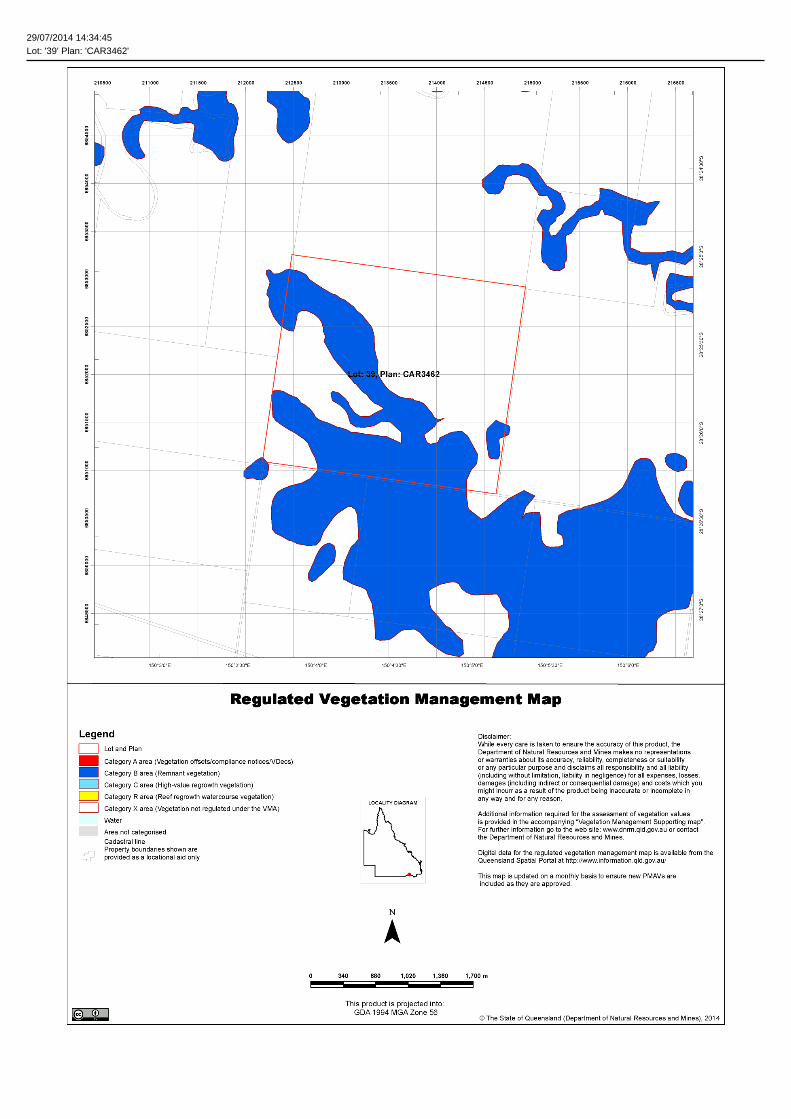
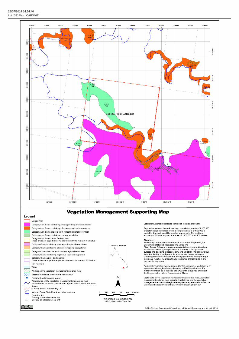
29/07/2014 14:34:45Lot: '39' Plan: 'CAR3462'
29/07/2014 14:34:46Lot: '39' Plan: 'CAR3462'

29/07/2014 14:34:48Lot: '39' Plan: 'CAR3462'
Vegetation Management Act 1999 - Extract from the essential habitat database
Essential habitat is required for assessment under the:
• State Development Assessment Provisions - Module 8: Native vegetation clearing which sets out the matters of interest to the state for development assessment under the Sustainable PlanningAct 2009; and
• Self-assessable vegetation clearing codes made under the Vegetation Management Act 1999
Essential habitat for one or more of the following species is found on and within 1.1 km of the identified subject lot/s or on and within 2.2 km of an identified coordinate on the accompanying essential habitatmap.
This report identifies essential habitat in Category A, B and Category C areas.
The numeric labels on the essential habitat map can be cross referenced with the database below to determine which essential habitat factors might exist for a particular species.
Essential habitat is compiled from a combination of species habitat models and buffered species records.
The Department of Natural Resources and Mines website (http://www.dnrm.qld.gov.au) has more information on how the layer is applied under the State Development Assessment Provisions - Module 8:Native vegetation clearing and the Vegetation Management Act 1999.
Regional ecosystem is a mandatory essential habitat factor, unless otherwise stated.
Essential habitat, for protected wildlife, means a category A area, a category B area or category C area shown on the regulated vegetation management map-
1) (a) that has at least 3 essential habitat factors for the protected wildlife that must include any essential habitat factors that are stated as mandatory for the protected wildlife in the essential habitatdatabase; or
2) (b) in which the protected wildlife, at any stage of its life cycle, is located.
Essential habitat identifies endangered or vulnerable native wildlife prescribed under the Nature Conservation Act 1994.
Essential habitat in Category A and B (Remnant vegetation species record) areas:1100m Species Information
(no results)
Essential habitat in Category A and B (Remnant vegetation species record) areas:1100m Regional Ecosystems Information
(no results)
Essential habitat in Category A and B (Remnant vegetation) areas:1100m Species Information
(no results)
Essential habitat in Category A and B (Remnant vegetation) areas:1100m Regional Ecosystems Information
(no results)
Essential habitat in Category C (High value regrowth vegetation) areas:1100m Species Information
(no results)
Essential habitat in Category C (High value regrowth vegetation) areas:1100m Regional Ecosystems Information
(no results)

© Biosis 2014 – Leaders in Ecology and Heritage Consulting 28
Appendix 5: Vegetation Clearing Measures
Vegetation clearance within areas mapped as supporting remnant Of Concern vegetation (i.e. RE 11.3.19) is
prohibited until a permit under the Vegetation Management Act 1999 (VM Act) has been secured and all vegetation
clearance must be undertaken in accordance with the terms and conditions of this permit.
A copy of the permit to clear native vegetation and relevant application details shall be kept on site during clearing
activities. Copies of the application and Permit will be provided to site personnel once received.
Clearance of native wooded vegetation not included within the Referral Agency Response (Vegetation) Plan
attached to the permit to clear under the VM Act is strictly prohibited.
The full extent of the approved clearance zone is to be clearly marked on drawings and in the field using highly
visible flagging tape, fencing or similar, prior to any works taking place. Areas of retained remnant Least Concern
vegetation are to be identified as "No-Go Zones".
The following measures to prevent damage to trees within areas of retained remnant Least Concern vegetation at
the interface of the clearance zone shall be implemented.
1. Identification of Tree Protection Zones (TPZ) and installation of 1.8 m fencing and signage.
2. Where works are required within the TPZ installation of trunk and branch girdles.
3. Tying back branches.
All of the above measures shall be undertaken in accordance with AS 4970-2009_Protection of trees on development
sites#.
Where the above measures are not practicable, a spotter should be nominated and should be present to ensure
that clearance works do not intrude into adjacent areas.
To minimise disturbance to adjoining areas, overstorey vegetation shall be cleared towards the centre of the
approved clearance zone.
Erosion and sedimentation control measures shall be implemented in accordance with site-based stormwater
management plans.
The following activities are prohibited in identified No Go Zones and TPZs:
• storage and mixing of materials;
• vehicle parking;
• liquid disposal;
• machinery repairs and/or refuelling;
• construction property office or sheds;
• combustion of any materials;
• stockpiling of soil, rubble or debris; and
• unauthorised pesticide, herbicide or chemical applications.
Vehicle and equipment movement shall be restricted to established roads, tracks and pathways.
Stockpiling of mulch, weeds or soil outside designated lay-down areas is not permitted.

© Biosis 2014 – Leaders in Ecology and Heritage Consulting 29
Vegetative material and debris must not be pushed into gullies, watercourses, other drainage lines or waterlogged
areas.
A fauna spotter catcher must be engaged prior to clearance to ensure that:
• no Koalas are present within the clearance zone;
• any vegetation occupied by native fauna is not cleared until the fauna moves out of the vegetation; and
• any native fauna situated within areas to be cleared are relocated to a secure area of similar habitat prior to
the commencement of vegetation clearance works.
Clearance of vegetation will be conducted in a manner (i.e. staged) to ensure that any native fauna living near the
clearance zone have time to move out of the areas of disturbance without human intervention.
#The radius of the TPZ is calculated for each tree by multiplying its DBH × 12.
TPZ = DBH × 12
where
DBH = trunk diameter measured at 1.4 m above ground
Radius is measured from the centre of the stem at ground level. A TPZ should not be less than 2 m nor greater than 15 m
(except where crown protection is required)