
PROPERTY RIGHTS, LAND MARKETS, AND LAND USE · PDF filePROPERTY RIGHTS, LAND MARKETS, AND LAND...
33
PROPERTY RIGHTS, LAND MARKETS, AND LAND USE IN BANGKOK: CONSEQUENCES OF SIAM’S 1901 LAND TITLE DEED ACT Dr. Jessica Vechbanyongratana Faculty of Economics, Chulalongkorn University
Transcript of PROPERTY RIGHTS, LAND MARKETS, AND LAND USE · PDF filePROPERTY RIGHTS, LAND MARKETS, AND LAND...

PROPERTY RIGHTS, LAND
MARKETS, AND LAND USE IN
BANGKOK:
CONSEQUENCES OF SIAM’S
1901 LAND TITLE DEED ACT
Dr. Jessica Vechbanyongratana
Faculty of Economics, Chulalongkorn University

Research Questions
Did the change from usufruct rights to full private
property rights in land following Siam’s 1901 Land
Title Deed Act lead to:
1. greater land market activity?
2. diversification of land use in Bangkok?

Related Literature
Besley and Ghatak (2010) – Comprehensive overview of the interplay between property rights and economic development
Impact of land rights formalization on land markets:
Ravallion and van de Walle (2008) Introduction of transferable usufruct rights created a robust
market for rural land in Vietnam
Barnes and Griffith-Charles (2007) Formalization of land rights in St. Lucia did not led to a vital
urban land market because supporting government and cultural institutions were not in place.
This paper considers the impact of introducing one dimension of land rights security on land market activity and land use in an urban land market.

Historical Background
19th Century Property Rights in Land
Land rights were based on rights of usufruct.
Land deeds were issued to cultivators who cleared land and proved to local government officials that they had made the plot productive within 3 years.
After significant depopulation after the fall of Ayutthaya, these land institutions resulted in the settling of land around Bangkok by many smallholders.
Legally, owners had the right to use the land for agriculture, use the deed as collateral for loans, and transfer property as long as land taxes were paid on an annual basis.

Were 19th century land rights secure?
Previous researchers claim that 19th century Siamese land rights were insecure:
“Property rights in land in the mid-nineteenth century do not appear to have been well defined” and were generally ad hoc and lacking systemization prior to reforms (Feeny 1982, 93-94).
Prior to the modernization of the land code in 1901, “the expansion of land use in Siam was complicated by the fact that it was not clear which land belonged to whom” (Larsson 2012, 32).
Traditional chanote tra daeng deeds were “not important for the commoner nor the official” (Chitchang 2013, 137 and139).

Were 19th century land rights secure?
Besley and Ghatak (2010) discuss 4 ways in which
insecure property rights negatively affect economic
efficiency:
1. High expropriation risk low investment incentive
2. Insecure/ill-defined property rights need to
defend property
3. Insecure/ill-defined property rights inability to use
property as collateral (“dead asset”)
4. Insecure/ill-defined property rights reduces ability
to utilize land to is best possible alternative use

Were 19th century land rights secure?
Changkrajang and Vechbanyongratana (2016) note that 19th century land rights were secure in most dimensions.
1. Expropriation risk minimal as evidenced by cultivation of long-term orchard crops in primary documents
2. Insecure/ill-defined property rights unlikely given systematic land recordkeeping and evidence of formal arbitration of disputes
3. Right to use land as collateral is given in law and observed in practice
But…
4. Risk of deed loss due to lack of crop maintenance or change in land use.

Historical Background
1901 Land Title Deed Act
King Chulalongkorn enacted the 1901 Land Title Deed Act
Introduced full private property rights in land
Divorced land use from land rights
Potential reasons behind the enactment of the 1901 Land Title Deed Act
Economic explanation: Increased value of land as a factor of production in rice cultivation following the 1855 Bowring Treaty and other subsequent treaties was accompanied by the need for stronger property rights in land (Feeny 1989)
Political explanation: Introduction of full private property rights and titling based on cadastral survey was a political tool for keeping potential colonizers (British and French in particular) from encroaching further on Siam’s territory (Larsson 2012)

Hypothesis
Before 1901• Usufruct rights in land
• Transferable
• Risk of loss due to
lack of crop
maintenance
land use change
After 1901• Full private property rights
in land
• Transferable
• Reduced risk of deed loss
since ownership is no longer
tied to agricultural use
1901 Land Title Deed Act
Reduced
risk of loss
Diversified potential
productive activities
Increase land market
activity in Bangkok’s
growing commercial areas

Data
Government copies of garden title deeds (tonkuachanote suan)
Served 2 purposes:
Ownership document for areca and fruit orchards
Tax document (taxes assessed per mature fruit tree)
Issued in 1884-89 during a comprehensive orchard tax reassessment ordered by King Chulalongkorn in 1882 (collection resides at the Department of Land Museum)
Records include:
Plot characteristics (location, size, tax assessment, productivity (tax per rai), and border properties)
Owner characteristics (social class, gender, relationship between owners)


Plot register numbers
District and province
Land measurements in
the 4 cardinal
directions (traditional
Thai measurements of
sen, wa, and sawk)
Border properties in
the 4 cardinal directions
Annual tax assessment
Owners
Registration date
Number of contiguous
plots (kanat)
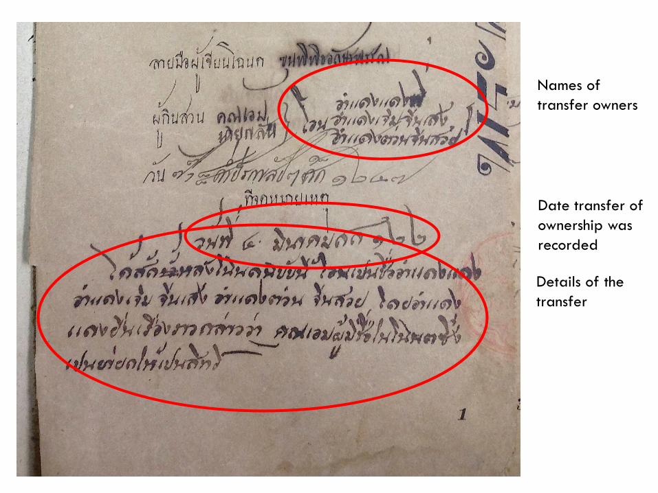
Names of
transfer owners
Date transfer of
ownership was
recorded
Details of the
transfer

Data
This sample:
9,934 orchard land deeds
Excludes 137 government- and temple-owned properties
Located in 20 districts in Bangkok

Orchard Deed Sample Coverage
Bangkok’s current administrative borders
Coverage of 1880s orchard deeds


Map of Bangkok Land Use, 1896
Source: Royal Survey Department

Summary Statistics (N=9,934)
Variable Measurement Mean Std. Dev.
Transfer 0/1 0.13 0.33
District on East Bank of Chao Phraya River 0/1 0.27 0.45
District on West Bank of Chao Phraya River 0/1 0.40 0.49
District in Western Frontier 0/1 0.33 0.47
Tax per Rai Baht 1.59 2.04
Total Rai Rai 4.66 6.60
Borders Transportation Network 0/1 0.50 0.50
Borders Canal 0/1 0.45 0.50
Borders River 0/1 0.02 0.13
Borders Road 0/1 0.06 0.24
Borders Village or Temple 0/1 0.06 0.25
Borders Irrigation Ditch 0/1 0.08 0.27
Ordinary Thai Owner 0/1 0.85 0.36
Chinese/Foreign Owner 0/1 0.06 0.23
Elite Thai Owner 0/1 0.10 0.30
Single Listed Owner 0/1 0.27 0.45

Geographical Distribution of Properties and Transfers
Area
Total Number
of Deeds
% of Properties
Transferred
% Transferred
before 1901
% Transferred
after 1901
East Bank of Chao Phraya River
Bang Rak and Sathorn 319 28.4 3.8 24.8
Phra Nakorn, Dusit, Pom Prap Sattru
Phai, and Samphanthawong
457 8.8 2.8 5.9
Koh Laem 458 20.1 4.4 15.7
Bang Sue 1,483 6.5 1.1 5.4
West Bank of Chao Phraya River
Bang Phlat 262 13.0 2.3 10.7
Klongsan 279 20.8 11.8 9.0
Rat Burana 623 13.3 5.0 8.3
Thonburi 1,027 18.8 6.1 12.7
Bangkok Noi and Bangkok Yai 1,767 15.9 3.6 12.3
West Frontier
Bang Khae 110 8.2 2.7 5.5
Chom Thong 510 9.8 3.3 6.5
Bang Khunthian and Bang Bon 634 8.2 3.3 4.9
Phasi Charoen 764 11.5 5.0 6.5
Talingchan 1,241 8.5 2.7 5.8


Timing of Property Transfers

Methodology
Cox Proportional Hazards Model
Measures the instantaneous hazard rate of a transfer
of plot j at time t
xj is a vector of variables containing the prevailing land
policy (=1 after 1901), plot characteristics, owner
characteristics, and proxies for macroeconomic
conditions
βx is a vector of coefficients estimated from the data.
ℎ 𝑡|𝒙𝒋 = ℎ0 𝑡 𝑒𝑥𝑝 𝒙𝒋𝜷𝒙

Data Construction
9,934 deeds (subjects) and 1,272 transfers (failures)
Each property is observed annually from the registration date until either:
1. the property is transferred (single failure); or
2. the property falls out of observation and is censored in 1908.
Time-varying covariates:
Policy variable
Dummy variable that equals 1 in all periods after the enactment of the 1901 Land Title Deed Act
Macroeconomic variables (annual)
rice exports in 10,000s of tons (Feeny 1982)
terms of trade index (Huff and Caggiano 2008)

Relative Risk of Property Transfer: Cox Proportional Hazard ModelVARIABLES (1) (2)
Policy (period after enactment of 1901 Land Title Deed Act) 2.35*** 2.76***
Macroeconomic Variables
Rice Exports (per 10,000 metric tons) 1.01***
Terms of Trade (1882=100) 1.01**
District-level Variables
District on east bank of Chao Phraya River 0.67*** 0.67***
Policy*District on east bank of Chao Phraya River 2.43*** 2.43***
District on west bank of Chao Phraya River 1.33** 1.33**
Policy*District on west bank of Chao Phraya River 1.43** 1.43**
Plot-level Variables
Tax Per Rai (baht) 1.09*** 1.09***
Policy*Tax per Rai 0.98 0.98
Borders Village or Temple 0.62** 0.62**
Policy*Borders Temple of Village 2.12*** 2.13***
Number of Subjects 9,934 9,934
Number of Failures 1,272 1,272
Observations 207,415 207,415
Coefficients reported as hazard ratios; *** p<0.01, ** p<0.05, * p<0.1
Other controls: total rai, policy*total rai, borders transportation network,
policy*transportation, borders irrigation canal, policy*irrigation, chinese owner, elite

Summary of Results
Properties are associated with a 2.35 times higher relative risk of transfer in the period after the land policy is enacted in 1901.
Relative to western frontier properties:
Land transactions on the urban east side of the Chao Phraya River accelerate significantly after 1901
The risk of land transfers in west bank districts is higher in both periods, but accelerates further after 1901.
Properties adjacent to population centers (temples and villages) are at a higher relative risk of transfer after 1901.

Sensitivity Analysis
While the results suggest that the 1901 Land Title Deed Act vitalized Bangkok’s urban land market, there is concern that there is anticipation of the change in land policy or that the policy variable is capturing some other change in the economy.
Several similar policies were discussed but not enacted between 1888 and 1901 (Larsson 2012, 32).
Cadastral surveys in preparation for issuing new land deeds under the Torrens System commenced in 1896 (Feeny 1982, 95)
Sensitivity analysis performed using 6-year intervals around alternative “policy” dates, 1896, 1901, and 1905

Sensitivity Analysis Using Alternative Policy Years
Policy Year 1896 1901 1905
VARIABLES Year Range 1893-1899 1898-1904 1902-1908
Policy 1.40 2.79*** 0.20***
0.35*** 0.76 1.47**
2.54** 1.63* 3.55***
1.08 1.77*** 1.88***
1.53 0.97 1.28
Tax Per Rai (baht) 0.96 1.10*** 1.08***
Policy*Tax Per Rai (baht) 1.14* 0.95** 1.06
0.98 0.46* 1.71***
0.42 2.65** 0.66
Number of Subjects 9781 9650 9055
Number of Failures 242 749 393
Observations 58,284 56,442 44,059
Coefficients reported as hazard ratios; *** p<0.01, ** p<0.05, * p<0.1
Policy*Borders Village or Temple
Other controls: rice exports, total rai, policy*total rai, borders transportation network,
policy*transportation, borders irrigation canal, policy*irrigation, chinese owner, elite
owner, and single listed owner.
District on east bank of Chao Phraya River
Policy*District on east bank of Chao Phraya River
District on west bank of Chao Phraya River
Policy*District on west bank of Chao Phraya River
Borders Village or Temple

Was there Land Use Change?
I argue that the increase in land market activity, especially on the east side of the River, is due to lifting land use restrictions from land rights, thus opening the door for alternative economic activities in a rapidly urbanizing city.
Is there evidence of land use change from orchards to other economic activities?
From the deeds: at least 25 properties requested a change in land use from orchard to mill through official channels (i.e. tax jurisdiction). All of these were located in Thonburi, Klongsan, and Koh Laem.
Maps of Bangkok land use show rapid change between 1896 and 1909, especially on the east side of the river.

Documented Land Use Change in the Deeds
Example
13 November 1905
Land deeds 1005-1006, dated 8 November 1905, along with land deeds 126-128 are issued to Bukkalo Temple and Mr.___ (Chinese). Mr.___ entered into an agreement to transfer ownership of plots 126-128 to the Ministry of Religious Affairs in exchange for the ownership of plots 123-124.
5 March 1906
We have been informed that a sawmill has been established [on this property] by Mr.___ according to Revenue Department document number 311/1355, written on 28 February 1906.

Map of Bangkok Land Use, 1896
Source: Royal Survey Department

Map of Bangkok Land Use, 1909
Source: Royal Survey Department

Conclusions
The enactment of the 1901 Land Title Deed Act is associated with an acceleration of property transactions in Bangkok.
Although property rights in land were secure in most dimensions before 1901, the divorce of agricultural land use from land rights increased the potential economic uses for land located in rapidly urbanizing areas of Bangkok.
The enactment of the 1901 Land Title Deed Act likely facilitated the redistribution and efficient use of urban land in Bangkok’s center.


