PROJECT Finish building the bikeway expansions #1Master...
8
Page 66 - Corridor-wide Projects Hennepin County • Minnehaha - Hiawatha Strategic Investment Framework PROJECT M o b i l i t y L a n d U s e & P h y s i c a l R e s o u r c e s E n v i r o n m e n t & N a t u r a l R e s o u r c e s E c o n o m i c D e v e l o p m e n t S o c i a l , C u l t u r a l a n d H e r i t a g e Build the expanded bikeways network through the corridor’s neighborhoods which is planned for in the Minneapolis Bikeways Master Plan. This expanded bikeways network would provide north-south and east-west bikeway connections through the corridor’s neighborhoods. Today, bikeways loop around the corridor’s neighborhoods, including the Midtown Greenway, West River Parkway, Minnehaha Parkway, Minnehaha Avenue on-street bike lanes, and the Hiawatha LRT Trail. However, there are virtually no designated bikeways that provide east-west connections through the heart of the corridor area. The Minneapolis Bikeways Master Plan contains the following planned bikeways within the study area or that would connect through the corridor to adjacent neighborhoods: RiverLake Greenway: The RiverLake Greenway project is slated to be constructed in 2010. The project will include a continuous bike corridor connecting I-35W to West River Parkway using a variety of bicycle facility strategies. Within the corridor, the bikeway will include on-street bike lanes from Hiawatha to Minnehaha Avenue. The project is funded in the City’s Capital Improvement Plan (CIP) and will create a strong east-west connection for the city and the neighborhoods. 20th Avenue/Minnehaha Avenue Bikeway: Bike lanes on Minnehaha Avenue currently end (or start) just south of Lake Street leaving a gap between Lake Street and the Midtown Greenway that is needed to connect the Minnehaha-Hiawatha corridor to downtown Minneapolis. This bikeway project will extend bike lanes north along 26th Avenue to the Midtown Greenway and along Minnehaha Avenue from its intersection with 26th Avenue north to 20th Avenue, which connects to Riverside Avenue at the U of M. This bikeway project is funded by the Non-Motorized Transportation (NTP) pilot program funding and completion is anticipated in 2010. 38th Street Bikeway: This project is identified as an “experimental bikeway” in the Minneapolis Bikeways Master Plan. 38th Street is a major “rung” street along the diagonal corridor and connects the 38th Street LRT Station to Minnehaha Avenue. It is also one of the more continuous east-west streets through Minneapolis. As such, this street is a priority for bikeway improvements. The bikeway should be a significant component of the street and be designed in conjunction with street reconstruction. This bikeway is not currently funded in the City’s CIP, however, Municipal State Aid (MSA) funds could be a source of funding for the planned bikeway improvements. 46th Street Bike Lanes: This project includes striping of bicycle lanes from Minnehaha east ultimately crossing the Ford Bridge into St. Paul. When sequenced with other projects (45th Street Bikeway and Minnehaha Reconstruction) this project will help form a stronger bike network connecting the LRT station at 46th Street to St. Paul. The bikeway project is not currently funded in the City’s CIP. County State Aid Highway (CSAH) funding could be applied. Note that a bike lane connection from Minnehaha Avenue west to the LRT station is not envisioned on 46th Street. Given the ROW constraints and high traffic volumes, bikes are could be directed to a potential 45th Street bikeway or south to Minnehaha Parkway where a grade separated crossing exists over Hiawatha Avenue. 32nd Street Bikeway: This bikeway project is slated to be a “bicycle boulevard” in the Minneapolis Bikeways Master Plan and is not currently funded in the City’s CIP. 32nd Street west of Minnehaha Avenue is part of the City’s MSA program which could be a funding source for the planned bikeway improvements. 32nd Street is a minor “rung” street along the diagonal corridor and is a lower priority bikeway improvement. 38th Avenue Bikeway: While largely outside of the project area, this bikeway project would help create a key linkage to the City’s bicycle network and would connect the corridor to city and regional destinations. The project is not currently funded in the City’s CIP but is an MSA street. Sharrows are markings that designate general areas of streets for bicyclists to ride in without a definite lane. Speed bumps and other traffic calming devices are used on bicycle boulevards to discourage motorists from using the street or driving too fast. Bike lanes are marked areas of streets meant exclusively for bicycles. Finish building the bikeway expansions identified in the Minneapolis Bikeways Master Plan #1
Transcript of PROJECT Finish building the bikeway expansions #1Master...
Page 66 - Corridor-wide Projects Hennepin County • Minnehaha - Hiawatha Strategic Investment Framework Hennepin County • Minnehaha - Hiawatha Strategic Investment Framework
P R O J E C T
Mob
ility
Land
Use
& Physical Resources Envi
ronm
ent & Natural Resources
Econ
om
ic Development
Soci
al, C
ultural and Heritage
Hennepin County • Minnehaha - Hiawatha Strategic Investment Framework
Build the expanded bikeways network through the corridor’s neighborhoods which is planned for in the Minneapolis Bikeways Master Plan. This expanded bikeways network would provide north-south and east-west bikeway connections through the corridor’s neighborhoods. Today, bikeways loop around the corridor’s neighborhoods, including the Midtown Greenway, West River Parkway, Minnehaha Parkway, Minnehaha Avenue on-street bike lanes, and the Hiawatha LRT Trail. However, there are virtually no designated bikeways that provide east-west connections through the heart of the corridor area. The Minneapolis Bikeways Master Plan contains the following planned bikeways within the study area or that would connect through the corridor to adjacent neighborhoods:
RiverLake Greenway: The RiverLake Greenway project is slated to be constructed in 2010. The project will include a continuous bike corridor connecting I-35W to West River Parkway using a variety of bicycle facility strategies. Within the corridor, the bikeway will include on-street bike lanes from Hiawatha to Minnehaha Avenue. The project is funded in the City’s Capital Improvement Plan (CIP) and will create a strong east-west connection for the city and the neighborhoods.
20th Avenue/Minnehaha Avenue Bikeway: Bike lanes on Minnehaha Avenue currently end (or start) just south of Lake Street leaving a gap between Lake Street and the Midtown Greenway that is needed to connect the Minnehaha-Hiawatha corridor to downtown Minneapolis. This bikeway project will extend bike lanes north along 26th Avenue to the Midtown Greenway and along Minnehaha Avenue from its intersection with 26th Avenue north to 20th Avenue, which connects to Riverside Avenue at the U of M. This bikeway project is funded by the Non-Motorized Transportation (NTP) pilot program funding and completion is anticipated in 2010.
38th Street Bikeway: This project is identified as an “experimental bikeway” in the Minneapolis Bikeways Master Plan. 38th Street is a major “rung” street along the diagonal corridor and connects the 38th Street LRT Station to Minnehaha Avenue. It is also one of the more continuous east-west streets through Minneapolis. As such, this street is a priority for bikeway improvements. The bikeway should be a significant component of the street and be designed in conjunction with street reconstruction. This bikeway is not currently funded in the City’s CIP, however, Municipal State Aid (MSA) funds could be a source of funding for the planned bikeway improvements.
46th Street Bike Lanes: This project includes striping of bicycle lanes from Minnehaha east ultimately crossing the Ford Bridge into St. Paul. When sequenced with other projects (45th Street Bikeway and Minnehaha Reconstruction) this project will help form a stronger bike network connecting the LRT station at 46th Street to St. Paul. The bikeway project is not currently funded in the City’s CIP. County State Aid Highway (CSAH) funding could be applied. Note that a bike lane connection from Minnehaha Avenue west to the LRT station is not envisioned on 46th Street. Given the ROW constraints and high traffic volumes, bikes are could be directed to a potential 45th Street bikeway or south to Minnehaha Parkway where a grade separated crossing exists over Hiawatha Avenue.
32nd Street Bikeway: This bikeway project is slated to be a “bicycle boulevard” in the Minneapolis Bikeways Master Plan and is not currently funded in the City’s CIP. 32nd Street west of Minnehaha Avenue is part of the City’s MSA program which could be a funding source for the planned bikeway improvements. 32nd Street is a minor “rung” street along the diagonal corridor and is a lower priority bikeway improvement.
38th Avenue Bikeway: While largely outside of the project area, this bikeway project would help create a key linkage to the City’s bicycle network and would connect the corridor to city and regional destinations. The project is not currently funded in the City’s CIP but is an MSA street.
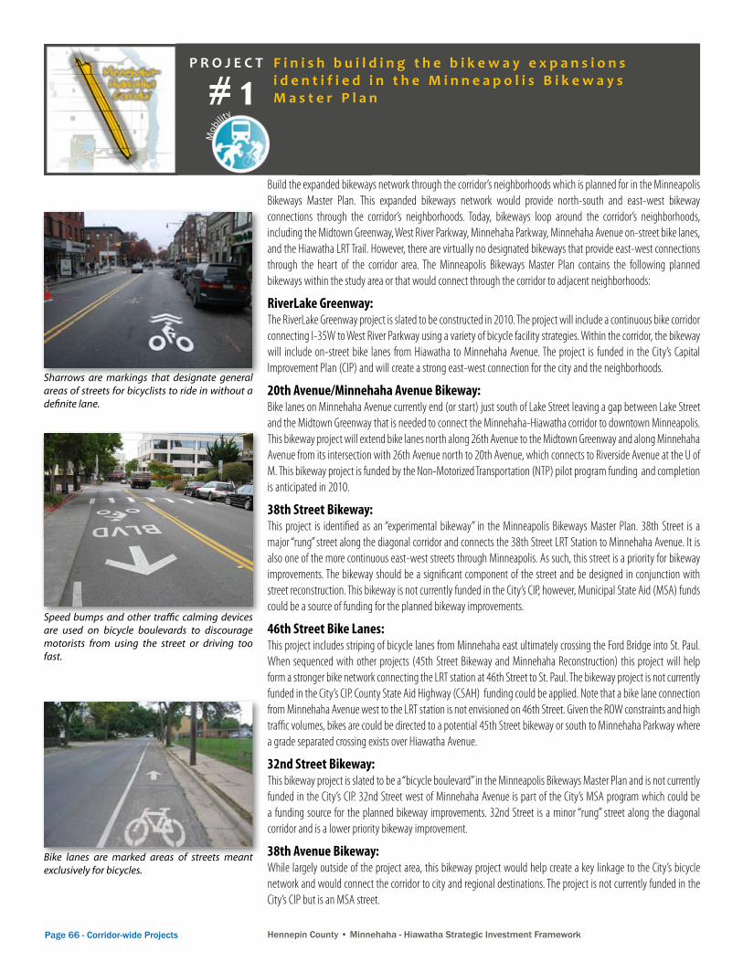
Sharrows are markings that designate general areas of streets for bicyclists to ride in without a definite lane.
Speed bumps and other traffic calming devices are used on bicycle boulevards to discourage motorists from using the street or driving too fast.
Bike lanes are marked areas of streets meant exclusively for bicycles.
Minneapolis Bicycle Facility Manual Chapter 4—On Street Facilities
Page 91
Photo: Example of parking removal on one side along a 44’ MSA two lane roadway (80’ ROW) to allow for a 6’ bike lane, a pair of 12’ traffic lanes and 10’ parking lane (40th St S).
Bikeway Types—Bike Lane
Photo: Example of a 50’ MSA (80’ ROW) two lane roadway (11th Ave S) with bike lanes and parking on both sides. This segment has little traffic congestion so three or four traffic lanes are not needed.
Photo: Example of a 54’ CSA two lane roadway (100’ ROW) with two 13’ lanes, a pair of 6’ bike lanes and 10’ parking lanes (Minnehaha Ave S). Buses require extra lane widths so that they do not block the bike lane.
Photo: Example of a 40’ MSA two lane roadway (60’ ROW) with two 12’ lanes, a pair of 6’ bike lanes, and 2’ gutter pans (42nd Ave N). Parking was removed on both sides of this road to allow for new bike lanes.
Photo: Example of a 48’ MSA roadway (60’ ROW) with three 12’ lanes and a pair of 6’ bike lanes (Plymouth Ave N). Previously this roadway segment was a four lane roadway with excess capacity.
Bike Lane—Bike lanes are most commonly installed on collector and minor arterial streets with traffic volumes between 2,000 and 20,000 vehicles per day. In most situations, bike lanes are not appropriate for local streets. Since most collector and minor arterial streets are CSA or MSA roadways, trade-offs must be made between parking, bike lanes, and traffic capacity needs to meet standard street widths. Below are examples of different roadway cross sections along corridors with bike lanes.
Minneapolis Bicycle Facility Manual Chapter 9—Innovation
Page 208
On-Street Treatments— Bicycle Boulevard
Option: Traffic Calming Devices such as speed humps or diverters can deter motorists from using a route.
Option: Intersections can be modified to allow bicycles passage while prohibiting vehicles from entering.
Standard: Addition of identification signage compliments the pavement marking message.
Standard: Addition of pavement markings clearly tells both cyclists and motorists that bicyclists are prominent.
Option: Reversing stop signs at key intersections to allow for free-flow biking.
Standard: Replace street signs along bike routes to include bicycle symbols.
F i n i s h b u i l d i n g t h e b i k e w a y e x p a n s i o n s i d e n t i f i e d i n t h e M i n n e a p o l i s B i k e w a y s M a s t e r P l a n# 1
Hennepin County • Minnehaha - Hiawatha Strategic Investment Framework Corridor-wide Projects - Page 67Hennepin County • Minnehaha - Hiawatha Strategic Investment Framework
Coordinated Projects: Reconstruct 38th Street as a Complete Street and neighborhood gateway - #39
Reconstruct 46th Street as a Complete Street, Green Street and neighborhood gateway - #44
Add walk/bike crossings of Hiawatha Ave and bikeway connections - #43
Timing: Long term
Costs: $$ - $$$
Coordination/Roles of Organizations: City of Minneapolis Public Works—Lead Agency, funding
City of Minneapolis CPED—support, planning
Hennepin County Transportation Dept—support, planning and design, funding
Hennepin County Housing, Community Works & Transit Dept—support, coordination
Minneapolis Park & Recreation Board—support, planning and design, funding
Transit for Livable Communities (TLC) —support, funding
Potential Funding Sources: Non-Motorized Transportation Pilot Program (NTP)—Federal Highway Administration (FHA) – and Bike Walk Twin Cities Initiative (TLC)
National Scenic Byways Program - FHA (Minneapolis Grand Rounds Scenic Byway)
City of Minneapolis Public Works (CIP)
Hennepin County
Minneapolis Park & Recreation Board
Metropolitan Council
Key Metric(s) (Top 5): A30, A38, A39, A46, A47
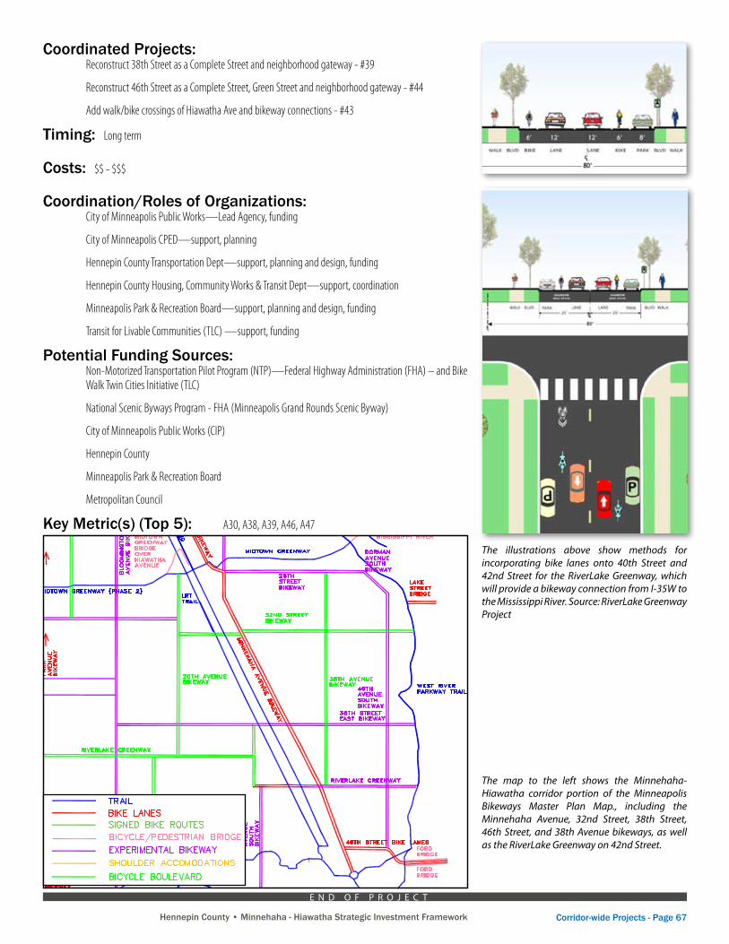
The map to the left shows the Minnehaha-Hiawatha corridor portion of the Minneapolis Bikeways Master Plan Map., including the Minnehaha Avenue, 32nd Street, 38th Street, 46th Street, and 38th Avenue bikeways, as well as the RiverLake Greenway on 42nd Street.
The illustrations above show methods for incorporating bike lanes onto 40th Street and 42nd Street for the RiverLake Greenway, which will provide a bikeway connection from I-35W to the Mississippi River. Source: RiverLake Greenway Project
Bike Lanes with Parking – 42nd St West of Hiawatha
Bike Lanes with Parking – 42nd St East of Hiawatha
E N D O F P R O J E C T
Page 68 - Corridor-wide Projects Hennepin County • Minnehaha - Hiawatha Strategic Investment Framework Hennepin County • Minnehaha - Hiawatha Strategic Investment Framework
P R O J E C T
Mob
ility
Land
Use
& Physical Resources Envi
ronm
ent & Natural Resources
Econ
om
ic Development
Soci
al, C
ultural and Heritage
Hennepin County • Minnehaha - Hiawatha Strategic Investment Framework
A key component of making the corridor’s neighborhoods more bike-friendly is to increase the provision of biking amenities at key activity areas, including commercial nodes, transit stops (LRT and bus), parks, schools, and other public buildings. Biking amenities include bike parking (racks, lockers, covered bike racks), train/bus bike racks, bike-friendly lighting, bike route signage, shower facilities, bike sharing kiosks, and bike repair services.
The three LRT stations have both bike racks and lockers. Bike racks are also located at various places along Minnehaha Avenue and 38th Street. The City of Minneapolis has a Neighborhood Bike Rack 50/50 Cost Share Program to help fund the installation of bike racks at eligible locations. Schools, libraries, parks and other public facilities can request bike racks at no cost. All Metro Transit buses and LRT trains have bike racks available for transporting bikes.
The City of Minneapolis and neighborhood organizations should identify desired bike parking locations, the installation of additional bike racks and lockers, and adequate lighting for bikeways and bike parking locations. In addition, opportunities should be explored for developing bike signage, repair, and shower facilities, such as the Freewheel Midtown Bike Center and the Phillips Eco-Enterprise Center (The Green Institute).
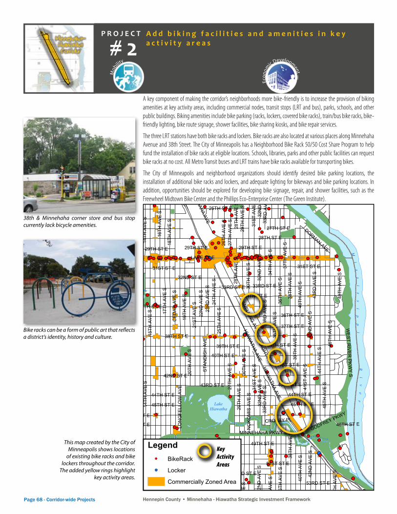
38th & Minnehaha corner store and bus stop currently lack bicycle amenities.
Bike racks can be a form of public art that reflects a district’s identity, history and culture.
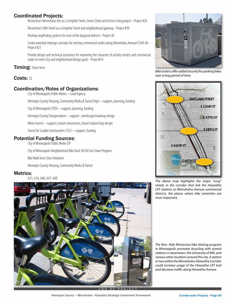
This map created by the City of Minneapolis shows locations
of existing bike racks and bike lockers throughout the corridor.
The added yellow rings highlight key activity areas.
Mi
ss
is
si
pp
iR
iv
er
Lake Calhoun
Lake Harriet
CedarLake
Lake Nokomis
LakeoftheIsles
Mother Lake
LakeHiawatha
DiamondLake
WirthLake
GrassLake
TaftLake
Jo Pond
RyanLake
BrownieLake
LoringPond
PowderhornLake
BirchPond
SpringLake
M i n n e h a h a C r e e k
Ba
s s e t tC
r e ek
Sh
in
gl
e
Cr
e
ek
Mi
ss
is
si
pp
iR
iv
er
M i n ne h
a h a C r e e k
B a s s e t t C r e e k
M i n n e ha h a
C r e e k M i n n e h a h a C r e e k
WebberPond
LakeMead
Mi
ss
i s s i p p i
R i v e r
INTE
RST
ATE
35W
INTE
RST
ATE
94
PAR
K A
VE
CH
ICAG
O A
VE
POR
TLA
ND
AV
E
38TH ST E
LAKE ST E
42ND ST E
35TH ST E5TH
AV
E S
PEN
N A
VE N
CED
AR
AVE
S
HIAWATHA AVE
26TH ST E
2ND
ST
N
15TH
AV
E S
16TH
AV
E S
LYN
DAL
E A
VE N
28TH
AV
E S
HIGHWAY 62
NIC
OLL
ET
AVE 17
TH A
VE
S
1ST
AVE
S
4TH
AV
E S
BRYA
NT
AVE
SAL
DR
ICH
AVE
S
32ND ST E
43RD ST E
OA
KLAN
D A
VE
50TH ST W
DU
PON
T AV
E S
THO
MAS
AVE
N
LAKE ST W
46TH
AV
E S
XER
XES
AVE
S
42N
DA
VE S
41S
T A
VE S
BLO
OM
ING
TON
AV
E
31ST ST E
GR
AND
AVE
S
40TH
AV
E S
54TH ST E
44TH
AV
E S
2ND
ST
NE
58TH ST E
RIVERRD E
SHER
IDAN
AVE
N
56TH ST W
BROADWAY ST NEFR
EM
ON
T AV
E N
45TH
AV
E S
34TH
AV
E S
CEN
TRAL
AVE
NE
28TH ST E
FRA
NC
E A
VE S
FILL
MO
RE
ST N
E
INTERSTATE 394
STE
VEN
S A
VE
EMER
SO
N A
VE N
26TH AVE N
39TH
AV
E S
56TH ST E
36TH
AV
E S
WAS
HIN
GTO
N A
VEN
54TH ST W
MARSHALL ST NE
38TH
AV
E S
SNELLING AVE
49TH AVE N
LOWRY AVE N
35TH AVE N
36TH AVE N
34TH AVE N
31S
T A
VE S
LOWRY AVE NE
43R
DA
VE S
394 HOV LN
GLENWOOD AVE
PEN
N A
VE S
GIR
ARD
AVE
N
52ND ST E
60TH ST E
UNIVERSITY AVE SE
34TH ST E
30TH
AV
E S
8TH ST S
LIN
CO
LNS
T N
E
XER
XES
AVE
N
WEST RIVER PKWY
7TH ST S
HENNEPIN A
VE
DU
PON
T AV
E N
PLYMOUTH AVE N
ZEN
ITH
AVE
S
RU
SSEL
L AV
E N
51ST ST E
26TH AVE NE
8TH ST SE
29TH
AV
E S
36TH ST W
26TH ST W
LON
GFE
LLO
W A
VE
MC
KIN
LEY
ST
NE
20TH
AV
E S
35TH
AV
E S
53RD AVE N
GR
AND
ST
NE
24TH ST E
25TH ST W
11TH
AV
E S
36TH ST E
4TH ST S
DIGHT AVE
HENNEPIN AVE E
5TH ST S
48TH ST E
35TH ST W
CO
LUM
BU
S A
VE
25TH ST E
UN
IVE
RSI
TY A
VE
NE
27TH ST W
5TH ST N
22ND AVE NE
HAR
RIE
T A
VE
DOWLING AVE N
3RD
AVE
S
CLE
VELA
ND
ST
NE
3RD
ST
NE
5TH ST SE
MO
NR
OE
ST
NE
CO
LFAX
AV
E S
ABB
OTT
AV
E S
14TH
AV
E S
10TH
AV
E S
24TH ST W
53RD ST W
52ND AVE N
NO
KOM
IS A
VE
S
FRANKLIN AVE E
IRVI
NG
AV
E N
18TH AVE NE
COMO AVE SE
49TH ST E
33R
DA
VE S
CO
LFAX
AV
E N
OLSON MEMORIAL HWY
26TH
AV
E S
PLEA
SAN
T AV
E
14TH AVE N
3RD ST S
QU
EEN
AVE
N
49TH ST W
BRYA
NT
AVE
N
WES
T RIV
ER PK
WY S
40TH ST E
2ND
AVE
S
9TH ST S
40TH ST W
57TH ST W
58TH ST W
HIG
HW
AY 6
5
POLK
ST
NE
51ST AVE N
10TH ST S
FRANKLIN AVE W
39TH ST E
ALD
RIC
H A
VE N
42ND ST W
EMER
SO
N A
VE S
41ST ST E
GA
RFI
ELD
AV
E6T
H S
T N
ULY
SSES
ST
NE
7TH ST N
23R
DA
VE S
53RD ST E
44TH ST W
12TH
AV
E S
13TH AVE NE
VIC
TOR
Y M
EMO
RIA
L D
R
16TH AVE N
44TH ST E
29TH AVE NE
BEA
RD
AV
E S
MAIN ST NE
8TH AVE NE
33RD AVE NE
45TH ST E
6TH
ST
NE
41ST ST W
CLI
NTO
N A
VE
HAY
ES
ST
NE
61ST ST W
LASA
LLE
AVE
2ND ST SE
MINNEHAHA PKWY E
27TH
AV
E S
22ND ST E
29TH AVE N
SAINT ANTHONY PKWY
OSSEO RD
38TH ST W
37TH
AV
E S
1ST ST N
3RD A
VE N
55TH ST E
FRE
MO
NT
AVE
S
18TH ST E
MAIN ST SE
28TH AVE NE
42ND AVE N
DOUGLAS AVE
46TH ST W
MINNEHAHA AVE
CAM
DEN
AVE
N
23RD AVE N
RIVERSIDE AVE
PIER
CE
ST N
E
OA
K S
T SE
CAL
HO
UN
PKW
Y E
WASHINGTON AVE S
1ST A
VE N
STIN
SON
PK
WY
HIGHW
AY 12
1
GOLDEN VALLEY RD
NICO
LLET
MAL
L
HU
MBO
LDT
AVE
N
39TH ST W
6TH ST SE
19TH
AV
E S
43RD ST W
17TH ST E
31ST AVE NE
NO
KOM
IS P
KWY
E
2ND AVE N
12TH ST S
19TH AVE NE
IND
UST
RIA
L B
LVD
37TH AVE N
HIG
HW
AY 7
7
STIN
SON
BLV
D N
E
24TH AVE NE
1ST AVE NE
BEN
JAM
IN S
T N
E
OAK PARK AVE N
ELM ST SE
48TH AVE N
5TH
ST
NE
3RD AVE NE
NEW
BRI
GHTON
BLVD
KASOTA AVE
59TH ST E
15TH ST E
45TH ST W
21ST ST W
BUC
HA
NAN
ST
NE
SEABURY AVE
25TH
AV
E S
HO
LME
S AV
E S
6TH ST S
32N
DA
VE S
60TH ST W
27TH
AVE
SE
QU
EEN
AVE
S
7TH ST SE4TH ST N
24TH
AV
E S
1ST ST S
11TH AVE N
34TH AVE NE
EXCELSIO
R BLV
D
TAFT
ST
NE
HO
OVE
R S
T N
E
47TH ST W
PILL
SBU
RY
AVE
FRANKLIN AVE SE
27TH AVE NE
EMER
ALD
ST
PAR
K R
D
21S
T A
VE S
E
18TH
AV
E SE
10TH AVE N
BLAI
SDEL
L AV
E
23RD AVE NE
E RIVER TER
DORMAN AVE
32ND ST W
29TH AVE SE
ELLI
OT
AVE
18 1/2 AVE NE
55TH ST W
TAY
LOR
ST
NE
46TH AVE N
15TH AVE N
37TH AVE NE
36TH AVE NE
25TH AVE N
HURON BLVD SE
GO
DW
ARD
ST
NE
GODFREY PKWY
45TH AVE N
4TH
ST
NE
HIGHW
AY 55
WEN
TWO
RTH
AV
E
RU
SSEL
L AV
E S
2 1/
2 ST
NE
SUNSET BLVD
LYN
DAL
E A
VE W
DR
EW A
VES
ISLAND AVE E
THE MALL
24TH AVE N
ORLINAVE SE
9TH ST SE
17TH AVE SE
20TH AVE NE
JAM
ES A
VEN
59TH ST W
48TH ST W
MILITARY HWY
UPT
ON
AVE
S
SUNRISE D
R
LAKE
PL
CH
UR
CH
ST
SE
46TH ST E
LINDEN A
VE W
8TH AVE N
RAMSEY ST NE 5TH AVE NE
W L
YND
ALE
AV
E N
VIN
CE
NT
AVE
S
7TH AVE NE
WALNUT ST
3RD
ST
N
52ND ST W
13TH
AV
E SE
21S
T A
VE S
HAM
PSH
IRE
DR
27TH ST E
FULTON ST SE
DEAN
PKWY
16TH
ST
N
4TH AVE N
37TH ST E
WIL
LOW
ST
47TH
AV
E S
22ND AVE N
4TH ST SE
22N
DA
VE S
LYN
DAL
E A
VE S
5TH AVE N
57TH ST E
51ST ST W
50TH AVE N
SPRING ST NE
35TH AVE NE
17TH AVE N
33RD ST E
OLI
VER
AV
E N
24TH
AV
E SE
MO
RG
AN
AV
E S
4TH AVE NE WINTER ST NE
30TH AVE N
14TH AVE NE
ARTH
UR
ST
NE
15TH
AVE
SE
CEDAR VIEW DR
2ND ST S
GIR
ARD
AVE
S
33R
DA
VE S
E
NEW
TON
AV
E S
33RD AVE N
19TH ST E
50TH ST E
22ND ST W
MO
RG
AN
AV
E N
DIAMOND LAKE RD W
IRVI
NG
AV
E S
WAS
HBU
RN
AVE
N
LOG
AN
AV
E S
JAM
ES A
VES
STA
ND
ISH
AVE
PARK
LN
43RD AVE N
CROSBY PL
LAUREL AVE W
13TH
AV
E S
18TH
AV
E S
34TH ST W
12TH AVE N
PARK DR
SHER
IDAN
AVE
S
62ND ST W
29TH ST E
61ST ST E
44TH AVE N
29TH ST W
EUCLID P
L
BANK ST
VIN
CE
NT
AVE
N
48TH
AV
E S
WEST BROADW
AY
UPT
ON
AVE
N
EWIN
G A
VE
S
HU
MBO
LDT
AVE
S
KNO
X A
VEN
THO
MAS
AVE
S
18TH AVE N
31ST ST W
47TH ST E
28TH ST W
LOG
AN
AV
E N
MC
KIN
LEY
PL
13TH ST S
SUMMER ST NE
62ND ST E
21ST AVE N
27TH AVE N
SUMMIT AVELINCOLN AVE
POLK
ST
NE
12TH
AVE
S
45TH ST W
2ND
AVE
S
10TH
AVE
S
3RD
AVE
S
GIR
ARD
AVE
N
DR
EW A
VES
HIGHWAY 62
46TH
AV
E S
QU
EEN
AVE
S
58TH ST E
GR
AND
AVE
S
6TH
ST
N
46TH ST W
MA
IN S
T N
E
49TH ST E
53RD AVE N
17TH AVE N
STE
VEN
S A
VE
29TH
AV
E S
IRVI
NG
AV
E N
56TH ST E
33R
DA
VE S
37TH ST E
18TH
AV
E S
33R
DA
VE S
13TH
AV
E S
36TH
AV
E S
3RD
ST
N
27TH
AV
E S
61ST ST W
BRYA
NT
AVE
S
14TH
AV
E S
40TH ST E
58TH ST W
19TH AVE NE
11TH
AV
E S
LOG
AN
AV
E N
GR
AND
AVE
S
14TH AVE N
14TH
AV
E S
24TH ST E
33RD ST E
27TH ST E28
TH A
VE
S27TH ST E
36TH
AV
E S
5TH ST SE
29TH
AV
E S
28TH ST E
38TH
AV
E S
2ND
AVE
S
4TH ST N
16TH AVE N
5TH
AV
E S
14TH
AV
E S
44TH AVE N
BLAI
SDEL
L AV
E
ARTH
UR
ST
NE
30TH
AV
E S
VIN
CE
NT
AVE
N
17TH ST E
PAR
K A
VE
24TH AVE NEU
PTO
N A
VE N
34TH
AV
E S
UPT
ON
AVE
S
54TH ST W
1ST S
T N
FRA
NC
E A
VE S
57TH ST E
PILL
SBU
RY
AVE NIC
OLL
ET
AVE
29TH ST E
4TH ST SE
29TH ST E
54TH ST E
INTE
RST
ATE
94
HIAWATHA AVE
14TH AVE NE
27TH AVE NE
51ST ST W
41ST ST E42ND ST W
28TH
AV
E S
25TH AVE N
40TH
AV
E S
GIR
ARD
AVE
S
1ST ST S
1ST
AVE
S
4TH
ST
NE
39TH ST E
49TH ST W
32N
DA
VE S
5TH ST SE
42ND ST W
36TH AVE NE
CLI
NTO
N A
VE
BRYA
NT
AVE
N
53RD ST W
51ST ST E
3RD
AVE
S
19TH ST E
CLI
NTO
N A
VE
XER
XES
AVE
N
2ND
AVE
S
15TH AVE N
37TH AVE NE
12TH AVE N
32ND ST W
4TH
ST
N
47TH ST W
53RD ST E
62ND ST W
50TH ST E
VIN
CE
NT
AVE
N
6TH ST S
31ST ST E
43RD ST W
10TH
AV
E S
13TH AVE NE
1ST
AVE
S
52ND AVE N
51ST AVE N
46TH ST E
CLI
NTO
N A
VE
22ND ST E
59TH ST E
44TH
AV
E S
9TH ST S
XER
XES
AVE
N
7TH ST S
52ND ST E
3RD ST N
19TH
AV
E S
45TH ST E
43RD ST E
41ST ST W
8TH AVE N
MA
IN S
T N
E
39TH ST E
44TH ST W
HIG
HW
AY 65
27TH
AV
E S
32N
DA
VE S
33R
DA
VE S
XER
XES
AVE
N
31S
T A
VE S
8TH ST S
30TH
AV
E S
40TH ST W
22ND ST E
DU
PON
T AV
E S
48TH ST W
42N
DA
VE S
PILL
SBU
RY
AVE
29TH ST E
32N
DA
VE S
18TH ST E
25TH ST E
INTE
RST
ATE
35W
IRVI
NG
AV
E N
ELLI
OT
AVE
HIGHWAY 62
6TH ST SE
GA
RFI
ELD
AV
E
11TH
AV
E S
7TH ST SE
31S
T A
VE S
2ND A
VE N
44TH ST E
DR
EW A
VES
55TH ST E55TH ST W
52ND ST W
21S
T A
VE S
24TH ST W
57TH ST E
27TH AVE N
10TH
AV
E S
36TH ST E
12TH
AV
E S
13TH
AV
E S
32N
DA
VE S
5TH AVE N
ELLI
OT
AVE
8TH ST S
14TH
AV
E S
57TH ST W
/ 0 0.5 1 1.5 20.25Miles
Bike Racks and LockersJanuary 2007
LegendBikeRack
Locker
Commercially Zoned Area3,591 Racks
15,111 Bike Rack Spaces
29 Locker Locations249 Locker Spaces
Mi
ss
is
si
pp
iR
iv
er
Lake Calhoun
Lake Harriet
CedarLake
Lake Nokomis
LakeoftheIsles
Mother Lake
LakeHiawatha
DiamondLake
WirthLake
GrassLake
TaftLake
Jo Pond
RyanLake
BrownieLake
LoringPond
PowderhornLake
BirchPond
SpringLake
M i n n e h a h a C r e e k
Ba
s s e t tC
r e ek
Sh
in
gl
e
Cr
ee
k
Mi
ss
is
si
pp
iR
iv
er
M i n ne h
a h a C r e e k
B a s s e t t C r e e k
M i n n e ha h a
C r e e k M i n n e h a h a C r e e k
WebberPond
LakeMead
Mi
ss
i s s i p p i
R i v e r
INTE
RST
ATE
35W
INTE
RST
ATE
94
PAR
K A
VE
CH
ICAG
O A
VE
POR
TLA
ND
AV
E
38TH ST E
LAKE ST E
42ND ST E
35TH ST E5TH
AV
E S
PEN
N A
VE N
CED
AR
AVE
S
HIAWATHA AVE
26TH ST E
2ND
ST
N
15TH
AV
E S
16TH
AV
E S
LYN
DAL
E A
VE N
28TH
AV
E S
HIGHWAY 62
NIC
OLL
ET
AVE 17
TH A
VE
S
1ST
AVE
S
4TH
AV
E S
BRYA
NT
AVE
SAL
DR
ICH
AVE
S
32ND ST E
43RD ST E
OA
KLAN
D A
VE
50TH ST W
DU
PON
T AV
E S
THO
MAS
AVE
N
LAKE ST W
46TH
AV
E S
XER
XES
AVE
S
42N
DA
VE S
41S
T A
VE S
BLO
OM
ING
TON
AV
E
31ST ST E
GR
AND
AVE
S
40TH
AV
E S
54TH ST E
44TH
AV
E S
2ND
ST
NE
58TH ST E
RIVERRD E
SHER
IDAN
AVE
N
56TH ST W
BROADWAY ST NE
FRE
MO
NT
AVE
N
45TH
AV
E S
34TH
AV
E S
CEN
TRAL
AVE
NE
28TH ST E
FRA
NC
E A
VE S
FILL
MO
RE
ST N
E
INTERSTATE 394
STE
VEN
S A
VE
EMER
SO
N A
VE N
26TH AVE N
39TH
AV
E S
56TH ST E
36TH
AV
E S
WAS
HIN
GTO
N A
VEN
54TH ST W
MARSHALL ST NE
38TH
AV
E S
SNELLING AVE
49TH AVE N
LOWRY AVE N
35TH AVE N
36TH AVE N
34TH AVE N
31S
T A
VE S
LOWRY AVE NE
43R
DA
VE S
394 HOV LN
GLENWOOD AVE
PEN
N A
VE S
GIR
ARD
AVE
N
52ND ST E
60TH ST E
UNIVERSITY AVE SE
34TH ST E
30TH
AV
E S
8TH ST S
LIN
CO
LNS
T N
E
XER
XES
AVE
N
WEST RIVER PKWY
7TH ST S
HENNEPIN A
VE
DU
PON
T AV
E N
PLYMOUTH AVE N
ZEN
ITH
AVE
S
RU
SSEL
L AV
E N
51ST ST E
26TH AVE NE
8TH ST SE
29TH
AV
E S
36TH ST W
26TH ST W
LON
GFE
LLO
W A
VE
MC
KIN
LEY
ST
NE
20TH
AV
E S
35TH
AV
E S
53RD AVE N
GR
AND
ST
NE
24TH ST E
25TH ST W
11TH
AV
E S
36TH ST E
4TH ST S
DIGHT AVE
HENNEPIN AVE E
5TH ST S
48TH ST E
35TH ST W
CO
LUM
BU
S A
VE
25TH ST E
UN
IVE
RSI
TY A
VE
NE
27TH ST W
5TH ST N
22ND AVE NE
HAR
RIE
T A
VE
DOWLING AVE N
3RD
AVE
S
CLE
VELA
ND
ST
NE
3RD
ST
NE
5TH ST SE
MO
NR
OE
ST
NE
CO
LFAX
AV
E S
ABB
OTT
AV
E S
14TH
AV
E S
10TH
AV
E S
24TH ST W
53RD ST W
52ND AVE N
NO
KOM
IS A
VE
S
FRANKLIN AVE E
IRVI
NG
AV
E N
18TH AVE NE
COMO AVE SE
49TH ST E
33R
DA
VE S
CO
LFAX
AV
E N
OLSON MEMORIAL HWY
26TH
AV
E S
PLEA
SAN
T AV
E
14TH AVE N
3RD ST S
QU
EEN
AVE
N
49TH ST W
BRYA
NT
AVE
N
WES
T RIV
ER PK
WY S
40TH ST E
2ND
AVE
S
9TH ST S
40TH ST W
57TH ST W
58TH ST W
HIG
HW
AY 6
5
POLK
ST
NE
51ST AVE N
10TH ST S
FRANKLIN AVE W
39TH ST E
ALD
RIC
H A
VE N
42ND ST W
EMER
SO
N A
VE S
41ST ST E
GA
RFI
ELD
AV
E6T
H S
T N
ULY
SSES
ST
NE
7TH ST N
23R
DA
VE S
53RD ST E
44TH ST W
12TH
AV
E S
13TH AVE NE
VIC
TOR
Y M
EMO
RIA
L D
R
16TH AVE N
44TH ST E
29TH AVE NE
BEA
RD
AV
E S
MAIN ST NE
8TH AVE NE
33RD AVE NE
45TH ST E
6TH
ST
NE
41ST ST W
CLI
NTO
N A
VE
HAY
ES
ST
NE
61ST ST W
LASA
LLE
AVE
2ND ST SE
MINNEHAHA PKWY E
27TH
AV
E S
22ND ST E
29TH AVE N
SAINT ANTHONY PKWY
OSSEO RD
38TH ST W
37TH
AV
E S
1ST ST N
3RD A
VE N
55TH ST E
FRE
MO
NT
AVE
S
18TH ST E
MAIN ST SE
28TH AVE NE
42ND AVE N
DOUGLAS AVE
46TH ST W
MINNEHAHA AVE
CAM
DEN
AVE
N
23RD AVE N
RIVERSIDE AVE
PIER
CE
ST N
E
OA
K S
T SE
CAL
HO
UN
PKW
Y E
WASHINGTON AVE S
1ST A
VE N
STIN
SON
PK
WY
HIGHW
AY 12
1
GOLDEN VALLEY RD
NICO
LLET
MAL
L
HU
MBO
LDT
AVE
N
39TH ST W
6TH ST SE
19TH
AV
E S
43RD ST W
17TH ST E
31ST AVE NE
NO
KOM
IS P
KWY
E
2ND AVE N
12TH ST S
19TH AVE NE
IND
UST
RIA
L B
LVD
37TH AVE N
HIG
HW
AY 7
7
STIN
SON
BLV
D N
E
24TH AVE NE
1ST AVE NE
BEN
JAM
IN S
T N
E
OAK PARK AVE N
ELM ST SE
48TH AVE N
5TH
ST
NE
3RD AVE NE
NEW
BRI
GHTON
BLVD
KASOTA AVE
59TH ST E
15TH ST E
45TH ST W
21ST ST W
BUC
HA
NAN
ST
NE
SEABURY AVE
25TH
AV
E S
HO
LME
S AV
E S
6TH ST S
32N
DA
VE S
60TH ST W
27TH
AVE
SE
QU
EEN
AVE
S
7TH ST SE4TH ST N
24TH
AV
E S
1ST ST S
11TH AVE N
34TH AVE NE
EXCELSIO
R BLV
D
TAFT
ST
NE
HO
OVE
R S
T N
E
47TH ST W
PILL
SBU
RY
AVE
FRANKLIN AVE SE
27TH AVE NE
EMER
ALD
ST
PAR
K R
D
21S
T A
VE S
E
18TH
AV
E SE
10TH AVE N
BLAI
SDEL
L AV
E
23RD AVE NE
E RIVER TER
DORMAN AVE
32ND ST W
29TH AVE SE
ELLI
OT
AVE
18 1/2 AVE NE
55TH ST W
TAY
LOR
ST
NE
46TH AVE N
15TH AVE N
37TH AVE NE
36TH AVE NE
25TH AVE N
HURON BLVD SE
GO
DW
ARD
ST
NE
GODFREY PKWY
45TH AVE N
4TH
ST
NE
HIGHW
AY 55
WEN
TWO
RTH
AV
E
RU
SSEL
L AV
E S
2 1/
2 ST
NE
SUNSET BLVD
LYN
DAL
E A
VE W
DR
EW A
VES
ISLAND AVE E
THE MALL
24TH AVE N
ORLINAVE SE
9TH ST SE
17TH AVE SE
20TH AVE NE
JAM
ES A
VEN
59TH ST W
48TH ST W
MILITARY HWY
UPT
ON
AVE
S
SUNRISE D
R
LAKE
PL
CH
UR
CH
ST
SE
46TH ST E
LINDEN A
VE W
8TH AVE N
RAMSEY ST NE 5TH AVE NE
W L
YND
ALE
AV
E N
VIN
CE
NT
AVE
S
7TH AVE NE
WALNUT ST
3RD
ST
N
52ND ST W
13TH
AV
E SE
21S
T A
VE S
HAM
PSH
IRE
DR
27TH ST E
FULTON ST SE
DEAN
PKWY
16TH
ST
N
4TH AVE N
37TH ST E
WIL
LOW
ST
47TH
AV
E S
22ND AVE N
4TH ST SE
22N
DA
VE S
LYN
DAL
E A
VE S
5TH AVE N
57TH ST E
51ST ST W
50TH AVE N
SPRING ST NE
35TH AVE NE
17TH AVE N
33RD ST E
OLI
VER
AV
E N
24TH
AV
E SE
MO
RG
AN
AV
E S
4TH AVE NE WINTER ST NE
30TH AVE N
14TH AVE NE
ARTH
UR
ST
NE
15TH
AVE
SE
CEDAR VIEW DR
2ND ST S
GIR
ARD
AVE
S
33R
DA
VE S
E
NEW
TON
AV
E S
33RD AVE N
19TH ST E
50TH ST E
22ND ST W
MO
RG
AN
AV
E N
DIAMOND LAKE RD W
IRVI
NG
AV
E S
WAS
HBU
RN
AVE
N
LOG
AN
AV
E S
JAM
ES A
VES
STA
ND
ISH
AVE
PARK
LN
43RD AVE N
CROSBY PL
LAUREL AVE W
13TH
AV
E S
18TH
AV
E S
34TH ST W
12TH AVE N
PARK DR
SHER
IDAN
AVE
S
62ND ST W
29TH ST E
61ST ST E
44TH AVE N
29TH ST W
EUCLID P
L
BANK ST
VIN
CE
NT
AVE
N
48TH
AV
E S
WEST BROADW
AY
UPT
ON
AVE
N
EWIN
G A
VE
S
HU
MBO
LDT
AVE
S
KNO
X A
VEN
THO
MAS
AVE
S
18TH AVE N
31ST ST W
47TH ST E
28TH ST W
LOG
AN
AV
E N
MC
KIN
LEY
PL
13TH ST S
SUMMER ST NE
62ND ST E
21ST AVE N
27TH AVE N
SUMMIT AVELINCOLN AVE
POLK
ST
NE
12TH
AVE
S
45TH ST W
2ND
AVE
S
10TH
AVE
S
3RD
AVE
S
GIR
ARD
AVE
N
DR
EW A
VES
HIGHWAY 62
46TH
AV
E S
QU
EEN
AVE
S
58TH ST E
GR
AND
AVE
S
6TH
ST
N
46TH ST W
MA
IN S
T N
E
49TH ST E
53RD AVE N
17TH AVE N
STE
VEN
S A
VE
29TH
AV
E S
IRVI
NG
AV
E N
56TH ST E
33R
DA
VE S
37TH ST E
18TH
AV
E S
33R
DA
VE S
13TH
AV
E S
36TH
AV
E S
3RD
ST
N
27TH
AV
E S
61ST ST W
BRYA
NT
AVE
S
14TH
AV
E S
40TH ST E
58TH ST W
19TH AVE NE
11TH
AV
E S
LOG
AN
AV
E N
GR
AND
AVE
S
14TH AVE N
14TH
AV
E S
24TH ST E
33RD ST E
27TH ST E
28TH
AV
E S
27TH ST E
36TH
AV
E S
5TH ST SE
29TH
AV
E S
28TH ST E
38TH
AV
E S
2ND
AVE
S
4TH ST N
16TH AVE N
5TH
AV
E S
14TH
AV
E S
44TH AVE N
BLAI
SDEL
L AV
E
ARTH
UR
ST
NE
30TH
AV
E S
VIN
CE
NT
AVE
N
17TH ST E
PAR
K A
VE
24TH AVE NE
UPT
ON
AVE
N
34TH
AV
E S
UPT
ON
AVE
S
54TH ST W
1ST S
T N
FRA
NC
E A
VE S
57TH ST E
PILL
SBU
RY
AVE NIC
OLL
ET
AVE
29TH ST E
4TH ST SE
29TH ST E
54TH ST E
INTE
RST
ATE
94
HIAWATHA AVE
14TH AVE NE
27TH AVE NE
51ST ST W
41ST ST E42ND ST W
28TH
AV
E S
25TH AVE N
40TH
AV
E S
GIR
ARD
AVE
S
1ST ST S
1ST
AVE
S
4TH
ST
NE
39TH ST E
49TH ST W
32N
DA
VE S
5TH ST SE
42ND ST W
36TH AVE NE
CLI
NTO
N A
VE
BRYA
NT
AVE
N
53RD ST W
51ST ST E
3RD
AVE
S
19TH ST E
CLI
NTO
N A
VE
XER
XES
AVE
N
2ND
AVE
S
15TH AVE N
37TH AVE NE
12TH AVE N
32ND ST W
4TH
ST
N
47TH ST W
53RD ST E
62ND ST W
50TH ST E
VIN
CE
NT
AVE
N
6TH ST S
31ST ST E
43RD ST W
10TH
AV
E S
13TH AVE NE
1ST
AVE
S
52ND AVE N
51ST AVE N
46TH ST E
CLI
NTO
N A
VE
22ND ST E
59TH ST E
44TH
AV
E S
9TH ST S
XER
XES
AVE
N
7TH ST S
52ND ST E
3RD ST N
19TH
AV
E S
45TH ST E
43RD ST E
41ST ST W
8TH AVE N
MA
IN S
T N
E
39TH ST E
44TH ST W
HIG
HW
AY 65
27TH
AV
E S
32N
DA
VE S
33R
DA
VE S
XER
XES
AVE
N
31S
T A
VE S
8TH ST S
30TH
AV
E S
40TH ST W
22ND ST E
DU
PON
T AV
E S
48TH ST W
42N
DA
VE S
PILL
SBU
RY
AVE
29TH ST E
32N
DA
VE S
18TH ST E
25TH ST E
INTE
RST
ATE
35W
IRVI
NG
AV
E N
ELLI
OT
AVE
HIGHWAY 62
6TH ST SE
GA
RFI
ELD
AV
E
11TH
AV
E S
7TH ST SE
31S
T A
VE S
2ND A
VE N
44TH ST E
DR
EW A
VES
55TH ST E55TH ST W
52ND ST W
21S
T A
VE S
24TH ST W
57TH ST E
27TH AVE N
10TH
AV
E S
36TH ST E
12TH
AV
E S
13TH
AV
E S
32N
DA
VE S
5TH AVE N
ELLI
OT
AVE
8TH ST S
14TH
AV
E S
57TH ST W
/ 0 0.5 1 1.5 20.25Miles
Bike Racks and LockersJanuary 2007
LegendBikeRack
Locker
Commercially Zoned Area3,591 Racks
15,111 Bike Rack Spaces
29 Locker Locations249 Locker Spaces
Key Activity Areas
A d d b i k i n g f a c i l i t i e s a n d a m e n i t i e s i n k e y a c t i v i t y a r e a s# 2
Hennepin County • Minnehaha - Hiawatha Strategic Investment Framework Corridor-wide Projects - Page 69Hennepin County • Minnehaha - Hiawatha Strategic Investment Framework
Bike lockers offer added security for parking bikes over a long period of time.
The above map highlights the major “rung” streets in the corridor that link the Hiawatha LRT stations to Minnehaha Avenue commercial districts, the places where bike amenities are most important.
The Nice Ride Minnesota bike sharing program in Minneapolis promotes bicycling with several stations in downtown, the University of MN, and various other locations around the city. A station or two within the Minnehaha-Hiawatha Corridor could increase usage of the Hiawatha LRT trail and decrease traffic along Hiawatha Avenue.
Coordinated Projects: Reconstruct Minnehaha Ave as a Complete Street, Green Street and Active Living project - Project #26
Reconstruct 38th Street as a Complete Street and neighborhood gateway - Project #39
Develop wayfinding systems for each of the diagonal districts - Project #5
Create potential redesign concepts for existing commercial nodes along Minnehaha Avenue/CSAH 48 - Project #23
Provide design and technical assistance for improving the character of activity centers and commercial nodes to meet City and neighborhood design goals - Project#14
Timing: Short term
Costs: $$
Coordination/Roles of Organizations: City of Minneapolis Public Works—Lead Agency
Hennepin County Housing, Community Works & Transit Dept—support, planning, funding
City of Minneapolis CPED—support, planning, funding
Hennepin County Transportation—support , streetscape/roadway design
Metro Transit—support, transit connections, transit station/stop design
Transit for Livable Communities (TLC)—support, funding
Potential Funding Sources: City of Minneapolis Public Works CIP
City of Minneapolis Neighborhood Bike Rack 50/50 Cost Share Program
Bike Walk Twin Cities Initiatives
Hennepin County Housing, Community Works & Transit
Metrics:A31, A34, A40, A47, A48
Creative Pipe, Inc. - CS 2-C and CS 1-C Perforated Sheet Steel Lockers
CS 2-C and CS 1-C Perforated Sheet Steel Lockers
CS 1-C-T-PP-CUCustom Perforated Sheet Steel Single Capacity, Triangular Lockers, with Custom Bicycle Design and Square Perforations as Manufactured for Los Angeles Metropolitan Transit Authority.
CS 2-C-PPTri-Met Light Rail Max System Shown with Optional Perforated Sheet Steel Side and Door Panels. Note the visibility afforded by the perforated sheet steel.
http://www.creativepipe.com/ccs-2-ss-pp-cu.htm (1 of 9) [2/15/2008 8:04:22 AM]
E N D O F P R O J E C T
Page 70 - Corridor-wide Projects Hennepin County • Minnehaha - Hiawatha Strategic Investment Framework Hennepin County • Minnehaha - Hiawatha Strategic Investment Framework
P R O J E C T
Mob
ility
Land
Use
& Physical Resources Envi
ronm
ent & Natural Resources
Econ
om
ic Development
Soci
al, C
ultural and Heritage
Hennepin County • Minnehaha - Hiawatha Strategic Investment Framework
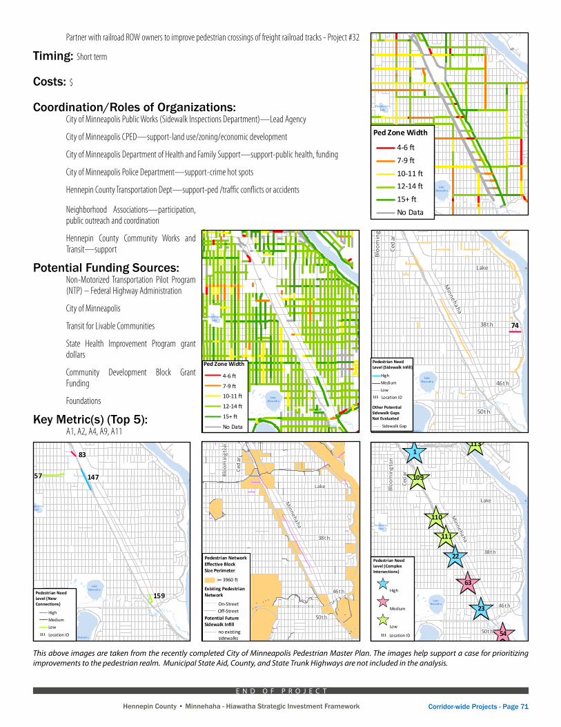
Although the Minnehaha-Hiawatha corridor contains sidewalks on most of its streets, the quality of the pedestrian connections and environment varies significantly from street to street. The Minneapolis Pedestrian Master Plan, which was completed in 2009, provides a city-wide analysis of existing conditions of the pedestrian environment. This city-wide existing conditions analysis of physical infrastructure includes sidewalks gaps (one or both sides), low pedestrian network connectivity, pedestrian zone width, number of traffic lanes to be crossed, traffic signal locations and types, curb extensions, pedestrian-level street lighting, and sidewalks crossing at-grade railroad tracks. This analysis also provides existing usage conditions for all streets city-wide, including primary transit routes, pedestrian volumes, pedestrian generators/destinations, posted vehicle traffic speeds, and pedestrian-related traffic crashes.
Although the city-wide pedestrian environment analysis looks at both local (including Minneapolis Park Board) and non-local streets (MSA, County and State), there are significant gaps in this analysis for the Minnehaha-Hiawatha corridor. Most notably, the existing pedestrian zone width is not shown for Hiawatha Avenue (TH 55) and the numerous cross-streets between Hiawatha Avenue and Snelling Avenue. The data that is available for the cross-streets (between Minnehaha Ave and Snelling Ave) indicates that most of these cross-streets have pedestrian zone widths that are substantially below the City’s desired minimum pedestrian zone width of 12’-15’. In addition, this corridor contains 13 crossings of at-grade freight railroad tracks with a majority of these “sidewalks” having an asphalt surface rather than a concrete surface. Legal barriers limit sidewalk improvements across railroad tracks and it is illegal to assess the railroad company for the costs of improvements to sidewalks on railroad property. These at-grade railroad crossings present safety and accessibility issues for pedestrian movement. Finally, pedestrian connectivity within the corridor is limited significantly by the following:
Street connection gaps on east side of Hiawatha – 31st, 34th, 36th, 39th »
Street connection gaps on west side of Hiawatha – only 6 out of the 17 cross-streets connect to »Hiawatha Avenue on the west side
Dight Avenue does not have a sidewalk »
Since most of the corridor’s streets lie within Hiawatha LRT station areas, which are guided to have a strong pedestrian environment, the City, County, Metro Transit and MnDOT should work together to conduct a more detailed analysis of the conditions/needs of the pedestrian environment than is provided in the city-wide Pedestrian Master Plan. The County’s Active Living Program and Complete Streets Policy, as well as the City’s Design Guidelines for Streets & Sidewalks, could provide additional guidance for this more detailed analysis. Active Living Hennepin Communities “walkability audit” process could be used to help complete the inventory in a cost effective and community participatory way.
The city inspects and repairs sidewalks neighborhood by neighborhood on an approximately 10-year cycle. The city also coordinates sidewalk repairs with other capital improvement projects in order to maximize resources. This could provide a starting basis for the assessment.
The result of this project would be a map and database that identifies needed improvements, the type of improvement needed and a general cost estimate for the improvement. This would enable larger scale projects to incorporate the improvement idea as they occur such as street reconstruction or redevelopment projects.
Coordinated Projects: Reconstruct Minnehaha Ave as a Complete Street, Green Street and Active Living project- Project #26
Reconstruct 38th Street as a Complete Street and neighborhood gateway - Project #39
Reconstruct 46th Street as a Complete Street, Green Street and neighborhood gateway - Project #44
Improve pedestrian crossing safety and experience of Hiawatha Ave’s (MN 55) signalized intersections - Project #28
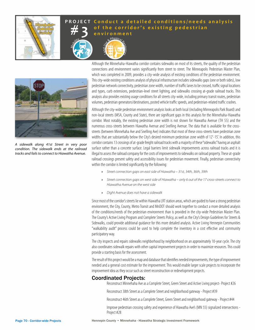
A sidewalk along 41st Street in very poor condition. The sidewalk ends at the railroad tracks and fails to connect to Hiawatha Avenue.
C o n d u c t a d e t a i l e d c o n d i t i o n s / n e e d s a n a l y s i s o f t h e c o r r i d o r ’ s e x i s t i n g p e d e s t r i a n e n v i r o n m e n t# 3
Hennepin County • Minnehaha - Hiawatha Strategic Investment Framework Corridor-wide Projects - Page 71Hennepin County • Minnehaha - Hiawatha Strategic Investment Framework
Partner with railroad ROW owners to improve pedestrian crossings of freight railroad tracks - Project #32
Timing: Short term
Costs: $
Coordination/Roles of Organizations: City of Minneapolis Public Works (Sidewalk Inspections Department)—Lead Agency
City of Minneapolis CPED—support-land use/zoning/economic development
City of Minneapolis Department of Health and Family Support—support-public health, funding
City of Minneapolis Police Department—support-crime hot spots
Hennepin County Transportation Dept—support-ped /traffic conflicts or accidents
City of Minneapolis Pedestrian Master Plan
Appendix A – Existing Conditions and Plans Maps
8%11%
12%
66%
Mi
ss
is
si
pp
iR
iv
er
Lake Calh oun
DiamondLake
Wir thLake
Gra ssLake
Ta ftLa k e
Jo Po nd
Rya nLake
Bro wnieLa ke
Lori ngPon d
Lake Harr iet
Ced arLake
Lake Nokomi s
LakeoftheIs les
Mot herL ake
LakeHiawath a
Mi
ss
is
si
pp
iR
iv
er
M i nn e
ha h a C r e e k
Bassett Creek
M i n ne h
a ha
C r e e k M i n n e h a h a C r e e k
W e b b e r
P o n d
LakeMead
Mi
ss
is
si p
pi
R i v er
PowderhornLake
Bi rchPo nd
Spri ngLake
M i nn e h ah a C r e e k
Ba
s s e t tC
r ee k
S
h
in
gl
e
C
r
e
e
k
Ped Zone Width
4-6 ft
7-9 ft
10-11 ft
12-14 ft
15+ ft
No Data
Map A-21: Pedestrian Zone Width on Local and Park Board Streets
Notes:The pedestrian zone widthshown here is the minimum width from the face of curb to the back of sidewalk on both sides of a block on streets with sidewalks onat least one side on streetswhich are not Municipal StateAid, County, or State TrunkHighway.
Source: Minneapolis StreetWidths Inventory
Ped Zone Width as Share of Total
Local and Park BoardStreet Mileage
DRAFT FINAL PLAN 9/25/09
Page A-22
This above images are taken from the recently completed City of Minneapolis Pedestrian Master Plan. The images help support a case for prioritizing improvements to the pedestrian realm. Municipal State Aid, County, and State Trunk Highways are not included in the analysis.
City of Minneapolis Pedestrian Master Plan
Appendix C – Priority Improvement Projects Evaluation
Mi
ss
is
si
pp
iR
iv
er
Lake Calh oun
Dia m o n dLa ke
Wir thLake
Gra ssLake
Ta ftLa k e
Jo Po nd
Rya nLake
Bro wnieLa ke
Lori ngPon d
Lake Harr iet
Ced arLake
Lake Nokomi s
LakeoftheIs les
Mot herL ake
LakeHiawath a
Mi
ss
is
si
pp
iR
iv
er
Mi n n
e
h a
h a C r e e k
Bassett Creek
M i nne
h a
h aC r e e k M i n n e h a h a C r e e k
W e b b e r
P o n d
LakeMead
Mi
ss
is s
ip
p i
Ri v e r
PowderhornLake
Bi rchPo nd
Spri ngLake
M i nn e h ah a C r e ek
Ba
ss e t t
C re e
k
S
h
in
gl
e
C
re
ek
Lake
Frankl in
38th
46th
Broadway
Lowry
44th
Plymouth
Glenwood
50th
Como
Cent
ral
John
son
Mar
shal
l
Uni
vers
ity
Lynd
ale
Frem
ont
Penn
2nd
Lowry
Lake
Lynd
ale
Nic
olle
t
Chic
ago
Bloo
min
gton
Ced
arHen
nep
in
Henn epin
34th
28th
Penn
Xerx
es
Fran
ce
Brya
nt
Riverside
Exce
lsio r
Stin
son
4th
W Broadway
Olson M emorial
Vict
ory
Mem
oria
l
Minnehaha
Lynd
ale
Nic
olle
t
Chic
ago
Bloo
min
gton
Ced
ar
50th
University
1
65
63
42
54
23
22
25
28
20
21
18
146
111
110
109
112
113
Pedestrian Need Level (ComplexIntersections)
High
Medium
Low
Map C-1: Pedestrian Need Evaluation: Complex Intersections
111 Location ID
DRAFT FINAL PLAN 9/25/09
Page C-6
City of Minneapolis Pedestrian Master Plan
Appendix C – Priority Improvement Projects Evaluation
Mi
ss
is
si
pp
iR
iv
er
Lake Calh oun
Dia m o n dLa ke
Wir thLake
Gra ssLake
Ta ftLa k e
Jo Po nd
Rya nLake
Bro wnieLa ke
Lori ngPon d
Lake Harr iet
Ced arLake
Lake Nokomi s
LakeoftheIs les
Mot herL ake
LakeHiawath a
Mi
ss
is
si
pp
iR
iv
er
Mi n n
e
h a
h a C r e e k
Bassett Creek
M i nne
h a
h aC r e e k M i n n e h a h a C r e e k
W e b b e r
P o n d
LakeMead
Mi
ss
is s
ip
p i
Ri v e r
PowderhornLake
Bi rchPo nd
Spri ngLake
M i nn e h ah a C r e ek
Ba
ss e t t
C re e
k
S
h
in
gl
e
C
re
ek
Lake
Frankl in
38th
46th
Broadway
Lowry
44th
Plymouth
Glenwood
50th
Como
Cent
ral
John
son
Mar
shal
l
Uni
vers
ity
Lynd
ale
Frem
ont
Penn
2nd
Lowry
Lake
Lynd
ale
Nic
olle
t
Chic
ago
Bloo
min
gton
Ced
arHen
nep
in
Henn epin
34th
28th
Penn
Xerx
es
Fran
ce
Brya
nt
Riverside
Exce
lsio r
Stin
son
4th
W Broadway
Olson M emorial
Vict
ory
Mem
oria
lM
innehaha
Lynd
ale
Nic
olle
t
Chic
ago
Bloo
min
gton
Ced
ar
50th
University
1
65
63
42
54
23
22
25
28
20
21
18
146
111
110
109
112
113
Pedestrian Need Level (ComplexIntersections)
High
Medium
Low
Map C-1: Pedestrian Need Evaluation: Complex Intersections
111 Location ID
DRAFT FINAL PLAN 9/25/09
Page C-6
City of Minneapolis Pedestrian Master Plan
Appendix C – Priority Improvement Projects Evaluation
Mi
ss
is
si
pp
iR
iv
er
Lake Calh oun
Dia m o n dLa ke
Wir thLake
Gra ssLake
Ta ftLa k e
Jo Po nd
Rya nLake
Bro wnieLa ke
Lori ngPon d
Lake Harr iet
Ced arLake
Lake Nokomi s
LakeoftheIs les
Mot herL ake
LakeHiawath a
Mi
ss
is
si
pp
iR
iv
er
Mi n n
e
h a
h a C r e e k
Bassett Creek
M i nne
h a
h aC r e e k M i n n e h a h a C r e e k
W e b b e r
P o n d
LakeMead
Mi
ss
is s
ip
p i
Ri v e r
PowderhornLake
Bi rchPo nd
Spri ngLake
M i nn e h ah a C r e ek
Ba
ss e t t
C re e
k
S
h
in
gl
e
C
re
ek44
81
55
36
94
1383132
82 82
52
62
3770
99
74
15
Lake
Frankl in
38th
46th
Broadway
Lowry
44th
Plymouth
Glenwood
50th
Como
Cent
ral
John
son
Mar
shal
l
Uni
vers
ity
Lynd
ale
Frem
ont
Penn
2nd
Lowry
Lake
Lynd
ale
Nic
olle
t
Chic
ago
Bloo
min
gton
Ced
arHen
nep
in
Henn epin
34th
28th
Penn
Xerx
es
Fran
ce
Brya
nt
Riverside
Exce
lsio r
Stin
son
4th
W Broadway
Olson M emorial
Vict
ory
Mem
oria
l
Minnehaha
Lynd
ale
Nic
olle
t
Chic
ago
Bloo
min
gton
Ced
ar
50th
University
111 Location ID
Map C-5: Pedestrian Need Evaluation: Sidewalk Infill
Pedestrian Need Level (Sidewalk Infill)
High
Medium
Low
Other Potential Sidewalk Gaps Not Evaluated
Sidewalk Gap
DRAFT FINAL PLAN 9/25/09
Page C-10
City of Minneapolis Pedestrian Master Plan
Appendix C – Priority Improvement Projects Evaluation
Mi
ss
is
si
pp
iR
iv
er
Lake Calh oun
Dia m o n dLa ke
Wir thLake
Gra ssLake
Ta ftLa k e
Jo Po nd
Rya nLake
Bro wnieLa ke
Lori ngPon d
Lake Harr iet
Ced arLake
Lake Nokomi s
LakeoftheIs les
Mot herL ake
LakeHiawath a
Mi
ss
is
si
pp
iR
iv
er
Mi n n
e
h a
h a C r e e k
Bassett Creek
M i nne
h a
h aC r e e k M i n n e h a h a C r e e k
W e b b e r
P o n d
LakeMead
Mi
ss
is s
ip
p i
Ri v e r
PowderhornLake
Bi rchPo nd
Spri ngLake
M i nn e h ah a C r e ek
Ba
ss e t t
C re e
k
S
h
in
gl
e
C
re
ek44
81
55
36
94
1383132
82 82
52
62
3770
99
74
15
Lake
Frankl in
38th
46th
Broadway
Lowry
44th
Plymouth
Glenwood
50th
Como
Cent
ral
John
son
Mar
shal
l
Uni
vers
ity
Lynd
ale
Frem
ont
Penn
2nd
Lowry
Lake
Lynd
ale
Nic
olle
t
Chic
ago
Bloo
min
gton
Ced
arHen
nep
in
Henn epin
34th
28th
Penn
Xerx
es
Fran
ce
Brya
nt
Riverside
Exce
lsio r
Stin
son
4th
W Broadway
Olson M emorial
Vict
ory
Mem
oria
lM
innehaha
Lynd
ale
Nic
olle
t
Chic
ago
Bloo
min
gton
Ced
ar
50th
University
111 Location ID
Map C-5: Pedestrian Need Evaluation: Sidewalk Infill
Pedestrian Need Level (Sidewalk Infill)
High
Medium
Low
Other Potential Sidewalk Gaps Not Evaluated
Sidewalk Gap
DRAFT FINAL PLAN 9/25/09
Page C-10
City of Minneapolis Pedestrian Master Plan
Appendix C – Priority Improvement Projects Evaluation
Mi
ss
is
si
pp
iR
iv
er
Lake Calh oun
Dia m o n dLa ke
Wir thLake
Gra ssLake
Ta ftLa k e
Jo Po nd
Rya nLake
Bro wnieLa ke
Lori ngPon d
Lake Harr iet
Ced arLake
Lake Nokomi s
LakeoftheIs les
Mot herL ake
LakeHiawath a
Mi
ss
is
si
pp
iR
iv
er
Mi n n
e
h a
h a C r e e k
Bassett Creek
M i nne
h a
h aC r e e k M i n n e h a h a C r e e k
W e b b e r
P o n d
LakeMead
Mi
ss
is s
ip
p i
Ri v e r
PowderhornLake
Bi rchPo nd
Spri ngLake
M i nn e h ah a C r e ek
Ba
ss e t t
C re e
k
S
h
in
gl
e
C
re
ek
155 155
154
152 13
14910
150
8
46
156
132
148
157
159
153
147
83
45
157171170
Pedestrian Need Level (New Connections)
High
Medium
Low
111 Location ID
Map C-6: Pedestrian Need Evaluation: Connectivity Improvements
DRAFT FINAL PLAN 9/25/09
Page C-11
Neighborhood Associations—participation, public outreach and coordination
Hennepin County Community Works and Transit—support
Potential Funding Sources: Non-Motorized Transportation Pilot Program (NTP) – Federal Highway Administration
City of Minneapolis
Transit for Livable Communities
State Health Improvement Program grant dollars
Community Development Block Grant Funding
Foundations
Key Metric(s) (Top 5): A1, A2, A4, A9, A11
E N D O F P R O J E C T
City of Minneapolis Pedestrian Master Plan
Appendix A – Existing Conditions and Plans Maps
Lake
Frankl in
38th
46th
Broadway
Lowry
44th
Plymouth
Glenwood
50th
Como
Cent
ral
John
son
Mar
shal
l
Uni
vers
ity
Lynd
ale
Frem
ont
Penn
2nd
Lowry
Lake
Lynd
ale
Nic
olle
t
Chic
ago
Bloo
min
gton
Ced
arHen
nep
in
Henn epin
34th
28th
Penn
Xerx
es
Fran
ce
Brya
nt
Riverside
Exce
lsio r
Stin
son
4th
W Broadway
Olson M emorial
Vict
ory
Mem
oria
l
Minnehaha
Washington
Lynd
ale
Nic
olle
t
Chic
ago
Bloo
min
gton
Ced
ar
50th
University
Map A-13: Areas of Low Pedestrian Network Connectivity
Notes:The pedestrian networkeffective block sizeis the size of block createdby the existing pedestriannetwork and potentialfuture sidewalk infill. A threshold of 3960 footperimeter is double the size of a standard long cityblock (330 x 660 feet).
Source: Minneapolis Pedestrian Master Plan
Pedestrian NetworkEffective Block Size Perimeter
Existing Pedestrian Network
Potential FutureSidewalk Infill
On-Street
no existing sidewalks
>= 3960 ft
Off-Street
DRAFT FINAL PLAN 9/25/09
Page A-14
City of Minneapolis Pedestrian Master Plan
Appendix A – Existing Conditions and Plans Maps
Mi
ss
is
si
pp
iR
iv
er
Lake Calh oun
DiamondLake
Wir thLake
Gra ssLake
Ta ftLa k e
Jo Po nd
Rya nLake
Bro wnieLa ke
Lori ngPon d
Lake Harr iet
Ced arLake
Lake Nokomi s
LakeoftheIs les
Mot herL ake
LakeHiawath a
Mi
ss
is
si
pp
iR
iv
er
M i nn e
ha h a C r e e k
Bassett Creek
M i n ne h
a ha
C r e e k M i n n e h a h a C r e e k
W e b b e r
P o n d
LakeMead
Mi
ss
is
si p
pi
R i v er
PowderhornLake
Bi rchPo nd
Spri ngLake
M i nn e h ah a C r e e k
Ba
s s e t tC
r ee k
S
h
in
gl
e
C
r
e
e
k
20%26%
24%
6%
16%8%
Ped Zone Width
4-6 ft
7-9 ft
10-11 ft
12-14 ft
15+ ft
No Data
Map A-22: Pedestrian Zone Width on Non-Local Streets
Ped Zone Width as Share of Total Non-Local Street Mileage
(MSA, CSAH, TH)
Notes:The pedestrian zone widthshown here is the minimum width from the face of curb to the back of sidewalk on both sides of a block on streets with sidewalks onat least one side on streets which are Municipal StateAid, County, or State TrunkHighway.
Source: Minneapolis StreetWidths Inventory
DRAFT FINAL PLAN 9/25/09
Page A-23
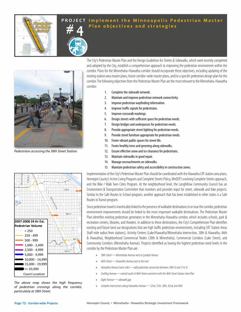
Page 72 - Corridor-wide Projects Hennepin County • Minnehaha - Hiawatha Strategic Investment Framework Hennepin County • Minnehaha - Hiawatha Strategic Investment Framework
P R O J E C T
Mob
ility
Land
Use
& Physical Resources Envi
ronm
ent & Natural Resources
Econ
om
ic Development
Soci
al, C
ultural and Heritage
Hennepin County • Minnehaha - Hiawatha Strategic Investment Framework
The City’s Pedestrian Master Plan and the Design Guidelines for Streets & Sidewalks, which were recently completed and adopted by the City, establish a comprehensive approach to improving the pedestrian environment within the corridor. Plans for the Minnehaha-Hiawatha corridor should incorporate these objectives, including updating of the existing station area master plans, future corridor-wide master plans, and/or a specific pedestrian design plan for the corridor. The following objectives from the Pedestrian Master Plan are the most relevant to the Minnehaha-Hiawatha corridor:
Complete the sidewalk network. 1. Maintain and improve pedestrian network connectivity.2. Improve pedestrian wayfinding information.3. Improve traffic signals for pedestrians.4. Improve crosswalk markings.5. Design streets with sufficient space for pedestrian needs.6. Design bridges and underpasses for pedestrian needs.7. Provide appropriate street lighting for pedestrian needs.8. Provide street furniture appropriate for pedestrian needs.9. Foster vibrant public spaces for street life.10. Foster healthy trees and greening along sidewalks.11. Ensure effective snow and ice clearance for pedestrians.12. Maintain sidewalks in good repair.13. Manage encroachments on sidewalks.14. Maintain pedestrian safety and accessibility in construction zones. 15.
Implementation of the City’s Pedestrian Master Plan should be coordinated with the Hiawatha LRT station area plans, Hennepin County’s Active Living Program and Complete Streets Policy, MnDOT’s evolving Complete Streets approach, and the Bike / Walk Twin Cities Program. At the neighborhood level, the Longfellow Community Council has an Environment & Transportation Committee that monitors and provides input for street, sidewalk and bike projects. Similar to the Safe Routes to School program, another approach that has been established in other states is a Safe Routes to Transit program.
Since pedestrian travel is inextricably linked to the presence of walkable destinations in or near the corridor, pedestrian environment improvements should be linked to the most important walkable destinations. The Pedestrian Master Plan identifies existing pedestrian generators in the Minnehaha-Hiawatha corridor, which includes schools, park & recreation centers, libraries, and theaters. In addition to these destinations, the City’s Comprehensive Plan identifies existing and future land use designations that are high traffic pedestrian environments, including LRT Station Areas (half-mile radius from stations), Activity Centers (Lake/Hiawatha/Minnehaha intersection, 38th & Hiawatha, 46th & Hiawatha), Neighborhood Commercial Nodes (38th & Minnehaha), Commercial Corridors (Lake Street), and Community Corridors (Minnehaha Avenue). Projects identified as having the highest pedestrian need levels in the corridor by the Pedestrian Master Plan are:
38th Street » —Minnehaha Avenue west to Lyndale Avenue
46th Street » —Hiawatha Avenue east to the river
Hiawatha Avenue (west side) » —add pedestrian connection between 28th St and 31st St
Snelling Avenue » —extend south of 46th Street consistent with the 46th Street Station Area Plan
Dight Avenue » —sidewalk gap
Complex intersections along Hiawatha Avenue » —32nd, 35th, 38th, 42nd, and 46th
Pedestrians accessing the 38th Street Station.
The above map shows the high frequency of pedestrian crossings along the corridor, particularly at 38th Street.
City of Minneapolis Pedestrian Master Plan
Appendix A – Existing Conditions and Plans Maps
Mi
ss
is
si
pp
iR
iv
er
Lake Calh oun
Dia m o n dLa ke
Wir thLake
Gra ssLake
Ta ftLa k e
Jo Po nd
Rya nLake
Bro wnieLa ke
Lori ngPon d
Lake Harr iet
Ced arLake
Lake Nokomi s
LakeoftheIs les
Mot herL ake
LakeHiawath a
Mi
ss
is
si
pp
iR
iv
er
M i nn e
ha h a C r e e k
Bassett Creek
M i n ne h
a ha
C r e e k M i n n e h a h a C r e e k
W e b b e r
P o n d
LakeMead
Mi
ss
is
si p
pi
R i v er
PowderhornLake
Bi rchPo nd
Spri ngLake
M i nn e h ah a C r e e k
Ba
s s e t tC
r ee k
S
h
in
gl
e
C
r
e
e
k
Lake
Frankl in
38th
46th
Broadway
Lowry
44th
Plymouth
Glenwood
50th
Como
Cent
ral
John
son
Mar
shal
l
Uni
vers
ity
Lynd
ale
Frem
ont
Penn
2nd
Lowry
Lake
Lynd
ale
Nic
olle
t
Chic
ago
Bloo
min
gton
Ced
arHen
nep
in
Henn epin
34th
28th
Penn
Xerx
es
Fran
ce
Brya
nt
Riverside
Exce
lsio r
Stin
son
4th
W Broadway
Olson M emorial
Vict
ory
Mem
oria
l
Minnehaha
Washington
Lynd
ale
Nic
olle
t
Chic
ago
Bloo
min
gton
Ced
ar
50th
University
Map A-5: Pedestrian Counts
Notes:All counts were takenat mid-block locationsin Sept 2007 or Sept 2008 for either 2 hr (4-6pm) or24 hr (6:30am-6:30pm)time periods. 24 hr estimates assumed12 hour = 75% of 24 hrand 2 hour = 28% of 24 hr.
The top pedestrian count locations are:21,700: Washington@Union 17,900: Nicollet @ 7th 9,700: Nicollet @ 12th 7,200: 15th SE @ Univ.7,000: Hennepin @ 7th6,300: 2nd @ 7th6,200: Marquette @ 7th3,800: 15th SE @ 5th3,300: Stone Arch Bridge3,200: 3rd @ 4th3,100: 4th @ 3rd2,900: Hennepin @ Lake
Source: City of Minneapolis PublicWorks; Transit for LivableCommunities
2007-2008 24 Hr Est. Pedestrian Volume
Count Location
Existing Pedestrian Network
On-Street Off-Street
< 250250 - 499500 - 9991,000 - 2,4992,500 - 4,9995,000 - 9,99910,000 - 14,99915,000 - 19,999>= 20,000
DRAFT FINAL PLAN 9/25/09
Page A-6
I m p l e m e n t t h e M i n n e a p o l i s P e d e s t r i a n M a s t e r P l a n o b j e c t i v e s a n d s t r a t e g i e s# 4
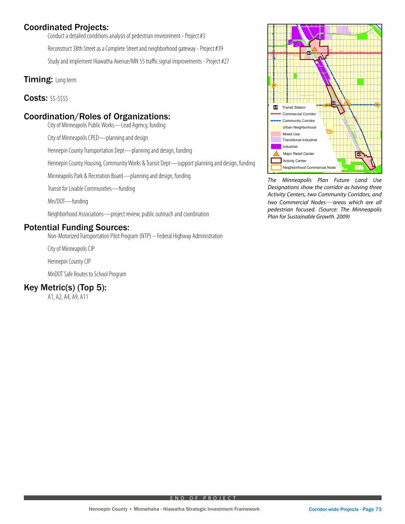
Hennepin County • Minnehaha - Hiawatha Strategic Investment Framework Corridor-wide Projects - Page 73Hennepin County • Minnehaha - Hiawatha Strategic Investment Framework
Coordinated Projects: Conduct a detailed conditions analysis of pedestrian environment - Project #3
Reconstruct 38th Street as a Complete Street and neighborhood gateway - Project #39
Study and implement Hiawatha Avenue/MN 55 traffic signal improvements - Project #27
Timing: Long term
Costs: $$-$$$$
Coordination/Roles of Organizations: City of Minneapolis Public Works—Lead Agency, funding
City of Minneapolis CPED—planning and design
Hennepin County Transportation Dept—planning and design, funding
Hennepin County Housing, Community Works & Transit Dept—support planning and design, funding
Minneapolis Park & Recreation Board—planning and design, funding
Transit for Livable Communities—funding
Mn/DOT—funding
Neighborhood Associations—project review, public outreach and coordination
Potential Funding Sources: Non-Motorized Transportation Pilot Program (NTP) – Federal Highway Administration
City of Minneapolis CIP
Hennepin County CIP
MnDOT Safe Routes to School Program
Key Metric(s) (Top 5): A1, A2, A4, A9, A11
The Minneapolis Plan Future Land Use Designations show the corridor as having three Activity Centers, two Community Corridors, and two Commercial Nodes—areas which are all pedestrian focused. (Source: The Minneapolis Plan for Sustainable Growth. 2009)
E N D O F P R O J E C T
#*
hghg
hg
p¤p¤
p¤
p¤
p¤
p¤
p¤p¤
p¤p¤
p¤
Map 1.2d: Future Land UseSouth Sector
Legend
p¤ Transit Station
hg Growth Center
#* Major Retail Center
Activity Center
Neighborhood Commercial Node
Industrial Employment District
Commercial Corridor
Community Corridor
Urban Neighborhood
Mixed Use
Commercial
Public and Institutional
Transitional Industrial
Industrial
Parks and Open Space
Water
/Source: City of
Minneapolis
Created by:Minneapolis Community Planning and Economic
Development DepartmentPlanning Division
Adopted by City CouncilOctober 2, 2009
0 5,000 10,0002,500Feet 1-43
Urban neighborhoodcontains a range ofresidential densities, with a limited amount of other usesappropriate in a residential setting.
For more details on categories, see narrative in land usechapter.