Program Book - vhub.org · E-mail: [email protected] Corina Risso – Argentina...
42
Program Book of the Fourth International Maar Conference Intra-Conference Field Guide A Multidisciplinary Congress on Monogenetic Volcanism Rangitoto Island & by Ian EM Smith, Jan M Lindsay, Károly Németh, Shane J Cronin Geoscience Society of New Zealand Miscellaneous Publication 131D Auckland, New Zealand 20-24 February 2012 Pulvermaar Tihany Badacsony Laguna Azul Cerro Chivo 3IMC - ARGENTINA 2IMC - HUNGARY - SLOVAKIA -GERMANY 1IMC - GERMANY Eichholzmaar Laguna Potrok Aike Filakovo Dauner Maare
Transcript of Program Book - vhub.org · E-mail: [email protected] Corina Risso – Argentina...

Program Bookof the
Fourth International Maar Conference
Intra-Conference Field Guide
A Multidisciplinary Congresson Monogenetic Volcanism
Rangitoto Island
&
byIan EM Smith, Jan M Lindsay, Károly Németh, Shane J Cronin
Geoscience Society of New Zealand Miscellaneous Publication 131D
Auckland, New Zealand20-24 February 2012
Pulvermaar
Tihany
Badacsony
Laguna Azul
Cerro Chivo
3IMC - ARGENTINA
2IMC - HUNGARY - SLOVAKIA -GERMANY
1IMC - GERMANY
Eichholzmaar
Laguna Potrok Aike
Filakovo
Dauner Maare

Fourth International Maar Conference a multidisciplinary congress on monogenetic volcanism
Auckland, New Zealand
20 – 24 February 2012
PROGRAM BOOK
INTRA-CONFERENCE FIELD GUIDE: RANGITOTO ISLAND
by
Ian EM Smith, Jan M Lindsay, Károly Németh, Shane J Cronin
Geoscience Society of New Zealand Miscellaneous Publication 131D
ISBN 978-1-877480-18-8 ISSN Online 2230-4495 ISSN Print 2230-4487


Program Book of the Fourth International Maar Conference, Auckland, New Zealand, 20 – 24 February 2012 - Geoscience Society of New Zealand Miscellaneous Publication 131D
1
OOrrggaanniizziinngg CCoommmmiitttteeee
Károly Németh, Massey University, Palmerston North
Ian EM Smith, Auckland University, Auckland
Shane J Cronin, Massey University, Palmerston North
Jan M Lindsay, Auckland University, Auckland
Kate Arentsen, Massey University, Palmerston North
Elaine Smid, Auckland University, Auckland
Janet Simes, Absolutely Organised Ltd, Wellington
CChhaaiirrppeerrssoonnss
Károly Németh, Massey University, Palmerston North
Ian EM Smith, Auckland University, Auckland

Program Book of the Fourth International Maar Conference, Auckland, New Zealand, 20 – 24 February 2012 - Geoscience Society of New Zealand Miscellaneous Publication 131D
2
SSCCIIEENNTTIIFFIICC AADDVVIISSOORRYY BBOOAARRDD
Bernd Zolitschka – Germany E-mail: [email protected]
Hetu Sheth – India E-mail: [email protected]
Georg Buechel – Germany E-mail: [email protected]
Guido Giordano – Italy E-mail: [email protected]
Kathy Cashman - USA E-mail: [email protected]
Claus Siebe – Mexico E-mail: [email protected]
Young Kwan Sohn – Korea E-mail: [email protected]
Greg Valentine - USA E-mail: [email protected] Volker Lorenz - Germany
E-mail: [email protected] Corina Risso – Argentina
E-mail: [email protected] Gonca Gençalioğlu Kuşcu – Turkey
E-mail: [email protected] Stephan Kurszlaukis - Canada
E-mail: [email protected] James DL White - New Zealand E-mail: [email protected] Bernd Zimanowski – Germany
E-mail: [email protected] Joan Marti – Spain
E-mail: [email protected] Shane J Cronin - New Zealand E-mail: [email protected]
Jan Lindsay - New Zealand E-mail: [email protected] Ian EM Smith - New Zealand
E-mail: [email protected] Károly Németh - New Zealand E-mail: [email protected]

Program Book of the Fourth International Maar Conference, Auckland, New Zealand, 20 – 24 February 2012 - Geoscience Society of New Zealand Miscellaneous Publication 131D
3
TABLE OF CONTENTS Welcome ..................................................................................................................................... 4
Registration ................................................................................................................................ 4
Disclaimers ................................................................................................................................. 4
Scientific Program ...................................................................................................................... 5
Social Events .............................................................................................................................. 5
Useful Information ..................................................................................................................... 6
Information for Contributors ...................................................................................................... 7
Schedule Quick Guide ................................................................................................................ 8
Map of the 4IMC Venue ............................................................................................................ 9
Map of Auckland City .............................................................................................................. 10
Venue ....................................................................................................................................... 11
Other Important Information .................................................................................................... 12
Detailed Program ...................................................................................................................... 15
DAY 1 .................................................................................................................................... 15
Opening Ceremony & Welcome Address ......................................................................... 15
DAY 2 .................................................................................................................................... 18
DAY 3: Intra-conference field trip to Rangitoto Island ......................................................... 21
DAY 4 .................................................................................................................................... 23
DAY 5 .................................................................................................................................... 24
Other News and Activities ....................................................................................................... 25
Glossary of Common/Geographical Māori Words .................................................................. 26
Intra-Conference Field Guide ................................................................................................... 27

Program Book of the Fourth International Maar Conference, Auckland, New Zealand, 20 – 24 February 2012 - Geoscience Society of New Zealand Miscellaneous Publication 131D
4
WELCOME The Organizing Committee warmly welcomes you to the Fourth International Maar Conference and to Auckland, New Zealand. REGISTRATION Registration will take place in the Neon Foyer at 22 Symonds St. from 3 pm on Sunday, 19 February 2012, followed by an Ice-Breaker function from 5 to 7 pm including light snacks. Delegates are required to wear their name badge at all times as they allow access to all Conference sessions and catering, as follows:
1. attendance to the meeting 2. coffee/tea breaks each morning and afternoon (11am and 4 pm) 3. lunches each day (1 pm) 4. intra-conference field trip including boat transportation, lunch box and drinks, field
guide and field trip leaders 5. one ice-breaker function 6. free wireless internet and computer access at the venue 7. printed conference Abstract Book, Program Book and Intra-conference field guide 8. two poster sessions with cash bar 9. registration fees
Conference Dinner Entry to the conference dinner is by pre-purchased ticket. The cost includes:
1. transportation to and from conference dinner site, Villa Maria Estate, by coach (6 pm) 2. 3 course dinner with wine
DISCLAIMERS The speakers, topics and times are correct at the time of printing. However, the Conference Organizing Committee reserves the right to make changes as needed. The Organizing Committee kindly advises all the participants to have comprehensive health and travel insurance and/or up-to-date information about the necessary administrative procedures in case of the need to accesss health care facilities. The Organizing Committee will not accept any liability for loss of monies, personal injuries or loss or damage of property belonging to the Conference participants and accompanying persons or any other incidents which may occur in relation to the Conference.

Program Book of the Fourth International Maar Conference, Auckland, New Zealand, 20 – 24 February 2012 - Geoscience Society of New Zealand Miscellaneous Publication 131D
5
SCIENTIFIC PROGRAM The Organizing and Scientific Committee selected 5 Scientific Themes that cover a wide range of research fields dealing with monogenetic volcanic fields and maar/diatreme volcanism. The five themes will collect keynote and normal oral presentations following a “source to surface” approach from the morning of 20 February 2012 until lunch time on 24
February 2012. There will not be parallel sessions, in order to allow participants to listen to each of the talks and to promote our goal of wide ranging information sharing. All oral presentations will take place in room 401-439 (see map, pg. 9); this room is located adjacent to the Neon Foyer. Poster sessions will take place in the Neon Foyer. Field Trips The pre-conference field trip to the South Auckland Volcanic Field and around the Auckland Volcanic Field is scheduled for 17 - 19 February. The bus leaves from the Owen G. Glenn Building at 12 Grafton Road at 8:30 am sharp on each day. Lunches and water provided. The intra-conference field trip to Rangitoto is scheduled for Wednesday, 22 February. Please make your own way to the Auckland Ferry Terminal (99 Quay St.; see map, pg. 10) by 8:40 am at the latest. The full group is required to be in attendance a half an hour before the 9:15 am ferry deparature—arriving later than this may forfeit our discount and you may need to pay your own way ($27 return). Please collect your boxed lunch prior to boarding the ferry. The post-conference field trip to the Waipiata Volcanic Field on the South Island is scheduled for 25 - 27 February 2012. The trip leaves early morning on Saturday, 25 February from Air New Zealand’s Domestic Terminal at Auckland Airport and lasts until 27 February 2012 (late afternoon) arriving to the same air terminal to allow participants to catch international flights from New Zealand in the evening. Round Table Discussions On Day 4, Thursday, 23 February, three separate round table discussions will be held with the aim of summarizing the main achievements in each of the scientific themes (see Schedule, pg. 24). Themes will be introduced by a moderator and each participant is invited to contribute to the discussion. If you have any discussion material you wish to share with others (e.g. a presentation), please contact the moderator of your round table to upload your presentation to the media used in these sessions. Contact Information For any questions concerning scientific aspects of the meeting please contact: [email protected]. For any questions regarding your registration please contact [email protected]. SOCIAL EVENTS Ice Breaker Function: 19 February 2012, 5 – 7 pm, Neon Foyer This event takes place after registration (from 3 pm) and will include light finger foods and a limited quantity of free drinks. The event will take place at the Neon Foyer at 22 Symonds St. (see map, pg. 9).

Program Book of the Fourth International Maar Conference, Auckland, New Zealand, 20 – 24 February 2012 - Geoscience Society of New Zealand Miscellaneous Publication 131D
6
Poster Sessions: 20 and 21 February 2012, 4:30 – 6:30 pm, Neon Foyer During two poster sessions, delegates will get the opportunity to discuss the posters over light finger foods and a cash bar ($5 per drink). Food and drinks will be served from 4 - 6 pm. Conference Dinner: 23 February 2012, meet 6 pm at 12 Grafton Rd, 7 pm start This event will include a three course dinner including wine and will take place at the stunning Villa Maria Estate’s Auckland Winery, located in the crater of one of the Auckland Volcanic Field’s volcanoes: Waitomokia tuff ring in Mangere, near the Auckland Airport. Villa Maria is one of New Zealand’s premier wine producers and they have made a feature of their ‘winery in a volcano’. During the evening there may be a chance to tour the vineyard and examine the tuff ring deposits. Meet in the bus bay in front of the Owen G Glenn building, 12 Grafton Rd. (see map, pg. 10. The coach will leave for the conference dinner site at 6 pm. USEFUL INFORMATION Parking Public car parking is available at the Owen G Glenn Building at 12 Grafton Rd. (see map, pg. 10). Casual parking costs are: $4 per hour from 7 am to 5 pm and a $5 flat rate from 5 pm to closing. Hours are 7 am to 11:30 pm on weekdays, 7:30 am to 11:30 pm on Saturdays and midday to 5 pm on Sundays. Other public carparks may be available along Symonds St. and Wellesley St. Computer Access and WiFi The conference venue is equipped with University of Auckland wireless internet. All conference attendees have been assigned a temporary username and password by UoA for usage of wireless internet and access to computer lab machines. Please see the registration desk to obtain your details. A computer lab (403-409), located in the Engineering Department, has been reserved for conference delegates’ use during the conference (see map, pg. 9). It is available Monday, Thursday, and Friday from 8:30 am to 8 pm; on Tuesday it is available from 8.30 am to 10.30 am and 3 – 8 pm. If you wish to use the computer lab on Wednesday in lieu of attending the Rangitoto intra-conference field trip, you may have to share with students. Lecture computers in conference rooms 401-401, 403-401, 403-402, 403-403, and 403-404 can be used by conference delegates to practice talks; please speak to one of the student helpers at registration in the Neon Foyer. Airport Transport The Airbus Express bus runs every 10 minutes from the airport to the city at a cost of $16 one-way, or $26 return, per person. City stops include Langham Hotel, University of Auckland, Upper, Middle and Lower Queens Street and the Downtown Ferry Terminal. http://www.airbus.co.nz/ You may wish to take a shuttle; to arrange, please see http://www.newzealand.com/int/plan/airport-shuttles+auckland/ Taxis are upwards of $60 NZD to and from the city. Auckland Co-op Taxis Phone (09) 300-3000

Program Book of the Fourth International Maar Conference, Auckland, New Zealand, 20 – 24 February 2012 - Geoscience Society of New Zealand Miscellaneous Publication 131D
7
Alert Taxis Phone (09) 309 2000 Smoking Policy Smoking is not permitted anywhere on the campus of The University of Auckland. Emergencies In the case of an emergency, please dial 111. From a University phone, you need to dial‘1‘ to dial outside of the University, or ‘1111.‘ Please note the nearest exit in case of an emergency. Security can be reached at extension 85000 from a University phone. Emergency exits are noted on the venue map (pg. 9). Our emergency gathering location is on the footpath outside of the venue. INFORMATION FOR CONTRIBUTORS ORAL PRESENTATIONS Oral presentations will be 15 minutes long (12 minutes for presentation and 3 for questions). The Organizing Committee of the 4IMC accepts PowerPoint Presentations. The Conference will provide laptop and suitable projectors. We do not accept presentations from personal computers due to security reasons. Each talk must be uploaded a day before the scheduled talk in the lecture theatre, room 1-439, during tea breaks, lunches, or poster sessions—please see the registration desk. If you wish to practice your presentation, practice rooms are available (401-401, 403-401, 403-402, 403-403, and 403-404; see map, pg. 9). Delegates giving talks in the first day should upload their presentation a day before, starting at 4 pm during registration on 19 February. We suggest placing the presentation file(s) on USB flash/pen drives that are easy to connect to the conference PCs. Presenters are responsible for testing their presentations on PCs using MS XP/Vista/Windows 7 operating systems. Macintosh users should prepare their presentation in a way that is compatible with the conference PC system. KEYNOTE PRESENTATIONS Keynote presentations will be 30 minutes long (25 minutes for presentation and 5 for questions and discussions). POSTERS Posters will have a high profile and importance at this conference. Approximately two hours on Day 1 and 2 are devoted only to poster presentations, with no simultaneous oral presentations. Posters are a particularly effective way of displaying data, including maps, tables and experimental results. Posters will be grouped by thematic sessions and clearly identified by a code both in the programme and the display area to facilitate easy location. A special area for posters will be arranged in the Neon Foyer of the Conference Centre (see map, pg. 9). The poster boards provided are Velcro-receptive portrait-oriented panels. Your posters should be no wider than 850 mm and up to 1600mm in height (i.e., A0 size approximately). Velcro sticky dots will be provided. These can be installed from 3 pm onwards on Sunday 19 February and no later than 4:00 pm on Monday, 20 February.

Program Book of the Fourth International Maar Conference, Auckland, New Zealand, 20 – 24 February 2012 - Geoscience Society of New Zealand Miscellaneous Publication 131D
8
SCHEDULE QUICK GUIDE (Detailed schedule pgs. 15 - 24)
Sunday 19 February
Monday 20 February
Tuesday 21 February
Wednesday 22 February
Thursday 23 February
Friday 24 February
9.00 – 9.30 Opening Address 401-439
9.30 – 10.00 Keynote Talk -
Magmatic Systems
Paul Wallace 10.00 – 11.00
Regular Talks
9.30 – 10.00 Keynote Talk –
Eruptive Processes Gerrardo
Carrasco-Núñez 10.00 – 11.00
Regular Talks
8:40 – Meet at Auckland Ferry
Terminal (99 Quay St.) for
Intra-conference Field trip 9.15 Boat
departure for Rangitoto Island
9.30 – 10.00 Keynote Talk -
Environment and Economy
Claus Siebe 10.00 – 11.00
Regular Talks
9.30 – 10.00 Keynote Talk
– Hazard Mark Bishop 10.00 – 11.00
Regular Talks
11.00 – 11.30 Break
11.00 – 11.30 Break 11.00 – 11.30
Break 11.00 – 11.30
Break
11.30 – 13.00 Regular Talks
11.30 – 13.00 Regular Talks
11.30 – 12.00 Keynote Talk -
Environment and Economy
Bernd Zolitschka 12.15 – 13.15
Regular Talks
11.30 – 12.15 Regular Talks
13.00 - 14.00 Lunch
12.45 – 14.00 Lunch 13.00 – 14.00
Lunch 12.15 – 13.15
Lunch
3.00 Registration Starts, Neon
Foyer
14.00 – 14.30 Keynote Talk -
Shallow subsurface
Volker Lorenz 14.30 – 16.00
Regular Talks
14.00 – 14.30 Keynote Talk -
Eruptive processes
Roberto Sulpizio 14.30 – 16.00
Regular Talks
Round Table Magmatic systems - Ian EM Smith
14.00 -14.30 Round Table
Shallow subsurface processes - Karoly Nemeth
14.30 - 15.00 Round Table
Eruptive processes to Environment and
Economy - Shane J Cronin
15.00 - 15.30 Round Table
Hazard - Jan M Lindsay 15.30 - 16.00
13.15 - 14.15 Closing
ceremony – Awards
Election for the host country of
5IMC
15.30 Pre-conference
field trip arrivals
16.00 – 16.30 Break
16.00 – 16.30 Break
15.30 – Departure from Rangitoto
Island 15.45 - Arrival at
Ferry Building
16.00 – 16.30 Break
16.00 Upload of
talks starts for Monday’s presenters
16.30 – 18.30 Poster Session
Neon Foyer
16.30 – 18.30 Poster Session
Neon Foyer
18.00 Meet at Owen G Glenn Building, 12
Grafton Road; Departure to Conference Dinner
19.00 Conference Dinner
17.00 – 19.00 Ice Breaker
Function, Neon Foyer

Program Book of the Fourth International Maar Conference, Auckland, New Zealand, 20 – 24 February 2012 - Geoscience Society of New Zealand Miscellaneous Publication 131D
9
MAP OF THE 4IMC VENUE
The lecture theatre labelled 1.439 (yellow star) will be used throughout the conference for oral presentations, with the poster sessions and icebreaker functions, as well as registration, occurring in the Neon Foyer (marked with a green star).

Program Book of the Fourth International Maar Conference, Auckland, New Zealand, 20 – 24 February 2012 - Geoscience Society of New Zealand Miscellaneous Publication 131D
10
MAP OF AUCKLAND CITY

Program Book of the Fourth International Maar Conference, Auckland, New Zealand, 20 – 24 February 2012 - Geoscience Society of New Zealand Miscellaneous Publication 131D
11
VENUE The Fourth International Maar Conference (4IMC) takes place on The University of Auckland’s City Campus in Auckland, New Zealand’s largest city. When Auckland was the capital city of New Zealand from 1842-1865, Parliament met in Old Government House, now sited on The University of Auckland’s campus. The conference venue is located in the middle of the UoA City Campus at the Conference Centre at 22 Symonds St., Building 401. The University of Auckland was established in 1883 with 4 teaching staff for the 95 enrolled students. It has grown by leaps and bounds and today has over 40,000 students over 5 campuses and serves as one of New Zealand’s top research institutions. Depending on traffic, it takes 30-45 minutes from the Auckland Airport to the conference site by car, shuttle, or the Airbus Express bus. Auckland City sits atop the active monogenetic Auckland Volcanic Field (AVF), and signs of the area’s rich volcanic history are unmistakeable, particularly on the drive from the airport to the city. Vegetated volcanic cones and circular maar features dot the city landscape and provide topographic relief to the region. Many of the volcanic features are preserved as parks, allowing visitors and locals alike to enjoy their natural beauty. Volcanic Mount Eden, the highest natural feature in Auckland’s mainland at 196 m asl, provides a great viewpoint to spot the many other volcanic cones and view the city skyline. The field is approximately 250,000 years old, and contains ~53 volcanoes, 3 of which have only been recognized in the past year. The volcanic cones of Auckland formed natural defense outposts, or pā, for the Māori, the first New Zealanders, who settled here ~1350 AD. They terraced the cones and used the rich volcanic soil for agriculture, growing such food as kumara, a form of sweet potato that is still popular in New Zealand today. Māori were also the first (and only) people to witness an AVF eruption--human and dog footprints were found in the ash from Rangitoto’s ~1400 AD eruption. More information about Rangitoto’s history will be provided during the intra-conference field trip. In 1859, Ferdinand Hochstetter and his colleague Charles Heaphy were the first scientists to thoroughly map the Auckland region. Hochstetter included this map and notes about several now-quarried or destroyed scoria cones in his book on the geology of New Zealand in 1864. Without Hochstetter, information about the shapes, sizes, and possible eruption dynamics seen in the deposits would certainly have been lost as Auckland’s rapid growth has demanded more and more material and land from its volcanoes. For more details about individual volcanoes and the field’s history, the book Volcanoes of Auckland (Hayward, Murdoch, and Maitland, 2011) is strongly recommended. The region around Auckland also displays older volcanic features. To the west, the Waitakere Ranges are all that is left of an andesitic volcano (of Miocene age), while to the east, the Coromandel peninsula contains the remains of the Coromandel Volcanic Zone (of Miocene and Pliocene age). Extinct monogenetic volcanic fields surround Auckland to the north and south. In the Northland, small basaltic features date back to 10 Ma in several monogenetic fields. The South Auckland Volcanic Field contains 80+ volcanoes (1.5 – 0.5 Ma) and lies just to the southwest. Some have postulated that the hot spot that fed the South Auckland Field now feeds the AVF. The introduction of firearms in the early 1800s by Europeans encouraged infighting amongst Māori tribes, or iwi, scattering them away from the Auckland area and European immigrants

Program Book of the Fourth International Maar Conference, Auckland, New Zealand, 20 – 24 February 2012 - Geoscience Society of New Zealand Miscellaneous Publication 131D
12
(Pākehā) chose to settle here in the 1830s due to the region’s natural harbours. Water continues to play an important role in Auckland’s heritage and because of the number of boats that can be seen sailing in its harbours, it is often dubbed the ‘City of Sails’. One in three Auckland households owns a boat; Auckland’s Westhaven Marina is the largest in the Southern Hemisphere. Auckland’s small isthmus, < 2 km across at its narrowest, connects Northland to the main body of the North Island. It is one of the only cities to have harbours on two different major bodies of water; the Pacific Ocean fills the Waitemata Harbour in the east while the Manukau Harbour and Tasman Sea makes up the western boundary. To this day, Auckland remains NZ’s main port for cruise ships and is an importsnt freight terminus. Currently, Auckland is home to ~1.5 million people, or 34% of New Zealand’s population, and contains the largest Polynesian population of any city in the world, as well as representatives from virtually every world demographic. Auckland is also proudly known as the city where New Zealand’s All Blacks rugby team won the Rugby World Cup title in 2011, during which the celebrations generated enough ground movement to cause tremors beneath Auckland, as detected by a seismometer installed 25 m beneath Mt Eden Stadium. OTHER IMPORTANT INFORMATION Healthcare All visitors to, and residents of, New Zealand are entitled to free or low cost treatment under the Accident Compensation Corporation in the case of accidents. Please note that treatment for chronic conditions or non-accidents will require payment. For more information, please see: http://www.acc.co.nz/ The nearest hospital is located approximately 5 minutes driving distance from UoA: Auckland City Hospital 2 Park Rd Auckland 09-367 0000 http://www.adhb.govt.nz While The University of Auckland does have a health centre, they are perennially overbooked and we recommend QuayMed in their stead: QuayMed A & M Clinic 68 Beach Road Auckland 09 919 2555 http://alturl.com/xaghe QuayMed is a ~10 minute walk or 5 minute drive from the conference venue. Mon-Fri 8 am – 7 pm Sat 9 am – 1 pm Emergency dentists (Ponsonby Accident and Emergency Dental Unit) can be contacted at 09 376 9222; http://www.aucklandemergencydentist.co.nz/

Program Book of the Fourth International Maar Conference, Auckland, New Zealand, 20 – 24 February 2012 - Geoscience Society of New Zealand Miscellaneous Publication 131D
13
Tipping Tipping is not customary in New Zealand; however, for outstanding service, 10% is adequate at the more upscale restaurants and hotels. Taxi drivers are not usually tipped but they appreciate rounding the fare up to the nearest dollar. Banking/Currency Exchange New Zealand money consists of dollars in $1 and $2 coins and $5, $10, $20, $50, and $100 notes, with cents in $0.10, $0.20, $0.50 demoninations. Money can be exchanged at banks or at Exchange Bureaus, the closest of which are found on Queen St. There are no restrictions on the amount of foreign currency or traveller‘s checks that can be brought in or taken out of NZ. Credit cards are widely accepted. EFTPOS is more commonly used than credit cards and almost all businesses accept this method of payment. The major banks in Auckland are ANZ, ASB Bank, BNZ, HSBC, Kiwi Bank, National Bank, and Westpac. Trading banks are generally open Monday-Friday from 9 am to 4.30 pm. The New Zealand dollar is worth approximately USD 0.79, GBP 0.51, and Euro 0.62 at the time of this writing. There are two bank branches with ATMs on the City Campus: the National Bank has a branch on the Ground floor, Kate Edger Information Commons, 9 Symonds Street; ASB Bank has a branch on Level 1, Owen G Glenn Building, 12 Grafton Road. Outside of campus, the closest ATMs for other banks are ANZ's at 256--260 Queen Street, HSBC's at 1 Queen Street, and Westpac's at 210 Queen Street. Shopping Hours Shopping hours in New Zealand vary a great deal but are generally 9 am to 5:30 pm, Monday-Saturday. Most stores in larger towns and cities are open on Sundays for slightly limited hours (typically 10 am to 4:30 pm). Stores catering to tourists (such as on Queen St.) are generally open every day, often with extended hours. There are a number of 24-hour convenience stores, service stations and supermarkets in the central city. New Zealand has a goods and services tax (GST) of 15% which is charged on almost all goods and services and is typically included in the displayed price.
Food On the City Campus, food can be bought in the main Student Union cafeteria, in the Postgraduate Lounge on Level 4 of the Kate Edger Information Commons; in cafés and food outlets around the Student Union; and in cafeterias at the School of Engineering Building, the Human Sciences Building, and the Law School (http://alturl.com/7gzyk). The nearest grocery store is Countdown Metro, 19 Victoria St. It is open 7 am to 10 pm. Excellent restaurants and food courts can be found throughout Auckland, particularly in the Central Business District. Here are just a few within ~20 minutes walk from the conference venue, some of which include vegetarian and gluten free options (prices exclude drinks): Food Alley award-winning food
court; 15 options 9 Albert St ~$15
Revive Healthy, vegetarian 33 Lorne St ~$15 Mexicali Fresh Vegetarian options 137 Quay St ~$15 Raw Power Healthy, vegetarian Level 1, 10 Vulcan
Lane. Limited hours ~$15
Burger Fuel Vegetarian options 291 Queen St ~$15 Copthorne - Zoe’s Vegetarian options 150 Anzac Ave ~$30

Program Book of the Fourth International Maar Conference, Auckland, New Zealand, 20 – 24 February 2012 - Geoscience Society of New Zealand Miscellaneous Publication 131D
14
Gina’s Italian Vegetarian, gluten free options
161 Symonds St ~$25
Little Mexico Cantina
31 Wellesley St ~$30
For fine dining (>$30), please explore Auckland’s Viaduct area (Quay and Hobson Streets). Road Rules and Petrol In New Zealand, all vehicles drive on the left side of the road and give way to approaching traffic from the right. Those with international driver’s licenses (in English) may drive in New Zealand. Road signs and rules are more or less easy to understand, with the highest speed limit at 100 km per hour in rural areas and 50 km/h in urban areas. One noteable exception is the left turning rule: when turning left, yield to oncoming traffic turning right. Take care at one-lane bridges, which are common in rural areas. Road conditions are generally good, but driving can be hazardous during severe weather and when passing other cars. Roads outside of the city are generally twisty—it is easy to underestimate the time it will take—and distances between fuel stops can be significant. Petrol averages around $2.10 NZD per liter for 91 octane. Please see the following link for road rules: http://www.nzta.govt.nz/resources/roadcode/road-code-index.html Miscellaneous Telephone New Zealand's telephone numbers comply with the international format of country code, area code, telephone number. Phone numbers for Auckland take the following format: +64 9 123 4567, where +64 denotes the country code, 9 the area code, and 123 4567 the telephone number. Add ‘1’ from a University phone to dial outside of the University locally. And add ‘0’ in front of the ‘9’ if you are calling from a cell phone or from outside of Auckland. Car Rental If you wish to rent a car, the following contact details may be helpful: U Save Phone: (09) 256 9430 Avis Phone: (09) 526-2847 Budget Phone: (09) 529-7788 Europcar Phone: 0800 800 115 Hertz Phone: 0800-654321 Thrifty Phone: 0800-737070 Tourist Information For further information about Auckland, please visit any of the following webpages: http://www.aucklandnz.com/ http://www.aucklandnz.com/things-to-do/auckland-must-dos http://www.viewauckland.co.nz/restaurants/metro-top-50-restaurants-2011-feature-4664.html http://gatherandhunt.co.nz/ http://www.lonelyplanet.com/new-zealand/auckland http://www.rankers.co.nz/regions/auckland http://www.tripadvisor.com/Tourism-g1811027-Auckland_North_Island-Vacations.html http://www.newzealand.com/int/ http://www.mfat.govt.nz/Embassies/2-Foreign-representatives-to-NZ/Diplomatic-and-Consular-List.php

Program Book of the Fourth International Maar Conference, Auckland, New Zealand, 20 – 24 February 2012 - Geoscience Society of New Zealand Miscellaneous Publication 131D
15
DETAILED PROGRAM
DAY 1 20 February 2012
Opening Ceremony & Welcome Address - 9.00 – 9.30
Day 1 Session 1 – 20 February 2012
Presenter Title Lecture time Abstract
Volume Page #
Keynote Paul Wallace
Cinder cone fields associated with warm-slab subduction zones: Magma generation and shallow volcanic processes in the Cascades and Central Mexico as revealed by melt inclusions and experimental phase equilibria
9.30 – 10.00 93
Marco Brenna A genetic model for basaltic volcanic fields, Jeju Island, Korea
10.00 – 10.15 15
Raymond Cas Influences on the location of the basaltic, continental Newer Volcanics Province, southeastern Australia, its diverse monogenetic volcanoes, and the highly variable eruption styles
10.15 – 10.30 23
Lucy McGee Fine scale mantle heterogeneity revealed in monogenetic eruptions in the Auckland Volcanic Field
10.30 – 10.45 66
Horst Kämpf Earthquake swarms, a sign of active magmatic processes in the Regensburg – Leipzig – Rostock zone, Central Europe?
10.45 – 11.00 41
Coffee Break - 11.00 – 11.30
Day 1 Session 2 – 20 February 2012
Presenter Title Lecture time Page # Gabor Kereszturi Magma-output rates of the Auckland Volcanic Field
(New Zealand) 11.30 – 11.45 47
Shane Cronin Insights into monogenetic volcanism from paired studies of two contrasting Quaternary continental volcanic fields - Auckland (New Zealand) and Jeju (Republic of Korea)
11.45 – 12.00 27
Szabolcs Harangi Petrogenesis of the Late Miocene-Quaternary alkaline basalts in the Pannonian Basin, eastern-central Europe
12.00 – 12.15 37
Julie Boyce The multiple magma batches of Mt. Rouse, Newer Volcanics Province, Victoria, Australia
12.15 – 12.30 13
Ian Smith Mantle Flow and the Origin of Tiny Igneous Provinces: an Example from the Late Cenozoic of Northern New Zealand
12.30 – 12.45 78
Youxue Zhang Eruptibility of Gas-driven Eruptions 12.45 – 13.00 102
Lunch Break - 13.00 – 14.00

Program Book of the Fourth International Maar Conference, Auckland, New Zealand, 20 – 24 February 2012 - Geoscience Society of New Zealand Miscellaneous Publication 131D
16
Day 1 Session 3 – 20 February 2012 Presenter Title Lecture time Page # Keynote Volker Lorenz
On differences and similarities between maar-diatreme volcanoes and explosive collapse calderas
14.00 – 14.30 58
Nathalie Lefebvre Macro- and micro-characterization of multiple lower diatreme conduit remnants: Implications for maar-diatreme formation
14.30 – 14.45 54
Thomas Engel The Kisselwörth Diatreme and the Nierstein - Astheim Volcanic System. Phreatomagmatic Paleocene / Eocene volcanism on the western main fault of the Upper Rhine Graben (Germany).
14.45 – 15.00 60
Roger Briggs The influence of subsurface hydrogeology on the nature and localisation of volcanism in the South Auckland Volcanic Field
15.00 – 15.15 17
Teagan Blaikie A geophysical comparison of simple and complex maar volcanoes from the Cainozoic Newer Volcanics Province, Southeastern Australia
15.15 – 15.30 9
Peter Suhr Maar-Diatreme Volcanism and its post-eruptive Subsidence
15.30 – 15.45 86
Jozua van Otterloo Understanding the dynamics of complex magma-water interaction of a system with alternating magmatic and phreatomagmatic eruption styles, Mt. Gambier, Australia
15.45 – 16.00 91
Coffee Break - 16.00 – 16.30
Poster Presentations – 16.30 – 18.30
Presenter Title Poster # Page # Sonja Bosshard Eruptive and depositional characteristics of the
Loolmurwak and Eledoi maar volcanoes, Lake Natron – Engaruka monogenetic volcanic field, northern Tanzania
1 106
Sonja Bosshard Rapid magma ascent and short eruption durations in the Lake Natron - Engaruka monogenetic volcanic field (northern Tanzania): Evidence from the Pello Hill scoria cone
2 128
Raymond Cas Cyclicity in fluctuating phreatomagmatic and magmatic eruptive styles at the 35 ka Tower Hill Volcanic Complex, southeast Australia
3 136
Shane Cronin Developing probabilistic eruption scenarios for distributed volcanism in the Auckland Volcanic Field, New Zealand
4 108
Szabolcs Harangi Volcano park, geoparks and outreach activities on volcanoes in Hungary
5 112
Uwe Kaulfuss Fossil microorganisms, plants and animals from the Early Miocene Foulden Maar, Otago, New Zealand
7 113
Gábor Kereszturi Lava flows and related hazards at the Auckland Volcanic Field (New Zealand)
8 117
Gábor Kereszturi Spatial distribution of monogenetic volcanoes on volcanic islands
9 115
Gi Bom Kim Holocene explosive eruptions of Ulleung Island, a potentially active volcano and a source of marine tephra in the East Sea
10 119
Program Book of the Fourth International Maar Conference, Auckland, New Zealand, 20 – 24 February 2012 - Geoscience Society of New Zealand Miscellaneous Publication 131D
17
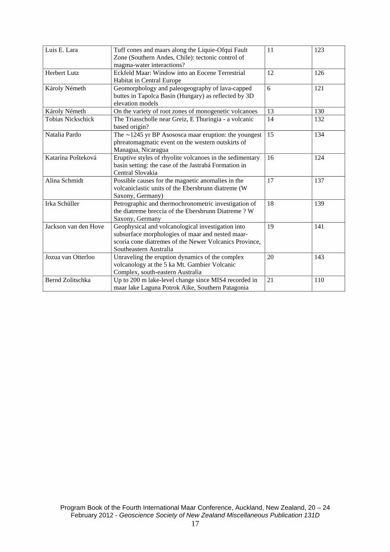
Luis E. Lara Tuff cones and maars along the Liquie-Ofqui Fault Zone (Southern Andes, Chile): tectonic control of magma-water interactions?
11 123
Herbert Lutz Eckfeld Maar: Window into an Eocene Terrestrial Habitat in Central Europe
12 126
Károly Németh Geomorphology and paleogeography of lava-capped buttes in Tapolca Basin (Hungary) as reflected by 3D elevation models
6 121
Károly Németh On the variety of root zones of monogenetic volcanoes 13 130 Tobias Nickschick The Triasscholle near Greiz, E Thuringia - a volcanic
based origin? 14 132
Natalia Pardo The ∼1245 yr BP Asososca maar eruption: the youngest phreatomagmatic event on the western outskirts of Managua, Nicaragua
15 134
Katarína Pošteková Eruptive styles of rhyolite volcanoes in the sedimentary basin setting: the case of the Jastrabá Formation in Central Slovakia
16 124
Alina Schmidt Possible causes for the magnetic anomalies in the volcaniclastic units of the Ebersbrunn diatreme (W Saxony, Germany)
17 137
Irka Schüller Petrographic and thermochronometric investigation of the diatreme breccia of the Ebersbrunn Diatreme ? W Saxony, Germany
18 139
Jackson van den Hove Geophysical and volcanological investigation into subsurface morphologies of maar and nested maar-scoria cone diatremes of the Newer Volcanics Province, Southeastern Australia
19 141
Jozua van Otterloo Unraveling the eruption dynamics of the complex volcanology at the 5 ka Mt. Gambier Volcanic Complex, south-eastern Australia
20 143
Bernd Zolitschka Up to 200 m lake-level change since MIS4 recorded in maar lake Laguna Potrok Aike, Southern Patagonia
21 110

Program Book of the Fourth International Maar Conference, Auckland, New Zealand, 20 – 24 February 2012 - Geoscience Society of New Zealand Miscellaneous Publication 131D
18
DAY 2 21 February 2012
Day 2 Session 1 – 21 February 2012
Presenter Title Lecture time Page # Keynote Gerrardo Carrasco-Núñez
Rhyolitic and basaltic maar volcanoes, a perspective from Mexican volcanism
9.30 – 10.00 21
Javier Agustin-Flores Insights into the controls on the formation of contrasting tuff rings vs. cones in the Auckland Volcanic Field, New Zealand
10.00 – 10.15 1
Robin Andrews Making craters: a review and approach to thermodynamic analysis of the 1886 Rotomahana eruption
10.15 – 10.30 3
James DL White Fragments within fragments: are composite pyroclasts hints of weakness or sustained violence?
10.30 – 10.45 96
Gonca Gençalioğlu Kuşcu
Morphological and chemical diversity of maars in Central Anatolian Volcanic Province (Turkey)
10.45 – 11.00 31
Coffee Break - 11.00 – 11.30
Day 2 Session 2 – 21 February 2012
Presenter Title Lecture time Page # Miguel J Haller Phreatomagmatism related to trachyte dome
explosions 11.30 – 11.45 35
Pooja Kshirsagar Mafic alkalic magmatism in central Kachchh, India: a monogenetic volcanic field in the northwestern Deccan Traps
11.45 – 12.00 49
Yishai Weinstein The impact of drainage basin dynamics on volcanic activity style: a detailed Ar-Ar dating of a dry-wet transition
12.00 – 12.15 95
Simone Jordan Vesicle texture analysis of juvenile pyroclasts from the Pleistocene Lake Purrumbete Maar, Newer Volcanics Province, southern Australia
12.15 – 12.30 39
Young Kwan Sohn Sedimentary and volcanotectonic evolution of a basaltic diatreme in a nonmarine backarc-margin basin (the Miocene Janggi Basin, SE Korea)
12.30 – 12.45 82
Lunch Break - 12.45 – 14.00
Day 2 Session 3 – 21 February 2012
Presenter Title Lecture time Page # Keynote Roberto Sulpizio
Insights on behaviour of granular flows from field analysis and laboratory experiments
14.00 – 14.30 88
Hetu Sheth Evolution of the polygenetic cinder cone of Barren Island, an explosive-effusive mafic arc volcano in the Andaman Sea (NE Indian Ocean)
14.30 – 14.45 72
Adrian Pittari Variation in deposit characteristics and eruption processes across the lifetime of a monogenetic field, the South Auckland volcanic field
14.45 – 15.00 70
Sonja Bosshard Origin of fluidal pyroclast morphologies in melilititic monogenetic cones: Insights from the recent explosive eruption of Oldoinyo Lengai, Tanzania
15.00 – 15.15 11
Bob Stewart Evidence for sporadic Eocene to Pliocene effusive 15.15 – 15.30 84

Program Book of the Fourth International Maar Conference, Auckland, New Zealand, 20 – 24 February 2012 - Geoscience Society of New Zealand Miscellaneous Publication 131D
19
and explosive subaqueous volcanism in northern Chatham Island, SW-Pacific
Pablo Caffe Neogene monogenetic volcanoes from the northern Puna of Argentina, Central Andean plateau.
15.30 – 15.45 19
Károly Németh A nested polymagmatic and polycyclic tuff ring and scoria cone complex at Chaguido (Jeju Island), South Korea
15.45 – 16.00 68
Coffee Break - 16.00 – 16.30
Poster Presentations – 16.30 – 18.30
Presenter Title Poster # Page # Sonja Bosshard Eruptive and depositional characteristics of the
Loolmurwak and Eledoi maar volcanoes, Lake Natron – Engaruka monogenetic volcanic field, northern Tanzania
1 106
Sonja Bosshard Rapid magma ascent and short eruption durations in the Lake Natron - Engaruka monogenetic volcanic field (northern Tanzania): Evidence from the Pello Hill scoria cone
2 128
Raymond Cas Cyclicity in fluctuating phreatomagmatic and magmatic eruptive styles at the 35 ka Tower Hill Volcanic Complex, southeast Australia
3 136
Shane Cronin Developing probabilistic eruption scenarios for distributed volcanism in the Auckland Volcanic Field, New Zealand
4 108
Szabolcs Harangi Volcano park, geoparks and outreach activities on volcanoes in Hungary
5 112
Uwe Kaulfuss Fossil microorganisms, plants and animals from the Early Miocene Foulden Maar, Otago, New Zealand
7 113
Gábor Kereszturi Lava flows and related hazards at the Auckland Volcanic Field (New Zealand)
8 117
Gábor Kereszturi Spatial distribution of monogenetic volcanoes on volcanic islands
9 115
Gi Bom Kim Holocene explosive eruptions of Ulleung Island, a potentially active volcano and a source of marine tephra in the East Sea
10 119
Luis E. Lara Tuff cones and maars along the Liquie-Ofqui Fault Zone (Southern Andes, Chile): tectonic control of magma-water interactions?
11 123
Herbert Lutz Eckfeld Maar: Window into an Eocene Terrestrial Habitat in Central Europe
12 126
Károly Németh Geomorphology and paleogeography of lava-capped buttes in Tapolca Basin (Hungary) as reflected by 3D elevation models
6 121
Károly Németh On the variety of root zones of monogenetic volcanoes 13 130 Tobias Nickschick The Triasscholle near Greiz, E Thuringia - a volcanic
based origin? 14 132
Natalia Pardo The ∼1245 yr BP Asososca maar eruption: the youngest phreatomagmatic event on the western outskirts of Managua, Nicaragua
15 134
Katarína Pošteková Eruptive styles of rhyolite volcanoes in the sedimentary basin setting: the case of the Jastrabá Formation in Central Slovakia
16 124
Alina Schmidt Possible causes for the magnetic anomalies in the volcaniclastic units of the Ebersbrunn diatreme (W Saxony, Germany)
17 137

Program Book of the Fourth International Maar Conference, Auckland, New Zealand, 20 – 24 February 2012 - Geoscience Society of New Zealand Miscellaneous Publication 131D
20
Irka Schüller Petrographic and thermochronometric investigation of the diatreme breccia of the Ebersbrunn Diatreme ? W Saxony, Germany
18 139
Jackson van den Hove Geophysical and volcanological investigation into subsurface morphologies of maar and nested maar-scoria cone diatremes of the Newer Volcanics Province, Southeastern Australia
19 141
Jozua van Otterloo Unraveling the eruption dynamics of the complex volcanology at the 5 ka Mt. Gambier Volcanic Complex, south-eastern Australia
20 143
Bernd Zolitschka Up to 200 m lake-level change since MIS4 recorded in maar lake Laguna Potrok Aike, Southern Patagonia
21 110

Program Book of the Fourth International Maar Conference, Auckland, New Zealand, 20 – 24 February 2012 - Geoscience Society of New Zealand Miscellaneous Publication 131D
21
DAY 3: Intra-conference field trip to Rangitoto Island 22 February 2012
There will be a full day field trip to the Rangitoto Island on Day 3 (Wednesday, 22 February 2012). The trip will require moderate fitness, a torch (or flashlight) to explore the lava caves, shoes that can handle rough, uneven terrain, such as “a’a” lava, and some readiness for a boat ride that could be rough if the conditions are windy. Please be ready for strong UV and sunshine, as well as wind and sudden summer rain. Participants are required to be in attendance a half an hour before sailing in order to obtain the ticket included with 4IMC registration, so meeting for the field trip will be at 8:40 am at the Auckland Ferry Building. Participants arriving later will need to cover their own costs. During the trip, a boxed lunch and a small bottle of water will be provided. Please pick up your lunch box from the conference organizers prior to boarding. On the boat a commercial bar will function for additional drinks; however, you may want to bring extra water with you as it may be a hot day. Toilet facilities are only available at the wharf on Rangitoto and on the boat. The boat will leave Rangitoto to return to Auckland City at 3.30 pm and arrive in the city by 4 pm. For those of you who wish to spend some time in a unique part of Auckland, we recommend getting off of the boat at the brief stop in the seaside village of Devonport (see map, next page). You can catch a ferry back to Auckland for $5.70 every 30 minutes from 3:45 pm until 10.30 pm, with a final ferry at 11:30 pm. Devonport is a haven for artists, architecture lovers, and beach-goers, and also contains sites of geological and historical interest, such as North Head volcano, which has been used as a coastal defense location since Māori times through to the 1950s and is complete with accessible underground tunnels. Two other AVF volcanoes may be explored in Devonport: Mt Victoria and Mt Cambria.

Program Book of the Fourth International Maar Conference, Auckland, New Zealand, 20 – 24 February 2012 - Geoscience Society of New Zealand Miscellaneous Publication 131D
22
Map of Devonport, Auckland.
A = Ferry Terminal in Devonport.
Program Book of the Fourth International Maar Conference, Auckland, New Zealand, 20 – 24 February 2012 - Geoscience Society of New Zealand Miscellaneous Publication 131D
23
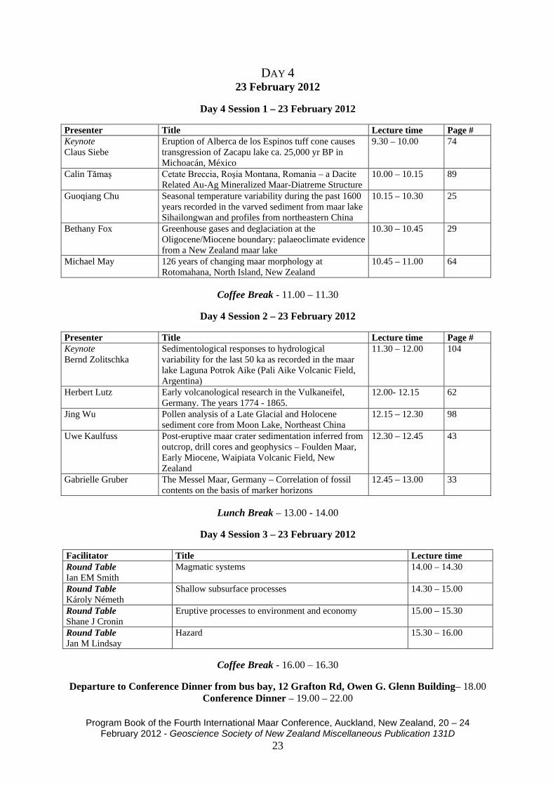
DAY 4 23 February 2012
Day 4 Session 1 – 23 February 2012
Presenter Title Lecture time Page # Keynote Claus Siebe
Eruption of Alberca de los Espinos tuff cone causes transgression of Zacapu lake ca. 25,000 yr BP in Michoacán, México
9.30 – 10.00 74
Calin Tămaş Cetate Breccia, Roşia Montana, Romania – a Dacite Related Au-Ag Mineralized Maar-Diatreme Structure
10.00 – 10.15 89
Guoqiang Chu Seasonal temperature variability during the past 1600 years recorded in the varved sediment from maar lake Sihailongwan and profiles from northeastern China
10.15 – 10.30 25
Bethany Fox Greenhouse gases and deglaciation at the Oligocene/Miocene boundary: palaeoclimate evidence from a New Zealand maar lake
10.30 – 10.45 29
Michael May 126 years of changing maar morphology at Rotomahana, North Island, New Zealand
10.45 – 11.00 64
Coffee Break - 11.00 – 11.30
Day 4 Session 2 – 23 February 2012
Presenter Title Lecture time Page # Keynote Bernd Zolitschka
Sedimentological responses to hydrological variability for the last 50 ka as recorded in the maar lake Laguna Potrok Aike (Pali Aike Volcanic Field, Argentina)
11.30 – 12.00 104
Herbert Lutz Early volcanological research in the Vulkaneifel, Germany. The years 1774 - 1865.
12.00- 12.15 62
Jing Wu Pollen analysis of a Late Glacial and Holocene sediment core from Moon Lake, Northeast China
12.15 – 12.30 98
Uwe Kaulfuss Post-eruptive maar crater sedimentation inferred from outcrop, drill cores and geophysics – Foulden Maar, Early Miocene, Waipiata Volcanic Field, New Zealand
12.30 – 12.45 43
Gabrielle Gruber The Messel Maar, Germany – Correlation of fossil contents on the basis of marker horizons
12.45 – 13.00 33
Lunch Break – 13.00 - 14.00
Day 4 Session 3 – 23 February 2012
Facilitator Title Lecture time Round Table Ian EM Smith
Magmatic systems 14.00 – 14.30
Round Table Károly Németh
Shallow subsurface processes 14.30 – 15.00
Round Table Shane J Cronin
Eruptive processes to environment and economy 15.00 – 15.30
Round Table Jan M Lindsay
Hazard 15.30 – 16.00
Coffee Break - 16.00 – 16.30
Departure to Conference Dinner from bus bay, 12 Grafton Rd, Owen G. Glenn Building– 18.00
Conference Dinner – 19.00 – 22.00

Program Book of the Fourth International Maar Conference, Auckland, New Zealand, 20 – 24 February 2012 - Geoscience Society of New Zealand Miscellaneous Publication 131D
24
DAY 5 24 February 2012
Day 5 Session 1 – 24 February 2012
Presenter Title Lecture time Page # Keynote Mark Bishop
Volcanic Shield Fields, Newer Volcanic Province, Australia
9.30 – 10.00 7
Hugo Delgado Granados A study of the diffuse emissions of CO2 in the Michoacan-Guanajuato monogenetic volcanic field (Mexico)
10.00 – 10.15 28
Elaine Smid Soil Gas CO2 Fluxes and Concentrations in the Auckland Volcanic Field, New Zealand: A Pilot Study
10.15 – 10.30 76
Jan M Lindsay Determining volcanic risk in the Auckland Volcanic Field: a multidisciplinary approach
10.30 – 10.45 56
Catherine Kenedi Challenges of monitoring a potentially active volcanic field in a large urban area: Auckland Volcanic Field, New Zealand
10.45 – 11.00 45
Coffee Break - 11.00 – 11.30
Day 5 Session 2 – 24 February 2012
Presenter Title Lecture time Page # Aleksandra Zawalna-Geer
History of ash fall events trapped in maar lake sediments
11.30 – 11.45 100
Mark Bebbington Paleomagnetic and geological updates to an event-order model for the Auckland Volcanic Field
11.45 – 12.00 5
Nicolas Le Corvec The Auckland Volcanic Field – a basaltic field showing random behavior?
12.00 – 12.15 51
Lunch Break - 12.15 – 13.15
Day 5 Session 3 – 24 February 2012
Presenter Title Lecture time Károly Németh Ian EM Smith
Closing Ceremony
13.15 – 13.45
Jan M Lindsay Jim Luhr Award 13.45 – 14.00 Shane J Cronin Announcement of the host of 5IMC 14.00 – 14.15

Program Book of the Fourth International Maar Conference, Auckland, New Zealand, 20 – 24 February 2012 - Geoscience Society of New Zealand Miscellaneous Publication 131D
25
OTHER NEWS AND ACTIVITIES Other scientific activities: SPECIAL VOLUME WITH SELECTED CONTRIBUTIONS FROM THE MEETING Special Volume of the Bulletin of Volcanology K. NÉMETH, IAN EM SMITH, PIERRE-SIMON ROSS (Editors) “Mongenetic volcanic fields: toward a source to surface model” Contributors to this Special Volume are invited to submit manuscripts in the field of small scale basaltic systems, volcanological modelling, volcaniclastic facies analysis, description of diatremes, relationship between Surtseyan and maar volcanism, intra-crater effusive and intrusive processes, lava surface morphological studies, dating methods based on new techniques, volcanic hazard studies relevant to maar-diatreme volcanism and new results of experimental volcanology to understand phreatomagmatism. Manuscripts should be submitted to any of the Editors not later than 15th May 2012. Manuscripts will go through standard review processes, and they should be submitted in the standard and format of the Bulletin of Volcanology. Final acceptance will be based on the Bulletin of Volcanology Editor in Chief’s approval! ADVANCES IN VOLCANOLOGY BOOK SERIES [SPRINGER] SERIES EDITORS: KATHY CASHMAN AND KÁROLY NÉMETH A new book series has been launched by Springer “Advances in Volcanology” in 2012. We are calling for manuscripts and editors to work on thematic books that reflect the current research trends in Volcanology. Please submit your plan to either of the Series Editors for evaluation. We are particularly interested in a proposals for a book that summarizes current advances in our understanding of monogenetic volcanism “Monogenetic Volcanic Field”. This book will be sponsored by the IAVCEI Commission on Monogenetic Volcanism. JOIN THE IAVCEI COMMISSION ON MONOGENETIC VOLCANISM
You can join to the activity of the IAVCEI Commission on Monogenetic Volcanism via https://vhub.org/groups/iavcei_cmv After joining the IAVCEI CMV you are able to upload resources (data, papers, reports) and contribute to discussions and other activities of the Commission. Files and photos from the 4IMC will be deposited on the IAVCEI CMV website.

Program Book of the Fourth International Maar Conference, Auckland, New Zealand, 20 – 24 February 2012 - Geoscience Society of New Zealand Miscellaneous Publication 131D
26
GLOSSARY OF COMMON/GEOGRAPHICAL MĀORI WORDS
Māori English Aotearoa Māori name for New Zealand: ‘Land of the Long White Cloud’ Aroha Love, compassion Awa River Haere mai! Welcome! Enter! Haka Chant with dance, to challenge Hui Meeting, conference Iti Small, little Iwi Tribe Kai Food; A place where food is plentiful Kia Ora Hello Koha Gift, present Koru** Maori spiral symbol representing growth, strength, and peace Mana Authority, power Manga Stream Marae or wharenui* Meeting house Maunga Mountain Moana Sea, inland sea Māori Indigenous Polynesian people of New Zealand Motu Island Nui Large, big ō Of One Sand, earth Pā Māori village Pae Ridge, range Pākehā Of European descent Papa Flat Poto Short Puke Hill Roa Long Roto Lake Tai Coast, tide Tapu Sacred, to be avoided, taboo Wai Water Waka Canoe Whānau* Family Whanga* Harbour, bay *‘Wh’ is pronounced like an ‘f’. Every vowel is sounded, e.g., ‘one’ is pronounced ‘oh-nay.’ **The koru symbol is featured in the 4IMC logo as well as on the front covers of the 4IMC abstract and programme books. Source: http://www.nzhistory.net.nz/culture/tereo-100words
Program Book of the Fourth International Maar Conference, Auckland, New Zealand, 20 – 24 February 2012 - Geoscience Society of New Zealand Miscellaneous Publication 131D
27
INTRA-CONFERENCE FIELD GUIDE RANGITOTO, AUCKLANDS NEWEST VOLCANO
Ian EM Smith 1, Jan M Lindsay 1, Károly Németh 2 1. Auckland Univeristy 2. Massey University Overview Rangitoto is one of Auckland’s more iconic landscape features. Standing at the entrance to the Waitemata harbour, Rangitoto last erupted some ~550 years ago and is the youngest volcano in the Auckland Volcanic Field (Lindsay 2010). Recent research has revealed more about Rangitoto’s history and this will be discussed ascending its summit and exploring its various volcanic features. The ferry departs from the downtown ferry terminal at 9.15am and Devonport at 9.25am, and will leave Rangitoto at 3.30pm. The walk is a moderate one on rough tracks and requires sturdy footwear and a moderate level of fitness.
Key Facts
Maori name: Rangitoto, derived from the phrase ‘Nga Rangi-i-totongia-a Tama-te-kapua’ - the days of the bleeding of Tama-te-kapua - captain of the Arawa waka, refers to a battle between Tamatekapua and the Tainui at Islington Bay (e.g. Murdoch 1991). Location: Auckland City. Part of the Auckland Volcanic Field Height: 260 m Age: Formed during two eruptions, 600 and 550 years ago (ca 1400 AD and 1450 AD) Composition: Basalt lava, scoria and ash Volume volcanic material: About 2 cubic km
Introduction
Rangitoto Island is a graceful, almost symmetrical, volcanic cone which dominates the skyline to the north-east of Auckland City (Fig. 1). It is the youngest and by far the largest of the ca. 50 volcanoes in the basaltic Auckland volcanic field. The estimated volume of basalt in the volcano (2 cubic kilometres) is about half the volume of all of the basalt in the field. The volcano has a complex structure created during two distinct periods of eruption. The lower lava-covered slopes are relatively gentle although they steepen towards the summit of the island. The upper part of the volcano is made up of steep slopes of scoria. At the summit there is a central crater 60 m deep and 150 m in diameter. A second smaller crater to the east and a complex series of mounds, ridges and depressions to the north of the main crater show that activity was not confined to a single vent. Some of these features are remnants of older craters which were destroyed as the eruption progressed.

Program Book of the Fourth International Maar Conference, Auckland, New Zealand, 20 – 24 February 2012 - Geoscience Society of New Zealand Miscellaneous Publication 131D
28
Figure 1. Geological sketch map of Rangitoto volcano and adjacent Motutapu Island, showing the main Rangitoto eruptive products. Ellipses show generalised areas of equal ash thickness (in cm) for the first Rangitoto eruption. Insets show the location of the Auckland Volcanic Field and other basaltic intraplate volcanic fields in the upper North Island, and the position of Lake Pupuke relative to Rangitoto. Adapted from Needham et al. (2010).
Formation of the island
Rangitoto began as a series of explosive phreatomagmatic eruptions caused when magma, originating from the mantle at depths of about 80 km, broke through the sea bottom at the entrance to the Waitemata Harbour (Fig. 2). A series of ash explosions built up a low cone which eventually acted as a rampart denying the sea water further access to the hot magma. A period of mildly explosive magmatic activity followed, during which lava fountaining and intermittent explosive activity built up an overlapping series of steep sided scoria cones (e.g. North Cone), and covered much of nearby Motutapu Island in ash (Fig. 1). This initial eruption produced magma of alkali basalt composition similar to other Auckland volcanoes and was probably equivalent to Mt Wellington in size. Following a time break of a few decades, a new fire fountaining eruption occurred, producing the current summit scoria cone (i.e. Central Cone; Fig. 2). Towards the end of this eruption, lava flows broke out from fractures around the flanks of the cone to create a smooth apron of lava. The basalt magma produced during this younger (and larger) eruption was sub-alkaline in composition and was the result of a higher degree of melting at slightly lower pressures than the initial alkaline phase. It is possible that the passage of the first batch of magma through the mantle somehow triggered melting in another (higher) zone in the mantle on its way to the surface (Needham et al. 2010).

Program Book of the Fourth International Maar Conference, Auckland, New Zealand, 20 – 24 February 2012 - Geoscience Society of New Zealand Miscellaneous Publication 131D
29
Figure 2. Schematic diagram illustrating the eruptive history of Rangitoto Volcano. A) The first eruption from Rangitoto commenced about 600 years ago, probably erupting through shallow seawater and generating a phreatomagmatic tuff ring; B) strombolian style activity resulted in the formation of a scoria cone ~200m asl, depositing ash on nearby Motutapu Island; C) a period of quiescence of several decades followed the first eruption, during which the original conduit partially solidified; D) the early stages of the second eruption, possibly about 550 years ago, were dominated by Strombolian style activity, which built a steep-sided scoria cone forming the present-day summit and deposited a thin layer of ash on Motutapu; E) a period of lava effusion lead to the development of the extensive lava field and associated near-vent spatter cones; F) the main features of Rangitoto Volcano today. (From Needham et al. 2010) Maori Presence
Although no oral tradition has survived that describes the actual eruption and creation of Rangitoto, we know that Maori were living on the adjacent Motutapu Island at the time. Ash from the early

Program Book of the Fourth International Maar Conference, Auckland, New Zealand, 20 – 24 February 2012 - Geoscience Society of New Zealand Miscellaneous Publication 131D
30
eruption buried wood and shell of a habitation site in Administration Bay, and excavations at the Sunde Site have revealed casts of dog and human footprints in the ash. Carbon-14 dates of ca. 600 years old measured on charred wood beneath the ash on Motutapu Island give a maximum age for the volcano.
Flora of Rangitoto
The flora on Rangitoto is unique among the islands situated in the Hauraki Gulf. The island is home to some 200+ species of plants, ferns and mosses that have established themselves over the past 200 years on a relatively soil-less, water-less, barren landscape. The establishment and development of flora on Rangitoto is thought to have been a slow process, with the development of an appropriate soil on the basalt requiring the longest period of time although this process gradually became faster as the island became more inhabitable.
In the beginning, the first plants (lichens and mosses) established themselves by growing in crevices in-filled with fine ash from the final stages of the eruption. As the fine, spongy, highly humic, brown detritus accumulated in the crevices, this soil-like surface allowed larger plants (ferns and shrubs) to establish themselves on the lava field. Today Rangitoto is dominated by Pohutukawa (Metrosideros excelsa) ‘New Zealand Christmas’ trees, a primary rock coloniser, which forms ‘vegetation islands’ that gradually fuse together to form large forested area (Millener 1979). Rangitoto is home to the largest Pohutukawa forest in the world. Various pest eradication schemes have been conducted over the years to remove introduced pests and restore vegetation on Rangitoto and Motutapu.
Geological Features
A walk on Rangitoto reveals many interesting volcanic features. The gentle lower slopes are composed of many overlapping lava flows whose surfaces commonly show good pahoehoe textures near to their source, and aa textures at their distal (coastal) ends. Toward their distal ends the margins of many flows are defined by prominent levees formed by accumulation of chilled lava at the margins of moving flows.
A small but well-developed system of lava tunnels linked by lava trenches occurs on the south-eastern flanks of Rangitoto Island close to the boundary between the summit scoria cones and the surrounding lava field. The tunnels formed after still-molten lava withdrew from a channel roofed by chilled lava; the trenches formed in places where the roof was too thin and collapsed as the lava withdrew, or where a roof did not form.
The summit scoria cone rises from the “moat” at the top of the lava slopes. As seen from Auckland the cone is a multiple structure with two outer hills flanking the younger summit cone and crater that represent the remnants of earlier cones destroyed by later eruptions. Good exposures of scoria forming the summit area are seen on tracks on the north-eastern side; these formed by episodic fire fountaining.
When fresh, the scoria is normally dark grey but reaction with water percolating through the hot porous scoria soon after the eruption has caused some of the rock to turn a deep red. The red colouration is due to oxidation of the iron in the basaltic scoria.

Program Book of the Fourth International Maar Conference, Auckland, New Zealand, 20 – 24 February 2012 - Geoscience Society of New Zealand Miscellaneous Publication 131D
31
Figure 3. Map showing the localities of the various field stops and general geographical features of the southern part of Rangitoto Island.

Program Book of the Fourth International Maar Conference, Auckland, New Zealand, 20 – 24 February 2012 - Geoscience Society of New Zealand Miscellaneous Publication 131D
32
Description of Field Stops (see also Fig. 3)
Ferry arrives approximately 9.45 am
1. Information shelter at Rangitoto Wharf. Introduction and briefing. After a short ferry ride we will arrive at Rangitoto Wharf, situated on the southern coast of Rangitoto Island and at the periphery of the Rangitoto lava field. Sea level has remained virtually the same since the eruptions of Rangitoto, so the features seen on the coast will shed some light on how the lava interacted with the sea water towards the latter stages of the second eruption. Be sure to look at the smooth, wrinkly, curved lava features that snake their way into the water parallel to the wharf. From the wharf we will ascend the main cone of Rangitoto stopping at several locations to discuss the features of the volcano. The position of the stops is indicated on Fig.3 and we will visit these in the order 2,3,4,9,8,6,7,5 before returning to the wharf for the 3.30pm departure.
2. Raised margin of lava flow. Brief discussion of the Rangitoto lava field and of lava flow
textures. As we make our way towards the summit we will see the features and textures of the Rangitoto lava field. Near the source of lava effusion (at the base of the scoria cone) the lava field is quite thick, up to 50 m, whilst at the coast is considerably thinner, less than 20 m; although individual flows themselves are no more than 5 m thick. The majority of the lava field is comprised of blocky, clinker a’a lava flows, with rarer occurrences of smooth, ropey pahoehoe lava flows along the main track to the summit and along coastal areas, e.g. near Islington Bay and the Rangitoto Wharf. During eruption, the a’a flows transported brecciated, broken lava blocks downslope atop a more massive flow core. The blocks form at the leading edge of a flow due to instantaneous cooling with the air or water. Blocks generally tumble down the steep flow fronts and are either ‘bulldozed’ or buried by the advancing flow. Rocks on the outside of the flow tend to be highly vesicular and glassy, whilst those from the flow interior tend to be more massive and crystalline.
3. DOC information point. This is on the boardwalk, on the left side of the main track as we ascend. It provides a good opportunity to discuss the structure of the lava field and view to summit.
4. Moat between lava field and summit cone. Pause to regroup and discuss the two eruptive
styles of Rangitoto. Leave this stop at 11 am. At an elevation of 150 m the southern and eastern flanks of the volcano are dominated by an unusual moat-like structure, which defines the boundary between the lower lava-covered slopes and the scoria crown. It is understood to have formed as a result of a subsidence event following the release of significant volumes of lava from fissures on the upper flanks.
5. On track immediately before summit crater. Deposits of lapilli from the scoria cone. Exposed in cuttings next to the summit track not far from the main crater are layers of the pyroclastic material (scoria, lapilli and bombs) that make up the central scoria cone of Rangitoto. These glassy, highly vesicular rock fragments originate from gas-rich molten or semi-molten lava that has been ejected into the air, quickly cooled and deposited close to the vent, frequently still partially molten. Pyroclastics are typically cylindrical, spherical, teardrop, dumbbell or button-like in shape, and generally take their shape when they are

Program Book of the Fourth International Maar Conference, Auckland, New Zealand, 20 – 24 February 2012 - Geoscience Society of New Zealand Miscellaneous Publication 131D
33
airborne. Also common in the pyroclastic deposits of Rangitoto is ‘welded’ scoria, which forms when semi-molten scoria fragments ‘stick’ to other fragments when they land. The accumulation of the pyroclastic fragments described above formed the Rangitoto scoria cone.
6. Summit crater. Not far from Stop 5 is the observation deck located on the rim of the main crater of Rangitoto. The near circular bowl-shaped crater of Rangitoto is approximately 150 m in diameter and 60 m in depth, and reaches a height of ~260 m above sea level. This is the position of the vent for the second Rangitoto eruption, which started off as a moderately explosive (Strombolian style) eruption, forming the scoria cone, and then becoming more effusive (Hawaiian style) towards the latter stages of the eruption.
7. Summit. Discussion of the Auckland Volcanic Field and of the two eruptive phases of
Rangitoto. Lunch. Leave this stop by 2.00 pm. At the summit we are presented with a 360° view of Rangitoto volcano and the surrounding natural and man-made features. To the south-west we can see the Auckland CBD, situated next to the Waitemata Harbour, and some of the other larger volcanic cones (Mt Wellington, Mt Eden, One Tree Hill, The Domain, Mt Mangere) in the AVF. To the west we see the residential suburbs of North Shore City and smaller volcanic cones (North Head, Mt Victoria) and slightly larger explosion craters (Lake Pupuke, Tank Farm, Onepoto Basin). To the north-east we see Motutapu Island, which was covered in significant volumes of volcanic ash from the Rangitoto eruptions. Ash from both Rangitoto eruptions has also been found in drill core from Lake Pupuke (Fig. 1). To the south and south-east we see the other islands of the Hauraki Gulf, the islands of Waiheke and Motuihe, and volcanic cone of Motukorea (Brown’s Island).
8. Small quarry on northern side of main cone. Discussion of the structure of the cone, and varying alteration of deposits. Exposed in this quarry are alternating pyroclastic layers of black to dark brown and red, and less frequent patches of yellow-tinted scoria. Each colour indicates different processes acting on the pyroclastic material prior to, during and after eruption. Dark coloured scoria (black and dark brown) reflects relatively unaltered rock fragments. In comparison, red scoria generally indicates oxidizing conditions (higher temperature and/or presence of permeating magmatic gases) acting on the iron content of the scoria at the time of eruption. Red scoria may also result from post-depositional chemical weathering. The yellow coloured scoria seen in some areas in the quarry has probably been altered by hydrothermal activity at some stage.
9. Lava Caves/Tubes South-east of the Central Scoria Cone, and in close proximity to the “moat” are some of Rangitoto’s most popular geological features – the lava caves. These formed when the exterior of a low-viscosity pahoehoe lava flow “chilled” (in contact with ground and air) and crusted over, creating an insulated tube that allowed the molten lava interior to continue flowing. Towards the latter stage of the eruption, lava supply down the lava tube system waned, and subsequently drained, leaving behind the cave-like structures we are about to walk through. Be sure to have a torch and watch out for the Wetas!!
10. Baches adjacent to wharf. Here we will look at some of the remaining bach communities on Rangitoto. These were built in the 20s and 30s, and consist of private holiday dwellings and boatsheds as well as

Program Book of the Fourth International Maar Conference, Auckland, New Zealand, 20 – 24 February 2012 - Geoscience Society of New Zealand Miscellaneous Publication 131D
34
communal facilities such as the swimming pool and a community hall. Built by families during the depression era, they demonstrate the kiwi do-it-yourself attitudes of the times. Since 1937 it has been prohibited to build further buildings on the island.
Ferry departs 3.30pm
References Lindsay, J.M. (2010): Volcanoes in the big smoke: a review of hazard and risk in the Auckland
Volcanic Field. in: Williams A.L., Pinches G.M., Chin C.Y. McMorran T.J. and Massey C.I. (eds). Geologically Active. Delegate Papers of the 11th Congress of the International Association for Engineering Geology and the Environment (IAEG). 2010 Taylor & Francis Group, London, ISBN 978-0-415-60034-7
Millener, L.H. (1979). Forest, scrub and fresh-water communities: Rangitoto. In: Brook, P.J. (Ed),
Natural History of Auckland: an Introduction. The Pelorus Press Ltd, Auckland, pp. 41-43. Murdoch, G. (Compiler) (1991). He Korero Ta Whito Mo Rangitoto – a brief outline of the Maori
Historical Associations with Rangitoto Island. Unpublished paper, p. 1-14.
Needham, A.J., Lindsay, J.M., Smith, I.E.M., Augustinus, P., Shane, P.A., (2010). Sequential eruption of alkaline and sub-alkaline magmas from a small monogenetic volcano in the Auckland Volcanic Field, New Zealand. Journal of Volcanology and Geothermal Research, doi:10.1016/j.jvolgeores.2010.07.017


Pulvermaar
Tihany
Badacsony
Laguna Azul
Cerro Chivo
3IMC - ARGENTINA
2IMC - HUNGARY - SLOVAKIA -GERMANY
1IMC - GERMANY
Eichholzmaar
Laguna Potrok Aike
Filakovo
Dauner Maare