
Product Specification Document
170
© 2021 Consortium CCI LST CCI Land Surface Temperature Product Specification Document WP1.2 – DEL-LST-CCI-D1.2-PSD Ref.: LST-CCI-D1.2-PSD Date: 01-Feb-2021 Organisation: Consortium CCI LST
Transcript of Product Specification Document

© 2021 Consortium CCI LST
CCI Land Surface Temperature
Product Specification Document
WP1.2 – DEL-LST-CCI-D1.2-PSD
Ref.: LST-CCI-D1.2-PSD
Date: 01-Feb-2021
Organisation: Consortium CCI LST

Product Specification Document
WP1.2 – DEL-LST-CCI-D1.2-PSD
Ref.: LST-CCI-D1.2-PSD
Version: .2.0
Date: 13-Jul-2021
Page: ii
© 2021 Consortium CCI LST
Signatures
Written by Emma Dodd University of Leicester
Reviewed by Jérôme Bruniquel ACRI-ST
Approved by Darren Ghent ULeic
Authorized by Simon Pinnock ESA
Change log
1.0 16-Sep-2019 First version
1.1 14-Mar-2019 First version released
1.2 14-May-2019 Updated flags following DEWG
1.3 29-May-2019 Updates to file formats following production of test files.
1.4 13-Jun-2019 Updated some parts on requirements for the microwave and a few inconsistencies
1.5 15-Jul-2019 Changes to CF convention number, units and coordinates metadata following AR1 meeting and checking of initial data files produced. Also made clearer that the products will include day and night data seperately where appropriate.
1.6 16-Jul-2019 The time should now be a double in Table 19, Table 26 and Table 29. The time definition in Table 26 has been changed back to what is was before as only the L3C/L3S should be split into day and night.

Product Specification Document
WP1.2 – DEL-LST-CCI-D1.2-PSD
Ref.: LST-CCI-D1.2-PSD
Version: .2.0
Date: 13-Jul-2021
Page: iii
© 2021 Consortium CCI LST
1.7 16-Sep-2019 • Included further detail about the format of the L3C files, making it clear that these files will provide day and night data (or descending and ascending orbits) in separate files.
• Added examples and further information for the additional segregators used in the filename formatting.
• Specified the directory structure to be used for the product files.
• Made some variables in L3C/L3S files optional based on feedback from Estellus and University of Leicester.
1.8 25-Sep-2019 • Replaced mention of F11, F13, F17 with F13, F17, F18 for SSM/I and SSMIS series (DMSP satellites).
• Definition of n variable changed to specify use for both IR and MW.
1.9 25-Oct-2019 • Changed “Begin” to “Beginning” in detailed file format specification tables for consistency with PVP document.
• Replaced < character in flag_meanings with LESS_THAN to conform with CCI file format and CF standards.
1.10 14-Jan-2020 • Lst_unc_sys is scalar and should therefore not have coordinates ni,nj or lat, lon in the metadata. This was noted as causing a problem with IRIS.
• Updated global attributes (source) in the example files in the appendix as they were not consistent with this document.
1.11 17-Jun-2020 • Updated file and directory naming for annual and monthly files based on recent discussions about the best way to do this consistently.
1.12 1-Feb-2021 • Microwave information updated for platforms and quality flags.
• Updated the description of actual_range as this didn’t make much sense, and it mentioned the valid_range when we are using valid_min and valid_max instead.
• Updated file format information to CCI Data Standards V2.2.
• Flags in the example file metadata in the Appendices were not the same as given in the file format tables. Both should now be the same.
• Some coordinates were the wrong way round in the file format for L3.
1.13 6-May-2021 • Update to merged product naming strings.
• FV and LWM should be optional for L3 products.
• Different qual_flag variable format for Daily L3C IR files compared to other IR L3 files added to Section 5.5.3.
2.0 8-Jul-2021 • V2.00 document generated from V1.13 with some additional updates included as detailed below.
• Added a L3C MW lst time offset variable.

Product Specification Document
WP1.2 – DEL-LST-CCI-D1.2-PSD
Ref.: LST-CCI-D1.2-PSD
Version: .2.0
Date: 13-Jul-2021
Page: iv
© 2021 Consortium CCI LST
Table of Content
1. EXECUTIVE SUMMARY ------------------------------------------------------------------------------------------1
2. INTRODUCTION ---------------------------------------------------------------------------------------------------6 2.1. Purpose and Scope --------------------------------------------------------------------------------------------------------- 6 2.2. Document -------------------------------------------------------------------------------------------------------------------- 6 2.3. Applicable Documents ---------------------------------------------------------------------------------------------------- 6 2.4. Reference Documents ----------------------------------------------------------------------------------------------------- 7 2.5. Glossary ----------------------------------------------------------------------------------------------------------------------- 8
3. PRODUCT OVERVIEW ------------------------------------------------------------------------------------------ 10 3.1. Summary of Products --------------------------------------------------------------------------------------------------- 10 3.2. Details of Products ------------------------------------------------------------------------------------------------------- 13 3.3. User Requirements addressed by LST_CCI products ------------------------------------------------------------ 22 3.4. Improvements over existing products ------------------------------------------------------------------------------ 32
4. FILE FORMAT AND METADATA ----------------------------------------------------------------------------- 35 4.1. Rationale -------------------------------------------------------------------------------------------------------------------- 35 4.2. Filename convention ---------------------------------------------------------------------------------------------------- 36 4.3. Directory structure ------------------------------------------------------------------------------------------------------- 38 4.4. Global attributes ---------------------------------------------------------------------------------------------------------- 40 4.5. Variable attributes ------------------------------------------------------------------------------------------------------- 45 4.6. Unique product identifiers --------------------------------------------------------------------------------------------- 47
5. PRODUCT SPECIFICATION ------------------------------------------------------------------------------------ 50 5.1. Format of the product description tables-------------------------------------------------------------------------- 50 5.2. Storage type definitions ------------------------------------------------------------------------------------------------ 51 5.3. Uncertainty Nomenclature -------------------------------------------------------------------------------------------- 51 5.4. L2P data --------------------------------------------------------------------------------------------------------------------- 53
5.4.1. Description ----------------------------------------------------------------------------------------------------------------------------53 5.4.2. Summary of contents ---------------------------------------------------------------------------------------------------------------53 5.4.3. Detailed contents --------------------------------------------------------------------------------------------------------------------55
5.5. L3U, L3C and L3S data --------------------------------------------------------------------------------------------------- 79 5.5.1. Description ----------------------------------------------------------------------------------------------------------------------------79 5.5.2. Summary of contents ---------------------------------------------------------------------------------------------------------------80 5.5.3. Detailed contents --------------------------------------------------------------------------------------------------------------------82
6. FILE SIZE ESTIMATES ----------------------------------------------------------------------------------------- 139
7. DATA ACCESS -------------------------------------------------------------------------------------------------- 140
8. DATA DOCUMENTATION, VALIDATION AND INTERCOMPARISON ------------------------------ 141
9. ISSUES FOR FUTURE RELEASES OF THIS DOCUMENT ------------------------------------------------ 143 A.1. L2P Example ---------------------------------------------------------------------------------------------------------- 144 A.2. L3 Example ------------------------------------------------------------------------------------------------------------ 153
Product Specification Document
WP1.2 – DEL-LST-CCI-D1.2-PSD
Ref.: LST-CCI-D1.2-PSD
Version: .2.0
Date: 13-Jul-2021
Page: v
© 2021 Consortium CCI LST
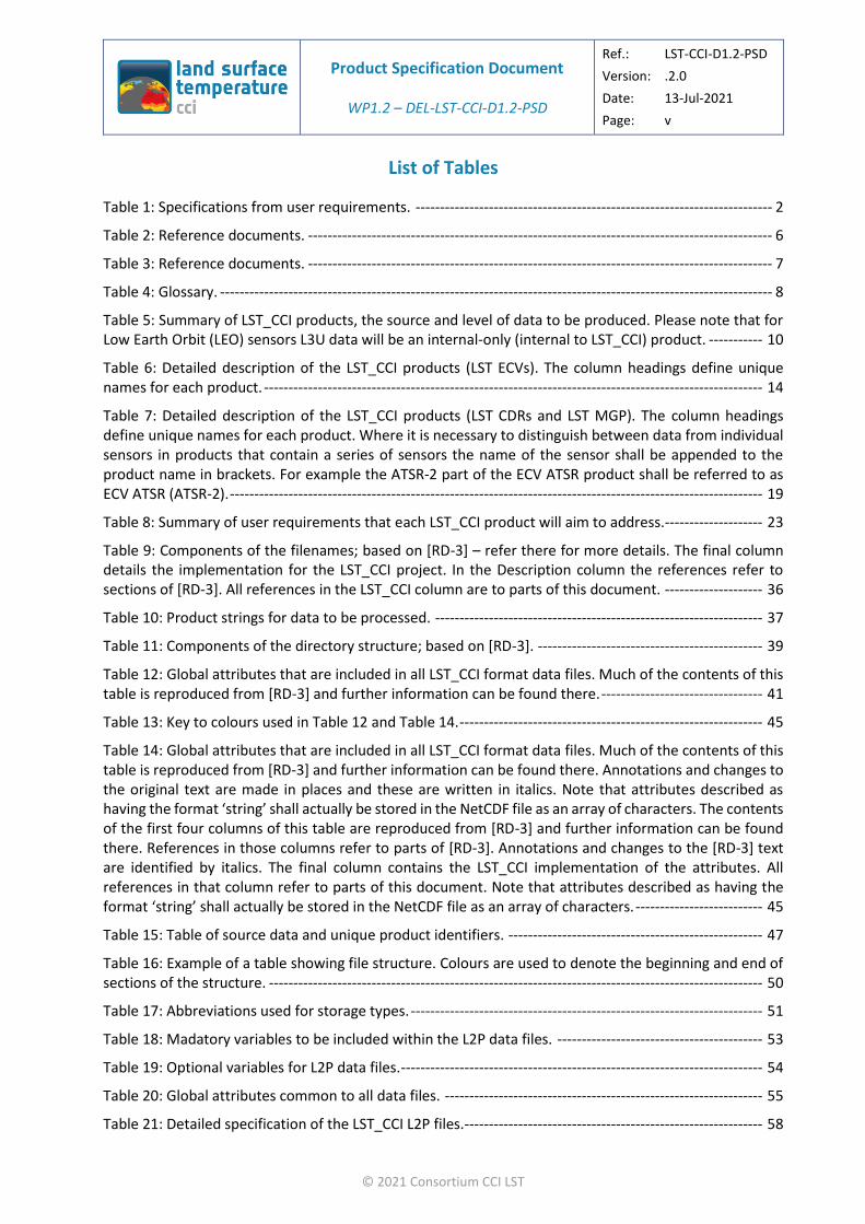
List of Tables
Table 1: Specifications from user requirements. ------------------------------------------------------------------------- 2
Table 2: Reference documents. ----------------------------------------------------------------------------------------------- 6
Table 3: Reference documents. ----------------------------------------------------------------------------------------------- 7
Table 4: Glossary. ----------------------------------------------------------------------------------------------------------------- 8
Table 5: Summary of LST_CCI products, the source and level of data to be produced. Please note that for Low Earth Orbit (LEO) sensors L3U data will be an internal-only (internal to LST_CCI) product. ----------- 10
Table 6: Detailed description of the LST_CCI products (LST ECVs). The column headings define unique names for each product. ------------------------------------------------------------------------------------------------------ 14
Table 7: Detailed description of the LST_CCI products (LST CDRs and LST MGP). The column headings define unique names for each product. Where it is necessary to distinguish between data from individual sensors in products that contain a series of sensors the name of the sensor shall be appended to the product name in brackets. For example the ATSR-2 part of the ECV ATSR product shall be referred to as ECV ATSR (ATSR-2). ------------------------------------------------------------------------------------------------------------- 19
Table 8: Summary of user requirements that each LST_CCI product will aim to address.-------------------- 23
Table 9: Components of the filenames; based on [RD-3] – refer there for more details. The final column details the implementation for the LST_CCI project. In the Description column the references refer to sections of [RD-3]. All references in the LST_CCI column are to parts of this document. -------------------- 36
Table 10: Product strings for data to be processed. ------------------------------------------------------------------- 37
Table 11: Components of the directory structure; based on [RD-3]. ---------------------------------------------- 39
Table 12: Global attributes that are included in all LST_CCI format data files. Much of the contents of this table is reproduced from [RD-3] and further information can be found there. --------------------------------- 41
Table 13: Key to colours used in Table 12 and Table 14. -------------------------------------------------------------- 45
Table 14: Global attributes that are included in all LST_CCI format data files. Much of the contents of this table is reproduced from [RD-3] and further information can be found there. Annotations and changes to the original text are made in places and these are written in italics. Note that attributes described as having the format ‘string’ shall actually be stored in the NetCDF file as an array of characters. The contents of the first four columns of this table are reproduced from [RD-3] and further information can be found there. References in those columns refer to parts of [RD-3]. Annotations and changes to the [RD-3] text are identified by italics. The final column contains the LST_CCI implementation of the attributes. All references in that column refer to parts of this document. Note that attributes described as having the format ‘string’ shall actually be stored in the NetCDF file as an array of characters. -------------------------- 45
Table 15: Table of source data and unique product identifiers. ---------------------------------------------------- 47
Table 16: Example of a table showing file structure. Colours are used to denote the beginning and end of sections of the structure. ----------------------------------------------------------------------------------------------------- 50
Table 17: Abbreviations used for storage types. ------------------------------------------------------------------------ 51
Table 18: Madatory variables to be included within the L2P data files. ------------------------------------------ 53
Table 19: Optional variables for L2P data files. -------------------------------------------------------------------------- 54
Table 20: Global attributes common to all data files. ----------------------------------------------------------------- 55
Table 21: Detailed specification of the LST_CCI L2P files.------------------------------------------------------------- 58
Product Specification Document
WP1.2 – DEL-LST-CCI-D1.2-PSD
Ref.: LST-CCI-D1.2-PSD
Version: .2.0
Date: 13-Jul-2021
Page: vi
© 2021 Consortium CCI LST
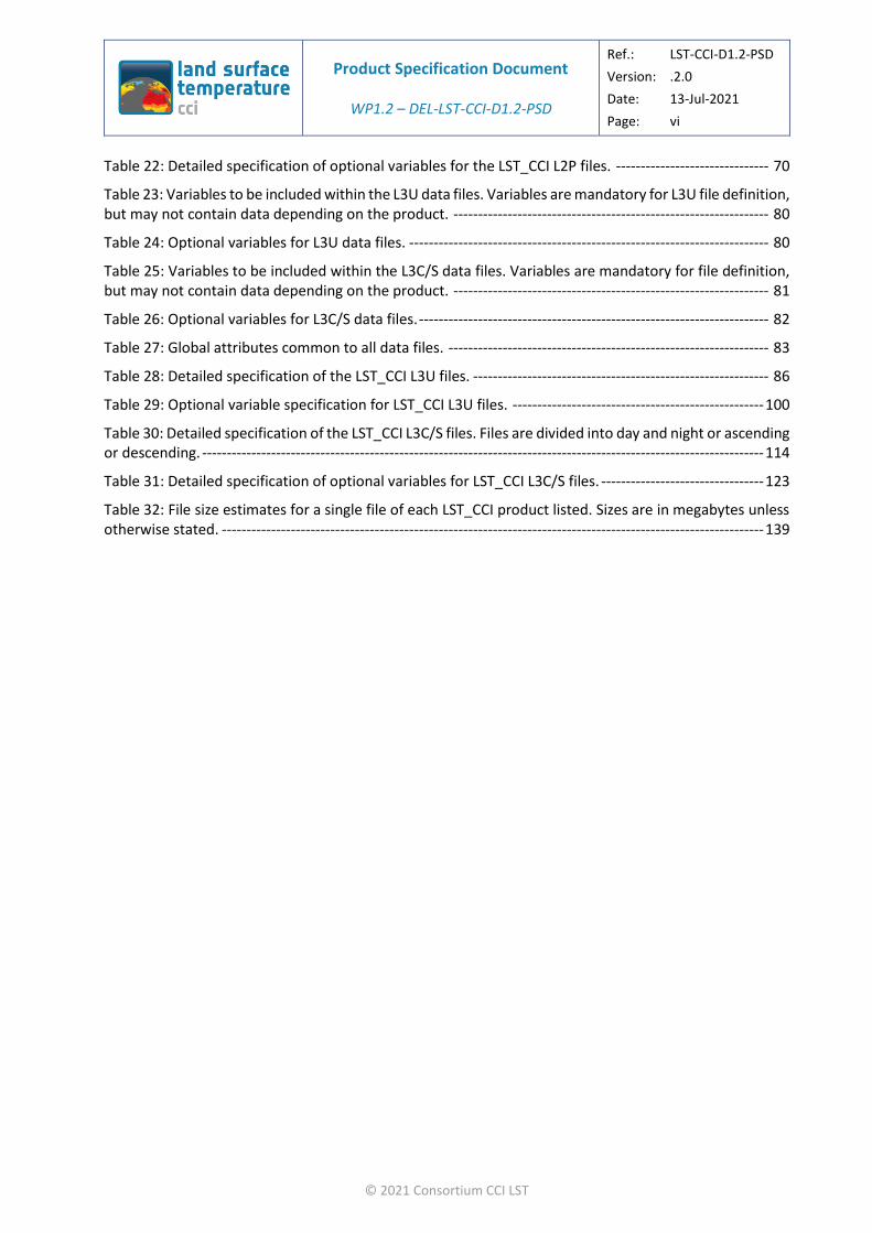
Table 22: Detailed specification of optional variables for the LST_CCI L2P files. ------------------------------- 70
Table 23: Variables to be included within the L3U data files. Variables are mandatory for L3U file definition, but may not contain data depending on the product. ---------------------------------------------------------------- 80
Table 24: Optional variables for L3U data files. ------------------------------------------------------------------------- 80
Table 25: Variables to be included within the L3C/S data files. Variables are mandatory for file definition, but may not contain data depending on the product. ---------------------------------------------------------------- 81
Table 26: Optional variables for L3C/S data files. ----------------------------------------------------------------------- 82
Table 27: Global attributes common to all data files. ----------------------------------------------------------------- 83
Table 28: Detailed specification of the LST_CCI L3U files. ------------------------------------------------------------ 86
Table 29: Optional variable specification for LST_CCI L3U files. --------------------------------------------------- 100
Table 30: Detailed specification of the LST_CCI L3C/S files. Files are divided into day and night or ascending or descending. ------------------------------------------------------------------------------------------------------------------ 114
Table 31: Detailed specification of optional variables for LST_CCI L3C/S files. --------------------------------- 123
Table 32: File size estimates for a single file of each LST_CCI product listed. Sizes are in megabytes unless otherwise stated. -------------------------------------------------------------------------------------------------------------- 139

Product Specification Document
WP1.2 – DEL-LST-CCI-D1.2-PSD
Ref.: LST-CCI-D1.2-PSD
Version: .2.0
Date: 13-Jul-2021
Page: 1
© 2021 Consortium CCI LST
1. Executive Summary
The European Space Agency Climate Change Initiative on Land Surface Temperature (hereafter LST_CCI) aims to produce and validate Land Surface Temperature (LST) LST Essential Climate Variable (ECV) data products to provide an accurate view of temperatures across land surfaces globally over the past 20 to 25 years.
This document provides descriptions and specifications of products that shall be produced by the LST_CCI project. Product specifications were developed from user requirements defined in the LST_CCI User Requirements Document [AD-1]. Information obtained through the surveys and interviews was synthesised in [AD-1] and used to define LST user requirements and advice notes relevant to the LST_CCI project. Throughout this document, the technical specifications have been noted where relevant to the LST_CCI products specified to ensure full traceability of how the requirements will be met by the Project.
GCOS requirements (thresholds) for LST climate products are for spatial resolution of 0.05°, a temporal resolution of day-night, accuracy and precision of < 1 K, stability of < 0.3 K per decade and a length of record of 20 years. It should be noted that the spatial and temporal resolution requirements for a single ECV product may be mutually exclusive. However, LST_CCI aims to address these requirements where possible. For all LST_CCI data products, the aim is to produce datasets which all fulfil the required accuracy, precision and stability requirements from GCOS. All thermal infrared products, from both geostationary and low earth orbits, will provide data at a spatial resolution of at least 0.05° if not higher. For all sensors and data product types, there will be one product that provides at least day-night data. Most will provide data of higher temporal resolution. Some data products will provide a length of record of at least 20 years by the end of the project, such as MODIS and AVHRR ECVs.
LST_CCI plans to produce two types of LST products as follows:
❖ LST Essential Climate Variable (ECV) products, where the priorities are for a long, stable climate records formed from single satellite sensors.
❖ Climate Data Records (CDRs) produced from combining data from different satellite sensors.
The specifications contained in this Product Specification Document (PSD) provide a complete description of the products, including the definition of file level metadata, for all Level 2 and 3 data files (L2 and L3) to be provided by LST_CCI.
This Product Specifications Document (PSD) is effectively a live document, which will be updated as new information on datasets is available. These specifications are summarised in Table 1 using the following naming convention:
LST-PSD-<type>-<number>-<source>
Where:
❖ LST-PSD indicates that the specification has originated from this LST CCI Product Specifications Document (PSD)
❖ <type> can be one of two options:
“SPN”: A specification that must be implemented in the project outputs.
“OPT”: An optional specification that could improve a product output if feasible to implement.
❖ <number> is a two-digit counter

Product Specification Document
WP1.2 – DEL-LST-CCI-D1.2-PSD
Ref.: LST-CCI-D1.2-PSD
Version: .2.0
Date: 13-Jul-2021
Page: 2
© 2021 Consortium CCI LST
❖ <source> identifies where the requirement originated, in all cases to date this is the URD (User Requirements Document) but it is feasible other sources may drive specification as the project progresses.
These technical specification numbers are directly linked to user requirement numbers, which use the following naming convention [AD-1]:
LST-URD-<type>-<number>-<source>
Where:
❖ LST-URD indicates that the requirement or advice note has originated from this LST CCI User Requirements Document (URD)
❖ <type> can be one of three options:
“REQ”: A requirement that must be addressed by the project.
“OPT”: An optional requirement that should be met where possible.
“ADV”: An advisory requirement that should be considered where feasible. These are used where requirements cannot be analysed quantitatively, for example the CRG interviews or free text questions provided in the Lisbon and Online questionnaires.
❖ <number> is a two digit counter
❖ <source> identifies where the requirement originated, in this case it can be one or more of three options:
‘L’: Joint Land Workshop held in Lisbon [AD-1, Section 5]
‘O’: Online questionnaire [AD-1, Section 6]
‘I’: Interviews with members of the CRG [AD-1, Section 7]
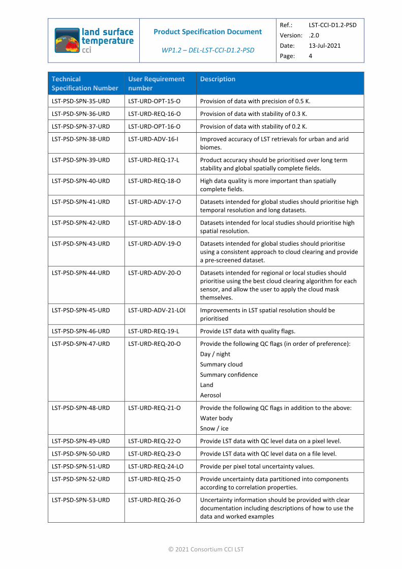
Table 1: Specifications from user requirements.
LST-PSD-SPN-1-URD LST-URD-REQ-01-O Provide LST products in NetCDF format.
LST-PSD-SPN-2-URD LST-URD-ADV-01-O CCI standard format is recommended for LST CCI products.
LST-PSD-SPN-3-URD LST-URD-ADV-02-OI Disseminate clear information on what LST data represents, potential applications and how the data may be used.
LST-PSD-SPN-4-URD LST-URD-ADV-03-I Provide documentation detailing assumptions made during the retrieval process or product construction, including detailed information on any techniques used for merging.
LST-PSD-SPN-5-URD LST-URD-ADV-04-LI Ensure long term, easy access to data.
LST-PSD-SPN-6-URD LST-URD-ADV-05-O Provide a summary of the availability and characteristics of different LST products.
LST-PSD-SPN-7-URD LST-URD-ADV-06-LI Consistency should be maintained between different LST products within LST CCI.

Product Specification Document
WP1.2 – DEL-LST-CCI-D1.2-PSD
Ref.: LST-CCI-D1.2-PSD
Version: .2.0
Date: 13-Jul-2021
Page: 3
© 2021 Consortium CCI LST
LST-PSD-SPN-8-URD LST-URD-ADV-07-OI Consistency between LST CCI and other CCI products should be maintained.
LST-PSD-SPN-9-URD LST-URD-ADV-08-OI Provide information on how comparable LST CCI products are with other CCI datasets, for example, spatial and temporal averaging, uncertainties, changes likely to impact LST (e.g. vegetation fractional cover).
LST-PSD-SPN-10-URD LST-URD-REQ-02-O Provide LST from IR LEO satellites.
LST-PSD-SPN-11-URD LST-URD-REQ-03-O Provide LST from IR GEO satellites
LST-PSD-SPN-12-URD LST-URD-REQ-04-O Provide products which merge LST from multiple IR LEO satellite datasets to create a long running, near-global CDR.
LST-PSD-SPN-13-URD LST-URD-REQ-05-LO Provide products produced by merging LEO and GEO datasets.
LST-PSD-SPN-14-URD LST-URD-REQ-06-O Provide LST data products at level 2.
LST-PSD-SPN-15-URD LST-URD-REQ-07-O Provide LST data products at level 3C.
LST-PSD-SPN-16-URD LST-URD-REQ-08-O Data from MODIS instruments should be given high priority.
LST-PSD-SPN-17-URD LST-URD-ADV-09-LI Provide multi-decadal, homogenised datasets, free from non-climatic discontinuities.
LST-PSD-SPN-18-URD LST-URD-ADV-10-OI Provision of MW LST products.
LST-PSD-SPN-19-URD LST-URD-ADV-11-LOI Provision of all-sky LST datasets.
LST-PSD-SPN-20-URD LST-URD-ADV-12-O Provision of Meteosat data.
LST-PSD-SPN-21-URD LST-URD-ADV-13-O Provision of Landsat data.
LST-PSD-SPN-22-URD LST-URD-ADV-14-O Provision of AVHRR data.
LST-PSD-SPN-23-URD LST-URD-REQ-09-O Provide global coverage of LST data.
LST-PSD-SPN-24-URD LST-URD-REQ-10-O Provide observations at all hours of the day.
LST-PSD-SPN-25-URD LST-URD-REQ-11-O Provide minimum dataset length of 10 years.
LST-PSD-SPN-26-URD LST-URD-OPT-11-O Provide minimum dataset length of 30 years.
LST-PSD-SPN-27-URD LST-URD-REQ-12-O Provide datasets with a spatial resolution of 1 km.
LST-PSD-SPN-28-URD LST-URD-OPT-12-O Spatial resolution better than 1 km.
LST-PSD-SPN-29-URD LST-URD-REQ-13-O Provide data with temporal resolution of 6 hours.
LST-PSD-SPN-30-URD LST-URD-OPT-13-O Provide data with a temporal resolution of 1 hour.
LST-PSD-SPN-31-URD LST-URD-ADV-15-OI Provision of LST observations close to solar noon / early afternoon should be prioritised.
LST-PSD-SPN-32-URD LST-URD-REQ-14-O Provision of data with accuracy of 1 K.
LST-PSD-SPN-33-URD LST-URD-OPT-14-O Provision of data with accuracy of 0.5 K.
LST-PSD-SPN-34-URD LST-URD-REQ-15-O Provision of data with precision of 1 K.
Product Specification Document
WP1.2 – DEL-LST-CCI-D1.2-PSD
Ref.: LST-CCI-D1.2-PSD
Version: .2.0
Date: 13-Jul-2021
Page: 4
© 2021 Consortium CCI LST
LST-PSD-SPN-35-URD LST-URD-OPT-15-O Provision of data with precision of 0.5 K.
LST-PSD-SPN-36-URD LST-URD-REQ-16-O Provision of data with stability of 0.3 K.
LST-PSD-SPN-37-URD LST-URD-OPT-16-O Provision of data with stability of 0.2 K.
LST-PSD-SPN-38-URD LST-URD-ADV-16-I Improved accuracy of LST retrievals for urban and arid biomes.
LST-PSD-SPN-39-URD LST-URD-REQ-17-L Product accuracy should be prioritised over long term stability and global spatially complete fields.
LST-PSD-SPN-40-URD LST-URD-REQ-18-O High data quality is more important than spatially complete fields.
LST-PSD-SPN-41-URD LST-URD-ADV-17-O Datasets intended for global studies should prioritise high temporal resolution and long datasets.
LST-PSD-SPN-42-URD LST-URD-ADV-18-O Datasets intended for local studies should prioritise high spatial resolution.
LST-PSD-SPN-43-URD LST-URD-ADV-19-O Datasets intended for global studies should prioritise using a consistent approach to cloud clearing and provide a pre-screened dataset.
LST-PSD-SPN-44-URD LST-URD-ADV-20-O Datasets intended for regional or local studies should prioritise using the best cloud clearing algorithm for each sensor, and allow the user to apply the cloud mask themselves.
LST-PSD-SPN-45-URD LST-URD-ADV-21-LOI Improvements in LST spatial resolution should be prioritised
LST-PSD-SPN-46-URD LST-URD-REQ-19-L Provide LST data with quality flags.
LST-PSD-SPN-47-URD LST-URD-REQ-20-O Provide the following QC flags (in order of preference):
Day / night
Summary cloud
Summary confidence
Land
Aerosol
LST-PSD-SPN-48-URD LST-URD-REQ-21-O Provide the following QC flags in addition to the above:
Water body
Snow / ice
LST-PSD-SPN-49-URD LST-URD-REQ-22-O Provide LST data with QC level data on a pixel level.
LST-PSD-SPN-50-URD LST-URD-REQ-23-O Provide LST data with QC level data on a file level.
LST-PSD-SPN-51-URD LST-URD-REQ-24-LO Provide per pixel total uncertainty values.
LST-PSD-SPN-52-URD LST-URD-REQ-25-O Provide uncertainty data partitioned into components according to correlation properties.
LST-PSD-SPN-53-URD LST-URD-REQ-26-O Uncertainty information should be provided with clear documentation including descriptions of how to use the data and worked examples
Product Specification Document
WP1.2 – DEL-LST-CCI-D1.2-PSD
Ref.: LST-CCI-D1.2-PSD
Version: .2.0
Date: 13-Jul-2021
Page: 5
© 2021 Consortium CCI LST
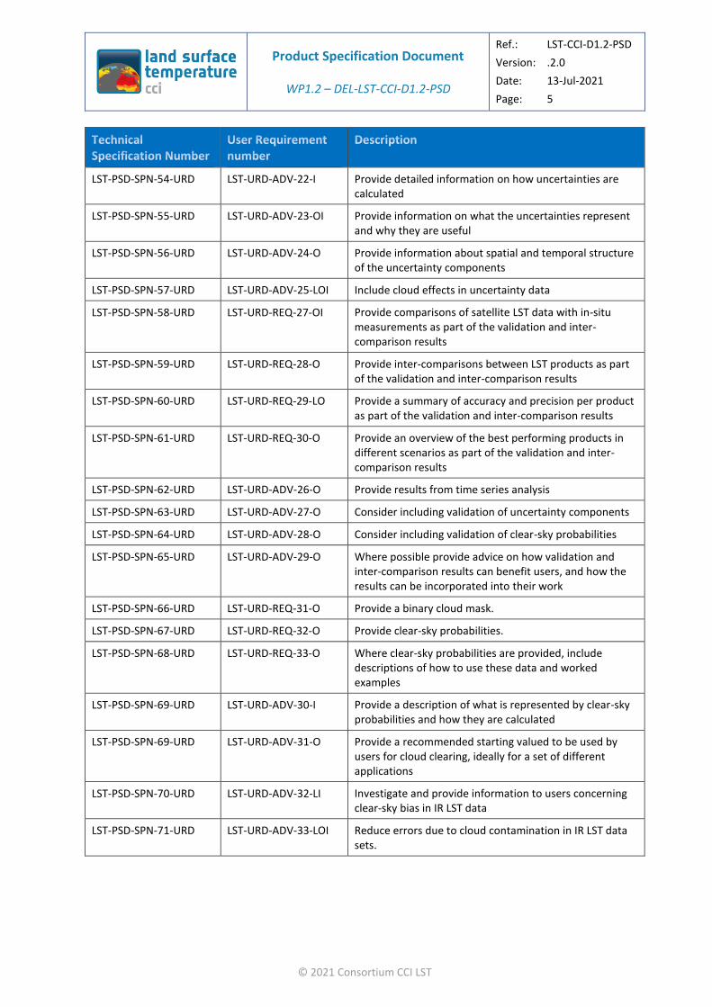
LST-PSD-SPN-54-URD LST-URD-ADV-22-I Provide detailed information on how uncertainties are calculated
LST-PSD-SPN-55-URD LST-URD-ADV-23-OI Provide information on what the uncertainties represent and why they are useful
LST-PSD-SPN-56-URD LST-URD-ADV-24-O Provide information about spatial and temporal structure of the uncertainty components
LST-PSD-SPN-57-URD LST-URD-ADV-25-LOI Include cloud effects in uncertainty data
LST-PSD-SPN-58-URD LST-URD-REQ-27-OI Provide comparisons of satellite LST data with in-situ measurements as part of the validation and inter-comparison results
LST-PSD-SPN-59-URD LST-URD-REQ-28-O Provide inter-comparisons between LST products as part of the validation and inter-comparison results
LST-PSD-SPN-60-URD LST-URD-REQ-29-LO Provide a summary of accuracy and precision per product as part of the validation and inter-comparison results
LST-PSD-SPN-61-URD LST-URD-REQ-30-O Provide an overview of the best performing products in different scenarios as part of the validation and inter-comparison results
LST-PSD-SPN-62-URD LST-URD-ADV-26-O Provide results from time series analysis
LST-PSD-SPN-63-URD LST-URD-ADV-27-O Consider including validation of uncertainty components
LST-PSD-SPN-64-URD LST-URD-ADV-28-O Consider including validation of clear-sky probabilities
LST-PSD-SPN-65-URD LST-URD-ADV-29-O Where possible provide advice on how validation and inter-comparison results can benefit users, and how the results can be incorporated into their work
LST-PSD-SPN-66-URD LST-URD-REQ-31-O Provide a binary cloud mask.
LST-PSD-SPN-67-URD LST-URD-REQ-32-O Provide clear-sky probabilities.
LST-PSD-SPN-68-URD LST-URD-REQ-33-O Where clear-sky probabilities are provided, include descriptions of how to use these data and worked examples
LST-PSD-SPN-69-URD LST-URD-ADV-30-I Provide a description of what is represented by clear-sky probabilities and how they are calculated
LST-PSD-SPN-69-URD LST-URD-ADV-31-O Provide a recommended starting valued to be used by users for cloud clearing, ideally for a set of different applications
LST-PSD-SPN-70-URD LST-URD-ADV-32-LI Investigate and provide information to users concerning clear-sky bias in IR LST data
LST-PSD-SPN-71-URD LST-URD-ADV-33-LOI Reduce errors due to cloud contamination in IR LST data sets.

Product Specification Document
WP1.2 – DEL-LST-CCI-D1.2-PSD
Ref.: LST-CCI-D1.2-PSD
Version: .2.0
Date: 13-Jul-2021
Page: 6
© 2021 Consortium CCI LST
2. Introduction
2.1. Purpose and Scope
This document provides descriptions and specifications of products that shall be produced by the land surface temperature (LST) climate change initiative project (LST_CCI), which is part of the European Space Agency (ESA) Climate Change Initiative (CCI). The specifications were developed from user requirements defined in the LST_CCI User Requirements Document [AD-1].
2.2. Document
After this introduction, the document is divided into a number of major sections that are briefly described below:
❖ Section 3: Product Overview
This section provides a description of the products to be produced by the LST_CCI project as well as the user requirements that these products address and the improvements over existing products.
❖ Section 4: File Format and Metadata
This section gives information on the file format and metadata to be used for LST_CCI products, including information on filenames, global and variable attributes and unique product identifiers.
❖ Section 5: Product Specification
This section gives a detailed description of the contents of Level 2 and Level 3 satellite data files to be produced by LST_CCI.
It also provides a description of the uncertainty nomenclature to be used.
❖ Sections 6 to 9
These sections provide further information for users about the data products and their dissemination including:
File size estimates
Data access
Data documentation
Validation and intercomparison
Issues for future release of this document
2.3. Applicable Documents
The following is a list of applicable documents with a direct bearing on the content of this report. Where referenced in the text, these are identified as AD-xx, where ‘xx’ is the number in the table below.
Table 2: Reference documents.
[AD-1] LST CCI (2018) User Requirements Document, Reference LST-CCI-D1.1-URD - i1r0

Product Specification Document
WP1.2 – DEL-LST-CCI-D1.2-PSD
Ref.: LST-CCI-D1.2-PSD
Version: .2.0
Date: 13-Jul-2021
Page: 7
© 2021 Consortium CCI LST
2.4. Reference Documents
The following is a list of reference documents with a direct bearing on the content of this report. Where referenced in the text, these are identified as RD-xx, where ‘xx’ is the number in the table below.
Table 3: Reference documents.
[RD-1] GHRSST Science Team (2012), The Recommended GHRSST Data Specification (GDS) 2.0, document
revision 5, available from https://www.ghrsst.org/wp-content/uploads/2016/10/GDS20r5.pdf
(Accessed 29th November 2018).
[RD-2] NetCDF Climate and Forecast (CF) Metadata Convention; http://cfconventions.org/ (Accessed 29th
November 2018).
[RD-3] ESA Climate Office (2018) CCI data standards 2.0 (CCI-PRGM-EOPS-TN-13-0009), available from http://cci.esa.int/sites/default/files/filedepot/CCIDataStandards_v2-0_CCI-PRGM-EOPS-TN-13-0009.pdf
[RD-4] DUE GlobTemperature Project (2018), Product User Guide V3.0 (GlobT-WP3-DEL-11), available from
http://www.globtemperature.info/index.php/public-documentation/deliverables-1/108-globtemperature-product-user-guide/file (Accessed 5th December 2018)
[RD-5] NetCDF Attribute Convention on Dataset Discovery (ACDD):
http://wiki.esipfed.org/index.php/Category:Attribute_Conventions_Dataset_Discovery
(Accessed 6th December 2018).
[RD-6] The UDUNITS package; https://www.unidata.ucar.edu/software/udunits/
[RD-7] Russ Rew, Glenn Davis, Steve Emmerson, Harvey Davies, Ed Hartnett, Dennis Heimbigner and Ward Fisher (2018), The NetCDF Users Guide (NetCDF 4.6.2);
https://www.unidata.ucar.edu/software/netcdf/docs/user_guide.html (Accessed 12th December
2018)
[RD-8] DUE GlobTemperature Project (2016), Satellite LST User Handbook (GlobT-WP3-DEL-25), available from
http://www.globtemperature.info/index.php/public-documentation/deliverables-1/215-lst-handbook/file (Accessed 14th January 2019)

Product Specification Document
WP1.2 – DEL-LST-CCI-D1.2-PSD
Ref.: LST-CCI-D1.2-PSD
Version: .2.0
Date: 13-Jul-2021
Page: 8
© 2021 Consortium CCI LST
2.5. Glossary
The following terms have been used in this report with the meanings shown.
Table 4: Glossary.
AATSR Advanced ATSR
ACDD NetCDF Attribute Convention on Dataset Discovery
ATSR Along Track Scanning Radiometer; the ATSR series of instruments comprises ATSR-1, ATSR-2 and AATSR
AMSR-E Advanced Microwave Scanning Radiometer for EOS
AOD Aerosol Optical Depth
ATBD Algorithm Theoretical Basis Document
AVHRR Advanced Very High Resolution Radiometer
CAMEL Combined ASTER and MODIS Emissivity database over Land
CAR Climate Assessment Report
CCI Climate Change Initiative
CDR Climate Data Record
CF Climate and forecasting conventions
CIMSS Cooperative Institute for Meteorological Satellite Studies database of monthly land surface emissivity
DMSP Defense Meteorological Satellite Program
E3UB End to End ECV Uncertainty Budget
ECMWF The European Centre for Medium-Range Weather Forecasts
ECV Essential Climate Variable
ERA5 ECMWF Reanalysis 5
ERA-Interim ECMWF Reanalysis - Interim
ESA European Space Agency
FCOVER Copernicus Global Land Fraction of Vegetation Cover dataset
GDS GHRSST Data Specifications
GEO Geostationary orbit
GHRSST Group for High Resolution Sea Surface Temperature
GOES Geostationary Operational Environmental Satellite
IDL Interactive Data Language
IMS IMS
IR Infrared

Product Specification Document
WP1.2 – DEL-LST-CCI-D1.2-PSD
Ref.: LST-CCI-D1.2-PSD
Version: .2.0
Date: 13-Jul-2021
Page: 9
© 2021 Consortium CCI LST
JAMI Japanese Advanced Meteorological Imager
L2 Level 2 data
L2P Level 2 pre-processed data; geophysical variables at the full resolution of the instrument, in a satellite projection with associated geographical information.
L3 Level 3 data
L3U Level 3 uncollated data; gridded version of L2P data.
L3C Level 3 collated data; L2P data from a single instrument that have been combined and mapped onto a space-time grid.
L3S Level 3 super-collated data; L2P data from multiple instruments that have been combined and mapped onto a space-time grid.
LCC Land Cover Classification
LEO Low Earth Orbit
LST Land Surface Temperature
LST_CCI Land Surface Temperature Climate Change Initiative
MATLAB Matrix Laboratory
MODIS Moderate Resolution Imaging Spectroradiometer
MSG Meteosat Second Generation
MTSAT Multifunctional Transport Satellites
MW Microwave
NetCDF Network Common Data Format
NDVI Normalized Difference Vegetation index
PSD Product Specification Document
PUG Product User Guide
PVIR Product Validation and Intercomparison Report
QC Quality control
REA Reanalysis
RDAC Regional Data Assembly Centre.
SC Snow Cover
SEVIRI Spinning Enhanced Visible Infra-Red Imager
SLSTR Sea and Land Surface Temperature Radiometer
SR Surface Reflectance
SSM/I Special Sensor Microwave - Imager
SSMIS Special Sensor Microwave - Imager/Sounder
UUID Universal Unique Identifier

Product Specification Document
WP1.2 – DEL-LST-CCI-D1.2-PSD
Ref.: LST-CCI-D1.2-PSD
Version: .2.0
Date: 13-Jul-2021
Page: 10
© 2021 Consortium CCI LST
3. Product Overview
3.1. Summary of Products
An overview of the products to be produced by the LST_CCI project is shown in Table 5. More details on the products can be found in Section 3.2. The table also records which satellite sensors will be used to create the products and the format of the input data. The final column indicates the level of data to be produced from each sensor and the resolution/grid spacing of the data in the files. All LST CCI datasets specified in Table 5 will be made available via the CCI Open Data Portal (http://cci.esa.int/data) as well as the GlobTemperature Data Portal (http://data.globtemperature.info/)
The table indicates that the project will produce data at levels L2P, L3U, L3C and L3S. These are all defined below. As the project will receive some data at data level L1B, this is also defined below.
❖ L1B Level 1 B data
The data collected by the satellite sensor with processing (for example calibration) applied.
❖ L2P Level 2 pre-processed data
Geophysical variables at the full resolution of the instrument, in a satellite projection with associated geographical information.
❖ L3U Level 3 uncollated data
Spatially averaged version of L2P data.
❖ L3C Level 3 collated data
L3U data from a single instrument that have been combined and temporally averaged.
❖ L3S Level 3 super-collated data
L3U data from multiple instruments that have been combined and temporally averaged onto a common grid.
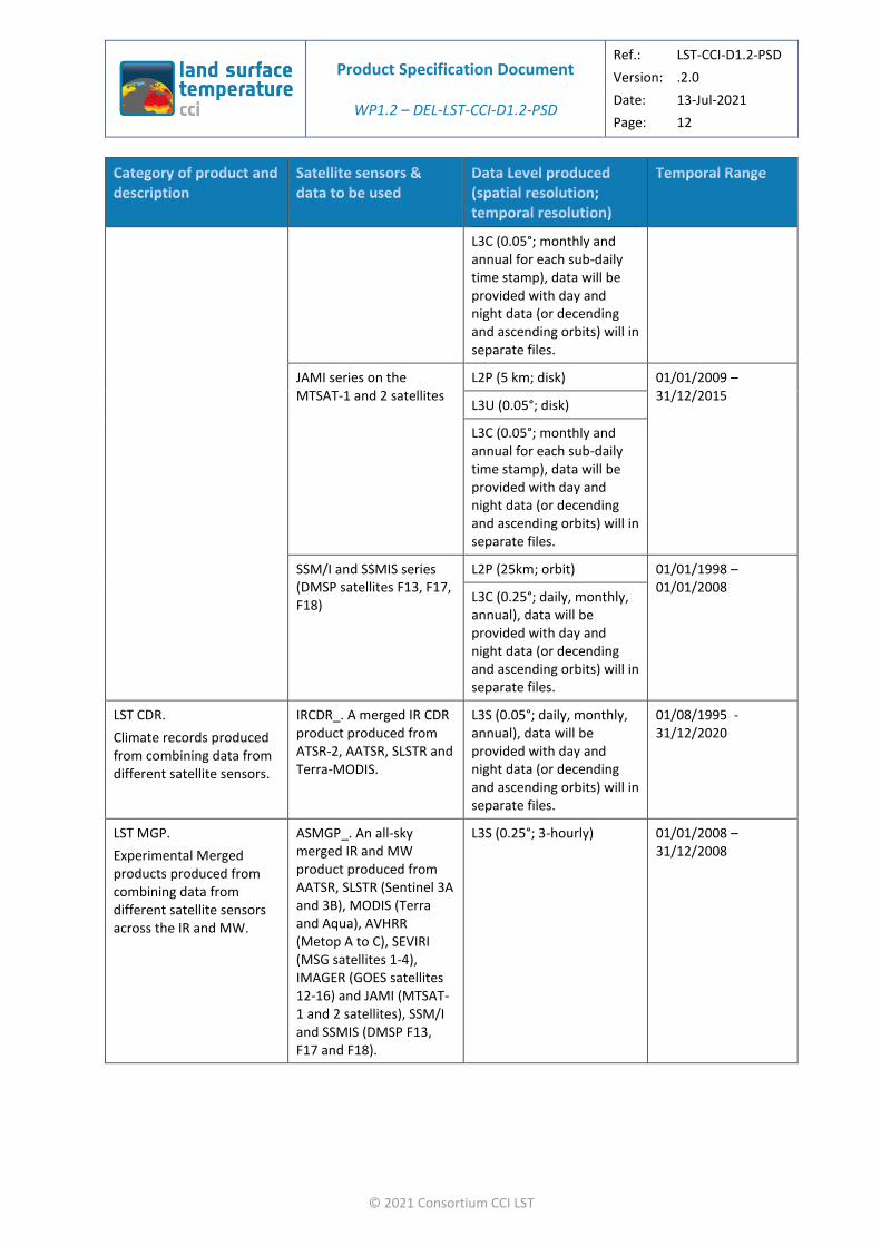
Table 5: Summary of LST_CCI products, the source and level of data to be produced. Please note that for Low Earth Orbit (LEO) sensors L3U data will be an internal-only (internal to LST_CCI) product.
LST ECV.
Climate records formed from single satellite sensors.
ATSR series (ATSR-2, AATSR) (Envisat format)
L2P (1 km; orbit) 01/08/1995 – 08/04/2012
L3C (0.01°, 0.05°; daily, multi-day composite, monthly, annual), data will be provided with day and night data (or decending and ascending orbits) will in separate files.
L2P (1 km; orbit)

Product Specification Document
WP1.2 – DEL-LST-CCI-D1.2-PSD
Ref.: LST-CCI-D1.2-PSD
Version: .2.0
Date: 13-Jul-2021
Page: 11
© 2021 Consortium CCI LST
MODIS series (Terra and Aqua)
L3C (0.01°, 0.05°; daily, multi-day composite, monthly, annual), data will be provided with day and night data (or decending and ascending orbits) will in separate files.
18/12/1999 - 31/12/2020
SEVIRI on MSG satellites 1-4
L2P (5 km; disk) 01/01/2004 - 31/12/2020
L3U (0.05°; disk)
L3C (0.05°; monthly and annual for each sub-daily time stamp), data will be provided with day and night data (or decending and ascending orbits) will in separate files.
AVHRR on NOAA platforms 15—19
L2P (1 km; orbit) 13/05/1998 -31/12/2020
L3C (0.01°, 0.05°; daily, multi-day composite, monthly, annual), data will be provided with day and night data (or decending and ascending orbits) will in separate files.
AVHRR on Metop platforms A to C
L2P (1 km; orbit) 01/01/2007 - 31/12/2020
L3C (0.01°, 0.05°; daily, multi-day composite, monthly, annual), data will be provided with day and night data (or decending and ascending orbits) will in separate files.
SLSTR series (Sentinel 3A and Sentinel 3B)
L2P (1 km; orbit) 16/02/2016 – 31/12/2020
L3C (0.01°, 0.05°; daily, multi-day composite, monthly, annual), data will be provided with day and night data (or decending and ascending orbits) will in separate files.
IMAGER series on GOES satellites 12-16
L2P (5 km; disk) 01/01/2004 - 31/12/2020
L3U (0.05°; disk)
Product Specification Document
WP1.2 – DEL-LST-CCI-D1.2-PSD
Ref.: LST-CCI-D1.2-PSD
Version: .2.0
Date: 13-Jul-2021
Page: 12
© 2021 Consortium CCI LST
L3C (0.05°; monthly and annual for each sub-daily time stamp), data will be provided with day and night data (or decending and ascending orbits) will in separate files.
JAMI series on the MTSAT-1 and 2 satellites
L2P (5 km; disk) 01/01/2009 – 31/12/2015
L3U (0.05°; disk)
L3C (0.05°; monthly and annual for each sub-daily time stamp), data will be provided with day and night data (or decending and ascending orbits) will in separate files.
SSM/I and SSMIS series (DMSP satellites F13, F17, F18)
L2P (25km; orbit) 01/01/1998 – 01/01/2008
L3C (0.25°; daily, monthly, annual), data will be provided with day and night data (or decending and ascending orbits) will in separate files.
LST CDR.
Climate records produced from combining data from different satellite sensors.
IRCDR_. A merged IR CDR product produced from ATSR-2, AATSR, SLSTR and Terra-MODIS.
L3S (0.05°; daily, monthly, annual), data will be provided with day and night data (or decending and ascending orbits) will in separate files.
01/08/1995 - 31/12/2020
LST MGP.
Experimental Merged products produced from combining data from different satellite sensors across the IR and MW.
ASMGP_. An all-sky merged IR and MW product produced from AATSR, SLSTR (Sentinel 3A and 3B), MODIS (Terra and Aqua), AVHRR (Metop A to C), SEVIRI (MSG satellites 1-4), IMAGER (GOES satellites 12-16) and JAMI (MTSAT-1 and 2 satellites), SSM/I and SSMIS (DMSP F13, F17 and F18).
L3S (0.25°; 3-hourly) 01/01/2008 – 31/12/2008

Product Specification Document
WP1.2 – DEL-LST-CCI-D1.2-PSD
Ref.: LST-CCI-D1.2-PSD
Version: .2.0
Date: 13-Jul-2021
Page: 13
© 2021 Consortium CCI LST
IRMGP_. A merged IR CDR product produced from AATSR, SLSTR (Sentinel 3A and 3B), MODIS (Terra and Aqua), AVHRR (Metop A to C), SEVIRI (MSG satellites 1-4), IMAGER (GOES satellites 12-16) and JAMI (MTSAT-1 and 2 satellites).
L3S (0.05°; daily, monthly, annual), data will be provided with day and night data (or decending and ascending orbits) will in separate files.
01/01/2009-31/12/2020
3.2. Details of Products
Each product entry in Table 5 is expanded in Table 6 (LST ECVs) and Table 7 (LST CDRs and LST MGP). This table provides full details of each product. This includes aspects such as the file names, the file sizes etc.
The headings to the columns in Table 2 define unique names for each product. These shall be appended in brackets with the name of an individual sensor if it is necessary to distinguish between sensors in a series. For example the individual components of the ATSR ECV product shall be referred to as ATSR ECV (ATSR-2) and ATSR ECV (AATSR).
Users should note that requirements for different varieties of data to be created from the L2 and L3 data (for example L3 files with different grid spacing at multiples of 0.05° or containing a blend of data from different sensors) will be compatible with the CCI toolbox.

Product Specification Document
WP1.2 – DEL-LST-CCI-D1.2-PSD
Ref.: LST-CCI-D1.2-PSD
Version: .2.0
Date: 13-Jul-2021
Page: 14
© 2021 Consortium CCI LST
Table 6: Detailed description of the LST_CCI products (LST ECVs). The column headings define unique names for each product.
Product Group
LST ECV
Satellite sensors used
ATSR series (ATSR-2, AATSR)
MODIS series (Terra, Aqua)
SEVIRI series (MSG Platforms)
AVHRR series (AVHRR on NOAA platforms)
AVHRR series (AVHRR on Metop platforms)
SLSTR series (Sentinel 3A, 3B)
IMAGER series (GOES platforms)
JAMI series (MTSAT platforms)
SSM/I and SSMIS series (DMSP F13, F17 and F18).
Satellite sensor type
Infrared Infrared Infrared Infrared Infrared Infrared Infrared Infrared Microwave
Satellite Platform
ERS-2, Envisat Terra, Aqua MSG satellites 1-4
NOAA platforms 15—19
Metop platforms A to C
Sentinel 3A, Sentinel 3B
GOES satellites 12-16
MTSAT-1 and 2 satellites
DMSP satellites F11, F13 and F17
Satellite Orbit Polar Polar Geostationary Polar Polar Polar Geostationary Geostationary Polar
Input data source
ESA NASA EUMETSAT NOAA EUMETSAT ESA NOAA JMA CM SAF, NOAA
Input data format
Envisat HDF-EOS HRIT NetCDF NetCDF NetCDF-4 GVAR LRIT NetCDF
Input data level
L1B
Product Specification Document
WP1.2 – DEL-LST-CCI-D1.2-PSD
Ref.: LST-CCI-D1.2-PSD
Version: .2.0
Date: 13-Jul-2021
Page: 15
© 2021 Consortium CCI LST
Input data frequency
One file per orbit per sensor (typically 14 orbits per day, one sensor operating 1995-2012 with overlap periods between sensors)
One file per orbit granule per sensor (typically 288 granules per pay, two sensors operating)
One scan every 15 mins.
One file per orbit per sensor (typically 14 orbits per day, one primary operational sensor operating at any one time)
One file per orbit per sensor (typically 14 orbits per day, one primary operational sensor operating at any one time)
3 minute PDUs (granules).
One scan every 30 mins.
One scan every 30 mins.
One file per orbit per sensor (typically 14 orbits per day, one primary operational sensor operating at any one time)
Input data grid
1 km orbit grid 1 km orbit grid 5 km disk 1 km orbit grid 1 km orbit grid 1 km orbit grid 5 km disk 5 km disk 2 km orbit
Input data spatial coverage
Global Global 79° W to 79° E longitude, 81° S to 81° N latitude
Global Global Global 156° W to 6° E longitude, 78° S to 78° N latitude
64° E to 134° W longitude, 81° S to 81° N latitude
Global
Processing to be applied by the project
LST retrieval, LST uncertainty estimates, cloud screening.
LST retrieval, LST uncertainty estimates, cloud screening.
LST retrieval, LST uncertainty estimates, cloud screening.
LST retrieval, LST uncertainty estimates, cloud screening.
LST retrieval, LST uncertainty estimates, cloud screening.
LST retrieval, LST uncertainty estimates, cloud screening.
LST retrieval, LST uncertainty estimates, cloud screening.
LST retrieval, LST uncertainty estimates, cloud screening.
LST retrieval, LST uncertainty estimates.
Output data level
L2P, L3C L2P, L3C L2P, L3U, L3C L2P, L3C L2P, L3C L2P, L3C L2P, L3U, L3C L2P, L3U, L3C L2P, L3C
Product Specification Document
WP1.2 – DEL-LST-CCI-D1.2-PSD
Ref.: LST-CCI-D1.2-PSD
Version: .2.0
Date: 13-Jul-2021
Page: 16
© 2021 Consortium CCI LST
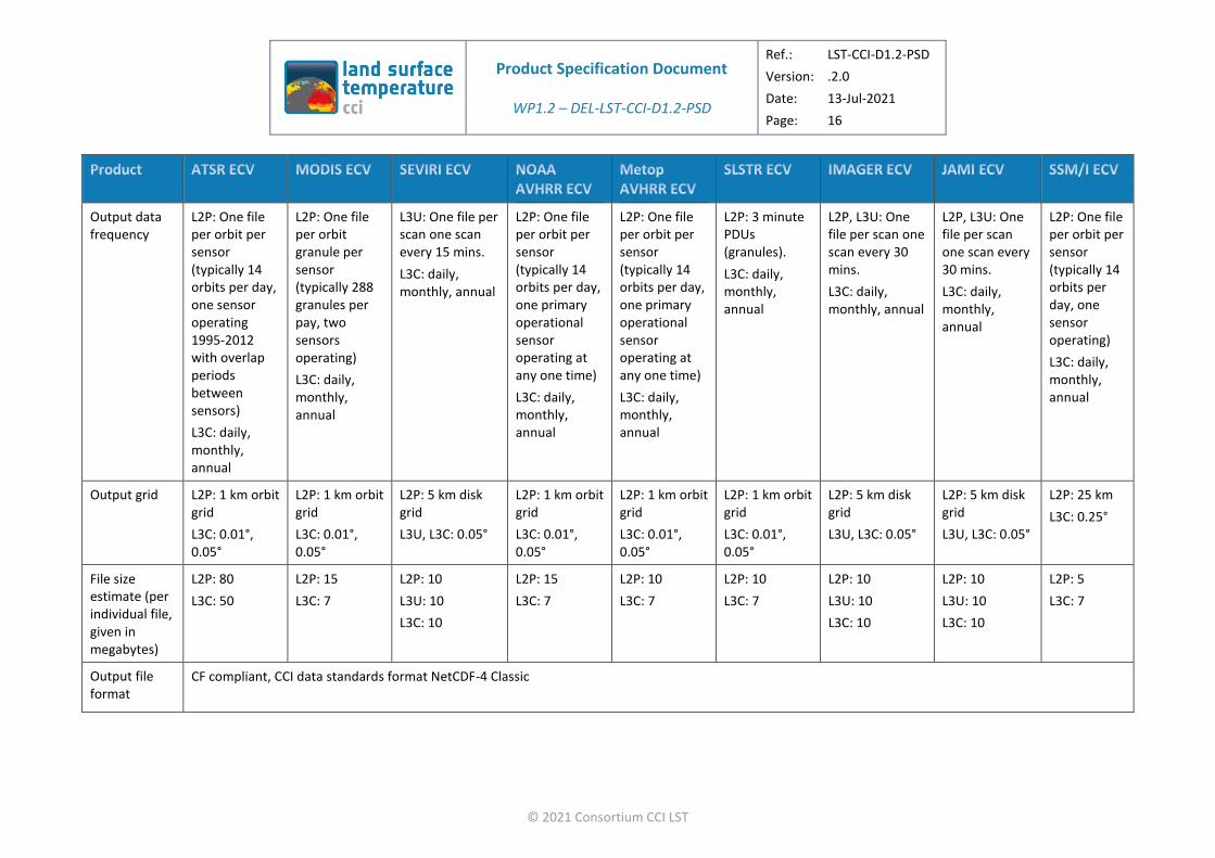
Output data frequency
L2P: One file per orbit per sensor (typically 14 orbits per day, one sensor operating 1995-2012 with overlap periods between sensors)
L3C: daily, monthly, annual
L2P: One file per orbit granule per sensor (typically 288 granules per pay, two sensors operating)
L3C: daily, monthly, annual
L3U: One file per scan one scan every 15 mins.
L3C: daily, monthly, annual
L2P: One file per orbit per sensor (typically 14 orbits per day, one primary operational sensor operating at any one time)
L3C: daily, monthly, annual
L2P: One file per orbit per sensor (typically 14 orbits per day, one primary operational sensor operating at any one time)
L3C: daily, monthly, annual
L2P: 3 minute PDUs (granules).
L3C: daily, monthly, annual
L2P, L3U: One file per scan one scan every 30 mins.
L3C: daily, monthly, annual
L2P, L3U: One file per scan one scan every 30 mins.
L3C: daily, monthly, annual
L2P: One file per orbit per sensor (typically 14 orbits per day, one sensor operating)
L3C: daily, monthly, annual
Output grid L2P: 1 km orbit grid
L3C: 0.01°, 0.05°
L2P: 1 km orbit grid
L3C: 0.01°, 0.05°
L2P: 5 km disk grid
L3U, L3C: 0.05°
L2P: 1 km orbit grid
L3C: 0.01°, 0.05°
L2P: 1 km orbit grid
L3C: 0.01°, 0.05°
L2P: 1 km orbit grid
L3C: 0.01°, 0.05°
L2P: 5 km disk grid
L3U, L3C: 0.05°
L2P: 5 km disk grid
L3U, L3C: 0.05°
L2P: 25 km
L3C: 0.25°
File size estimate (per individual file, given in megabytes)
L2P: 80
L3C: 50
L2P: 15
L3C: 7
L2P: 10
L3U: 10
L3C: 10
L2P: 15
L3C: 7
L2P: 10
L3C: 7
L2P: 10
L3C: 7
L2P: 10
L3U: 10
L3C: 10
L2P: 10
L3U: 10
L3C: 10
L2P: 5
L3C: 7
Output file format
CF compliant, CCI data standards format NetCDF-4 Classic
Product Specification Document
WP1.2 – DEL-LST-CCI-D1.2-PSD
Ref.: LST-CCI-D1.2-PSD
Version: .2.0
Date: 13-Jul-2021
Page: 17
© 2021 Consortium CCI LST
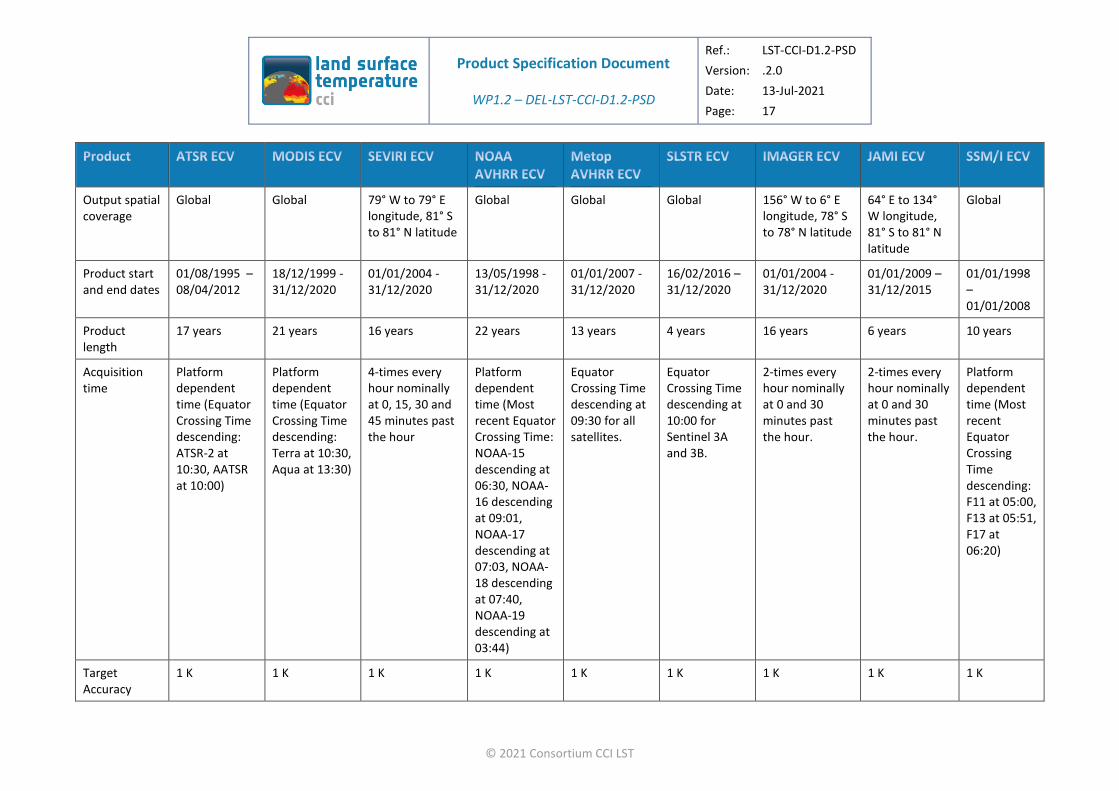
Output spatial coverage
Global Global 79° W to 79° E longitude, 81° S to 81° N latitude
Global Global Global 156° W to 6° E longitude, 78° S to 78° N latitude
64° E to 134° W longitude, 81° S to 81° N latitude
Global
Product start and end dates
01/08/1995 – 08/04/2012
18/12/1999 - 31/12/2020
01/01/2004 - 31/12/2020
13/05/1998 -31/12/2020
01/01/2007 - 31/12/2020
16/02/2016 – 31/12/2020
01/01/2004 - 31/12/2020
01/01/2009 – 31/12/2015
01/01/1998 – 01/01/2008
Product length
17 years 21 years 16 years 22 years 13 years 4 years 16 years 6 years 10 years
Acquisition time
Platform dependent time (Equator Crossing Time descending: ATSR-2 at 10:30, AATSR at 10:00)
Platform dependent time (Equator Crossing Time descending: Terra at 10:30, Aqua at 13:30)
4-times every hour nominally at 0, 15, 30 and 45 minutes past the hour
Platform dependent time (Most recent Equator Crossing Time: NOAA-15 descending at 06:30, NOAA-16 descending at 09:01, NOAA-17 descending at 07:03, NOAA-18 descending at 07:40, NOAA-19 descending at 03:44)
Equator Crossing Time descending at 09:30 for all satellites.
Equator Crossing Time descending at 10:00 for Sentinel 3A and 3B.
2-times every hour nominally at 0 and 30 minutes past the hour.
2-times every hour nominally at 0 and 30 minutes past the hour.
Platform dependent time (Most recent Equator Crossing Time descending: F11 at 05:00, F13 at 05:51, F17 at 06:20)
Target Accuracy
1 K 1 K 1 K 1 K 1 K 1 K 1 K 1 K 1 K

Product Specification Document
WP1.2 – DEL-LST-CCI-D1.2-PSD
Ref.: LST-CCI-D1.2-PSD
Version: .2.0
Date: 13-Jul-2021
Page: 18
© 2021 Consortium CCI LST
Target Stability
<0.1 K/decade <0.1 K/decade <0.1 K/decade <0.1 K/decade <0.1 K/decade <0.1 K/decade <0.1 K/decade <0.1 K/decade <0.1 K/decade
Target Precision
1 K 1 K 1 K 1 K 1 K 1 K 1 K 1 K 1 K
File names (read from top to bottom for each product).
Options are given in square brackets ([]).
Definitions of the fields contained in chevrons (<>) are in Section 4.2
ESACCI-LST-
[L2P or L3C]- [L2P or L3C]- [L2P, L3U or L3C]-
[L2P or L3C]- [L2P or L3C]- [L2P or L3C]- [L2P, L3U or L3C]-
[L2P, L3U or L3C]-
[L2P or L3C]-
LST-
[ATSR_2 or ATSR_3]-
[MODIST or MODISA]-
SEVIRI- AVHR<X>- SLSTR<X>- GOES<X> MTSAT<X> SSMI<X>
<Indicative Date><Indicative Time>-
fv<FileVersion>.nc

Product Specification Document
WP1.2 – DEL-LST-CCI-D1.2-PSD
Ref.: LST-CCI-D1.2-PSD
Version: .2.0
Date: 13-Jul-2021
Page: 19
© 2021 Consortium CCI LST
Table 7: Detailed description of the LST_CCI products (LST CDRs and LST MGP). The column headings define unique names for each product. Where it is necessary to distinguish between data from individual sensors in products that contain a series of sensors the name of the sensor shall be appended to the product name in brackets. For example the ATSR-2 part of the ECV ATSR product shall be referred to as ECV ATSR (ATSR-2).
Product Group LST MGP LST CDR LST MGP
Satellite sensors used AATSR, SLSTR, MODIS, AVHRR, SEVIRI, IMAGER and JAMI.
ATSR-2, AATSR, SLSTR and MODIS. AATSR, SLSTR, MODIS, AVHRR, SEVIRI, IMAGER, JAMI, SSM/I, and SSMIS.
Satellite sensor type Infrared Infrared Infrared and Microwave
Satellite Platform Envisat, Sentinel 3A and 3B, Terra and Aqua, Metop A to C, MSG satellites 1-4, GOES satellites 12-16, MTSAT-1 and 2 satellites.
Envisat, Sentinel 3A and 3B, Terra and Aqua.
Envisat, Sentinel 3A and 3B, Terra and Aqua, Metop A to C, MSG satellites 1-4, GOES satellites 12-16, MTSAT-1 and 2 satellites, DMSP F11, F13 and F17.
Satellite Orbit Polar and Geostationary Polar Polar and Geostationary
Input data source ATSR ECV (AATSR), SLSTR ECV, MODIS ECV, AVHRR ECV, SEVIRI ECV, IMAGER ECV, JAMI ECV
ATSR ECV, SLSTR ECV, MODIS ECV ATSR ECV (AATSR), SLSTR ECV, MODIS ECV, AVHRR ECV, SEVIRI ECV, IMAGER ECV, JAMI ECV, SSM/I ECV
Input data format LST_CCI format Netcdf
Input data level L2P

Product Specification Document
WP1.2 – DEL-LST-CCI-D1.2-PSD
Ref.: LST-CCI-D1.2-PSD
Version: .2.0
Date: 13-Jul-2021
Page: 20
© 2021 Consortium CCI LST
Input data frequency ATSR, AVHRR: One file per orbit per sensor (typically 14 orbits per day)
SLSTR: 3 minute PDUs (granules).
MODIS: One file per orbit granule per sensor (typically 288 granules per pay, two sensors operating)
SEVIRI: One scan every 15 mins.
IMAGER, JAMI: One scan every 30 mins.
ATSR, AVHRR: One file per orbit per sensor (typically 14 orbits per day)
SLSTR: 3 minute PDUs (granules).
MODIS: One file per orbit granule per sensor (typically 288 granules per pay, two sensors operating)
ATSR, AVHRR, SSM/I, SSMIS: One file per orbit per sensor (typically 14 orbits per day)
SLSTR: 3 minute PDUs (granules).
MODIS: One file per orbit granule per sensor (typically 288 granules per pay, two sensors operating)
SEVIRI: One scan every 15 mins.
IMAGER, JAMI: One scan every 30 mins.
Input data grid 1 km orbit grid and 5 km disk 1 km orbit grid 1 km orbit grid and 5 km disk
Input data spatial coverage Global Global Global
Processing to be applied by the project LST retrieval, LST uncertainty estimates, cloud screening, merging of LST retrievals and uncertainty estimates.
LST retrieval, LST uncertainty estimates, cloud screening, merging of LST retrievals and uncertainty estimates.
LST retrieval, LST uncertainty estimates, cloud screening, merging of LST retrievals and uncertainty estimates.
Output data level L3S
Output data frequency daily, monthly, annual 3 hourly
Output grid 0.05°
File size estimate L3S: 172 L3S: 100 L3S: 172
Output file format CF compliant, CCI data standards format NetCDF-4 Classic
Output spatial coverage Global
Product start and end dates 01/01/2008-31/12/2020 01/08/1995 - 31/12/2020 01/01/2008 – 31/12/2008
Product length 11 years 15 years 1 year
LST time of day Adjusted to 3-hourly Adjusted to 10.30 am and pm local time Adjusted to 3-hourly
Product Specification Document
WP1.2 – DEL-LST-CCI-D1.2-PSD
Ref.: LST-CCI-D1.2-PSD
Version: .2.0
Date: 13-Jul-2021
Page: 21
© 2021 Consortium CCI LST
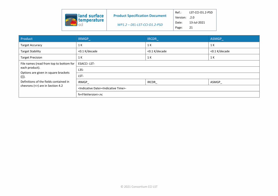
Target Accuracy 1 K 1 K 1 K
Target Stability <0.1 K/decade <0.1 K/decade <0.1 K/decade
Target Precision 1 K 1 K 1 K
File names (read from top to bottom for each product).
Options are given in square brackets ([]).
Definitions of the fields contained in chevrons (<>) are in Section 4.2
ESACCI- LST-
L3S-
LST-
IRMGP_ IRCDR_ ASMGP_
<Indicative Date><Indicative Time>-
fv<FileVersion>.nc
Product Specification Document
WP1.2 – DEL-LST-CCI-D1.2-PSD
Ref.: LST-CCI-D1.2-PSD
Version: .2.0
Date: 13-Jul-2021
Page: 22
© 2021 Consortium CCI LST
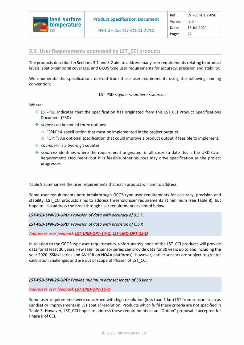
3.3. User Requirements addressed by LST_CCI products
The products described in Sections 3.1 and 3.2 aim to address many user requirements relating to product levels, spatio-temporal coverage, and GCOS type user requirements for accuracy, precision and stability.
We enumerate the specifications derived from these user requirements using the following naming convention:
LST-PSD-<type>-<number>-<source>
Where:
❖ LST-PSD indicates that the specification has originated from this LST CCI Product Specifications Document (PSD)
❖ <type> can be one of three options:
“SPN”: A specification that must be implemented in the project outputs.
“OPT”: An optional specification that could improve a product output if feasible to implement.
❖ <number> is a two-digit counter
❖ <source> identifies where the requirement originated, in all cases to date this is the URD (User Requirements Document) but it is feasible other sources may drive specification as the project progresses.
Table 8 summarises the user requirements that each product will aim to address.
Some user requirements note breakthrough GCOS type user requirements for accuracy, precision and stability. LST_CCI products aims to address threshold user requirements at minimum (see Table 8), but hope to also address the breakthrough user requirements as noted below.
LST-PSD-SPN-33-URD: Provision of data with accuracy of 0.5 K.
LST-PSD-SPN-35-URD: Provision of data with precision of 0.5 K
Addresses user feedback LST-URD-OPT-14-O, LST-URD-OPT-15-O
In relation to the GCOS type user requirements, unfortunately none of the LST_CCI products will provide data for at least 30 years. Few satellite sensor series can provide data for 30 years up to and including the year 2020 (SSM/I series and AVHRR on NOAA platforms). However, earlier sensors are subject to greater calibration challenges and are out of scope of Phase I of LST_CCI.
LST-PSD-SPN-26-URD: Provide minimum dataset length of 30 years.
Addresses user feedback LST-URD-OPT-11-O
Some user requirements were concerned with high resolution (less than 1 km) LST from sensors such as Landsat or improvements in LST spatial resolution. Products which fulfil these criteria are not specified in Table 5. However, LST_CCI hopes to address these requirements in an “Option” proposal if accepted for Phase II of CCI.

Product Specification Document
WP1.2 – DEL-LST-CCI-D1.2-PSD
Ref.: LST-CCI-D1.2-PSD
Version: .2.0
Date: 13-Jul-2021
Page: 23
© 2021 Consortium CCI LST
LST-PSD-SPN-21-URD: Provision of Landsat data.
LST-PSD-SPN-28-URD: Provide datasets with a spatial resolution finer than 1 km.
LST-PSD-SPN-45-URD: Improvements in LST spatial resolution should be prioritised.
Addresses user feedback LST-URD-ADV-13-O, LST-URD-OPT-12-O, LST-URD-ADV-21-LOI
Unfortunately, none of the LST_CCI products will provide data for at least 30 years. Few satellite sensor series can provide data for 30 years up to and including the year 2020, and of those that could provide 30 years of data (SSM/I series and AVHRR on NOAA platforms), however earlier sensors are subject to greater calibration challenges and out of scope of Phase I of LST_CCI.
LST-PSD-SPN-26-URD: Provide minimum dataset length of 30 years.
Addresses user feedback LST-URD-OPT-11-O
Table 8: Summary of user requirements that each LST_CCI product will aim to address.
ATSR ECV L2P (1 km; orbit) LST-PSD-SPN-14-URD: Provide LST data products at level 2.
LST-PSD-SPN-10-URD: Provide LST from IR LEO satellites.
LST-PSD-SPN-23-URD: Provide global coverage of LST data.
LST-PSD-SPN-24-URD: Provide observations at all hours of the day.
LST-PSD-SPN-38-URD: Provide data with a temporal resolution of 1 hour.
LST-PSD-SPN-27-URD: Provide datasets with a spatial resolution of 1 km.
LST-PSD-SPN-25-URD: Provide minimum dataset length of 10 years.
LST-PSD-SPN-32-URD: Provision of data with accuracy of 1 K.
LST-PSD-SPN-34-URD: Provision of data with precision of 1 K.
LST-PSD-SPN-36-URD: Provision of data with stability of 0.3 K.
LST-PSD-SPN-37-URD: Provision of data with stability of 0.2 K.
Addresses user feedback LST-URD-REQ-06-O, LST-URD-REQ-02-O, LST-URD-REQ-09-O, LST-URD-REQ-10-O, RBR-13-O, LST-URD-REQ-12-O, LST-URD-REQ-11-O, LST-URD-REQ-14-O, LST-URD-REQ-15-O, LST-URD-REQ-16-O, LST-URD-OPT-16-O
L3C (0.01°, 0.05°; daily, monthly, annual)
LST-PSD-SPN-15-URD: Provide LST data products at level 3C.
LST-PSD-SPN-10-URD: Provide LST from IR LEO satellites.
LST-PSD-SPN-23-URD: Provide global coverage of LST data.
LST-PSD-SPN-27-URD: Provide datasets with a spatial resolution of 1 km.
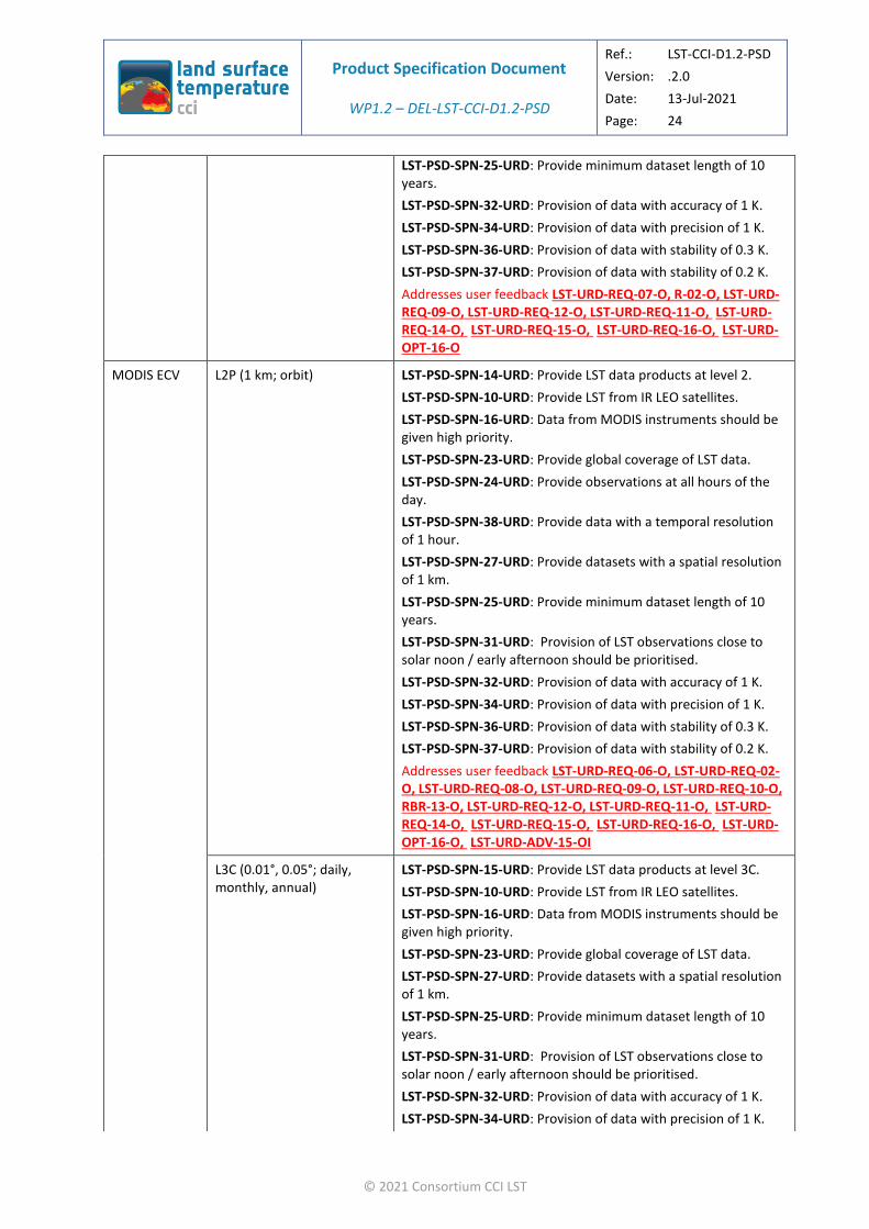
Product Specification Document
WP1.2 – DEL-LST-CCI-D1.2-PSD
Ref.: LST-CCI-D1.2-PSD
Version: .2.0
Date: 13-Jul-2021
Page: 24
© 2021 Consortium CCI LST
LST-PSD-SPN-25-URD: Provide minimum dataset length of 10 years.
LST-PSD-SPN-32-URD: Provision of data with accuracy of 1 K.
LST-PSD-SPN-34-URD: Provision of data with precision of 1 K.
LST-PSD-SPN-36-URD: Provision of data with stability of 0.3 K.
LST-PSD-SPN-37-URD: Provision of data with stability of 0.2 K.
Addresses user feedback LST-URD-REQ-07-O, R-02-O, LST-URD-REQ-09-O, LST-URD-REQ-12-O, LST-URD-REQ-11-O, LST-URD-REQ-14-O, LST-URD-REQ-15-O, LST-URD-REQ-16-O, LST-URD-OPT-16-O
MODIS ECV L2P (1 km; orbit) LST-PSD-SPN-14-URD: Provide LST data products at level 2.
LST-PSD-SPN-10-URD: Provide LST from IR LEO satellites.
LST-PSD-SPN-16-URD: Data from MODIS instruments should be given high priority.
LST-PSD-SPN-23-URD: Provide global coverage of LST data.
LST-PSD-SPN-24-URD: Provide observations at all hours of the day.
LST-PSD-SPN-38-URD: Provide data with a temporal resolution of 1 hour.
LST-PSD-SPN-27-URD: Provide datasets with a spatial resolution of 1 km.
LST-PSD-SPN-25-URD: Provide minimum dataset length of 10 years.
LST-PSD-SPN-31-URD: Provision of LST observations close to solar noon / early afternoon should be prioritised.
LST-PSD-SPN-32-URD: Provision of data with accuracy of 1 K.
LST-PSD-SPN-34-URD: Provision of data with precision of 1 K.
LST-PSD-SPN-36-URD: Provision of data with stability of 0.3 K.
LST-PSD-SPN-37-URD: Provision of data with stability of 0.2 K.
Addresses user feedback LST-URD-REQ-06-O, LST-URD-REQ-02-O, LST-URD-REQ-08-O, LST-URD-REQ-09-O, LST-URD-REQ-10-O, RBR-13-O, LST-URD-REQ-12-O, LST-URD-REQ-11-O, LST-URD-REQ-14-O, LST-URD-REQ-15-O, LST-URD-REQ-16-O, LST-URD-OPT-16-O, LST-URD-ADV-15-OI
L3C (0.01°, 0.05°; daily, monthly, annual)
LST-PSD-SPN-15-URD: Provide LST data products at level 3C.
LST-PSD-SPN-10-URD: Provide LST from IR LEO satellites.
LST-PSD-SPN-16-URD: Data from MODIS instruments should be given high priority.
LST-PSD-SPN-23-URD: Provide global coverage of LST data.
LST-PSD-SPN-27-URD: Provide datasets with a spatial resolution of 1 km.
LST-PSD-SPN-25-URD: Provide minimum dataset length of 10 years.
LST-PSD-SPN-31-URD: Provision of LST observations close to solar noon / early afternoon should be prioritised.
LST-PSD-SPN-32-URD: Provision of data with accuracy of 1 K.
LST-PSD-SPN-34-URD: Provision of data with precision of 1 K.

Product Specification Document
WP1.2 – DEL-LST-CCI-D1.2-PSD
Ref.: LST-CCI-D1.2-PSD
Version: .2.0
Date: 13-Jul-2021
Page: 25
© 2021 Consortium CCI LST
LST-PSD-SPN-36-URD: Provision of data with stability of 0.3 K.
LST-PSD-SPN-37-URD: Provision of data with stability of 0.2 K.
Addresses user feedback LST-URD-REQ-07-O, LST-URD-REQ-02-O, LST-URD-REQ-08-O, LST-URD-REQ-09-O, LST-URD-REQ-12-O, LST-URD-REQ-11-O, LST-URD-REQ-14-O, LST-URD-REQ-15-O, LST-URD-REQ-16-O, LST-URD-OPT-16-O, LST-URD-ADV-15-OI
SEVIRI ECV L2P (5 km; disk) LST-PSD-SPN-14-URD: Provide LST data products at level 2.
LST-PSD-SPN-11-URD: Provide LST from IR GEO satellites.
LST-PSD-SPN-20-URD: Provision of Meteosat data.
LST-PSD-SPN-24-URD: Provide observations at all hours of the day.
LST-PSD-SPN-38-URD: Provide data with a temporal resolution of 1 hour.
LST-PSD-SPN-25-URD: Provide minimum dataset length of 10 years.
LST-PSD-SPN-31-URD: Provision of LST observations close to solar noon / early afternoon should be prioritised.
LST-PSD-SPN-32-URD: Provision of data with accuracy of 1 K.
LST-PSD-SPN-34-URD: Provision of data with precision of 1 K.
LST-PSD-SPN-36-URD: Provision of data with stability of 0.3 K.
LST-PSD-SPN-37-URD: Provision of data with stability of 0.2 K.
Addresses user feedback LST-URD-REQ-06-O, LST-URD-REQ-03-O, LST-URD-ADV-12-O, LST-URD-REQ-10-O, RBR-13-O, LST-URD-REQ-11-O, LST-URD-REQ-14-O, LST-URD-REQ-15-O, LST-URD-REQ-16-O, LST-URD-OPT-16-O, LST-URD-ADV-15-OI
L3U (0.05°; disk) LST-PSD-SPN-11-URD: Provide LST from IR GEO satellites.
LST-PSD-SPN-20-URD: Provision of Meteosat data.
LST-PSD-SPN-24-URD: Provide observations at all hours of the day.
LST-PSD-SPN-38-URD: Provide data with a temporal resolution of 1 hour.
LST-PSD-SPN-25-URD: Provide minimum dataset length of 10 years.
LST-PSD-SPN-31-URD: Provision of LST observations close to solar noon / early afternoon should be prioritised.
LST-PSD-SPN-32-URD: Provision of data with accuracy of 1 K.
LST-PSD-SPN-34-URD: Provision of data with precision of 1 K.
LST-PSD-SPN-36-URD: Provision of data with stability of 0.3 K.
LST-PSD-SPN-37-URD: Provision of data with stability of 0.2 K.
Addresses user feedback LST-URD-REQ-03-O, LST-URD-ADV-12-O, LST-URD-REQ-10-O, RBR-13-O, LST-URD-REQ-11-O, LST-URD-REQ-14-O, LST-URD-REQ-15-O, LST-URD-REQ-16-O, LST-URD-OPT-16-O, LST-URD-ADV-15-OI
L3C (0.05°; daily, monthly, annual)
LST-PSD-SPN-15-URD: Provide LST data products at level 3C.
LST-PSD-SPN-11-URD: Provide LST from IR GEO satellites.
LST-PSD-SPN-20-URD: Provision of Meteosat data.

Product Specification Document
WP1.2 – DEL-LST-CCI-D1.2-PSD
Ref.: LST-CCI-D1.2-PSD
Version: .2.0
Date: 13-Jul-2021
Page: 26
© 2021 Consortium CCI LST
LST-PSD-SPN-25-URD: Provide minimum dataset length of 10 years.
LST-PSD-SPN-31-URD: Provision of LST observations close to solar noon / early afternoon should be prioritised.
LST-PSD-SPN-32-URD: Provision of data with accuracy of 1 K.
LST-PSD-SPN-34-URD: Provision of data with precision of 1 K.
LST-PSD-SPN-36-URD: Provision of data with stability of 0.3 K.
LST-PSD-SPN-37-URD: Provision of data with stability of 0.2 K.
Addresses user feedback LST-URD-REQ-07-O, LST-URD-REQ-03-O, LST-URD-ADV-12-O, LST-URD-REQ-11-O, LST-URD-REQ-14-O, LST-URD-REQ-15-O, LST-URD-REQ-16-O, LST-URD-OPT-16-O, LST-URD-ADV-15-OI
NOAA AVHRR ECV
L2P (1 km; orbit) LST-PSD-SPN-14-URD: Provide LST data products at level 2.
LST-PSD-SPN-10-URD: Provide LST from IR LEO satellites.
LST-PSD-SPN-22-URD: Provision of AVHRR data.
LST-PSD-SPN-23-URD: Provide global coverage of LST data.
LST-PSD-SPN-24-URD: Provide observations at all hours of the day.
LST-PSD-SPN-38-URD: Provide data with a temporal resolution of 1 hour.
LST-PSD-SPN-27-URD: Provide datasets with a spatial resolution of 1 km.
LST-PSD-SPN-25-URD: Provide minimum dataset length of 10 years.
LST-PSD-SPN-32-URD: Provision of data with accuracy of 1 K.
LST-PSD-SPN-34-URD: Provision of data with precision of 1 K.
LST-PSD-SPN-36-URD: Provision of data with stability of 0.3 K.
LST-PSD-SPN-37-URD: Provision of data with stability of 0.2 K.
Addresses user feedback LST-URD-REQ-06-O, LST-URD-REQ-02-O, LST-URD-ADV-14-O, LST-URD-REQ-09-O, LST-URD-REQ-10-O, RBR-13-O, LST-URD-REQ-12-O, LST-URD-REQ-11-O, LST-URD-REQ-14-O, LST-URD-REQ-15-O, LST-URD-REQ-16-O, LST-URD-OPT-16-O
L3C (0.01°, 0.05°; daily, monthly, annual)
LST-PSD-SPN-15-URD: Provide LST data products at level 3C.
LST-PSD-SPN-22-URD: Provision of AVHRR data.
LST-PSD-SPN-23-URD: Provide global coverage of LST data.
LST-PSD-SPN-27-URD: Provide datasets with a spatial resolution of 1 km.
LST-PSD-SPN-25-URD: Provide minimum dataset length of 10 years.
LST-PSD-SPN-32-URD: Provision of data with accuracy of 1 K.
LST-PSD-SPN-34-URD: Provision of data with precision of 1 K.
LST-PSD-SPN-36-URD: Provision of data with stability of 0.3 K.
LST-PSD-SPN-37-URD: Provision of data with stability of 0.2 K.
Addresses user feedback LST-URD-REQ-07-O, LST-URD-ADV-14-O, LST-URD-REQ-09-O, LST-URD-REQ-12-O, LST-URD-REQ-11-O,
Product Specification Document
WP1.2 – DEL-LST-CCI-D1.2-PSD
Ref.: LST-CCI-D1.2-PSD
Version: .2.0
Date: 13-Jul-2021
Page: 27
© 2021 Consortium CCI LST
LST-URD-REQ-14-O, LST-URD-REQ-15-O, LST-URD-REQ-16-O, LST-URD-OPT-16-O
Metop AVHRR ECV
L2P (1 km; orbit) LST-PSD-SPN-14-URD: Provide LST data products at level 2.
LST-PSD-SPN-10-URD: Provide LST from IR LEO satellites.
LST-PSD-SPN-22-URD: Provision of AVHRR data.
LST-PSD-SPN-23-URD: Provide global coverage of LST data.
LST-PSD-SPN-24-URD: Provide observations at all hours of the day.
LST-PSD-SPN-38-URD: Provide data with a temporal resolution of 1 hour.
LST-PSD-SPN-27-URD: Provide datasets with a spatial resolution of 1 km.
LST-PSD-SPN-25-URD: Provide minimum dataset length of 10 years.
LST-PSD-SPN-32-URD: Provision of data with accuracy of 1 K.
LST-PSD-SPN-34-URD: Provision of data with precision of 1 K.
LST-PSD-SPN-36-URD: Provision of data with stability of 0.3 K.
LST-PSD-SPN-37-URD: Provision of data with stability of 0.2 K.
Addresses user feedback LST-URD-REQ-06-O, LST-URD-REQ-02-O, LST-URD-ADV-14-O, LST-URD-REQ-09-O, LST-URD-REQ-10-O, RBR-13-O, LST-URD-REQ-12-O, LST-URD-REQ-11-O, LST-URD-REQ-14-O, LST-URD-REQ-15-O, LST-URD-REQ-16-O, LST-URD-OPT-16-O
L3C (0.01°, 0.05°; daily, monthly, annual)
LST-PSD-SPN-15-URD: Provide LST data products at level 3C.
LST-PSD-SPN-10-URD: Provide LST from IR LEO satellites.
LST-PSD-SPN-22-URD: Provision of AVHRR data.
LST-PSD-SPN-23-URD: Provide global coverage of LST data.
LST-PSD-SPN-27-URD: Provide datasets with a spatial resolution of 1 km.
LST-PSD-SPN-25-URD: Provide minimum dataset length of 10 years.
LST-PSD-SPN-32-URD: Provision of data with accuracy of 1 K.
LST-PSD-SPN-34-URD: Provision of data with precision of 1 K.
LST-PSD-SPN-36-URD: Provision of data with stability of 0.3 K.
LST-PSD-SPN-37-URD: Provision of data with stability of 0.2 K.
Addresses user feedback LST-URD-REQ-07-O, LST-URD-REQ-02-O, LST-URD-ADV-14-O, LST-URD-REQ-09-O, LST-URD-REQ-12-O, LST-URD-REQ-11-O, LST-URD-REQ-14-O, LST-URD-REQ-15-O, LST-URD-REQ-16-O, LST-URD-OPT-16-O
SLSTR ECV L2P (1 km; orbit) LST-PSD-SPN-14-URD: Provide LST data products at level 2.
LST-PSD-SPN-10-URD: Provide LST from IR LEO satellites.
LST-PSD-SPN-23-URD: Provide global coverage of LST data.
LST-PSD-SPN-24-URD: Provide observations at all hours of the day.
LST-PSD-SPN-38-URD: Provide data with a temporal resolution of 1 hour.

Product Specification Document
WP1.2 – DEL-LST-CCI-D1.2-PSD
Ref.: LST-CCI-D1.2-PSD
Version: .2.0
Date: 13-Jul-2021
Page: 28
© 2021 Consortium CCI LST
LST-PSD-SPN-27-URD: Provide datasets with a spatial resolution of 1 km.
LST-PSD-SPN-32-URD: Provision of data with accuracy of 1 K.
LST-PSD-SPN-34-URD: Provision of data with precision of 1 K.
LST-PSD-SPN-36-URD: Provision of data with stability of 0.3 K.
LST-PSD-SPN-37-URD: Provision of data with stability of 0.2 K.
Addresses user feedback LST-URD-REQ-06-O, LST-URD-REQ-02-O, LST-URD-REQ-09-O, LST-URD-REQ-10-O, RBR-13-O, LST-URD-REQ-12-O, LST-URD-REQ-14-O, LST-URD-REQ-15-O, LST-URD-REQ-16-O, LST-URD-OPT-16-O
L3C (0.01°, 0.05°; daily, monthly, annual)
LST-PSD-SPN-15-URD: Provide LST data products at level 3C.
LST-PSD-SPN-10-URD: Provide LST from IR LEO satellites.
LST-PSD-SPN-23-URD: Provide global coverage of LST data.
LST-PSD-SPN-27-URD: Provide datasets with a spatial resolution of 1 km.
LST-PSD-SPN-36-URD: Provision of data with stability of 0.3 K.
LST-PSD-SPN-37-URD: Provision of data with stability of 0.2 K.
Addresses user feedback LST-URD-REQ-07-O, LST-URD-REQ-02-O, LST-URD-REQ-09-O, LST-URD-REQ-12-O, LST-URD-REQ-14-O, LST-URD-REQ-15-O, LST-URD-REQ-16-O, LST-URD-OPT-16-O
IMAGER ECV L2P (5 km; disk) LST-PSD-SPN-14-URD: Provide LST data products at level 2.
LST-PSD-SPN-11-URD: Provide LST from IR GEO satellites.
LST-PSD-SPN-24-URD: Provide observations at all hours of the day.
LST-PSD-SPN-38-URD: Provide data with a temporal resolution of 1 hour.
LST-PSD-SPN-25-URD: Provide minimum dataset length of 10 years.
LST-PSD-SPN-31-URD: Provision of LST observations close to solar noon / early afternoon should be prioritised.
LST-PSD-SPN-32-URD: Provision of data with accuracy of 1 K.
LST-PSD-SPN-34-URD: Provision of data with precision of 1 K.
LST-PSD-SPN-36-URD: Provision of data with stability of 0.3 K.
LST-PSD-SPN-37-URD: Provision of data with stability of 0.2 K.
Addresses user feedback LST-URD-REQ-06-O, LST-URD-REQ-03-O, LST-URD-REQ-10-O, RBR-13-O, LST-URD-REQ-11-O, LST-URD-REQ-14-O, LST-URD-REQ-15-O, LST-URD-REQ-16-O, LST-URD-OPT-16-O, LST-URD-ADV-15-OI
L3U (0.05°; disk) LST-PSD-SPN-11-URD: Provide LST from IR GEO satellites.
LST-PSD-SPN-24-URD: Provide observations at all hours of the day.
LST-PSD-SPN-38-URD: Provide data with a temporal resolution of 1 hour.
LST-PSD-SPN-25-URD: Provide minimum dataset length of 10 years.
LST-PSD-SPN-31-URD: Provision of LST observations close to solar noon / early afternoon should be prioritised.

Product Specification Document
WP1.2 – DEL-LST-CCI-D1.2-PSD
Ref.: LST-CCI-D1.2-PSD
Version: .2.0
Date: 13-Jul-2021
Page: 29
© 2021 Consortium CCI LST
LST-PSD-SPN-32-URD: Provision of data with accuracy of 1 K.
LST-PSD-SPN-34-URD: Provision of data with precision of 1 K.
LST-PSD-SPN-36-URD: Provision of data with stability of 0.3 K.
LST-PSD-SPN-37-URD: Provision of data with stability of 0.2 K.
Addresses user feedback LST-URD-REQ-03-O, LST-URD-REQ-10-O, RBR-13-O, LST-URD-REQ-11-O, LST-URD-REQ-14-O, LST-URD-REQ-15-O, LST-URD-REQ-16-O, LST-URD-OPT-16-O, LST-URD-ADV-15-OI
L3C (0.05°; daily, monthly, annual)
LST-PSD-SPN-15-URD: Provide LST data products at level 3C.
LST-PSD-SPN-11-URD: Provide LST from IR GEO satellites.
LST-PSD-SPN-25-URD: Provide minimum dataset length of 10 years.
LST-PSD-SPN-31-URD: Provision of LST observations close to solar noon / early afternoon should be prioritised.
LST-PSD-SPN-32-URD: Provision of data with accuracy of 1 K.
LST-PSD-SPN-34-URD: Provision of data with precision of 1 K.
LST-PSD-SPN-36-URD: Provision of data with stability of 0.3 K.
LST-PSD-SPN-37-URD: Provision of data with stability of 0.2 K.
Addresses user feedback LST-URD-REQ-07-O, LST-URD-REQ-03-O, LST-URD-REQ-11-O, LST-URD-REQ-14-O, LST-URD-REQ-15-O, LST-URD-REQ-16-O, LST-URD-OPT-16-O, LST-URD-ADV-15-OI
JAMI ECV L2P (5 km; disk) LST-PSD-SPN-14-URD: Provide LST data products at level 2.
LST-PSD-SPN-11-URD: Provide LST from IR GEO satellites.
LST-PSD-SPN-24-URD: Provide observations at all hours of the day.
LST-PSD-SPN-38-URD: Provide data with a temporal resolution of 1 hour.
LST-PSD-SPN-31-URD: Provision of LST observations close to solar noon / early afternoon should be prioritised.
LST-PSD-SPN-32-URD: Provision of data with accuracy of 1 K.
LST-PSD-SPN-34-URD: Provision of data with precision of 1 K.
LST-PSD-SPN-36-URD: Provision of data with stability of 0.3 K.
LST-PSD-SPN-37-URD: Provision of data with stability of 0.2 K.
Addresses user feedback LST-URD-REQ-06-O, LST-URD-REQ-03-O, LST-URD-REQ-10-O, RBR-13-O, LST-URD-REQ-14-O, LST-URD-REQ-15-O, LST-URD-REQ-16-O, LST-URD-OPT-16-O, LST-URD-ADV-15-OI
L3U (0.05°; disk) LST-PSD-SPN-11-URD: Provide LST from IR GEO satellites.
LST-PSD-SPN-24-URD: Provide observations at all hours of the day.
LST-PSD-SPN-38-URD: Provide data with a temporal resolution of 1 hour.
LST-PSD-SPN-31-URD: Provision of LST observations close to solar noon / early afternoon should be prioritised.
LST-PSD-SPN-32-URD: Provision of data with accuracy of 1 K.
LST-PSD-SPN-34-URD: Provision of data with precision of 1 K.

Product Specification Document
WP1.2 – DEL-LST-CCI-D1.2-PSD
Ref.: LST-CCI-D1.2-PSD
Version: .2.0
Date: 13-Jul-2021
Page: 30
© 2021 Consortium CCI LST
LST-PSD-SPN-36-URD: Provision of data with stability of 0.3 K.
LST-PSD-SPN-37-URD: Provision of data with stability of 0.2 K.
Addresses user feedback LST-URD-REQ-03-O, LST-URD-REQ-10-O, RBR-13-O, LST-URD-REQ-14-O, LST-URD-REQ-15-O, LST-URD-REQ-16-O, LST-URD-OPT-16-O, LST-URD-ADV-15-OI
L3C (0.05°; daily, monthly, annual)
LST-PSD-SPN-15-URD: Provide LST data products at level 3C.
LST-PSD-SPN-11-URD: Provide LST from IR GEO satellites.
LST-PSD-SPN-32-URD: Provision of data with accuracy of 1 K.
LST-PSD-SPN-34-URD: Provision of data with precision of 1 K.
LST-PSD-SPN-36-URD: Provision of data with stability of 0.3 K.
LST-PSD-SPN-37-URD: Provision of data with stability of 0.2 K.
Addresses user feedback LST-URD-REQ-07-O, LST-URD-REQ-03-O, LST-URD-REQ-14-O, LST-URD-REQ-15-O, LST-URD-REQ-16-O, LST-URD-OPT-16-O, LST-URD-ADV-15-OI
SSM/I ECV L2P (25km; orbit) LST-PSD-SPN-14-URD: Provide LST data products at level 2.
LST-PSD-SPN-18-URD: Provision of MW LST products.
LST-PSD-SPN-19-URD: Provision of all-sky LST datasets.
LST-PSD-SPN-23-URD: Provide global coverage of LST data.
LST-PSD-SPN-25-URD: Provide minimum dataset length of 10 years.
LST-PSD-SPN-32-URD: Provision of data with accuracy of 1 K.
LST-PSD-SPN-34-URD: Provision of data with precision of 1 K.
LST-PSD-SPN-36-URD: Provision of data with stability of 0.3 K.
LST-PSD-SPN-37-URD: Provision of data with stability of 0.2 K.
Addresses user feedback LST-URD-REQ-06-O, LST-URD-ADV-10-OI, LST-URD-ADV-11-LOI, LST-URD-REQ-09-O, LST-URD-REQ-11-O, LST-URD-REQ-14-O, LST-URD-REQ-15-O, LST-URD-REQ-16-O, LST-URD-OPT-16-O
L3C (0.25°; daily, monthly, annual)
LST-PSD-SPN-15-URD: Provide LST data products at level 3C.
LST-PSD-SPN-18-URD: Provision of MW LST products.
LST-PSD-SPN-19-URD: Provision of all-sky LST datasets.
LST-PSD-SPN-23-URD: Provide global coverage of LST data.
LST-PSD-SPN-25-URD: Provide minimum dataset length of 10 years.
LST-PSD-SPN-32-URD: Provision of data with accuracy of 1 K.
LST-PSD-SPN-34-URD: Provision of data with precision of 1 K.
LST-PSD-SPN-36-URD: Provision of data with stability of 0.3 K.
LST-PSD-SPN-37-URD: Provision of data with stability of 0.2 K.
Addresses user feedback LST-URD-REQ-07-O, LST-URD-ADV-10-OI, LST-URD-ADV-11-LOI, LST-URD-REQ-09-O, LST-URD-REQ-11-O, LST-URD-REQ-14-O, LST-URD-REQ-15-O, LST-URD-REQ-16-O, LST-URD-OPT-16-O
IRMGP_ L3S (0.05°; daily, monthly, annual)
LST-PSD-SPN-13-URD: Provide products produced by merging LEO and GEO datasets.
LST-PSD-SPN-23-URD: Provide global coverage of LST data.

Product Specification Document
WP1.2 – DEL-LST-CCI-D1.2-PSD
Ref.: LST-CCI-D1.2-PSD
Version: .2.0
Date: 13-Jul-2021
Page: 31
© 2021 Consortium CCI LST
LST-PSD-SPN-25-URD: Provide minimum dataset length of 10 years.
LST-PSD-SPN-31-URD: Provision of LST observations close to solar noon / early afternoon should be prioritised.
LST-PSD-SPN-32-URD: Provision of data with accuracy of 1 K.
LST-PSD-SPN-34-URD: Provision of data with precision of 1 K.
LST-PSD-SPN-36-URD: Provision of data with stability of 0.3 K.
LST-PSD-SPN-37-URD: Provision of data with stability of 0.2 K.
Addresses user feedback LST-URD-REQ-05-LO, LST-URD-REQ-09-O, LST-URD-REQ-09-O, LST-URD-REQ-11-O, LST-URD-REQ-14-O, LST-URD-REQ-15-O, LST-URD-REQ-16-O, LST-URD-OPT-16-O, LST-URD-ADV-15-OI
IR CDR_ L3S (0.05°; daily, monthly, annual)
LST-PSD-SPN-10-URD: Provide LST from IR LEO satellites.
LST-PSD-SPN-12-URD: Provide products which merge LST from multiple IR LEO satellite datasets to create a long running, near-global CDR.
LST-PSD-SPN-23-URD: Provide global coverage of LST data.
LST-PSD-SPN-25-URD: Provide minimum dataset length of 10 years.
LST-PSD-SPN-32-URD: Provision of data with accuracy of 1 K.
LST-PSD-SPN-34-URD: Provision of data with precision of 1 K.
LST-PSD-SPN-36-URD: Provision of data with stability of 0.3 K.
LST-PSD-SPN-37-URD: Provision of data with stability of 0.2 K.
Addresses user feedback LST-URD-REQ-02-O, LST-URD-REQ-04-O, LST-URD-REQ-09-O, LST-URD-REQ-11-O, LST-URD-REQ-14-O, LST-URD-REQ-15-O, LST-URD-REQ-16-O, LST-URD-OPT-16-O
ASMGP_ L3S (0.05°; 3-hourly) LST-PSD-SPN-13-URD: Provide products produced by merging LEO and GEO datasets.
LST-PSD-SPN-19-URD: Provision of all-sky LST datasets.
LST-PSD-SPN-23-URD: Provide global coverage of LST data.
LST-PSD-SPN-29-URD: Provide data with temporal resolution of 6 hours.
LST-PSD-SPN-32-URD: Provision of data with accuracy of 1 K.
LST-PSD-SPN-34-URD: Provision of data with precision of 1 K.
LST-PSD-SPN-36-URD: Provision of data with stability of 0.3 K.
LST-PSD-SPN-37-URD: Provision of data with stability of 0.2 K.
Addresses user feedback LST-URD-REQ-05-LO, LST-URD-ADV-11-LOI, LST-URD-REQ-09-O, LST-URD-REQ-09-O, LST-URD-REQ-13-O, LST-URD-REQ-14-O, LST-URD-REQ-15-O, LST-URD-REQ-16-O, LST-URD-OPT-16-O
Product Specification Document
WP1.2 – DEL-LST-CCI-D1.2-PSD
Ref.: LST-CCI-D1.2-PSD
Version: .2.0
Date: 13-Jul-2021
Page: 32
© 2021 Consortium CCI LST
3.4. Improvements over existing products
The new products to be produced by the LST_CCI project will address a number of the weaknesses of existing LST data that are perceived by users and take advantage of their strengths. These strengths and weaknesses are described in full in [AD-1]. Some points of relevance to the LST_CCI products are summarised below:
❖ Long term records of LST can be developed from sensors such as ATSR and AVHRR.
AVHRR TIR data can provide a long record of land surface temperature. However, AVHRR LST is not harmonised yet. There are also issues with calibration (being addressed in the FIDUCEO project (http://www.fiduceo.eu/) and orbital drift (to be addressed during LST_CCI).
ATSR sensors, and their successor the SLSTR sensors, provide a long record of land surface temperature with stability in local crossing times and calibration as well as high accuracy. Yet there is a gap in the record between loss of contact with the AATSR sensor on Envisat in 2012 and the launch of SLSTR on Sentinel 3A in 2016.
An ATSR-SLSTR Climate Data Record will aim to produce a gap-free, long term record of LST, using MODIS data to bridge and fill the data gap between ATSR and SLSTR sensors (2012-2016). A prototype of this CDR was produced during the GlobTemperature project (http://www.globtemperature.info/) with a first experimental approach to homogenising to a common acquisition time and no L1 harmonisation. Both of these challenges will be address in LST_CCI. This will aim to provide multi-decadal, homogenised datasets, free from non-climatic discontinuities.
LST-PSD-SPN-17-URD: Provide multi-decadal, homogenised datasets, free from non-climatic discontinuities.
Addresses user feedback LST-URD-ADV-09-LI
LST_CCI products from sensors such as ATSR and AVHRR, will be produced at L2P (generally 14 orbits per day) and daily L3C in order to prioritise both high temporal resolution as well as long datasets. These datasets will also provide relatively high resolution data at 1 km (L2P) and 0.01°-0.05° (L3C)
LST-PSD-SPN-41-URD: Datasets intended for global studies should prioritise high temporal resolution and long datasets.
LST-PSD-SPN-42-URD: Datasets intended for local studies should prioritise high spatial resolution.
Addresses user feedback LST-URD-ADV-17-O, LST-URD-ADV-18-O
❖ The modern satellite observing system includes IR sensors (on both polar orbiting and geostationary platforms) and microwave sensors which have individual strengths and weaknesses for retrieving LST.
Retrievals in the IR are generally more accurate than MW retrievals due to smaller variation of surface emissivities, better instrument calibration, independence of measurements from other temperature datasets, and stronger dependence of the radiance on temperature. They also provide higher spatial resolution LST. Yet, TIR retrievals cannot be accomplished in the presence of cloud.

Product Specification Document
WP1.2 – DEL-LST-CCI-D1.2-PSD
Ref.: LST-CCI-D1.2-PSD
Version: .2.0
Date: 13-Jul-2021
Page: 33
© 2021 Consortium CCI LST
Microwave measurements usually have a larger spatial resolution per pixel than retrievals in the IR, but have a lower sensitivity to non-precipitating clouds, offering increased coverage in cloudy conditions.
The production of a merged IR Climate Data Record will aim to combine the advantages of LEO and GEO for thermal infrared derived LST. Additionally, the production of a prototype all-sky merged product will aim to combine the advantages of IR and MW sensors for monitoring LST under different cloud conditions and at different spatio-temporal resolutions.
❖ Cloud contamination was a major concern for users of IR derived LSTs.
During LST_CCI, different cloud different probability schemes (Bayesian and Probabilistic) will be investigated and compared with operational cloud masks and threshold-based approaches.
For LST_CCI data products at L2P, data will be provided without explicit cloud masking but with information in a quality control bit mask and clear-sky probabilities where appropriate for the cloud mask applied to the specific sensor.
Single-sensor ECV products (for example the MODIS ECV) at L3U and L3C will all utilise the best cloud algorithm for that specific LST product, established from previous studies.
For multi-sensor ECVs, cloud detection work carried out in WP2.4 of LST_CCI will determine the best cloud algorithm for each product.
There will be a focus on instruments prioritised from a CDR perspective, but these would have the flexibility to be implemented across further sensors within any continuation work, allowing for cloud masking consistency across all LST data records.
Within this proposed approach, there remains the flexibility to use information from different channels when processing different instrument series to maximize the cloud detection efficiency.
LST_CCI will prioritise a consistent approach to cloud clearing and will provide pre-screen datasets (see Section 5). This project will also prioritise using the best cloud clearing algorithm for each sensor.
LST-PSD-SPN-43-URD: Datasets intended for global studies should prioritise using a consistent approach to cloud clearing and provide a pre-screened dataset.
LST-PSD-SPN-44-URD: Datasets intended for regional or local studies should prioritise using the best cloud clearing algorithm for each sensor, and allow the user to apply the cloud mask themselves.
Addresses user feedback LST-URD-ADV-19-O, LST-URD-ADV-20-O
❖ Accuracy, precision and stability of LST records are key for both users and GCOS ECV requirements.
LST_CCI will produce LST climate products, which are required to have:
Accuracy of < 1 K.
Precision of < 1 K.
Stability of < 0.3 K per decade.
LST-PSD-SPN-32-URD: Provision of data with accuracy of 1 K.
LST-PSD-SPN-34-URD: Provision of data with precision of 1 K.
LST-PSD-SPN-36-URD: Provision of data with stability of 0.3 K.
Addresses user feedback LST-URD-REQ-14-O, LST-URD-REQ-15-O, LST-URD-REQ-16-O
These match user requirements for accuracy, precision and stability.
LST_CCI will aim to improve upon these requirements to produce LST products with:
Product Specification Document
WP1.2 – DEL-LST-CCI-D1.2-PSD
Ref.: LST-CCI-D1.2-PSD
Version: .2.0
Date: 13-Jul-2021
Page: 34
© 2021 Consortium CCI LST
Accuracy of < 0.5 K.
Precision of < 0.5 K.
Stability of < 0.2 K per decade.
LST-PSD-SPN-33-URD: Provision of data with accuracy of 0.5 K.
LST-PSD-SPN-35-URD: Provision of data with precision of 0.5 K
LST-PSD-SPN-37-URD: Provision of data with stability of 0.2 K.
Addresses user feedback LST-URD-OPT-14-O, LST-URD-OPT-15-O, LST-URD-OPT-16-O
LST_CCI, at the request of users, will prioritise accuracy and high data quality over long-term stability and global spatially complete fields. However, we aim to address all of these issues in the products provided.
LST-PSD-SPN-39-URD: Product accuracy should be prioritised over long term stability and global spatially complete fields.
LST-PSD-SPN-40-URD: High data quality is more important than spatially complete fields.
Addresses user feedback LST-URD-REQ-17-L, LST-URD-REQ-18-O
❖ Users were interested in the provision of per pixel uncertainty components, as well as total uncertainty.
As detailed in Section 5, information for different uncertainty components (according to correlation properties) will be provided on a per pixel basis as well as total uncertainty derived from theses uncertainty components.
Other metadata which may be of use, such as the number of pixels flagged as clear sky or cloud contaminated, will also be provided.
LST-PSD-SPN-51-URD: Provide per pixel total uncertainty values.
LST-PSD-SPN-52-URD: Provide uncertainty data partitioned into components according to correlation properties.
Addresses user feedback LST-URD-REQ-24-LO, LST-URD-REQ-25-O
❖ Users requested that LST_CCI examine the provision of improved accuracy of LST retrievals for urban and arid biomes over existing products. This will be addressed in LST_CCI.
LST-PSD-SPN-38-URD: Improved accuracy of LST retrievals for urban and arid biomes
Addresses user feedback LST-URD-OPT-14-O

Product Specification Document
WP1.2 – DEL-LST-CCI-D1.2-PSD
Ref.: LST-CCI-D1.2-PSD
Version: .2.0
Date: 13-Jul-2021
Page: 35
© 2021 Consortium CCI LST
4. File Format and Metadata
4.1. Rationale
The format of the data files shall be Network Common Data Format (NetCDF) and shall follow Climate and Forecasting (CF) conventions. This is the format preferred by the majority of potential users of the products and recommended in the user requirements [AD-1].
LST-PSD-SPN-1-URD: Provide LST products in NetCDF format.
Addresses user feedback LST-URD-REQ-01-O
The use of NetCDF also allows the use of a variety of different tools and programming languages to manipulate and view the data, for example the CCI Toolbox and the tools available within languages such as the Interactive Data Language (IDL), the Matrix Laboratory (MATLAB) and Python. The use of NetCDF format is also a minimum requirement of the CCI Data Standards [RD-3].
NetCDF files are already very well established in the LST user community owing to the success of the GlobTemperature project (http://www.globtemperature.info/). GlobTemperature provides LST data products in a CF compliant NetCDF data format, known as the GlobTemperature Harmonised format and detailed in [RD-4]. The GlobTemperature Harmonised format already includes much of the data and metadata that users require and that LST_CCI wish to include in the files, as well as being very similar in many respects to the CCI Data Format requested by users. For LST_CCI we will follow CCI standard data formats [RD-3], which are generally similar to the GlobTemperature Harmonised file format [RD-4], and are compatible with the latest climate and forecasting (CF) conventions [RD-2]. Furthermore, the CCI data standards ensure a programme wide consistent data format.
LST-PSD-SPN-2-URD: CCI standard format is recommended for LST CCI products.
Addresses user feedback LST-URD-ADV-01-O
The format of recommended by CCI Data Standards is ‘NetCDF-4 classic’. Therefore this shall be used for LST_CCI files. ‘NetCDF-4 classic’ combines two aspects of the files: the underlying file format (NetCDF-4) and the data model (‘classic’). The NetCDF-4 file format uses Hierarchical Data Format version 5 (HDF5) as its base format and gives access to desirable features such as internal per variable compression. It is compatible with the NetCDF library from version 4. Although the NetCDF-4/HDF5 format is not compatible with older versions of the library, the additional features such as its compression abilities gives it clear advantages over the other options. The classic data model has a number of limitations compared to enhanced, for example the enhanced data model includes a greater number of allowed storage types. Either can be written using the NetCDF-4/HDF5 underlying format. The advantage of using the classic model is that it maintains compatibility with legacy software.
In summary:
❖ The LST_CCI files shall be NetCDF-4/HDF5 format and shall use the NetCDF classic data model.
❖ The file specifications shall follow CCI Data Standards and CF conventions.
❖ The file format will be based on CCI Data Standards.
❖ This will establish a single file specification covering all metadata requirements.

Product Specification Document
WP1.2 – DEL-LST-CCI-D1.2-PSD
Ref.: LST-CCI-D1.2-PSD
Version: .2.0
Date: 13-Jul-2021
Page: 36
© 2021 Consortium CCI LST
4.2. Filename convention
LST_CCI shall follow the file naming convention (form 2) specified in [RD-3] i.e.:
ESACCI-<CCI Project>-<Processing Level>-<Data Type>-<Product String>[-<Additional Segregator>]-<Indicative Date>[<Indicative Time>]-fv<FileVersion>.nc
The components to this list (with further explanatory information) which are relevant to LST_CCI are given in [RD-3] pages 13 to 20. That information is summarised here in Table 9 with an additional column (headed LST_CCI definition) that details the implementation of the filenaming convention that shall be used by the LST_CCI project. All the information required to define the LST_CCI files is contained within this document.
Table 9: Components of the filenames; based on [RD-3] – refer there for more details. The final column details the implementation for the LST_CCI project. In the Description column the references refer to sections of [RD-3]. All references in the LST_CCI column are to parts of this document.
<CCI Project> LST This is the standard project name as stated on Page 15 of [RD-3].
As stated in the description column.
<Processing Level> The data processing level code (L2P, L3U, L3C or L3S)
The data processing level code, defined on Pages 13-14 of [RD-3].
See Section 3.1 of this document.
<Data Type> LST This is a short term describing the main data type in the dataset.
This is set to the primary data type contained in the file, which will generally be LST.
<Product String> A character string identifying the LST product set.
Each ECV team defines the Product String they will use for their data and make this information available in their documentation.
The product string must not include hyphens, but can include underscores.
See
Table 10 of this document.
[-<Additional Segregator>]
An additional segreagator with further relevant information about the product.
Additional segragators provide further information about the product such as the spatio-temporal resolution or whether the product is day or night, for example:
• 0.05deg_1DAILY_NIGHT
o a 1 day composite of nighttime data at 0.05° resolution
• 0.05deg_1DAILY_ASC
o a 1 day composite of nighttime data from ascending orbits

Product Specification Document
WP1.2 – DEL-LST-CCI-D1.2-PSD
Ref.: LST-CCI-D1.2-PSD
Version: .2.0
Date: 13-Jul-2021
Page: 37
© 2021 Consortium CCI LST
<Indicative Date> YYYYMMDD The identifying date for this data set.
Format is YYYYMMDD, where YYYY is the four digit year, MM is the two digit month (either 00 for annual files, or from 01 to 12) and DD is the two digit day of the month (either 00 for annual and monthly files, or from 01 to 31). The date used should best represent the observation date for the data set.
As stated in the description column.
<Indicative Time> HHMMSS The identifying time for this data set in UTC. Format is HHMMSS where HH is the two digit hour from 00 to 23, MM is the two digit minute from 00 to 59 and SS is the two digit second from 00 to 59.
As stated in the description column.
<FileVersion> x.xx File version number in the form n{1,}[.n{1,}] (That is 1 or more digits followed by optional . and another 1 or more digits.)
Each external cycle will increment main digit by 1. Internal cycle will increment first digit after decimal point to 5. Each minor release will increment by second digit after decimal point. For example: 1.53 would be the Year 2 internal cycle 3rd minor release (such as due to a bug fix).
As stated in the description column.
Table 10: Product strings for data to be processed.
IRCDR_ Envisat, Sentinel 3A and 3B, Aqua, Terra
IRCDR_
ATSR-2 ERS-2 ATSR_2
AATSR Envisat ATSR_3
AVHRR NOAA-<X> or Metop<Y> AVHR<X> <X> is the satellite number of the NOAA platform
Or,
if the AVHRR is on a Metop platform <X> is ‘M’<Y>, where <Y> indicates the Metop platform (A or B).
IMAGER GOES<X> GOES<X> <X> is the satellite number of the GOES platform

Product Specification Document
WP1.2 – DEL-LST-CCI-D1.2-PSD
Ref.: LST-CCI-D1.2-PSD
Version: .2.0
Date: 13-Jul-2021
Page: 38
© 2021 Consortium CCI LST
IRMGP_ Envisat, Sentinel 3A and 3B, Aqua, Terra, Metop platforms, MSG, GOES, MTSAT
IRMGP_
ASMGP_ Envisat, Sentinel 3A and 3B, Aqua, Terra, Metop platforms, MSG, GOES, MTSAT, DMSP
ASMGP_
MODIS Aqua MODISA
MODIS Terra MODIST
JAMI MTSAT<X> MTSAT<X> <X> is the satellite number of the MTSAT platform
SLSTR Sentinel 3A or Sentinel 3B SLSTR<X> <X> indicates the Sentinel 3 platform (A or B).
SEVIRI MSG<X> SEVIRI <X> is the satellite number of the MSG platform
SSM/I, SSMIS DMSP-F<X> SSMI<X> <X> is the satellite number of the DMSP platform
4.3. Directory structure
LST_CCI shall use the following directory structure based on [RD-3] i.e.:
<Base Directory>/<ecv_product_type>_<ecv_level>/<version>/<year>[/<month>][/<day>]
So that, for example, for the MODIS ECV at Level L2P from the Terra sensor for the date 01/04/2018 the filepath for an example file (following the filenaming conventions given in Section 4.2) would be:
/group_workspaces/jasmin2/esacci_lst/TERRA_MODIS_L2P/1.00/2018/04/01/ESACCI-LST-L2P-LST-MODIST-20180401202000-fv1.00.nc
The components to this list (with further explanatory information) which are relevant to LST_CCI are given is provided in Table 11.

Product Specification Document
WP1.2 – DEL-LST-CCI-D1.2-PSD
Ref.: LST-CCI-D1.2-PSD
Version: .2.0
Date: 13-Jul-2021
Page: 39
© 2021 Consortium CCI LST
Table 11: Components of the directory structure; based on [RD-3].
<Base Directory> Location of the dataset.
Base folder of the dataset, for example a group workspace on a HPC system.
<platform> Platform information.
The platform data which is contained in the folder. The following are currently recognised for use in LST_CCI, where <x> indicates the number or letter associated with a platform (e.g. SENTINE3A, GOES12):
• CDR
• MGP
• ERS-2
• ENVISAT
• TERRA
• AQUA
• Metop<x>
• NOAA<x>
• MSG<x>
• GOES<x>
• MTSAT<x
• SENTINEL3<x>
<sensor> Sensor/s information.
The sensor data which is contained in the folder. The following are currently recognised for use in LST_CCI:
• ATSR-MODIS-SLSTR
• MERGED-IR
• MERGED-IR-MW
• SSMI
• ATSR-2
• AATSR
• MODIS
• AVHRR
• SEVIRI
• IMAGER
• JAMI
• SLSTR
<ecv_level> The data processing level code (L2P, L3U, L3C or L3S)
The data processing level code, defined on Pages 13-14 of [RD-3].

Product Specification Document
WP1.2 – DEL-LST-CCI-D1.2-PSD
Ref.: LST-CCI-D1.2-PSD
Version: .2.0
Date: 13-Jul-2021
Page: 40
© 2021 Consortium CCI LST
<Version> x.xx Version number of the dataset in the form n{1,}[.n{1,}] (That is 1 or more digits followed by optional . and another 1 or more digits.)
Each external cycle will increment main digit by 1. Internal cycle will increment first digit after decimal point to 5. Each minor release will increment by second digit after decimal point. For example: 1.53 would be the Year 2 internal cycle 3rd minor release (such as due to a bug fix).
This should match the version number of the files contained in this directory.
<yyyy>/<mm>/<dd>
The identifying date for this data set.
Format is <yyyy>/<mm>/<dd>, where YYYY is the four digit year, MM is the two digit month (either 00 for annual files, or from 01 to 12) and DD is the two digit day of the month (either 00 for annual and monthly files, or from 01 to 31). The date used should best represent the observation date for the data set.
4.4. Global attributes
Attributes are metadata that are stored in a NetCDF file. Global attributes contain information that applies to the whole contents of the NetCDF file. The CCI Data Standards document defines a set of global attributes that shall be included in LST_CCI files and also recommend attributes for data discovery [RD-3].
Table 12 contains a list of the global attributes employed in LST_CCI files. Much of this is reproduced from Pages 7 to 8 in [RD-3]. Points to note are:
❖ The definition of the shading of the rows in the table is given in Table 13.
❖ All references in the Description column refer to the contents of [RD-3].
❖ The final column, headed ‘LST_CCI definition’ contains information about the implementation of the attributes for the LST_CCI files. All references in this column are to parts of this document.
As revealed by the column headed ‘Source’, the definition of the attributes was based on CF conventions, the Unidata Attribute Convention for Dataset Discovery (ACDD) [RD-5], and the specifications provided by the CCI Data Standards [RD-3].

Product Specification Document
WP1.2 – DEL-LST-CCI-D1.2-PSD
Ref.: LST-CCI-D1.2-PSD
Version: .2.0
Date: 13-Jul-2021
Page: 41
© 2021 Consortium CCI LST
Table 12: Global attributes that are included in all LST_CCI format data files. Much of the contents of this table is reproduced from [RD-3] and further information can be found there.
title string A text string containing a succinct description of the dataset.
CF, ACDD
See examples in Section 5 and Appendix A.
institution string A text string detailing where the data was produced using names from the CCI common vocabulary.
CCI See examples in Section 5 and Appendix A.
source string A text string containing the original data source(s). If multiple sources and ancillary data are used this source be a comma-separated list.
CF See Section 4.6 in this document for the source codes relevant to the LST_CCI products.
history string Processing history of the dataset.
CF, ACDD
Appendix A contains an example of this.
references string References to ATBD, product specification document, technical note or other document describing the data.
CF Include any relevant publications or webpages.
tracking_id string A UUID (Universal Unique Identifier) value produced using version 4 (random number based) for consistency with CMIP5.
ACDD As stated in Description column.
Conventions string A text string identifying the netCDF conventions followed. This attribute should be set to the version of CF used and should also include the ACDD. For example: “CF-1.4, Unidata Observation Dataset v1.0”.
CF CF-1.8
product_version string A text string containing the product version of the dataset.
See Section 4.2 of this document
format_version string A text string containing the CCI data used for the dataset.
The CCI data format used, for example “CCI Data Standards v2.2”.
summary string A paragraph describing the dataset.
ACDD See examples in Section 5 and Appendix A.

Product Specification Document
WP1.2 – DEL-LST-CCI-D1.2-PSD
Ref.: LST-CCI-D1.2-PSD
Version: .2.0
Date: 13-Jul-2021
Page: 42
© 2021 Consortium CCI LST
keywords string A comma-separated list of key words and phrases. Typical keywords include: Earth Science, Land Surface, Land Temperature and Land Surface Temperature
ACDD As stated in Description column.
id string The filename of the file. ACDD As stated in Description column.
naming_authority string The naming authority. Fixed as le.ac.uk following ACDD convention.
ACDD As stated in Description column.
keywords_vocabulary string The guideline being followed for the words/phrases in the “keywords” attribute. For LST_CCI this is “NASA Global change Master Directory (GCMD) Science Keywords”.
ACDD As stated in Description column.
cdm_data_type string The THREDDS data type appropriate for this dataset. “swath” or “grid”.
ACDD “swath” if L2P file, otherwise “grid”
comment string Miscellaneous information about the data or methods used to produce it.
CF, ACDD
Should include the text "These data were produced as part of the ESA LST CCI project." as well as information on dataset length and coverage.
date_created string The date on which the data were produced in the form “yyyymmddThhmmssZ”. This time format is ISO 8601 compliant.
ACDD As stated in Description column.
creator_name string Provide a name and email address for the most relevant point of contact, as well as a URL relevant to this data set.
ACDD See examples in Appendix A.
creator_url
creator_email
project string The scientific project that produced the data. Set to “Climate Change Initiative - European Space Agency”.
ACDD As stated in Description column.

Product Specification Document
WP1.2 – DEL-LST-CCI-D1.2-PSD
Ref.: LST-CCI-D1.2-PSD
Version: .2.0
Date: 13-Jul-2021
Page: 43
© 2021 Consortium CCI LST
geospatial_lat_min float Southernmost latitude in decimal degrees north, range -90 to +90.
CCI, ACDD
As stated in Description column.
geospatial_lat_max float Northernmost latitude in decimal degrees north, range -180 to +180.
CCI, ACDD
As stated in Description column.
geospatial_lon_min float Westernmost longitude in decimal degrees north, range -180 to +180.
CCI, ACDD
As stated in Description column.
geospatial_lon_max float Easternmost longitude in decimal degrees north, range -180 to +180.
CCI, ACDD
As stated in Description column.
geospatial_vertical_min float Assumed to be in metres above ground unless geospatial_vertical_units attribute defined otherwise.
CCI, ACDD
Set to 0 for LST products.
geospatial_vertical_max float Assumed to be in metres above ground unless geospatial_vertical_units attribute defined otherwise.
CCI, ACDD
Set to 0 for LST products.
time_coverage_start string The time of the earliest observation contained in the data file in the form “yyyymmddThhmmssZ”.
ACDD As stated in Description column.
time_coverage_end string The time of the latest observation contained in the data file in the form “yyyymmddThhmmssZ”.
ACDD As stated in Description column.
time_coverage_duration string An ISO8601 string of the difference between time_coverage_start and time_coverage_end.
ACDD In the form PdDThHmMsS where d is the number of days, h is the number of hours, m is the number of minutes, s is the number of seconds, omitting dD etc. if the number is zero.
time_coverage_resolution string An ISO8601 string of the time coverage resolution for the data in the file. For L2 data on the original satellite sampling frequency it is acceptable to use ‘satellite_orbit_frequency’.
CCI, ACDD
‘satellite_orbit_frequency’ for L2P data and ISO8601 strings for L3 data.

Product Specification Document
WP1.2 – DEL-LST-CCI-D1.2-PSD
Ref.: LST-CCI-D1.2-PSD
Version: .2.0
Date: 13-Jul-2021
Page: 44
© 2021 Consortium CCI LST
standard_name_vocabulary string The name of the controlled vocabulary from which variable standard names are taken.
CF Set to "CF Standard Name Table v71".
license string Description of the data access and distribution restrictions.
ACDD Set to "ESA CCI Data Policy: free and open access".
platform string Satellite names from the CCI common vocabulary list. Comma-separated if more than one and angled brackets for a platform series.
CCI See Table 10 in this document for the platforms relevant to the LST_CCI products.
sensor string Sensor names from the CCI common vocabulary list. Comma-separated if more than one e.g. “MODIS, AATSR”.
CCI See Table 10 in this document for the platforms relevant to the LST_CCI products.
spatial_resolution string String describing the approximate resolution of the product For example, “1.1km at nadir”.
CCI Value depends on the product. See Table 5or Table 6.
key_variables string A comma-separated list of the key primary variables in the file i.e. those that have been scientifically validated and are appropriated for display in the CCI Open Data Portal and CCI Toolbox.
CCI Set as "land_surface_temperature".
geospatial_lat_units string Units of the latitudinal resolution. Typically “degrees_north”
Mandatory for gridded files on a regular lat/lon grid (L3C, L3U, and L3S).
geospatial_lon_units string Units of the longitudinal resolution. Typically “degrees_east”
Mandatory for gridded files on a regular lat/lon grid (L3C, L3U, and L3S).
geospatial_lat_resolution float Latitude Resolution in units matching geospatial_lat_units.
Mandatory for gridded files on a regular lat/lon grid (L3C, L3U, and L3S).
geospatial_lon_resolution float Latitude Resolution in units matching geospatial_lat_units.
Mandatory for gridded files on a regular lat/lon grid (L3C, L3U, and L3S).

Product Specification Document
WP1.2 – DEL-LST-CCI-D1.2-PSD
Ref.: LST-CCI-D1.2-PSD
Version: .2.0
Date: 13-Jul-2021
Page: 45
© 2021 Consortium CCI LST
Table 13: Key to colours used in Table 12 and Table 14.
Blue Mandatory item for all files.
Violet Mandatory for certain types of files. Optional for others.
4.5. Variable attributes
In the context of a NetCDF file a variable refers to an array of data stored within the file. Each variable can have attributes associated with it. [RD-3] defines some attributes that should be provided with variables, while CF conventions demand others.
As for the global attributes, the variable attributes to be utilised in LST_CCI files are given in Table 14. These attributes are based on [RD-3], CF conventions and variable attributes used for the GlobTemperature Harmonised Format. References within the table in the Description column refer to the contents of [RD-3] or to other external references. The LST_CCI implementation of the variables is given in the column headed ‘LST_CCI definition’. All references in this column are to parts of this document. There are some differences to the attributes to be used that depends on the nature of the data being stored; these are identified using violet shading (see Table 13).
Table 14: Global attributes that are included in all LST_CCI format data files. Much of the contents of this table is reproduced from [RD-3] and further information can be found there. Annotations and changes to the original text are made in places and these are written in italics. Note that attributes described as having the format ‘string’ shall actually be stored in the NetCDF file as an array of characters. The contents of the first four columns of this table are reproduced from [RD-3] and further information can be found there. References in those columns refer to parts of [RD-3]. Annotations and changes to the [RD-3] text are identified by italics. The final column contains the LST_CCI implementation of the attributes. All references in that column refer to parts of this document. Note that attributes described as having the format ‘string’ shall actually be stored in the NetCDF file as an array of characters.
long_name string A free-text descriptive variable name. CF, ACDD See specifications in Section 5.
standard_name string Where defined, a standard and unique description of a physical quantity. For the complete list of standard name strings, see [RD-5]. Do not include this attribute if no standard_name exists.
CF, ACDD See specifications in Section 5.
units string Text description of the units, preferably S.I., and must be compatible with the Unidata UDUNITS package [RD-6]. For a given variable (e.g. LST), these must be the same for each dataset.
CF, ACDD See specifications in Section 5.

Product Specification Document
WP1.2 – DEL-LST-CCI-D1.2-PSD
Ref.: LST-CCI-D1.2-PSD
Version: .2.0
Date: 13-Jul-2021
Page: 46
© 2021 Consortium CCI LST
_FillValue Must be same as the variable type
A value used to indicate array elements containing no valid data. This value must be of the same type as the storage (packed) type. This should be set for all variables except for time.
CF Set to -32768.
calendar string A string giving the calendar used for the time variable.
Set to "gregorian".
valid_min Expressed in same data type as variable
Minimum valid value for this variable once they are packed (in storage type). The fill value should be outside this valid range. This should be set for all variables except for time.
CF See specifications in Section 5.
valid_max Expressed in same data type as variable
Maximum valid value for this variable once they are packed (in storage type). The fill value should be outside this valid range. This should be set for all variables except for time.
CF See specifications in Section 5.
actual_range Expressed in same data type as variable
Gives the actual range of the data within the file, within the limits of the valid min and max.
CCI As given in description column.
coordinates string Identifies auxiliary coordinate variables, label variables, and alternative coordinate variables.
CF, CCI Set as “lat lon”, “ni nj” or “tie_lat tie_lon” for all gridded variables that are not dimension variables.
scale_factor Must be expressed in the unpacked data type
To be multiplied by the variable to recover the original value. Defined by the producer. Valid values within valid_min and valid_max should be transformed by scale_factor and add_offset, otherwise skipped to avoid floating point errors.
CF See specifications in Section 5.
The type of this attribute defines the type of the unpacked data.
add_offset Must be expressed in the unpacked data type
To be added to the variable after multiplying by the scale factor to recover the original value. If only one of scale_factor or add_offset is needed, then both should be included anyway to avoid ambiguity, with scale_factor defaulting to 1.0 and add_offset defaulting to 0.0.
CF See specifications in Section 5.
The type of this attribute defines the type of the unpacked data.
flag_meanings string Space-separated list of text descriptions. Words within a phrase should be connected with underscores.
CF See specifications in Section 5.
Used only for flags.
Product Specification Document
WP1.2 – DEL-LST-CCI-D1.2-PSD
Ref.: LST-CCI-D1.2-PSD
Version: .2.0
Date: 13-Jul-2021
Page: 47
© 2021 Consortium CCI LST
flag_masks Array of the data type of variable
Array of valid variable masks (required when the bit field contains independent Boolean conditions).
CF See specifications in Section 5.
Used only for flags.
ancillary_variables string Ancillary variables such as uncertainty or quality flags should be identified by the ancillary_variables attribute of the related primary variable.
CF, CCI Metadata which is provided for “lst” variable only.
4.6. Unique product identifiers
Some of the attributes described in Table 12 and Table 14 contain identifiers for the data that have been used to create the file. In Table 15 all the source data to be used by the project are listed together with the unique text strings that shall be used by to refer to these in the LST_CCI files.
The format of the text is:
❖ <Product String>-<RDAC>-<Processing Level>-<Additional Segregator>-v<Product Version>
The definition of these elements can be found in Table 9, with the exception of the following points:
❖ <Product Version> - this specifies the version of the dataset and should have the form x.y, where x is the major and y the minor version number.
❖ <RDAC> - Regional Data Assembly Centre.
❖ <Additional Segregator> - type of source data if not Level 1 IR or MW data.
FV is Fractional Vegetation
LSE is Land Surface Emissivity
DEM is Digital Elevation Model
LCC is Land Cover Classification
REA is Reanalysis
SC is Snow Cover
SR is Surface Reflectance
AOD is Aerosol Optical Depth
Table 15: Table of source data and unique product identifiers.
ATSR2 Level 1 ATSR2-ESA-L1-v3.0
AATSR Level 1 AATSR-ESA-L1-v3.0
SLSTR 3A Level 1 SLSTR3A-ESA-L1-v1.0
SLSTR 3B Level 1 SLSTR3B-ESA-L1-v1.0
MODIS Terra Level 1 MODIST-NASA-L1-v6.1
MODIS Aqua Level 1 MODISA-NASA-L1-v6.1

Product Specification Document
WP1.2 – DEL-LST-CCI-D1.2-PSD
Ref.: LST-CCI-D1.2-PSD
Version: .2.0
Date: 13-Jul-2021
Page: 48
© 2021 Consortium CCI LST
AVHRR Metop Level 1 AVHRRMTA-EUMETSAT-L1-v1.5
AVHRR NOAA Level 1 AVHRR<X>-NOAA-L1-v<Y> <X> is the satellite number; <Y> is the format version number in form x.y where x is the major format version (1, 2, 3, 4 or 5) and y is used to denote format changes where the major format number is unchanged (possible values are 0, 1 and 2).
SEVIRI Level 1 SEVIRI-EUMETSAT-L1-v1.0
IMAGER Level 1 IMAGER<X>-NOAA-L1-v<Y> <X> is the satellite number; <Y> is the format version number in form x.y where x is the major format version (1, 2, 3, 4 or 5) and y is used to denote format changes where the major format number is unchanged (possible values are 0, 1 and 2).
JAMI Level 1 JAMI<X>-JMA-L1-v<Y> <X> is the satellite number; <Y> is the format version number in form x.y where x is the major format version (1, 2, 3, 4 or 5) and y is used to denote format changes where the major format number is unchanged (possible values are 0, 1 and 2).
SSM/I Level 1 SSMI<X>-NOAA-L1-v3.0 <X> is the satellite number.
SSMIS Level 1 SSMI<X>-NOAA-L1-v3.0 <X> is the satellite number.
ERA5 reanalysis data ERA5-ECMWF-REA-c41r2 Version number format is non-standard.
ERA-Interim reanalysis data ERAI-ECMWF-REA-c31r2 Version number format is non-standard.
Geoland-2 FCOVER dataset FCOVER-Copernicus-FV-v2.0
UW/CIMSS Baseline Fit Global Infrared Land Surface Emissivity Database
UWCIMMS-CIMMS-LSE-v3.0
MEaSUREs CAMEL Broadband Emissivity Product
CAMEL-CIMMS-LSE-v1.0
ECOSTRESS spectral library ECOSTRESS-NASA-LSE-v1.0
The Interactive Multisensor Snow and Ice Mapping System (IMS) Daily Northern Hemisphere Snow and Ice Analysis
IMS-NSIDC-SC-v1.3
SRTM DEM SRTM-USGS-DEM-v2.0
Product Specification Document
WP1.2 – DEL-LST-CCI-D1.2-PSD
Ref.: LST-CCI-D1.2-PSD
Version: .2.0
Date: 13-Jul-2021
Page: 49
© 2021 Consortium CCI LST
UOL ATSR LST Biome Classification data
UOLALB-UOL-LCC-v2.0
ASTER Global Emissivity Dataset ASTERGED-NASA-LSE-v3.0
ESA CCI Land Cover MERIS surface reflectance time series
MERIS-ESACCILC-SR-v1.0
ESA CCI Water Vapour products Unknown at present. Products not available currently.
ESA CCI Snow products Unknown at present. Products not available currently.
ESA CCI Lake Surface Temperature products
Unknown at present. Products not available currently.
ESA CCI Aerosol products ATSRAER-SwanseaUniversity-AOD-v4.3
ESA CCI High Resolution Land Cover data
Unknown at present. Products not available currently.

Product Specification Document
WP1.2 – DEL-LST-CCI-D1.2-PSD
Ref.: LST-CCI-D1.2-PSD
Version: .2.0
Date: 13-Jul-2021
Page: 50
© 2021 Consortium CCI LST
5. Product Specification
This section contains detailed specifications for the files to be produced by the LST_CCI project. The structure of the files is fully specified, including the geophysical variables, the metadata and aspects of the data such as the grid.
In addition to the tables in this section, Network Common Data Form Language (CDL) format listing of the headers of example L2P and L3U NetCDF files are provided in Appendix A. These will be tested using the CF compliance checker at http://puma.nerc.ac.uk/cgi-bin/cf-checker.pl to confirm that they comply with the CF conventions version 1.8.
5.1. Format of the product description tables
Tables are used to describe the detailed structure of the data files in the following subsections. An example of the layout of the tables is shown in Table 16. The points to note are:
❖ Colours are used to show the start and end of sections of the file structure.
❖ The column headed ‘T’ contains the storage type of the variables and attributes; the abbreviations used are explained in Table 17.
❖ The column headed ‘D’ contains the dimensionality of the variables. Dimensions are ordered as in the network Common Data form Language (CDL) definition i.e. with the fastest changing dimension last.
❖ The ‘Bytes’ column indicates the storage requirement for each item.
Table 16: Example of a table showing file structure. Colours are used to denote the beginning and end of sections of the structure.
Dataset Beginning of dataset
dimensions Beginning of dimensions
dimension1
dimension2
dimensionN
dimensions End of dimensions
variables Beginning of variables
variable Beginning of variable
variable_name
attributes Beginning of attributes
attribute1
attribute2
attributeN
attributes End of attributes

Product Specification Document
WP1.2 – DEL-LST-CCI-D1.2-PSD
Ref.: LST-CCI-D1.2-PSD
Version: .2.0
Date: 13-Jul-2021
Page: 51
© 2021 Consortium CCI LST
variable End of variable
More variable definitions as required
variables End of variables
attributes Beginning of global attributes
Global attributes that have values that are consistent between data levels are defined in Table 20.
global_attribute1
global_attribute2
global_attributeN
attributes End of global attributes
dataset End of Dataset
5.2. Storage type definitions
Storage types and abbreviations used to refer to them are listed in Table 17. Storage types are limited to those available in the classic NetCDF format. For information the names commonly used for these data types is given in the “Common name” column.
Note that although the abbreviation ‘st’ is used to indicate text strings, in the NetCDF classic data model there is actually no ‘string’ storage type [RD-7]. This type of data is instead stored as an array of characters.
Table 17: Abbreviations used for storage types.
sc 8-bit signed integer byte The NetCDF data type names are the same as the common names mentioned in “Common name” for these types.
ss 16-bit signed integer short
sl 32-bit signed integer int (or long)
fl 32-bit floating point float
db 64-bit floating point double
st Character array string To be stored in the NetCDF file as an array of characters (8-bit unsigned integers)
5.3. Uncertainty Nomenclature
Uncertainty information will be provided on a per pixel basis in all LST_CCI files. Both total uncertainty and uncertainty components partitioned according to correlation properties. This addresses the user requirements noted below.

Product Specification Document
WP1.2 – DEL-LST-CCI-D1.2-PSD
Ref.: LST-CCI-D1.2-PSD
Version: .2.0
Date: 13-Jul-2021
Page: 52
© 2021 Consortium CCI LST
LST-PSD-SPN-51-URD: Provide per pixel total uncertainty values.
LST-PSD-SPN-52-URD: Provide uncertainty data partitioned into components according to correlation properties.
Addresses user feedback LST-URD-REQ-24-LO, LST-URD-REQ-25-O
A common nomenclature for the expression of error and uncertainty terms was defined for the ESA DUE GlobTemperature project [RD-8]. This will also be used for LST_CCI. Information on the definition of terms is provided below:
❖ Random uncertainty
Uncertainties which are uncorrelated (or weakly correlated) on all spatial and temporal scales.
❖ Locally correlated atmospheric uncertainty
Uncertainty from locally correlated errors on atmospheric scales
❖ Locally correlated surface uncertainty
Uncertainty from locally correlated errors on surface scales.
❖ Systematic uncertainty
Uncertainty from large-scale systematic errors which are correlated on all spatial and temporal scales.
❖ Total uncertainty
The sum in quadrature of individual uncertainty components,
For clarity, we also define here the terms uncertainty, error, accuracy and precision:
❖ Uncertainty: the range of values reasonable to attribute to the measurand given the measured value.
❖ Error: how different the measured value is from the (unknown) true value of the measurand.
❖ Accuracy: how close the measured value is to the (unknown) true value of the measurand.
❖ Precision: how reproducible the measurement is, how close a set of measurements are to each other.
Users also requested uncertainties in the following formats.
LST-PSD-SPN-62-URD: Provide the 95 % confidence interval with confidence level information.
Addresses user feedback REQ-30-TR
We address the above user requirements by instead providing the fully uncertainty breakdown, including total uncertainty as well as uncertainty components, as described previously in this section.

Product Specification Document
WP1.2 – DEL-LST-CCI-D1.2-PSD
Ref.: LST-CCI-D1.2-PSD
Version: .2.0
Date: 13-Jul-2021
Page: 53
© 2021 Consortium CCI LST
5.4. L2P data
5.4.1. Description
L2P data files contain swath based LST data. In the context of the LST_CCI project, they will be produced from:
❖ ATSR-2 and AATSR Level 1 data for the ATSR ECV.
❖ Terra and Aqua MODIS Level 1 data for the MODIS ECV.
❖ SEVIRI Level 1 data from MSG platforms 1-4 for the SEVIRI ECV.
❖ AVHRR Level 1 data from NOAA platforms 15-19 for the NOAA AVHRR ECV.
❖ AVHRR Level 1 data from Metop platforms A to C for the Metop AVHRR ECV.
❖ SLSTR Level 1 data from Sentinels 3A and 3B for the SLSTR ECV.
❖ IMAGER Level 1 data from GOES platforms 12-16 for the GOES ECV.
❖ JAMI Level 1 data from MTSAT platforms 1 and 2 for the JAMI ECV.
❖ SSM/I and SSMIS Level 1 data from DMSP platforms F13, F17 and F18 for the SSM/I ECV.
Each file shall contain a single orbit or disk of data. The pixel geometry used is instrument dependent and contained within the Level 1 data. L2P files shall include confidence information and per pixel LST uncertainty information, as well as other auxiliary variables.
5.4.2. Summary of contents
The files produced by LST_CCI will meet the specifications detailed in the CCI Data Standards Document [RD-3] in terms of content. Variables will be stored in the NetCDF files in conformance with CF convention and follow the recommendations of [RD-3] with regards to variable definition.
The L2P files will contain gridded LST and per pixel LST uncertainty information (total and split into components) as well as auxiliary information, for example wind speed, which users requested. Information about how to use and combine the uncertainties will be provided in LST_CCI documentation as detailed in Section 8. A summary of the data fields is given in Table 18 for mandatory variables, and in Table 20 for optional variables.
Table 18: Madatory variables to be included within the L2P data files.
time Coordinate variable; time of each temporal point of the data arrays; the start time of the orbit, granule or disk.
dtime Time differences of LST retrievals from the base time in the “time” coordinate variable
lat Coordinate variable; central latitude of each spatial point of the data arrays
lon Coordinate variable; central longitude of each spatial point of the data arrays
channel Coordinate variable; sensor channel information
satze The per pixel satellite zenith angle of the observation.
sataz The per pixel satellite azimuth angle of the observation.

Product Specification Document
WP1.2 – DEL-LST-CCI-D1.2-PSD
Ref.: LST-CCI-D1.2-PSD
Version: .2.0
Date: 13-Jul-2021
Page: 54
© 2021 Consortium CCI LST
solze The per pixel solar zenith angle of the observation.
solaz The per pixel solar azimuth angle of the observation.
qual_flag Per pixel quality flags for each LST retrieval.
domain_flag Per pixel domain flags for each LST retrieval, containing information on spatio-temporal domains.
lst Best available LST retrievals; fill values to be provided where there is ocean (ice free or ice covered) or cloud.
lst_uncertainty Per pixel total uncertainty of the LST retrieval. Calculated by adding the individual uncertainty components (“lst_unc_ran”, “lst_unc_loc_atm”, “lst_unc_loc_sfc”, “lst_unc_sys”) in quadrature.
lst_unc_ran Random uncertainties, which are uncorrelated (or weakly correlated) on all spatial and temporal scales.
lst_unc_loc_atm Locally correlated atmospheric uncertainties.
lst_unc_loc_sfc Locally correlated biome or surface uncertainties.
lst_unc_sys Large scale systematic uncertainties, which are correlated on all spatial and temporal scales.
The variables to be included in L2P files noted in Table 18 address the following user requirements.
LST-PSD-SPN-46-URD: Provide LST data with quality flags.
LST-PSD-SPN-49-URD: Provide LST data with QC level data on a pixel level.
LST-PSD-SPN-50-URD: Provide LST data with QC level data on a file level.
Addresses user feedback LST-URD-REQ-19-L, LST-URD-REQ-22-O, LST-URD-REQ-23-O
Table 19: Optional variables for L2P data files.
fv Fractional vegetation value of the pixel.
ndvi Normalised Difference Vegetation Index of the pixel.
emis Land Surface Emissivity of the pixel.
t2m Surface Air Temperature at the pixel (2 m height).
sh2m Humidity at the pixel (2 m height).
ws2m Wind speed at the pixel (2 m height).
lcc Land cover classification of the pixel (biome).
tcwv Total Column Water Vapour of the pixel.

Product Specification Document
WP1.2 – DEL-LST-CCI-D1.2-PSD
Ref.: LST-CCI-D1.2-PSD
Version: .2.0
Date: 13-Jul-2021
Page: 55
© 2021 Consortium CCI LST
5.4.3. Detailed contents
The detailed contents of the L2P products are defined in Table 20, Table 21 and Table 22. The former is used to specify the global attributes that have common values in files for all data levels. Together the tables specify the structure of the NetCDF files. Examples of what the attributes might contain in a real file can be found in Appendix A. Details of optional variables can be found in Table 22.
The variable details for L2P files noted in Table 18 address the following user requirements.
LST-PSD-SPN-47-URD: Provide the following QC flags (in order of preference): day/night, summary cloud, summary confidence, land, aerosol.
LST-PSD-SPN-48-URD: Provide the following QC flags in addition to the above: water body, snow/ice.
LST-PSD-SPN-66-URD: Provide a binary cloud mask.
Addresses user feedback LST-URD-REQ-20-O, LST-URD-REQ-21-O, LST-URD-REQ-31-O
Table 20: Global attributes common to all data files.
attributes Beginning of global attributes
title Insert satellite sensor name and data level into the string to create a descriptive name for the data.
ESA LST CCI <Product String> <Data Level> product
st
institution Name of institution at which file was created
st
source Comma separated list of all source data present in this file. List LST sources first, followed by auxiliary sources. See Section 4.6 for source data names.
st
history To contain a history of applications that have been used to process the data. For example this can be used to record the version of the retrieval algorithm applied to the data, the identity of intermediate files used in the processing etc.
st
references Published or web based references.
tracking_id Universally Unique Identifier. For example see http://www.ossp.or g/pkg/lib/uuid/
st
Conventions The version of the netCDF conventions followed.
"CF-1.8" st
product_version Product version (see Section 4.6). st
format_version The CCI data format used for the dataset.
“CCI Data Standards v2.2” st

Product Specification Document
WP1.2 – DEL-LST-CCI-D1.2-PSD
Ref.: LST-CCI-D1.2-PSD
Version: .2.0
Date: 13-Jul-2021
Page: 56
© 2021 Consortium CCI LST
summary A paragraph describing the dataset. st
keywords A comma-separated list of key words and phrases.
Typical keywords include: Earth Science, Land Surface, Land Temperature and Land Surface Temperature
st
id The filename of the file. st
naming_authority The naming authority. “ESA” st
keywords_vocabulary
The guideline being followed for the words/phrases in the “keywords” attribute.
“NASA Global change Master Directory (GCMD) Science Keywords”
st
cdm_data_type The THREDDS data type appropriate for this dataset.
“swath” for L2P and “grid” for L3 files.
st
comment Miscellaneous information about the data or methods used to produce it.
"These data were produced as part of the ESA LST CCI project."
st
date_created File creation Format: yyyymmddThhmmssZ
st
creator_name Provide a name and email address for the most relevant point of contact, as well as a URL relevant to this data set.
st
creator_url st
creator_email st
project The scientific project that produced the data.
“Climate Change Initiative - European Space Agency”
st
geospatial_lat_min Southernmost latitude in decimal degrees north, range -90 to +90.
fl
geospatial_lat_max Northernmost latitude in decimal degrees north, range -180 to +180.
fl
geospatial_lon_min Westernmost longitude in decimal degrees north, range -180 to +180.
fl
geospatial_lon_max
Easternmost longitude in decimal degrees north, range -180 to +180.
fl
geospatial_vertical_min
Assumed to be in metres above ground unless geospatial_vertical_units attribute defined otherwise.
fl
geospatial_vertical_max
Assumed to be in metres above ground unless geospatial_vertical_units attribute defined otherwise.
fl
time_coverage_start
Date and time of the first measurement in the data file.
Format: yyyymmddThhmmssZ
st
time_coverage_end Date and time of the last measurement in the data file.
Format: yyyymmddThhmmssZ
st
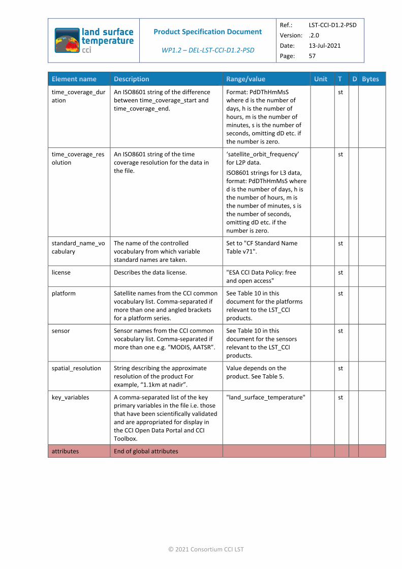
Product Specification Document
WP1.2 – DEL-LST-CCI-D1.2-PSD
Ref.: LST-CCI-D1.2-PSD
Version: .2.0
Date: 13-Jul-2021
Page: 57
© 2021 Consortium CCI LST
time_coverage_duration
An ISO8601 string of the difference between time_coverage_start and time_coverage_end.
Format: PdDThHmMsS where d is the number of days, h is the number of hours, m is the number of minutes, s is the number of seconds, omitting dD etc. if the number is zero.
st
time_coverage_resolution
An ISO8601 string of the time coverage resolution for the data in the file.
‘satellite_orbit_frequency’ for L2P data.
ISO8601 strings for L3 data, format: PdDThHmMsS where d is the number of days, h is the number of hours, m is the number of minutes, s is the number of seconds, omitting dD etc. if the number is zero.
st
standard_name_vocabulary
The name of the controlled vocabulary from which variable standard names are taken.
Set to "CF Standard Name Table v71".
st
license Describes the data license. "ESA CCI Data Policy: free and open access"
st
platform Satellite names from the CCI common vocabulary list. Comma-separated if more than one and angled brackets for a platform series.
See Table 10 in this document for the platforms relevant to the LST_CCI products.
st
sensor Sensor names from the CCI common vocabulary list. Comma-separated if more than one e.g. “MODIS, AATSR”.
See Table 10 in this document for the sensors relevant to the LST_CCI products.
st
spatial_resolution String describing the approximate resolution of the product For example, “1.1km at nadir”.
Value depends on the product. See Table 5.
st
key_variables A comma-separated list of the key primary variables in the file i.e. those that have been scientifically validated and are appropriated for display in the CCI Open Data Portal and CCI Toolbox.
"land_surface_temperature" st
attributes End of global attributes
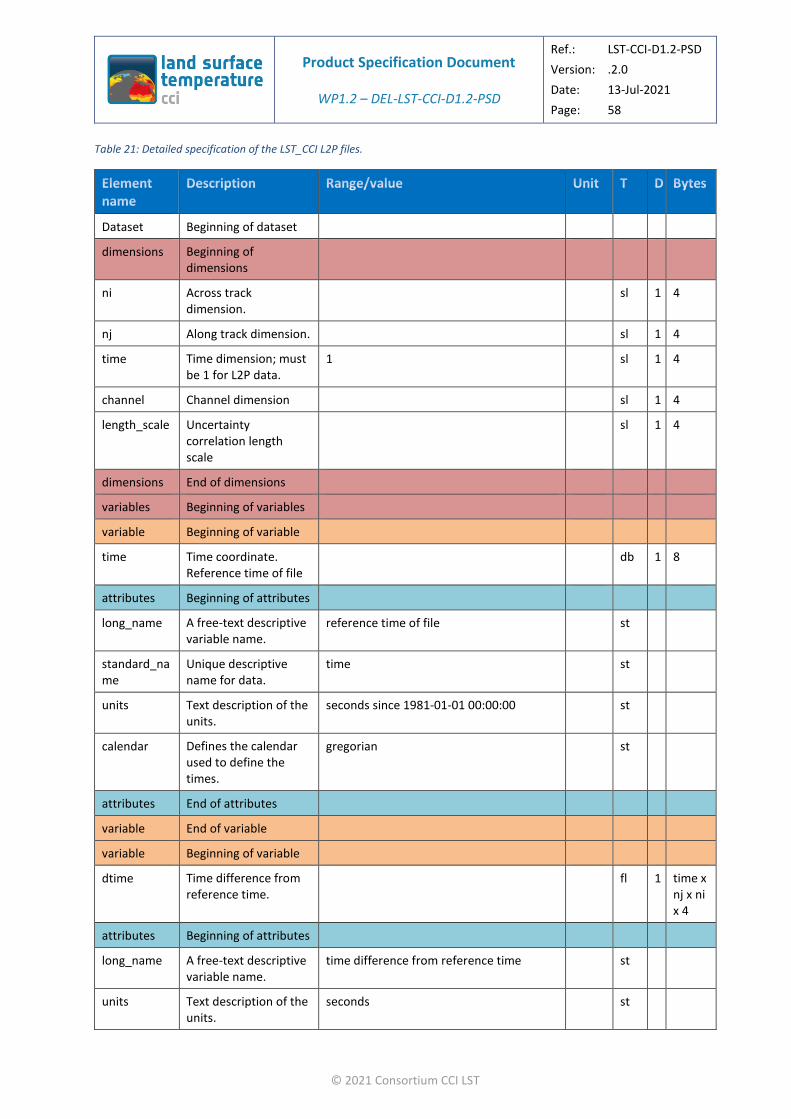
Product Specification Document
WP1.2 – DEL-LST-CCI-D1.2-PSD
Ref.: LST-CCI-D1.2-PSD
Version: .2.0
Date: 13-Jul-2021
Page: 58
© 2021 Consortium CCI LST
Table 21: Detailed specification of the LST_CCI L2P files.
Dataset Beginning of dataset
dimensions Beginning of dimensions
ni Across track dimension.
sl 1 4
nj Along track dimension. sl 1 4
time Time dimension; must be 1 for L2P data.
1 sl 1 4
channel Channel dimension sl 1 4
length_scale Uncertainty correlation length scale
sl 1 4
dimensions End of dimensions
variables Beginning of variables
variable Beginning of variable
time Time coordinate. Reference time of file
db 1 8
attributes Beginning of attributes
long_name A free-text descriptive variable name.
reference time of file st
standard_name
Unique descriptive name for data.
time st
units Text description of the units.
seconds since 1981-01-01 00:00:00 st
calendar Defines the calendar used to define the times.
gregorian st
attributes End of attributes
variable End of variable
variable Beginning of variable
dtime Time difference from reference time.
fl 1 time x nj x ni x 4
attributes Beginning of attributes
long_name A free-text descriptive variable name.
time difference from reference time st
units Text description of the units.
seconds st

Product Specification Document
WP1.2 – DEL-LST-CCI-D1.2-PSD
Ref.: LST-CCI-D1.2-PSD
Version: .2.0
Date: 13-Jul-2021
Page: 59
© 2021 Consortium CCI LST
_FillValue A value used to indicate array elements containing no valid data.
-32768 fl 4
valid_min Minimum valid value for this variable once they are packed (in storage type).
0 fl 4
valid_max Maximum valid value for this variable once they are packed (in storage type).
86400 fl 4
coordinates Identifies coordinate variables.
ni nj st
attributes End of attributes
variable End of variable
variable Beginning of variable
lat Latitude coordinates. [-90, 90] fl 1 nj x ni x 4
attributes Beginning of attributes
long_name A free-text descriptive variable name.
latitude_coordinates st
standard_name
Unique descriptive name for data.
latitude st
units Text description of the units.
degrees_north st
_FillValue A value used to indicate array elements containing no valid data.
-32768 fl 4
valid_min Minimum valid value for this variable once they are packed (in storage type).
-90 fl 4
valid_max Maximum valid value for this variable once they are packed (in storage type).
90 fl 4
reference_datum
Information about the coordinates.
geographical coordinates, WGS84 projection
st
Attributes End of attributes
variable End of variable
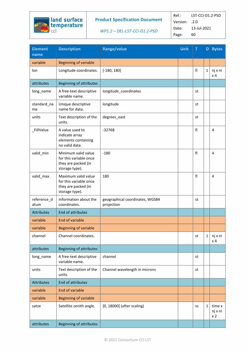
Product Specification Document
WP1.2 – DEL-LST-CCI-D1.2-PSD
Ref.: LST-CCI-D1.2-PSD
Version: .2.0
Date: 13-Jul-2021
Page: 60
© 2021 Consortium CCI LST
variable Beginning of variable
lon Longitude coordinates. [-180, 180] fl 1 nj x ni x 4
attributes Beginning of attributes
long_name A free-text descriptive variable name.
longitude_coordinates st
standard_name
Unique descriptive name for data.
longitude st
units Text description of the units.
degrees_east st
_FillValue A value used to indicate array elements containing no valid data.
-32768 fl 4
valid_min Minimum valid value for this variable once they are packed (in storage type).
-180 fl 4
valid_max Maximum valid value for this variable once they are packed (in storage type).
180 fl 4
reference_datum
Information about the coordinates.
geographical coordinates, WGS84 projection
st
Attributes End of attributes
variable End of variable
variable Beginning of variable
channel Channel coordinates. st 1 nj x ni x 4
attributes Beginning of attributes
long_name A free-text descriptive variable name.
channel st
units Text description of the units.
Channel wavelength in microns st
Attributes End of attributes
variable End of variable
variable Beginning of variable
satze Satellite zenith angle. [0, 18000] (after scaling) ss 1 time x nj x ni x 2
attributes Beginning of attributes

Product Specification Document
WP1.2 – DEL-LST-CCI-D1.2-PSD
Ref.: LST-CCI-D1.2-PSD
Version: .2.0
Date: 13-Jul-2021
Page: 61
© 2021 Consortium CCI LST
long_name A free-text descriptive variable name.
satellite zenith angle st
units Text description of the units.
degrees st
_FillValue A value used to indicate array elements containing no valid data.
-32768 ss 2
add_offset To be added to the variable after multiplying by the scale factor to recover the original value.
0 fl 4
scale_factor To be multiplied by the variable to recover the original value.
0.01 fl 4
valid_min Minimum valid value for this variable once they are packed (in storage type).
0 ss 2
valid_max Maximum valid value for this variable once they are packed (in storage type).
18000 ss 2
coordinates Identifies coordinate variables.
ni nj st
Attributes End of attributes
variable End of variable
variable Beginning of variable
sataz Satellite azimuth angle.
[-18000, 18000] (after scaling) ss 1 time x nj x ni x 2
attributes Beginning of attributes
long_name A free-text descriptive variable name.
satellite azimuth angle st
units Text description of the units.
degrees st
_FillValue A value used to indicate array elements containing no valid data.
-32768 ss 2

Product Specification Document
WP1.2 – DEL-LST-CCI-D1.2-PSD
Ref.: LST-CCI-D1.2-PSD
Version: .2.0
Date: 13-Jul-2021
Page: 62
© 2021 Consortium CCI LST
add_offset To be added to the variable after multiplying by the scale factor to recover the original value.
0 fl 4
scale_factor To be multiplied by the variable to recover the original value.
0.01 fl 4
valid_min Minimum valid value for this variable once they are packed (in storage type).
-18000 ss 2
valid_max Maximum valid value for this variable once they are packed (in storage type).
18000 ss 2
coordinates Identifies coordinate variables.
ni nj st
Attributes End of attributes
variable End of variable
variable Beginning of variable
solze Solar zenith angle. [0, 18000] (after scaling, measured from the vertical)
ss 1 time x nj x ni x 2
attributes Beginning of attributes
long_name A free-text descriptive variable name.
solar zenith angle st
units Text description of the units.
degrees st
_FillValue A value used to indicate array elements containing no valid data.
-32768 ss 2
add_offset To be added to the variable after multiplying by the scale factor to recover the original value.
0 fl 4
scale_factor To be multiplied by the variable to recover the original value.
0.01 fl 4
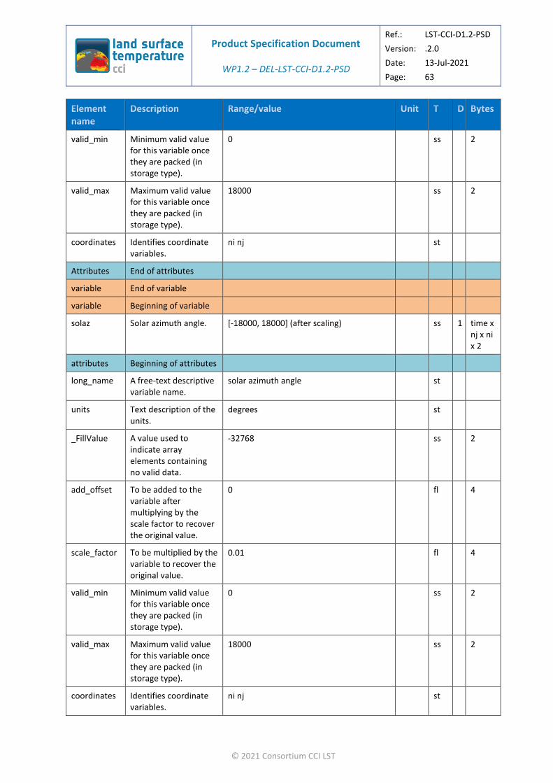
Product Specification Document
WP1.2 – DEL-LST-CCI-D1.2-PSD
Ref.: LST-CCI-D1.2-PSD
Version: .2.0
Date: 13-Jul-2021
Page: 63
© 2021 Consortium CCI LST
valid_min Minimum valid value for this variable once they are packed (in storage type).
0 ss 2
valid_max Maximum valid value for this variable once they are packed (in storage type).
18000 ss 2
coordinates Identifies coordinate variables.
ni nj st
Attributes End of attributes
variable End of variable
variable Beginning of variable
solaz Solar azimuth angle. [-18000, 18000] (after scaling) ss 1 time x nj x ni x 2
attributes Beginning of attributes
long_name A free-text descriptive variable name.
solar azimuth angle st
units Text description of the units.
degrees st
_FillValue A value used to indicate array elements containing no valid data.
-32768 ss 2
add_offset To be added to the variable after multiplying by the scale factor to recover the original value.
0 fl 4
scale_factor To be multiplied by the variable to recover the original value.
0.01 fl 4
valid_min Minimum valid value for this variable once they are packed (in storage type).
0 ss 2
valid_max Maximum valid value for this variable once they are packed (in storage type).
18000 ss 2
coordinates Identifies coordinate variables.
ni nj st
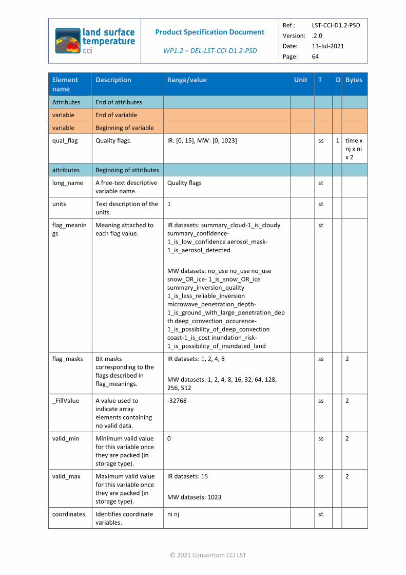
Product Specification Document
WP1.2 – DEL-LST-CCI-D1.2-PSD
Ref.: LST-CCI-D1.2-PSD
Version: .2.0
Date: 13-Jul-2021
Page: 64
© 2021 Consortium CCI LST
Attributes End of attributes
variable End of variable
variable Beginning of variable
qual_flag Quality flags. IR: [0, 15], MW: [0, 1023] ss 1 time x nj x ni x 2
attributes Beginning of attributes
long_name A free-text descriptive variable name.
Quality flags st
units Text description of the units.
1 st
flag_meanings
Meaning attached to each flag value.
IR datasets: summary_cloud-1_is_cloudy summary_confidence-1_is_low_confidence aerosol_mask-1_is_aerosol_detected
MW datasets: no_use no_use no_use snow_OR_ice- 1_is_snow_OR_ice summary_inversion_quality- 1_is_less_reliable_inversion microwave_penetration_depth- 1_is_ground_with_large_penetration_dep th deep_convection_occurence- 1_is_possibility_of_deep_convection coast-1_is_cost inundation_risk- 1_is_possibility_of_inundated_land
st
flag_masks Bit masks corresponding to the flags described in flag_meanings.
IR datasets: 1, 2, 4, 8
MW datasets: 1, 2, 4, 8, 16, 32, 64, 128, 256, 512
ss 2
_FillValue A value used to indicate array elements containing no valid data.
-32768 ss 2
valid_min Minimum valid value for this variable once they are packed (in storage type).
0 ss 2
valid_max Maximum valid value for this variable once they are packed (in storage type).
IR datasets: 15
MW datasets: 1023
ss 2
coordinates Identifies coordinate variables.
ni nj st
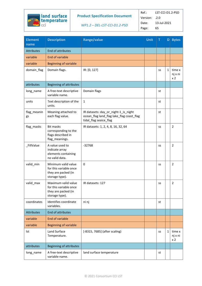
Product Specification Document
WP1.2 – DEL-LST-CCI-D1.2-PSD
Ref.: LST-CCI-D1.2-PSD
Version: .2.0
Date: 13-Jul-2021
Page: 65
© 2021 Consortium CCI LST
Attributes End of attributes
variable End of variable
variable Beginning of variable
domain_flag Domain flags. IR: [0, 127] ss 1 time x nj x ni x 2
attributes Beginning of attributes
long_name A free-text descriptive variable name.
Domain flags st
units Text description of the units.
1 st
flag_meanings
Meaning attached to each flag value.
IR datasets: day_or_night-1_is_night ocean_flag land_flag lake_flag coast_flag tidal_flag seaice_flag
st
flag_masks Bit masks corresponding to the flags described in flag_meanings.
IR datasets: 1, 2, 4, 8, 16, 32, 64 ss 2
_FillValue A value used to indicate array elements containing no valid data.
-32768 ss 2
valid_min Minimum valid value for this variable once they are packed (in storage type).
0 ss 2
valid_max Maximum valid value for this variable once they are packed (in storage type).
IR datasets: 127 ss 2
coordinates Identifies coordinate variables.
ni nj st
Attributes End of attributes
variable End of variable
variable Beginning of variable
lst Land Surface Temperature.
[-8315, 7685] (after scaling) ss 1 time x nj x ni x 2
attributes Beginning of attributes
long_name A free-text descriptive variable name.
land surface temperature st
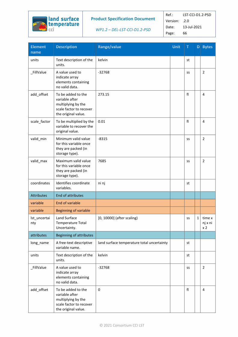
Product Specification Document
WP1.2 – DEL-LST-CCI-D1.2-PSD
Ref.: LST-CCI-D1.2-PSD
Version: .2.0
Date: 13-Jul-2021
Page: 66
© 2021 Consortium CCI LST
units Text description of the units.
kelvin st
_FillValue A value used to indicate array elements containing no valid data.
-32768 ss 2
add_offset To be added to the variable after multiplying by the scale factor to recover the original value.
273.15 fl 4
scale_factor To be multiplied by the variable to recover the original value.
0.01 fl 4
valid_min Minimum valid value for this variable once they are packed (in storage type).
-8315 ss 2
valid_max Maximum valid value for this variable once they are packed (in storage type).
7685 ss 2
coordinates Identifies coordinate variables.
ni nj st
Attributes End of attributes
variable End of variable
variable Beginning of variable
lst_uncertainty
Land Surface Temperature Total Uncertainty.
[0, 10000] (after scaling) ss 1 time x nj x ni x 2
attributes Beginning of attributes
long_name A free-text descriptive variable name.
land surface temperature total uncertainty st
units Text description of the units.
kelvin st
_FillValue A value used to indicate array elements containing no valid data.
-32768 ss 2
add_offset To be added to the variable after multiplying by the scale factor to recover the original value.
0 fl 4

Product Specification Document
WP1.2 – DEL-LST-CCI-D1.2-PSD
Ref.: LST-CCI-D1.2-PSD
Version: .2.0
Date: 13-Jul-2021
Page: 67
© 2021 Consortium CCI LST
scale_factor To be multiplied by the variable to recover the original value.
0.001 fl 4
valid_min Minimum valid value for this variable once they are packed (in storage type).
0 ss 2
valid_max Maximum valid value for this variable once they are packed (in storage type).
10000 ss 2
coordinates Identifies coordinate variables.
ni nj st
Attributes End of attributes
variable End of variable
variable Beginning of variable
lst_unc_ran Land Surface Temperature uncertainty from uncorrelated errors.
[0, 10000] (after scaling) ss 1 time x nj x ni x 2
attributes Beginning of attributes
long_name A free-text descriptive variable name.
uncertainty from uncorrelated errors st
units Text description of the units.
kelvin st
_FillValue A value used to indicate array elements containing no valid data.
-32768 ss 2
add_offset To be added to the variable after multiplying by the scale factor to recover the original value.
0 fl 4
scale_factor To be multiplied by the variable to recover the original value.
0.001 fl 4
valid_min Minimum valid value for this variable once they are packed (in storage type).
0 ss 2

Product Specification Document
WP1.2 – DEL-LST-CCI-D1.2-PSD
Ref.: LST-CCI-D1.2-PSD
Version: .2.0
Date: 13-Jul-2021
Page: 68
© 2021 Consortium CCI LST
valid_max Maximum valid value for this variable once they are packed (in storage type).
10000 ss 2
coordinates Identifies coordinate variables.
ni nj st
Attributes End of attributes
variable End of variable
variable Beginning of variable
lst_unc_loc_atm
Land Surface Temperature uncertainty from locally correlated errors on atmospheric scales.
[0, 10000] (after scaling) ss 1 time x nj x ni x 2
attributes Beginning of attributes
long_name A free-text descriptive variable name.
uncertainty from locally correlated errors on atmospheric scales
st
units Text description of the units.
kelvin st
_FillValue A value used to indicate array elements containing no valid data.
-32768 ss 2
add_offset To be added to the variable after multiplying by the scale factor to recover the original value.
0 fl 4
scale_factor To be multiplied by the variable to recover the original value.
0.001 fl 4
valid_min Minimum valid value for this variable once they are packed (in storage type).
0 ss 2
valid_max Maximum valid value for this variable once they are packed (in storage type).
10000 ss 2
coordinates Identifies coordinate variables.
ni nj st
Attributes End of attributes

Product Specification Document
WP1.2 – DEL-LST-CCI-D1.2-PSD
Ref.: LST-CCI-D1.2-PSD
Version: .2.0
Date: 13-Jul-2021
Page: 69
© 2021 Consortium CCI LST
variable End of variable
variable Beginning of variable
lst_unc_loc_sfc
Land Surface Temperature uncertainty from locally correlated errors on surface scales.
[0, 10000] (after scaling) ss 1 time x nj x ni x 2
attributes Beginning of attributes
long_name A free-text descriptive variable name.
uncertainty from locally correlated errors on surface scales
st
units Text description of the units.
kelvin st
_FillValue A value used to indicate array elements containing no valid data.
-32768 ss 2
add_offset To be added to the variable after multiplying by the scale factor to recover the original value.
0 fl 4
scale_factor To be multiplied by the variable to recover the original value.
0.001 fl 4
valid_min Minimum valid value for this variable once they are packed (in storage type).
0 ss 2
valid_max Maximum valid value for this variable once they are packed (in storage type).
10000 ss 2
coordinates Identifies coordinate variables.
ni nj st
Attributes End of attributes
variable End of variable
variable Beginning of variable
lst_unc_sys Land Surface Temperature uncertainty from large-scale systematic errors.
[0, 10000] (after scaling) ss 1 length_scale
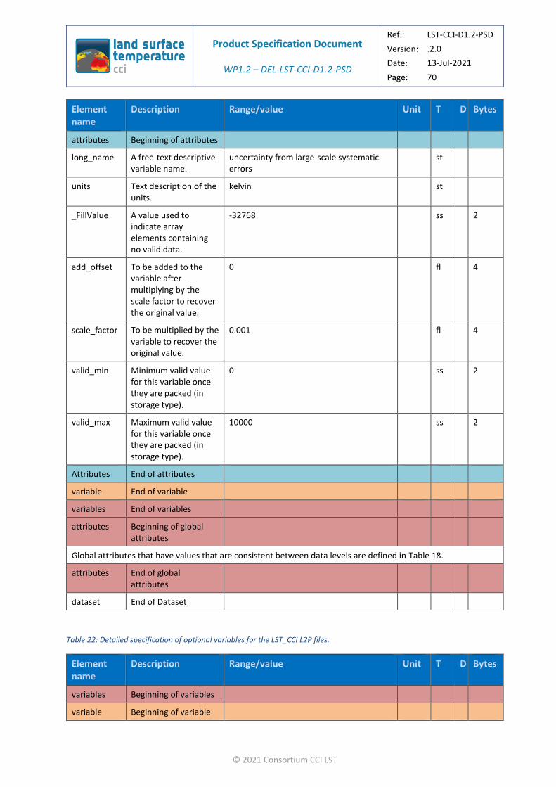
Product Specification Document
WP1.2 – DEL-LST-CCI-D1.2-PSD
Ref.: LST-CCI-D1.2-PSD
Version: .2.0
Date: 13-Jul-2021
Page: 70
© 2021 Consortium CCI LST
attributes Beginning of attributes
long_name A free-text descriptive variable name.
uncertainty from large-scale systematic errors
st
units Text description of the units.
kelvin st
_FillValue A value used to indicate array elements containing no valid data.
-32768 ss 2
add_offset To be added to the variable after multiplying by the scale factor to recover the original value.
0 fl 4
scale_factor To be multiplied by the variable to recover the original value.
0.001 fl 4
valid_min Minimum valid value for this variable once they are packed (in storage type).
0 ss 2
valid_max Maximum valid value for this variable once they are packed (in storage type).
10000 ss 2
Attributes End of attributes
variable End of variable
variables End of variables
attributes Beginning of global attributes
Global attributes that have values that are consistent between data levels are defined in Table 18.
attributes End of global attributes
dataset End of Dataset
Table 22: Detailed specification of optional variables for the LST_CCI L2P files.
variables Beginning of variables
variable Beginning of variable

Product Specification Document
WP1.2 – DEL-LST-CCI-D1.2-PSD
Ref.: LST-CCI-D1.2-PSD
Version: .2.0
Date: 13-Jul-2021
Page: 71
© 2021 Consortium CCI LST
emis Land Surface Emissivity
[0, 10000] (after scaling) ss 1 time x channel x nj x ni x 2
attributes Beginning of attributes
long_name A free-text descriptive variable name.
surface emissivity st
units Text description of the units.
1 st
_FillValue A value used to indicate array elements containing no valid data.
-32768 Ss 2
add_offset To be added to the variable after multiplying by the scale factor to recover the original value.
0 Fl 4
scale_factor To be multiplied by the variable to recover the original value.
0.0001 Fl 4
valid_min Minimum valid value for this variable once they are packed (in storage type).
0 ss 2
valid_max Maximum valid value for this variable once they are packed (in storage type).
10000 ss 2
coordinates Identifies coordinate variables.
ni nj st
Attributes End of attributes
variable End of variable
variable Beginning of variable
fv Fractional vegetation cover
[0, 10000] (after scaling) ss 1 time x nj x ni x 2
attributes Beginning of attributes
long_name A free-text descriptive variable name.
fractional vegetation cover st
units Text description of the units.
1 st

Product Specification Document
WP1.2 – DEL-LST-CCI-D1.2-PSD
Ref.: LST-CCI-D1.2-PSD
Version: .2.0
Date: 13-Jul-2021
Page: 72
© 2021 Consortium CCI LST
_FillValue A value used to indicate array elements containing no valid data.
-32768 Ss 2
add_offset To be added to the variable after multiplying by the scale factor to recover the original value.
0 Fl 4
scale_factor To be multiplied by the variable to recover the original value.
0.0001 Fl 4
valid_min Minimum valid value for this variable once they are packed (in storage type).
0 ss 2
valid_max Maximum valid value for this variable once they are packed (in storage type).
10000 ss 2
source Auxiliary data source. CGLPS FCOVER 1 km dataset v2.0, which has been brokered to C3S: https://land.copernicus.eu/global/products/fcover
st
coordinates Identifies coordinate variables.
ni nj st
Attributes End of attributes
variable End of variable
variable Beginning of variable
ndvi Normalised Difference Vegetation Index.
[0, 10000] (after scaling) ss 1 time x lon x lat x 2
attributes Beginning of attributes
long_name A free-text descriptive variable name.
normalized difference vegetation index st
units Text description of the units.
1 st
_FillValue A value used to indicate array elements containing no valid data.
-32768 ss 2
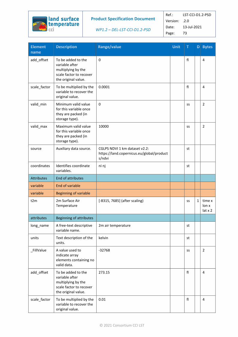
Product Specification Document
WP1.2 – DEL-LST-CCI-D1.2-PSD
Ref.: LST-CCI-D1.2-PSD
Version: .2.0
Date: 13-Jul-2021
Page: 73
© 2021 Consortium CCI LST
add_offset To be added to the variable after multiplying by the scale factor to recover the original value.
0 fl 4
scale_factor To be multiplied by the variable to recover the original value.
0.0001 fl 4
valid_min Minimum valid value for this variable once they are packed (in storage type).
0 ss 2
valid_max Maximum valid value for this variable once they are packed (in storage type).
10000 ss 2
source Auxiliary data source. CGLPS NDVI 1 km dataset v2.2: https://land.copernicus.eu/global/products/ndvi
st
coordinates Identifies coordinate variables.
ni nj st
Attributes End of attributes
variable End of variable
variable Beginning of variable
t2m 2m Surface Air Temperature
[-8315, 7685] (after scaling) ss 1 time x lon x lat x 2
attributes Beginning of attributes
long_name A free-text descriptive variable name.
2m air temperature st
units Text description of the units.
kelvin st
_FillValue A value used to indicate array elements containing no valid data.
-32768 ss 2
add_offset To be added to the variable after multiplying by the scale factor to recover the original value.
273.15 fl 4
scale_factor To be multiplied by the variable to recover the original value.
0.01 fl 4
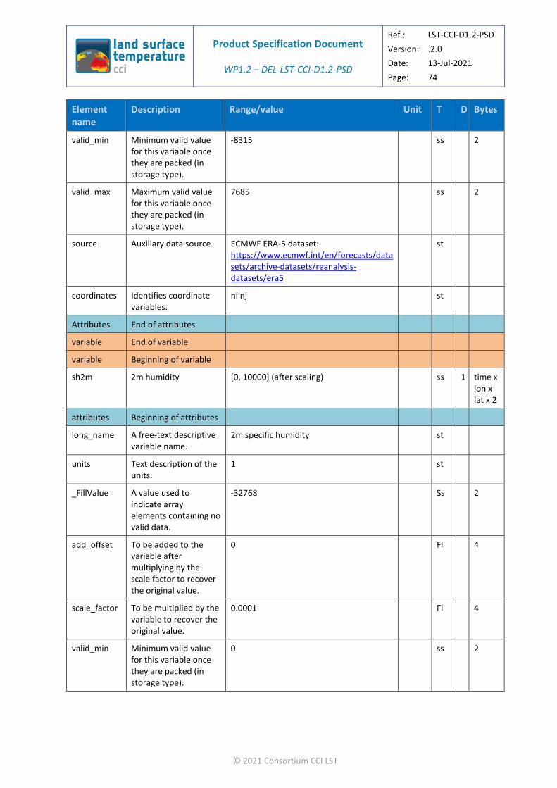
Product Specification Document
WP1.2 – DEL-LST-CCI-D1.2-PSD
Ref.: LST-CCI-D1.2-PSD
Version: .2.0
Date: 13-Jul-2021
Page: 74
© 2021 Consortium CCI LST
valid_min Minimum valid value for this variable once they are packed (in storage type).
-8315 ss 2
valid_max Maximum valid value for this variable once they are packed (in storage type).
7685 ss 2
source Auxiliary data source. ECMWF ERA-5 dataset: https://www.ecmwf.int/en/forecasts/datasets/archive-datasets/reanalysis-datasets/era5
st
coordinates Identifies coordinate variables.
ni nj st
Attributes End of attributes
variable End of variable
variable Beginning of variable
sh2m 2m humidity [0, 10000] (after scaling) ss 1 time x lon x lat x 2
attributes Beginning of attributes
long_name A free-text descriptive variable name.
2m specific humidity st
units Text description of the units.
1 st
_FillValue A value used to indicate array elements containing no valid data.
-32768 Ss 2
add_offset To be added to the variable after multiplying by the scale factor to recover the original value.
0 Fl 4
scale_factor To be multiplied by the variable to recover the original value.
0.0001 Fl 4
valid_min Minimum valid value for this variable once they are packed (in storage type).
0 ss 2
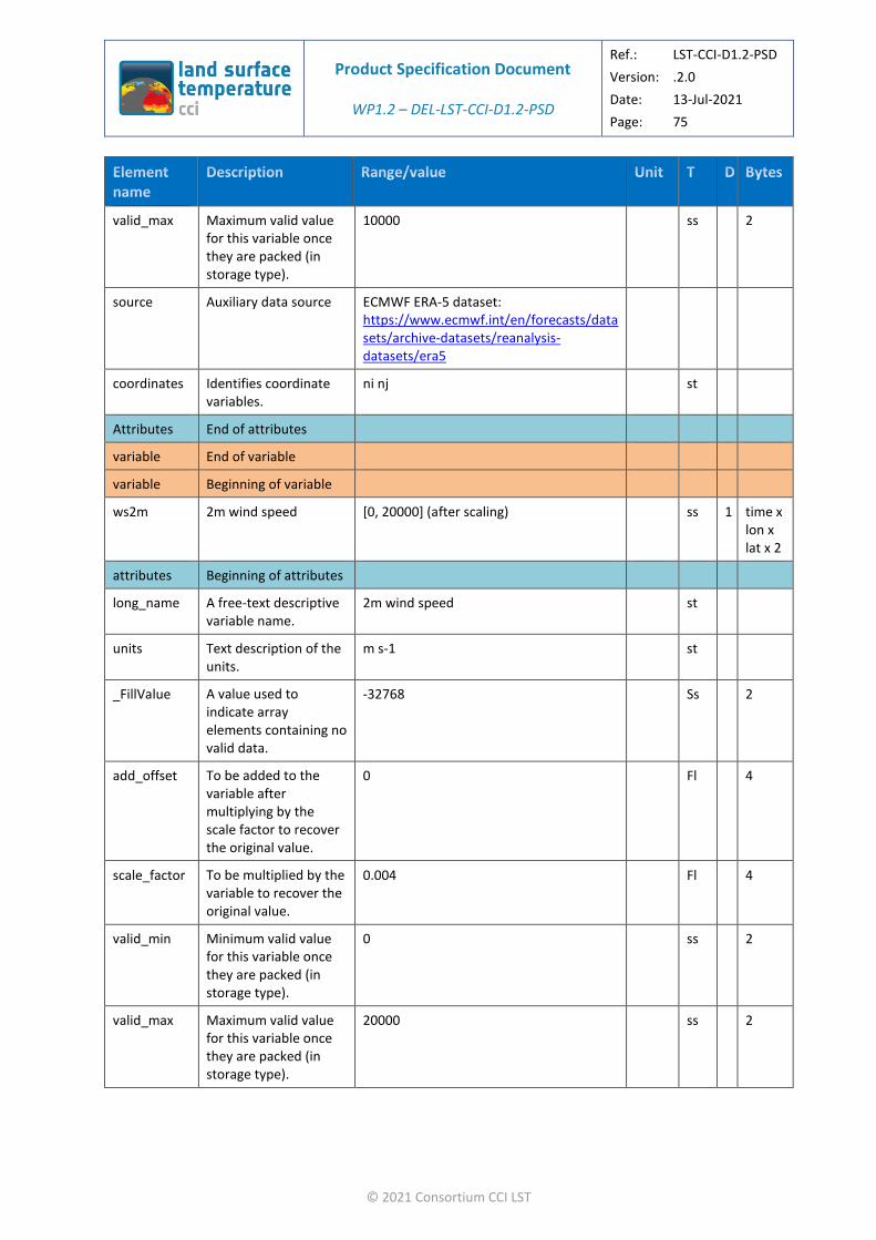
Product Specification Document
WP1.2 – DEL-LST-CCI-D1.2-PSD
Ref.: LST-CCI-D1.2-PSD
Version: .2.0
Date: 13-Jul-2021
Page: 75
© 2021 Consortium CCI LST
valid_max Maximum valid value for this variable once they are packed (in storage type).
10000 ss 2
source Auxiliary data source ECMWF ERA-5 dataset: https://www.ecmwf.int/en/forecasts/datasets/archive-datasets/reanalysis-datasets/era5
coordinates Identifies coordinate variables.
ni nj st
Attributes End of attributes
variable End of variable
variable Beginning of variable
ws2m 2m wind speed [0, 20000] (after scaling) ss 1 time x lon x lat x 2
attributes Beginning of attributes
long_name A free-text descriptive variable name.
2m wind speed st
units Text description of the units.
m s-1 st
_FillValue A value used to indicate array elements containing no valid data.
-32768 Ss 2
add_offset To be added to the variable after multiplying by the scale factor to recover the original value.
0 Fl 4
scale_factor To be multiplied by the variable to recover the original value.
0.004 Fl 4
valid_min Minimum valid value for this variable once they are packed (in storage type).
0 ss 2
valid_max Maximum valid value for this variable once they are packed (in storage type).
20000 ss 2
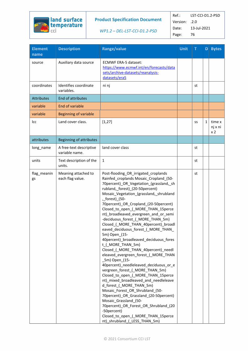
Product Specification Document
WP1.2 – DEL-LST-CCI-D1.2-PSD
Ref.: LST-CCI-D1.2-PSD
Version: .2.0
Date: 13-Jul-2021
Page: 76
© 2021 Consortium CCI LST
source Auxiliary data source ECMWF ERA-5 dataset: https://www.ecmwf.int/en/forecasts/datasets/archive-datasets/reanalysis-datasets/era5
coordinates Identifies coordinate variables.
ni nj st
Attributes End of attributes
variable End of variable
variable Beginning of variable
lcc Land cover class. [1,27] ss 1 time x nj x ni x 2
attributes Beginning of attributes
long_name A free-text descriptive variable name.
land cover class st
units Text description of the units.
1 st
flag_meanings
Meaning attached to each flag value.
Post-flooding_OR_irrigated_croplands Rainfed_croplands Mosaic_Cropland_(50-70percent)_OR_Vegetation_(grassland,_shrubland,_forest)_(20-50percent) Mosaic_Vegetation_(grassland,_shrubland,_forest)_(50-70percent)_OR_Cropland_(20-50percent) Closed_to_open_(_MORE_THAN_15percent)_broadleaved_evergreen_and_or_semi-deciduous_forest_(_MORE_THAN_5m) Closed_(_MORE_THAN_40percent)_broadleaved_deciduous_forest_(_MORE_THAN_5m) Open_(15-40percent)_broadleaved_deciduous_forest_(_MORE_THAN_5m) Closed_(_MORE_THAN_40percent)_needleleaved_evergreen_forest_(_MORE_THAN_5m) Open_(15-40percent)_needleleaved_deciduous_or_evergreen_forest_(_MORE_THAN_5m) Closed_to_open_(_MORE_THAN_15percent)_mixed_broadleaved_and_needleleaved_forest_(_MORE_THAN_5m) Mosaic_Forest_OR_Shrubland_(50-70percent)_OR_Grassland_(20-50percent) Mosaic_Grassland_(50-70percent)_OR_Forest_OR_Shrubland_(20-50percent) Closed_to_open_(_MORE_THAN_15percent)_shrubland_(_LESS_THAN_5m)
st

Product Specification Document
WP1.2 – DEL-LST-CCI-D1.2-PSD
Ref.: LST-CCI-D1.2-PSD
Version: .2.0
Date: 13-Jul-2021
Page: 77
© 2021 Consortium CCI LST
Closed_to_open_(_MORE_THAN_15percent)_grassland Sparse_(_MORE_THAN_15percent)_vegetation_(woody_vegetation,_shrubs,_grassland) Closed_(_MORE_THAN_40percent)_broadleaved_forest_regularly_flooded_-Fresh_water Closed_(_MORE_THAN_40percent)_broadleaved_semi-deciduous_and_or_evergreen_forest_regularly_flooded_-Saline_water Closed_to_open_(_MORE_THAN_15percent)_vegetation_(grassland,_shrubland,_woody_vegetation)_on_regularly_flooded_or_waterlogged_soil_-Fresh,_brackish_or_saline_water Artificial_surfaces_and_associated_areas_(urban_areas__MORE_THAN_50percent) Bare_areas_of_soil_types_not_contained_in_biomes_21_to_25 Bare_areas_of_soil_type_Entisols_–_Orthents Bare_areas_of_soil_type_Shifting_sand Bare_areas_of_soil_type_Aridisols_-_Calcids Bare_areas_of_soil_type_Aridisols_-_Cambids Bare_areas_of_soil_type_Gelisols_-_Orthels Water_bodies_(inland_lakes,_rivers,_sea:_max_10km_away_from_coast) Permanent_snow_and_ice
flag_masks Values corresponding to the flags described in flag_meanings.
1, 2, 3, 4, 5, 6, 7, 8, 9, 10, 11, 12, 13, 14, 15, 16, 17, 18, 19, 20, 21, 22, 23, 24, 25, 26, 27
ss 2
_FillValue A value used to indicate array elements containing no valid data.
-32768 ss 2
valid_min Minimum valid value for this variable once they are packed (in storage type).
0 ss 2
valid_max Maximum valid value for this variable once they are packed (in storage type).
27 ss 2
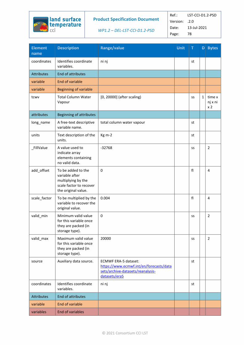
Product Specification Document
WP1.2 – DEL-LST-CCI-D1.2-PSD
Ref.: LST-CCI-D1.2-PSD
Version: .2.0
Date: 13-Jul-2021
Page: 78
© 2021 Consortium CCI LST
coordinates Identifies coordinate variables.
ni nj st
Attributes End of attributes
variable End of variable
variable Beginning of variable
tcwv Total Column Water Vapour
[0, 20000] (after scaling) ss 1 time x nj x ni x 2
attributes Beginning of attributes
long_name A free-text descriptive variable name.
total column water vapour st
units Text description of the units.
Kg m-2 st
_FillValue A value used to indicate array elements containing no valid data.
-32768 ss 2
add_offset To be added to the variable after multiplying by the scale factor to recover the original value.
0 fl 4
scale_factor To be multiplied by the variable to recover the original value.
0.004 fl 4
valid_min Minimum valid value for this variable once they are packed (in storage type).
0 ss 2
valid_max Maximum valid value for this variable once they are packed (in storage type).
20000 ss 2
source Auxiliary data source. ECMWF ERA-5 dataset: https://www.ecmwf.int/en/forecasts/datasets/archive-datasets/reanalysis-datasets/era5
st
coordinates Identifies coordinate variables.
ni nj st
Attributes End of attributes
variable End of variable
variables End of variables
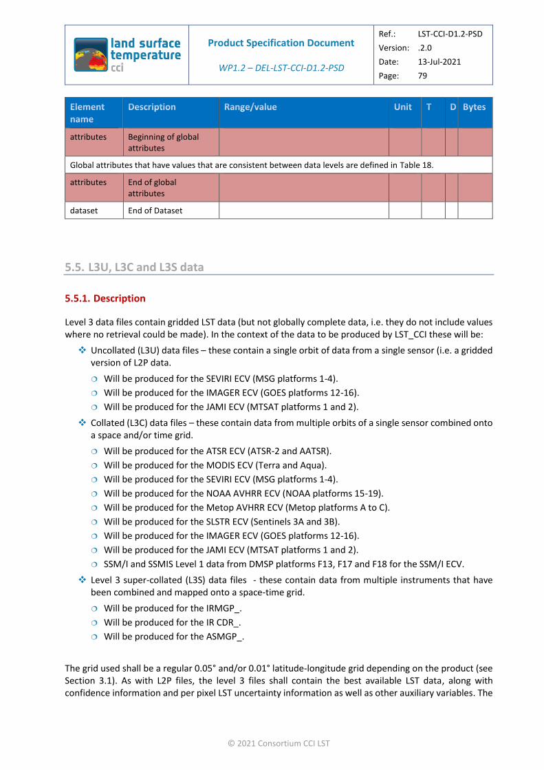
Product Specification Document
WP1.2 – DEL-LST-CCI-D1.2-PSD
Ref.: LST-CCI-D1.2-PSD
Version: .2.0
Date: 13-Jul-2021
Page: 79
© 2021 Consortium CCI LST
attributes Beginning of global attributes
Global attributes that have values that are consistent between data levels are defined in Table 18.
attributes End of global attributes
dataset End of Dataset
5.5. L3U, L3C and L3S data
5.5.1. Description
Level 3 data files contain gridded LST data (but not globally complete data, i.e. they do not include values where no retrieval could be made). In the context of the data to be produced by LST_CCI these will be:
❖ Uncollated (L3U) data files – these contain a single orbit of data from a single sensor (i.e. a gridded version of L2P data.
Will be produced for the SEVIRI ECV (MSG platforms 1-4).
Will be produced for the IMAGER ECV (GOES platforms 12-16).
Will be produced for the JAMI ECV (MTSAT platforms 1 and 2).
❖ Collated (L3C) data files – these contain data from multiple orbits of a single sensor combined onto a space and/or time grid.
Will be produced for the ATSR ECV (ATSR-2 and AATSR).
Will be produced for the MODIS ECV (Terra and Aqua).
Will be produced for the SEVIRI ECV (MSG platforms 1-4).
Will be produced for the NOAA AVHRR ECV (NOAA platforms 15-19).
Will be produced for the Metop AVHRR ECV (Metop platforms A to C).
Will be produced for the SLSTR ECV (Sentinels 3A and 3B).
Will be produced for the IMAGER ECV (GOES platforms 12-16).
Will be produced for the JAMI ECV (MTSAT platforms 1 and 2).
SSM/I and SSMIS Level 1 data from DMSP platforms F13, F17 and F18 for the SSM/I ECV.
❖ Level 3 super-collated (L3S) data files - these contain data from multiple instruments that have been combined and mapped onto a space-time grid.
Will be produced for the IRMGP_.
Will be produced for the IR CDR_.
Will be produced for the ASMGP_.
The grid used shall be a regular 0.05° and/or 0.01° latitude-longitude grid depending on the product (see Section 3.1). As with L2P files, the level 3 files shall contain the best available LST data, along with confidence information and per pixel LST uncertainty information as well as other auxiliary variables. The
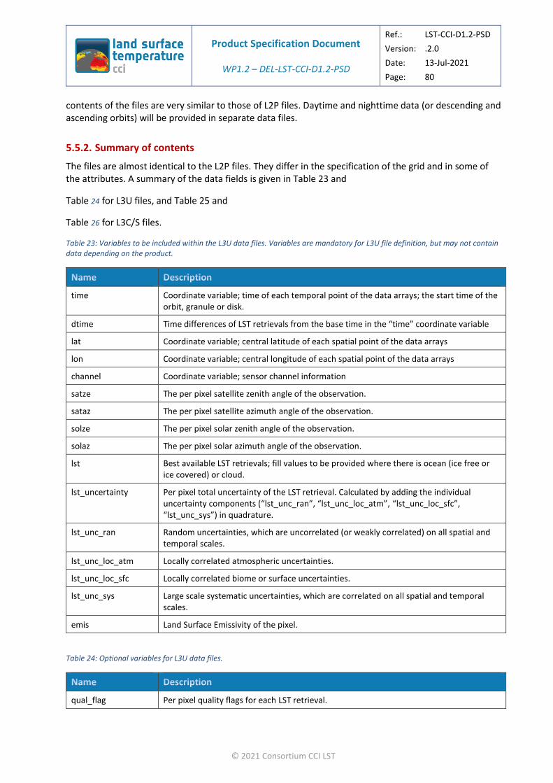
Product Specification Document
WP1.2 – DEL-LST-CCI-D1.2-PSD
Ref.: LST-CCI-D1.2-PSD
Version: .2.0
Date: 13-Jul-2021
Page: 80
© 2021 Consortium CCI LST
contents of the files are very similar to those of L2P files. Daytime and nighttime data (or descending and ascending orbits) will be provided in separate data files.
5.5.2. Summary of contents
The files are almost identical to the L2P files. They differ in the specification of the grid and in some of the attributes. A summary of the data fields is given in Table 23 and
Table 24 for L3U files, and Table 25 and
Table 26 for L3C/S files.
Table 23: Variables to be included within the L3U data files. Variables are mandatory for L3U file definition, but may not contain data depending on the product.
time Coordinate variable; time of each temporal point of the data arrays; the start time of the orbit, granule or disk.
dtime Time differences of LST retrievals from the base time in the “time” coordinate variable
lat Coordinate variable; central latitude of each spatial point of the data arrays
lon Coordinate variable; central longitude of each spatial point of the data arrays
channel Coordinate variable; sensor channel information
satze The per pixel satellite zenith angle of the observation.
sataz The per pixel satellite azimuth angle of the observation.
solze The per pixel solar zenith angle of the observation.
solaz The per pixel solar azimuth angle of the observation.
lst Best available LST retrievals; fill values to be provided where there is ocean (ice free or ice covered) or cloud.
lst_uncertainty Per pixel total uncertainty of the LST retrieval. Calculated by adding the individual uncertainty components (“lst_unc_ran”, “lst_unc_loc_atm”, “lst_unc_loc_sfc”, “lst_unc_sys”) in quadrature.
lst_unc_ran Random uncertainties, which are uncorrelated (or weakly correlated) on all spatial and temporal scales.
lst_unc_loc_atm Locally correlated atmospheric uncertainties.
lst_unc_loc_sfc Locally correlated biome or surface uncertainties.
lst_unc_sys Large scale systematic uncertainties, which are correlated on all spatial and temporal scales.
emis Land Surface Emissivity of the pixel.
Table 24: Optional variables for L3U data files.
qual_flag Per pixel quality flags for each LST retrieval.

Product Specification Document
WP1.2 – DEL-LST-CCI-D1.2-PSD
Ref.: LST-CCI-D1.2-PSD
Version: .2.0
Date: 13-Jul-2021
Page: 81
© 2021 Consortium CCI LST
domain_flag Per pixel domain flags for each LST retrieval, containing information on spatio-temporal domains.
ndvi Normalised Difference Vegetation Index of the pixel.
t2m Surface Air Temperature at the pixel (2 m height).
sh2m Humidity at the pixel (2 m height).
ws2m Wind speed at the pixel (2 m height).
variance LST variance.
lcc Land cover classification of the pixel (biome).
tcwv Total Column Water Vapour of the pixel.
variance LST variance.
n Number of L2P pixels flagged as clear-sky which have contributed to the L3 pixel LST.
ncld Number of L2P pixels flagged as cloud which were not used to calculate the L3 pixel LST.
fv Fractional vegetation value of the pixel.
lwm Land Water Mask. A common CCI land water mask will be used (Land Cover CCI).
Table 25: Variables to be included within the L3C/S data files. Variables are mandatory for file definition, but may not contain data depending on the product.
time Coordinate variable; time of each temporal point of the data arrays; the start time of the file, which will be the start date and time at 00:00 on the first date of the temporal period if an averaged product; for daily each day at 00:00, for monthly: the first day of the month at 00:00. For nominal time products the start time will be the earliest time of the input data for each file.
dtime Time differences of LST retrievals from the base time in the “time” coordinate variable
lat Coordinate variable; central latitude of each spatial point of the data arrays
lon Coordinate variable; central longitude of each spatial point of the data arrays
channel Coordinate variable; sensor channel information
satze The per pixel satellite zenith angle of the observation.
sataz The per pixel satellite azimuth angle of the observation.
lst Best available LST retrievals; fill values to be provided where there is ocean (ice free or ice covered) or cloud.
lst_uncertainty Per pixel total uncertainty of the LST retrieval. Calculated by adding the individual uncertainty components (“lst_unc_ran”, “lst_unc_loc_atm”, “lst_unc_loc_sfc”, “lst_unc_sys”) in quadrature.
lst_unc_ran Random uncertainties, which are uncorrelated (or weakly correlated) on all spatial and temporal scales.
lst_unc_loc_atm Locally correlated atmospheric uncertainties.
lst_unc_loc_sfc Locally correlated biome or surface uncertainties.

Product Specification Document
WP1.2 – DEL-LST-CCI-D1.2-PSD
Ref.: LST-CCI-D1.2-PSD
Version: .2.0
Date: 13-Jul-2021
Page: 82
© 2021 Consortium CCI LST
lst_unc_sys Large scale systematic uncertainties, which are correlated on all spatial and temporal scales.
Table 26: Optional variables for L3C/S data files.
lcc Land cover classification of the pixel (biome).
qual_flag Per pixel quality flags for each LST retrieval.
domain_flag Per pixel domain flags for each LST retrieval, containing information on spatio-temporal domains.
tcwv Total Column Water Vapour of the pixel.
ndvi Normalised Difference Vegetation Index of the pixel.
emis Land Surface Emissivity of the pixel.
t2m Surface Air Temperature at the pixel (2 m height).
sh2m Humidity at the pixel (2 m height).
ws2m Wind speed at the pixel (2 m height).
n Number of L2P pixels flagged as clear-sky which have contributed to the L3 pixel for IR products, or number of L2P pixels which have contributed to the L3 pixel for MW products.
ncld Number of L2P pixels flagged as cloud which were not used to calculate the L3 pixel LST.
fv Fractional vegetation value of the pixel.
lwm Land Water Mask.
solze The per pixel solar zenith angle of the observation.
solaz The per pixel solar azimuth angle of the observation.
lst_time_correction LST offset in Kevin to be added by the user to the lst variable to estimate the LST adjusted from local time overpass to either 6 AM/PM. Currently used for MW files only.
The variables to be included in L3 files noted above address the following user requirements.
LST-PSD-SPN-46-URD: Provide LST data with quality flags.
LST-PSD-SPN-49-URD: Provide LST data with QC level data on a pixel level.
LST-PSD-SPN-50-URD: Provide LST data with QC level data on a file level.
Addresses user feedback LST-URD-REQ-19-L, LST-URD-REQ-22-O, LST-URD-REQ-23-O
5.5.3. Detailed contents
The detailed contents of the products are defined in Table 27, Table 28 and Table 29. The table specifies the structure of the NetCDF files. Much of this is done with reference to Table 21. However, note that in keeping with the examples in [AD.1] the spatial dimensions are given different names in level 3 files compared to L2P (lat and lon in the former, ni and nj in the latter). Example of how these contents would
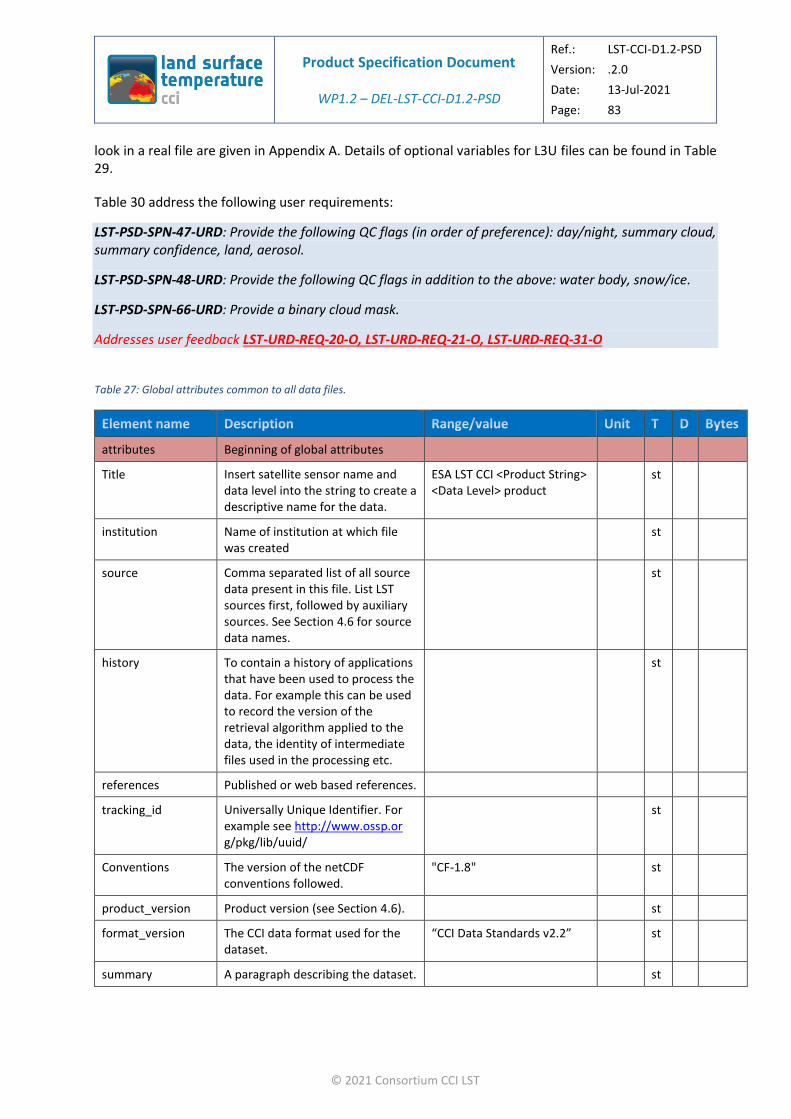
Product Specification Document
WP1.2 – DEL-LST-CCI-D1.2-PSD
Ref.: LST-CCI-D1.2-PSD
Version: .2.0
Date: 13-Jul-2021
Page: 83
© 2021 Consortium CCI LST
look in a real file are given in Appendix A. Details of optional variables for L3U files can be found in Table 29.
Table 30 address the following user requirements:
LST-PSD-SPN-47-URD: Provide the following QC flags (in order of preference): day/night, summary cloud, summary confidence, land, aerosol.
LST-PSD-SPN-48-URD: Provide the following QC flags in addition to the above: water body, snow/ice.
LST-PSD-SPN-66-URD: Provide a binary cloud mask.
Addresses user feedback LST-URD-REQ-20-O, LST-URD-REQ-21-O, LST-URD-REQ-31-O
Table 27: Global attributes common to all data files.
attributes Beginning of global attributes
Title Insert satellite sensor name and data level into the string to create a descriptive name for the data.
ESA LST CCI <Product String> <Data Level> product
st
institution Name of institution at which file was created
st
source Comma separated list of all source data present in this file. List LST sources first, followed by auxiliary sources. See Section 4.6 for source data names.
st
history To contain a history of applications that have been used to process the data. For example this can be used to record the version of the retrieval algorithm applied to the data, the identity of intermediate files used in the processing etc.
st
references Published or web based references.
tracking_id Universally Unique Identifier. For example see http://www.ossp.or g/pkg/lib/uuid/
st
Conventions The version of the netCDF conventions followed.
"CF-1.8" st
product_version Product version (see Section 4.6). st
format_version The CCI data format used for the dataset.
“CCI Data Standards v2.2” st
summary A paragraph describing the dataset. st

Product Specification Document
WP1.2 – DEL-LST-CCI-D1.2-PSD
Ref.: LST-CCI-D1.2-PSD
Version: .2.0
Date: 13-Jul-2021
Page: 84
© 2021 Consortium CCI LST
keywords A comma-separated list of key words and phrases.
Typical keywords include: Earth Science, Land Surface, Land Temperature and Land Surface Temperature
st
Id The filename of the file. st
naming_authority The naming authority. “ESA” st
keywords_vocabulary
The guideline being followed for the words/phrases in the “keywords” attribute.
“NASA Global change Master Directory (GCMD) Science Keywords”
st
cdm_data_type The THREDDS data type appropriate for this dataset.
“swath” for L2P and “grid” for L3 files.
st
comment Miscellaneous information about the data or methods used to produce it.
"These data were produced as part of the ESA LST CCI project."
st
date_created File creation Format: yyyymmddThhmmssZ
st
creator_name Provide a name and email address for the most relevant point of contact, as well as a URL relevant to this data set.
st
creator_url st
creator_email st
project The scientific project that produced the data.
“Climate Change Initiative - European Space Agency”
st
geospatial_lat_min Southernmost latitude in decimal degrees north, range -90 to +90.
fl
geospatial_lat_max Northernmost latitude in decimal degrees north, range -180 to +180.
fl
geospatial_lon_min Westernmost longitude in decimal degrees north, range -180 to +180.
fl
geospatial_lon_max
Easternmost longitude in decimal degrees north, range -180 to +180.
fl
geospatial_vertical_min
Assumed to be in metres above ground unless geospatial_vertical_units attribute defined otherwise.
fl
geospatial_vertical_max
Assumed to be in metres above ground unless geospatial_vertical_units attribute defined otherwise.
fl
time_coverage_start
Date and time of the first measurement in the data file.
Format: yyyymmddThhmmssZ
st
time_coverage_end Date and time of the last measurement in the data file.
Format: yyyymmddThhmmssZ
st

Product Specification Document
WP1.2 – DEL-LST-CCI-D1.2-PSD
Ref.: LST-CCI-D1.2-PSD
Version: .2.0
Date: 13-Jul-2021
Page: 85
© 2021 Consortium CCI LST
time_coverage_duration
An ISO8601 string of the difference between time_coverage_start and time_coverage_end.
Format: PdDThHmMsS where d is the number of days, h is the number of hours, m is the number of minutes, s is the number of seconds, omitting dD etc. if the number is zero.
st
time_coverage_resolution
An ISO8601 string of the time coverage resolution for the data in the file.
‘satellite_orbit_frequency’ for L2P data.
ISO8601 strings for L3 data, format: PdDThHmMsS where d is the number of days, h is the number of hours, m is the number of minutes, s is the number of seconds, omitting dD etc. if the number is zero.
st
standard_name_vocabulary
The name of the controlled vocabulary from which variable standard names are taken.
Set to "CF Standard Name Table v71".
st
license Describes the data license. "ESA CCI Data Policy: free and open access"
st
platform Satellite names from the CCI common vocabulary list. Comma-separated if more than one and angled brackets for a platform series.
See Table 10 in this document for the platforms relevant to the LST_CCI products.
st
sensor Sensor names from the CCI common vocabulary list. Comma-separated if more than one e.g. “MODIS, AATSR”.
See Table 10 in this document for the platforms relevant to the LST_CCI products.
st
spatial_resolution String describing the approximate resolution of the product For example, “1.1km at nadir”.
Value depends on the product. See Table 5.
st
key_variables A comma-separated list of the key primary variables in the file i.e. those that have been scientifically validated and are appropriated for display in the CCI Open Data Portal and CCI Toolbox.
"land_surface_temperature" st
geospatial_lat_units
Units of the latitudinal resolution. degrees_north st
geospatial_lon_units
Units of the longitudinal resolution. degrees_east st
geospatial_lat_resolution
Latitude Resolution in units matching geospatial_lat_units.
fl

Product Specification Document
WP1.2 – DEL-LST-CCI-D1.2-PSD
Ref.: LST-CCI-D1.2-PSD
Version: .2.0
Date: 13-Jul-2021
Page: 86
© 2021 Consortium CCI LST
geospatial_lon_resolution
Longitude Resolution in units matching geospatial_lon_units.
fl
attributes End of global attributes
Table 28: Detailed specification of the LST_CCI L3U files.
Dataset Beginning of dataset
dimensions Beginning of dimensions
Lat Latitude dimension. sl 1 4
Lon Longitude dimension.
sl 1 4
channel Channel dimension sl 1 4
length_scale Uncertainty correlation length scale
sl 1 4
time Time dimension; must be 1 for L3U data.
1 sl 1 4
dimensions End of dimensions
variables Beginning of variables
variable Beginning of variable
time Time coordinate. Reference time of file
db 1 8
attributes Beginning of attributes
long_name A free-text descriptive variable name.
reference time of file st
standard_name
Unique descriptive name for data.
time st
units Text description of the units.
seconds since 1981-01-01 00:00:00 st
calendar Defines the calendar used to define the times.
gregorian st
attributes End of attributes
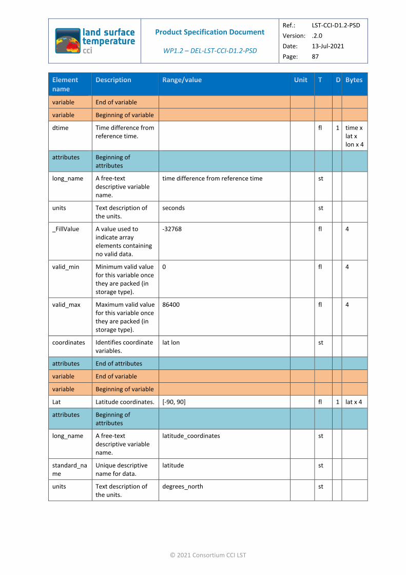
Product Specification Document
WP1.2 – DEL-LST-CCI-D1.2-PSD
Ref.: LST-CCI-D1.2-PSD
Version: .2.0
Date: 13-Jul-2021
Page: 87
© 2021 Consortium CCI LST
variable End of variable
variable Beginning of variable
dtime Time difference from reference time.
fl 1 time x lat x lon x 4
attributes Beginning of attributes
long_name A free-text descriptive variable name.
time difference from reference time st
units Text description of the units.
seconds st
_FillValue A value used to indicate array elements containing no valid data.
-32768 fl 4
valid_min Minimum valid value for this variable once they are packed (in storage type).
0 fl 4
valid_max Maximum valid value for this variable once they are packed (in storage type).
86400 fl 4
coordinates Identifies coordinate variables.
lat lon st
attributes End of attributes
variable End of variable
variable Beginning of variable
Lat Latitude coordinates. [-90, 90] fl 1 lat x 4
attributes Beginning of attributes
long_name A free-text descriptive variable name.
latitude_coordinates st
standard_name
Unique descriptive name for data.
latitude st
units Text description of the units.
degrees_north st
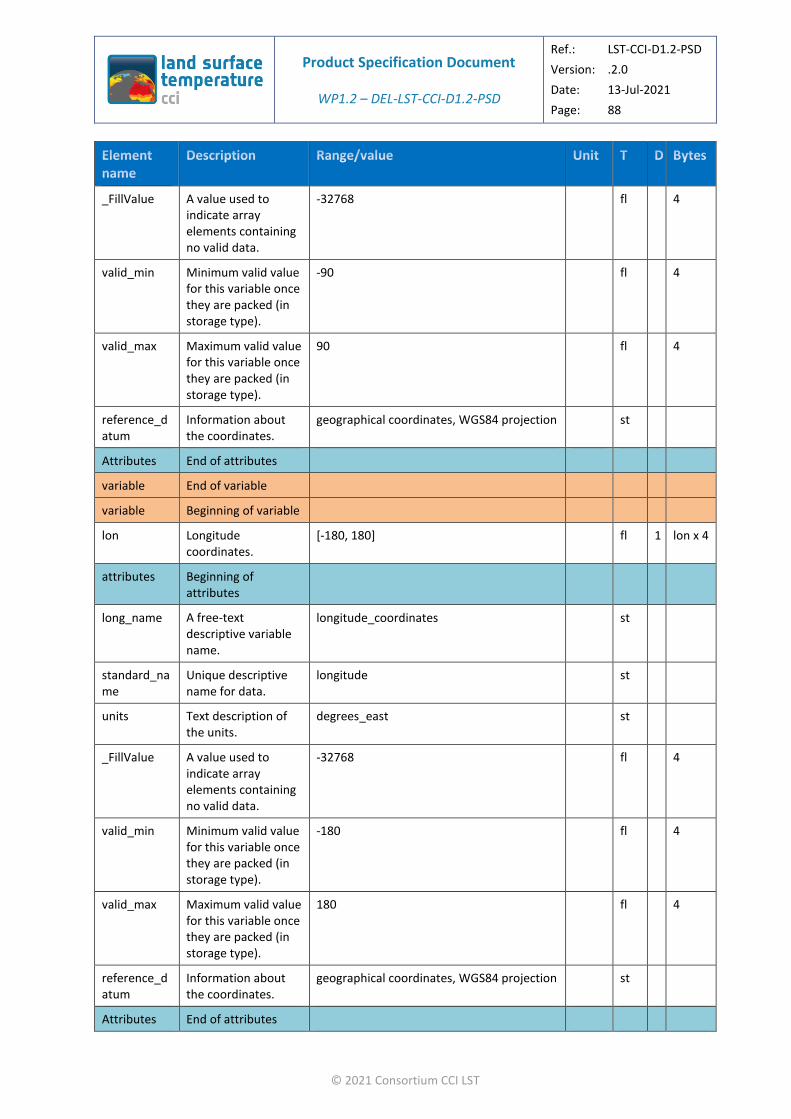
Product Specification Document
WP1.2 – DEL-LST-CCI-D1.2-PSD
Ref.: LST-CCI-D1.2-PSD
Version: .2.0
Date: 13-Jul-2021
Page: 88
© 2021 Consortium CCI LST
_FillValue A value used to indicate array elements containing no valid data.
-32768 fl 4
valid_min Minimum valid value for this variable once they are packed (in storage type).
-90 fl 4
valid_max Maximum valid value for this variable once they are packed (in storage type).
90 fl 4
reference_datum
Information about the coordinates.
geographical coordinates, WGS84 projection st
Attributes End of attributes
variable End of variable
variable Beginning of variable
lon Longitude coordinates.
[-180, 180] fl 1 lon x 4
attributes Beginning of attributes
long_name A free-text descriptive variable name.
longitude_coordinates st
standard_name
Unique descriptive name for data.
longitude st
units Text description of the units.
degrees_east st
_FillValue A value used to indicate array elements containing no valid data.
-32768 fl 4
valid_min Minimum valid value for this variable once they are packed (in storage type).
-180 fl 4
valid_max Maximum valid value for this variable once they are packed (in storage type).
180 fl 4
reference_datum
Information about the coordinates.
geographical coordinates, WGS84 projection st
Attributes End of attributes

Product Specification Document
WP1.2 – DEL-LST-CCI-D1.2-PSD
Ref.: LST-CCI-D1.2-PSD
Version: .2.0
Date: 13-Jul-2021
Page: 89
© 2021 Consortium CCI LST
variable End of variable
variable Beginning of variable
channel Channel coordinates. st 1 Channel x 4
attributes Beginning of attributes
long_name A free-text descriptive variable name.
channel st
units Text description of the units.
Channel wavelength in microns st
Attributes End of attributes
variable End of variable
variable Beginning of variable
satze Satellite zenith angle.
[0, 18000] (after scaling) ss 1 time x lat x lon x 2
attributes Beginning of attributes
long_name A free-text descriptive variable name.
satellite zenith angle st
units Text description of the units.
degrees st
_FillValue A value used to indicate array elements containing no valid data.
-32768 Fl 2
add_offset To be added to the variable after multiplying by the scale factor to recover the original value.
0 Fl 4
scale_factor To be multiplied by the variable to recover the original value.
0.01 Fl 4
valid_min Minimum valid value for this variable once they are packed (in storage type).
0 Fl 2

Product Specification Document
WP1.2 – DEL-LST-CCI-D1.2-PSD
Ref.: LST-CCI-D1.2-PSD
Version: .2.0
Date: 13-Jul-2021
Page: 90
© 2021 Consortium CCI LST
valid_max Maximum valid value for this variable once they are packed (in storage type).
18000 Fl 2
coordinates Identifies coordinate variables.
lat lon st
Attributes End of attributes
variable End of variable
variable Beginning of variable
sataz Satellite azimuth angle.
[-18000, 18000] (after scaling) ss 1 time x lat x lon x 2
attributes Beginning of attributes
long_name A free-text descriptive variable name.
satellite azimuth angle st
units Text description of the units.
degrees st
_FillValue A value used to indicate array elements containing no valid data.
-32768 ss 2
add_offset To be added to the variable after multiplying by the scale factor to recover the original value.
0 fl 4
scale_factor To be multiplied by the variable to recover the original value.
0.01 fl 4
valid_min Minimum valid value for this variable once they are packed (in storage type).
-18000 Fl 2
valid_max Maximum valid value for this variable once they are packed (in storage type).
18000 fl 2
coordinates Identifies coordinate variables.
lat lon st
Attributes End of attributes

Product Specification Document
WP1.2 – DEL-LST-CCI-D1.2-PSD
Ref.: LST-CCI-D1.2-PSD
Version: .2.0
Date: 13-Jul-2021
Page: 91
© 2021 Consortium CCI LST
variable End of variable
variable Beginning of variable
solze Solar zenith angle. [0, 18000] (after scaling, measured from the vertical)
ss 1 time x lat x lon x 2
attributes Beginning of attributes
long_name A free-text descriptive variable name.
solar zenith angle st
units Text description of the units.
degrees st
_FillValue A value used to indicate array elements containing no valid data.
-32768 ss 2
add_offset To be added to the variable after multiplying by the scale factor to recover the original value.
0 fl 4
scale_factor To be multiplied by the variable to recover the original value.
0.01 fl 4
valid_min Minimum valid value for this variable once they are packed (in storage type).
0 Fl 2
valid_max Maximum valid value for this variable once they are packed (in storage type).
18000 Fl 2
coordinates Identifies coordinate variables.
lat lon st
Attributes End of attributes
variable End of variable
variable Beginning of variable
solaz Solar azimuth angle. [-18000, 18000] (after scaling) ss 1 time x lat x lon x 2
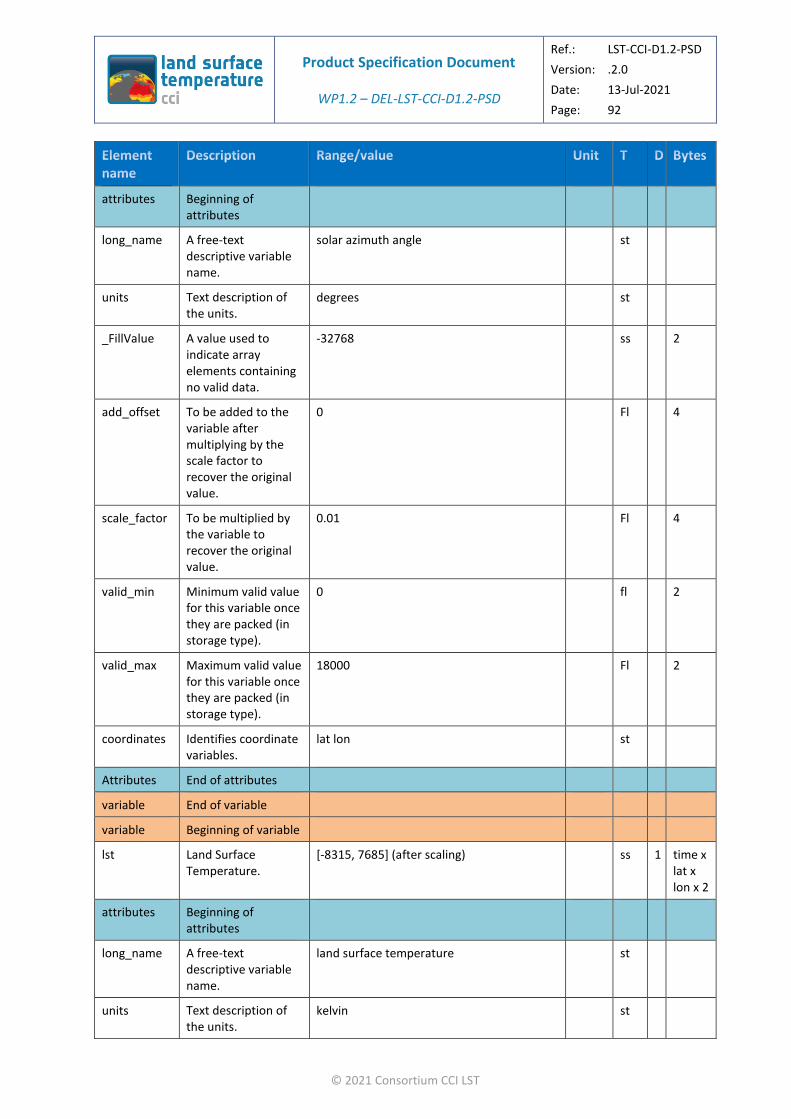
Product Specification Document
WP1.2 – DEL-LST-CCI-D1.2-PSD
Ref.: LST-CCI-D1.2-PSD
Version: .2.0
Date: 13-Jul-2021
Page: 92
© 2021 Consortium CCI LST
attributes Beginning of attributes
long_name A free-text descriptive variable name.
solar azimuth angle st
units Text description of the units.
degrees st
_FillValue A value used to indicate array elements containing no valid data.
-32768 ss 2
add_offset To be added to the variable after multiplying by the scale factor to recover the original value.
0 Fl 4
scale_factor To be multiplied by the variable to recover the original value.
0.01 Fl 4
valid_min Minimum valid value for this variable once they are packed (in storage type).
0 fl 2
valid_max Maximum valid value for this variable once they are packed (in storage type).
18000 Fl 2
coordinates Identifies coordinate variables.
lat lon st
Attributes End of attributes
variable End of variable
variable Beginning of variable
lst Land Surface Temperature.
[-8315, 7685] (after scaling) ss 1 time x lat x lon x 2
attributes Beginning of attributes
long_name A free-text descriptive variable name.
land surface temperature st
units Text description of the units.
kelvin st

Product Specification Document
WP1.2 – DEL-LST-CCI-D1.2-PSD
Ref.: LST-CCI-D1.2-PSD
Version: .2.0
Date: 13-Jul-2021
Page: 93
© 2021 Consortium CCI LST
_FillValue A value used to indicate array elements containing no valid data.
-32768 ss 2
add_offset To be added to the variable after multiplying by the scale factor to recover the original value.
273.15 fl 4
scale_factor To be multiplied by the variable to recover the original value.
0.01 fl 4
valid_min Minimum valid value for this variable once they are packed (in storage type).
-8315 Fl 2
valid_max Maximum valid value for this variable once they are packed (in storage type).
7685 Fl 2
coordinates Identifies coordinate variables.
lat lon st
Attributes End of attributes
variable End of variable
variable Beginning of variable
lst_uncertainty
Land Surface Temperature Total Uncertainty.
[0, 10000] (after scaling) ss 1 time x lat x lon x 2
attributes Beginning of attributes
long_name A free-text descriptive variable name.
land surface temperature total uncertainty st
units Text description of the units.
kelvin st
_FillValue A value used to indicate array elements containing no valid data.
-32768 ss 2
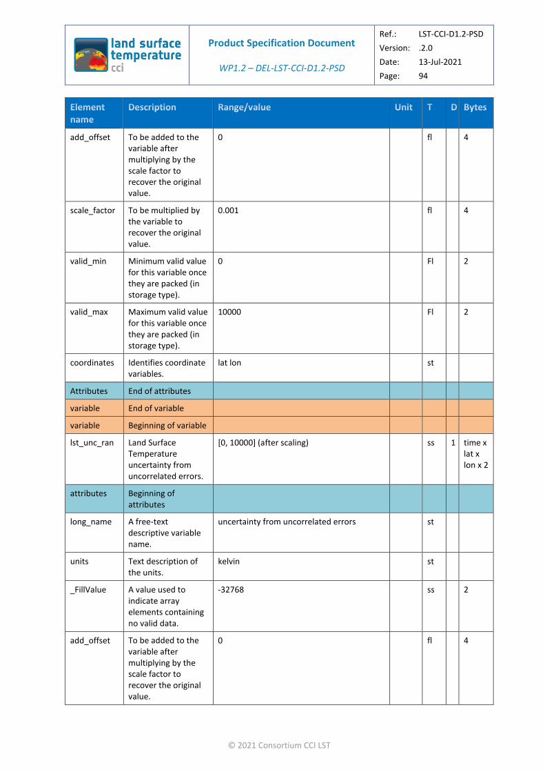
Product Specification Document
WP1.2 – DEL-LST-CCI-D1.2-PSD
Ref.: LST-CCI-D1.2-PSD
Version: .2.0
Date: 13-Jul-2021
Page: 94
© 2021 Consortium CCI LST
add_offset To be added to the variable after multiplying by the scale factor to recover the original value.
0 fl 4
scale_factor To be multiplied by the variable to recover the original value.
0.001 fl 4
valid_min Minimum valid value for this variable once they are packed (in storage type).
0 Fl 2
valid_max Maximum valid value for this variable once they are packed (in storage type).
10000 Fl 2
coordinates Identifies coordinate variables.
lat lon st
Attributes End of attributes
variable End of variable
variable Beginning of variable
lst_unc_ran Land Surface Temperature uncertainty from uncorrelated errors.
[0, 10000] (after scaling) ss 1 time x lat x lon x 2
attributes Beginning of attributes
long_name A free-text descriptive variable name.
uncertainty from uncorrelated errors st
units Text description of the units.
kelvin st
_FillValue A value used to indicate array elements containing no valid data.
-32768 ss 2
add_offset To be added to the variable after multiplying by the scale factor to recover the original value.
0 fl 4

Product Specification Document
WP1.2 – DEL-LST-CCI-D1.2-PSD
Ref.: LST-CCI-D1.2-PSD
Version: .2.0
Date: 13-Jul-2021
Page: 95
© 2021 Consortium CCI LST
scale_factor To be multiplied by the variable to recover the original value.
0.001 fl 4
valid_min Minimum valid value for this variable once they are packed (in storage type).
0 ss 2
valid_max Maximum valid value for this variable once they are packed (in storage type).
10000 ss 2
coordinates Identifies coordinate variables.
lat lon st
Attributes End of attributes
variable End of variable
variable Beginning of variable
lst_unc_loc_atm
Land Surface Temperature uncertainty from locally correlated errors on atmospheric scales.
[0, 10000] (after scaling) ss 1 time x lat x lon x 2
attributes Beginning of attributes
long_name A free-text descriptive variable name.
uncertainty from locally correlated errors on atmospheric scales
st
units Text description of the units.
kelvin st
_FillValue A value used to indicate array elements containing no valid data.
-32768 ss 2
add_offset To be added to the variable after multiplying by the scale factor to recover the original value.
0 fl 4
scale_factor To be multiplied by the variable to recover the original value.
0.001 fl 4
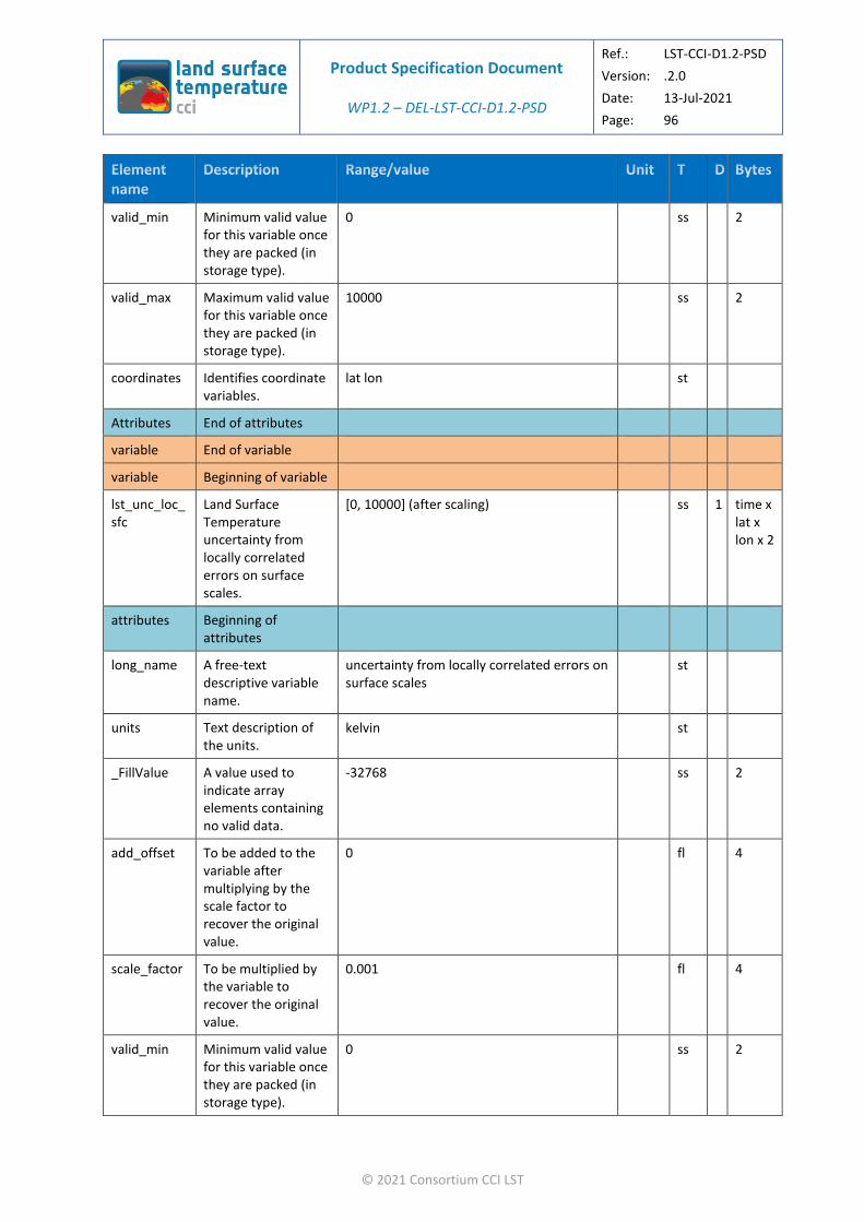
Product Specification Document
WP1.2 – DEL-LST-CCI-D1.2-PSD
Ref.: LST-CCI-D1.2-PSD
Version: .2.0
Date: 13-Jul-2021
Page: 96
© 2021 Consortium CCI LST
valid_min Minimum valid value for this variable once they are packed (in storage type).
0 ss 2
valid_max Maximum valid value for this variable once they are packed (in storage type).
10000 ss 2
coordinates Identifies coordinate variables.
lat lon st
Attributes End of attributes
variable End of variable
variable Beginning of variable
lst_unc_loc_sfc
Land Surface Temperature uncertainty from locally correlated errors on surface scales.
[0, 10000] (after scaling) ss 1 time x lat x lon x 2
attributes Beginning of attributes
long_name A free-text descriptive variable name.
uncertainty from locally correlated errors on surface scales
st
units Text description of the units.
kelvin st
_FillValue A value used to indicate array elements containing no valid data.
-32768 ss 2
add_offset To be added to the variable after multiplying by the scale factor to recover the original value.
0 fl 4
scale_factor To be multiplied by the variable to recover the original value.
0.001 fl 4
valid_min Minimum valid value for this variable once they are packed (in storage type).
0 ss 2

Product Specification Document
WP1.2 – DEL-LST-CCI-D1.2-PSD
Ref.: LST-CCI-D1.2-PSD
Version: .2.0
Date: 13-Jul-2021
Page: 97
© 2021 Consortium CCI LST
valid_max Maximum valid value for this variable once they are packed (in storage type).
10000 ss 2
coordinates Identifies coordinate variables.
lat lon st
Attributes End of attributes
variable End of variable
variable Beginning of variable
lst_unc_sys Land Surface Temperature uncertainty from large-scale systematic errors.
[0, 10000] (after scaling) ss 1 length_scale
attributes Beginning of attributes
long_name A free-text descriptive variable name.
uncertainty from large-scale systematic errors
st
units Text description of the units.
kelvin st
_FillValue A value used to indicate array elements containing no valid data.
-32768 ss 2
add_offset To be added to the variable after multiplying by the scale factor to recover the original value.
0 fl 4
scale_factor To be multiplied by the variable to recover the original value.
0.001 fl 4
valid_min Minimum valid value for this variable once they are packed (in storage type).
0 ss 2
valid_max Maximum valid value for this variable once they are packed (in storage type).
10000 ss 2
Attributes End of attributes

Product Specification Document
WP1.2 – DEL-LST-CCI-D1.2-PSD
Ref.: LST-CCI-D1.2-PSD
Version: .2.0
Date: 13-Jul-2021
Page: 98
© 2021 Consortium CCI LST
variable End of variable
variable Beginning of variable
emis Land Surface Emissivity
[0, 10000] (after scaling) ss 1 time x lat x lon x channel x 2
attributes Beginning of attributes
long_name A free-text descriptive variable name.
surface emissivity st
units Text description of the units.
1 st
_FillValue A value used to indicate array elements containing no valid data.
-32768 Ss 2
add_offset To be added to the variable after multiplying by the scale factor to recover the original value.
0 Fl 4
scale_factor To be multiplied by the variable to recover the original value.
0.0001 Fl 4
valid_min Minimum valid value for this variable once they are packed (in storage type).
0 Fl 2
valid_max Maximum valid value for this variable once they are packed (in storage type).
10000 fl 2
coordinates Identifies coordinate variables.
lat lon st
Attributes End of attributes
variable End of variable
variance Land Surface Temperature variance.
[0,10000] (after scaling) ss 1 time x lat x lon x 2

Product Specification Document
WP1.2 – DEL-LST-CCI-D1.2-PSD
Ref.: LST-CCI-D1.2-PSD
Version: .2.0
Date: 13-Jul-2021
Page: 99
© 2021 Consortium CCI LST
attributes Beginning of attributes
long_name A free-text descriptive variable name.
land surface temperature variance st
units Text description of the units.
Kelvin st
_FillValue A value used to indicate array elements containing no valid data.
-32768 Ss 2
add_offset To be added to the variable after multiplying by the scale factor to recover the original value.
0 Fl 4
scale_factor To be multiplied by the variable to recover the original value.
0.01 Fl 4
valid_min Minimum valid value for this variable once they are packed (in storage type).
0 ss 2
valid_max Maximum valid value for this variable once they are packed (in storage type).
10000 ss 2
coordinates Identifies coordinate variables.
lat lon st
Attributes End of attributes
variable End of variable
variables End of variables
attributes Beginning of global attributes
Global attributes that have values that are consistent between data levels are defined in Table 27.
attributes End of global attributes
dataset End of Dataset

Product Specification Document
WP1.2 – DEL-LST-CCI-D1.2-PSD
Ref.: LST-CCI-D1.2-PSD
Version: .2.0
Date: 13-Jul-2021
Page: 100
© 2021 Consortium CCI LST
Table 29: Optional variable specification for LST_CCI L3U files.
Dataset Beginning of dataset
dimensions Beginning of dimensions
lat Latitude dimension. sl 1 4
lon Longitude dimension.
sl 1 4
channel Channel dimension sl 1 4
length_scale Uncertainty correlation length scale
sl 1 4
time Time dimension; must be 1 for L3U data.
1 sl 1 4
dimensions End of dimensions
variables Beginning of variables
variable Beginning of variable
qual_flag Quality flags. IR: [0, 15], MW: [0, 1023] ss 1 time x lat x lon x 2
attributes Beginning of attributes
long_name A free-text descriptive variable name.
Quality flags st
units Text description of the units.
1 st

Product Specification Document
WP1.2 – DEL-LST-CCI-D1.2-PSD
Ref.: LST-CCI-D1.2-PSD
Version: .2.0
Date: 13-Jul-2021
Page: 101
© 2021 Consortium CCI LST
flag_meanings
Meaning attached to each flag value.
IR datasets (except Daily L3C): summary_cloud-1_is_cloudy summary_confidence-1_is_low_confidence aerosol_mask-1_is_aerosol_detected
IR datasets (Daily L3C): local_solar_time_quality-1_is_nearest_to_local_solar_time
MW datasets: no_use no_use no_use snow_OR_ice- 1_is_snow_OR_ice summary_inversion_quality- 1_is_less_reliable_inversion microwave_penetration_depth- 1_is_ground_with_large_penetration_dep th deep_convection_occurence- 1_is_possibility_of_deep_convection coast-1_is_cost inundation_risk- 1_is_possibility_of_inundated_land
st
flag_masks Bit masks corresponding to the flags described in flag_meanings.
IR datasets: 1, 2, 4, 8
MW datasets: 1, 2, 4, 8, 16, 32, 64, 128, 256, 512
ss 2
_FillValue A value used to indicate array elements containing no valid data.
-32768 fl 2
valid_min Minimum valid value for this variable once they are packed (in storage type).
0 Fl 2
valid_max Maximum valid value for this variable once they are packed (in storage type).
IR datasets: 15
MW datasets: 1023
fl 2
coordinates Identifies coordinate variables.
lat lon st
Attributes End of attributes
variable End of variable
variable Beginning of variable

Product Specification Document
WP1.2 – DEL-LST-CCI-D1.2-PSD
Ref.: LST-CCI-D1.2-PSD
Version: .2.0
Date: 13-Jul-2021
Page: 102
© 2021 Consortium CCI LST
domain_flag Domain flags. IR: [0, 127] ss 1 time x lat x lon x 2
attributes Beginning of attributes
long_name A free-text descriptive variable name.
Domain flags st
units Text description of the units.
1 st
flag_meanings
Meaning attached to each flag value.
IR datasets: day_or_night-1_is_night ocean_flag land_flag lake_flag coast_flag tidal_flag seaice_flag
st
flag_masks Bit masks corresponding to the flags described in flag_meanings.
IR datasets: 1, 2, 4, 8, 16, 32, 64 ss 2
_FillValue A value used to indicate array elements containing no valid data.
-32768 ss 2
valid_min Minimum valid value for this variable once they are packed (in storage type).
0 ss 2
valid_max Maximum valid value for this variable once they are packed (in storage type).
IR datasets: 127 ss 2
coordinates Identifies coordinate variables.
ni nj st
Attributes End of attributes
variable End of variable
variable Beginning of variable
ndvi Normalised Difference Vegetation Index.
[0, 10000] (after scaling) ss 1 time x lat x lon x 2
attributes Beginning of attributes

Product Specification Document
WP1.2 – DEL-LST-CCI-D1.2-PSD
Ref.: LST-CCI-D1.2-PSD
Version: .2.0
Date: 13-Jul-2021
Page: 103
© 2021 Consortium CCI LST
long_name A free-text descriptive variable name.
normalized difference vegetation index st
units Text description of the units.
1 st
_FillValue A value used to indicate array elements containing no valid data.
-32768 ss 2
add_offset To be added to the variable after multiplying by the scale factor to recover the original value.
0 fl 4
scale_factor To be multiplied by the variable to recover the original value.
0.0001 fl 4
valid_min Minimum valid value for this variable once they are packed (in storage type).
0 ss 2
valid_max Maximum valid value for this variable once they are packed (in storage type).
10000 ss 2
source Auxiliary data source.
CGLPS NDVI 1 km dataset v2.2: https://land.copernicus.eu/global/products/ndvi
st
coordinates Identifies coordinate variables.
lat lon st
Attributes End of attributes
variable End of variable
variable Beginning of variable
t2m 2m Surface Air Temperature
[-8315, 7685] (after scaling) ss 1 time x lat x lon x 2
attributes Beginning of attributes
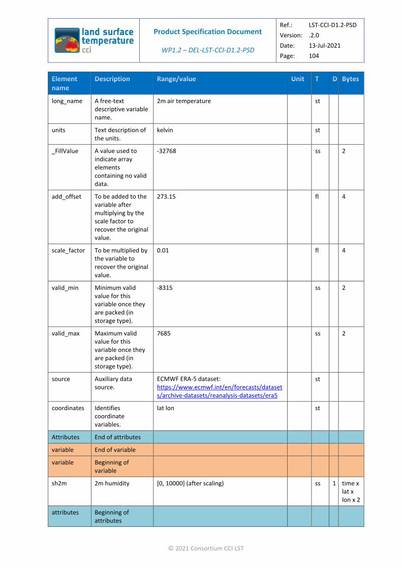
Product Specification Document
WP1.2 – DEL-LST-CCI-D1.2-PSD
Ref.: LST-CCI-D1.2-PSD
Version: .2.0
Date: 13-Jul-2021
Page: 104
© 2021 Consortium CCI LST
long_name A free-text descriptive variable name.
2m air temperature st
units Text description of the units.
kelvin st
_FillValue A value used to indicate array elements containing no valid data.
-32768 ss 2
add_offset To be added to the variable after multiplying by the scale factor to recover the original value.
273.15 fl 4
scale_factor To be multiplied by the variable to recover the original value.
0.01 fl 4
valid_min Minimum valid value for this variable once they are packed (in storage type).
-8315 ss 2
valid_max Maximum valid value for this variable once they are packed (in storage type).
7685 ss 2
source Auxiliary data source.
ECMWF ERA-5 dataset: https://www.ecmwf.int/en/forecasts/datasets/archive-datasets/reanalysis-datasets/era5
st
coordinates Identifies coordinate variables.
lat lon st
Attributes End of attributes
variable End of variable
variable Beginning of variable
sh2m 2m humidity [0, 10000] (after scaling) ss 1 time x lat x lon x 2
attributes Beginning of attributes

Product Specification Document
WP1.2 – DEL-LST-CCI-D1.2-PSD
Ref.: LST-CCI-D1.2-PSD
Version: .2.0
Date: 13-Jul-2021
Page: 105
© 2021 Consortium CCI LST
long_name A free-text descriptive variable name.
2m specific humidity st
units Text description of the units.
1 st
_FillValue A value used to indicate array elements containing no valid data.
-32768 Ss 2
add_offset To be added to the variable after multiplying by the scale factor to recover the original value.
0 Fl 4
scale_factor To be multiplied by the variable to recover the original value.
0.0001 Fl 4
valid_min Minimum valid value for this variable once they are packed (in storage type).
0 ss 2
valid_max Maximum valid value for this variable once they are packed (in storage type).
10000 ss 2
source Auxiliary data source
ECMWF ERA-5 dataset: https://www.ecmwf.int/en/forecasts/datasets/archive-datasets/reanalysis-datasets/era5
coordinates Identifies coordinate variables.
lat lon st
Attributes End of attributes
variable End of variable
variable Beginning of variable
ws2m 2m wind speed [0, 20000] (after scaling) ss 1 time x lat x lon x 2
attributes Beginning of attributes

Product Specification Document
WP1.2 – DEL-LST-CCI-D1.2-PSD
Ref.: LST-CCI-D1.2-PSD
Version: .2.0
Date: 13-Jul-2021
Page: 106
© 2021 Consortium CCI LST
long_name A free-text descriptive variable name.
2m wind speed st
units Text description of the units.
m s-1 st
_FillValue A value used to indicate array elements containing no valid data.
-32768 Ss 2
add_offset To be added to the variable after multiplying by the scale factor to recover the original value.
0 Fl 4
scale_factor To be multiplied by the variable to recover the original value.
0.004 Fl 4
valid_min Minimum valid value for this variable once they are packed (in storage type).
0 ss 2
valid_max Maximum valid value for this variable once they are packed (in storage type).
20000 ss 2
source Auxiliary data source
ECMWF ERA-5 dataset: https://www.ecmwf.int/en/forecasts/datasets/archive-datasets/reanalysis-datasets/era5
coordinates Identifies coordinate variables.
lat lon st
Attributes End of attributes
variable End of variable
variable Beginning of variable
variance Land Surface Temperature variance.
[0,10000] (after scaling) ss 1 time x lat x lon x 2
attributes Beginning of attributes

Product Specification Document
WP1.2 – DEL-LST-CCI-D1.2-PSD
Ref.: LST-CCI-D1.2-PSD
Version: .2.0
Date: 13-Jul-2021
Page: 107
© 2021 Consortium CCI LST
long_name A free-text descriptive variable name.
land surface temperature variance st
units Text description of the units.
Kelvin st
_FillValue A value used to indicate array elements containing no valid data.
-32768 Ss 2
add_offset To be added to the variable after multiplying by the scale factor to recover the original value.
0 Fl 4
scale_factor To be multiplied by the variable to recover the original value.
0.01 Fl 4
valid_min Minimum valid value for this variable once they are packed (in storage type).
0 ss 2
valid_max Maximum valid value for this variable once they are packed (in storage type).
10000 ss 2
coordinates Identifies coordinate variables.
lat lon st
Attributes End of attributes
variable End of variable
variable Beginning of variable
lcc Land cover class. [1,27] ss 1 time x lat x lon x 2
attributes Beginning of attributes
long_name A free-text descriptive variable name.
land cover class st

Product Specification Document
WP1.2 – DEL-LST-CCI-D1.2-PSD
Ref.: LST-CCI-D1.2-PSD
Version: .2.0
Date: 13-Jul-2021
Page: 108
© 2021 Consortium CCI LST
units Text description of the units.
1 st
flag_meanings
Meaning attached to each flag value.
Post-flooding_OR_irrigated_croplands Rainfed_croplands Mosaic_Cropland_(50-70percent)_OR_Vegetation_(grassland,_shrubland,_forest)_(20-50percent) Mosaic_Vegetation_(grassland,_shrubland,_forest)_(50-70percent)_OR_Cropland_(20-50percent) Closed_to_open_(_MORE_THAN_15percent)_broadleaved_evergreen_and_or_semi-deciduous_forest_(_MORE_THAN_5m) Closed_(_MORE_THAN_40percent)_broadleaved_deciduous_forest_(_MORE_THAN_5m) Open_(15-40percent)_broadleaved_deciduous_forest_(_MORE_THAN_5m) Closed_(_MORE_THAN_40percent)_needleleaved_evergreen_forest_(_MORE_THAN_5m) Open_(15-40percent)_needleleaved_deciduous_or_evergreen_forest_(_MORE_THAN_5m) Closed_to_open_(_MORE_THAN_15percent)_mixed_broadleaved_and_needleleaved_forest_(_MORE_THAN_5m) Mosaic_Forest_OR_Shrubland_(50-70percent)_OR_Grassland_(20-50percent) Mosaic_Grassland_(50-70percent)_OR_Forest_OR_Shrubland_(20-50percent) Closed_to_open_(_MORE_THAN_15percent)_shrubland_(_LESS_THAN_5m) Closed_to_open_(_MORE_THAN_15percent)_grassland Sparse_(_MORE_THAN_15percent)_vegetation_(woody_vegetation,_shrubs,_grassland) Closed_(_MORE_THAN_40percent)_broadleaved_forest_regularly_flooded_-Fresh_water Closed_(_MORE_THAN_40percent)_broadleaved_semi-deciduous_and_or_evergreen_forest_regularly_flooded_-Saline_water Closed_to_open_(_MORE_THAN_15percent)_vegetation_(grassland,_shrubland,_woody_vegetation)_on_regularly_flooded_or_waterlogged_soil_-Fresh,_brackish_or_saline_water Artificial_surfaces_and_associated_areas_(urban_areas__MORE_THAN_50percent) Bare_areas_of_soil_types_not_contained_in_biomes_21_to_25 Bare_areas_of_soil_type_Entisols_–
st

Product Specification Document
WP1.2 – DEL-LST-CCI-D1.2-PSD
Ref.: LST-CCI-D1.2-PSD
Version: .2.0
Date: 13-Jul-2021
Page: 109
© 2021 Consortium CCI LST
_Orthents Bare_areas_of_soil_type_Shifting_sand Bare_areas_of_soil_type_Aridisols_-_Calcids Bare_areas_of_soil_type_Aridisols_-_Cambids Bare_areas_of_soil_type_Gelisols_-_Orthels Water_bodies_(inland_lakes,_rivers,_sea:_max_10km_away_from_coast) Permanent_snow_and_ice
flag_masks Values corresponding to the flags described in flag_meanings.
1, 2, 3, 4, 5, 6, 7, 8, 9, 10, 11, 12, 13, 14, 15, 16, 17, 18, 19, 20, 21, 22, 23, 24, 25, 26, 27
ss 2
_FillValue A value used to indicate array elements containing no valid data.
-32768 Fl 2
valid_min Minimum valid value for this variable once they are packed (in storage type).
0 Fl 2
valid_max Maximum valid value for this variable once they are packed (in storage type).
27 fl 2
coordinates Identifies coordinate variables.
lat lon st
Attributes End of attributes
variable End of variable
variable Beginning of variable
tcwv Total Column Water Vapour
[0, 20000] (after scaling) ss 1 time x lat x lon x 2
attributes Beginning of attributes
long_name A free-text descriptive variable name.
total column water vapour st
units Text description of the units.
kg m-2 st
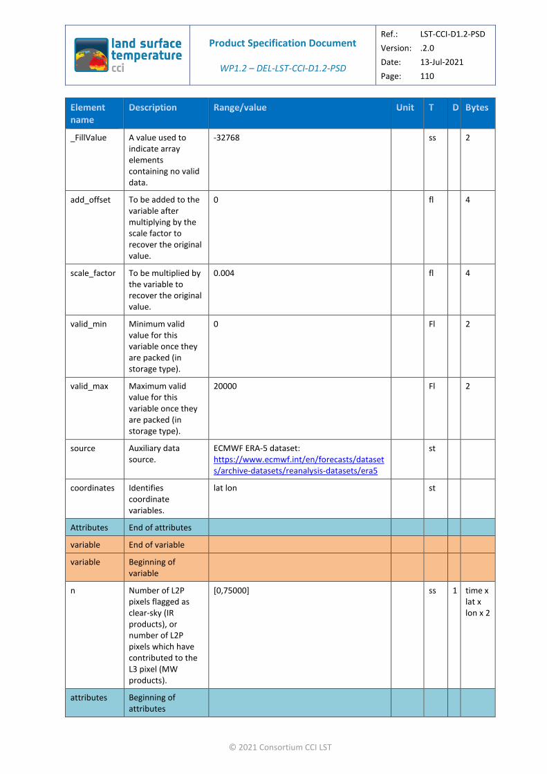
Product Specification Document
WP1.2 – DEL-LST-CCI-D1.2-PSD
Ref.: LST-CCI-D1.2-PSD
Version: .2.0
Date: 13-Jul-2021
Page: 110
© 2021 Consortium CCI LST
_FillValue A value used to indicate array elements containing no valid data.
-32768 ss 2
add_offset To be added to the variable after multiplying by the scale factor to recover the original value.
0 fl 4
scale_factor To be multiplied by the variable to recover the original value.
0.004 fl 4
valid_min Minimum valid value for this variable once they are packed (in storage type).
0 Fl 2
valid_max Maximum valid value for this variable once they are packed (in storage type).
20000 Fl 2
source Auxiliary data source.
ECMWF ERA-5 dataset: https://www.ecmwf.int/en/forecasts/datasets/archive-datasets/reanalysis-datasets/era5
st
coordinates Identifies coordinate variables.
lat lon st
Attributes End of attributes
variable End of variable
variable Beginning of variable
n Number of L2P pixels flagged as clear-sky (IR products), or number of L2P pixels which have contributed to the L3 pixel (MW products).
[0,75000] ss 1 time x lat x lon x 2
attributes Beginning of attributes

Product Specification Document
WP1.2 – DEL-LST-CCI-D1.2-PSD
Ref.: LST-CCI-D1.2-PSD
Version: .2.0
Date: 13-Jul-2021
Page: 111
© 2021 Consortium CCI LST
long_name A free-text descriptive variable name.
Number of pixels averaged st
units Text description of the units.
1 st
_FillValue A value used to indicate array elements containing no valid data.
-32768 Ss 2
valid_min Minimum valid value for this variable once they are packed (in storage type).
0 ss 2
valid_max Maximum valid value for this variable once they are packed (in storage type).
75000 ss 2
coordinates Identifies coordinate variables.
lat lon st
Attributes End of attributes
variable End of variable
variable Beginning of variable
ncld Number of pixels flagged as cloudy
[0,75000] ss 1 time x lat x lon x 2
attributes Beginning of attributes
long_name A free-text descriptive variable name.
Number of pixels excluded st
units Text description of the units.
1 st
_FillValue A value used to indicate array elements containing no valid data.
-32768 Ss 2

Product Specification Document
WP1.2 – DEL-LST-CCI-D1.2-PSD
Ref.: LST-CCI-D1.2-PSD
Version: .2.0
Date: 13-Jul-2021
Page: 112
© 2021 Consortium CCI LST
valid_min Minimum valid value for this variable once they are packed (in storage type).
0 ss 2
valid_max Maximum valid value for this variable once they are packed (in storage type).
75000 ss 2
coordinates Identifies coordinate variables.
lat lon st
Attributes End of attributes
variable End of variable
variable Beginning of variable
lwm Land water mask [0,10000] (after scaling) ss 1 time x lat x lon x 2
attributes Beginning of attributes
long_name A free-text descriptive variable name.
Land water mask st
units Text description of the units.
1 st
_FillValue A value used to indicate array elements containing no valid data.
-32768 Ss 2
add_offset To be added to the variable after multiplying by the scale factor to recover the original value.
0 Fl 4
scale_factor To be multiplied by the variable to recover the original value.
0.0001 Fl 4

Product Specification Document
WP1.2 – DEL-LST-CCI-D1.2-PSD
Ref.: LST-CCI-D1.2-PSD
Version: .2.0
Date: 13-Jul-2021
Page: 113
© 2021 Consortium CCI LST
valid_min Minimum valid value for this variable once they are packed (in storage type).
0 ss 2
valid_max Maximum valid value for this variable once they are packed (in storage type).
10000 ss 2
coordinates Identifies coordinate variables.
lat lon st
Attributes End of attributes
variable End of variable
variable Beginning of variable
fv Fractional vegetation cover.
[0, 10000] (after scaling) ss 1 time x lat x lon x 2
attributes Beginning of attributes
long_name A free-text descriptive variable name.
fractional vegetation cover st
units Text description of the units.
1 st
_FillValue A value used to indicate array elements containing no valid data.
-32768 ss 2
add_offset To be added to the variable after multiplying by the scale factor to recover the original value.
0 fl 4
scale_factor To be multiplied by the variable to recover the original value.
0.0001 fl 4

Product Specification Document
WP1.2 – DEL-LST-CCI-D1.2-PSD
Ref.: LST-CCI-D1.2-PSD
Version: .2.0
Date: 13-Jul-2021
Page: 114
© 2021 Consortium CCI LST
valid_min Minimum valid value for this variable once they are packed (in storage type).
0 fl 2
valid_max Maximum valid value for this variable once they are packed (in storage type).
20000 fl 2
source Auxiliary data source.
CGLPS FCOVER 1 km dataset v2.0, which has been brokered to C3S: https://land.copernicus.eu/global/products/fcover
st
coordinates Identifies coordinate variables.
lat lon st
Attributes End of attributes
variable End of variable
variables End of variables
attributes Beginning of global attributes
Global attributes that have values that are consistent between data levels are defined in Table 27.
attributes End of global attributes
dataset End of Dataset
Table 30: Detailed specification of the LST_CCI L3C/S files. Files are divided into day and night or ascending or descending.
Dataset Beginning of dataset
dimensions Beginning of dimensions
lat Latitude dimension. sl 1 4
lon Longitude dimension. sl 1 4
channel Channel dimension sl 1 4
length_scale Uncertainty correlation length scale
sl 1 4
time Time dimension sl 1 4
dimensions End of dimensions

Product Specification Document
WP1.2 – DEL-LST-CCI-D1.2-PSD
Ref.: LST-CCI-D1.2-PSD
Version: .2.0
Date: 13-Jul-2021
Page: 115
© 2021 Consortium CCI LST
variables Beginning of variables
variable Beginning of variable
time Time coordinate. Reference time of file
db 1 8
attributes Beginning of attributes
long_name A free-text descriptive variable name.
reference time of file st
standard_name
Unique descriptive name for data.
time st
units Text description of the units.
seconds since 1981-01-01 00:00:00 st
calendar Defines the calendar used to define the times.
gregorian st
attributes End of attributes
variable End of variable
variable Beginning of variable
dtime Time difference from reference time.
fl 1 time x lat x lon x 4
attributes Beginning of attributes
long_name A free-text descriptive variable name.
time difference from reference time st
units Text description of the units.
seconds st
_FillValue A value used to indicate array elements containing no valid data.
-32768 fl 4
valid_min Minimum valid value for this variable once they are packed (in storage type).
0 fl 4
valid_max Maximum valid value for this variable once they are packed (in storage type).
Daily: 86400
Monthly: 2678400
Annual: 31622400
fl 4
coordinates Identifies coordinate variables.
lat lon st
attributes End of attributes
variable End of variable
variable Beginning of variable

Product Specification Document
WP1.2 – DEL-LST-CCI-D1.2-PSD
Ref.: LST-CCI-D1.2-PSD
Version: .2.0
Date: 13-Jul-2021
Page: 116
© 2021 Consortium CCI LST
lat Latitude coordinates. [-90, 90] fl 1 lat x 4
attributes Beginning of attributes
long_name A free-text descriptive variable name.
latitude_coordinates st
standard_name
Unique descriptive name for data.
latitude st
units Text description of the units.
degrees_north st
_FillValue A value used to indicate array elements containing no valid data.
-32768 fl 4
valid_min Minimum valid value for this variable once they are packed (in storage type).
-90 fl 4
valid_max Maximum valid value for this variable once they are packed (in storage type).
90 fl 4
reference_datum
Information about the coordinates.
geographical coordinates, WGS84 projection
st
Attributes End of attributes
variable End of variable
variable Beginning of variable
lon Longitude coordinates. [-180, 180] fl 1 lon x 4
attributes Beginning of attributes
long_name A free-text descriptive variable name.
longitude_coordinates st
standard_name
Unique descriptive name for data.
longitude st
units Text description of the units.
degrees_east st
_FillValue A value used to indicate array elements containing no valid data.
-32768 fl 4
valid_min Minimum valid value for this variable once they are packed (in storage type).
-180 fl 4

Product Specification Document
WP1.2 – DEL-LST-CCI-D1.2-PSD
Ref.: LST-CCI-D1.2-PSD
Version: .2.0
Date: 13-Jul-2021
Page: 117
© 2021 Consortium CCI LST
valid_max Maximum valid value for this variable once they are packed (in storage type).
180 fl 4
reference_datum
Information about the coordinates.
geographical coordinates, WGS84 projection
st
Attributes End of attributes
variable End of variable
variable Beginning of variable
channel Channel coordinates. st 1 lat x lon x 4
attributes Beginning of attributes
long_name A free-text descriptive variable name.
channel st
units Text description of the units.
Channel wavelength in microns st
Attributes End of attributes
variable End of variable
variable Beginning of variable
satze Satellite zenith angle. [0, 18000] (after scaling) ss 1 time x lat x lon x 2
attributes Beginning of attributes
long_name A free-text descriptive variable name.
satellite zenith angle st
units Text description of the units.
degrees st
_FillValue A value used to indicate array elements containing no valid data.
-32768 ss 2
add_offset To be added to the variable after multiplying by the scale factor to recover the original value.
0 fl 4
scale_factor To be multiplied by the variable to recover the original value.
0.01 fl 4
valid_min Minimum valid value for this variable once they are packed (in storage type).
0 ss 2

Product Specification Document
WP1.2 – DEL-LST-CCI-D1.2-PSD
Ref.: LST-CCI-D1.2-PSD
Version: .2.0
Date: 13-Jul-2021
Page: 118
© 2021 Consortium CCI LST
valid_max Maximum valid value for this variable once they are packed (in storage type).
18000 ss 2
coordinates Identifies coordinate variables.
lat lon st
Attributes End of attributes
variable End of variable
variable Beginning of variable
sataz Satellite azimuth angle. [-18000, 18000] (after scaling) ss 1 time x lat x lon x 2
attributes Beginning of attributes
long_name A free-text descriptive variable name.
satellite azimuth angle st
units Text description of the units.
degrees st
_FillValue A value used to indicate array elements containing no valid data.
-32768 ss 2
add_offset To be added to the variable after multiplying by the scale factor to recover the original value.
0 fl 4
scale_factor To be multiplied by the variable to recover the original value.
0.01 fl 4
valid_min Minimum valid value for this variable once they are packed (in storage type).
-18000 ss 2
valid_max Maximum valid value for this variable once they are packed (in storage type).
18000 ss 2
coordinates Identifies coordinate variables.
lat lon st
Attributes End of attributes
variable End of variable
variable Beginning of variable

Product Specification Document
WP1.2 – DEL-LST-CCI-D1.2-PSD
Ref.: LST-CCI-D1.2-PSD
Version: .2.0
Date: 13-Jul-2021
Page: 119
© 2021 Consortium CCI LST
lst Land Surface Temperature.
[-8315, 7685] (after scaling) ss 1 time x lat x lon x 2
attributes Beginning of attributes
long_name A free-text descriptive variable name.
land surface temperature st
units Text description of the units.
kelvin st
_FillValue A value used to indicate array elements containing no valid data.
-32768 ss 2
add_offset To be added to the variable after multiplying by the scale factor to recover the original value.
273.15 fl 4
scale_factor To be multiplied by the variable to recover the original value.
0.01 fl 4
valid_min Minimum valid value for this variable once they are packed (in storage type).
-8315 ss 2
valid_max Maximum valid value for this variable once they are packed (in storage type).
7685 ss 2
coordinates Identifies coordinate variables.
lat lon st
Attributes End of attributes
variable End of variable
variable Beginning of variable
lst_uncertainty
Land Surface Temperature Total Uncertainty.
[0, 10000] (after scaling) ss 1 time x lat x lon x 2
attributes Beginning of attributes
long_name A free-text descriptive variable name.
land surface temperature total uncertainty
st
units Text description of the units.
kelvin st
_FillValue A value used to indicate array elements containing no valid data.
-32768 ss 2
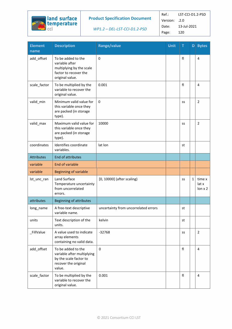
Product Specification Document
WP1.2 – DEL-LST-CCI-D1.2-PSD
Ref.: LST-CCI-D1.2-PSD
Version: .2.0
Date: 13-Jul-2021
Page: 120
© 2021 Consortium CCI LST
add_offset To be added to the variable after multiplying by the scale factor to recover the original value.
0 fl 4
scale_factor To be multiplied by the variable to recover the original value.
0.001 fl 4
valid_min Minimum valid value for this variable once they are packed (in storage type).
0 ss 2
valid_max Maximum valid value for this variable once they are packed (in storage type).
10000 ss 2
coordinates Identifies coordinate variables.
lat lon st
Attributes End of attributes
variable End of variable
variable Beginning of variable
lst_unc_ran Land Surface Temperature uncertainty from uncorrelated errors.
[0, 10000] (after scaling) ss 1 time x lat x lon x 2
attributes Beginning of attributes
long_name A free-text descriptive variable name.
uncertainty from uncorrelated errors st
units Text description of the units.
kelvin st
_FillValue A value used to indicate array elements containing no valid data.
-32768 ss 2
add_offset To be added to the variable after multiplying by the scale factor to recover the original value.
0 fl 4
scale_factor To be multiplied by the variable to recover the original value.
0.001 fl 4

Product Specification Document
WP1.2 – DEL-LST-CCI-D1.2-PSD
Ref.: LST-CCI-D1.2-PSD
Version: .2.0
Date: 13-Jul-2021
Page: 121
© 2021 Consortium CCI LST
valid_min Minimum valid value for this variable once they are packed (in storage type).
0 ss 2
valid_max Maximum valid value for this variable once they are packed (in storage type).
10000 ss 2
coordinates Identifies coordinate variables.
lat lon st
Attributes End of attributes
variable End of variable
variable Beginning of variable
lst_unc_loc_atm
Land Surface Temperature uncertainty from locally correlated errors on atmospheric scales.
[0, 10000] (after scaling) ss 1 time x lat x lon x 2
attributes Beginning of attributes
long_name A free-text descriptive variable name.
uncertainty from locally correlated errors on atmospheric scales
st
units Text description of the units.
kelvin st
_FillValue A value used to indicate array elements containing no valid data.
-32768 ss 2
add_offset To be added to the variable after multiplying by the scale factor to recover the original value.
0 fl 4
scale_factor To be multiplied by the variable to recover the original value.
0.001 fl 4
valid_min Minimum valid value for this variable once they are packed (in storage type).
0 ss 2
valid_max Maximum valid value for this variable once they are packed (in storage type).
10000 ss 2
coordinates Identifies coordinate variables.
lat lon st

Product Specification Document
WP1.2 – DEL-LST-CCI-D1.2-PSD
Ref.: LST-CCI-D1.2-PSD
Version: .2.0
Date: 13-Jul-2021
Page: 122
© 2021 Consortium CCI LST
Attributes End of attributes
variable End of variable
variable Beginning of variable
lst_unc_loc_sfc
Land Surface Temperature uncertainty from locally correlated errors on surface scales.
[0, 10000] (after scaling) ss 1 time x lat x lon x 2
attributes Beginning of attributes
long_name A free-text descriptive variable name.
uncertainty from locally correlated errors on surface scales
st
units Text description of the units.
kelvin st
_FillValue A value used to indicate array elements containing no valid data.
-32768 ss 2
add_offset To be added to the variable after multiplying by the scale factor to recover the original value.
0 fl 4
scale_factor To be multiplied by the variable to recover the original value.
0.001 fl 4
valid_min Minimum valid value for this variable once they are packed (in storage type).
0 ss 2
valid_max Maximum valid value for this variable once they are packed (in storage type).
10000 ss 2
coordinates Identifies coordinate variables.
lat lon st
Attributes End of attributes
variable End of variable
variable Beginning of variable
lst_unc_sys Land Surface Temperature uncertainty from large-scale systematic errors.
[0, 10000] (after scaling) ss 1 time x lat x lon x 2
attributes Beginning of attributes
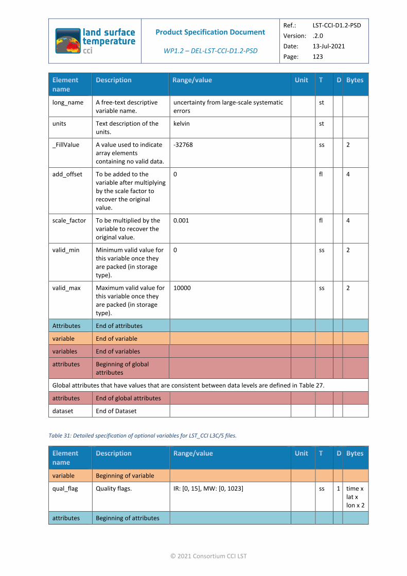
Product Specification Document
WP1.2 – DEL-LST-CCI-D1.2-PSD
Ref.: LST-CCI-D1.2-PSD
Version: .2.0
Date: 13-Jul-2021
Page: 123
© 2021 Consortium CCI LST
long_name A free-text descriptive variable name.
uncertainty from large-scale systematic errors
st
units Text description of the units.
kelvin st
_FillValue A value used to indicate array elements containing no valid data.
-32768 ss 2
add_offset To be added to the variable after multiplying by the scale factor to recover the original value.
0 fl 4
scale_factor To be multiplied by the variable to recover the original value.
0.001 fl 4
valid_min Minimum valid value for this variable once they are packed (in storage type).
0 ss 2
valid_max Maximum valid value for this variable once they are packed (in storage type).
10000 ss 2
Attributes End of attributes
variable End of variable
variables End of variables
attributes Beginning of global attributes
Global attributes that have values that are consistent between data levels are defined in Table 27.
attributes End of global attributes
dataset End of Dataset
Table 31: Detailed specification of optional variables for LST_CCI L3C/S files.
variable Beginning of variable
qual_flag Quality flags. IR: [0, 15], MW: [0, 1023] ss 1 time x lat x lon x 2
attributes Beginning of attributes

Product Specification Document
WP1.2 – DEL-LST-CCI-D1.2-PSD
Ref.: LST-CCI-D1.2-PSD
Version: .2.0
Date: 13-Jul-2021
Page: 124
© 2021 Consortium CCI LST
long_name A free-text descriptive variable name.
Quality flags st
units Text description of the units.
1 st
flag_meanings
Meaning attached to each flag value.
IR datasets: summary_cloud-1_is_cloudy summary_confidence-1_is_low_confidence aerosol_mask-1_is_aerosol_detected
MW datasets: no_use no_use no_use snow_OR_ice- 1_is_snow_OR_ice summary_inversion_quality- 1_is_less_reliable_inversion microwave_penetration_depth- 1_is_ground_with_large_penetration_dep th deep_convection_occurence- 1_is_possibility_of_deep_convection coast-1_is_cost inundation_risk- 1_is_possibility_of_inundated_land
st
flag_masks Bit masks corresponding to the flags described in flag_meanings.
IR datasets: 1, 2, 4, 8
MW datasets: 1, 2, 4, 8, 16, 32, 64, 128, 256, 512
ss 2
_FillValue A value used to indicate array elements containing no valid data.
-32768 ss 2
valid_min Minimum valid value for this variable once they are packed (in storage type).
0 ss 2
valid_max Maximum valid value for this variable once they are packed (in storage type).
IR datasets: 15
MW datasets: 1023
ss 2
coordinates Identifies coordinate variables.
lat lon st
Attributes End of attributes
variable End of variable
variable Beginning of variable
domain_flag Domain flags. IR: [0, 127] ss 1 time x lat x lon x 2
attributes Beginning of attributes

Product Specification Document
WP1.2 – DEL-LST-CCI-D1.2-PSD
Ref.: LST-CCI-D1.2-PSD
Version: .2.0
Date: 13-Jul-2021
Page: 125
© 2021 Consortium CCI LST
long_name A free-text descriptive variable name.
Domain flags st
units Text description of the units.
1 st
flag_meanings
Meaning attached to each flag value.
IR datasets: day_or_night-1_is_night ocean_flag land_flag lake_flag coast_flag tidal_flag seaice_flag
st
flag_masks Bit masks corresponding to the flags described in flag_meanings.
IR datasets: 1, 2, 4, 8, 16, 32, 64 ss 2
_FillValue A value used to indicate array elements containing no valid data.
-32768 ss 2
valid_min Minimum valid value for this variable once they are packed (in storage type).
0 ss 2
valid_max Maximum valid value for this variable once they are packed (in storage type).
IR datasets: 127 ss 2
coordinates Identifies coordinate variables.
ni nj st
Attributes End of attributes
variable End of variable
variable Beginning of variable
lcc Land cover class. [1,27] ss 1 time x lat x lon x 2
attributes Beginning of attributes
long_name A free-text descriptive variable name.
land cover class st
units Text description of the units.
1 st
flag_meanings
Meaning attached to each flag value.
Post-flooding_OR_irrigated_croplands Rainfed_croplands Mosaic_Cropland_(50-70percent)_OR_Vegetation_(grassland,_shrubland,_forest)_(20-50percent) Mosaic_Vegetation_(grassland,_shrubland,_forest)_(50-70percent)_OR_Cropland_(20-50percent) Closed_to_open_(_MORE_THAN_15perc
st
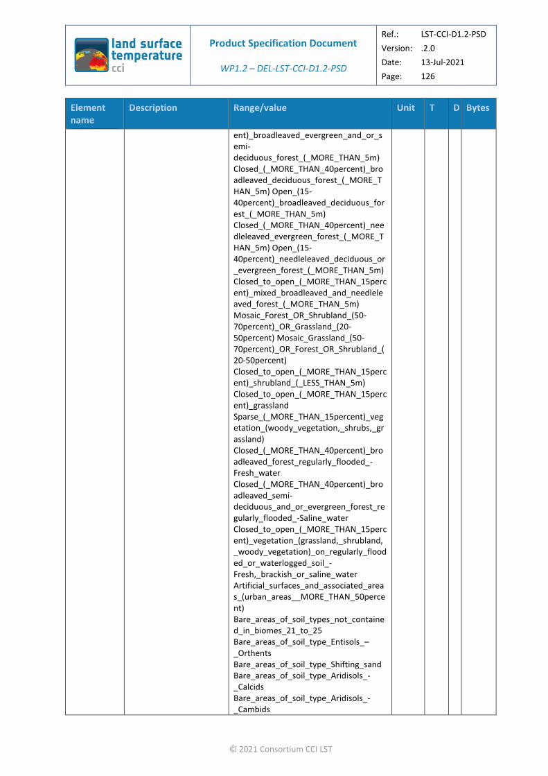
Product Specification Document
WP1.2 – DEL-LST-CCI-D1.2-PSD
Ref.: LST-CCI-D1.2-PSD
Version: .2.0
Date: 13-Jul-2021
Page: 126
© 2021 Consortium CCI LST
ent)_broadleaved_evergreen_and_or_semi-deciduous_forest_(_MORE_THAN_5m) Closed_(_MORE_THAN_40percent)_broadleaved_deciduous_forest_(_MORE_THAN_5m) Open_(15-40percent)_broadleaved_deciduous_forest_(_MORE_THAN_5m) Closed_(_MORE_THAN_40percent)_needleleaved_evergreen_forest_(_MORE_THAN_5m) Open_(15-40percent)_needleleaved_deciduous_or_evergreen_forest_(_MORE_THAN_5m) Closed_to_open_(_MORE_THAN_15percent)_mixed_broadleaved_and_needleleaved_forest_(_MORE_THAN_5m) Mosaic_Forest_OR_Shrubland_(50-70percent)_OR_Grassland_(20-50percent) Mosaic_Grassland_(50-70percent)_OR_Forest_OR_Shrubland_(20-50percent) Closed_to_open_(_MORE_THAN_15percent)_shrubland_(_LESS_THAN_5m) Closed_to_open_(_MORE_THAN_15percent)_grassland Sparse_(_MORE_THAN_15percent)_vegetation_(woody_vegetation,_shrubs,_grassland) Closed_(_MORE_THAN_40percent)_broadleaved_forest_regularly_flooded_-Fresh_water Closed_(_MORE_THAN_40percent)_broadleaved_semi-deciduous_and_or_evergreen_forest_regularly_flooded_-Saline_water Closed_to_open_(_MORE_THAN_15percent)_vegetation_(grassland,_shrubland,_woody_vegetation)_on_regularly_flooded_or_waterlogged_soil_-Fresh,_brackish_or_saline_water Artificial_surfaces_and_associated_areas_(urban_areas__MORE_THAN_50percent) Bare_areas_of_soil_types_not_contained_in_biomes_21_to_25 Bare_areas_of_soil_type_Entisols_–_Orthents Bare_areas_of_soil_type_Shifting_sand Bare_areas_of_soil_type_Aridisols_-_Calcids Bare_areas_of_soil_type_Aridisols_-_Cambids

Product Specification Document
WP1.2 – DEL-LST-CCI-D1.2-PSD
Ref.: LST-CCI-D1.2-PSD
Version: .2.0
Date: 13-Jul-2021
Page: 127
© 2021 Consortium CCI LST
Bare_areas_of_soil_type_Gelisols_-_Orthels Water_bodies_(inland_lakes,_rivers,_sea:_max_10km_away_from_coast) Permanent_snow_and_ice
flag_masks Values corresponding to the flags described in flag_meanings.
1, 2, 3, 4, 5, 6, 7, 8, 9, 10, 11, 12, 13, 14, 15, 16, 17, 18, 19, 20, 21, 22, 23, 24, 25, 26, 27
ss 2
_FillValue A value used to indicate array elements containing no valid data.
-32768 ss 2
valid_min Minimum valid value for this variable once they are packed (in storage type).
0 ss 2
valid_max Maximum valid value for this variable once they are packed (in storage type).
27 ss 2
coordinates Identifies coordinate variables.
lat lon st
Attributes End of attributes
variable End of variable
variable Beginning of variable
tcwv Total Column Water Vapour
[0, 20000] (after scaling) ss 1 time x lat x lon x 2
attributes Beginning of attributes
long_name A free-text descriptive variable name.
total column water vapour st
units Text description of the units.
Kg m-2 st
_FillValue A value used to indicate array elements containing no valid data.
-32768 ss 2
add_offset To be added to the variable after multiplying by the scale factor to recover the original value.
0 fl 4
scale_factor To be multiplied by the variable to recover the original value.
0.004 fl 4

Product Specification Document
WP1.2 – DEL-LST-CCI-D1.2-PSD
Ref.: LST-CCI-D1.2-PSD
Version: .2.0
Date: 13-Jul-2021
Page: 128
© 2021 Consortium CCI LST
valid_min Minimum valid value for this variable once they are packed (in storage type).
0 ss 2
valid_max Maximum valid value for this variable once they are packed (in storage type).
20000 ss 2
source Auxiliary data source. ECMWF ERA-5 dataset: https://www.ecmwf.int/en/forecasts/datasets/archive-datasets/reanalysis-datasets/era5
st
coordinates Identifies coordinate variables.
lat lon st
Attributes End of attributes
variable End of variable
variable Beginning of variable
ndvi Normalised Difference Vegetation Index.
[0, 10000] (after scaling) ss 1 time x lat x lon x 2
attributes Beginning of attributes
long_name A free-text descriptive variable name.
normalised difference vegetation index st
units Text description of the units.
1 st
_FillValue A value used to indicate array elements containing no valid data.
-32768 ss 2
add_offset To be added to the variable after multiplying by the scale factor to recover the original value.
0 fl 4
scale_factor To be multiplied by the variable to recover the original value.
0.0001 fl 4
valid_min Minimum valid value for this variable once they are packed (in storage type).
0 ss 2
valid_max Maximum valid value for this variable once they are packed (in storage type).
10000 ss 2

Product Specification Document
WP1.2 – DEL-LST-CCI-D1.2-PSD
Ref.: LST-CCI-D1.2-PSD
Version: .2.0
Date: 13-Jul-2021
Page: 129
© 2021 Consortium CCI LST
source Auxiliary data source. CGLPS NDVI 1 km dataset v2.2: https://land.copernicus.eu/global/products/ndvi
st
coordinates Identifies coordinate variables.
lat lon st
Attributes End of attributes
variable End of variable
variable Beginning of variable
emis Land Surface Emissivity [0, 10000] (after scaling) ss 1 time x lat x lon x channel x 2
attributes Beginning of attributes
long_name A free-text descriptive variable name.
surface emissivity st
units Text description of the units.
kelvin st
_FillValue A value used to indicate array elements containing no valid data.
-32768 Ss 2
add_offset To be added to the variable after multiplying by the scale factor to recover the original value.
0 Fl 4
scale_factor To be multiplied by the variable to recover the original value.
0.0001 Fl 4
valid_min Minimum valid value for this variable once they are packed (in storage type).
0 ss 2
valid_max Maximum valid value for this variable once they are packed (in storage type).
10000 ss 2
coordinates Identifies coordinate variables.
lat lon st
Attributes End of attributes
variable End of variable
variable Beginning of variable

Product Specification Document
WP1.2 – DEL-LST-CCI-D1.2-PSD
Ref.: LST-CCI-D1.2-PSD
Version: .2.0
Date: 13-Jul-2021
Page: 130
© 2021 Consortium CCI LST
t2m 2m Surface Air Temperature
[-8315, 7685] (after scaling) ss 1 time x lat x lon x 2
attributes Beginning of attributes
long_name A free-text descriptive variable name.
surface air temperature st
units Text description of the units.
kelvin st
_FillValue A value used to indicate array elements containing no valid data.
-32768 ss 2
add_offset To be added to the variable after multiplying by the scale factor to recover the original value.
273.15 fl 4
scale_factor To be multiplied by the variable to recover the original value.
0.01 fl 4
valid_min Minimum valid value for this variable once they are packed (in storage type).
-8315 ss 2
valid_max Maximum valid value for this variable once they are packed (in storage type).
7685 ss 2
source Auxiliary data source. ECMWF ERA-5 dataset: https://www.ecmwf.int/en/forecasts/datasets/archive-datasets/reanalysis-datasets/era5
st
coordinates Identifies coordinate variables.
lat lon st
Attributes End of attributes
variable End of variable
variable Beginning of variable
sh2m 2m humidity [0, 10000] (after scaling) ss 1 time x lat x lon x 2
attributes Beginning of attributes
long_name A free-text descriptive variable name.
2m specific humidity st

Product Specification Document
WP1.2 – DEL-LST-CCI-D1.2-PSD
Ref.: LST-CCI-D1.2-PSD
Version: .2.0
Date: 13-Jul-2021
Page: 131
© 2021 Consortium CCI LST
units Text description of the units.
1 st
_FillValue A value used to indicate array elements containing no valid data.
-32768 Ss 2
add_offset To be added to the variable after multiplying by the scale factor to recover the original value.
0 Fl 4
scale_factor To be multiplied by the variable to recover the original value.
0.0001 Fl 4
valid_min Minimum valid value for this variable once they are packed (in storage type).
0 ss 2
valid_max Maximum valid value for this variable once they are packed (in storage type).
10000 ss 2
source Auxiliary data source ECMWF ERA-5 dataset: https://www.ecmwf.int/en/forecasts/datasets/archive-datasets/reanalysis-datasets/era5
coordinates Identifies coordinate variables.
lat lon st
Attributes End of attributes
variable End of variable
variable Beginning of variable
ws2m 2m wind speed [0, 20000] (after scaling) ss 1 time x lat x lon x 2
attributes Beginning of attributes
long_name A free-text descriptive variable name.
2m wind speed st
units Text description of the units.
m s-1 st
_FillValue A value used to indicate array elements containing no valid data.
-32768 Ss 2
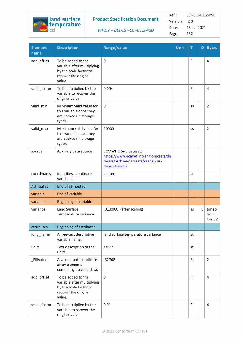
Product Specification Document
WP1.2 – DEL-LST-CCI-D1.2-PSD
Ref.: LST-CCI-D1.2-PSD
Version: .2.0
Date: 13-Jul-2021
Page: 132
© 2021 Consortium CCI LST
add_offset To be added to the variable after multiplying by the scale factor to recover the original value.
0 Fl 4
scale_factor To be multiplied by the variable to recover the original value.
0.004 Fl 4
valid_min Minimum valid value for this variable once they are packed (in storage type).
0 ss 2
valid_max Maximum valid value for this variable once they are packed (in storage type).
20000 ss 2
source Auxiliary data source ECMWF ERA-5 dataset: https://www.ecmwf.int/en/forecasts/datasets/archive-datasets/reanalysis-datasets/era5
coordinates Identifies coordinate variables.
lat lon st
Attributes End of attributes
variable End of variable
variable Beginning of variable
variance Land Surface Temperature variance.
[0,10000] (after scaling) ss 1 time x lat x lon x 2
attributes Beginning of attributes
long_name A free-text descriptive variable name.
land surface temperature variance st
units Text description of the units.
Kelvin st
_FillValue A value used to indicate array elements containing no valid data.
-32768 Ss 2
add_offset To be added to the variable after multiplying by the scale factor to recover the original value.
0 Fl 4
scale_factor To be multiplied by the variable to recover the original value.
0.01 Fl 4
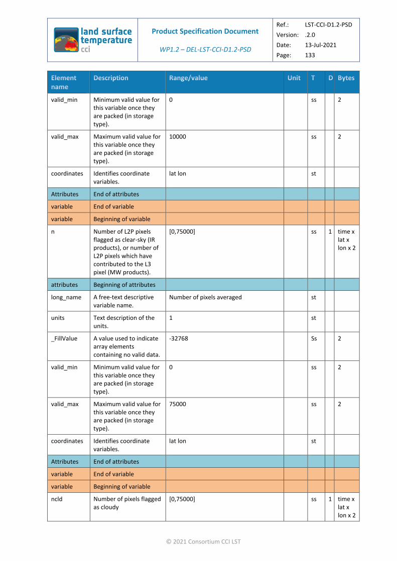
Product Specification Document
WP1.2 – DEL-LST-CCI-D1.2-PSD
Ref.: LST-CCI-D1.2-PSD
Version: .2.0
Date: 13-Jul-2021
Page: 133
© 2021 Consortium CCI LST
valid_min Minimum valid value for this variable once they are packed (in storage type).
0 ss 2
valid_max Maximum valid value for this variable once they are packed (in storage type).
10000 ss 2
coordinates Identifies coordinate variables.
lat lon st
Attributes End of attributes
variable End of variable
variable Beginning of variable
n Number of L2P pixels flagged as clear-sky (IR products), or number of L2P pixels which have contributed to the L3 pixel (MW products).
[0,75000] ss 1 time x lat x lon x 2
attributes Beginning of attributes
long_name A free-text descriptive variable name.
Number of pixels averaged st
units Text description of the units.
1 st
_FillValue A value used to indicate array elements containing no valid data.
-32768 Ss 2
valid_min Minimum valid value for this variable once they are packed (in storage type).
0 ss 2
valid_max Maximum valid value for this variable once they are packed (in storage type).
75000 ss 2
coordinates Identifies coordinate variables.
lat lon st
Attributes End of attributes
variable End of variable
variable Beginning of variable
ncld Number of pixels flagged as cloudy
[0,75000] ss 1 time x lat x lon x 2
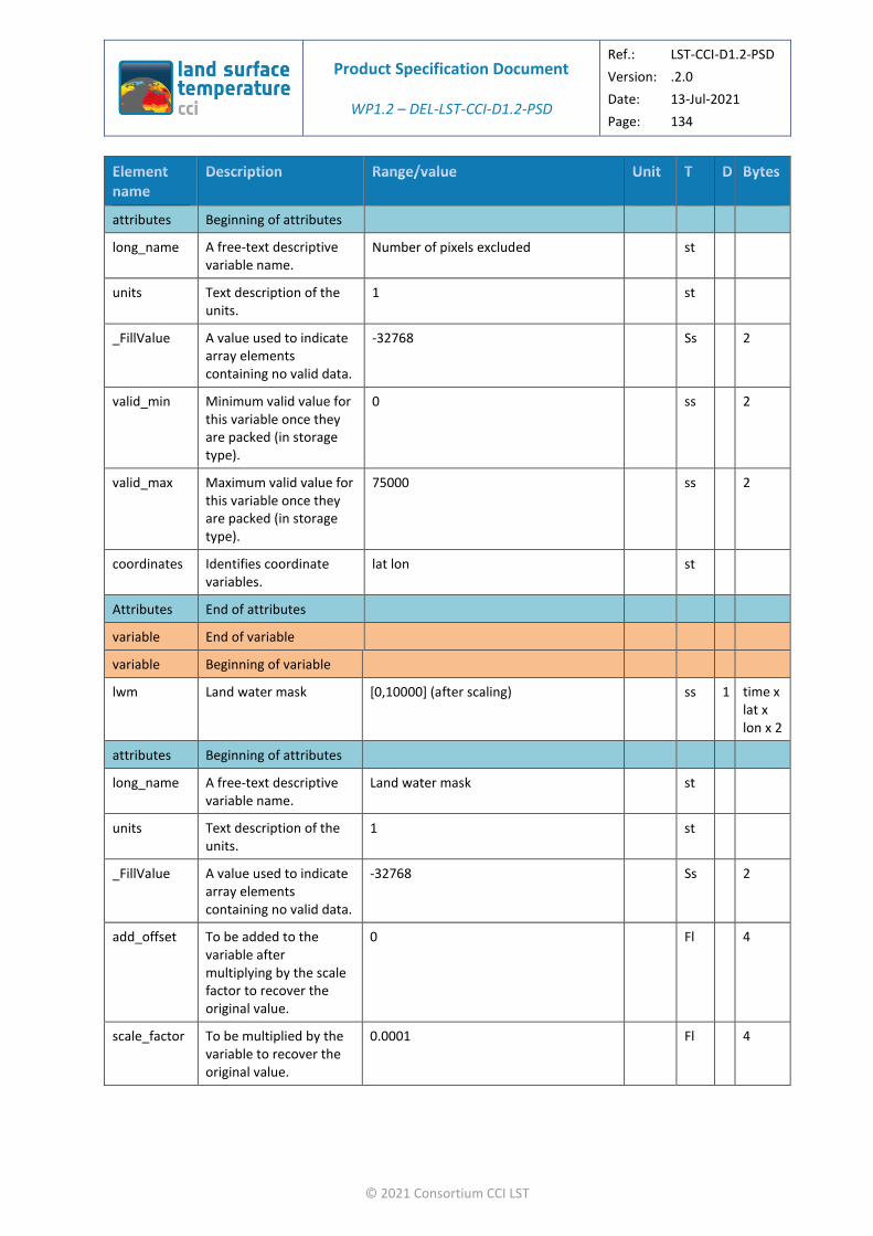
Product Specification Document
WP1.2 – DEL-LST-CCI-D1.2-PSD
Ref.: LST-CCI-D1.2-PSD
Version: .2.0
Date: 13-Jul-2021
Page: 134
© 2021 Consortium CCI LST
attributes Beginning of attributes
long_name A free-text descriptive variable name.
Number of pixels excluded st
units Text description of the units.
1 st
_FillValue A value used to indicate array elements containing no valid data.
-32768 Ss 2
valid_min Minimum valid value for this variable once they are packed (in storage type).
0 ss 2
valid_max Maximum valid value for this variable once they are packed (in storage type).
75000 ss 2
coordinates Identifies coordinate variables.
lat lon st
Attributes End of attributes
variable End of variable
variable Beginning of variable
lwm Land water mask [0,10000] (after scaling) ss 1 time x lat x lon x 2
attributes Beginning of attributes
long_name A free-text descriptive variable name.
Land water mask st
units Text description of the units.
1 st
_FillValue A value used to indicate array elements containing no valid data.
-32768 Ss 2
add_offset To be added to the variable after multiplying by the scale factor to recover the original value.
0 Fl 4
scale_factor To be multiplied by the variable to recover the original value.
0.0001 Fl 4
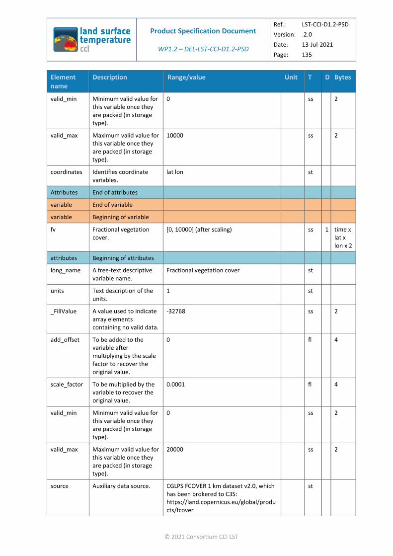
Product Specification Document
WP1.2 – DEL-LST-CCI-D1.2-PSD
Ref.: LST-CCI-D1.2-PSD
Version: .2.0
Date: 13-Jul-2021
Page: 135
© 2021 Consortium CCI LST
valid_min Minimum valid value for this variable once they are packed (in storage type).
0 ss 2
valid_max Maximum valid value for this variable once they are packed (in storage type).
10000 ss 2
coordinates Identifies coordinate variables.
lat lon st
Attributes End of attributes
variable End of variable
variable Beginning of variable
fv Fractional vegetation cover.
[0, 10000] (after scaling) ss 1 time x lat x lon x 2
attributes Beginning of attributes
long_name A free-text descriptive variable name.
Fractional vegetation cover st
units Text description of the units.
1 st
_FillValue A value used to indicate array elements containing no valid data.
-32768 ss 2
add_offset To be added to the variable after multiplying by the scale factor to recover the original value.
0 fl 4
scale_factor To be multiplied by the variable to recover the original value.
0.0001 fl 4
valid_min Minimum valid value for this variable once they are packed (in storage type).
0 ss 2
valid_max Maximum valid value for this variable once they are packed (in storage type).
20000 ss 2
source Auxiliary data source. CGLPS FCOVER 1 km dataset v2.0, which has been brokered to C3S: https://land.copernicus.eu/global/products/fcover
st

Product Specification Document
WP1.2 – DEL-LST-CCI-D1.2-PSD
Ref.: LST-CCI-D1.2-PSD
Version: .2.0
Date: 13-Jul-2021
Page: 136
© 2021 Consortium CCI LST
coordinates Identifies coordinate variables.
lat lon st
Attributes End of attributes
variable End of variable
variable Beginning of variable
solze Solar zenith angle. [0, 18000] (after scaling) ss 1 time x lat x lon x 2
attributes Beginning of attributes
long_name A free-text descriptive variable name.
solar zenith angle st
units Text description of the units.
degrees st
_FillValue A value used to indicate array elements containing no valid data.
-32768 ss 2
add_offset To be added to the variable after multiplying by the scale factor to recover the original value.
0 fl 4
scale_factor To be multiplied by the variable to recover the original value.
0.01 fl 4
valid_min Minimum valid value for this variable once they are packed (in storage type).
0 ss 2
valid_max Maximum valid value for this variable once they are packed (in storage type).
18000 ss 2
coordinates Identifies coordinate variables.
lat lon st
Attributes End of attributes
variable End of variable
variable Beginning of variable
solaz Solar azimuth angle. [-18000, 18000] (after scaling) ss 1 time x lat x lon x 2
attributes Beginning of attributes

Product Specification Document
WP1.2 – DEL-LST-CCI-D1.2-PSD
Ref.: LST-CCI-D1.2-PSD
Version: .2.0
Date: 13-Jul-2021
Page: 137
© 2021 Consortium CCI LST
long_name A free-text descriptive variable name.
solar azimuth angle st
units Text description of the units.
degrees st
_FillValue A value used to indicate array elements containing no valid data.
-32768 ss 2
add_offset To be added to the variable after multiplying by the scale factor to recover the original value.
0 fl 4
scale_factor To be multiplied by the variable to recover the original value.
0.01 fl 4
valid_min Minimum valid value for this variable once they are packed (in storage type).
0 ss 2
valid_max Maximum valid value for this variable once they are packed (in storage type).
18000 ss 2
coordinates Identifies coordinate variables.
lat lon st
Attributes End of attributes
variable End of variable
variable Beginning of variable
lst_time_correction
LST offset from local time to 6AM/6PM.
[-1000, 1000] (after scaling) ss 1 time x lat x lon x 2
attributes Beginning of attributes
long_name A free-text descriptive variable name.
offset to be added to the land surface temperature
st
units Text description of the units.
kelvin st
_FillValue A value used to indicate array elements containing no valid data.
-32768 ss 2

Product Specification Document
WP1.2 – DEL-LST-CCI-D1.2-PSD
Ref.: LST-CCI-D1.2-PSD
Version: .2.0
Date: 13-Jul-2021
Page: 138
© 2021 Consortium CCI LST
add_offset To be added to the variable after multiplying by the scale factor to recover the original value.
0 fl 4
scale_factor To be multiplied by the variable to recover the original value.
0.01 fl 4
valid_min Minimum valid value for this variable once they are packed (in storage type).
-1000 Fl 2
valid_max Maximum valid value for this variable once they are packed (in storage type).
1000 Fl 2
coordinates Identifies coordinate variables.
lat lon st
Attributes End of attributes
variable End of variable
variables End of variables
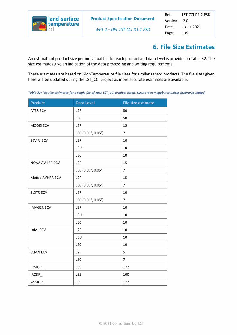
Product Specification Document
WP1.2 – DEL-LST-CCI-D1.2-PSD
Ref.: LST-CCI-D1.2-PSD
Version: .2.0
Date: 13-Jul-2021
Page: 139
© 2021 Consortium CCI LST
6. File Size Estimates
An estimate of product size per individual file for each product and data level is provided in Table 32. The size estimates give an indication of the data processing and writing requirements.
These estimates are based on GlobTemperature file sizes for similar sensor products. The file sizes given here will be updated during the LST_CCI project as more accurate estimates are available.
Table 32: File size estimates for a single file of each LST_CCI product listed. Sizes are in megabytes unless otherwise stated.
ATSR ECV L2P 80
L3C 50
MODIS ECV L2P 15
L3C (0.01°, 0.05°) 7
SEVIRI ECV L2P 10
L3U 10
L3C 10
NOAA AVHRR ECV L2P 15
L3C (0.01°, 0.05°) 7
Metop AVHRR ECV L2P 15
L3C (0.01°, 0.05°) 7
SLSTR ECV L2P 10
L3C (0.01°, 0.05°) 7
IMAGER ECV L2P 10
L3U 10
L3C 10
JAMI ECV L2P 10
L3U 10
L3C 10
SSM/I ECV L2P 5
L3C 7
IRMGP_ L3S 172
IRCDR_ L3S 100
ASMGP_ L3S 172

Product Specification Document
WP1.2 – DEL-LST-CCI-D1.2-PSD
Ref.: LST-CCI-D1.2-PSD
Version: .2.0
Date: 13-Jul-2021
Page: 140
© 2021 Consortium CCI LST
7. Data Access
Access to all LST_CCI products specified here will be provided via the CCI Open Data Portal (http://cci.esa.int/data) as well as the GlobTemperature Data Portal (http://data.globtemperature.info/) in GlobTemperature harmonised format to support the existing GlobTemperature LST community. This range of data access points will provide users with a range of dissemination options which should make the data easily accessible. In addition, they will provide a detailed description of externally linked datasets and should provide long term stewardship of the data. In addition, the CCI data portal provides interactive map services. These points address the user requirements noted below.
LST-PSD-SPN-5-URD: Ensure long term, easy access to data.
Addresses user feedback LST-URD-ADV-04-LI
It should be noted here that post-project operationalisation of LST_CCI data products is expected via the Copernicus Climate Change Service (https://climate.copernicus.eu/).

Product Specification Document
WP1.2 – DEL-LST-CCI-D1.2-PSD
Ref.: LST-CCI-D1.2-PSD
Version: .2.0
Date: 13-Jul-2021
Page: 141
© 2021 Consortium CCI LST
8. Data Documentation, Validation and Intercomparison
Data documentation, validation and intercomparison for the products specified here will be provided by LST_CCI and will be freely available to users from the LST_CCI website (http://cci.esa.int/lst). Some of this information will also be made available via journal publications. The type of documents to be provided are listed below, along with the user requirements which they will address:
❖ ATBD:
Algorithm Theoretical Basis Documents (ATBDs) shall describe the data, methods and algorithms used for each product.
LST-PSD-SPN-3-URD: Disseminate clear information on what LST data represents, potential applications and how the data may be used.
LST-PSD-SPN-4-URD: Provide documentation detailing assumptions made during the retrieval process or product construction, including detailed information on any techniques used for merging.
LST-PSD-SPN-68-URD: Where clear-sky probabilities are provided, include descriptions of how to use these data and worked examples.
LST-PSD-SPN-69-URD: Provide a description of what is represented by clear-sky probabilities and how they are calculated.
LST-PSD-SPN-69-URD: Provide a recommended starting valued to be used by users for cloud clearing, ideally for a set of different applications.
LST-PSD-SPN-70-URD: Investigate and provide information to users concerning clear-sky bias in IR LST data.
LST-PSD-SPN-71-URD: Reduce errors due to cloud contamination in IR LST data sets.
Addresses user feedback LST-URD-ADV-02-OI, LST-URD-ADV-03-I, LST-URD-REQ-33-O, LST-URD-ADV-30-I, LST-URD-ADV-31-O, LST-URD-ADV-32-LI, LST-URD-ADV-33-LOI
❖ CAR:
The Climate Assessment Report (CAR) will provide comparison of LST_CCI products to other climate data sets of LST.
LST-PSD-SPN-8-URD: Consistency between LST CCI and other CCI products should be maintained.
LST-PSD-SPN-9-URD: Provide information on how comparable LST CCI products are with other CCI datasets, for example, spatial and temporal averaging, uncertainties, changes likely to impact LST (e.g. vegetation fractional cover).
Addresses user feedback LST-URD-ADV-07-OI, LST-URD-ADV-08-OI
❖ E3UB:
An End to End ECV Uncertainty Budget (E3UB) will be provided for LST_CCI products.
LST-PSD-SPN-53-URD: Uncertainty information should be provided with clear documentation including descriptions of how to use the data and worked examples.
LST-PSD-SPN-54-URD: Provide detailed information on how uncertainties are calculated.
LST-PSD-SPN-55-URD: Provide information on what the uncertainties represent and why they are useful.

Product Specification Document
WP1.2 – DEL-LST-CCI-D1.2-PSD
Ref.: LST-CCI-D1.2-PSD
Version: .2.0
Date: 13-Jul-2021
Page: 142
© 2021 Consortium CCI LST
LST-PSD-SPN-56-URD: Provide information about spatial and temporal structure of the uncertainty components.
LST-PSD-SPN-57-URD: Include cloud effects in uncertainty data.
Addresses user feedback LST-URD-REQ-26-O, LST-URD-ADV-22-I, LST-URD-ADV-23-OI, LST-URD-ADV-24-O, LST-URD-ADV-25-LOI
❖ PUG:
The Product User Guide (PUG) for the data products produced by the LST_CCI project which aims to facilitate users in their exploitation of the LST_CCI product suite.
LST-PSD-SPN-6-URD: Provide a summary of the availability and characteristics of different LST products.
Addresses user feedback LST-URD-ADV-05-O
❖ PVIR:
The Product Validation and Intercomparison Report (PVIR) for the data products produced by the LST_CCI project which contains the results of product validation and intercomparison for each LST_CCI product.
LST-PSD-SPN-7-URD: Consistency should be maintained between different LST products within LST CCI.
LST-PSD-SPN-58-URD: Provide comparisons of satellite LST data with in-situ measurements as part of the validation and inter-comparison results.
LST-PSD-SPN-59-URD: Provide inter-comparisons between LST products as part of the validation and inter-comparison results.
LST-PSD-SPN-60-URD: Provide a summary of accuracy and precision per product as part of the validation and inter-comparison results.
LST-PSD-SPN-61-URD: Provide an overview of the best performing products in different scenarios as part of the validation and inter-comparison results.
LST-PSD-SPN-62-URD: Provide results from time series analysis.
LST-PSD-SPN-75-URD: Consider including validation of uncertainty components.
LST-PSD-SPN-64-URD: Consider including validation of clear-sky probabilities.
LST-PSD-SPN-65-URD: Where possible provide advice on how validation and inter-comparison results can benefit users, and how the results can be incorporated into their work.
Addresses user feedback LST-URD-ADV-06-LI, LST-URD-REQ-27-OI, LST-URD-REQ-28-O, LST-URD-REQ-29-LO, LST-URD-REQ-30-O, LST-URD-ADV-26-O, LST-URD-ADV-27-O, LST-URD-ADV-28-O, LST-URD-ADV-29-O

Product Specification Document
WP1.2 – DEL-LST-CCI-D1.2-PSD
Ref.: LST-CCI-D1.2-PSD
Version: .2.0
Date: 13-Jul-2021
Page: 143
© 2021 Consortium CCI LST
9. Issues for Future Releases of this Document
It is recommended that future releases of this product specification should resolve the following issues:
❖ Currently there is no indication in the file metadata about which version of the product specification document was followed when creating each file. It is recommended that a new global attribute is added to the specification for each data level to provide this information.
❖ The definition of product strings and filename additional segregators are currently not consistent with those defined by the ESA CCI data standards working group. These need to be resolved in the future in a way that allows the LST_CCI product specifications to remain consistent with the GDS.
❖ Updates to this document may occur following technical feasibility assessments by algorithm development and processing activities.
❖ Updates relevant to the SSD specifications may be incorporated into this document.

Product Specification Document
WP1.2 – DEL-LST-CCI-D1.2-PSD
Ref.: LST-CCI-D1.2-PSD
Version: .2.0
Date: 13-Jul-2021
Page: 144
© 2021 Consortium CCI LST
Appendix A - CDL listings of NetCDF headers
A.1. L2P Example
dimensions:
time = 1 ;
length_scale = 1 ;
channel = 2 ;
nj = 43520 ;
ni = 512 ;
variables:
float time(time) ;
time:long_name = "reference time of file" ;
time:standard_name = "time" ;
time:units = "seconds since 1981-01-01 00:00:00" ;
time:_FillValue = -32768.f ;
time:calendar = "gregorian" ;
float dtime(time, nj, ni) ;
dtime:long_name = "time difference from reference time" ;
dtime:units = "seconds" ;
dtime:_FillValue = -32768.f ;
dtime:valid_min = 0.f ;
dtime:valid_max = 86400.f ;
dtime:coordinates = "lon lat" ;
float lat(nj, ni) ;
lat:long_name = "latitude_coordinates" ;
lat:standard_name = "latitude" ;
lat:units = "degrees_north" ;

Product Specification Document
WP1.2 – DEL-LST-CCI-D1.2-PSD
Ref.: LST-CCI-D1.2-PSD
Version: .2.0
Date: 13-Jul-2021
Page: 145
© 2021 Consortium CCI LST
lat:_FillValue = -32768.f ;
lat:valid_min = -90.f ;
lat:valid_max = 90.f ;
lat:reference_datum = "geographical coordinates, WGS84 projection" ;
float lon(nj, ni) ;
lon:long_name = "longitude_coordinates" ;
lon:standard_name = "latitude" ;
lon:units = "degrees_east" ;
lon:_FillValue = -32768.f ;
lon:valid_min = -180.f ;
lon:valid_max = 180.f ;
lon:reference_datum = "geographical coordinates, WGS84 projection" ;
short satze(time, nj, ni) ;
satze:long_name = "satellite zenith angle" ;
satze:units = "degrees" ;
satze:_FillValue = -32768s ;
satze:add_offset = 0.f ;
satze:scale_factor = 0.01f ;
satze:valid_min = 0s ;
satze:valid_max = 18000s ;
satze:coordinates = "lon lat" ;
short sataz(time, nj, ni) ;
sataz:long_name = "satellite azimuth angle" ;
sataz:units = "degrees" ;
sataz:_FillValue = -32768s ;
sataz:add_offset = 0.f ;
sataz:scale_factor = 0.01f ;

Product Specification Document
WP1.2 – DEL-LST-CCI-D1.2-PSD
Ref.: LST-CCI-D1.2-PSD
Version: .2.0
Date: 13-Jul-2021
Page: 146
© 2021 Consortium CCI LST
sataz:valid_min = -18000s ;
sataz:valid_max = 18000s ;
sataz:coordinates = "lon lat" ;
short solze(time, nj, ni) ;
solze:long_name = "solar zenith angle" ;
solze:units = "degrees" ;
solze:_FillValue = -32768s ;
solze:add_offset = 0.f ;
solze:scale_factor = 0.01f ;
solze:valid_min = 0s ;
solze:valid_max = 18000s ;
solze:coordinates = "lon lat" ;
short solaz(time, nj, ni) ;
solaz:long_name = "solar azimuth angle" ;
solaz:units = "degrees" ;
solaz:_FillValue = -32768s ;
solaz:add_offset = 0.f ;
solaz:scale_factor = 0.01f ;
solaz:valid_min = -18000s ;
solaz:valid_max = 18000s ;
solaz:coordinates = "lon lat" ;
short qual_flag(time, nj, ni) ;
qual_flag:long_name = "Quality Flags" ;
qual_flag:flag_meanings = "summary_cloud-1_is_cloudy summary_confidence-1_is_low_confidence aerosol_mask-1_is_aerosol_detected" ;
qual_flag:flag_masks = 1s, 2s, 4s, 8s, 16s, 32s, 64s, 128s, 256s, 512s ;
qual_flag:_FillValue = -32768s ;

Product Specification Document
WP1.2 – DEL-LST-CCI-D1.2-PSD
Ref.: LST-CCI-D1.2-PSD
Version: .2.0
Date: 13-Jul-2021
Page: 147
© 2021 Consortium CCI LST
qual_flag:valid_min = 0s ;
qual_flag:valid_max = 1023s ;
qual_flag:coordinates = "lon lat" ;
short domain_flag(time, nj, ni) ;
domain_flag:long_name = "Domain Flags" ;
domain_flag:flag_meanings = "day_or_night-1_is_night ocean_flag land_flag lake_flag coast_flag tidal_flag seaice_flag " ;
domain_flag:flag_masks = 1s, 2s, 4s, 8s, 16s, 32s, 64s;
domain_flag:_FillValue = -32768s ;
domain_flag:valid_min = 0s ;
domain_flag:valid_max = 127s ;
domain_flag:coordinates = "lon lat" ;
short lst(time, nj, ni) ;
lst:long_name = "land surface temperature" ;
lst:units = "kelvin" ;
lst:_FillValue = -32768s ;
lst:add_offset = 273.15f ;
lst:scale_factor = 0.01f ;
lst:valid_min = -8315s ;
lst:valid_max = 7685s ;
lst:coordinates = "lon lat" ;
short lst_uncertainty(time, nj, ni) ;
lst_uncertainty:long_name = "land surface temperature total uncertainty" ;
lst_uncertainty:units = "kelvin" ;
lst_uncertainty:_FillValue = -32768s ;
lst_uncertainty:add_offset = 0.f ;
lst_uncertainty:scale_factor = 0.001f ;

Product Specification Document
WP1.2 – DEL-LST-CCI-D1.2-PSD
Ref.: LST-CCI-D1.2-PSD
Version: .2.0
Date: 13-Jul-2021
Page: 148
© 2021 Consortium CCI LST
lst_uncertainty:valid_min = 0s ;
lst_uncertainty:valid_max = 10000s ;
lst_uncertainty:coordinates = "lon lat" ;
short lst_unc_ran(time, nj, ni) ;
lst_unc_ran:long_name = "uncertainty from uncorrelated errors" ;
lst_unc_ran:units = "kelvin" ;
lst_unc_ran:_FillValue = -32768s ;
lst_unc_ran:add_offset = 0.f ;
lst_unc_ran:scale_factor = 0.001f ;
lst_unc_ran:valid_min = 0s ;
lst_unc_ran:valid_max = 10000s ;
lst_unc_ran:coordinates = "lon lat" ;
short lst_unc_loc_atm(time, nj, ni) ;
lst_unc_loc_atm:long_name = "uncertainty from locally correlated errors on atmospheric scales" ;
lst_unc_loc_atm:units = "kelvin" ;
lst_unc_loc_atm:_FillValue = -32768s ;
lst_unc_loc_atm:add_offset = 0.f ;
lst_unc_loc_atm:scale_factor = 0.001f ;
lst_unc_loc_atm:valid_min = 0s ;
lst_unc_loc_atm:valid_max = 10000s ;
lst_unc_loc_atm:coordinates = "lon lat" ;
short lst_unc_loc_sfc(time, nj, ni) ;
lst_unc_loc_sfc:long_name = "uncertainty from locally correlated errors on surface scales" ;
lst_unc_loc_sfc:units = "kelvin" ;
lst_unc_loc_sfc:_FillValue = -32768s ;
lst_unc_loc_sfc:add_offset = 0.f ;

Product Specification Document
WP1.2 – DEL-LST-CCI-D1.2-PSD
Ref.: LST-CCI-D1.2-PSD
Version: .2.0
Date: 13-Jul-2021
Page: 149
© 2021 Consortium CCI LST
lst_unc_loc_sfc:scale_factor = 0.001f ;
lst_unc_loc_sfc:valid_min = 0s ;
lst_unc_loc_sfc:valid_max = 10000s ;
lst_unc_loc_sfc:coordinates = "lon lat" ;
short lst_unc_sys(length_scale) ;
lst_unc_sys:long_name = "uncertainty from large-scale systematic errors" ;
lst_unc_sys:units = "kelvin" ;
lst_unc_sys:_FillValue = -32768s ;
lst_unc_sys:add_offset = 0.f ;
lst_unc_sys:scale_factor = 0.001f ;
lst_unc_sys:valid_min = 0s ;
lst_unc_sys:valid_max = 10000s ;
short lcc(time, nj, ni) ;
lcc:long_name = "land cover class" ;
lcc:flag_meanings = "Post-flooding_OR_irrigated_croplands Rainfed_croplands Mosaic_Cropland_(50-70percent)_OR_Vegetation_(grassland,_shrubland,_forest)_(20-50percent) Mosaic_Vegetation_(grassland,_shrubland,_forest)_(50-70percent)_OR_Cropland_(20-50percent) Closed_to_open_(_MORE_THAN_15percent)_broadleaved_evergreen_and_or_semi-deciduous_forest_(_MORE_THAN_5m) Closed_(_MORE_THAN_40percent)_broadleaved_deciduous_forest_(_MORE_THAN_5m) Open_(15-40percent)_broadleaved_deciduous_forest_(_MORE_THAN_5m) Closed_(_MORE_THAN_40percent)_needleleaved_evergreen_forest_(_MORE_THAN_5m) Open_(15-40percent)_needleleaved_deciduous_or_evergreen_forest_(_MORE_THAN_5m) Closed_to_open_(_MORE_THAN_15percent)_mixed_broadleaved_and_needleleaved_forest_(_MORE_THAN_5m) Mosaic_Forest_OR_Shrubland_(50-70percent)_OR_Grassland_(20-50percent) Mosaic_Grassland_(50-70percent)_OR_Forest_OR_Shrubland_(20-50percent) Closed_to_open_(_MORE_THAN_15percent)_shrubland_(_LESS_THAN_5m) Closed_to_open_(_MORE_THAN_15percent)_grassland Sparse_(_MORE_THAN_15percent)_vegetation_(woody_vegetation,_shrubs,_grassland) Closed_(_MORE_THAN_40percent)_broadleaved_forest_regularly_flooded_-Fresh_water Closed_(_MORE_THAN_40percent)_broadleaved_semi-deciduous_and_or_evergreen_forest_regularly_flooded_-Saline_water Closed_to_open_(_MORE_THAN_15percent)_vegetation_(grassland,_shrubland,_woody_vegetation)_on_regularly_flooded_or_waterlogged_soil_-Fresh,_brackish_or_saline_water Artificial_surfaces_and_associated_areas_(urban_areas__MORE_THAN_50percent) Bare_areas_of_soil_types_not_contained_in_biomes_21_to_25 Bare_areas_of_soil_type_Entisols_–_Orthents Bare_areas_of_soil_type_Shifting_sand Bare_areas_of_soil_type_Aridisols_-_Calcids
Product Specification Document
WP1.2 – DEL-LST-CCI-D1.2-PSD
Ref.: LST-CCI-D1.2-PSD
Version: .2.0
Date: 13-Jul-2021
Page: 150
© 2021 Consortium CCI LST
Bare_areas_of_soil_type_Aridisols_-_Cambids Bare_areas_of_soil_type_Gelisols_-_Orthels Water_bodies_(inland_lakes,_rivers,_sea:_max_10km_away_from_coast) Permanent_snow_and_ice" ;
lcc:flag_values = 1s, 2s, 3s, 4s, 5s, 6s, 7s, 8s, 9s, 10s, 11s, 12s, 13s, 14s, 15s, 16s, 17s, 18s, 19s, 20s, 21s, 22s, 23s, 24s, 25s, 26s, 27s ;
lcc:_FillValue = -32768s ;
lcc:valid_min = 1 ;
lcc:valid_max = 27 ;
lcc:coordinates = "lon lat" ;
short fv(time, nj, ni) ;
fv:long_name = "fractional vegetation cover" ;
fv:_FillValue = -32768s ;
fv:add_offset = 0.f ;
fv:scale_factor = 0.0001f ;
fv:valid_min = 0s ;
fv:valid_max = 10000s ;
fv:source = "CGLPS FCOVER 1 km dataset v2.0, which has been brokered to C3S:https://land.copernicus.eu/global/products/fcover" ;
fv:coordinates = "lon lat" ;
short tcwv(time, nj, ni) ;
tcwv:long_name = "total column water vapour" ;
tcwv:units = "kg m-2" ;
tcwv:_FillValue = -32768s ;
tcwv:add_offset = 0.f ;
tcwv:scale_factor = 0.004f ;
tcwv:valid_min = 0s ;
tcwv:valid_max = 20000s ;
tcwv:source = "ECMWF ERA-Interim dataset: https://www.ecmwf.int/en/forecasts/datasets/reanalysis-datasets/era-interim" ;
tcwv:coordinates = "lon lat" ;
Product Specification Document
WP1.2 – DEL-LST-CCI-D1.2-PSD
Ref.: LST-CCI-D1.2-PSD
Version: .2.0
Date: 13-Jul-2021
Page: 151
© 2021 Consortium CCI LST
short channel(channel) ;
channel:long_name = "channel wavelength in microns" ;
channel:units = "microns" ;
channel:_FillValue = -32768s ;
channel:add_offset = 0.f ;
channel:scale_factor = 0.001f ;
channel:valid_min = 0s ;
channel:valid_max = 15000s ;
channel:coordinates = "lon lat" ;
// global attributes:
:title = "ESA LST CCI land surface temperature level L2P from Advanced Along-Track Scanning Radiometer" ;
:institution = "University of Leicester" ;
:source = " AATSR-ESA-L1-v3.0" ;
:history = "Created using software developed at University of Leicester" ;
:references = "http://cci.esa.int/lst" ;
:tracking_id = "dummyval0000" ;
:Conventions = "CF-1.8" ;
:product_version = "1.00" ;
:format_version = " CCI Data Standards v2.2" ;
:summary = "This file contains level L1C global land surface temperatures from ATSR_ satellite observations. Level 1C data are level 1B data that have been further processed prior to deriving geophysical variables from the data" ;
:keywords = "Earth Science, Land Surface, Land Temperature, Land Surface Temperature" ;
:id = "ESACCI-LST-L2P-LST-ATSR_3-20060718001802-fv1.00.nc" ;
:naming_authority = "le.ac.uk" ;
:keywords_vocabulary = "NASA Global change Master Directory (GCMD) Science Keywords" ;

Product Specification Document
WP1.2 – DEL-LST-CCI-D1.2-PSD
Ref.: LST-CCI-D1.2-PSD
Version: .2.0
Date: 13-Jul-2021
Page: 152
© 2021 Consortium CCI LST
:cdm_data_type = "Swath" ;
:comment = "These data were produced as part of the ESA LST CCI project." ;
:date_created = "20190528T155910Z" ;
:creator_name = "University of Leicester Surface Temperature Group" ;
:creator_url = "http://cci.esa.int/lst" ;
:creator_email = "[email protected]" ;
:project = "Climate Change Initiative - European Space Agency" ;
:geospatial_lat_min = -83.78497f ;
:geospatial_lat_max = 83.78481f ;
:geospatial_lon_min = -180.f ;
:geospatial_lon_max = 179.9999f ;
:geospatial_vertical_min = 0.f ;
:geospatial_vertical_max = 0.f ;
:time_coverage_start = "20060718T001816Z" ;
:time_coverage_end = "20060718T020633Z" ;
:time_coverage_duration = "PT01H48M17S" ;
:time_coverage_resolution = "satellite_orbit_frequency" ;
:standard_name_vocabulary = " CF Standard Name Table v71" ;
:license = "ESA CCI Data Policy: free and open access" ;
:platform = "Envisat" ;
:sensor = "ATSR_3" ;
:spatial_resolution = "1 km at nadir" ;
:geospatial_lat_units = "degrees_north" ;
:geospatial_lon_units = "degrees_east" ;
:key_variables = "land_surface_temperature" ;

Product Specification Document
WP1.2 – DEL-LST-CCI-D1.2-PSD
Ref.: LST-CCI-D1.2-PSD
Version: .2.0
Date: 13-Jul-2021
Page: 153
© 2021 Consortium CCI LST
A.2. L3 Example
dimensions:
time = 1 ;
length_scale = 1 ;
channel = 2 ;
lat = 512 ;
lon = 256 ;
float time(time) ;
time:long_name = "reference time of file" ;
time:standard_name = "time" ;
time:units = "seconds since 1981-01-01 00:00:00" ;
time:_FillValue = -32768.f ;
time:calendar = "gregorian" ;
variables:
float time(time) ;
time:long_name = "reference time of file" ;
time:standard_name = "time" ;
time:units = "seconds since 1981-01-01 00:00:00" ;
time:calendar = "gregorian" ;
float dtime(time, lat, lon) ;
dtime:long_name = "time difference from reference time" ;
dtime:units = "seconds" ;
dtime:_FillValue = -32768.f ;
dtime:valid_min = 0.f ;
dtime:valid_max = 86400.f ;
Product Specification Document
WP1.2 – DEL-LST-CCI-D1.2-PSD
Ref.: LST-CCI-D1.2-PSD
Version: .2.0
Date: 13-Jul-2021
Page: 154
© 2021 Consortium CCI LST
dtime:coordinates = "lon lat" ;
float lat(lat, lon) ;
lat:long_name = "latitude_coordinates" ;
lat:standard_name = "latitude" ;
lat:units = "degrees_north" ;
lat:_FillValue = -32768.f ;
lat:valid_min = -90.f ;
lat:valid_max = 90.f ;
lat:reference_datum = "geographical coordinates, WGS84 projection" ;
float lon(lat, lon) ;
lon:long_name = "longitude_coordinates" ;
lon:standard_name = "latitude" ;
lon:units = "degrees_east" ;
lon:_FillValue = -32768.f ;
lon:valid_min = -180.f ;
lon:valid_max = 180.f ;
lon:reference_datum = "geographical coordinates, WGS84 projection" ;
short satze(time, lat, lon) ;
satze:long_name = "satellite zenith angle" ;
satze:units = "degrees" ;
satze:_FillValue = -32768s ;
satze:add_offset = 0.f ;
satze:scale_factor = 0.01f ;
satze:valid_min = 0s ;
satze:valid_max = 18000s ;
satze:coordinates = "lon lat" ;
short sataz(time, lat, lon) ;
Product Specification Document
WP1.2 – DEL-LST-CCI-D1.2-PSD
Ref.: LST-CCI-D1.2-PSD
Version: .2.0
Date: 13-Jul-2021
Page: 155
© 2021 Consortium CCI LST
sataz:long_name = "satellite azimuth angle" ;
sataz:units = "degrees" ;
sataz:_FillValue = -32768s ;
sataz:add_offset = 0.f ;
sataz:scale_factor = 0.01f ;
sataz:valid_min = -18000s ;
sataz:valid_max = 18000s ;
sataz:coordinates = "lon lat" ;
short solze(time, lat, lon) ;
solze:long_name = "solar zenith angle" ;
solze:units = "degrees" ;
solze:_FillValue = -32768s ;
solze:add_offset = 0.f ;
solze:scale_factor = 0.01f ;
solze:valid_min = 0s ;
solze:valid_max = 18000s ;
solze:coordinates = "lon lat" ;
short solaz(time, lat, lon) ;
solaz:long_name = "solar azimuth angle" ;
solaz:units = "degrees" ;
solaz:_FillValue = -32768s ;
solaz:add_offset = 0.f ;
solaz:scale_factor = 0.01f ;
solaz:valid_min = -18000s ;
solaz:valid_max = 18000s ;
solaz:coordinates = "lon lat" ;
short qual_flag(time, lat, lon) ;

Product Specification Document
WP1.2 – DEL-LST-CCI-D1.2-PSD
Ref.: LST-CCI-D1.2-PSD
Version: .2.0
Date: 13-Jul-2021
Page: 156
© 2021 Consortium CCI LST
qual_flag:long_name = "Quality Flags" ;
qual_flag:flag_meanings = "summary_cloud-1_is_cloudy summary_confidence-1_is_low_confidence aerosol_mask-1_is_aerosol_detected" ;
qual_flag:flag_masks = 1s, 2s, 4s, 8s, 16s, 32s, 64s, 128s, 256s, 512s ;
qual_flag:_FillValue = -32768s ;
qual_flag:valid_min = 0s ;
qual_flag:valid_max = 1023s ;
qual_flag:coordinates = "lon lat" ;
short domain_flag(time, lat, lon) ;
domain_flag:long_name = "Domain Flags" ;
domain_flag:flag_meanings = "day_or_night-1_is_night ocean_flag land_flag lake_flag coast_flag tidal_flag seaice_flag " ;
domain_flag:flag_masks = 1s, 2s, 4s, 8s, 16s, 32s, 64s;
domain_flag:_FillValue = -32768s ;
domain_flag:valid_min = 0s ;
domain_flag:valid_max = 127s ;
domain_flag:coordinates = "lon lat" ;
short lst(time, lat, lon) ;
lst:long_name = "land surface temperature" ;
lst:units = "kelvin" ;
lst:_FillValue = -32768s ;
lst:add_offset = 273.15f ;
lst:scale_factor = 0.01f ;
lst:valid_min = -8315s ;
lst:valid_max = 7685s ;
lst:coordinates = "lon lat" ;
short lst_uncertainty(time, lat, lon) ;
lst_uncertainty:long_name = "land surface temperature total uncertainty" ;

Product Specification Document
WP1.2 – DEL-LST-CCI-D1.2-PSD
Ref.: LST-CCI-D1.2-PSD
Version: .2.0
Date: 13-Jul-2021
Page: 157
© 2021 Consortium CCI LST
lst_uncertainty:units = "kelvin" ;
lst_uncertainty:_FillValue = -32768s ;
lst_uncertainty:add_offset = 0.f ;
lst_uncertainty:scale_factor = 0.001f ;
lst_uncertainty:valid_min = 0s ;
lst_uncertainty:valid_max = 10000s ;
lst_uncertainty:coordinates = "lon lat" ;
short lst_unc_ran(time, lat, lon) ;
lst_unc_ran:long_name = "uncertainty from uncorrelated errors" ;
lst_unc_ran:units = "kelvin" ;
lst_unc_ran:_FillValue = -32768s ;
lst_unc_ran:add_offset = 0.f ;
lst_unc_ran:scale_factor = 0.001f ;
lst_unc_ran:valid_min = 0s ;
lst_unc_ran:valid_max = 10000s ;
lst_unc_ran:coordinates = "lon lat" ;
short lst_unc_loc_atm(time, lat, lon) ;
lst_unc_loc_atm:long_name = "uncertainty from locally correlated errors on atmospheric scales" ;
lst_unc_loc_atm:units = "kelvin" ;
lst_unc_loc_atm:_FillValue = -32768s ;
lst_unc_loc_atm:add_offset = 0.f ;
lst_unc_loc_atm:scale_factor = 0.001f ;
lst_unc_loc_atm:valid_min = 0s ;
lst_unc_loc_atm:valid_max = 10000s ;
lst_unc_loc_atm:coordinates = "lon lat" ;
short lst_unc_loc_sfc(time, lat, lon) ;

Product Specification Document
WP1.2 – DEL-LST-CCI-D1.2-PSD
Ref.: LST-CCI-D1.2-PSD
Version: .2.0
Date: 13-Jul-2021
Page: 158
© 2021 Consortium CCI LST
lst_unc_loc_sfc:long_name = "uncertainty from locally correlated errors on surface scales" ;
lst_unc_loc_sfc:units = "kelvin" ;
lst_unc_loc_sfc:_FillValue = -32768s ;
lst_unc_loc_sfc:add_offset = 0.f ;
lst_unc_loc_sfc:scale_factor = 0.001f ;
lst_unc_loc_sfc:valid_min = 0s ;
lst_unc_loc_sfc:valid_max = 10000s ;
lst_unc_loc_sfc:coordinates = "lon lat" ;
short lst_unc_sys(length_scale) ;
lst_unc_sys:long_name = "uncertainty from large-scale systematic errors" ;
lst_unc_sys:units = "kelvin" ;
lst_unc_sys:_FillValue = -32768s ;
lst_unc_sys:add_offset = 0.f ;
lst_unc_sys:scale_factor = 0.001f ;
lst_unc_sys:valid_min = 0s ;
lst_unc_sys:valid_max = 10000s ;
short lcc(time, lat, lon) ;
lcc:long_name = "land cover class" ;
lcc:flag_meanings = "Post-flooding_OR_irrigated_croplands Rainfed_croplands Mosaic_Cropland_(50-70percent)_OR_Vegetation_(grassland,_shrubland,_forest)_(20-50percent) Mosaic_Vegetation_(grassland,_shrubland,_forest)_(50-70percent)_OR_Cropland_(20-50percent) Closed_to_open_(_MORE_THAN_15percent)_broadleaved_evergreen_and_or_semi-deciduous_forest_(_MORE_THAN_5m) Closed_(_MORE_THAN_40percent)_broadleaved_deciduous_forest_(_MORE_THAN_5m) Open_(15-40percent)_broadleaved_deciduous_forest_(_MORE_THAN_5m) Closed_(_MORE_THAN_40percent)_needleleaved_evergreen_forest_(_MORE_THAN_5m) Open_(15-40percent)_needleleaved_deciduous_or_evergreen_forest_(_MORE_THAN_5m) Closed_to_open_(_MORE_THAN_15percent)_mixed_broadleaved_and_needleleaved_forest_(_MORE_THAN_5m) Mosaic_Forest_OR_Shrubland_(50-70percent)_OR_Grassland_(20-50percent) Mosaic_Grassland_(50-70percent)_OR_Forest_OR_Shrubland_(20-50percent) Closed_to_open_(_MORE_THAN_15percent)_shrubland_(_LESS_THAN_5m) Closed_to_open_(_MORE_THAN_15percent)_grassland Sparse_(_MORE_THAN_15percent)_vegetation_(woody_vegetation,_shrubs,_grassland)
Product Specification Document
WP1.2 – DEL-LST-CCI-D1.2-PSD
Ref.: LST-CCI-D1.2-PSD
Version: .2.0
Date: 13-Jul-2021
Page: 159
© 2021 Consortium CCI LST
Closed_(_MORE_THAN_40percent)_broadleaved_forest_regularly_flooded_-Fresh_water Closed_(_MORE_THAN_40percent)_broadleaved_semi-deciduous_and_or_evergreen_forest_regularly_flooded_-Saline_water Closed_to_open_(_MORE_THAN_15percent)_vegetation_(grassland,_shrubland,_woody_vegetation)_on_regularly_flooded_or_waterlogged_soil_-Fresh,_brackish_or_saline_water Artificial_surfaces_and_associated_areas_(urban_areas__MORE_THAN_50percent) Bare_areas_of_soil_types_not_contained_in_biomes_21_to_25 Bare_areas_of_soil_type_Entisols_–_Orthents Bare_areas_of_soil_type_Shifting_sand Bare_areas_of_soil_type_Aridisols_-_Calcids Bare_areas_of_soil_type_Aridisols_-_Cambids Bare_areas_of_soil_type_Gelisols_-_Orthels Water_bodies_(inland_lakes,_rivers,_sea:_max_10km_away_from_coast) Permanent_snow_and_ice" ;
lcc:flag_values = 1s, 2s, 3s, 4s, 5s, 6s, 7s, 8s, 9s, 10s, 11s, 12s, 13s, 14s, 15s, 16s, 17s, 18s, 19s, 20s, 21s, 22s, 23s, 24s, 25s, 26s, 27s ;
lcc:_FillValue = -32768s ;
lcc:valid_min = 1 ;
lcc:valid_max = 27 ;
lcc:coordinates = "lon lat" ;
short fv(time, lat, lon) ;
fv:long_name = " fractional vegetation cover" ;
fv:_FillValue = -32768s ;
fv:add_offset = 0.f ;
fv:scale_factor = 0.0001f ;
fv:valid_min = 0s ;
fv:valid_max = 20000s ;
fv:source = "CGLPS FCOVER dataset: https://land.copernicus.eu/global/products/fcover" ;
fv:coordinates = "lon lat" ;
short tcwv(time, lat, lon) ;
tcwv:long_name = "total column water vapour" ;
tcwv:units = "kg m-2" ;
tcwv:_FillValue = -32768s ;
tcwv:add_offset = 0.f ;
tcwv:scale_factor = 0.004f ;
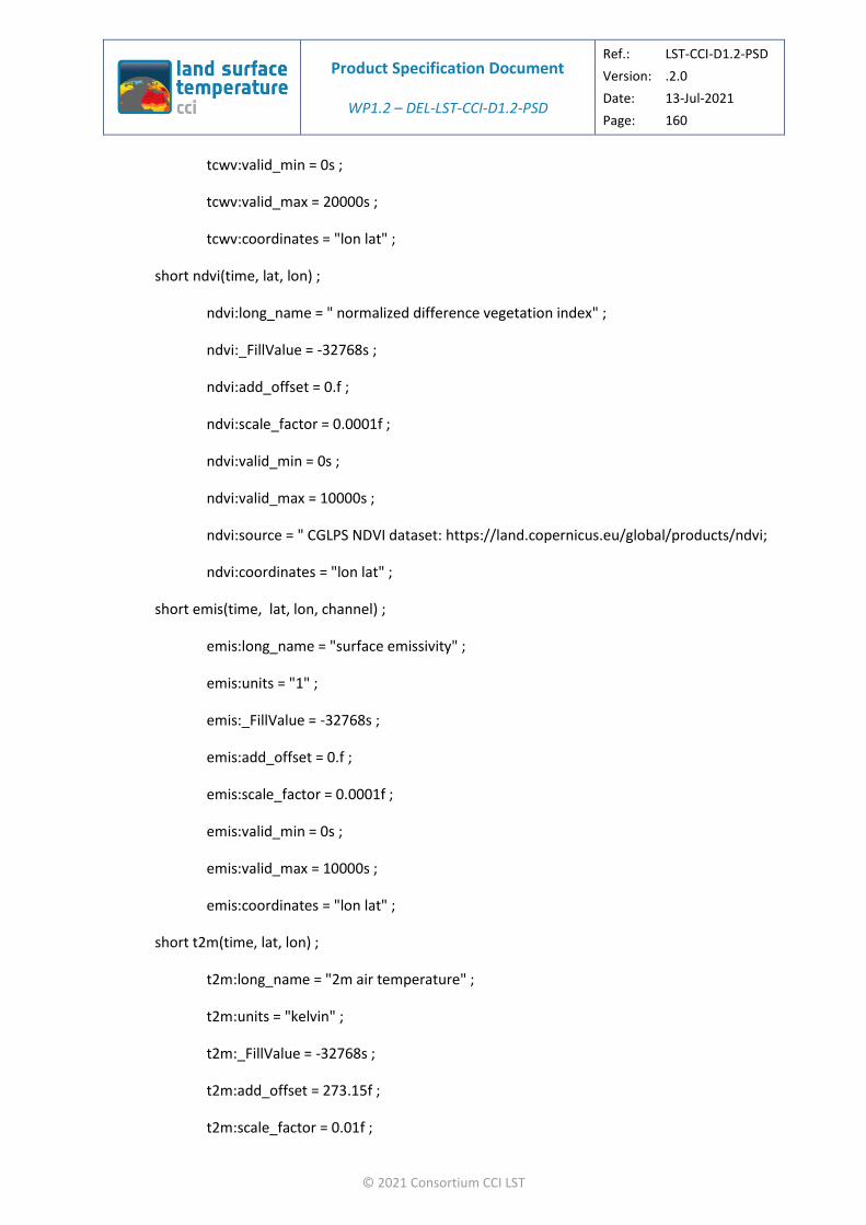
Product Specification Document
WP1.2 – DEL-LST-CCI-D1.2-PSD
Ref.: LST-CCI-D1.2-PSD
Version: .2.0
Date: 13-Jul-2021
Page: 160
© 2021 Consortium CCI LST
tcwv:valid_min = 0s ;
tcwv:valid_max = 20000s ;
tcwv:coordinates = "lon lat" ;
short ndvi(time, lat, lon) ;
ndvi:long_name = " normalized difference vegetation index" ;
ndvi:_FillValue = -32768s ;
ndvi:add_offset = 0.f ;
ndvi:scale_factor = 0.0001f ;
ndvi:valid_min = 0s ;
ndvi:valid_max = 10000s ;
ndvi:source = " CGLPS NDVI dataset: https://land.copernicus.eu/global/products/ndvi;
ndvi:coordinates = "lon lat" ;
short emis(time, lat, lon, channel) ;
emis:long_name = "surface emissivity" ;
emis:units = "1" ;
emis:_FillValue = -32768s ;
emis:add_offset = 0.f ;
emis:scale_factor = 0.0001f ;
emis:valid_min = 0s ;
emis:valid_max = 10000s ;
emis:coordinates = "lon lat" ;
short t2m(time, lat, lon) ;
t2m:long_name = "2m air temperature" ;
t2m:units = "kelvin" ;
t2m:_FillValue = -32768s ;
t2m:add_offset = 273.15f ;
t2m:scale_factor = 0.01f ;

Product Specification Document
WP1.2 – DEL-LST-CCI-D1.2-PSD
Ref.: LST-CCI-D1.2-PSD
Version: .2.0
Date: 13-Jul-2021
Page: 161
© 2021 Consortium CCI LST
t2m:valid_min = -8315s ;
t2m:valid_max = 7685s ;
t2m:source = "ECMWF ERA-5 dataset: https://www.ecmwf.int/en/forecasts/datasets/archive-datasets/reanalysis-datasets/era5";
t2m:coordinates = "lon lat" ;
short sh2m(time, lat, lon) ;
sh2m:long_name = "2m specific humidity" ;
sh2m:_FillValue = -32768s ;
sh2m:add_offset = 0f ;
sh2m:scale_factor = 0.0001f ;
sh2m:valid_min = 0s ;
sh2m:valid_max = 10000s ;
sh2m:source = "ECMWF ERA-5 dataset: https://www.ecmwf.int/en/forecasts/datasets/archive-datasets/reanalysis-datasets/era5";
sh2m:coordinates = "lon lat" ;
short ws2m(time, lat, lon) ;
ws2m:long_name = "2m wind speed" ;
ws2m:units = "m s-1" ;
ws2m:_FillValue = -32768s ;
ws2m:add_offset = 0f ;
ws2m:scale_factor = 0.004f ;
ws2m:valid_min = 0s ;
ws2m:valid_max = 20000s ;
ws2m:source = "ECMWF ERA-5 dataset: https://www.ecmwf.int/en/forecasts/datasets/archive-datasets/reanalysis-datasets/era5";
ws2m:coordinates = "lon lat" ;
short n(time, lat, lon) ;
n:long_name = "Number of pixels averaged" ;

Product Specification Document
WP1.2 – DEL-LST-CCI-D1.2-PSD
Ref.: LST-CCI-D1.2-PSD
Version: .2.0
Date: 13-Jul-2021
Page: 162
© 2021 Consortium CCI LST
n:_FillValue = -32768s ;
n:valid_min = 0s ;
n:valid_max = 75000s ;
n:coordinates = "lon lat" ;
short ncld(time, lat, lon) ;
ncld:long_name = "Number of pixels averaged" ;
ncld:_FillValue = -32768s ;
ncld:valid_min = 0s ;
ncld:valid_max = 75000s ;
ncld:coordinates = "lon lat" ;
short lwm(time, lat, lon) ;
lwm:long_name = "Land water mask" ;
lwm:_FillValue = -32768s ;
lwm:add_offset = 0.f ;
lwm:scale_factor = 0.0001f ;
lwm:valid_min = 0s ;
lwm:valid_max = 10000s ;
lwm:coordinates = "lon lat" ;
short variance(time, lat, lon) ;
variance:long_name = "land surface temperature variance" ;
variance:units = "kelvin" ;
variance:_FillValue = -32768s ;
variance:add_offset = 0.f ;
variance:scale_factor = 0.01f ;
variance:valid_min = 0s ;
variance:valid_max = 10000s ;
variance:coordinates = "lon lat" ;
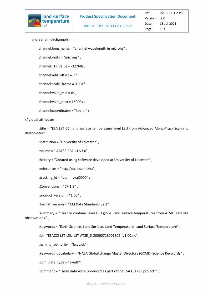
Product Specification Document
WP1.2 – DEL-LST-CCI-D1.2-PSD
Ref.: LST-CCI-D1.2-PSD
Version: .2.0
Date: 13-Jul-2021
Page: 163
© 2021 Consortium CCI LST
short channel(channel) ;
channel:long_name = "channel wavelength in microns" ;
channel:units = "microns" ;
channel:_FillValue = -32768s ;
channel:add_offset = 0.f ;
channel:scale_factor = 0.001f ;
channel:valid_min = 0s ;
channel:valid_max = 15000s ;
channel:coordinates = "lon lat" ;
// global attributes:
:title = "ESA LST CCI land surface temperature level L3U from Advanced Along-Track Scanning Radiometer" ;
:institution = "University of Leicester" ;
:source = " AATSR-ESA-L1-v3.0" ;
:history = "Created using software developed at University of Leicester" ;
:references = "http://cci.esa.int/lst" ;
:tracking_id = "dummyval0000" ;
:Conventions = "CF-1.8" ;
:product_version = "1.00" ;
:format_version = " CCI Data Standards v2.2" ;
:summary = "This file contains level L3U global land surface temperatures from ATSR_ satellite observations." ;
:keywords = "Earth Science, Land Surface, Land Temperature, Land Surface Temperature" ;
:id = "ESACCI-LST-L3U-LST-ATSR_3-20060718001802-fv1.00.nc" ;
:naming_authority = "le.ac.uk" ;
:keywords_vocabulary = "NASA Global change Master Directory (GCMD) Science Keywords" ;
:cdm_data_type = "Swath" ;
:comment = "These data were produced as part of the ESA LST CCI project." ;

Product Specification Document
WP1.2 – DEL-LST-CCI-D1.2-PSD
Ref.: LST-CCI-D1.2-PSD
Version: .2.0
Date: 13-Jul-2021
Page: 164
© 2021 Consortium CCI LST
:date_created = "20190528T155910Z" ;
:creator_name = "University of Leicester Surface Temperature Group" ;
:creator_url = "http://cci.esa.int/lst" ;
:creator_email = "[email protected]" ;
:project = "Climate Change Initiative - European Space Agency" ;
:geospatial_lat_min = -83.78497f ;
:geospatial_lat_max = 83.78481f ;
:geospatial_lon_min = -180.f ;
:geospatial_lon_max = 179.9999f ;
:geospatial_vertical_min = 0.f ;
:geospatial_vertical_max = 0.f ;
:time_coverage_start = "20060718T001816Z" ;
:time_coverage_end = "20060718T020633Z" ;
:time_coverage_duration = "PT01H48M17S" ;
:time_coverage_resolution = "grid" ;
:standard_name_vocabulary = " CF Standard Name Table v71" ;
:license = "ESA CCI Data Policy: free and open access" ;
:platform = "Envisat" ;
:sensor = "ATSR_3" ;
:spatial_resolution = "1 km at nadir" ;
:geospatial_lat_units = "degrees_north" ;
:geospatial_lon_units = "degrees_east" ;
:key_variables = "land_surface_temperature" ;
End of Document


