PROBE RESOURCES LTD.
20
Probe Resources Ltd. Geophysical Assessment Report Larry Claim: 356561 Sookochoff Consultants Inc. August 5, 2007 page 1 of 14 PROBE RESOURCES LTD. GEOPHYSICAL ASSESSMENT REPORT (Event Number: 4150927) on the LARRY CLAIM (Tenure: 356561 49° 23’ 10” N 118° 52’ 45” W Greenwood M.D. N.T.S.M082E036
Transcript of PROBE RESOURCES LTD.
Probe Resources Ltd.
Geophysical Assessment Report
Larry Claim: 356561
Sookochoff Consultants Inc.
August 5, 2007 page 1 of 14
PROBE RESOURCES
LTD.
GEOPHYSICAL ASSESSMENT REPORT
(Event Number: 4150927)
on the
LARRY CLAIM (Tenure: 356561
49°°°° 23’ 10” N 118°°°° 52’ 45” W
Greenwood M.D. N.T.S.M082E036

Probe Resources Ltd.
Geophysical Assessment Report
Larry Claim: 356561
Sookochoff Consultants Inc.
August 5, 2007 page 2 of 14
Table of Contents
page
Summary -------------------------------------------------------------------------- 3.
Introduction ----------------------------------------------------------------------- 4.
Property Description and Location --------------------------------------------- 4.
Accessibility, Climate, Local Resources, Infrastructure and Physiography 4.
History ----------------------------------------------------------------------------- 5.
Geological Setting ---------------------------------------------------------------- 6.
Mineralization --------------------------------------------------------------------- 9.
2007 VLF-EM Survey ----------------------------------------------------------- 9.
References ------------------------------------------------------------------------- 11.
Statement of Costs --------------------------------------------------------------- 12.
Certificate -------------------------------------------------------------------------- 13.
Appendix I VLF-EM Raw Data -------------------------------------------- 14.
Illustrations
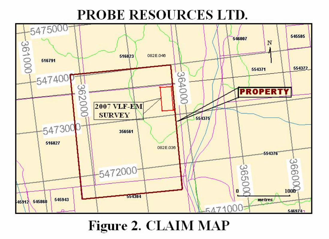
Figure 1. Location Map -------------------------------------------- following page 3.
Figure 2. Claim Map ----------------------------------------------- following page 4.
Figure 3. VLF-EM Raw Data ----------------------------------- following page 9.
Figure 4. VLF-EM Fraser Filtered Data ----------------------- following page 9.
Figure 5. VLF-EM Fraser Filtered Contoured Data ---------- following page 9.

Probe Resources Ltd.
Geophysical Assessment Report
Larry Claim: 356561
Sookochoff Consultants Inc.
August 5, 2007 page 3 of 14
Summary
The Larry Claim owned 100% by Probe Resources Ltd., covers an area of 500 hectares, and is
located 15 km east-southeast of Beaverdell and 38 km northeast of Camp McKinney where
placer gold and lode gold deposits were worked since 1894 and where one property has produced
$1,000,000 in gold from 1894 to 1903. The Anarchist Group of rocks is host to most of the Camp
McKinney gold deposits.
The Larry Claim is indicated to predominantly cover the Anarchist Group of rocks in contact
with a projection of the Kettle River Formation of acidic tuffs and sediments including shales,
and which in other areas are known to include small plugs of porphyritic rhyolite which
apparently mark volcanic vent zones, along the southwest boundary.
The Larry Claim covers localized correlative anomalous soil geochemical zones delineated prior
to 1985 on the former Cann 1 and Cann 2 mineral claims. On the Cann 1 claim one of four zones
contained gold values of up to 735 ppb in soil geochemical samples. On the former Cann 2
claim, exploration was more advanced with trenching completed on two correlative anomalous
soil geochemical zones. Assay results of samples taken from the trenches of the mineralized
zone, designated as the Northeast Zone, returned up to 2.21% Cu and 5.33% Fe. The trenches
exposed rock types and assay values indicating a strong potential for the location of Camp
McKinney style of mineral deposit.
A recent lineament array analysis of the Larry claim indicated a conjugate fault array of two
fault sets; northeasterly and northwesterly. Some significant potential mineral controlling
structural patterns are evident.
The 2007 VLF-EM survey resulted in the delineation of two northwesterly, open-ended zones.
These two zones do not appear to provide any southward continuity to the 2003 VLF-EM
northerly trending anomalous zones; although the two general directions have been indicated in
the lineament array analysis.
Probe Resources Ltd.
Geophysical Assessment Report
Larry Claim: 356561
Sookochoff Consultants Inc.
August 5, 2007 page 4 of 14
Introduction
An exploration program consisting of a localized geophysical (VLF-EM) survey was completed
on the Larry mineral claim for assessment work to be applied to the Larry mineral claim for one
year (Event Number 4150927). The purpose of the geophysical (VLF-EM) survey was to locate
the structure that is indicated on aerial photographs in the area of the correlative geochemical
anomalies of the southeast zone and to determine the significance of the structure to the indicated
mineralization
Information for this report was obtained from sources as cited under Selected References and
from previous exploration work performed on the property since 1980.
Property Description and Location
The property consists of one located 20 unit grid claim covering an area of 500 hectares.
Particulars are as follows:
Claim Name Tenure No. Expiry Date
Larry 356561 June 11, 2008
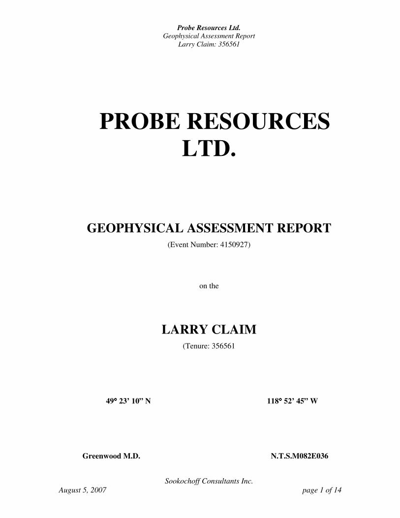
The property is located 15 km east-southeast of Beaverdell and 38 km northeast of Camp
McKinney and 40 km north of Rock Creek within map sheet M082E036 in central southern
British Columbia. Rock Creek, the nearest commercial center is 453 km east of Vancouver and
100 km east of Penticton and 144 km west of Castlegar, two major centers that are served daily
by a commercial airline.
Camp McKinney, where placer and hard rock mining was initially carried out in 1894, is 38 km
to the south-southwest.
As portions of the property are deeded lands, company liability and/or environmental liability
insurance may be required prior to conducting exploration work on the deeded portions of the
property.
Accessibility, Climate, and Physiography
Access from Rock Creek to the LCP of the Larry claim is northward via the Rock Creek-
Christian Valley Highway from Rock Creek, through Westbridge and approximately to the km 27
marking. The marking is a red 27 on a white board measuring 20 by 30 cm attached to a tree on
the south side of the highway at a height of some three metres.
The region is situated within the dry belt of British Columbia with rainfall between 25 and 30 cm
per year. Temperatures during the summer months could reach a high of 30° and average 25°C
with the winter temperatures reaching a low of -15°C and averaging 8°C. On the property, the
permanent snow on the ground would be from December to April and would not hamper a year-
round exploration program.
Probe Resources Ltd.
Geophysical Assessment Report
Larry Claim: 356561
Sookochoff Consultants Inc.
August 5, 2007 page 5 of 14
Accessibility, Climate, and Physiography (cont’d)
The general climate of the area would allow a snow free surface exploration program of up to
nine months of the year at the lower elevations.
Sufficient water for all phases of the exploration season could be available from the Kettle River
which is within 200 metres of the southeast corner of the Larry claim.
Diesel-electric power would initially be required for exploration and development. A major
transmission line is four km to the south with a natural gas pipeline 14 km to the south.
The property is situated within the Beaverdell Range of mountains and covers subdued
topography. Elevations range from 650 metres at the mid-eastern boundary to 950 metres at the
mid-western boundary.
History
The history of the immediate area centers around the placer deposits of McKinney Creek and the
mines at Camp McKinney, 38 km to the southwest of the Larry claim. Camp McKinney was one
of the early lode gold camps of British Columbia with one property, the Cariboo, producing over
$1,000,000 in gold largely between 1894 and 1903. A number of other properties were
developed but none of these produced important amounts of ore.
A stamp mill was in operation from 1894 until 1903, during which time 123,457 tons of ore
was milled. Recovery totaled 69,581 ounces of gold and 6,359 ounces of silver. Claims within
Camp McKinney were periodically worked from 1903 to 1962 when gold-silver ore was shipped
to the Trail Smelter, and thereafter. Some of the properties worked on within Camp McKinney
include the Anarchist, Gold Hill, Eureka and Sailor Fraction, Sailor and Minnie-Ha-Ha,
Kamloops and the Wiarton.
On the ground presently covered by the Larry claim group exploration work was completed over
a southern portion by Golden Chance Resources Inc. on their Cann 1 mineral claim and over a
northern portion by Silverleaf Resources Ltd. on their Cann 2 mineral claim. The exploration
work was completed in 1983 and 1985.
On the Cann 2 mineral claim, Silverleaf Resources Ltd. completed geophysical and geochemical
surveys in August, 1983 (Sookochoff, 1983 (AR 12,323), detailed geophysical, geological and
geochemical surveys in May, 1984 (Sookochoff, 1984) and trenching in November, 1984
(Sookochoff, 1985).
The second stage exploration program on the Cann 2 mineral claim consisting of trenching
within two correlative anomalous soil geochemical zones, presently designated as the Northeast
Zone, an area of 300 by 600 metres, and the Northwest Zone, an area of 600 meters long and up
to 500 metres wide. Ten trenches, designated as A to J, to either detect the source of the soil
anomalies or to observe bedrock in mineral indicated locals, were completed within both zones.

Probe Resources Ltd.
Geophysical Assessment Report
Larry Claim: 356561
Sookochoff Consultants Inc.
August 5, 2007 page 6 of 14
History (cont’d)
Samples taken by Brox (1984) from six trenches, A to F, within the Northeast Zone returned
assay values of up to 2.21% Cu within a greenstone breccia and 5.33% Fe within a grayish-green
dacite hosting fine disseminated pyrite. Of the four trenches, G to J, completed within the
Northwest Zone, two were terminated in overburden; trench G exposed chloritic andesite, a
sample of which returned 24 ppm Cu; trench J exposed dioritic bedrock, a sample of which
returned no anomalous mineral values.
On the Cann 1 mineral claim, Golden Chance Resources Inc. completed geochemical and
geophysical surveys in 1983, resulting in the delineation of eight correlative anomalous zones
and one prime zone, designated as “A” (Mark, 1983 AR 12,553). In 1985 follow-up surveys,
primarily on zone “A”, were completed by Golden Chance Resources Ltd. resulting in the
determination that the extensive zone “A” anomaly did not exist in its previous form, however,
consisted of four localized correlative anomalous soil geochemical zones (Mark, 1985). In 1993,
the LA 1-8 mineral claims covered four of the 1983 anomalies and the Golden Chance former
zone “A”.
In 1995 the LAR 1-4 mineral claims were staked to cover the four localized anomalies of zone
“A” and additional ground to the north where Silverleaf Resources completed an exploration
program in 1983 and 1984. In 1996 a localized geochemical survey was completed on the LAR 1
claim.
In 1996 the Larry 20 unit claim was staked to include the LAR 1-4 claims and additional ground,
which was previously explored by Silverleaf Resources Ltd. and by Golden Chance Resources
Inc.
From 1997 to 2006, limited localized geochemical and geophysical surveys, prospecting, a GPS
survey and a lineament array analysis were completed on the Larry claim by Probe Resources
Ltd
Geological Setting
Regional
The regional geology and metallogenesis have been studied in most detail by Peatfield (1978).
Monger (1967) has provided a detailed look of the early Tertiary rocks of the area and
Reinsbakken (1968) provided a detailed geological interpretation of the area directly to the
north and east of the claim area. Other relevant Canadian studies on geology and metallogeny
of the area have been provided by Seraphim (1956), among others.
The regional geology (Little, 1957) consists of seven basic units as follows:
The oldest mapped units of the area are those of the para-gneissic basement Monashee Group
which appears only in the very southeastern part of the map, as it appears only to the east of the
Granby River north of Grand Forks.
Probe Resources Ltd.
Geophysical Assessment Report
Larry Claim: 356561
Sookochoff Consultants Inc.
August 5, 2007 page 7 of 14
Geological Setting
Regional (cont’d)
The next, and most important unit in terms of areal extent and ore deposits of the Phoenix
Camp, is the Anarchist Group which is composed of greenstone, greywacke, limestone, and
paragneiss. These form the basic basement rocks of the area into which have been intruded two
distinct types of Cretaceous (?)/Tertiary (?) intrusions
The first is the Nelson batholithic rocks which are granodioritic to granitic and monzonitic in
composition. These batholithic rocks are reported by Little to be cutting the second
serpentinized ultra-basic bodies which also appear within the various mineral camps of the area
and are believed to be genetically significant to ore deposits.
Finally, there is a varied and extensive deposition of the Tertiary rocks, the oldest being the
Coryell intrusions, which are generally acid phases including syenite, monzonite, shonkinite,
and granite. These are followed in age by the Kettle River Formation, which basically consists
of extrusive acidic volcanics with associated conglomerates, sandstone and shale.
These rocks are intruded finally by the Phoenix volcanic group of andesite, trachyte, and
basalt, and generally more basic volcanic units with mixed siltstone and shale. This final
Tertiary package is part of what has been described by Peatfield and other recent authors as
being very important in the possible remobilization and hence, concentration of precious metal
deposits within and around the much earlier Triassic Brooklyn Formation copper precious
metal skarn deposits. These Tertiary rocks are most often represented by small acid intrusive
plugs and dykes except for the Phoenix area itself where numerous basic to intermediate flows
of the Marron Formation are also in evidence (Monger, 1967).
Within the immediate area of the Larry claim of the Camp McKinney area, the Anarchist group
consists very largely of highly metamorphosed sedimentary rocks but includes also altered
greenstones and possibly also altered intrusive rocks. The sedimentary members of the group are
the altered equivalents of quartzite, slate and limestone, micaceous quartzites, mica schists, and
crystalline limestone. The sheared greenstones possibly represent both intrusive and extrusive
types.
Dacite (D) Light grey groundmass on fresh surface; abundant milky-white
phenocrysts; minor sulphide mineralization.
Conglomerate (Co) Light green on fresh surface; matrix supported; variable clast sizes
(most less than two mm); no visible mineralization; clasts
composed of chert and feldspars
Diorite (I) Silica rich; muscovite, biotite, hornblende, plagioclase; no visible
mineralization.
Probe Resources Ltd.
Geophysical Assessment Report
Larry Claim: 356561
Sookochoff Consultants Inc.
August 5, 2007 page 8 of 14
Geological Setting – Regional (cont’d
A second group of rocks within the Anarchist series are light grey, granitic rocks, quite generally
gneissic, the outcrops of which have in some cases a slightly rusty appearance. Quartz and
microcline predominate with orthoclase and albitic-oligoclase generally present.
The granitic rocks are intrusive into the schists of the Anarchist series. Another group consists of
weathered basic intrusives which, in local areas, can be represented as serpentine with
considerable pyrite development in association with shear zones.
Feldspar porphyry "dykes" are also common in the area. The rock is described as a "pale pink to
flesh colored, fine grained rock with granitic texture. Quartz is fairly common and feldspar,
shreds of biotite, hornblende, small individuals of apatite and some iron ore make up the balance
of the rock".
The Kettle River Formation consists of acidic tuff and local basins of conglomerate, shales and
sandstones. In the conglomerate of the Kettle River formation, the roundstones consist for the
most part of rocks of the underlying formations exposed in the vicinity. In some areas a little
rhyolite is imbedded with acidic tuff and sandstone. In other areas, small plugs of porphyritic
rhyolite with quartz phenocrysts apparently mark the vents from which some of the acidic tuff
was emitted.
The Phoenix volcanic group overlies the Kettle River formation with apparent unconformity, for
in many places it lays directly upon older formations. It consists mainly of andesitic and trachytic
lavas, but locally contains imbedded sediments. In some areas siltstones are exposed in the group
and west of Midway tuffs and shales are well exposed in road and railway cuts.
Geological Setting – Property
The Larry Claim, as indicated from Map 6-1957 Kettle River Geology East Half, is underlain by
the Anarchist group with an infringement of the Kettle River rocks in the southwest.
A preliminary geological mapping and sampling program was completed for Silverleaf
Resources Ltd. by in May 1984 Brox (1984) on the two delineated correlative anomalous soil
geochemical areas presently included within the ground of the Larry claim and designated as
the northeast and the northwest zones as indicated on Figure 5. In the northeast area Brox
reports that the outcroppings were dominantly greenstone, however, the Trench A in the south
revealed pelitic sediments and Trench C within the mid portion of the zone revealed the
presence of diorite.
Within the Northwest Zone, Brox reports that greenstones predominate in a northerly trending
contact with dacite to the west. The dacite is in contact with a conglomerate to the west, which
is in contact with an intrusive? diorite. The strongest correlative soil geochemical anomaly is
within the greenstone portion adjacent to the dacite contact.

Probe Resources Ltd.
Geophysical Assessment Report
Larry Claim: 356561
Sookochoff Consultants Inc.
August 5, 2007 page 9 of 14
Geological Setting – Property (cont’d)
On the southern portion of the Larry claim covering the former Cann 1 correlative soil
geochemical anomalies, the geology is only generalized from the regional geology map and is
indicated as Anarchist Group rocks in contact with Kettle River Formation rocks within the
southwest quadrant.
Mineralization
According to Hedley (1940), the gold bearing mineral zones at Camp McKinney are mainly of
quartz veins, that may be over five metres wide, occurring in the schists of the Anarchist series
and in general paralleling the strike and dip of the schistosity. The quartz veins are mineralized
with pyrite accompanied by galena and zinc blend and carry in places good values in gold. With
only pyrite in the veins, the gold values are low. The gold mineralization may be associated with
shear zones with little or no quartz. Mineralization may also occur as sparse disseminations, or
pockets, of pyrite, and/or chalcopyrite, galena and tetrahedrite.
According to Brox (1984) most of the rock samples taken from the anomalous zones show
some degree of sulphide mineralization. This degree of mineralization varies from visible
pyrite specs to fine sulphide veinlets with malachite staining. Anomalous results from assays of
samples collected by Brox returned: 2,284 ppm Cu and 7.4 ppm Ag. from Trench A and 496
ppm Cu, 3.8 ppm Ag and 338 ppm As from Trench B. The rocks around the two trenches
located within the Northeast Zone display extensive mineralization of malachite, azurite,
pyrite, chalcopyrite, and chalcocite.
Brox reports the following assays of selected grab samples taken from the trenches.
Location % Cu % Fe oz/t Ag
Trench B 0.42 --- 0.47
Trench C --- 5.33 ---
Trench E 2.21 --- ---
2007 Geophysical Survey
VLF-EM Survey
A Sabre Model 27 VLF-EM receiver manufactured by Sabre Electronics of Vancouver was
utilized in the VLF-EM survey. The primary transmission utilized was from Seattle,
broadcasting at a frequency of 18.6 Khz. The VLF-EM receiver measures the amount of
distortion produced in the primary transmitted field and a secondary magnetic field, which may
be induced by a conductive mass such as a sulphide body.
The VLF-EM unit, due to its relatively high frequency, can detect low conductive zones such
as fault or shear zones, carbonaceous sediments, or lithological contacts and has the added
disadvantage of indicating anomalous conditions from unwanted sources such as swamp edges,
creeks and topographical highs.


Probe Resources Ltd.
Geophysical Assessment Report
Larry Claim: 356561
Sookochoff Consultants Inc.
August 5, 2007 page 10 of 14
VLF-EM Survey (cont’d)
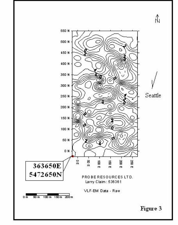
The purpose of the geophysical (VLF-EM) survey was to determine the southern extension of the
2003 Northeast zone VLF-EM anomaly (AR 27,236) which is open-ended to the south.
A base line was established from 363650E, 5472650N (00N) for 550 metres north (550N).
VLF-EM readings were taken at 25 metre intervals along east-west lines at 50 metre intervals
from the base-line for 250 metres.
The VLF-EM readings are shown on the accompanying maps as Figures 3 to 5 with Figure 3
showing the raw data, Figure 4 showing the fraser filtered readings, and Figure 5 showing the
contoured fraser filtered date with the interpretation as to the anomalous VLF-EM zones. The
anomalous zones are indicated as two north-westerly, open-ended trending zones.
Respectfully submitted
Sookochoff Consultants Inc.
Laurence Sookochoff, P.Eng.
Vancouver, BC
August 5, 2007
Probe Resources Ltd.
Geophysical Assessment Report
Larry Claim: 356561
Sookochoff Consultants Inc.
August 5, 2007 page 11 of 14
References
Brox, D. -- Unpublished report to Silverleaf Resources Ltd. on the geology and sampling of
the eastern and western sectors of correlative anomalous soil geochemical zones
on the Cann 2 mineral claim. June, 1984.
Cairnes, C.E. - Mineral Deposits of the West Half of Kettle River Area, British Columbia.
Canada Department of Mines and Resources, Mines and Geology Branch, Bureau
of Geology and Topography, Geological Survey. Paper 37-21. June, 1937.
Cockfield, W.E. - Lode Gold Deposits of Fairview Camp, Camp McKinney and Vidette Lake
Area and the Dividend-Lakeview Property near Osoyoos, B.C., Memoir 179. 1935.
Hedley, M.S. - Geology of Camp McKinney and of the Cariboo-Amelia Mine, Similkameen
District. British Columbia Department of Mines, Bulletin No. 6. 1940.
Leroy, O.E. - Geological Survey of Canada. Memoir No. 21. 1912.
Little, H.W. - Geology of the Greenwood Map-Area. G.S.C. 79-29. 1983. Map Scale
1:5,000.
Map 15-1961 - Kettle River (West Half) British Columbia. G.S.C. Ottawa 1961.
Map 6-1957 - Kettle River (East Half) British Columbia. G.S.C. Ottawa 1961.
Mark, D.G. - Geochemical/ Geophysical Report over the Cann 1 Claim for Golden Chance
Resources Inc. November 8, 1983. AR 12,553.
Mark, D.G. - Geochemical/Geophysical Report on the Cann 1 Claim for Golden Chance
Resources Inc. September 25, 1985. AR 13,883.
McNaughton, D.A. - Greenwood - Phoenix Area, British Columbia, G.S.C. Paper 45-20
Canada Dept. of Mines. Ottawa, 1945.
MINDEP FILES - Computer retrieval mineral inventory files on B.C. including entry
82E/SW 020-028. (Phoenix). B.C. Ministry of Energy, Mines and Petroleum
Resources.
Roberts, A.F. - Report on the Camp McKinney Property for McKinney Resources Inc.
November 12, 1982.
Sawyer, J.B.P. - Summary Report on Mineral Properties in the Boundary District,
Greenwood M.D. for Kettle River Mines Ltd. May 25, 1981.
Sookochoff, L.- Geological, Geophysical, and Geochemical Report on the Larry Mineral Claim
for Probe Resources Ltd. September 25, 2003. AR 27,236.
Probe Resources Ltd.
Geophysical Assessment Report
Larry Claim: 356561
Sookochoff Consultants Inc.
August 5, 2007 page 12 of 14
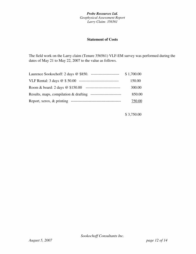
Statement of Costs
The field work on the Larry claim (Tenure 356561) VLF-EM survey was performed during the
dates of May 21 to May 22, 2007 to the value as follows.
Laurence Sookochoff: 2 days @ $850. ---------------------- $ 1,700.00
VLF Rental: 3 days @ $ 50.00 ------------------------------- 150.00
Room & board: 2 days @ $150.00 --------------------------- 300.00
Results, maps, compilation & drafting ------------------------ 850.00
Report, xerox, & printing --------------------------------------- 750.00
$ 3,750.00
Probe Resources Ltd.
Geophysical Assessment Report
Larry Claim: 356561
Sookochoff Consultants Inc.
August 5, 2007 page 13 of 14
Certificate
I, Laurence Sookochoff, of the City of Vancouver, in the Province of British Columbia, do
hereby certify that I am a Consulting Geologist with an address at 120 125A-1030 Denman
Street Vancouver, BC V6G 2M6.
I, Laurence Sookochoff, further certify that:
1) I am a graduate of the University of British Columbia (1966) and hold a B.Sc.
degree in Geology.
2) I have been practicing my profession for the past fourty-one years.
3) I am registered and in good standing with the Association of Professional Engineers
and Geoscientists of British Columbia.
4) Information for this report was obtained from sources as cited under the Reference
section of this report, from work performed on the Larry claim ground since 1983, and
from the geophysical survey as described herein.
6) I do not have any interest in Probe Resources Ltd. nor in the Larry mineral claim as
described herein.
Laurence Sookochoff, P. Eng.
Vancouver, B.C.
Probe Resources Ltd.
Geophysical Assessment Report
Larry Claim: 356561
Sookochoff Consultants Inc.
August 5, 2007 page 14 of 14
Appendix I
VLF-EM RAW DATA

PROBE RESOURCES LTD
2007 VLF-EM SURVEY
S W Null Filter S W Null Filter S W Null Filter
0 0 3 100 0 2 200 0 2
0 25 2 100 25 3 200 25 -3 6
0 50 3 -4 100 50 6 0 200 50 -4 -1
0 75 6 -3 100 75 -1 1 200 75 -6 -13
0 100 3 9 100 100 -5 -4 200 100 0 -10
0 125 5 16 100 125 1 0 200 125 3 4
0 150 -5 0 100 150 -3 -3 200 150 1 10
0 175 -3 -6 100 175 -1 -7 200 175 -2 2
0 200 3 -3 100 200 2 -3 200 200 -4 -8
0 225 -5 -3 100 225 1 -4 200 225 0 -11
0 250 1 -1 100 250 -5 -7 200 250 2 -8
0 275 0 0 100 275 -2 -6 200 275 5 6
0 300 -3 -8 100 300 5 6 200 300 5 18
0 325 2 -8 100 325 -6 -9 200 325 -4 10
0 350 3 -1 100 350 3 -14 200 350 -4 5
0 375 4 0 100 375 5 -3 200 375 -5 1
0 400 2 -2 100 400 6 9 200 400 -8 -17
0 425 5 3 100 425 2 8 200 425 0 -16
0 450 3 7 100 450 0 6 200 450 4 -1
0 475 1 2 100 475 0 5 200 475 4 7
0 500 0 100 500 -4 200 500 1
0 525 2 100 525 -1 200 525 0
50 0 1 150 0 4 250 0 5 50 25 6 10 150 25 1 2 250 25 0 5
50 50 1 10 150 50 3 6 250 50 2 7
50 75 -4 -1 150 75 0 1 250 75 -2 2
50 100 1 2 150 100 -2 -7 250 100 -3 -3
50 125 -3 -3 150 125 4 -4 250 125 1 4
50 150 -2 -9 150 150 1 5 250 150 -4 1
50 175 3 3 150 175 -3 -6 250 175 -2 -8
50 200 1 10 150 200 3 4 250 200 -2 -12
50 225 -3 3 150 225 1 12 250 225 4 -8
50 250 -3 0 150 250 -5 -2 250 250 4 2
50 275 -2 2 150 275 -3 -13 250 275 6 12
50 300 -4 -12 150 300 1 -6 250 300 0 10
50 325 -3 -12 150 325 4 3 250 325 -2 0
50 350 2 -7 150 350 0 4 250 350 -2 -5
50 375 3 -3 150 375 2 6 250 375 0 -7
50 400 3 1 150 400 -2 2 250 400 1 -6
50 425 5 10 150 425 -2 -9 250 425 4 3
50 450 0 10 150 450 0 -10 250 450 3 8
50 475 -2 1 150 475 5 2 250 475 -1 2
50 500 -3 150 500 3 250 500 0
50 525 0 150 525 0 250 525 0