Priority Scour Critical Bridge Countermeasure Plan of ...gis.dot.nh.gov/bridge_scour/Concord...
34
DocID_Nob Attachment D: Bridge Elevation Summary Showing Existing Streambed, Foundation Depth(s) and Observed and/or Calculated Scour Depths The Following Materials Are Being Submitted With This Report: Attachment H: Plan View Showing Location of Scour Holes, Debris, etc, Attachment B: Map Showing Detour Route(s) Attachment E: Boring Logs and/or Other Subsurface Information Attachment F: Survey Cross Sections From Current and Previous Inspection Reports Attachment G: Supporting Documentation, Calculations, Estimates, and Conceptual Designs for Scour Countermeasures Attachment A: Photos Attachment C: Field Verification Card (FVC) Feature Crossed: Merrimack River Feature Carried: I-93 & US Route 4 SB Owner: NHDOT New Hampshire Department of Transportation Scour Critical Bridge Plan of Action (POA) Report Final Recommended Action: Given the facts that these interstate bridges are considered to be ultra-critical to the NHDOT, an individual flood event could yield exposed piles at Pier 2, and the stream bed composition of deep granular/sand deposits, CHA recommends that A-Jacks be installed around the pier to provide countermeasure protection. Until such measure is installed, CHA recommends that the bridge be monitored during and after significant flood events and inspected for possible scouring or damage. In addition regular biennial inspections should continue to document the riverbed elevations at the bridge. Due to the depth of water at the piers and across the river, post-flood inspections should include dive inspections. Diving inspections should continue every 2 years. Concord 136/116 POA Report Scour POA Priority: Attachment I: Post Flood Inspection Documentation Post Flood Inspection Tasks Flood Monitoring Program Conceptual Structural / Hydraulic Countermeasures Fixed Monitoring Devices Increased Inspection Frequency Priority Countermeasure Priority Monitoring Attachment J: Scour / H&H Backup Calculations Attachment K: NHDOT Underwater Inspection Report
-
Upload
truongthuan -
Category
Documents
-
view
227 -
download
4
Transcript of Priority Scour Critical Bridge Countermeasure Plan of ...gis.dot.nh.gov/bridge_scour/Concord...

DocID_Nob
Attachment D: Bridge Elevation Summary Showing Existing Streambed, Foundation Depth(s) and Observed and/or Calculated Scour Depths
The Following Materials Are Being Submitted With This Report:
Attachment H: Plan View Showing Location of Scour Holes, Debris, etc,
Attachment B: Map Showing Detour Route(s)
Attachment E: Boring Logs and/or Other Subsurface Information
Attachment F: Survey Cross Sections From Current and Previous Inspection Reports
Attachment G: Supporting Documentation, Calculations, Estimates, and Conceptual Designs for Scour Countermeasures
Attachment A: Photos
Attachment C: Field Verification Card (FVC)
Feature Crossed: Merrimack River
Feature Carried: I-93 & US Route 4 SB
Owner: NHDOT
New HampshireDepartment of Transportation
Scour Critical BridgePlan of Action (POA) Report
Final Recommended Action:Given the facts that these interstate bridges are considered to be ultra-critical to the NHDOT, an individual flood event could yield exposed piles at Pier 2, and the stream bed composition of deep granular/sand deposits, CHA recommends that A-Jacks be installed around the pier to provide countermeasure protection. Until such measure is installed, CHA recommends that the bridge be monitored during and after significant flood events and inspected for possible scouring or damage. In addition regular biennial inspections should continue to document the riverbed elevations at the bridge. Due to the depth of water at the piers and across the river, post-flood inspections should include dive inspections. Diving inspections should continue every 2 years.
Concord 136/116
POA Report
Scour POA Priority:
Attachment I: Post Flood Inspection Documentation
Post Flood Inspection Tasks
Flood Monitoring Program
Conceptual Structural / Hydraulic Countermeasures
Fixed Monitoring Devices
Increased Inspection Frequency
Priority Countermeasure
PriorityMonitoring
Attachment J: Scour / H&H Backup Calculations
Attachment K: NHDOT Underwater Inspection Report
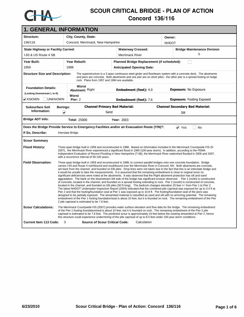
SCOUR CRITICAL BRIDGE − PLAN OF ACTIONConcord 136/116
1. GENERAL INFORMATIONStructure:
Year Built:
136/116
1959
City, County, State:
Concord, Merrimack, New Hampshire
State Highway or Facility Carried:
I-93 & US Route 4 SB
Waterway Crossed:
Merrimack River
Owner:
NHDOT
Year Rebuilt:
1988
Planned Bridge Replacement (if scheduled):
Anticipated Opening Date:
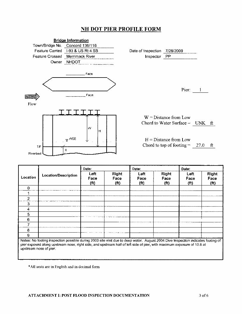
The superstructure is a 3 span continuous steel girder and floorbeam system with a concrete deck. The abutments and piers are concrete. Both abutments and one pier are on short piles - the other pier is a spread footing on ledge rock. Plans from 1957 and 1984 are available.
Structure Size and Description:
Foundation Details:
KNOWN UNKNOWN
Subsurface SoilInformation:
Bridge ADT Info:
Does the Bridge Provide Service to Emergency Facilities and/or an Evacuation Route (Y/N)?:
Interstate BridgeIf So, Describe:
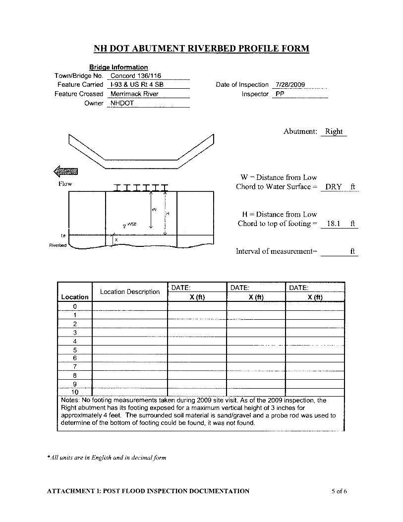
WorstAbutment: Right
WorstPier: 2
(Looking Downstream L to R)
Channel Primary Bed Material:
Sand
Channel Secondary Bed Material:
Silt
Embedment (feet): 4.0 Exposure: No Exposure
Embedment (feet): 7.6 Exposure: Footing Exposed
Scour Summary
Three-span bridge built in 1959 and reconstructed in 1988. Based on information included in the Merrimack Countywide FIS (9-2007), the Merrimack River experienced a significant flood in 1960 (100-year storm). In addition, according to the FEMA Independent Evaluation of Recent Flooding in New Hampshire (7-08), the Merrimack River watershed flooded in 2006 and 2007, with a recurrence interval of 50-100 years.
Flood History:
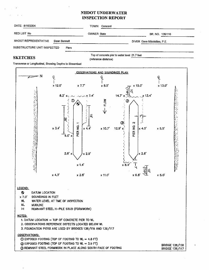
Three-span bridge built in 1959 and reconstructed in 1988, to connect parallel bridges onto one concrete foundation. Bridge carries I-93 and Route 4 northbound and southbound over the Merrimack River in Concord, NH. Both abutments are concrete, set back from the channel, and founded on EB piles. Drop lines were not taken due to the fact that this is an interstate bridge and it would be unsafe to take the measurements. It is assumed that the remaining embedment is close to original since no significant deficiencies were noted at the abutments. It was observed that the Right abutment protection has silt and sand aggradation. The bank on the downstream left side of the bridge has significant erosion observed. Pier 1 (north) is constructed of concrete, located in the channel, and founded on a spread footing extending to rock. Pier 2 (south) is constructed of concrete, located in the channel, and founded on EB piles (50 ft long). The bedrock changes elevation 20 feet +/- from Pier 1 to Pier 2. The latest NHDOT Underwater Inspection Report (2004) indicated that the combined pile cap/seal was exposed for up to 3.4 ft at Pier 2 and that the footing/foundation seal at Pier 1 was exposed up to 10.8 ft. The footing/foundation seal of the piers was designed to be partially exposed. The streambed material is classified as sand and silt with no armoring potential. The remaining embedment of the Pier 1 footing foundation/seal is about 10 feet, but it is founded on rock. The remaining embedment of the Pier 2 pile cap/seal is estimated to be 7.6 feet.
Field Observation:
The Merrimack Countywide FIS (2007) provides water surface elevation and flow data for the bridge. The remaining embedment of the Pier 1 footing foundation/seal is about 10 feet, but it is founded on rock. The remaining embedment of the Pier 2 pile cap/seal is estimated to be 7.6 feet. The predicted scour is approximately 16 feet below the existing streambed at Pier 2, hence this structure could experience undermining of the pile cap/seal of up to 8.5 feet under 100-year storm conditions.
Scour Calculations:
Current Item 113 Code: 3 Source of Scour Critical Code: Calculation
Borings:
Yes No
Bridge Maintenance Division5
200325000 Year:Total:
Text9:6/23/2010 Text9:Scour Critical Bridge - Plan of Action: Concord 136/116 Text9: Page 1 of 6

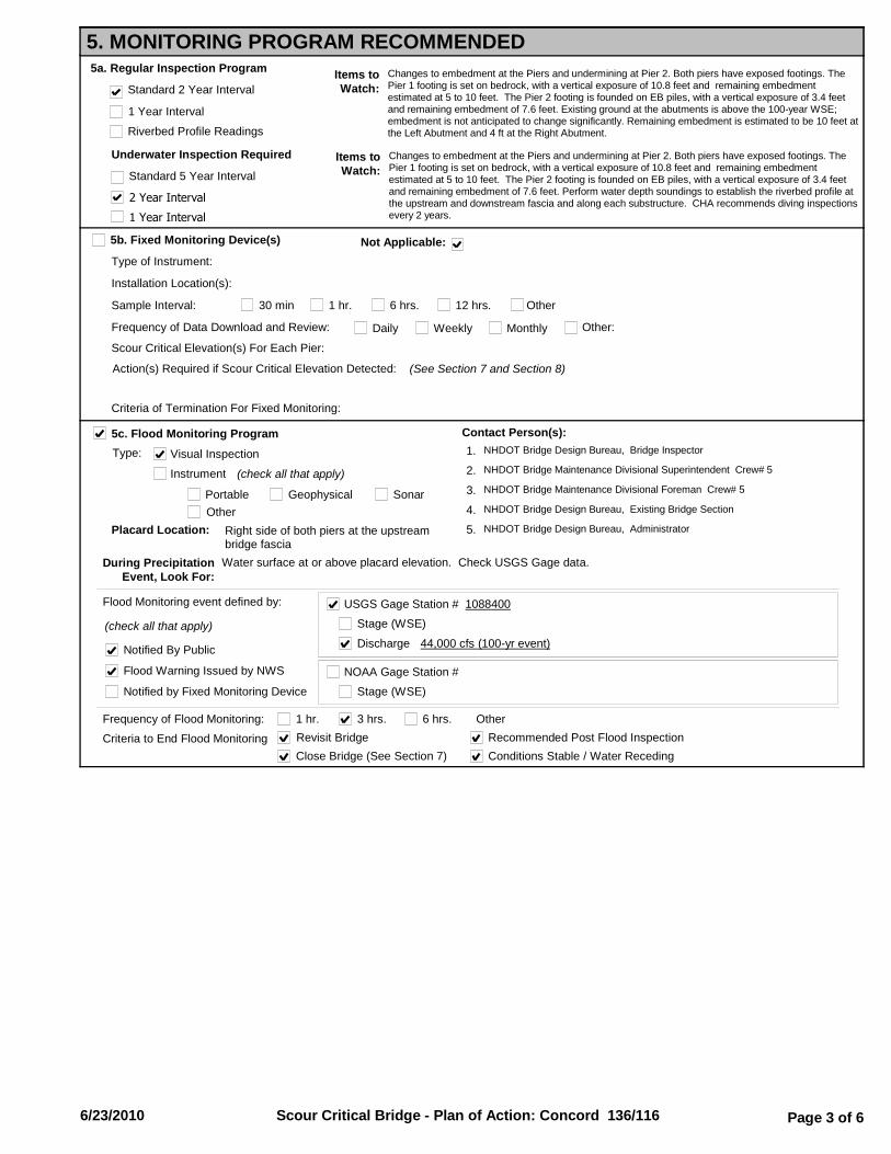
5. MONITORING PROGRAM RECOMMENDED5a. Regular Inspection Program
Riverbed Profile Readings
Items toWatch:
Changes to embedment at the Piers and undermining at Pier 2. Both piers have exposed footings. The Pier 1 footing is set on bedrock, with a vertical exposure of 10.8 feet and remaining embedment estimated at 5 to 10 feet. The Pier 2 footing is founded on EB piles, with a vertical exposure of 3.4 feet and remaining embedment of 7.6 feet. Existing ground at the abutments is above the 100-year WSE; embedment is not anticipated to change significantly. Remaining embedment is estimated to be 10 feet at the Left Abutment and 4 ft at the Right Abutment.
5b. Fixed Monitoring Device(s)
Type of Instrument:
Installation Location(s):
Sample Interval: 30 min 1 hr. 6 hrs. 12 hrs. Other
Frequency of Data Download and Review: Daily Weekly Monthly Other:
Scour Critical Elevation(s) For Each Pier:
Criteria of Termination For Fixed Monitoring:
Standard 2 Year Interval
Underwater Inspection Required Items toWatch:
Changes to embedment at the Piers and undermining at Pier 2. Both piers have exposed footings. The Pier 1 footing is set on bedrock, with a vertical exposure of 10.8 feet and remaining embedment estimated at 5 to 10 feet. The Pier 2 footing is founded on EB piles, with a vertical exposure of 3.4 feet and remaining embedment of 7.6 feet. Perform water depth soundings to establish the riverbed profile at the upstream and downstream fascia and along each substructure. CHA recommends diving inspections every 2 years.
Standard 5 Year Interval
2 Year Interval
1 Year Interval
5c. Flood Monitoring Program
Type:
Discharge
Visual Inspection
Instrument (check all that apply)
Portable Geophysical SonarOther
(check all that apply)
Flood Monitoring event defined by:
44,000 cfs (100-yr event)
Stage (WSE)
Frequency of Flood Monitoring: 1 hr. 3 hrs. 6 hrs. Other
Notified By Public
Flood Warning Issued by NWS
Notified by Fixed Monitoring Device
USGS Gage Station # 1088400
1 Year Interval
Criteria to End Flood MonitoringConditions Stable / Water Receding
Recommended Post Flood Inspection
Action(s) Required if Scour Critical Elevation Detected: (See Section 7 and Section 8)
Not Applicable:
During PrecipitationEvent, Look For:
Water surface at or above placard elevation. Check USGS Gage data.
Revisit Bridge
Close Bridge (See Section 7)
Placard Location: Right side of both piers at the upstream bridge fascia
Contact Person(s):NHDOT Bridge Design Bureau, Bridge Inspector1.
NHDOT Bridge Maintenance Divisional Superintendent Crew# 52.
NHDOT Bridge Maintenance Divisional Foreman Crew# 53.
NHDOT Bridge Design Bureau, Existing Bridge Section4.
NHDOT Bridge Design Bureau, Administrator5.
Stage (WSE)
NOAA Gage Station #
Text9:6/23/2010 Text9:Scour Critical Bridge - Plan of Action: Concord 136/116 Text9: Page 3 of 6

Scour Critical Riverbed Elevation(s) for Each Pier/Abutment: 228.0 at Left Abutment, 201.1 at Pier 1 (footing is on bedrock), 205.0 at Pier 2, 226.0 at Right Abutment
NOTE: Additional Details for Action(s) Required May Be Included in Sections 7 and 8.
Action(s) Required if Scour Critical Riverbed Elevation Detected:
Assess changes in channel/riverbed profiles, possible undermining evidence, and overall stability. Consider closing bridge.
Agency and Department Responsible for Monitoring:
NHDOT
Contact Person:
NHDOT Bridge Design Bureau (603) 271-2731
Riverbed Profile Readings (See Attachment I)
Items toWatch:
Changes to embedment at the Piers and undermining at Pier 2. Both piers have exposed footings. The Pier 1 footing is set on bedrock, with a vertical exposure of 10.8 feet and remaining embedment estimated at 5 to 10 feet. The Pier 2 footing is founded on EB piles, with a vertical exposure of 3.4 feet and remaining embedment of 7.6 feet. Existing ground at the abutments is above the 100-year WSE; embedment is not anticipated to change significantly. Remaining embedment is estimated to be 10 feet at the Left Abutment and 4 ft at the Right Abutment.
5d. Post-Flood Inspection Tasks Required
Visual Inspection (See Attachment I)
Profile at Substructure (See Attachment I)
Undermining (See Attachment I)
6. COUNTERMEASURE RECOMMENDATIONS
Conceptual Structural / Hydraulic Countermeasures
Basis for the Selection of the Preferred Scour Countermeasure:
Include Information on Hydraulic, Structural or Monitoring Countermeasures.
(1) A-Jacks around Pier 2
Estimated Cost
$ 370,000
(2) $
(3) $
Deep water requires A-Jacks. Pier 1 founded on rock.
Countermeasure Implementation Project Type:
Proposed Construction
Other
Bridge Maintenance
Programmed Construction - Project Lead Agency
Bridge Design
Highway Design
Recommended Countermeasures to be Performed by:
NHDOT
Contact Person:
NHDOT Bridge Design Bureau (603) 271-2731
Post Flood Inspection Tasks Required
Flood Monitoring Program
Fixed Monitoring Devices
Regular Inspection Program
Lead Agency:
Conceptual Cost Estimate:
H & H Summary Information:
247
260
33750
44000
86250
231.3
234
240.5
50 year
Flow (cfs) Elevation (ft)
100 year
500 year
Roadway
Low Chord
Flow Impacting Bridge Flow Overtopping Bridge
No
No
No
No
No
No
19300 227.110 year No No
Text9:6/23/2010 Text9:Scour Critical Bridge - Plan of Action: Concord 136/116 Text9: Page 4 of 6

7. BRIDGE CLOSURE PLAN
Scour Measurement Results / Monitoring Device (See Section 5)
Criteria For Consideration of Bridge Closure:
Observed Structure Movement / Settlement
Water Surface Elevation Reaches Low Chord
Overtopping Road or Structure
Other: Debris Accumulation Movement of RipRap/Other Armor Protection Loss of Road Embankment
Agency and Department Responsible for Closure:
Contact Person(s):
NHDOT Bridge Design Bureau, Bridge Inspector
(See Attachment C)
Water Reaches Critical Elevation: 234.0 ft, placard (100-yr event)
NHDOT Municipality:Transportation Management Center
1.
NHDOT Bridge Maintenance Divisional Superintendent Crew# 52.
NHDOT Bridge Maintenance Divisional Foreman Crew# 53.
NHDOT Bridge Design Bureau, Existing Bridge Section4.
NHDOT Bridge Design Bureau, Administrator5.
Ice Jam
Discharge 44,000 cfs (100-yr event)Stage (WSE)USGS Gage Station # 1088400
Stage (WSE)NOAA Gage Station #
8. DETOUR ROUTEDetour Route Description: (See Attachment B)
Bridges on Detour Route:
Bridge NumberFeatureCrossed
Load Posting (tons) (Date)
Item 113Code
Traffic Control Equipment (detour signing and barriers) and storage location(s) (NHDOT/Town): NHDOT Bridge Maintenance Divisional Crew 5
Additional Considerations or Critical Issues (susceptibility to overtopping, limited waterway adequacy, lane restrictions, etc.):
NHDOT Bridge Design Bureau (603) 271-2731
News Release, Other Public Notice (include authorized person(s), information to be provided and limitations):
NHDOT Public Information Officer, NHDOT Bridge Design Bureau (603) 271-2731
FeatureCarried
VerticalClearance
(feet)
WidthRestrictions
(feet)
HighwayMaintenance
District: 05
NHDOT Bureauof Traffic
Concord 154/123 MERRIMACK RIVER 56.3 (N/A)8I-393,US 4,US202 unrestricted 42.0
Text9:6/23/2010 Text9:Scour Critical Bridge - Plan of Action: Concord 136/116 Text9: Page 5 of 6

9. BRIDGE REOPENING PLAN9a. Criteria for Consideration to Complete Interim Bridge Reopening:
Agency and Person Responsible for Re-Opening Bridge After Inspection:
NHDOT Bridge Design Bureau (603) 271-2731
Post Flood Inspection Completed
Critical Elevation Marker Is Visible
Reasons for Closure Have Abated
Water Surface Levels Dropping
Diving Inspection Completed within 7 calendar days
Verify Riverbed Elevation (drop line readings)
Streambed Elevation Drops Less than
Streambed Elevation 1.0 Feet
3 Feet
9b. Criteria for Completing Bridge Reopening Process:
Above Critical Footing Elevation. (See Section 5d)
Text9:6/23/2010 Text9:Scour Critical Bridge - Plan of Action: Concord 136/116 Text9: Page 6 of 6

Bridge: Concord 136/116
Date Taken: 7/28/2009 11:07:14 AM
Description: VIEW UPSTREAM FROM BRIDGE
Source: Nobis
DocID_Nob
Bridge: Concord 136/116
Date Taken: 7/28/2009 10:58:48 AM
Description: VIEW DOWNSTREAM FROM BRIDGE
Source: Nobis
DocID_Nob
Text9:6/23/2010 Text9:Attachment A: Bridge Photos: Concord 136/116 Text9: Page 1 of 3

Bridge: Concord 136/116
Date Taken: 7/28/2009 10:47:02 AM
Description: DOWNSTREAM BRIDGE ELEVATION
Source: Nobis
DocID_Nob
Bridge: Concord 136/116
Date Taken: 7/28/2009 10:30:26 AM
Description: PIER 2 FROM RIGHT ABUTMENT
Source: Nobis
DocID_Nob
Text9:6/23/2010 Text9:Attachment A: Bridge Photos: Concord 136/116 Text9: Page 2 of 3
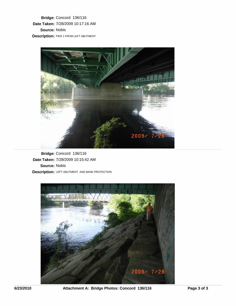
Bridge: Concord 136/116
Date Taken: 7/28/2009 10:17:16 AM
Description: PIER 1 FROM LEFT ABUTMENT
Source: Nobis
DocID_Nob
Bridge: Concord 136/116
Date Taken: 7/28/2009 10:15:42 AM
Description: LEFT ABUTMENT AND BANK PROTECTION
Source: Nobis
DocID_Nob
Text9:6/23/2010 Text9:Attachment A: Bridge Photos: Concord 136/116 Text9: Page 3 of 3

NEW HAMPSHIRE BRIDGE SCOURINVESTIGATION
CONCORD 136/116
DETOUR ROUTE11 King Court, Keene, NH 03431-4648
Main: (603) 357-2445 www.chacompanies.com
DATE: 3/2/10
Drawn By: DC
ATTACHMENT B

Bridge: Concord 136/116
Detour (miles): Last ADT:
Foundation Details:
KNOWN
UNKNOWN Worst Abutment: Right
Worst Pier: 2(Looking Downstream L to R)
Embedment (feet): 4.0 Exposure: No Exposure
Embedment (feet): 7.6 Exposure: Footing Exposed
Diving Insp Reports: 8/10/2004
FIELD VERIFICATION CARD (POA Attachment C)
Owner: NHDOT
Feature Carried: I-93 & US Route 4 SB
Feature Crossed: Merrimack River
Town, County: Concord - Merrimack
Contact Person: NHDOT Bridge Design Bureau (603) 271-2731
BRIDGE INFORMATION
Superstructure Type: Girder and Floorbeam System
Superstructure Material: Steel
Scour Critical Feature: Pier 2
Placard Location: Right side of both piers at the upstream bridge fascia
Red List: No
Number of Spans: 3
USGS Gage Station: 1088400 USGS Station Prox To Bridge: 2.3mi DS of Bridge
GENERAL INFORMATION
Scour Measurement Results / Monitoring Device
CRITERIA FOR CONSIDERATION OF BRIDGE CLOSURE
Observed Structure Movement / Settlement
Water Surface Elevation Reaches Low Chord
Overtopping Road or Structure
Date/TimeNotified:
Completed ProperNotification
Close BridgeRevisit BridgePost-Flood Inspection Recommendation
POST-MONITORING VERIFICATION
ACTION TAKEN
REFERENCE PHOTOS
Dates:
Water Reaches Critical Elevation: 234.0 ft, placard (100-yr event)
Agency:
What To Look For: Changes to embedment or undermining at Pier 2. The Pier 2 footing is founded on EB piles that extend 50 feet. The footing is exposed 3.4 feet, leaving a remaining embedment of 7.6 feet for the spread footing.
(Left to Right Convention Looking Downstream)
CRITERIA FOR CONSIDERATION TO COMPLETE INTERIM BRIDGE REOPENING:
Agency and Person Responsible for Re-Opening Bridge After Inspection:
NHDOT Bridge Design Bureau (603) 271-2731
Critical Elevation Marker Is Visible
Reasons for Closure Have Abated
Water Surface Levels Dropping
Verify Riverbed Elevation
Above Critical Footing Elevation. (See Section 5d)
(Continued on Next Page)
Interim Reopening Date:Interim Reopening Approved By: Time:
INTERIM REOPENING COMMENTS
Traffic Control Equipment (detour signing and barriers) and storage location(s) (NHDOT/Town): NHDOT Bridge Maintenance Divisional Crew 5
HighwayMaintenance
District: 05
NHDOT Bureauof Traffic
Streambed Elevation Drops Less than
Streambed Elevation 1.0 Feet
3 Feet
Other: Debris Accumulation Movement of RipRap/Other Armor Protection Loss of Road Embankment Ice Jam
Discharge 44,000 cfs (100-yr event)Stage (WSE)USGS Gage Station # 1088400
Stage (WSE)NOAA Gage Station #
NOAA Gage Station: NOAA Station Prox To Bridge:
1 200325000 Year:Total:
Text9:6/23/2010 Text9:Attachment C: Field Verification Card: Concord 136/116 Text9: Page 1 of 2

Upstream Low Water
DocID_Nobis_1148
Downstream Elevation of Bridge at Low Water
DocID_Nobis_1148
Scour Critical Feature at Low Water
DocID_Nobis_1148
Text9:6/23/2010 Text9:Attachment C: Field Verification Card: Concord 136/116 Text9: Page 2 of 2

NEW HAMPSHIRE BRIDGE SCOURINVESTIGATION
CONCORD 136/116
BRIDGE ELEVATION SUMMARY11 King Court, Keene, NH 03431-4648
Main: (603) 357-2445 www.chacompanies.com
DATE: 3/2/10
Drawn By: DC
ATTACHMENT D

INVESTIGATION
NEW HAMPSHIRE BRIDGE SCOUR
EDATE: 5/10
BORING LOGS
CONCORD 136/116
PIER 2
PIER 2
PIER 1
FIL
E N
AM
E =
DA
TE
/TIM
E =
US
ER
=
K:\
18
45
7\C
AD
D\M
ST
N\B
rid
ge P
OA
Part
B\C
on
co
rd
13
6-1
16
\18
45
7_
cp
b_
geo
_b
lp-2
.dg
n
6/2
3/2
01
0
3757
ATTACHMENT
CP-NORMAL
SUBTITLE TEXT SIZE
N.T.S.
www.chacompanies.comMain: (603) 357-2445
11 King Court Keene, NH 03431-4648
Drawing Copyright c 2009
RA
P1
LA
ANNOTATION SCALE 200
FOOTING ELEVATION (FT) STREAMBED ELEVATION (FT)
BOTTOM CHA FIELD (2009)
vUPSTREAM ELEVATIONv

CHA File No: 18925.2003.1510
11 King Court Keene, NH 03431-4648 Main: (603)-357-2445 New Hampshire Scour Investigation
Concord 136/116 Attachment G: Scour Countermeasures
Attachment G: Supporting Documentation, Calculations,
Estimates, and Conceptual Designs for Scour Countermeasures

Interoffice Memorandum
To: Bill Horne
From: Phil Pierce
Date: May 25, 2010
Subject: Discussion of Pile Foundation Scour for a 100-Year Event Bridge ID No.: Concord 136/116 & 136/117 CHA Project No. 18457.3600.1510
This memo addresses issues related to pile stability/capacity and CHA’s proposed Item 113 Rating. Given:
• Twin bridges which support Interstate I-93 & US Route 4 • Built 1959, rebuilt 1988. • Both abutments are concrete, set back from the channel, and founded on EB piles. • Pier 1 (north) is constructed of concrete, located in the channel, and founded on a spread footing extending to rock,
hence of no concern from a scour perspective. • Pier 2 (south) is constructed of concrete, located in the channel, and founded on EB piles (50 ft long).
o The latest NHDOT Underwater Inspection Report (2004) indicated that the combined pile cap/seal was exposed for up to 3.4 ft at Pier 2
o The remaining embedment of the Pier 2 pile cap/seal is estimated to be 7.6 feet. o The predicted scour is approximately 16 feet below the existing streambed at Pier 2, hence this structure could
experience undermining of the pile cap/seal of up to 8.5 feet during 100-year storm conditions (approximately 20% of total pile length).
• The bridge has withstood several large flood events during its life, with apparently relatively minor evidence of significant scour damage or loss of material from around the piers
Evaluation/Conclusions: CHA has considered these conditions and conclude that a refined pile group analysis would probably indicate potential instability of the pile group during design flood scour. Although a simplified evaluation of pile buckling strength indicates sufficient strength of an individual pile, it does not account for potential lateral displacement of the pile cap. Further, the resistance of the superstructure to such lateral displacement of the pier caps cannot be easily estimated. Recommendations: Given these conditions and conclusions, and considering the vital nature of interstate bridges, coupled with the Department’s expressed desire to avoid reliance on long-term monitoring of vital bridges, CHA recommends installation of a physical scour countermeasure at Pier 2. Specifically, the use of A-Jacks would be appropriate due to the depth of water surrounding the pier. Accordingly, CHA recommends that Item 113 be coded as 3 (scour critical) with the accompanying need for monitoring during and after major events, until such time as the countermeasures are installed. Following successful installation, the rating could be changed to 7 to remove the bridge from scour critical status.

NHDOT PROTECTIVE COUNTERMEASURES 5/24/2010
ESTIMATED COST OF PROPOSED COUNTERMEASURES - A-Jacks:
136/116Concord
52657 Over 10'35 16 A-Jacks width = 1.5 times pier width7.6 59 A-Jacks Length is along its center17 A-Jacks area based on 1.5 times pier width is 6288 sq ft
alternatively, A-Jacks area based on ys = 17.0 width (3 sides) => 2856 sq ftuse A-Jacks based averaged area
SSU CM TYPE Length (ft) Width (ft) Depth (ft) No. Items Quantity Unit Unit Price Subtotal1 1 LS $30,000 $30,0001 1 LS $20,000 $20,000
235 20 1 511 SY $30 $15,334235 20 1 2945 EA $68 $198,788
1 1 LS $15,000 $15,000Proposed work: $15,000 - Only Minor streambed leveling required - Install A-Jacks [1 A-Jack covers 1.5624 SF) $294,121 - Water diversion is not necessary 25% $73,530
$367,652
$370,000
Assumptions:Environmental impact associated with the proposed work is judged to be: minorGiven the estimated quantities for this item, the unit price is judged to be equal to average unit prices.
Notes:The cost of mitigating or eliminating potential environmental impacts is not included in this estimate. The cost of environmental permit preparation is also not included herein.
Use A-Jacks due to deep water. Mobilization
SubtotalContingency
Total Estimated Cost
Conceptual Budget
Predicted scour depth, ys, ft
ItemAccess to pier via bargebarge rental
Pier 2 A-Jacks Site PrepA-Jacks (tied together)Underwater placement support (Divers)
Bridge Width Low Flow Water DepthMax. Vertical Opening Pier Width (ft)
Remaining embedment Pier Length (ft)
Bridge No. SSU's Protected Pier 2Town Spans Protected N/A
Dist. Between Abutment Faces Approved Countermeasure Type A-Jacks
6/24/2010 Appendix G

NEW HAMPSHIRE BRIDGE SCOURINVESTIGATION
CONCORD 136/116
BRIDGE ELEVATION SUMMARY11 King Court, Keene, NH 03431-4648
Main: (603) 357-2445 www.chacompanies.com
DATE: 3/2/10
Drawn By: DC
ATTACHMENT D

NEW HAMPSHIRE BRIDGE SCOURINVESTIGATION
CONCORD 136/116
PLACARD INSTALLATION LOCATION11 King Court, Keene, NH 03431-4648
Main: (603) 357-2445 www.chacompanies.com
DATE: 3/2/10
Drawn By: DC
ATTACHMENT G

New Hampshire DOT Scour Field Sketch
11 King Court, Keene, NH 03431-4648
Main: (603) 357-2445 www.chacompanies.com Town/Bridge#:
DATE: 7/28/09
Drawn By: DCConcord 136/116
ATTACHMENT H

NHDOT POST FLOOD INSPECTION REPORT (POA Attachment I)
Bridge: Post Flood Inspection Date:Concord 136/116GENERAL INFORMATION
Town: Concord
Feature Carried: I-93 & US Route 4 SB
Owner: NHDOT
Feature Crossed: Merrimack River
Major Basin (HU8): Merrimack River
Functional Class: 11 - Urban Principal Arterial - Interstate
Detour Length: 1 (miles)
Year Built: 1959
Year ofReconstruction: 1988
ADT: 25000 Year of ADT: 2003
Overall Fed Sufficiency Rating: 94.8
RedList: No
Item 60: 7 Item 61: 6 Item 71: 9 Item 113: 3
Current:
HYDRAULIC INFORMATION
FEMA Study:
Whitman & Howard Information
USGS Report:
Tidal Influence: Other Hydrologic & Hydraulic Data:Merrimack Countywide FIS provides elevation and flow data for the bridge. Gage 01088400 operational from April 1979 to present. Merrimack River- Concord Tributaries Watershed.
100-Yr Water Velocity (feet per sec): 4.3
Angle Of Attack 5
Watershed Area (sq. mi): 2385
(Flood Flow)
BRIDGE INFORMATIONBridge Length (in feet): 526.00 Plans Available: Borings Available:
Abutment Foundation: EB Piles Pier Foundation: EB Piles
2005 2006 2007
Flood / Scour HistoryComments:
Three-span bridge built in 1959 and reconstructed in 1988. Based on information included in the Merrimack Countywide FIS (9-2007), the Merrimack River experienced a significant flood in 1960 (100-year storm). In addition, according to the FEMA Independent Evaluation of Recent Flooding in New Hampshire (7-08), the Merrimack River watershed flooded in 2006 and 2007, with a recurrence interval of 50-100 years.
Flood History:
:
Bridge Width (in feet): 57.00
Substructure Channel Stability Hydraulic Adequacy Scour Risk
Posting 49.9 , NPR
Bridge Plan File Loc: 6-3-1
(scale of 1-9)(worst - best)
100-Yr Overtopping Relief: No Overtopping
11/28/2007
Bridge Scour ReportNov 1992 :( )
RESULTS OF POST FLOOD INSPECTION
:(Actual Metric Tons, Signed)
Date of Interim Bridge Reopening:Date of Bridge Closure:
Date of Post Flood Inspection: Post Flood Inspection Completed By:
NA NA
Foundation Details:
KNOWN
UNKNOWN Worst Abutment: Right
Worst Pier: 2(Looking Downstream L to R)
Embedment (feet): 4.0 Exposure: No Exposure
Embedment (feet): 7.6 Exposure: Footing Exposed
Diving Insp Reports: 8/10/2004
Superstructure Type: Girder and Floorbeam System
Superstructure Material: Steel
Scour Critical Feature: Pier 2
Placard Location: Right side of both piers at the upstream bridge fascia
Red List: No
Number of Spans: 3
USGS Gage Station: 1088400 USGS Station Prox To Bridge: 2.3mi DS of Bridge
Dates:
What To Look For: Changes to embedment or undermining at Pier 2. The Pier 2 footing is founded on EB piles that extend 50 feet. The footing is exposed 3.4 feet, leaving a remaining embedment of 7.6 feet for the spread footing.
NOAA Gage Station: NOAA Station Prox To Bridge:
Text9:6/23/2010 Text9:Attachment I: Post Flood Inspection Report: Concord 136/116 Text9: Page 1 of 1


CHA File No: 18925.2003.1510
11 King Court Keene, NH 03431-4648 Main: (603)-357-2445 New Hampshire Scour Investigation
Concord 136/116 Attachment J: Scour/H&H Backup
Calculations
Attachment J: Scour/H&H Backup Calculations
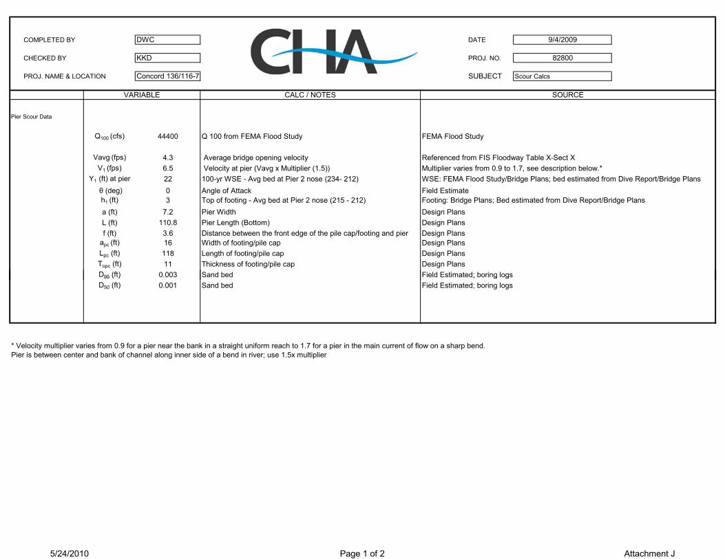
COMPLETED BY DWC DATE
CHECKED BY KKD PROJ. NO.
PROJ. NAME & LOCATION Concord 136/116-7 SUBJECT Scour Calcs
Pier Scour Data
Q100 (cfs) 44400 Q 100 from FEMA Flood Study FEMA Flood Study
Vavg (fps) 4.3 Average bridge opening velocity Referenced from FIS Floodway Table X-Sect XV1 (fps) 6.5 Velocity at pier (Vavg x Multiplier (1.5)) Multiplier varies from 0.9 to 1.7, see description below.*
Y1 (ft) at pier 22 100-yr WSE - Avg bed at Pier 2 nose (234- 212) WSE: FEMA Flood Study/Bridge Plans; bed estimated from Dive Report/Bridge Plans θ (deg) 0 Angle of Attack Field Estimateh1 (ft) 3 Top of footing - Avg bed at Pier 2 nose (215 - 212) Footing: Bridge Plans; Bed estimated from Dive Report/Bridge Plansa (ft) 7.2 Pier Width Design PlansL (ft) 110.8 Pier Length (Bottom) Design Plansf (ft) 3.6 Distance between the front edge of the pile cap/footing and pier Design Plans
apc (ft) 16 Width of footing/pile cap Design PlansLpc (ft) 118 Length of footing/pile cap Design PlansTopc (ft) 11 Thickness of footing/pile cap Design PlansD95 (ft) 0.003 Sand bed Field Estimated; boring logs
9/4/2009
82800
VARIABLE CALC / NOTES SOURCE
95 ( ) ; g gD50 (ft) 0.001 Sand bed Field Estimated; boring logs
* Velocity multiplier varies from 0.9 for a pier near the bank in a straight uniform reach to 1.7 for a pier in the main current of flow on a sharp bend.Pier is between center and bank of channel along inner side of a bend in river; use 1.5x multiplier
5/24/2010 Page 1 of 2 Attachment J

K4: ARMORING COEFFICIENTCOMPLEX PIER SCOUR COMPUTATIONS CASE 2
Reference for methodology: HEC-18 Fourth Edition Bridge 136/116 & 136/117 (100-Year Event)
K4: PIER COMPONENTPier #2
D95 (ft) = 0.0030 <---Field EstimateD50 (ft) = 0.0010 <---Field Estimate
COMPLEX PIERS SCOUR ANALYSIS V1: APPROACH VELOCITY (ft/s) = 6.50NOTE: Bridges 136/116 and 136/117 share same pier; only one scour calc performed. y: DEPTH (ft) = 22.00NOTE; Pier 1 is founded on rock; Scour calc performed for Pier 2 only. a: PIER WIDTH (ft) = 7.20Reference for methodology: HEC-18 4th Edition Chapter 6 Ku = 11.17PIER COMPONENT Yes Vc95: CRITICAL VELOCITY FOR D95 (ft/s) = 2.70Bent Number Pier #2 Vc50: CRITICAL VELOCITY FOR D50 (ft/s) = 1.87V1: VELOCITY (fps) 6.50 ViC95: INITIAL SCOUR VELOCITY FOR D95 (ft/s) = 1.15Y1: DEPTH (ft) 22 ViC50: INITIAL SCOUR VELOCITY FOR D50 (ft/s) = 0.75
ATTACK ANGLE, Degrees 0 VR: VELOCITY RATIO (ft/s) = 8.00h1: PIER STEM HEIGHT ABOVE BED (ft) 3.00 K4 = 1.00INDIVIDUAL PIER WIDTH (ft) 7.20a: PIER WIDTH (ft) 7.20 K4: FOOTING COMPONENTL: PIER LENGTH (ft) 110.80 Pier #2f: PIER SETBACK FROM EDGE OF PILE CAP (ft) 3.60 D95 (ft) = 0.0030PIER SHAPE (S=SQUARE, C = CIRCULAR, SN = SHARP NOSE) sn D50 (ft) = 0.0010K1: SHAPE COEFFICIENT 0.90 V1: APPROACH VELOCITY (ft/s) = 6.12K2: ANGLE COEFFICIENT 1.00 y: DEPTH (ft) = 23.35K3: BED COND. COEFFICIENT 1.10 a: CAP WIDTH (ft) = 16.00K4: BED AMORING COEFFICIENT 1.00 Ku = 11.17Khpier: WEIGHTING FACTOR FOR PIER SCOUR 0.23 Vc95: CRITICAL VELOCITY FOR D95 (ft/s) = 2.72g: gravitational constant (ft/s2) 32.20 Vc50: CRITICAL VELOCITY FOR D50 ft/s) = 1.89
FROUDE NUMBER, Fr 0.24 ViC95: INITIAL SCOUR VELOCITY FOR D95 (ft/s) = 1.11LOCAL SCOUR DEPTH (ft), Yspier 2.7 ViC50: INITIAL SCOUR VELOCITY FOR D50 (ft/s) = 0.73
VR: VELOCITY RATIO (ft/s) = 6.97FOOTING COMPONENT Yes K4 = 1.00Bent Number Pier #2V2: VELOCITY (fps) 6.12 Note: If D50 < 0.007 ft or D95 < 0.066 ft, then K4=1Y2: DEPTH (ft) 23.35ATTACK ANGLE, Degrees 0hopc: PRE-SCOUR PILE CAP BOTTOM HEIGHT ABOVE BED (ft) -8.00D50 (ft) 0.0010Ks (ft) 0.0015Ku critical velocity transport coefficient 11.17Vc critical transport velocity (fps) 1.89Yf: distance from bed to top of footing (ft) 4.35Vf : Average velocity in the flow zone above the top of footing (fps) 5.27apc: PILE CAP WIDTH (ft) 16.00Lpc: PILE CAP LENGTH (ft) 118.00Topc: PILE CAP THICKNESS (ft) 11.00CAP SHAPE (S=SQUARE, C = CIRCULAR) SY2max = 3.5*apc (ft) 56.00K1: SHAPE COEFFICIENT 1.10K2: ANGLE COEFFICIENT 1.00K3: BED COND. COEFFICIENT 1.10K4: BED AMORING COEFFICIENT 1.00Kw: WIDE PIER ADJUSTMENT FACTOR 1.00FROUDE NUMBER, Fr 0.22LOCAL SCOUR DEPTH (ft), Ysfc 12.9
TOTAL SCOUR DEPTH = Yspier + Ysfc 15.6
Calc. By: DWC Date: 9/4/2009Check By: KKD Date: 11/12/2009
Sand Bed
5/24/2010 Page 2 of 2 Attachment J

CHA File No: 18925.2003.1510
11 King Court Keene, NH 03431-4648 Main: (603)-357-2445 New Hampshire Scour Investigation
Concord 136/116 Attachment K: Underwater Inspection
Reports
Attachment K: Underwater Inspection Reports