PRIME: Proactive Infrastructure Monitoring and Evaluation · PRIME . Instrument . Solar . regulator...
25
© NERC All rights reserved PRIME: Proactive Infrastructure Monitoring and Evaluation PRIME MOVERS: Jon Chambers / Philip Meldrum / Paul Wilkinson Geophysical Tomography Team
Transcript of PRIME: Proactive Infrastructure Monitoring and Evaluation · PRIME . Instrument . Solar . regulator...

© NERC All rights reserved
PRIME: Proactive Infrastructure Monitoring
and Evaluation
PRIME MOVERS:
Jon Chambers / Philip Meldrum / Paul Wilkinson
Geophysical Tomography Team

© NERC All rights reserved
PRIME – What is it ?
• A new low cost – low power 4D [time lapse 3D] ground resistivity imaging system for critical zone monitoring.
• Develop a system and demonstrate the operational benefits of PRIME to potential beneficiaries including the research community, asset owners and service providers……
Critical Zones
Geohazards
Landfill / Barriers
Mining groundwater rebound
Groundwater
contamination

© NERC All rights reserved
Electrical Resistivity Tomography (ERT) – What is it ? NON-INVASIVE
• Resistivity – the resistance of the ground to passing electrical current. Sensitive to geological variations, changes in groundwater saturation, and the presence of contaminants. (Imaging by ERT – analogous to medical imaging)
• Why use ERT?
• Volumetric information
• Non-invasive
• Rapid
• Composition
• Moisture content
Material Resistivity (Ohm.m) Clay Low Sand and gravel Moderate Concrete High Granite Very high
Medical imaging
Geophysical
imaging
© NERC All rights reserved
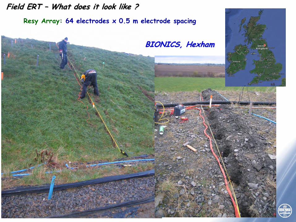
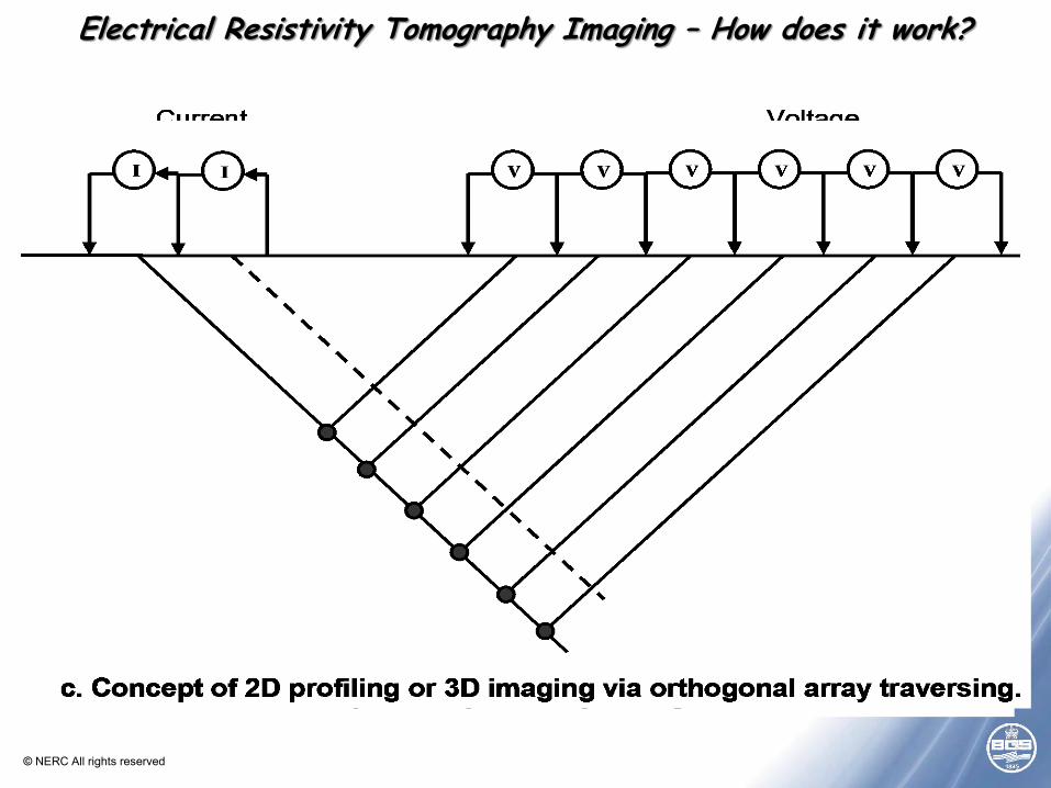
Field ERT – What does it look like ?
Resy Array: 64 electrodes x 0.5 m electrode spacing
BIONICS, Hexham
© NERC All rights reserved
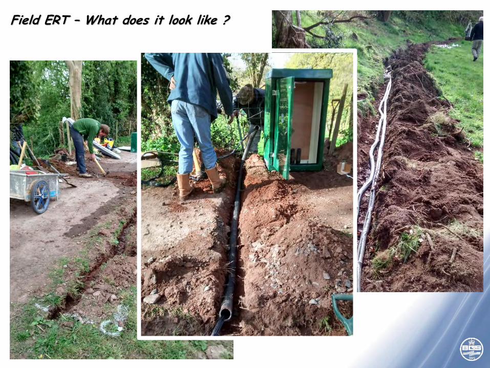
Field ERT – What does it look like ?
© NERC All rights reserved
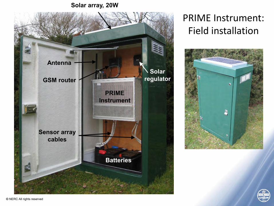
GSM router
Antenna
Batteries
PRIME Instrument
Solar regulator
Solar array, 20W
Sensor array cables
PRIME Instrument: Field installation

© NERC All rights reserved
PRIME Instrument: Modular: 16 x 16 (256 electrodes)
HV Supply: 100V (200 V max)
Current: 0.1 - 100mA
Measurement channels: 7-off Gain setting: 1, 10
SP Null: +/- 2.5 VDC Measurement accuracy: ADC +/-5V range: 38uV*
ADC +/- 10V range: 72uV*
Power: 12 VDC (10 W)
Setup & Control: Command file & Scheduling via Ethernet
Access via Web Portal
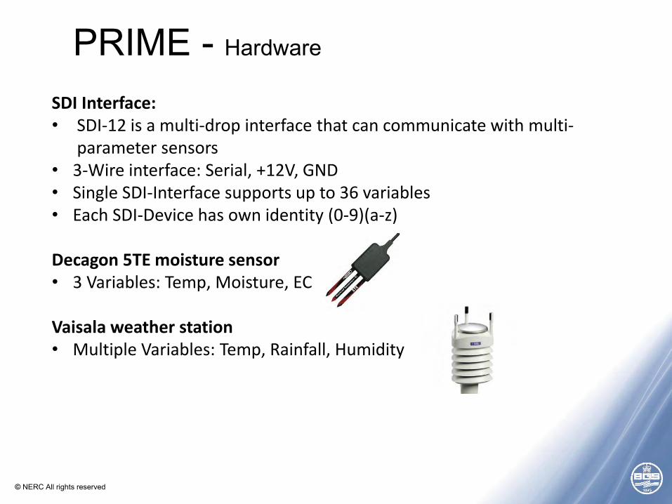
PRIME - Hardware
© NERC All rights reserved
SDI Interface: • SDI-12 is a multi-drop interface that can communicate with multi-
parameter sensors • 3-Wire interface: Serial, +12V, GND • Single SDI-Interface supports up to 36 variables • Each SDI-Device has own identity (0-9)(a-z)
Decagon 5TE moisture sensor • 3 Variables: Temp, Moisture, EC
Vaisala weather station • Multiple Variables: Temp, Rainfall, Humidity
PRIME - Hardware
© NERC All rights reserved
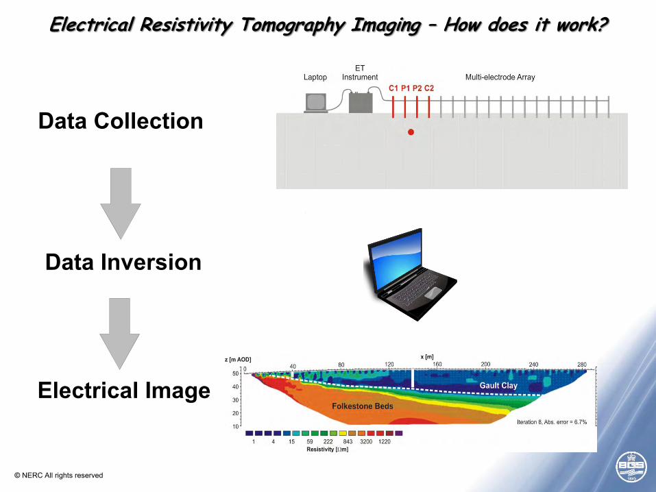
Electrical Resistivity Tomography Imaging – How does it work?
© NERC All rights reserved
Computer
Data Collection
Data Inversion
Electrical Model
Layer 1Layer 2Layer 3 X XXX X X X X X XX X X X X XXX X
Resistivity Instrument
X X
Elevation(mAOD)
Resistivity ( mW )
160 120 80 40 0
53 70 94 126 168 224 300 400
140135130125120115110105100 Till TillSand and GravelOverlying Sandy TillBromsgrove Sandstone
EstimatedGroundwaterLevel
Data Collection
Electrical Image
Electrical Resistivity Tomography Imaging – How does it work?
Data Inversion
© NERC All rights reserved
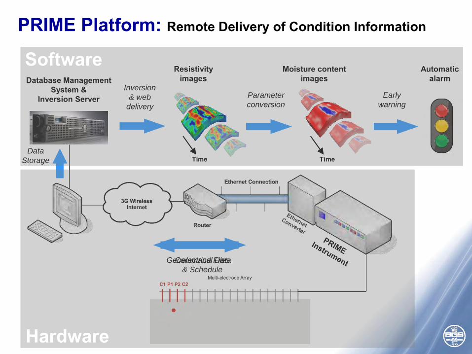
Command Files
& Schedule
Geoelectrical Data
Database Management System &
Inversion Server
Data
Storage
Early
warning
Automatic alarm
Inversion
& web
delivery
Resistivity images
Time
Parameter
conversion
Moisture content images
Time
PRIME Platform: Remote Delivery of Condition Information
Software
Hardware
© NERC All rights reserved
1 km1 km
Nottingham
Loughborough
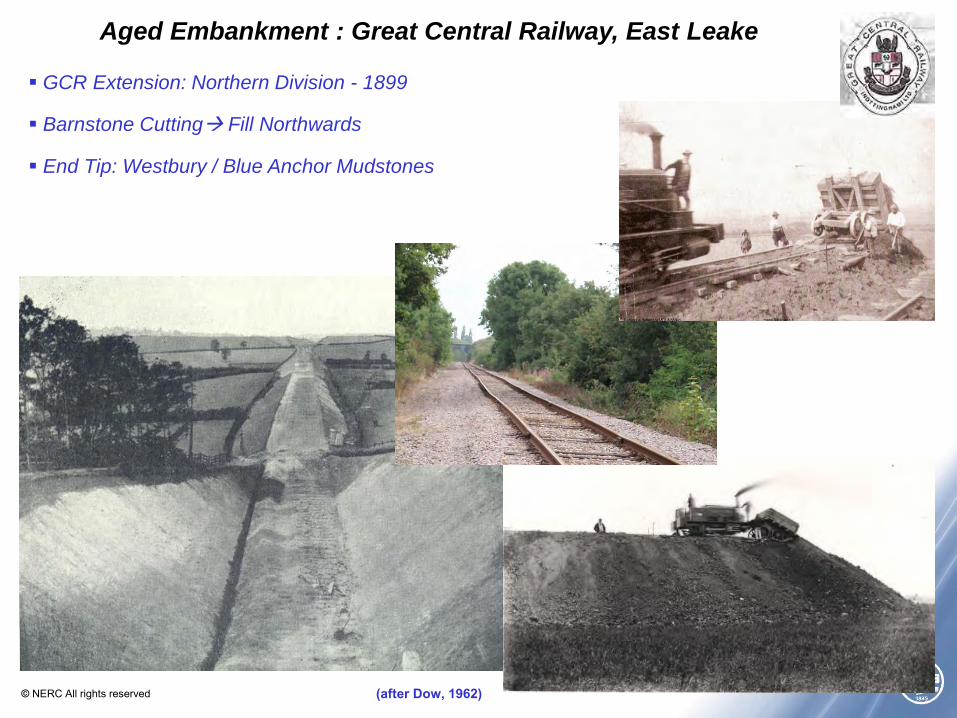
Aged Embankment : Great Central Railway, East Leake
GCR Extension: Northern Division - 1899
Barnstone Cutting Fill Northwards
End Tip: Westbury / Blue Anchor Mudstones
(after Dow, 1962)
© NERC All rights reserved
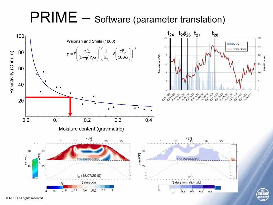
• Soil moisture
relationships can be used to translate
resistivity images into
moisture content
t24 t25 t26 t27 t28
PRIME – Software (parameter translation)
© NERC All rights reserved
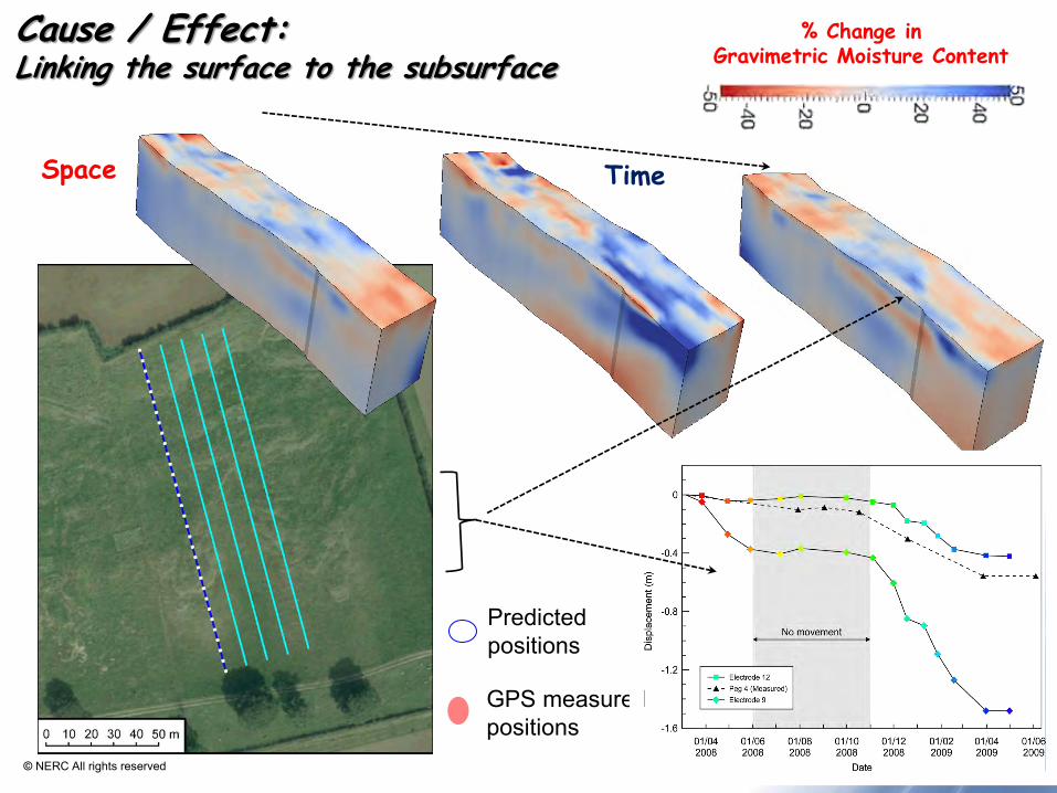
Cause / Effect: Linking the surface to the subsurface
Predicted positions
GPS measured positions
Time Space
% Change in Gravimetric Moisture Content
© NERC All rights reserved
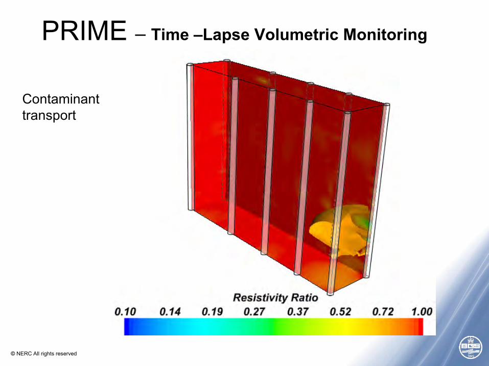
PRIME – Time –Lapse Volumetric Monitoring
Contaminant transport
© NERC All rights reserved
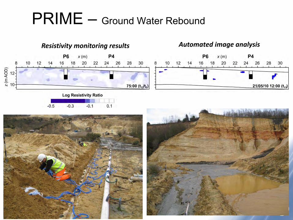
PRIME – Ground Water Rebound
Resistivity monitoring results Automated image analysis

© NERC All rights reserved
1. Old Dalby Railway Cutting (Network Rail)
2. Llangynidr Canal Embankment (Canal & River Trust)
3. Newbury Road Cutting (Southampton University)
4. Aldbrough Coastal Landslide
5. Charlton Kings Landslide
6. Boxford Water Meadows (CEH)
7. Bristol Water Test Site (Birmingham University)
1 2
3
4
5
6 7
PRIME – Applications across the UK
© NERC All rights reserved
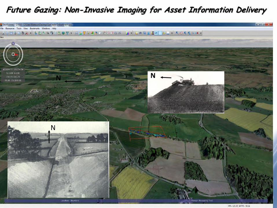
Future Gazing: Non-Invasive Imaging for Asset Information Delivery
N
N N
© NERC All rights reserved
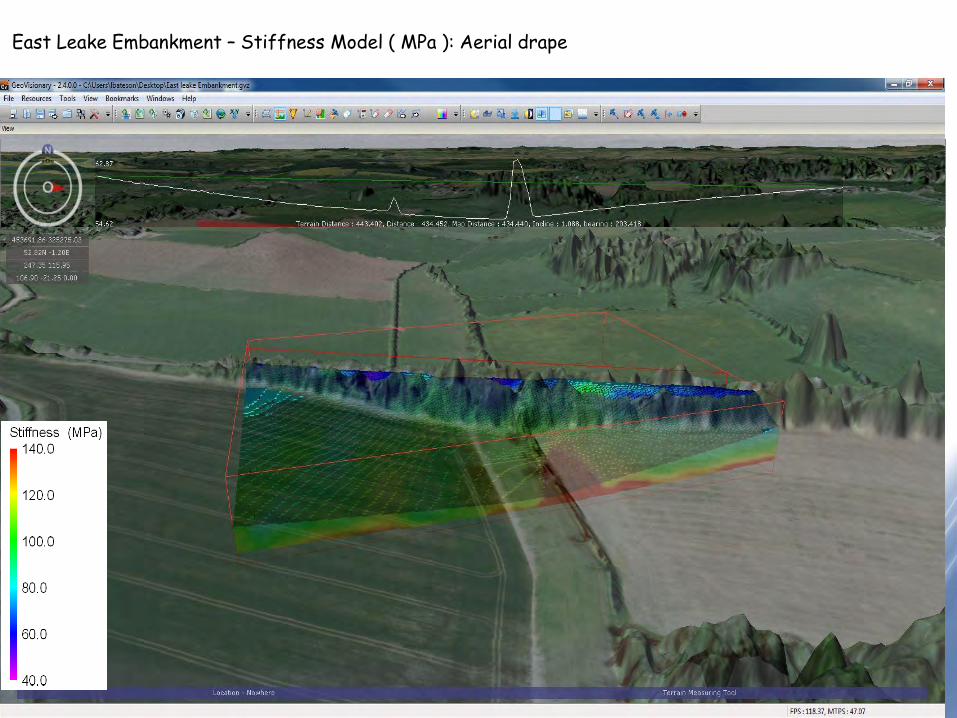
East Leake Embankment – Stiffness Model ( MPa ): Aerial drape
© NERC All rights reserved
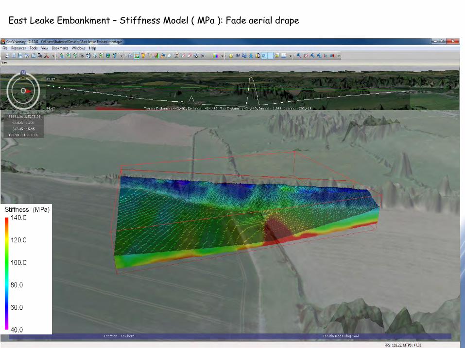
East Leake Embankment – Stiffness Model ( MPa ): Fade aerial drape
© NERC All rights reserved
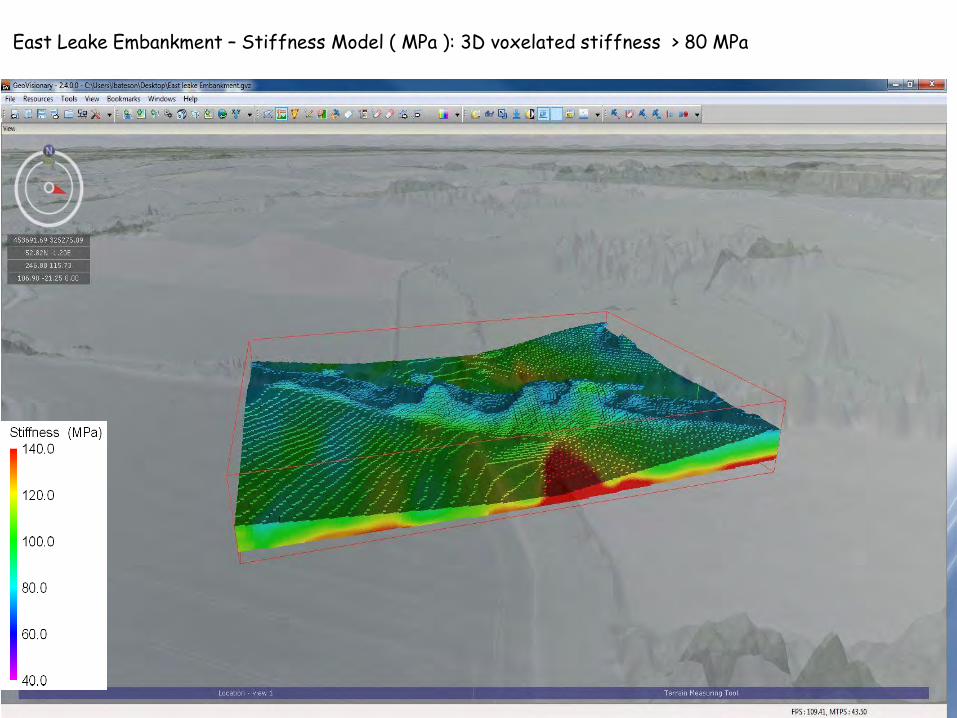
East Leake Embankment – Stiffness Model ( MPa ): 3D voxelated stiffness > 80 MPa
© NERC All rights reserved
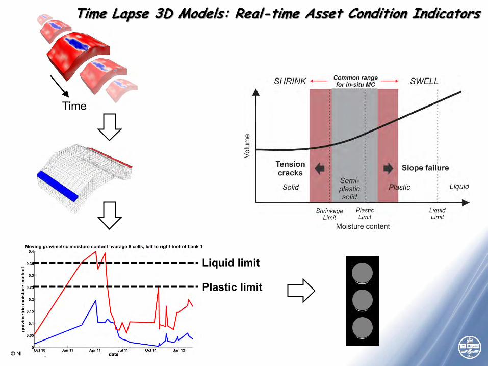
Liquid limit
Plastic limit
Time Lapse 3D Models: Real-time Asset Condition Indicators
© NERC All rights reserved
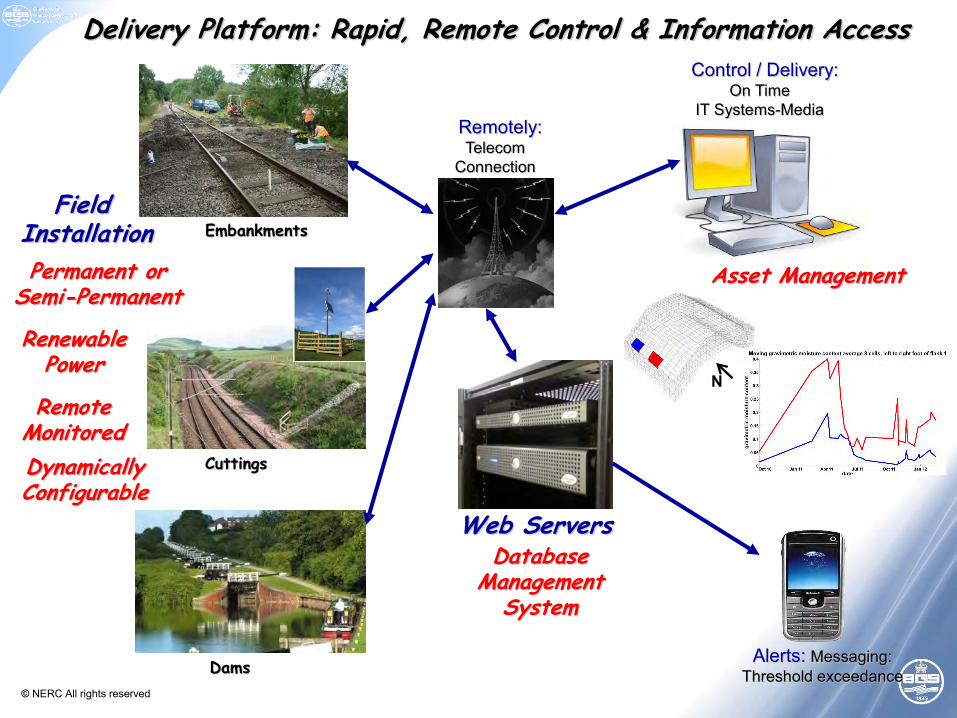
Delivery Platform: Rapid, Remote Control & Information Access
Web Servers
Renewable Power
Permanent or Semi-Permanent
Field Installation
Remote Monitored
Embankments
Database Management
System
Dynamically Configurable
Cuttings
Dams
Remotely: Telecom
Connection
Control / Delivery: On Time
IT Systems-Media
Alerts: Messaging: Threshold exceedance
Asset Management
N
© NERC All rights reserved
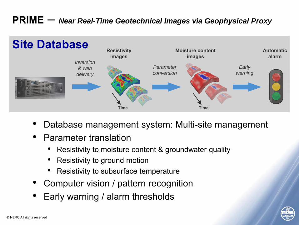
• Database management system: Multi-site management • Parameter translation
• Resistivity to moisture content & groundwater quality • Resistivity to ground motion • Resistivity to subsurface temperature
• Computer vision / pattern recognition • Early warning / alarm thresholds
PRIME – Near Real-Time Geotechnical Images via Geophysical Proxy
Early
warning
Automatic alarm
Inversion
& web
delivery
Resistivity images
Time
Parameter
conversion
Moisture content images
Time
Site Database

© NERC All rights reserved
• PRIME instrument has been developed – on budget and to specification • Modular, low power (10 W), low cost (~£7k) • Applicable to a wide range of monitoring applications • Multiple installation planned for 2015
• PRIME information delivery progressing well • Working with ITM Monitoring to interface with industry standards • Developing automated image analysis approaches with
Nottingham University • Future development
• New grant applications to develop and demonstrate workflow • Development of high-power PRIME system (ESIOS?)
PRIME - Summary


![Cisco Prime Infrastructure 3.1 · Cisco Prime Infrastructure 3.1.3 リファレンス ガイド CHAPTER 2 [ 設定( Configuration ) ] ページのフィールド参照 2-1 [ネットワーク](https://static.fdocuments.net/doc/165x107/5e1bda26322138697563c3c2/cisco-prime-infrastructure-31-cisco-prime-infrastructure-313-ffff.jpg)