Preparing for coastal change - WordPress.com
36
A SUMMARY OF COASTAL HAZARDS AND CLIMATE CHANGE GUIDANCE FOR LOCAL GOVERNMENT Preparing for coastal change
Transcript of Preparing for coastal change - WordPress.com
A SUMMARY OF COASTAL HAZARDS AND CLIMATE CHANGE GUIDANCE FOR LOCAL GOVERNMENT
Preparing for coastal change

Disclaimer
The information in this publication is, according to the Ministry for the Environment’s best efforts, accurate at the time of publication. The Ministry will make every reasonable effort to keep it current and accurate. However, users of this publication are advised that:
• the information provided has no official status and so does not alter the laws of New Zealand, other official guidelines or requirements
• it does not constitute legal advice, and users should take specific advice from qualified professionals before taking any action as a result of information obtained from this publication
• the Ministry for the Environment does not accept any responsibility or liability whatsoever whether in contract, tort, equity or otherwise for any action taken as a result of reading, or reliance placed on this publication because of having read any part, or all, of the information in this publication or for any error, or inadequacy, deficiency, flaw in or omission from the information provided in this publication
• all references to websites, organisations or people not within the Ministry for the Environment are provided for convenience only and should not be taken as endorsement of those websites or information contained in those websites nor of organisations or people referred to.
Acknowledgements
The Ministry thanks the authors of the guidance for their work in preparing the material on which this summary is based: Rob Bell, Judy Lawrence, Sylvia Allan, Paula Blackett and Scott Stephens. In addition, a large number of experts and stakeholders provided helpful feedback on drafts and participated in meetings and workshops during the development of the guidance.
Cover photo supplied by Dave Allen, NIWA.
Published in December 2017 by the Ministry for the Environment Manatū Mō Te Taiao PO Box 10362, Wellington 6143, New Zealand
ISBN: 978-1-98-852526-6 Publication number: ME 1335
© Crown copyright New Zealand 2017
This document is available on the Ministry for the Environment website: www.mfe.govt.nz.

3PREPARING FOR COASTAL CHANGE
Contents
Introduction 4
Why is this guidance required? 4
Who is the guidance for? 5
Adaptive planning 5
Part 1: Climate change and coastal hazards 6
Part 2: The decision cycle 9
Overview 9
A. What is happening? 10
B. What matters most? 23
C. What can we do about it? 25
D. How can we implement the strategy? 30
E. How is it working? 30
Part 3: Legislation 33
Part 4: What next? 35

4 PREPARING FOR COASTAL CHANGE
IntroductionSince 2001, the Ministry for the Environment has provided guidance on how to adapt to the risks from coastal hazards caused by climate change, particularly those associated with sea-level rise. The previous guidance, published in 2008, has been widely used by local government, and also by others involved in providing services and infrastructure to coastal areas. The Ministry also provides climate projections for New Zealand, a manual on climate change effects and impacts assessment, and tools for estimating the effects of climate change on flood flow.
The Coastal Hazards and Climate Change guidance (released together with this summary) is a major revision of the 2008 edition. It updates scientific understanding and the legal framework. It introduces new material on hazard, risk and vulnerability assessments, and collaborative approaches to engaging with communities. The 2017 edition also explains adaptive approaches to planning for climate change in coastal communities.
References cited in this summary can be found in the reference list of the full guidance.
Why is this guidance required?Hazard risk is compounding in coastal areas, because hazard impacts are occurring more frequently as seas rise, while at the same time coastal development and property values are increasing. Sea level is expected to keep rising for at least several centuries, posing an ongoing challenge for us and future generations to create more sustainable coastal communities.
Coastal hazards can have impacts on a wide range of our social, cultural and economic values, as well as affecting our natural and physical environment. Acceptable solutions for adapting to the changes will vary from place to place, and for some communities will be made more complex by greater risks, greater vulnerability, and a lower ability to cope. There is no one-size-fits-all solution.
Local government faces the enduring question of how to achieve the aspirations of local communities while making (sometimes unpopular) decisions that will enable them to adapt to the impacts of a changing climate.
The guidance developed by the Ministry supports local government in this complex role.
5PREPARING FOR COASTAL CHANGE
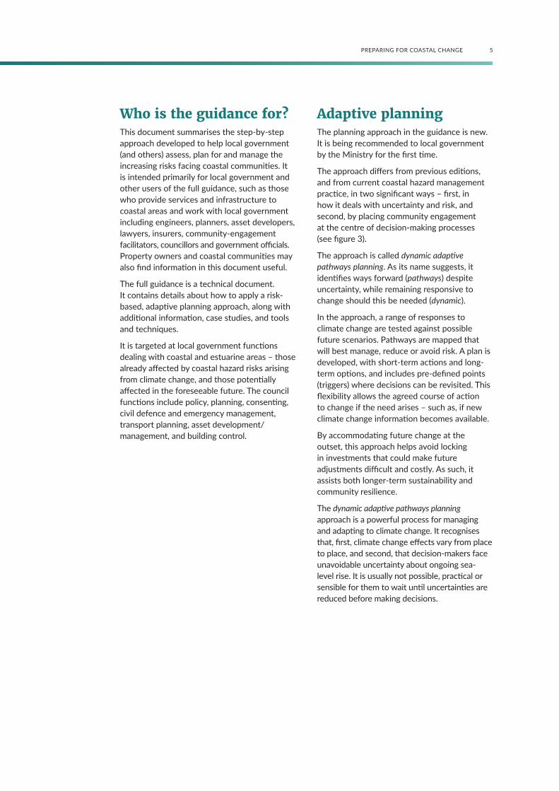
Who is the guidance for?This document summarises the step-by-step approach developed to help local government (and others) assess, plan for and manage the increasing risks facing coastal communities. It is intended primarily for local government and other users of the full guidance, such as those who provide services and infrastructure to coastal areas and work with local government including engineers, planners, asset developers, lawyers, insurers, community-engagement facilitators, councillors and government officials. Property owners and coastal communities may also find information in this document useful.
The full guidance is a technical document. It contains details about how to apply a risk-based, adaptive planning approach, along with additional information, case studies, and tools and techniques.
It is targeted at local government functions dealing with coastal and estuarine areas – those already affected by coastal hazard risks arising from climate change, and those potentially affected in the foreseeable future. The council functions include policy, planning, consenting, civil defence and emergency management, transport planning, asset development/management, and building control.
Adaptive planning The planning approach in the guidance is new. It is being recommended to local government by the Ministry for the first time.
The approach differs from previous editions, and from current coastal hazard management practice, in two significant ways – first, in how it deals with uncertainty and risk, and second, by placing community engagement at the centre of decision-making processes (see figure 3).
The approach is called dynamic adaptive pathways planning. As its name suggests, it identifies ways forward (pathways) despite uncertainty, while remaining responsive to change should this be needed (dynamic).
In the approach, a range of responses to climate change are tested against possible future scenarios. Pathways are mapped that will best manage, reduce or avoid risk. A plan is developed, with short-term actions and long-term options, and includes pre-defined points (triggers) where decisions can be revisited. This flexibility allows the agreed course of action to change if the need arises – such as, if new climate change information becomes available.
By accommodating future change at the outset, this approach helps avoid locking in investments that could make future adjustments difficult and costly. As such, it assists both longer-term sustainability and community resilience.
The dynamic adaptive pathways planning approach is a powerful process for managing and adapting to climate change. It recognises that, first, climate change effects vary from place to place, and second, that decision-makers face unavoidable uncertainty about ongoing sea-level rise. It is usually not possible, practical or sensible for them to wait until uncertainties are reduced before making decisions.
6 PREPARING FOR COASTAL CHANGE
Part 1: Climate change and coastal hazardsEarth’s climate is changing, mostly due to emissions of greenhouse gases from human activities, such as burning fossil fuels (eg, coal and oil), agriculture, and deforestation (where large areas of trees are cleared). The greenhouse gases we emit include carbon dioxide, methane and nitrous oxide. They warm the Earth, and one of the major and most certain consequences of warming is sea-level rise.
How much warming occurs in future will depend on global greenhouse gas emissions. Countries have agreed to limit warming to below 2°C above pre-industrial levels, but this is an ambitious aim and by no means certain to be achieved. More warming over the next few decades is inevitable, even if global emissions were to stop completely today. Because we can never be sure what will happen, in planning for this climate change we need to consider a range of possible futures, or ‘scenarios’.
Climate change and sea-level rise are not in themselves hazards, but they will make worse coastal hazards already occurring due to natural processes. While sea-level rise will have the greatest effect, changes in storminess will also influence how often other impacts from coastal hazards occur, and how damaging they are. These include hazards from storm surges and waves.
Sea-level rise will increase the frequency and scale of coastal hazards. For example, as sea level rises we will experience more floods that inundate existing infrastructure, such as coastal roads. In New Zealand, by 2050–2070, extreme coastal water levels that are currently expected to be reached or exceeded only once every 100 years (on average) will occur at least once per year or more (on average) – earlier in areas with smaller tide ranges. More information is provided in section 6.4 of the guidance.
After at least a thousand years of little change, sea level around the world began to rise around the latter half of the 19th century, and increased at a rate of around 1.7 millimetres
a year during the 20th century (see figure 1). Since satellite measurements began in 1993, the average global sea level has risen about 3.3 millimetres a year. The increase is due partly to natural climate variability and partly to faster sea-level rise caused by global warming.
Local responses to local changes in sea level
Local sea-level change may be different from the global average, because winds and currents may change and because ice meltwater added to the oceans is not distributed evenly around the world.
If the land is rising or falling, this also changes the sea level in that place. The term relative sea-level change describes the combined movement of both water and land (see figure 7). That is, even if sea level was constant there could still be changes in relative sea levels – rising land would produce a relative fall in sea level, while sinking land would produce a relative rise in sea level.
Across New Zealand, the average relative sea-level rise for the 100 years up to 2015 was around 1.8 millimetres a year (see figure 2). This rise means that what was an extreme high tide level in 1900 is now reached about twice as often.
While published projections of future sea- level rise are usually global, locally we need to adapt to the relative sea-level rise. So, for New Zealand, corrections need to be applied for differences in the regional ocean response for the southwest Pacific and for local vertical land movement.

7PREPARING FOR COASTAL CHANGE
Note: Determined from more than 100 years of gauge records at the four main ports (black circles) and inferred rates from gauge station records used in the first half of the 1900s to set the local vertical datums (see supplementary information sheet 10 in the guidance), spliced with modern records (blue circles). Standard deviations of the trend are listed in the brackets.
Source data: Analysis up to end of 2008 from Hannah & Bell (2012), updated with seven years of mean sea level data to end of 2015 (Hannah, 2016); sea level data from various port companies is acknowledged.
1880
Data: CSIRO
0
0.005
-0.05
0.1
0.15
0.2
0.25
0.3
1900
Glo
bal m
ean
sea
leve
l (m
etre
s; s
ince
188
0)
1920 1940 1960 1980 2000 2020
Auckland1.60 mm/yr [±0.08]
Whangarei (to 2008)2.2 mm/yr [±0.6]
Moturiki1.90 mm/yr [±0.25]
New Plymouth1.37 mm/yr [±0.16]
Nelson1.57 mm/yr [±0.22]
Wellington2.23 mm/yr [±0.16]*
Lyttelton2.12 mm/yr [±0.09]
Timaru1.78 mm/yr [±0.22]
Dunedin1.42 mm/yr [±0.08]
Bluff1.67 mm/yr [±0.13]
NZ average relative SLR(four main ports):1.78 ± 0.21 mm/yr
NZ average relative SLR(all 10 gauge sites):1.76 mm/yr
*1.97 mm/yr when adjusted for tectonic subsidence
Figure 1: Cumulative changes in global mean sea level since 1880, based on a reconstruction of long-term tide gauge measurements to the end of 2013 (black) and recent satellite measurements to the end of 2015 (red)
Note: Lighter lines are the upper and lower bounds of the likely range (± 1 standard deviation) of the mean sea level (MSL) from available tide gauges, which depends on the number of measurements collected and the precision of the methods.
Source: Tide gauge data – Church & White (2011) updated to 2013 (United States Environmental Protection Agency, 2016); Satellite data adjusted for glacial isostatic adjustment and inverted barometer (Commonwealth Scientific and Industrial Research Organisation, 2016)
Figure 2: Relative sea-level rise (SLR) rates in New Zealand, up to and including 2015 (excluding Whangarei), determined from longer-term sea level gauge records at the four main ports

8 PREPARING FOR COASTAL CHANGE
According to the Intergovernmental Panel on Climate Change’s (IPCC)1 Fifth Assessment Report (2013), sea-level rise in our region is expected to be up to 10 per cent more than the global average. This is accommodated in the guidance by applying a correction of up to an additional 0.05 metres by 2100.
Future warming will cause further sea-level rise due to three processes:
• expansion of the ocean’s water, as it warms
• melting of mountain glaciers around the world
• melting of the polar ice sheets in Greenland and Antarctica.
However, it is not possible to make a ‘best estimate’ of what that future sea-level rise will be, or assign a likelihood to different possible scenarios. Instead, plausible futures are best explored using a range of scenarios of future global greenhouse gas emissions that have been developed by climate change researchers for the IPCC. Under all scenarios, sea level will continue to rise during the 21st century and beyond, and the rate of sea-level rise will very likely be faster than in the past few decades.
1 The Intergovernmental Panel on Climate Change (IPCC) is the leading international body for the assessment of climate change, its potential impacts, and options for adaptation and mitigation.

9PREPARING FOR COASTAL CHANGE
Part 2: The decision cycleThe guidance recommends that planning for the impact of climate change on coastal hazards follow a 10-step decision cycle. The cycle is made up of elements to secure and implement a long-term strategic planning and decision-making framework for coastal areas potentially, or already, affected by coastal hazards and climate-change effects, such as sea-level rise. The 10-step process is iterative, as steps can be revisited – for example, if new climate change information becomes available.
Figure 3: The 10-step decision cycle, grouped around five questions
Source: Adapted from Max Oulton (University of Waikato), and UN-Habitat (2014)
Although the 10-step decision cycle is presented in guidance on coastal hazards and climate change, it can apply more broadly to planning under changing and uncertain conditions.
Full details of all the supporting tools and resources available are in chapter 12 of the guidance.
OverviewThe 10-step decision cycle (figure 3) is structured around five key questions:
A. What is happening?
B. What matters most?
C. What can we do about it?
D. How can we implement the strategy?
E. How is it working?
WHAT IS HAPPENING?
WHAT M
ATTERS MO
ST?
WHAT CAN WE DO ABOUT IT?
HO
W CAN W
E IMPLEMENT THE STRATEGY?
HO
W IS
IT W
ORK
ING?
Preparationand
Context
Hazard andSea-level RiseAssessments
Valuesand
Objectives
VulnerabilityandRisk
ReviewandAdjust
Monitor
ImplementationPlan
IdentifyOptions and
PathwaysAdaptivePlanning Strategy
(with triggers)
OptionEvaluation
DRIVERS OF CHANGE
New climate information;signals and triggers;social, cultural andeconomic change
COMMUNITY ENGAGEMENT
1 2
3
4
58
67
9
10

10 PREPARING FOR COASTAL CHANGE
A. What is happening?
Step 1: Preparation and context
Setting up the team and securing resources
A multi-disciplinary team will be needed to implement the 10-step decision cycle, as navigating the coastal adaptation challenge will require a wide set of expertise, skills and knowledge. Once the team is established, much of the preparatory work will revolve around understanding the scope of the changing risk, and the local community context, before formulating and resourcing a working plan.
Changing risk
Much of New Zealand’s population lives at the coast, and many of our cities are located in coastal areas. Climate change poses an increasing risk to these coastal areas, in particular because sea-level rise increases their exposure to coastal hazards. This risk is further compounded by ongoing development and population growth in coastal areas, along with rising property values.
The high-level definition of risk2 is the ‘effect of uncertainty on objectives’.
• Effect refers to a deviation from the expected (negative or positive).
• Objectives can encompass a range of goals, such as financial, health and safety, resilience, and environmental goals.
Figure 4 shows levels of risk exposure in different regions, for low-lying coastal areas. Using these measures, the highest coastal risk exposure is in Canterbury and Hawke’s Bay, with Waikato having the greatest length of road network exposed (mostly local roads).
2 Standard AS/NZS ISO 31000:2009 Risk Management.
Preparatory tasks: Setting the context and the scope of the risk
1. Establish the team and agree on the best way to work together.
2. Establish the need to reduce coastal risk (including the effects of climate change).• Identify the scope of coastal
hazard risk.
• Define communities, and the factors shaping risk.
• Perform stocktake of available information (eg, demographics, relevant plans and policies, topographic elevation data).
• Make connections with potentially affected communities.
3. Agree how your team will engage with the community, iwi and hapū, and stakeholders.
4. Agree on the planning approach and mobilise resources.
• From the contextual information (see box 3 in the guidance), decide on the overall approach.
• Develop a case for the project within and between councils, and secure funding and a planning mandate.
• Develop a work programme.
Source: Adapted from Glavovic (in press)

11PREPARING FOR COASTAL CHANGE
Figure 4: Levels of coastal risk exposure determined by resident population, buildings, roads, railway, airports and jetties/wharves for land elevations less than 1.5 metres above mean high water spring (MHWS3) at the coast.
Note: The boxes above show aggregated results from regional totals where LiDAR4 data were available.
Source: Bell et al (2015), including the infographic; Parliamentary Commissioner for the Environment (2015)
3 Mean high water spring (MHWS) describes the highest level that spring tides reach (ie, the tide just after a full or new moon), on average, over a long timescale – often 18–20 years.
4 Light Detection and Ranging (LiDAR) uses a laser scanning system, usually mounted on an aircraft, and is accurate for heights down to 0.1 metres.
Auckland
Northland
Hawke’s Bay
Gisborne
Waikato
Bay of Plenty
Tasman
Nelson
Wellington
Canterbury
Otago
11,399 4 km5,483
16,918 5 km3,633
16,062
9 km
5 km
133 km | 14 km2,761 4,700
169 km | 15 km
30,580 5 km10,284 291 km | 10 km
24,747 4 km8,740 169 km | 3 km
12,595 13 km3,957 174 km | 4 km
769 km | 37 km
83 km | 10 km
Population
0-1.5m available LiDAR: highest counts
ResidentialBuilding
Local | Arterial
Km Rail
$19B (2011) Replacement cost of all buildings
43,680 Total number of residential buildings
68,170 Total number of all buildings
133,265 (Census 2013) Total resident population
National Infrastructure
382 critical-facility buildings
5 airports
1,547 jetties & wharves
2,121 km of roads (1,930 km local roads)
46 km railway

12 PREPARING FOR COASTAL CHANGE
Climate change will increasingly change the nature and broaden the extent of the impact from coastal hazards. Its impact will also be influenced by the vulnerability of the coastal community in question, and its coping capacity.
As exposure to coastal hazards increases over time, difficult decisions will be required around assets and infrastructure at the coast (eg, buildings and roads). Do we remove, relocate, forgo or protect these investments? The places and environments valued by people will also be exposed to increasing impacts, and vulnerable groups and those with little capacity to move will be particularly affected.
Communities, councils and infrastructure providers will need to ensure present knowledge of the increasing future risk and the evolving consequences are embedded in key private and public decisions now. The risks to future communities, and their ability to address them, should not be made worse by decisions taken now.
Local government’s roles
The avoidance or mitigation of natural hazards is one of the core services to which councils must have particular regard when performing their roles. Local government will need to identify communities or coastal infrastructure or amenities that are vulnerable to the effects of sea-level rise, and address the likely consequences.
Without a planned response, adaptation could be ad-hoc and limit future options, while the risks to communities from climate change effects continue to increase over time. Local government is responsible for developing strategies to ensure current risk exposure does not increase unmanageably in the future (eg, Policy 27, New Zealand Coastal Policy Statement 2010).
Risk management and planning must recognise that:
a. the risks are changing – both from coastal hazards and the additional exposure from ongoing development, and
b. there is a high level of uncertainty about future greenhouse gas emissions and the rate of sea-level rise.
The need to replace, protect, modify or remove buildings, amenities and infrastructure in vulnerable coastal areas increasingly exposed to natural hazards, is a major responsibility, where local government (along with central government) will have leadership roles. More information is in chapter 2 and appendix A of the guidance.
Community engagement principles
Adapting to ongoing sea-level rise will require individuals, families, communities, businesses, infrastructure and utility providers, and local and central government to make choices about the future. Different interests, expectations, values and world views may result in a lack of consensus. In addition, the impacts of sea-level rise and the consequences of planning decisions will not be the same for everyone. For these reasons, it is widely accepted that community engagement will be essential and that communities should play a central role in decision-making.
It is difficult to prepare for, and to respond to, situations where the level of risk is not constant. Discussion and debate are likely to lead to a greater shared understanding of the:
• causes of the problem
• problem itself
• risks and vulnerabilities
• values at stake
• range of responses possible.
The guidance recommends that engagement be more inclusive, rather than less. Three key questions must be addressed in the early phase of establishing a programme of community engagement:
• Who should participate?
• What do we already know about the community?
• How should participation proceed?
The guidance adopts the International Association for Public Participation (IAP2) spectrum of public participation (see figure 5), which provides clear descriptions of what each type of public engagement could entail, and how decisions could be made. Using a uniform and generally accepted terminology for public participation will help align expectations and practice throughout New Zealand.

13PREPARING FOR COASTAL CHANGE
Figure 5: The International Association for Public Participation spectrum of public participation
Source: International Association of Public Participation (2014) – with permission
INFORM CONSULT INVOLVE COLLABORATE EMPOWER
PUBL
IC P
ART
ICIP
ATIO
N G
OA
L
To provide the public with balanced and objective information to assist them in understanding the problem, alternatives, opportunities and/or solutions.
To obtain public feedback on analysis, alternatives and/or decisions.
To work directly with the public throughout the process to ensure that public concerns and aspirations are consistently understood and considered.
To partner with the public in each aspect of the decision including the development of alternatives and the identification of the preferred solution.
To place final decision making in the hands of the public.
PRO
MIS
E TO
TH
E PU
BLIC
We will keep you informed.
We will keep you informed, listen to and acknowledge concerns and aspirations, and provide feedback on how public input influenced the decision. We will seek your feedback on drafts and proposals.
We will work with you to ensure that your concerns and aspirations are directly reflected in the alternatives developed and provide feedback on how public input influenced the decision.
We will work together with you to formulate solutions and incorporate your advice and recommendations into the decisions to the maximum extent possible.
We will implement what you decide.
INCREASING IMPACT ON THE DECISION

14 PREPARING FOR COASTAL CHANGE
Chapter 3 of the guidance focuses on engagement. It includes questions to help identify where on the spectrum to position engagement at various steps, and how to identify stakeholders and participants:
• What is the nature of the decision?
• What is the purpose or goal of the engagement?
• How diverse are the community, iwi, hapū, and stakeholder values?
• How are the potential impacts distributed?
More information is in section 3.3 of the guidance.
Once the level of engagement has been determined, the process can be established. The majority of the decisions made on adaptation to sea-level rise are likely to require an engagement process towards the collaborative end of the IAP2 spectrum. Although the overall process will be collaborative the sequence of activities and events which make up the process could be located on a different part of the IAP2
spectrum. For example, some steps in the 10-step decision cycle are more suited to an ‘inform’ approach, while others may suit ‘empowerment’.
There are no recipes for good collaborative process because each process should suit the local situation. Instead, six interacting guiding principles for inclusive engagement are outlined in figure 6. More detail on these is in section 3.4 of the guidance.
Engagement activities should:
1. be in line with the guiding principles
2. suit the target group(s)
3. fit the stage of the 10-step decision cycle and achieve the outcomes desired for that step, as well as contribute to the process as a whole.
Information on engagement is also in chapters 7–11 of the guidance.
Understanding and awareness of changing coastal risk
When considering the effects of climate change, uncertainty5 is unavoidable. Although the fact that sea level is rising, and will continue to rise, is not in question, the future rate is highly uncertain. In short, the impacts of climate change will not be known with precision for the foreseeable future.
Local authorities dealing with those impacts on coastal areas will inevitably have to make decisions in the face of this uncertainty. Despite the uncertainties, the effects of sea-level rise need to be included in coastal planning.
To include this uncertainty in decisions about activities and assets with long lifetimes, a wide set of possible futures need to be considered. This helps ensure responses identified today, for whatever timeframe, are flexible and able to be adapted in future.
Intentionally accounting for uncertainties will help ensure the coastal planning process considers all the evidence and avoids the risk of unexpected consequences arising from our decisions. By not considering a full range of plausible outcomes, decisions could commit the community to increased risk or reliance on a single option, making future adaptation more complex and expensive.
When using hazard assessments in decision-making, four levels of uncertainty exist that lead to different types of decisions and policies (see table 1).
The uncertainty for timeframes beyond 2100 arises mainly because of the unknown rate of future sea-level rise, which locates it in the ‘deep uncertainty’ category with a wide range of possible consequences (category d in table 1). Likelihoods cannot be assigned to sea-level rise projections, which depend on future global greenhouse gas emissions, nor can a ‘best-estimate’ be determined for longer-term planning. The range of future scenarios that could eventuate will need to be assessed, along with their likely consequences.
5 When discussing risk, uncertainty describes not having enough information to fully understand an event, its consequences or likelihood. The specific meaning for each of these terms is in the glossary in the guidance.

15PREPARING FOR COASTAL CHANGE
Figure 6: Principles that encourage effective dialogue
Six principles to encourage a process that:
creates space for dialogue to reconcile contested interests,
develops learning and trust, enhances understanding, and
considers culture, values, interests and priorities
Secure committed resources and institutional support
• Adequate resources.
• Institutional and cross-organisational support.
Be timely and take the time
• Initiate adaptation conversations early.
• Listen to and understand different perspectives before acting.
• Engage regularly.
• Respond to existing issues and concerns in a timely manner.
• Commit to an agreed timeframe.
1.
Be flexible and adaptable
• Allow the process to evolve if necessary.
• Allow the time to understand each perspective.
2.
Be inclusive, empathetic and ensure representative participation (equity)
• Enable diverse representation.
• Balance power.
• Be sensitive and empathetic.
3.
Run a transparent process
• No surprises.
• Decision-making exposed.
• Clear expectations.
• Make limitations of process clear.
4.
Be cognisant of scientific input/knowledge
• Explore uncertainty.
• Include local and cultural knowledge.
• Jointly seek and explore knowledge (learning).
5.
6.

16 PREPARING FOR COASTAL CHANGE
Table 1: The four levels of uncertainty and possible policy responses
Future coastal hazards… response
a. …are knowable (little uncertainty)
predict and act policies
b. ...will behave in much the same way as in the past (statistical uncertainty)
‘trend-based’ policies
c. …are well described by a few overarching scenarios (scenario uncertainty)
‘static robust’ policies
d. …are unknown or disagreed upon by experts and/or stakeholders with no consensus on what the future might bring (deep uncertainty)
adaptive and iterative policies
Waiting until uncertainties are reduced before making decisions, or holding back on changing present plans and strategies under uncertain conditions, is usually not acceptable to those most exposed to the risk, nor to those who have the responsibility to manage such risks or to the wider community who may have to pay for the consequences.
Guiding principle
For near-term decisions (eg, with
planning horizons up to 2040-2060),
uncertainty about sea-level rise
should not delay initial decision-
making processes. This is because the
uncertainty range is smaller – global
sea-level rise is projected to lie within
a range of about 0.2–0.4 metres above
the 1995 level.6
Near-term decisions such as these
should build in flexibility, to enable
changes to actions or pathways that
can accommodate higher sea-level
rise over longer timeframes. They
need to be able to include the impact
of sea-level rise increasing the
frequency and magnitude of storm-
related coastal flooding and erosion.
Flexible adaptive management
approaches can also cover the situation
where the rate of sea-level rise is
slower than anticipated. In this case,
planned response options or switching
to the next pathway can be delayed.
Understanding the consequences of acting and not acting is an essential requirement of local government decision-makers. Making decisions under uncertain conditions will always involve subjective assessments of available knowledge.
Failure to consider uncertainties typically results in risk being transferred from individuals to the wider community and from those alive today to future generations.
The impacts of decisions taken today, for example, on the location of a subdivision on the coast, or to intensify the use of exposed low-lying land, are unlikely to be felt by those making the decisions or current property owners; however, they may have significant consequences in the future for individuals and/or the wider community.
6 This projection is based on IPCC scenarios.

17PREPARING FOR COASTAL CHANGE
Being aware of potential consequences of today’s decisions can help reduce the risk and minimise the transfer of risk to future generations.
Guiding principle
When planning for the future
under uncertain conditions, it is
important to also consider potential
for the transfer of risk in the future,
legal liabilities, and the financial
consequences of decisions to others,
including future generations.
Step 2: Hazard and sea-level rise assessments
The changing climate and future projections for coastal areas
Sea-level rise is highly relevant for long-term decisions made in coastal areas, because its long-term impact on these areas is potentially very large. Past coastal developments were built on the premise that sea level would remain relatively constant, and this has meant that the rise in sea level which has occurred so far (about 0.2 metres since 1900) is already affecting human activities and infrastructure in coastal areas.
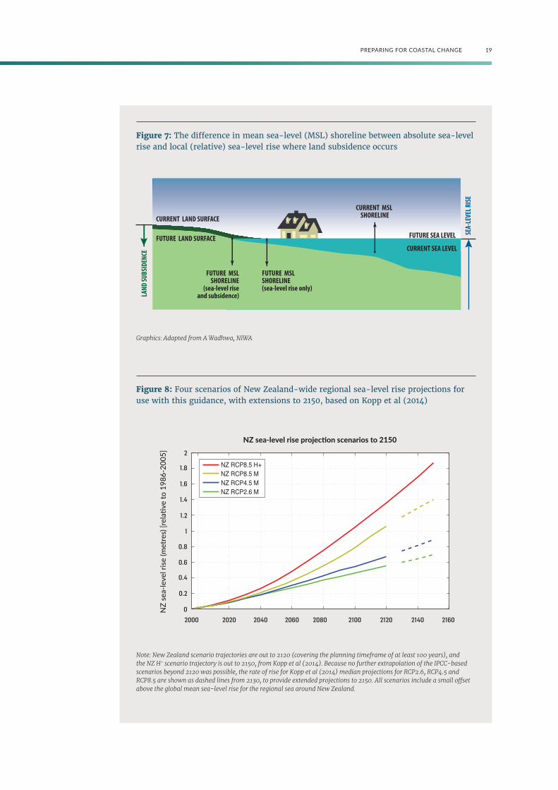
Sea-level rise can be considered in two ways (see figure 7):
• Absolute sea-level rise, which is measured relative to the centre of Earth by satellites, or using tide gauges corrected for local land movement. It is usually expressed as a global average. It is used in most projections of sea-level rise. Absolute sea-level rise in a given region may not be the same as the global average.
• Relative sea-level rise (explained in Part 1), is measured relative to the local landmass (by tide gauges), taking into account regional differences in the absolute sea-level rise as well as local vertical land movement (uplift and subsidence).
Relative sea-level rise is the sea-level rise that has to be adapted to in a given region. If the landmass in question is subsiding, the relative sea-level rise will be greater than the absolute sea-level rise in that region (see figure 7), while if the landmass is undergoing uplift the opposite is true.
Future climate change and sea-level rise depend on the combined effect on global emissions of a wide range of socio-economic factors and climate-related policies.
It is not possible to assign likelihoods
(probabilities) to individual climate
change and sea-level rise scenarios.
Instead, a set of scenarios is used
to span a range of possibilities and
provide decision-makers with a range
of possible futures to test response
options against, rather than adopting
a single estimate of future change.
The sea-level rise projections generated for use in the guidance come from:
• the IPCC’s Fifth Assessment Report (2013), which provides projections out to 2100
• a recent study by Kopp et al (2014) which produced projections out to 2200.
18 PREPARING FOR COASTAL CHANGE
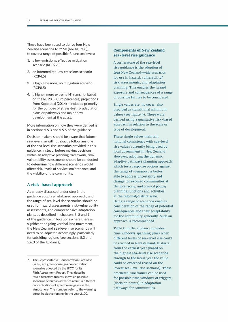
These have been used to derive four New Zealand scenarios to 2150 (see figure 8), to cover a range of possible future sea levels:
1. a low emissions, effective mitigation scenario (RCP2.67)
2. an intermediate-low emissions scenario (RCP4.5)
3. a high emissions, no mitigation scenario (RCP8.5)
4. a higher, more extreme H+ scenario, based on the RCP8.5 (83rd percentile) projections from Kopp et al (2014) – included primarily for the purpose of stress-testing adaptation plans or pathways and major new development at the coast.
More information on how they were derived is in sections 5.5.3 and 5.5.5 of the guidance.
Decision-makers should be aware that future sea-level rise will not exactly follow any one of the sea-level rise scenarios provided in this guidance. Instead, before making decisions within an adaptive planning framework, risk/vulnerability assessments should be conducted to determine how different scenarios would affect risk, levels of service, maintenance, and the viability of the community.
A risk-based approach
As already discussed under step 1, the guidance adopts a risk-based approach, and the range of sea-level rise scenarios should be used for hazard assessments, risk/vulnerability assessments, and comprehensive adaptation plans, as described in chapters 6, 8 and 9 of the guidance. In locations where there is significant ongoing vertical land movement, the New Zealand sea-level rise scenarios will need to be adjusted accordingly, particularly for subsiding regions (see sections 5.3 and 5.6.3 of the guidance).
7 The Representative Concentration Pathways (RCPs) are greenhouse gas concentration scenarios adopted by the IPCC for its Fifth Assessment Report. They describe four alternative futures, in which possible scenarios of human activities result in different concentrations of greenhouse gases in the atmosphere. The numbers refer to the warming effect (radiative forcing) in the year 2100.
Components of New Zealand sea-level rise guidance
A cornerstone of the sea-level
rise guidance is the adoption of
four New Zealand-wide scenarios
for use in hazard, vulnerability/
risk assessments, and adaptation
planning. This enables the hazard
exposure and consequences of a range
of possible futures to be considered.
Single values are, however, also
provided as transitional minimum
values (see figure 9). These were
derived using a qualitative risk-based
approach in relation to the scale or
type of development.
These single values maintain
national consistency with sea-level
rise values currently being used by
local government in New Zealand.
However, adopting the dynamic
adaptive pathways planning approach,
which tests response options against
the range of scenarios, is better
able to address uncertainty and
change for exposed communities at
the local scale, and council policy/
planning functions and activities
at the regional/district scale.
Using a range of scenarios enables
consideration of the range of potential
consequences and their acceptability
for the community generally. Such an
approach is recommended.
Table 11 in the guidance provides
time windows spanning years when
different levels of sea-level rise could
be reached in New Zealand. It starts
from the earliest year (based on
the highest sea-level rise scenario)
through to the latest year the value
could be exceeded (based on the
lowest sea-level rise scenario). These
bracketed timeframes can be used
for possible time windows of triggers
(decision points) in adaptation
pathways for communities.
19PREPARING FOR COASTAL CHANGE
Figure 8: Four scenarios of New Zealand-wide regional sea-level rise projections for use with this guidance, with extensions to 2150, based on Kopp et al (2014)
Note: New Zealand scenario trajectories are out to 2120 (covering the planning timeframe of at least 100 years), and the NZ H+ scenario trajectory is out to 2150, from Kopp et al (2014). Because no further extrapolation of the IPCC-based scenarios beyond 2120 was possible, the rate of rise for Kopp et al (2014) median projections for RCP2.6, RCP4.5 and RCP8.5 are shown as dashed lines from 2130, to provide extended projections to 2150. All scenarios include a small offset above the global mean sea-level rise for the regional sea around New Zealand.
Figure 7: The difference in mean sea-level (MSL) shoreline between absolute sea-level rise and local (relative) sea-level rise where land subsidence occurs
Graphics: Adapted from A Wadhwa, NIWA
2000
0
0.2
0.4
0.6
0.8
1
1.2
1.4
1.6
1.8
2
2020
NZ
sea-
leve
l rise
(met
res)
[rel
ative
to 1
986-
2005
]
NZ sea-level rise projection scenarios to 2150
2040 2060 2080 2100 2120 2140 2160
NZ RCP8.5 H+NZ RCP8.5 MNZ RCP4.5 MNZ RCP2.6 M
FUTURE LAND SURFACE
CURRENT LAND SURFACE
FUTURE MSL SHORELINE(sea-level rise only)
FUTURE MSLSHORELINE
(sea-level riseand subsidence)LA
ND SU
BSID
ENCE
CURRENT MSL SHORELINE
FUTURE SEA LEVEL
CURRENT SEA LEVEL
SEA-
LEVE
L RIS
E

20 PREPARING FOR COASTAL CHANGE
In planning, four broad categories of development are assigned different sea-level rise allowances to take into account (table 2) until an adaptive pathways planning approach can be undertaken considering the four sea-level rise scenarios in their local or regional context – these are called minimum transitional SLR values. An additional component may need to be applied locally to these transitional sea-level rise values for significant vertical land movement.
The sea-level rise values for Categories C (0.65 m) and D (1.0 m) are similar to sea-level rise values currently being used by local government in New Zealand for the next 100 years. New developments can be in two categories: coastal subdivision, greenfield developments and major new infrastructure (Category A) should avoid hazard risk by using sea level rise over more than 100 years and the H+ scenario; changes in land use and redevelopment (intensification, Category B) should adapt to hazards by conducting a risk assessment using all four scenarios and the pathways planning approach. The H+ scenario is used for stress testing the future climate sensitivity and adaptive capacity of major new development, and testing adaptation pathways for existing development.
More information on the specific sea-level rise guidance is in section 5.7 of the guidance.
Besides sea-level rise, coastal and estuarine environments will also be affected by changes in weather-related coastal hazard drivers such as storm surges, waves, winds, and frequency and intensity of storms. Any changes in impacts from these will have implications for coastal erosion, coastal flooding, and groundwater/drainage levels. However, these other effects of climate change on coastal hazards will be secondary to that of ongoing sea-level rise.
Coastal hazards: impacts and assessments
The guidance primarily addresses the two main coastal hazards:
1. coastal inundation (compounded by flooding from rainfall, rivers and groundwater)
2. coastal erosion (beaches, estuarine shores, cliffs).
There are other impacts of sea-level rise on groundwater, drainage, saltwater intrusion and liquefaction. Tsunami impacts will also be affected by sea-level rise.
Climate change will affect these coastal hazards in two main ways:
• rising sea level
• changes in storm frequency or intensity.
The New Zealand Coastal Policy Statement 2010 directs the identification of areas in the coastal environment that are potentially affected by coastal hazards, and assessment of the associated risks over at least the next 100 years. It also directs a risk-based approach to managing coastal hazards, and prioritises identification of areas at high risk of being affected over at least a 100 year timeframe. This is a key focus of step 2 in the 10-step decision cycle. These hazard assessments then inform community engagement processes, and risk and vulnerability assessments in the following steps of the adaptation process (chapter 8 in the guidance).
The purpose of a coastal hazard assessment is to identify the spatial extent and magnitude of hazards, and to quantify, if possible, the likelihood of hazards occurring. Chapter 6 in the guidance addresses the following common questions when undertaking a coastal hazard assessment. Refer to the relevant sections for more information:
• What are the hazard sources (section 6.2)?
• What will be impacted by the hazard (section 6.4)? What type of hazard assessment should therefore be undertaken?
• What scale of coastal hazard assessment is required (section 6.5.2)?
• Where are the vulnerable areas, and where should we focus our effort (section 6.5.3)?
• What climate change scenarios should be considered? For example, what extreme event probabilities and what sea-level rise scenarios (section 5.7) and future increases in waves and storm surge should be included in a coastal hazard sensitivity assessment (section 5.9)?
• What tools and models should be used and what are the data requirements (section 6.5.5)?

21PREPARING FOR COASTAL CHANGE
Table 2: Minimum transitional New Zealand-wide sea-level rise allowances and scenarios for use in planning instruments where a single value is required at local/district scale while in transition towards adaptive pathways planning using the New Zealand-wide sea-level rise scenarios
Category Description Transitional response
A Coastal subdividion, greenfield developments and major new infrastructure.
Avoid hazard risk by using sea-level rise over more than 100 years and the H+ scenario.
B Changes in land use and redevelopment (intensification).
Adapt to hazards by conducting a risk assessment using the range of scenarios and using the pathways approach.
C Land-use planning controls for existing coastal development and assets planning. Use of single values at local/district scale transitional until dynamic adaptive pathways planning is undertaken.
1.0 m sea-level rise
D Non-habitable short-lived assets with a functional need to be at the coast, and either low-consequences or readily adaptable (including services).
0.65 m sea-level rise
Note: An adjustment for significant local vertical land movement may also be needed to these values (section 5.3 of the guidance).

22 PREPARING FOR COASTAL CHANGE
Guiding principles for hazard assessments
There is no single way to approach a
coastal hazard assessment. Various
combinations of data analysis,
modelling and mapping techniques
can be used, depending on factors
such as the locality, data availability,
cost and assets at risk.
A coastal hazard assessment should
relate the hazard magnitude to
its likelihood of occurring, where
possible. Sometimes statistical
likelihoods cannot be assigned within
a planning timeframe, as is the
case for sea-level rise. When this
happens, an adaptive risk-based
approach means including a range of
future sea-level rise scenarios in the
coastal hazard assessment (chapters
5 and 8 of the guidance), focusing on
hazard exposure (eg, using the 1 per
cent annual exceedance probability
inundation event).
Understanding the uncertainties and
effectively communicating how they
have been handled is essential for
informed, risk-based decisions.
Before any detailed coastal
hazard assessment of any scale
is undertaken, a region-wide
hazard exposure screening should
guide priorities and more detailed
subsequent assessments. A region-
wide hazard assessment is useful in
its own right to support land-use
planning and adaptation planning
processes for managing hazard risk
across a region or district.
Generally, more detailed coastal
hazard assessments, using multiple
scenarios of sea-level rise and
sensitivity to changes in waves
and storm surges, will be needed
as input to:
• community engagement processes,
to provide background information
for communities, iwi and hapū and
stakeholders about the increasing
hazard exposure at local levels
• risk and vulnerability assessments
(step 4 of the 10-step decision cycle)
• detailed land-use planning and
adaptation planning processes
(steps 5–8 of the cycle).
Hazard assessments are required
at step 2 of the decision cycle, to
inform council staff and affected
communities, iwi and hapū, and
stakeholders; they provide the
necessary information for making
decisions during steps 3–10 of the
decision cycle.
A checklist of good practice for coastal hazard assessments is in section 6.5.1 of the guidance.

23PREPARING FOR COASTAL CHANGE
B. What matters most?
Step 3: Values and objectives
Establishing values and objectives
The values and objectives of coastal communities, and also council functions and services, will be affected by coastal hazards and sea-level rise in different ways. These values and objectives need to be identified here in step 3 of the decision cycle. Combined with the hazard assessment completed at step 2, they will support a vulnerability assessment at step 4.
Establishing a collaborative process to explore values and objectives will help develop a joint understanding of the problem, what is important and to whom, so objectives can be developed to guide the adaptive decision-making process. There are three stages:
1. Exploration and capture of values in a way that clearly expresses:
a. what of value is potentially affected by coastal hazards and sea-level rise
b. who it is of value to
c. where it is located geographically.
This includes consideration by decision makers of the foreseeable needs of future generations, and how communities could be affected in the future by decisions taken today.
Questions that underpin this activity include: Who should participate? How could they participate? What tools and techniques could be applied to explore community values?
2. Reframe the agreed community values into objectives. This allows them to be included in the vulnerability assessment and future adaptation decisions.
See sections 7.4–7.6 of the guidance for more detail.
3. Clarify and agree on local government objectives over different jurisdictions, services and functions.
Understanding the community’s values and objectives will help the council gauge the feasibility of adaptive plans. Moreover, decision-makers will need to have a clear understanding of their own joint objectives, role and obligations. This information then feeds into step 4 of the decision cycle for assessing vulnerability and risk.
More detail on methods to guide processes in step 3 is in section 7.3 of the guidance.
The outcome should be a summary of community values:
• What values and things of value are likely to be affected by coastal hazards and sea-level rise?
• Where are they and who are they valuable to?
• What is the diversity and (dis)agreement of values and norms?
• To what degree will groups in the community be affected?
Some groups are likely to be more negatively affected than others by coastal hazards and sea-level rise, and the consequences of adaptation decisions taken. For this reason, it is critical to ensure all groups’ values are considered when assessing risk and when identifying and evaluating adaptation options.
Step 4: Vulnerability and riskThis step assesses the potential of assets (public and private) and people (including the things they value) to be negatively affected by exposure to coastal hazards and sea-level rise. The capacity of the community to adapt is another key aspect of vulnerability, which is complementary to assessing risk.
Vulnerability assessments
Vulnerability assessments are used worldwide to assess the broader impacts and implications of changes to the coast and communities resulting from climate change. They assess the potential harm and loss to a community or coastal environment caused by sea-level rise and coastal hazards, taking into account the ability of the community or environment to cope and adapt to change. In doing this, it becomes possible to identify and prioritise exposed areas.

24 PREPARING FOR COASTAL CHANGE
Guiding practice: Steps in a vulnerability assessment
There are three main steps to a
vulnerability assessment:
1. a sensitivity analysis for the
systems associated with the
planning area
2. an evaluation of the adaptive
capacity of the system
3. an assessment of how vulnerable
the system is to the effects of
climate change.
Sensitivity is the degree to which a
built, natural or human system is
directly or indirectly affected by
a given hazard exposure, and the
changes in climate conditions that
result in climate impacts on built and
natural systems.
Adaptive capacity is the ability of
natural and human systems to
accommodate changes in climate
impacts with minimum disruption
or additional cost.
More information on vulnerability assessments is in section 8.1 of the guidance.
Risk assessments
Risk is typically assessed as a combination of the likelihood of an impact occurring, and the consequences of that impact. In this case we are assessing the exposure and vulnerability of people and assets to coastal hazards.
When assessing the risk associated with sea-level rise, consequence is the more important component (as likelihood cannot be quantified for future sea-level rise – only for the coastal hazard itself). Calculating the consequences under various sea-level rise scenarios for a particular asset, if sea-level rise is not addressed, can be useful in prioritising assets and exposed populations for adaptation planning.
Guiding practice: Sequence of risk assessments
Different organisations have
different goals, data and resource
available to them. To accommodate
these differences, a three-level risk
assessment process (of increasing
depth and resource requirement)
can be used.
• A ‘first pass’ risk screening can
be conducted as a desktop study
to screen the climate change-
related risk exposure using readily
available datasets. This will tell
you whether a more detailed
second- or third-level assessment
is required, or not (if coastal
risks are not likely to be an issue
for some time at the location
in question).
• A ‘second pass’ risk assessment
takes a standard risk-based
approach using national data,
regional/local information and
expert knowledge. It enables
identification of how climate
change may compound existing
risks or the emergence of new
risks (eg, in areas previously
unaffected), and informs whether
a more detailed third-level
assessment is required.
• A ‘third pass’ (detailed) risk
assessment enables further
investigation of shortlisted areas
of risks, and prioritisation and
testing of strategies and actions in
conjunction with the vulnerability
assessments.

25PREPARING FOR COASTAL CHANGE
Risk assessments are needed at three steps in the decision cycle:
1. At the end of step 2, to prioritise and inform council stakeholders, iwi and hapū, and coastal communities. Undertaking regional/district risk screening following the hazard assessments will identify areas of greatest risk from sea-level rise and the regional/district extent to align with the approach in the New Zealand Coastal Policy Statement 2010 (Policy 24).
2. At step 4, more detailed risk and vulnerability assessments can be applied to areas with the highest and/or earliest onset of potential risk from the initial hazard- and risk-screening exercises. These should initially focus on areas where significant vulnerabilities and risk emerge at a modest sea-level rise, as well as assessing the regional/district extent of risk.
3. At step 6, detailed risk assessments are an integral part of evaluating the effectiveness of response options in reducing risk, and under what conditions and time periods they remain effective.
More information on risk assessments is in section 8.2 of the guidance. Information on engaging the community around assessing vulnerability and risk can be found in section 8.3.
Vulnerability assessments and risk assessments are essential tools for evaluating and identifying adaptation options and pathways later on, at step 6 of the decision cycle.
C. What can we do about it?
Step 5: Identify options and pathwaysCoastal adaptation takes place in a dynamic system, where conditions are changing and risk is increasing. A range of different coastal futures could emerge, and it is important that decisions made now are flexible enough to enable feasible and affordable adjustments to be made over time.
Adaptation options at the coast can be described under the following groupings:
Accommodate: adjust existing assets by using measures that anticipate hazard risk, such as raising floor levels, providing alternative inundation flow paths, or requiring relocatable houses.
Protect: hold the line using natural buffers, like dunes, or hard structures, like seawalls.
Retreat: move existing people and assets away from the coast in a managed way over time, or in response to erosion and inundation damage after climate-related events.
Avoidance strategies: stop putting people and assets in harm’s way, primarily using land-use planning measures.
In practice, there will likely be a combination or sequence of these types of measures as coastal areas are increasingly affected.
The ability to adapt relies on decisions that are flexible and can be adjusted, or switched to alternative pathways, whatever future sea-level rise is experienced. Different groups in the community will also have different capacities to adapt, depending on their vulnerability.

26 PREPARING FOR COASTAL CHANGE
Applying an adaptive pathways planning approach
Identifying options and pathways takes place in three steps:
1. Identify and agree on council and community objectives using the outputs from steps 3–4 of the decision cycle.
2. Identify the possible range of adaptation options.
3. Develop pathways that meet the agreed objectives.
At each of these three steps, engagement with the community will take place.
An adaptive pathways planning approach is a risk-based approach which avoids the need to have firm ‘predictions’ or to use only one scenario as a basis for decision-making. It accommodates uncertainty, and can enable active community and stakeholder engagement and community capacity building. This approach is used to identify options and pathways that will be evaluated in step 6. They will be implemented through different strategies and plans depending on the context, at steps 7–8 of the decision cycle.
The adaptive pathways planning approach asks:
• What are the first impacts that we will face as a result of climate change (outputs from step 2)?
• Under what conditions will current arrangements be ineffective (outputs from steps 2–4)?
• What are the alternatives (step 5)?
• What are the different pathways that can be taken to achieve the same objectives (step 5)?
• How robust are the options over a range of future climate scenarios (step 6)?
• Are they flexible enough to enable a change of path in the future with minimum disruption and cost (step 6)?
The dynamic adaptive policy pathways approach develops a series of actions over time (pathways) to achieve objectives (determined at step 3) under uncertain and changing conditions. It is built on the notion that decisions are made over time as conditions
change, and cannot be predicted. Existing policies and decisions will eventually start to fail to meet objectives as the conditions change – for example, as the sea-level rises and the frequency of hazard events exceeds an agreed threshold, expressed as a trigger point. Once this happens, additional or different actions are needed to achieve objectives, and an alternative pathway emerges (figure 9 shows shifts in pathways in response to sea-level rise triggers).
By exploring different pathways and testing the consequences under the different scenarios, an adaptive plan can be designed that includes a mix of short-term actions and long-term options. The plan is monitored for thresholds that signal an approaching decision point to either implement the next step of a pathway, or reassess the objectives or the plan itself, requiring a return to earlier steps of the decision cycle.
Climate change scenarios allow options to be ‘stress tested’ for their ability to meet objectives. Stress testing enables us to evaluate whether the response options can still meet the objectives if, for example, a high sea-level rise scenario comes to pass. It also helps to identify future trigger points for transferring to another pathway.
Once options have been identified, they should be described in detail and then tested against the objectives decided at step 3, and other criteria that address uncertainty and robustness over time. Criteria should include:
• flexibility (ability to be adjusted with minimal cost)
• avoiding inflexible commitment to a particular option
• meeting stated objectives over at least 100 years
• performance over a range of possible future climate change and non-climate change scenarios.
Figure 10 shows an adaptation pathways map. Similar to a ‘Metro’ map for public transport, it presents alternative routes for getting to the same point (objective) in the future. See section 9.3.3 and appendix G in the guidance for further information and Deltares’ video explaining maps: https://publicwiki.deltares.nl/display/AP/Adaptation+Pathways.

27PREPARING FOR COASTAL CHANGE
Figure 9: Adaptation route map illustrating how different adaptation options combine into adaptation pathways: current management (black): raise dykes or stopbanks (blue), broaden dykes (green) and retreat (red)
Figure 10: An adaptation pathways map
Note: Each option is effective for a distinct range of sea-level rise, after which a shift to another option is needed (indicated by arrows). Pathways are implemented depending on improved projections or observed climate change. Source: Werners et al (2013); with permission
Source: Adapted from Haasnoot et al (2013); Hermans et al (2017)
Action A
Action B
Action C
Action D
Changing conditions
Time high-end scenario
Time low-end scenario
Transfer point to new action and pathway
Policy action and pathway effective
Adaptation threshold for policy action and pathway (no longer meets objectives)
Trigger (decision point)
Adaptation signals
Currentsituation
0 10 70 80 90 100
0 10 70 80 90 100
0.8
0.6
0.4
0.2
0.01990 2000 2010 2020 2030 2040 2050 2060 2070 2080 2090 2100
YearCurrent Opinion Environmental Sustainability
0.0
1. 2. 3.
0.2
0.4
0.6
0.8
Sea
leve
l (m
)
Implementationdependent on(rate of) sea-level rise
Decision space
Alte
rnati
ve s
trat
egy/
tran
sfor
mati
onal
cha
nge
(eg,
retr
eat)
Incr
emen
tal c
ontin
uatio
n cu
rren
t man
agem
ent (
eg, r
aise
dyk
es)
Curr
ent
man
agem
ent
Adaptation
turn
ing
poin
t
Alte
rnati
ve a
dapt
ation
(eg,
bro
ad m
ulti-
func
tiona
l dyk
es)

28 PREPARING FOR COASTAL CHANGE
Step 6: Option evaluation
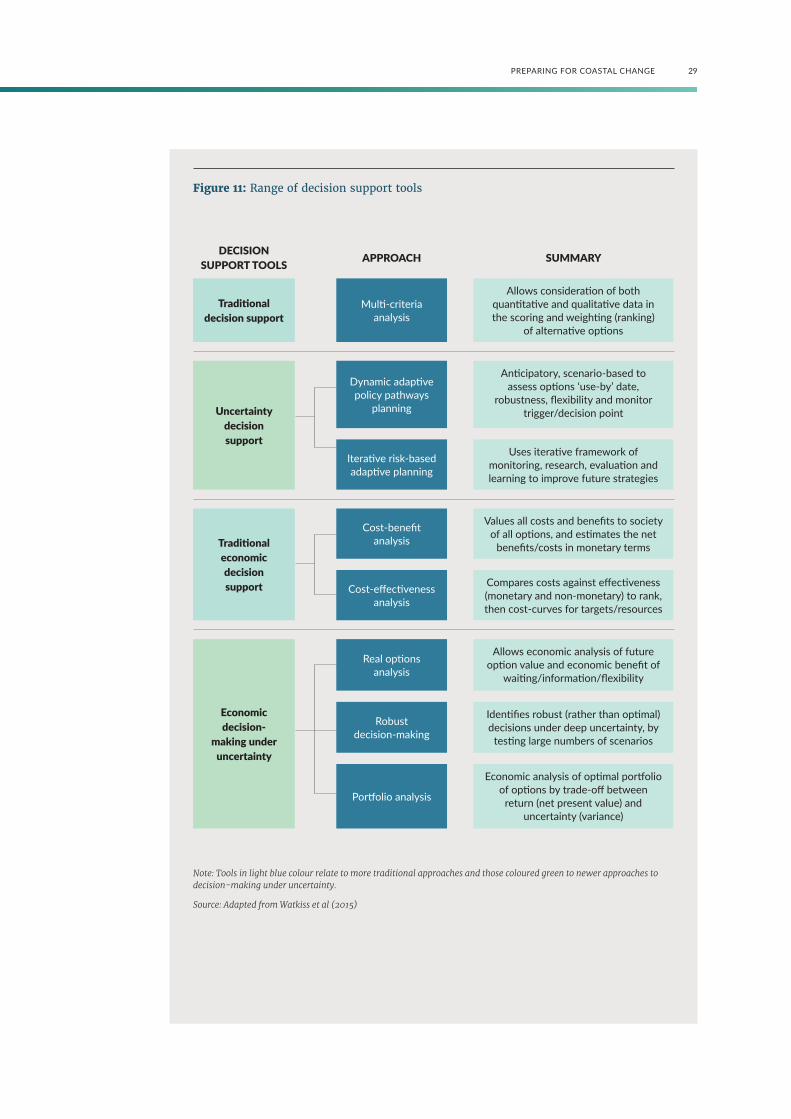
Options and pathways may be evaluated using a number of tools (see figure 11), against a range of climate change scenarios.
The applicability of different tools is discussed in section 9.4 of the guidance. The evaluation tools chosen in any situation need to reflect the stage in the decision process, the nature and scale of the issue, the objectives that are to be achieved, and the options that have been identified.
Guiding practice
Dynamic adaptive policy pathways
(DAPP) planning is particularly useful
for making decisions at the coast,
which is a dynamic environment
with ever-changing risk profiles, and
where there is uncertainty around
the rates and magnitude of changes,
especially over the long term.
DAPP focuses on:
a. making transparent what the
dependencies are between actions
b. whether options will result in lock-
in of existing risk or create future
exposure to hazard risk, while
c. keeping multiple pathway options
open for the future.
This helps to reduce the risk of
irreversible decisions that could result
in costly future adjustments.
Importantly, DAPP does not prescribe
a single solution that is determined
at the start. Future options are
left for future decisions (when an
agreed threshold or advance signal
is reached), provided they help
achieve the stated objective. This
means there is some certainty for the
community about what the future
possible pathways entail and the
consequences of not meeting the
objectives. Transparent trade-offs can
be made where there are competing
options, and different values within
communities. Informed debate can
then take place on options with an
awareness of how these actions might
affect future decision-making.
The adaptive planning approach (eg, DAPP) enables:
• an adaptive strategy (step 7) to be built and each pathway to be assessed for its costs over time, including the costs of changing course when options can no longer meet the stated objectives (see appendices G and H of the guidance)
• decisions to be taken in stages over time, by first setting objectives, then deciding thresholds for future actions, and allowing enough time to implement the response options.
See section 9.5 of the guidance for more information on approaches for including community interests in steps 5 and 6 of the decision cycle.
29PREPARING FOR COASTAL CHANGE
Figure 11: Range of decision support tools
Note: Tools in light blue colour relate to more traditional approaches and those coloured green to newer approaches to decision-making under uncertainty.
Source: Adapted from Watkiss et al (2015)
DECISION SUPPORT TOOLS APPROACH SUMMARY
Traditional decision support
Multi-criteria analysis
Allows consideration of both quantitative and qualitative data in the scoring and weighting (ranking)
of alternative options
Uncertainty decision support
Dynamic adaptive policy pathways
planning
Anticipatory, scenario-based to assess options ‘use-by’ date,
robustness, flexibility and monitor trigger/decision point
Iterative risk-based adaptive planning
Uses iterative framework of monitoring, research, evaluation and learning to improve future strategies
Traditional economic decision support
Cost-benefit analysis
Values all costs and benefits to society of all options, and estimates the net
benefits/costs in monetary terms
Cost-effectiveness analysis
Compares costs against effectiveness (monetary and non-monetary) to rank, then cost-curves for targets/resources
Economic decision-
making under uncertainty
Real options analysis
Allows economic analysis of future option value and economic benefit of
waiting/information/flexibility
Robust decision-making
Identifies robust (rather than optimal) decisions under deep uncertainty, by
testing large numbers of scenarios
Portfolio analysis
Economic analysis of optimal portfolio of options by trade-off between
return (net present value) and uncertainty (variance)

30 PREPARING FOR COASTAL CHANGE
D. How can we implement the strategy?
Step 7: Adaptive planning strategy (with triggers)Step 7 is where the adaptive strategy is developed. This captures the options identified and prioritised in step 5, and the adaptive pathways developed and evaluated in step 6.
This step covers:
1. developing signals and triggers (decision points) for monitoring the plan later at step 9, to allow review and adjustment at step 10
2. identifying which frameworks and measures will be used to implement the plan.
Developing triggers (decision points)
To monitor the strategy as conditions change over time, there needs to be a way to measure when an option or pathway no longer meets its objectives and needs to be adjusted. This requires some kind of advance signal or early warning system. Early signals are preferable to allow enough time for adjustments to be made (eg, resourcing, consenting, implementing).
Examples of specific coastal signals that can be useful early alerts include:
• increasing frequency of clearing stormwater drainage systems
• measurement of saltwater in groundwater systems
• increasing cost and/or complexity of maintaining pumping systems.
Signals and triggers based on measures of sea-level rise or coastal inundation frequency can include a buffer that gives lead time to manage any ‘course correction’ required (see figure 12).
To enable the adaptive planning strategy to operate over long timeframes, and to address uncertainty about the future, triggers need to define the conditions under which the current option or pathway will not meet the plan objectives.
Step 8: Implementation planStep 7 brings together the preferred adaptive planning strategy which councils and communities will be working towards in the long term. The strategy will involve a range of pathways and decision points, parts of which will need to be embedded into statutory planning documents as part of this step.
As the adaptive planning strategy will be longer term than the life of most regional and district plans, it may need to be incorporated in such plans through an appendix or schedule, where it can provide long-term context and guidance for planners and decision-makers. It can then be reviewed at the time of plan reviews or when the triggers in the adaptive plan signal that the pathway no longer meets its objectives. The overall strategy may also involve specific methods (including rules) and other planning techniques in statutory plans.
The choice of method(s) will depend on the situation, the scale of the area and its current development, the objectives and policies, and the community’s input. See tables 25-27 in the guidance for more information about types of planning that may be useful, and more detailed methods and techniques that can be used.
E. How is it working?
Step 9: MonitoringRegular monitoring contributes to an understanding of changing risks over time, and helps with timely responses to anticipated future levels of risk.
Councils are already engaged in monitoring physical changes and the effectiveness of policies and plans. Because climate change effects will increasingly impact on coastal areas and communities, these monitoring systems will need to be bolstered and re-targeted. For example, councils will need to monitor the achievement of objectives (use-by date of options and pathways) and progression towards signals and triggers (decision points) to enable time to switch between adaptation pathways. Such a trigger could be, for example, the number of damaging or disruptive floods in the central business district over a given time period that is tolerable and acceptable to communities and councils.

31PREPARING FOR COASTAL CHANGE
Figure 12: Signals and triggers (decision points)
Changing condition Decreasing performance
Perf
orm
ance
Triggerto implement
pathway A
Signal• threshold
approaching• (re)consider
implementation
Trigger C or D
Lead time
to C or D
Adaptation threshold (AT)
Threshold
TimeRange of triggers(decision points)
Adapted from graphic by Marjolijn Haasnoot: Deltares 2016
Range of use-by dates(moment of AT) depending
on scenario and values
Lead time from current pathway to A
think &engage
32 PREPARING FOR COASTAL CHANGE
Regular monitoring of the effectiveness of the current pathway against objectives and new information (for example, on climate, sea-level rise, and the effectiveness of global emission reduction) or in light of social, cultural and economic changes, may require adjustments to the decisions or objectives. It may be that some earlier steps in the decision cycle need to be revisited. Regular monitoring, shared with the community and stakeholders, contributes to a shared understanding of changing risks over time, and helps with timely responses to anticipated future levels of risk.
To yield consistent information that reveals trends and changes and is useful for long-term planning, monitoring must:
• be undertaken over time
• follow a consistent framework
• use standardised practice methods
• be done at identified consistent measurement locations.
Some information needs are likely to change over time, so adjustments and additions to the monitoring framework may be needed.
There are three general areas of monitoring that will contribute to an understanding of the changing environment: vulnerability, risk exposure, and effectiveness of responses. See section 11.2 in the guidance for more information.
An adaptation monitoring framework is required as part of the adaptive planning strategy (step 7). This will be linked to plans and actions at the local level as part of the implementation plan (step 8). There are also opportunities to involve the community in monitoring (see section 11.3 of the guidance).
Step 10: Review and adjust
Step 10 reinforces that the 10-step decision cycle is not a linear process. Depending on the nature of the policy, plan or adaptation pathway, regular reviews of the identified adaptation triggers (decision points) may be needed. These triggers will be based on the social and economic effects of physical impacts and the adaptive capacity of communities, and will emerge through monitoring.
Planning along adaptive pathways should also provide for emerging research and findings about hazards and risks, development of new tools for managing hazard risk, and engagement with the community at key decision points.

33PREPARING FOR COASTAL CHANGE
Part 3: LegislationIn 2014, Local Government New Zealand identified the key responsibilities of regional councils and territorial authorities in relation to natural hazards8 as:
8 LGNZ 2014, Managing natural hazard risk in New Zealand – towards more resilient communities.
Regional councils“Regional councils are charged with:
• controlling the use of land for the purpose of the avoidance or mitigation of natural hazards (section 30 RMA 19919), unless otherwise specified in the RPS;10
• setting out (in the RPS) objectives, policies and methods relating to the avoidance and mitigation of natural hazards and specifying responsibilities for functions relating to natural hazards;
• addressing natural hazards risk in carrying out its other RMA planning and consent processing functions;
• coordinating regional CDEM11 Groups (and participating on such groups); and
• developing and maintaining soil conservation and river control (flood protection) schemes.
Territorial authorities
Territorial authorities are charged with:
• controlling the effects of the use of land for the avoidance or mitigation of natural hazards (section 31 RMA 1991);
• exercising discretion under section 106 to refuse a subdivision consent where the land is subject to certain hazards, or the subsequent use of the land will exacerbate the hazard;
• controlling building under the Building Act by issuing consents for buildings that comply with the Building Code;
• issuing LIMs12 under the LGOIMA13 and PIMs14 under the Building Act; and
8 LGNZ 2014, Managing natural hazard risk in New Zealand – towards more resilient communities.
9 Resource Management Act 1991.
10 Regional policy statement.
11 Civil defence emergency management.
12 Land information memorandum.
13 Local Government Official Information and Meetings Act 1987.
14 Project information memorandum.
• participating in regional CDEM Groups.”
Regional policy statements play a central role in determining how local authorities manage natural hazards. They must meet the natural hazard management responsibilities under the Resource Management Act 1991 and national policy statements (including the New Zealand Coastal Policy Statement 2010), and may draw on councils’ long-term plans developed under the Local Government Act 2002, Soil Conservation and Rivers Control Act 1941 provisions, and civil defence emergency management group plans.
Key legislationKey legislation for users of the full guidance is listed in the guidance (chapter 2 and appendix A). It includes:
• Resource Management Act 1991Part 2 (Purpose and Principles) Section 6 (matters of national importance) Section 7 (requires that particular regard must be had to a number of matters including the effects of climate change). Figure 13 shows the key RMA policy statements and plans, and their relationships. These have legal force, and their preparation and review are formally required under the RMA. They have specified community and stakeholder process requirements as part of their development, and there are formal opportunities to challenge and test their contents. The New Zealand Coastal Policy Statement 2010 (Objective 5 and Policies 3 and 24-27)
• Building Act 2004 (Section 71, Building on land subject to natural hazards)
• Local Government Act 2002
• Civil Defence Emergency Management Act 2002

34 PREPARING FOR COASTAL CHANGE
Figure 13: Relationships for coastal hazard management under RMA policy and plans
Sets out clear national policy direction for managing natural coastal hazards and climate change. Must be given effect to in the RPS and regional and district plans.
Identifies issues, objectives, policies and methods. Specifies whether region or district is responsible for land use to avoid or mitigate natural hazards.
Appropriate level for risk screening and identification of ‘no development’ coastal areas, in accordance with objectives and policy approach must be given effect to in regional and district plans.
States objectives, policies and rules (and may state methods) to carry out functions and achieve the purposes of the RMA. Depending on how the RPS has allocated natural hazard responsibilities, may contain rules managing use and development across the MHWS into identified hazard areas on land. May identify coastal hazard areas and contain policy, rules and methods of management in such areas.
Allocates management of natural hazards responsibilities to be determined at regional level through the RPS. Particular regard must be had to the effects of climate change.
Resource Management Act (RMA )
New Zealand Coastal Policy Statement 2010
Regional policy statement (RPS)
District plans States objectives, policies and rules (and may state methods) to carry out functions and achieve the purposes of the RMA. Depending on how the RPS has allocated natural hazard responsibilities, may contain rules managing use and development in identified hazard areas in the district, including coastal hazard areas, and contain policy, rules and methods of management.
Use of zoning, overlays and other techniques to manage land use.
Regional coastal plan (may be part of a regional plan
to promote integrated management across mean high
water springs (MHWS))
Regional plans (optional)

35PREPARING FOR COASTAL CHANGE
Part 4: What next?The third edition of the Ministry for the Environment’s Coastal Hazards and Climate Change guidance is a living document. That is, the Ministry intends to review it regularly and provide a statement on whether it remains up to date or whether there have been new developments in science or policy. The Dynamic Adaptive Policy Pathways approach is being implemented globally and now within New Zealand and its practice is being further developed (eg, signal and trigger identification). Reviewing the guidance regularly will ensure the Ministry keeps up with new developments, and provides this information to councils and the wider public.
In developing the guidance, the Ministry has been coordinating with the Department of Conservation (DOC), which is producing guidance on Policies 24–27 and Objective 5 of the New Zealand Coastal Policy Statement 2010. The two guidance documents complement each other, with DOC’s guidance covering interpretation of the policies and the Ministry’s guidance focusing on implementation.
The Paris Agreement on climate change, concluded in December 2015, has an adaptation goal (that sits alongside a mitigation goal) to enhance adaptive capacity, strengthen resilience, and reduce vulnerability to climate change.
The Agreement obliges Parties to plan for and take action on adaptation, and to report on this. The Agreement does not prescribe how we do this because adaptation to the impacts of climate change is a jurisdictional matter and each country will have its own set of impacts to cope with and adapt to depending on its capacities.
A lot of what is in the Paris Agreement is not completely new, but it does give much more visibility to the importance of each country understanding the likely impacts of climate change, and being prepared through appropriate planning and action.
The previous Minister for Climate Change Issues established a Climate Change Adaptation Technical Working Group comprising technical experts across government and the private sector which will provide advice on options for adapting to the effects of climate change. The group’s advice will be based on sound evidence from their first report, a stocktake of existing adaptation work across central and local government and the private sector which was conducted in 2017. The Ministry’s climate change adaptation guidance for local government, including the updated Coastal Hazards and Climate Change guidance, was included in that stocktake. The work of the Group will also contribute to future updates of the guidance.

36 PREPARING FOR COASTAL CHANGE