PREPARED FOR: CITY OF PARSONS, KANSAS KANSAS …_2015.pdf · PARSONS, KANSAS 3 1. PROJECT OVERVIEW...
53
PREPARED FOR: CITY OF PARSONS, KANSAS KANSAS DEPARTMENT OF TRANSPORTATION KDOT # 59-50 KA-3590-01
Transcript of PREPARED FOR: CITY OF PARSONS, KANSAS KANSAS …_2015.pdf · PARSONS, KANSAS 3 1. PROJECT OVERVIEW...

PREPARED FOR: CITY OF PARSONS, KANSAS KANSAS DEPARTMENT OF TRANSPORTATION
KDOT # 59-50 KA-3590-01

US-59 ACCESS MANAGEMENT PLAN PARSONS, KANSAS 1
ACKNOWLEDGEMENTS
City of Parsons Darrell Moyer – Director of Engineering Debbie Lamb, City Clerk and Acting City Manager Martha Wilkerson – Planning and Zoning Administrator Kari West – Public Information Officer/Community Development Director
Fred Gress – Former City Manager
Kansas Department of Transportation (KDOT)
David Gurss – Corridor Planning Manager Wayne Gudmonson, PE – District IV Engineer George Dockery, PE – District IV, Area 4 Engineer Jessica Upchurch, PE – Special Projects Engineer Priscilla Peterson – District IV Public Affairs Manager Kristy Kelley – District IV Community Affairs Manager
Affinis Corp
Mike McKenna, PE, PTOE – Project Manager Lee Baer, EI – Traffic Engineer Kurt Rotering, PE, PTOE – Former Traffic Engineer
Thank you to all the citizens of the City of Parsons and the City Commissioners who provided input, comments, and feedback throughout the planning process. Your insight and local knowledge was invaluable to the development of the recommendations contained in the US-59 Access Management Plan.

US-59 ACCESS MANAGEMENT PLAN PARSONS, KANSAS 2
TABLE OF CONTENTS ACKNOWLEDGEMENTS ....................................................................................... 1
TABLE OF CONTENTS ........................................................................................ 2
1. PROJECT OVERVIEW ...................................................................................... 3
2. ACCESS MANAGEMENT OVERVIEW ...................................................................... 7
3. PUBLIC OUTREACH STRATEGY ......................................................................... 12
4. LAND USE CHARACTERISTICS ........................................................................... 18
5. TRANSPORTATION CHARACTERISTICS ................................................................. 20
6. RECOMMENDATIONS ..................................................................................... 37
7. IMPLEMENTATION STRATEGIES ........................................................................ 49
APPENDIX A – PUBLIC INVOLVEMENT .................................................................... A-1
APPENDIX B – RECOMMENDATION SHEETS .............................................................. B-1
APPENDIX C – LABETTE COUNTY HEALTH DEPARTMENT .............................................. C-1

US-59 ACCESS MANAGEMENT PLAN PARSONS, KANSAS 3
1. PROJECT OVERVIEW
1.1 Introduction and Project Purpose The US-59 Access Management Plan has been conducted by the Kansas Department of Transportation (KDOT) in cooperation with the City of Parsons as part of the $8 billion Transportation Works for Kansas (T-WORKS) program. Access management is the systematic control of the location, design, and operations of driveways, median openings, interchanges, and street connections to a roadway. Managing access is important because each access along a roadway introduces potential for conflict and friction within the traffic stream. Providing access to adjacent property is also important for many reasons – including economic activity and growth. Studies have shown managed corridors are more economically viable than unmanaged corridors. Numerous studies have also shown corridors without good access management often have more crashes and lower travel speeds. The Federal Highway Administration (FHWA) has listed access management as one of the nine proven safety countermeasures credited with significantly reducing the national highway fatality rate between 2007 and 2010. Per the Highway Safety Manual, areas where effective access management has been implemented have experienced:
• A 5-percent to 23-percent reduction in all crashes along two-lane rural highways, and • A 25-percent to 31-percent reduction in severe (injury/fatal) crashes along
urban/suburban arterials.
Lastly, access management techniques help protect taxpayer investments in transportation by promoting safe, efficient traffic flow, thus reducing the need to rebuild infrastructure. Another way of thinking about it is access management attempts to balance property access with traffic safety and mobility. The US-59 corridor is a major thoroughfare with existing and future potential development. A variety of transportation challenges may therefore come about, such as the need for additional access to the highway. The US-59 Access Management Plan identifies a coordinated strategy to provide access while promoting safe and efficient traffic flow. KDOT and the City of Parsons continue to promote access management along US-59 by consolidating driveways when opportunities arise and limiting access to the highway from new developments. Although they have been successful to date, a complete access management plan is needed to continue this process. The US-59 Access Management Plan provides a corridor specific guide
KDOT Access Management Policy

US-59 ACCESS MANAGEMENT PLAN PARSONS, KANSAS 4
to augment KDOT’s Access Management Policy. KDOT and the City of Parsons have committed to an ongoing collaborative implementation process in order to achieve this vision and accomplish this plan’s stated goals. The US-59 Access Management Plan will identify a corridor-based strategy to achieve the following goals:
1. Improve motorist safety within the study area. 2. Enhance and preserve efficient traffic flow along US-59 through Parsons. 3. Enhance and preserve economic development potential of Parsons, as related to
development adjacent to US-59 and the subsequent need for reasonable access. 4. Promote continued intergovernmental coordination between KDOT and the City of
Parsons. This planning process is focused on preserving the integrity of the existing US-59 alignment by promoting safe and efficient traffic flow.

US-59 ACCESS MANAGEMENT PLAN PARSONS, KANSAS 5
1.2 Planning Area
The City of Parsons, situated along US-59, is the county seat of Labette County. Located in southeastern Kansas, Parsons is about 31 miles north of the Oklahoma state line. Nearby Kansas towns include Cherryvale, Oswego, Independence, Chanute, and Pittsburg. US-400 also travels through the northern part of Parsons and intersects US-59 1.8 miles north of the Parsons’s city center.
Figure 1: Project Limits Map
CITY LIMIT
CITY LIMIT
PARSONS

US-59 ACCESS MANAGEMENT PLAN PARSONS, KANSAS 6
The limits of the project encompass the properties along US-59 within the city limits of Parsons specifically North of Gabriel Avenue to the railroad overpass and South of Wilson Avenue to Jothi Avenue. Within the center of Parsons only traffic flow, intersections, and commercial properties along US-59 are included in this study.
1.3 Priority Areas The area around the US-59 and US-400 interchange has numerous development opportunities including the southeast corner of US-59 and Cattle Drive. This quadrant is currently planned for a motel or hotel with attached conference center. The development is proposed to have two access points. Traffic will use Cattle Drive to access the property from the north and a direct access to US-59 will be placed on the south property line. Further analysis of this project and conclusions listed in the traffic impact study performed by the developer’s consultant are located in Section 6.3. When KDOT Corridor Management funds become available, an Access Management Plan is needed to be able to apply these funds to this project. Construction of Cattle Drive, along with other improvements to the area around the US-59 and US-400 interchange, is the first priority of the City of Parsons and its citizens. There are nine access points, including five intersections, within eight-tenths of a mile around the US-400 interchange. This high density of intersections creates numerous conflicts. Detailed discussion about these locations is in Section 6.3. When the concept of the Access Management Plan was being discussed with the City of Parsons, they began identifying additional priority areas along the US-59 corridor. Many of these locations were identified because of perceived and actual safety concerns:
• The intersection of US-59 and Southern Avenue. City staff has indicated this
intersection consistently has crashes and the pavement markings pose challenges to the traveling public.
• Sight distances at numerous downtown intersections, specifically Crawford Avenue, are minimal and do not give the drivers enough time to make a proper decision.
• The US-59 and Main Street intersection connects a key east-west road through Parsons with US-59 and therefore has a large amount of traffic and a large number of turning vehicles as well. This intersection has congestion and some confusing traffic control.
Throughout this Access Management Plan, these and other locations are discussed. Recommendations are in Section 6.3.

US-59 ACCESS MANAGEMENT PLAN PARSONS, KANSAS 7
2. ACCESS MANAGEMENT OVERVIEW
2.1 Understanding Access Management Access management, as defined by the Transportation Research Board (TRB), is “the systematic control of the location, spacing, design, and operations of driveways, median openings, interchanges, and street connections to a roadway.” This process involves managing the number of driveways, or access points, along a roadway in order to reduce the number of conflict points a driver may encounter. Conflict points are locations within the stream of traffic flow where vehicles stop, slow, merge, or cross paths. The greater the number of conflict points along the traffic stream, the greater the chance that two vehicles will collide. Access management attempts to reduce the number of conflict points in order to improve traffic flow and safety. Methods used in reducing the number of conflict points are discussed in Section 2.3.
2.2 Roadway Functional Classification A key concept of access management is the functional classification of roadways. Roadways are typically grouped according to the type of traffic service they are intended to provide. There are three categories (or classifications): arterial, collector, and local. Arterials are major roadways intended primarily to serve through traffic, where access is carefully controlled. These roadways generally have regional importance and are intended to serve moderate to high volumes of traffic traveling relatively long distances at higher speeds. Collector roadways provide a lower level of service than arterial roadways and are intended to move traffic from local roads to arterials. Local roadways consist of all roads not defined as arterials or collectors and primarily provide access to land with little or no through traffic and low speeds. US-59 is functionally classified as an arterial whose primary function is to move traffic through and within Parsons. According to the Route Access Control Map from the KDOT Bureau of Transportation Planning, the highway is categorized as Partial Access Control 3. This designation is for rural highways likely to remain two-lane. New access should be limited to public roads only. US-59 is also a commercial/industrial corridor and adjacent properties need access. These two functions working together create congestion and safety issues.

US-59 ACCESS MANAGEMENT PLAN PARSONS, KANSAS 8
2.3 Access Management Design Techniques
There are multiple methods utilized to improve safety and efficiency of a highway. The design techniques used in this study to analyze the existing corridor and make recommendations come from the KDOT Access Management Policy. The items listed below are procedures that could be used along the study corridor and can also be applied to other parts of Parsons to achieve the same benefits. Each of the techniques listed below have a variety of benefits when utilized appropriately. This is not a complete list of all the possible techniques.
Minimize Conflict Points Conflict points are locations where vehicles may come into conflict with another vehicle. Reducing conflict points creates fewer opportunities for vehicles to need to slow down to turn, fewer vehicles cutting in front of others, and fewer distractions for drivers. Reducing the conflict points usually results in fewer crashes. Any reduction in conflict points also provides a more efficient corridor by minimizing changes of speed and improving the flow of traffic along the corridor and through intersections. Each three-legged intersection, or typical driveway, creates nine conflict points; while each four-legged intersection creates 32 conflict points. Including pedestrians and bicycles increases the number of conflict points to 48 at each four-legged intersection. Right-in/right-out entrances are a tool that reduces conflict points while still providing access. These can easily be created with a median or a splitter island.
Access Spacing Limiting the number of driveways and increasing the spacing between driveways reduces conflict points and decreases the chances for a crash. The KDOT Access Management Policy has criteria for this spacing based on the class and speed limit of the highway. US-59 through Parsons has speeds ranging from 20 mph to 50 mph and has a D Route classification (Table 1, Section 5.1). According to Table C-1 in the KDOT Access Management Policy, access spacing for this classification ranges from 115 feet to 230 feet depending on the speed.
Conflict Locations
US-59 ACCESS MANAGEMENT PLAN PARSONS, KANSAS 9
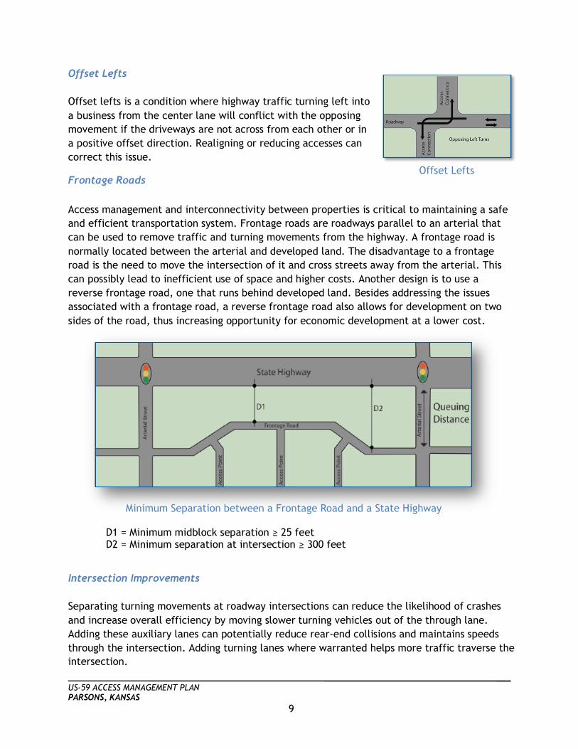
Offset Lefts Offset lefts is a condition where highway traffic turning left into a business from the center lane will conflict with the opposing movement if the driveways are not across from each other or in a positive offset direction. Realigning or reducing accesses can correct this issue.
Frontage Roads Access management and interconnectivity between properties is critical to maintaining a safe and efficient transportation system. Frontage roads are roadways parallel to an arterial that can be used to remove traffic and turning movements from the highway. A frontage road is normally located between the arterial and developed land. The disadvantage to a frontage road is the need to move the intersection of it and cross streets away from the arterial. This can possibly lead to inefficient use of space and higher costs. Another design is to use a reverse frontage road, one that runs behind developed land. Besides addressing the issues associated with a frontage road, a reverse frontage road also allows for development on two sides of the road, thus increasing opportunity for economic development at a lower cost.
Intersection Improvements Separating turning movements at roadway intersections can reduce the likelihood of crashes and increase overall efficiency by moving slower turning vehicles out of the through lane. Adding these auxiliary lanes can potentially reduce rear-end collisions and maintains speeds through the intersection. Adding turning lanes where warranted helps more traffic traverse the intersection.
Offset Lefts
Minimum Separation between a Frontage Road and a State Highway D1 = Minimum midblock separation ≥ 25 feet D2 = Minimum separation at intersection ≥ 300 feet

US-59 ACCESS MANAGEMENT PLAN PARSONS, KANSAS 10
Updating signal timings to current volumes and improving driveway widths, radii, and slopes will help move traffic smoothly off, on, and along the highway. Signal timing describes the amount of green time a specific leg receives for each cycle. As traffic patterns change over time, signal timings should be adjusted. A well timed signal allows traffic to flow efficiently with minimal delay.
Moving driveways away from intersections also improves the efficiency of intersections. This area is called the functional area and includes the distance traveled while deciding if needing to stop, deceleration distance while stopping, and the length of the queue.
Medians Another technique that has a proven track record of reducing crashes on an arterial is to construct medians. These raised (non-traversable) or grass areas installed in place of a two-way left-turn lane (TWLTL) limit left turn movements to specific locations of a roadway. Medians near intersections are particularly beneficial as accesses within the queue length significantly decrease the efficiency of an intersection.
Intersection Functional Area
Medians to Create Right-In/Right-Outs

US-59 ACCESS MANAGEMENT PLAN PARSONS, KANSAS 11
2.4 Benefits of Access Management Access Management is one of the FHWA’s nine proven safety countermeasures. KDOT has created the Access Management Policy to guide the execution of proper access management. This has the potential to benefit multiple different users in a transportation system. Promoting safety and efficiency along a corridor creates a good transportation environment – which is good for business. Actual and perceived safety of a customer entering or exiting a business promotes return customers. Fewer entrances also increase pedestrian safety and activity along a corridor. Also, efficient roadways can decrease travel time for both customers and delivery vehicles. As travel time decreases along the corridor, the market area grows. Having an access management plan in place will assure that future development will be constructed to current criteria and promote safety and efficiency.
There usually is not a specific timeline to implement access management techniques. Access management is generally integrated with roadway projects, property owner changes, redevelopment, or when safety concerns present themselves. Additionally, the specific type of improvements recommended in this plan may be different when it is time for the construction to be completed. Nearby factors, traffic volumes, land uses, and many other aspects may necessitate a different or better application.
“One study in Texas indicated that corridors with access control improvements experienced an 18
percent increase in property values after construction.”
- Federal Highway Administration
Increase of Market Area

US-59 ACCESS MANAGEMENT PLAN PARSONS, KANSAS 12
3. PUBLIC OUTREACH STRATEGY
3.1 Public Outreach Overview Public outreach is a process by which interested and affected individuals, the business community, special interest groups, and governmental entities are informed of a project and its goals, and have the opportunity to participate in the decision making process. Public outreach supports the exchange of ideas and information among interested individuals and groups, which is critical to resolving the challenges involved in any project. Outreach also creates and builds partnerships, involves the community, helps form mutual understanding, encourages trust, reduces conflict, and ultimately leads to a more complete and successful project.
3.2 Stakeholder Meetings Three stakeholder meetings were held to initially make contact with the stakeholders, describe the planning process, and hear their ideas. The meetings were all held on February 24, 2014 at Parsons’s City Hall at 10:00 a.m. for the north end of Parsons, 12:00 p.m. for the downtown area, and 2:00 p.m. for the south end of the city. Stakeholders are individuals and groups who are affected by, or have an interest in, a particular project or action. The sign-in sheets for each stakeholder meeting are located in Appendix A. The meetings included a wide variety of stakeholders:
• City of Parsons government • Labette County government • Jobs Inc. • Residents • Businesses • Business groups, e.g. chambers of commerce • Property owners • School districts • Media contacts
The objective of the meetings was to provide stakeholders with the purpose and goals of the project and provide stakeholders an opportunity to participate in the decision making process. Creating and building relationships with stakeholders also helps to increase support for of the project. Community leader education and buy-in can go a long way towards building a positive attitude about the project among the greater community. The comments we heard from the stakeholders were:

US-59 ACCESS MANAGEMENT PLAN PARSONS, KANSAS 13
First Meeting – North End of town: 1. Safety is a good thing; US-59 is busier than it was 2. Slowing the speed down helped – 55 mph by the sale barn and 65 to the north. 3. Excited from Travel Plaza’s point of view 4. Safety is important – Crashes happen daily at Walmart 5. The plan is a good idea – need to put in regulations 6. The plan sounds good 7. We need 16th Street (US-59) safety 8. Pulling out of the stock yards is tough, have waited for 10 minutes to pull out; need
turn lanes 9. Improve the pavement markings near the Travel Plaza 10. Travel Plaza was built in 2001 11. Truckers park at the stock yards – from an old request by KDOT. There are up to 12-13
trucks in the lot at one time 12. There is more development coming 13. The north end of town has a unique mix of trucks and pedestrians 14. Old Dominion has 200 trips a day. The biggest difficulty for the trucks is exiting
eastbound US-400 on to US-59 and Union Ave on to US-400. 75 percent turn right at Union Road and head east or west on US-400 and the remaining 25 percent head north on US-59
15. Old Dominion plans to double the truck traffic at the US-59 location within the next few years.
16. Pedestrians walk along the highway from town to Walmart. A pedestrian connection would be good
17. Could US-59 be updated to four-lane north of Parsons? Underpass and Labette Creek Bridge are both designed for two-lane highway
Second Meeting – Central Section; Downtown Area:
1. A plan would be good. Semi-trucks turn into Hermann Lumber next to Pete’s 2. Par-Com has one access on to US-59 in the building that used to be the old Casey’s.
Sight distance is an issue. Been there 7 years and have not seen any wrecks 3. 315 N. 16th Street – frame shop – share the alley with the entrance to McDonalds –
there is a school zone there and the intersection is very busy. May need to widen the alley – do not want to lose it because the frame shop is using the parking lot with alley access. Entrance to McDonald’s is very crowded and there are daily conflicts entering and leaving the frame shop. Originally was only supposed to be an exit only
4. President of Jobs Inc. – explained they started 27 years ago – got investors and bought a lot of land around the US-400 interchange. They want to make sure each parcel has good ingress and egress
5. The area that needs attention is out by Walmart and Old Dominion at the Union Intersection
6. Traffic Control around the US-400 interchange needs improvement 7. Resident at 1601 Clark on US-59. 38 years ago it was a residential area, not so much
anymore. Might be interested in selling

US-59 ACCESS MANAGEMENT PLAN PARSONS, KANSAS 14
8. Getting across US-59 in the middle part of town is difficult (Main, Washington, Clark, Crawford, Broadway, and Appleton). There used to be signals and one-way streets (Broadway and Washington) around the downtown.
9. 800 S. 16th Street – Auto store with no access onto US-59 – he would like to sell it. His only access crosses the bike/hike trail.
10. As buildings too close to US-59 become available, would the city consider buying them to improve sight distance? The worst is on the northwest corner of US-59 and Washington Street.
11. Fred noted this is very difficult for the Fire Department and would like to see pre-emption at that location.
12. Fire Station may be moving to Corning Street. Third Meeting – South End of Town:
1. No complaints on access at the farm talk paper. The condition of the road is poor near the hospital and on the bridge over the railroad.
2. There is a bus stop on 21st Street. 3. The hospital’s main entrance is real busy and the industrial traffic lets out between
2:30 and 3:30 p.m.. They would like to see the access locations narrowed 4. The Hospital has it in their master plan and would like to have a separate entrance for
their EMS vehicles. Currently they share a drive with folks visiting for doctor appointments. The hospital has drainage issues on the central and south drives.
5. Ruts on US-59 6. Fire Marshall talked about blind spots at Crawford and Washington intersections with
US-59. Southern and US-59 has more crashes than other locations. Too many options on the west leg. Large southbound right-turn truck movement.
7. Look at Jothi intersection for turning traffic with trucks. Summary Based on the comments collected from the 28 stakeholders at the meetings, the following themes emerged for US-59 through Parsons;
• The north end of town is and will continue to see the fastest growth in traffic. There is a need for short and long term traffic control improvements in this area, especially around the US-400 interchange.
• There are safety issues near downtown because of inadequate sight distance mostly due to lack of building setbacks.
• On the south end of town the intersection of US-59 and Southern Boulevard needs geometric improvements to improve the overall safety.
• Work with the hospital on access spacing as they implement the remainder of their master plan.

US-59 ACCESS MANAGEMENT PLAN PARSONS, KANSAS 15
3.3 City Commission Meeting Similar to the initial stakeholder meeting, a presentation and discussion occurred at the February 27th, 2014 City Commission meeting. Fred Gress, City Manager, introduced the consultant and gave a short introduction of the project. The consultant provided a short presentation on access management and how it will help and affect Parsons. The city commissioners asked three main questions:
1. Who was invited to the stakeholder meetings, how were they invited, and who attended?
a. Key stakeholders were listed, Fred Gress explained that they were invited and how each was selected.
2. What is the most dangerous intersection in town? a. The consultant and Fred Gress informed the city commissioners the process was
just getting started and from our efforts it would be premature to answer that. Fred and Larry Steeby, Fire Chief, stated that US-59 and Southern Avenue had another right angle crash on Monday, February 24th.
3. Are the KDOT Corridor Management funds the same as the KDOT Community Development Block Grant (CBDG) Program?
a. The consultant explained that this was a different pot of money from CBDG and then KDOT explained the application process. The Corridor Management Funds are a selection process and not guaranteed.
The city commissioners appreciated the answers and KDOT successfully helped put emphasis on the fact that expectations need to be managed and once the plan is done there is not an expectancy that all projects are built in the next year. The US-59 Access Management Plan is a strategy for the future. A second presentation was provided for the City Commission on April 30th, 2015 by the consultant. At the conclusion, the Mayor of Parsons, Jeff Perez, asked what exactly the Access Management Plan meant for the City of Parsons. The consultant explained that the “improvements” shown in the Access Management Plan were not items that needed to be immediately completed. Most of the improvements could be worked into normal city maintenance activities. The consultant further explained that having an Access Management Plan would help the City of Parsons in applying for different funding sources from KDOT for the larger improvements. The City Commission as a whole were very supportive of the improvements and had very few questions. A local property owner, Corky Beachner, was also supportive of the improvements shown on property that he currently owns.

US-59 ACCESS MANAGEMENT PLAN PARSONS, KANSAS 16
3.4 Public Open Houses Two public open houses were conducted to distribute and gather information from area citizens. The open house format is less formal than the stakeholder meetings and allows attendees to collaborate to formulate resolutions for problems. A summary of each open house is provided below.
Public Open House #1 (March 25, 2014) The first public open house for US-59 was held from 4:00 p.m. to 7:00 p.m. on March 25, 2014 in the Parsons’s City Hall. KDOT, the City of Parsons city staff and the consultant team discussed access management and the scope of the project with 20 residents. Five display boards and a rolled out aerial were used. Images of the boards are located in Appendix A. The boards included a general definition of access management along with more detailed explanations of the safety, efficiency, and economic activity aspects. Another board explaining the intersection influence zone was also presented. Common comments included confusion about what the project scope included, concerns about their driveways being closed, and a schedule of when work would occur. Sticky notes were used to write down specific residents’ comments. The notes compiled were:
1. US-59 and 21st Street is a terrible intersection 2. Multiple crashes at US-59 and Southern Avenue 3. Consolidate the access points for Hermann Lumber and the gas station 4. Remove left turn signal at Corning Avenue 5. Eastbound through traffic at Main Street intersection is problematic 6. Dedicated left-turn lane for east and west traffic on Main Street 7. Buy land for five lanes through downtown Parsons 8. US-59 and Crawford Avenue is hazardous. 9. No roundabouts 10. Future entrance on the east side of US-59 south of Cattle Drive 11. Major congestion around the US-400 interchange
Questionnaires were also available for the public to fill out and comment. None have been returned to the project team.
Public Open House #2 (May 28, 2015) The second public open house for US-59 was held from 5:00 p.m. to 7:00 p.m. on May 28, 2015 in the basement of the Parsons’s City Hall. The consultant team shared and discussed two roll out project length aerials, five display boards, and a power point presentation with the City of Parsons city staff, KDOT, and 12 residents.

US-59 ACCESS MANAGEMENT PLAN PARSONS, KANSAS 17
Common comments included confusion about when the projects would begin and who would fund the projects. The common questions were:
1. When would the projects happen? 2. How will these projects take priority vs existing projects? 3. Will these improvements spur economic developments? 4. Who purchases the properties needed for the improvements? 5. Who paid for the Access Management Plan?
The questions and concerns were all addressed by various members of the consultant team, KDOT and the City of Parsons staff. All attendees seemed to leave the final public open house pleased with the product and quality of the Access Management Plan and the proposed improvements.

US-59 ACCESS MANAGEMENT PLAN PARSONS, KANSAS 18
4. LAND USE CHARACTERISTICS
4.1 Transportation/Land Use Relationship Kansas arterials are vital links between communities and are essential to commerce, trade, and tourism. Within a community, transportation is closely linked to land use, which means localized activity in smaller towns depends on the highways for access to and from homes and businesses. As land use changes along a corridor, the design and function of the roadway needs to change as well. Conversely, the design and function of roadways often direct the types of land uses that are appropriate in a given location. For example, a commercial development will want to be adjacent to an arterial that has high traffic volume. Also, roads that are designed to go to and by commercial sites are often designed to provide sufficient flow and access to the development. In fact, KDOT’s Access Spacing Criteria consider land use and level of development among the factors in determining appropriate access spacing.
4.2 Existing Conditions In December 2009, the City of Parsons had the foresight to improve their position in economic development by investing in creating a Strategic Plan. This plan contains recommendations for possible sites and infrastructure for future development. Existing land use conditions along US-59 include multiple industrial parks on the north and south ends of town. West of US-59 on Jothi Avenue is the Wayne Moran Industrial Park. Just north of this park along the west side of US-59 are Industrial Park No. 1 and Industrial Park No. 2. North of US-400 along US-59 are the Tolan Creek Industrial Park and Flynn Industrial Park.
Wayne Moran Industrial Park

US-59 ACCESS MANAGEMENT PLAN PARSONS, KANSAS 19
There is also a central business district, residential, and light commercial within the city limit. The central business district is located west of US-59 on a recently renovated Main Street. The majority of the other commercial within Parsons is located east of US-59 on Main Street (old US-400) and along the US-59 corridor near the US-400 interchange. Residential land use along US-59 is mainly limited to the central portion of the city between Wilson Avenue and Felix Avenue. Due to the east-west layout of the city, a majority of homes that line US-59 are accessed from side streets and alleys.

US-59 ACCESS MANAGEMENT PLAN PARSONS, KANSAS 20
5. TRANSPORTATION CHARACTERISTICS
5.1 Characteristics of the US-59 Corridor To better manage and address the diversity of more than 10,000 miles of Kansas State Highways, KDOT has developed a Route Classification System based on daily traffic, route continuity, access to major cities, trip length, and route spacing. The system is divided into five classes: A through E. KDOT uses the Route Classification System to help make decisions regarding future roadway improvements, maintenance, and other items. KDOT also uses route classification to make decisions regarding access. KDOT’s route classifications are based on the roadway types, significance to the national and regional highway network, traffic volumes, and posted speed limits. KDOT has designated US-59, which runs from the Canadian border south to Laredo, Texas, as a Class D route through Kansas since it is important for intercounty movement but not a major north south route through Kansas (Table 1). Table 1: KDOT Route Classifications
CLASS DEFINITION AND DESCRIPTIONClass A The Interstate System, including the Kansas Turnpike—Class A routes are interstates. They
are fully access-controlled routes that permit high-speed travel. They are important arterieswith high truck volumes. Examples include I-70 and I-35. Statewide, Class A routes average21,700 vehicles per day. They make up just 8 percent of the highway system but carry morethan 40 percent of the daily travel.
Class B Routes that serve as the most important statewide and interstate corridors for travel—Class B routes are non-Interstate routes with limited access, high-speed travel, long distancetruck traffic, and statewide significance. The routes serve distinct trip movements since theyare widely spaced throughout the State. On major sections of the routes, traffic volumes arerelatively constant. A significant number of out-of-state vehicles use Class B routes, and tripson the routes are typically very long. Examples include US-50, US-36, and US-400. Theseroutes average 5,100 vehicles per day.
Class C Defined as arterials, routes that are closely integrated with Class A and B routes in serviceto all parts of the State—Major locations that are not on Class A or B routes are connectedby a Class C route. Trip lengths are usually long. Class C routes are for regional travel andconnect to higher-speed, limited-access roads. US-77 and K-10 are examples. The averagenumber of vehicles per day on these routes is 3,800.
Class D Routes that provide access to arterials and serve small urban areas not on a Class A, B, or Croute—The routes are important for intercounty movement. Class D routes provide intercountytransport and connect to higher-speed roadways. They may have speed restrictionsbecause of the number of local road intersections. Examples are US-50B (business route),K-16, and K-25. On average, these routes are traveled by 1,800 vehicles per day.
Class E Primarily for local service only, routes typified by very short trips—Class E routes arefrequently used on a daily basis, sometimes several times a day, to connect rural residentswith other routes or to provide access to small towns in the area. Class E routes are for shorttrips. They typically connect small towns to nearby higher speed routes. They carry lowtraffic volumes and few trucks. K-76 and K-245 are examples. The average number ofvehicles per day on these routes statewide is 800.
Source: KDOT Access Management Policy (2013)

US-59 ACCESS MANAGEMENT PLAN PARSONS, KANSAS 21
Since there is no north-south bypass route around Parsons, the highway is also the main arterial in the city. Although in recent years the City of Parsons and KDOT have implemented access management techniques along US-59, over years of development, numerous driveways and entrances have been connected directly to the highway. Along US-59 at the south end of the Parsons, from the south city limits to Wilson Avenue, these accesses are mostly commercial. Between Wilson Avenue and Felix Avenue the driveways are mostly residential with only a few commercial properties. North of Felix Avenue, around the US-400 interchange, commercial and industrial entrances create a majority of the access points. The traffic along US-59 in the City of Parsons can be grouped into two categories: through traffic using US-59 as a connector between communities and local traffic traveling to and from businesses and residences within the City of Parsons. US-59 is a two-lane rural highway as it enters Parsons from the south and transitions to a three lane section at Commerce Drive. At Southern Boulevard US-59 transitions to a four-lane section that continues through downtown to Felix Avenue. North of Felix Avenue, the highway returns to a two-lane rural section north to Cattle Drive where is becomes a three-lane section to Flynn Drive. North of Flynn Drive US-59 exits the city limits as a two-lane rural highway. The posted speed limit varies within the study area as shown in Figure 2.

US-59 ACCESS MANAGEMENT PLAN PARSONS, KANSAS 22
Figure 2: Posted Speed Limit Zones.

US-59 ACCESS MANAGEMENT PLAN PARSONS, KANSAS 23
Truck Traffic Throughout discussions with the City of Parsons, local KDOT officials, and the public it is clear that truck access around the US-400 interchange on US-59 is a major concern. Currently a majority of these trucks come from the north and turn onto US-400. Old Dominion, a shipping business located on Union Road, north of US-400, is the largest truck traffic generator. Old Dominion has stated that they currently create 200 daily truck trips and are planning on doubling this number in the next few years. Additionally, the Travel Plaza on the southeast quadrant of the interchange is a destination for trucks traveling across the state on US-400. Other truck destinations in this area are the stockyards, industrial facilities to the north, and multiple commercial properties that receive daily deliveries. All of these trucks traveling through one of the many intersections around US-400 conflict with other traffic traveling on US-59 in the area. Further discussion of this truck traffic and recommendations for these areas are in Section 6.3.
Old Dominion Trucks

US-59 ACCESS MANAGEMENT PLAN PARSONS, KANSAS 24
5.2 Existing and Projected Traffic Volumes Key components of any traffic analysis are traffic volumes. Existing and proposed traffic volumes are used for signal warrants, auxiliary lanes analysis, roadway sections, and road classification. 2013 average daily traffic (ADT) volumes along US-59 were provided by KDOT (Figure 3).
Figure 3: 2013 Average Daily Traffic Volumes.

US-59 ACCESS MANAGEMENT PLAN PARSONS, KANSAS 25
Using linear growth projections based on the past 5 years of counts, KDOT’s Models and Forecasting group are predicting that traffic will grow at a 1.0 percent to 1.3 percent rate throughout the City of Parsons. Due to proposed development, the higher growth will be on the north and south ends of the city. Analysis of critical areas of the road network’s ability to support this level of growth is discussed in Section 6.3. Future 2035 volumes are shown in Figure 4.
Figure 4: 2035 Average Daily Traffic Volumes.

US-59 ACCESS MANAGEMENT PLAN PARSONS, KANSAS 26
Peak hour turning movement counts were taken May 28th and 29th, 2014 at four intersections along US-59. The intersections, Southern Boulevard, Main Street, North Boulevard, and Union Road, were identified by the design team as intersections with auxiliary lanes that needed closer analysis to determine the best use for each lane. The peak hours counted at each of the intersections were 7:00 a.m. to 9:00 a.m. in the morning and 4:00 p.m. to 6:00 p.m. in the evening (Figure 5). The PM peak hour counts were greater than the AM peak hour counts, so they were used for analysis.
231
4
150
46423
21
0213 25
412
7
157
114
35
10217 148
884
36
162
599
8267
67172 5728
2433
29
169
1116
2627
6155 236
532
2
247
139
16
2132
7249 53
UNION ROAD
1540
17
273
77
25
22305 2710
16412
62
198
8419
17082
132227 8045
4315
38
205
4227
6214
18177 1260
NORTH BLVD
MAIN STREET
SOUTHERN BLVD
AM PEAK HOUR PM PEAK HOUR
US
-59
US
-59
US
-59
US
-59
US
-59
US
-59
Figure 5: 2014 Peak Hour Turning Movements

US-59 ACCESS MANAGEMENT PLAN PARSONS, KANSAS 27
2035 peak hour turning movement counts were created using the KDOT provided growth rate of 1.0 percent to 1.3 percent. Over 21 years, US-59 and the intersections of Southern Boulevard, North Boulevard, and Union Road were increased by 1.3 percent and US-59 and Main Street was increased by 1.0 percent.
341
5
197
6055
428
0279 37
516
9
206
118
47
13285 1810
1085
44
200
7311
10183
83212 7035
3143
38
222
1421
3435
8203 347
742
3
324
182
21
3173
9327 70
UNION ROAD
2052
22
358
99
37
29400 3513
20215
76
244
104
23
210101
163280 9955
5620
50
269
5535
8118
24232 1679
NORTH BLVD
MAIN STREET
SOUTHERN BLVD
AM PEAK HOUR PM PEAK HOUR
US
-59
US
-59
US
-59
US
-59
US
-59
US
-59
Figure 6: 2035 Peak Hour Turning Movements

US-59 ACCESS MANAGEMENT PLAN PARSONS, KANSAS 28
Using the 2014 and 2035 peak hour turning movement counts, intersection capacity analysis was performed using Synchro, Version 8.0, based on the Highway Capacity Manual (HCM). For simplicity, the amount of delay is equated to a grade, or Level of Service (LOS), based on thresholds of driver acceptance. A letter grade between A and F is assigned, where LOS A represents the best operation. Table 2 represents the LOS associated with intersection control delay, in seconds per vehicle (sec/veh), for signalized and stop control intersections. Table 2: Intersection Level of Service Summary (2010 Highway Capacity Manual)
Each community has a certain LOS that is deemed acceptable. Most rural cities try to obtain a LOS C for all movements at un-signalized intersections. A LOS D or E may be acceptable at locations where low to moderate traffic volumes exist and a traffic signal is not warranted or is not desirable for other reasons. For signalized intersections the LOS relates to all vehicles using the intersection. A LOS C, which is typical for rural communities, was used as the minimum desirable standard for each movement at signalized intersections. The existing LOS and delay for the major intersections along US-59 in Parsons are shown on Table 3. All movements and intersections are at or above the acceptable level. The only movement with a LOS less than B is the westbound movement at US-59 and Union Road in the PM Peak Hour. This is due to the large westbound left-turn movement from the commercial properties turning south towards downtown Parsons. This LOS of C is still an acceptable level for a stop-controlled side street.
STOP CONTROL SIGNAL CONTROLApproach Delay Control Delay
sec/veh sec/vehA ≤ 10 ≤ 10B >10 and ≤ 15 >10 and ≤ 20C >15 and ≤ 25 >20 and ≤ 35D >25 and ≤ 35 >35and ≤ 55E >35 and ≤ 50 >55 and ≤ 80F >50 >80
LEVEL OF SERVICE CRITERIA
Level of Service (LOS)

US-59 ACCESS MANAGEMENT PLAN PARSONS, KANSAS 29
Table 3: Intersection Level of Service – Existing Conditions
Table 4: Intersection Level of Service – 2035 Conditions
The 2035 LOS for all movements along the US-59 corridor is still at or above the acceptable level except for the westbound movement at Union Road. As is, the highway should still function efficiently well into the future. Recommendations in Section 6.3 address US-59 and Union Road.
INTERSECTIONAPPROACH/MOVEMENT LOS DELAY LOS DELAY
US-59 and Southern BoulevardEastbound B 11.1 B 14.2
Westbound B 12.4 B 14.4Northbound A 0.6 A 0.8Southbound A 0.1 A 0.4
US-59 and Main StreetSignalized B 13.9 B 15.1
US-59 and North BoulevardEastbound B 10.7 B 13.0
Westbound B 10.3 B 10.9Northbound A 0.7 A 0.2Southbound A 0.5 A 0.7
US-59 and Union RoadEastbound B 10.3 B 11.1
Westbound B 14.7 C 20.2Northbound A 1.4 A 0.3Southbound A 0.1 A 0.2
A.M. PEAK HOUR P.M. PEAK HOUR
INTERSECTIONAPPROACH/MOVEMENT LOS DELAY LOS DELAY
US-59 and Southern BoulevardEastbound B 12.7 C 20.8
Westbound C 15.0 C 19.4Northbound A 0.7 A 0.9Southbound A 0.1 A 0.5
US-59 and Main StreetSignalized B 14.0 B 15.4
US-59 and North BoulevardEastbound B 11.8 C 16.6
Westbound B 11.3 B 12.7Northbound A 0.7 A 0.2Southbound A 0.5 A 0.8
US-59 and Union RoadEastbound B 11.3 B 12.7
Westbound C 18.2 E 45.7Northbound A 1.4 A 0.3Southbound A 0.1 A 0.2
A.M. PEAK HOUR P.M. PEAK HOUR

US-59 ACCESS MANAGEMENT PLAN PARSONS, KANSAS 30
5.3 Turning Lane Analysis The intersections with US-59 of Southern Boulevard, Main Street, North Boulevard, and Union Road all have existing auxiliary lanes. To determine if right and left-turn lanes along US-59 are applicable, the auxiliary lane warrants in the KDOT Access Management Policy and the peak hour turning movement counts (Figure 5) were used. One of three warrants must be satisfied to install a left-turn lane along a KDOT highway:
1. Safety warrant—The safety criterion is triggered if one of the following occurs: • A public intersection has a crash rate (crashes per 10 million entering vehicles)
statistically significant above the statewide average (critical crash rate). • A pattern of left-turn/rear-end crashes is present at an existing access point along a
corridor and the addition of a left-turn lane would be expected to reduce those crashes.
2. Special circumstances warrant—The special circumstances criterion is triggered if one
of the following occurs: • Consider the construction of left-turn lanes at locations where site geometry
(horizontal/vertical alignment, sight distance, access configuration, other) would improve the operational and/or safety aspects of the highway.
• Construct left-turn lanes when special circumstances known by the District Engineer are present at the specific access location.
3. Operational warrant—The operational criterion is triggered when:
• Left-turn lane warrants for two-lane highways—Utilize the information provided in Table 5 for guidance based on operations.
Along US-59 in Parsons, discussion on the safety assessment of each intersection is included in Section 5.5. Table 5 and the peak hour turning movement counts were used to assess the operational warrant for left-turns at each non-signalized intersection (Table 6). The US-59 and Southern Boulevard northbound direction, both directions at US-59 and North Boulevard, and neither direction at US-59 and Union Road are warranted for a left-turn lane. Geometric recommendations dependent on this analysis are described in detail in Section 6.3.

US-59 ACCESS MANAGEMENT PLAN PARSONS, KANSAS 31
Table 5: Recommended operational left-turn lane warrants for two-lane highways (KDOT Access Management Policy)
Table 6: Operational analysis of left-turn lanes along US-59
According to the AASHTO 2011 A Policy on Geometric Design of Highways and Streets (Green Book), exclusive left-turn lanes on the side street legs should be considered where left-turn volumes exceed 100 vehicles per hour. The Green Book also states that left-turn lanes may also be provided for lower volumes based on KDOT and Parsons’s assessment of the need. The westbound left-turn movement at Union Road, is the movement that has an existing PM Peak Hour volume that exceeds 100 vehicles per hour (Figure 5). Recommendations for signal installation and adjusting the pavement markings at this intersection are located in Section 6.3.
Opposing VolumeVo (vph) 5% Left turns 10% Left turns 20% Left turns 30% Left turns
800 136 99 74 65700 159 116 87 76600 186 135 101 88500 218 158 119 103400 255 185 139 121300 301 218 164 143200 356 259 194 169100 426 309 232 202
800 127 93 69 61700 149 108 81 71600 174 126 95 83500 203 148 111 97400 238 173 130 113300 281 204 153 134200 333 242 181 158100 398 289 217 189
*45-mph speed volumes are interpolated from 40-mph and 50-mph tables
Advancing Volume Va (vph)
40-mph speed
45-mph speed*
INTERSECTIONDirection of Travel
Northbound 249 13 232 YesSouthbound 274 7 189 No
Northbound 342 3 280 YesSouthbound 287 9 332 Yes
Northbound 257 6 263 NoSouthbound 402 2 254 No
Southern Boulevard
Union Road
North Boulevard
Opposing Volume Operation Warranted
Advancing Volume
% Left Turn

US-59 ACCESS MANAGEMENT PLAN PARSONS, KANSAS 32
5.4 Road Safety Audit In March 2004, KDOT completed a Road Safety Audit (RSA) for Labette County. A detailed breakdown of US-59 through the City of Parsons was included. This breakdown includes route characteristics, intersection characteristics, traffic signal details, speed data, turning movement data, and recommendations. This 2004 RSA is 10 years old and most of the data was collected prior to the US-400 bypass construction. Due to this, most of the data and recommendations are irrelevant to current day traffic patterns. KDOT is currently completing a new RSA for Labette County, but it will not be complete in time to include in this plan. Once it is completed, the RSA should be reviewed for additional information and recommendations on US-59 through Parsons.
5.5 Crash Data The City of Parsons and KDOT provided crash reports from 2010 to early 2014. Muptiple crash reports at 27 intersections were analyzed for patterns and risk. To identify crash rates which are significantly worse than the statewide average for urban intersections, the critical crash rate is calculated relative to the ADT. When the crash rate is higher than the critical rate, an investigation is recommended. Crash rates are considered a better measurement of risk that crash frequencies alone since they account for differences in traffic flow. Two intersections, Southern Boulevard and Main Street, have an Intersection Crash Rate greater than the Critical Crash Rate.
Southern Boulevard The main crash pattern that appeared when reviewing the US-59 and Southern Boulevard intersection was right-angle crashes. The cause for the crashes between 2010 and 2014 do differ, but it appears that vehicles on Southern Boulevard pull out in front of US-59 vehicles. Recommendations for improving safety at Southern Boulevard are located in Section 6.3.
Main Street At the US-59 and Main Street intersection there have been multiple crashes with injuries since 2010. The types of crashes that have occurred include rear-end, failure to yield, and changing lanes. The intersection control at US-59 and Main Street is a traffic signal which naturally creates more rear-end crashes. Additionally, the existing lane configuration has combination left/through lanes which encourages rear-end crashes. Another issue caused from the current lane configurations is the opposing left-turn lanes do not line up causing left-turn vehicles to block drivers’ views of approaching traffic. Recommendations to improve this intersection are located in Section 6.3.
US-400 Majority of the crashes at the US-400 ramp intersections since 2010 were rear-end crashes. Of these rear-end crashes, many were due to vehicles traveling too fast as they exit US-400 and

US-59 ACCESS MANAGEMENT PLAN PARSONS, KANSAS 33
failing to stop in time. The remaining crashes were vehicles stopped at the eastbound off-ramp failing to yield the right-of-way to northbound vehicles.
Union Road At the US-59 and Union Road intersection there is a pronounced crash pattern – westbound left turning traffic pull out in front of northbound through vehicles. Recommendations to improve the safety of this intersection are in Section 6.3.
5.6 Traffic Signals There are currently two traffic signals along the US-59 corridor through Parsons. Both signals were installed on old US-400 at the Corning Avenue and Main Street intersections. The first traffic signal encountered by northbound traffic entering Parsons, US-59 and Corning Avenue, is a three-phase timed signal (Table 7). Corning Avenue east of US-59 is an eastbound one-way street. The northbound left-turn movement is a protected movement and the southbound left-turn is permitted. There are pedestrian heads and crosswalks on all four legs of the intersection. These pedestrian signals do not have push buttons but automatically provide a walk symbol with the appropriate phase. The other traffic signal on US-59 is at Main Street. This two-phase signal is pre-timed and controls one of the busiest intersections in Parsons. All four legs are two-way and include push-button activated pedestrian signals. Using the 2014 peak hour turning movement counts and Synchro, intersection level of service and vehicle delay was calculated for the existing intersection configuration (Table 8).
Table 7: Traffic Signal Analysis – Main Street
GREEN TIME YELLOW TIME ALL RED TIME(ALL) (ALL) (ALL)
1 LT 1 LT/Thru1 LT/Thru n/a 1 Thru/RT
1 Thru1 LT/Thru 1 LT/Thru 1 LT/Thru1 Thru/RT 1 RT 1 Thru/RT
Notes:1. Mast arm.2. Pedestrian signals with push buttons for all four legs.3. Left Turn Yield on Green Ball (R10-12) signs for all four legs.
Main Street Pre-Timed
NOTE
Corning Street Actuated
SIGNAL TYPE
INTERSECTIONGEOMETRICS
(EB)GEOMETRICS
(NB/SB)GEOMETRICS
(WB)
1
1, 2, 340
4.0 2.0
4.0 2.0

US-59 ACCESS MANAGEMENT PLAN PARSONS, KANSAS 34
Other Intersections Per the 2009 Edition of the Manual on Uniform Traffic Control Devices (MUTCD):
An engineering study of traffic conditions, pedestrian characteristics, and physical characteristics of the location shall be performed to determine whether installation of a traffic control signal is justified at a particular location.
The investigation of the need for a traffic control signal shall include an analysis of factors related to the existing operation and safety at the study location and the potential to improve these conditions, and the applicable factors contained in the following traffic signal warrants:
• Warrant 1, Eight-Hour Vehicular Volume • Warrant 2, Four-Hour Vehicular Volume • Warrant 3, Peak Hour • Warrant 4, Pedestrian Volume • Warrant 5, School Crossing • Warrant 6, Coordinated Signal System • Warrant 7, Crash Experience • Warrant 8, Roadway Network • Warrant 9, Intersection Near a Grade Crossing
The satisfaction of a traffic signal warrant or warrants shall not in itself require the installation of a traffic control signal.
The PM peak hour traffic counts from Section 5.2 were used to determine whether installation of a traffic signal is justified for Southern Boulevard, North Boulevard, and Union Road. Warrant 3, Peak Hour, is satisfied if all three criteria listed in Table 8 (Condition A) are satisfied or if the volumes plotted on Figure 7 (Condition B) are above the applicable curve.
Condition A Using Synchro 8 and the peak hour turning movement counts, the stopped time delay was calculated (Table 8). US-59 and Southern Boulevard and US-59 and North Boulevard do not satisfy any of the three necessary criteria and only 2 of the 3 criteria included in Condition A are met for US-59 and Union Road. The peak hour signal warrant is not satisfied based on Condition A.

US-59 ACCESS MANAGEMENT PLAN PARSONS, KANSAS 35
CRITERIA
Total stopped time delay experienced by the traffic on one minor-street approach exceeds 4 vehicle hours.
0.38 veh-hr N 0.26 veh-hr N 0.79 veh-hr N
Volume on one minor-street approach > 100 vehicles per hour
96 veh/hr N 72 veh/hr N 140 veh/hr Y
Total entering volume during the peak hour > 800 vehicles per hour
713 veh/hr N 629 veh/hr N 839 veh/hr Y
UNION ROADSOUTHERN BLVD NORTH BLVD
Table 8: Peak Hour Signal Warrant Analysis – 2014 Counts – Condition A (2010 MUTCD)
Condition B To satisfy Warrant 3 using Condition B, points representing the vehicles per hour on the major street and corresponding vehicles per hour on the higher-volume minor-street approach during the peak hour must fall above the applicable curve in Figure 7. Per the MUTCD, the figure representing 70% may be used if the posted speed limit exceeds 40 mph. Referencing Figure 2, US-59 is posted at 45 mph through Southern Boulevard, North Boulevard, and Union Road. Since none of the plotted points for the intersections fall above the 1 Lane & 1 Lane line, the warrant is not satisfied based on Condition B (Figure 7).
Analyzing the results of both Condition A and Condition B of Warrant 3, Peak Hour, US-59 and Union Road is the closest of the three observed intersections to warrant a traffic signal. KDOT was able to provide Eight-Hour Vehicular Volume counts that showed Union Road met the criteria for signalization under Warrant 1 (Figure 8). Signalizing US-59 and Union Road will aid in development of this area as well as reduce crashes at this intersection.

US-59 ACCESS MANAGEMENT PLAN PARSONS, KANSAS 36
Figure 7: Peak Hour Signal Warrant Analysis – 2014 Counts – Condition B (70% Factor) (2010 MUTCD)
Figure 8: Eight Hour Signal Warrant Analysis – 2014 Counts – Warrant 1
US-59 ACCESS MANAGEMENT PLAN PARSONS, KANSAS 37
6. RECOMMENDATIONS
DESIGN RECOMMENDATIONS
6.1 Plan Design Concept Recommendations Design recommendations presented in this section should be considered for implementation by KDOT and the City of Parsons when the opportunity arises. The improvements shown will improve the access management of the existing land uses, residences, and businesses. Access management is necessary for safety and efficiency of the road network. If an entire block is redeveloped, the access management plan should be reviewed and adjusted based on the recommendations below and KDOT’s Access Management Policy. There is no timeline for these recommendations as they should be implemented when redevelopment or other projects occur or if a safety issue is present.
6.2 Access Management The recommendations below address many of the concerns that brought this project to fruition. These recommendations should be followed as a general guideline wherever possible for new and existing locations:
• New and existing commercial access to US-59 should be limited to the side streets and alleyways. If a driveway mid-block is necessary is should be as far from an existing intersection as possible.
• Along the entire corridor there are numerous residential and commercial driveways on US-59. As improvements occur along the corridor, these driveways need to be reviewed for opportunities to be closed, consolidated, or reduced to standard width. A majority of the properties have adjacent alleys which could provide the required access. Each location will need to be reviewed on an individual basis due to unique garage locations and other physical restraints. Ideally there would be zero residential or commercial driveways on the highway.
• Alleys and frontage roads should be improved and created to encourage use by adjacent property owners.

US-59 ACCESS MANAGEMENT PLAN PARSONS, KANSAS 38
6.3 Geometric Recommendations A potential improvement project discussed before this plan was undertaken consists of expanding Cattle Drive from US-59 east 800 feet. This project will provide improved access as new development is occurring on the southeast quadrant of US-59 and Cattle Drive (Section 1.3). The hotel and conference center traffic impact study, dated January 27, 2014, completed by the developer’s consultant, recommends adding an access to Cattle Drive and a full access onto US-59 475 feet south of Cattle Drive. Private entrances are discouraged on KDOT highways, especially at locations with high speeds. The south access should be constructed as a right-in/right-out and be moved further south to the property line. A right-in/right-out will prevent left-turns across the through traffic and therefore maintain the current safety and efficiency of the highway. Using a pork-chop island to physically prevent the left-turns will create the need for a right-turn lane and acceleration taper at the south entrance. Radii will need to be large enough to accommodate the design vehicle for proposed and possible future developments.
As recommended in the traffic impact study, a northbound right-turn lane from US-59 to Cattle Drive is not needed based on KDOT right-turn warrants, but would be beneficial, especially if more development is expected on Cattle Drive. The access management exhibits, Sheets 1 through 10 in Appendix C, depict recommended geometric improvements along the US-59 corridor within the city limits. The south city limit is at Jothi Avenue and the north city limit is about 0.70 miles north of Flynn Drive. The exhibits show commercial driveway consolidations, US-59 expansions, and lane reconfigurations. Below is a list of specific recommended improvements that are depicted on each figure:
Typical Right-In/Right-Out Detail

US-59 ACCESS MANAGEMENT PLAN PARSONS, KANSAS 39
Sheet 1:
Jothi Avenue Jothi Avenue is the access to the Wayne Moran Industrial Park. There is an existing southbound right-turn lane on US-59 at Jothi Avenue and there is good sight distance for vehicles turning onto US-59. As more developers move into the area, this intersection should be analyzed using the increased traffic projections.
Commerce Drive Northbound US-59 traffic does not currently have a dedicated left-turn lane to turn into Commerce Drive. Restriping the existing two-way left-turn lane (TWLTL) into a dedicated left-turn lane will provide more protection for the left turning vehicles and encourage them to move out of the through lane while waiting for a gap in opposing traffic.
Sheet 2:
Labette County Health Department Labette County Health Department has three existing US-59 access points. Another driveway currently exists just north of the hospital’s north drive which goes to a vacant concrete pad. It is recommended that this access and concrete pad be removed. Labette County Health currently has a plan to create another access point on the north end of their property near the existing concrete pad’s driveway to provide access for their Emergency Medical Services (EMS) vehicles (Appendix D). If a new access is provided, it should be signed as an exit only and be used only by the EMS vehicles. A gate arm could be used to prevent access which could be raised when an emergency occurs. Additionally, an emergency signal could also be installed on US-59 that activates when the EMS vehicles need to access the highway.
21st Street The intersection of US-59 and 21st Street currently has northbound and southbound left-turn and right-turn lanes. Also, the west leg of the intersection has adequate radii to allow truck traffic to maneuver on and off the highway. Pavement marking could be added to the west leg to clarify the stopping location and centerline. Just north of 21st Street there are two access points on the west side of the road that could be combined into one driveway. This driveway should be lined up with the existing driveway on the east side of the highway. To help sight distance for vehicles turning from these driveways and Southern Boulevard to the north, the trees on either side of the bridge should be trimmed.

US-59 ACCESS MANAGEMENT PLAN PARSONS, KANSAS 40
Sheet 3:
Southern Boulevard One of the intersections that has had a large number of crashes is Southern Boulevard. Many of these crashes are due to vehicles on Southern Boulevard pulling out in front of vehicles traveling on US-59. Trimming the trees mentioned in Sheet 2 along with the following improvements to this intersection will help:
• The southbound US-59 outside lane turns into a dedicated right turn lane at Southern Boulevard. Unfamiliar drivers stay in this lane until they are near the intersection then merge into the through lane. Due to this, vehicles turning onto US-59 think the through vehicle is turning and pull out in front of them. To improve this situation, signage and pavement markings indicating the right turn lane should be extended further to the north.
o RIGHT LANE MUST TURN RIGHT signs (R3-7r) should be installed on the light poles between the railroad bridge and Southern Boulevard.
o Additional right turn arrows should be installed in the lane per KDOT typical details.
o Add a wide dotted white pavement marking line north to notify drivers of a lane drop.
• The west leg of US-59 and Southern Boulevard currently has three dedicated lanes: a left-turn lane, a through lane, and a right turn lane. There have been a few crashes where a large vehicle sitting in the left-turn lane blocks the view of US-59 traffic to the through traffic. Restriping this west leg could improve this conflict.
o Gore out the eastbound left-turn lane. o Add left turn arrows to the through lane to make a combined
through/left-turn lane. o Move the stop bar closer to US-59. This will improve sight triangles and
reduce the distance needed to cross US-59.
Sheet 4:
Thornton Avenue to Morton Avenue On the west side of US-59 between Thornton Avenue and Morton Avenue there are two businesses, Pump’n Pete’s (Pete’s) and Herrman Lumber, which have multiple access points. In discussions with Gary Peters, Pete’s owner, he stated that in the near future they will move the convenience store from the southwest corner of US-59 and Thornton Avenue to west of the existing fuel pumps. This provides the opportunity to improve access management. The existing parking located on Thornton Avenue for the current convenience store should be removed. Pete’s access could be consolidated to the alley and to one driveway on Thornton Avenue. This would create a natural flow behind the

US-59 ACCESS MANAGEMENT PLAN PARSONS, KANSAS 41
gas pumps and reduce conflicts. To allow gas trucks into the site, the alley would need to be widened slightly. Herrman Lumber, located just north of Pete’s, has two existing driveways on US-59 in addition to access from the alley. These driveways could be consolidated to one driveway just south of Morton Avenue, allowing truck access to the rear of the property, and the alley which would be a shared access with Pete’s.
Corning Avenue The existing configuration for the west leg at Corning Avenue could be restriped to remove the dual left-turn by replacing the existing through/left-turn arrows in the center lane with through only arrows. While reviewing the crash reports, the dual left-turn arrows create some confusion. People have turned from the inside lane to the outside lane. When US-400 traveled on Corning Avenue, the traffic volumes were high enough to require the dual lefts. US-400 has been rerouted off of Corning Avenue and the traffic volumes have dropped. According to city officials, the current volumes do not require two left-turn lanes. Just north of Corning Avenue, there is a driveway adjacent to the alley with a power pole in-between. This creates an opportunity to combine the driveway and the alley. The power pole would most likely need to be relocated for this to occur.
Sheet 5:
Main Street The intersection of US-59 and Main Street is one of the major intersections in Parsons. The property on the northeast corner provides an opportunity to consolidate entrances to the alley north of Main Street and a shared entrance on Main Street east of US-59. The shared entrance on Main Street would need to be located to maintain the usability of the Bowen Pharmacy drive-thru. At the US-59 and Main Street intersection itself, a few improvements could immediately improve the safety and efficiency of the intersection. Restriping the east and west legs to create dedicated left-turn lanes would increase capacity and reduce confusion (Figure 9). The signal heads and signage on the mast arms would also need to be modified to correctly direct traffic. Using the existing peak hour turning movement counts, this new configuration would slightly improve the intersection delay (Table 9). Additionally, based on the crash analysis in Seciton 5.5, isolating and lining up the left turns should reduce eastbound and westbound rear-end and left-turn crashes. The north and south legs of US-59 and Main Street currently have two lanes in each direction. If the opportunity ever arises, the southbound lanes should be shifted to the west to provide room for dedicated left-turn lanes. South of Main Street the land west

US-59 ACCESS MANAGEMENT PLAN PARSONS, KANSAS 42
of US-59 is currently owned by the City of Parsons. North of Main Street, one half of the block is bare ground owned by First Baptist Church and the other half is a residential property. The existing traffic signal is pretimed. Retiming the signal or adding detection and actuation would also cost effectively provide improvements that would improve capacity and efficiency of the intersection.
Figure 9: Proposed US-59 and Main Street lane configuration Table 9: Main Street Traffic Signal Level of Service
LOS DELAY LOS DELAYExisting Lane Configuration
Signalized B 13.9 B 15.1Proposed Lane Configuration
Signalized A 8.8 B 14.5
A.M. PEAK HOUR P.M. PEAK HOURUS-59 AND MAIN STREET
Main Street U
S-59

US-59 ACCESS MANAGEMENT PLAN PARSONS, KANSAS 43
Washington Avenue The west leg of US-59 and Washington Avenue has existing parking within the influence area of the intersection. To improve the safety and reduce conflict, this parking should be shifted back to the west. The City of Parsons might consider the purchase of the building on the northwest corner of Washington Avenue and US-59, if it ever becomes available, to increase the sight distance at this intersection.
Crawford Avenue On the northeast corner of US-59 and Crawford Avenue is an existing McDonald’s restaurant. Currently drivers turning into the site using the alley back up onto US-59 and drive over the curbs due to the sharp turn. The development agreement between McDonald’s and the City of Parsons stated that the access point onto the alley must be an exit only. This driveway currently has a sign and an arrow that encourages its use as an entrance. These should be removed or changed to urge all entering vehicles to use the entrance off of Crawford Avenue.
Dirr Avenue School Crossing The signage for the school crossing at Dirr Avenue should be updated to match the current version of MUTCD.
Sheet 6:
Kennedy Avenue Just south of Kennedy Avenue are two opportunities to consolidate entrances to the side road. On both the east and west sides of US-59 are wide entrances to businesses. Both of these entrances should be closed and the existing entrances on Kennedy Avenue should be used.
Sheet 7:
North Boulevard The southernmost access point from US-59 to the sale barn should be moved to the existing North Boulevard driveway. Improved radii and turn lanes should be added to North Boulevard to ease and encourage its use by trucks. The radii on the existing access point to North Boulevard should be increased to promote easier truck traffic. Additionally, the north sale barn access point should be moved to the north end of the property which would increase the distance between access points along US-59. There is a proposed development area along the east side of US-59 north of North Boulevard. When this land develops, proper access management techniques should be used. Limiting full access from US-59 to one location across from the north sale barn entrance and using a reverse frontage road are both techniques that should be evaluated prior to approval. Any development access will need to be coordinated with and approved by KDOT.

US-59 ACCESS MANAGEMENT PLAN PARSONS, KANSAS 44
If a frontage or reverse frontage road is constructed for the proposed development east of US-59, access to the existing church should be moved from US-59 to the reverse frontage road.
Sheet 8:
Driveways and access points south of the US-400 interchange are depicted. These driveways are all very close to each other generating multiple conflict points. Improvements identified to improve capacity and safety in this area include:
Cattle Drive Cattle Drive, which is described in detail at the beginning of Section 6.3, and a new access onto US-59 south of Cattle Drive should be constructed. The southern drive is recommended to be a right-in/right-out driveway to limit conflicts and protect the integrity of the highway.
Harding Drive Harding Drive runs along the south side of US-400 west of US-59 and provides access to multiple businesses including a hotel and a Veterans Affairs clinic. The existing spacing between the centerline of the south on-ramps and the Harding Drive intersection is about 300 feet. In order to improve this spacing, it is recommended to realign Harding Drive to the south to align with Cattle Drive. Access to the residential and commercial properties on the west side of US-59 in this area could then be relocated to the realigned Harding Drive. This improvement would create better access management on US-59 by consolidating five access points into one and increasing the spacing between intersections to about 700 feet. According to the KDOT Access Management Policy, the recommended minimum spacing to be used for freeway interchange with a two-lane crossroad is 1,320 feet from the ramp terminals to a four-legged intersection (Figure 10). Although moving Harding Drive to this new location still does not meet this recommended distance, it is 400 feet further away.

US-59 ACCESS MANAGEMENT PLAN PARSONS, KANSAS 45
Figure 10: Minimum spacing for freeway interchange with two-lane crossroads (KDOT Access Management Policy)
Sheet 9:
North of the US-400 interchange there are two full access intersections. Union Road is spaced 670 feet from the westbound US-400 ramp terminal which is less than the recommended 1,320 feet. As traffic grows, the spacing of this intersection will become an issue. The next intersection, a Walmart access, is 1,500 feet from the north US-400 ramps.
US-400 Intersections: Near-Term Recommendations To improve the efficiency and safety of the area north of US-400 in the near-term, a couple items are recommended. Channelizing the southbound US-59 to westbound US-400 right turn would reduce the delay for northbound left turns by making a merge location on the ramp. Refreshing the current pavement markings and improving the pavement surface will better guide vehicles.
US-400 Intersections: Long-Term Recommendations Per KDOT’s Models and Forecasting Unit, it is projected that traffic on US-59 near the US-400 interchange will grow at a rate of 1.3 percent. As traffic grows, the roadway section and intersections will eventually reach capacity. Major modifications or reconstruction options to consider for the interchange include standard traffic signals, a diverging diamond interchange, a single point urban intersection, or roundabouts.

US-59 ACCESS MANAGEMENT PLAN PARSONS, KANSAS 46
Union Road US-59 and Union Road is a two-way stop controlled intersection with a pattern of westbound to southbound left-turn crashes (Section 5.5), great sight distance, and existing left and right-turn lanes. Using the data provided by KDOT, signal warrant #1 was satisfied. Based on the warrant being met, compiled with an expected reduction of crashes at this intersection, we would recommend signalization. In addition to improving intersection performance this would allow protected left turns from Union Road onto US-59. Signalizing all approaches will provide acceptable levels of service and greatly reduce the right angle crashes. Additionally, increasing the radii on the west leg of Union Road will allow trucks to turn onto and off of US-59 without going into the through lanes.
Figure 11: Proposed US-59 and Union Road lane configuration
US-59
Uni
on R
oad

US-59 ACCESS MANAGEMENT PLAN PARSONS, KANSAS 47
Sheet 10:
The City of Parsons has recently created a frontage road for Flynn Industrial Park to connect two industries and provide access to US-59 at Flynn Drive. This frontage road should be realigned away from US-59 into a reverse frontage road. This will create room between the road and the highway for future development. This would also increase the storage capacity for westbound traffic at US-59 and Flynn Drive. The new reverse frontage road could be continued to the south to connect into the Walmart circulation road. Walmart truck traffic could move onto this new road and the existing access onto US-59 could subsequently be eliminated. Radii would need to be an appropriate size to accommodate the trucks.
Future US-59 Four Lane Section: The existing roadway section is a two lane section from Labette Creek to Flynn Drive that includes additional right turn lanes where needed. This section of roadway currently carries approximately 8,500 vehicles per day. Twenty years from now, US-59 around the US-400 interchange will carry close to 12,000 vehicles per day. KDOT and the City of Parsons should consider making US-59 a typical four lane section as the area and traffic continue to develop and grow. The four lane section should extend from Labette Creek to the existing approach of Flynn Drive. This will provide sufficient capacity for the area. The City of Parsons should keep this recommendation in mind for corridor preservation, building setbacks, right-of-way dedication or acquisition, etc. Portions of this four lane section could have curb and gutter or open ditch. The option between the two will depend on the area and the kind of development, this would be a joint decision between KDOT and the City of Parsons.

US-59 ACCESS MANAGEMENT PLAN PARSONS, KANSAS 48
POLICY RECOMMENDATIONS
6.4 Adjust Current City Policy to Promote Access Management Rather than determining criteria on a case by case basis as development is proposed, policies made in advance regarding development and its associated impacts offer a systematic approach which treats development in the city fairly and equitably. Appropriate policies can assist with achieving long-range goals and provide justification and guidance for access management decisions. Additionally, the City of Parsons should establish a classification hierarchy for their street system. Access management strategies are dependent on the designation of streets. A published hierarchy is needed to properly utilize this plan and KDOT’s Access Management Policy.
6.5 Promote KDOT Access Spacing Criteria Access management in existing areas is difficult to accomplish without a change of land-use or new construction. As redevelopment occurs along the US-59 corridor, the recommendations presented in the report and KDOT’s Access Management Policy should guide access management decisions.

US-59 ACCESS MANAGEMENT PLAN PARSONS, KANSAS 49
7. IMPLEMENTATION STRATEGIES
7.1 Intergovernmental Coordination The City of Parsons and KDOT should encourage continued coordination on access management issues in the future. The US-59 Access Management Plan is a good start to what should be a long-lasting effort. As both of these agencies move forward with plans, regulations, and projects, continued consultation would be helpful. This will help meet plan goals and will minimize negative development impacts on access to US-59. Additionally, although Labette County was not involved with the development of this plan, coordination with the county would also be productive to create a quality corridor. The City of Parsons and developers need to submit plats, development proposals, and site plans that affect US-59 to KDOT for review early in the development process. Early reviews offer an opportunity for coordination before the development is approved at the local level and facilitate information sharing between agencies. These reviews will also promote the use of any new access management techniques. The KDOT development review process is similar to the permitting process, whereby information is submitted to the local area office for initial review and then forwarded to KDOT’s planning and engineering staff for further review. KDOT’s Access Management Unit reviews the information for access-related issues and then if needed, forwards the proposal to other affected KDOT staff, such as the Traffic Engineering Section and Bureau of Road Design.
7.2 Interlocal Cooperation Agreement KDOT’s formal access planning instruments provide a cooperative intergovernmental process for transportation partners to achieve a unified transportation vision. Access management plans, area transportation plans, and corridor management plans lead stakeholders through a process of input, analysis, and consensus building. An interlocal cooperation agreement which is the culmination of that coordination and recognizes a commitment between the City of Parsons and KDOT will be created and should consider this plan when making decisions. Interlocal cooperation agreements provide the framework for decision-making in developing transportation priorities and determining how new development and its transportation demands will be accommodated. Kansas Statute 12-2901 below provides guidelines:
Statute 12-2901: Purpose of act. It is the purpose of this act to permit local governmental units to make the most efficient use of their powers by enabling them to cooperate with other localities, persons, associations and corporations on a basis of mutual advantage and thereby to provide services and facilities in a manner and pursuant to forms of governmental organization that will accord best with geographic, economic, population and other factors influencing the needs and development of local communities.

US-59 ACCESS MANAGEMENT PLAN PARSONS, KANSAS 50
In addition to formal cooperation agreements, the City of Parsons should strive to forge working relationships with KDOT. Through these relationships, open lines of communication provide another mechanism for cooperation and coordination. The KDOT District and Area offices will strive to maintain regular communication with the city to provide support and guidance on access related issues. The area offices, in particular, will provide opportunities for one-on-one interface with stakeholders regarding access issues.
7.3 Implementation As opportunities for redevelopment, reconstruction, or safety concerns present a need, this plan, as well as the KDOT Access Management Policy, should be referenced and followed to create a better US-59 corridor. As funds are made available, the improvements shown in this plan should take priority to improve access.
7.4 Recommended Improvements Table The table below sums up the improvements discussed in this plan. Along with improvements, the table provides the triggers necessary to facilitate the need for these improvements. Please refer to Section 6 for in-depth descriptions of these improvements and Figures 1-10 in Appendix C for conceptual drawings.
Table 10: Recommended Improvements
Route Segment/ Location
Initial Improvement
Timing TriggerFuture
ImprovementTiming Trigger
Sheet Number
Page Number
US-59 & access management
- Reduce existing access. - Move access to alleys and side streets.
1 to 10 years
Concurrent with redevelopment
- Increase to a four lane divided section from Labette Creek to Flynn Drive.
> 20 years > 12,000 ADT 1-10 36 / 46
Commerce Drive
- Re-stripe with dedicated left turn lane for NB US-59.
< 5 yearsProposed improvement needed
- - - 1 38
Labette County Health Department
- Remove existing access to the north concrete pad.
< 5 yearsProposed improvement needed
- Add Emergency Service entrance at north end with access control.
< 10 yearsAs redevelopment occurs
2 38
21st Street
- Add pavement marking to west leg for stopping location and center line.
< 5 yearswork into regular maintenance
- - - 2 38
Recommended Improvements

US-59 ACCESS MANAGEMENT PLAN PARSONS, KANSAS 51
Table 10: Recommended Improvements (continued)
Route Segment/ Location
Initial Improvement
Timing TriggerFuture
ImprovementTiming Trigger
Sheet Number
Page Number
Farm Talk Entrance
- Trim trees up north along US-59.
1-10 yearswork into regular maintenance
- Consolidate entrances.
1-10 yearsAs opportunity presesents
2 38
Southern Boulevard
- Add R3-7r's for SB US-59 Restripe west leg.
< 5 yearsProposed improvement needed
- - - 3 39
Thornton Avenue to Morton Avenue
- Widen Thornton Ave. and reduce direct access from US-59.
< 5 yearsConcurrent with redevelopment
- - - 4 39
Corning Avenue- Make center lane on west leg a thru only.
< 5 yearsProposed improvement needed
- - - 4 40
Alley just north of Corning Avenue
- Consolidate access to alley. - Remove existing power pole.
< 5 yearsConcurrent with redevelopment
- - - 4 40
Main Street
- Restripe EB and WB legs. - Re-time traffic signal. - Add detection / actuation. - Consolidate access.
< 5 yearsProposed improvement needed
- Shift SB leg of US-59 west and add dedicated left turn lane.
> 5 yearsAs redevelopment occurs
5 40 / 41
Washington Avenue
- Shift parking west, away from the intersection.
< 5 yearsProposed improvement needed
- - - 5 42
Crawford Avenue
- McDonald entrance should be signed / striped to show the only entrance is from Crawford Ave.
< 5 yearsProposed improvement needed
- - - 5 42
Dirr Avenue- Update school crossing signing.
< 5 yearsProposed improvement needed
- - - 5 42
Kennedy Avenue
- Close wide entrances to US-59, use existing alley entrances.
< 5 yearsAs redevelopment occurs
- - - 6 42
North Boulevard- Adjust entrances to US-59.
1-5 yearsAs redevelopment occurs
- Move church access to future reverse frontage road.
> 5 yearsAs redevelopment occurs
7 42 / 43
First drive south of Cattle Drive
- Develop as Right-in, Right-out.
< 5 yearsWith proposed development
- - - 8 43
Recommended Improvements

US-59 ACCESS MANAGEMENT PLAN PARSONS, KANSAS 52
Table 10: Recommended Improvements (continued)
Route Segment/ Location
Initial Improvement
Timing TriggerFuture
ImprovementTiming Trigger
Sheet Number
Page Number
Cattle Drive- Improve to 3 lane roadway.
< 5 yearsWith proposed development
- - - 8 43
Harding Drive
- Re-align Harding Drive and reduce access points on US-59.
1-10 yearsAs funding is avialible
- - - 8 43 / 44
US-59 & US-400 Intersections
- Refresh pavement marking. -Add free-flowing right turn lane (North side only).
< 5 yearsProposed improvement needed
- Reconfigure the intechange.
> 10 years
As the area develops and the intersections reach capacity
8 & 9 44
Union Road
- Add a traffic signal and re stripe pavement marking on each leg. -Increase radii.
< 5 YearsSignal warrant met
- - - 9 45
Recommended Improvements