Preliminary Geologic Map of the - New Mexico … · Preliminary Geologic Map of the ... This work...
9
Preliminary Geologic Map of the Elk Quadrangle, Chaves and Otero Counties, New Mexico. By Kate Zeigler May 2008 New Mexico Bureau of Geology and Mineral Resources Open-file Digital Geologic Map OF-GM 175 Scale 1:24,000 This work was supported by the U.S. Geological Survey, National Cooperative Geologic Mapping Program (STATEMAP) under USGS Cooperative Agreement 06HQPA0003 and the New Mexico Bureau of Geology and Mineral Resources. New Mexico Bureau of Geology and Mineral Resources 801 Leroy Place, Socorro, New Mexico, 87801-4796 The views and conclusions contained in this document are those of the author and should not be interpreted as necessarily representing the official policies, either expressed or implied, of the U.S. Government or the State of New Mexico.
Transcript of Preliminary Geologic Map of the - New Mexico … · Preliminary Geologic Map of the ... This work...

Preliminary Geologic Map of the Elk Quadrangle,
Chaves and Otero Counties, New Mexico.
By
Kate Zeigler
May 2008
New Mexico Bureau of Geology and Mineral Resources Open-file Digital Geologic Map OF-GM 175
Scale 1:24,000
This work was supported by the U.S. Geological Survey, National Cooperative Geologic Mapping Program (STATEMAP) under USGS Cooperative Agreement 06HQPA0003
and the New Mexico Bureau of Geology and Mineral Resources.
New Mexico Bureau of Geology and Mineral Resources 801 Leroy Place, Socorro, New Mexico, 87801-4796
The views and conclusions contained in this document are those of the author and should not be interpreted as necessarily representing the official policies,
either expressed or implied, of the U.S. Government or the State of New Mexico.
Preliminary Geologic Map of Elk Quadrangle, Southern Sacramento Mountains, in Otero and Chaves Counties, southeastern New Mexico
Kate Zeigler
Department of Earth & Planetary Sciences, University of New Mexico, Albuquerqe, NM 87131
INTRODUCTION
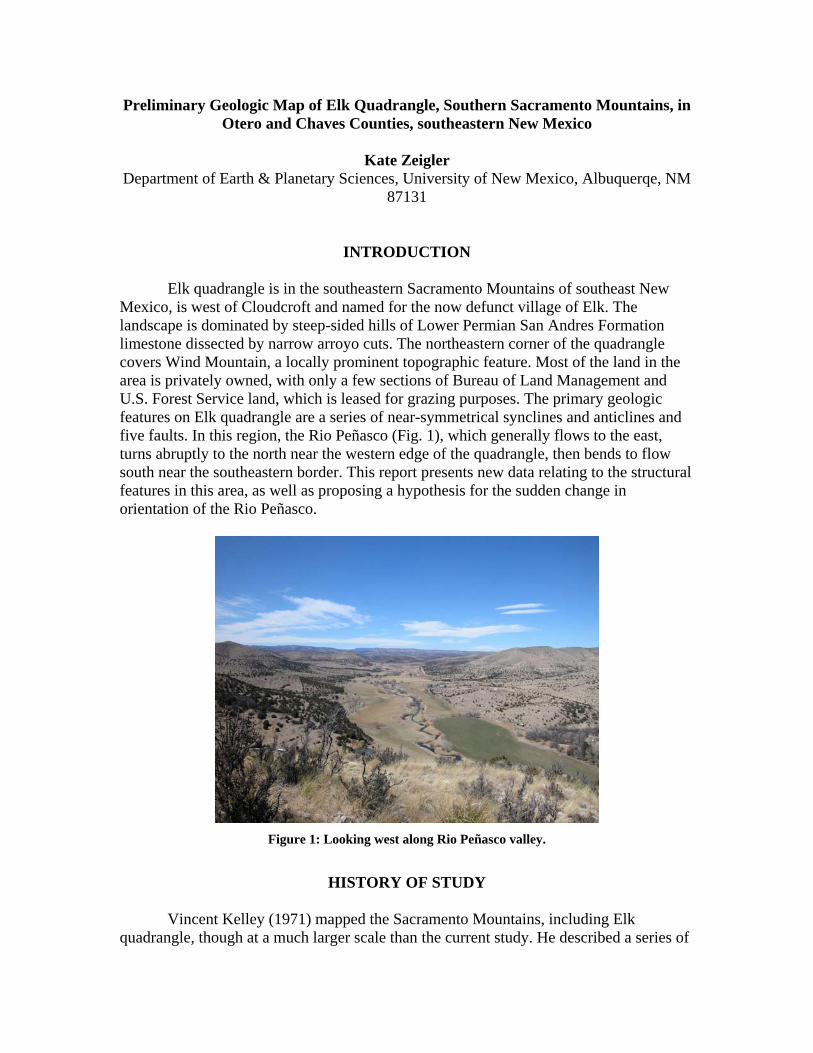
Elk quadrangle is in the southeastern Sacramento Mountains of southeast New Mexico, is west of Cloudcroft and named for the now defunct village of Elk. The landscape is dominated by steep-sided hills of Lower Permian San Andres Formation limestone dissected by narrow arroyo cuts. The northeastern corner of the quadrangle covers Wind Mountain, a locally prominent topographic feature. Most of the land in the area is privately owned, with only a few sections of Bureau of Land Management and U.S. Forest Service land, which is leased for grazing purposes. The primary geologic features on Elk quadrangle are a series of near-symmetrical synclines and anticlines and five faults. In this region, the Rio Peñasco (Fig. 1), which generally flows to the east, turns abruptly to the north near the western edge of the quadrangle, then bends to flow south near the southeastern border. This report presents new data relating to the structural features in this area, as well as proposing a hypothesis for the sudden change in orientation of the Rio Peñasco.
Figure 1: Looking west along Rio Peñasco valley.
HISTORY OF STUDY
Vincent Kelley (1971) mapped the Sacramento Mountains, including Elk quadrangle, though at a much larger scale than the current study. He described a series of
anticlines and synclines, the Tinney anticlinorium, oriented northeast-southwest in the Elk region, as well as mapping several faults with similarly oriented strikes. He was among the first to describe the lithostratigraphy of the San Andres Formation in detail and separated these strata into three members (in ascending order): Rio Bonito, Bonney Canyon and Fourmile Draw. In the Elk quadrangle, only the Rio Bonito and Bonney Canyon Members were documented. Because Kelley (1971) mapped the area at a large scale, details of the structures and Quaternary deposits were not included.
ACKNOWLEDGMENTS Funding for the mapping of Elk Quadrangle was provided by the State Map Program, which is jointly supported by the U.S. Geological Survey and the New Mexico Bureau of Geology and Mineral Resources. I thank Dr. J. Michael Timmons for logistical support, Stacy Timmons for contact information for local land owners and Melanie Locke for field assistance. Land owners who graciously granted permission for work on their property include P. Cooper, M. Foley Sr., D. Soukup, B. Cleve, C. Mulcock, J. Powell and J. Ellett. The Ellets also provided useful contact information for other property owners in the area. Special thanks to D. Soukup for his generous hospitality when Lincoln Forest closed due to fire restrictions. Fieldwork was conducted by standard methods, except in the few cases where land owners could not be contacted for permission – in these instances, geologic data was obtained and extrapolated from previous geologic maps, air photography and adjacent geology.
GEOLOGY
Stratigraphy The geology of the Elk area is dominated by the lower two members of the Lower Permian San Andres Formation: the Rio Bonito and Bonney Canyon Members. Kelley (1971) described these units in detail and the descriptions here pertain to what is seen in locally in Elk quadrangle. Quaternary deposits are confined to the arroyo cuts and the Rio Peñasco and Elk Canyon valleys. Rio Bonito Member, San Andres Formation
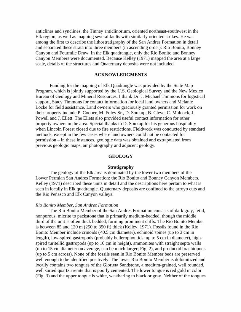
The Rio Bonito Member of the San Andres Formation consists of dark gray, fetid, nonporous, micrite to packstone that is primarily medium-bedded, though the middle third of the unit is often thick bedded, forming prominent cliffs. The Rio Bonito Member is between 85 and 120 m (250 to 350 ft) thick (Kelley, 1971). Fossils found in the Rio Bonito Member include crinoids (<0.5 cm diameter), echinoid spines (up to 3 cm in length), low-spired gastropods (probably bellerophontids, up to 5 cm in diameter), high-spired turitellid gastropods (up to 10 cm in height), ammonites with straight septa walls (up to 15 cm diameter on average, can be much larger; Fig. 2), and productid brachiopods (up to 5 cm across). None of the fossils seen in Rio Bonito Member beds are preserved well enough to be identified positively. The lower Rio Bonito Member is dolomitized and locally contains two tongues of the Glorieta Sandstone, a medium-grained, well rounded, well sorted quartz arenite that is poorly cemented. The lower tongue is red gold in color (Fig. 3) and the upper tongue is white, weathering to black or gray. Neither of the tongues
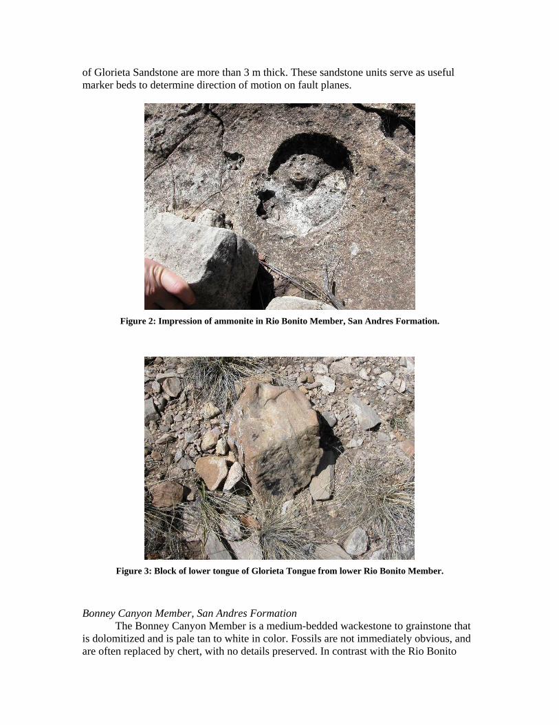
of Glorieta Sandstone are more than 3 m thick. These sandstone units serve as useful marker beds to determine direction of motion on fault planes.
Figure 2: Impression of ammonite in Rio Bonito Member, San Andres Formation.
Figure 3: Block of lower tongue of Glorieta Tongue from lower Rio Bonito Member.
Bonney Canyon Member, San Andres Formation The Bonney Canyon Member is a medium-bedded wackestone to grainstone that is dolomitized and is pale tan to white in color. Fossils are not immediately obvious, and are often replaced by chert, with no details preserved. In contrast with the Rio Bonito
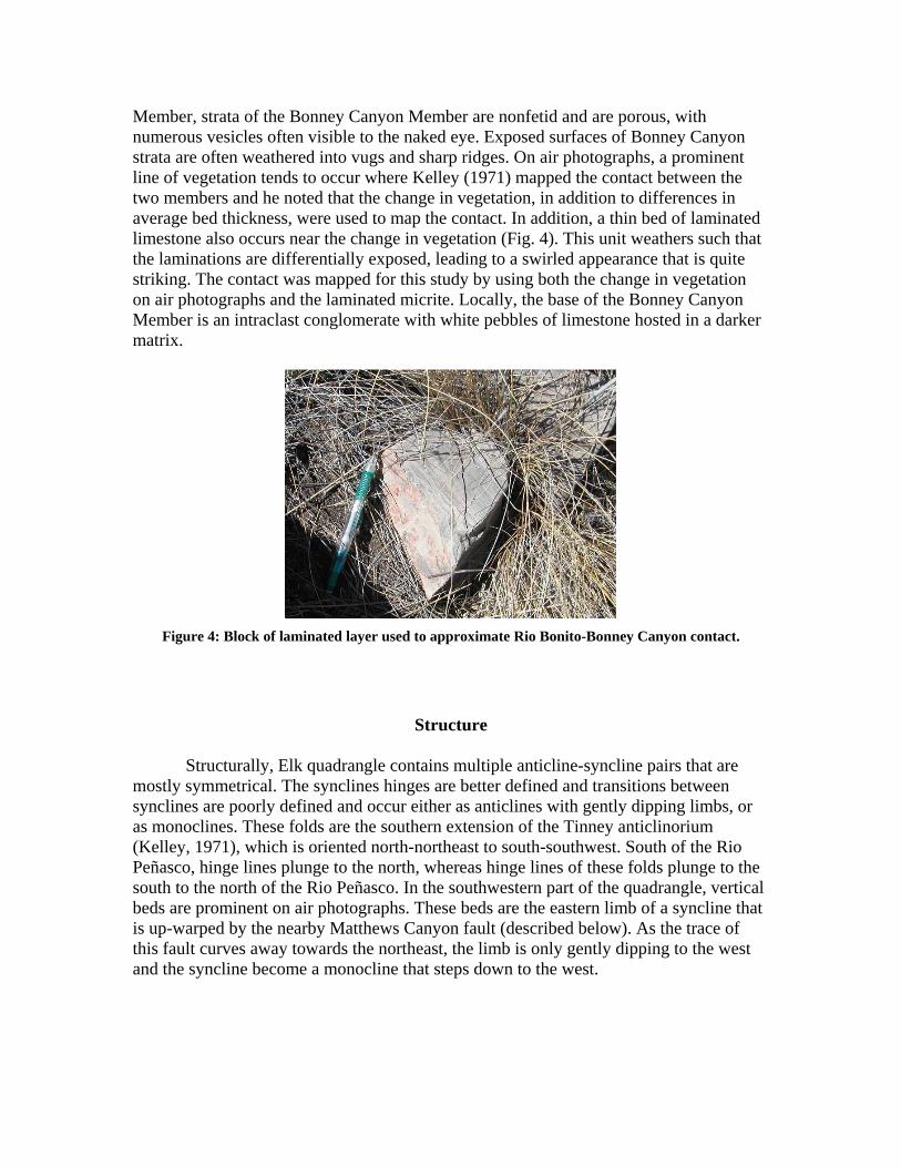
Member, strata of the Bonney Canyon Member are nonfetid and are porous, with numerous vesicles often visible to the naked eye. Exposed surfaces of Bonney Canyon strata are often weathered into vugs and sharp ridges. On air photographs, a prominent line of vegetation tends to occur where Kelley (1971) mapped the contact between the two members and he noted that the change in vegetation, in addition to differences in average bed thickness, were used to map the contact. In addition, a thin bed of laminated limestone also occurs near the change in vegetation (Fig. 4). This unit weathers such that the laminations are differentially exposed, leading to a swirled appearance that is quite striking. The contact was mapped for this study by using both the change in vegetation on air photographs and the laminated micrite. Locally, the base of the Bonney Canyon Member is an intraclast conglomerate with white pebbles of limestone hosted in a darker matrix.
Figure 4: Block of laminated layer used to approximate Rio Bonito-Bonney Canyon contact.
Structure Structurally, Elk quadrangle contains multiple anticline-syncline pairs that are
mostly symmetrical. The synclines hinges are better defined and transitions between synclines are poorly defined and occur either as anticlines with gently dipping limbs, or as monoclines. These folds are the southern extension of the Tinney anticlinorium (Kelley, 1971), which is oriented north-northeast to south-southwest. South of the Rio Peñasco, hinge lines plunge to the north, whereas hinge lines of these folds plunge to the south to the north of the Rio Peñasco. In the southwestern part of the quadrangle, vertical beds are prominent on air photographs. These beds are the eastern limb of a syncline that is up-warped by the nearby Matthews Canyon fault (described below). As the trace of this fault curves away towards the northeast, the limb is only gently dipping to the west and the syncline become a monocline that steps down to the west.
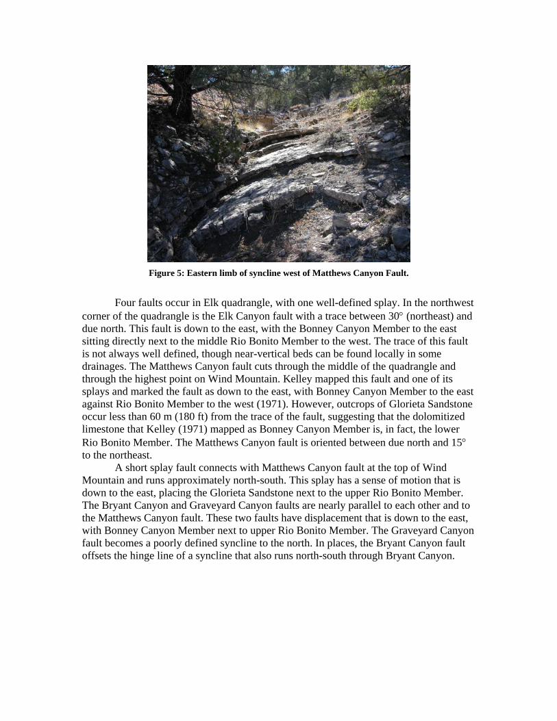
Figure 5: Eastern limb of syncline west of Matthews Canyon Fault.
Four faults occur in Elk quadrangle, with one well-defined splay. In the northwest
corner of the quadrangle is the Elk Canyon fault with a trace between 30 (northeast) and due north. This fault is down to the east, with the Bonney Canyon Member to the east sitting directly next to the middle Rio Bonito Member to the west. The trace of this fault is not always well defined, though near-vertical beds can be found locally in some drainages. The Matthews Canyon fault cuts through the middle of the quadrangle and through the highest point on Wind Mountain. Kelley mapped this fault and one of its splays and marked the fault as down to the east, with Bonney Canyon Member to the east against Rio Bonito Member to the west (1971). However, outcrops of Glorieta Sandstone occur less than 60 m (180 ft) from the trace of the fault, suggesting that the dolomitized limestone that Kelley (1971) mapped as Bonney Canyon Member is, in fact, the lower Rio Bonito Member. The Matthews Canyon fault is oriented between due north and 15 to the northeast.
A short splay fault connects with Matthews Canyon fault at the top of Wind Mountain and runs approximately north-south. This splay has a sense of motion that is down to the east, placing the Glorieta Sandstone next to the upper Rio Bonito Member. The Bryant Canyon and Graveyard Canyon faults are nearly parallel to each other and to the Matthews Canyon fault. These two faults have displacement that is down to the east, with Bonney Canyon Member next to upper Rio Bonito Member. The Graveyard Canyon fault becomes a poorly defined syncline to the north. In places, the Bryant Canyon fault offsets the hinge line of a syncline that also runs north-south through Bryant Canyon.
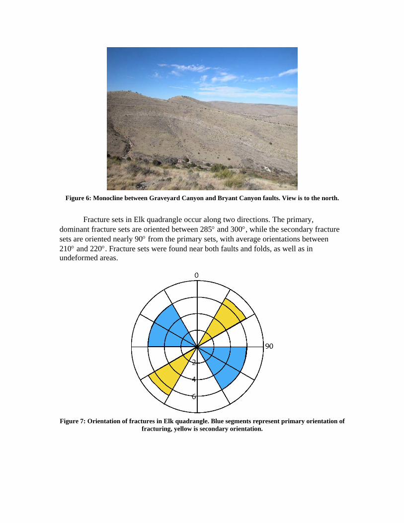
Figure 6: Monocline between Graveyard Canyon and Bryant Canyon faults. View is to the north.
Fracture sets in Elk quadrangle occur along two directions. The primary,
dominant fracture sets are oriented between 285 and 300, while the secondary fracture sets are oriented nearly 90 from the primary sets, with average orientations between 210 and 220. Fracture sets were found near both faults and folds, as well as in undeformed areas.
Figure 7: Orientation of fractures in Elk quadrangle. Blue segments represent primary orientation of
fracturing, yellow is secondary orientation.
Geomorphology and Quaternary Deposits Young deposits include alluvial gravels in modern stream channels and arroyos, and silts and muds of the associated floodplains. Alluvial gravels are dominantly limestone cobbles and pebbles with rare clasts of Glorieta Sandstone. Fine-grained floodplain deposits occur only in the Rio Peñasco valley and to a much lesser extent in Elk Canyon. These soils are only 1-5 m thick and contain numerous cobbles of limestone, except to the east of Graveyard Canyon, where the soil abruptly thickens to over 50 m (150 ft) of non-rocky soil (Mulcock, pers. comm.) and abuts cliffs of middle Rio Bonito Member strata. To the west, toes of bedrock-dominated hills merge gradually into floodplain soils of the Rio Peñasco. According to land owner C. Mulcock, the eastern bend in the Rio Peñasco was once blocked by a natural dam thousands of years previously, creating a lake. The thick, rich soils in this part of the Rio Peñasco valley represent the remains of those lake deposits. In addition to the dramatic thickening of soil east of the Graveyard Canyon fault, the water table rises from 25 to 30 m (75 to 90 ft) to only 3 m (8 to 9 ft).
Locally, small terraces are present along the Rio Peñasco valley and Elk Canyon. These terraces are composed primarily of limestone cobbles that are cemented together with re-precipitated calcite (locally travertine deposits also bind terrace deposits together). These terraces sit 3-5 m above the modern floodplains in the Rio Peñasco and Elk Canyon valleys. In some much smaller drainages, very small terraces are locally present.
Reference
Kelley, V.C., 1971, Geology of the Pecos country, southeastern New Mexico: New
Mexico Bureau of Mines & Mineral Resources, Memoir 24, 78 p.
DESCRIPTION OF UNITS Quaternary Qal Alluvium – Limestone pebbles and cobbles found in modern, active streams and
arroyos. Also includes silts and muds of associated floodplain deposits. Thickness varies from 1 to 50 m (3 to 150 feet).
Qt Young stream terraces – Cemented limestone pebbles and cobbles occurring as
flat-surfaced landforms occurring 3 to 5 m above modern floodplain surfaces. Thickness usually less than 3 m (10 feet).
Lower Permian Psb Bonney Canyon Member, San Andres Formation – Dolomitized, medium
bedded packstone to grainstone that is porous. Fossils replaced with chert. Usually caps ridgelines. Lower contact is placed at both a change in vegetation seen in air photographs and at wavy laminated bed. 0 to 60 feet in thickness (Kelley, 1971).
Psr Rio Bonito Member, San Andres Formation – Micrite to packstone that is
medium to thick bedded. Lower third is dolomitized, tan to ivory in color, and contains two tongues of the Glorieta Sandstone. Upper two-thirds is non-dolomitized and dark gray in color. Fetid when broken and nonporous. Abundant fossils are present and include crinoids, echinoid spines, bellerophontid and turitellid gastropods, and ammonites, brachiopods. 250 to 350 feet in thickness (Kelley, 1971). Glorieta Sandstone is a medium-grained, well sorted, well rounded quartz arenite that is red gold or white in color.