Preliminary Environmental Information Report Appendix 9.6 ...
Our northern runway: making best use of Gatwick
\z
Preliminary Environmental Information Report Appendix 10.9.1: Preliminary Risk Assessment September 2021

Preliminary Environmental Information Report: September 2021 Appendix 10.9.1: Preliminary Risk Assessment Page i
Our northern runway: making best use of Gatwick
Table of Contents
1 Introduction 1
2 Baseline Information 1
3 Preliminary Risk Assessment 7
4 Conceptual Site Model 9
5 Conclusions and Recommendations 11
6 References 11
7 Glossary 13

Preliminary Environmental Information Report: September 2021 Appendix 10.9.1: Preliminary Risk Assessment Page 1
Our northern runway: making best use of Gatwick
1 Introduction
1.1 General
1.1.1 This document forms Appendix 10.9.1 of the Preliminary
Environmental Information Report (PEIR) prepared on behalf of
Gatwick Airport Limited (GAL). The PEIR presents the preliminary
findings of the Environmental Impact Assessment (EIA) process
for the proposal to make best use of Gatwick Airport’s existing
runways (referred to within this report as ‘the Project’). The
Project proposes alterations to the existing northern runway
which, together with the lifting of the current restrictions on its
use, would enable dual runway operations. The Project includes
the development of a range of infrastructure and facilities which,
with the alterations to the northern runway, would enable the
airport passenger and aircraft operations to increase. Further
details regarding the components of the Project can be found in
Chapter 5: Project Description.
1.1.2 This document provides the Preliminary Risk Assessment for the
Project.
1.2 Preamble
1.2.1 The Preliminary Risk Assessment provides an appraisal of
potential areas of land contamination likely to be affected by the
Project. It utilises desk based information and data from previous
ground investigations to determine whether potential
contamination sources resulting from historical/existing activities
could cause a risk to future site users, construction workers,
adjacent site users, controlled waters and the environment during
the construction and operation of the Project. This Preliminary
Risk Assessment has been undertaken to identify areas of land
contamination that would plausibly cause a risk and thus
determine whether control measures or remediation are
necessary.
1.3 Legislation, Policy and Guidance
1.3.1 This report has been produced in general accordance with the
following:
▪ Water Environment (Water Framework Directive)
Regulations 2017;
▪ Contaminated Land (England) Regulations 2006 (as
amended 2012);
▪ Environmental Protection Act 1990;
▪ Environment Act 1995;
▪ Environmental Permitting (England and Wales) Regulations
2016 (as amended (EU Exit) 2019);
▪ National Planning Policy Framework (2021);
▪ Airports National Policy Statement (2018);
▪ National Networks National Policy Statement (2015);
▪ Department for Environmental, Food and Rural Affairs
(DEFRA) Environmental Protection Act 1990: Part 2A -
Contaminated Land Statutory Guidance (2012);
▪ Environment Agency (2020) Land Contamination Risk
Management (LCRM)
▪ Construction Industry Research and Information Association
(CIRIA) Document C665: Assessing Risks Posed by
Hazardous Ground Gases to Buildings (CIRIA, 2007);
▪ CIRIA Document C552 – Contaminated land Risk
Assessment: A Guide to Good Practice (CIRIA, 2001a);
▪ CIRIA Document C532 – Control of Water pollution from
Construction Sites: Guidance for Consultants and
Contractors (CIRIA, 2001b)
▪ British Standard requirements for the 'Investigation of
potentially contaminated sites - Code of practice' (ref.
BS10175:2011+A2:2017);
▪ British Standard requirements for the 'Code of practice for
ground investigations' (ref. BS5930:2015); and
▪ British Standard requirements for the 'Code of practice for
the design of protective measures for methane and carbon
dioxide ground gases for new buildings' (ref
BS8485:2015+A1:2019).
1.3.2 Where appropriate, consideration has also been given to the
following:
▪ The potential for environmental liabilities to occur under
other associated regimes, for example the Water Resources
Act 1991 (as amended 2009) and the Environmental
Damage (Prevention and Remediation) (England)
Regulations 2015 (as amended 2019); and
▪ Key constraints on site redevelopment.
1.3.3 Details of the limitations of this type of assessment are described
in Annex 1.
1.4 Data Sources
1.4.1 The assessment utilises information obtained from the following
sources:
▪ British Geological Survey (BGS), Geology of Britain Viewer
(Website:
http://mapapps.bgs.ac.uk/geologyofbritian/home.html);
▪ Geological Survey of England and Wales, Sheet 302
Horsham, 1:50,000 scale;
▪ Environment Agency (EA) Groundwater Vulnerability
mapping, 1:100,000 scale);
▪ Groundsure GeoInsight Report (geological and
hydrogeological information provided by the BGS and EA;
▪ Groundsure EnviroInsight Report (landfills and other
contaminative land use information provided by the EA, local
planning authorities and the BGS);
▪ Groundsure EnviroInsight Report (recent and historical OS
mapping);
▪ Previous geo-environmental investigation and assessment
reports;
▪ Local Planning Authority records;
▪ Sussex Geodiversity Partnership records; and
▪ A walkover survey.
2 Baseline Information
2.1 Site History
2.1.1 A site history for Gatwick Airport has been established through
review of historical mapping. A brief summary is provided in
Table 2.1.1.
Table 2.1.1: Site History
Date Description
From
1870
The site comprised numerous fields bound by trees and
hedgerows with wooded areas. A number of farms were
present across the site. Charlwood Park was present in the
north of the Project site. Several rivers and tributaries ran
across the Project site. A large ‘Fish Pond’ is indicated in
the north of the Project site. An engine tower and
gasometer were indicated to the north of Timberham Lodge
and south of the Fish Pond. The London, Brighton and
South Coast Railway ran north to south through central site
where Gatwick Station is identified.
From
1879
An unnamed road bisected the site, orientated
approximately north to south.
A nursery was present in the south west of the site in 1895.

Preliminary Environmental Information Report: September 2021 Appendix 10.9.1: Preliminary Risk Assessment Page 2
Our northern runway: making best use of Gatwick
Date Description
By 1896 Gatwick Race Course had been constructed in the north
east with orchards indicated in the south east.
By 1913
to 1920s
Gatwick Race Course was now labelled as a Golf Course
and residential dwellings were now present along the
unnamed road. By 1914, a number of cottages and a wind
pump were indicated across Westfield Common in the
south west of the site. Between 1914 and 1919, numerous
additional tracks were indicated along the rail line through
the centre of the site.
1930s to
1940s
The Project site had predominantly been developed as an
aerodrome. By 1946, numerous possible drains and/or
ditches were indicated across the west of the Project site.
1950s
Major airport development had occurred by this time.
However, no substantial development was indicated in the
east of the site.
From
1960s
Various industrial and commercial land uses were indicated
around the airport including ‘Works’ (Crawley Sewage
Treatment Works). Crawter’s Brook and the River Mole
were indicated to have been partially culverted under the
airport development. The course of Crawter’s Brook was
indicated to have been diverted by approximately.1965.
Several farms across Westfield Common were no longer
indicated with both the northern and main runways partially
occupying this area. Gatwick Golf Course was indicated to
have been expanded. Gatwick Rail Station had been
renamed Gatwick Airport Station by 1961 and the A23 and
A217 were first shown at this time. The central southern
portion of the site was labelled as Gatwick Airport between
1961 and 1963.
From
1970s
Further development of the airport had occurred. The
runways had been extended across Westfield Common and
the traffic control tower was now indicated.
The extensive drainage and balancing pond network, and
embankments were indicated to be present from around
1973. Between 1973 and 1978, a Timber Yard was
indicated in the south east corner of the site along with a
Greyhound Training Track. By 1976, the M23, roundabouts
and car parks have been constructed to the east of the
Project site with embankments either side. The M23 was
indicated running westerly from the east into the A23. Main
roads had been constructed into the north east and central
Date Description
area of the Project site by around 1976. Further car parks
and a large balancing pond were indicated to be present
alongside the River Mole in the north east of the site. The
London Road (A217) had become more established in the
1970s. By 1977 the Fish Pond in the north of the site was
no longer identified as present (potentially infilled).
From
1980s
Land drains were indicated to divert into a surface water
feature in the north, and embankments had been
constructed south of Charlwood Road, and along the
eastern edge of the River Mole. By 1989, the surface water
feature in the north, adjacent to Charlwood Park
Farmhouse, had been potentially infilled and developed
with several carparks. An electrical substation was
indicated in the west of the site along with possible bunded
areas (likely associated with the fire training area). The
eastern most roundabout (named Airport Way Roundabout
East) and several commercial buildings have been
constructed including a computer centre and a further
electrical substation. Further car parking areas had been
constructed in the south east. Further expansion of the
airport had occurred by this time, including main access
roads (Airport Way Roundabout West) and South Terminal
Satellite Pier, and fuel depots in the north east. Large
embankments were identified to the north of the North
Terminal Building along with Pier 5 and ancillary buildings /
areas associated with the airport. A fire station was
indicated in the central southern area of the airport
development by around 1987.
From
2000s
A reservoir bound by embankments was indicated in the
south east (adjacent to Crawley Sewage Treatment Works).
Further expansion/development of the North Terminal area
had occurred.
2.2 Site Walkover
2.2.1 A site walkover was undertaken on the 25 September 2019, the
findings of which are presented in detail within Annex 2.
2.3 Environmental Setting
Geology
2.3.1 The stratigraphic sequence beneath the Project site is shown in
Table 2.3.1 and on Figures 10.6.1 and 10.6.2 (Volume 2 of the
PEIR).
Table 2.3.1: Geology
Strata Description and Approximate Thickness
Alluvium
This stratum is indicated to comprise clay, silt, sand
and gravel. Indicated to be present across parts of
the west and north of the site (likely associated with
the River Mole) and also in the east (likely
associated with Gatwick Stream). Likely to be up to
several metres in thickness, where present.
Head Deposits
This stratum is indicated to comprise clay, silt, sand
and gravel. Only indicated to be present in a small
area in the centre of the site. Likely to be of very
limited thickness, where present.
River Terrace
Deposits (River
Mole)
This stratum is indicated to comprise sand and
gravel and is indicated to be present across parts of
the west, centre and east of the site. Likely to be up
to several metres in thickness, where present.
Weald Clay
Formation
This stratum is indicated to comprise mudstone with
seams of clay-ironstone in the south east and far
east of the site. It is indicated to be absent in the far
south of the site. Likely to be of significant thickness
beneath the site.
Upper
Tunbridge Wells
Sand Formation
This stratum is indicated to comprise sandstone
and mudstone and is only indicated to be present in
the far south of the site. Likely to be of significant
thickness.
2.3.2 No geological Sites of Special Scientific Interest (SSSIs) or Local
Geological Sites (LGSs) are located within 1 km of the site.
2.3.3 The site is located within a Brick Clay Resource Mineral
Safeguarding Area, relating to the Weald Clay Formation.
2.3.4 Further details on site specific geology, based on site
investigations carried out across the site to date are provided in
the Previous Ground Investigations section.

Preliminary Environmental Information Report: September 2021 Appendix 10.9.1: Preliminary Risk Assessment Page 3
Our northern runway: making best use of Gatwick
Hydrogeology
2.3.5 The aquifer classification for each geological stratum are
presented in Table 2.3.2.
Table 2.3.2: Aquifer Classification
Strata Aquifer Classification
Alluvium Secondary A Aquifer
Head Deposits Secondary Undifferentiated Aquifer
River Terrace Deposits (River
Mole) Secondary A Aquifer
Weald Clay Formation Unproductive Stratum
Upper Tunbridge Wells Sand
Formation Secondary A Aquifer
2.3.6 The site is not located within a Source Protection Zone and there
are no potable groundwater abstraction licences within the vicinity
of the Project site.
2.3.7 One active groundwater abstraction license is recorded
approximately 1 km south of the airport boundary. This is
licensed for general usage (non-potable) with a permitted
maximum annual volume of 47,450 m3 and maximum daily
volume of 130 m3.
2.3.8 Further details on site specific hydrogeology, based on site
investigations carried out across the site to date are provided in
the Previous Ground Investigations section.
Hydrology
2.3.9 The main watercourse flowing through the site is the River Mole.
It flows from the south and is culverted under both the main
runway and existing northern runway. Upon exiting the culvert, it
forms the western and northern boundary of the airport before
heading north away from the airport at Hookwood.
2.3.10 Tributaries of the River Mole including Crawter’s Brook, the
Gatwick Stream, Man’s Brook, Burstow Stream and Westfield
Stream all flow through or close to the site.
2.3.11 The study area is located within a Surface Water Nitrate
Vulnerable Zone (NVZ) and a Surface Water Safeguard Zone
(SgZ). A NVZ is an area of land draining into water known to be
polluted by nitrates. A SgZ is an area that influences the water
quality at water abstraction sites at risk of failing the drinking
water protection objectives.
2.3.12 There are no surface water or potable surface water abstraction
licences within the vicinity of the Project site.
Environmental Information
2.3.13 Industrial land uses, landfills and other waste facilities, and
pollution incidents recorded on site and within an approximate
500 metre buffer are presented in Table 2.3.3.
Table 2.3.3: Environmental Data
Environmental Data
Approx.
Distance
and
Direction
Part A1 and IPPC Authorised Activities
Installation Name and Detail
Shell Hydrogen Refuelling Station – issued 2017 On site -
north
Gatwick Power Station – issued 2006 On site -
south
Crawley Sewage Treatment Works CHP – issued 2010 Adjacent –
south east
Control of Major Accident Hazards
Name and Detail
Shell UK Oil Products Ltd – Gatwick Fuel Farm –
Upper Tier
On site -
north
Registered Waste Sites
Name and Description
Gatwick Waste Care Centre – Special Waste Transfer
Station - <25,000 tonnes – issued 2010
On site -
central
Austins Land – Landfill accepting Non-Biodegradable
Wastes - >25,000 to <75,000 tonnes – issued 1978 On site - east
Platinum International Ltd – Metal Recycling Site -
<25,000 tonnes – issued 2017
90 metres -
south
Crawley Sewage Treatment Works – Landfill - <25,000
tonnes – issued 2013
Adjacent –
south east
DJ Grab Services Ltd – Physical Treatment Facility -
>25,000 to <75,000 tonnes – issued 2016
50 metres -
north
Simmonds Donald Richard Thomas – Metal Recycling
Site - <25,000 tonnes – issued 1994
140 metres -
east
Jupp Peter – Treatment of waste to produce soil -
<25,000 tonnes – issued 2013
280 metres -
east
Environmental Data
Approx.
Distance
and
Direction
United Grab Hire Ltd - Physical Treatment Facility -
<25,000 tonnes – issued 2013
390 metres -
east
National Incidents and Records of Pollution*
Impact Details
Significant impact to Gatwick Stream – List 1
substance - 1999
On site –
north east
Major impact to water – List 2 substance - 2001 On site –
south west
Major impact to water – List 2 substance (surfactants
and detergents) - 2002
On site -
north
Major impact to water – List 2 substance
(biodegradable material or waste) - 2018
On site -
north
Major impact to water – List 2 substance (sewage
materials) - 2017 On site - east
Significant impact to land and water – List 2 substance
(oil or fuel) - 2014
20 metres -
south
Significant impact to water – List 2 substance
(unspecified) - 2016
On site –
south east
Significant impact to water – List 2 substance (gas and
fuel oils) - 2002
90 metres -
east
Historical Landfill Sites
Name and Description
Gatwick Brickworks – inert waste – 1983 to 1984 240 metres
north
Blackcomer Wood – inert waste - 1976 330 metres
south east
* Significant/major incidents identified only
2.3.14 A number of potential sources of contamination have also been
identified from historical mapping. Potential sources of
contamination are shown as potential areas of concern (PAOC) in
Figure 10.6.3 (Volume 2 of the PEIR).
Ground Stability
2.3.15 The site is indicated to have the potential for small scale
underground mining in relation to iron ore.

Preliminary Environmental Information Report: September 2021 Appendix 10.9.1: Preliminary Risk Assessment Page 4
Our northern runway: making best use of Gatwick
2.3.16 Areas at moderate risk for compressibility are present across the
site which appear to correspond to BGS mapped areas of
Alluvium.
2.3.17 A moderate risk of slope instability has been identified for a small
area along the A23 embankment.
Previous Ground Investigations
Introduction
2.3.18 A number of ground investigations and assessments have been
undertaken across the Project site. A summary of the reports
available is provided in Annex 3 and the location of the
exploratory holes shown in Figure 10.6.4 (Volume 2 of the PEIR).
Site Specific Geology
Made Ground
2.3.19 Made Ground has been encountered across the majority of the
site, averaging approximately 1 m thickness (generally
<2 metres). Localised deeper Made Ground was encountered at
between 3 metres and 3.7 metres and up to a maximum of
6.45 metres directly west of the North Terminal Building.
2.3.20 The greatest depth of Made Ground was considered to be a
result of the removal of superficial deposits associated with the
original course of the Gatwick Stream during construction of Pier
5.
Superficial Deposits
2.3.21 Superficial deposits of Alluvium, Head and River Terrace
Deposits have been encountered across the site associated with
former and existing watercourses. These deposits appear to have
been commonly excavated to facilitate airport development.
2.3.22 The Alluvium has been encountered up to approximately
2.9 metres in thickness with an average thickness of
approximately 1 metre. Localised layers of peat were identified
within these deposits.
2.3.23 The River Terrace Deposits were reported to be up to 1.1 metres
thickness where present.
Solid Geology
2.3.24 The Weald Clay Formation has been encountered across the site
as part of previous investigations to a maximum depth of
35.5 metres (unproven). This comprised mudstone/siltstone with
a weathered upper horizon typically comprising a stiff clay.
Site Specific Hydrogeology
2.3.25 Shallow groundwater was generally identified between
approximately 0.8 metres and 3 metres below ground level (bgl)
within the Made Ground, superficial deposits or weathered Weald
Clay Formation.
2.3.26 Groundwater was identified to generally be perched and
discontinuous with these deposits.
Reported Evidence of Contamination
2.3.27 In 2013, an investigation of a fuel leak around Pier 4 (Atkins,
2013) was undertaken due to observations of fuel impacted flood
water and free phase contamination within a utilities chamber.
2.3.28 The investigation identified hydrocarbon impacted soils and
groundwater with the potential source attributed to underground
fuel lines. It is not known if any remediation was completed
following this investigation.
2.3.29 In 2017, a ground investigation at the Boeing hangar identified
loose asbestos fibres (chrysotile) within a sample of shallow
Made Ground and hydrocarbon impacted perched shallow
groundwater along with elevated Volatile Organic Compounds
(VOCs) in soil gas samples.
2.3.30 Activities within the firefighting area have involved the burning of
pools of kerosene fuel and gas in two separate basins.
Firefighting foam is used to extinguish the fires.
Soil and Groundwater Contamination Encountered as Part of
Previous Investigation
2.3.31 Historical soil and groundwater data obtained as part of the
previous investigations have been compared to contemporary
assessment criteria, where available. This has been undertaken
using historical ground investigation data associated with
exploratory holes located within those parts of the Project site
where development is proposed.
2.3.32 In order to assess risks to future site users, concentrations of
contaminants of concern have been compared to Suitable 4 Use
Levels (S4UL) for Human Health Risk Assessment published by
Land Quality Management: Chartered Institute of Environmental
Health in 2015. In accordance with the copyright notice the
Publication Number for RPS Group is S4UL3177.
2.3.33 The redevelopment of the Project site comprises a commercial
scheme and therefore, S4ULs for a commercial land use have
been used.
2.3.34 A notable exclusion from the S4ULs is lead. In the absence of a
S4UL for lead, the Category 4 Screening Level (C4SL) has been
selected, published by DEFRA in 2014. It is noted that the C4SL
are based on the acceptance of a low level of toxicological
concern, rather than the more conservative standard adopted in
the derivation of S4ULs, which are based on a tolerable or
minimal level of risk.
2.3.35 The site is located above Secondary A Aquifers relating to the.
Alluvium and River Terrace Deposits. Therefore, the results of the
groundwater analysis have been compared with Environmental
Quality Standards (EQS) freshwater values and where these are
not available, the UK Drinking Water Standard (DWS) values. In
the absence of both of the aforementioned World Health
Organisation (WHO) values have been used.
2.3.36 Screening criteria used for the protection of human health and
groundwater are provided in Annex 4.
2.3.37 The available ground gas data included as part of historical
ground investigations has been qualitatively assessed.
2.3.38 It is of note that a number of boreholes located within the area of
the northern runway recorded a pungent odour, potentially
associated with organic materials, within the Alluvium.
Human Health Risk Assessment
2.3.39 Soil sample chemical results have not exceeded the relevant
screening criteria protective of future site users.
Controlled Waters Screening Assessment
2.3.40 Table 2.3.4 details exploratory holes for which groundwater
samples have exceeded the relevant screening criteria.
2.3.41 Certain laboratory detection levels in samples used in previous
ground investigations are higher than the screening criteria.
However, for the purposes of a water quality screening exercise
this is considered acceptable.

Preliminary Environmental Information Report: September 2021 Appendix 10.9.1: Preliminary Risk Assessment Page 5
Our northern runway: making best use of Gatwick
Table 2.3.4: Groundwater Chemical Results Exceeding Screening Criteria
Project Element Report ID and date (refer Annex 3) Exploratory Hole and (Target
Geology)
Contaminant and Concentration (ug/l) (pH
in pH units)
Screening Criterion (ug/l) - Exceedances in Bold
EQS DWS WHO ATO
Relocation of Fire Training Ground 11 - 1999 TP11 (Made Ground)*
Copper – 20 1 2,000 -
Nickel – 130 4 50 -
Nitrite – 1,400 - 100 -
MA1 Main Contractor Compound 18 - 2010 BH03 (Made Ground/ RTD (RPS
interpretation)/ Weald Clay)
Cadmium – 1.3 0.08 5 -
Nickel – 99 4 50 -
Lead – 5 1.2 10 -
Selenium – 17 - 10 -
Zinc – 18 10.9 5,000 -
Ammoniacal Nitrogen – 1,900 15 - -
Sulphate – 776,220 400,000 250,000 -
Nitrite - 110 - 100 -
1,1 Dichloroethane – 12 NA NA NA
Tetrachloroethene – 16 10 10 -
1,4 Dichlorobenzene – 15 20 - 0.3
1,2 Dichlorobenzene 48 20 - 1
MA1 Main Contractor Compound 17 - 2007
NB1 (Weald Clay)
Ammoniacal Nitrogen – 210 15 - -
MBAS – 90 NA NA NA
pH – 9.7 >9 NA NA
Total Alkalinity – 72,000 NA NA NA
EPH (C10-C20) – 380 - 10 -
EPH (C20-C30) – 40 - 10 -
NB2 (Weald Clay)
MBAS – 270 NA NA NA
Nickel – 5 4 50 -
Total Alkalinity – 260,000 NA NA NA
EPH (C10-C20) – 1,200 - 10 -
EPH (C20-C30) – 70 - 10 -
1,1 Dichloroethane – 5 NA NA NA
Taxiway Victor 36 - 2013 WS19 (Clay)*
pH – 9.1 >9 NA NA
Potassium – 130,000 - 12,000 -
Manganese – 8,800 123 50 -
NA = not available
*Groundwater sample taken as grab sample
2.3.42 Exceedances of screening criteria for a number of contaminants of concern, including heavy metals, hydrocarbons and VOCs, have been identified within perched / groundwaters.
2.3.43 Table 2.3.5 identified exploratory holes for which soil leachate samples have exceeded the relevant screening criteria.

Preliminary Environmental Information Report: September 2021 Appendix 10.9.1: Preliminary Risk Assessment Page 6
Our northern runway: making best use of Gatwick
Table 2.3.5: Chemical Leachate Results Exceeding Screening Criteria
Project Element Report ID and date
(refer Annex 3)
Exploratory Hole, Depth and
(Geology) Contaminant and Concentration (ug/l)
Screening Criterion (ug/l) – Exceedances in Bold
EQS DWS WHO ATO
Charlie Box 31 - 2013
WS08 – 0.9 metres (Made Ground)
WS09 – 0.9 metres (Made Ground)
WS05 – 2.15 metres (Made Ground)
Fluoranthene – 0.22 0.0063 - -
Benzo(a)pyrene – 0.04 0.00017 0.01 -
Chromium - 63 4.7 50 -
Copper - 30 1 2,000 -
Lead - 2 1.2 10 -
Nickel - 40 4 50 -
Zinc - 200 10.9 5,000 -
Fluoranthene – 0.1 0.0063 - -
Chromium - 28 4.7 50 -
Nickel - 26 4 50 -
Zinc - 66 10.9 5,000 -
Ethylbenzene - 69 - - 2
m/p Xylene - 270 30 - -
TPH (C6-C8 aliphatic) – 2,600 - 10 -
TPH (C8-C10 aliphatic) – 14,000 - 10 -
WS06 – 0.9 metres (Made Ground)
TPH (C8-C10 aromatic) – 4,800 - 10 -
TPH (C8-C10 aliphatic) – 1,800 - 10 -
Chromium - 10 4.7 50 -
Copper - 60 1 2,000 -
Lead – 3 1.2 10 -
Nickel - 10 4 50 -
Zinc - 66 10.9 5,000 -
Fluoranthene – 1.4 0.0063 - -
Benzo(b)fluoranthene – 0.47 0.00017 - -
Benzo(k)fluoranthene – 0.63 0.00017 - -
Benzo(a)pyrene – 0.54 0.00017 0.01 -
Indeno(123-cd)pyrene – 0.38 0.00017 - -
Benzo(ghi)perylene – 0.4 0.00017 - -
WS06 – 1.6 metres (Clay) TPH (C8-C10 aliphatic) – 590 - 10 -
Preliminary Environmental Information Report: September 2021 Appendix 10.9.1: Preliminary Risk Assessment Page 7
Our northern runway: making best use of Gatwick
2.3.44 Slight hydrocarbon odours were noted within the Made Ground
encountered at WS05 and moderate hydrocarbon odours at
WS08. A slight organic odour was noted within the Made Ground
encountered at WS06.
2.3.45 The identified exceedances indicate leachable concentrations of
heavy metals and hydrocarbons. It is considered that the
exceedances for hydrocarbons are generally confined to the
Made Ground and close to the boundary of the Made Ground /
underlying Weald Clay Formation interface.
2.3.46 The results of leachate analysis suggest that the general quality
of Made Ground identified on the site may represent a potential
source in the generation of low quality perched groundwater
therein.
2.3.47 The locations of the soil, leachate and groundwater exceedances
are shown in Figure 10.6.5 (Volume 2 of the PEIR).
Ground Gas Monitoring
2.3.48 Ground gas monitoring data is available from approximately
seven previous phases of ground investigations. Elevated
methane (up to approximately 32.4 %), carbon dioxide (up to
approx. 11%), carbon monoxide (up to approximately 313 parts
per million (ppm)) and depleted oxygen have been recorded in
various parts of the site together with high ground gas flow rates
(up to 43.1 litres per hour (l/hr)).
2.3.49 Additionally, soil vapour sampling recorded elevated hydrocarbon
vapours during a ground investigation for the construction of the
Boeing hangar.
2.3.50 Potential sources of elevated ground gas were attributed to the
infilled balancing pond at the North Terminal and a former fuel
line at the South Terminal.
2.3.51 Characteristic Situations (CS) assigned to areas across the
Project site ranged between CS1 (very low risk) and CS3
(moderate risk). The CS is determined by the modified Wilson
and Card classification (CIRIA, 2007). The method uses both gas
concentrations and borehole flow rates to define a CS for a site
based on the limiting gas volume flow for methane and carbon
dioxide.
Unexploded Ordnance
2.3.52 The risk of Unexploded Ordnance (UXO) has been reported for
Gatwick Airport and a summary provided below.
UXO Hazard Summary
2.3.53 The main sources of UXO hazard arise from munitions
storage/disposal activities undertaken at Gatwick and in the
surrounding area during and immediately after World War II.
There were munitions supply depots surrounding Gatwick Airport
supporting the Royal Air Force (RAF), Home Guard, Special
Operations Executive (SOE) and the regular Army prior to the D-
Day invasions in 1944.
2.3.54 At the end of World War II, some of the unused munitions at the
depots were disposed of locally. This included ordnance returned
to the depots which were not required in combat but were primed
and fused.
UXO in Made Ground
2.3.55 Post-World War II, during the extension of Gatwick Airport,
significant earthworks were undertaken in construction of the
airfield.
2.3.56 A large number and wide range of live ordnance was found when
excavating within Made Ground across much of the airfield.
There is consequently a potential for UXO to be present within
the Made Ground across the airport and just outside the airfield
perimeter, as proven by these post-World War II UXO finds.
2.3.57 Records of finds to date indicate that such ordnance is likely to
comprise close combat munitions such as grenades, mortars,
smoke bombs, small arms ammunition, Projector, Infantry, Anti
Tank (PIATs) alongside anti-tank mines and a variety of other
ammunition.
2.3.58 The UXO hazard is considered to be confined to the Made
Ground. However, potential for some localised munitions stores
dating from World War II buried at shallow depth in the natural
ground cannot be totally discounted.
3 Preliminary Risk Assessment
3.1 Introduction
3.1.1 An outline conceptual site model (CSM) consists of an appraisal
of the source-pathway-receptor 'contaminant linkages' which is
central to the approach used to determine the existence of
'contaminated land' according to the definition set out under Part
2A of the Environmental Protection Act 1990. For a risk to exist
(under Part 2A), all three of the following components must be
present to facilitate a potential 'pollutant linkage'.
▪ Source referring to the source of contamination (Hazard).
▪ Pathway for the contaminant to move/migrate to receptor(s).
▪ Receptor (Target) that could be affected by the
contaminant(s).
3.1.2 Receptors include human beings, other living organisms, crops,
controlled waters and buildings / structures. The National
Planning Policy Framework (Ministry of Housing, Communities
and Local Government, 2021) used to address contaminated land
through the planning process, follows the same principles as
those set out under Part 2A. Further details on the Part 2A
regime are presented within Annex 5.
3.1.3 Each stage of the potential pollutant linkage sequence has been
assessed individually on the basis of information obtained during
the walkover and desk study exercise.
3.2 Potential Sources
On-site - Existing
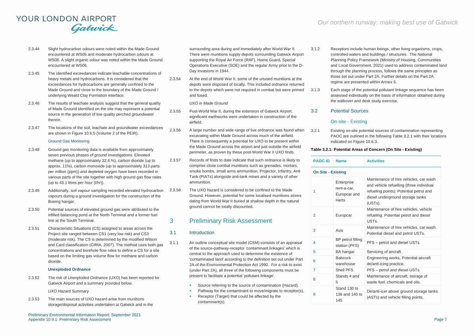
3.2.1 Existing on-site potential sources of contamination representing
PAOC are outlined in the following Table 3.2.1 with their locations
indicated on Figure 10.6.3.
Table 3.2.1: Potential Areas of Concern (On Site - Existing)
PAOC ID Name Activities
On Site - Existing
1
Enterprise
rent-a-car,
Europcar and
Herts
Maintenance of hire vehicles, car wash
and vehicle refuelling (three individual
refueling points). Potential petrol and
diesel underground storage tanks
(USTs).
2 Europcar
Maintenance of hire vehicles, vehicle
refueling. Potential petrol and diesel
USTs.
3 Avis Maintenance of hire vehicles, car wash.
Potential diesel and petrol USTs.
4 BP petrol filling
station (PFS) PFS – petrol and diesel USTs.
5 BA hangar Servicing of aircraft.
6 Babcock
warehouse
Engineering works, Potential aircraft
de/anti-icing practice.
7 Shell PFS PFS – petrol and diesel USTs.
8 Stands 4 and
5
Maintenance of aircraft, storage of
waste fuel, chemicals and oils.
9
Stand 130 to
136 and 140 to
145
De/anti-icer above ground storage tanks
(ASTs) and vehicle filling points.

Preliminary Environmental Information Report: September 2021 Appendix 10.9.1: Preliminary Risk Assessment Page 8
Our northern runway: making best use of Gatwick
PAOC ID Name Activities
10 Fire Station Maintenance vehicle storage area.
11 TCR Repair of ground support vehicles, oil
ATSs.
12 DHL Waste treatment plant
13 Fuel Farm Aviation fuel ASTs and potential
underground pipeline.
14 Wet tip
Sewage waste septic tank, lined storage
lagoons for contaminated surface water
runoff.
15 Fire Fighting
Area
Fire training, propane AST and
underground pipe, kerosene.
16 Oscar Remote
Stands
Refuelling area and vehicle wash. Fuel
USTs, gas oil AST, soap AST, engine
and hydraulic oil ASTs, Adblue IBCs.
17 Stand 574 Maintenance of aircraft, storage of
waste fuel, chemicals and oils.
18 Stand 558 Large fuel spill (2019)
19 Esso PFS PFS – petrol and diesel USTs.
20 Texaco PFS PFS – petrol and diesel USTs.
45 to 48,
50, 51, 53
to 55, 57,
60 to 77
Electricity
substations Electricity substations
3.2.2 Made Ground, likely to be present across the Project site as a
result of construction/demolition activities, is also considered to
represent a potential source of contaminants of concern.
3.2.3 Made Ground and superficial deposits (in particular Alluvium
including peat and organic clays) may represent potential sources
of ground gas generation.
On-site – Historical
3.2.4 Historical on-site potential sources of contamination representing
PAOC are outlined in the following table with their locations
indicated on Figure 10.6.3 (Volume 2 of the PEIR).
Table 3.2.2: Potential Areas of Concern (On Site - Historical)
PAOC ID Name Activities
On Site - Historical
21 Timber Yard Potential timber treatment
PAOC ID Name Activities
22 Fuel Depots Potential fuel tanks and pipework
23
Smithy, Engine
House and
Tramway
Sidings
Smithy, Engine House and Tramway
Sidings
24 Railway Sidings Railway Sidings
25 to 32 Tank(s) Unknown use
33 Tanks Unknown use, dates from 1960s /
1970s
34 Gasometers Potential pipework, sumps
35 to 39 Water
bodies/ponds Potential backfill unknown
40 Balancing Pond Potential backfill unknown
41 Reservoir/pond Potential backfill unknown
42 Pit Potential backfill unknown
43, 44,
49, 52
and 56
Electricity
substations
Electricity substations
58 Pollution
Incident
Significant impact to water – List 2
substance (unspecified) - 2016
Off-site – Existing
3.2.5 The only existing off-site potential source of contamination
representing a PAOC is outlined in the following table with its
location indicated on Figure 10.6.3 (Volume 2 of the PEIR).
Table 3.2.3: Potential Areas of Concern (Off-Site - Existing)
PAOC ID Name Activities
Off Site - Existing
59 Crawley STW Sewage Treatment Works, CHP Plant
Off-site – Historical
3.2.6 No potentially significant historical off-site sources of
contamination have been identified.
3.3 Potential Pathways
3.3.1 The risks to future on site human health receptors via the
pathways of dermal contact and ingestion will be mitigated in
areas of proposed building or hardstanding as the pathway will be
inactive. However, in any areas of proposed soft landscaping, the
pathways of dermal contact and ingestion could still be active. In
addition, there would be potential for the airborne migration of
soil/dust from these areas.
3.3.2 There is the potential for ground gas (from on or off-site sources)
and volatile contaminants of concern in soil and/or groundwater
(if present) beneath the site to impact future site users where
buildings are proposed via the inhalation pathway in indoor areas.
3.3.3 There is the potential for contaminants of concern (if present)
beneath the site to migrate beneath the Project site via perched
groundwater (if present) within granular horizons of the Made
Ground, the superficial deposits and the weathered Weald Clay
Formation. These contaminants may impact either controlled
waters receptors or off-site human heath receptors via the dermal
contact, ingestion and vapour inhalation pathways.
3.3.4 The surface water drainage system (where discharging to
controlled waters) service corridors and/or subterranean
infrastructure corridors could act as preferential pathways for the
migration of any potential contaminants of concern.
3.3.5 The Weald Clay Formation is considered to be sufficiently
impermeable and thick as to prevent the downward vertical
migration of any contaminants within groundwater (if present) to
the underlying Tunbridge Wells Sand Formation. This pathway
may require consideration where piles that breach the thickness
of the Weald Clay Formation are required as part of building
construction.
3.4 Potential Receptors
3.4.1 Potential human receptors include future site users, construction
workers during site development works and off-site human
receptors including workers, residents and general public users
on land within or adjacent to the Project site.
3.4.2 Elevated levels of ground gas and depleted oxygen levels have
been detected as part of previous investigations. In addition,
asbestos has been identified within Made Ground sampled from
beneath the Project site. These findings would be taken into
account in the design of further ground investigations and
remediation strategy (where required) and Health and Safety risk
assessments.
3.4.3 Head deposits are indicated to be present in a small area in the
centre of the Project site. This stratum are classified as a
Secondary Undifferentiated Aquifer. Given this classification, it is
not considered to represent potential controlled waters receptor.

Preliminary Environmental Information Report: September 2021 Appendix 10.9.1: Preliminary Risk Assessment Page 9
Our northern runway: making best use of Gatwick
3.4.4 The Alluvium (indicated to be present across parts of the north,
east and west) of the Project site and River Terrace Deposits
(indicated to be present across parts of the west, centre and east)
are classified as Secondary A Aquifers and, as such, are
considered to be potential controlled waters receptors.
3.4.5 The Tunbridge Wells Sand Formation Secondary A Aquifer at
depth is not generally considered a potential receptor given the
upper level of protection afforded by the significant thickness of
the overlying impermeable Weald Clay Formation. However, this
stratum may become a potential receptor where piles that breach
the thickness of the Weald Clay Formation are required as part of
building construction.
3.4.6 Surface water receptors are considered to comprise the River
Mole (flowing through the Project site) and its associated
tributaries including Crawter’s Brook, the Gatwick Stream, Man’s
Brook, Burstow Stream and Westfield Stream (which either flow
through or close to the Project site).
3.4.7 The groundwater abstraction located approximately 1 km to the
south of the site, is not considered a potential receptor due to the
distance and it is located hydraulically up-gradient from the
Project site.
4 Conceptual Site Model
4.1 Outline Conceptual Site Model
4.1.1 An outline CSM has been developed for the overall Project site
on the basis of the site reconnaissance and desk study. It
considers each element of the Project and identifies potential
sources, pathways and receptors (ie potential pollutant linkages).
The outline CSM is summarised in Table 4.1.1 below.

Preliminary Environmental Information Report: September 2021 Appendix 10.9.1: Preliminary Risk Assessment Page 10
Our northern runway: making best use of Gatwick
Table 4.1.1: Outline Conceptual Site Model
Potential Source Contaminants of Concern Via Potential Pathways Linkage Potentially
Active? Receptors
On site – existing:
PAOC 1 to PAOC 20, PAOC 45 to 48, PAOC 50, PAOC 51,
PAOC 53 to 55, PAOC 57, PAOC 60 to 77
On site – historical:
PAOC 21 to PAOC 58, PAOC 44, PAOC 49, PAOC 52,
PAOC 56
Metals, inorganics, hydrocarbons,
glycols, VOCs, SVOCs, PCBs,
PFOS/PFAS, pesticides, herbicides and
asbestos
Soil
Direct contact/ingestion ✓1
Future site users
Construction workers
Inhalation of volatiles ✓2
Future site users
Construction workers
Airborne migration of soil or
dust
✓1
✓1
Future site users
Construction workers
Off-site users
Leaching of mobile
contaminants
✓
✓
3
Alluvium Secondary A Aquifer
River Terrace Deposits Secondary A Aquifer
Tunbridge Wells Sand Formation Secondary A
Aquifer
Ground
water
Direct contact/ingestion ✓
1
✓
Future site users
Construction workers
Off-site users
Inhalation of volatiles ✓
2
✓
Future site users
Construction workers
Off-site users
Lateral migration in
permeable strata
✓
✓
✓
Alluvium Secondary A Aquifer
River Terrace Deposits Secondary A Aquifer
River Mole and associated tributaries
Off-site – existing:
PAOC 59
Metals, inorganics, pesticides, PCBs,
treatment chemicals, pathogens,
hydrocarbons and asbestos
Ground
water
Lateral migration and
subsequent inhalation of
volatiles
✓2
Future site users
Construction workers
On and off-site:
Made Ground / natural strata (including superficial deposits),
PAOC 35 to PAOC 42 and PAOC 14 and PAOC 58 or bio-
degradation of contamination
Carbon dioxide and methane Ground
Gas
Vertical and lateral migration
and subsequent inhalation of
ground gas
✓2
✓
Future site users
Construction workers
Off-site users
Explosive risks ✓
2
✓
Future site users
Construction workers
Off-site users
Notes:
1 Pathway will be inactive in areas of proposed building cover and hardstanding
2 Pathway will be inactive in areas where buildings/confined spaces are not proposed
3 This pathway may be active where piles that breach the thickness of the Weald Clay Formation are required as part of building construction

Preliminary Environmental Information Report: September 2021 Appendix 10.9.1: Preliminary Risk Assessment Page 11
Our northern runway: making best use of Gatwick
5 Conclusions and Recommendations
5.1.1 The Preliminary Risk Assessment has identified a number
historical and current potential sources of contamination
representing PAOC across the Project site. The outline CSM
produced as part of the assessment has identified a number of
potential pollutant linkages associated with these sources that
may be active where areas of the Project site are proposed for
development.
5.1.2 In order to determine requirements for further assessment, the
locations of PAOC have been overlain on the boundaries of the
proposed development areas and are indicated on Figure 10.6.4
(Volume 2 of the PEIR).
5.1.3 Recommendations for each development area have been derived
in consideration of:
▪ PAOC located within the development area boundary;
▪ whether any buildings are proposed as part of the
development (thus requiring consideration of the ground
gas/vapour inhalation pathway); and
▪ pre-existing site investigation data, where available.
5.1.4 A flowchart detailing the recommendation strategy for further
works is provided in Annex 6 together with a table detailing
recommendations for each development area.
5.1.5 Where recommended, the scope of any further ground
investigation will be determined on a case-by-case basis and will
be agreed with the Environment Agency/relevant local planning
authority prior to its implementation. Investigations may include
some of the following:
▪ drilling of boreholes or excavation of trial pits, targeting
identified PAOC and pollutant linkages;
▪ installation of groundwater and gas monitoring wells;
▪ collection of soil and groundwater samples with chemical
analysis of these samples for contaminants of concern;
▪ ground gas monitoring from wells installed at the site; and
▪ assessment of ground conditions and generic quantitative
risk assessment of soil and groundwater chemical analysis
results to determine the potential for the identified potential
pollutant linkages to remain active upon development of the
area.
5.1.6 Where appropriate, the investigations will include geotechnical
testing to provide information on land stability and inform detailed
design. Following the ground investigation, a remediation strategy
will be implemented, where necessary. At this stage, the strategy
is anticipated to comprise the following:
▪ the proposed remediation technique;
▪ implementation plan setting out the objectives and
requirements of the remediation;
▪ validation sampling to confirm that remediation objectives
have been met; and
▪ verification report.
5.1.7 The scope of the remediation strategy will be agreed with the
Environment Agency/relevant local planning authority prior to its
implementation. On completion of the remediation works, a
verification report will be sent to the Environment Agency/relevant
local planning authority for approval. Subject to the scope of the
remediation strategy, the following will be undertaken where
appropriate to inform construction activities and the detailed
design of the buildings:
▪ Piling risk assessment (in accordance with the Environment
Agency guidance) including control measures (where
appropriate) to mitigate risk to controlled waters during piling
installation;
▪ Detailed ground gas risk assessment and gas control
measures during construction and to be incorporated into
building design (where appropriate); and
▪ Groundwater and/or surface water monitoring.
5.1.8 The remediation strategy will be supported by a Project wide
Material Management Plan prepared in accordance with CL:AIRE
Code of Practice (CL:AIRE, 2011).
5.1.9 Where, further ground investigation is not recommended at this
stage, a discovery strategy would be implemented for that
development area as a watching brief for any unanticipated or
previously un-encountered contamination. RPS or another
suitably trained personnel would be contacted, where any
significant visual or olfactory evidence of contamination, not
previously encountered, is identified by construction workers
during the development works. The following shall be considered
indicative of soil contamination that may require remediation:
▪ the presence of free phase contamination (liquid oils);
▪ fibrous or cement bound materials (potentially asbestos
containing materials);
▪ significant staining and discolouration of exposed soils; and /
or
▪ olfactory evidence of hydrocarbon contamination.
5.1.10 Any construction activities in the area of this material would
cease until an appropriate plan for dealing with the contamination
has been put in place.
5.1.11 In terms of construction workers, prior to construction works
taking place specific risk assessment will be required in line with
Health & Safety requirements. This will enable control measures
and appropriate levels of PPE to be implemented.
6 References
Legislation
Contaminated Land (England) Regulations 2006 (as amended
2012).
Environmental Damage (Prevention and Remediation)
Regulations 2015.
The Water Resources Act 1991.
Published Documents
British Geological Survey [n/d] Geology of Britain Viewer [online]
Available at:
https://www.bgs.ac.uk/discoveringGeology/geologyOfBritain/view
er.html Accessed: 18 December 2019
British Standards Institution (2011) British Standard BS
10175:2011+A2:2017: Investigation of Potentially Contaminated
Sites: Code of Practice.
British Standards Institution (2015) Code of practice for ground
investigations (BS5930:2015).
British Standards Institution (2015) Code of practice for the
design of protective measures for methane and carbon dioxide
ground gases for new buildings (BS8485:2015+A1:2019).
DEFRA (2012) Environmental Protection Act 1990: Part 2A -
Contaminated Land Statutory Guidance.
DEFRA (2014) Category 4 Screening Levels
Department of the Environment (1995) Industry Profile – Airports.
Department for Transport (2015) National Policy Statement for
National Networks. [Online] Available at:
https://assets.publishing.service.gov.uk/government/uploads/syst
em/uploads/attachment_data/file/387223/npsnn-web.pdf

Preliminary Environmental Information Report: September 2021 Appendix 10.9.1: Preliminary Risk Assessment Page 12
Our northern runway: making best use of Gatwick
Department for Transport (2018) Airports National Policy
Statement: New Runway Capacity and Infrastructure at Airports
in the South East of England. [Online] Available at:
https://assets.publishing.service.gov.uk/government/uploads/syst
em/uploads/attachment_data/file/714106/airports-nps-new-
runway-capacity-and-infrastructure-at-airports-in-the-south-east-
of-england-web-version.pdf
CL:AIRE (March 2011) Definition of Waste. Development Industry
Code of Practice, Version 2.
Construction Industry Research and Information Association
(CIRIA) (2007) C665: Assessing Risks Posed by Hazardous
Ground Gases to Buildings.
CIRIA Document C552 – Contaminated land Risk Assessment: A
Guide to Good Practice (CIRIA, 2001a).
CIRIA Document C532 – Control of Water pollution from
Construction Sites: Guidance for Consultants and Contractors
(CIRIA, 2001b).
Environment Agency (2001) Piling and Penetrative Ground
Improvement Methods on Land Affected by Contamination:
Guidance on Pollution Prevention. NC/99/73.
Environment Agency (February 2002) Piling into contaminated
sites. National Groundwater and Contaminated Land Centre.
Environment Agency (2020) Land Contamination: Risk
Management
Highways Agency (2008) Design Manual for Roads and Bridges.
Vol 4. Geotechnics and Drainage. Section2. Earthworks, Part 2.
HD22/08. Managing Geotechnical Risk.
Land Quality Management and Chartered Institute of
Environmental Health (LQM/CIEH) (2015) S4ULs for Human
Health Risk Assessment
Ministry of Housing, Communities and Local Government (2021)
National Planning Policy Framework (NPPF). [Online] Available
at:
https://assets.publishing.service.gov.uk/government/uploads/syst
em/uploads/attachment_data/file/1005759/NPPF_July_2021.pdf
Nathanail, C.P., McCaffrey,C., Gillett, A.G., Ogden, R.C. &
Nathanail, J.F. (2015) The LQM/CIEH S4ULs for Human Health
Risk Assessment, Land Quality Press, Nottingham.
.

Preliminary Environmental Information Report: September 2021 Appendix 10.9.1: Preliminary Risk Assessment Page 13
Our northern runway: making best use of Gatwick
7 Glossary
7.1 Glossary of terms
Table 7.1.1: Glossary of Terms
Term Description
AST Above ground Storage Tank
AC Assessment criteria
BGL Below ground level
BGS British Geological Survey
BTEX Benzene, Toluene, Ethylbenzene and Xylene
C4SL Category 4 Screening Level
CO Carbon Monoxide
CS Characteristic Situation
CSM Conceptual Site Model
DQRA Detailed Quantitative Risk Assessment
DWS Drinking Water Standard
EA Environment Agency
EIA Environmental Impact Assessment
EQS Environmental Quality Standard
GAC Generic Assessment Criteria
GAL Gatwick Airport Limited
IBC Integrated Bulk Container
KM Kilometers
L/Hr Litres per hour
LGS Local Geological Site
mb Millibars
MBAS Methylene Blue Active Substances
NVZ Nitrate Vulnerable Zone
OS Ordnance Survey
PAOC Potential Areas of Concern
PCB Polychlorinated Biphenyl
PFAS Perfluoroalkyl substances
PFOS Perflyorooctane sulphonic acid
PPE Personal Protective Equipment
PPM Parts per million
RAF Royal Air Force
S4UL Suitable 4 Use Levels
SgZ Safeguard Zone
SOE Special Operations Executive
Term Description
SSSI Site of Special Scientific Interest
SVOCs Semi Volatile Organic Compounds
TPH Total Petroleum Hydrocarbons
UST Underground Storage Tank
UXO Unexploded Ordnance
VOCs Volatile Organic Compounds
WHO World Health Organisation
WHO ATO World Health Organisation Appearance Taste
Odour
WFD Water Framework Directive

Preliminary Environmental Information Report: September 2021 Appendix 10.9.1: Preliminary Risk Assessment Annex 1
Our northern runway: making best use of Gatwick
Annex 1
Assessment Limitations
Preliminary Environmental Information Report: September 2021 Appendix 10.9.1: Preliminary Risk Assessment Annex 1
Our northern runway: making best use of Gatwick
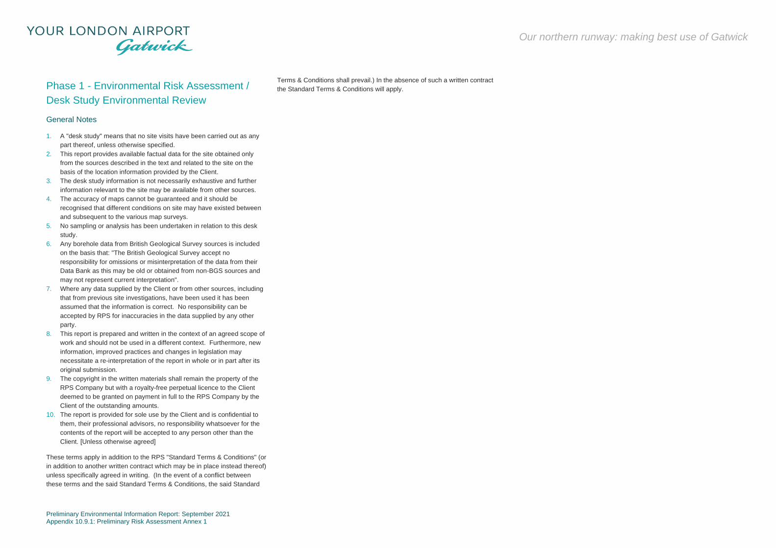
Phase 1 - Environmental Risk Assessment /
Desk Study Environmental Review
General Notes
1. A "desk study" means that no site visits have been carried out as any
part thereof, unless otherwise specified.
2. This report provides available factual data for the site obtained only
from the sources described in the text and related to the site on the
basis of the location information provided by the Client.
3. The desk study information is not necessarily exhaustive and further
information relevant to the site may be available from other sources.
4. The accuracy of maps cannot be guaranteed and it should be
recognised that different conditions on site may have existed between
and subsequent to the various map surveys.
5. No sampling or analysis has been undertaken in relation to this desk
study.
6. Any borehole data from British Geological Survey sources is included
on the basis that: "The British Geological Survey accept no
responsibility for omissions or misinterpretation of the data from their
Data Bank as this may be old or obtained from non-BGS sources and
may not represent current interpretation".
7. Where any data supplied by the Client or from other sources, including
that from previous site investigations, have been used it has been
assumed that the information is correct. No responsibility can be
accepted by RPS for inaccuracies in the data supplied by any other
party.
8. This report is prepared and written in the context of an agreed scope of
work and should not be used in a different context. Furthermore, new
information, improved practices and changes in legislation may
necessitate a re-interpretation of the report in whole or in part after its
original submission.
9. The copyright in the written materials shall remain the property of the
RPS Company but with a royalty-free perpetual licence to the Client
deemed to be granted on payment in full to the RPS Company by the
Client of the outstanding amounts.
10. The report is provided for sole use by the Client and is confidential to
them, their professional advisors, no responsibility whatsoever for the
contents of the report will be accepted to any person other than the
Client. [Unless otherwise agreed]
These terms apply in addition to the RPS "Standard Terms & Conditions" (or
in addition to another written contract which may be in place instead thereof)
unless specifically agreed in writing. (In the event of a conflict between
these terms and the said Standard Terms & Conditions, the said Standard
Terms & Conditions shall prevail.) In the absence of such a written contract
the Standard Terms & Conditions will apply.

Preliminary Environmental Information Report: September 2021 Appendix 10.9.1: Preliminary Risk Assessment Annex 2
Our northern runway: making best use of Gatwick
Annex 2
Walkover Observations

Preliminary Environmental Information Report: September 2021 Appendix 10.9.1: Preliminary Risk Assessment Annex 2
Our northern runway: making best use of Gatwick
Site visit was completed of Gatwick airport on the 25th of September 2019
Table A2.1: Summary of on site activities
Section Description
Site Layout:
The site comprised Gatwick Airport and associated infrastructure including a number of hotels, offices and a railway station.
The airport operations included two runways (main and central) located in the south of the site. A number of carparks, two commercial buildings, a British Airways Hangar and warehouse were located to the south
of the runways.
The land to the far north west of the runway comprised a fire training ground with undeveloped, (likely agricultural) land beyond.
The main airport operations area to the north of the runways comprised a Boeing Hangar, Virgin Hangar, a number of aircraft stands and a maintenance area in the north west with car parking areas for long stay
parking further to the north west. The central north area comprised a number of taxiways and aircraft stands, a cargo centre, the fire station, storage areas, a fuel farm and further car parking areas. To the north
east of the runways were further aircraft stands and taxiways, the two airport terminals and a number of offices and hotels.
The airport also comprised an eastern area located beyond the railway line and A23, which comprised a number of car parks, vehicle hire offices and workshops, hotels, offices and fast food restaurants.
Activity /
Operations:
For ease of description the site has been separated into the below areas.
Eastern area:
This area is located to the east of the main airport, beyond the railway line and A23. The southern portion of the eastern area comprised woodland with two ponds in the south (likely associated with adjacent
sewage treatments works). The center of the eastern area was occupied by a number of long stay car parks, including self-park south, south valet and valet courtyard, as identified on Figure 5.2.1b. The long stay
car parks were accessed from Ring Road South. Also located adjacent to the Ring Road to the north of the car parking areas (between self-park south robotics and the coach park on Figure 5.2.1b) were two
buildings comprising maintenance areas occupied by Enterprise rent-a-car, Europcar and Herts for the maintenance of hire vehicles. The buildings were also noted to comprise car wash areas and vehicle
refueling areas with three individual refueling points noted. Labelling on the refueling points indicated that underground storage tanks of petrol were located below. Two further vehicles hire company maintenance
areas were noted within the south valet car parking area. One (located adjacent to the east of Pond G (Figure 5.2.1e) was occupied by Europcar and also appeared to include a refueling area with likely
underground fuel storage tanks.
An Avis vehicle maintenance area was also located in the east of the site to the south of the forecourt, leading from the south terminal. The maintenance area also appeared to be utilized for the repair of hire
vehicles and included a car wash and vehicle refueling facilities with labelling on the dispensing pumps indicating both diesel and petrol underground tanks were present.
The northern area of the east of the site comprised a multi-store car park and forecourt area (leading via aboveground covered walkways to the south terminal), a Hilton Hotel, a Marriott Hotel, two office buildings a
drive in McDonalds and KFC restaurant and a petrol filling station operated by BP and associated car parking areas.
South of the runways:
Car parking areas were located to the southwest of the runways which predominantly appeared to be utilised as long stay parking for customers. The south east of the runway included a staff car park area (car
park z on Figure 5.2.1b) with a material store to the north of the car park for storage of grit and other hardcore materials reported to be currently utilised for the development of a new slipway. A British Airways
hangar was located adjacent to the east of the car park and was reported to be utilised for the servicing of aircraft. The hangar was not permitted to be accessed as part of the site walkover but appeared to
comprise warehouse / maintenance area on the airside with offices to the rear. Two large above ground tanks were noted to the rear of the hangar and appeared to be sprinkler water storage tanks, however this
was not confirmed. Further car parking and a warehouse noted to be occupied by Mitie (facility management) and Babcock (engineering services) were located to the south east of the runways. A disused aircraft
was also located in this area, reported to be utilised for the practising of de/anti-icing however only water was reported to be used.
Northeast of the runways:
The north east of the runway comprised the South and North Airport Terminals and associated piers and aircraft stands. Hotels, offices and commercial buildings were also located in the landside area of the north
east of the site including a police station and a Shell petrol filling station. The airside in the north east of the airport included small engineering areas (one of which was located to the south of stands 4 and 5) and
another adjacent to stand 574. The engineering areas were utilised by each air firm for the maintenance of airplanes at the stands and included the storage of waste from the airplanes such as waste fuel and also
small amounts of chemicals and oils for use in airplane maintenance. The majority of the non-waste chemicals were noted to be stored on bunds or in bunded stores.
Above ground de/anti-icer storage tanks and materials were stored in the area of stands 136 to 140 just north east of the runways.
Centre north of the runways:

Preliminary Environmental Information Report: September 2021 Appendix 10.9.1: Preliminary Risk Assessment Annex 2
Our northern runway: making best use of Gatwick
Section Description
A fire station and airside maintenance vehicle storage area were located to the immediate north centre of the runways. Further aircraft stands and a cargo centre (comprising of terraced warehouse units) were
present beyond this. The cargo centre occupants included Royal Mail, World Freight Service and Animal Aircare Ltd and TCR (air industry ground support equipment servicing). The unit occupied by TCR was
utilised for the repair of ground support vehicles.
Further car parking and a waste treatment plant occupied by DHL were located to the north of the Cargo Centre with a fuel farm comprising five large above ground tanks for the storage of aviation fuel located in
the far north. The aviation fuel was reported to be transported directly to the tanks via an underground pipeline. Access was not permitted to the fuel farm as part of the site walkover. Adjacent to the fuel farm was
a small waste area (referred to as the “wet tip”) where sewage waste from the aircraft was disposed of to a septic tank. In addition, the waste area comprised two lined pools for the storage of surface water from
the runways / external areas and contaminated water from the runways / external areas.
North west of the runways:
The far northwest of the runways included an area utilised by the fire service for training purposes with undeveloped, likely agricultural land beyond. Two dummy aircraft were located in this area for fire training
purposes. An above ground propane storage tank was present in the south west of the fire training area with beneath ground pipework supplying the large dummy aircraft in the centre. A land drain was noted
around the fire service training area.
The area to the north west of the runways also included a Boeing hangar, currently under development and not yet in use, a Virgin hangar, aircraft stands and a maintenance area (Oscar Remote Stands on Figure
5.2.1a), including refuelling area for ground service vehicles and vehicle wash facilities. A large long stay car parking area was also located beyond the Virgin hangar to the north west of the runways.
The majority of the airside vehicles on-site were noted to be electric powered with numerous recharging points located around the airport.
Drainage:
Slot drains were observed in the runway, taxiway and aircraft stand areas. The site representative reported that all drainage within the airside area and possible also the landside area operated by Gatwick drains
to a number of ponds located around the airport. The ponds then connect to a water treatment plant located in the north of the site, above stand 64, where the surface water is treated and tested before being
discharged to the River Mole.
The site representative reported that all drainage within the airside area can be controlled and either closed off or directed to a dedicated pond in the event of a spill.
A vehicle refuelling and adjacent car wash were located in the landside maintenance area (Oscar Remote Stands), surface water drains were noted surrounding the vehicle refuelling area and below the vehicle
wash. It was not known where the drains discharged to or if an interceptor was present, however, the site representative reported that, similarly to all drainage on-site, the drains entered an on-site pond for
treatment. Three adjacent drain covers were noted in the refuelling area vicinity indicating the potential presence of an interceptors.
Further refuelling areas and vehicle washes were noted in the eastern area of the site operated by vehicle hire firms. Dedicated surface water drainage was not noted in the vicinity of the vehicle hire maintenance
areas in the east of the site excluding the Europcar maintenance area adjacent to the east of Pond G where surface water drains were noted in the vicinity of the refuelling area. It was not known if an interceptor
was present in these areas.
A septic tank for foul waste from the airplanes was reported to be located in the north of the site north of the fuel farms. This was reported to be collected and disposed of off-site.
Bulk Storage /
Tanks:
Five above ground bulk storage tanks of aviation fuel were observed in the fuel farm in the north of the site. The capacity of the tanks was not provided, however, given their size it is considered to be in the millions
of litres. It was also not clear if the tanks extended below ground. The tanks were reported to be directly filled from an underground pipeline which was reported to extend from a dedicated port to the airport. Fuel
was then reported to be connected to the airplane stands via underground pipework with a refuelling point at each aircraft stand. The fuel was reported to be piped through the underground pipework at high
pressure.
A refuelling area for the fuelling of airside support vehicles was located in the maintenance area (Oscar Remote Stands) in the centre north of the site. The refuelling area was noted to comprise eight dispensing
points and five ventilation pipes indicated the presence of approximately five underground fuel storage tanks. The tanks were reported to contain diesel, petrol and gas oil. A refill point for an unleaded petrol
underground storage tank was noted with labelling indicating the tank was 29,100 litres in capacity. No other refill points were identified.
An above ground bulk storage tank of gas oil (48,500 litres capacity) was also noted in the Oscar Remote Stands area. The tank was noted to comprise an integrally bunded tank with the refill and dispensing
points / hose located behind a roller shutter door within the bund. No significant staining was noted in the area. An integrally bunded tank of Adblue was also noted.
A 6,500 litre aboveground storage tank reported to comprise soap (SC08 Stand Cleaner) was also noted in this area. The tank was located within a brick bund. The bund was not covered and was filled with an
approximately 5cm deep layer of green coloured liquid. It was not clear if this represented a leak from the tank or the combination of a leak and rainwater or other contamination.
Adjacent to the refuelling area in Oscar Remote Stands was a maintenance warehouse for the servicing of airside support vehicles. Three above ground tanks were noted on a mezzanine level within the
warehouse. The tanks were reported to comprise engine and hydraulic oil and were connected by aboveground pipework to refilling and dispensing points. A bunded external store of drums of oil and intermediate
bulk containers of Adblue were also noted.

Preliminary Environmental Information Report: September 2021 Appendix 10.9.1: Preliminary Risk Assessment Annex 2
Our northern runway: making best use of Gatwick
Section Description
Two petrol filling stations were noted on site. A Shell operated PFS was located in the north east of the site, adjacent to the Premier Inn. The forecourt area of the Shell PFS was not accessed and therefore, the
number, capacity and contents of the underground tanks was not identified. The second PFS was located in the north east of the site adjacent to the McDonalds restaurant and was operated by BP. Labelling on
the refill points for the underground storage tanks indicated the presence of five tanks as below:
57,730 litres diesel;
43,120 unleaded petrol;
14,610 diesel;
31,120 unleaded petrol; and
14;610 unleaded petrol.
Underground fuel storage tanks containing petrol and diesel are also considered likely to be present beneath the refuelling areas operated by vehicle hire companies in the east of the site. RPS considers that there
is the potential for approximately ten underground tanks to be present between the five hire car facilities.
Above ground de/anti-icer tanks were noted in the centre of the site in the area of stand 130 to 145. The de/anti-icer tanks comprised four 80,000 litre tanks of ECO2 and two 80,000 litre tanks of KONSIN for the
de/anti-icing of the runways, taxi areas and aircraft stands. Above ground pipework connected to small generators was located between the tanks which was operated to fill de/anti-icing vehicles with the de/anti-
icer when required, each vehicle was reported to hold 6,000 litres of de/anti-icer. Granular de/anti-icing material (Safegrip SF) was also stored in a covered area adjacent to the tanks. Both ECO2 and KONSIN
were utilised for the de/anti-icing of the runways with Type IV reported to be utilised for the de/anti-icing of planes. Three 80,000 litre above ground storage tanks of Type IV for the de/anti-icing of planes were also
located in this area. Further above ground storage tanks of de/anti-icer for the aircraft were located in integrally bunded tanks to the south of the fuel farm.
The TCR maintenance area included two above ground oil storage tanks of 2,000 litre capacity. The tanks were located internally to the unit. Some staining of the underlying hardstanding was noted.
Waste:
Waste contaminated water from spills and similar events was reported to be cleaned up by a dedicated cleaning vehicle with a vacuum function with the contaminated water then disposed of in the wet tip area,
located in the north of the site immediately beyond the aviation fuel farm. The wet tip comprised two pools / pit which appeared to be concrete lined. One pool was for contaminated water and the other was for
littered surface water. The surface water pool was reported to be discharged to the drainage system with any litter waste within the pool collected and crushed. Contaminated water was reported to be collected by
a waste tanker and disposed of off-site. The waste tanker was reported to be operated by Sweeptank.
Contaminated mats and granules following a spill event were also stored in the wet tip area in a covered store in metal 205 litre drums located on plastic bunds. DHL were reported to collect the waste
contaminated materials.
Containers (metal drums, boxes and intermediate bulk containers) of contaminated rags, waste oil filters, waste oil and waste chemical containers were noted on-site, stored in the air firm maintenance areas, the
airside vehicle maintenance area in Oscar Remote Stand and within the TCR maintenance warehouse.
An above ground metal waste oil tank and intermediate bulk containers of adblue were located externally to the airside vehicle maintenance area. Both were reported to be collected by DHL.
An above ground waste oil tank was also located internally to the TCR maintenance warehouse. The tank was reported to be approximately 2,000 litres in capacity. Contaminated waste from the TCR unit was
reported to be collected by Oakwood.
Electricity
Substations
/Transformers:
Electricity substations were reported to be present on site and were understood to be the responsibility of Gatwick Airport. The site representative was not aware of the location of all the substations however one
was noted in the south west and one in the east of the site, adjacent to Pond G. The substation adjacent to Pond G was labelled as the responsibility of UK Power Networks.
Visual Evidence
of
Contamination:
The site representative reported that, on occasions, the refuelling of planes has resulted in small spills of fuel. Spill kits were located throughout the site and all airside support vehicles were noted to carry spill kits
with absorbent booms, granules and specialist clay to block drains.
A recent large fuel spill (in 2019) was reported to have occurred in the area of stand 558. The spill was the result of ground works damaging an aviation fuel pipe which caused a large geyser of fuel given the
pressure of the pipes. The airport fire service and airside support were reported to have attended the event.
Statutory
Nuisance: The site representative reported no knowledge of any statutory nuisances in relation to the site.
Other Issues: No Japanese Knotweed or Giant Hogweed (invasive plant species) were readily identified on or adjacent to the site at the time of the survey. (It should be noted that the identification can be limited by the seasons
and in areas of dense vegetation growth).
The Surrounding Area
The site is located in an area of mixed commercial, agricultural and residential area land uses. At the time of the site inspection, neighbouring land consisted of the following:

Preliminary Environmental Information Report: September 2021 Appendix 10.9.1: Preliminary Risk Assessment Annex 2
Our northern runway: making best use of Gatwick
Table A2.2: Neighbouring Land Uses
Direction Description
North: Agricultural land with residential properties beyond.
East: Agricultural land and residential properties.
South: Agricultural land and industrial estate.
West: Agricultural land and residential properties.
The River Mole was observed to run along the northern edge of the site.

Preliminary Environmental Information Report: September 2021 Appendix 10.9.1: Preliminary Risk Assessment Annex 3
Our northern runway: making best use of Gatwick
Annex 3
Previous Ground Investigation Reports Summary

Preliminary Environmental Information Report: September 2021 Appendix 10.9.1: Preliminary Risk Assessment Annex 3
Our northern runway: making best use of Gatwick
Table A3.1: Summary of Existing Ground Investigation Reports
No Report Title GAL
Reference Date
In Genesis
Area? Purpose GI Scope Soil Samples? GW Samples?
GW Level
Monitoring?
Long term?
Ground Gas
Monitoring?
Interpretation of
Environmental
Results?
1
A380 On Stand 125 – Site
Investigation Report
(appendix to document)
2A125-00-
C-911-SUR-
000001
14/03/2012 N (Stand 125)
Determine structural strength
of concrete and ability to
handle traffic
4 concrete cores
4 WS holes
4 DCP tests
2 (metals, total TPH,
PAH 16) N N N N
2
Geotechnical Design
Report – Airfield
Operations Building (AOB)
2S169-XX-
C-XXX-
PDR-00007
04/04/2012 N (AOB) GDR for new AOB 6 WS holes
2 GW/Gas MW N N
Y (2 rounds -
March 2012)
Y (2 rounds –
March 2012)
N - No gas RA
undertaken
3
Airfield Taxiway Papa
November (P&N)–
Pavement Investigation
Test Report
2AFLD-00-
C-911-SUR-
000001
17/04/2018
N (taxiway
P&N – no plan
or coordinates
for locations of
core samples)
Pavement investigation 11 concrete cores N N N N N
4
South Terminal Northern
Extension Structural
Assessment of Spare
Capacity in the Existing
Structure
20206-XX-
S-247-BOD-
000026
05/06/2018
N (extension to
Bloc hotel,
located in South
Terminal)
Structural assessment for
proposed extension to the
existing Bloc hotel, includes SI
and associated GDR (as
appendices to the main report)
2 dynamic sampling and
RC follow on boreholes
2 GW MW
2 CPT
4 TP
2 (metals, speciated
PAH, phenol,
cyanide and
asbestos screen)
N N N N
5
Phase I Environmental
Site Assessment 10509471 June 2017
N (Boeing
Hangar)
Desk study prior to
construction of Boeing Hanger
None – included review
of previous Arcadis SI
report
NA NA NA NA NA
Phase II Environmental
Site Assessment
No
reference June 2017
SI prior to construction of
Boeing Hangar
19 WS
2 surface water samples
2 sediment samples
4 TP
12 vapour boreholes
5 spoil heap samples
42
(metals, cyanide,
VOCs, SVOCs, PAH,
phenol, EPH,
asbestos, PCBs,
pesticides/
herbicides
21 (metals, VOCs,
SVOCs and EPH)
Surface water were
also analysed for
cyanide, PCBS,
PFAS, PFOS and
PFOA
Y (1 round)
N but vapour
samples
collected
(ground
gases, TPH
and VOCs)
Y
Focused Soil and
Groundwater Investigation
for PFAS
41525212 09/11/2019 Provide further information on
PFAS, following Phase II SI
5 WS
5 MW
2 surface soil samples
12 (PFAS and
asbestos screen) 4 (PFAS) Y (1 round) N Y
Phase 2 Gatwick Boeing
Hangar Geo
Environmental
Interpretative Report
20000-XX-
B-911-PDR-
000006
July 2017 SI prior to construction of
Boeing Hangar
15 RC boreholes
22 TP
22 CPT
46 (metals, cyanide,
speciated PAH,
banded TPH, VOCs,
AC and asbestos)
and 10 leachate tests
19 (metals,
cyanide, phenols,
speciated PAH,
TPH CWG and
VOC)
Y (6 rounds
over 2.5
months)
Y (6 rounds) Y
GDR – Boeing Hangar
20760-00-C-
915-TDT-
000001
10/11/2017 GDR to enable design of
hangar
23 CPT
4 TP N N N N N

Preliminary Environmental Information Report: September 2021 Appendix 10.9.1: Preliminary Risk Assessment Annex 3
Our northern runway: making best use of Gatwick
No Report Title GAL
Reference Date
In Genesis
Area? Purpose GI Scope Soil Samples? GW Samples?
GW Level
Monitoring?
Long term?
Ground Gas
Monitoring?
Interpretation of
Environmental
Results?
Gatwick Boeing Hangar -
Ground Investigation
Report
20000-XX-
B-911-PDR-
000001
February 2017 SI prior to construction of
Boeing Hangar
13 dynamic sampling
and RC boreholes
7 TP
10 (metals, asbestos,
PAH and TPH CWG)
3 (Metals, PAH,
phenols). GW
samples collected
during drilling
N N N
Gatwick Boeing Hangar –
Geo Environmental
Interpretative report
20760-XX-
R-911-SUR-
000002
February 2017 Interpretation of 20000-XX-B-
911-PDR-000001 report NA As above Y
Gatwick Hangar –
Geotechnical Interpretative
Report
20760-XX-
R-911-SRC-
00002
March 2017 Interpretation of 20000-XX-B-
911-PDR-000001 report NA NA NA NA NA NA
6
Crawters Brook Bird
Netting - Ground
Investigation Report
20000-XX-
C-871-SRC-
000001
14/03/2016
N (along
Perimeter Road
South)
Provide information for bird
netting over Crawters Brook
Stream
5 WS
4 (metals, PAHs,
TPH CWG,
asbestos, cyanide,
phenol and WAC)
N N N N
7 Report on a Geotechnical
Investigation - Dax
20206-00-C-
911-SUR-
000001
November
2012
N (in Southern
Terminal, next
to end of
shuttle)
Geotechnical SI for new
building 2 WS N N N N N
8
Factual Ground
Investigation Report - De-
Icing tanks
J13784 v2 22/10/2018 N
Proposed to locate new free-
standing bunded de-icing
tanks
3 WS
2 PBT
4 concrete cores
4 DCP
2 (metals, banded
TPH, phenol, PAHs,
WAC)
N N N N
9
Ground Investigation -
South Terminal
International Departures
Lounge (IDL)
20206-00-
SR-900-
000001 rev
1
August 1998
Unknown – not
likely as relates
to existing IDL
Geotechnical SI for proposed
extension to IDL 2 CP N N N N N
10
South Terminal External
Security Building – Ground
Investigation Specification
22152-XX-
C-911-SPE-
000004/5
11/10/2017 Not relevant – specification document, no GI
undertaken NA NA NA NA NA NA
11
Fire Training Ground –
Geotechnical and
Contamination
Assessment
106400/010
0
September
1999 Y (fire training
area)
Proposed to redevelop current
fire training ground with a fire
training rig
12 TP
17 (metals, PAH,
phenol, asbestos,
TPH and TEM)
5 (metals, TOC,
nitrate, iron,
manganese, BOD
and COD) from trial
pits
N N Y
Laboratory Analysis Letter
Report
No
reference 22/08/2002 Unknown – very little information provided N
4 (inorganics and
oil fingerprinting) N N N
12 Long Term Storage
Lagoon Nr 1
22150-XX-
C-870-UDT-
000017
03/12/2013 N (to east of
South Terminal)
Refurbish existing storage
lagoon (Pond D) – drainage
calculations
6 WS N N N N N

Preliminary Environmental Information Report: September 2021 Appendix 10.9.1: Preliminary Risk Assessment Annex 3
Our northern runway: making best use of Gatwick
No Report Title GAL
Reference Date
In Genesis
Area? Purpose GI Scope Soil Samples? GW Samples?
GW Level
Monitoring?
Long term?
Ground Gas
Monitoring?
Interpretation of
Environmental
Results?
13
Report on a Ground
Investigation at New
Engineering Stores
12255 March 2011 N Provide information for
foundation design of stores
14 Concrete cores
12 DCP
8 WS
N N N N N
14
Gatwick Batcher Plant –
land contamination results
and Trial Pit Narrative
Document
22196-00-C-
864-TDT-
000001
29/01/2018
Y (one of
construction
compounds)
Provide information of
geotechnical properties of soil 5 TP
5 (metals, asbestos,
PAHs and TPH
CWG)
N N N Y
15
Gatwick Stream Flood
Attenuation –
Contaminated Soil
Sampling from the Control
structure & Haul Road
Results
22089-XX-
U-871-REP-
000004
13/12/2013 N Not provided 3 soil samples
3 (metals, phenol, e-
coli, PAHs, TPH
CWG
N N N N
16
Gatwick Taxiway and AGL
Rehabilitation – Pavement
Site Investigation
20000-XX-
R-XXX-
SUR-
000002
05/06/2013
N (TPs on north
side of Taxiway
42 S)
Not provided 25 Concrete cores
2 TP N N N N N
17
Gatwick Airport
Maintenance Base –
Groundwater Monitoring
and Risk Assessment
20064-XX-
C-911-SUR-
000001
January 2007
Y (one of the
construction
compounds
Monitoring before, during and
after demolition of buildings on
the maintenance base
4 CP
4 MW
16 soil and 3
sediment samples
(metals, asbestos,
cyanide, EPH, PAH,
VOCs and SVOCs)
3 rounds carried
out from 4 newly
installed wells and
8 pre-existing wells
(metals, EPH, PAH,
VOCs and SVOCs)
3 rounds
(only 1
completed at
time of
reporting)
N Y
18
Report on a Ground
Investigation at London
Gatwick Airport South
Terminal - Hangar 5 &
Building P7
20062-00-
SR-247-
000001 Rev
1.0
15/02/2010
Y (one of the
construction
compounds)
Prior to demolition of buildings,
to be replaced by a logistics
centre
3 CP and 3 MW
2 WS
12 (metals, cyanide,
asbestos PAH, VOC,
SVOCs)
3 (metals, cyanide,
PAH, VOC,
SVOCs)
1 round N N
19
Jubilee House Coach
Parking – Ground
Investigation Test Report
20700-00-S-
200-TST-
000001
11/11/2016 N Proposed construction of new
bus/coach pick-up area
3 WS
3 CBR 1 (WAC) N N N N
20
Main and North Runway
Rehabilitation – Ground
Investigation Report
2000-XXC-
4191-REP-
00003
08/12/2017 Y (northern
runway) Rehabilitation of runways
22 Cores with WS
follow-on
N – Hydrocarbon
contamination noted
on logs
N N N N
21 Maintenance Base –
Hangar Decommission Y– duplicate of Report 17
22 MSCP 7 – Ground
Investigation Report
20000-XX-
C-734-SUR-
000001
09/01/2017 N Proposed construction of new
car park
6 dynamic sample with
RC follow-on 10 (WAC) N N N N

Preliminary Environmental Information Report: September 2021 Appendix 10.9.1: Preliminary Risk Assessment Annex 3
Our northern runway: making best use of Gatwick
No Report Title GAL
Reference Date
In Genesis
Area? Purpose GI Scope Soil Samples? GW Samples?
GW Level
Monitoring?
Long term?
Ground Gas
Monitoring?
Interpretation of
Environmental
Results?
MSCP 7 – Geo-
environmental Desk Study
20700-XX-
U-911-TDT-
0000022070
0-XX-U-911-
TDT-000002
August 2016 Desk Study N N N N N
MSCP 7 – Ground
Investigation Report
20700-XX-
C-911-TDT-
000001
12/10/2016
As report 20000-XX-C-
734-SUR-000001
10 (WAC) N N N Y
MSCP 7 Site Investigation
– Additional Groundwater
Monitoring and Reporting
20700-XX-
C-911-TDT-
000002
Rev02
23/07/2017 N N 4 rounds (8
months) N N
23
MSCP 4 – Geo-
environmental Desk Study
22081-XX-
U-911-TDT-
000001
20/06/2017
N Proposed construction of new
car park
Desk Study N N N N N
MSCP 4 – Ground
Investigation Report
20000-XX-
B-911-TDT-
000001
17/01/2018
3 dynamic samples
2with RC follow-on
3 MW
9 WS
18 (metals, PAH,
TPH CWG, phenols,
asbestos and WAC)
3 (pH, sulphate,
magnesium)
3 rounds (4
months) N N
MSCP 4 – Ground
Investigation Report
22081-XX-
C-911-TDT-
000001
05/03/2018 As report 20000-XX-B-911-TDT-000001 Y
24
NT Car Park J Ditch
Remediation Design
Report
20724-XX-
X-864-ROP-
000002
18/11/11 N Investigation of ditch instability
and settlement in car park
2 RC
1 WS
4 TP
3 ditch water sample
points
7 (metals, PAH,
TPH, SVOCs, VOCs,
TEM, asbestos and
WAC)
3 (metals, PAH,
TPH, SVOCs and
VOC)
N N Y
25
North Terminal Extension
– Interpretative
Geoenvironmental Report
20700-XX-
RP-900-
000003
27/03/2009
N Proposed extension to North
Terminal
9 RC + 7 MW
10 WS +
8 MW
14 DP
16 Cores
20 DCP
28 (metals, RPH,
PAH, TPH CWG,
VOCs, SVOCs and
WAC) – no
laboratory certificates
5 (metals, VOCs,
SVOCs, EPH and
PAH) – no
laboratory
certificates
4 rounds
(over 1.5
months)
4 rounds
(over 1.5
months)
Y
North Terminal
Redevelopment –
Geotechnical Desktop Site
Appraisal
20700-XX-
S-247—
BOD-
0000241
01/07/52013 None – desktop review N N N N N

Preliminary Environmental Information Report: September 2021 Appendix 10.9.1: Preliminary Risk Assessment Annex 3
Our northern runway: making best use of Gatwick
No Report Title GAL
Reference Date
In Genesis
Area? Purpose GI Scope Soil Samples? GW Samples?
GW Level
Monitoring?
Long term?
Ground Gas
Monitoring?
Interpretation of
Environmental
Results?
26
Gatwick Car Park Survey
Zones F&G Factual Report
20000-XX-
B-911-PDR-
000005
July 2017
N
Proposed overdecking of car
park
5 RC + 3 MW
10 WS
14 (metals, PAH,
TPH CWG,
asbestos, cyanide)
3 (inorganics)
3 rounds
(over 1
month)
N N
Car Park Decking –
Ground Investigation
Report
20600-XX-
C-911-TDT-
000001
20/07/2019
As report 20000-XX-B-911-PDR-000005
Y
South Terminal Decking
Zones F&G –
Geotechnical Design
Report
20600-020-
U-247-SPE-
000001
18/01/2018 N
South Terminal Decking
Zones F 7 G –
Geotechnical Design
Report Sprinkler Tank
20600-00-U-
247-SPE-
000002
09/07/2018 Proposed sprinkler tank base
at car park F&G
1 WS + 1 MW
2 TP N N
2 rounds (2
weeks) N NA
27
Pier 1 and Pier 2
Developments –
Contaminated Land Site
Investigation Interpretative
Report
20209-XX-
SR-200-
000002 &
20340-XX-
SR-200-
000002
January 2010 N Proposed redevelopment of
Pier 1 and Pier 2
1 CP + 1 MW
9 WS + 2 MW
3 TP
12 (metals, EPH,
TPH CWG, PCBS,
VOCs, PAH, WAC)
N (wells dry) 1 round N Y
28 Pier 4 Not relevant – specification document, no ground investigation undertaken
29
Report on a Ground
Investigation at Gatwick
North Terminal Pier 5
SE-RRG-F-
001 26/01/2011
N Redevelop Pier 5 – new link
bridges, 2nd floor extension
2 RC + 2 MW
3 WS
5 (metals, cyanide,
TPH CWG, PAH,
VOC, PCB, asbestos
and WAC)
N 1 round N N
Pier 5 Reconfiguration –
Environmental and
Geotechnical Interpretative
Report
20704-XX-
BR-XXX-
000001
12/09/2011 As report SE-RRG-F-001 Y
30 Pier 6 Surveys – Log &
HWD report
2TQ01-00-
R-911-SUR-
000003
31/07/2018 N Proposed realignment of
Quebec Taxiway
14 Cores
14 DCP
11 TP
N N N N NA
31
Pier 6 Extension – Trial Pit
Testing Report
20709-00-R-
911-SUR-
000003
June 2013
N Redevelopment of Pier 6
7 TP
2 (metals, asbestos,
cyanide, PAH, TPH
CWG)
N N N N
Gatwick Pier 6 Extension –
Fuel Leakage Investigation
20709-00-C-
911-STD-
000001
June 2013 8 CP – 8 MW
5 WS – 5 MW N
2 rounds of
sampling (metals,
PAH, TPH CWG) –
6 rounds (2
months) N Y

Preliminary Environmental Information Report: September 2021 Appendix 10.9.1: Preliminary Risk Assessment Annex 3
Our northern runway: making best use of Gatwick
No Report Title GAL
Reference Date
In Genesis
Area? Purpose GI Scope Soil Samples? GW Samples?
GW Level
Monitoring?
Long term?
Ground Gas
Monitoring?
Interpretation of
Environmental
Results?
no laboratory
certificates
Ground Gas Investigation
– Pier 6 Extension
20709-00-C-
911-STD-
000002
February 2013 4 CP – 4 MW
8 WS – 8 MW N N
6 rounds
(over three
months)
6 rounds
(over three
months)
Y
Gatwick North Terminal
Pier 6 Extensions –
Pavement Investigation
Report
20709-00-R-
911-SUR-
000007
10/07/2013 42 Cores N N N N N
Pier 6 Extension – Factual
Ground Investigation
Report
20709-00-R-
911-SUR-
000005
June 2013 As report 20709-00-C-911-STD-000001 (includes laboratory certificates) N
Pier 6 Survey Works –
Stand 103 – Borehole 10
& 11 Report
2S103-00-
R-911-SUR-
000004
05/07/2018 2 WS with RC follow on
– 2 MW
3 (metals, TPH
CWG, PAH, SVOCs,
VOCs and asbestos)
N N N N
32 Project Engineering List Not relevant – no reports in folder
33
Public Transport DDA
Access – Ground
Investigation Report
20000-XX-
C-734-SUR-
000002
09/01/2017
Y (potential area
for junction
improvement
works)
Improving access to local
transport
1 WS with RC follow on
– 1 MW
1 trial trench
4 TP
7 (metals, PAH,
BTEX, PCB, WAC) N
2 rounds (1
week) N N
Public Transport DDA
Access – Combined
Ground Investigation
Report & Geteochnical
Design Report
20000-XX-
R-734-SUR-
000001
11/04/2017 As report 20000-XX-C-734-SUR-000002 Y
34 Redevelopment of Hangar
5 & Building P7 Y – duplicate of report 18
35
Geotechnical Report on
Ground Investigation –
Sub-Station G
20226-00-C-
734-SRC-
000001
July 2015 N Redevelop the sub-station and
relocated within a car park
7 Cores
2 TP with DCPs
7 (metals, PAH, TPH
CWG and WAC) N N N N
36
Southern Terminal
Baggage & Pier 1 –
Factual Site Investigation
Report
20209-XX-
C-XXX-
REP-
000001
28/03/2012
N
Redevelop the current Pier 1 –
include changes to the existing
piers and taxiways and new
baggage facility
22 RC
6 WS
14 CBR
N N N N N
Pier 1 & Baggage Project
Report on a Ground
Investigation – Phase 3
20220-00-R-
911-SUR-
000004
21/06/2013
4 CP with RC follow on
– 2 MW
4 WS
N N 4 rounds (weekly) N
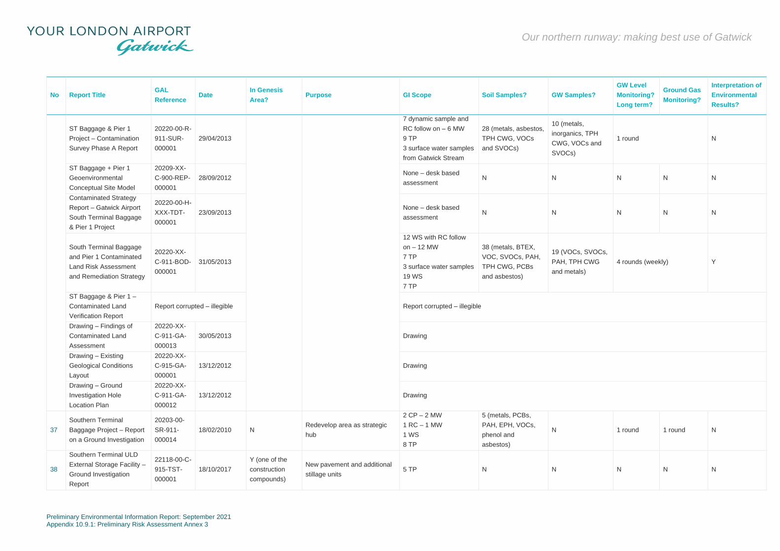
Preliminary Environmental Information Report: September 2021 Appendix 10.9.1: Preliminary Risk Assessment Annex 3
Our northern runway: making best use of Gatwick
No Report Title GAL
Reference Date
In Genesis
Area? Purpose GI Scope Soil Samples? GW Samples?
GW Level
Monitoring?
Long term?
Ground Gas
Monitoring?
Interpretation of
Environmental
Results?
ST Baggage & Pier 1
Project – Contamination
Survey Phase A Report
20220-00-R-
911-SUR-
000001
29/04/2013
7 dynamic sample and
RC follow on – 6 MW
9 TP
3 surface water samples
from Gatwick Stream
28 (metals, asbestos,
TPH CWG, VOCs
and SVOCs)
10 (metals,
inorganics, TPH
CWG, VOCs and
SVOCs)
1 round N
ST Baggage + Pier 1
Geoenvironmental
Conceptual Site Model
20209-XX-
C-900-REP-
000001
28/09/2012 None – desk based
assessment N N N N N
Contaminated Strategy
Report – Gatwick Airport
South Terminal Baggage
& Pier 1 Project
20220-00-H-
XXX-TDT-
000001
23/09/2013 None – desk based
assessment N N N N N
South Terminal Baggage
and Pier 1 Contaminated
Land Risk Assessment
and Remediation Strategy
20220-XX-
C-911-BOD-
000001
31/05/2013
12 WS with RC follow
on – 12 MW
7 TP
3 surface water samples
19 WS
7 TP
38 (metals, BTEX,
VOC, SVOCs, PAH,
TPH CWG, PCBs
and asbestos)
19 (VOCs, SVOCs,
PAH, TPH CWG
and metals)
4 rounds (weekly) Y
ST Baggage & Pier 1 –
Contaminated Land
Verification Report
Report corrupted – illegible Report corrupted – illegible
Drawing – Findings of
Contaminated Land
Assessment
20220-XX-
C-911-GA-
000013
30/05/2013 Drawing
Drawing – Existing
Geological Conditions
Layout
20220-XX-
C-915-GA-
000001
13/12/2012 Drawing
Drawing – Ground
Investigation Hole
Location Plan
20220-XX-
C-911-GA-
000012
13/12/2012 Drawing
37
Southern Terminal
Baggage Project – Report
on a Ground Investigation
20203-00-
SR-911-
000014
18/02/2010 N Redevelop area as strategic
hub
2 CP – 2 MW
1 RC – 1 MW
1 WS
8 TP
5 (metals, PCBs,
PAH, EPH, VOCs,
phenol and
asbestos)
N 1 round 1 round N
38
Southern Terminal ULD
External Storage Facility –
Ground Investigation
Report
22118-00-C-
915-TST-
000001
18/10/2017
Y (one of the
construction
compounds)
New pavement and additional
stillage units 5 TP N N N N N

Preliminary Environmental Information Report: September 2021 Appendix 10.9.1: Preliminary Risk Assessment Annex 3
Our northern runway: making best use of Gatwick
No Report Title GAL
Reference Date
In Genesis
Area? Purpose GI Scope Soil Samples? GW Samples?
GW Level
Monitoring?
Long term?
Ground Gas
Monitoring?
Interpretation of
Environmental
Results?
ULD External Storage
Facility – Trial Pit Test
Results
22118-00-C-
915-TST-
000003
18/10/2017 As above (comprised the 5 trial pit logs)
39
Gatwick STAD Project –
Ashdown House Ramp
and Canopy area Report
20362-00-C-
911-SUR-
000001
16/01/2013 N Determine bearing capacity for
canopy structure 1 WS N N N N N
40
Strategic Power Resilience
Project (Control Tower) –
Site Investigation Report
20473-XX-
C-XXX-
SRC-
000001
14/11/2018 Unknown
Determine whether leaching of
diesel fuels from adjacent
underground fuel tanks had
occurred
2 WS
2 (metals, PAH,
EPH, GRO, BTEX,
PCBs, asbestos and
WAC)
N N N Y
41 Taxiway and AGL
Rehabilitation N – duplicate of report 16
42 UXO and EXO Surveys –
New Hangar
20760-XX-
R-911-SRC-
000001
18/11/2016 N Undertaken prior to
construction of Boeing Hangar NA NA NA NA NA NA
43
Westfield Stream Gatwick
– Ground Investigation
Report
No
reference on
report
January 2015
Y (Pond A and
potential area
for flood
compensation)
Design of diversion of the
Westfield Stream
3 WS with RC follow on
– 1 MW
11 TP
20 (metals, asbestos,
cyanide, PAH and
TPH) – no laboratory
certificates provided
N 1 round N Y
44 Main and North Runway
Rehabilitation Y – original version (v0) of report 20
45 Public Transport and DDA
Access Y– duplicate of report 33 (Ground Investigation Report, ref: 20000-XX-C-734-SUR-000002
WS – window sample borehole
TP – trial pit
CPT – cone penetration test
MW – monitoring well
GDR – Geotechnical Design Report
RC – rotary core
PBT – plate bearing tests
DCP – dynamic cone penetrometer test
CP – cable percussion borehole
CBR – California Bearing Ratio

Preliminary Environmental Information Report: September 2021 Appendix 10.9.1: Preliminary Risk Assessment Annex 4
Our northern runway: making best use of Gatwick
Annex 4
Screening Criteria

Preliminary Environmental Information Report: September 2021 Appendix 10.9.1: Preliminary Risk Assessment Annex 4
Our northern runway: making best use of Gatwick
Table A4.1: Groundwater Screening Criteria
Contaminant AA-EQS (micrograms
per litre)
UK Drinking
Water Standards
(micrograms per
litre)
WHO Health
(micrograms
per litre)
WHO ATO
(micrograms
per litre)
Aluminium - 200 - -
Ammonia (NH3 as N) 15 - - -
Ammonium (as NH4+) - 500 - -
Anthracene 0.1 - - -
Antimony - 5 - -
Arsenic 50 - - -
Barium - 1000 - -
Benzene 10 - - -
Benzo(a)pyrene 0.00017 - - -
Benzo(b)flouranthene 0.00017 - - -
Benzo(k)fluoranthene 0.00017 - - -
Benzo(g,h,i)perylene) 0.00017 - - -
Benzyl butyl phthalate 7.5 - - -
Biphenyl 25 - - -
Boron 2,000 - - -
Cadmium and its compounds - dissolved (< 40 mg/l calcium carbonate) <=0.08 - - -
Cadmium and its compounds - dissolved (40 - <50 mg/l calcium carbonate) 0.08 - - -
Cadmium and its compounds - dissolved (50 - <100 mg/l calcium carbonate) 0.09 - - -
Cadmium and its compounds - dissolved (100 - <200 mg/l calcium carbonate) 0.15 - - -
Cadmium and its compounds - dissolved (>200 mg/l calcium carbonate) 0.25 - - -
Calcium - 250,000 - -
Carbon tetrachloride 12 - - -
Chloride 250,000 - - -
Chlorine (total residual oxidant) 2 - - -
Chloroform 12 - - -
4-chloro-3-methylphenol 40 - - -
Chloronitro toluenes 10 - - -
2-chlorophenol 50 - - -
3-chlorophenol-4-chlorophenol total (or individual monochlorophenols) 50 - - -
Chromium III (dissolved) 4.7 - - -
Chromium VI (dissolved) 3.4 - - -
Copper (dissolved) 1 (bioavailable) - - -
Cyanide 1 - - -
Dibutyl phthalate 8 - - -
3,4-dichloroaniline 0.2 - - -
Dichlorobenzene - total dichlorobenzene isomers 20 - - -

Preliminary Environmental Information Report: September 2021 Appendix 10.9.1: Preliminary Risk Assessment Annex 4
Our northern runway: making best use of Gatwick
Contaminant AA-EQS (micrograms
per litre)
UK Drinking
Water Standards
(micrograms per
litre)
WHO Health
(micrograms
per litre)
WHO ATO
(micrograms
per litre)
Dichloro-methane 20 - - -
1,2-dichloroethane 10 - - -
1,1-dichloroethene - - 30 -
1,2-dichloroethene - - 50 -
1,2-dibromo-3-chloropropane - 0.1 - -
1,2-dichlorobenzene - - - 1 to 10
1,2-dichloropropane - 0.1 - -
1,3-dichloropropene - 0.1 - -
1,4-dichlorobenzene - - - 0.3 to 30
2,4-dichlorophenol 4.2 - - -
Diethyl phthalate 200 - - -
Dimethyl phthalate 800 - - -
Dioctyl phthalate 20 - - -
Di(2-ethylhexyl)-phthalate (DEHP) 1.3 - - -
Ethylbenzene - - - 2 to 200
Fluoranthene 0.0063 - - -
Fluoride - dissolved (<50 mg of Calcium carbonate per litre of water (mg/l)) 1,000 - - -
Fluoride - dissolved (>50 mg/l of calcium carbonate) 5,000 - - -
Hexachloro-benzene 0.03 - - -
Hexachloro-butadiene 0.10 - - -
Hexachloro-cyclohexane 0.02 - - -
Hydrocarbons (dissolved/emulsions) - 10 - -
Hydrogen Sulphide 0.25 - - -
Indeno(1,2,3-cd)pyrene 0.00017 - - -
Iron - dissolved 1,000 - - -
Lead and its compounds (dissolved) 1.2 (bioavailable) - - -
Magnesium - 50,000 - -
Manganese - dissolved 123 (bioavailable) - - -
Mercury and its compounds (dissolved) 1 - - -
Methylbenzene 50 - - -
Naphthalene 2 - - -
Nickel and its compounds (dissolved) 4 (bioavailable) - - -
Nitrate (as NO3) - 50,000 - -
Nitrite (as NO2) - 100 - -
pH (6 - 9) - - - -
Pentachloro-benzene 0.007 - - -
Pentachloro-phenol 0.4 - - -

Preliminary Environmental Information Report: September 2021 Appendix 10.9.1: Preliminary Risk Assessment Annex 4
Our northern runway: making best use of Gatwick
Contaminant AA-EQS (micrograms
per litre)
UK Drinking
Water Standards
(micrograms per
litre)
WHO Health
(micrograms
per litre)
WHO ATO
(micrograms
per litre)
Phenol 7.7 - - -
Phosphorous - 2200 - -
Potassium - 12,000 - -
Selenium - 10 - -
Sodium 170,000 - - -
Sulphate 400,000 - - -
Sulphide 0.25 - - -
Styrene 50 - - -
Tetrachloroethane 140 - - -
Tetrachloroethene (PCE) 10 - - -
Tetrachloro-ethylene 10 - - -
Tetrachloromethane (PCM) 12 - - -
Toluene 74 - - -
Tributyl phosphate 50 - - -
Trichloro-benzenes 0.4 - - -
Trichloroethene 10 - - -
Trichloro-ethylene 10 - - -
Trichloro-methane (chloroform) 2.5 - - -
1,1,1-trichloroethane 100 - - -
1,1,2-trichloroethane 400 - - -
2,4,6-trichlorophenol - - 200 -
Vanadium (0-200 mg/l of calcium carbonate) 20 - - -
Vanadium (>200 mg/l calcium carbonate) 60 - - -
Vinyl Chloride - 0.5 - -
Xylene 30 - - -
Zinc - dissolved plus ambient background concentration 10.9 (bioavailable) - - -

Preliminary Environmental Information Report: September 2021 Appendix 10.9.1: Preliminary Risk Assessment Annex 4
Our northern runway: making best use of Gatwick
Table A4.2: Soils
Metals
Arsenic 640 S4UL(a)
Beryllium 12 S4UL(a)
Boron 240000 S4UL(a)
Cadmium 190 S4UL(a)
Chromium III 8600 S4UL(a)
Chromium VI 33 S4UL(a)
Copper 68000 S4UL(a)
Lead 2300 pC4SL
Elemental Mercury 58vap (25.8) S4UL(a)
Inorganic Mercury 1100 S4UL(a)
Methylmercury 320 S4UL(a)
Nickel 980 S4UL(a)
Selenium 12000 S4UL(a)
Vanadium 9000 S4UL(a)
Zinc 730000 S4UL(a)
Petroleum Hydrocarbons
1% SOM
Aliphatic EC 5-6 3200 (304)sol S4UL(a)
Aliphatic EC >6-8 7800 (144)sol S4UL(a)
Aliphatic EC >8-10 2000 (78)sol S4UL(a)
Aliphatic EC >10-12 9700 (48)sol S4UL(a)
Aliphatic EC >12-C16 59000 (24)sol S4UL(a)
Aliphatic EC >16-35 1600000 S4UL(a)
Aliphatic EC >35-44 1600000 S4UL(a)
Aromatic EC5-7 (benzene) 26000
(1220)sol S4UL(a)
Aromatic EC >7-8 (toluene) 56000(869)vap S4UL(a)
Aromatic EC >8-10 3500 (613)vap S4UL(a)
Aromatic EC >10-12 16000
(364)sol S4UL(a)
Aromatic EC >12-16 36000
(169)sol S4UL(a)
Aromatic EC >16-21 28000 S4UL(a)
Aromatic EC >21-35 28000 S4UL(a)
Aromatic EC >35-44 28000 S4UL(a)
Aliphatic + Aromatic EC >44-
70 28000 S4UL(a)
TPH Ali/Aro -
BTEX
Benzene 27 S4UL(a)
Toluene 56000
(869)vap S4UL(a)
Ethylbenzene 5700 (518)vap S4UL(a)
o-xylene 6600 (478)sol S4UL(a)
m-xylene 6200 (625)vap S4UL(a)
p-xylene 5900 (576)sol S4UL(a)
MTBE -
PAHs
Acenaphthene 84000
(57.0)sol S4UL(a)
Acenaphthylene 83000
(86.1)sol S4UL(a)
Anthracene 520000 S4UL(a)
Benzo(a)anthracene 170 S4UL(a)
Benzo(a)pyrene 35 S4UL(a)
Benzo(b)fluoranthene 44 S4UL(a)
Benzo(g,h,i)perylene 3900 S4UL(a)
Benzo(k)fluoranthene 1200 S4UL(a)
Chrysene 350 S4UL(a)
Dibenzo(a,h)anthracene 3.5 S4UL(a)
Fluoranthene 23000 S4UL(a)
Fluorene 63000
(30.9)sol S4UL(a)
Indeno(1,2,3-c,d)pyrene 500 S4UL(a)
Naphthalene 190 (76.4)sol S4UL(a)
Phenanthrene 22000 S4UL(a)
Pyrene 54000 S4UL(a)
PAH -
Phenols
Phenol 440 (26000)dir S4UL(a)
Chlorophenols 3500 S4UL(a)
Pentachlorophenol 400 S4UL(a)
Chloroalkanes & alkenes
Chloroethene (vinyl chloride) 0.059 S4UL(a)
Dichloroethane 0.67 S4UL(a)
Chlorinated Hydrocarbons
Tetrachloroethanes 270 S4UL(a)
Tetrachloroethene 19 S4UL(a)
Tetrachloromethane (Carbon
Tetrachloride) 2.9 S4UL(a)
Trichloroethane 660 S4UL(a)
Trichloroethene 1.2 S4UL(a)
Trichloromethane (Chloroform) 99 S4UL(a)
Explosives
Trinitrotoluene 1000 S4UL(a)
RDX 210000 S4UL(a)
HMX 110000 S4UL(a)
Pesticides
Aldrin 170 S4UL(a)
Dieldrin 170 S4UL(a)
Atrazine 9300 S4UL(a)
Dichlorvos 140 S4UL(a)
Endosulfan 5600
(0.003)vap S4UL(a)
Hexachlorocyclohexane 170 S4UL(a)
Beta-Hexachlorocyclohexane 65 S4UL(a)
Chlorobenzenes
Chlorobenzene 56 S4UL(a)
2- Dichlorobenzene 2000 (571)sol S4UL(a)
4- Dichlorobenzene 4400 (224)vap S4UL(a)
1,2,3-Trichlorobenzene 102 S4UL(a)
1,2,4-Trichlorobenzene 220 S4UL(a)
1,3,5-Trichlorobenzene 23 S4UL(a)
1,2,3,4-Tetrachlorobenzene 1700 (122)vap S4UL(a)
1,2,3,5-Tetrachlorobenzene 49 (39.4)vap S4UL(a)
1,2,4.5 Tetrachlorobenzene 42 (19.7)sol S4UL(a)
Pentachlorobenzene 640 (43.0)sol S4UL(a)
Hexachlorobenzene 110 (0.20)vap S4UL(a)
Others
Carbon Disulphide 11 S4UL(a)
Hexachlorobutadiene 31 S4UL(a)
1,2 - Dichloroethane 0.67 S4UL(a)
1,1,1 - Trichloroethane 660 S4UL(a)
1,1,1,2 - Tetrachloroethane 110 S4UL(a)
Chlorobenzene 56 S4UL(a)
1,2 - Dichlorobenzene 2000 (571)sol S4UL(a)
1,3 - Dichlorobenzene 30 S4UL(a)

Preliminary Environmental Information Report: September 2021 Appendix 10.9.1: Preliminary Risk Assessment Annex 4
Our northern runway: making best use of Gatwick
1,4 - Dichlorobenzene 4400
(224)vap S4UL(a)
2,4,6 Trinitrotoluene (TNT) 1000 S4UL(a)
Notes
Soil chemical concentrations should initially be screened against the screening criteria
value outside of brackets.
vap
Vapour Saturation Limit. Concentration at which soil gas within pore space reaches
staruarion limit. Increases in soil concentration above this criteria will not lead to
increased soil gas concentrations with pore spaces. This value should not be used
within the assessment it is an informative.
sol
Solubility Saturation Limit. Concentration at which soil water becomes saturated with
contaminant. Where this concentration is exceeded, free product may be present with
pore spaces. If soils are below the water table exposure to free product upon the water
table should be considered qualitatively where it may be present at the ground surface.
dir
Screening criteria based on a threshold protective of direct skin contact with phenol.
Values in brackets are based on health effects following long term exposure provided for
illustration only.
pC4SLs have been used for lead in absence of S4ULs. Value selected is based on
LLTC 2: Intake leading to blood lead concentration of 3.5 μg dL-1
When assessing total xyxlene oncentrations these should be compared to the lower of
the lowest of the three isomers for the particular land use.
The screening values for the metals are based on a sandy loam with a SOM of 6%
S4ULs assume no free phase contamination is present.
References
(a)
The LQM/CIEH S4ULs for human Health risk Assessment, 2015
(b)
CL:AIRE SP1010 Development of Category 4 Screening Levels for Assessment of
Land Affected by Contamination (Rev. 2), September 2014

Preliminary Environmental Information Report: September 2021 Appendix 10.9.1: Preliminary Risk Assessment Annex 5
Our northern runway: making best use of Gatwick
Annex 5
Part 2A (The Contaminated Land Regime)

Preliminary Environmental Information Report: September 2021 Appendix 10.9.1: Preliminary Risk Assessment Annex 5
Our northern runway: making best use of Gatwick
Contaminated Land Definition
A5.1 Under Section 57 of the Environmental Act 1995, Part 2A was
inserted into the Environmental Protection Act 1990 to include
provisions for the management of contaminated land.
A5.2 Subsequent regulations were first implemented in England in
April 2000, Scotland in July 2000 and Wales in July 20011,
providing a definition of ‘contaminated land’ and setting out the
nature of liabilities that can be incurred by owners of
contaminated land and groundwater.
A5.3 According to the Act, contaminated land is defined as ‘any land
which appears to the local authority in whose area the land is
situated to be in such a condition, by reason of substances in, on
or under the land that:
a. significant harm is being caused or there is a significant
possibility of such harm being caused; or
b. significant pollution of controlled waters2 is being caused or
there is a significant possibility of such pollution being
caused3’
A5.4 The guidance on determining whether a particular possibility is
significant is based on the principles of risk assessment and in
particular on considerations of the magnitude or consequences of
the different types of significant harm caused. The term
‘possibility of significant harm being caused’ should be taken, as
referring to a measure of the probability, or frequency, of the
occurrence of circumstances that could lead to significant harm
being caused.
A5.5 The following situations are defined where harm is to be regarded
as significant:
i. Chronic or acute toxic effect, serious injury or death to
humans
ii. Irreversible or other adverse harm to the ecological system
iii. Substantial damage to, or failure of, buildings
1 In England by The Contaminated Land (England) Regulations 2000, updated by The Contaminated Land (England) (Amendment) Regulations 2012; in Scotland by The Contaminated Land (Scotland) Regulations 2000, updated by the Contaminated Land (Scotland) Regulations 2005; and in Wales by The Contaminated Land (Wales) Regulations 2001, updated by the Contaminated Land (Wales) Regulations 2006.
iv. Disease, other physical damage or death of livestock or
crops
v. The pollution of controlled waters4.
A5.6 With regard to radioactivity, contaminated land is defined as ‘any
land which appears to be in such a condition, by reason of
substances in, on or under the land that harm is being caused, or
there is a significant possibility of such harm being caused5’.
The Risk Assessment Methodology
A5.7 Risk assessment is the process of collating known information on
a hazard or set of hazards in order to estimate actual or potential
risks to receptors. The receptor may be humans, a water
resource, a sensitive local ecosystem or future construction
materials. Receptors can be connected with the hazard via one or
several exposure pathways (e.g. the pathway of direct contact).
Risks are generally managed by isolating or removing the hazard,
isolating the receptor, or by intercepting the exposure pathway.
Without the three essential components of a source (hazard),
pathway and receptor, there can be no risk. Thus, the mere
presence of a hazard at a site does not mean that there will
necessarily be attendant risks.
The Risk Assessment
A5.8 By considering where a viable pathway exists which connects a
source with a receptor, this assessment will identify where
pollutant linkages may exist. A pollutant linkage is the term used
by the DEFRA in their standard procedure on risk assessment. If
there is no pollutant linkage, then there is no risk. Therefore, only
where a viable pollutant linkage is established does this
assessment go on to consider the level of risk. Risk should be
based on a consideration of both:
The likelihood of an event (probability) - takes into account
both the presence of the hazard and receptor and the
integrity of the pathway.
The severity of the potential consequence - takes into
account both the potential severity of the hazard and the
sensitivity of the receptor.
2 In Scotland the term “controlled water” has been updated to “water environment” under the Contaminated Land (Scotland) Regulations 2005 in line with the Water Environment and Water Services (Scotland) Act 2003.
3 The definition was amended in 2012 by implementation of the Water Act 2003.
A5.9 For further information please see the Contaminated Land
section on the DEFRA website (www.defra.gov.uk).
4 Groundwater in this context does not include waters within underground strata but above the saturated zone.
5 The Radioactive Contaminated Land (Modification of Enactments) (England) Regulations 2006 and Contaminated Land (Wales) Regulations 2006.
Preliminary Environmental Information Report: September 2021 Appendix 10.9.1: Preliminary Risk Assessment Annex 6
Our northern runway: making best use of Gatwick
Annex 6
Requirement for Further Works

Preliminary Environmental Information Report: September 2021 Appendix 10.9.1: Preliminary Risk Assessment Annex 6
Our northern runway: making best use of Gatwick
Table A6.1: Recommendation Strategy for Further Works
Development Area PAOC ID Buildings Proposed? Previous Site
Investigation
Potential for pollutant linkages to
remain active upon development
Recommendation for Further
Assessment
Relocation of Virgin Estate Infrastructure 12 No No Yes Further Ground Investigation
Virgin Hangar - Pavement 16, 45 No No Yes Further Ground Investigation
Converting 40s Stands 22, 28, 52, 65 No No Yes Further Ground Investigation
South Terminal Coaching Gates 74 No Yes Yes Further Ground Investigation
Car Park Y Storage 36 No No Yes Further Ground Investigation
Motor Transport Facility None Yes No Yes Further Ground Investigation
Rendezvous Point North None No No None identified. Discovery Strategy
Satellite Airport Fire Service Facility None Yes No Yes Further Ground Investigation
Future Waste Water Treatment 59 No No Yes Further Ground Investigation
Longbridge Road Roundabout Compound None No No None identified. Discovery Strategy
Flood Compensation Zone at Car Park X and V None No Yes None identified. Discovery Strategy
Flood Compensation Area 3 None No No None identified. Discovery Strategy
Gatwick Stream FAS 2 None No No None identified. Discovery Strategy
Museum Field Flood Plain None No No None identified. Discovery Strategy
Pond A & River Mole Reconfiguration None No No None identified. Discovery Strategy
Relocation Substation J None Yes No Yes Further Assessment
Relocation Substation A None Yes No Yes Further Assessment
Environmental Mitigation and Enhancement (Brook Farm East) None No No None identified. Discovery Strategy
Environmental Mitigation and Enhancement (Brook Farm South) None No No None identified. Discovery Strategy
Environmental Mitigation and Enhancement (Brook Farm West) None No No None identified. Discovery Strategy
Environmental Mitigation and Enhancement (New Woodland) None No No None identified. Discovery Strategy
Environmental Mitigation None No No None identified. Discovery Strategy
Relocation of Fire Training Ground 15 Yes Yes Yes Further Ground Investigation.
Taxiway Juliet West (Spur) None No Yes None identified. Discovery Strategy
Taxiway Juliet 37, 41 No Yes Yes Further Ground Investigation.
Taxiway Juliet East None No No None identified. Discovery Strategy
Runway Exits (Northern to Juliet) 9 No No Yes Further Ground Investigation.
Northern Runway 08L/26R None No Yes None identified. Discovery Strategy
End Around Taxiway West None No No None identified. Discovery Strategy
Exit Taxiway Main to East None No No None identified. Discovery Strategy
Exit Taxiway Main to North None No Yes None identified. Discovery Strategy
Crawter's Road Car Park 43 No No None identified. Further Ground Investigation.
Airfield Satellite Welfare Contractor Compound None No Yes None identified. Discovery Strategy
Taxiway Uniform None No No None identified. Discovery Strategy
Cuckoo Remote Stands – Phase 1 16 No No Yes Further Ground Investigation
Tango Cut Through None No No None identified. Discovery Strategy
Taxiway Tango None No No None identified. Discovery Strategy
Lima Extension None No Yes None identified. Discovery Strategy

Preliminary Environmental Information Report: September 2021 Appendix 10.9.1: Preliminary Risk Assessment Annex 6
Our northern runway: making best use of Gatwick
Development Area PAOC ID Buildings Proposed? Previous Site
Investigation
Potential for pollutant linkages to
remain active upon development
Recommendation for Further
Assessment
Taxiway Whiskey-Victor-Zulu (Code C to Code E - 08) None No Yes None identified. Discovery Strategy
Reconfigure Code 150's to Code C (Phase 2) 12 No No Yes Further Ground Investigation
Pier 7 35, 60 No No Yes Further Ground Investigation
Pier 7 New Stands 35 No No Yes Further Ground Investigation
Code E Hangar None Yes (assumed open structure) Yes None identified. Discovery Strategy
Relocate Larkins Road Phase 2 (Diverted road surfacing and utilities) None No No None identified. Discovery Strategy
Care – Option 1 35 Yes No Yes Further Ground Investigation
North Terminal long stay decking None No No None identified. Discovery Strategy
CARE Waste Facility Option 2 - landside relocation 46 Yes No Yes Further Ground Investigation
Charlie Box 9 No Yes Yes Further Ground Investigation
MA1 Main Contractor Compound 6 No Yes Yes Further Ground Investigation
End Around Taxiway Yankee None No No None identified. Discovery Strategy
Taxiway Victor None No Yes None identified. Discovery Strategy
Taxiway Whiskey None No Yes None identified. Discovery Strategy
South Terminal IDL Expansion None Yes Yes Yes Further Ground Investigation
South Terminal Autonomous Vehicle Station None Yes No Yes Further Ground Investigation
Parking - MSCP J None No Yes None identified. Discovery Strategy
Hotel and Office – MSCP H None Yes No Yes Further Ground Investigation
North Terminal Forecourt None No Yes None identified. Discovery Strategy
North Terminal IDL Expansion None Yes No Yes Further Ground Investigation
North Terminal Reclaim None Yes No Yes Further Ground Investigation
North Terminal Make up Points (MUPs) None No No None identified. Discovery Strategy
North Terminal Autonomous Vehicle Station None Yes No Yes Further Ground Investigation
MSCP Y Hotel and Parking 40 No No Yes Further Ground Investigation
MSCP Y elements 40 No No Yes Further Ground Investigation
Parking X and V None No Yes None identified. Discovery Strategy
Surface access 4, 7, 19,, 40, 53,
73, 77 No Yes Yes Further Ground Investigation
Environmental mitigation and enhancement (Church Meadow) None No No None identified. Discovery Strategy
Reigate Field Welfare Contractor Compound None No No None identified. Discovery Strategy
South Terminal Forecourt 1, 2, 4 No Yes Yes Further Ground Investigation
Hotel – South Terminal (Car Rental FOH Site) 70 Yes No Yes Further Ground Investigation
Environmental mitigation and enhancement (Riverside) None No No None identified. Discovery Strategy
Environmental mitigation and enhancement (Noise Bund) None No No None identified. Discovery Strategy
Hotel and office provision None Yes No Yes Further Ground Investigation
Construction compounds None No No None identified. Discovery Strategy
Parking - Pentagon Field Decking None No No None identified. Discovery Strategy

Preliminary Environmental Information Report: September 2021 Appendix 10.9.1: Preliminary Risk Assessment Annex 6
Our northern runway: making best use of Gatwick