PRELIMINARY ENVIRONMENTAL ASSESSMENT FOR … · Angra dos Reis, a land pipeline of 97 km, and for...
16
Pipeline Technology Conference 2008 PRELIMINARY ENVIRONMENTAL ASSESSMENT FOR THE ENVIRONMENTAL IMPACT ASSESSMENT STUDY (EIA) OF THE ONSHORE PHASE OF THE MEXILHÃO PROJECT: CARAGUATATUBA GAS TREATMENT PLANT (UTGCA) AND CARAGUATATUBA-TAUBATÉ GAS PIPELINE (GASTAU) Wilson José de Oliveira (1) Marcelo Bernardes Secron (2) Shanty Navarro Hurtado (3) Edson Rodrigues Pereira Junior (4) Daniella dos Santos Medeiros (5) (1) Doctor of Philosophy in Remote Sensing – UNICAMP. Geologist– UNESP (University of São Paulo State). Geophysicist at PETROBRAS, working in the environmental engineering assessment sector - EAMB. (2) Masters in Environmental Engineering – PEAMB/UERJ (Post Graduation Program of University of Rio de Janeiro State). Civil Engineer – emphasis in Sanitary Engineering – FEN/UERJ. Environmental Engineer of PETROBRAS, working in the environmental engineering assessment sector - EAMB. (3) Developing Master degree in Oceanographic Geology – IO/USP (University of São Paulo). Geologist – IGc/USP. Geologist at PETROBRAS, working in the engineering environmental assessment sector - EAMB. (4)Master in Environmental Sciences – IF/UFRRJ (Rio de Janeiro Federal Rural University). Forestry Engineer – UFFRJ. Environmental Analyst of SEEBLA/PETROBRAS, working in the engineering environmental assessment sector - EAMB. (5) Doctor of Philosophy in Geosciences Education– UFRGN (Federal University of Rio Grande do Norte State). Geologist – UFRGS (Federal University of Rio Grande do Sul State). Environmental Engineer at PETROBRAS, working in international environmental assessment sector - INTER-AFE (Americas – Africa and Eurasia) Colombia. The PEA (Preliminary Environmental Assessment) at Petrobras consists, in general terms, of an internal technical process, prior to the environmental license, prepared to verify the environmental feasibility of a project, identifying the main environmental issues, as well as supporting development of the EIA (Environmental Impact Assessment Study). The technical guidelines for the PEA are prepared by the Environmental Assessment Engineering Team of PETROBRAS/ENGENHARIA/IETEG/ETEG/EAMB and are based on the characteristics of the project. The PEA is one of the elements of the environmental impact assessment, providing an initial assessment of the environmental aspects of the project (Screening). It also supports the assessment and determination of route and location alternatives of pipelines and industrial plants. The onshore phase of the Mexilhão Project consists of the construction of both the Caraguatatuba Gas Treatment Plant (UTGCA) that will process gas and condensate from Mexilhão Field, in the Santos Basin – SP, and the Caraguatatuba – Taubaté Gas Pipeline (GASTAU), between Caraguatatuba and Taubaté. The GASTAU will cross the Serra do Mar and connect the UTGCA to the Brazilian pipeline network, delivering gas. This study presents the procedures and conclusions of the PEA prepared for the UTGCA and GASTAU projects by PETROBRAS/ENGENHARIA/IETEG/ETEG/EAMB. Key Words: Preliminary Environmental Assessment, Environmental Impact Assessment, Environmental Screening, Mexilhão, Caraguatatuba - SP
-
Upload
phungquynh -
Category
Documents
-
view
215 -
download
0
Transcript of PRELIMINARY ENVIRONMENTAL ASSESSMENT FOR … · Angra dos Reis, a land pipeline of 97 km, and for...

Pipeline Technology Conference 2008
PRELIMINARY ENVIRONMENTAL ASSESSMENT FOR THE ENVIRONMENTAL IMPACT ASSESSMENT STUDY (EIA) OF THE
ONSHORE PHASE OF THE MEXILHÃO PROJECT: CARAGUATATUBA GAS TREATMENT PLANT (UTGCA) AND CARAGUATATUBA-TAUBATÉ
GAS PIPELINE (GASTAU)
Wilson José de Oliveira (1)
Marcelo Bernardes Secron (2)
Shanty Navarro Hurtado (3)
Edson Rodrigues Pereira Junior (4)
Daniella dos Santos Medeiros (5)
(1) Doctor of Philosophy in Remote Sensing – UNICAMP. Geologist– UNESP (University of São Paulo State). Geophysicist at PETROBRAS, working in the environmental engineering assessment sector - EAMB. (2) Masters in Environmental Engineering – PEAMB/UERJ (Post Graduation Program of University of Rio de Janeiro State). Civil Engineer – emphasis in Sanitary Engineering – FEN/UERJ. Environmental Engineer of PETROBRAS, working in the environmental engineering assessment sector - EAMB. (3) Developing Master degree in Oceanographic Geology – IO/USP (University of São Paulo). Geologist – IGc/USP. Geologist at PETROBRAS, working in the engineering environmental assessment sector - EAMB. (4)Master in Environmental Sciences – IF/UFRRJ (Rio de Janeiro Federal Rural University). Forestry Engineer – UFFRJ. Environmental Analyst of SEEBLA/PETROBRAS, working in the engineering environmental assessment sector - EAMB. (5) Doctor of Philosophy in Geosciences Education– UFRGN (Federal University of Rio Grande do Norte State). Geologist – UFRGS (Federal University of Rio Grande do Sul State). Environmental Engineer at PETROBRAS, working in international environmental assessment sector - INTER-AFE (Americas – Africa and Eurasia) Colombia.
The PEA (Preliminary Environmental Assessment) at Petrobras consists, in general terms, of an internal technical process, prior to the environmental license, prepared to verify the environmental feasibility of a project, identifying the main environmental issues, as well as supporting development of the EIA (Environmental Impact Assessment Study). The technical guidelines for the PEA are prepared by the Environmental Assessment Engineering Team of PETROBRAS/ENGENHARIA/IETEG/ETEG/EAMB and are based on the characteristics of the project. The PEA is one of the elements of the environmental impact assessment, providing an initial assessment of the environmental aspects of the project (Screening). It also supports the assessment and determination of route and location alternatives of pipelines and industrial plants. The onshore phase of the Mexilhão Project consists of the construction of both the Caraguatatuba Gas Treatment Plant (UTGCA) that will process gas and condensate from Mexilhão Field, in the Santos Basin – SP, and the Caraguatatuba – Taubaté Gas Pipeline (GASTAU), between Caraguatatuba and Taubaté. The GASTAU will cross the Serra do Mar and connect the UTGCA to the Brazilian pipeline network, delivering gas. This study presents the procedures and conclusions of the PEA prepared for the UTGCA and GASTAU projects by PETROBRAS/ENGENHARIA/IETEG/ETEG/EAMB. Key Words: Preliminary Environmental Assessment, Environmental Impact Assessment, Environmental Screening, Mexilhão, Caraguatatuba - SP

Pipeline Technology Conference 2008
1. Introduction
The Preliminary Environmental Assessment (PEA) at Petrobras generally consists of a technical process, prior to the environmental licensing process, to verify the environmental feasibility of a project, identifying the environmental variables to be considered in the Environmental Impact Study. Along with the technical and economic evaluation studies (EVTE) of any given project, the PEA, is an important source of internal information for the company, which shows the degree of difficulty to be found in the environmental licensing process, which is currently considered a critical point in the feasibility of a project. The PEA is based on the needs of business initiatives and is performed in accordance with the technical guidelines developed by the multidisciplinary team at the Petrobras Environmental Assessment Engineering Group (ENGENHARIA/IETEG/ ETEG/EAMB). The preliminary assessment is part of the decision-making process that defines the locations of pipelines and industrial plants. It also supports the planning of the subsequent environmental impact assessment study, identifying the important environmental aspects of a project. This paper will present the results from the environmental evaluation studies of the alternative locations for the Mexilhão Project (land part), that is, the criteria for choosing the best point for landing the submarine gas pipeline on the Brazilian coast, which is directly linked to the best location for installation of the Caraguatatuba Gas and Condensate Treatment Unit (UTGCA) and the best alternative route for the Caraguatatuba gas pipeline – Taubaté (GASTAU), which will connect the UTGCA with the pipeline network on the highlands in the southeast region of Brazil.
2. The Preliminary Environmental Assessment and The Environmental Impact Assessment
The environmental assessment of new business projects is part of the environmental licensing process, which is mandatory for potentially polluting activities in Brazil, in accordance with Federal Law 6.938/1981 and CONAMA (National Environmental Council) Resolutions 01/1986 and 237/1997. The environmental licensing processes for projects that may have significant impacts, such as oil and gas projects, require an Environmental Impact Assessment (EIA). The Preliminary Environmental Assessment (PEA) is an important tool for preparing the EIA, as it allows for the identification and general assessment of the most important environmental issues that might arise at a project in any given region.
The Preliminary Environmental Assessment (PEA) consists of a strategic evaluation performed by the interested party, carried out by its own team, where primary field data and significant secondary data are collected and used to assess the feasibility of a new project at its early stages. The PEA provides basic knowledge about the main environmental aspects concerning a new project, assists in the decision-making process for location alternatives and supports the preparation of the Terms of References to contract the Environmental Impact Assessment.
The Preliminary Environmental Assessment takes into consideration all the possible alternative locations for a project and selects the best alternatives to be assessed in the Environmental Impact Assessment. The PEA may suggest project modifications or may rule out certain regions or locations, to prevent difficulties during the

Pipeline Technology Conference 2008
environmental licensing process, the construction or operational phases. It also highlights all relevant socio-environmental issues that should be further investigated, such as environmental liabilities or the presence of traditional communities.
The Preliminary Environmental Assessment for the UTGCA and GASTAU was coordinated by the technical team of the Environmental Engineering Group (EAMB) at PETROBRAS/ENGENHARIA/IETEG/ETEG, with the assistance of CENPES (Petrobras Research Center).
3. The Mexilhão Project
The Mexilhão Project is the second to be installed in the Santos Basin, which is today a highly productive area containing considerable volumes of natural gas. As a pioneer in the productive field, the Mexilhão Project is being designed as an infrastructure project for the development of the Santos basin, and is composed of a platform, a submarine gas pipeline, a gas and condensate treatment plant on land and a gas pipeline that will connect this unit to the gas pipeline network on the southeastern plateau. As well as the Mexilhão Field, the structure will also serve flows from adjacent fields (the Cedro field). The Mexilhão field is one of 5 production poles in the Santos basin (Sul, Merluza, Mexilhão, BS-500 and Centro), and is located off the coast of the State of São Paulo, 165 km from the city of São Sebastião. The Mexilhão field, together with Cedro, that make up the Production Pole of Mexilhão will produce, as of 2009, around 9 million m3/day of natural gas and 20 thousand barrels of condensate per day from the platform of Mexilhão. This platform will be installed 145 km off the coast at 170 meters depth and is designed to produce 15 million m3/day. Flow from the Mexilhão platform will be by a submarine pipeline of 35 inches and 145 kilometers length up to the Caraguatatuba Gas Treatment Unit, where the natural gas and condensate will be processed. From this unit, the gas will flow to the highlands through a 28-inch pipeline 94 km long. The condensate will be sent to the São Sebastião Terminal, located in the municipality neighboring São Sebastião, by a smaller-diameter pipeline (6 inches) and shorter length (20 km). Figure 1 shows a diagram of Mexilhão project.
Figure 1 – General diagram of Mexilhão project.

Pipeline Technology Conference 2008
4. Preliminary Environmental Assessment of Submarine Gas Pipeline Cost Approach
The option to implement the Gas Treatment Unit in the municipality of Caraguatatuba was the result of a macro-regional analysis performed by the following areas of PETROBRAS: Gas and Energy, UN-RIO and ENGENHARIA/IEMX. This analysis took into consideration municipalities located along the coastal region close to the production area PMXL-1, in the Mexilhão field, located in the Santos basin, between the states of São Paulo and Rio de Janeiro. The municipalities included should have both physical and logistical conditions to receive the natural gas, and it should also be possible to install a gas line to connect to the existing transportation net. In that context, the following municipalities were chosen:
• Alternative 1: Cubatão (Presidente Bernardes Refinery - RPBC) - SP;
• Alternative 2: São Sebastião (São Sebastião Terminal) - SP;
• Alternative 3: Angra dos Reis (Angra dos Reis Terminal – RJ);
• Alternativa 4: Sepetiba (Rio de Janeiro – RJ);
• Alternative 5: Caraguatatuba –SP / Ubatuba – SP.
The macro-regional assessment carried out by the Gas and Energy group of PETROBRAS used the following tools: an interpretation of ortho-photos generated by satellites, an assessment of pictures taken during a helicopter flight over the municipalities and analysis of technical information from Petrobras projects.
Figure 2 illustrates the alternatives analyzed by PETROBRAS in defining the location for landing the submarine pipeline and installation of the UTGCA and Table 1 (Annex) shows the results of the Preliminary Macro-Regional Environmental Evaluation for Installation of the Gas Treatment Unit and Landing of the Submarine Pipeline.
Figure 2 - Landing alternatives of the submarine pipeline and installation of the UTGCA.

Pipeline Technology Conference 2008
The location for the landing of the submarine pipeline on the coast was chosen based on the best conditions on land for receiving production from the Mexilhão platform.
Bringing the gas to RPBC (Alternative 1), the submarine pipeline would be approximately 200 kilometers long, and it would be necessary to lay a land pipeline of 16 km. In this case, the pipeline would arrive in a densely populated region with no free areas to build the gas treatment unit. There is also the difficulty of taking the processed gas to the pipeline network in the São Paulo metropolitan region, as the existing strips are totally congested. Furthermore, amplification of the existing pipeline strips in the Serra do Mar State Park is not allowed.
For the São Sebastião Terminal (Alternative 2), the length of the submarine pipeline would be 150 kilometers, and it would be necessary to by-pass the island of Ilha Bela. However, as with Alternative 1, there are no areas with enough space for installation of a new processing unit close to the São Sebastião Terminal, due to the high level of human occupation in the area. Another factor to be considered would be the need for laying a land stretch of 70 kilometers up to the Guararema Terminal for connection with the pipeline network, which would be in an existing strip that crosses the Serra do Mar State Park for a distance of approximately 42 km.
Another alternative evaluated was to bring the flow through the Angra dos Reis regions (Alternative 3) and Sepetiba (Alternative 4) located on the west coast of the State of Rio de Janeiro, 220 and 240 km from the coast respectively. In this case, for connection with the existing network, it would be necessary to build, in the case of Angra dos Reis, a land pipeline of 97 km, and for Sepetiba, 48 km up to connection with the network in the municipality of Japeri (meeting the Campinas – Rio de Janeiro pipeline). In these cases, Angra dos Reis would have restricted space in the existing terminal and complications of a geological-geotechnical nature for using the existing strip over the steep sides of the Serra do Mar. Only Sepetiba would have both enough space and less interference with local communities.
The Ubatuba region is practically the same distance from the Mexilhão (138 km) as Caraguatatuba, and although it has good conditions for installation of the gas treatment unit, it has some complicating factors due to the proximity of the slopes to the coast, and the need cross a larger distance within the Serra do Mar State Park compared with the Caraguatatuba region. To land in Caraguatatuba, a submarine pipeline would be 138 km long, and the land stretch would be 7 km up to the place proposed for the Caraguatatuba Gas Treatment Unit (UTGCA). In this case, to take the processed gas to the pipeline network would require a land pipeline of 92 km, with 65 kilometers in a new stretch and 27 km in an existing stretch.
Following are some of the environmental aspects considered in the study of alternative locations for the UTGCA.

Pipeline Technology Conference 2008
5 - Preliminary Environmental Assessment of the Alternative Locations for the Caraguatatuba Gas Treatment Unit (UTGCA)
The main purpose of Preliminary Environmental Assessment (PEA) was to select an area to install the Gas Treatment Unit (UTGCA) within the municipality of Caraguatatuba-SP, that would be environmentally adequate in order to pass an environmental licensing process.
The Preliminary Environmental Assessment process should show compatibility with the environmental and social guidelines practiced by PETROBRAS and should meet all the environmental criteria stated under the applicable environmental regulations, at federal, state and municipal levels.
The Preliminary Environmental Assessment process started with field visits, collecting secondary information about the coastal region where the municipality of Caraguatatuba is located and analysis of operational project information. Based on this initial analysis, it was possible to define that the following environmental aspects and studies should be part of the Preliminary Environmental Assessment to select an environmentally adequate area to install the UTGCA:
• Environmental and land use regulations;
• Mapping of present and past land use (for the last 40 years);
• Mapping of relevant natural aspects (hydrographic basins, conservation units, geological maps, etc.);
• Study of risk areas for mud flows from Serra do Mar;
• Modeling for atmospheric contaminant dispersion;
• Study of present and past waste deposits in Caraguatatuba;
• Baseline assessment of: Soil, groundwater and surface water, geophysical assessments, and application of RBCA (Risk-Based Corrective Action) at the area selected to install the Gas Treatment Unit of Caraguatatuba.
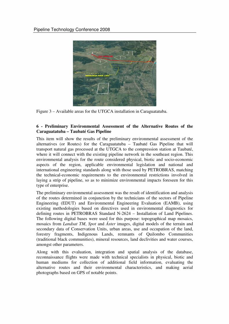
Selection of the area for the Gas Treatment Unit in Caraguatatuba included assessment of five areas available for acquisition by PETROBRAS (Figure 3). Four of the five areas (Areas 1, 2, 3 and 4) were located within the boundaries of a farm named Serramar, which occupies a significant portion of the total area of Caraguatatuba municipality, while Area 5 was located on adjacent land, and belonged to several small owners. Following, is the preliminary environmental assessment of alternative locations for the route of the Caraguatatuba – Taubaté Gas Pipeline.
Pipeline Technology Conference 2008
Figure 3 – Available areas for the UTGCA installation in Caraguatatuba.
6 - Preliminary Environmental Assessment of the Alternative Routes of the Caraguatatuba – Taubaté Gas Pipeline
This item will show the results of the preliminary environmental assessment of the alternatives (or Routes) for the Caraguatatuba – Taubaté Gas Pipeline that will transport natural gas processed at the UTGCA to the compression station at Taubaté, where it will connect with the existing pipeline network in the southeast region. This environmental analysis for the route considered physical, biotic and socio-economic aspects of the region, applicable environmental legislation and national and international engineering standards along with those used by PETROBRAS, matching the technical-economic requirements to the environmental restrictions involved in laying a strip of pipeline, so as to minimize environmental impacts foreseen for this type of enterprise.
The preliminary environmental assessment was the result of identification and analysis of the routes determined in conjunction by the technicians of the sectors of Pipeline Engineering (EDUT) and Environmental Engineering Evaluation (EAMB), using existing methodologies based on directives used in environmental diagnostics for defining routes in PETROBRAS Standard N-2624 – Installation of Land Pipelines. The following digital bases were used for this purpose: topographical map mosaics, mosaics from Landsat TM, Spot and Áster images, digital models of the terrain and secondary data of Conservation Units, urban areas, use and occupation of the land, forestry fragments, Indigenous Lands, remnants of Quilombo Communities (traditional black communities), mineral resources, land declivities and water courses, amongst other parameters.
Along with this evaluation, integration and spatial analysis of the database, reconnaissance flights were made with technical specialists in physical, biotic and human mediums for collection of additional field information, evaluating the alternative routes and their environmental characteristics, and making aerial photographs based on GPS of notable points.

Pipeline Technology Conference 2008
The land was also inspected to make geotechnical evaluations of matters related to crossing the Serra do Mar, the capacity of the existing stretches of the São Sebastião – Paulínia Oil Pipeline (OSPLAN) and the São José dos Campos – Guarulhos Oil Pipeline (OSVAT) for introducing a new line and the possibility of adopting alternatives using a strip parallel to the Tamoios Highway.
Based on the integration of this data, alternative routes were defined for the Caraguatatuba – Taubaté Gas Pipeline, as illustrated in figure 4. These Routes were named: Route 1, Route 2, Route 2A (a variation of Route 2), Route 3 and Route 4.
Figure 4 – Alternative routes for Caraguatatuba-Taubaté gás pipeline.
As well as factors to be considered for aptitude or for discarding alternatives for the choice of the route, a quantitative analysis was made the interference of each alternative on the environment.
The results for the five Routes analyzed for identification of the best alternative for the Caraguatatuba–Taubaté Pipeline are presented below. All of them start from the gas treatment unit to be installed in Caraguatatuba (UTGCA), and to reach the highlands in the direction of Taubaté, they will have to traverse the Serra do Mar, crossing the Serra do Mar State Park (PESM). Following, is a description of the characteristics of the 5 Routes analyzed.

Pipeline Technology Conference 2008
6.1 – Route 1
The first possibility to be considered, Route 1, aims to share, as much as possible, the existing stretches within the PESM, in order to minimize the impact on the protected biota. It goes from the city of Caraguatatuba, from the future UTGCA, and follows the coastal plain in a strip yet to be installed of approximately 9.4 km up to the border of the state park. From there it proceeds inside the PESM, still in a strip yet to be installed, on a stretch of 7 km, crossing the Serra do Mar up to the OSPLAN/OSVAT strip at its Km 27. From there it follows the existing strip up to the boundary of the State Park in a stretch 13.6km long. Within the PESM area, according to an evaluation made by the Institute for Technological Research of São Paulo University, the best option would be to dig a tunnel of approximately 1800 meters at the beginning of the park and another of 5200 meters at its northern end, making a total of 7km of tunnel. From there, it would continue in the existing strip to Guararema, and then follow the Guararema/Vale do Paraíba Refinary (REVAP) and REVAP/Taubaté strips.
In principle, this route would have the least impact due to its being, for the most part, in existing strips. Therefore, the main criteria to be evaluated are the geological, geotechnical and geomorphic condition of the existing strip, in view of the construction risks.
In this existing strip, in the stretch from São Sebastião to Guararema, there are two oil pipelines. The first to be installed was the OSPLAN, of 24 inch diameter, and later, the OSVAT oil pipeline of 42 inches. These pipelines supply oil to the Paulínia Refinary and the Vale do Paraíba Refinary, both in the State of São Paulo.
This existing strip and its access branches are a Route that is already occupied in the Serra do Mar and that has high geological-geotechnical risks. There are occasional problems of instability, with landslides and cave-ins, and there are constant works for containing the slopes and draining to protect the slopes.
Another important question to be considered is in regards to the human medium. One very likely impact would be the removal of houses, as the existing strips of the OSPLAN and OSVAT, in the region of Salesópolis, on the outskirts of Guararema and São José dos Campos pass close to urban areas.
6.2 – Route 2
Route 2, the duct and the PESM area will be installed in a completely new area. Thus minimizing the impact on the native vegetation and keeping it to its existing state. The shortest stretch possible crossing the PESM will be a maximum of 5.1km
This route shall begin within the future UTGCA, and cross the UTGCA coastal plains, where they meet the coastal high plains of primary and secondary forest, which are at the moment in excellent condition.
Apparently, the physical conditions of the terrain of route 2 are better, even when considering steepness, drainage and stone formation of the highland region.
Due to the fact that it is in new lands, the advantages of this route are that it passes through a less populated area when compared to Route 1.

Pipeline Technology Conference 2008
Nevertheless, this route has some drawbacks, such as, overcoming the natural dense vegetation, which is protected by the PESM, and crossing the protected zone of The National Municipal Park known as Dr. Rui Calazans de Araujo, within the municipality of Paraibuna.
6.3 – Route 2A
Corresponds to route 2, where the PESM passes through a 5.2Km tunnel
6.4 – Route 3
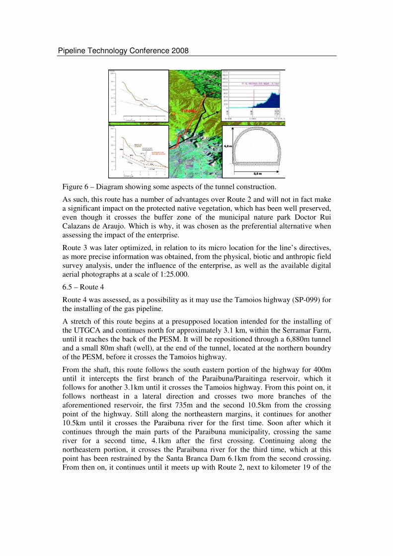
Route 3, is practically the same as route 2, yet there is a technological option to be considered. There is an underground passage for the gas pipeline, that is, a 5.2 kilometer tunnel to be considered, which crosses the PESM area, avoiding an environmental impact on the area protected by the PESM. This alternative for crossing the Coastal High Plain was analyzed and considered to be the best from a survey studied and carried out by the institute of technological surveys (PETROBRAS/IPT, February. 2006 and PETROBRAS/IPT, March. 2006).
The tunnel shall be excavated from the low lands, in Caraguatatuba, and rise at a maximum angle of 2° for 2.6km (Figures 5 and 6). At this point, there will be a shaft (well) drilled from the high plains, to a depth of 400m. These standards are not new, as they have already been used in the subterranean passage in the Aparados da Serra, on the border between the state of Santa Catarina and Rio Grande do Sul, for the Bolivia- Brasil gas pipeline. The geological survey of the location has shown results favorable to the construction of a tunnel, as it is made up fundamentally by migmatite gneiss rock, which is for the better part gneiss granite, whose schist or banding is practically perpendicular to the root of the tunnel, as such making it favorable for tunnel construction (PETROBRAS/SHAFT, 2005).
Figure 5 – General view of the tunnel project crossing the PESM.
Pipeline Technology Conference 2008
Figure 6 – Diagram showing some aspects of the tunnel construction.
As such, this route has a number of advantages over Route 2 and will not in fact make a significant impact on the protected native vegetation, which has been well preserved, even though it crosses the buffer zone of the municipal nature park Doctor Rui Calazans de Araujo. Which is why, it was chosen as the preferential alternative when assessing the impact of the enterprise.
Route 3 was later optimized, in relation to its micro location for the line’s directives, as more precise information was obtained, from the physical, biotic and anthropic field survey analysis, under the influence of the enterprise, as well as the available digital aerial photographs at a scale of 1:25.000.
6.5 – Route 4
Route 4 was assessed, as a possibility as it may use the Tamoios highway (SP-099) for the installing of the gas pipeline.
A stretch of this route begins at a presupposed location intended for the installing of the UTGCA and continues north for approximately 3.1 km, within the Serramar Farm, until it reaches the back of the PESM. It will be repositioned through a 6,880m tunnel and a small 80m shaft (well), at the end of the tunnel, located at the northern boundry of the PESM, before it crosses the Tamoios highway.
From the shaft, this route follows the south eastern portion of the highway for 400m until it intercepts the first branch of the Paraibuna/Paraitinga reservoir, which it follows for another 3.1km until it crosses the Tamoios highway. From this point on, it follows northeast in a lateral direction and crosses two more branches of the aforementioned reservoir, the first 735m and the second 10.5km from the crossing point of the highway. Still along the northeastern margins, it continues for another 10.5km until it crosses the Paraibuna river for the first time. Soon after which it continues through the main parts of the Paraibuna municipality, crossing the same river for a second time, 4.1km after the first crossing. Continuing along the northeastern portion, it crosses the Paraibuna river for the third time, which at this point has been restrained by the Santa Branca Dam 6.1km from the second crossing. From then on, it continues until it meets up with Route 2, next to kilometer 19 of the

Pipeline Technology Conference 2008
Tamoios highway next to Fazenda Brasil, where it continues for another 44km in the same direction until it reaches the future Taubate compression station.
It was observed, through a field survey, that there was not an additional platform along the highway that would facilitate the installation of the pipeline, and that earthworks, barriers and drainage would be necessary to avoid flooding.
In a topographically uneven region, this stretch of the pipeline would not be able to continue along the highway, because conceptually these works apply different technical criteria: Whereas the highway follows the grid lines, making huge movements of earth necessary (cuts and landfills), this stretch of the pipeline continues perpendicular to the grid lines thus minimizing the need for large earthworks.
It is important to mention the difficulties presented by the need to widen and install the pipeline without interrupting the traffic along the highway, as well as the risks, during the operational phase, of the proximity of the high pressure natural gas pipeline so close to a highway with a large volume of traffic.
Another important fact is the number of interferences in the urban and rural populations along the Tamoios highway.
6.6 – Quantitative Assessment with regard to Environmental Aspects of the different Routes
The relevant environmental aspects for each route along each stretch of the pipelines (20m) were interpreted and mapped in a GIS environments and quantified. Table 2 (Annex) shows the relevant environmental aspects that were considered and Table 3 (Annex) shows a summary of the results obtained from the related variable environmental physical, biotic and anthropic interferences. The values show the number of hectares intercepted by a 20m stretch along the length of each Route.
The route that presents the greatest effect on biotic environments is route 1, as it crosses the greatest number of patches of forest and because it is in the greatest number of buffer zones in conservation units. Route 2 A, together with Route 3, cause the least impact on the environment.
Route 4 causes the greatest affect on human environments as it interferes with urban and rural settlements, whereas the Alternative 3 provides the least interference.
From the physical environments assessed, it was noticed that route 3 shows the least number of stretches with slopes between 10° and 30°, whereas Route 1 had the greatest number.
7. Conclusions and Recommendations
As a result of this initial assessment, the municipality of Caraguatatuba was selected out of the other alternatives for the arrival of the underwater pipeline to the Paulista coast.
As a result of this initial assessment, the municipality of Caraguatatuba was selected out of the other alternatives as the best location for the installation of the UTGCA and consequently the arrival of the underwater pipeline , due to the following criteria:
• Extension of the required onshore and offshore pipelines;

Pipeline Technology Conference 2008
• Transportation logistics and Right of Way (ROW); • Low demographic rate; • Availability of land to install a gas treatment unit, including the possibility of
future expansion; • Environmental Impact in Parque Estadual da Serra do Mar • Environmental licensing difficulty.
The Preliminary Environmental Assessment (PEA) of the Gas Treatment Unit of Caraguatatuba (UTGCA) was an important instrument for the selection of Area 4 to install the UTGCA. The PEA allowed for the advanced identification of the relevant environmental aspects and impacts that were subsequently detailed and assessed by the Environmental Impact Assessment Study (EIA). In this sense, the Preliminary Environmental Assessment does not substitute the EIA, but it raises the initial bases for its satisfactory development.
Another important result from the Preliminary Environmental Assessment was the selection of an area free of environmental liabilities and active contamination sources.
Of all the routes assessed, the summary of all the effected areas by the environmental variables, show that routes 1, 2 and 4 are those that interfere most in the environmental variables, whereas Routes 2A and 3 of those that interfere the least, thus causing the least impact on the environment.
Of these two routes the one that interferes the least, is route 3 as it affects the least number of environmental variables analyzed, and shows the best position within the directives for the terrain – minimizing as such potential geological-geotechnical risks, the least interference in urban and rural agglomerates and the least number of water crossings, making it as such the preferred alternative.
The technological option to cross the Serra do Mar State Park through a tunnel is another extremely important factor in obtaining the environmental license for the project and thus the installation and operation of the enterprise.
It is suggested that a Preliminary Environmental Assessment be performed for new projects that will be subjected to an environmental licensing process, mainly in regions where there are environmental and social sensitivities, such as the case of the municipality of Caraguatatuba.
Incorporation of a tunnel in Route 3 was of fundamental importance for securing prior environmental feasibility for the Caraguatatuba-Taubaté gas pipeline project, as it would be practically impossible to obtain environmental licenses in view of the importance of the PESM for the preservation of one of the last large remnants of the Atlantic Rainforest in Brazil. It should be noted that according to current law, the PESM is a conservation unit with full protection, as well as being part of the patrimony of the State of São Paulo, it is of vital importance for preservation of vegetation species and is an important source of water for the region.
Thus, PETROBRAS, by modernizing conventional techniques for installing pipeline strips (construction of the tunnel), fulfils its socio-environmental responsibilities, while at the same time promoting development of energy infrastructure and environmental preservation.

Pipeline Technology Conference 2008
8. Bibliografia
- Engenharia de Avaliação Ambiental no Processo de Concepção de Projetos de Dutos da PETROBRAS – Estudo de Caso do Gasoduto Cacimbas (ES) – Catu (BA) – Rio Pipeline 2005 – Outubro de 2005 – Rio de Janeiro – RJ.
- BIODINÂMICA - ENGENHARIA E MEIO AMBIENTE. Estudo de Impacto Ambiental (EIA) da Unidade de Tratamento de Gás de Caraguatatuba. Rio de Janeiro, Abril 2006. 623p.
- BIODINÂMICA - ENGENHARIA E MEIO AMBIENTE. Estudo de Impacto Ambiental (EIA) da Gasoduto Caraguatatuba – Taubaté (GASTAU). Rio de Janeiro, Abril 2006. 891p.
- IPT. Analise de risco de processos de movimentos de massa e estudos para determinação de cota máxima de inundação para subsidiar a escolha entre as alternatives locacionais 3, 4A e 4 B da unidade de tratamento de gás do gasoduto de Mexilhão, Caraguatatuba-SP. Relatório final. São Paulo, 2006.67p.
- PETROBRAS. Avaliação das Alternatives do Recebimento do Gás em Terra. RL-Mexilhão-UTG-001 Anexo 1. Rio de Janeiro, 2004.8p.
- PETROBRAS. Caraguatatuba – Estudo de Alternatives de áreas. RL-Mexilhão-UTG-003. Rio de Janeiro, 2006.7p.
- PETROBRAS. Caraguatatuba – Estudo de Alternatives de Traçado. RL-GASTAU-001. Rio de Janeiro, 2006.15p.
- PETROBRAS / SHAFT CONSULTORIA. Túnel Mexilhão. Projeto Conceitual. Relatório Técnico. São Paulo. 2005.

Pipeline Technology Conference 2008
ANNEX
Table 1 – Results from the Preliminary Macro Environmental Regional Assessment of the Alternative Locations for the Installation of the Gas Treatment Unit and the arrival of the Underwater Pipeline.
CRITERIA ALTERNATIVE 1
Cubatão - SP
ALTERNATIVE 2
São Sebastião - SP
ALTERNATIVE 3
Angra dos Reis - SP
ALTERNATIVE 4
Sepetiba - SP ALTERNATIVE 5
Caraguatatuba - SP
Gas Pipeline to UTG
Offshore 200 km Onshore 16 km
Offshore 150 km
Offshore 220 km Offshore 240 km Offshore 138 km Onshore 7 km
UTG RPBC GEBAST with restriction of area
GEBIG with environmental
restrictions
Area available for purchase
Area available for purchase
Condensate RPBC GEBAST Oil Pipeline to GEBAST – 30 km
Oil Pipeline to REDUC – 60 km
GEBIG
Gas Pipeline to Gas Net
GASAN full, new gas pipeline
deemed unfeasible
Guararema – 70 km, GASAN and
GASPAL full, new gas pipeline
deemed unfeasible
Campinas-Rio
97 km to Japeri
Campinas-Rio,
48 km to Japeri
Campinas-Rio
92 km to Taubaté
Technical Feasibility
Current gas pipeline and
ROW can not fit the new project
Current gas pipeline and
ROW can not fit the new project
New gas pipeline part in Current Gas Pipilene (57 km) and part in new ROW (40
km)
New gas pipeline in new ROW - 48
km
New gas pipeline part in new ROW (65 km) and part in Current Gas Pipeline (27 km)
Environmental Permitting
Densely inhabited area
Densely inhabited area, crosses Ilha
Bela
Difficulties at Terminal and at the gas pipeline –
Touristic Area
Sensitive – Restinga de Marambaia
A more adequate location can be
defined as well as a new pipeline route
to minimize impacts
Transport Logistics
Long distance to Guararema and
Taubaté
Long distance to Guararema and
Taubaté
Arrives at the end of Campinas-Rio
(lower operational flexibility)
Arrives at the end of Campinas-Rio
(lower operational flexibility)
Arrives directly at the Campinas –Rio
at the point of highest operational
flexibility (Taubaté)

Pipeline Technology Conference 2008
Table 2 –Relevant environmental aspects.
Environment Relevant environmental aspects
Physical Alternative extensions; Gradient of the terrain; Water crossings; Mineral resources.
Biotic Forrest patches; Units under conservation (UC) and Special Zones Under Environmental Protection (ZEPA).
Anthropic Affected municipalities; urban and rural agglomerates; indigenous lands(TI); Historical Communities known as `Quilombos`.
Table 3 – Number of hectares affected by the variables in the alternative lines.
Environment Environmental variable Route 1 Route 2 Route 2A Route 3 Route 4
Fragments of forest 41.38 28.66 18.28 22.00 16.66
APAs + PESM 33.06 39.42 28.69 32.55 55.50
ZEPAs 5.97 5.97 5.97 5.97 5.97
Buffer zone 89.61 75.29 74.04 78.69 79.13 Bio
tic
Summary of biotic environments 170.02 149.34 126.98 139.21 157.26
Urban and rural agglomerates 19.09 17.22 17.22 10.97 32.00
Indigenous lands 0.00 0.00 0.00 0.00 0.00
Communities `Quilombolas` 0.00 0.00 0.00 0.00 0.00
Ant
hrop
ic
Summary of Anthropic environments 19.09 17.22 17.22 10.97 32.00
Slope of between 10 to 30 19.88 19.84 14.39 7.52 11.15
Areas of mineral extraction 34.28 33.39 33.39 32.46 26.60
Water crossings 0.24 0.82 0.82 0.11 3.69
Phy
sica
l
Summary of physical environments 54.40 54.05 48.60 40.09 41.44
Summary of all environments 243.51 220.61 192.80 190.27 230.70