PREFER 1 st Annual Review Meeting, 5-6 Dec 2013, Milano-Italy PREFER WP3.1 - Information Support to...
13
PREFER 1 st Annual Review Meeting, 5-6 Dec 2013, Milano-Italy PREFER WP3.1 - Information Support to Preparedness/Prevention Phase Product: “Daily Fire Hazard Map”
-
Upload
lynette-randall -
Category
Documents
-
view
216 -
download
3
Transcript of PREFER 1 st Annual Review Meeting, 5-6 Dec 2013, Milano-Italy PREFER WP3.1 - Information Support to...

PREFER 1st Annual Review Meeting, 5-6 Dec 2013, Milano-Italy
PREFER
WP3.1 - Information Support toPreparedness/Prevention Phase
Product: “Daily Fire Hazard Map”
PREFER
WP3.1 - Information Support toPreparedness/Prevention Phase
Product: “Daily Fire Hazard Map”
PREFER 1st Annual Review Meeting, 5-6 Dec 2013, Milano-Italy
Project WP 3.1, Task 3.1.6 status
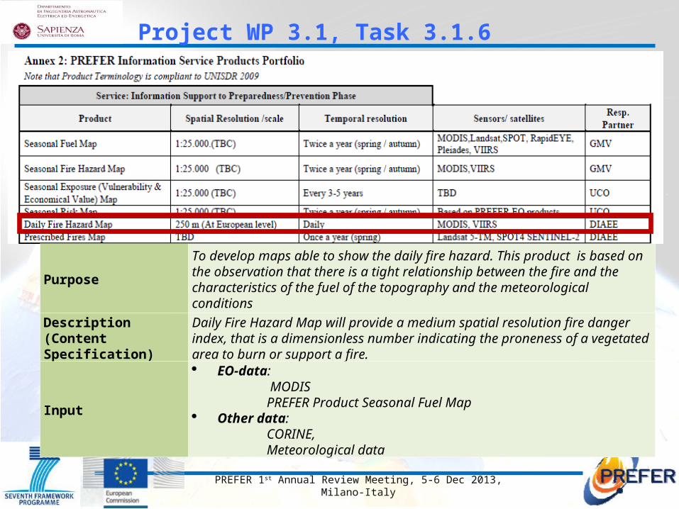
PurposeTo develop maps able to show the daily fire hazard. This product is based on the observation that there is a tight relationship between the fire and the characteristics of the fuel of the topography and the meteorological conditions
Description (Content Specification)
Daily Fire Hazard Map will provide a medium spatial resolution fire danger index, that is a dimensionless number indicating the proneness of a vegetated area to burn or support a fire.
Input
EO-data: MODIS PREFER Product Seasonal Fuel Map Other data: CORINE, Meteorological data

PREFER 1st Annual Review Meeting, 5-6 Dec 2013, Milano-Italy
1 To develop a daily Fire Hazard Index with the objective of showing the total hazard level for the area of interest and the zones of major concern within such area;
2 To develop maps able to show the fire hazard considering the tight relationship between fire and:• fuel characteristics (vegetation type, density, humidity
content);• topography (slope, altitude, solar aspect angle);• meteorological conditions (rainfall, wind direction and speed,
air humidity, surface and air temperature).
Daily Fire Hazard Index: objectives

PREFER 1st Annual Review Meeting, 5-6 Dec 2013, Milano-Italy
1- Statistical Methods or Structural (long-term fire risk index) defining forecast models based on the utilization of slowly changing parameters like topography or other variables that can be considered constant along the year and statistical information on the frequency of the phenomenon.
Methods to estimate fire hazard
2- Dynamical Methods (short-term fire risk index) based on:
• Data measured continuously (i.e. daily)• Characteristics of spatial data (orography and vegetation)• Forecast models of the meteorological parameters
Daily Fire Hazard Index: background

PREFER 1st Annual Review Meeting, 5-6 Dec 2013, Milano-Italy
The forecast was made on the basis of the calculation of 7 different risk indices (6 of which represent the evolution of indices developed for national applications and are substantially meteorological indices), using meteorological data interpolated on a grid of 50 km (10 km from 2012) and weather forecasts of Meteo France and satellite data.
The JRC has developed a new index, starting from the Fire Potential Index (FPI) introduced in 1998 in the USA (Burgan et al., 1998) which represents an evolution (Advanced FPI) adapted to the European reality.
The following indices have been tested:Portuguese Index, ICON method, Risk Numeric Drouet-Sol, Italian Risk Index, Canadian Index (Canadian Fire Weather Index), BEHAVE model, Fire Potential Index
EFFIS (European Forest Fires Information System)
Daily Fire Hazard Index: background

PREFER 1st Annual Review Meeting, 5-6 Dec 2013, Milano-Italy
The MFPI, which is a risk index based on the Fire Potential Index (FPI, Burgan) combines different types of static (topography, etc.) and dynamic (meteo data and remote sensing data) variables.
1/3
9/10
11/1219/20
16/16
6/12
5/8
4/410/9
18/11
13/6
8/5
17/1920/18
15/157/7
14/14
11/13
3/1
2/2
Within the SIGRI project this parameter is computed automatically every 3 hours for the following 3 days.
EFFIS (European Forest Fires Information System)
The result: Dynamic FWI
Daily Fire Hazard Index: state-of-the-art
SIGRI (Integrated System for Forest Fire Management)
www.sigri.it
PREFER 1st Annual Review Meeting, 5-6 Dec 2013, Milano-Italy
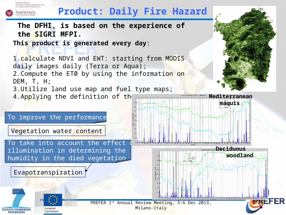
The DFHI, is based on the experience of the SIGRI MFPI.
This product is generated every day:
1.calculate NDVI and EWT: starting from MODIS daily images daily (Terra or Aqua);2.Compute the ET0 by using the information on DEM, T, H;3.Utilize land use map and fuel type maps;4.Applying the definition of the FPI.
Evapotranspiration
To take into account the effect of solar illumination in determining the existing humidity in the died vegetation
To improve the performance
Vegetation water content
Product: Daily Fire Hazard Index
Mediterranean maquis
Deciduous woodland

PREFER 1st Annual Review Meeting, 5-6 Dec 2013, Milano-Italy
Generation scheme of Daily Fire Hazard Map
Server
Algorithm computation of DFHI
ELABORATION
NDVI, EWT
DEM, fuel map
Meteo data
INPUT
DFHI MAPGeotiff Generation
In PREFER project we are developing a new Daily Fire Hazard Index
(DFHI) appropriate for the Mediterranean areas.
Product: Daily Fire Hazard Index - methodology
DEM based on SRTM

PREFER 1st Annual Review Meeting, 5-6 Dec 2013, Milano-Italy
DFHI
Temp/humid EMC FM TNF
Corine
Fueltype
Fuel Minhum
Min
Max
MinMin
MaxMax
2008 2012
Evapotranspiration
Daily Fire Hazard index
Daily NDVI
RG
Ten hour lag fuel moistureFraction of ten hour lag fuel moisture
EWT
Green veg. fraction
Dead veg. fractionGreen veg. fraction linked to fuel type
Dead veg. fractionGreen veg. fraction
JRC
Product: Daily Fire Hazard Index - methodology
FPI = (1 - Lf) * (1 - TNf)*100
Lf = fraction of live vegetationTNf = dead small fuel moisture content= f(Ta,Hu)

PREFER 1st Annual Review Meeting, 5-6 Dec 2013, Milano-Italy
In literature the estimation of EWT is discussed in depth by Ceccato, which relates EWT with GVMI for SPOT data.
The constants (a, b, c, d) are related to the sensor (MODIS) and the type of vegetation that is observed.More than a million of reflectance spectra have been simulated by varying simultaneously the biologicalparameters of the leaf, the structure of the canopy and atmospheric conditions for selecting the MODISbands and define the relationship between GVMI and EWT.
Product: Daily Fire Hazard Index - methodology
GM
VI
EWTcanopy
In the Sardinia region the maximum value of EWT occurs, for most of the territory, during the winter time.
Equivalent Water Tickness

PREFER 1st Annual Review Meeting, 5-6 Dec 2013, Milano-Italy
Product: Daily Fire Hazard Index - methodology
ET0 is estimated by using the Penman-Monteith formula modified according to FAO:
ETo = evapo-transpiration [mm day-1],Rn = net radiation at surface [MJ m-2 day-1], f(aspect, slope)G = soil heat flux [MJ m-2 day-1],T = daily mean value of the air temperature at 2 m [°C],u2 = wind speed at 2 m [m s-1],es = saturated vapor pressure [kPa],ea = mean vapor pressure [kPa], = de/dT [kPa °C-1], = psychrometric constant [kPa °C-1].
Evapotranspiration
COSMO-LAMI, spatial resolution 6 km, air temperature at 2m.

PREFER 1st Annual Review Meeting, 5-6 Dec 2013, Milano-Italy
Example of DFHI computed every 3 hours on Sardinia and Corsica, day 28 Aug. 2013
Hour: 00 Hour: 06 Hour: 12 Hour: 18
Hour: 00 Hour: 12
Product: Daily Fire Hazard Index

PREFER 1st Annual Review Meeting, 5-6 Dec 2013, Milano-Italy
Thank you
Product: Daily Fire Hazard Index