Numerical Analysis of Soil Liquefaction Induced Failure of ...
Upload
phungkhanhCategory
view
221download
0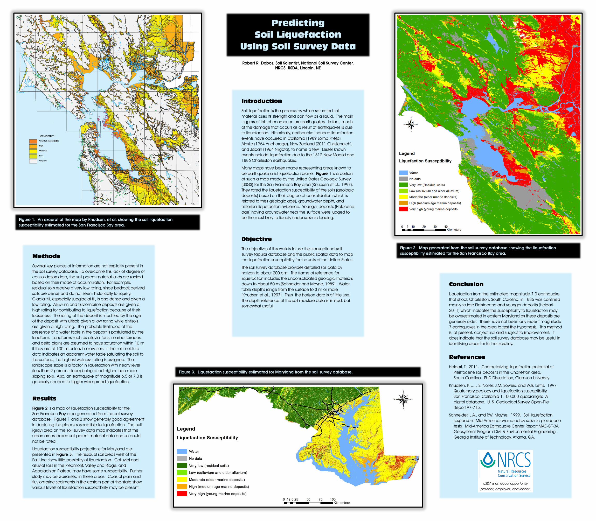
Predicting Soil Liquefaction
Using Soil Survey Data
Introduction
Soil liquefaction is the process by which saturated soil material loses its strength and can flow as a liquid. The main triggers of this phenomenon are earthquakes. In fact, much of the damage that occurs as a result of earthquakes is due to liquefaction. Historically, earthquake-induced liquefaction events have occurred in California (1989 Loma Prieta), Alaska (1964 Anchorage), New Zealand (2011 Christchurch), and Japan (1964 Niigata), to name a few. Lesser known events include liquefaction due to the 1812 New Madrid and 1886 Charleston earthquakes.
Many maps have been made representing areas known to be earthquake and liquefaction prone. Figure 1 is a portion of such a map made by the United States Geologic Survey (USGS) for the San Francisco Bay area (Knudsen et al., 1997). They rated the liquefaction susceptibility of the soils (geologic deposits) based on their degree of consolidation (which is related to their geologic age), groundwater depth, and historical liquefaction evidence. Younger deposits (Holocene age) having groundwater near the surface were judged to be the most likely to liquefy under seismic loading.
Objective
The objective of this work is to use the transactional soil survey tabular database and the public spatial data to map the liquefaction susceptibility for the soils of the United States.
The soil survey database provides detailed soil data by horizon to about 200 cm. The frame of reference for liquefaction includes the unconsolidated geologic materials down to about 50 m (Schneider and Mayne, 1989). Water table depths range from the surface to 3 m or more (Knudsen et al., 1997). Thus, the horizon data is of little use. The depth reference of the soil moisture data is limited, but somewhat useful.
Methods
Several key pieces of information are not explicitly present in the soil survey database. To overcome this lack of degree of consolidation data, the soil parent material kinds are ranked based on their mode of accumulation. For example, residual soils receive a very low rating, since bedrock derived soils are dense and do not seem historically to liquefy. Glacial till, especially subglacial till, is also dense and given a low rating. Alluvium and fluviomarine deposits are given a high rating for contributing to liquefaction because of their looseness. The rating of the deposit is modified by the age of the deposit, with ultisols given a low rating while entisols are given a high rating. The probable likelihood of the presence of a water table in the deposit is postulated by the landform. Landforms such as alluvial fans, marine terraces, and delta plains are assumed to have saturation within 10 m if they are at 100 m or less in elevation. If the soil moisture data indicates an apparent water table saturating the soil to the surface, the highest wetness rating is assigned. The landscape slope is a factor in liquefaction with nearly level (less than 2 percent slope) being rated higher than more sloping soils. Also, an earthquake of magnitude 6.5 or 7.0 is generally needed to trigger widespread liquefaction.
Results
Figure 2 is a map of liquefaction susceptibility for the San Francisco Bay area generated from the soil survey database. Figures 1 and 2 show generally good agreement in depicting the places susceptible to liquefaction. The null (gray) area on the soil survey data map indicates that the urban areas lacked soil parent material data and so could not be rated.
Liquefaction susceptibility projections for Maryland are presented in Figure 3. The residual soil areas west of the Fall Line show little possibility of liquefaction. Colluvial and alluvial soils in the Piedmont, Valley and Ridge, and Appalachian Plateau may have some susceptibility. Further study may be warranted in these areas. Coastal plain and fluviomarine sediments in the eastern part of the state show various levels of liquefaction susceptibility may be present.
Conclusion
Liquefaction from the estimated magnitude 7.0 earthquake that shook Charleston, South Carolina, in 1886 was confined mainly to late Pleistocene and younger deposits (Heidari, 2011) which indicates the susceptibility to liquefaction may be overestimated in eastern Maryland as these deposits are generally older. There have not been any recent magnitude 7 earthquakes in the area to test the hypothesis. This method is, at present, conjectural and subject to improvement. It does indicate that the soil survey database may be useful in identifying areas for further scrutiny.
References
Heidari, T. 2011. Characterizing liquefaction potential of Pleistocene soil deposits in the Charleston area, South Carolina. PhD Dissertation, Clemson University.
Knudsen, K.L., J.S. Noller, J.M. Sowers, and W.R. Lettis. 1997. Quaternary geology and liquefaction susceptibility, San Francisco, California 1:100,000 quadrangle: A digital database. U. S. Geological Survey Open-File Report 97-715.
Schneider, J.A., and P.W. Mayne. 1999. Soil liquefaction response in Mid-America evaluated by seismic piezocone tests. Mid-America Earthquake Center Report MAE-GT-3A. Geosystems Program Civil & Environmental Engineering, Georgia Institute of Technology, Atlanta, GA.
Figure 1. An excerpt of the map by Knudsen, et al. showing the soil liquefaction susceptibility estimated for the San Francisco Bay area.
Figure 2. Map generated from the soil survey database showing the liquefaction susceptibility estimated for the San Francisco Bay area.
Figure 3. Liquefaction susceptibility estimated for Maryland from the soil survey database.
Robert R. Dobos, Soil Scientist, National Soil Survey Center, NRCS, USDA, Lincoln, NE
USDA is an equal opportunity
provider, employer, and lender.