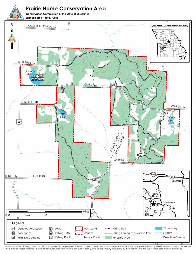
Prairie Home Conservation Area Map - MDC Discover Nature...Prairie Home Conservation Area Map...
1
CEDRON RD PRAIRIE RD FELDER RD ERNST RD HAZEL DELL SCHOOL RD ACRE D R HUNT MILL RD " ) W COOPER COUNTY MONITEAU COUNTY Johnson Lake Cattail Lake Church Lake 1 2 3 4 5 6 7 8 9 ! ! P ! Ò ! ! P ! Ò ! ! P ! ! P ! ! P ! ! P ! ! P ! ! P ! ! P ! Ò ! Ò ! Ò ! b ! _ ! l ! l ! l ! x 8 50 850 800 750 850 0 0.5 1 0.25 Miles S ite ^ ^ 40 70 O 179 87 87 179 63 D U W J Site Jamestown Prairie Home Columbia ! b ! ! P ! Ò ! _ ! l ! x Prairie Home Conservation Area Conservation Commission of the State of Missouri © Last Updated - 10/17/2018 1,461 Acres - Cooper, Moniteau County Legend Disabled Accessible Parking Lot Primitive Camping Privy Fishing Jetty Fishing Dock MDC Land County Service Road Hiking Trail Hiking / Biking / Equestrian Trail Forested Area Waterbody Stream Elevation Contour MAP DISCLAIMER: Although all data in this map have been compiled by the Missouri Department of Conservation, no warranty, expressed or implied, is made by the department as to the accuracy of the data and related materials. The act of distribution shall not constitute any such warranty, and no responsibility is assumed by the department in the use of these data or related materials.
Transcript of Prairie Home Conservation Area Map - MDC Discover Nature...Prairie Home Conservation Area Map...
CEDRON RD
PRAIRIE RD
FELDER RDERNST RD
HAZEL DELL SCHOOL RD
ACRE DR
HUNT MILL RD
")W
COOP
ER C
OUNT
YMO
NITE
AU C
OUNT
Y
JohnsonLake
CattailLake Church
Lake
12
3
4
5
67
8
9
!!P!Ò
!!P!Ò
!!P
!!P
!!P
!!P!!P
!!P
!!P
!Ò
!Ò
!Ò
!b!_!l !l!l !x
850850
800
750
850
0 0.5 10.25Miles
Site^
4070
O
17987
87179
63
D
UW
J
Site
Jamestown
PrairieHome
Columbia
!b
!!P
!Ò
!_
!l
!x
Prairie Home Conservation AreaConservation Commission of the State of Missouri © Last Updated - 10/17/2018
1,461 Acres - Cooper, Moniteau County
LegendDisabled Accessible
Parking Lot
Primitive Camping
PrivyFishing JettyFishing Dock
MDC Land
CountyService Road
Hiking Trail
Hiking / Biking / Equestrian Trail
Forested Area
WaterbodyStream
Elevation Contour
MAP DISCLAIMER: Although all data in this map have been compiled by the Missouri Department of Conservation, no warranty, expressed or implied, is made by the department as to the accuracy of the data and related materials. The act of distribution shall not constitute any such warranty, and no responsibility is assumed by the department in the use of these data or related materials.