Practical teaching of GIS at University of Liège · Practical teaching of GIS at University of...
20
UCL Belgium Geo Day 2013 Practical teaching of GIS at University of Liège Jean-Paul Kasprzyk, assistant
Transcript of Practical teaching of GIS at University of Liège · Practical teaching of GIS at University of...

UCL Belgium Geo Day 2013
Practical teaching of GIS at
University of Liège
Jean-Paul Kasprzyk, assistant

UCL
Jean-Paul Kasprzyk - Practical teaching of GIS at ULG
Belgium Geo Day 2013
Lessons
• Pr. Jean-Paul Donnay: – For non-geographers (geologists, urban planners, engineers…)
GIS users • Master:
– Introduction to GIS (15h theory + 15h practical)
– For Geographers & Land Surveyors
GIS professionals • Bach. :
– Cartography & GIS (30h th + 40h pr)
– Cartography complement – projections (15h th + 20h pr)
– Spatial analysis & GIS (30h th + 30h pr)
• Master : – Project management (10h th + 10h pr)
– GIS (30h th + 30h pr)
– Special questions of geomatics (20h th + 30h pr)

UCL
Jean-Paul Kasprzyk - Practical teaching of GIS at ULG
Belgium Geo Day 2013
GIS for users

UCL
Jean-Paul Kasprzyk - Practical teaching of GIS at ULG
Belgium Geo Day 2013
Introduction to GIS (1)
– Data analysis (QGIS) • Data schema
• Attribute table
• SQL requests
– Vector data (QGIS, OpenJump) • Import / export
• Topology decomposition
• Software extensions
– Raser data (Idrisi) • Import / export
• Metadata
• Color palette
• Image georeferencing
– Data exchange (QGIS) • De facto format standards
• OpenLayers, Google
• WMS client

UCL
Jean-Paul Kasprzyk - Practical teaching of GIS at ULG
Belgium Geo Day 2013
Introduction to GIS (2)
– Coordinate reference systems (QGIS, Google Earth/Maps) • SRID (EPSG)
• « On the fly » transformations
• WKT CRS definitions
– Spatial requests (QGIS, Open Jump) • Simple queries
• Topologic queries
• Spatial joints
• Geometry edition
– DEM (Idrisi, Surfer) • Interpolation
• Slopes, watershed, illumination
• 3D display
– Raster decision support (Idrisi) • Map algebra
• Multicriteria analysis

UCL
Jean-Paul Kasprzyk - Practical teaching of GIS at ULG
Belgium Geo Day 2013
GIS for professionals

UCL
Jean-Paul Kasprzyk - Practical teaching of GIS at ULG
Belgium Geo Day 2013
GIS prerequisite: cartography
• Map production – Geo-referencing
– Computer graphics (vector & raster)
– Data pre-treatments (generalization, classifications…)
– Semiotics application (symbol edition, etc.)
– Choropleth, flows, continuous maps…
– Plan design for surveyors
• Different GIS softwares
– ArcGIS, MapViewer, Idrisi, Q-GIS, Open Jump
– AutoCad, Covadis
UCL
Jean-Paul Kasprzyk - Practical teaching of GIS at ULG
Belgium Geo Day 2013
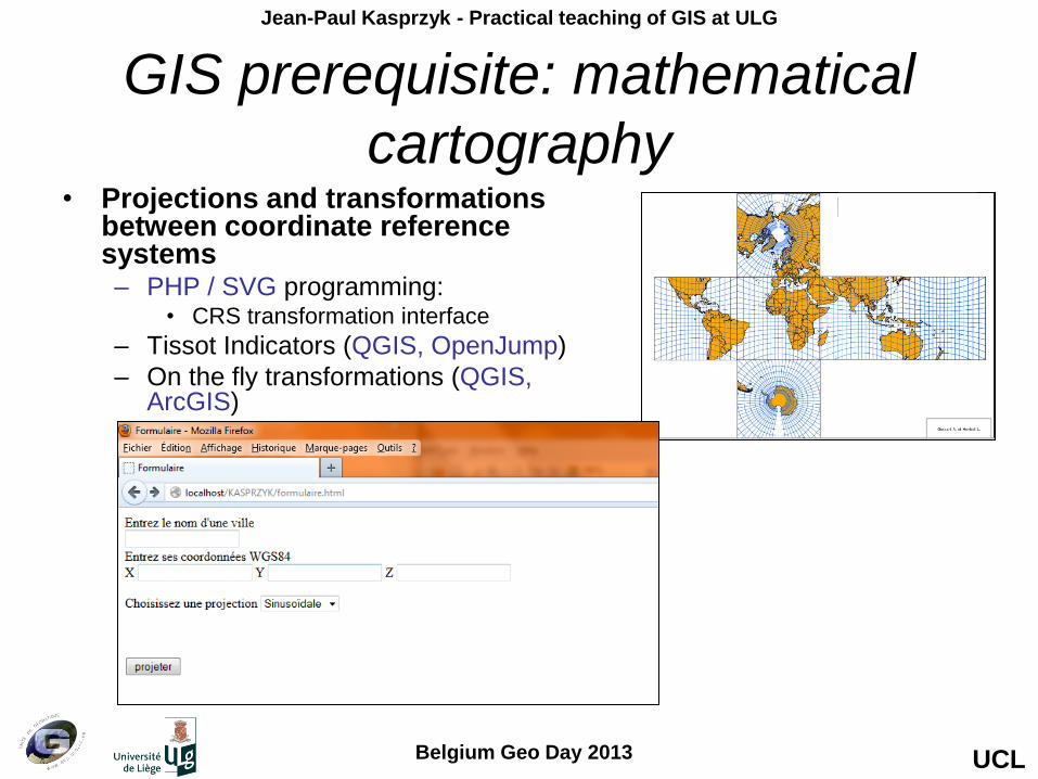
GIS prerequisite: mathematical
cartography • Projections and transformations
between coordinate reference systems – PHP / SVG programming:
• CRS transformation interface
– Tissot Indicators (QGIS, OpenJump)
– On the fly transformations (QGIS, ArcGIS)

UCL
Jean-Paul Kasprzyk - Practical teaching of GIS at ULG
Belgium Geo Day 2013
GIS prerequisite: spatial analysis
• Spatial statistics
– Spatial distributions, spatial auto-correlation
• Graph analysis
– Shortest path, flow analysis, propagation (raster)
• Multivariate analysis
– PCA, classifications, regressions, regionalization
• Geo-statistics & interpolations
– TIN, trend surfaces, Kriging, cost surfaces
• ArcGIS, Idrisi, Surfer, Statistica, MatLab, R, etc.

UCL
Jean-Paul Kasprzyk - Practical teaching of GIS at ULG
Belgium Geo Day 2013
GIS prerequisite: spatial analysis:
practical example Practical teacher: Marie Trotta

UCL
Jean-Paul Kasprzyk - Practical teaching of GIS at ULG
Belgium Geo Day 2013
GIS prerequisite: databases
• Theory: Pr. Pierre Wolper
• Database conceptual / logical / physical modeling – E/A formalism, SQL langage
• Main work: – database building (MySQL)
– PHP interface of the database

UCL
Jean-Paul Kasprzyk - Practical teaching of GIS at ULG
Belgium Geo Day 2013
GIS
• Main work (15h):
– Conceptual modeling of a spatial database
• Extended UML language
– Implementation of the GIS
• CASE tools
– Data integration
• Data conversion, loading, metadata…
– GIS interface
– OS software (MosKitt, PostGIS, GeoNetwork, Q-GIS…)
– Report (1 / pair of students)
• Other works (15h): – Spatial database applications: spatial index, requests, connectivity, etc.
– Map algebra: formalism & macro modeler, decision wizard, multicriteria modeling

UCL
Jean-Paul Kasprzyk - Practical teaching of GIS at ULG
Belgium Geo Day 2013
GIS main work: UML modeling (MosKitt)

UCL
Jean-Paul Kasprzyk - Practical teaching of GIS at ULG
Belgium Geo Day 2013
GIS main work: SQL modeling (MosKitt)

UCL
Jean-Paul Kasprzyk - Practical teaching of GIS at ULG
Belgium Geo Day 2013
GIS main work: Database implementation
and management (PostGIS)

UCL
Jean-Paul Kasprzyk - Practical teaching of GIS at ULG
Belgium Geo Day 2013
GIS main work: data integration (GeoKettle)

UCL
Jean-Paul Kasprzyk - Practical teaching of GIS at ULG
Belgium Geo Day 2013
GIS main work: exploitation (OpenJump,
PGAdmin)

UCL
Jean-Paul Kasprzyk - Practical teaching of GIS at ULG
Belgium Geo Day 2013
GIS other works: raster decision support (Idrisi)

UCL
Jean-Paul Kasprzyk - Practical teaching of GIS at ULG
Belgium Geo Day 2013
Special questions of GIS
• Distributed GIS : 3-tiers GIS architecture, GML (XML), Web services.
• Project driven exercise:
• Prototype solution to meet an external demand (SPI, Charleroi,
SEGEFA…)
• All students participate in the solution, in total autonomy.
• Project planning (PERT) and distribution of tasks
(Gantt) under the responsibility of a team (pair) of
project managers (cf. Project management course).
• Still incorporates the implementation of a data server,
a Web server, an application server;
and building Web services and customized interfaces.
• PostGIS, Apache, MapServer, Q-GIS, Python, PHP
(or other OS software)
• Oral presentation + report for the customer

UCL
Jean-Paul Kasprzyk - Practical teaching of GIS at ULG
Belgium Geo Day 2013
Thank you for listening!
Questions?