PPENDIX 5 - Santa Paula, California
381
APPENDIX 5.8 EDR RADIUS MAP REPORT
Transcript of PPENDIX 5 - Santa Paula, California

APPENDIX 5.8
EDR RADIUS MAP REPORT

FORM-NULL-MAR
®kcehCoeG htiw tropeR ™paM suidaR RDE ehT
440 Wheelers Farms RoadMilford, CT 06461Toll Free: 800.352.0050www.edrnet.com
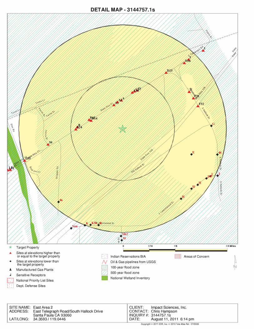
East Area 2East Telegraph Road/South Hallock DriveSanta Paula, CA 93060
Inquiry Number: 3144757.1sAugust 11, 2011

SECTION PAGE
Executive Summary ES1
Overview Map 2
Detail Map 3
Map Findings Summary 4
Map Findings 8
Orphan Summary 265
Government Records Searched/Data Currency Tracking GR-1
GEOCHECK ADDENDUM
Physical Setting Source Addendum A-1
Physical Setting Source Summary A-2
Physical Setting SSURGO Soil Map A-5
Physical Setting Source Map A-12
Physical Setting Source Map Findings A-14
Physical Setting Source Records Searched A-56
TC3144757.1s Page 1
Thank you for your business.Please contact EDR at 1-800-352-0050
with any questions or comments.
Disclaimer - Copyright and Trademark Notice
This Report contains certain information obtained from a variety of public and other sources reasonably available to Environmental DataResources, Inc. It cannot be concluded from this Report that coverage information for the target and surrounding properties does not exist fromother sources. NO WARRANTY EXPRESSED OR IMPLIED, IS MADE WHATSOEVER IN CONNECTION WITH THIS REPORT. ENVIRONMENTALDATA RESOURCES, INC. SPECIFICALLY DISCLAIMS THE MAKING OF ANY SUCH WARRANTIES, INCLUDING WITHOUT LIMITATION,MERCHANTABILITY OR FITNESS FOR A PARTICULAR USE OR PURPOSE. ALL RISK IS ASSUMED BY THE USER. IN NO EVENT SHALLENVIRONMENTAL DATA RESOURCES, INC. BE LIABLE TO ANYONE, WHETHER ARISING OUT OF ERRORS OR OMISSIONS, NEGLIGENCE,ACCIDENT OR ANY OTHER CAUSE, FOR ANY LOSS OF DAMAGE, INCLUDING, WITHOUT LIMITATION, SPECIAL, INCIDENTAL,CONSEQUENTIAL, OR EXEMPLARY DAMAGES. ANY LIABILITY ON THE PART OF ENVIRONMENTAL DATA RESOURCES, INC. IS STRICTLYLIMITED TO A REFUND OF THE AMOUNT PAID FOR THIS REPORT. Purchaser accepts this Report "AS IS". Any analyses, estimates, ratings,environmental risk levels or risk codes provided in this Report are provided for illustrative purposes only, and are not intended to provide, norshould they be interpreted as providing any facts regarding, or prediction or forecast of, any environmental risk for any property. Only a Phase IEnvironmental Site Assessment performed by an environmental professional can provide information regarding the environmental risk for anyproperty. Additionally, the information provided in this Report is not to be construed as legal advice.
Copyright 2011 by Environmental Data Resources, Inc. All rights reserved. Reproduction in any media or format, in wholeor in part, of any report or map of Environmental Data Resources, Inc., or its affiliates, is prohibited without prior written permission.
EDR and its logos (including Sanborn and Sanborn Map) are trademarks of Environmental Data Resources, Inc. or its affiliates. All othertrademarks used herein are the property of their respective owners.
TABLE OF CONTENTS

EXECUTIVE SUMMARY
TC3144757.1s EXECUTIVE SUMMARY 1
A search of available environmental records was conducted by Environmental Data Resources, Inc (EDR).The report was designed to assist parties seeking to meet the search requirements of EPA’s Standardsand Practices for All Appropriate Inquiries (40 CFR Part 312), the ASTM Standard Practice forEnvironmental Site Assessments (E 1527-05) or custom requirements developed for the evaluation ofenvironmental risk associated with a parcel of real estate.
TARGET PROPERTY INFORMATION
ADDRESS
EAST TELEGRAPH ROAD/SOUTH HALLOCK DRIVESANTA PAULA, CA 93060
COORDINATES
34.359300 - 34˚ 21’ 33.5’’Latitude (North): 119.044600 - 119˚ 2’ 40.6’’Longitude (West): Zone 11Universal Tranverse Mercator: 311965.4UTM X (Meters): 3803694.0UTM Y (Meters): 297 ft. above sea levelElevation:
USGS TOPOGRAPHIC MAP ASSOCIATED WITH TARGET PROPERTY
34119-C1 SANTA PAULA, CATarget Property Map:1967Most Recent Revision:
34119-D1 SANTA PAULA PEAK, CANorth Map:1988Most Recent Revision:
TARGET PROPERTY SEARCH RESULTS
The target property was not listed in any of the databases searched by EDR.
DATABASES WITH NO MAPPED SITES
No mapped sites were found in EDR’s search of available ("reasonably ascertainable ") governmentrecords either on the target property or within the search radius around the target property for thefollowing databases:
STANDARD ENVIRONMENTAL RECORDS
Federal NPL site list
NPL National Priority ListProposed NPL Proposed National Priority List SitesNPL LIENS Federal Superfund Liens
Federal Delisted NPL site list
Delisted NPL National Priority List Deletions
EXECUTIVE SUMMARY
TC3144757.1s EXECUTIVE SUMMARY 2
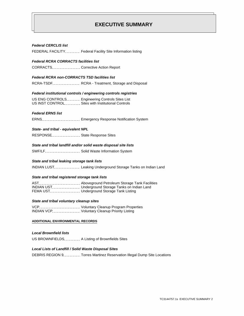
Federal CERCLIS list
FEDERAL FACILITY Federal Facility Site Information listing
Federal RCRA CORRACTS facilities list
CORRACTS Corrective Action Report
Federal RCRA non-CORRACTS TSD facilities list
RCRA-TSDF RCRA - Treatment, Storage and Disposal
Federal institutional controls / engineering controls registries
US ENG CONTROLS Engineering Controls Sites ListUS INST CONTROL Sites with Institutional Controls
Federal ERNS list
ERNS Emergency Response Notification System
State- and tribal - equivalent NPL
RESPONSE State Response Sites
State and tribal landfill and/or solid waste disposal site lists
SWF/LF Solid Waste Information System
State and tribal leaking storage tank lists
INDIAN LUST Leaking Underground Storage Tanks on Indian Land
State and tribal registered storage tank lists
AST Aboveground Petroleum Storage Tank FacilitiesINDIAN UST Underground Storage Tanks on Indian LandFEMA UST Underground Storage Tank Listing
State and tribal voluntary cleanup sites
VCP Voluntary Cleanup Program PropertiesINDIAN VCP Voluntary Cleanup Priority Listing
ADDITIONAL ENVIRONMENTAL RECORDS
Local Brownfield lists
US BROWNFIELDS A Listing of Brownfields Sites
Local Lists of Landfill / Solid Waste Disposal Sites
DEBRIS REGION 9 Torres Martinez Reservation Illegal Dump Site Locations

EXECUTIVE SUMMARY
TC3144757.1s EXECUTIVE SUMMARY 3
ODI Open Dump InventoryWMUDS/SWAT Waste Management Unit DatabaseHAULERS Registered Waste Tire Haulers ListingINDIAN ODI Report on the Status of Open Dumps on Indian Lands
Local Lists of Hazardous waste / Contaminated Sites
US CDL Clandestine Drug LabsHIST Cal-Sites Historical Calsites DatabaseSCH School Property Evaluation ProgramToxic Pits Toxic Pits Cleanup Act SitesUS HIST CDL National Clandestine Laboratory Register
Local Land Records
LIENS 2 CERCLA Lien InformationLUCIS Land Use Control Information SystemLIENS Environmental Liens ListingDEED Deed Restriction Listing
Records of Emergency Release Reports
HMIRS Hazardous Materials Information Reporting SystemLDS Land Disposal Sites ListingMCS Military Cleanup Sites Listing
Other Ascertainable Records
DOT OPS Incident and Accident DataDOD Department of Defense SitesFUDS Formerly Used Defense SitesCONSENT Superfund (CERCLA) Consent DecreesROD Records Of DecisionUMTRA Uranium Mill Tailings SitesMINES Mines Master Index FileTRIS Toxic Chemical Release Inventory SystemTSCA Toxic Substances Control ActFTTS FIFRA/ TSCA Tracking System - FIFRA (Federal Insecticide, Fungicide, & Rodenticide Act)/TSCA (Toxic Substances Control Act)HIST FTTS FIFRA/TSCA Tracking System Administrative Case ListingPADS PCB Activity Database SystemMLTS Material Licensing Tracking SystemRADINFO Radiation Information DatabaseRAATS RCRA Administrative Action Tracking SystemCA BOND EXP. PLAN Bond Expenditure PlanCortese "Cortese" Hazardous Waste & Substances Sites ListNotify 65 Proposition 65 RecordsDRYCLEANERS Cleaner FacilitiesWIP Well Investigation Program Case ListINDIAN RESERV Indian ReservationsSCRD DRYCLEANERS State Coalition for Remediation of Drycleaners ListingHWP EnviroStor Permitted Facilities ListingFINANCIAL ASSURANCE Financial Assurance Information ListingMED WASTE VENTURA Medical Waste Program ListPCB TRANSFORMER PCB Transformer Registration Database

EXECUTIVE SUMMARY
TC3144757.1s EXECUTIVE SUMMARY 4
PROC Certified Processors DatabaseCOAL ASH DOE Sleam-Electric Plan Operation DataCOAL ASH EPA Coal Combustion Residues Surface Impoundments List
EDR PROPRIETARY RECORDS
EDR Proprietary Records
Manufactured Gas Plants EDR Proprietary Manufactured Gas PlantsEDR Historical Cleaners EDR Proprietary Historic Dry Cleaners
SURROUNDING SITES: SEARCH RESULTS
Surrounding sites were identified in the following databases.
Elevations have been determined from the USGS Digital Elevation Model and should be evaluated ona relative (not an absolute) basis. Relative elevation information between sites of close proximityshould be field verified. Sites with an elevation equal to or higher than the target property have beendifferentiated below from sites with an elevation lower than the target property.Page numbers and map identification numbers refer to the EDR Radius Map report where detaileddata on individual sites can be reviewed.
Sites listed in bold italics are in multiple databases.
Unmappable (orphan) sites are not considered in the foregoing analysis.
STANDARD ENVIRONMENTAL RECORDS
Federal CERCLIS list
CERCLIS: The Comprehensive Environmental Response, Compensation and Liability Information Systemcontains data on potentially hazardous waste sites that have been reported to the USEPA by states,municipalities, private companies and private persons, pursuant to Section 103 of the ComprehensiveEnvironmental Response, Compensation and Liability Act (CERCLA). CERCLIS contains sites which are eitherproposed to or on the National Priorities List (NPL) and sites which are in the screening and assessment phasefor possible inclusion on the NPL.
A review of the CERCLIS list, as provided by EDR, and dated 02/25/2011 has revealed that there are 3 CERCLIS sites within approximately 1 mile of the target property.
PageMap IDDirection / Distance Address Equal/Higher Elevation ____________________ ________ ___________________ _____ _____
ASSOCIATED INSECTORY 1400 EAST SANTA PAULA S W 1/2 - 1 (0.561 mi.) X144 177
PageMap IDDirection / Distance Address Lower Elevation ____________________ ________ ___________________ _____ _____
FMC AG CHEMICAL 1409 E MAIN ST WSW 1/4 - 1/2 (0.421 mi.) S118 143 EDDIE’S EXXON 145 SOUTH 10TH STREET WSW 1/2 - 1 (0.958 mi.) 197 261

EXECUTIVE SUMMARY
TC3144757.1s EXECUTIVE SUMMARY 5
Federal CERCLIS NFRAP site List
CERC-NFRAP: Archived sites are sites that have been removed and archived from the inventory of CERCLISsites. Archived status indicates that, to the best of EPA’s knowledge, assessment at a site has been completedand that EPA has determined no further steps will be taken to list this site on the National Priorities List(NPL), unless information indicates this decision was not appropriate or other considerations require arecommendation for listing at a later time. This decision does not necessarily mean that there is no hazardassociated with a given site; it only means that, based upon available information, the location is not judgedto be a potential NPL site.
A review of the CERC-NFRAP list, as provided by EDR, and dated 02/25/2011 has revealed that there are 2 CERC-NFRAP sites within approximately 1 mile of the target property.
PageMap IDDirection / Distance Address Equal/Higher Elevation ____________________ ________ ___________________ _____ _____
DOWELL SCHLUMBERGER INC 1260 SANTA PAULA STREET W 1/2 - 1 (0.658 mi.) AA161 209
PageMap IDDirection / Distance Address Lower Elevation ____________________ ________ ___________________ _____ _____
AGRI SERV 1349 MAIN ST WSW 1/2 - 1 (0.508 mi.) W140 170
Federal RCRA generators list
RCRA-LQG: RCRAInfo is EPA’s comprehensive information system, providing access to data supportingthe Resource Conservation and Recovery Act (RCRA) of 1976 and the Hazardous and Solid Waste Amendments (HSWA)of 1984. The database includes selective information on sites which generate, transport, store, treat and/ordispose of hazardous waste as defined by the Resource Conservation and Recovery Act (RCRA). Large quantitygenerators (LQGs) generate over 1,000 kilograms (kg) of hazardous waste, or over 1 kg of acutely hazardouswaste per month.
A review of the RCRA-LQG list, as provided by EDR, and dated 06/15/2011 has revealed that there are 2 RCRA-LQG sites within approximately 0.75 miles of the target property.
PageMap IDDirection / Distance Address Equal/Higher Elevation ____________________ ________ ___________________ _____ _____
CONOCOPHILLIPS SANTA PAULA PUM 210 N 12TH ST W 1/2 - 1 (0.715 mi.) AC180 232
PageMap IDDirection / Distance Address Lower Elevation ____________________ ________ ___________________ _____ _____
WAKEFIELD SUBSTATION 137 N. 12TH ST. WSW 1/2 - 1 (0.703 mi.) 175 226
RCRA-SQG: RCRAInfo is EPA’s comprehensive information system, providing access to data supportingthe Resource Conservation and Recovery Act (RCRA) of 1976 and the Hazardous and Solid Waste Amendments (HSWA)of 1984. The database includes selective information on sites which generate, transport, store, treat and/ordispose of hazardous waste as defined by the Resource Conservation and Recovery Act (RCRA). Small quantitygenerators (SQGs) generate between 100 kg and 1,000 kg of hazardous waste per month.
A review of the RCRA-SQG list, as provided by EDR, and dated 06/15/2011 has revealed that there are 14 RCRA-SQG sites within approximately 0.75 miles of the target property.
PageMap IDDirection / Distance Address Equal/Higher Elevation ____________________ ________ ___________________ _____ _____
ASSOCIATED INSECTORY 1400 EAST SANTA PAULA S W 1/2 - 1 (0.561 mi.) X144 177 DOWELL SCHLUMBERGER INC 1260 SANTA PAULA STREET W 1/2 - 1 (0.658 mi.) AA161 209
PageMap IDDirection / Distance Address Lower Elevation ____________________ ________ ___________________ _____ _____
WEATHERFORD U S L P 201 S HALLOCK RD E 1/8 - 1/4 (0.214 mi.) G33 45

EXECUTIVE SUMMARY
TC3144757.1s EXECUTIVE SUMMARY 6
PageMap IDDirection / Distance Address Lower Elevation ____________________ ________ ___________________ _____ _____
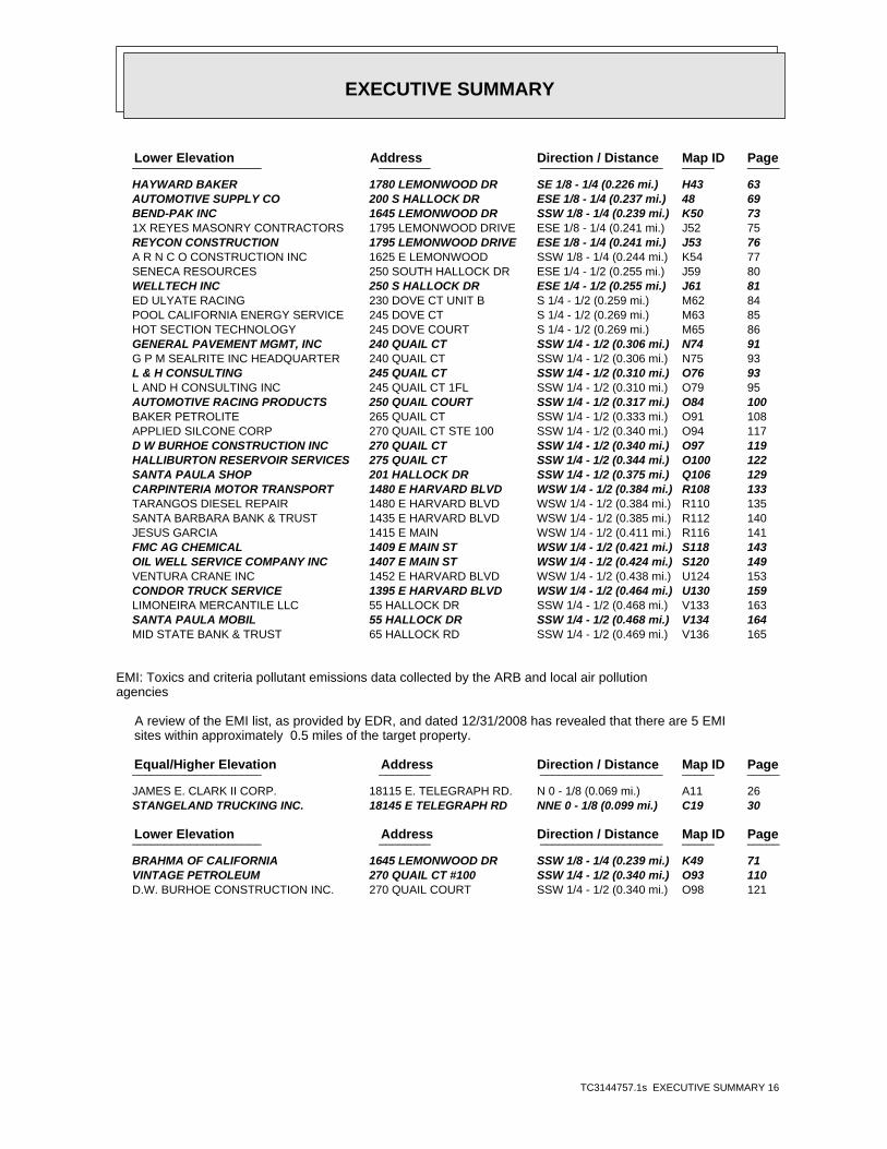
AUTOMOTIVE RACING PRODUCTS INC 1760 LEMONWOOD DR SE 1/8 - 1/4 (0.220 mi.) H37 52 AUTOMOTIVE SUPPLY CO 200 S HALLOCK DR ESE 1/8 - 1/4 (0.237 mi.) 48 69 BRAHMA OF CALIFORNIA 1645 LEMONWOOD DR SSW 1/8 - 1/4 (0.239 mi.) K49 71 WELLTECH INC 250 S HALLOCK DR ESE 1/4 - 1/2 (0.255 mi.) J61 81 AUTOMOTIVE RACING PRODUCTS 250 QUAIL COURT SSW 1/4 - 1/2 (0.317 mi.) O84 100 CAILFORNIA HAZMAT DISPOSAL 250 HALLOCK DR SSW 1/4 - 1/2 (0.321 mi.) N86 105 D W BURHOE CONSTRUCTION INC 270 QUAIL CT SSW 1/4 - 1/2 (0.340 mi.) O97 119 HALLIBURTON RESERVOIR SERVICES 275 QUAIL CT SSW 1/4 - 1/2 (0.344 mi.) O100 122 FMC CORP CITRUS MACHINERY DIV 1409 MAIN ST WSW 1/4 - 1/2 (0.421 mi.) S117 142 FMC AG CHEMICAL 1409 E MAIN ST WSW 1/4 - 1/2 (0.421 mi.) S118 143 AGRI SERV 1349 MAIN ST WSW 1/2 - 1 (0.508 mi.) W140 170
RCRA-CESQG: RCRAInfo is EPA’s comprehensive information system, providing access to data supportingthe Resource Conservation and Recovery Act (RCRA) of 1976 and the Hazardous and Solid Waste Amendments (HSWA)of 1984. The database includes selective information on sites which generate, transport, store, treat and/ordispose of hazardous waste as defined by the Resource Conservation and Recovery Act (RCRA). Conditionallyexempt small quantity generators (CESQGs) generate less than 100 kg of hazardous waste, or less than 1 kg ofacutely hazardous waste per month.
A review of the RCRA-CESQG list, as provided by EDR, and dated 06/15/2011 has revealed that there are 2 RCRA-CESQG sites within approximately 0.75 miles of the target property.
PageMap IDDirection / Distance Address Equal/Higher Elevation ____________________ ________ ___________________ _____ _____
THOMAS SAWYER DBA CLARK OIL 18115 E TELEGRAPH RD N 0 - 1/8 (0.069 mi.) A7 18
PageMap IDDirection / Distance Address Lower Elevation ____________________ ________ ___________________ _____ _____
L AND H CONSULTING INC 245 QUAIL CT SSW 1/4 - 1/2 (0.310 mi.) O82 98
State- and tribal - equivalent CERCLIS
ENVIROSTOR: The Department of Toxic Substances Control’s (DTSC’s) Site Mitigation and BrownfieldsReuse Program’s (SMBRP’s) EnviroStor database identifes sites that have known contamination or sites for whichthere may be reasons to investigate further. The database includes the following site types: FederalSuperfund sites (National Priorities List (NPL)); State Response, including Military Facilities and StateSuperfund; Voluntary Cleanup; and School sites. EnviroStor provides similar information to the informationthat was available in CalSites, and provides additional site information, including, but not limited to,identification of formerly-contaminated properties that have been released for reuse, properties whereenvironmental deed restrictions have been recorded to prevent inappropriate land uses, and riskcharacterization information that is used to assess potential impacts to public health and the environment atcontaminated sites.
A review of the ENVIROSTOR list, as provided by EDR, and dated 06/15/2011 has revealed that there are 4 ENVIROSTOR sites within approximately 1.5 miles of the target property.
PageMap IDDirection / Distance Address Equal/Higher Elevation ____________________ ________ ___________________ _____ _____
ASSOCIATED INSECTORY 1400 EAST SANTA PAULA S W 1/2 - 1 (0.561 mi.) X144 177Status: No Further Action
DOWELL - DIVISION OF DOW CHEMI 1260 EAST SANTA PAULA S W 1/2 - 1 (0.658 mi.) AA162 212Status: No Further Action

EXECUTIVE SUMMARY
TC3144757.1s EXECUTIVE SUMMARY 7
PageMap IDDirection / Distance Address Lower Elevation ____________________ ________ ___________________ _____ _____
AGRI-SERV INCORPORATED 1349 EAST MAIN STREET WSW 1/2 - 1 (0.508 mi.) W139 169Status: Refer: Other Agency
REGENCY SAVINGS BANK 1301 EAST MAIN STREET WSW 1/2 - 1 (0.579 mi.) Y146 191Status: Refer: 1248 Local Agency
State and tribal leaking storage tank lists
LUST: The Leaking Underground Storage Tank Incident Reports contain an inventory of reportedleaking underground storage tank incidents. The data come from the State Water Resources Control Board LeakingUnderground Storage Tank Information System.
A review of the LUST list, as provided by EDR, and dated 06/20/2011 has revealed that there are 31 LUST sites within approximately 1 mile of the target property.
PageMap IDDirection / Distance Address Equal/Higher Elevation ____________________ ________ ___________________ _____ _____
J.E. CLARK II CORP. - TELEGRAP 18115 TELEGRAPH RD N 0 - 1/8 (0.066 mi.) A2 8 J E CLARK II CORPORATION 18115 TELEGRAPH N 0 - 1/8 (0.069 mi.) A4 9
Status: Open - Site Assessment
STANGELAND TRUCKING CORP. 18145 TELEGRAPH RD NNE 0 - 1/8 (0.091 mi.) A16 29 STANGELAND TRUCKING CORP. 18145 TELEGRAPH NNE 0 - 1/8 (0.099 mi.) C20 36
Status: Completed - Case Closed
CHEVRON #9-5675 18252 TELEGRAPH RD ENE 1/8 - 1/4 (0.184 mi.) F28 44 CHEVRON SS #9-5675 18252 TELEGRAPH NE 1/8 - 1/4 (0.231 mi.) I44 65
Status: Completed - Case Closed
BAKER TANKS INC 1460 SANTA PAULA W 1/4 - 1/2 (0.436 mi.) T122 151Status: Completed - Case Closed
ASSOCIATED INSECTORY 1400 EAST SANTA PAULA S W 1/2 - 1 (0.561 mi.) X144 177Status: Completed - Case ClosedStatus: Completed - Case Closed
PETROLEUM CONSTRUCTION, I 1350 SANTA PAULA W 1/2 - 1 (0.592 mi.) X152 197Status: Completed - Case Closed
DOWELL-SCHLUMBERGER 1260 SANTA PAULA ST W 1/2 - 1 (0.658 mi.) AA163 213Status: Completed - Case Closed
DAVID KARLUK 325 OJAI RD W 1/2 - 1 (0.955 mi.) 196 259Status: Completed - Case Closed
PageMap IDDirection / Distance Address Lower Elevation ____________________ ________ ___________________ _____ _____
H & H OIL TOOL 208 HALLOCK SSW 1/4 - 1/2 (0.367 mi.) Q105 127Status: Completed - Case Closed
CARPINTERIA MOTOR TRANSPO 1480 HARVARD WSW 1/4 - 1/2 (0.384 mi.) R111 136Status: Completed - Case Closed
CONDOR TRUCK SERVICE 1395 HARVARD BLVD WSW 1/4 - 1/2 (0.464 mi.) U129 156Status: Completed - Case Closed
BATES FAMILY TRUST 1349 MAIN WSW 1/2 - 1 (0.508 mi.) W138 165Status: Open - Site Assessment
R & R PIPELINE INC 1315 MAIN ST WSW 1/2 - 1 (0.558 mi.) W143 176Status: Completed - Case Closed

EXECUTIVE SUMMARY
TC3144757.1s EXECUTIVE SUMMARY 8
PageMap IDDirection / Distance Address Lower Elevation ____________________ ________ ___________________ _____ _____
REGENCY SAVINGS BANK 1301 MAIN ST WSW 1/2 - 1 (0.579 mi.) Y145 189Status: Completed - Case Closed
PW ENVIROMENTAL 1301 MAIN ST WSW 1/2 - 1 (0.579 mi.) Y147 192 F.M. PEARCE CO 1255 MAIN ST E WSW 1/2 - 1 (0.619 mi.) Y156 206
Status: Completed - Case Closed
ULTRAMAR SS #755 (BEACON) 1202 MAIN ST WSW 1/2 - 1 (0.693 mi.) AB170 218Status: Completed - Case Closed
ULTRAMAR SS #755 (BEACON) 1202 MAIN ST WSW 1/2 - 1 (0.694 mi.) AB172 225 FRANKIE’S RADIATOR SHOP 1190 MAIN WSW 1/2 - 1 (0.714 mi.) AB178 227
Status: Completed - Case Closed
OLGA MANUFACTURING 1185 MAIN WSW 1/2 - 1 (0.718 mi.) AB181 234Status: Completed - Case Closed
MAGNUM MANUFACTURING 1150 MAIN STREET WSW 1/2 - 1 (0.750 mi.) 187 239Status: Completed - Case Closed
FOX MUFFLER 1085 MAIN ST WSW 1/2 - 1 (0.850 mi.) 189 243Status: Completed - Case Closed
GTE CENTRAL OFFICE OJAI ST WSW 1/2 - 1 (0.889 mi.) AF190 245 UNOCAL - 76 SS #0079 (FORMER) 1033 MAIN ST WSW 1/2 - 1 (0.915 mi.) AG191 247 UNOCAL SS #0079 (FORMER) 1033 MAIN ST WSW 1/2 - 1 (0.915 mi.) AG192 248
Status: Completed - Case Closed
UNOCAL #0079 1033 MAIN ST WSW 1/2 - 1 (0.915 mi.) AG193 249Status: Completed - Case ClosedStatus: Completed - Case Closed*Additional key fields are available in the Map Findings section
UNOCAL #0079 1033 MAIN ST WSW 1/2 - 1 (0.917 mi.) AG194 255 EDDIE’S EXXON (ZAHID SHAH) 145 10TH ST WSW 1/2 - 1 (0.936 mi.) AF195 255
Status: Completed - Case Closed
SLIC: SLIC Region comes from the California Regional Water Quality Control Board.
A review of the SLIC list, as provided by EDR, and dated 06/20/2011 has revealed that there are 5 SLIC sites within approximately 1 mile of the target property.
PageMap IDDirection / Distance Address Equal/Higher Elevation ____________________ ________ ___________________ _____ _____
CHAMNESS 134 13TH STREET, NORTH WSW 1/2 - 1 (0.584 mi.) 150 197Facility Status: Completed - Case Closed
PageMap IDDirection / Distance Address Lower Elevation ____________________ ________ ___________________ _____ _____
CONDOR TRUCK SERVICE 1395 EAST HARVARD BOULE WSW 1/4 - 1/2 (0.464 mi.) U128 155Facility Status: Completed - Case Closed
PW ENVIROMENTAL 1301 MAIN ST WSW 1/2 - 1 (0.579 mi.) Y147 192Facility Status: Completed - Case Closed
SANTA PAULA ROCK, GRAVEL & SAN 1224 SANTA CLARA ST SW 1/2 - 1 (0.742 mi.) AE185 237 HANSON AGGREGATE 1170 MONTEBELLO STREET SW 1/2 - 1 (0.838 mi.) 188 242
Facility Status: Completed - Case Closed

EXECUTIVE SUMMARY
TC3144757.1s EXECUTIVE SUMMARY 9
State and tribal registered storage tank lists
UST: The Underground Storage Tank database contains registered USTs. USTs are regulated underSubtitle I of the Resource Conservation and Recovery Act (RCRA). The data come from the State Water ResourcesControl Board’s Hazardous Substance Storage Container Database.
A review of the UST list, as provided by EDR, and dated 06/20/2011 has revealed that there are 25 UST sites within approximately 0.75 miles of the target property.
PageMap IDDirection / Distance Address Equal/Higher Elevation ____________________ ________ ___________________ _____ _____
J E CLARK II 18115 E TELEGRAPH RD N 0 - 1/8 (0.069 mi.) A8 20 PROFCO 18056 TELEGRAPH ROAD WNW 0 - 1/8 (0.084 mi.) B15 29 STANGELAND TRUCKING 18145 TELEGRAPH ROAD NNE 0 - 1/8 (0.099 mi.) C18 30 HAROLD C. COFFMAN 18035 TELEGRAPH ROAD W 0 - 1/8 (0.109 mi.) B23 40 CHEVRON #95675 18252 TELEGRAPH ROAD ENE 1/8 - 1/4 (0.184 mi.) F29 45 TEAGUE-MCKEVETT CO. 18249 TELEGRAPH ROAD NE 1/8 - 1/4 (0.217 mi.) D36 52 OIL TOOL SHOP 18286 TELEGRAPH ROAD NE 1/4 - 1/2 (0.271 mi.) I67 88 BAKER TANKS INC. 1460 SANTA PAULA STREET W 1/4 - 1/2 (0.436 mi.) T123 153 ASSOCIATED INSECTORY 1400 EAST SANTA PAULA S W 1/2 - 1 (0.561 mi.) X144 177 PETROLEUM CONSTRUCTION INC 1350 SANTA PAULA STREET W 1/2 - 1 (0.592 mi.) X155 206 DOWELL SCHLUMBERGER INC 1260 SANTA PAULA STREET W 1/2 - 1 (0.658 mi.) AA161 209 GUSTAVO RAMIREZ 1221 SANTA PAULA STREET W 1/2 - 1 (0.688 mi.) AA167 217 GEORGE J. CASTANEDA 1220 SATICOY STREET W 1/2 - 1 (0.735 mi.) AD183 237
PageMap IDDirection / Distance Address Lower Elevation ____________________ ________ ___________________ _____ _____
WEATHERFORD U S L P 201 S HALLOCK RD E 1/8 - 1/4 (0.214 mi.) G33 45 LEMONWOOD INDUSTRIAL PARK 250 HALLOCK DR SSW 1/4 - 1/2 (0.321 mi.) N88 107 HENDRICK PROPERTIES 1433 MAIN ST WSW 1/4 - 1/2 (0.386 mi.) R113 140 CARPENTERIA MOTOR TRANSPORT 1480 HARVARD BLVD WSW 1/4 - 1/2 (0.386 mi.) R114 141 CONDOR TRUCK SERVICE 1395 E HARVARD BLVD WSW 1/4 - 1/2 (0.464 mi.) U130 159 GOLDEN STATE PETROLEUM 55 HALLOCK DR. SSW 1/4 - 1/2 (0.468 mi.) V135 164 MAIN STREET INVESTMENTS 1349 MAIN STREET WSW 1/2 - 1 (0.506 mi.) W137 165 VACANT BUILDING 1301 MAIN STREET WSW 1/2 - 1 (0.581 mi.) Y149 197 F.M. PEARCE CO. 1253 MAIN STREET WSW 1/2 - 1 (0.621 mi.) Y157 208 ULTRAMAR STATION #3755 (2) 1202 MAIN ST. WSW 1/2 - 1 (0.694 mi.) AB173 225 FRANKIE’S RADIATOR SHOP 1190 MAIN STREET WSW 1/2 - 1 (0.712 mi.) AB177 227 HEDRICK, SANGER (OLGA MFG.) 1185 MAIN STREET WSW 1/2 - 1 (0.718 mi.) AB182 237
ADDITIONAL ENVIRONMENTAL RECORDS
Local Lists of Landfill / Solid Waste Disposal Sites
SWRCY: A listing of recycling facilities in California.
A review of the SWRCY list, as provided by EDR, and dated 06/01/2011 has revealed that there are 2 SWRCY sites within approximately 1 mile of the target property.
PageMap IDDirection / Distance Address Equal/Higher Elevation ____________________ ________ ___________________ _____ _____
SANTA PAULA RECYCLING 17905 E TELEGRAPH RD WSW 1/4 - 1/2 (0.288 mi.) L70 89
PageMap IDDirection / Distance Address Lower Elevation ____________________ ________ ___________________ _____ _____
VENTURA COUNTY RECYCLING & REV 1250 E HARVARD BLVD SW 1/2 - 1 (0.646 mi.) Z160 209

EXECUTIVE SUMMARY
TC3144757.1s EXECUTIVE SUMMARY 10
Local Lists of Hazardous waste / Contaminated Sites
CDL: A listing of drug lab locations. Listing of a location in this database does not indicatethat any illegal drug lab materials were or were not present there, and does not constitute a determinationthat the location either requires or does not require additional cleanup work.
A review of the CDL list, as provided by EDR, and dated 12/31/2010 has revealed that there are 2 CDL sites within approximately 0.5 miles of the target property.
PageMap IDDirection / Distance Address Equal/Higher Elevation ____________________ ________ ___________________ _____ _____
Not reported 8 FERRIS LN WSW 1/8 - 1/4 (0.183 mi.) 30 45
PageMap IDDirection / Distance Address Lower Elevation ____________________ ________ ___________________ _____ _____
Not reported 112 WIPPLE RD SW 1/8 - 1/4 (0.234 mi.) 46 68
Local Lists of Registered Storage Tanks
CA FID UST: The Facility Inventory Database contains active and inactive underground storage tanklocations. The source is the State Water Resource Control Board.
A review of the CA FID UST list, as provided by EDR, and dated 10/31/1994 has revealed that there are 9 CA FID UST sites within approximately 0.75 miles of the target property.
PageMap IDDirection / Distance Address Equal/Higher Elevation ____________________ ________ ___________________ _____ _____
J E CLARK II CORPORATION 18115 E TELEGRAPH RD N 0 - 1/8 (0.069 mi.) A10 21 STANGELAND TRUCKING INC. 18145 E TELEGRAPH RD NNE 0 - 1/8 (0.099 mi.) C19 30 BAKER TANK 1460 3 SANTA PAULA ST W 1/4 - 1/2 (0.466 mi.) 131 162 ASSOCIATED INSECTORY 1400 EAST SANTA PAULA S W 1/2 - 1 (0.561 mi.) X144 177
PageMap IDDirection / Distance Address Lower Elevation ____________________ ________ ___________________ _____ _____
WELLTECH INC 250 S HALLOCK DR ESE 1/4 - 1/2 (0.255 mi.) J61 81 D.W. BURHOE CONST. INC 2707 QUAIL CT S 1/4 - 1/2 (0.304 mi.) M73 90 CARPINTERIA MOTOR TRANSPO 1480 HARVARD WSW 1/4 - 1/2 (0.384 mi.) R111 136 CONDOR TRUCK SERVICE 1395 E HARVARD BLVD WSW 1/4 - 1/2 (0.464 mi.) U127 155 BEACON #755 1202 E MAIN ST WSW 1/2 - 1 (0.693 mi.) AB171 224
HIST UST: Historical UST Registered Database.
A review of the HIST UST list, as provided by EDR, and dated 10/15/1990 has revealed that there are 20 HIST UST sites within approximately 0.75 miles of the target property.
PageMap IDDirection / Distance Address Equal/Higher Elevation ____________________ ________ ___________________ _____ _____
ROY NEWSOM RANCH 18101 E TELEGRAPH RD NNW 0 - 1/8 (0.061 mi.) A1 8 J.E. CLARK CORP. PLANT #1 18115 E TELEGRAPH RD N 0 - 1/8 (0.069 mi.) A9 20 OFFICE FOR ABOVE 18035 E TELEGRAPH RD W 0 - 1/8 (0.105 mi.) B22 40 ALBERT KIMURA 18029 E TELEGRAPH RD W 0 - 1/8 (0.113 mi.) B24 41 95675 18252 E TELEGRAPH RD NE 1/8 - 1/4 (0.231 mi.) I45 67 OIL TOOL SHOP 18286 TELEGRAPH ROAD NE 1/4 - 1/2 (0.271 mi.) I67 88 ASSOCIATED INSECTORY 1400 EAST SANTA PAULA S W 1/2 - 1 (0.561 mi.) X144 177 P.C.I. 1350 E SANTA PAULA ST W 1/2 - 1 (0.592 mi.) X154 204
EXECUTIVE SUMMARY
TC3144757.1s EXECUTIVE SUMMARY 11
PageMap IDDirection / Distance Address Equal/Higher Elevation ____________________ ________ ___________________ _____ _____
SANTA PAULA 1260 E SANTA PAULA ST W 1/2 - 1 (0.658 mi.) AA164 215 TEAGUE-MCKEVETT DIVISION 305 PADRE DR N 1/2 - 1 (0.687 mi.) 166 216 SANTA PAULA PUMP STATION 210 N 12TH ST W 1/2 - 1 (0.715 mi.) AC179 229 GIL’S FOOD MRKT. 1220 SATICOY ST W 1/2 - 1 (0.735 mi.) AD184 237
PageMap IDDirection / Distance Address Lower Elevation ____________________ ________ ___________________ _____ _____
WELLTECH, INC. 250 HALLOCK DR SSW 1/4 - 1/2 (0.321 mi.) N87 106 SANTA PAULA SHOP 201 HALLOCK DR SSW 1/4 - 1/2 (0.375 mi.) Q106 129 CARPINTERIA MOTOR TRANSPORT 1480 E HARVARD BLVD WSW 1/4 - 1/2 (0.384 mi.) R108 133 FMC AG CHEMICAL 1409 E MAIN ST WSW 1/4 - 1/2 (0.421 mi.) S118 143 CONDOR TRUCK SERVICE 1395 E HARVARD BLVD WSW 1/4 - 1/2 (0.464 mi.) U130 159 WESTERN DIV TRANSMISSION/SUBST 1343 E MAIN ST WSW 1/2 - 1 (0.517 mi.) W141 173 WESTERN TRANSMISSION/SUBSTATIO 1343 E MAIN ST WSW 1/2 - 1 (0.517 mi.) W142 175 FAST GAS 1202 E MAIN ST WSW 1/2 - 1 (0.693 mi.) AB168 217
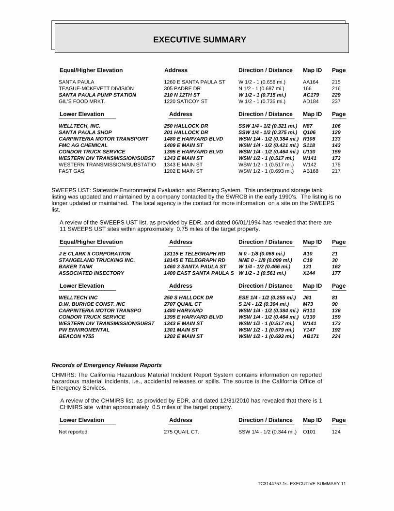
SWEEPS UST: Statewide Environmental Evaluation and Planning System. This underground storage tanklisting was updated and maintained by a company contacted by the SWRCB in the early 1990’s. The listing is nolonger updated or maintained. The local agency is the contact for more information on a site on the SWEEPSlist.
A review of the SWEEPS UST list, as provided by EDR, and dated 06/01/1994 has revealed that there are 11 SWEEPS UST sites within approximately 0.75 miles of the target property.
PageMap IDDirection / Distance Address Equal/Higher Elevation ____________________ ________ ___________________ _____ _____
J E CLARK II CORPORATION 18115 E TELEGRAPH RD N 0 - 1/8 (0.069 mi.) A10 21 STANGELAND TRUCKING INC. 18145 E TELEGRAPH RD NNE 0 - 1/8 (0.099 mi.) C19 30 BAKER TANK 1460 3 SANTA PAULA ST W 1/4 - 1/2 (0.466 mi.) 131 162 ASSOCIATED INSECTORY 1400 EAST SANTA PAULA S W 1/2 - 1 (0.561 mi.) X144 177
PageMap IDDirection / Distance Address Lower Elevation ____________________ ________ ___________________ _____ _____
WELLTECH INC 250 S HALLOCK DR ESE 1/4 - 1/2 (0.255 mi.) J61 81 D.W. BURHOE CONST. INC 2707 QUAIL CT S 1/4 - 1/2 (0.304 mi.) M73 90 CARPINTERIA MOTOR TRANSPO 1480 HARVARD WSW 1/4 - 1/2 (0.384 mi.) R111 136 CONDOR TRUCK SERVICE 1395 E HARVARD BLVD WSW 1/4 - 1/2 (0.464 mi.) U130 159 WESTERN DIV TRANSMISSION/SUBST 1343 E MAIN ST WSW 1/2 - 1 (0.517 mi.) W141 173 PW ENVIROMENTAL 1301 MAIN ST WSW 1/2 - 1 (0.579 mi.) Y147 192 BEACON #755 1202 E MAIN ST WSW 1/2 - 1 (0.693 mi.) AB171 224
Records of Emergency Release Reports
CHMIRS: The California Hazardous Material Incident Report System contains information on reportedhazardous material incidents, i.e., accidental releases or spills. The source is the California Office ofEmergency Services.
A review of the CHMIRS list, as provided by EDR, and dated 12/31/2010 has revealed that there is 1 CHMIRS site within approximately 0.5 miles of the target property.
PageMap IDDirection / Distance Address Lower Elevation ____________________ ________ ___________________ _____ _____
Not reported 275 QUAIL CT. SSW 1/4 - 1/2 (0.344 mi.) O101 124
EXECUTIVE SUMMARY
TC3144757.1s EXECUTIVE SUMMARY 12
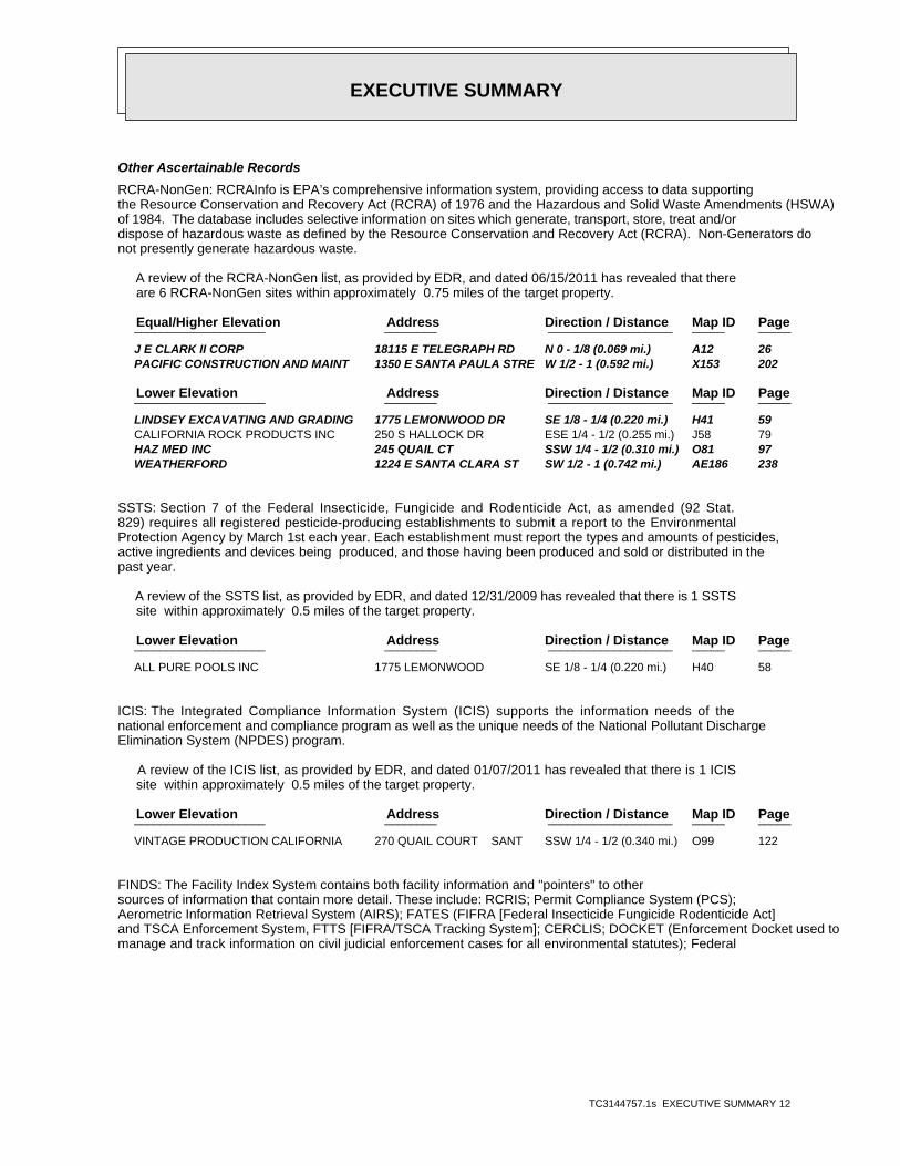
Other Ascertainable Records
RCRA-NonGen: RCRAInfo is EPA’s comprehensive information system, providing access to data supportingthe Resource Conservation and Recovery Act (RCRA) of 1976 and the Hazardous and Solid Waste Amendments (HSWA)of 1984. The database includes selective information on sites which generate, transport, store, treat and/ordispose of hazardous waste as defined by the Resource Conservation and Recovery Act (RCRA). Non-Generators donot presently generate hazardous waste.
A review of the RCRA-NonGen list, as provided by EDR, and dated 06/15/2011 has revealed that there are 6 RCRA-NonGen sites within approximately 0.75 miles of the target property.
PageMap IDDirection / Distance Address Equal/Higher Elevation ____________________ ________ ___________________ _____ _____
J E CLARK II CORP 18115 E TELEGRAPH RD N 0 - 1/8 (0.069 mi.) A12 26 PACIFIC CONSTRUCTION AND MAINT 1350 E SANTA PAULA STRE W 1/2 - 1 (0.592 mi.) X153 202
PageMap IDDirection / Distance Address Lower Elevation ____________________ ________ ___________________ _____ _____
LINDSEY EXCAVATING AND GRADING 1775 LEMONWOOD DR SE 1/8 - 1/4 (0.220 mi.) H41 59 CALIFORNIA ROCK PRODUCTS INC 250 S HALLOCK DR ESE 1/4 - 1/2 (0.255 mi.) J58 79 HAZ MED INC 245 QUAIL CT SSW 1/4 - 1/2 (0.310 mi.) O81 97 WEATHERFORD 1224 E SANTA CLARA ST SW 1/2 - 1 (0.742 mi.) AE186 238
SSTS: Section 7 of the Federal Insecticide, Fungicide and Rodenticide Act, as amended (92 Stat.829) requires all registered pesticide-producing establishments to submit a report to the EnvironmentalProtection Agency by March 1st each year. Each establishment must report the types and amounts of pesticides,active ingredients and devices being produced, and those having been produced and sold or distributed in thepast year.
A review of the SSTS list, as provided by EDR, and dated 12/31/2009 has revealed that there is 1 SSTS site within approximately 0.5 miles of the target property.
PageMap IDDirection / Distance Address Lower Elevation ____________________ ________ ___________________ _____ _____
ALL PURE POOLS INC 1775 LEMONWOOD SE 1/8 - 1/4 (0.220 mi.) H40 58
ICIS: The Integrated Compliance Information System (ICIS) supports the information needs of thenational enforcement and compliance program as well as the unique needs of the National Pollutant DischargeElimination System (NPDES) program.
A review of the ICIS list, as provided by EDR, and dated 01/07/2011 has revealed that there is 1 ICIS site within approximately 0.5 miles of the target property.
PageMap IDDirection / Distance Address Lower Elevation ____________________ ________ ___________________ _____ _____
VINTAGE PRODUCTION CALIFORNIA 270 QUAIL COURT SANT SSW 1/4 - 1/2 (0.340 mi.) O99 122
FINDS: The Facility Index System contains both facility information and "pointers" to othersources of information that contain more detail. These include: RCRIS; Permit Compliance System (PCS);Aerometric Information Retrieval System (AIRS); FATES (FIFRA [Federal Insecticide Fungicide Rodenticide Act]and TSCA Enforcement System, FTTS [FIFRA/TSCA Tracking System]; CERCLIS; DOCKET (Enforcement Docket used tomanage and track information on civil judicial enforcement cases for all environmental statutes); Federal
EXECUTIVE SUMMARY
TC3144757.1s EXECUTIVE SUMMARY 13
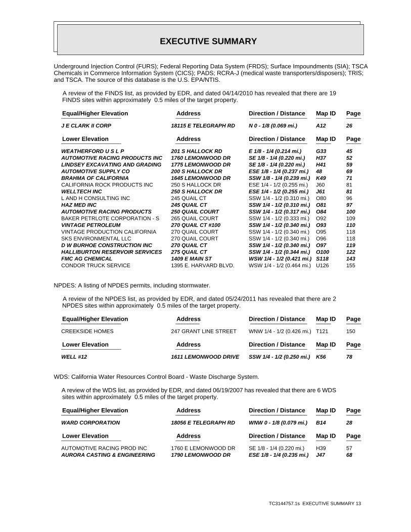
Underground Injection Control (FURS); Federal Reporting Data System (FRDS); Surface Impoundments (SIA); TSCAChemicals in Commerce Information System (CICS); PADS; RCRA-J (medical waste transporters/disposers); TRIS;and TSCA. The source of this database is the U.S. EPA/NTIS.
A review of the FINDS list, as provided by EDR, and dated 04/14/2010 has revealed that there are 19 FINDS sites within approximately 0.5 miles of the target property.
PageMap IDDirection / Distance Address Equal/Higher Elevation ____________________ ________ ___________________ _____ _____
J E CLARK II CORP 18115 E TELEGRAPH RD N 0 - 1/8 (0.069 mi.) A12 26
PageMap IDDirection / Distance Address Lower Elevation ____________________ ________ ___________________ _____ _____
WEATHERFORD U S L P 201 S HALLOCK RD E 1/8 - 1/4 (0.214 mi.) G33 45 AUTOMOTIVE RACING PRODUCTS INC 1760 LEMONWOOD DR SE 1/8 - 1/4 (0.220 mi.) H37 52 LINDSEY EXCAVATING AND GRADING 1775 LEMONWOOD DR SE 1/8 - 1/4 (0.220 mi.) H41 59 AUTOMOTIVE SUPPLY CO 200 S HALLOCK DR ESE 1/8 - 1/4 (0.237 mi.) 48 69 BRAHMA OF CALIFORNIA 1645 LEMONWOOD DR SSW 1/8 - 1/4 (0.239 mi.) K49 71 CALIFORNIA ROCK PRODUCTS INC 250 S HALLOCK DR ESE 1/4 - 1/2 (0.255 mi.) J60 81 WELLTECH INC 250 S HALLOCK DR ESE 1/4 - 1/2 (0.255 mi.) J61 81 L AND H CONSULTING INC 245 QUAIL CT SSW 1/4 - 1/2 (0.310 mi.) O80 96 HAZ MED INC 245 QUAIL CT SSW 1/4 - 1/2 (0.310 mi.) O81 97 AUTOMOTIVE RACING PRODUCTS 250 QUAIL COURT SSW 1/4 - 1/2 (0.317 mi.) O84 100 BAKER PETRLOTE CORPORATION - S 265 QUAIL COURT SSW 1/4 - 1/2 (0.333 mi.) O92 109 VINTAGE PETROLEUM 270 QUAIL CT #100 SSW 1/4 - 1/2 (0.340 mi.) O93 110 VINTAGE PRODUCTION CALIFORNIA 270 QUAIL COURT SSW 1/4 - 1/2 (0.340 mi.) O95 118 SKS ENVIRONMENTAL LLC 270 QUAIL COURT SSW 1/4 - 1/2 (0.340 mi.) O96 118 D W BURHOE CONSTRUCTION INC 270 QUAIL CT SSW 1/4 - 1/2 (0.340 mi.) O97 119 HALLIBURTON RESERVOIR SERVICES 275 QUAIL CT SSW 1/4 - 1/2 (0.344 mi.) O100 122 FMC AG CHEMICAL 1409 E MAIN ST WSW 1/4 - 1/2 (0.421 mi.) S118 143 CONDOR TRUCK SERVICE 1395 E. HARVARD BLVD. WSW 1/4 - 1/2 (0.464 mi.) U126 155
NPDES: A listing of NPDES permits, including stormwater.
A review of the NPDES list, as provided by EDR, and dated 05/24/2011 has revealed that there are 2 NPDES sites within approximately 0.5 miles of the target property.
PageMap IDDirection / Distance Address Equal/Higher Elevation ____________________ ________ ___________________ _____ _____
CREEKSIDE HOMES 247 GRANT LINE STREET WNW 1/4 - 1/2 (0.426 mi.) T121 150
PageMap IDDirection / Distance Address Lower Elevation ____________________ ________ ___________________ _____ _____
WELL #12 1611 LEMONWOOD DRIVE SSW 1/4 - 1/2 (0.250 mi.) K56 78
WDS: California Water Resources Control Board - Waste Discharge System.
A review of the WDS list, as provided by EDR, and dated 06/19/2007 has revealed that there are 6 WDS sites within approximately 0.5 miles of the target property.
PageMap IDDirection / Distance Address Equal/Higher Elevation ____________________ ________ ___________________ _____ _____
WARD CORPORATION 18056 E TELEGRAPH RD WNW 0 - 1/8 (0.079 mi.) B14 28
PageMap IDDirection / Distance Address Lower Elevation ____________________ ________ ___________________ _____ _____
AUTOMOTIVE RACING PROD INC 1760 E LEMONWOOD DR SE 1/8 - 1/4 (0.220 mi.) H39 57 AURORA CASTING & ENGINEERING 1790 LEMONWOOD DR ESE 1/8 - 1/4 (0.235 mi.) J47 68

EXECUTIVE SUMMARY
TC3144757.1s EXECUTIVE SUMMARY 14
PageMap IDDirection / Distance Address Lower Elevation ____________________ ________ ___________________ _____ _____
AUTOMOTIVE RACING PRODUCTS 250 QUAIL COURT SSW 1/4 - 1/2 (0.317 mi.) O84 100 BAKER PERFORMANCE CHEMICALS 265 QUAIL COURT SSW 1/4 - 1/2 (0.333 mi.) O89 107 ABRISA INDUSTRIAL GLASS, INC. 200 S HALLOCK DR SSW 1/4 - 1/2 (0.375 mi.) Q107 132
HIST CORTESE: The sites for the list are designated by the State Water Resource Control Board [LUST],the Integrated Waste Board [SWF/LS], and the Department of Toxic Substances Control [CALSITES].
A review of the HIST CORTESE list, as provided by EDR, and dated 04/01/2001 has revealed that there are 7 HIST CORTESE sites within approximately 0.5 miles of the target property.
PageMap IDDirection / Distance Address Equal/Higher Elevation ____________________ ________ ___________________ _____ _____
J E CLARK II CORPORATION 18115 TELEGRAPH N 0 - 1/8 (0.069 mi.) A4 9 STANGELAND TRUCKING CORP. 18145 TELEGRAPH NNE 0 - 1/8 (0.099 mi.) C20 36 MONTEREY COUNTY PUBLIC WO 18286 TELEGRAPH ENE 1/8 - 1/4 (0.186 mi.) F31 45 CHEVRON SS #9-5675 18252 TELEGRAPH NE 1/8 - 1/4 (0.231 mi.) I44 65 BAKER TANKS INC 1460 SANTA PAULA W 1/4 - 1/2 (0.436 mi.) T122 151
PageMap IDDirection / Distance Address Lower Elevation ____________________ ________ ___________________ _____ _____
H & H OIL TOOL 208 HALLOCK SSW 1/4 - 1/2 (0.367 mi.) Q105 127 CARPINTERIA MOTOR TRANSPO 1480 HARVARD WSW 1/4 - 1/2 (0.384 mi.) R111 136
VENTURA CO. BWT: The Business Plan, Hazardous Waste Producers, & Operating Underground Tanks Site AddressList indicates by site address whether EHD has Business Plan (BP), Waste Producer (W), and/or Underground Tank(T) Information.
A review of the VENTURA CO. BWT list, as provided by EDR, and dated 04/26/2011 has revealed that there are 33 VENTURA CO. BWT sites within approximately 0.5 miles of the target property.
PageMap IDDirection / Distance Address Equal/Higher Elevation ____________________ ________ ___________________ _____ _____
AMBER RESOURES DBA SAWYER PETR 18115 E TELEGRAPH RD N 0 - 1/8 (0.069 mi.) A6 17 J.E. CLARK II CORP. 18115 E TELEGRAPH RD N 0 - 1/8 (0.069 mi.) A13 28 WARD CORPORATION 18056 E TELEGRAPH RD WNW 0 - 1/8 (0.079 mi.) B14 28 SAWYER PETROLEUM 18145 E TELEGRAPH RD NNE 0 - 1/8 (0.099 mi.) C21 39 SANTA PAULA SHELL 100 S HALLOCK DR ENE 1/8 - 1/4 (0.190 mi.) F32 45 BATTERY MAN, CO 17951 E TELEGRAPH RD WSW 1/8 - 1/4 (0.249 mi.) L55 78 RUBEN’S TIRE 17902 E TELEGRAPH RD WSW 1/4 - 1/2 (0.319 mi.) P85 104 EDIN’S AUTO REPAIR 1451 E MAIN ST WSW 1/4 - 1/2 (0.361 mi.) P104 127
PageMap IDDirection / Distance Address Lower Elevation ____________________ ________ ___________________ _____ _____
WEATHERFORD US LP 201 S HALLOCK DR E 1/8 - 1/4 (0.214 mi.) G35 51 AUTOMOTIVE RACING PRODUCTS 1760 LEMONWOOD DR SE 1/8 - 1/4 (0.220 mi.) H38 56 HAYWARD BAKER 1780 LEMONWOOD DR SE 1/8 - 1/4 (0.226 mi.) H43 63 AURORA CASTING & ENGINEERING 1790 LEMONWOOD DR ESE 1/8 - 1/4 (0.235 mi.) J47 68 BEND-PAK INC 1645 LEMONWOOD DR SSW 1/8 - 1/4 (0.239 mi.) K50 73 BEND-PAK INC. 1645 LEMONWOOD DR SSW 1/8 - 1/4 (0.239 mi.) K51 75 REYCON CONSTRUCTION 1795 LEMONWOOD DRIVE ESE 1/8 - 1/4 (0.241 mi.) J53 76 WELL #12 1611 LEMONWOOD DRIVE SSW 1/4 - 1/2 (0.250 mi.) K56 78 DELTA LIQUID ENERGY 1620 LEMONWOOD DR SSW 1/4 - 1/2 (0.252 mi.) K57 78 HOT SECTION TECHNOLOGIES, INC 245 DOVE CT S 1/4 - 1/2 (0.269 mi.) M64 86 LINDSEY EXCAVATING & GRADING 18200 OLD HALLOCK DR SSW 1/4 - 1/2 (0.270 mi.) N66 87

EXECUTIVE SUMMARY
TC3144757.1s EXECUTIVE SUMMARY 15
PageMap IDDirection / Distance Address Lower Elevation ____________________ ________ ___________________ _____ _____
B & W PIPELINE, INC 235 QUAIL CT SSW 1/4 - 1/2 (0.298 mi.) N72 90 GENERAL PAVEMENT MGMT, INC 240 QUAIL CT SSW 1/4 - 1/2 (0.306 mi.) N74 91 L & H CONSULTING 245 QUAIL CT SSW 1/4 - 1/2 (0.310 mi.) O76 93 AUTOMOTIVE RACING PRODUCTS 250-275 QUAIL CT SSW 1/4 - 1/2 (0.317 mi.) O83 100 BAKER PETROLITE CORPORATION 265 QUAIL CT SSW 1/4 - 1/2 (0.333 mi.) O90 108 ABRISA INDUSTRIAL GLASS, INC. 200 S HALLOCK DR SSW 1/4 - 1/2 (0.375 mi.) Q107 132 TARANGO’S AUTO/DIESEL REPAIR 1480 E HARVARD BLVD WSW 1/4 - 1/2 (0.384 mi.) R109 135 CARPINTERIA MOTOR TRANSPO 1480 HARVARD WSW 1/4 - 1/2 (0.384 mi.) R111 136 DIAMOND SERVICES 1417 E MAIN ST #A WSW 1/4 - 1/2 (0.409 mi.) R115 141 FMC AG CHEMICAL 1409 E MAIN ST WSW 1/4 - 1/2 (0.421 mi.) S118 143 OIL WELL SERVICE COMPANY INC 1407 E MAIN ST WSW 1/4 - 1/2 (0.424 mi.) S120 149 ALTA QUALITY FARM SERVICE INC 1397 E HARVARD BLVD WSW 1/4 - 1/2 (0.462 mi.) U125 154 VEGA WELDING 1438 E HARVARD BLVD SW 1/4 - 1/2 (0.467 mi.) U132 163 SANTA PAULA MOBIL 55 HALLOCK DR SSW 1/4 - 1/2 (0.468 mi.) V134 164
HAZNET: The data is extracted from the copies of hazardous waste manifests received each year bythe DTSC. The annual volume of manifests is typically 700,000-1,000,000 annually, representing approximately350,000-500,000 shipments. Data from non-California manifests & continuation sheets are not included at thepresent time. Data are from the manifests submitted without correction, and therefore many contain someinvalid values for data elements such as generator ID, TSD ID, waste category, & disposal method. The sourceis the Department of Toxic Substance Control is the agency
A review of the HAZNET list, as provided by EDR, and dated 12/31/2009 has revealed that there are 57 HAZNET sites within approximately 0.5 miles of the target property.
PageMap IDDirection / Distance Address Equal/Higher Elevation ____________________ ________ ___________________ _____ _____
SANTA PAULA GATEWAY CENTER LLC 18114 TELEGRAPH RD N 0 - 1/8 (0.067 mi.) A3 8 J E CLARK II CORPORATION 18115 E TELEGRAPH RD N 0 - 1/8 (0.069 mi.) A5 15 AMBER RESOURES DBA SAWYER PETR 18115 E TELEGRAPH RD N 0 - 1/8 (0.069 mi.) A6 17 J E CLARK II CORPORATION 18115 E TELEGRAPH RD N 0 - 1/8 (0.069 mi.) A10 21 RUEBENS TIRE 17902 TELEGRAPH AVE NNE 0 - 1/8 (0.095 mi.) C17 29 STANGELAND TRUCKING 18145 TELEGRAPH ROAD NNE 0 - 1/8 (0.099 mi.) C18 30 STANGELAND TRUCKING INC. 18145 E TELEGRAPH RD NNE 0 - 1/8 (0.099 mi.) C19 30 SAWYER PETROLEUM 18145 E TELEGRAPH RD NNE 0 - 1/8 (0.099 mi.) C21 39 REMEDIATION SERVICE INT L INC 18201 E TELEGRAPH RD NE 1/8 - 1/4 (0.171 mi.) D25 41 OIL WELL SERVICE COMPANY 18286 EAST TELEGRAPH RO NE 1/4 - 1/2 (0.271 mi.) I68 88 ELITE R.V. SERVICE 17905 TELEGRAPH RD WSW 1/4 - 1/2 (0.288 mi.) L69 89 PERKINS LAND CO 1555 TELEGRAPH RD, HWY WSW 1/4 - 1/2 (0.294 mi.) L71 90 RUBEN’S TIRE 17902 E TELEGRAPH RD WSW 1/4 - 1/2 (0.319 mi.) P85 104 B&R AUTOMOTIVE REPAIR 1465 E MAIN ST WSW 1/4 - 1/2 (0.346 mi.) P102 125 AURORA CASTING & ENGINEERING, 1451 E MAIN STREET WSW 1/4 - 1/2 (0.361 mi.) P103 126 BAKER TANKS INC. 1460 SANTA PAULA STREET W 1/4 - 1/2 (0.436 mi.) T123 153
PageMap IDDirection / Distance Address Lower Elevation ____________________ ________ ___________________ _____ _____
SANTA PAULA FAMILY MOTORS 126 S HALLOCK DR ESE 1/8 - 1/4 (0.177 mi.) E26 42 FORD OF SANTA PAULA 126 HALLOCK DR ESE 1/8 - 1/4 (0.177 mi.) E27 43 WEATHERFORD U S L P 201 S HALLOCK RD E 1/8 - 1/4 (0.214 mi.) G33 45 WEATHERFORD U S 201 SOUTH HALLOCK DRIVE E 1/8 - 1/4 (0.214 mi.) G34 49 WEATHERFORD US LP 201 S HALLOCK DR E 1/8 - 1/4 (0.214 mi.) G35 51 AUTOMOTIVE RACING PRODUCTS INC 1760 LEMONWOOD DR SE 1/8 - 1/4 (0.220 mi.) H37 52 AUTOMOTIVE RACING PRODUCTS 1760 LEMONWOOD DR SE 1/8 - 1/4 (0.220 mi.) H38 56 LINDSEY EXCAVATING AND GRADING 1775 LEMONWOOD DR SE 1/8 - 1/4 (0.220 mi.) H41 59 HAYWARD BAKER INC 1780 E LEMONWOOD DR SE 1/8 - 1/4 (0.226 mi.) H42 62
EXECUTIVE SUMMARY
TC3144757.1s EXECUTIVE SUMMARY 16
PageMap IDDirection / Distance Address Lower Elevation ____________________ ________ ___________________ _____ _____
HAYWARD BAKER 1780 LEMONWOOD DR SE 1/8 - 1/4 (0.226 mi.) H43 63 AUTOMOTIVE SUPPLY CO 200 S HALLOCK DR ESE 1/8 - 1/4 (0.237 mi.) 48 69 BEND-PAK INC 1645 LEMONWOOD DR SSW 1/8 - 1/4 (0.239 mi.) K50 73 1X REYES MASONRY CONTRACTORS 1795 LEMONWOOD DRIVE ESE 1/8 - 1/4 (0.241 mi.) J52 75 REYCON CONSTRUCTION 1795 LEMONWOOD DRIVE ESE 1/8 - 1/4 (0.241 mi.) J53 76 A R N C O CONSTRUCTION INC 1625 E LEMONWOOD SSW 1/8 - 1/4 (0.244 mi.) K54 77 SENECA RESOURCES 250 SOUTH HALLOCK DR ESE 1/4 - 1/2 (0.255 mi.) J59 80 WELLTECH INC 250 S HALLOCK DR ESE 1/4 - 1/2 (0.255 mi.) J61 81 ED ULYATE RACING 230 DOVE CT UNIT B S 1/4 - 1/2 (0.259 mi.) M62 84 POOL CALIFORNIA ENERGY SERVICE 245 DOVE CT S 1/4 - 1/2 (0.269 mi.) M63 85 HOT SECTION TECHNOLOGY 245 DOVE COURT S 1/4 - 1/2 (0.269 mi.) M65 86 GENERAL PAVEMENT MGMT, INC 240 QUAIL CT SSW 1/4 - 1/2 (0.306 mi.) N74 91 G P M SEALRITE INC HEADQUARTER 240 QUAIL CT SSW 1/4 - 1/2 (0.306 mi.) N75 93 L & H CONSULTING 245 QUAIL CT SSW 1/4 - 1/2 (0.310 mi.) O76 93 L AND H CONSULTING INC 245 QUAIL CT 1FL SSW 1/4 - 1/2 (0.310 mi.) O79 95 AUTOMOTIVE RACING PRODUCTS 250 QUAIL COURT SSW 1/4 - 1/2 (0.317 mi.) O84 100 BAKER PETROLITE 265 QUAIL CT SSW 1/4 - 1/2 (0.333 mi.) O91 108 APPLIED SILCONE CORP 270 QUAIL CT STE 100 SSW 1/4 - 1/2 (0.340 mi.) O94 117 D W BURHOE CONSTRUCTION INC 270 QUAIL CT SSW 1/4 - 1/2 (0.340 mi.) O97 119 HALLIBURTON RESERVOIR SERVICES 275 QUAIL CT SSW 1/4 - 1/2 (0.344 mi.) O100 122 SANTA PAULA SHOP 201 HALLOCK DR SSW 1/4 - 1/2 (0.375 mi.) Q106 129 CARPINTERIA MOTOR TRANSPORT 1480 E HARVARD BLVD WSW 1/4 - 1/2 (0.384 mi.) R108 133 TARANGOS DIESEL REPAIR 1480 E HARVARD BLVD WSW 1/4 - 1/2 (0.384 mi.) R110 135 SANTA BARBARA BANK & TRUST 1435 E HARVARD BLVD WSW 1/4 - 1/2 (0.385 mi.) R112 140 JESUS GARCIA 1415 E MAIN WSW 1/4 - 1/2 (0.411 mi.) R116 141 FMC AG CHEMICAL 1409 E MAIN ST WSW 1/4 - 1/2 (0.421 mi.) S118 143 OIL WELL SERVICE COMPANY INC 1407 E MAIN ST WSW 1/4 - 1/2 (0.424 mi.) S120 149 VENTURA CRANE INC 1452 E HARVARD BLVD WSW 1/4 - 1/2 (0.438 mi.) U124 153 CONDOR TRUCK SERVICE 1395 E HARVARD BLVD WSW 1/4 - 1/2 (0.464 mi.) U130 159 LIMONEIRA MERCANTILE LLC 55 HALLOCK DR SSW 1/4 - 1/2 (0.468 mi.) V133 163 SANTA PAULA MOBIL 55 HALLOCK DR SSW 1/4 - 1/2 (0.468 mi.) V134 164 MID STATE BANK & TRUST 65 HALLOCK RD SSW 1/4 - 1/2 (0.469 mi.) V136 165
EMI: Toxics and criteria pollutant emissions data collected by the ARB and local air pollutionagencies
A review of the EMI list, as provided by EDR, and dated 12/31/2008 has revealed that there are 5 EMI sites within approximately 0.5 miles of the target property.
PageMap IDDirection / Distance Address Equal/Higher Elevation ____________________ ________ ___________________ _____ _____
JAMES E. CLARK II CORP. 18115 E. TELEGRAPH RD. N 0 - 1/8 (0.069 mi.) A11 26 STANGELAND TRUCKING INC. 18145 E TELEGRAPH RD NNE 0 - 1/8 (0.099 mi.) C19 30
PageMap IDDirection / Distance Address Lower Elevation ____________________ ________ ___________________ _____ _____
BRAHMA OF CALIFORNIA 1645 LEMONWOOD DR SSW 1/8 - 1/4 (0.239 mi.) K49 71 VINTAGE PETROLEUM 270 QUAIL CT #100 SSW 1/4 - 1/2 (0.340 mi.) O93 110 D.W. BURHOE CONSTRUCTION INC. 270 QUAIL COURT SSW 1/4 - 1/2 (0.340 mi.) O98 121

EXECUTIVE SUMMARY
TC3144757.1s EXECUTIVE SUMMARY 17
HWT: A listing of hazardous waste transporters. In California, unless specifically exempted, itis unlawful for any person to transport hazardous wastes unless the person holds a valid registration issuedby DTSC. A hazardous waste transporter registration is valid for one year and is assigned a uniqueregistration number.
A review of the HWT list, as provided by EDR, and dated 07/18/2011 has revealed that there are 4 HWT sites within approximately 0.75 miles of the target property.
PageMap IDDirection / Distance Address Equal/Higher Elevation ____________________ ________ ___________________ _____ _____
PACIFIC CONSTRUCTION & MAINTEN 1350 E. SANTA PAULA ST. W 1/2 - 1 (0.592 mi.) X151 197
PageMap IDDirection / Distance Address Lower Elevation ____________________ ________ ___________________ _____ _____
HAZ-MED, INC. 245 QUAIL CT. SSW 1/4 - 1/2 (0.310 mi.) O77 95 L & H CONSULTING, INC. 245 QUAIL COURT SSW 1/4 - 1/2 (0.310 mi.) O78 95 WELLTECH, INC. 250 HALLOCK DR SSW 1/4 - 1/2 (0.321 mi.) N87 106
MWMP: The Medical Waste Management Program (MWMP) ensures the proper handling and disposal ofmedical waste by permitting and inspecting medical waste Offsite Treatment Facilities (PDF) and TransferStations (PDF) throughout the state. MWMP also oversees all Medical Waste Transporters.
A review of the MWMP list, as provided by EDR, and dated 06/09/2011 has revealed that there is 1 MWMP site within approximately 0.75 miles of the target property.
PageMap IDDirection / Distance Address Lower Elevation ____________________ ________ ___________________ _____ _____
HAZ-MED, INC. 245 QUAIL CT. SSW 1/4 - 1/2 (0.310 mi.) O77 95
EDR PROPRIETARY RECORDS
EDR Proprietary Records
EDR Historical Auto Stations: EDR has searched selected national collections of business directories and has collectedlistings of potential gas station/filling station/service station sites that were available to EDRresearchers. EDR’s review was limited to those categories of sources that might, in EDR’s opinion, includegas station/filling station/service station establishments. The categories reviewed included, but were notlimited to gas, gas station, gasoline station, filling station, auto, automobile repair, auto service station,service station, etc.
A review of the EDR Historical Auto Stations list, as provided by EDR, has revealed that there are 8 EDR Historical Auto Stations sites within approximately 0.75 miles of the target property.
PageMap IDDirection / Distance Address Lower Elevation ____________________ ________ ___________________ _____ _____
MITCHELL S VELTEX STATION 1444 E MAIN ST WSW 1/4 - 1/2 (0.423 mi.) S119 148 GLEN CITY SERVICE 1301 E MAIN ST WSW 1/2 - 1 (0.579 mi.) Y148 196 SANTA PAULA EQUIPMENT REPAIR 1245 E MAIN ST WSW 1/2 - 1 (0.628 mi.) Y158 208 OSCAR S GARAGE 1257 E HARVARD BLVD SW 1/2 - 1 (0.646 mi.) Z159 208 AVERY S FLYING A SERVICE 1226 E HARVARD BLVD SW 1/2 - 1 (0.662 mi.) Z165 216 SANTA PAULA OIL CO 1202 E MAIN ST WSW 1/2 - 1 (0.693 mi.) AB169 218 WALTON S TEXACO SERVICE 1203 E MAIN ST WSW 1/2 - 1 (0.698 mi.) AB174 225 OSCAR S GARAGE 122 S 12TH ST WSW 1/2 - 1 (0.709 mi.) AB176 227

EXECUTIVE SUMMARY
TC3144757.1s EXECUTIVE SUMMARY 18
Due to poor or inadequate address information, the following sites were not mapped. Count: 20 records.
Site Name Database(s)____________ ____________
SOUTH MOUNTAIN ROAD BRIDGE, COUNTY NPDESROUTE 150 PROJECT, BETWEEN SANTA P NPDESPEPPERCORN RANCH NPDESTEMPORARY SOCCER FIELDS NPDESGENERAL TELEPHONE SWEEPS USTHIGHWAY 33 IN MIRA MONTE CDLUNION PACIFIC RAILROAD HAZNETCALTRANS D-7/CONSTR/EA07-1189F4 HAZNETCITY SANTA PAULA HAZNETCITY OF SANTA PAULA HAZNETCITY OF SANTA PAULA HAZNETCOUNTY OF VENTURA PUBLIC WORKS HAZNETHEDRICK PROPERTIES HAZNETCOLTON CUSTOM FARMING HAZNETEQUILON ENTERPRISES LLC HAZNETMESA UNION SCHOOL DISTRICT HAZNETVANPAK INC HAZNETSTAGECOACH GENERAL STORE WDST.A. STABEN, INC. ICISARGO PETROLEUM CORP. EMI

EDR Inc.EDR Inc.EDR Inc.EDR Inc.EDR Inc.EDR Inc.EDR Inc.EDR Inc.EDR Inc.EDR Inc.EDR Inc.EDR Inc.EDR Inc.EDR Inc.EDR Inc.EDR Inc.EDR Inc.EDR Inc.EDR Inc.EDR Inc.EDR Inc.EDR Inc.EDR Inc.EDR Inc.EDR Inc.EDR Inc.EDR Inc.EDR Inc.EDR Inc.EDR Inc.EDR Inc.EDR Inc.EDR Inc.EDR Inc.EDR Inc.EDR Inc.EDR Inc.EDR Inc.EDR Inc.EDR Inc.
230 kV230 kV
230 kV230 kV
230 kVkV
EDR Inc.EDR Inc.EDR Inc.EDR Inc.EDR Inc.EDR Inc.EDR Inc.EDR Inc.EDR Inc.EDR Inc.EDR Inc.EDR Inc.EDR Inc.EDR Inc.EDR Inc.EDR Inc.EDR Inc.EDR Inc.EDR Inc.EDR Inc.EDR Inc.EDR Inc.EDR Inc.EDR Inc.EDR Inc.EDR Inc.EDR Inc.EDR Inc.EDR Inc.EDR Inc.EDR Inc.EDR Inc.EDR Inc.EDR Inc.EDR Inc.EDR Inc.EDR Inc.EDR Inc.EDR Inc.EDR Inc.
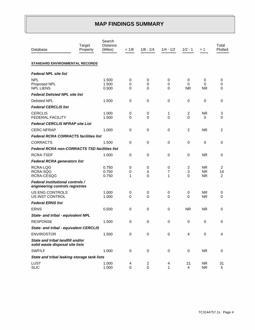
MAP FINDINGS SUMMARY
SearchTarget Distance Total
Database Property (Miles) < 1/8 1/8 - 1/4 1/4 - 1/2 1/2 - 1 > 1 Plotted
STANDARD ENVIRONMENTAL RECORDS
Federal NPL site list
0 0 0 0 0 0 1.500NPL 0 0 0 0 0 0 1.500Proposed NPL 0 NR NR 0 0 0 0.500NPL LIENS
Federal Delisted NPL site list
0 0 0 0 0 0 1.500Delisted NPL
Federal CERCLIS list
3 NR 2 1 0 0 1.000CERCLIS 0 0 0 0 0 0 1.500FEDERAL FACILITY
Federal CERCLIS NFRAP site List
2 NR 2 0 0 0 1.000CERC-NFRAP
Federal RCRA CORRACTS facilities list
0 0 0 0 0 0 1.500CORRACTS
Federal RCRA non-CORRACTS TSD facilities list
0 NR 0 0 0 0 1.000RCRA-TSDF
Federal RCRA generators list
2 NR 2 0 0 0 0.750RCRA-LQG 14 NR 3 7 4 0 0.750RCRA-SQG 2 NR 0 1 0 1 0.750RCRA-CESQG
Federal institutional controls /engineering controls registries
0 NR 0 0 0 0 1.000US ENG CONTROLS 0 NR 0 0 0 0 1.000US INST CONTROL
Federal ERNS list
0 NR NR 0 0 0 0.500ERNS
State- and tribal - equivalent NPL
0 0 0 0 0 0 1.500RESPONSE
State- and tribal - equivalent CERCLIS
4 0 4 0 0 0 1.500ENVIROSTOR
State and tribal landfill and/orsolid waste disposal site lists
0 NR 0 0 0 0 1.000SWF/LF
State and tribal leaking storage tank lists
31 NR 21 4 2 4 1.000LUST 5 NR 4 1 0 0 1.000SLIC
TC3144757.1s Page 4

MAP FINDINGS SUMMARY
SearchTarget Distance Total
Database Property (Miles) < 1/8 1/8 - 1/4 1/4 - 1/2 1/2 - 1 > 1 Plotted
0 NR 0 0 0 0 1.000INDIAN LUST
State and tribal registered storage tank lists
25 NR 11 7 3 4 0.750UST 0 NR 0 0 0 0 0.750AST 0 NR 0 0 0 0 0.750INDIAN UST 0 NR 0 0 0 0 0.750FEMA UST
State and tribal voluntary cleanup sites
0 NR 0 0 0 0 1.000VCP 0 NR 0 0 0 0 1.000INDIAN VCP
ADDITIONAL ENVIRONMENTAL RECORDS
Local Brownfield lists
0 NR 0 0 0 0 1.000US BROWNFIELDS
Local Lists of Landfill / SolidWaste Disposal Sites
0 NR 0 0 0 0 1.000DEBRIS REGION 9 0 NR 0 0 0 0 1.000ODI 0 NR 0 0 0 0 1.000WMUDS/SWAT 2 NR 1 1 0 0 1.000SWRCY 0 NR NR 0 0 0 0.500HAULERS 0 NR 0 0 0 0 1.000INDIAN ODI
Local Lists of Hazardous waste /Contaminated Sites
0 NR NR 0 0 0 0.500US CDL 0 0 0 0 0 0 1.500HIST Cal-Sites 0 NR 0 0 0 0 0.750SCH 0 0 0 0 0 0 1.500Toxic Pits 2 NR NR 0 2 0 0.500CDL 0 NR NR 0 0 0 0.500US HIST CDL
Local Lists of Registered Storage Tanks
9 NR 2 5 0 2 0.750CA FID UST 20 NR 9 6 1 4 0.750HIST UST 11 NR 4 5 0 2 0.750SWEEPS UST
Local Land Records
0 NR NR 0 0 0 0.500LIENS 2 0 NR 0 0 0 0 1.000LUCIS 0 NR NR 0 0 0 0.500LIENS 0 NR 0 0 0 0 1.000DEED
Records of Emergency Release Reports
0 NR NR 0 0 0 0.500HMIRS 1 NR NR 1 0 0 0.500CHMIRS 0 NR NR 0 0 0 0.500LDS
TC3144757.1s Page 5

MAP FINDINGS SUMMARY
SearchTarget Distance Total
Database Property (Miles) < 1/8 1/8 - 1/4 1/4 - 1/2 1/2 - 1 > 1 Plotted
0 NR NR 0 0 0 0.500MCS
Other Ascertainable Records
6 NR 2 2 1 1 0.750RCRA-NonGen 0 NR NR 0 0 0 0.500DOT OPS 0 0 0 0 0 0 1.500DOD 0 0 0 0 0 0 1.500FUDS 0 0 0 0 0 0 1.500CONSENT 0 0 0 0 0 0 1.500ROD 0 NR 0 0 0 0 1.000UMTRA 0 NR 0 0 0 0 0.750MINES 0 NR NR 0 0 0 0.500TRIS 0 NR NR 0 0 0 0.500TSCA 0 NR NR 0 0 0 0.500FTTS 0 NR NR 0 0 0 0.500HIST FTTS 1 NR NR 0 1 0 0.500SSTS 1 NR NR 1 0 0 0.500ICIS 0 NR NR 0 0 0 0.500PADS 0 NR NR 0 0 0 0.500MLTS 0 NR NR 0 0 0 0.500RADINFO 19 NR NR 13 5 1 0.500FINDS 0 NR NR 0 0 0 0.500RAATS 0 0 0 0 0 0 1.500CA BOND EXP. PLAN 2 NR NR 2 0 0 0.500NPDES 6 NR NR 3 2 1 0.500WDS 0 NR 0 0 0 0 1.000Cortese 7 NR NR 3 2 2 0.500HIST CORTESE 0 0 0 0 0 0 1.500Notify 65 0 NR 0 0 0 0 0.750DRYCLEANERS 0 NR 0 0 0 0 0.750WIP 33 NR NR 20 9 4 0.500VENTURA CO. BWT 57 NR NR 33 16 8 0.500HAZNET 5 NR NR 2 1 2 0.500EMI 0 0 0 0 0 0 1.500INDIAN RESERV 0 NR 0 0 0 0 1.000SCRD DRYCLEANERS 0 0 0 0 0 0 1.500HWP 4 NR 1 3 0 0 0.750HWT 0 NR NR 0 0 0 0.500FINANCIAL ASSURANCE 0 NR NR 0 0 0 0.500MED WASTE VENTURA 0 NR NR 0 0 0 0.500PCB TRANSFORMER 0 NR 0 0 0 0 1.000PROC 1 NR 0 1 0 0 0.750MWMP 0 NR NR 0 0 0 0.500COAL ASH DOE 0 NR 0 0 0 0 1.000COAL ASH EPA
EDR PROPRIETARY RECORDS
EDR Proprietary Records
0 0 0 0 0 0 1.500Manufactured Gas Plants 8 NR 7 1 0 0 0.750EDR Historical Auto Stations
TC3144757.1s Page 6

MAP FINDINGS SUMMARY
SearchTarget Distance Total
Database Property (Miles) < 1/8 1/8 - 1/4 1/4 - 1/2 1/2 - 1 > 1 Plotted
0 NR 0 0 0 0 0.750EDR Historical Cleaners
NOTES:
TP = Target Property
NR = Not Requested at this Search Distance
Sites may be listed in more than one database
TC3144757.1s Page 7
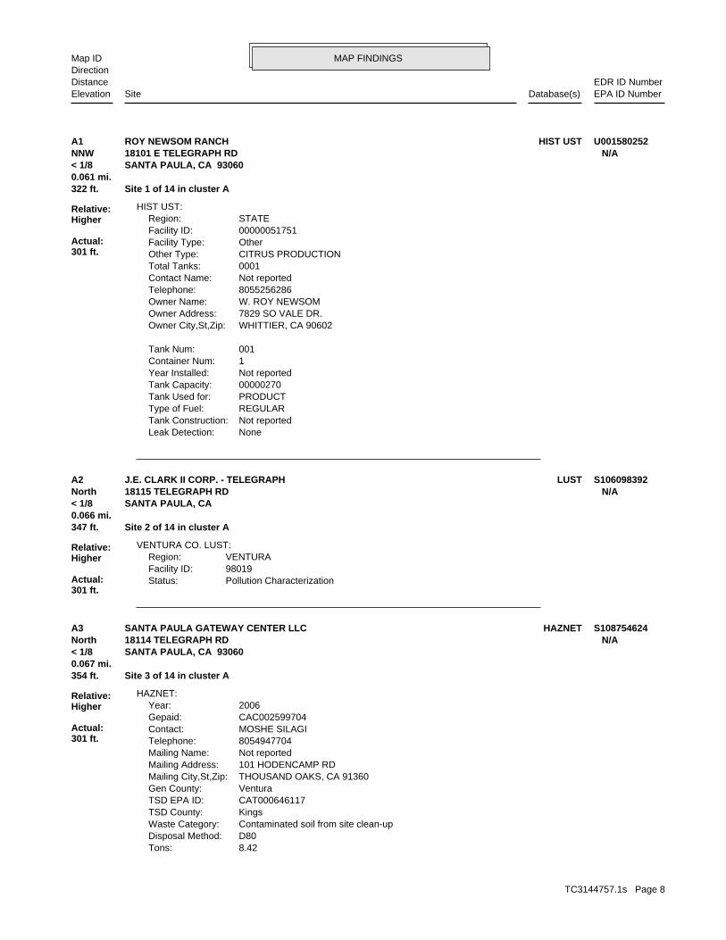
MAP FINDINGSMap IDDirection
EDR ID NumberDistanceEPA ID NumberDatabase(s)SiteElevation
NoneLeak Detection: Not reportedTank Construction: REGULARType of Fuel: PRODUCTTank Used for: 00000270Tank Capacity: Not reportedYear Installed: 1Container Num: 001Tank Num:
WHITTIER, CA 90602Owner City,St,Zip: 7829 SO VALE DR.Owner Address: W. ROY NEWSOMOwner Name: 8055256286Telephone: Not reportedContact Name: 0001Total Tanks: CITRUS PRODUCTIONOther Type: OtherFacility Type: 00000051751Facility ID: STATERegion:
HIST UST:
322 ft. Site 1 of 14 in cluster A0.061 mi.
Relative:Higher
Actual:301 ft.
< 1/8 SANTA PAULA, CA 93060NNW 18101 E TELEGRAPH RD N/AA1 HIST USTROY NEWSOM RANCH U001580252
Pollution CharacterizationStatus:98019Facility ID:VENTURARegion:
VENTURA CO. LUST:
347 ft. Site 2 of 14 in cluster A0.066 mi.
Relative:Higher
Actual:301 ft.
< 1/8 SANTA PAULA, CA North 18115 TELEGRAPH RD N/AA2 LUSTJ.E. CLARK II CORP. - TELEGRAPH S106098392
8.42Tons: D80Disposal Method: Contaminated soil from site clean-upWaste Category: KingsTSD County: CAT000646117TSD EPA ID: VenturaGen County: THOUSAND OAKS, CA 91360Mailing City,St,Zip: 101 HODENCAMP RDMailing Address: Not reportedMailing Name: 8054947704Telephone: MOSHE SILAGIContact: CAC002599704Gepaid: 2006Year:
HAZNET:
354 ft. Site 3 of 14 in cluster A0.067 mi.
Relative:Higher
Actual:301 ft.
< 1/8 SANTA PAULA, CA 93060North 18114 TELEGRAPH RD N/AA3 HAZNETSANTA PAULA GATEWAY CENTER LLC S108754624
TC3144757.1s Page 8

MAP FINDINGSMap IDDirection
EDR ID NumberDistanceEPA ID NumberDatabase(s)SiteElevation
VenturaFacility County:
SANTA PAULA GATEWAY CENTER LLC (Continued) S108754624
2008-12-23 00:00:00Date: ENFORCEMENTAction Type: T0611101177Global Id:
LUST:
2135766714Phone Number: [email protected]: R4 UNKNOWNCity: Not reportedAddress: LOS ANGELES RWQCB (REGION 4)Organization Name: DANIEL PIROTTONContact Name: Regional Board CaseworkerContact Type: T0611101177Global Id:
8056545040Phone Number: [email protected]: VENTURACity: 800 S. VICTORIA AVE.Address: VENTURA COUNTY LOPOrganization Name: DIANE B. WAHLContact Name: Local Agency CaseworkerContact Type: T0611101177Global Id:
LUST:
Click here to access the California GeoTracker records for this facility:
Not reportedSite History: Waste Oil / Motor / Hydraulic / LubricatingPotential Contaminants of Concern: Other Groundwater (uses other than drinking water)Potential Media Affect: Not reportedFile Location: 98019LOC Case Number: C98019RB Case Number: VENTURA COUNTY LOPLocal Agency: DBWCase Worker: VENTURA COUNTY LOPLead Agency: 2007-02-15 00:00:00Status Date: Open - Site AssessmentStatus: LUST Cleanup SiteCase Type: -119.044375419617Longitude: 34.360655199102Latitude: T0611101177Global Id: STATERegion:
LUST:
C-98019Reg Id: LTNKAReg By: 56Facility County Code: CORTESERegion:
CORTESE:
362 ft. Site 4 of 14 in cluster A0.069 mi.
Relative:Higher
Actual:301 ft.
< 1/8 SANTA PAULA, CA 93060North LUST18115 TELEGRAPH N/AA4 HIST CORTESEJ E CLARK II CORPORATION S103317851
TC3144757.1s Page 9

MAP FINDINGSMap IDDirection
EDR ID NumberDistanceEPA ID NumberDatabase(s)SiteElevation
Notice to Comply - #7Action: 2006-04-24 00:00:00Date: ENFORCEMENTAction Type: T0611101177Global Id:
Monitoring Report - Semi-AnnuallyAction: 2010-01-29 00:00:00Date: RESPONSEAction Type: T0611101177Global Id:
File review - #2Action: 2003-09-08 00:00:00Date: ENFORCEMENTAction Type: T0611101177Global Id:
Notice to Comply - #9Action: 2007-03-07 00:00:00Date: ENFORCEMENTAction Type: T0611101177Global Id:
Staff LetterAction: 2011-04-12 00:00:00Date: ENFORCEMENTAction Type: T0611101177Global Id:
File reviewAction: 2010-06-01 00:00:00Date: ENFORCEMENTAction Type: T0611101177Global Id:
Staff LetterAction: 2009-06-22 00:00:00Date: ENFORCEMENTAction Type: T0611101177Global Id:
File reviewAction: 2009-04-20 00:00:00Date: ENFORCEMENTAction Type: T0611101177Global Id:
Soil and Water Investigation WorkplanAction: 2005-10-31 00:00:00Date: RESPONSEAction Type: T0611101177Global Id:
Clean Up Fund - 5-Year Review SummaryAction: 2009-12-14 00:00:00Date: RESPONSEAction Type: T0611101177Global Id:
Technical Correspondence / Assistance / Other - #8Action: 2006-07-28 00:00:00Date: ENFORCEMENTAction Type: T0611101177Global Id:
Staff LetterAction:
J E CLARK II CORPORATION (Continued) S103317851
TC3144757.1s Page 10
MAP FINDINGSMap IDDirection
EDR ID NumberDistanceEPA ID NumberDatabase(s)SiteElevation
ENFORCEMENTAction Type: T0611101177Global Id:
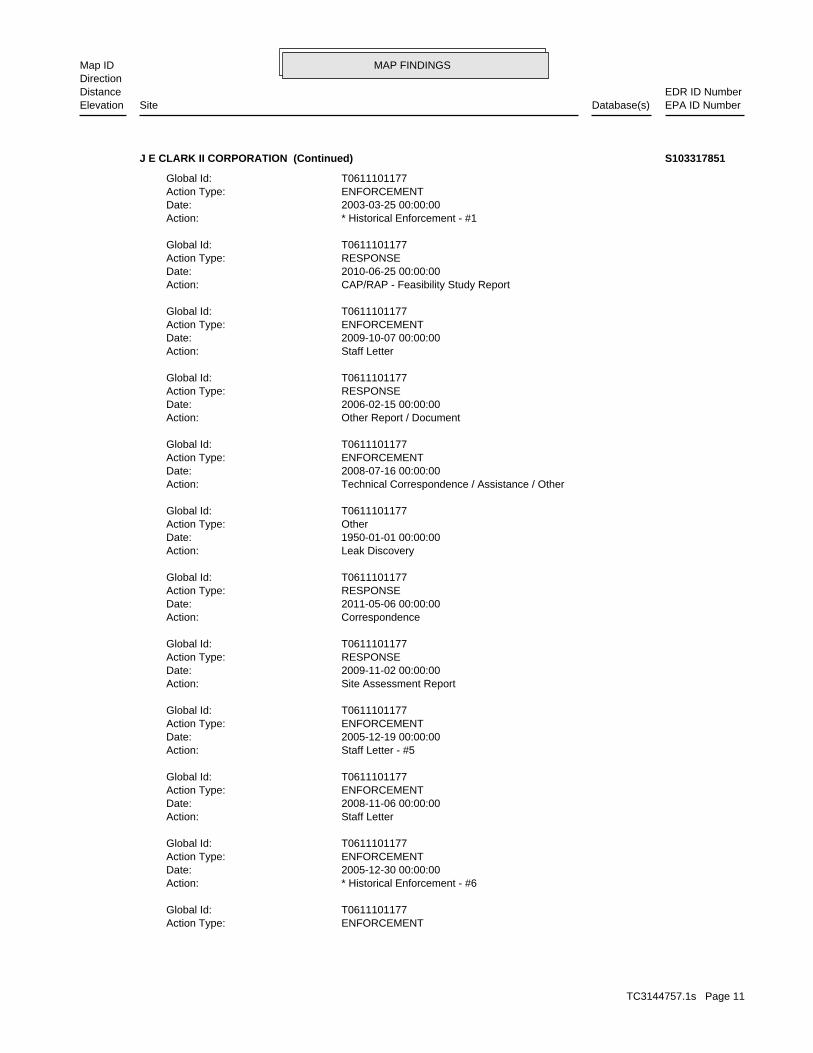
* Historical Enforcement - #6Action: 2005-12-30 00:00:00Date: ENFORCEMENTAction Type: T0611101177Global Id:
Staff LetterAction: 2008-11-06 00:00:00Date: ENFORCEMENTAction Type: T0611101177Global Id:
Staff Letter - #5Action: 2005-12-19 00:00:00Date: ENFORCEMENTAction Type: T0611101177Global Id:
Site Assessment ReportAction: 2009-11-02 00:00:00Date: RESPONSEAction Type: T0611101177Global Id:
CorrespondenceAction: 2011-05-06 00:00:00Date: RESPONSEAction Type: T0611101177Global Id:
Leak DiscoveryAction: 1950-01-01 00:00:00Date: OtherAction Type: T0611101177Global Id:
Technical Correspondence / Assistance / OtherAction: 2008-07-16 00:00:00Date: ENFORCEMENTAction Type: T0611101177Global Id:
Other Report / DocumentAction: 2006-02-15 00:00:00Date: RESPONSEAction Type: T0611101177Global Id:
Staff LetterAction: 2009-10-07 00:00:00Date: ENFORCEMENTAction Type: T0611101177Global Id:
CAP/RAP - Feasibility Study ReportAction: 2010-06-25 00:00:00Date: RESPONSEAction Type: T0611101177Global Id:
* Historical Enforcement - #1Action: 2003-03-25 00:00:00Date: ENFORCEMENTAction Type: T0611101177Global Id:
J E CLARK II CORPORATION (Continued) S103317851
TC3144757.1s Page 11

MAP FINDINGSMap IDDirection
EDR ID NumberDistanceEPA ID NumberDatabase(s)SiteElevation
Staff LetterAction: 2010-03-03 00:00:00Date: ENFORCEMENTAction Type: T0611101177Global Id:
Leak StoppedAction: 1950-01-01 00:00:00Date: OtherAction Type: T0611101177Global Id:
Leak ReportedAction: 1950-01-01 00:00:00Date: OtherAction Type: T0611101177Global Id:
Soil and Water Investigation WorkplanAction: 2007-09-28 00:00:00Date: RESPONSEAction Type: T0611101177Global Id:
Other Report / DocumentAction: 2007-07-31 00:00:00Date: RESPONSEAction Type: T0611101177Global Id:
Well Installation ReportAction: 2006-12-29 00:00:00Date: RESPONSEAction Type: T0611101177Global Id:
Soil and Water Investigation ReportAction: 2006-10-22 00:00:00Date: RESPONSEAction Type: T0611101177Global Id:
* No Action - #14Action: 2008-05-27 00:00:00Date: ENFORCEMENTAction Type: T0611101177Global Id:
Staff LetterAction: 2009-04-27 00:00:00Date: ENFORCEMENTAction Type: T0611101177Global Id:
Notice to Comply - #12Action: 2007-11-13 00:00:00Date: ENFORCEMENTAction Type: T0611101177Global Id:
Technical Correspondence / Assistance / Other - #13Action: 2008-02-04 00:00:00Date: ENFORCEMENTAction Type: T0611101177Global Id:
Notice to Comply - #10Action: 2007-06-21 00:00:00Date:
J E CLARK II CORPORATION (Continued) S103317851
TC3144757.1s Page 12

MAP FINDINGSMap IDDirection
EDR ID NumberDistanceEPA ID NumberDatabase(s)SiteElevation
RESPONSEAction Type: T0611101177Global Id:
Technical Correspondence / Assistance / Other - #11Action: 2007-07-30 00:00:00Date: ENFORCEMENTAction Type: T0611101177Global Id:
* Historical Enforcement - #4Action: 2005-08-09 00:00:00Date: ENFORCEMENTAction Type: T0611101177Global Id:
* No Action - #3Action: 2005-06-15 00:00:00Date: ENFORCEMENTAction Type: T0611101177Global Id:
Other Report / DocumentAction: 2003-05-09 00:00:00Date: RESPONSEAction Type: T0611101177Global Id:
Other WorkplanAction: 2003-05-09 00:00:00Date: RESPONSEAction Type: T0611101177Global Id:
Other Report / DocumentAction: 2008-10-10 00:00:00Date: RESPONSEAction Type: T0611101177Global Id:
Other Report / DocumentAction: 2008-07-11 00:00:00Date: RESPONSEAction Type: T0611101177Global Id:
Other Report / DocumentAction: 2008-04-11 00:00:00Date: RESPONSEAction Type: T0611101177Global Id:
Monitoring Report - QuarterlyAction: 2008-10-30 00:00:00Date: RESPONSEAction Type: T0611101177Global Id:
Monitoring Report - QuarterlyAction: 2008-07-30 00:00:00Date: RESPONSEAction Type: T0611101177Global Id:
Other Report / DocumentAction: 2009-02-02 00:00:00Date: RESPONSEAction Type: T0611101177Global Id:
J E CLARK II CORPORATION (Continued) S103317851
TC3144757.1s Page 13

MAP FINDINGSMap IDDirection
EDR ID NumberDistanceEPA ID NumberDatabase(s)SiteElevation
Not reportedRemedial Action Underway: Not reportedRemediation Plan Submitted: Not reportedPollution Characterization Began: Not reportedPreliminary Site Assessment Began: 4/6/1998Preliminary Site Assessment Workplan Submitted: FSource of Cleanup Funding: 960.6622784204019123671086098Approx. Dist To Production Well (ft): Not reportedWell Name: Not reportedWater System: Not reportedOperator: Not reportedLeak Source: Not reportedCause of Leak: Not reportedHow Leak Stopped: Not reportedHow Leak Discovered: Not reportedDate the Case was Closed: Not reportedDate Case Last Changed on Database: Not reportedDate Leak Stopped: 4/10/1998Date Confirmation Began: Not reportedDate Leak Record Entered: 4/6/1998Date Leak First Reported: 4/6/1998Date Leak Discovered: FREVEnforcement Type: Not reportedCross Street: 56000LLocal Agency: UNKStaff: Not reportedW Global ID: T0611101177Global ID: Not reportedAbatement Method Used at the Site: SoilCase Type: 98019Local Case No: Not reportedSubstance Quantity: Motor OilSubstance: Leak being confirmedStatus: C-98019facid: VenturaCounty: 04Regional Board: 4Region:
LUST REG 4:
Staff LetterAction: 2009-07-06 00:00:00Date: ENFORCEMENTAction Type: T0611101177Global Id:
Monitoring Report - QuarterlyAction: 2007-10-31 00:00:00Date: RESPONSEAction Type: T0611101177Global Id:
Soil and Water Investigation WorkplanAction: 2009-03-25 00:00:00Date: RESPONSEAction Type: T0611101177Global Id:
Electronic Reporting Submittal DueAction: 2009-02-02 00:00:00Date:
J E CLARK II CORPORATION (Continued) S103317851
TC3144757.1s Page 14

MAP FINDINGSMap IDDirection
EDR ID NumberDistanceEPA ID NumberDatabase(s)SiteElevation
Not reportedSummary: Not reportedAssigned Name: Not reportedSuspended: Not reportedCleanup Fund Id: Not reportedPriority: Not reportedBeneficial Use: KEALocal Agency Staff: 34.3594709 / -1Lat/Long: LUSTProgram: Not reportedRP Address: J. E. CLARK II CORPResponsible Party: Not reportedOwner Contact: Not reportedOrganization: Not reportedSoil Qualifier: Not reportedGW Qualifier: Not reportedSignificant Interim Remedial Action Taken: Not reportedHist Max MTBE Conc in Soil: Not reportedHist Max MTBE Conc in Groundwater: Not reportedHistorical Max MTBE Date: Not reportedEnforcement Action Date: Not reportedPost Remedial Action Monitoring Began:
J E CLARK II CORPORATION (Continued) S103317851
VenturaFacility County: 1.0425Tons: R01Disposal Method: Waste oil and mixed oilWaste Category: Los AngelesTSD County: CAT080013352TSD EPA ID: VenturaGen County: SANTA PAULA, CA 930610072Mailing City,St,Zip: PO BOX 72Mailing Address: Not reportedMailing Name: 8056491446Telephone: J E CLARK IIContact: CAL000827803Gepaid: 1998Year:
VenturaFacility County: .3753Tons: R01Disposal Method: Aqueous solution with total organic residues less than 10 percentWaste Category: Los AngelesTSD County: CAT080013352TSD EPA ID: VenturaGen County: SANTA PAULA, CA 930610072Mailing City,St,Zip: PO BOX 72Mailing Address: Not reportedMailing Name: 8056491446Telephone: J E CLARK IIContact: CAL000827803Gepaid: 2000Year:
HAZNET:
362 ft. Site 5 of 14 in cluster A0.069 mi.
Relative:Higher
Actual:301 ft.
< 1/8 SANTA PAULA, CA 93060North 18115 E TELEGRAPH RD N/AA5 HAZNETJ E CLARK II CORPORATION S103637214
TC3144757.1s Page 15

MAP FINDINGSMap IDDirection
EDR ID NumberDistanceEPA ID NumberDatabase(s)SiteElevation
71 additional CA_HAZNET: record(s) in the EDR Site Report.Click this hyperlink while viewing on your computer to access
VenturaFacility County: .0625Tons: Not reportedDisposal Method: Aqueous solution with total organic residues less than 10 percentWaste Category: Los AngelesTSD County: CAD981696420TSD EPA ID: VenturaGen County: SANTA PAULA, CA 930610072Mailing City,St,Zip: PO BOX 72Mailing Address: Not reportedMailing Name: 8056491446Telephone: J E CLARK IIContact: CAL000827803Gepaid: 1996Year:
VenturaFacility County: 13.1351Tons: Not reportedDisposal Method: Waste oil and mixed oilWaste Category: Los AngelesTSD County: CAT080013352TSD EPA ID: VenturaGen County: SANTA PAULA, CA 930610072Mailing City,St,Zip: PO BOX 72Mailing Address: Not reportedMailing Name: 8056491446Telephone: J E CLARK IIContact: CAL000827803Gepaid: 1997Year:
VenturaFacility County: 3.1275Tons: R01Disposal Method: Waste oil and mixed oilWaste Category: Los AngelesTSD County: CAD044429835TSD EPA ID: VenturaGen County: SANTA PAULA, CA 930610072Mailing City,St,Zip: PO BOX 72Mailing Address: Not reportedMailing Name: 8056491446Telephone: J E CLARK IIContact: CAL000827803Gepaid: 1997Year:
J E CLARK II CORPORATION (Continued) S103637214
TC3144757.1s Page 16

MAP FINDINGSMap IDDirection
EDR ID NumberDistanceEPA ID NumberDatabase(s)SiteElevation
EDDIE GIBSON/MGRContact: CAD982481905Gepaid: 2002Year:
Not reportedFacility County: 61.21Tons: R01Disposal Method: Waste oil and mixed oilWaste Category: Los AngelesTSD County: Not reportedTSD EPA ID: VenturaGen County: SANTA PAULA, CA 930610000Mailing City,St,Zip: PO BOX 988Mailing Address: Not reportedMailing Name: 8055251525Telephone: EDDIE GIBSON/MGRContact: CAD982481905Gepaid: 2002Year:
Not reportedFacility County: 0.40Tons: H01Disposal Method: Unspecified oil-containing wasteWaste Category: Los AngelesTSD County: Not reportedTSD EPA ID: VenturaGen County: SANTA PAULA, CA 930610000Mailing City,St,Zip: PO BOX 988Mailing Address: Not reportedMailing Name: 8055251525Telephone: EDDIE GIBSON/MGRContact: CAD982481905Gepaid: 2002Year:
Not reportedFacility County: 0.42Tons: H01Disposal Method: Waste oil and mixed oilWaste Category: Los AngelesTSD County: CAT080013352TSD EPA ID: VenturaGen County: SANTA PAULA, CA 930610000Mailing City,St,Zip: PO BOX 988Mailing Address: Not reportedMailing Name: 8055251525Telephone: EDDIE GIBSON/MGRContact: CAD982481905Gepaid: 2005Year:
HAZNET:
BUSINESS PLANProgram:FA0005133Facility ID:
VENTURA CO. BWT:
362 ft. Site 6 of 14 in cluster A0.069 mi.
Relative:Higher
Actual:301 ft.
< 1/8 SANTA PAULA, CA 93060North HAZNET18115 E TELEGRAPH RD N/AA6 VENTURA CO. BWTAMBER RESOURES DBA SAWYER PETROLEUM S101700940
TC3144757.1s Page 17

MAP FINDINGSMap IDDirection
EDR ID NumberDistanceEPA ID NumberDatabase(s)SiteElevation
60 additional CA_HAZNET: record(s) in the EDR Site Report.Click this hyperlink while viewing on your computer to access
Not reportedFacility County: 6.39Tons: Not reportedDisposal Method: Waste oil and mixed oilWaste Category: Los AngelesTSD County: Not reportedTSD EPA ID: VenturaGen County: SANTA PAULA, CA 930610000Mailing City,St,Zip: PO BOX 988Mailing Address: Not reportedMailing Name: 8055251525Telephone: EDDIE GIBSON/MGRContact: CAD982481905Gepaid: 2002Year:
Not reportedFacility County: 39.24Tons: H01Disposal Method: Waste oil and mixed oilWaste Category: Los AngelesTSD County: Not reportedTSD EPA ID: VenturaGen County: SANTA PAULA, CA 930610000Mailing City,St,Zip: PO BOX 988Mailing Address: Not reportedMailing Name: 8055251525Telephone:
AMBER RESOURES DBA SAWYER PETROLEUM (Continued) S101700940
other debris resulting from the cleanup of a spill, into or on any waste; or 100 kg or less of any residue or contaminated soil, waste or month, and accumulates at any time: 1 kg or less of acutely hazardous or generates 1 kg or less of acutely hazardous waste per calendar month, and accumulates 1000 kg or less of hazardous waste at any time; Handler: generates 100 kg or less of hazardous waste per calendarDescription: Conditionally Exempt Small Quantity GeneratorClassification: 09EPA Region: Not reportedContact email: (805) 525-1525Contact telephone: USContact country: SANTA PAULA, CA 93060 18115 E TELEGRAPH RDContact address: EDDIE GIBSONContact: SANTA PAULA, CA 93061 PO BOX 72Mailing address: CAD982481905EPA ID: SANTA PAULA, CA 93060 18115 E TELEGRAPH RDFacility address: THOMAS SAWYER DBA CLARK OILFacility name: 11/20/1996Date form received by agency:
RCRA-CESQG:
362 ft. Site 7 of 14 in cluster A0.069 mi.
Relative:Higher
Actual:301 ft.
< 1/8 SANTA PAULA, CA 93060North 18115 E TELEGRAPH RD CAD982481905A7 RCRA-CESQGTHOMAS SAWYER DBA CLARK OIL 1000363343
TC3144757.1s Page 18

MAP FINDINGSMap IDDirection
EDR ID NumberDistanceEPA ID NumberDatabase(s)SiteElevation
No violations foundViolation Status:
NoUsed oil transporter: NoUsed oil transfer facility: NoUsed oil Specification marketer: NoUsed oil fuel marketer to burner: NoUser oil refiner: NoUsed oil processor: NoUsed oil fuel burner: NoFurnace exemption: NoOn-site burner exemption: NoUnderground injection activity: NoTreater, storer or disposer of HW: YesTransporter of hazardous waste: NoRecycler of hazardous waste: NoMixed waste (haz. and radioactive): NoU.S. importer of hazardous waste:
Handler Activities Summary:
Not reportedOwner/Op end date: Not reportedOwner/Op start date: OperatorOwner/Operator Type: PrivateLegal status: (415) 555-1212Owner/operator telephone: Not reportedOwner/operator country: NOT REQUIRED, ME 99999 NOT REQUIREDOwner/operator address: NOT REQUIREDOwner/operator name:
Not reportedOwner/Op end date: Not reportedOwner/Op start date: OwnerOwner/Operator Type: PrivateLegal status: (818) 786-8180Owner/operator telephone: Not reportedOwner/operator country: VAN NUYS, CA 91401 14117 AETNA STOwner/operator address: THOMAS M SAWYEROwner/operator name:
Owner/Operator Summary:
hazardous waste the cleanup of a spill, into or on any land or water, of acutely any residue or contaminated soil, waste or other debris resulting from time: 1 kg or less of acutely hazardous waste; or 100 kg or less of hazardous waste during any calendar month, and accumulates at any from the cleanup of a spill, into or on any land or water, of acutely of any residue or contaminated soil, waste or other debris resulting land or water, of acutely hazardous waste; or generates 100 kg or less
THOMAS SAWYER DBA CLARK OIL (Continued) 1000363343
TC3144757.1s Page 19

MAP FINDINGSMap IDDirection
EDR ID NumberDistanceEPA ID NumberDatabase(s)SiteElevation
-119.114797Longitude:34.145913Latitude:3098Facility ID:
UST:
362 ft. Site 8 of 14 in cluster A0.069 mi.
Relative:Higher
Actual:301 ft.
< 1/8 SANTA PAULA, CA 93060North 18115 E TELEGRAPH RD N/AA8 USTJ E CLARK II U003778392
00010000Tank Capacity: 1977Year Installed: 9Container Num: 004Tank Num:
Visual, Stock InventorLeak Detection: 5/16 inchesTank Construction: REGULARType of Fuel: PRODUCTTank Used for: 00020000Tank Capacity: 1978Year Installed: 10Container Num: 003Tank Num:
Visual, Stock InventorLeak Detection: 3/8 inchesTank Construction: DIESELType of Fuel: PRODUCTTank Used for: 00006000Tank Capacity: 1956Year Installed: 12Container Num: 002Tank Num:
Visual, Stock InventorLeak Detection: 1/2 inchesTank Construction: DIESELType of Fuel: PRODUCTTank Used for: 00001500Tank Capacity: 1931Year Installed: 11Container Num: 001Tank Num:
SANTA PAULA, CA 93060Owner City,St,Zip: 18115 E TELEGRAPH RDOwner Address: J.E. CLARK CORP.Owner Name: 8055251525Telephone: EDDIE GIBSONContact Name: 0008Total Tanks: FUEL JOBBEROther Type: OtherFacility Type: 00000006128Facility ID: STATERegion:
HIST UST:
362 ft. Site 9 of 14 in cluster A0.069 mi.
Relative:Higher
Actual:301 ft.
< 1/8 SANTA PAULA, CA 93060North 18115 E TELEGRAPH RD N/AA9 HIST USTJ.E. CLARK CORP. PLANT #1 U001580177
TC3144757.1s Page 20

MAP FINDINGSMap IDDirection
EDR ID NumberDistanceEPA ID NumberDatabase(s)SiteElevation
Visual, Stock InventorLeak Detection: 3/8 inchesTank Construction: UNLEADEDType of Fuel: PRODUCTTank Used for: 00008000Tank Capacity: 1953Year Installed: 5Container Num: 008Tank Num:
Visual, Stock InventorLeak Detection: 3/8 inchesTank Construction: 06Type of Fuel: PRODUCTTank Used for: 00008000Tank Capacity: 1953Year Installed: 6Container Num: 007Tank Num:
Visual, Stock InventorLeak Detection: 3/8 inchesTank Construction: UNLEADEDType of Fuel: PRODUCTTank Used for: 00008000Tank Capacity: 1953Year Installed: 7Container Num: 006Tank Num:
Visual, Stock InventorLeak Detection: 3/8 inchesTank Construction: Not reportedType of Fuel: PRODUCTTank Used for: 00008000Tank Capacity: 1953Year Installed: 8Container Num: 005Tank Num:
Visual, Stock InventorLeak Detection: 1/4 inchesTank Construction: PREMIUMType of Fuel: PRODUCTTank Used for:
J.E. CLARK CORP. PLANT #1 (Continued) U001580177
SANTA PAULA 93060Mailing City,St,Zip: Not reportedMailing Address 2: 18115 E TELEGRAPH RDMailing Address: Not reportedMail To: Not reportedFacility Phone: Not reportedSIC Code: Not reportedCortese Code: CAL000827Regulated ID: UTNKARegulated By: 56002748Facility ID:
CA FID UST:
362 ft. Site 10 of 14 in cluster A0.069 mi.
Relative:Higher
Actual:301 ft.
< 1/8 HAZNETSANTA PAULA, CA 93060North SWEEPS UST18115 E TELEGRAPH RD N/AA10 CA FID USTJ E CLARK II CORPORATION S101596365
TC3144757.1s Page 21

MAP FINDINGSMap IDDirection
EDR ID NumberDistanceEPA ID NumberDatabase(s)SiteElevation
PStg: UNKNOWNTank Use: 6000Capacity: Not reportedActv Date: 56-000-000761-000003Swrcb Tank Id: Not reportedOwner Tank Id: ATank Status: 02-29-88Created Date: 09-30-92Act Date: 09-30-92Ref Date: 44-030703Board Of Equalization: 9Number: 761Comp Number: AStatus:
Not reportedNumber Of Tanks: Not reportedContent: PStg: UNKNOWNTank Use: 20000Capacity: Not reportedActv Date: 56-000-000761-000002Swrcb Tank Id: Not reportedOwner Tank Id: ATank Status: 02-29-88Created Date: 09-30-92Act Date: 09-30-92Ref Date: 44-030703Board Of Equalization: 9Number: 761Comp Number: AStatus:
8Number Of Tanks: Not reportedContent: PStg: UNKNOWNTank Use: 12000Capacity: Not reportedActv Date: 56-000-000761-000001Swrcb Tank Id: Not reportedOwner Tank Id: ATank Status: 02-29-88Created Date: 09-30-92Act Date: 09-30-92Ref Date: 44-030703Board Of Equalization: 9Number: 761Comp Number: AStatus:
SWEEPS UST:
ActiveStatus: Not reportedComments: Not reportedEPA ID: Not reportedNPDES Number: Not reportedDUNs Number: Not reportedContact Phone: Not reportedContact:
J E CLARK II CORPORATION (Continued) S101596365
TC3144757.1s Page 22

MAP FINDINGSMap IDDirection
EDR ID NumberDistanceEPA ID NumberDatabase(s)SiteElevation
9Number: 761Comp Number: AStatus:
Not reportedNumber Of Tanks: Not reportedContent: PStg: UNKNOWNTank Use: 12000Capacity: Not reportedActv Date: 56-000-000761-000006Swrcb Tank Id: Not reportedOwner Tank Id: ATank Status: 02-29-88Created Date: 09-30-92Act Date: 09-30-92Ref Date: 44-030703Board Of Equalization: 9Number: 761Comp Number: AStatus:
Not reportedNumber Of Tanks: Not reportedContent: PStg: UNKNOWNTank Use: 6000Capacity: Not reportedActv Date: 56-000-000761-000005Swrcb Tank Id: Not reportedOwner Tank Id: ATank Status: 02-29-88Created Date: 09-30-92Act Date: 09-30-92Ref Date: 44-030703Board Of Equalization: 9Number: 761Comp Number: AStatus:
Not reportedNumber Of Tanks: Not reportedContent: PStg: UNKNOWNTank Use: 6000Capacity: Not reportedActv Date: 56-000-000761-000004Swrcb Tank Id: Not reportedOwner Tank Id: ATank Status: 02-29-88Created Date: 09-30-92Act Date: 09-30-92Ref Date: 44-030703Board Of Equalization: 9Number: 761Comp Number: AStatus:
Not reportedNumber Of Tanks: Not reportedContent:
J E CLARK II CORPORATION (Continued) S101596365
TC3144757.1s Page 23
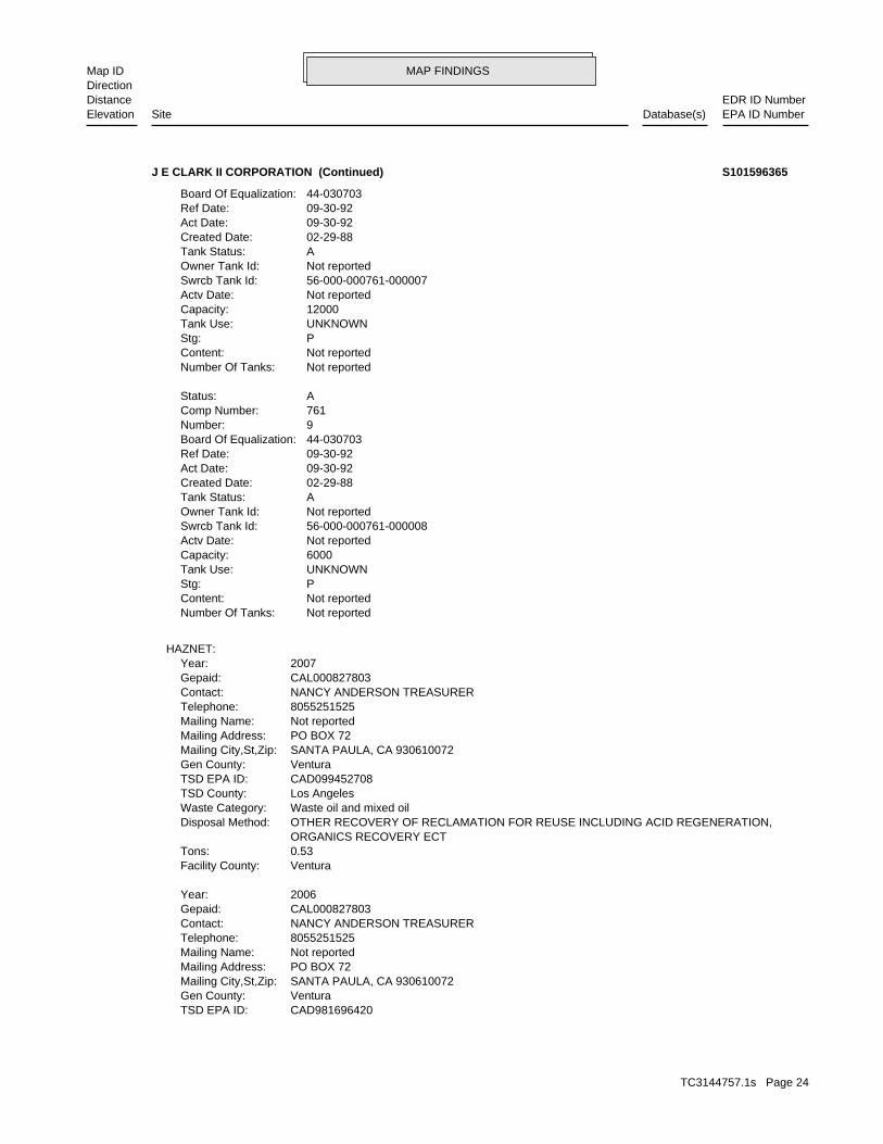
MAP FINDINGSMap IDDirection
EDR ID NumberDistanceEPA ID NumberDatabase(s)SiteElevation
CAD981696420TSD EPA ID: VenturaGen County: SANTA PAULA, CA 930610072Mailing City,St,Zip: PO BOX 72Mailing Address: Not reportedMailing Name: 8055251525Telephone: NANCY ANDERSON TREASURERContact: CAL000827803Gepaid: 2006Year:
VenturaFacility County: 0.53Tons: ORGANICS RECOVERY ECT OTHER RECOVERY OF RECLAMATION FOR REUSE INCLUDING ACID REGENERATION,Disposal Method: Waste oil and mixed oilWaste Category: Los AngelesTSD County: CAD099452708TSD EPA ID: VenturaGen County: SANTA PAULA, CA 930610072Mailing City,St,Zip: PO BOX 72Mailing Address: Not reportedMailing Name: 8055251525Telephone: NANCY ANDERSON TREASURERContact: CAL000827803Gepaid: 2007Year:
HAZNET:
Not reportedNumber Of Tanks: Not reportedContent: PStg: UNKNOWNTank Use: 6000Capacity: Not reportedActv Date: 56-000-000761-000008Swrcb Tank Id: Not reportedOwner Tank Id: ATank Status: 02-29-88Created Date: 09-30-92Act Date: 09-30-92Ref Date: 44-030703Board Of Equalization: 9Number: 761Comp Number: AStatus:
Not reportedNumber Of Tanks: Not reportedContent: PStg: UNKNOWNTank Use: 12000Capacity: Not reportedActv Date: 56-000-000761-000007Swrcb Tank Id: Not reportedOwner Tank Id: ATank Status: 02-29-88Created Date: 09-30-92Act Date: 09-30-92Ref Date: 44-030703Board Of Equalization:
J E CLARK II CORPORATION (Continued) S101596365
TC3144757.1s Page 24
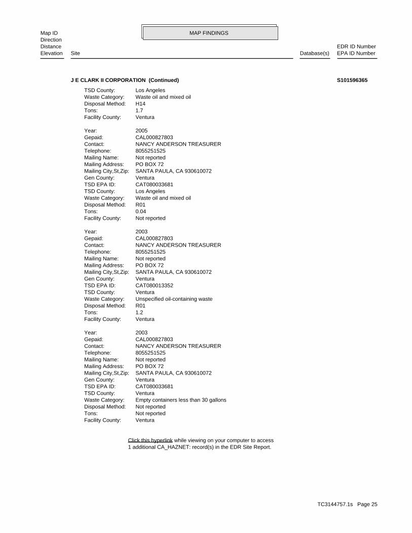
MAP FINDINGSMap IDDirection
EDR ID NumberDistanceEPA ID NumberDatabase(s)SiteElevation
1 additional CA_HAZNET: record(s) in the EDR Site Report.Click this hyperlink while viewing on your computer to access
VenturaFacility County: Not reportedTons: Not reportedDisposal Method: Empty containers less than 30 gallonsWaste Category: VenturaTSD County: CAT080033681TSD EPA ID: VenturaGen County: SANTA PAULA, CA 930610072Mailing City,St,Zip: PO BOX 72Mailing Address: Not reportedMailing Name: 8055251525Telephone: NANCY ANDERSON TREASURERContact: CAL000827803Gepaid: 2003Year:
VenturaFacility County: 1.2Tons: R01Disposal Method: Unspecified oil-containing wasteWaste Category: VenturaTSD County: CAT080013352TSD EPA ID: VenturaGen County: SANTA PAULA, CA 930610072Mailing City,St,Zip: PO BOX 72Mailing Address: Not reportedMailing Name: 8055251525Telephone: NANCY ANDERSON TREASURERContact: CAL000827803Gepaid: 2003Year:
Not reportedFacility County: 0.04Tons: R01Disposal Method: Waste oil and mixed oilWaste Category: Los AngelesTSD County: CAT080033681TSD EPA ID: VenturaGen County: SANTA PAULA, CA 930610072Mailing City,St,Zip: PO BOX 72Mailing Address: Not reportedMailing Name: 8055251525Telephone: NANCY ANDERSON TREASURERContact: CAL000827803Gepaid: 2005Year:
VenturaFacility County: 1.7Tons: H14Disposal Method: Waste oil and mixed oilWaste Category: Los AngelesTSD County:
J E CLARK II CORPORATION (Continued) S101596365
TC3144757.1s Page 25

MAP FINDINGSMap IDDirection
EDR ID NumberDistanceEPA ID NumberDatabase(s)SiteElevation
0Part. Matter 10 Micrometers & Smllr Tons/Yr: 0Particulate Matter Tons/Yr: 0SOX - Oxides of Sulphur Tons/Yr: 0NOX - Oxides of Nitrogen Tons/Yr: 0Carbon Monoxide Emissions Tons/Yr: 4Reactive Organic Gases Tons/Yr: 4Total Organic Hydrocarbon Gases Tons/Yr: Not reportedConsolidated Emission Reporting Rule: Not reportedCommunity Health Air Pollution Info System: VENTURA COUNTY APCDAir District Name: 5171SIC Code: VENAir District Name: 862Facility ID: SCCAir Basin: 56County Code: 1990Year:
0Part. Matter 10 Micrometers & Smllr Tons/Yr: 0Particulate Matter Tons/Yr: 0SOX - Oxides of Sulphur Tons/Yr: 0NOX - Oxides of Nitrogen Tons/Yr: 0Carbon Monoxide Emissions Tons/Yr: 4Reactive Organic Gases Tons/Yr: 4Total Organic Hydrocarbon Gases Tons/Yr: Not reportedConsolidated Emission Reporting Rule: Not reportedCommunity Health Air Pollution Info System: VENTURA COUNTY APCDAir District Name: 5171SIC Code: VENAir District Name: 862Facility ID: SCCAir Basin: 56County Code: 1987Year:
EMI:
362 ft. Site 11 of 14 in cluster A0.069 mi.
Relative:Higher
Actual:301 ft.
< 1/8 SANTA PAULA, CA 93060North 18115 E. TELEGRAPH RD. N/AA11 EMIJAMES E. CLARK II CORP. S106833374
(805) 525-1525Contact telephone: USContact country: SANTA PAULA, CA 93060 18115 E TELEGRAPH RDContact address: CLARK JEContact: SANTA PAULA, CA 93061 PO BOX 72Mailing address: CAD982440471EPA ID: SANTA PAULA, CA 93060 18115 E TELEGRAPH RDFacility address: J E CLARK II CORPFacility name: 12/03/1996Date form received by agency:
RCRA-NonGen:
362 ft. Site 12 of 14 in cluster A0.069 mi.
Relative:Higher
Actual:301 ft.
< 1/8 SANTA PAULA, CA 93060North FINDS18115 E TELEGRAPH RD CAD982440471A12 RCRA-NonGenJ E CLARK II CORP 1000593361
TC3144757.1s Page 26
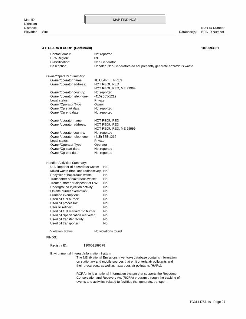
MAP FINDINGSMap IDDirection
EDR ID NumberDistanceEPA ID NumberDatabase(s)SiteElevation
events and activities related to facilities that generate, transport,Conservation and Recovery Act (RCRA) program through the tracking ofRCRAInfo is a national information system that supports the Resource
their precursors, as well as hazardous air pollutants (HAPs).on stationary and mobile sources that emit criteria air pollutants andThe NEI (National Emissions Inventory) database contains information Environmental Interest/Information System
110001189678Registry ID:
FINDS:
No violations foundViolation Status:
NoUsed oil transporter: NoUsed oil transfer facility: NoUsed oil Specification marketer: NoUsed oil fuel marketer to burner: NoUser oil refiner: NoUsed oil processor: NoUsed oil fuel burner: NoFurnace exemption: NoOn-site burner exemption: NoUnderground injection activity: NoTreater, storer or disposer of HW: NoTransporter of hazardous waste: NoRecycler of hazardous waste: NoMixed waste (haz. and radioactive): NoU.S. importer of hazardous waste:
Handler Activities Summary:
Not reportedOwner/Op end date: Not reportedOwner/Op start date: OperatorOwner/Operator Type: PrivateLegal status: (415) 555-1212Owner/operator telephone: Not reportedOwner/operator country: NOT REQUIRED, ME 99999 NOT REQUIREDOwner/operator address: NOT REQUIREDOwner/operator name:
Not reportedOwner/Op end date: Not reportedOwner/Op start date: OwnerOwner/Operator Type: PrivateLegal status: (415) 555-1212Owner/operator telephone: Not reportedOwner/operator country: NOT REQUIRED, ME 99999 NOT REQUIREDOwner/operator address: JE CLARK II PRESOwner/operator name:
Owner/Operator Summary:
Handler: Non-Generators do not presently generate hazardous wasteDescription: Non-GeneratorClassification: 09EPA Region: Not reportedContact email:
J E CLARK II CORP (Continued) 1000593361
TC3144757.1s Page 27

MAP FINDINGSMap IDDirection
EDR ID NumberDistanceEPA ID NumberDatabase(s)SiteElevation
corrective action activities required under RCRA.program staff to track the notification, permit, compliance, andand treat, store, or dispose of hazardous waste. RCRAInfo allows RCRA
J E CLARK II CORP (Continued) 1000593361
CUPA UNDERGROUND TANKS BUSINESS PLANProgram:FA0005132Facility ID:
VENTURA CO. BWT:
362 ft. Site 13 of 14 in cluster A0.069 mi.
Relative:Higher
Actual:301 ft.
< 1/8 SANTA PAULA, CA North 18115 E TELEGRAPH RD N/AA13 VENTURA CO. BWTJ.E. CLARK II CORP. S104994852
considered a minor threat to water quality unless coded at a higher to a major or minor threat. Not: All nurds without a TTWQ will be should cause a relatively minor impairment of beneficial uses compared Minor Threat to Water Quality. A violation of a regional board orderTreat To Water: Not reportedPOTW: Not reportedReclamation: 0Baseline Flow: 0Design Flow: Not reportedSecondary Waste Type: Not reportedSecondary Waste: Not reportedPrimary Waste Type: Not reportedPrimary Waste: Not reportedSIC Code 2: 0SIC Code: PrivateAgency Type: 8059210822Agency Telephone: GARY WARDAgency Contact: Santa Paula 930610715Agency City,St,Zip: PO Box 715Agency Address: WARD CORPAgency Name: GARY WARDFacility Contact: 8059210822Facility Telephone: 4Subregion: are assigned by the Regional Board CAS000001 The 1st 2 characters designate the state. The remaining 7NPDES Number: under Waste Discharge Requirements. Active - Any facility with a continuous or seasonal discharge that isFacility Status: pumping. repairing, oil production, storage and disposal operations, water washing, geothermal operations, air conditioning, ship building and processing operation of whatever nature, including mining, gravel semisolid wastes from any servicing, producing, manufacturing or Industrial - Facility that treats and/or disposes of liquid orFacility Type: 4 56I017449Facility ID:
CA WDS:
415 ft. Site 1 of 5 in cluster B0.079 mi.
Relative:Higher
Actual:302 ft.
< 1/8 SANTA PAULA, CA WNW VENTURA CO. BWT18056 E TELEGRAPH RD N/AB14 WDSWARD CORPORATION S105774036
TC3144757.1s Page 28

MAP FINDINGSMap IDDirection
EDR ID NumberDistanceEPA ID NumberDatabase(s)SiteElevation
BUSINESS PLAN HAZARDOUS WASTE GENERATORProgram:FA0008261Facility ID:
VENTURA CO. BWT:
dairy waste ponds. dischargers having waste storage systems with land disposal such as disposal systems, such as septic systems with subsurface disposal, or management practices, facilities with passive waste treatment and cooling water dischargers or thosewho must comply through best Category C - Facilities having no waste treatment systems, such asComplexity: represent no threat to water quality. Level. A Zero (0) may be used to code those NURDS that are found to
WARD CORPORATION (Continued) S105774036
D629Facility ID:VENTURA CO. UST:
441 ft. Site 2 of 5 in cluster B0.084 mi.
Relative:Higher
Actual:303 ft.
< 1/8 SANTA PAULA, CA WNW 18056 TELEGRAPH ROAD N/AB15 USTPROFCO U002244270
Case ClosedStatus:91091Facility ID:VENTURARegion:
VENTURA CO. LUST:
478 ft. Site 14 of 14 in cluster A0.091 mi.
Relative:Higher
Actual:304 ft.
< 1/8 SANTA PAULA, CA NNE 18145 TELEGRAPH RD N/AA16 LUSTSTANGELAND TRUCKING CORP. S106098393
VenturaFacility County: .4170Tons: R01Disposal Method: Unspecified oil-containing wasteWaste Category: Los AngelesTSD County: CAT080013352TSD EPA ID: VenturaGen County: SANTA PAULA, CA 930600000Mailing City,St,Zip: 17902 TELEGRAPH AVEMailing Address: Not reportedMailing Name: 0000000000Telephone: RUEBEN PENAContact: CAC000911792Gepaid: 1995Year:
HAZNET:
500 ft. Site 1 of 5 in cluster C0.095 mi.
Relative:Higher
Actual:305 ft.
< 1/8 SANTA PAULA, CA 93060NNE 17902 TELEGRAPH AVE N/AC17 HAZNETRUEBENS TIRE S102797182
TC3144757.1s Page 29

MAP FINDINGSMap IDDirection
EDR ID NumberDistanceEPA ID NumberDatabase(s)SiteElevation
VenturaFacility County: 4.5870Tons: R01Disposal Method: Waste oil and mixed oilWaste Category: Los AngelesTSD County: CAT080011059TSD EPA ID: VenturaGen County: VENTURA, CA 930030000Mailing City,St,Zip: 3418 LOMA VISTA ROADMailing Address: Not reportedMailing Name: 0000000000Telephone: HARRY STANGELANDContact: CAC000739296Gepaid: 1994Year:
HAZNET:
D1160Facility ID:VENTURA CO. UST:
522 ft. Site 2 of 5 in cluster C0.099 mi.
Relative:Higher
Actual:305 ft.
< 1/8 SANTA PAULA, CA NNE HAZNET18145 TELEGRAPH ROAD N/AC18 USTSTANGELAND TRUCKING U002244261
ATank Status: 02-29-88Created Date: 09-30-92Act Date: 09-30-92Ref Date: Not reportedBoard Of Equalization: 9Number: 541Comp Number: AStatus:
SWEEPS UST:
ActiveStatus: Not reportedComments: Not reportedEPA ID: Not reportedNPDES Number: Not reportedDUNs Number: Not reportedContact Phone: Not reportedContact: SANTA PAULA 93060Mailing City,St,Zip: Not reportedMailing Address 2: 18145 E TELEGRAPH RDMailing Address: Not reportedMail To: Not reportedFacility Phone: Not reportedSIC Code: Not reportedCortese Code: 54118Regulated ID: UTNKARegulated By: 56000677Facility ID:
CA FID UST:
522 ft. Site 3 of 5 in cluster C0.099 mi. EMI
Relative:Higher
Actual:305 ft.
< 1/8 HAZNETSANTA PAULA, CA 93060NNE SWEEPS UST18145 E TELEGRAPH RD N/AC19 CA FID USTSTANGELAND TRUCKING INC. U002097708
TC3144757.1s Page 30
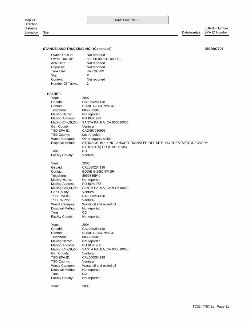
MAP FINDINGSMap IDDirection
EDR ID NumberDistanceEPA ID NumberDatabase(s)SiteElevation
2003Year:
Not reportedFacility County: 0.2Tons: Not reportedDisposal Method: Waste oil and mixed oilWaste Category: VenturaTSD County: CAL000254138TSD EPA ID: VenturaGen County: SANTA PAULA, CA 930610000Mailing City,St,Zip: PO BOX 988Mailing Address: Not reportedMailing Name: 8059335940Telephone: EDDIE GIBSON/MGRContact: CAL000254138Gepaid: 2004Year:
Not reportedFacility County: 0.2Tons: Not reportedDisposal Method: Waste oil and mixed oilWaste Category: VenturaTSD County: CAL000254138TSD EPA ID: VenturaGen County: SANTA PAULA, CA 930610000Mailing City,St,Zip: PO BOX 988Mailing Address: Not reportedMailing Name: 8059335940Telephone: EDDIE GIBSON/MGRContact: CAL000254138Gepaid: 2005Year:
VenturaFacility County: 0.3Tons: (H010-H129) OR (H131-H135) STORAGE, BULKING, AND/OR TRANSFER OFF SITE--NO TREATMENT/REOVERYDisposal Method: Other organic solidsWaste Category: Los AngelesTSD County: CAD097030993TSD EPA ID: VenturaGen County: SANTA PAULA, CA 930610000Mailing City,St,Zip: PO BOX 988Mailing Address: Not reportedMailing Name: 8059335940Telephone: EDDIE GIBSON/MGRContact: CAL000254138Gepaid: 2007Year:
HAZNET:
1Number Of Tanks: Not reportedContent: PStg: UNKNOWNTank Use: Not reportedCapacity: Not reportedActv Date: 56-000-000541-000001Swrcb Tank Id: Not reportedOwner Tank Id:
STANGELAND TRUCKING INC. (Continued) U002097708
TC3144757.1s Page 31

MAP FINDINGSMap IDDirection
EDR ID NumberDistanceEPA ID NumberDatabase(s)SiteElevation
VENTURA COUNTY APCDAir District Name: 3842SIC Code: VENAir District Name: 446Facility ID: SCCAir Basin: 56County Code: 1996Year:
0Part. Matter 10 Micrometers & Smllr Tons/Yr: 0Particulate Matter Tons/Yr: 0SOX - Oxides of Sulphur Tons/Yr: 0NOX - Oxides of Nitrogen Tons/Yr: 0Carbon Monoxide Emissions Tons/Yr: 2Reactive Organic Gases Tons/Yr: 2Total Organic Hydrocarbon Gases Tons/Yr: Not reportedConsolidated Emission Reporting Rule: Not reportedCommunity Health Air Pollution Info System: VENTURA COUNTY APCDAir District Name: 3842SIC Code: VENAir District Name: 446Facility ID: SCCAir Basin: 56County Code: 1995Year:
EMI:
14 additional CA_HAZNET: record(s) in the EDR Site Report.Click this hyperlink while viewing on your computer to access
VenturaFacility County: 46.79Tons: Not reportedDisposal Method: Waste oil and mixed oilWaste Category: VenturaTSD County: CAT080013352TSD EPA ID: VenturaGen County: SANTA PAULA, CA 930610000Mailing City,St,Zip: PO BOX 988Mailing Address: Not reportedMailing Name: 8059335940Telephone: EDDIE GIBSON/MGRContact: CAL000254138Gepaid: 2003Year:
VenturaFacility County: 36.97Tons: H01Disposal Method: Waste oil and mixed oilWaste Category: VenturaTSD County: CAT080013352TSD EPA ID: VenturaGen County: SANTA PAULA, CA 930610000Mailing City,St,Zip: PO BOX 988Mailing Address: Not reportedMailing Name: 8059335940Telephone: EDDIE GIBSON/MGRContact: CAL000254138Gepaid:
STANGELAND TRUCKING INC. (Continued) U002097708
TC3144757.1s Page 32
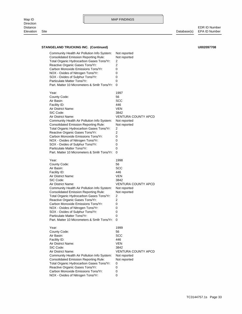
MAP FINDINGSMap IDDirection
EDR ID NumberDistanceEPA ID NumberDatabase(s)SiteElevation
0NOX - Oxides of Nitrogen Tons/Yr: 0Carbon Monoxide Emissions Tons/Yr: 0Reactive Organic Gases Tons/Yr: 0Total Organic Hydrocarbon Gases Tons/Yr: Not reportedConsolidated Emission Reporting Rule: Not reportedCommunity Health Air Pollution Info System: VENTURA COUNTY APCDAir District Name: 3842SIC Code: VENAir District Name: 446Facility ID: SCCAir Basin: 56County Code: 1999Year:
0Part. Matter 10 Micrometers & Smllr Tons/Yr: 0Particulate Matter Tons/Yr: 0SOX - Oxides of Sulphur Tons/Yr: 0NOX - Oxides of Nitrogen Tons/Yr: 0Carbon Monoxide Emissions Tons/Yr: 2Reactive Organic Gases Tons/Yr: 2Total Organic Hydrocarbon Gases Tons/Yr: Not reportedConsolidated Emission Reporting Rule: Not reportedCommunity Health Air Pollution Info System: VENTURA COUNTY APCDAir District Name: 3842SIC Code: VENAir District Name: 446Facility ID: SCCAir Basin: 56County Code: 1998Year:
0Part. Matter 10 Micrometers & Smllr Tons/Yr: 0Particulate Matter Tons/Yr: 0SOX - Oxides of Sulphur Tons/Yr: 0NOX - Oxides of Nitrogen Tons/Yr: 0Carbon Monoxide Emissions Tons/Yr: 2Reactive Organic Gases Tons/Yr: 2Total Organic Hydrocarbon Gases Tons/Yr: Not reportedConsolidated Emission Reporting Rule: Not reportedCommunity Health Air Pollution Info System: VENTURA COUNTY APCDAir District Name: 3842SIC Code: VENAir District Name: 446Facility ID: SCCAir Basin: 56County Code: 1997Year:
0Part. Matter 10 Micrometers & Smllr Tons/Yr: 0Particulate Matter Tons/Yr: 0SOX - Oxides of Sulphur Tons/Yr: 0NOX - Oxides of Nitrogen Tons/Yr: 0Carbon Monoxide Emissions Tons/Yr: 2Reactive Organic Gases Tons/Yr: 2Total Organic Hydrocarbon Gases Tons/Yr: Not reportedConsolidated Emission Reporting Rule: Not reportedCommunity Health Air Pollution Info System:
STANGELAND TRUCKING INC. (Continued) U002097708
TC3144757.1s Page 33

MAP FINDINGSMap IDDirection
EDR ID NumberDistanceEPA ID NumberDatabase(s)SiteElevation
56County Code: 2003Year:
0Part. Matter 10 Micrometers & Smllr Tons/Yr: 0Particulate Matter Tons/Yr: 0SOX - Oxides of Sulphur Tons/Yr: 0NOX - Oxides of Nitrogen Tons/Yr: 0Carbon Monoxide Emissions Tons/Yr: 4Reactive Organic Gases Tons/Yr: 4Total Organic Hydrocarbon Gases Tons/Yr: Not reportedConsolidated Emission Reporting Rule: Not reportedCommunity Health Air Pollution Info System: VENTURA COUNTY APCDAir District Name: 3083SIC Code: VENAir District Name: 446Facility ID: SCCAir Basin: 56County Code: 2002Year:
0Part. Matter 10 Micrometers & Smllr Tons/Yr: 0Particulate Matter Tons/Yr: 0SOX - Oxides of Sulphur Tons/Yr: 0NOX - Oxides of Nitrogen Tons/Yr: 0Carbon Monoxide Emissions Tons/Yr: 6Reactive Organic Gases Tons/Yr: 6Total Organic Hydrocarbon Gases Tons/Yr: Not reportedConsolidated Emission Reporting Rule: Not reportedCommunity Health Air Pollution Info System: VENTURA COUNTY APCDAir District Name: 3083SIC Code: VENAir District Name: 446Facility ID: SCCAir Basin: 56County Code: 2001Year:
0Part. Matter 10 Micrometers & Smllr Tons/Yr: 0Particulate Matter Tons/Yr: 0SOX - Oxides of Sulphur Tons/Yr: 0NOX - Oxides of Nitrogen Tons/Yr: 0Carbon Monoxide Emissions Tons/Yr: 0Reactive Organic Gases Tons/Yr: 0Total Organic Hydrocarbon Gases Tons/Yr: Not reportedConsolidated Emission Reporting Rule: Not reportedCommunity Health Air Pollution Info System: VENTURA COUNTY APCDAir District Name: 3842SIC Code: VENAir District Name: 446Facility ID: SCCAir Basin: 56County Code: 2000Year:
0Part. Matter 10 Micrometers & Smllr Tons/Yr: 0Particulate Matter Tons/Yr: 0SOX - Oxides of Sulphur Tons/Yr:
STANGELAND TRUCKING INC. (Continued) U002097708
TC3144757.1s Page 34
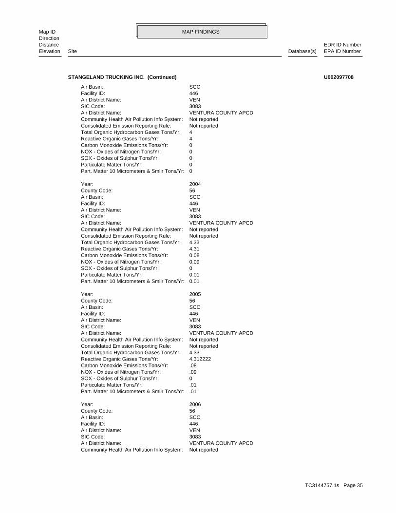
MAP FINDINGSMap IDDirection
EDR ID NumberDistanceEPA ID NumberDatabase(s)SiteElevation
Not reportedCommunity Health Air Pollution Info System: VENTURA COUNTY APCDAir District Name: 3083SIC Code: VENAir District Name: 446Facility ID: SCCAir Basin: 56County Code: 2006Year:
.01Part. Matter 10 Micrometers & Smllr Tons/Yr: .01Particulate Matter Tons/Yr: 0SOX - Oxides of Sulphur Tons/Yr: .09NOX - Oxides of Nitrogen Tons/Yr: .08Carbon Monoxide Emissions Tons/Yr: 4.312222Reactive Organic Gases Tons/Yr: 4.33Total Organic Hydrocarbon Gases Tons/Yr: Not reportedConsolidated Emission Reporting Rule: Not reportedCommunity Health Air Pollution Info System: VENTURA COUNTY APCDAir District Name: 3083SIC Code: VENAir District Name: 446Facility ID: SCCAir Basin: 56County Code: 2005Year:
0.01Part. Matter 10 Micrometers & Smllr Tons/Yr: 0.01Particulate Matter Tons/Yr: 0SOX - Oxides of Sulphur Tons/Yr: 0.09NOX - Oxides of Nitrogen Tons/Yr: 0.08Carbon Monoxide Emissions Tons/Yr: 4.31Reactive Organic Gases Tons/Yr: 4.33Total Organic Hydrocarbon Gases Tons/Yr: Not reportedConsolidated Emission Reporting Rule: Not reportedCommunity Health Air Pollution Info System: VENTURA COUNTY APCDAir District Name: 3083SIC Code: VENAir District Name: 446Facility ID: SCCAir Basin: 56County Code: 2004Year:
0Part. Matter 10 Micrometers & Smllr Tons/Yr: 0Particulate Matter Tons/Yr: 0SOX - Oxides of Sulphur Tons/Yr: 0NOX - Oxides of Nitrogen Tons/Yr: 0Carbon Monoxide Emissions Tons/Yr: 4Reactive Organic Gases Tons/Yr: 4Total Organic Hydrocarbon Gases Tons/Yr: Not reportedConsolidated Emission Reporting Rule: Not reportedCommunity Health Air Pollution Info System: VENTURA COUNTY APCDAir District Name: 3083SIC Code: VENAir District Name: 446Facility ID: SCCAir Basin:
STANGELAND TRUCKING INC. (Continued) U002097708
TC3144757.1s Page 35

MAP FINDINGSMap IDDirection
EDR ID NumberDistanceEPA ID NumberDatabase(s)SiteElevation
.01Part. Matter 10 Micrometers & Smllr Tons/Yr: .01Particulate Matter Tons/Yr: 0SOX - Oxides of Sulphur Tons/Yr: .09NOX - Oxides of Nitrogen Tons/Yr: .08Carbon Monoxide Emissions Tons/Yr: 4.312222Reactive Organic Gases Tons/Yr: 4.33Total Organic Hydrocarbon Gases Tons/Yr: Not reportedConsolidated Emission Reporting Rule: Not reportedCommunity Health Air Pollution Info System: VENTURA COUNTY APCDAir District Name: 3083SIC Code: VENAir District Name: 446Facility ID: SCCAir Basin: 56County Code: 2007Year:
.01Part. Matter 10 Micrometers & Smllr Tons/Yr: .01Particulate Matter Tons/Yr: 0SOX - Oxides of Sulphur Tons/Yr: .09NOX - Oxides of Nitrogen Tons/Yr: .08Carbon Monoxide Emissions Tons/Yr: 4.312222Reactive Organic Gases Tons/Yr: 4.33Total Organic Hydrocarbon Gases Tons/Yr: Not reportedConsolidated Emission Reporting Rule: Not reportedCommunity Health Air Pollution Info System: VENTURA COUNTY APCDAir District Name: 3083SIC Code: VENAir District Name: 446Facility ID: SCCAir Basin: 56County Code: 2007Year:
.01Part. Matter 10 Micrometers & Smllr Tons/Yr: .01Particulate Matter Tons/Yr: 0SOX - Oxides of Sulphur Tons/Yr: .09NOX - Oxides of Nitrogen Tons/Yr: .08Carbon Monoxide Emissions Tons/Yr: 4.312222Reactive Organic Gases Tons/Yr: 4.33Total Organic Hydrocarbon Gases Tons/Yr: Not reportedConsolidated Emission Reporting Rule:
STANGELAND TRUCKING INC. (Continued) U002097708
STATERegion:LUST:
C-91091Reg Id: LTNKAReg By: 56Facility County Code: CORTESERegion:
CORTESE:
522 ft. Site 4 of 5 in cluster C0.099 mi.
Relative:Higher
Actual:305 ft.
< 1/8 SANTA PAULA, CA 93060NNE LUST18145 TELEGRAPH N/AC20 HIST CORTESESTANGELAND TRUCKING CORP. S103946459
TC3144757.1s Page 36
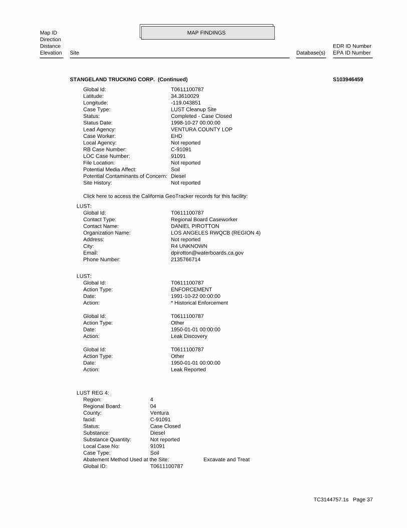
MAP FINDINGSMap IDDirection
EDR ID NumberDistanceEPA ID NumberDatabase(s)SiteElevation
T0611100787Global ID: Excavate and TreatAbatement Method Used at the Site: SoilCase Type: 91091Local Case No: Not reportedSubstance Quantity: DieselSubstance: Case ClosedStatus: C-91091facid: VenturaCounty: 04Regional Board: 4Region:
LUST REG 4:
Leak ReportedAction: 1950-01-01 00:00:00Date: OtherAction Type: T0611100787Global Id:
Leak DiscoveryAction: 1950-01-01 00:00:00Date: OtherAction Type: T0611100787Global Id:
* Historical EnforcementAction: 1991-10-22 00:00:00Date: ENFORCEMENTAction Type: T0611100787Global Id:
LUST:
2135766714Phone Number: [email protected]: R4 UNKNOWNCity: Not reportedAddress: LOS ANGELES RWQCB (REGION 4)Organization Name: DANIEL PIROTTONContact Name: Regional Board CaseworkerContact Type: T0611100787Global Id:
LUST:
Click here to access the California GeoTracker records for this facility:
Not reportedSite History: DieselPotential Contaminants of Concern: SoilPotential Media Affect: Not reportedFile Location: 91091LOC Case Number: C-91091RB Case Number: Not reportedLocal Agency: EHDCase Worker: VENTURA COUNTY LOPLead Agency: 1998-10-27 00:00:00Status Date: Completed - Case ClosedStatus: LUST Cleanup SiteCase Type: -119.043851Longitude: 34.3610029Latitude: T0611100787Global Id:
STANGELAND TRUCKING CORP. (Continued) S103946459
TC3144757.1s Page 37

MAP FINDINGSMap IDDirection
EDR ID NumberDistanceEPA ID NumberDatabase(s)SiteElevation
Not reportedSummary: Not reportedAssigned Name: Not reportedSuspended: Not reportedCleanup Fund Id: Not reportedPriority: Not reportedBeneficial Use: EHDLocal Agency Staff: 34.3616298 / -1Lat/Long: LUSTProgram: Not reportedRP Address: STANGELAND TRUCKINGResponsible Party: Not reportedOwner Contact: Not reportedOrganization: Not reportedSoil Qualifier: Not reportedGW Qualifier: Not reportedSignificant Interim Remedial Action Taken: Not reportedHist Max MTBE Conc in Soil: Not reportedHist Max MTBE Conc in Groundwater: Not reportedHistorical Max MTBE Date: 10/22/1991Enforcement Action Date: Not reportedPost Remedial Action Monitoring Began: Not reportedRemedial Action Underway: 9/23/1998Remediation Plan Submitted: 9/23/1998Pollution Characterization Began: 12/15/1994Preliminary Site Assessment Began: 10/22/1991Preliminary Site Assessment Workplan Submitted: FSource of Cleanup Funding: 848.1723749409697395011877228Approx. Dist To Production Well (ft): Not reportedWell Name: Not reportedWater System: Not reportedOperator: Not reportedLeak Source: Not reportedCause of Leak: Not reportedHow Leak Stopped: Not reportedHow Leak Discovered: 10/27/1998Date the Case was Closed: Not reportedDate Case Last Changed on Database: Not reportedDate Leak Stopped: 10/22/1991Date Confirmation Began: Not reportedDate Leak Record Entered: 10/22/1991Date Leak First Reported: 10/22/1991Date Leak Discovered: EFEnforcement Type: Not reportedCross Street: 56000LLocal Agency: UNKStaff: Not reportedW Global ID:
STANGELAND TRUCKING CORP. (Continued) S103946459
TC3144757.1s Page 38

MAP FINDINGSMap IDDirection
EDR ID NumberDistanceEPA ID NumberDatabase(s)SiteElevation
EDDIE GIBSON/MGRContact: CAL000254138Gepaid: 2002Year:
Not reportedFacility County: 35.82Tons: H01Disposal Method: Waste oil and mixed oilWaste Category: Los AngelesTSD County: Not reportedTSD EPA ID: VenturaGen County: SANTA PAULA, CA 930610000Mailing City,St,Zip: PO BOX 988Mailing Address: Not reportedMailing Name: 8059335940Telephone: EDDIE GIBSON/MGRContact: CAL000254138Gepaid: 2002Year:
Not reportedFacility County: 35.35Tons: R01Disposal Method: Waste oil and mixed oilWaste Category: Los AngelesTSD County: Not reportedTSD EPA ID: VenturaGen County: SANTA PAULA, CA 930610000Mailing City,St,Zip: PO BOX 988Mailing Address: Not reportedMailing Name: 8059335940Telephone: EDDIE GIBSON/MGRContact: CAL000254138Gepaid: 2002Year:
Not reportedFacility County: Not reportedTons: H01Disposal Method: Not reportedWaste Category: Los AngelesTSD County: Not reportedTSD EPA ID: VenturaGen County: SANTA PAULA, CA 930610000Mailing City,St,Zip: PO BOX 988Mailing Address: Not reportedMailing Name: 8059335940Telephone: EDDIE GIBSON/MGRContact: CAL000254138Gepaid: 2002Year:
HAZNET:
BUSINESS PLAN HAZARDOUS WASTE GENERATORProgram:FA0007004Facility ID:
VENTURA CO. BWT:
522 ft. Site 5 of 5 in cluster C0.099 mi.
Relative:Higher
Actual:305 ft.
< 1/8 SANTA PAULA, CA NNE HAZNET18145 E TELEGRAPH RD N/AC21 VENTURA CO. BWTSAWYER PETROLEUM S105511912
TC3144757.1s Page 39

MAP FINDINGSMap IDDirection
EDR ID NumberDistanceEPA ID NumberDatabase(s)SiteElevation
Not reportedFacility County: 6.03Tons: Not reportedDisposal Method: Waste oil and mixed oilWaste Category: Los AngelesTSD County: Not reportedTSD EPA ID: VenturaGen County: SANTA PAULA, CA 930610000Mailing City,St,Zip: PO BOX 988Mailing Address: Not reportedMailing Name: 8059335940Telephone:
SAWYER PETROLEUM (Continued) S105511912
NoneLeak Detection: 10 gaugeTank Construction: UNLEADEDType of Fuel: PRODUCTTank Used for: 00001000Tank Capacity: 1975Year Installed: 1Container Num: 001Tank Num:
SANTA PAULA, CA 93060Owner City,St,Zip: 18035 E. TELEGRAPH RD.Owner Address: HAROLD C. COFFMANOwner Name: 8059331026Telephone: Not reportedContact Name: 0001Total Tanks: CONTRACTINGOther Type: OtherFacility Type: 00000060456Facility ID: STATERegion:
HIST UST:
554 ft. Site 3 of 5 in cluster B0.105 mi.
Relative:Higher
Actual:303 ft.
< 1/8 SANTA PAULA, CA 93060West 18035 E TELEGRAPH RD N/AB22 HIST USTOFFICE FOR ABOVE U001580207
D628Facility ID:VENTURA CO. UST:
575 ft. Site 4 of 5 in cluster B0.109 mi.
Relative:Higher
Actual:303 ft.
< 1/8 SANTA PAULA, CA West 18035 TELEGRAPH ROAD N/AB23 USTHAROLD C. COFFMAN U002169454
TC3144757.1s Page 40
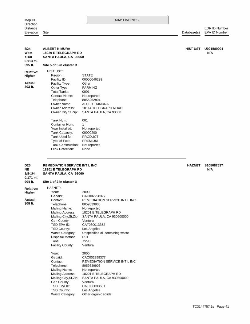
MAP FINDINGSMap IDDirection
EDR ID NumberDistanceEPA ID NumberDatabase(s)SiteElevation
NoneLeak Detection: Not reportedTank Construction: PREMIUMType of Fuel: PRODUCTTank Used for: 00000200Tank Capacity: Not reportedYear Installed: 1Container Num: 001Tank Num:
SANTA PAULA, CA 93060Owner City,St,Zip: 18114 TELEGRAPH ROADOwner Address: ALBERT KIMURAOwner Name: 8055252804Telephone: Not reportedContact Name: 0001Total Tanks: FARMINGOther Type: OtherFacility Type: 00000046299Facility ID: STATERegion:
HIST UST:
595 ft. Site 5 of 5 in cluster B0.113 mi.
Relative:Higher
Actual:303 ft.
< 1/8 SANTA PAULA, CA 93060West 18029 E TELEGRAPH RD N/AB24 HIST USTALBERT KIMURA U001580091
Other organic solidsWaste Category: Los AngelesTSD County: CAT080033681TSD EPA ID: VenturaGen County: SANTA PAULA, CA 930600000Mailing City,St,Zip: 18201 E TELEGRAPH RDMailing Address: Not reportedMailing Name: 8059339903Telephone: REMEDIATION SERVICE INT L INCContact: CAC002298377Gepaid: 2000Year:
VenturaFacility County: .2293Tons: R01Disposal Method: Unspecified oil-containing wasteWaste Category: Los AngelesTSD County: CAT080013352TSD EPA ID: VenturaGen County: SANTA PAULA, CA 930600000Mailing City,St,Zip: 18201 E TELEGRAPH RDMailing Address: Not reportedMailing Name: 8059339903Telephone: REMEDIATION SERVICE INT L INCContact: CAC002298377Gepaid: 2000Year:
HAZNET:
904 ft. Site 1 of 2 in cluster D0.171 mi.
Relative:Higher
Actual:308 ft.
1/8-1/4 SANTA PAULA, CA 93060NE 18201 E TELEGRAPH RD N/AD25 HAZNETREMEDIATION SERVICE INT L INC S105087637
TC3144757.1s Page 41

MAP FINDINGSMap IDDirection
EDR ID NumberDistanceEPA ID NumberDatabase(s)SiteElevation
VenturaFacility County: .3000Tons: D80Disposal Method:
REMEDIATION SERVICE INT L INC (Continued) S105087637
CAL000225146Gepaid: 2003Year:
VenturaFacility County: 0.08Tons: H01Disposal Method: Aqueous solution with total organic residues less than 10 percentWaste Category: VenturaTSD County: CAT000613893TSD EPA ID: VenturaGen County: SANTA PAULA, CA 930609611Mailing City,St,Zip: 126 S HALLOCK DR STE SMailing Address: Not reportedMailing Name: 8059333636Telephone: CHRISTOPHER R SCHMITTContact: CAL920834546Gepaid: 2003Year:
VenturaFacility County: 0.2Tons: R01Disposal Method: Unspecified solvent mixtureWaste Category: VenturaTSD County: CAD008252405TSD EPA ID: VenturaGen County: SANTA PAULA, CA 930600000Mailing City,St,Zip: 126 S HALLOCK DRMailing Address: Not reportedMailing Name: 8059333636Telephone: HUMBERTO GUERRERO, GENERAL MGRContact: CAL000225146Gepaid: 2003Year:
Not reportedFacility County: 0.03Tons: H01Disposal Method: Aqueous solution with total organic residues less than 10 percentWaste Category: Los AngelesTSD County: CAT000613893TSD EPA ID: VenturaGen County: SANTA PAULA, CA 930609611Mailing City,St,Zip: 126 S HALLOCK DR STE SMailing Address: Not reportedMailing Name: 8059333636Telephone: CHRISTOPHER R SCHMITTContact: CAL920834546Gepaid: 2004Year:
HAZNET:
936 ft. Site 1 of 2 in cluster E0.177 mi.
Relative:Lower
Actual:289 ft.
1/8-1/4 SANTA PAULA, CA 93060ESE 126 S HALLOCK DR N/AE26 HAZNETSANTA PAULA FAMILY MOTORS S103994583
TC3144757.1s Page 42

MAP FINDINGSMap IDDirection
EDR ID NumberDistanceEPA ID NumberDatabase(s)SiteElevation
5 additional CA_HAZNET: record(s) in the EDR Site Report.Click this hyperlink while viewing on your computer to access
Not reportedFacility County: 0.02Tons: H01Disposal Method: Aqueous solution with total organic residues less than 10 percentWaste Category: Los AngelesTSD County: Not reportedTSD EPA ID: VenturaGen County: SANTA PAULA, CA 930609611Mailing City,St,Zip: 126 S HALLOCK DR STE SMailing Address: Not reportedMailing Name: 8059333636Telephone: CHRISTOPHER R SCHMITTContact: CAL920834546Gepaid: 2002Year:
VenturaFacility County: 6Tons: R01Disposal Method: Unspecified oil-containing wasteWaste Category: VenturaTSD County: CAT080013352TSD EPA ID: VenturaGen County: SANTA PAULA, CA 930600000Mailing City,St,Zip: 126 S HALLOCK DRMailing Address: Not reportedMailing Name: 8059333636Telephone: HUMBERTO GUERRERO, GENERAL MGRContact:
SANTA PAULA FAMILY MOTORS (Continued) S103994583
8059333636Telephone: MARTY APROIANContact: CAL000275393Gepaid: 2006Year:
VenturaFacility County: 5.82Tons: ORGANICS RECOVERY ECT OTHER RECOVERY OF RECLAMATION FOR REUSE INCLUDING ACID REGENERATION,Disposal Method: Oil/water separation sludgeWaste Category: Los AngelesTSD County: CAT080013352TSD EPA ID: VenturaGen County: SANTA PAULA, CA 930609611Mailing City,St,Zip: 126 HALLOCK DRMailing Address: Not reportedMailing Name: 8059333636Telephone: MARTY APROIANContact: CAL000275393Gepaid: 2007Year:
HAZNET:
936 ft. Site 2 of 2 in cluster E0.177 mi.
Relative:Lower
Actual:289 ft.
1/8-1/4 SANTA PAULA, CA 93060ESE 126 HALLOCK DR N/AE27 HAZNETFORD OF SANTA PAULA S108207056
TC3144757.1s Page 43

MAP FINDINGSMap IDDirection
EDR ID NumberDistanceEPA ID NumberDatabase(s)SiteElevation
Not reportedFacility County: 5.87Tons: R01Disposal Method: Oil/water separation sludgeWaste Category: Los AngelesTSD County: CAT080013352TSD EPA ID: VenturaGen County: MISSION HILLS, CA 91345Mailing City,St,Zip: 11041 SEPULVEDA BLVDMailing Address: Not reportedMailing Name: 8059333636Telephone: STEVEN MARESContact: CAL000275393Gepaid: 2004Year:
Not reportedFacility County: 5.87Tons: R01Disposal Method: Oil/water separation sludgeWaste Category: Los AngelesTSD County: CAT080013352TSD EPA ID: VenturaGen County: MISSION HILLS, CA 91345Mailing City,St,Zip: 11041 SEPULVEDA BLVDMailing Address: Not reportedMailing Name: 8059333636Telephone: STEVEN MARESContact: CAL000275393Gepaid: 2005Year:
VenturaFacility County: 4.45Tons: H13Disposal Method: Oil/water separation sludgeWaste Category: Los AngelesTSD County: CAT080013352TSD EPA ID: VenturaGen County: SANTA PAULA, CA 930609611Mailing City,St,Zip: 126 HALLOCK DRMailing Address: Not reportedMailing Name:
FORD OF SANTA PAULA (Continued) S108207056
Case ClosedStatus:93037Facility ID:VENTURARegion:
VENTURA CO. LUST:
970 ft. Site 1 of 4 in cluster F0.184 mi.
Relative:Higher
Actual:300 ft.
1/8-1/4 SANTA PAULA, CA ENE 18252 TELEGRAPH RD N/AF28 LUSTCHEVRON #9-5675 S106098394
TC3144757.1s Page 44

MAP FINDINGSMap IDDirection
EDR ID NumberDistanceEPA ID NumberDatabase(s)SiteElevation
D631Facility ID:VENTURA CO. UST:
970 ft. Site 2 of 4 in cluster F0.184 mi.
Relative:Higher
Actual:300 ft.
1/8-1/4 SANTA PAULA, CA ENE 18252 TELEGRAPH ROAD N/AF29 USTCHEVRON #95675 U002244271
or drug lab equipment and/or materials were stored. Illegal Drug Lab (L) - location where an illegal drug lab was operatedLab Type: 200111017Facility ID:
CDL:
968 ft.0.183 mi.
Relative:Higher
Actual:304 ft.
1/8-1/4 SANTA PAULA, CA 93060WSW 8 FERRIS LN N/A30 CDL S107536413
37Reg Id: LTNKAReg By: 56Facility County Code: CORTESERegion:
CORTESE:
981 ft. Site 3 of 4 in cluster F0.186 mi.
Relative:Higher
Actual:299 ft.
1/8-1/4 SANTA PAULA, CA 93060ENE 18286 TELEGRAPH N/AF31 HIST CORTESEMONTEREY COUNTY PUBLIC WO S105026485
BUSINESS PLAN- SANTA PAULA CUPA UNDERGROUND TANKSProgram:FA0018198Facility ID:
VENTURA CO. BWT:
1002 ft. Site 4 of 4 in cluster F0.190 mi.
Relative:Equal
Actual:297 ft.
1/8-1/4 SANTA PAULA, CA ENE 100 S HALLOCK DR N/AF32 VENTURA CO. BWTSANTA PAULA SHELL S107863671
P O BOX 31Mailing address: CAD050087287EPA ID: SANTA PAULA, CA 93060 201 S HALLOCK RDFacility address: WEATHERFORD U S L PFacility name: 05/07/2001Date form received by agency:
RCRA-SQG:
1129 ft. Site 1 of 3 in cluster G0.214 mi. HAZNET
Relative:Lower
Actual:292 ft.
1/8-1/4 USTSANTA PAULA, CA 93060East FINDS201 S HALLOCK RD CAD050087287G33 RCRA-SQGWEATHERFORD U S L P 1000116592
TC3144757.1s Page 45

MAP FINDINGSMap IDDirection
EDR ID NumberDistanceEPA ID NumberDatabase(s)SiteElevation
D000Waste code:Hazardous Waste Summary:
NoUsed oil transporter: NoUsed oil transfer facility: NoUsed oil Specification marketer: NoUsed oil fuel marketer to burner: NoUser oil refiner: NoUsed oil processor: NoUsed oil fuel burner: NoFurnace exemption: NoOn-site burner exemption: NoUnderground injection activity: NoTreater, storer or disposer of HW: NoTransporter of hazardous waste: NoRecycler of hazardous waste: NoMixed waste (haz. and radioactive): NoU.S. importer of hazardous waste:
Handler Activities Summary:
Not reportedOwner/Op end date: Not reportedOwner/Op start date: OperatorOwner/Operator Type: PrivateLegal status: (415) 555-1212Owner/operator telephone: Not reportedOwner/operator country: NOT REQUIRED, ME 99999 NOT REQUIREDOwner/operator address: NOT REQUIREDOwner/operator name:
Not reportedOwner/Op end date: Not reportedOwner/Op start date: OwnerOwner/Operator Type: PrivateLegal status: (713) 693-4000Owner/operator telephone: Not reportedOwner/operator country: HOUSTON, TX 77027 515 POST OAK BLVD STE 600Owner/operator address: WEATHERFORD U S L POwner/operator name:
Owner/Operator Summary:
hazardous waste at any time waste during any calendar month, and accumulates more than 1000 kg of hazardous waste at any time; or generates 100 kg or less of hazardous waste during any calendar month and accumulates less than 6000 kg of Handler: generates more than 100 and less than 1000 kg of hazardousDescription: Small Small Quantity GeneratorClassification: PrivateLand type: 09EPA Region: Not reportedContact email: (805) 933-0200Contact telephone: USContact country: SANTA PAULA, CA 930610031 P O BOX 31Contact address: MARK SKAGGSContact: SANTA PAULA, CA 930610031
WEATHERFORD U S L P (Continued) 1000116592
TC3144757.1s Page 46

MAP FINDINGSMap IDDirection
EDR ID NumberDistanceEPA ID NumberDatabase(s)SiteElevation
0 Final penalty amount: 0 Proposed penalty amount: Not reported Enforcement lead agency: Not reported Enf. disp. status date: Not reported Enf. disposition status: Not reported Enforcement action date: Not reported Enforcement action: StateViolation lead agency: 09/15/1993Date achieved compliance: 07/21/1992Date violation determined: Generators - GeneralArea of violation: FR - 262.10-12.ARegulation violated:
0 Paid penalty amount: 0 Final penalty amount: 0 Proposed penalty amount: Not reported Enforcement lead agency: Not reported Enf. disp. status date: Not reported Enf. disposition status: Not reported Enforcement action date: Not reported Enforcement action: StateViolation lead agency: 09/15/1998Date achieved compliance: 09/15/1993Date violation determined: Generators - GeneralArea of violation: FR - 262.10-12.ARegulation violated:
Facility Has Received Notices of Violations:
SPENT SOLVENTS AND SPENT SOLVENT MIXTURES. IN F002, F004, AND F005, AND STILL BOTTOMS FROM THE RECOVERY OF THESE ONE OR MORE OF THE ABOVE HALOGENATED SOLVENTS OR THOSE SOLVENTS LISTED CONTAINING, BEFORE USE, A TOTAL OF TEN PERCENT OR MORE (BY VOLUME) OF FLUOROCARBONS; ALL SPENT SOLVENT MIXTURES/BLENDS USED IN DEGREASING 1,1,1-TRICHLOROETHANE, CARBON TETRACHLORIDE, AND CHLORINATED TETRACHLOROETHYLENE, TRICHLOROETHYLENE, METHYLENE CHLORIDE, THE FOLLOWING SPENT HALOGENATED SOLVENTS USED IN DEGREASING:Waste name: F001Waste code:
TRICHLOROETHYLENEWaste name: D040Waste code:
TETRACHLOROETHYLENEWaste name: D039Waste code:
BENZENEWaste name: D018Waste code:
WHICH WOULD BE CONSIDERED AS IGNITABLE HAZARDOUS WASTE. MATERIAL. LACQUER THINNER IS AN EXAMPLE OF A COMMONLY USED SOLVENT WHICH CAN BE OBTAINED FROM THE MANUFACTURER OR DISTRIBUTOR OF THE FLASH POINT OF A WASTE IS TO REVIEW THE MATERIAL SAFETY DATA SHEET, CLOSED CUP FLASH POINT TESTER. ANOTHER METHOD OF DETERMINING THE LESS THAN 140 DEGREES FAHRENHEIT AS DETERMINED BY A PENSKY-MARTENS IGNITABLE HAZARDOUS WASTES ARE THOSE WASTES WHICH HAVE A FLASHPOINT OFWaste name: D001Waste code:
Not DefinedWaste name:
WEATHERFORD U S L P (Continued) 1000116592
TC3144757.1s Page 47

MAP FINDINGSMap IDDirection
EDR ID NumberDistanceEPA ID NumberDatabase(s)SiteElevation
8056475595Telephone: H & H OIL TOOL CO INCContact: CAD050087287Gepaid: 1994Year:
Not reportedFacility County: 5.11Tons: H01Disposal Method: Liquids with halogenated organic compounds >= 1,000 Mg./LWaste Category: OrangeTSD County: Not reportedTSD EPA ID: VenturaGen County: HOUSTON, TX 770270000Mailing City,St,Zip: 515 POST OAK BLVD SUITE 600Mailing Address: Not reportedMailing Name: 7136934330Telephone: PATRICK FORD-ENVT’L PROJ MGRContact: CAD050087287Gepaid: 2002Year:
HAZNET:
D209Facility ID:VENTURA CO. UST:
corrective action activities required under RCRA.program staff to track the notification, permit, compliance, andand treat, store, or dispose of hazardous waste. RCRAInfo allows RCRAevents and activities related to facilities that generate, transport,Conservation and Recovery Act (RCRA) program through the tracking ofRCRAInfo is a national information system that supports the Resource
facilities.generators, transporters, and treatment, storage, and disposalprovides California with information on hazardous waste shipments forCalifornia Hazardous Waste Tracking System - Datamart (HWTS-DATAMART) Environmental Interest/Information System
110002647832Registry ID:
FINDS:
State Contractor/GranteeEvaluation lead agency: 09/15/1993Date achieved compliance: Generators - GeneralArea of violation: COMPLIANCE EVALUATION INSPECTION ON-SITEEvaluation: 07/21/1992Evaluation date:
State Contractor/GranteeEvaluation lead agency: 09/15/1998Date achieved compliance: Generators - GeneralArea of violation: COMPLIANCE EVALUATION INSPECTION ON-SITEEvaluation: 09/15/1993Evaluation date:
Evaluation Action Summary:
0 Paid penalty amount:
WEATHERFORD U S L P (Continued) 1000116592
TC3144757.1s Page 48

MAP FINDINGSMap IDDirection
EDR ID NumberDistanceEPA ID NumberDatabase(s)SiteElevation
VenturaFacility County: .0208Tons: R01Disposal Method: Hydrocarbon solvents (benzene, hexane, Stoddard, Etc.)Waste Category: Los AngelesTSD County: CAD008302903TSD EPA ID: VenturaGen County: SANTA PAULA, CA 930610031Mailing City,St,Zip: PO BOX 31Mailing Address: Not reportedMailing Name: 8056475595Telephone: H & H OIL TOOL CO INCContact: CAD050087287Gepaid: 1993Year:
VenturaFacility County: 3.0000Tons: D80Disposal Method: Unspecified oil-containing wasteWaste Category: KernTSD County: CAD980675276TSD EPA ID: VenturaGen County: SANTA PAULA, CA 930610031Mailing City,St,Zip: PO BOX 31Mailing Address: Not reportedMailing Name: 8056475595Telephone: H & H OIL TOOL CO INCContact: CAD050087287Gepaid: 1993Year:
VenturaFacility County: 10.1136Tons: D80Disposal Method: Unspecified oil-containing wasteWaste Category: KernTSD County: CAD980675276TSD EPA ID: VenturaGen County: SANTA PAULA, CA 930610031Mailing City,St,Zip: PO BOX 31Mailing Address: Not reportedMailing Name:
WEATHERFORD U S L P (Continued) 1000116592
Los AngelesTSD County: CAT080013352TSD EPA ID: VenturaGen County: HOUSTON, TX 770279408Mailing City,St,Zip: 515 POST OAK BLVD STE 600Mailing Address: Not reportedMailing Name: 7134399400Telephone: WEATHERFORD US LPContact: CAL000143253Gepaid: 2000Year:
HAZNET:
1129 ft. Site 2 of 3 in cluster G0.214 mi.
Relative:Lower
Actual:292 ft.
1/8-1/4 SANTA PAULA, CA 93061East 201 SOUTH HALLOCK DRIVE N/AG34 HAZNETWEATHERFORD U S S103995231
TC3144757.1s Page 49

MAP FINDINGSMap IDDirection
EDR ID NumberDistanceEPA ID NumberDatabase(s)SiteElevation
BAKERSFIELD, CA 933080000Mailing City,St,Zip: 3701 FRUITVALE AVENUEMailing Address: Not reportedMailing Name: 7134399400Telephone: WEATHERFORD U S INCContact: CAL000130691Gepaid: 1995Year:
VenturaFacility County: 10.9564Tons: T01Disposal Method: Unspecified sludge wasteWaste Category: KernTSD County: CAD980675276TSD EPA ID: VenturaGen County: HOUSTON, TX 770279408Mailing City,St,Zip: 515 POST OAK BLVD STE 600Mailing Address: Not reportedMailing Name: 7134399400Telephone: WEATHERFORD US LPContact: CAL000143253Gepaid: 1996Year:
VenturaFacility County: 1.15Tons: H01Disposal Method: Off-specification, aged or surplus organicsWaste Category: Los AngelesTSD County: CAD050806850TSD EPA ID: VenturaGen County: BAKERSFIELD, CA 933080000Mailing City,St,Zip: 3701 FRUITVALE AVENUEMailing Address: Not reportedMailing Name: 7134399400Telephone: WEATHERFORD U S INCContact: CAL000130691Gepaid: 1999Year:
VenturaFacility County: 0.75Tons: H01Disposal Method: Alkaline solution (pH >= 12.5) with metalsWaste Category: Los AngelesTSD County: CAD050806850TSD EPA ID: VenturaGen County: HOUSTON, TX 770279408Mailing City,St,Zip: 515 POST OAK BLVD STE 600Mailing Address: Not reportedMailing Name: 7134399400Telephone: WEATHERFORD US LPContact: CAL000143253Gepaid: 1999Year:
VenturaFacility County: 1.4386Tons: R01Disposal Method: Unspecified oil-containing wasteWaste Category:
WEATHERFORD U S (Continued) S103995231
TC3144757.1s Page 50

MAP FINDINGSMap IDDirection
EDR ID NumberDistanceEPA ID NumberDatabase(s)SiteElevation
additional CA_HAZNET: detail in the EDR Site Report.Click this hyperlink while viewing on your computer to access
VenturaFacility County: .1250Tons: H01Disposal Method: Other organic solidsWaste Category: 99TSD County: AZD049318009TSD EPA ID: VenturaGen County:
WEATHERFORD U S (Continued) S103995231
VenturaFacility County: 1.25Tons: R01Disposal Method: Waste oil and mixed oilWaste Category: VenturaTSD County: CAT080013352TSD EPA ID: VenturaGen County: HOUSTON, TX 770279408Mailing City,St,Zip: 515 POST OAK BLVD STE 600Mailing Address: ATTN: BECKY ALBERS/ENV COMPLMailing Name: 7136934000Telephone: SCOTT ROBINSON ENVTL MANAGERContact: CAL000143253Gepaid: 2003Year:
VenturaFacility County: 1.34Tons: H01Disposal Method: Liquids with halogenated organic compounds >= 1,000 Mg./LWaste Category: VenturaTSD County: CAT000613976TSD EPA ID: VenturaGen County: HOUSTON, TX 770279408Mailing City,St,Zip: 515 POST OAK BLVD STE 600Mailing Address: ATTN: BECKY ALBERS/ENV COMPLMailing Name: 7136934000Telephone: SCOTT ROBINSON ENVTL MANAGERContact: CAL000143253Gepaid: 2003Year:
HAZNET:
HAZARDOUS WASTE GENERATOR BUSINESS PLAN- SANTA PAULAProgram:FA0006123Facility ID:
VENTURA CO. BWT:
1129 ft. Site 3 of 3 in cluster G0.214 mi.
Relative:Lower
Actual:292 ft.
1/8-1/4 SANTA PAULA, CA 93060East HAZNET201 S HALLOCK DR N/AG35 VENTURA CO. BWTWEATHERFORD US LP S105774043
TC3144757.1s Page 51

MAP FINDINGSMap IDDirection
EDR ID NumberDistanceEPA ID NumberDatabase(s)SiteElevation
D630Facility ID:VENTURA CO. UST:
1148 ft. Site 2 of 2 in cluster D0.217 mi.
Relative:Higher
Actual:308 ft.
1/8-1/4 SANTA PAULA, CA NE 18249 TELEGRAPH ROAD N/AD36 USTTEAGUE-MCKEVETT CO. U002169455
Not reportedOwner/Op end date: 01/01/2002Owner/Op start date: OperatorOwner/Operator Type: PrivateLegal status: Not reportedOwner/operator telephone: USOwner/operator country: Not reported Not reportedOwner/operator address: AUTOMOTIVE RACING PRODUCTSOwner/operator name:
Not reportedOwner/Op end date: 01/01/2002Owner/Op start date: OwnerOwner/Operator Type: PrivateLegal status: Not reportedOwner/operator telephone: USOwner/operator country: Not reported Not reportedOwner/operator address: MICHAEL HOLZAPPELOwner/operator name:
Owner/Operator Summary:
hazardous waste at any time waste during any calendar month, and accumulates more than 1000 kg of hazardous waste at any time; or generates 100 kg or less of hazardous waste during any calendar month and accumulates less than 6000 kg of Handler: generates more than 100 and less than 1000 kg of hazardousDescription: Small Small Quantity GeneratorClassification: PrivateLand type: 09EPA Region: Not reportedContact email: (805) 525-1497Contact telephone: USContact country: SANTA PAULA, CA 93060 LEMONWOOD DRContact address: JOHN BAILEYContact: SANTA PAULA, CA 93060 LEMONWOOD DRMailing address: CAR000131029EPA ID: SANTA PAULA, CA 93060 1760 LEMONWOOD DRFacility address: AUTOMOTIVE RACING PRODUCTS INCFacility name: 12/02/2002Date form received by agency:
RCRA-SQG:
1162 ft. Site 1 of 7 in cluster H0.220 mi.
Relative:Lower
Actual:283 ft.
1/8-1/4 HAZNETSANTA PAULA, CA 93060SE FINDS1760 LEMONWOOD DR CAR000131029H37 RCRA-SQGAUTOMOTIVE RACING PRODUCTS INC 1006805682
TC3144757.1s Page 52

MAP FINDINGSMap IDDirection
EDR ID NumberDistanceEPA ID NumberDatabase(s)SiteElevation
Evaluation Action Summary:
No violations foundViolation Status:
SPENT SOLVENT MIXTURES. F005, AND STILL BOTTOMS FROM THE RECOVERY OF THESE SPENT SOLVENTS AND OF THE ABOVE HALOGENATED SOLVENTS OR THOSE LISTED IN F001, F004, OR BEFORE USE, A TOTAL OF TEN PERCENT OR MORE (BY VOLUME) OF ONE OR MORE 1,1,2-TRICHLOROETHANE; ALL SPENT SOLVENT MIXTURES/BLENDS CONTAINING, ORTHO-DICHLOROBENZENE, TRICHLOROFLUOROMETHANE, AND CHLOROBENZENE, 1,1,2-TRICHLORO-1,2,2-TRIFLUOROETHANE, METHYLENE CHLORIDE, TRICHLOROETHYLENE, 1,1,1-TRICHLOROETHANE, THE FOLLOWING SPENT HALOGENATED SOLVENTS: TETRACHLOROETHYLENE,Waste name: F002Waste code:
TRICHLOROETHYLENEWaste name: D040Waste code:
TETRACHLOROETHYLENEWaste name: D039Waste code:
CHROMIUMWaste name: D007Waste code:
WHICH WOULD BE CONSIDERED AS IGNITABLE HAZARDOUS WASTE. MATERIAL. LACQUER THINNER IS AN EXAMPLE OF A COMMONLY USED SOLVENT WHICH CAN BE OBTAINED FROM THE MANUFACTURER OR DISTRIBUTOR OF THE FLASH POINT OF A WASTE IS TO REVIEW THE MATERIAL SAFETY DATA SHEET, CLOSED CUP FLASH POINT TESTER. ANOTHER METHOD OF DETERMINING THE LESS THAN 140 DEGREES FAHRENHEIT AS DETERMINED BY A PENSKY-MARTENS IGNITABLE HAZARDOUS WASTES ARE THOSE WASTES WHICH HAVE A FLASHPOINT OFWaste name: D001Waste code:
Hazardous Waste Summary:
Small Quantity GeneratorClassification: AUTOMOTIVE RACING PRODUCTS INCFacility name: 12/02/2002Date form received by agency:
Historical Generators:
NoUsed oil transporter: NoUsed oil transfer facility: NoUsed oil Specification marketer: NoUsed oil fuel marketer to burner: NoUser oil refiner: NoUsed oil processor: NoUsed oil fuel burner: NoFurnace exemption: NoOn-site burner exemption: NoUnderground injection activity: NoTreater, storer or disposer of HW: NoTransporter of hazardous waste: NoRecycler of hazardous waste: NoMixed waste (haz. and radioactive): NoU.S. importer of hazardous waste:
Handler Activities Summary:
AUTOMOTIVE RACING PRODUCTS INC (Continued) 1006805682
TC3144757.1s Page 53

MAP FINDINGSMap IDDirection
EDR ID NumberDistanceEPA ID NumberDatabase(s)SiteElevation
VenturaFacility County: 16.93Tons: (H010-H129) OR (H131-H135) STORAGE, BULKING, AND/OR TRANSFER OFF SITE--NO TREATMENT/REOVERYDisposal Method: Unspecified oil-containing wasteWaste Category: Los AngelesTSD County: CAD097030993TSD EPA ID: VenturaGen County: SANTA PAULA, CA 930600000Mailing City,St,Zip: 1760 LEMONWOOD DRMailing Address: Not reportedMailing Name: 8055251497Telephone: JULIE MILLSContact: CAR000131029Gepaid: 2009Year:
VenturaFacility County: 46.6684Tons: (H010-H129) OR (H131-H135) STORAGE, BULKING, AND/OR TRANSFER OFF SITE--NO TREATMENT/REOVERYDisposal Method: Other organic solidsWaste Category: Los AngelesTSD County: CAD097030993TSD EPA ID: VenturaGen County: SANTA PAULA, CA 930600000Mailing City,St,Zip: 1760 LEMONWOOD DRMailing Address: Not reportedMailing Name: 8055251497Telephone: JULIE MILLSContact: CAR000131029Gepaid: 2009Year:
HAZNET:
corrective action activities required under RCRA.program staff to track the notification, permit, compliance, andand treat, store, or dispose of hazardous waste. RCRAInfo allows RCRAevents and activities related to facilities that generate, transport,Conservation and Recovery Act (RCRA) program through the tracking ofRCRAInfo is a national information system that supports the Resource
facilities.generators, transporters, and treatment, storage, and disposalprovides California with information on hazardous waste shipments forCalifornia Hazardous Waste Tracking System - Datamart (HWTS-DATAMART) Environmental Interest/Information System
110014377290Registry ID:
FINDS:
StateEvaluation lead agency: Not reportedDate achieved compliance: Not reportedArea of violation: COMPLIANCE EVALUATION INSPECTION ON-SITEEvaluation: 01/26/2007Evaluation date:
AUTOMOTIVE RACING PRODUCTS INC (Continued) 1006805682
TC3144757.1s Page 54

MAP FINDINGSMap IDDirection
EDR ID NumberDistanceEPA ID NumberDatabase(s)SiteElevation
26 additional CA_HAZNET: record(s) in the EDR Site Report.Click this hyperlink while viewing on your computer to access
VenturaFacility County: 22.249Tons: ORGANICS RECOVERY ECT OTHER RECOVERY OF RECLAMATION FOR REUSE INCLUDING ACID REGENERATION,Disposal Method: Waste oil and mixed oilWaste Category: Los AngelesTSD County: CAT080013352TSD EPA ID: VenturaGen County: SANTA PAULA, CA 930600000Mailing City,St,Zip: 1760 LEMONWOOD DRMailing Address: Not reportedMailing Name: 8055251497Telephone: JULIE MILLSContact: CAR000131029Gepaid: 2009Year:
VenturaFacility County: 2.812Tons: (H010-H129) OR (H131-H135) STORAGE, BULKING, AND/OR TRANSFER OFF SITE--NO TREATMENT/REOVERYDisposal Method: Waste oil and mixed oilWaste Category: FresnoTSD County: CAD093459485TSD EPA ID: VenturaGen County: SANTA PAULA, CA 930600000Mailing City,St,Zip: 1760 LEMONWOOD DRMailing Address: Not reportedMailing Name: 8055251497Telephone: JULIE MILLSContact: CAR000131029Gepaid: 2009Year:
VenturaFacility County: 4.142Tons: FUEL BLENDING PRIOR TO ENERGY RECOVERY AT ANOTHER SITEDisposal Method: Waste oil and mixed oilWaste Category: 99TSD County: TXD077603371TSD EPA ID: VenturaGen County: SANTA PAULA, CA 930600000Mailing City,St,Zip: 1760 LEMONWOOD DRMailing Address: Not reportedMailing Name: 8055251497Telephone: JULIE MILLSContact: CAR000131029Gepaid: 2009Year:
AUTOMOTIVE RACING PRODUCTS INC (Continued) 1006805682
TC3144757.1s Page 55

MAP FINDINGSMap IDDirection
EDR ID NumberDistanceEPA ID NumberDatabase(s)SiteElevation
JULIE MILLSContact: CAL000225999Gepaid: 2003Year:
VenturaFacility County: 6.74Tons: R01Disposal Method: Other organic solidsWaste Category: VenturaTSD County: CAT080033681TSD EPA ID: VenturaGen County: SANTA PAULA, CA 930600000Mailing City,St,Zip: 1760 LEMONWOOD DRIVEMailing Address: Not reportedMailing Name: 8055251497Telephone: JULIE MILLSContact: CAL000225999Gepaid: 2003Year:
VenturaFacility County: 7.53Tons: H01Disposal Method: Hydrocarbon solvents (benzene, hexane, Stoddard, Etc.)Waste Category: VenturaTSD County: CAT000613893TSD EPA ID: VenturaGen County: SANTA PAULA, CA 930600000Mailing City,St,Zip: 1760 LEMONWOOD DRIVEMailing Address: Not reportedMailing Name: 8055251497Telephone: JULIE MILLSContact: CAL000225999Gepaid: 2003Year:
Not reportedFacility County: 1.4Tons: H01Disposal Method: Hydrocarbon solvents (benzene, hexane, Stoddard, Etc.)Waste Category: Los AngelesTSD County: CAT000613893TSD EPA ID: VenturaGen County: SANTA PAULA, CA 930600000Mailing City,St,Zip: 1760 LEMONWOOD DRIVEMailing Address: Not reportedMailing Name: 8055251497Telephone: JULIE MILLSContact: CAL000225999Gepaid: 2004Year:
HAZNET:
BUSINESS PLAN - SANTA PAULA HAZ WASTE GENERATOR (RCRA-LQG) - GENERALProgram:FA0007118Facility ID:
VENTURA CO. BWT:
1162 ft. Site 2 of 7 in cluster H0.220 mi.
Relative:Lower
Actual:283 ft.
1/8-1/4 SANTA PAULA, CA 93060SE HAZNET1760 LEMONWOOD DR N/AH38 VENTURA CO. BWTAUTOMOTIVE RACING PRODUCTS S105773473
TC3144757.1s Page 56

MAP FINDINGSMap IDDirection
EDR ID NumberDistanceEPA ID NumberDatabase(s)SiteElevation
6 additional CA_HAZNET: record(s) in the EDR Site Report.Click this hyperlink while viewing on your computer to access
VenturaFacility County: Not reportedTons: H01Disposal Method: Not reportedWaste Category: VenturaTSD County: CAT000613976TSD EPA ID: VenturaGen County: SANTA PAULA, CA 930600000Mailing City,St,Zip: 1760 LEMONWOOD DRIVEMailing Address: Not reportedMailing Name: 8055251497Telephone: JULIE MILLSContact: CAL000225999Gepaid: 2003Year:
VenturaFacility County: 5.27Tons: H01Disposal Method: Hydrocarbon solvents (benzene, hexane, Stoddard, Etc.)Waste Category: VenturaTSD County: CAT000613976TSD EPA ID: VenturaGen County: SANTA PAULA, CA 930600000Mailing City,St,Zip: 1760 LEMONWOOD DRIVEMailing Address: Not reportedMailing Name: 8055251497Telephone:
AUTOMOTIVE RACING PRODUCTS (Continued) S105773473
0SIC Code: ?Agency Type: 8055251497Agency Telephone: Brock FergussonAgency Contact: Santa Paula 930609510Agency City,St,Zip: 1760 E Lemonwood DrAgency Address: AUTOMOTIVE RACING PROD INCAgency Name: Brock FergussonFacility Contact: 8055251497Facility Telephone: 4Subregion: are assigned by the Regional Board CAS000001 The 1st 2 characters designate the state. The remaining 7NPDES Number: under Waste Discharge Requirements. Active - Any facility with a continuous or seasonal discharge that isFacility Status: pumping. repairing, oil production, storage and disposal operations, water washing, geothermal operations, air conditioning, ship building and processing operation of whatever nature, including mining, gravel semisolid wastes from any servicing, producing, manufacturing or Industrial - Facility that treats and/or disposes of liquid orFacility Type: 4 56I018207Facility ID:
CA WDS:
1162 ft. Site 3 of 7 in cluster H0.220 mi.
Relative:Lower
Actual:283 ft.
1/8-1/4 SANTA PAULA, CA 93060SE 1760 E LEMONWOOD DR N/AH39 WDSAUTOMOTIVE RACING PROD INC S106103460
TC3144757.1s Page 57
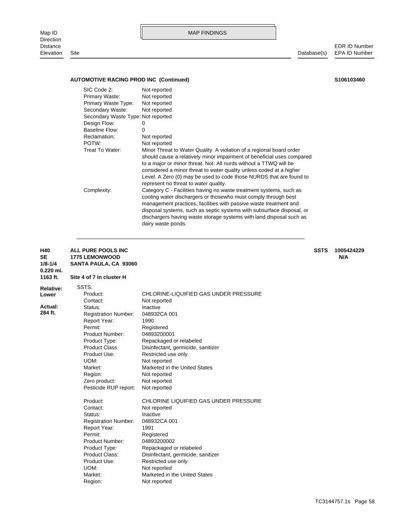
MAP FINDINGSMap IDDirection
EDR ID NumberDistanceEPA ID NumberDatabase(s)SiteElevation
dairy waste ponds. dischargers having waste storage systems with land disposal such as disposal systems, such as septic systems with subsurface disposal, or management practices, facilities with passive waste treatment and cooling water dischargers or thosewho must comply through best Category C - Facilities having no waste treatment systems, such asComplexity: represent no threat to water quality. Level. A Zero (0) may be used to code those NURDS that are found to considered a minor threat to water quality unless coded at a higher to a major or minor threat. Not: All nurds without a TTWQ will be should cause a relatively minor impairment of beneficial uses compared Minor Threat to Water Quality. A violation of a regional board orderTreat To Water: Not reportedPOTW: Not reportedReclamation: 0Baseline Flow: 0Design Flow: Not reportedSecondary Waste Type: Not reportedSecondary Waste: Not reportedPrimary Waste Type: Not reportedPrimary Waste: Not reportedSIC Code 2:
AUTOMOTIVE RACING PROD INC (Continued) S106103460
Not reportedRegion: Marketed in the United StatesMarket: Not reportedUOM: Restricted use onlyProduct Use: Disinfectant, germicide, sanitizerProduct Class: Repackaged or relabeledProduct Type: 04893200002Product Number: RegisteredPermit: 1991Report Year: 048932CA 001Registration Number: InactiveStatus: Not reportedContact: CHLORINE LIQUIFIED GAS UNDER PRESSUREProduct:
Not reportedPesticide RUP report: Not reportedZero product: Not reportedRegion: Marketed in the United StatesMarket: Not reportedUOM: Restricted use onlyProduct Use: Disinfectant, germicide, sanitizerProduct Class: Repackaged or relabeledProduct Type: 04893200001Product Number: RegisteredPermit: 1990Report Year: 048932CA 001Registration Number: InactiveStatus: Not reportedContact: CHLORINE-LIQUIFIED GAS UNDER PRESSUREProduct:
SSTS:
1163 ft. Site 4 of 7 in cluster H0.220 mi.
Relative:Lower
Actual:284 ft.
1/8-1/4 SANTA PAULA, CA 93060SE 1775 LEMONWOOD N/AH40 SSTSALL PURE POOLS INC 1005424229
TC3144757.1s Page 58

MAP FINDINGSMap IDDirection
EDR ID NumberDistanceEPA ID NumberDatabase(s)SiteElevation
Not reportedPesticide RUP report: Not reportedZero product:
ALL PURE POOLS INC (Continued) 1005424229
Not reportedRegulation violated:Facility Has Received Notices of Violations:
NoUsed oil transporter: NoUsed oil transfer facility: NoUsed oil Specification marketer: NoUsed oil fuel marketer to burner: NoUser oil refiner: NoUsed oil processor: NoUsed oil fuel burner: NoFurnace exemption: NoOn-site burner exemption: NoUnderground injection activity: NoTreater, storer or disposer of HW: YesTransporter of hazardous waste: NoRecycler of hazardous waste: NoMixed waste (haz. and radioactive): NoU.S. importer of hazardous waste:
Handler Activities Summary:
Not reportedOwner/Op end date: Not reportedOwner/Op start date: OwnerOwner/Operator Type: PrivateLegal status: (805) 525-1086Owner/operator telephone: Not reportedOwner/operator country: SANTA PAULA, CA 93060 P O BOX 4Owner/operator address: LUANA DUNE LINDSEYOwner/operator name:
Owner/Operator Summary:
Handler: Non-Generators do not presently generate hazardous wasteDescription: Non-GeneratorClassification: PrivateLand type: 09EPA Region: Not reportedContact email: (805) 525-1086Contact telephone: USContact country: SANTA PAULA, CA 930600004 P O BOX 4Contact address: BOB CLARKContact: CAR000013094EPA ID: SANTA PAULA, CA 93060 1775 LEMONWOOD DRFacility address: LINDSEY EXCAVATING AND GRADINGFacility name: 06/11/1996Date form received by agency:
RCRA-NonGen:
1163 ft. Site 5 of 7 in cluster H0.220 mi.
Relative:Lower
Actual:284 ft.
1/8-1/4 HAZNETSANTA PAULA, CA 93060SE FINDS1775 LEMONWOOD DR CAR000013094H41 RCRA-NonGenLINDSEY EXCAVATING AND GRADING 1001111771
TC3144757.1s Page 59
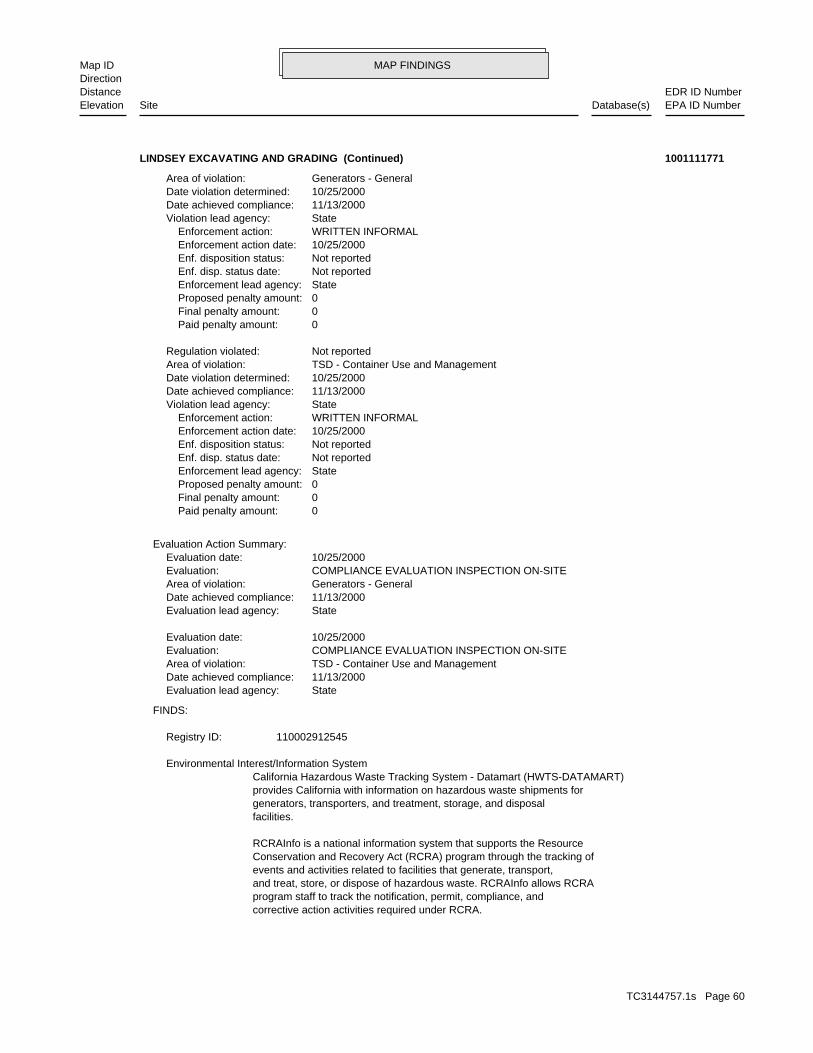
MAP FINDINGSMap IDDirection
EDR ID NumberDistanceEPA ID NumberDatabase(s)SiteElevation
corrective action activities required under RCRA.program staff to track the notification, permit, compliance, andand treat, store, or dispose of hazardous waste. RCRAInfo allows RCRAevents and activities related to facilities that generate, transport,Conservation and Recovery Act (RCRA) program through the tracking ofRCRAInfo is a national information system that supports the Resource
facilities.generators, transporters, and treatment, storage, and disposalprovides California with information on hazardous waste shipments forCalifornia Hazardous Waste Tracking System - Datamart (HWTS-DATAMART) Environmental Interest/Information System
110002912545Registry ID:
FINDS:
StateEvaluation lead agency: 11/13/2000Date achieved compliance: TSD - Container Use and ManagementArea of violation: COMPLIANCE EVALUATION INSPECTION ON-SITEEvaluation: 10/25/2000Evaluation date:
StateEvaluation lead agency: 11/13/2000Date achieved compliance: Generators - GeneralArea of violation: COMPLIANCE EVALUATION INSPECTION ON-SITEEvaluation: 10/25/2000Evaluation date:
Evaluation Action Summary:
0 Paid penalty amount: 0 Final penalty amount: 0 Proposed penalty amount: State Enforcement lead agency: Not reported Enf. disp. status date: Not reported Enf. disposition status: 10/25/2000 Enforcement action date: WRITTEN INFORMAL Enforcement action: StateViolation lead agency: 11/13/2000Date achieved compliance: 10/25/2000Date violation determined: TSD - Container Use and ManagementArea of violation: Not reportedRegulation violated:
0 Paid penalty amount: 0 Final penalty amount: 0 Proposed penalty amount: State Enforcement lead agency: Not reported Enf. disp. status date: Not reported Enf. disposition status: 10/25/2000 Enforcement action date: WRITTEN INFORMAL Enforcement action: StateViolation lead agency: 11/13/2000Date achieved compliance: 10/25/2000Date violation determined: Generators - GeneralArea of violation:
LINDSEY EXCAVATING AND GRADING (Continued) 1001111771
TC3144757.1s Page 60
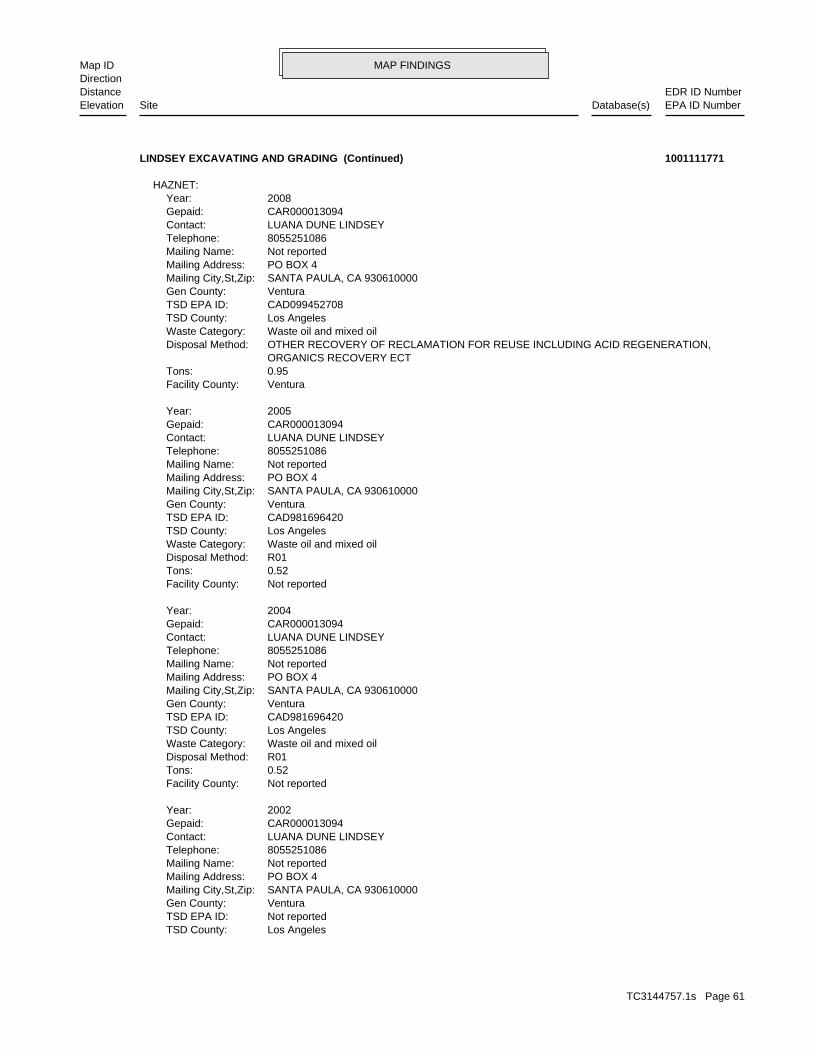
MAP FINDINGSMap IDDirection
EDR ID NumberDistanceEPA ID NumberDatabase(s)SiteElevation
Los AngelesTSD County: Not reportedTSD EPA ID: VenturaGen County: SANTA PAULA, CA 930610000Mailing City,St,Zip: PO BOX 4Mailing Address: Not reportedMailing Name: 8055251086Telephone: LUANA DUNE LINDSEYContact: CAR000013094Gepaid: 2002Year:
Not reportedFacility County: 0.52Tons: R01Disposal Method: Waste oil and mixed oilWaste Category: Los AngelesTSD County: CAD981696420TSD EPA ID: VenturaGen County: SANTA PAULA, CA 930610000Mailing City,St,Zip: PO BOX 4Mailing Address: Not reportedMailing Name: 8055251086Telephone: LUANA DUNE LINDSEYContact: CAR000013094Gepaid: 2004Year:
Not reportedFacility County: 0.52Tons: R01Disposal Method: Waste oil and mixed oilWaste Category: Los AngelesTSD County: CAD981696420TSD EPA ID: VenturaGen County: SANTA PAULA, CA 930610000Mailing City,St,Zip: PO BOX 4Mailing Address: Not reportedMailing Name: 8055251086Telephone: LUANA DUNE LINDSEYContact: CAR000013094Gepaid: 2005Year:
VenturaFacility County: 0.95Tons: ORGANICS RECOVERY ECT OTHER RECOVERY OF RECLAMATION FOR REUSE INCLUDING ACID REGENERATION,Disposal Method: Waste oil and mixed oilWaste Category: Los AngelesTSD County: CAD099452708TSD EPA ID: VenturaGen County: SANTA PAULA, CA 930610000Mailing City,St,Zip: PO BOX 4Mailing Address: Not reportedMailing Name: 8055251086Telephone: LUANA DUNE LINDSEYContact: CAR000013094Gepaid: 2008Year:
HAZNET:
LINDSEY EXCAVATING AND GRADING (Continued) 1001111771
TC3144757.1s Page 61
MAP FINDINGSMap IDDirection
EDR ID NumberDistanceEPA ID NumberDatabase(s)SiteElevation
Not reportedFacility County: 0.89Tons: R01Disposal Method: Waste oil and mixed oilWaste Category:
LINDSEY EXCAVATING AND GRADING (Continued) 1001111771
VenturaFacility County: 0.1Tons: FUEL BLENDING PRIOR TO ENERGY RECOVERY AT ANOTHER SITEDisposal Method: Unspecified solvent mixtureWaste Category: 99TSD County: TXD077603371TSD EPA ID: VenturaGen County: SANTA PAULA, CA 930609510Mailing City,St,Zip: 1780 E LEMONWOOD DRMailing Address: Not reportedMailing Name: 8059331331Telephone: LLOYD D MANES ASST SHOP MGRContact: CAL000144279Gepaid: 2009Year:
VenturaFacility County: 0.3Tons: FUEL BLENDING PRIOR TO ENERGY RECOVERY AT ANOTHER SITEDisposal Method: Hydrocarbon solvents (benzene, hexane, Stoddard, Etc.)Waste Category: 99TSD County: TXD077603371TSD EPA ID: VenturaGen County: SANTA PAULA, CA 930609510Mailing City,St,Zip: 1780 E LEMONWOOD DRMailing Address: Not reportedMailing Name: 8059331331Telephone: LLOYD D MANES ASST SHOP MGRContact: CAL000144279Gepaid: 2009Year:
VenturaFacility County: 0.125Tons: (H010-H129) OR (H131-H135) STORAGE, BULKING, AND/OR TRANSFER OFF SITE--NO TREATMENT/REOVERYDisposal Method: Unspecified organic liquid mixtureWaste Category: 99TSD County: TXD077603371TSD EPA ID: VenturaGen County: SANTA PAULA, CA 930609510Mailing City,St,Zip: 1780 E LEMONWOOD DRMailing Address: Not reportedMailing Name: 8059331331Telephone: LLOYD D MANES ASST SHOP MGRContact: CAL000144279Gepaid: 2009Year:
HAZNET:
1196 ft. Site 6 of 7 in cluster H0.226 mi.
Relative:Lower
Actual:285 ft.
1/8-1/4 SANTA PAULA, CA 93060SE 1780 E LEMONWOOD DR N/AH42 HAZNETHAYWARD BAKER INC S107146155
TC3144757.1s Page 62
MAP FINDINGSMap IDDirection
EDR ID NumberDistanceEPA ID NumberDatabase(s)SiteElevation
17 additional CA_HAZNET: record(s) in the EDR Site Report.Click this hyperlink while viewing on your computer to access
VenturaFacility County: 3Tons: FUEL BLENDING PRIOR TO ENERGY RECOVERY AT ANOTHER SITEDisposal Method: Waste oil and mixed oilWaste Category: 99TSD County: TXD077603371TSD EPA ID: VenturaGen County: SANTA PAULA, CA 930609510Mailing City,St,Zip: 1780 E LEMONWOOD DRMailing Address: Not reportedMailing Name: 8059331331Telephone: LLOYD D MANES ASST SHOP MGRContact: CAL000144279Gepaid: 2009Year:
VenturaFacility County: 6.28419Tons: ORGANICS RECOVERY ECT OTHER RECOVERY OF RECLAMATION FOR REUSE INCLUDING ACID REGENERATION,Disposal Method: Oil/water separation sludgeWaste Category: Los AngelesTSD County: CAT080013352TSD EPA ID: VenturaGen County: SANTA PAULA, CA 930609510Mailing City,St,Zip: 1780 E LEMONWOOD DRMailing Address: Not reportedMailing Name: 8059331331Telephone: LLOYD D MANES ASST SHOP MGRContact: CAL000144279Gepaid: 2009Year:
HAYWARD BAKER INC (Continued) S107146155
R01Disposal Method: Unspecified oil-containing wasteWaste Category: Los AngelesTSD County: Not reportedTSD EPA ID: VenturaGen County: SANTA PAULA, CA 930609510Mailing City,St,Zip: 1780 E LEMONWOOD DRMailing Address: Not reportedMailing Name: 8059331331Telephone: RICHARD REVELESContact: CAL000144279Gepaid: 2002Year:
HAZNET:
BUSINESS PLAN - SANTA PAULA HAZARDOUS WASTE GENERATORProgram:FA0006130Facility ID:
VENTURA CO. BWT:
1196 ft. Site 7 of 7 in cluster H0.226 mi.
Relative:Lower
Actual:285 ft.
1/8-1/4 SANTA PAULA, CA SE HAZNET1780 LEMONWOOD DR N/AH43 VENTURA CO. BWTHAYWARD BAKER S104162127
TC3144757.1s Page 63
MAP FINDINGSMap IDDirection
EDR ID NumberDistanceEPA ID NumberDatabase(s)SiteElevation
VenturaFacility County: .4000Tons: H01Disposal Method: Unspecified oil-containing wasteWaste Category: Los AngelesTSD County: CAD000088252TSD EPA ID: VenturaGen County: SANTA PAULA, CA 930609510Mailing City,St,Zip: 1780 E LEMONWOOD DRMailing Address: Not reportedMailing Name: 0000000000Telephone: HAYWARD BAKERContact: CAL000144279Gepaid: 1996Year:
Not reportedFacility County: 0.67Tons: R01Disposal Method: Unspecified oil-containing wasteWaste Category: Los AngelesTSD County: Not reportedTSD EPA ID: VenturaGen County: SANTA PAULA, CA 930609510Mailing City,St,Zip: 1780 E LEMONWOOD DRMailing Address: Not reportedMailing Name: 8059331331Telephone: RICHARD REVELESContact: CAL000144279Gepaid: 2001Year:
Not reportedFacility County: 0.55Tons: D80Disposal Method: Unspecified oil-containing wasteWaste Category: Los AngelesTSD County: Not reportedTSD EPA ID: VenturaGen County: SANTA PAULA, CA 930609510Mailing City,St,Zip: 1780 E LEMONWOOD DRMailing Address: Not reportedMailing Name: 8059331331Telephone: RICHARD REVELESContact: CAL000144279Gepaid: 2001Year:
Not reportedFacility County: 1.10Tons:
HAYWARD BAKER (Continued) S104162127
TC3144757.1s Page 64
MAP FINDINGSMap IDDirection
EDR ID NumberDistanceEPA ID NumberDatabase(s)SiteElevation
OtherAction Type: T0611100859Global Id:
Leak DiscoveryAction: 1950-01-01 00:00:00Date: OtherAction Type: T0611100859Global Id:
LUST:
2135766714Phone Number: [email protected]: R4 UNKNOWNCity: Not reportedAddress: LOS ANGELES RWQCB (REGION 4)Organization Name: DANIEL PIROTTONContact Name: Regional Board CaseworkerContact Type: T0611100859Global Id:
Not reportedPhone Number: [email protected]: VENTURACity: 800 S. VICTORIA AVEAddress: VENTURA COUNTY LOPOrganization Name: ERIN K. O’CONNELLContact Name: Local Agency CaseworkerContact Type: T0611100859Global Id:
LUST:
Click here to access the California GeoTracker records for this facility:
Not reportedSite History: GasolinePotential Contaminants of Concern: Other Groundwater (uses other than drinking water)Potential Media Affect: Not reportedFile Location: 93037LOC Case Number: C93037RB Case Number: VENTURA COUNTY LOPLocal Agency: EKOCase Worker: VENTURA COUNTY LOPLead Agency: 1997-09-22 00:00:00Status Date: Completed - Case ClosedStatus: LUST Cleanup SiteCase Type: -119.0427804Longitude: 34.3612474Latitude: T0611100859Global Id: STATERegion:
LUST:
C-93037Reg Id: LTNKAReg By: 56Facility County Code: CORTESERegion:
CORTESE:
1220 ft. Site 1 of 4 in cluster I0.231 mi.
Relative:Higher
Actual:309 ft.
1/8-1/4 SANTA PAULA, CA 93060NE LUST18252 TELEGRAPH N/AI44 HIST CORTESECHEVRON SS #9-5675 S102859907
TC3144757.1s Page 65

MAP FINDINGSMap IDDirection
EDR ID NumberDistanceEPA ID NumberDatabase(s)SiteElevation
EKOLocal Agency Staff: 34.3617488 / -1Lat/Long: LUSTProgram: Not reportedRP Address: CHEVRON USA PRODUCTS COMPANYResponsible Party: Not reportedOwner Contact: Not reportedOrganization: Not reportedSoil Qualifier: Not reportedGW Qualifier: Not reportedSignificant Interim Remedial Action Taken: Not reportedHist Max MTBE Conc in Soil: Not reportedHist Max MTBE Conc in Groundwater: Not reportedHistorical Max MTBE Date: Not reportedEnforcement Action Date: 1/16/1997Post Remedial Action Monitoring Began: 7/5/1996Remedial Action Underway: 7/5/1996Remediation Plan Submitted: 10/4/1993Pollution Characterization Began: 10/4/1993Preliminary Site Assessment Began: 5/28/1993Preliminary Site Assessment Workplan Submitted: FSource of Cleanup Funding: 1015.9988918664121050318027136Approx. Dist To Production Well (ft): Not reportedWell Name: Not reportedWater System: Not reportedOperator: Not reportedLeak Source: Not reportedCause of Leak: Not reportedHow Leak Stopped: Not reportedHow Leak Discovered: 9/22/1997Date the Case was Closed: Not reportedDate Case Last Changed on Database: Not reportedDate Leak Stopped: 10/4/1993Date Confirmation Began: Not reportedDate Leak Record Entered: 10/4/1993Date Leak First Reported: 10/4/1993Date Leak Discovered: Not reportedEnforcement Type: Not reportedCross Street: 56000LLocal Agency: UNKStaff: Not reportedW Global ID: T0611100859Global ID: Not reportedAbatement Method Used at the Site: GroundwaterCase Type: 93037Local Case No: Not reportedSubstance Quantity: GasolineSubstance: Case ClosedStatus: C93037facid: VenturaCounty: 04Regional Board: 4Region:
LUST REG 4:
Leak ReportedAction: 1950-01-01 00:00:00Date:
CHEVRON SS #9-5675 (Continued) S102859907
TC3144757.1s Page 66

MAP FINDINGSMap IDDirection
EDR ID NumberDistanceEPA ID NumberDatabase(s)SiteElevation
Not reportedSummary: Not reportedAssigned Name: Not reportedSuspended: Not reportedCleanup Fund Id: Not reportedPriority: Not reportedBeneficial Use:
CHEVRON SS #9-5675 (Continued) S102859907
Not reportedType of Fuel: PRODUCTTank Used for: 00005000Tank Capacity: 1970Year Installed: 4Container Num: 004Tank Num:
Stock InventorLeak Detection: 0000250 unknownTank Construction: Not reportedType of Fuel: PRODUCTTank Used for: 00010000Tank Capacity: 1970Year Installed: 3Container Num: 003Tank Num:
Stock InventorLeak Detection: 0000250 unknownTank Construction: Not reportedType of Fuel: PRODUCTTank Used for: 00010000Tank Capacity: 1970Year Installed: 2Container Num: 002Tank Num:
Stock InventorLeak Detection: 0000250 unknownTank Construction: Not reportedType of Fuel: PRODUCTTank Used for: 00010000Tank Capacity: 1980Year Installed: 1Container Num: 001Tank Num:
SAN FRANCISCO, CA 94105Owner City,St,Zip: 575 MARKETOwner Address: CHEVRON U.S.A. INC.Owner Name: 8055254556Telephone: CRAIG,LARRYContact Name: 0005Total Tanks: Not reportedOther Type: Gas StationFacility Type: 00000062798Facility ID: STATERegion:
HIST UST:
1220 ft. Site 2 of 4 in cluster I0.231 mi.
Relative:Higher
Actual:309 ft.
1/8-1/4 SANTA PAULA, CA 93060NE 18252 E TELEGRAPH RD N/AI45 HIST UST95675 U001580086
TC3144757.1s Page 67

MAP FINDINGSMap IDDirection
EDR ID NumberDistanceEPA ID NumberDatabase(s)SiteElevation
Stock InventorLeak Detection: 0000130 unknownTank Construction: Not reportedType of Fuel: WASTETank Used for: 00001000Tank Capacity: 1970Year Installed: 5Container Num: 005Tank Num:
Stock InventorLeak Detection: 0000250 unknownTank Construction:
95675 (Continued) U001580086
or drug lab equipment and/or materials were stored. Illegal Drug Lab (L) - location where an illegal drug lab was operatedLab Type: 201012003Facility ID:
CDL:
1238 ft.0.234 mi.
Relative:Lower
Actual:287 ft.
1/8-1/4 SANTA PAULA, CA 93060SW 112 WIPPLE RD N/A46 CDL S110744798
0Design Flow: Not reportedSecondary Waste Type: Not reportedSecondary Waste: rubble and concrete are examples of this category. Such wastes could cause turbidity and siltation. Uncontaminated soils, or organic wastes and have little adverse impact on water quality. Inert/Influent or Solid Wastes that do not contain soluble pollutantsPrimary Waste Type: Stormwater RunoffPrimary Waste: Not reportedSIC Code 2: 3365SIC Code: PrivateAgency Type: Not reportedAgency Telephone: Not reportedAgency Contact: 0Agency City,St,Zip: Not reportedAgency Address: AURORA CASTING AND ENGINEERINGAgency Name: Frank PenroseFacility Contact: 8059372761Facility Telephone: 4Subregion: are assigned by the Regional Board CAS000001 The 1st 2 characters designate the state. The remaining 7NPDES Number: under Waste Discharge Requirements. Active - Any facility with a continuous or seasonal discharge that isFacility Status: Industrial, Agricultural or Solid Waste (Class I, II or III) Other - Does not fall into the category of Municipal/Domestic,Facility Type: 4 56I014967Facility ID:
CA WDS:
1241 ft. Site 1 of 7 in cluster J0.235 mi.
Relative:Lower
Actual:285 ft.
1/8-1/4 SANTA PAULA, CA ESE VENTURA CO. BWT1790 LEMONWOOD DR N/AJ47 WDSAURORA CASTING & ENGINEERING S105773469
TC3144757.1s Page 68

MAP FINDINGSMap IDDirection
EDR ID NumberDistanceEPA ID NumberDatabase(s)SiteElevation
BUSINESS PLAN - SANTA PAULAProgram:FA0006324Facility ID:
VENTURA CO. BWT:
dairy waste ponds. dischargers having waste storage systems with land disposal such as disposal systems, such as septic systems with subsurface disposal, or management practices, facilities with passive waste treatment and cooling water dischargers or thosewho must comply through best Category C - Facilities having no waste treatment systems, such asComplexity: represent no threat to water quality. Level. A Zero (0) may be used to code those NURDS that are found to considered a minor threat to water quality unless coded at a higher to a major or minor threat. Not: All nurds without a TTWQ will be should cause a relatively minor impairment of beneficial uses compared Minor Threat to Water Quality. A violation of a regional board orderTreat To Water: The facility is not a POTW.POTW: No reclamation requirements associated with this facility.Reclamation: 0Baseline Flow:
AURORA CASTING & ENGINEERING (Continued) S105773469
Not reportedOwner/Op start date: OwnerOwner/Operator Type: PrivateLegal status: (909) 987-4092Owner/operator telephone: Not reportedOwner/operator country: RANCHO CUCAMONGA, CA 91701 5001 VIA VERDEOwner/operator address: CHAI PONGOwner/operator name:
Owner/Operator Summary:
hazardous waste at any time waste during any calendar month, and accumulates more than 1000 kg of hazardous waste at any time; or generates 100 kg or less of hazardous waste during any calendar month and accumulates less than 6000 kg of Handler: generates more than 100 and less than 1000 kg of hazardousDescription: Small Small Quantity GeneratorClassification: 09EPA Region: Not reportedContact email: (909) 428-9072Contact telephone: USContact country: SANTA PAULA, CA 93060 200 S HALLOCK DRContact address: MICHAEL SPAGNOLAContact: SANTA PAULA, CA 93060 S HALLOCK DRMailing address: CA0000267088EPA ID: SANTA PAULA, CA 93060 200 S HALLOCK DRFacility address: AUTOMOTIVE SUPPLY COFacility name: 04/25/1994Date form received by agency:
RCRA-SQG:
1251 ft.0.237 mi.
Relative:Lower
Actual:288 ft.
1/8-1/4 HAZNETSANTA PAULA, CA 93060ESE FINDS200 S HALLOCK DR CA000026708848 RCRA-SQGAUTOMOTIVE SUPPLY CO 1000905016
TC3144757.1s Page 69

MAP FINDINGSMap IDDirection
EDR ID NumberDistanceEPA ID NumberDatabase(s)SiteElevation
PO BOX 3258Mailing Address: Not reportedMailing Name: 8055254902Telephone: ROBERT APPENZELLERContact: CAL000288799Gepaid: 2009Year:
VenturaFacility County: 0.15Tons: (H010-H129) OR (H131-H135) STORAGE, BULKING, AND/OR TRANSFER OFF SITE--NO TREATMENT/REOVERYDisposal Method: Unspecified oil-containing wasteWaste Category: Los AngelesTSD County: CAD028409019TSD EPA ID: VenturaGen County: VENTURA, CA 930063258Mailing City,St,Zip: PO BOX 3258Mailing Address: Not reportedMailing Name: 8055254902Telephone: ROBERT APPENZELLERContact: CAL000288799Gepaid: 2009Year:
HAZNET:
corrective action activities required under RCRA.program staff to track the notification, permit, compliance, andand treat, store, or dispose of hazardous waste. RCRAInfo allows RCRAevents and activities related to facilities that generate, transport,Conservation and Recovery Act (RCRA) program through the tracking ofRCRAInfo is a national information system that supports the Resource Environmental Interest/Information System
110002616198Registry ID:
FINDS:
No violations foundViolation Status:
NoUsed oil transporter: NoUsed oil transfer facility: NoUsed oil Specification marketer: NoUsed oil fuel marketer to burner: NoUser oil refiner: NoUsed oil processor: NoUsed oil fuel burner: NoFurnace exemption: NoOn-site burner exemption: NoUnderground injection activity: NoTreater, storer or disposer of HW: NoTransporter of hazardous waste: NoRecycler of hazardous waste: NoMixed waste (haz. and radioactive): NoU.S. importer of hazardous waste:
Handler Activities Summary:
Not reportedOwner/Op end date:
AUTOMOTIVE SUPPLY CO (Continued) 1000905016
TC3144757.1s Page 70

MAP FINDINGSMap IDDirection
EDR ID NumberDistanceEPA ID NumberDatabase(s)SiteElevation
Not reportedFacility County: 0.15Tons: D80Disposal Method: Other organic solidsWaste Category: Los AngelesTSD County: Not reportedTSD EPA ID: VenturaGen County: SANTA PAULA, CA 930600000Mailing City,St,Zip: 200 S HALLOCK DRMailing Address: Not reportedMailing Name: 9094289072Telephone: CHAI PONGContact: CA0000267088Gepaid: 2002Year:
VenturaFacility County: 0.187Tons: (H010-H129) OR (H131-H135) STORAGE, BULKING, AND/OR TRANSFER OFF SITE--NO TREATMENT/REOVERYDisposal Method: Unspecified organic liquid mixtureWaste Category: Los AngelesTSD County: CAD028409019TSD EPA ID: VenturaGen County: VENTURA, CA 930063258Mailing City,St,Zip: PO BOX 3258Mailing Address: Not reportedMailing Name: 8055254902Telephone: ROBERT APPENZELLERContact: CAL000288799Gepaid: 2009Year:
VenturaFacility County: 0.2805Tons: (H010-H129) OR (H131-H135) STORAGE, BULKING, AND/OR TRANSFER OFF SITE--NO TREATMENT/REOVERYDisposal Method: Oxygenated solvents (acetone, butanol, ethyl acetate, etc.)Waste Category: Los AngelesTSD County: CAD028409019TSD EPA ID: VenturaGen County: VENTURA, CA 930063258Mailing City,St,Zip:
AUTOMOTIVE SUPPLY CO (Continued) 1000905016
SANTA PAULA, CA 93060 1645 LEMONWOOD DRContact address: ENVIRONMENTAL MANAGERContact: SANTA PAULA, CA 93060 LEMONWOOD DRMailing address: CAD981981673EPA ID: SANTA PAULA, CA 93060 1645 LEMONWOOD DRFacility address: BRAHMA OF CALIFORNIAFacility name: 04/08/1987Date form received by agency:
RCRA-SQG:
1264 ft. Site 1 of 6 in cluster K0.239 mi.
Relative:Lower
Actual:283 ft.
1/8-1/4 EMISANTA PAULA, CA 93060SSW FINDS1645 LEMONWOOD DR CAD981981673K49 RCRA-SQGBRAHMA OF CALIFORNIA 1000242634
TC3144757.1s Page 71

MAP FINDINGSMap IDDirection
EDR ID NumberDistanceEPA ID NumberDatabase(s)SiteElevation
RCRAInfo is a national information system that supports the Resource Environmental Interest/Information System
110001159120Registry ID:
FINDS:
No violations foundViolation Status:
NoUsed oil transporter: NoUsed oil transfer facility: NoUsed oil Specification marketer: NoUsed oil fuel marketer to burner: NoUser oil refiner: NoUsed oil processor: NoUsed oil fuel burner: NoFurnace exemption: NoOn-site burner exemption: NoUnderground injection activity: NoTreater, storer or disposer of HW: NoTransporter of hazardous waste: NoRecycler of hazardous waste: NoMixed waste (haz. and radioactive): NoU.S. importer of hazardous waste:
Handler Activities Summary:
Not reportedOwner/Op end date: Not reportedOwner/Op start date: OperatorOwner/Operator Type: PrivateLegal status: (415) 555-1212Owner/operator telephone: Not reportedOwner/operator country: NOT REQUIRED, ME 99999 NOT REQUIREDOwner/operator address: NOT REQUIREDOwner/operator name:
Not reportedOwner/Op end date: Not reportedOwner/Op start date: OwnerOwner/Operator Type: PrivateLegal status: (415) 555-1212Owner/operator telephone: Not reportedOwner/operator country: NOT REQUIRED, ME 99999 NOT REQUIREDOwner/operator address: HOLLIN CORPORATIONOwner/operator name:
Owner/Operator Summary:
hazardous waste at any time waste during any calendar month, and accumulates more than 1000 kg of hazardous waste at any time; or generates 100 kg or less of hazardous waste during any calendar month and accumulates less than 6000 kg of Handler: generates more than 100 and less than 1000 kg of hazardousDescription: Small Small Quantity GeneratorClassification: 09EPA Region: Not reportedContact email: (805) 933-2736Contact telephone: USContact country:
BRAHMA OF CALIFORNIA (Continued) 1000242634
TC3144757.1s Page 72

MAP FINDINGSMap IDDirection
EDR ID NumberDistanceEPA ID NumberDatabase(s)SiteElevation
0Part. Matter 10 Micrometers & Smllr Tons/Yr: 0Particulate Matter Tons/Yr: 0SOX - Oxides of Sulphur Tons/Yr: 0NOX - Oxides of Nitrogen Tons/Yr: 0Carbon Monoxide Emissions Tons/Yr: 10Reactive Organic Gases Tons/Yr: 10Total Organic Hydrocarbon Gases Tons/Yr: Not reportedConsolidated Emission Reporting Rule: Not reportedCommunity Health Air Pollution Info System: VENTURA COUNTY APCDAir District Name: 3792SIC Code: VENAir District Name: 1393Facility ID: SCCAir Basin: 56County Code: 1990Year:
0Part. Matter 10 Micrometers & Smllr Tons/Yr: 0Particulate Matter Tons/Yr: 0SOX - Oxides of Sulphur Tons/Yr: 0NOX - Oxides of Nitrogen Tons/Yr: 0Carbon Monoxide Emissions Tons/Yr: 6Reactive Organic Gases Tons/Yr: 6Total Organic Hydrocarbon Gases Tons/Yr: Not reportedConsolidated Emission Reporting Rule: Not reportedCommunity Health Air Pollution Info System: VENTURA COUNTY APCDAir District Name: 3792SIC Code: VENAir District Name: 1393Facility ID: SCCAir Basin: 56County Code: 1987Year:
EMI:
corrective action activities required under RCRA.program staff to track the notification, permit, compliance, andand treat, store, or dispose of hazardous waste. RCRAInfo allows RCRAevents and activities related to facilities that generate, transport,Conservation and Recovery Act (RCRA) program through the tracking of
BRAHMA OF CALIFORNIA (Continued) 1000242634
8059339970Telephone: RHONDA GAINES/HRContact: CAL000167681Gepaid: 2009Year:
HAZNET:
BUSINESS PLAN - SANTA PAULA HAZARDOUS WASTE GENERATORProgram:FA0006124Facility ID:
VENTURA CO. BWT:
1264 ft. Site 2 of 6 in cluster K0.239 mi.
Relative:Lower
Actual:283 ft.
1/8-1/4 SANTA PAULA, CA 93060SSW HAZNET1645 LEMONWOOD DR N/AK50 VENTURA CO. BWTBEND-PAK INC S101699929
TC3144757.1s Page 73

MAP FINDINGSMap IDDirection
EDR ID NumberDistanceEPA ID NumberDatabase(s)SiteElevation
0.05Tons: H01Disposal Method: Other organic solidsWaste Category: Los AngelesTSD County: CAD008252405TSD EPA ID: VenturaGen County: SANTA PAULA, CA 930609651Mailing City,St,Zip: 1645 E LEMONWOOD DRMailing Address: Not reportedMailing Name: 8059339970Telephone: RHONDA GAINES/HRContact: CAL000167681Gepaid: 2006Year:
VenturaFacility County: 1.57Tons: (H010-H129) OR (H131-H135) STORAGE, BULKING, AND/OR TRANSFER OFF SITE--NO TREATMENT/REOVERYDisposal Method: Other organic solidsWaste Category: Los AngelesTSD County: CAD008252405TSD EPA ID: VenturaGen County: SANTA PAULA, CA 930609651Mailing City,St,Zip: 1645 E LEMONWOOD DRMailing Address: Not reportedMailing Name: 8059339970Telephone: RHONDA GAINES/HRContact: CAL000167681Gepaid: 2007Year:
VenturaFacility County: 1Tons: (H010-H129) OR (H131-H135) STORAGE, BULKING, AND/OR TRANSFER OFF SITE--NO TREATMENT/REOVERYDisposal Method: Other organic solidsWaste Category: Los AngelesTSD County: CAD008252405TSD EPA ID: VenturaGen County: SANTA PAULA, CA 930609651Mailing City,St,Zip: 1645 E LEMONWOOD DRMailing Address: Not reportedMailing Name: 8059339970Telephone: RHONDA GAINES/HRContact: CAL000167681Gepaid: 2008Year:
VenturaFacility County: 0.2Tons: (H010-H129) OR (H131-H135) STORAGE, BULKING, AND/OR TRANSFER OFF SITE--NO TREATMENT/REOVERYDisposal Method: Other organic solidsWaste Category: Los AngelesTSD County: CAD008252405TSD EPA ID: VenturaGen County: SANTA PAULA, CA 930609651Mailing City,St,Zip: 1645 E LEMONWOOD DRMailing Address: Not reportedMailing Name:
BEND-PAK INC (Continued) S101699929
TC3144757.1s Page 74

MAP FINDINGSMap IDDirection
EDR ID NumberDistanceEPA ID NumberDatabase(s)SiteElevation
17 additional CA_HAZNET: record(s) in the EDR Site Report.Click this hyperlink while viewing on your computer to access
Not reportedFacility County: 0.25Tons: Not reportedDisposal Method: Other organic solidsWaste Category: Los AngelesTSD County: CAD008252405TSD EPA ID: VenturaGen County: SANTA PAULA, CA 930609651Mailing City,St,Zip: 1645 E LEMONWOOD DRMailing Address: Not reportedMailing Name: 8059339970Telephone: RHONDA GAINES/HRContact: CAL000167681Gepaid: 2005Year:
VenturaFacility County:
BEND-PAK INC (Continued) S101699929
HAZARDOUS WASTE GENERATOR BUSINESS PLAN - SANTA PAULAProgram:FA0006128Facility ID:
VENTURA CO. BWT:
1264 ft. Site 3 of 6 in cluster K0.239 mi.
Relative:Lower
Actual:283 ft.
1/8-1/4 SANTA PAULA, CA SSW 1645 LEMONWOOD DR N/AK51 VENTURA CO. BWTBEND-PAK INC. S109348648
VenturaFacility County: .2502Tons: R01Disposal Method: Unspecified oil-containing wasteWaste Category: Los AngelesTSD County: CAT080013352TSD EPA ID: VenturaGen County: SANTA PAULA, CA 930610000Mailing City,St,Zip: P.O BOX 910Mailing Address: Not reportedMailing Name: 0000000000Telephone: PAUL REYESContact: CAC000859416Gepaid: 1995Year:
HAZNET:
1270 ft. Site 2 of 7 in cluster J0.241 mi.
Relative:Lower
Actual:285 ft.
1/8-1/4 SANTA PAULA, CA 93060ESE 1795 LEMONWOOD DRIVE N/AJ52 HAZNET1X REYES MASONRY CONTRACTORS S103636833
TC3144757.1s Page 75

MAP FINDINGSMap IDDirection
EDR ID NumberDistanceEPA ID NumberDatabase(s)SiteElevation
REYCON CONSTRUCTION INCContact: CAL000128562Gepaid: 1999Year:
VenturaFacility County: .2293Tons: R01Disposal Method: Unspecified solvent mixtureWaste Category: Los AngelesTSD County: CAD008252405TSD EPA ID: VenturaGen County: SANTA PAULA, CA 930610910Mailing City,St,Zip: PO BOX 910Mailing Address: Not reportedMailing Name: 8055255256Telephone: REYCON CONSTRUCTION INCContact: CAL000128562Gepaid: 2000Year:
Not reportedFacility County: 0.39Tons: R01Disposal Method: Unspecified solvent mixtureWaste Category: Los AngelesTSD County: Not reportedTSD EPA ID: VenturaGen County: SANTA PAULA, CA 930610910Mailing City,St,Zip: PO BOX 910Mailing Address: Not reportedMailing Name: 8055255256Telephone: CHRIS URREA/OFF MGRContact: CAL000128562Gepaid: 2002Year:
VenturaFacility County: 0.22Tons: H13Disposal Method: Unspecified organic liquid mixtureWaste Category: Los AngelesTSD County: CAT080013352TSD EPA ID: VenturaGen County: SANTA PAULA, CA 930610910Mailing City,St,Zip: PO BOX 910Mailing Address: Not reportedMailing Name: 8055255256Telephone: CHRIS URREA/OFF MGRContact: CAL000128562Gepaid: 2006Year:
HAZNET:
HAZARDOUS WASTE GENERATOR BUSINESS PLAN - SANTA PAULAProgram:FA0006199Facility ID:
VENTURA CO. BWT:
1270 ft. Site 3 of 7 in cluster J0.241 mi.
Relative:Lower
Actual:285 ft.
1/8-1/4 SANTA PAULA, CA 93060ESE HAZNET1795 LEMONWOOD DRIVE N/AJ53 VENTURA CO. BWTREYCON CONSTRUCTION S100927794
TC3144757.1s Page 76

MAP FINDINGSMap IDDirection
EDR ID NumberDistanceEPA ID NumberDatabase(s)SiteElevation
additional CA_HAZNET: detail in the EDR Site Report.Click this hyperlink while viewing on your computer to access
VenturaFacility County: 0.3544Tons: R01Disposal Method: Unspecified solvent mixtureWaste Category: Los AngelesTSD County: CAD008252405TSD EPA ID: VenturaGen County: SANTA PAULA, CA 930610910Mailing City,St,Zip: PO BOX 910Mailing Address: Not reportedMailing Name: 8055255256Telephone: REYCON CONSTRUCTION INCContact: CAL000128562Gepaid: 1999Year:
VenturaFacility County: 0.271Tons: T01Disposal Method: Unspecified oil-containing wasteWaste Category: Los AngelesTSD County: CAT080013352TSD EPA ID: VenturaGen County: SANTA PAULA, CA 930610910Mailing City,St,Zip: PO BOX 910Mailing Address: Not reportedMailing Name: 8055255256Telephone:
REYCON CONSTRUCTION (Continued) S100927794
Not reportedFacility County: 3.58Tons: R01Disposal Method: Unspecified oil-containing wasteWaste Category: Los AngelesTSD County: Not reportedTSD EPA ID: VenturaGen County: CAMARILLO, CA 930100000Mailing City,St,Zip: 1090 DESEO AVEMailing Address: Not reportedMailing Name: 8053837380Telephone: JACK ARNOT/PRESContact: CAL000189813Gepaid: 2002Year:
HAZNET:
1290 ft. Site 4 of 6 in cluster K0.244 mi.
Relative:Lower
Actual:284 ft.
1/8-1/4 SANTA PAULA, CA 93060SSW 1625 E LEMONWOOD N/AK54 HAZNETA R N C O CONSTRUCTION INC S106091505
TC3144757.1s Page 77

MAP FINDINGSMap IDDirection
EDR ID NumberDistanceEPA ID NumberDatabase(s)SiteElevation
BUSINESS PLANProgram:FA0019088Facility ID:
VENTURA CO. BWT:
1312 ft. Site 1 of 4 in cluster L0.249 mi.
Relative:Higher
Actual:303 ft.
1/8-1/4 SANTA PAULA, CA WSW 17951 E TELEGRAPH RD N/AL55 VENTURA CO. BWTBATTERY MAN, CO S108086592
BUSINESS PLAN - SANTA PAULAProgram:FA0008275Facility ID:
VENTURA CO. BWT:
93061Discharge Zip: CADischarge State: Santa PaulaDischarge City: P. O. Box 569Discharge Address: Santa Paula CityDischarge Name: Not reportedTermination Date Of Regulatory Measure: 1/1/2011Expiration Date Of Regulatory Measure: 7/5/2001Effective Date Of Regulatory Measure: Not reportedAdoption Date Of Regulatory Measure: NPDESProgram Type: 4A566000580WDID: 633111Place Id: EnrolleeRegulatory Measure Type: R4-2003-0108Order No: 193032Regulatory Measure Id: 4Region: 43379Agency Id: ActiveFacility Status: CAG994005Npdes Number:
NPDES:
1320 ft. Site 5 of 6 in cluster K0.250 mi.
Relative:Lower
Actual:284 ft.
1/4-1/2 SANTA PAULA, CA 93060SSW VENTURA CO. BWT1611 LEMONWOOD DRIVE N/AK56 NPDESWELL #12 S106100252
BUSINESS PLAN - SANTA PAULAProgram:FA0006373Facility ID:
VENTURA CO. BWT:
1331 ft. Site 6 of 6 in cluster K0.252 mi.
Relative:Lower
Actual:284 ft.
1/4-1/2 SANTA PAULA, CA SSW 1620 LEMONWOOD DR N/AK57 VENTURA CO. BWTDELTA LIQUID ENERGY S105773588
TC3144757.1s Page 78
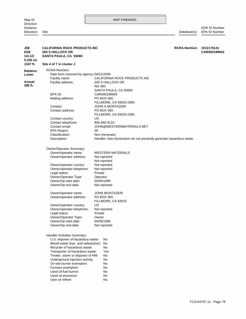
MAP FINDINGSMap IDDirection
EDR ID NumberDistanceEPA ID NumberDatabase(s)SiteElevation
NoUser oil refiner: NoUsed oil processor: NoUsed oil fuel burner: NoFurnace exemption: NoOn-site burner exemption: NoUnderground injection activity: NoTreater, storer or disposer of HW: YesTransporter of hazardous waste: NoRecycler of hazardous waste: NoMixed waste (haz. and radioactive): NoU.S. importer of hazardous waste:
Handler Activities Summary:
Not reportedOwner/Op end date: 04/05/1999Owner/Op start date: OwnerOwner/Operator Type: PrivateLegal status: Not reportedOwner/operator telephone: USOwner/operator country: FILLMORE, CA 93016 PO BOX 360Owner/operator address: JOHN MONTAZERIOwner/operator name:
Not reportedOwner/Op end date: 04/05/1999Owner/Op start date: OperatorOwner/Operator Type: PrivateLegal status: Not reportedOwner/operator telephone: Not reportedOwner/operator country: Not reported Not reportedOwner/operator address: WESTERN MATERIALSOwner/operator name:
Owner/Operator Summary:
Handler: Non-Generators do not presently generate hazardous wasteDescription: Non-GeneratorClassification: 09EPA Region: [email protected] email: 805-660-4110Contact telephone: USContact country: FILLMORE, CA 93016 0360 PO BOX 360Contact address: JOHN A MONTAZERIContact: FILLMORE, CA 93016 0360 PO BOX 360Mailing address: CAR000199943EPA ID: SANTA PAULA, CA 93060 NO 400 250 S HALLOCK DRFacility address: CALIFORNIA ROCK PRODUCTS INCFacility name: 04/21/2009Date form received by agency:
RCRA-NonGen:
1347 ft. Site 4 of 7 in cluster J0.255 mi.
Relative:Lower
Actual:285 ft.
1/4-1/2 SANTA PAULA, CA 93060ESE 250 S HALLOCK DR CAR000199943J58 RCRA-NonGenCALIFORNIA ROCK PRODUCTS INC 1012176141
TC3144757.1s Page 79

MAP FINDINGSMap IDDirection
EDR ID NumberDistanceEPA ID NumberDatabase(s)SiteElevation
No violations foundViolation Status:
NoUsed oil transporter: NoUsed oil transfer facility: NoUsed oil Specification marketer: NoUsed oil fuel marketer to burner:
CALIFORNIA ROCK PRODUCTS INC (Continued) 1012176141
VenturaFacility County: .0400Tons: H01Disposal Method: Detergent waste chemicalsWaste Category: San DiegoTSD County: CAT080010101TSD EPA ID: VenturaGen County: BAKERSFIELD, CA 933080000Mailing City,St,Zip: 2131 MARS COURTMailing Address: Not reportedMailing Name: 8059332217Telephone: SENECA RESOURCESContact: CAL000127314Gepaid: 1994Year:
VenturaFacility County: .1092Tons: H01Disposal Method: Off-specification, aged or surplus organicsWaste Category: San DiegoTSD County: CAT080010101TSD EPA ID: VenturaGen County: BAKERSFIELD, CA 933080000Mailing City,St,Zip: 2131 MARS COURTMailing Address: Not reportedMailing Name: 8059332217Telephone: SENECA RESOURCESContact: CAL000127314Gepaid: 1994Year:
Not reportedFacility County: 0.03Tons: H01Disposal Method: Off-specification, aged or surplus inorganicsWaste Category: Los AngelesTSD County: CAD008364432TSD EPA ID: VenturaGen County: BAKERSFIELD, CA 933080000Mailing City,St,Zip: 2131 MARS COURTMailing Address: Not reportedMailing Name: 6613994270Telephone: T R ALBURGER ENV & SAF MGRContact: CAL000127314Gepaid: 2004Year:
HAZNET:
1347 ft. Site 5 of 7 in cluster J0.255 mi.
Relative:Lower
Actual:285 ft.
1/4-1/2 SANTA PAULA, CA 93060ESE 250 SOUTH HALLOCK DR N/AJ59 HAZNETSENECA RESOURCES S104578653
TC3144757.1s Page 80

MAP FINDINGSMap IDDirection
EDR ID NumberDistanceEPA ID NumberDatabase(s)SiteElevation
corrective action activities required under RCRA.program staff to track the notification, permit, compliance, andand treat, store, or dispose of hazardous waste. RCRAInfo allows RCRAevents and activities related to facilities that generate, transport,Conservation and Recovery Act (RCRA) program through the tracking ofRCRAInfo is a national information system that supports the Resource Environmental Interest/Information System
110038891214Registry ID:
FINDS:
1347 ft. Site 6 of 7 in cluster J0.255 mi.
Relative:Lower
Actual:285 ft.
1/4-1/2 SANTA PAULA, CA 93060ESE 250 S HALLOCK DR N/AJ60 FINDSCALIFORNIA ROCK PRODUCTS INC 1012107655
NoMixed waste (haz. and radioactive): NoU.S. importer of hazardous waste:
Handler Activities Summary:
Not reportedOwner/Op end date: Not reportedOwner/Op start date: OwnerOwner/Operator Type: PrivateLegal status: (713) 225-7755Owner/operator telephone: Not reportedOwner/operator country: HOUSTON, TX 77002 1000 LOUISANA STE 2600Owner/operator address: WELLTECH INCORPORATEDOwner/operator name:
Owner/Operator Summary:
hazardous waste at any time waste during any calendar month, and accumulates more than 1000 kg of hazardous waste at any time; or generates 100 kg or less of hazardous waste during any calendar month and accumulates less than 6000 kg of Handler: generates more than 100 and less than 1000 kg of hazardousDescription: Small Small Quantity GeneratorClassification: 09EPA Region: Not reportedContact email: (805) 525-7149Contact telephone: USContact country: SANT PAULA, CA 93060 250 S HALLOCK DRContact address: JAMES BASTIONContact: CAD983584863EPA ID: SANTA PAULA, CA 93060 250 S HALLOCK DRFacility address: WELLTECH INCFacility name: 06/07/1991Date form received by agency:
RCRA-SQG:
1347 ft. HAZNETSite 7 of 7 in cluster J0.255 mi. SWEEPS UST
Relative:Lower
Actual:285 ft.
1/4-1/2 CA FID USTSANTA PAULA, CA 93060ESE FINDS250 S HALLOCK DR CAD983584863J61 RCRA-SQGWELLTECH INC 1000594639
TC3144757.1s Page 81
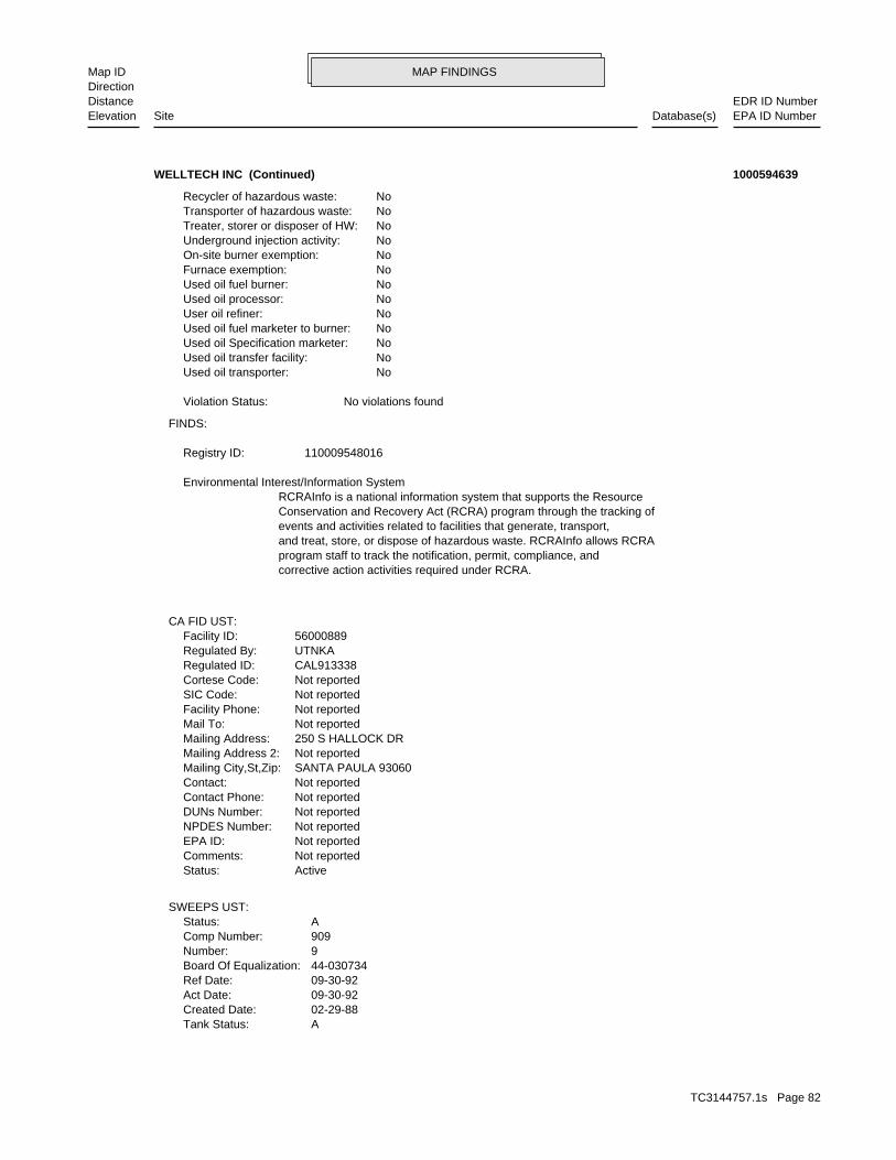
MAP FINDINGSMap IDDirection
EDR ID NumberDistanceEPA ID NumberDatabase(s)SiteElevation
ATank Status: 02-29-88Created Date: 09-30-92Act Date: 09-30-92Ref Date: 44-030734Board Of Equalization: 9Number: 909Comp Number: AStatus:
SWEEPS UST:
ActiveStatus: Not reportedComments: Not reportedEPA ID: Not reportedNPDES Number: Not reportedDUNs Number: Not reportedContact Phone: Not reportedContact: SANTA PAULA 93060Mailing City,St,Zip: Not reportedMailing Address 2: 250 S HALLOCK DRMailing Address: Not reportedMail To: Not reportedFacility Phone: Not reportedSIC Code: Not reportedCortese Code: CAL913338Regulated ID: UTNKARegulated By: 56000889Facility ID:
CA FID UST:
corrective action activities required under RCRA.program staff to track the notification, permit, compliance, andand treat, store, or dispose of hazardous waste. RCRAInfo allows RCRAevents and activities related to facilities that generate, transport,Conservation and Recovery Act (RCRA) program through the tracking ofRCRAInfo is a national information system that supports the Resource Environmental Interest/Information System
110009548016Registry ID:
FINDS:
No violations foundViolation Status:
NoUsed oil transporter: NoUsed oil transfer facility: NoUsed oil Specification marketer: NoUsed oil fuel marketer to burner: NoUser oil refiner: NoUsed oil processor: NoUsed oil fuel burner: NoFurnace exemption: NoOn-site burner exemption: NoUnderground injection activity: NoTreater, storer or disposer of HW: NoTransporter of hazardous waste: NoRecycler of hazardous waste:
WELLTECH INC (Continued) 1000594639
TC3144757.1s Page 82

MAP FINDINGSMap IDDirection
EDR ID NumberDistanceEPA ID NumberDatabase(s)SiteElevation
VenturaFacility County: 1.0000Tons: H01Disposal Method: Unspecified oil-containing wasteWaste Category: Los AngelesTSD County: CAD000088252TSD EPA ID: VenturaGen County: SANTA PAULA, CA 930600000Mailing City,St,Zip: 250 SO HALLOCK DRMailing Address: Not reportedMailing Name: 0000000000Telephone: WELLTECH INCContact: CAL000063179Gepaid: 1993Year:
VenturaFacility County: 16.6383Tons: R01Disposal Method: Unspecified oil-containing wasteWaste Category: KernTSD County: CAD980883177TSD EPA ID: VenturaGen County: SANTA PAULA, CA 930600000Mailing City,St,Zip: 250 SO HALLOCK DRMailing Address: Not reportedMailing Name: 0000000000Telephone: WELLTECH INCContact: CAL000063179Gepaid: 1993Year:
HAZNET:
Not reportedNumber Of Tanks: Not reportedContent: PStg: UNKNOWNTank Use: 10000Capacity: Not reportedActv Date: 56-000-000909-000002Swrcb Tank Id: Not reportedOwner Tank Id: ATank Status: 02-29-88Created Date: 09-30-92Act Date: 09-30-92Ref Date: 44-030734Board Of Equalization: 9Number: 909Comp Number: AStatus:
2Number Of Tanks: Not reportedContent: PStg: UNKNOWNTank Use: 10000Capacity: Not reportedActv Date: 56-000-000909-000001Swrcb Tank Id: Not reportedOwner Tank Id:
WELLTECH INC (Continued) 1000594639
TC3144757.1s Page 83

MAP FINDINGSMap IDDirection
EDR ID NumberDistanceEPA ID NumberDatabase(s)SiteElevation
SANTA PAULA, CA 930600000Mailing City,St,Zip: 230 DOVE CT UNIT BMailing Address: Not reportedMailing Name: 8059330391Telephone: ED ULYATEContact: CAL000216899Gepaid: 2000Year:
Not reportedFacility County: 0.62Tons: H01Disposal Method: Liquids with halogenated organic compounds >= 1,000 Mg./LWaste Category: OrangeTSD County: Not reportedTSD EPA ID: VenturaGen County: SANTA PAULA, CA 930600000Mailing City,St,Zip: 230 DOVE CT UNIT BMailing Address: Not reportedMailing Name: 8059330391Telephone: ED HANSEN - SHOP FRMNContact: CAL000216899Gepaid: 2001Year:
Not reportedFacility County: 0.57Tons: H01Disposal Method: Liquids with halogenated organic compounds >= 1,000 Mg./LWaste Category: OrangeTSD County: Not reportedTSD EPA ID: VenturaGen County: SANTA PAULA, CA 930600000Mailing City,St,Zip: 230 DOVE CT UNIT BMailing Address: Not reportedMailing Name: 8059330391Telephone: ED HANSEN - SHOP FRMNContact: CAL000216899Gepaid: 2002Year:
VenturaFacility County: 0.6Tons: H01Disposal Method: Liquids with halogenated organic compounds >= 1,000 Mg./LWaste Category: VenturaTSD County: CAT000613976TSD EPA ID: VenturaGen County: SANTA PAULA, CA 930600000Mailing City,St,Zip: 230 DOVE CT UNIT BMailing Address: Not reportedMailing Name: 8059330391Telephone: ED HANSEN - SHOP FRMNContact: CAL000216899Gepaid: 2003Year:
HAZNET:
1366 ft. Site 1 of 5 in cluster M0.259 mi.
Relative:Lower
Actual:279 ft.
1/4-1/2 SANTA PAULA, CA 93060South 230 DOVE CT UNIT B N/AM62 HAZNETED ULYATE RACING S105093182
TC3144757.1s Page 84

MAP FINDINGSMap IDDirection
EDR ID NumberDistanceEPA ID NumberDatabase(s)SiteElevation
VenturaFacility County: .1542Tons: H01Disposal Method: Liquids with halogenated organic compounds >= 1,000 Mg./LWaste Category: OrangeTSD County: CAT000613976TSD EPA ID: VenturaGen County:
ED ULYATE RACING (Continued) S105093182
.1250Tons: R01Disposal Method: Aqueous solution with total organic residues 10 percent or moreWaste Category: Los AngelesTSD County: CAD008252405TSD EPA ID: VenturaGen County: BAKERSFIELD, CA 933892044Mailing City,St,Zip: PO BOX 12044Mailing Address: Not reportedMailing Name: 8056333730Telephone: POOL CALIF ENERGY SVCS INCContact: CAL000031952Gepaid: 1995Year:
VenturaFacility County: .5004Tons: H01Disposal Method: Waste oil and mixed oilWaste Category: Los AngelesTSD County: CAD981696420TSD EPA ID: VenturaGen County: BAKERSFIELD, CA 933892044Mailing City,St,Zip: PO BOX 12044Mailing Address: Not reportedMailing Name: 8056333730Telephone: POOL CALIF ENERGY SVCS INCContact: CAL000031952Gepaid: 1996Year:
VenturaFacility County: 0.22Tons: FUEL BLENDING PRIOR TO ENERGY RECOVERY AT ANOTHER SITEDisposal Method: Paint sludgeWaste Category: Los AngelesTSD County: CAT080013352TSD EPA ID: VenturaGen County: SANTA PAULA, CA 930609652Mailing City,St,Zip: 245 DOVE CTMailing Address: Not reportedMailing Name: 8059331788Telephone: CLARK REX/ PRESContact: CAL000214282Gepaid: 2007Year:
HAZNET:
1420 ft. Site 2 of 5 in cluster M0.269 mi.
Relative:Lower
Actual:279 ft.
1/4-1/2 SANTA PAULA, CA 93060South 245 DOVE CT N/AM63 HAZNETPOOL CALIFORNIA ENERGY SERVICES INC S103645662
TC3144757.1s Page 85

MAP FINDINGSMap IDDirection
EDR ID NumberDistanceEPA ID NumberDatabase(s)SiteElevation
3 additional CA_HAZNET: record(s) in the EDR Site Report.Click this hyperlink while viewing on your computer to access
VenturaFacility County: .2050Tons: R01Disposal Method: Other organic solidsWaste Category: Los AngelesTSD County: CAD008252405TSD EPA ID: VenturaGen County: BAKERSFIELD, CA 933892044Mailing City,St,Zip: PO BOX 12044Mailing Address: Not reportedMailing Name: 8056333730Telephone: POOL CALIF ENERGY SVCS INCContact: CAL000031952Gepaid: 1995Year:
VenturaFacility County: .1250Tons: R01Disposal Method: Unspecified organic liquid mixtureWaste Category: Los AngelesTSD County: CAD008252405TSD EPA ID: VenturaGen County: BAKERSFIELD, CA 933892044Mailing City,St,Zip: PO BOX 12044Mailing Address: Not reportedMailing Name: 8056333730Telephone: POOL CALIF ENERGY SVCS INCContact: CAL000031952Gepaid: 1995Year:
VenturaFacility County:
POOL CALIFORNIA ENERGY SERVICES INC (Continued) S103645662
BUSINESS PLAN - SANTA PAULA HAZARDOUS WASTE GENERATORProgram:FA0006877Facility ID:
VENTURA CO. BWT:
1420 ft. Site 3 of 5 in cluster M0.269 mi.
Relative:Lower
Actual:279 ft.
1/4-1/2 SANTA PAULA, CA South 245 DOVE CT N/AM64 VENTURA CO. BWTHOT SECTION TECHNOLOGIES, INC S105511715
8059331788Telephone: CLARK REX/ PRESContact: CAL000214282Gepaid: 2005Year:
HAZNET:
1420 ft. Site 4 of 5 in cluster M0.269 mi.
Relative:Lower
Actual:279 ft.
1/4-1/2 SANTA PAULA, CA 93060South 245 DOVE COURT N/AM65 HAZNETHOT SECTION TECHNOLOGY S105724707
TC3144757.1s Page 86

MAP FINDINGSMap IDDirection
EDR ID NumberDistanceEPA ID NumberDatabase(s)SiteElevation
Not reportedFacility County: 0.22Tons: R01Disposal Method: Unspecified solvent mixtureWaste Category: Los AngelesTSD County: Not reportedTSD EPA ID: VenturaGen County: SANTA PAULA, CA 930600000Mailing City,St,Zip: 245 DOVE COURTMailing Address: Not reportedMailing Name: 8059331788Telephone: CLARK REX/ PRESContact: CAL000214282Gepaid: 2001Year:
Not reportedFacility County: 0.2Tons: R01Disposal Method: Unspecified oil-containing wasteWaste Category: Los AngelesTSD County: Not reportedTSD EPA ID: VenturaGen County: SANTA PAULA, CA 930600000Mailing City,St,Zip: 245 DOVE COURTMailing Address: Not reportedMailing Name: 8059331788Telephone: CLARK REX/ PRESContact: CAL000214282Gepaid: 2001Year:
Not reportedFacility County: 0.33Tons: R01Disposal Method: Unspecified oil-containing wasteWaste Category: Los AngelesTSD County: CAT080013352TSD EPA ID: VenturaGen County: SANTA PAULA, CA 930600000Mailing City,St,Zip: 245 DOVE COURTMailing Address: Not reportedMailing Name:
HOT SECTION TECHNOLOGY (Continued) S105724707
HAZARDOUS WASTE GENERATOR BUSINESS PLAN - SANTA PAULAProgram:FA0006266Facility ID:
VENTURA CO. BWT:
1426 ft. Site 1 of 7 in cluster N0.270 mi.
Relative:Lower
Actual:283 ft.
1/4-1/2 SANTA PAULA, CA SSW 18200 OLD HALLOCK DR N/AN66 VENTURA CO. BWTLINDSEY EXCAVATING & GRADING S110499724
TC3144757.1s Page 87

MAP FINDINGSMap IDDirection
EDR ID NumberDistanceEPA ID NumberDatabase(s)SiteElevation
Stock InventorLeak Detection: 1/4 inchesTank Construction: UNLEADEDType of Fuel: PRODUCTTank Used for: 00001000Tank Capacity: Not reportedYear Installed: 2Container Num: 002Tank Num:
Stock InventorLeak Detection: 1/4 inchesTank Construction: DIESELType of Fuel: PRODUCTTank Used for: 00004000Tank Capacity: Not reportedYear Installed: 1Container Num: 001Tank Num:
SANTA PAULA, CA 93060Owner City,St,Zip: 201 SOUTH HALLOCK DRIVEOwner Address: NORA D. RUSHING ESTATEOwner Name: 8056475595Telephone: MILBURN W. WILSONContact Name: 0000Total Tanks: OIL TOOL RENTAL PROPOther Type: Gas StationFacility Type: 00000059309Facility ID: STATERegion:
HIST UST:
D632Facility ID:VENTURA CO. UST:
1430 ft. Site 3 of 4 in cluster I0.271 mi.
Relative:Higher
Actual:306 ft.
1/4-1/2 SANTA PAULA, CA NE HIST UST18286 TELEGRAPH ROAD N/AI67 USTOIL TOOL SHOP U001580208
.4170Tons: R01Disposal Method: Unspecified oil-containing wasteWaste Category: Los AngelesTSD County: CAT080013352TSD EPA ID: VenturaGen County: SANTA PAULA, CA 930609508Mailing City,St,Zip: 17699 S MOUNTAIN RDMailing Address: Not reportedMailing Name: 3105954501Telephone: J H SIPPRELLE-PRES.Contact: CAL000016375Gepaid: 1995Year:
HAZNET:
1430 ft. Site 4 of 4 in cluster I0.271 mi.
Relative:Higher
Actual:306 ft.
1/4-1/2 SANTA PAULA, CA 93060NE 18286 EAST TELEGRAPH ROAD N/AI68 HAZNETOIL WELL SERVICE COMPANY S103979916
TC3144757.1s Page 88

MAP FINDINGSMap IDDirection
EDR ID NumberDistanceEPA ID NumberDatabase(s)SiteElevation
VenturaFacility County:
OIL WELL SERVICE COMPANY (Continued) S103979916
VenturaFacility County: .2085Tons: R01Disposal Method: Unspecified aqueous solutionWaste Category: Los AngelesTSD County: CAT080013352TSD EPA ID: VenturaGen County: SANTA PAULA, CA 930600000Mailing City,St,Zip: 17905 E TELEGRAPH RDMailing Address: Not reportedMailing Name: 0000000000Telephone: GREG MYERSContact: CAL000121414Gepaid: 1995Year:
VenturaFacility County: .4378Tons: R01Disposal Method: Aqueous solution with total organic residues 10 percent or moreWaste Category: Los AngelesTSD County: CAT080013352TSD EPA ID: VenturaGen County: SANTA PAULA, CA 930600000Mailing City,St,Zip: 17905 E TELEGRAPH RDMailing Address: Not reportedMailing Name: 0000000000Telephone: GREG MYERSContact: CAL000121414Gepaid: 1997Year:
HAZNET:
1522 ft. Site 2 of 4 in cluster L0.288 mi.
Relative:Higher
Actual:304 ft.
1/4-1/2 SANTA PAULA, CA 93060WSW 17905 TELEGRAPH RD N/AL69 HAZNETELITE R.V. SERVICE S103962665
19607Party Number: 2011-05-31 00:00:00As Of: NRural: 10/27/2008Effective Date: NWhether The Facility Is Grandfathered: Not reportedFacility Phone Number:
SWRCY:
1522 ft. Site 3 of 4 in cluster L0.288 mi.
Relative:Higher
Actual:304 ft.
1/4-1/2 SANTA PAULA, CA 93060WSW 17905 E TELEGRAPH RD N/AL70 SWRCYSANTA PAULA RECYCLING S109291916
TC3144757.1s Page 89

MAP FINDINGSMap IDDirection
EDR ID NumberDistanceEPA ID NumberDatabase(s)SiteElevation
VenturaFacility County: .4170Tons: R01Disposal Method: Unspecified oil-containing wasteWaste Category: Los AngelesTSD County: CAT080013352TSD EPA ID: VenturaGen County: FILLMORE, CA 930160000Mailing City,St,Zip: PO BOX 336Mailing Address: Not reportedMailing Name: 0000000000Telephone: PERKINS LAND COContact: CAC000760520Gepaid: 1996Year:
HAZNET:
1551 ft. Site 4 of 4 in cluster L0.294 mi.
Relative:Higher
Actual:304 ft.
1/4-1/2 FILLMORE, CA 93016WSW 1555 TELEGRAPH RD, HWY 126 N/AL71 HAZNETPERKINS LAND CO S103633054
HAZARDOUS WASTE GENERATORProgram:FA0009434Facility ID:
VENTURA CO. BWT:
1575 ft. Site 2 of 7 in cluster N0.298 mi.
Relative:Lower
Actual:280 ft.
1/4-1/2 SANTA PAULA, CA SSW 235 QUAIL CT N/AN72 VENTURA CO. BWTB & W PIPELINE, INC S106570524
ActiveStatus: Not reportedComments: Not reportedEPA ID: Not reportedNPDES Number: Not reportedDUNs Number: Not reportedContact Phone: Not reportedContact: SANTA PAULA 93060Mailing City,St,Zip: Not reportedMailing Address 2: 2707 QUAIL CTMailing Address: Not reportedMail To: Not reportedFacility Phone: Not reportedSIC Code: Not reportedCortese Code: 21519Regulated ID: UTNKARegulated By: 56004874Facility ID:
CA FID UST:
1603 ft. Site 5 of 5 in cluster M0.304 mi.
Relative:Lower
Actual:276 ft.
1/4-1/2 SANTA PAULA, CA 93060South SWEEPS UST2707 QUAIL CT N/AM73 CA FID USTD.W. BURHOE CONST. INC S101596396
TC3144757.1s Page 90

MAP FINDINGSMap IDDirection
EDR ID NumberDistanceEPA ID NumberDatabase(s)SiteElevation
Not reportedNumber Of Tanks: Not reportedContent: PStg: UNKNOWNTank Use: 1000Capacity: Not reportedActv Date: 56-000-001462-000002Swrcb Tank Id: Not reportedOwner Tank Id: ATank Status: 02-29-88Created Date: 09-30-92Act Date: 09-30-92Ref Date: 44-030816Board Of Equalization: 9Number: 1462Comp Number: AStatus:
2Number Of Tanks: Not reportedContent: PStg: UNKNOWNTank Use: 1000Capacity: Not reportedActv Date: 56-000-001462-000001Swrcb Tank Id: Not reportedOwner Tank Id: ATank Status: 02-29-88Created Date: 09-30-92Act Date: 09-30-92Ref Date: 44-030816Board Of Equalization: 9Number: 1462Comp Number: AStatus:
SWEEPS UST:
D.W. BURHOE CONST. INC (Continued) S101596396
Unspecified organic liquid mixtureWaste Category: Los AngelesTSD County: CAD000088252TSD EPA ID: VenturaGen County: SANTA PAULA, CA 930600000Mailing City,St,Zip: 240 QUAIL CTMailing Address: Not reportedMailing Name: 0000000000Telephone: HARMONY CONSTRUCTION OF CALContact: CAL000117677Gepaid: 1995Year:
HAZNET:
BUSINESS PLAN - SANTA PAULA HAZARDOUS WASTE GENERATORProgram:FA0009924Facility ID:
VENTURA CO. BWT:
1615 ft. Site 3 of 7 in cluster N0.306 mi.
Relative:Lower
Actual:279 ft.
1/4-1/2 SANTA PAULA, CA SSW HAZNET240 QUAIL CT N/AN74 VENTURA CO. BWTGENERAL PAVEMENT MGMT, INC S102563417
TC3144757.1s Page 91
MAP FINDINGSMap IDDirection
EDR ID NumberDistanceEPA ID NumberDatabase(s)SiteElevation
VenturaFacility County: .4587Tons: R01Disposal Method: Unspecified oil-containing wasteWaste Category: KernTSD County: CAD980883177TSD EPA ID: VenturaGen County: SANTA PAULA, CA 930600000Mailing City,St,Zip: 240 QUAIL CTMailing Address: Not reportedMailing Name: 0000000000Telephone: HARMONY CONSTRUCTION OF CALContact: CAL000117677Gepaid: 1994Year:
VenturaFacility County: .4587Tons: Not reportedDisposal Method: Unspecified oil-containing wasteWaste Category: KernTSD County: CAD980883177TSD EPA ID: VenturaGen County: SANTA PAULA, CA 930600000Mailing City,St,Zip: 240 QUAIL CTMailing Address: Not reportedMailing Name: 0000000000Telephone: HARMONY CONSTRUCTION OF CALContact: CAL000117677Gepaid: 1994Year:
VenturaFacility County: .4500Tons: H01Disposal Method: Empty containers less than 30 gallonsWaste Category: Los AngelesTSD County: CAD000088252TSD EPA ID: VenturaGen County: SANTA PAULA, CA 930600000Mailing City,St,Zip: 240 QUAIL CTMailing Address: Not reportedMailing Name: 0000000000Telephone: HARMONY CONSTRUCTION OF CALContact: CAL000117677Gepaid: 1995Year:
VenturaFacility County: .3336Tons: H01Disposal Method:
GENERAL PAVEMENT MGMT, INC (Continued) S102563417
TC3144757.1s Page 92

MAP FINDINGSMap IDDirection
EDR ID NumberDistanceEPA ID NumberDatabase(s)SiteElevation
Not reportedFacility County: 0.1Tons: Not reportedDisposal Method: Unspecified organic liquid mixtureWaste Category: Los AngelesTSD County: CAT080013352TSD EPA ID: VenturaGen County: SANTA PAULA, CA 93060Mailing City,St,Zip: 240 QUAIL CTMailing Address: Not reportedMailing Name: 8056521193Telephone: SANTIAGO GOROSTIZAContact: CAL000282013Gepaid: 2004Year:
HAZNET:
1615 ft. Site 4 of 7 in cluster N0.306 mi.
Relative:Lower
Actual:279 ft.
1/4-1/2 SANTA PAULA, CA 93060SSW 240 QUAIL CT N/AN75 HAZNETG P M SEALRITE INC HEADQUARTERS S108207462
Other organic solidsWaste Category: Los AngelesTSD County: CAT080033681TSD EPA ID: VenturaGen County: SANTA PAULA, CA 930600000Mailing City,St,Zip: 245 QUAIL COURTMailing Address: Not reportedMailing Name: 8056475775Telephone: DELL MUNTZEL/PRESContact: CAD982322570Gepaid: 1998Year:
Not reportedFacility County: 0.12Tons: D80Disposal Method: Unspecified oil-containing wasteWaste Category: Los AngelesTSD County: Not reportedTSD EPA ID: VenturaGen County: SANTA PAULA, CA 930600000Mailing City,St,Zip: 245 QUAIL COURTMailing Address: Not reportedMailing Name: 8056475775Telephone: ROBERTA MUNTZEL-VPContact: CAD982322570Gepaid: 2002Year:
HAZNET:
HAZARDOUS WASTE GENERATORProgram:FA0006153Facility ID:
VENTURA CO. BWT:
1635 ft. Site 1 of 22 in cluster O0.310 mi.
Relative:Lower
Actual:278 ft.
1/4-1/2 SANTA PAULA, CA SSW HAZNET245 QUAIL CT N/AO76 VENTURA CO. BWTL & H CONSULTING S103645674
TC3144757.1s Page 93

MAP FINDINGSMap IDDirection
EDR ID NumberDistanceEPA ID NumberDatabase(s)SiteElevation
6 additional CA_HAZNET: record(s) in the EDR Site Report.Click this hyperlink while viewing on your computer to access
VenturaFacility County: .2000Tons: H01Disposal Method: Unspecified oil-containing wasteWaste Category: Los AngelesTSD County: CAD000088252TSD EPA ID: VenturaGen County: SANTA PAULA, CA 930600000Mailing City,St,Zip: 245 QUAIL COURTMailing Address: Not reportedMailing Name: 8056475775Telephone: DELL MUNTZEL/PRESContact: CAD982322570Gepaid: 1998Year:
VenturaFacility County: .2293Tons: H01Disposal Method: Off-specification, aged or surplus inorganicsWaste Category: Los AngelesTSD County: CAD000088252TSD EPA ID: VenturaGen County: SANTA PAULA, CA 930600000Mailing City,St,Zip: 245 QUAIL COURTMailing Address: Not reportedMailing Name: 8056475775Telephone: DELL MUNTZEL/PRESContact: CAD982322570Gepaid: 1998Year:
VenturaFacility County: .6255Tons: H01Disposal Method: Unspecified solvent mixtureWaste Category: Los AngelesTSD County: CAD000088252TSD EPA ID: VenturaGen County: SANTA PAULA, CA 930600000Mailing City,St,Zip: 245 QUAIL COURTMailing Address: Not reportedMailing Name: 8056475775Telephone: DELL MUNTZEL/PRESContact: CAD982322570Gepaid: 1998Year:
VenturaFacility County: .1250Tons: D80Disposal Method:
L & H CONSULTING (Continued) S103645674
TC3144757.1s Page 94

MAP FINDINGSMap IDDirection
EDR ID NumberDistanceEPA ID NumberDatabase(s)SiteElevation
3456Registration Number: Not reportedMethod: 800-952-2909Contact Phone: Not reportedContact Name: 41Sr No: MEDICAL WASTE TRANSPORTERSFacility Type:
Not reportedRegistration Number: Not reportedMethod: 805-647-2541Contact Phone: Not reportedContact Name: 47Sr No: PERMITTED MEDICAL WASTE TRANSFER STATIONS CURRENTLY IN OPERATIONFacility Type:
MWMP:
2/28/2012Expiration Date:3456Reg Num:
HWT:
1635 ft. Site 2 of 22 in cluster O0.310 mi.
Relative:Lower
Actual:278 ft.
1/4-1/2 SANTA PAULA, CA 93060SSW MWMP245 QUAIL CT. N/AO77 HWTHAZ-MED, INC. S109467007
7/31/2011Expiration Date:2486Reg Num:
HWT:
1635 ft. Site 3 of 22 in cluster O0.310 mi.
Relative:Lower
Actual:278 ft.
1/4-1/2 SANTA PAULA, CA 93060SSW 245 QUAIL COURT N/AO78 HWTL & H CONSULTING, INC. S109467006
VenturaFacility County: 0.4587Tons: (H010-H129) OR (H131-H135) STORAGE, BULKING, AND/OR TRANSFER OFF SITE--NO TREATMENT/REOVERYDisposal Method: Unspecified oil-containing wasteWaste Category: Los AngelesTSD County: CAD097030993TSD EPA ID: VenturaGen County: SANTA PAULA, CA 930600000Mailing City,St,Zip: 245 QUAIL CTMailing Address: Not reportedMailing Name: 8056475775Telephone: DELL L MUNTZELContact: CAR000175638Gepaid: 2008Year:
HAZNET:
1635 ft. Site 4 of 22 in cluster O0.310 mi.
Relative:Lower
Actual:278 ft.
1/4-1/2 SANTA PAULA, CA 93060SSW 245 QUAIL CT 1FL N/AO79 HAZNETL AND H CONSULTING INC S108749921
TC3144757.1s Page 95

MAP FINDINGSMap IDDirection
EDR ID NumberDistanceEPA ID NumberDatabase(s)SiteElevation
VenturaFacility County: 0.83Tons: H01Disposal Method: Unspecified oil-containing wasteWaste Category: Los AngelesTSD County: CAD097030993TSD EPA ID: VenturaGen County: SANTA PAULA, CA 930600000Mailing City,St,Zip: 245 QUAIL CTMailing Address: Not reportedMailing Name: 8056475775Telephone: DELL L MUNTZELContact: CAR000175638Gepaid: 2006Year:
VenturaFacility County: 1.1Tons: (H010-H129) OR (H131-H135) STORAGE, BULKING, AND/OR TRANSFER OFF SITE--NO TREATMENT/REOVERYDisposal Method: Oil/water separation sludgeWaste Category: Los AngelesTSD County: CAD097030993TSD EPA ID: VenturaGen County: SANTA PAULA, CA 930600000Mailing City,St,Zip: 245 QUAIL CTMailing Address: Not reportedMailing Name: 8056475775Telephone: DELL L MUNTZELContact: CAR000175638Gepaid: 2007Year:
L AND H CONSULTING INC (Continued) S108749921
corrective action activities required under RCRA.program staff to track the notification, permit, compliance, andand treat, store, or dispose of hazardous waste. RCRAInfo allows RCRAevents and activities related to facilities that generate, transport,Conservation and Recovery Act (RCRA) program through the tracking ofRCRAInfo is a national information system that supports the Resource Environmental Interest/Information System
110031348799Registry ID:
FINDS:
1635 ft. Site 5 of 22 in cluster O0.310 mi.
Relative:Lower
Actual:278 ft.
1/4-1/2 SANTA PAULA, CA 93060SSW 245 QUAIL CT N/AO80 FINDSL AND H CONSULTING INC 1010458760
TC3144757.1s Page 96

MAP FINDINGSMap IDDirection
EDR ID NumberDistanceEPA ID NumberDatabase(s)SiteElevation
NoUsed oil transfer facility: NoUsed oil Specification marketer: NoUsed oil fuel marketer to burner: NoUser oil refiner: NoUsed oil processor: NoUsed oil fuel burner: NoFurnace exemption: NoOn-site burner exemption: NoUnderground injection activity: NoTreater, storer or disposer of HW: YesTransporter of hazardous waste: NoRecycler of hazardous waste: NoMixed waste (haz. and radioactive): NoU.S. importer of hazardous waste:
Handler Activities Summary:
Not reportedOwner/Op end date: Not reportedOwner/Op start date: OperatorOwner/Operator Type: PrivateLegal status: (415) 555-1212Owner/operator telephone: Not reportedOwner/operator country: NOT REQUIRED, ME 99999 NOT REQUIREDOwner/operator address: NOT REQUIREDOwner/operator name:
Not reportedOwner/Op end date: Not reportedOwner/Op start date: OwnerOwner/Operator Type: PrivateLegal status: (805) 647-2541Owner/operator telephone: Not reportedOwner/operator country: SANTA PAULA, CA 93060 245 QUAIL CTOwner/operator address: JAMES SCHLEIMEROwner/operator name:
Owner/Operator Summary:
Handler: Non-Generators do not presently generate hazardous wasteDescription: Non-GeneratorClassification: 09EPA Region: Not reportedContact email: (805) 647-2541Contact telephone: USContact country: SANTA PAULA, CA 93060 245 QUAIL CTContact address: ROBERTA MUNTZELContact: CAD983583261EPA ID: SANTA PAULA, CA 93060 245 QUAIL CTFacility address: HAZ MED INCFacility name: 11/27/1995Date form received by agency:
RCRA-NonGen:
1635 ft. Site 6 of 22 in cluster O0.310 mi.
Relative:Lower
Actual:278 ft.
1/4-1/2 SANTA PAULA, CA 93060SSW FINDS245 QUAIL CT CAD983583261O81 RCRA-NonGenHAZ MED INC 1000594495
TC3144757.1s Page 97

MAP FINDINGSMap IDDirection
EDR ID NumberDistanceEPA ID NumberDatabase(s)SiteElevation
corrective action activities required under RCRA.program staff to track the notification, permit, compliance, andand treat, store, or dispose of hazardous waste. RCRAInfo allows RCRAevents and activities related to facilities that generate, transport,Conservation and Recovery Act (RCRA) program through the tracking ofRCRAInfo is a national information system that supports the Resource
facilities.generators, transporters, and treatment, storage, and disposalprovides California with information on hazardous waste shipments forCalifornia Hazardous Waste Tracking System - Datamart (HWTS-DATAMART) Environmental Interest/Information System
110002845020Registry ID:
FINDS:
No violations foundViolation Status:
NoUsed oil transporter:
HAZ MED INC (Continued) 1000594495
hazardous waste the cleanup of a spill, into or on any land or water, of acutely any residue or contaminated soil, waste or other debris resulting from time: 1 kg or less of acutely hazardous waste; or 100 kg or less of hazardous waste during any calendar month, and accumulates at any from the cleanup of a spill, into or on any land or water, of acutely of any residue or contaminated soil, waste or other debris resulting land or water, of acutely hazardous waste; or generates 100 kg or less other debris resulting from the cleanup of a spill, into or on any waste; or 100 kg or less of any residue or contaminated soil, waste or month, and accumulates at any time: 1 kg or less of acutely hazardous or generates 1 kg or less of acutely hazardous waste per calendar month, and accumulates 1000 kg or less of hazardous waste at any time; Handler: generates 100 kg or less of hazardous waste per calendarDescription: Conditionally Exempt Small Quantity GeneratorClassification: 09EPA Region: [email protected] email: 805-647-5775Contact telephone: USContact country: SANTA PAULA, CA 93060 245 QUAIL CTContact address: DELL L MUNTZELContact: CAR000175638EPA ID: SANTA PAULA, CA 93060 1FL 245 QUAIL CTFacility address: L AND H CONSULTING INCFacility name: 07/13/2006Date form received by agency:
RCRA-CESQG:
1635 ft. Site 7 of 22 in cluster O0.310 mi.
Relative:Lower
Actual:278 ft.
1/4-1/2 SANTA PAULA, CA 93060SSW 245 QUAIL CT CAR000175638O82 RCRA-CESQGL AND H CONSULTING INC 1010313607
TC3144757.1s Page 98

MAP FINDINGSMap IDDirection
EDR ID NumberDistanceEPA ID NumberDatabase(s)SiteElevation
No violations foundViolation Status:
WHICH WOULD BE CONSIDERED AS IGNITABLE HAZARDOUS WASTE. MATERIAL. LACQUER THINNER IS AN EXAMPLE OF A COMMONLY USED SOLVENT WHICH CAN BE OBTAINED FROM THE MANUFACTURER OR DISTRIBUTOR OF THE FLASH POINT OF A WASTE IS TO REVIEW THE MATERIAL SAFETY DATA SHEET, CLOSED CUP FLASH POINT TESTER. ANOTHER METHOD OF DETERMINING THE LESS THAN 140 DEGREES FAHRENHEIT AS DETERMINED BY A PENSKY-MARTENS IGNITABLE HAZARDOUS WASTES ARE THOSE WASTES WHICH HAVE A FLASHPOINT OFWaste name: D001Waste code:
Hazardous Waste Summary:
NoUsed oil transporter: NoUsed oil transfer facility: NoUsed oil Specification marketer: NoUsed oil fuel marketer to burner: NoUser oil refiner: NoUsed oil processor: NoUsed oil fuel burner: NoFurnace exemption: NoOn-site burner exemption: NoUnderground injection activity: NoTreater, storer or disposer of HW: YesTransporter of hazardous waste: NoRecycler of hazardous waste: NoMixed waste (haz. and radioactive): NoU.S. importer of hazardous waste:
Handler Activities Summary:
Not reportedOwner/Op end date: 02/10/1987Owner/Op start date: OwnerOwner/Operator Type: PrivateLegal status: Not reportedOwner/operator telephone: USOwner/operator country: SANTA PAULA, CA 93060 245 QUAIL CT 1 FLOwner/operator address: DELL MUNTZELOwner/operator name:
Not reportedOwner/Op end date: 02/10/1987Owner/Op start date: OperatorOwner/Operator Type: PrivateLegal status: Not reportedOwner/operator telephone: USOwner/operator country: Not reported Not reportedOwner/operator address: DELL MUNTZELOwner/operator name:
Owner/Operator Summary:
L AND H CONSULTING INC (Continued) 1010313607
TC3144757.1s Page 99
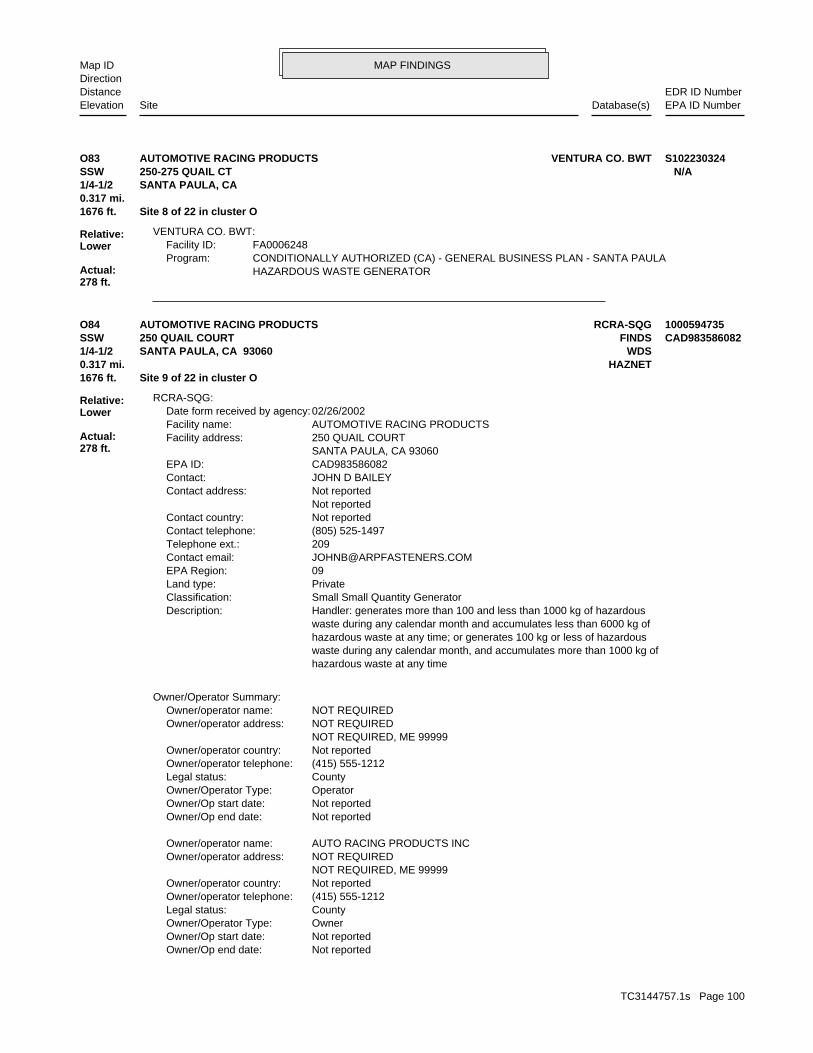
MAP FINDINGSMap IDDirection
EDR ID NumberDistanceEPA ID NumberDatabase(s)SiteElevation
HAZARDOUS WASTE GENERATORCONDITIONALLY AUTHORIZED (CA) - GENERAL BUSINESS PLAN - SANTA PAULAProgram:FA0006248Facility ID:
VENTURA CO. BWT:
1676 ft. Site 8 of 22 in cluster O0.317 mi.
Relative:Lower
Actual:278 ft.
1/4-1/2 SANTA PAULA, CA SSW 250-275 QUAIL CT N/AO83 VENTURA CO. BWTAUTOMOTIVE RACING PRODUCTS S102230324
Not reportedOwner/Op end date: Not reportedOwner/Op start date: OwnerOwner/Operator Type: CountyLegal status: (415) 555-1212Owner/operator telephone: Not reportedOwner/operator country: NOT REQUIRED, ME 99999 NOT REQUIREDOwner/operator address: AUTO RACING PRODUCTS INCOwner/operator name:
Not reportedOwner/Op end date: Not reportedOwner/Op start date: OperatorOwner/Operator Type: CountyLegal status: (415) 555-1212Owner/operator telephone: Not reportedOwner/operator country: NOT REQUIRED, ME 99999 NOT REQUIREDOwner/operator address: NOT REQUIREDOwner/operator name:
Owner/Operator Summary:
hazardous waste at any time waste during any calendar month, and accumulates more than 1000 kg of hazardous waste at any time; or generates 100 kg or less of hazardous waste during any calendar month and accumulates less than 6000 kg of Handler: generates more than 100 and less than 1000 kg of hazardousDescription: Small Small Quantity GeneratorClassification: PrivateLand type: 09EPA Region: [email protected] email: 209Telephone ext.: (805) 525-1497Contact telephone: Not reportedContact country: Not reported Not reportedContact address: JOHN D BAILEYContact: CAD983586082EPA ID: SANTA PAULA, CA 93060 250 QUAIL COURTFacility address: AUTOMOTIVE RACING PRODUCTSFacility name: 02/26/2002Date form received by agency:
RCRA-SQG:
1676 ft. Site 9 of 22 in cluster O0.317 mi. HAZNET
Relative:Lower
Actual:278 ft.
1/4-1/2 WDSSANTA PAULA, CA 93060SSW FINDS250 QUAIL COURT CAD983586082O84 RCRA-SQGAUTOMOTIVE RACING PRODUCTS 1000594735
TC3144757.1s Page 100

MAP FINDINGSMap IDDirection
EDR ID NumberDistanceEPA ID NumberDatabase(s)SiteElevation
State Contractor/GranteeEvaluation lead agency: 05/06/2004Date achieved compliance: Generators - GeneralArea of violation: COMPLIANCE EVALUATION INSPECTION ON-SITEEvaluation: 04/06/2004Evaluation date:
Evaluation Action Summary:
0 Paid penalty amount: 0 Final penalty amount: 0 Proposed penalty amount: State Enforcement lead agency: Not reported Enf. disp. status date: Not reported Enf. disposition status: 04/06/2004 Enforcement action date: WRITTEN INFORMAL Enforcement action: StateViolation lead agency: 05/06/2004Date achieved compliance: 04/06/2004Date violation determined: Generators - GeneralArea of violation: Not reportedRegulation violated:
Facility Has Received Notices of Violations:
TETRACHLOROETHYLENEWaste name: D039Waste code:
213Waste name: 213Waste code:
Hazardous Waste Summary:
Small Quantity GeneratorClassification: AUTO RACING PRODUCTSSite name: AUTOMOTIVE RACING PRODUCTSFacility name: 06/20/1991Date form received by agency:
Large Quantity GeneratorClassification: AUTOMOTIVE RACING PRODUCTSFacility name: 02/26/2002Date form received by agency:
Historical Generators:
NoUsed oil transporter: NoUsed oil transfer facility: NoUsed oil Specification marketer: NoUsed oil fuel marketer to burner: NoUser oil refiner: NoUsed oil processor: NoUsed oil fuel burner: NoFurnace exemption: NoOn-site burner exemption: NoUnderground injection activity: NoTreater, storer or disposer of HW: NoTransporter of hazardous waste: NoRecycler of hazardous waste: NoMixed waste (haz. and radioactive): NoU.S. importer of hazardous waste:
Handler Activities Summary:
AUTOMOTIVE RACING PRODUCTS (Continued) 1000594735
TC3144757.1s Page 101

MAP FINDINGSMap IDDirection
EDR ID NumberDistanceEPA ID NumberDatabase(s)SiteElevation
Category C - Facilities having no waste treatment systems, such asComplexity: represent no threat to water quality. Level. A Zero (0) may be used to code those NURDS that are found to considered a minor threat to water quality unless coded at a higher to a major or minor threat. Not: All nurds without a TTWQ will be should cause a relatively minor impairment of beneficial uses compared Minor Threat to Water Quality. A violation of a regional board orderTreat To Water: Not reportedPOTW: Not reportedReclamation: 0Baseline Flow: 0Design Flow: Not reportedSecondary Waste Type: Not reportedSecondary Waste: Not reportedPrimary Waste Type: Not reportedPrimary Waste: Not reportedSIC Code 2: 0SIC Code: ?Agency Type: 8055251497Agency Telephone: Brock FergussonAgency Contact: Santa Paula 930609510Agency City,St,Zip: 1760 E Lemonwood DrAgency Address: AUTOMOTIVE RACING PROD INCAgency Name: Brock FergussonFacility Contact: 8055251497Facility Telephone: 4Subregion: are assigned by the Regional Board CAS000001 The 1st 2 characters designate the state. The remaining 7NPDES Number: under Waste Discharge Requirements. Active - Any facility with a continuous or seasonal discharge that isFacility Status: pumping. repairing, oil production, storage and disposal operations, water washing, geothermal operations, air conditioning, ship building and processing operation of whatever nature, including mining, gravel semisolid wastes from any servicing, producing, manufacturing or Industrial - Facility that treats and/or disposes of liquid orFacility Type: 4 56I018233Facility ID:
CA WDS:
corrective action activities required under RCRA.program staff to track the notification, permit, compliance, andand treat, store, or dispose of hazardous waste. RCRAInfo allows RCRAevents and activities related to facilities that generate, transport,Conservation and Recovery Act (RCRA) program through the tracking ofRCRAInfo is a national information system that supports the Resource
facilities.generators, transporters, and treatment, storage, and disposalprovides California with information on hazardous waste shipments forCalifornia Hazardous Waste Tracking System - Datamart (HWTS-DATAMART) Environmental Interest/Information System
110002846886Registry ID:
FINDS:
AUTOMOTIVE RACING PRODUCTS (Continued) 1000594735
TC3144757.1s Page 102

MAP FINDINGSMap IDDirection
EDR ID NumberDistanceEPA ID NumberDatabase(s)SiteElevation
CAD983586082Gepaid: 2009Year:
VenturaFacility County: 1.1676Tons: (H010-H129) OR (H131-H135) STORAGE, BULKING, AND/OR TRANSFER OFF SITE--NO TREATMENT/REOVERYDisposal Method: Not reportedWaste Category: FresnoTSD County: CAD093459485TSD EPA ID: VenturaGen County: SANTA PAULA, CA 930600000Mailing City,St,Zip: 1760 LEMONWOOD DRIVEMailing Address: Not reportedMailing Name: 8055251497Telephone: JULIE MILLSContact: CAD983586082Gepaid: 2009Year:
VenturaFacility County: 32.7166Tons: (H010-H129) OR (H131-H135) STORAGE, BULKING, AND/OR TRANSFER OFF SITE--NO TREATMENT/REOVERYDisposal Method: Other organic solidsWaste Category: Los AngelesTSD County: CAD097030993TSD EPA ID: VenturaGen County: SANTA PAULA, CA 930600000Mailing City,St,Zip: 1760 LEMONWOOD DRIVEMailing Address: Not reportedMailing Name: 8055251497Telephone: JULIE MILLSContact: CAD983586082Gepaid: 2009Year:
VenturaFacility County: 1.323Tons: (H010-H129) OR (H131-H135) STORAGE, BULKING, AND/OR TRANSFER OFF SITE--NO TREATMENT/REOVERYDisposal Method: Aqueous solution with total organic residues less than 10 percentWaste Category: Los AngelesTSD County: CAT000613893TSD EPA ID: VenturaGen County: SANTA PAULA, CA 930600000Mailing City,St,Zip: 1760 LEMONWOOD DRIVEMailing Address: Not reportedMailing Name: 8055251497Telephone: JULIE MILLSContact: CAD983586082Gepaid: 2009Year:
HAZNET:
dairy waste ponds. dischargers having waste storage systems with land disposal such as disposal systems, such as septic systems with subsurface disposal, or management practices, facilities with passive waste treatment and cooling water dischargers or thosewho must comply through best
AUTOMOTIVE RACING PRODUCTS (Continued) 1000594735
TC3144757.1s Page 103

MAP FINDINGSMap IDDirection
EDR ID NumberDistanceEPA ID NumberDatabase(s)SiteElevation
80 additional CA_HAZNET: record(s) in the EDR Site Report.Click this hyperlink while viewing on your computer to access
VenturaFacility County: 1.7514Tons: FUEL BLENDING PRIOR TO ENERGY RECOVERY AT ANOTHER SITEDisposal Method: Not reportedWaste Category: 99TSD County: TXD077603371TSD EPA ID: VenturaGen County: SANTA PAULA, CA 930600000Mailing City,St,Zip: 1760 LEMONWOOD DRIVEMailing Address: Not reportedMailing Name: 8055251497Telephone: JULIE MILLSContact: CAD983586082Gepaid: 2009Year:
VenturaFacility County: 6.7424Tons: (H010-H129) OR (H131-H135) STORAGE, BULKING, AND/OR TRANSFER OFF SITE--NO TREATMENT/REOVERYDisposal Method: Other inorganic solid wasteWaste Category: Los AngelesTSD County: CAD097030993TSD EPA ID: VenturaGen County: SANTA PAULA, CA 930600000Mailing City,St,Zip: 1760 LEMONWOOD DRIVEMailing Address: Not reportedMailing Name: 8055251497Telephone: JULIE MILLSContact:
AUTOMOTIVE RACING PRODUCTS (Continued) 1000594735
Not reportedFacility County: 0.37Tons: Not reportedDisposal Method: Unspecified oil-containing wasteWaste Category: Los AngelesTSD County: CAT080013352TSD EPA ID: VenturaGen County: SANTA PAULA, CA 93060Mailing City,St,Zip: 1409 E MAIN STMailing Address: Not reportedMailing Name: 8055253334Telephone: MIGUEL ARROYO/OWNERContact: CAL000258543Gepaid: 2004Year:
HAZNET:
BUSINESS PLAN HAZARDOUS WASTE GENERATORProgram:FA0019303Facility ID:
VENTURA CO. BWT:
1685 ft. Site 1 of 4 in cluster P0.319 mi.
Relative:Higher
Actual:302 ft.
1/4-1/2 SANTA PAULA, CA WSW HAZNET17902 E TELEGRAPH RD N/AP85 VENTURA CO. BWTRUBEN’S TIRE S108219744
TC3144757.1s Page 104

MAP FINDINGSMap IDDirection
EDR ID NumberDistanceEPA ID NumberDatabase(s)SiteElevation
NoUser oil refiner: NoUsed oil processor: NoUsed oil fuel burner: NoFurnace exemption: NoOn-site burner exemption: NoUnderground injection activity: NoTreater, storer or disposer of HW: YesTransporter of hazardous waste: NoRecycler of hazardous waste: NoMixed waste (haz. and radioactive): NoU.S. importer of hazardous waste:
Handler Activities Summary:
Not reportedOwner/Op end date: 04/05/1999Owner/Op start date: OperatorOwner/Operator Type: PrivateLegal status: Not reportedOwner/operator telephone: USOwner/operator country: Not reported Not reportedOwner/operator address: JOHN MONTAZERIOwner/operator name:
Not reportedOwner/Op end date: 04/05/1999Owner/Op start date: OwnerOwner/Operator Type: PrivateLegal status: 805-525-1100Owner/operator telephone: USOwner/operator country: FILLMORE, CA 93016 PO BOX 360Owner/operator address: LARRY G DIAMONDOwner/operator name:
Owner/Operator Summary:
Handler: Non-Generators do not presently generate hazardous wasteDescription: Non-GeneratorClassification: 09EPA Region: [email protected] email: 805-660-4110Contact telephone: USContact country: FILLMORE, CA 93016-0360 PO BOX 360Contact address: JOHN A MONTAZERIContact: FILLMORE, CA 93016-0360 PO BOX 360Mailing address: CAR000218040EPA ID: SANTA PAULA, CA 93060 STE B 250 HALLOCK DRFacility address: CAILFORNIA HAZMAT DISPOSALFacility name: 04/11/2011Date form received by agency:
RCRA-SQG:
1695 ft. Site 5 of 7 in cluster N0.321 mi.
Relative:Lower
Actual:280 ft.
1/4-1/2 SANTA PAULA, CA 93060SSW 250 HALLOCK DR CAR000218040N86 RCRA-SQGCAILFORNIA HAZMAT DISPOSAL 1014465343
TC3144757.1s Page 105
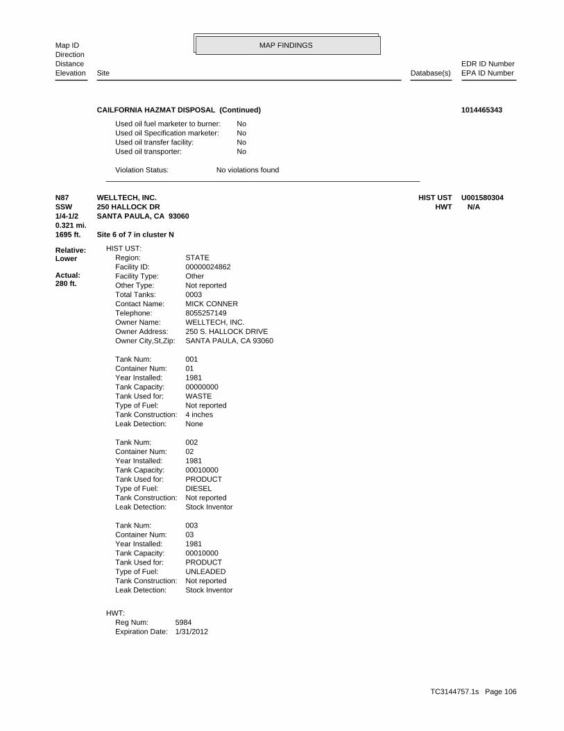
MAP FINDINGSMap IDDirection
EDR ID NumberDistanceEPA ID NumberDatabase(s)SiteElevation
No violations foundViolation Status:
NoUsed oil transporter: NoUsed oil transfer facility: NoUsed oil Specification marketer: NoUsed oil fuel marketer to burner:
CAILFORNIA HAZMAT DISPOSAL (Continued) 1014465343
1/31/2012Expiration Date:5984Reg Num:
HWT:
Stock InventorLeak Detection: Not reportedTank Construction: UNLEADEDType of Fuel: PRODUCTTank Used for: 00010000Tank Capacity: 1981Year Installed: 03Container Num: 003Tank Num:
Stock InventorLeak Detection: Not reportedTank Construction: DIESELType of Fuel: PRODUCTTank Used for: 00010000Tank Capacity: 1981Year Installed: 02Container Num: 002Tank Num:
NoneLeak Detection: 4 inchesTank Construction: Not reportedType of Fuel: WASTETank Used for: 00000000Tank Capacity: 1981Year Installed: 01Container Num: 001Tank Num:
SANTA PAULA, CA 93060Owner City,St,Zip: 250 S. HALLOCK DRIVEOwner Address: WELLTECH, INC.Owner Name: 8055257149Telephone: MICK CONNERContact Name: 0003Total Tanks: Not reportedOther Type: OtherFacility Type: 00000024862Facility ID: STATERegion:
HIST UST:
1695 ft. Site 6 of 7 in cluster N0.321 mi.
Relative:Lower
Actual:280 ft.
1/4-1/2 SANTA PAULA, CA 93060SSW HWT250 HALLOCK DR N/AN87 HIST USTWELLTECH, INC. U001580304
TC3144757.1s Page 106
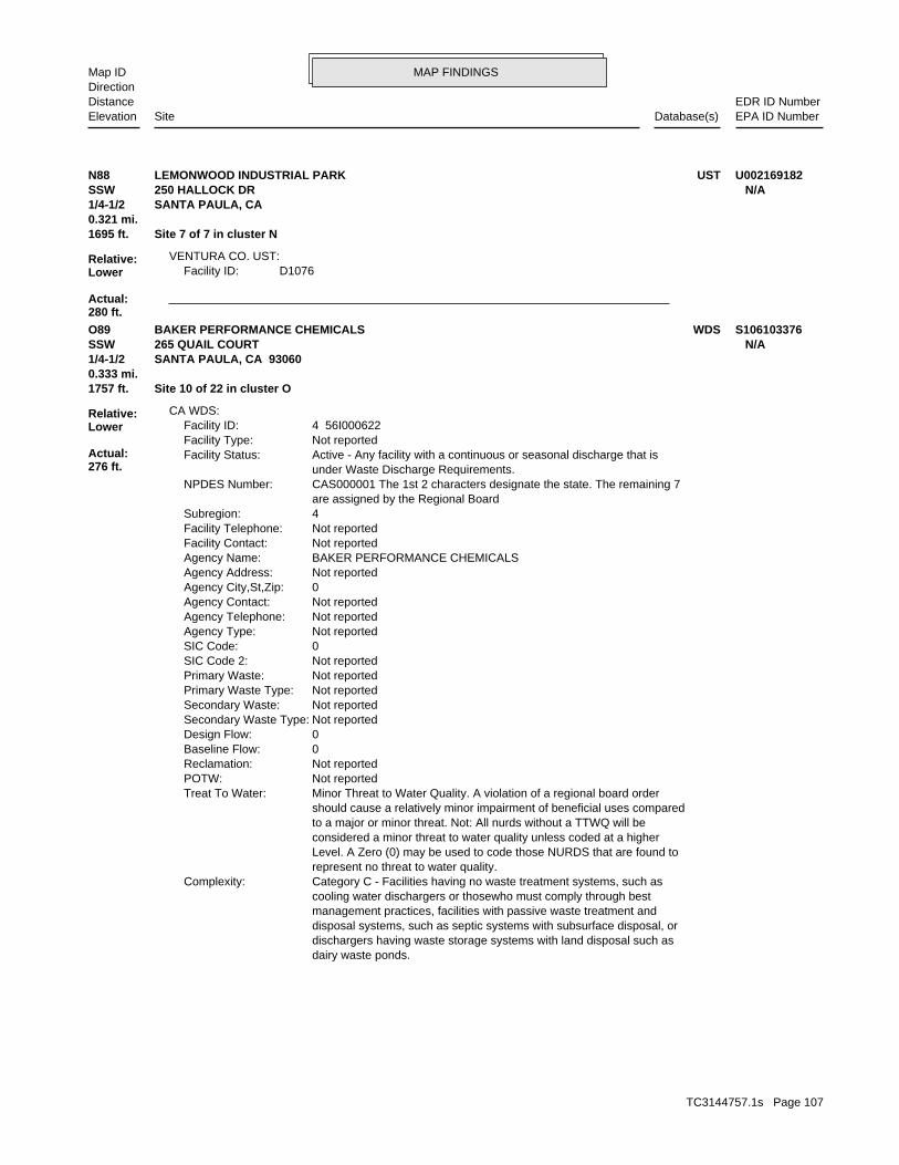
MAP FINDINGSMap IDDirection
EDR ID NumberDistanceEPA ID NumberDatabase(s)SiteElevation
D1076Facility ID:VENTURA CO. UST:
1695 ft. Site 7 of 7 in cluster N0.321 mi.
Relative:Lower
Actual:280 ft.
1/4-1/2 SANTA PAULA, CA SSW 250 HALLOCK DR N/AN88 USTLEMONWOOD INDUSTRIAL PARK U002169182
dairy waste ponds. dischargers having waste storage systems with land disposal such as disposal systems, such as septic systems with subsurface disposal, or management practices, facilities with passive waste treatment and cooling water dischargers or thosewho must comply through best Category C - Facilities having no waste treatment systems, such asComplexity: represent no threat to water quality. Level. A Zero (0) may be used to code those NURDS that are found to considered a minor threat to water quality unless coded at a higher to a major or minor threat. Not: All nurds without a TTWQ will be should cause a relatively minor impairment of beneficial uses compared Minor Threat to Water Quality. A violation of a regional board orderTreat To Water: Not reportedPOTW: Not reportedReclamation: 0Baseline Flow: 0Design Flow: Not reportedSecondary Waste Type: Not reportedSecondary Waste: Not reportedPrimary Waste Type: Not reportedPrimary Waste: Not reportedSIC Code 2: 0SIC Code: Not reportedAgency Type: Not reportedAgency Telephone: Not reportedAgency Contact: 0Agency City,St,Zip: Not reportedAgency Address: BAKER PERFORMANCE CHEMICALSAgency Name: Not reportedFacility Contact: Not reportedFacility Telephone: 4Subregion: are assigned by the Regional Board CAS000001 The 1st 2 characters designate the state. The remaining 7NPDES Number: under Waste Discharge Requirements. Active - Any facility with a continuous or seasonal discharge that isFacility Status: Not reportedFacility Type: 4 56I000622Facility ID:
CA WDS:
1757 ft. Site 10 of 22 in cluster O0.333 mi.
Relative:Lower
Actual:276 ft.
1/4-1/2 SANTA PAULA, CA 93060SSW 265 QUAIL COURT N/AO89 WDSBAKER PERFORMANCE CHEMICALS S106103376
TC3144757.1s Page 107
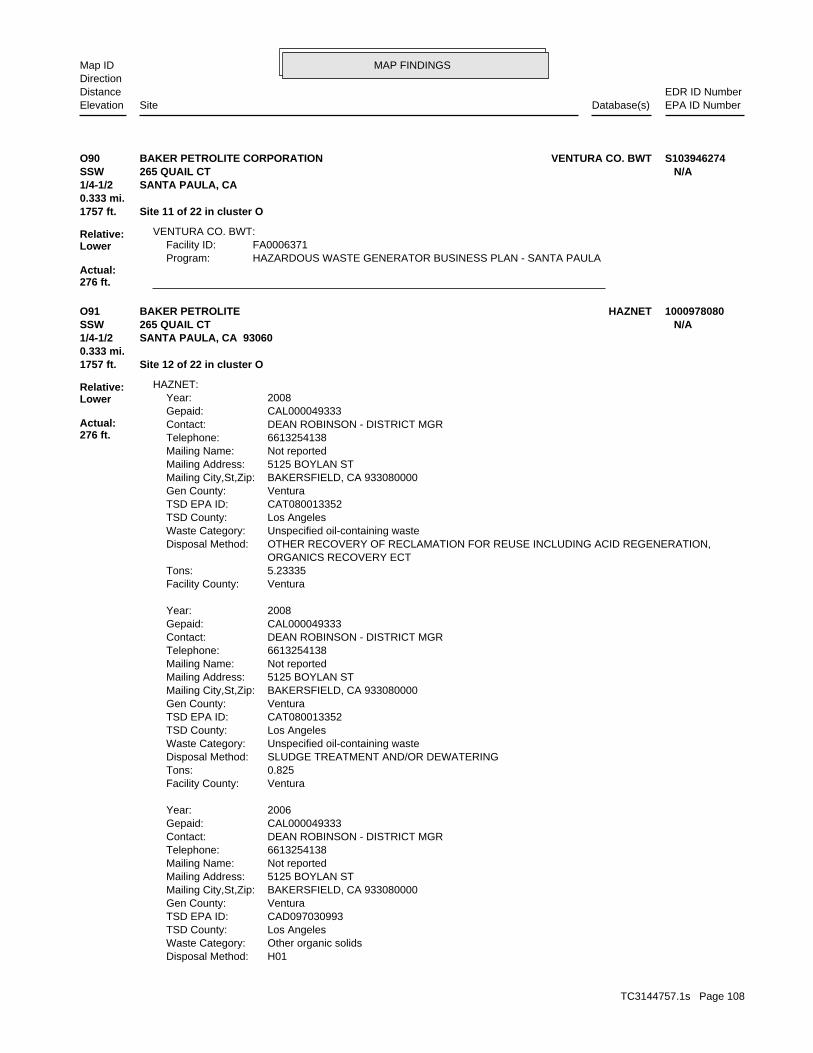
MAP FINDINGSMap IDDirection
EDR ID NumberDistanceEPA ID NumberDatabase(s)SiteElevation
HAZARDOUS WASTE GENERATOR BUSINESS PLAN - SANTA PAULAProgram:FA0006371Facility ID:
VENTURA CO. BWT:
1757 ft. Site 11 of 22 in cluster O0.333 mi.
Relative:Lower
Actual:276 ft.
1/4-1/2 SANTA PAULA, CA SSW 265 QUAIL CT N/AO90 VENTURA CO. BWTBAKER PETROLITE CORPORATION S103946274
H01Disposal Method: Other organic solidsWaste Category: Los AngelesTSD County: CAD097030993TSD EPA ID: VenturaGen County: BAKERSFIELD, CA 933080000Mailing City,St,Zip: 5125 BOYLAN STMailing Address: Not reportedMailing Name: 6613254138Telephone: DEAN ROBINSON - DISTRICT MGRContact: CAL000049333Gepaid: 2006Year:
VenturaFacility County: 0.825Tons: SLUDGE TREATMENT AND/OR DEWATERINGDisposal Method: Unspecified oil-containing wasteWaste Category: Los AngelesTSD County: CAT080013352TSD EPA ID: VenturaGen County: BAKERSFIELD, CA 933080000Mailing City,St,Zip: 5125 BOYLAN STMailing Address: Not reportedMailing Name: 6613254138Telephone: DEAN ROBINSON - DISTRICT MGRContact: CAL000049333Gepaid: 2008Year:
VenturaFacility County: 5.23335Tons: ORGANICS RECOVERY ECT OTHER RECOVERY OF RECLAMATION FOR REUSE INCLUDING ACID REGENERATION,Disposal Method: Unspecified oil-containing wasteWaste Category: Los AngelesTSD County: CAT080013352TSD EPA ID: VenturaGen County: BAKERSFIELD, CA 933080000Mailing City,St,Zip: 5125 BOYLAN STMailing Address: Not reportedMailing Name: 6613254138Telephone: DEAN ROBINSON - DISTRICT MGRContact: CAL000049333Gepaid: 2008Year:
HAZNET:
1757 ft. Site 12 of 22 in cluster O0.333 mi.
Relative:Lower
Actual:276 ft.
1/4-1/2 SANTA PAULA, CA 93060SSW 265 QUAIL CT N/AO91 HAZNETBAKER PETROLITE 1000978080
TC3144757.1s Page 108

MAP FINDINGSMap IDDirection
EDR ID NumberDistanceEPA ID NumberDatabase(s)SiteElevation
45 additional CA_HAZNET: record(s) in the EDR Site Report.Click this hyperlink while viewing on your computer to access
Not reportedFacility County: 0.64Tons: Not reportedDisposal Method: Off-specification, aged or surplus organicsWaste Category: Los AngelesTSD County: CAT080013352TSD EPA ID: VenturaGen County: BAKERSFIELD, CA 933080000Mailing City,St,Zip: 5125 BOYLAN STMailing Address: Not reportedMailing Name: 6613254138Telephone: DEAN ROBINSON - DISTRICT MGRContact: CAL000049333Gepaid: 2004Year:
Not reportedFacility County: 0.64Tons: Not reportedDisposal Method: Off-specification, aged or surplus organicsWaste Category: Los AngelesTSD County: CAT080013352TSD EPA ID: VenturaGen County: BAKERSFIELD, CA 933080000Mailing City,St,Zip: 5125 BOYLAN STMailing Address: Not reportedMailing Name: 6613254138Telephone: DEAN ROBINSON - DISTRICT MGRContact: CAL000049333Gepaid: 2005Year:
VenturaFacility County: 0.01Tons:
BAKER PETROLITE (Continued) 1000978080
112(r) of the Clean Air Act (CAA).certain flammable or toxic substances, as required under sectionplans reported by companies that handle, manufacture, use, or storeUS EPA Risk Management Plan (RMP) database stores the risk management Environmental Interest/Information System
110000510368Registry ID:
FINDS:
1757 ft. Site 13 of 22 in cluster O0.333 mi.
Relative:Lower
Actual:276 ft.
1/4-1/2 SANTA PAULA, CA 93060SSW 265 QUAIL COURT N/AO92 FINDSBAKER PETRLOTE CORPORATION - SANTA PAULA 1012067405
TC3144757.1s Page 109

MAP FINDINGSMap IDDirection
EDR ID NumberDistanceEPA ID NumberDatabase(s)SiteElevation
Not reportedCommunity Health Air Pollution Info System: VENTURA COUNTY APCDAir District Name: 1311SIC Code: VENAir District Name: 56Facility ID: SCCAir Basin: 56County Code: 1995Year:
0Part. Matter 10 Micrometers & Smllr Tons/Yr: 0Particulate Matter Tons/Yr: 0SOX - Oxides of Sulphur Tons/Yr: 3NOX - Oxides of Nitrogen Tons/Yr: 45Carbon Monoxide Emissions Tons/Yr: 10Reactive Organic Gases Tons/Yr: 30Total Organic Hydrocarbon Gases Tons/Yr: Not reportedConsolidated Emission Reporting Rule: Not reportedCommunity Health Air Pollution Info System: VENTURA COUNTY APCDAir District Name: 1311SIC Code: VENAir District Name: 939Facility ID: SCCAir Basin: 56County Code: 1990Year:
0Part. Matter 10 Micrometers & Smllr Tons/Yr: 0Particulate Matter Tons/Yr: 0SOX - Oxides of Sulphur Tons/Yr: 3NOX - Oxides of Nitrogen Tons/Yr: 26Carbon Monoxide Emissions Tons/Yr: 15Reactive Organic Gases Tons/Yr: 30Total Organic Hydrocarbon Gases Tons/Yr: Not reportedConsolidated Emission Reporting Rule: Not reportedCommunity Health Air Pollution Info System: VENTURA COUNTY APCDAir District Name: 1311SIC Code: VENAir District Name: 939Facility ID: SCCAir Basin: 56County Code: 1987Year:
EMI:
their precursors, as well as hazardous air pollutants (HAPs).on stationary and mobile sources that emit criteria air pollutants andThe NEI (National Emissions Inventory) database contains information Environmental Interest/Information System
110013930489Registry ID:
FINDS:
1796 ft. Site 14 of 22 in cluster O0.340 mi.
Relative:Lower
Actual:276 ft.
1/4-1/2 SANTA PAULA, CA 93060SSW EMI270 QUAIL CT #100 N/AO93 FINDSVINTAGE PETROLEUM 1006832453
TC3144757.1s Page 110

MAP FINDINGSMap IDDirection
EDR ID NumberDistanceEPA ID NumberDatabase(s)SiteElevation
0SOX - Oxides of Sulphur Tons/Yr: 0NOX - Oxides of Nitrogen Tons/Yr: 0Carbon Monoxide Emissions Tons/Yr: 17Reactive Organic Gases Tons/Yr: 30Total Organic Hydrocarbon Gases Tons/Yr: Not reportedConsolidated Emission Reporting Rule: Not reportedCommunity Health Air Pollution Info System: VENTURA COUNTY APCDAir District Name: 1311SIC Code: VENAir District Name: 56Facility ID: SCCAir Basin: 56County Code: 1996Year:
0Part. Matter 10 Micrometers & Smllr Tons/Yr: 0Particulate Matter Tons/Yr: 0SOX - Oxides of Sulphur Tons/Yr: 1NOX - Oxides of Nitrogen Tons/Yr: 17Carbon Monoxide Emissions Tons/Yr: 8Reactive Organic Gases Tons/Yr: 18Total Organic Hydrocarbon Gases Tons/Yr: Not reportedConsolidated Emission Reporting Rule: Not reportedCommunity Health Air Pollution Info System: VENTURA COUNTY APCDAir District Name: 1311SIC Code: VENAir District Name: 939Facility ID: SCCAir Basin: 56County Code: 1996Year:
0Part. Matter 10 Micrometers & Smllr Tons/Yr: 0Particulate Matter Tons/Yr: 0SOX - Oxides of Sulphur Tons/Yr: 2NOX - Oxides of Nitrogen Tons/Yr: 14Carbon Monoxide Emissions Tons/Yr: 7Reactive Organic Gases Tons/Yr: 17Total Organic Hydrocarbon Gases Tons/Yr: Not reportedConsolidated Emission Reporting Rule: Not reportedCommunity Health Air Pollution Info System: VENTURA COUNTY APCDAir District Name: 1311SIC Code: VENAir District Name: 939Facility ID: SCCAir Basin: 56County Code: 1995Year:
0Part. Matter 10 Micrometers & Smllr Tons/Yr: 0Particulate Matter Tons/Yr: 0SOX - Oxides of Sulphur Tons/Yr: 1NOX - Oxides of Nitrogen Tons/Yr: 0Carbon Monoxide Emissions Tons/Yr: 17Reactive Organic Gases Tons/Yr: 32Total Organic Hydrocarbon Gases Tons/Yr: Not reportedConsolidated Emission Reporting Rule:
VINTAGE PETROLEUM (Continued) 1006832453
TC3144757.1s Page 111

MAP FINDINGSMap IDDirection
EDR ID NumberDistanceEPA ID NumberDatabase(s)SiteElevation
SCCAir Basin: 56County Code: 1998Year:
0Part. Matter 10 Micrometers & Smllr Tons/Yr: 0Particulate Matter Tons/Yr: 0SOX - Oxides of Sulphur Tons/Yr: 0NOX - Oxides of Nitrogen Tons/Yr: 0Carbon Monoxide Emissions Tons/Yr: 13Reactive Organic Gases Tons/Yr: 24Total Organic Hydrocarbon Gases Tons/Yr: Not reportedConsolidated Emission Reporting Rule: Not reportedCommunity Health Air Pollution Info System: VENTURA COUNTY APCDAir District Name: 1311SIC Code: VENAir District Name: 56Facility ID: SCCAir Basin: 56County Code: 1998Year:
0Part. Matter 10 Micrometers & Smllr Tons/Yr: 0Particulate Matter Tons/Yr: 0SOX - Oxides of Sulphur Tons/Yr: 1NOX - Oxides of Nitrogen Tons/Yr: 17Carbon Monoxide Emissions Tons/Yr: 9Reactive Organic Gases Tons/Yr: 20Total Organic Hydrocarbon Gases Tons/Yr: Not reportedConsolidated Emission Reporting Rule: Not reportedCommunity Health Air Pollution Info System: VENTURA COUNTY APCDAir District Name: 1311SIC Code: VENAir District Name: 939Facility ID: SCCAir Basin: 56County Code: 1997Year:
0Part. Matter 10 Micrometers & Smllr Tons/Yr: 0Particulate Matter Tons/Yr: 0SOX - Oxides of Sulphur Tons/Yr: 0NOX - Oxides of Nitrogen Tons/Yr: 0Carbon Monoxide Emissions Tons/Yr: 20Reactive Organic Gases Tons/Yr: 36Total Organic Hydrocarbon Gases Tons/Yr: Not reportedConsolidated Emission Reporting Rule: Not reportedCommunity Health Air Pollution Info System: VENTURA COUNTY APCDAir District Name: 1311SIC Code: VENAir District Name: 56Facility ID: SCCAir Basin: 56County Code: 1997Year:
0Part. Matter 10 Micrometers & Smllr Tons/Yr: 0Particulate Matter Tons/Yr:
VINTAGE PETROLEUM (Continued) 1006832453
TC3144757.1s Page 112

MAP FINDINGSMap IDDirection
EDR ID NumberDistanceEPA ID NumberDatabase(s)SiteElevation
Not reportedConsolidated Emission Reporting Rule: Not reportedCommunity Health Air Pollution Info System: VENTURA COUNTY APCDAir District Name: 1311SIC Code: VENAir District Name: 939Facility ID: SCCAir Basin: 56County Code: 2000Year:
0Part. Matter 10 Micrometers & Smllr Tons/Yr: 0Particulate Matter Tons/Yr: 0SOX - Oxides of Sulphur Tons/Yr: 1NOX - Oxides of Nitrogen Tons/Yr: 25Carbon Monoxide Emissions Tons/Yr: 7Reactive Organic Gases Tons/Yr: 29Total Organic Hydrocarbon Gases Tons/Yr: Not reportedConsolidated Emission Reporting Rule: Not reportedCommunity Health Air Pollution Info System: VENTURA COUNTY APCDAir District Name: 1311SIC Code: VENAir District Name: 939Facility ID: SCCAir Basin: 56County Code: 1999Year:
0Part. Matter 10 Micrometers & Smllr Tons/Yr: 0Particulate Matter Tons/Yr: 0SOX - Oxides of Sulphur Tons/Yr: 0NOX - Oxides of Nitrogen Tons/Yr: 0Carbon Monoxide Emissions Tons/Yr: 11Reactive Organic Gases Tons/Yr: 20Total Organic Hydrocarbon Gases Tons/Yr: Not reportedConsolidated Emission Reporting Rule: Not reportedCommunity Health Air Pollution Info System: VENTURA COUNTY APCDAir District Name: 1311SIC Code: VENAir District Name: 56Facility ID: SCCAir Basin: 56County Code: 1999Year:
0Part. Matter 10 Micrometers & Smllr Tons/Yr: 0Particulate Matter Tons/Yr: 0SOX - Oxides of Sulphur Tons/Yr: 1NOX - Oxides of Nitrogen Tons/Yr: 18Carbon Monoxide Emissions Tons/Yr: 7Reactive Organic Gases Tons/Yr: 28Total Organic Hydrocarbon Gases Tons/Yr: Not reportedConsolidated Emission Reporting Rule: Not reportedCommunity Health Air Pollution Info System: VENTURA COUNTY APCDAir District Name: 1311SIC Code: VENAir District Name: 939Facility ID:
VINTAGE PETROLEUM (Continued) 1006832453
TC3144757.1s Page 113

MAP FINDINGSMap IDDirection
EDR ID NumberDistanceEPA ID NumberDatabase(s)SiteElevation
0Particulate Matter Tons/Yr: 0SOX - Oxides of Sulphur Tons/Yr: 1NOX - Oxides of Nitrogen Tons/Yr: 0Carbon Monoxide Emissions Tons/Yr: 11Reactive Organic Gases Tons/Yr: 18Total Organic Hydrocarbon Gases Tons/Yr: Not reportedConsolidated Emission Reporting Rule: YCommunity Health Air Pollution Info System: VENTURA COUNTY APCDAir District Name: 1311SIC Code: VENAir District Name: 56Facility ID: SCCAir Basin: 56County Code: 2001Year:
0Part. Matter 10 Micrometers & Smllr Tons/Yr: 0Particulate Matter Tons/Yr: 0SOX - Oxides of Sulphur Tons/Yr: 1NOX - Oxides of Nitrogen Tons/Yr: 21Carbon Monoxide Emissions Tons/Yr: 6Reactive Organic Gases Tons/Yr: 26Total Organic Hydrocarbon Gases Tons/Yr: Not reportedConsolidated Emission Reporting Rule: YCommunity Health Air Pollution Info System: VENTURA COUNTY APCDAir District Name: 1311SIC Code: VENAir District Name: 939Facility ID: SCCAir Basin: 56County Code: 2001Year:
0Part. Matter 10 Micrometers & Smllr Tons/Yr: 0Particulate Matter Tons/Yr: 0SOX - Oxides of Sulphur Tons/Yr: 1NOX - Oxides of Nitrogen Tons/Yr: 0Carbon Monoxide Emissions Tons/Yr: 10Reactive Organic Gases Tons/Yr: 18Total Organic Hydrocarbon Gases Tons/Yr: Not reportedConsolidated Emission Reporting Rule: Not reportedCommunity Health Air Pollution Info System: VENTURA COUNTY APCDAir District Name: 1311SIC Code: VENAir District Name: 56Facility ID: SCCAir Basin: 56County Code: 2000Year:
0Part. Matter 10 Micrometers & Smllr Tons/Yr: 0Particulate Matter Tons/Yr: 0SOX - Oxides of Sulphur Tons/Yr: 1NOX - Oxides of Nitrogen Tons/Yr: 21Carbon Monoxide Emissions Tons/Yr: 6Reactive Organic Gases Tons/Yr: 25Total Organic Hydrocarbon Gases Tons/Yr:
VINTAGE PETROLEUM (Continued) 1006832453
TC3144757.1s Page 114

MAP FINDINGSMap IDDirection
EDR ID NumberDistanceEPA ID NumberDatabase(s)SiteElevation
56Facility ID: SCCAir Basin: 56County Code: 2003Year:
0Part. Matter 10 Micrometers & Smllr Tons/Yr: 0Particulate Matter Tons/Yr: 0SOX - Oxides of Sulphur Tons/Yr: 1NOX - Oxides of Nitrogen Tons/Yr: 21Carbon Monoxide Emissions Tons/Yr: 7Reactive Organic Gases Tons/Yr: 30Total Organic Hydrocarbon Gases Tons/Yr: Not reportedConsolidated Emission Reporting Rule: YCommunity Health Air Pollution Info System: VENTURA COUNTY APCDAir District Name: 1311SIC Code: VENAir District Name: 939Facility ID: SCCAir Basin: 56County Code: 2003Year:
0Part. Matter 10 Micrometers & Smllr Tons/Yr: 0Particulate Matter Tons/Yr: 0SOX - Oxides of Sulphur Tons/Yr: 1NOX - Oxides of Nitrogen Tons/Yr: 18Carbon Monoxide Emissions Tons/Yr: 7Reactive Organic Gases Tons/Yr: 27Total Organic Hydrocarbon Gases Tons/Yr: Not reportedConsolidated Emission Reporting Rule: YCommunity Health Air Pollution Info System: VENTURA COUNTY APCDAir District Name: 1311SIC Code: VENAir District Name: 939Facility ID: SCCAir Basin: 56County Code: 2002Year:
0Part. Matter 10 Micrometers & Smllr Tons/Yr: 0Particulate Matter Tons/Yr: 0SOX - Oxides of Sulphur Tons/Yr: 1NOX - Oxides of Nitrogen Tons/Yr: 0Carbon Monoxide Emissions Tons/Yr: 12Reactive Organic Gases Tons/Yr: 21Total Organic Hydrocarbon Gases Tons/Yr: Not reportedConsolidated Emission Reporting Rule: YCommunity Health Air Pollution Info System: VENTURA COUNTY APCDAir District Name: 1311SIC Code: VENAir District Name: 56Facility ID: SCCAir Basin: 56County Code: 2002Year:
0Part. Matter 10 Micrometers & Smllr Tons/Yr:
VINTAGE PETROLEUM (Continued) 1006832453
TC3144757.1s Page 115
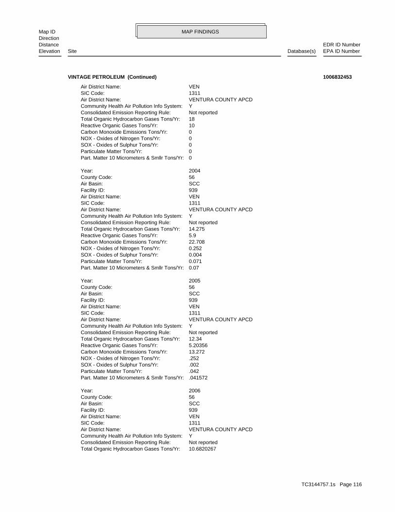
MAP FINDINGSMap IDDirection
EDR ID NumberDistanceEPA ID NumberDatabase(s)SiteElevation
10.6820267Total Organic Hydrocarbon Gases Tons/Yr: Not reportedConsolidated Emission Reporting Rule: YCommunity Health Air Pollution Info System: VENTURA COUNTY APCDAir District Name: 1311SIC Code: VENAir District Name: 939Facility ID: SCCAir Basin: 56County Code: 2006Year:
.041572Part. Matter 10 Micrometers & Smllr Tons/Yr: .042Particulate Matter Tons/Yr: .002SOX - Oxides of Sulphur Tons/Yr: .252NOX - Oxides of Nitrogen Tons/Yr: 13.272Carbon Monoxide Emissions Tons/Yr: 5.20356Reactive Organic Gases Tons/Yr: 12.34Total Organic Hydrocarbon Gases Tons/Yr: Not reportedConsolidated Emission Reporting Rule: YCommunity Health Air Pollution Info System: VENTURA COUNTY APCDAir District Name: 1311SIC Code: VENAir District Name: 939Facility ID: SCCAir Basin: 56County Code: 2005Year:
0.07Part. Matter 10 Micrometers & Smllr Tons/Yr: 0.071Particulate Matter Tons/Yr: 0.004SOX - Oxides of Sulphur Tons/Yr: 0.252NOX - Oxides of Nitrogen Tons/Yr: 22.708Carbon Monoxide Emissions Tons/Yr: 5.9Reactive Organic Gases Tons/Yr: 14.275Total Organic Hydrocarbon Gases Tons/Yr: Not reportedConsolidated Emission Reporting Rule: YCommunity Health Air Pollution Info System: VENTURA COUNTY APCDAir District Name: 1311SIC Code: VENAir District Name: 939Facility ID: SCCAir Basin: 56County Code: 2004Year:
0Part. Matter 10 Micrometers & Smllr Tons/Yr: 0Particulate Matter Tons/Yr: 0SOX - Oxides of Sulphur Tons/Yr: 0NOX - Oxides of Nitrogen Tons/Yr: 0Carbon Monoxide Emissions Tons/Yr: 10Reactive Organic Gases Tons/Yr: 18Total Organic Hydrocarbon Gases Tons/Yr: Not reportedConsolidated Emission Reporting Rule: YCommunity Health Air Pollution Info System: VENTURA COUNTY APCDAir District Name: 1311SIC Code: VENAir District Name:
VINTAGE PETROLEUM (Continued) 1006832453
TC3144757.1s Page 116

MAP FINDINGSMap IDDirection
EDR ID NumberDistanceEPA ID NumberDatabase(s)SiteElevation
.0038Part. Matter 10 Micrometers & Smllr Tons/Yr: .004Particulate Matter Tons/Yr: 0SOX - Oxides of Sulphur Tons/Yr: .05NOX - Oxides of Nitrogen Tons/Yr: .042Carbon Monoxide Emissions Tons/Yr: 5.08870265Reactive Organic Gases Tons/Yr:
VINTAGE PETROLEUM (Continued) 1006832453
STORAGE, BULKING, AND/OR TRANSFER OFF SITE--NO TREATMENT/REOVERYDisposal Method: Waste oil and mixed oilWaste Category: Los AngelesTSD County: CAD044429835TSD EPA ID: VenturaGen County: SANTA PAULA, CA 930609205Mailing City,St,Zip: 270 QUAIL CT STE 100Mailing Address: Not reportedMailing Name: 8057019235Telephone: ALASTAIR WINN PRESIDENTContact: CAL000302771Gepaid: 2007Year:
VenturaFacility County: 0.06Tons: (H010-H129) OR (H131-H135) STORAGE, BULKING, AND/OR TRANSFER OFF SITE--NO TREATMENT/REOVERYDisposal Method: Oxygenated solvents (acetone, butanol, ethyl acetate, etc.)Waste Category: Los AngelesTSD County: CAD044429835TSD EPA ID: VenturaGen County: SANTA PAULA, CA 930609205Mailing City,St,Zip: 270 QUAIL CT STE 100Mailing Address: Not reportedMailing Name: 8057019235Telephone: ALASTAIR WINN PRESIDENTContact: CAL000302771Gepaid: 2007Year:
VenturaFacility County: 0.41Tons: (H010-H129) OR (H131-H135) STORAGE, BULKING, AND/OR TRANSFER OFF SITE--NO TREATMENT/REOVERYDisposal Method: Oil/water separation sludgeWaste Category: Los AngelesTSD County: CAD044429835TSD EPA ID: VenturaGen County: SANTA PAULA, CA 930609205Mailing City,St,Zip: 270 QUAIL CT STE 100Mailing Address: Not reportedMailing Name: 8057019235Telephone: ALASTAIR WINN PRESIDENTContact: CAL000302771Gepaid: 2007Year:
HAZNET:
1796 ft. Site 15 of 22 in cluster O0.340 mi.
Relative:Lower
Actual:276 ft.
1/4-1/2 SANTA PAULA, CA 93060SSW 270 QUAIL CT STE 100 N/AO94 HAZNETAPPLIED SILCONE CORP S108742402
TC3144757.1s Page 117

MAP FINDINGSMap IDDirection
EDR ID NumberDistanceEPA ID NumberDatabase(s)SiteElevation
VenturaFacility County: 0.05Tons: T03Disposal Method: Not reportedWaste Category: 99TSD County: UTD981552177TSD EPA ID: VenturaGen County: SANTA PAULA, CA 930609205Mailing City,St,Zip: 270 QUAIL CT STE 100Mailing Address: Not reportedMailing Name: 8057019235Telephone: ALASTAIR WINN PRESIDENTContact: CAL000302771Gepaid: 2006Year:
VenturaFacility County: 0.76Tons: (H010-H129) OR (H131-H135)
APPLIED SILCONE CORP (Continued) S108742402
Incident Tracking, Compliance Assistance, and Compliance Monitoring.that support Compliance and Enforcement programs. These include;has the capability to track other activities occurring in the Regionthat information with Federal actions already in the system. ICIS alsoCompliance System (PCS) which supports the NPDES and will integrateit Headquarters. A future release of ICIS will replace the Permitinformation is maintained in ICIS by EPA in the Regional offices andFederal Administrative and Judicial enforcement actions. Thisa single repository for that information. Currently, ICIS contains allreplace EPA’s independent databases that contain Enforcement data withinformation across most of EPA’s programs. The vision for ICIS is tocomplete, will contain integrated Enforcement and ComplianceCompliance Information System and provides a database that, whenICIS (Integrated Compliance Information System) is the Integrated Environmental Interest/Information System
110032598213Registry ID:
FINDS:
1796 ft. Site 16 of 22 in cluster O0.340 mi.
Relative:Lower
Actual:276 ft.
1/4-1/2 SANTA PAULA, CA 93060SSW 270 QUAIL COURT N/AO95 FINDSVINTAGE PRODUCTION CALIFORNIA 1010494153
110020745274Registry ID:
FINDS:
1796 ft. Site 17 of 22 in cluster O0.340 mi.
Relative:Lower
Actual:276 ft.
1/4-1/2 SANTA PAULA, CA 93060SSW 270 QUAIL COURT N/AO96 FINDSSKS ENVIRONMENTAL LLC 1008002995
TC3144757.1s Page 118

MAP FINDINGSMap IDDirection
EDR ID NumberDistanceEPA ID NumberDatabase(s)SiteElevation
corrective action activities required under RCRA.program staff to track the notification, permit, compliance, andand treat, store, or dispose of hazardous waste. RCRAInfo allows RCRAevents and activities related to facilities that generate, transport,Conservation and Recovery Act (RCRA) program through the tracking ofRCRAInfo is a national information system that supports the Resource Environmental Interest/Information System
SKS ENVIRONMENTAL LLC (Continued) 1008002995
NoFurnace exemption: NoOn-site burner exemption: NoUnderground injection activity: NoTreater, storer or disposer of HW: NoTransporter of hazardous waste: NoRecycler of hazardous waste: NoMixed waste (haz. and radioactive): NoU.S. importer of hazardous waste:
Handler Activities Summary:
Not reportedOwner/Op end date: Not reportedOwner/Op start date: OwnerOwner/Operator Type: PrivateLegal status: (805) 525-7474Owner/operator telephone: Not reportedOwner/operator country: SANTA PAULA, CA 93060 270 QUAIL CTOwner/operator address: DOUGLAS W BURHOE JROwner/operator name:
Owner/Operator Summary:
hazardous waste at any time waste during any calendar month, and accumulates more than 1000 kg of hazardous waste at any time; or generates 100 kg or less of hazardous waste during any calendar month and accumulates less than 6000 kg of Handler: generates more than 100 and less than 1000 kg of hazardousDescription: Small Small Quantity GeneratorClassification: 09EPA Region: Not reportedContact email: (805) 525-7474Contact telephone: USContact country: SANTA PAULA, CA 93060 270 QUAIL CTContact address: FREDERICK BURHOEContact: SANTA PAULA, CA 93060 QUAIL CTMailing address: CAD983639956EPA ID: SANTA PAULA, CA 93060 270 QUAIL CTFacility address: D W BURHOE CONSTRUCTION INCFacility name: 06/15/1992Date form received by agency:
RCRA-SQG:
1796 ft. Site 18 of 22 in cluster O0.340 mi.
Relative:Lower
Actual:276 ft.
1/4-1/2 HAZNETSANTA PAULA, CA 93060SSW FINDS270 QUAIL CT CAD983639956O97 RCRA-SQGD W BURHOE CONSTRUCTION INC 1000686646
TC3144757.1s Page 119

MAP FINDINGSMap IDDirection
EDR ID NumberDistanceEPA ID NumberDatabase(s)SiteElevation
DOUGLAS W BURHOE JRContact: CAD983639956Gepaid: 2000Year:
Not reportedFacility County: 14.41Tons: R01Disposal Method: Oil/water separation sludgeWaste Category: Los AngelesTSD County: CAT080013352TSD EPA ID: VenturaGen County: SANTA PAULA, CA 93066Mailing City,St,Zip: 11775 FOOTHILL BLVDMailing Address: Not reportedMailing Name: 8055257474Telephone: CAROL A BURHOE-SEC/CFOContact: CAC002587070Gepaid: 2005Year:
VenturaFacility County: 0.2Tons: H01Disposal Method: Unspecified solvent mixtureWaste Category: Los AngelesTSD County: CAD028409019TSD EPA ID: VenturaGen County: SANTA PAULA, CA 930610911Mailing City,St,Zip: PO BOX 911Mailing Address: Not reportedMailing Name: 8052906385Telephone: DOUG BURHOEContact: CAC002605957Gepaid: 2006Year:
HAZNET:
corrective action activities required under RCRA.program staff to track the notification, permit, compliance, andand treat, store, or dispose of hazardous waste. RCRAInfo allows RCRAevents and activities related to facilities that generate, transport,Conservation and Recovery Act (RCRA) program through the tracking ofRCRAInfo is a national information system that supports the Resource Environmental Interest/Information System
110002878789Registry ID:
FINDS:
No violations foundViolation Status:
NoUsed oil transporter: NoUsed oil transfer facility: NoUsed oil Specification marketer: NoUsed oil fuel marketer to burner: NoUser oil refiner: NoUsed oil processor: NoUsed oil fuel burner:
D W BURHOE CONSTRUCTION INC (Continued) 1000686646
TC3144757.1s Page 120

MAP FINDINGSMap IDDirection
EDR ID NumberDistanceEPA ID NumberDatabase(s)SiteElevation
VenturaFacility County: .2001Tons: H01Disposal Method: Liquids with halogenated organic compounds >= 1,000 Mg./LWaste Category: OrangeTSD County: CAT000613976TSD EPA ID: VenturaGen County: SANTA PAULA, CA 930609653Mailing City,St,Zip: 270 QUAIL CTMailing Address: Not reportedMailing Name: 8055257474Telephone:
D W BURHOE CONSTRUCTION INC (Continued) 1000686646
VENAir District Name: 1153Facility ID: SCCAir Basin: 56County Code: 1997Year:
0Part. Matter 10 Micrometers & Smllr Tons/Yr: 0Particulate Matter Tons/Yr: 0SOX - Oxides of Sulphur Tons/Yr: 0NOX - Oxides of Nitrogen Tons/Yr: 0Carbon Monoxide Emissions Tons/Yr: 0Reactive Organic Gases Tons/Yr: 0Total Organic Hydrocarbon Gases Tons/Yr: Not reportedConsolidated Emission Reporting Rule: Not reportedCommunity Health Air Pollution Info System: VENTURA COUNTY APCDAir District Name: 8711SIC Code: VENAir District Name: 1153Facility ID: SCCAir Basin: 56County Code: 1996Year:
0Part. Matter 10 Micrometers & Smllr Tons/Yr: 0Particulate Matter Tons/Yr: 0SOX - Oxides of Sulphur Tons/Yr: 0NOX - Oxides of Nitrogen Tons/Yr: 0Carbon Monoxide Emissions Tons/Yr: 0Reactive Organic Gases Tons/Yr: 0Total Organic Hydrocarbon Gases Tons/Yr: Not reportedConsolidated Emission Reporting Rule: Not reportedCommunity Health Air Pollution Info System: VENTURA COUNTY APCDAir District Name: 8711SIC Code: VENAir District Name: 1153Facility ID: SCCAir Basin: 56County Code: 1995Year:
EMI:
1796 ft. Site 19 of 22 in cluster O0.340 mi.
Relative:Lower
Actual:276 ft.
1/4-1/2 SANTA PAULA, CA 93060SSW 270 QUAIL COURT N/AO98 EMID.W. BURHOE CONSTRUCTION INC. S106829691
TC3144757.1s Page 121

MAP FINDINGSMap IDDirection
EDR ID NumberDistanceEPA ID NumberDatabase(s)SiteElevation
0Part. Matter 10 Micrometers & Smllr Tons/Yr: 0Particulate Matter Tons/Yr: 0SOX - Oxides of Sulphur Tons/Yr: 0NOX - Oxides of Nitrogen Tons/Yr: 0Carbon Monoxide Emissions Tons/Yr: 0Reactive Organic Gases Tons/Yr: 0Total Organic Hydrocarbon Gases Tons/Yr: Not reportedConsolidated Emission Reporting Rule: Not reportedCommunity Health Air Pollution Info System: VENTURA COUNTY APCDAir District Name: 8711SIC Code:
D.W. BURHOE CONSTRUCTION INC. (Continued) S106829691
1389SIC Code: Not reportedNAIC Code: Not reportedFed Facility: NTribal Indicator: 270 QUAIL COURTAddress: VINTAGE PRODUCTION CALIFORNIAFacility Name: FRS 110032598213Program ID:
10EPA Region #: VenturaFacility County: CWA 311B6B1 AO For Class I Penalty - Spill Expedited Settlement Pilot (Regionally Approved)Enforcement Action Type: SANTA PAULA, California 93060 270 QUAIL COURT SANTA PAULA CA 93060Facility Address: VINTAGE PRODUCTION CALIFORNIAFacility Name: VINTAGE PRODUCTION CALIFORNIAAction Name: FRS 110032598213Program ID: 110032598213FRS ID: 09-2007-0134Enforcement Action ID:
ICIS:
1796 ft. Site 20 of 22 in cluster O0.340 mi.
Relative:Lower
Actual:276 ft.
1/4-1/2 SANTA PAULA, CA 93060SSW 270 QUAIL COURT SANTA PAULA CA 93060 N/AO99 ICISVINTAGE PRODUCTION CALIFORNIA 1011536983
SANTA PAULA, CA 93060 275 QUAIL CTContact address: JOHN HALESContact: SANTA PAULA, CA 93060 QUAIL CTMailing address: CAD983669771EPA ID: SANTA PAULA, CA 93060 275 QUAIL CTFacility address: HALLIBURTON RESERVOIR SERVICESFacility name: 06/14/1993Date form received by agency:
RCRA-SQG:
1818 ft. Site 21 of 22 in cluster O0.344 mi.
Relative:Lower
Actual:275 ft.
1/4-1/2 HAZNETSANTA PAULA, CA 93060SSW FINDS275 QUAIL CT CAD983669771O100 RCRA-SQGHALLIBURTON RESERVOIR SERVICES 1000857540
TC3144757.1s Page 122

MAP FINDINGSMap IDDirection
EDR ID NumberDistanceEPA ID NumberDatabase(s)SiteElevation
1994Year:HAZNET:
corrective action activities required under RCRA.program staff to track the notification, permit, compliance, andand treat, store, or dispose of hazardous waste. RCRAInfo allows RCRAevents and activities related to facilities that generate, transport,Conservation and Recovery Act (RCRA) program through the tracking ofRCRAInfo is a national information system that supports the Resource Environmental Interest/Information System
110002900237Registry ID:
FINDS:
No violations foundViolation Status:
NoUsed oil transporter: NoUsed oil transfer facility: NoUsed oil Specification marketer: NoUsed oil fuel marketer to burner: NoUser oil refiner: NoUsed oil processor: NoUsed oil fuel burner: NoFurnace exemption: NoOn-site burner exemption: NoUnderground injection activity: NoTreater, storer or disposer of HW: NoTransporter of hazardous waste: NoRecycler of hazardous waste: NoMixed waste (haz. and radioactive): NoU.S. importer of hazardous waste:
Handler Activities Summary:
Not reportedOwner/Op end date: Not reportedOwner/Op start date: OwnerOwner/Operator Type: PrivateLegal status: (714) 978-7900Owner/operator telephone: Not reportedOwner/operator country: ANAHEIM, CA 92806 1729 DOUGLASS RD STE COwner/operator address: DANIEL POSILOVICHOwner/operator name:
Owner/Operator Summary:
hazardous waste at any time waste during any calendar month, and accumulates more than 1000 kg of hazardous waste at any time; or generates 100 kg or less of hazardous waste during any calendar month and accumulates less than 6000 kg of Handler: generates more than 100 and less than 1000 kg of hazardousDescription: Small Small Quantity GeneratorClassification: 09EPA Region: Not reportedContact email: (805) 525-7422Contact telephone: USContact country:
HALLIBURTON RESERVOIR SERVICES (Continued) 1000857540
TC3144757.1s Page 123
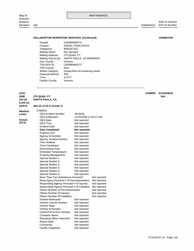
MAP FINDINGSMap IDDirection
EDR ID NumberDistanceEPA ID NumberDatabase(s)SiteElevation
VenturaFacility County: 3.3777Tons: R01Disposal Method: Unspecified oil-containing wasteWaste Category: KernTSD County: CAD980883177TSD EPA ID: VenturaGen County: SANTA PAULA, CA 930600000Mailing City,St,Zip: 275 QUAIL CTMailing Address: Not reportedMailing Name: 8055257422Telephone: DANIEL POSILOVICHContact: CAD983669771Gepaid:
HALLIBURTON RESERVOIR SERVICES (Continued) 1000857540
Not reportedFacility Telephone: Not reportedComments: Not reportedReport Date: Not reportedReporting Officer Name/ID: Not reportedCompany Name: Not reportedCA/DOT/PUC/ICC Number: Not reportedVehicle Id Number: Not reportedVehicle State: Not reportedVehicle License Number: Not reportedVehicle Make/year: Not reportedOthers Number Of Fatalities: Not reportedOthers Number Of Injuries: Not reportedOthers Number Of Decontaminated: Not reportedResponding Agency Personel # Of Fatalities: Not reportedResponding Agency Personel # Of Injuries: Not reportedResp Agncy Personel # Of Decontaminated: Not reportedMore Than Two Substances Involved?: Not reportedSpecial Studies 6: Not reportedSpecial Studies 5: Not reportedSpecial Studies 4: Not reportedSpecial Studies 3: Not reportedSpecial Studies 2: Not reportedSpecial Studies 1: Not reportedProperty Management: Not reportedEstimated Temperature: Not reportedSurrounding Area: Not reportedTime Completed: Not reportedTime Notified: Not reportedAgency Incident Number: Not reportedAgency Id Number: Not reportedProperty Use: Not reportedDate Completed: Not reportedIncident Date: Not reportedOES Time: Not reportedOES Date: 11/25/2008 11:50:27 AMOES notification: ’08-8436OES Incident Number:
CHMIRS:
1818 ft. Site 22 of 22 in cluster O0.344 mi.
Relative:Lower
Actual:275 ft.
1/4-1/2 SANTA PAULA, CA SSW 275 QUAIL CT. N/AO101 CHMIRS S110419222
TC3144757.1s Page 124

MAP FINDINGSMap IDDirection
EDR ID NumberDistanceEPA ID NumberDatabase(s)SiteElevation
sewage was recovered. A lift station backed up into intercepter. All but 10 gallons ofDescription: 0Number of Fatalities: 0Number of Injuries: 0Evacuations: Not reportedUnknown: Not reportedTons: Not reportedSheen: Not reportedQuarts: Not reportedPints: Not reportedOunces: Not reportedLiters: Not reportedPounds: Not reportedGrams: Not reportedGallons: Not reportedCUFT: Not reportedCups: Not reportedBBLS: 200Quantity Released: SewageSubstance: Not reportedE Date: storm drainSite Type: YesContained: Not reportedAmount: Santa Paula Fire DepartmentAdmin Agency: 11/25/2008Incident Date: Southwest WaterAgency: 2008Year: 1000Date/Time: Not reportedOther: Gal(s)Measure: Not reportedType: Not reportedWhat Happened: Not reportedContainment: Reporting PartyCleanup By: Treatment/Sewage FacilitySpill Site: storm drainWaterway: YesWaterway Involved:
(Continued) S110419222
H01Disposal Method: Hydrocarbon solvents (benzene, hexane, Stoddard, Etc.)Waste Category: VenturaTSD County: CAD053044053TSD EPA ID: VenturaGen County: SANTA PAULA, CA 930600000Mailing City,St,Zip: 1465 E MAIN STMailing Address: Not reportedMailing Name: 8055254002Telephone: RICHARD DAILYContact: CAL000203489Gepaid: 2003Year:
HAZNET:
1826 ft. Site 2 of 4 in cluster P0.346 mi.
Relative:Higher
Actual:299 ft.
1/4-1/2 SANTA PAULA, CA 93060WSW 1465 E MAIN ST N/AP102 HAZNETB&R AUTOMOTIVE REPAIR S106091646
TC3144757.1s Page 125

MAP FINDINGSMap IDDirection
EDR ID NumberDistanceEPA ID NumberDatabase(s)SiteElevation
Not reportedFacility County: 0.62Tons: R01Disposal Method: Waste oil and mixed oilWaste Category: Los AngelesTSD County: Not reportedTSD EPA ID: VenturaGen County: SANTA PAULA, CA 930600000Mailing City,St,Zip: 1465 E MAIN STMailing Address: Not reportedMailing Name: 8055254002Telephone: RICHARD DAILYContact: CAL000203489Gepaid: 2002Year:
Not reportedFacility County: 1.08Tons: R01Disposal Method: Waste oil and mixed oilWaste Category: Los AngelesTSD County: Not reportedTSD EPA ID: VenturaGen County: SANTA PAULA, CA 930600000Mailing City,St,Zip: 1465 E MAIN STMailing Address: Not reportedMailing Name: 8055254002Telephone: RICHARD DAILYContact: CAL000203489Gepaid: 2002Year:
VenturaFacility County: 0.07Tons:
B&R AUTOMOTIVE REPAIR (Continued) S106091646
FRANK PENROSEContact: CAL000152993Gepaid: 1998Year:
VenturaFacility County: 0.1459Tons: R01Disposal Method: Unspecified oil-containing wasteWaste Category: Los AngelesTSD County: CAT080013352TSD EPA ID: VenturaGen County: SANTA PAULA, CA 930600000Mailing City,St,Zip: 1790 LEMONWOOD DRIVEMailing Address: Not reportedMailing Name: 8059332761Telephone: FRANK PENROSEContact: CAL000152993Gepaid: 1999Year:
HAZNET:
1905 ft. Site 3 of 4 in cluster P0.361 mi.
Relative:Higher
Actual:298 ft.
1/4-1/2 SANTA PAULA, CA 93060WSW 1451 E MAIN STREET N/AP103 HAZNETAURORA CASTING & ENGINEERING, INC. S103951271
TC3144757.1s Page 126

MAP FINDINGSMap IDDirection
EDR ID NumberDistanceEPA ID NumberDatabase(s)SiteElevation
VenturaFacility County: .2085Tons: R01Disposal Method: Unspecified oil-containing wasteWaste Category: Los AngelesTSD County: CAT080013352TSD EPA ID: VenturaGen County: SANTA PAULA, CA 930600000Mailing City,St,Zip: 1790 LEMONWOOD DRIVEMailing Address: Not reportedMailing Name: 8059332761Telephone:
AURORA CASTING & ENGINEERING, INC. (Continued) S103951271
BUSINESS PLAN - SANTA PAULA HAZARDOUS WASTE GENERATORProgram:FA0006993Facility ID:
VENTURA CO. BWT:
1905 ft. Site 4 of 4 in cluster P0.361 mi.
Relative:Higher
Actual:298 ft.
1/4-1/2 SANTA PAULA, CA WSW 1451 E MAIN ST N/AP104 VENTURA CO. BWTEDIN’S AUTO REPAIR S105511816
T0611100248Global Id:LUST:
Click here to access the California GeoTracker records for this facility:
Not reportedSite History: GasolinePotential Contaminants of Concern: SoilPotential Media Affect: Not reportedFile Location: 87127LOC Case Number: C-87127RB Case Number: Not reportedLocal Agency: EHDCase Worker: VENTURA COUNTY LOPLead Agency: 1989-04-03 00:00:00Status Date: Completed - Case ClosedStatus: LUST Cleanup SiteCase Type: -119.0473528Longitude: 34.3545458Latitude: T0611100248Global Id: STATERegion:
LUST:
C-87127Reg Id: LTNKAReg By: 56Facility County Code: CORTESERegion:
CORTESE:
1939 ft. Site 1 of 3 in cluster Q0.367 mi.
Relative:Lower
Actual:275 ft.
1/4-1/2 SANTA PAULA, CA 93060SSW LUST208 HALLOCK N/AQ105 HIST CORTESEH & H OIL TOOL S102431101
TC3144757.1s Page 127

MAP FINDINGSMap IDDirection
EDR ID NumberDistanceEPA ID NumberDatabase(s)SiteElevation
Not reportedWell Name: Not reportedWater System: Not reportedOperator: Not reportedLeak Source: Not reportedCause of Leak: Not reportedHow Leak Stopped: Not reportedHow Leak Discovered: 4/3/1989Date the Case was Closed: Not reportedDate Case Last Changed on Database: Not reportedDate Leak Stopped: 7/1/1988Date Confirmation Began: Not reportedDate Leak Record Entered: 11/18/1987Date Leak First Reported: 11/18/1987Date Leak Discovered: EFEnforcement Type: Not reportedCross Street: 56000LLocal Agency: UNKStaff: Not reportedW Global ID: T0611100248Global ID: EDETAbatement Method Used at the Site: SoilCase Type: 87127Local Case No: Not reportedSubstance Quantity: GasolineSubstance: Case ClosedStatus: C-87127facid: VenturaCounty: 04Regional Board: 4Region:
LUST REG 4:
* Historical EnforcementAction: 1987-11-18 00:00:00Date: ENFORCEMENTAction Type: T0611100248Global Id:
Leak ReportedAction: 1950-01-01 00:00:00Date: OtherAction Type: T0611100248Global Id:
Leak DiscoveryAction: 1950-01-01 00:00:00Date: OtherAction Type: T0611100248Global Id:
LUST:
2135766714Phone Number: [email protected]: R4 UNKNOWNCity: Not reportedAddress: LOS ANGELES RWQCB (REGION 4)Organization Name: DANIEL PIROTTONContact Name: Regional Board CaseworkerContact Type:
H & H OIL TOOL (Continued) S102431101
TC3144757.1s Page 128
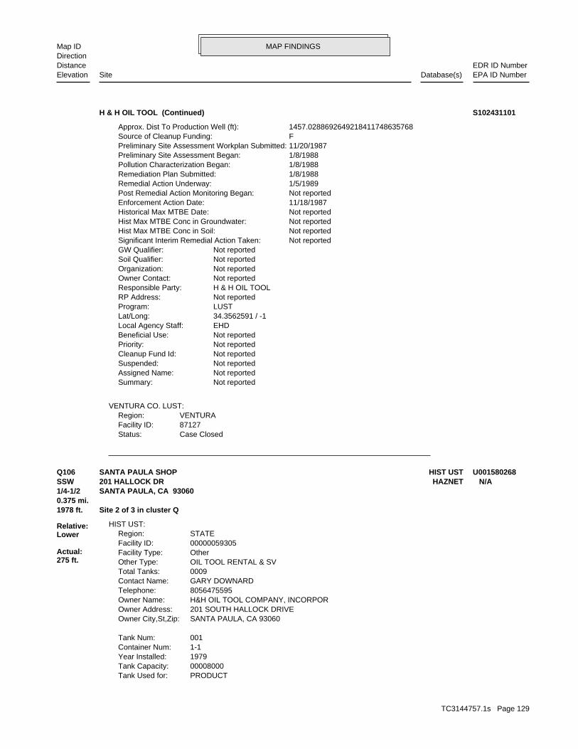
MAP FINDINGSMap IDDirection
EDR ID NumberDistanceEPA ID NumberDatabase(s)SiteElevation
Case ClosedStatus:87127Facility ID:VENTURARegion:
VENTURA CO. LUST:
Not reportedSummary: Not reportedAssigned Name: Not reportedSuspended: Not reportedCleanup Fund Id: Not reportedPriority: Not reportedBeneficial Use: EHDLocal Agency Staff: 34.3562591 / -1Lat/Long: LUSTProgram: Not reportedRP Address: H & H OIL TOOLResponsible Party: Not reportedOwner Contact: Not reportedOrganization: Not reportedSoil Qualifier: Not reportedGW Qualifier: Not reportedSignificant Interim Remedial Action Taken: Not reportedHist Max MTBE Conc in Soil: Not reportedHist Max MTBE Conc in Groundwater: Not reportedHistorical Max MTBE Date: 11/18/1987Enforcement Action Date: Not reportedPost Remedial Action Monitoring Began: 1/5/1989Remedial Action Underway: 1/8/1988Remediation Plan Submitted: 1/8/1988Pollution Characterization Began: 1/8/1988Preliminary Site Assessment Began: 11/20/1987Preliminary Site Assessment Workplan Submitted: FSource of Cleanup Funding: 1457.0288692649218411748635768Approx. Dist To Production Well (ft):
H & H OIL TOOL (Continued) S102431101
PRODUCTTank Used for: 00008000Tank Capacity: 1979Year Installed: 1-1Container Num: 001Tank Num:
SANTA PAULA, CA 93060Owner City,St,Zip: 201 SOUTH HALLOCK DRIVEOwner Address: H&H OIL TOOL COMPANY, INCORPOROwner Name: 8056475595Telephone: GARY DOWNARDContact Name: 0009Total Tanks: OIL TOOL RENTAL & SVOther Type: OtherFacility Type: 00000059305Facility ID: STATERegion:
HIST UST:
1978 ft. Site 2 of 3 in cluster Q0.375 mi.
Relative:Lower
Actual:275 ft.
1/4-1/2 SANTA PAULA, CA 93060SSW HAZNET201 HALLOCK DR N/AQ106 HIST USTSANTA PAULA SHOP U001580268
TC3144757.1s Page 129

MAP FINDINGSMap IDDirection
EDR ID NumberDistanceEPA ID NumberDatabase(s)SiteElevation
VisualLeak Detection: 1/4 inchesTank Construction: WASTE OILType of Fuel: WASTETank Used for: 00000500Tank Capacity: 1984Year Installed: 1-7Container Num: 007Tank Num:
VisualLeak Detection: 4 inchesTank Construction: WASTE OILType of Fuel: WASTETank Used for: 00001500Tank Capacity: 1983Year Installed: 1-6Container Num: 006Tank Num:
VisualLeak Detection: 4 inchesTank Construction: WASTE OILType of Fuel: WASTETank Used for: 00001500Tank Capacity: 1983Year Installed: 1-5Container Num: 005Tank Num:
VisualLeak Detection: 4 inchesTank Construction: WASTE OILType of Fuel: WASTETank Used for: 00001500Tank Capacity: 1983Year Installed: 1-4Container Num: 004Tank Num:
Stock InventorLeak Detection: 1/4 inchesTank Construction: UNLEADEDType of Fuel: PRODUCTTank Used for: 00004000Tank Capacity: 1979Year Installed: 1-3Container Num: 003Tank Num:
Stock InventorLeak Detection: 1/4 inchesTank Construction: DIESELType of Fuel: PRODUCTTank Used for: 00008000Tank Capacity: 1979Year Installed: 1-2Container Num: 002Tank Num:
Stock InventorLeak Detection: 1/4 inchesTank Construction: UNLEADEDType of Fuel:
SANTA PAULA SHOP (Continued) U001580268
TC3144757.1s Page 130
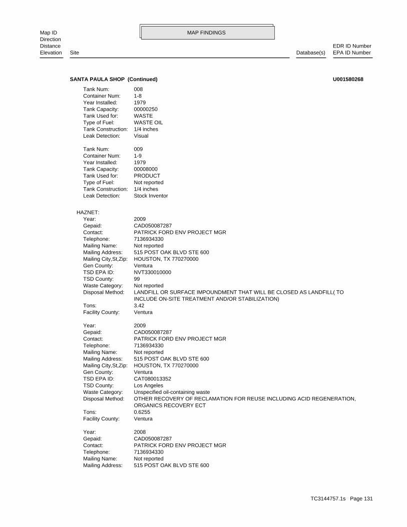
MAP FINDINGSMap IDDirection
EDR ID NumberDistanceEPA ID NumberDatabase(s)SiteElevation
515 POST OAK BLVD STE 600Mailing Address: Not reportedMailing Name: 7136934330Telephone: PATRICK FORD ENV PROJECT MGRContact: CAD050087287Gepaid: 2008Year:
VenturaFacility County: 0.6255Tons: ORGANICS RECOVERY ECT OTHER RECOVERY OF RECLAMATION FOR REUSE INCLUDING ACID REGENERATION,Disposal Method: Unspecified oil-containing wasteWaste Category: Los AngelesTSD County: CAT080013352TSD EPA ID: VenturaGen County: HOUSTON, TX 770270000Mailing City,St,Zip: 515 POST OAK BLVD STE 600Mailing Address: Not reportedMailing Name: 7136934330Telephone: PATRICK FORD ENV PROJECT MGRContact: CAD050087287Gepaid: 2009Year:
VenturaFacility County: 3.42Tons: INCLUDE ON-SITE TREATMENT AND/OR STABILIZATION) LANDFILL OR SURFACE IMPOUNDMENT THAT WILL BE CLOSED AS LANDFILL( TODisposal Method: Not reportedWaste Category: 99TSD County: NVT330010000TSD EPA ID: VenturaGen County: HOUSTON, TX 770270000Mailing City,St,Zip: 515 POST OAK BLVD STE 600Mailing Address: Not reportedMailing Name: 7136934330Telephone: PATRICK FORD ENV PROJECT MGRContact: CAD050087287Gepaid: 2009Year:
HAZNET:
Stock InventorLeak Detection: 1/4 inchesTank Construction: Not reportedType of Fuel: PRODUCTTank Used for: 00008000Tank Capacity: 1979Year Installed: 1-9Container Num: 009Tank Num:
VisualLeak Detection: 1/4 inchesTank Construction: WASTE OILType of Fuel: WASTETank Used for: 00000250Tank Capacity: 1979Year Installed: 1-8Container Num: 008Tank Num:
SANTA PAULA SHOP (Continued) U001580268
TC3144757.1s Page 131

MAP FINDINGSMap IDDirection
EDR ID NumberDistanceEPA ID NumberDatabase(s)SiteElevation
10 additional CA_HAZNET: record(s) in the EDR Site Report.Click this hyperlink while viewing on your computer to access
VenturaFacility County: 43.68Tons: ORGANICS RECOVERY ECT OTHER RECOVERY OF RECLAMATION FOR REUSE INCLUDING ACID REGENERATION,Disposal Method: Unspecified aqueous solutionWaste Category: Los AngelesTSD County: CAT080013352TSD EPA ID: VenturaGen County: HOUSTON, TX 770270000Mailing City,St,Zip: 515 POST OAK BLVD STE 600Mailing Address: Not reportedMailing Name: 7136934330Telephone: PATRICK FORD ENV PROJECT MGRContact: CAD050087287Gepaid: 2008Year:
VenturaFacility County: 0.25Tons: FUEL BLENDING PRIOR TO ENERGY RECOVERY AT ANOTHER SITEDisposal Method: Oxygenated solvents (acetone, butanol, ethyl acetate, etc.)Waste Category: 99TSD County: TXD077603371TSD EPA ID: VenturaGen County: HOUSTON, TX 770270000Mailing City,St,Zip: 515 POST OAK BLVD STE 600Mailing Address: Not reportedMailing Name: 7136934330Telephone: PATRICK FORD ENV PROJECT MGRContact: CAD050087287Gepaid: 2008Year:
VenturaFacility County: 5.0225Tons: INCLUDE ON-SITE TREATMENT AND/OR STABILIZATION) LANDFILL OR SURFACE IMPOUNDMENT THAT WILL BE CLOSED AS LANDFILL( TODisposal Method: Not reportedWaste Category: 99TSD County: NVT330010000TSD EPA ID: VenturaGen County: HOUSTON, TX 770270000Mailing City,St,Zip:
SANTA PAULA SHOP (Continued) U001580268
pumping. repairing, oil production, storage and disposal operations, water washing, geothermal operations, air conditioning, ship building and processing operation of whatever nature, including mining, gravel semisolid wastes from any servicing, producing, manufacturing or Industrial - Facility that treats and/or disposes of liquid orFacility Type: 4 56I015652Facility ID:
CA WDS:
1982 ft. Site 3 of 3 in cluster Q0.375 mi.
Relative:Lower
Actual:275 ft.
1/4-1/2 SANTA PAULA, CA SSW VENTURA CO. BWT200 S HALLOCK DR N/AQ107 WDSABRISA INDUSTRIAL GLASS, INC. S105511752
TC3144757.1s Page 132

MAP FINDINGSMap IDDirection
EDR ID NumberDistanceEPA ID NumberDatabase(s)SiteElevation
BUSINESS PLAN- SANTA PAULA HAZARDOUS WASTE GENERATORProgram:FA0006859Facility ID:
VENTURA CO. BWT:
dairy waste ponds. dischargers having waste storage systems with land disposal such as disposal systems, such as septic systems with subsurface disposal, or management practices, facilities with passive waste treatment and cooling water dischargers or thosewho must comply through best Category C - Facilities having no waste treatment systems, such asComplexity: represent no threat to water quality. Level. A Zero (0) may be used to code those NURDS that are found to considered a minor threat to water quality unless coded at a higher to a major or minor threat. Not: All nurds without a TTWQ will be should cause a relatively minor impairment of beneficial uses compared Minor Threat to Water Quality. A violation of a regional board orderTreat To Water: Not reportedPOTW: Not reportedReclamation: 0Baseline Flow: 0Design Flow: Not reportedSecondary Waste Type: Not reportedSecondary Waste: Not reportedPrimary Waste Type: Not reportedPrimary Waste: Not reportedSIC Code 2: 0SIC Code: PrivateAgency Type: 8055254902Agency Telephone: RICHARD SELFRIDGEAgency Contact: Santa Paula 930609646Agency City,St,Zip: 200 Hallock DrAgency Address: ABRISA INDUSTRIAL GLASSAgency Name: RICHARD SELFRIDGEFacility Contact: 8055254902Facility Telephone: 4Subregion: are assigned by the Regional Board CAS000001 The 1st 2 characters designate the state. The remaining 7NPDES Number: under Waste Discharge Requirements. Active - Any facility with a continuous or seasonal discharge that isFacility Status:
ABRISA INDUSTRIAL GLASS, INC. (Continued) S105511752
CARPINTERIA, CA 93013Owner City,St,Zip: 410 PALM AVE.Owner Address: CARPINTERIA MOTOR TRANSPORTOwner Name: 8056563897Telephone: TERRY BLISSContact Name: 0003Total Tanks: TRUCKINGOther Type: OtherFacility Type: 00000049242Facility ID: STATERegion:
HIST UST:
2029 ft. Site 1 of 9 in cluster R0.384 mi.
Relative:Lower
Actual:292 ft.
1/4-1/2 SANTA PAULA, CA 93060WSW HAZNET1480 E HARVARD BLVD N/AR108 HIST USTCARPINTERIA MOTOR TRANSPORT U001580117
TC3144757.1s Page 133

MAP FINDINGSMap IDDirection
EDR ID NumberDistanceEPA ID NumberDatabase(s)SiteElevation
VenturaFacility County: 2.431Tons: H01Disposal Method: Waste oil and mixed oilWaste Category: Santa ClaraTSD County: CAL000161743TSD EPA ID: VenturaGen County: SANTA PAULA, CA 930600000Mailing City,St,Zip: 1480 E HARVARD BLVDMailing Address: Not reportedMailing Name: 8059335054Telephone: CARPINTERIA MOTOR TRANSPORTContact: CAL000188087Gepaid: 1999Year:
VenturaFacility County: 0.6255Tons: Not reportedDisposal Method: Unspecified oil-containing wasteWaste Category: Santa ClaraTSD County: CAL000161743TSD EPA ID: VenturaGen County: SANTA PAULA, CA 930600000Mailing City,St,Zip: 1480 E HARVARD BLVDMailing Address: Not reportedMailing Name: 8059335054Telephone: CARPINTERIA MOTOR TRANSPORTContact: CAL000188087Gepaid: 1999Year:
HAZNET:
VisualLeak Detection: Not reportedTank Construction: REGULARType of Fuel: PRODUCTTank Used for: 00001000Tank Capacity: Not reportedYear Installed: 3Container Num: 003Tank Num:
VisualLeak Detection: Not reportedTank Construction: DIESELType of Fuel: PRODUCTTank Used for: 00001000Tank Capacity: Not reportedYear Installed: 2Container Num: 002Tank Num:
VisualLeak Detection: Not reportedTank Construction: DIESELType of Fuel: PRODUCTTank Used for: 00008000Tank Capacity: Not reportedYear Installed: 1Container Num: 001Tank Num:
CARPINTERIA MOTOR TRANSPORT (Continued) U001580117
TC3144757.1s Page 134

MAP FINDINGSMap IDDirection
EDR ID NumberDistanceEPA ID NumberDatabase(s)SiteElevation
HAZARDOUS WASTE GENERATOR BUSINESS PLAN - SANTA PAULAProgram:FA0006141Facility ID:
VENTURA CO. BWT:
2029 ft. Site 2 of 9 in cluster R0.384 mi.
Relative:Lower
Actual:292 ft.
1/4-1/2 SANTA PAULA, CA WSW 1480 E HARVARD BLVD N/AR109 VENTURA CO. BWTTARANGO’S AUTO/DIESEL REPAIR S101700541
.2500Tons: H01Disposal Method: Other organic solidsWaste Category: Los AngelesTSD County: CAD050806850TSD EPA ID: VenturaGen County: SANTA PAULA, CA 930600000Mailing City,St,Zip: 1480 E HARVARD BLVDMailing Address: Not reportedMailing Name: 0000000000Telephone: HECTOR/LAURIE TARANGOContact: CAL000144120Gepaid: 2000Year:
Not reportedFacility County: 0.08Tons: R01Disposal Method: Unspecified oil-containing wasteWaste Category: Los AngelesTSD County: Not reportedTSD EPA ID: VenturaGen County: SANTA PAULA, CA 930600000Mailing City,St,Zip: 1480 E HARVARD BLVDMailing Address: Not reportedMailing Name: 8059333199Telephone: BILL TIPTON, OFFICE MGRContact: CAL000144120Gepaid: 2002Year:
VenturaFacility County: 0.22Tons: R01Disposal Method: Unspecified oil-containing wasteWaste Category: Los AngelesTSD County: CAT080013352TSD EPA ID: VenturaGen County: SANTA PAULA, CA 930602942Mailing City,St,Zip: 1480 E HARVARD BLVDMailing Address: Not reportedMailing Name: 8059333199Telephone: TINA ALVERDIContact: CAL000144120Gepaid: 2006Year:
HAZNET:
2029 ft. Site 3 of 9 in cluster R0.384 mi.
Relative:Lower
Actual:292 ft.
1/4-1/2 SANTA PAULA, CA 93060WSW 1480 E HARVARD BLVD N/AR110 HAZNETTARANGOS DIESEL REPAIR S105035408
TC3144757.1s Page 135

MAP FINDINGSMap IDDirection
EDR ID NumberDistanceEPA ID NumberDatabase(s)SiteElevation
VenturaFacility County:
TARANGOS DIESEL REPAIR (Continued) S105035408
2000-04-12 00:00:00Date: ENFORCEMENTAction Type: T0611100622Global Id:
LUST:
2135766714Phone Number: [email protected]: R4 UNKNOWNCity: Not reportedAddress: LOS ANGELES RWQCB (REGION 4)Organization Name: DANIEL PIROTTONContact Name: Regional Board CaseworkerContact Type: T0611100622Global Id:
Not reportedPhone Number: [email protected]: VENTURACity: 800 S. VICTORIA AVEAddress: VENTURA COUNTY LOPOrganization Name: ERIN K. O’CONNELLContact Name: Local Agency CaseworkerContact Type: T0611100622Global Id:
LUST:
Click here to access the California GeoTracker records for this facility:
Not reportedSite History: GasolinePotential Contaminants of Concern: Other Groundwater (uses other than drinking water)Potential Media Affect: Stored electronically as an E-fileFile Location: 90038LOC Case Number: C90038RB Case Number: VENTURA COUNTY LOPLocal Agency: EKOCase Worker: VENTURA COUNTY LOPLead Agency: 2004-05-20 00:00:00Status Date: Completed - Case ClosedStatus: LUST Cleanup SiteCase Type: -119.04977Longitude: 34.356564Latitude: T0611100622Global Id: STATERegion:
LUST:
C-90038Reg Id: LTNKAReg By: 56Facility County Code: CORTESERegion:
CORTESE:
2029 ft. VENTURA CO. BWTSite 4 of 9 in cluster R0.384 mi. SWEEPS UST
Relative:Lower
Actual:292 ft.
1/4-1/2 CA FID USTSANTA PAULA, CA 93060WSW LUST1480 HARVARD N/AR111 HIST CORTESECARPINTERIA MOTOR TRANSPO S101619944
TC3144757.1s Page 136

MAP FINDINGSMap IDDirection
EDR ID NumberDistanceEPA ID NumberDatabase(s)SiteElevation
* Historical EnforcementAction: 2000-11-27 00:00:00Date: ENFORCEMENTAction Type: T0611100622Global Id:
Leak StoppedAction: 1950-01-01 00:00:00Date: OtherAction Type: T0611100622Global Id:
Leak ReportedAction: 1950-01-01 00:00:00Date: OtherAction Type: T0611100622Global Id:
UnknownAction: 2004-06-30 00:00:00Date: RESPONSEAction Type: T0611100622Global Id:
* Historical EnforcementAction: 2001-03-02 00:00:00Date: ENFORCEMENTAction Type: T0611100622Global Id:
Leak DiscoveryAction: 1950-01-01 00:00:00Date: OtherAction Type: T0611100622Global Id:
* Historical Enforcement - #10Action: 2004-05-17 00:00:00Date: ENFORCEMENTAction Type: T0611100622Global Id:
* Historical EnforcementAction: 2003-10-29 00:00:00Date: ENFORCEMENTAction Type: T0611100622Global Id:
LOP Case Closure Summary to RBAction: 2003-09-30 00:00:00Date: ENFORCEMENTAction Type: T0611100622Global Id:
Closure/No Further Action Letter - #11Action: 2004-05-20 00:00:00Date: ENFORCEMENTAction Type: T0611100622Global Id:
* Historical EnforcementAction: 2003-02-11 00:00:00Date: ENFORCEMENTAction Type: T0611100622Global Id:
* Historical EnforcementAction:
CARPINTERIA MOTOR TRANSPO (Continued) S101619944
TC3144757.1s Page 137

MAP FINDINGSMap IDDirection
EDR ID NumberDistanceEPA ID NumberDatabase(s)SiteElevation
Not reportedWell Name: Not reportedWater System: Not reportedOperator: Not reportedLeak Source: Not reportedCause of Leak: Not reportedHow Leak Stopped: Not reportedHow Leak Discovered: 5/20/2004Date the Case was Closed: Not reportedDate Case Last Changed on Database: 3/10/1990Date Leak Stopped: 3/9/1990Date Confirmation Began: Not reportedDate Leak Record Entered: 3/9/1990Date Leak First Reported: 3/9/1990Date Leak Discovered: CLOSEnforcement Type: Not reportedCross Street: 56000LLocal Agency: UNKStaff: Not reportedW Global ID: T0611100622Global ID: Excavate and DisposeAbatement Method Used at the Site: GroundwaterCase Type: 90038Local Case No: Not reportedSubstance Quantity: GasolineSubstance: Case ClosedStatus: C-90038facid: VenturaCounty: 04Regional Board: 4Region:
LUST REG 4:
Monitoring Report - QuarterlyAction: 2001-01-30 00:00:00Date: RESPONSEAction Type: T0611100622Global Id:
Other Report / DocumentAction: 2003-03-21 00:00:00Date: RESPONSEAction Type: T0611100622Global Id:
Request for ClosureAction: 2001-12-31 00:00:00Date: RESPONSEAction Type: T0611100622Global Id:
Request for ClosureAction: 2001-01-30 00:00:00Date: RESPONSEAction Type: T0611100622Global Id:
Monitoring Report - QuarterlyAction: 2000-07-30 00:00:00Date: RESPONSEAction Type: T0611100622Global Id:
CARPINTERIA MOTOR TRANSPO (Continued) S101619944
TC3144757.1s Page 138

MAP FINDINGSMap IDDirection
EDR ID NumberDistanceEPA ID NumberDatabase(s)SiteElevation
1776Comp Number: AStatus:
SWEEPS UST:
ActiveStatus: Not reportedComments: Not reportedEPA ID: Not reportedNPDES Number: Not reportedDUNs Number: Not reportedContact Phone: Not reportedContact: SANTA PAULA 93060Mailing City,St,Zip: Not reportedMailing Address 2: 1480 E HARVARDMailing Address: Not reportedMail To: Not reportedFacility Phone: Not reportedSIC Code: Not reportedCortese Code: Not reportedRegulated ID: UTNKARegulated By: 56000258Facility ID:
CA FID UST:
Case ClosedStatus:90038Facility ID:VENTURARegion:
VENTURA CO. LUST:
Not reportedSummary: Not reportedAssigned Name: Not reportedSuspended: Not reportedCleanup Fund Id: Not reportedPriority: Not reportedBeneficial Use: EKOLocal Agency Staff: 34.357014 / -1Lat/Long: LUSTProgram: Not reportedRP Address: CARPINTERIA MOTOR TRANSPORTResponsible Party: Not reportedOwner Contact: Not reportedOrganization: Not reportedSoil Qualifier: Not reportedGW Qualifier: Not reportedSignificant Interim Remedial Action Taken: Not reportedHist Max MTBE Conc in Soil: Not reportedHist Max MTBE Conc in Groundwater: Not reportedHistorical Max MTBE Date: 3/9/1990Enforcement Action Date: 7/31/2000Post Remedial Action Monitoring Began: Not reportedRemedial Action Underway: 11/9/1995Remediation Plan Submitted: 7/15/1991Pollution Characterization Began: 7/15/1991Preliminary Site Assessment Began: 3/9/1990Preliminary Site Assessment Workplan Submitted: FSource of Cleanup Funding: 1315.418621931067665803987909Approx. Dist To Production Well (ft):
CARPINTERIA MOTOR TRANSPO (Continued) S101619944
TC3144757.1s Page 139

MAP FINDINGSMap IDDirection
EDR ID NumberDistanceEPA ID NumberDatabase(s)SiteElevation
BUSINESS PLAN - SANTA PAULA HAZARDOUS WASTE GENERATORProgram:FA0006285Facility ID:
VENTURA CO. BWT:
1Number Of Tanks: DIESELContent: PStg: M.V. FUELTank Use: 8000Capacity: Not reportedActv Date: 56-000-001776-000001Swrcb Tank Id: Not reportedOwner Tank Id: ATank Status: 02-29-88Created Date: 09-30-92Act Date: 09-30-92Ref Date: 44-030864Board Of Equalization: 9Number:
CARPINTERIA MOTOR TRANSPO (Continued) S101619944
VenturaFacility County: 0.2Tons: D99Disposal Method: Waste oil and mixed oilWaste Category: VenturaTSD County: CAD044429835TSD EPA ID: VenturaGen County: SANTA BARBARA, CA 93101Mailing City,St,Zip: PO BOX 60839Mailing Address: Not reportedMailing Name: 8058823883Telephone: CHRISTINE SONTAB/ASSIST VContact: CAC002562538Gepaid: 2003Year:
HAZNET:
2033 ft. Site 5 of 9 in cluster R0.385 mi.
Relative:Lower
Actual:293 ft.
1/4-1/2 SANTA PAULA, CA 93060WSW 1435 E HARVARD BLVD N/AR112 HAZNETSANTA BARBARA BANK & TRUST S107140221
D1541Facility ID:VENTURA CO. UST:
2037 ft. Site 6 of 9 in cluster R0.386 mi.
Relative:Lower
Actual:296 ft.
1/4-1/2 SANTA PAULA, CA WSW 1433 MAIN ST N/AR113 USTHENDRICK PROPERTIES U004022053
TC3144757.1s Page 140

MAP FINDINGSMap IDDirection
EDR ID NumberDistanceEPA ID NumberDatabase(s)SiteElevation
D1032Facility ID:VENTURA CO. UST:
2040 ft. Site 7 of 9 in cluster R0.386 mi.
Relative:Lower
Actual:292 ft.
1/4-1/2 SANTA PAULA, CA WSW 1480 HARVARD BLVD N/AR114 USTCARPENTERIA MOTOR TRANSPORT U002169190
HAZARDOUS WASTE GENERATORProgram:FA0006992Facility ID:
VENTURA CO. BWT:
2159 ft. Site 8 of 9 in cluster R0.409 mi.
Relative:Lower
Actual:295 ft.
1/4-1/2 SANTA PAULA, CA WSW 1417 E MAIN ST #A N/AR115 VENTURA CO. BWTDIAMOND SERVICES S108240157
VenturaFacility County: 10.1136Tons: Not reportedDisposal Method: Other organic solidsWaste Category: KernTSD County: CAD980675276TSD EPA ID: VenturaGen County: SANTA PAULA, CA 930600000Mailing City,St,Zip: 1415 E MAINMailing Address: Not reportedMailing Name: 0000000000Telephone: JESUS GARCIAContact: CAC002205129Gepaid: 2000Year:
VenturaFacility County: 10.1136Tons: D80Disposal Method: Other organic solidsWaste Category: KingsTSD County: CAT000646117TSD EPA ID: VenturaGen County: SANTA PAULA, CA 930600000Mailing City,St,Zip: 1415 E MAINMailing Address: Not reportedMailing Name: 0000000000Telephone: JESUS GARCIAContact: CAC002205129Gepaid: 2000Year:
HAZNET:
2169 ft. Site 9 of 9 in cluster R0.411 mi.
Relative:Lower
Actual:294 ft.
1/4-1/2 SANTA PAULA, CA 93060WSW 1415 E MAIN N/AR116 HAZNETJESUS GARCIA S105084539
TC3144757.1s Page 141

MAP FINDINGSMap IDDirection
EDR ID NumberDistanceEPA ID NumberDatabase(s)SiteElevation
NoFurnace exemption: NoOn-site burner exemption: NoUnderground injection activity: NoTreater, storer or disposer of HW: NoTransporter of hazardous waste: NoRecycler of hazardous waste: NoMixed waste (haz. and radioactive): NoU.S. importer of hazardous waste:
Handler Activities Summary:
Not reportedOwner/Op end date: Not reportedOwner/Op start date: OwnerOwner/Operator Type: PrivateLegal status: (415) 555-1212Owner/operator telephone: Not reportedOwner/operator country: NOT REQUIRED, ME 99999 NOT REQUIREDOwner/operator address: FMC CORPOwner/operator name:
Not reportedOwner/Op end date: Not reportedOwner/Op start date: OperatorOwner/Operator Type: PrivateLegal status: (415) 555-1212Owner/operator telephone: Not reportedOwner/operator country: NOT REQUIRED, ME 99999 NOT REQUIREDOwner/operator address: NOT REQUIREDOwner/operator name:
Owner/Operator Summary:
hazardous waste at any time waste during any calendar month, and accumulates more than 1000 kg of hazardous waste at any time; or generates 100 kg or less of hazardous waste during any calendar month and accumulates less than 6000 kg of Handler: generates more than 100 and less than 1000 kg of hazardousDescription: Small Small Quantity GeneratorClassification: 09EPA Region: Not reportedContact email: Not reportedContact telephone: Not reportedContact country: Not reported Not reportedContact address: Not reportedContact: RIVERSIDE, CA 92504 6446 FREMONT STMailing address: CAT080012065EPA ID: SANTA PAULA, CA 93060 1409 MAIN STFacility address: FMC CORP CITRUS MACHINERY DIVFacility name: 09/01/1996Date form received by agency:
RCRA-SQG:
2223 ft. Site 1 of 4 in cluster S0.421 mi.
Relative:Lower
Actual:294 ft.
1/4-1/2 SANTA PAULA, CA 93060WSW 1409 MAIN ST CAT080012065S117 RCRA-SQGFMC CORP CITRUS MACHINERY DIV 1000109411
TC3144757.1s Page 142

MAP FINDINGSMap IDDirection
EDR ID NumberDistanceEPA ID NumberDatabase(s)SiteElevation
No violations foundViolation Status:
Large Quantity GeneratorClassification: FMC CORP CITRUS MACHINERY DIVFacility name: 10/22/1980Date form received by agency:
Historical Generators:
NoUsed oil transporter: NoUsed oil transfer facility: NoUsed oil Specification marketer: NoUsed oil fuel marketer to burner: NoUser oil refiner: NoUsed oil processor: NoUsed oil fuel burner:
FMC CORP CITRUS MACHINERY DIV (Continued) 1000109411
Karen JuristContact Name: 9271184.00000Contact ID:
CERCLIS Site Contact Name(s):
Not reportedSite FUDS Flag: Not reportedAlias EPA ID: Not reportedCC Concurrence FY: Not reportedCC Concurrence Date: 06111Site Fips Code: 19891006Non NPL Status Date: SI Start NeededNon NPL Status: Not reportedRResp Fed Agency Code: Not reportedRBRAC Code: Not reportedDMNSN Unit Code: Not on the NPLNPL Status: Not reportedSite Settings Code: Not reportedClassification: 09EPA Region: Not reportedRST Code: Not reportedParent ID: Not reportedNFRAP Flag: Not reportedSite Init By Prog: Not reportedUSGS Quadrangle: Not reportedRCRA ID: NSite Orphan Flag: Not reportedDMNSN Number: Not a Federal FacilityFederal Facility: 18070102USGC Hydro Unit: 6000SMSA Number: Not reportedIFMS ID: 19Congressional District: FMC AG CHEMICALShort Name: VENTURAFacility County: CAD000775593EPA ID: 0903593Site ID:
CERCLIS:
HAZNET2223 ft. VENTURA CO. BWTSite 2 of 4 in cluster S0.421 mi. HIST UST
Relative:Lower
Actual:294 ft.
1/4-1/2 FINDSSANTA PAULA, CA 93060WSW RCRA-SQG1409 E MAIN ST CAD000775593S118 CERCLISFMC AG CHEMICAL 1000109339
TC3144757.1s Page 143

MAP FINDINGSMap IDDirection
EDR ID NumberDistanceEPA ID NumberDatabase(s)SiteElevation
additional US CERCLIS Financial: detail in the EDR Site Report.Click this hyperlink while viewing on your computer to access
For detailed financial records, contact EDR for a Site Report.:
Not reportedAction Anomaly: Not reportedUrgency Indicator: Not reportedPlanning Status: State, Fund FinancedPrimary Responsibility: SITEWIDEOperable Unit: Low priority for further assessmentPriority Level: 10/06/1989Date Completed: Not reportedDate Started: PRELIMINARY ASSESSMENTAction: 001Action Code:
For detailed financial records, contact EDR for a Site Report.:
Not reportedAction Anomaly: Not reportedUrgency Indicator: Not reportedPlanning Status: State, Fund FinancedPrimary Responsibility: SITEWIDEOperable Unit: Not reportedPriority Level: 05/03/1989Date Completed: Not reportedDate Started: DISCOVERYAction: 001Action Code:
CERCLIS Assessment History:
Not reportedSite Description: Not reportedAlias Comments:
Not reportedContact Email: Site Assessment Manager (SAM)Contact Title: (415) 972-3097Contact Tel: Dawn RichmondContact Name: 9270438.00000Contact ID:
Not reportedContact Email: Site Assessment Manager (SAM)Contact Title: (415) 972-3814Contact Tel: Carl BricknerContact Name: 13002167.00000Contact ID:
Not reportedContact Email: Site Assessment Manager (SAM)Contact Title: (415) 972-3095Contact Tel: Jeff InglisContact Name: 9270048.00000Contact ID:
Not reportedContact Email: Site Assessment Manager (SAM)Contact Title: (415) 972-3219Contact Tel:
FMC AG CHEMICAL (Continued) 1000109339
TC3144757.1s Page 144

MAP FINDINGSMap IDDirection
EDR ID NumberDistanceEPA ID NumberDatabase(s)SiteElevation
NoUser oil refiner: NoUsed oil processor: NoUsed oil fuel burner: NoFurnace exemption: NoOn-site burner exemption: NoUnderground injection activity: NoTreater, storer or disposer of HW: NoTransporter of hazardous waste: NoRecycler of hazardous waste: NoMixed waste (haz. and radioactive): NoU.S. importer of hazardous waste:
Handler Activities Summary:
Not reportedOwner/Op end date: Not reportedOwner/Op start date: OperatorOwner/Operator Type: PrivateLegal status: (415) 555-1212Owner/operator telephone: Not reportedOwner/operator country: NOT REQUIRED, ME 99999 NOT REQUIREDOwner/operator address: NOT REQUIREDOwner/operator name:
Not reportedOwner/Op end date: Not reportedOwner/Op start date: OwnerOwner/Operator Type: PrivateLegal status: (415) 555-1212Owner/operator telephone: Not reportedOwner/operator country: NOT REQUIRED, ME 99999 NOT REQUIREDOwner/operator address: FMC CORPORATIONOwner/operator name:
Owner/Operator Summary:
hazardous waste at any time waste during any calendar month, and accumulates more than 1000 kg of hazardous waste at any time; or generates 100 kg or less of hazardous waste during any calendar month and accumulates less than 6000 kg of Handler: generates more than 100 and less than 1000 kg of hazardousDescription: Small Small Quantity GeneratorClassification: Facility is not located on Indian land. Additional information is not known.Land type: 09EPA Region: Not reportedContact email: Not reportedContact telephone: Not reportedContact country: Not reported Not reportedContact address: Not reportedContact: SANTA PAULA, CA 93060 PO BOX 107Mailing address: CAD000775593EPA ID: SANTA PAULA, CA 93060 1409 E MAIN STFacility address: FMC CORP AGRI CHEM GROUPFacility name: 09/01/1996Date form received by agency:
RCRA-SQG:
FMC AG CHEMICAL (Continued) 1000109339
TC3144757.1s Page 145

MAP FINDINGSMap IDDirection
EDR ID NumberDistanceEPA ID NumberDatabase(s)SiteElevation
and financial information.including an inventory of sites, planned and actual site activities,system contains information on all aspects of hazardous waste sites,to support management in all phases of the Superfund program. TheLiability Information System) is the Superfund database that is usedCERCLIS (Comprehensive Environmental Response, Compensation, and
corrective action activities required under RCRA.program staff to track the notification, permit, compliance, andand treat, store, or dispose of hazardous waste. RCRAInfo allows RCRAevents and activities related to facilities that generate, transport,Conservation and Recovery Act (RCRA) program through the tracking ofRCRAInfo is a national information system that supports the Resource Environmental Interest/Information System
110002628764Registry ID:
FINDS:
StateEvaluation lead agency: 12/13/1985Date achieved compliance: Generators - GeneralArea of violation: NON-FINANCIAL RECORD REVIEWEvaluation: 11/19/1985Evaluation date:
StateEvaluation lead agency: Not reportedDate achieved compliance: Not reportedArea of violation: COMPLIANCE EVALUATION INSPECTION ON-SITEEvaluation: 11/19/1985Evaluation date:
Evaluation Action Summary:
0 Paid penalty amount: 0 Final penalty amount: 0 Proposed penalty amount: State Enforcement lead agency: Not reported Enf. disp. status date: Not reported Enf. disposition status: 11/29/1985 Enforcement action date: WRITTEN INFORMAL Enforcement action: StateViolation lead agency: 12/13/1985Date achieved compliance: 11/19/1985Date violation determined: Generators - GeneralArea of violation: Not reportedRegulation violated:
Facility Has Received Notices of Violations:
Large Quantity GeneratorClassification: FMC CORP AGRI CHEM GROUPFacility name: 08/22/1980Date form received by agency:
Historical Generators:
NoUsed oil transporter: NoUsed oil transfer facility: NoUsed oil Specification marketer: NoUsed oil fuel marketer to burner:
FMC AG CHEMICAL (Continued) 1000109339
TC3144757.1s Page 146

MAP FINDINGSMap IDDirection
EDR ID NumberDistanceEPA ID NumberDatabase(s)SiteElevation
OTHER RECOVERY OF RECLAMATION FOR REUSE INCLUDING ACID REGENERATION,Disposal Method: Waste oil and mixed oilWaste Category: Los AngelesTSD County: CAD099452708TSD EPA ID: VenturaGen County: SANTA PAULA, CA 93060Mailing City,St,Zip: 1409 E MAIN STMailing Address: Not reportedMailing Name: 8059332860Telephone: JOSE LARIOSContact: CAL000298465Gepaid: 2009Year:
HAZNET:
HAZARDOUS WASTE GENERATORProgram:FA0007114Facility ID:
VENTURA CO. BWT:
NoneLeak Detection: 12 gaugeTank Construction: Not reportedType of Fuel: WASTETank Used for: 00000500Tank Capacity: Not reportedYear Installed: 3Container Num: 003Tank Num:
NoneLeak Detection: 3/16 inchesTank Construction: Not reportedType of Fuel: WASTETank Used for: 00002000Tank Capacity: Not reportedYear Installed: 2Container Num: 002Tank Num:
NoneLeak Detection: 3/16 inchesTank Construction: Not reportedType of Fuel: PRODUCTTank Used for: 00002000Tank Capacity: Not reportedYear Installed: 1Container Num: 001Tank Num:
RIVERSIDE, CA 92507Owner City,St,Zip: 1540 LINDEN ST.Owner Address: FMC CORPORTATIONOwner Name: 8055252151Telephone: J. BEEGHLYContact Name: 0003Total Tanks: FRUIT & PRODUCE HANDOther Type: OtherFacility Type: 00000007380Facility ID: STATERegion:
HIST UST:
FMC AG CHEMICAL (Continued) 1000109339
TC3144757.1s Page 147

MAP FINDINGSMap IDDirection
EDR ID NumberDistanceEPA ID NumberDatabase(s)SiteElevation
VenturaFacility County: 1.273Tons: ORGANICS RECOVERY ECT OTHER RECOVERY OF RECLAMATION FOR REUSE INCLUDING ACID REGENERATION,Disposal Method: Waste oil and mixed oilWaste Category: Los AngelesTSD County: CAD099452708TSD EPA ID: VenturaGen County: SANTA PAULA, CA 93060Mailing City,St,Zip: 1409 E MAIN STMailing Address: Not reportedMailing Name: 8059332860Telephone: JOSE LARIOSContact: CAL000298465Gepaid: 2008Year:
VenturaFacility County: 0.437Tons: ORGANICS RECOVERY ECT OTHER RECOVERY OF RECLAMATION FOR REUSE INCLUDING ACID REGENERATION,Disposal Method: Waste oil and mixed oilWaste Category: Los AngelesTSD County: CAT080013352TSD EPA ID: VenturaGen County: SANTA PAULA, CA 93060Mailing City,St,Zip: 1409 E MAIN STMailing Address: Not reportedMailing Name: 8059332860Telephone: JOSE LARIOSContact: CAL000298465Gepaid: 2008Year:
VenturaFacility County: 0.418Tons: ORGANICS RECOVERY ECT
FMC AG CHEMICAL (Continued) 1000109339
GASOLINE STATIONSType: 1961Year: MITCHELL S VELTEX STATIONName:
EDR Historical Auto Stations:
2236 ft. Site 3 of 4 in cluster S0.423 mi.
Relative:Lower
Actual:294 ft.
1/4-1/2 SANTA PAULA, CA WSW 1444 E MAIN ST N/AS119 EDR Historical Auto StationsMITCHELL S VELTEX STATION 1009027945
TC3144757.1s Page 148

MAP FINDINGSMap IDDirection
EDR ID NumberDistanceEPA ID NumberDatabase(s)SiteElevation
2003Year:
Not reportedFacility County: 0.25Tons: R01Disposal Method: Unspecified oil-containing wasteWaste Category: Los AngelesTSD County: CAT080033681TSD EPA ID: VenturaGen County: SANTA PAULA, CA 930600000Mailing City,St,Zip: 1407 E MAIN STMailing Address: Not reportedMailing Name: 8055252103Telephone: BERT GEMMELLContact: CAL000241723Gepaid: 2004Year:
VenturaFacility County: 0.15Tons: INCLUDE ON-SITE TREATMENT AND/OR STABILIZATION) LANDFILL OR SURFACE IMPOUNDMENT THAT WILL BE CLOSED AS LANDFILL( TODisposal Method: Other organic solidsWaste Category: 99TSD County: NVT330010000TSD EPA ID: VenturaGen County: SANTA PAULA, CA 930600000Mailing City,St,Zip: 1407 E MAIN STMailing Address: Not reportedMailing Name: 8055252103Telephone: BERT GEMMELLContact: CAL000241723Gepaid: 2007Year:
VenturaFacility County: 0.41Tons: TREATMENT) DISCHARGE TO SEWER/POTW OR NPDES(WITH PRIOR STORAGE--WITH OR WITHOUTDisposal Method: Oil/water separation sludgeWaste Category: Los AngelesTSD County: CAT080013352TSD EPA ID: VenturaGen County: SANTA PAULA, CA 930600000Mailing City,St,Zip: 1407 E MAIN STMailing Address: Not reportedMailing Name: 8055252103Telephone: BERT GEMMELLContact: CAL000241723Gepaid: 2007Year:
HAZNET:
HAZARDOUS WASTE GENERATOR BUSINESS PLAN - SANTA PAULAProgram:FA0007046Facility ID:
VENTURA CO. BWT:
2241 ft. Site 4 of 4 in cluster S0.424 mi.
Relative:Lower
Actual:294 ft.
1/4-1/2 SANTA PAULA, CA 93060WSW HAZNET1407 E MAIN ST N/AS120 VENTURA CO. BWTOIL WELL SERVICE COMPANY INC S105511815
TC3144757.1s Page 149

MAP FINDINGSMap IDDirection
EDR ID NumberDistanceEPA ID NumberDatabase(s)SiteElevation
1 additional CA_HAZNET: record(s) in the EDR Site Report.Click this hyperlink while viewing on your computer to access
VenturaFacility County: 0.08Tons: R01Disposal Method: Unspecified oil-containing wasteWaste Category: VenturaTSD County: CAT080013352TSD EPA ID: VenturaGen County: SANTA PAULA, CA 930600000Mailing City,St,Zip: 1407 E MAIN STMailing Address: Not reportedMailing Name: 8055252103Telephone: JIM KEETER/DISPATCHERContact: CAL000241723Gepaid: 2003Year:
VenturaFacility County: 0.22Tons: R01Disposal Method: Unspecified solvent mixtureWaste Category: VenturaTSD County: CAD008252405TSD EPA ID: VenturaGen County: SANTA PAULA, CA 930600000Mailing City,St,Zip: 1407 E MAIN STMailing Address: Not reportedMailing Name: 8055252103Telephone: JIM KEETER/DISPATCHERContact: CAL000241723Gepaid:
OIL WELL SERVICE COMPANY INC (Continued) S105511815
93101Discharge Zip: CaDischarge State: Santa BarbaraDischarge City: 122 E Arrellaga St # BDischarge Address: John J HolehouseDischarge Name: 1/13/2009Termination Date Of Regulatory Measure: Not reportedExpiration Date Of Regulatory Measure: 9/1/2005Effective Date Of Regulatory Measure: N/AAdoption Date Of Regulatory Measure: ConstructionProgram Type: 4 56C336326WDID: Not AvailablePlace Id: EnrolleeRegulatory Measure Type: Not reportedOrder No: Not AvailableRegulatory Measure Id: 4Region: N/AAgency Id: TerminatedFacility Status: CAS000002Npdes Number:
NPDES:
2250 ft. Site 1 of 3 in cluster T0.426 mi.
Relative:Higher
Actual:325 ft.
1/4-1/2 SANTA PAULA, CA 93060WNW 247 GRANT LINE STREET N/AT121 NPDESCREEKSIDE HOMES S109440847
TC3144757.1s Page 150

MAP FINDINGSMap IDDirection
EDR ID NumberDistanceEPA ID NumberDatabase(s)SiteElevation
VenturaCounty: 04Regional Board: 4Region:
LUST REG 4:
Leak ReportedAction: 1950-01-01 00:00:00Date: OtherAction Type: T0611101055Global Id:
Leak DiscoveryAction: 1950-01-01 00:00:00Date: OtherAction Type: T0611101055Global Id:
LUST:
2135766714Phone Number: [email protected]: R4 UNKNOWNCity: Not reportedAddress: LOS ANGELES RWQCB (REGION 4)Organization Name: DANIEL PIROTTONContact Name: Regional Board CaseworkerContact Type: T0611101055Global Id:
LUST:
Click here to access the California GeoTracker records for this facility:
Not reportedSite History: DieselPotential Contaminants of Concern: SoilPotential Media Affect: Not reportedFile Location: 95166LOC Case Number: C-95166RB Case Number: Not reportedLocal Agency: EHDCase Worker: VENTURA COUNTY LOPLead Agency: 1996-02-13 00:00:00Status Date: Completed - Case ClosedStatus: LUST Cleanup SiteCase Type: -119.051426Longitude: 34.359676Latitude: T0611101055Global Id: STATERegion:
LUST:
C-95166Reg Id: LTNKAReg By: 56Facility County Code: CORTESERegion:
CORTESE:
2302 ft. Site 2 of 3 in cluster T0.436 mi.
Relative:Higher
Actual:320 ft.
1/4-1/2 SANTA PAULA, CA 93060West LUST1460 SANTA PAULA N/AT122 HIST CORTESEBAKER TANKS INC S104164896
TC3144757.1s Page 151

MAP FINDINGSMap IDDirection
EDR ID NumberDistanceEPA ID NumberDatabase(s)SiteElevation
Not reportedSummary: Not reportedAssigned Name: Not reportedSuspended: Not reportedCleanup Fund Id: Not reportedPriority: Not reportedBeneficial Use: EHDLocal Agency Staff: 34.3603389 / -1Lat/Long: LUSTProgram: Not reportedRP Address: BAKER TANKS INCResponsible Party: Not reportedOwner Contact: Not reportedOrganization: Not reportedSoil Qualifier: Not reportedGW Qualifier: Not reportedSignificant Interim Remedial Action Taken: Not reportedHist Max MTBE Conc in Soil: Not reportedHist Max MTBE Conc in Groundwater: Not reportedHistorical Max MTBE Date: Not reportedEnforcement Action Date: 10/29/1995Post Remedial Action Monitoring Began: 10/29/1995Remedial Action Underway: 10/29/1995Remediation Plan Submitted: 9/18/1995Pollution Characterization Began: 9/18/1995Preliminary Site Assessment Began: 7/11/1995Preliminary Site Assessment Workplan Submitted: FSource of Cleanup Funding: 779.41924076605581162596042772Approx. Dist To Production Well (ft): Not reportedWell Name: Not reportedWater System: Not reportedOperator: Not reportedLeak Source: Not reportedCause of Leak: Not reportedHow Leak Stopped: Not reportedHow Leak Discovered: 2/13/1996Date the Case was Closed: Not reportedDate Case Last Changed on Database: Not reportedDate Leak Stopped: 7/11/1995Date Confirmation Began: Not reportedDate Leak Record Entered: 5/24/1995Date Leak First Reported: 5/24/1995Date Leak Discovered: Not reportedEnforcement Type: Not reportedCross Street: 56000LLocal Agency: UNKStaff: Not reportedW Global ID: T0611101055Global ID: Excavate and DisposeAbatement Method Used at the Site: SoilCase Type: 95166Local Case No: Not reportedSubstance Quantity: DieselSubstance: Case ClosedStatus: C-95166facid:
BAKER TANKS INC (Continued) S104164896
TC3144757.1s Page 152

MAP FINDINGSMap IDDirection
EDR ID NumberDistanceEPA ID NumberDatabase(s)SiteElevation
Case ClosedStatus:95166Facility ID:VENTURARegion:
VENTURA CO. LUST:
BAKER TANKS INC (Continued) S104164896
VenturaFacility County: 4.1700Tons: R01Disposal Method: Waste oil and mixed oilWaste Category: Los AngelesTSD County: CAT080011059TSD EPA ID: VenturaGen County: SANTA PAULA, CA 930600000Mailing City,St,Zip: 1460 EAST SANTA PAULA STMailing Address: Not reportedMailing Name: 8055251710Telephone: BAKER TANKS INCContact: CAC001104328Gepaid: 1995Year:
HAZNET:
D1185Facility ID:VENTURA CO. UST:
2302 ft. Site 3 of 3 in cluster T0.436 mi.
Relative:Higher
Actual:320 ft.
1/4-1/2 SANTA PAULA, CA West HAZNET1460 SANTA PAULA STREET N/AT123 USTBAKER TANKS INC. U002244217
MICHELLE PINAContact: CAL000220228Gepaid: 2003Year:
Not reportedFacility County: 0.58Tons: R01Disposal Method: Waste oil and mixed oilWaste Category: Los AngelesTSD County: CAT080013352TSD EPA ID: VenturaGen County: SANTA PAULA, CA 930610000Mailing City,St,Zip: PO BOX 388Mailing Address: Not reportedMailing Name: 8056561019Telephone: MICHELLE PINAContact: CAL000220228Gepaid: 2004Year:
HAZNET:
2310 ft. Site 1 of 8 in cluster U0.438 mi.
Relative:Lower
Actual:285 ft.
1/4-1/2 SANTA PAULA, CA 93060WSW 1452 E HARVARD BLVD N/AU124 HAZNETVENTURA CRANE INC S105511759
TC3144757.1s Page 153

MAP FINDINGSMap IDDirection
EDR ID NumberDistanceEPA ID NumberDatabase(s)SiteElevation
Not reportedFacility County: 0.10Tons: R01Disposal Method: Unspecified oil-containing wasteWaste Category: Los AngelesTSD County: Not reportedTSD EPA ID: VenturaGen County: SANTA PAULA, CA 930610000Mailing City,St,Zip: PO BOX 388Mailing Address: Not reportedMailing Name: 8056561019Telephone: MICHELLE PINAContact: CAL000220228Gepaid: 2002Year:
Not reportedFacility County: 1.00Tons: R01Disposal Method: Waste oil and mixed oilWaste Category: Los AngelesTSD County: Not reportedTSD EPA ID: VenturaGen County: SANTA PAULA, CA 930610000Mailing City,St,Zip: PO BOX 388Mailing Address: Not reportedMailing Name: 8056561019Telephone: MICHELLE PINAContact: CAL000220228Gepaid: 2002Year:
VenturaFacility County: 1.16Tons: R01Disposal Method: Unspecified oil-containing wasteWaste Category: VenturaTSD County: CAT080013352TSD EPA ID: VenturaGen County: SANTA PAULA, CA 930610000Mailing City,St,Zip: PO BOX 388Mailing Address: Not reportedMailing Name: 8056561019Telephone:
VENTURA CRANE INC (Continued) S105511759
HAZARDOUS WASTE GENERATORProgram:FA0006291Facility ID:
VENTURA CO. BWT:
2438 ft. Site 2 of 8 in cluster U0.462 mi.
Relative:Lower
Actual:284 ft.
1/4-1/2 SANTA PAULA, CA WSW 1397 E HARVARD BLVD N/AU125 VENTURA CO. BWTALTA QUALITY FARM SERVICE INC S103366398
TC3144757.1s Page 154

MAP FINDINGSMap IDDirection
EDR ID NumberDistanceEPA ID NumberDatabase(s)SiteElevation
their precursors, as well as hazardous air pollutants (HAPs).on stationary and mobile sources that emit criteria air pollutants andThe NEI (National Emissions Inventory) database contains information Environmental Interest/Information System
110013916361Registry ID:
FINDS:
2447 ft. Site 3 of 8 in cluster U0.464 mi.
Relative:Lower
Actual:284 ft.
1/4-1/2 SANTA PAULA, CA 93060WSW 1395 E. HARVARD BLVD. N/AU126 FINDSCONDOR TRUCK SERVICE 1006831146
ActiveStatus: Not reportedComments: Not reportedEPA ID: Not reportedNPDES Number: Not reportedDUNs Number: Not reportedContact Phone: Not reportedContact: SANTA PAULA 93060Mailing City,St,Zip: Not reportedMailing Address 2: 1395 E HARVARD BLVDMailing Address: Not reportedMail To: Not reportedFacility Phone: Not reportedSIC Code: Not reportedCortese Code: 5670Regulated ID: UTNKARegulated By: 56002463Facility ID:
CA FID UST:
2447 ft. Site 4 of 8 in cluster U0.464 mi.
Relative:Lower
Actual:284 ft.
1/4-1/2 SANTA PAULA, CA 93060WSW 1395 E HARVARD BLVD N/AU127 CA FID USTCONDOR TRUCK SERVICE S101619945
EKOCase Worker: Cleanup Program SiteCase Type: -119.05219Longitude: 34.355503Latitude: SR0005483Lead Agency Case Number: VENTURA COUNTY LOPLead Agency: T10000001130Global Id: 2009-12-09 00:00:00Status Date: Completed - Case ClosedFacility Status: STATERegion:
SLIC:
2447 ft. Site 5 of 8 in cluster U0.464 mi.
Relative:Lower
Actual:284 ft.
1/4-1/2 SANTA PAULA, CA 93060WSW 1395 EAST HARVARD BOULEVARD N/AU128 SLICCONDOR TRUCK SERVICE S109604723
TC3144757.1s Page 155

MAP FINDINGSMap IDDirection
EDR ID NumberDistanceEPA ID NumberDatabase(s)SiteElevation
Click here to access the California GeoTracker records for this facility:
without evaluation, additional assessment, or remediation. contamination remains at the site without regulatory oversight, Owner chose not to enter the Voluntary Cleanup Program. TheSite History: Lead, Diesel, Gasoline, Other PetroleumPotential Contaminants of Concern: Soil, Under InvestigationPotential Media Affected: Not reportedFile Location: SR0000000RB Case Number: VENTURA COUNTY LOPLocal Agency:
CONDOR TRUCK SERVICE (Continued) S109604723
DANIEL PIROTTONContact Name: Regional Board CaseworkerContact Type: T0611133749Global Id:
8056545040Phone Number: [email protected]: VENTURACity: 800 S. VICTORIA AVE.Address: VENTURA COUNTY LOPOrganization Name: DIANE B. WAHLContact Name: Local Agency CaseworkerContact Type: T0611133749Global Id:
LUST:
Click here to access the California GeoTracker records for this facility:
Not reported does not require further action with regard to the UST system removal. not indicate excess health risk associated with the impacts. EHD risk assessment model assuming residential receptors. The model did findings during the 2004 upgrade. EHD evaluated the data and ran a soil around the dispensers and product piping, consistent with the DMI-EMK. The report indicates shallow fuel impacts are present in 2009 UST System Removal and Soil Sampling Report, prepared by EHD CUPA staff provided EHD with a copy of the URR and a June 29,Site History: Gasoline, DieselPotential Contaminants of Concern: SoilPotential Media Affect: Stored electronically as an E-fileFile Location: 04026LOC Case Number: C04026RB Case Number: VENTURA COUNTY LOPLocal Agency: DBWCase Worker: VENTURA COUNTY LOPLead Agency: 2005-02-04 00:00:00Status Date: Completed - Case ClosedStatus: LUST Cleanup SiteCase Type: -119.052878Longitude: 34.355204Latitude: T0611133749Global Id: STATERegion:
LUST:
2447 ft. Site 6 of 8 in cluster U0.464 mi.
Relative:Lower
Actual:284 ft.
1/4-1/2 SANTA PAULA, CA WSW 1395 HARVARD BLVD N/AU129 LUSTCONDOR TRUCK SERVICE S106447850
TC3144757.1s Page 156

MAP FINDINGSMap IDDirection
EDR ID NumberDistanceEPA ID NumberDatabase(s)SiteElevation
Leak DiscoveryAction: 1950-01-01 00:00:00Date: OtherAction Type: T0611133749Global Id:
Tank Removal Report / UST Sampling ReportAction: 2009-06-29 00:00:00Date: RESPONSEAction Type: T0611133749Global Id:
Closure/No Further Action LetterAction: 2005-02-04 00:00:00Date: ENFORCEMENTAction Type: T0611133749Global Id:
* Historical Enforcement - #1Action: 2004-06-08 00:00:00Date: ENFORCEMENTAction Type: T0611133749Global Id:
* No Action - #5Action: 2004-10-08 00:00:00Date: ENFORCEMENTAction Type: T0611133749Global Id:
Notice to Comply - #3Action: 2004-08-30 00:00:00Date: ENFORCEMENTAction Type: T0611133749Global Id:
* Historical Enforcement - #2Action: 2004-06-09 00:00:00Date: ENFORCEMENTAction Type: T0611133749Global Id:
* Historical EnforcementAction: 2004-11-10 00:00:00Date: ENFORCEMENTAction Type: T0611133749Global Id:
CAP/RAP - Other ReportAction: 2004-09-17 00:00:00Date: RESPONSEAction Type: T0611133749Global Id:
Unauthorized Release FormAction: 2009-09-02 00:00:00Date: RESPONSEAction Type: T0611133749Global Id:
LUST:
2135766714Phone Number: [email protected]: R4 UNKNOWNCity: Not reportedAddress: LOS ANGELES RWQCB (REGION 4)Organization Name:
CONDOR TRUCK SERVICE (Continued) S106447850
TC3144757.1s Page 157
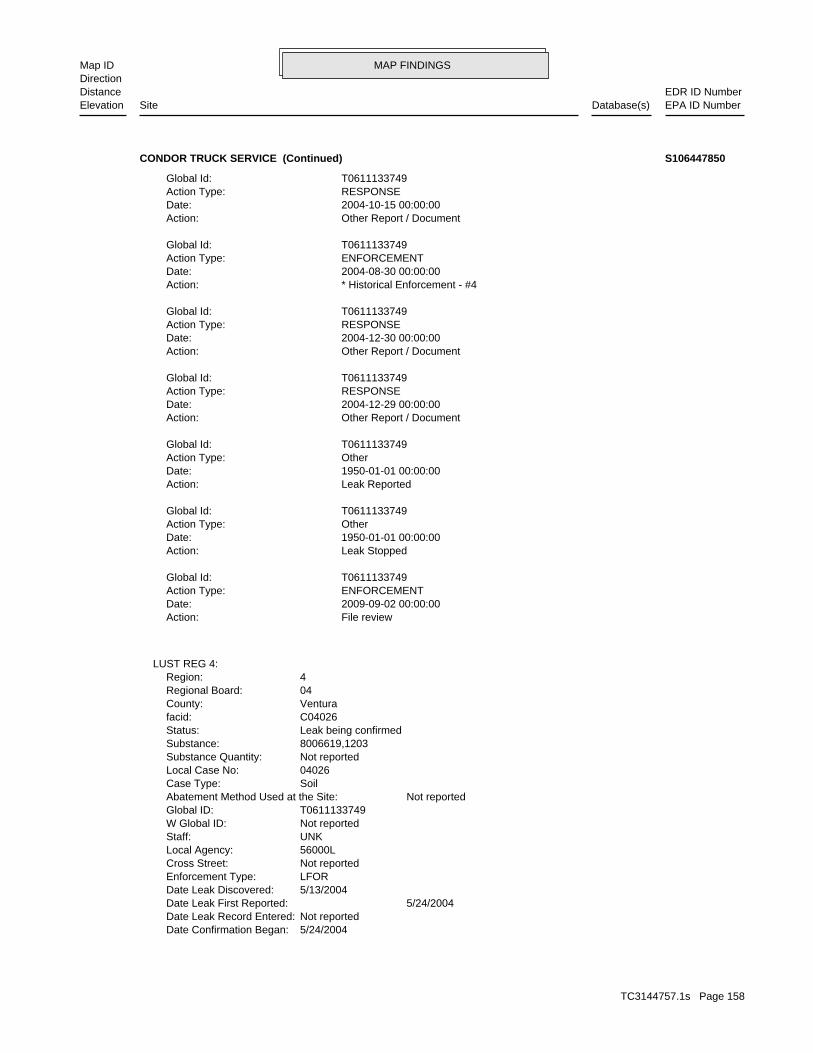
MAP FINDINGSMap IDDirection
EDR ID NumberDistanceEPA ID NumberDatabase(s)SiteElevation
5/24/2004Date Confirmation Began: Not reportedDate Leak Record Entered: 5/24/2004Date Leak First Reported: 5/13/2004Date Leak Discovered: LFOREnforcement Type: Not reportedCross Street: 56000LLocal Agency: UNKStaff: Not reportedW Global ID: T0611133749Global ID: Not reportedAbatement Method Used at the Site: SoilCase Type: 04026Local Case No: Not reportedSubstance Quantity: 8006619,1203Substance: Leak being confirmedStatus: C04026facid: VenturaCounty: 04Regional Board: 4Region:
LUST REG 4:
File reviewAction: 2009-09-02 00:00:00Date: ENFORCEMENTAction Type: T0611133749Global Id:
Leak StoppedAction: 1950-01-01 00:00:00Date: OtherAction Type: T0611133749Global Id:
Leak ReportedAction: 1950-01-01 00:00:00Date: OtherAction Type: T0611133749Global Id:
Other Report / DocumentAction: 2004-12-29 00:00:00Date: RESPONSEAction Type: T0611133749Global Id:
Other Report / DocumentAction: 2004-12-30 00:00:00Date: RESPONSEAction Type: T0611133749Global Id:
* Historical Enforcement - #4Action: 2004-08-30 00:00:00Date: ENFORCEMENTAction Type: T0611133749Global Id:
Other Report / DocumentAction: 2004-10-15 00:00:00Date: RESPONSEAction Type: T0611133749Global Id:
CONDOR TRUCK SERVICE (Continued) S106447850
TC3144757.1s Page 158

MAP FINDINGSMap IDDirection
EDR ID NumberDistanceEPA ID NumberDatabase(s)SiteElevation
Case ClosedStatus:04026Facility ID:VENTURARegion:
VENTURA CO. LUST:
Not reportedSummary: Not reportedAssigned Name: Not reportedSuspended: Not reportedCleanup Fund Id: Not reportedPriority: Not reportedBeneficial Use: DBWLocal Agency Staff: 0 / 0Lat/Long: Not reportedProgram: 1395 HARVARD BLVDRP Address: PAULResponsible Party: Not reportedOwner Contact: Not reportedOrganization: Not reportedSoil Qualifier: Not reportedGW Qualifier: Not reportedSignificant Interim Remedial Action Taken: Not reportedHist Max MTBE Conc in Soil: Not reportedHist Max MTBE Conc in Groundwater: Not reportedHistorical Max MTBE Date: Not reportedEnforcement Action Date: Not reportedPost Remedial Action Monitoring Began: Not reportedRemedial Action Underway: Not reportedRemediation Plan Submitted: Not reportedPollution Characterization Began: Not reportedPreliminary Site Assessment Began: Not reportedPreliminary Site Assessment Workplan Submitted: PipingSource of Cleanup Funding: Not reportedApprox. Dist To Production Well (ft): Not reportedWell Name: Not reportedWater System: Not reportedOperator: PipingLeak Source: UNKCause of Leak: RPPHow Leak Stopped: OMHow Leak Discovered: Not reportedDate the Case was Closed: Not reportedDate Case Last Changed on Database: 5/13/2004Date Leak Stopped:
CONDOR TRUCK SERVICE (Continued) S106447850
STATERegion:HIST UST:
-119.05143Longitude:34.35557Latitude:3320Facility ID:
UST:
2447 ft. Site 7 of 8 in cluster U0.464 mi. HAZNET
Relative:Lower
Actual:284 ft.
1/4-1/2 SWEEPS USTSANTA PAULA, CA 93060WSW HIST UST1395 E HARVARD BLVD N/AU130 USTCONDOR TRUCK SERVICE U001580127
TC3144757.1s Page 159
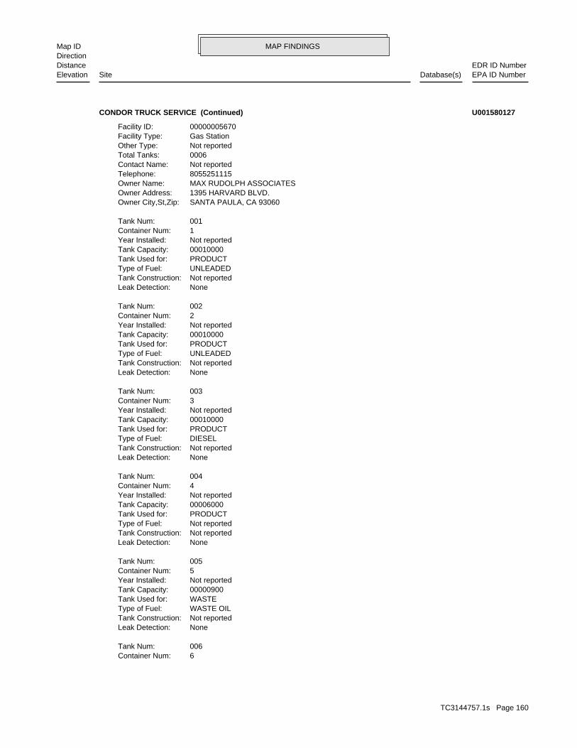
MAP FINDINGSMap IDDirection
EDR ID NumberDistanceEPA ID NumberDatabase(s)SiteElevation
6Container Num: 006Tank Num:
NoneLeak Detection: Not reportedTank Construction: WASTE OILType of Fuel: WASTETank Used for: 00000900Tank Capacity: Not reportedYear Installed: 5Container Num: 005Tank Num:
NoneLeak Detection: Not reportedTank Construction: Not reportedType of Fuel: PRODUCTTank Used for: 00006000Tank Capacity: Not reportedYear Installed: 4Container Num: 004Tank Num:
NoneLeak Detection: Not reportedTank Construction: DIESELType of Fuel: PRODUCTTank Used for: 00010000Tank Capacity: Not reportedYear Installed: 3Container Num: 003Tank Num:
NoneLeak Detection: Not reportedTank Construction: UNLEADEDType of Fuel: PRODUCTTank Used for: 00010000Tank Capacity: Not reportedYear Installed: 2Container Num: 002Tank Num:
NoneLeak Detection: Not reportedTank Construction: UNLEADEDType of Fuel: PRODUCTTank Used for: 00010000Tank Capacity: Not reportedYear Installed: 1Container Num: 001Tank Num:
SANTA PAULA, CA 93060Owner City,St,Zip: 1395 HARVARD BLVD.Owner Address: MAX RUDOLPH ASSOCIATESOwner Name: 8055251115Telephone: Not reportedContact Name: 0006Total Tanks: Not reportedOther Type: Gas StationFacility Type: 00000005670Facility ID:
CONDOR TRUCK SERVICE (Continued) U001580127
TC3144757.1s Page 160

MAP FINDINGSMap IDDirection
EDR ID NumberDistanceEPA ID NumberDatabase(s)SiteElevation
ORGANICS RECOVERY ECT OTHER RECOVERY OF RECLAMATION FOR REUSE INCLUDING ACID REGENERATION,Disposal Method: Tank bottom wasteWaste Category: Los AngelesTSD County: CAT080013352TSD EPA ID: VenturaGen County: SANTA PAULA, CA 930610828Mailing City,St,Zip: PO BOX 828Mailing Address: Not reportedMailing Name: 8055251115Telephone: PAUL RUDOLPHContact: CAL000298750Gepaid: 2009Year:
HAZNET:
Not reportedNumber Of Tanks: Not reportedContent: PStg: UNKNOWNTank Use: 10000Capacity: Not reportedActv Date: 56-000-000940-000002Swrcb Tank Id: Not reportedOwner Tank Id: ATank Status: 02-29-88Created Date: 09-30-92Act Date: 09-30-92Ref Date: 44-030737Board Of Equalization: 9Number: 940Comp Number: AStatus:
2Number Of Tanks: Not reportedContent: PStg: UNKNOWNTank Use: 10000Capacity: Not reportedActv Date: 56-000-000940-000001Swrcb Tank Id: Not reportedOwner Tank Id: ATank Status: 02-29-88Created Date: 09-30-92Act Date: 09-30-92Ref Date: 44-030737Board Of Equalization: 9Number: 940Comp Number: AStatus:
SWEEPS UST:
NoneLeak Detection: Not reportedTank Construction: WASTE OILType of Fuel: WASTETank Used for: 00000500Tank Capacity: Not reportedYear Installed:
CONDOR TRUCK SERVICE (Continued) U001580127
TC3144757.1s Page 161

MAP FINDINGSMap IDDirection
EDR ID NumberDistanceEPA ID NumberDatabase(s)SiteElevation
Not reportedFacility County: 0.1Tons: D80Disposal Method: Other organic solidsWaste Category: Los AngelesTSD County: CAT080033681TSD EPA ID: VenturaGen County: SANTA PAULA, CA 93060Mailing City,St,Zip: 1395 E HARVARD BLVDMailing Address: Not reportedMailing Name: 8055251115Telephone: BOB COLVINContact: CAC002595255Gepaid: 2005Year:
VenturaFacility County: 0.834Tons:
CONDOR TRUCK SERVICE (Continued) U001580127
UNKNOWNTank Use: 10000Capacity: Not reportedActv Date: 56-000-001180-000001Swrcb Tank Id: Not reportedOwner Tank Id: ATank Status: 02-29-88Created Date: 09-30-92Act Date: 09-30-92Ref Date: 44-030764Board Of Equalization: 9Number: 1180Comp Number: AStatus:
SWEEPS UST:
ActiveStatus: Not reportedComments: Not reportedEPA ID: Not reportedNPDES Number: Not reportedDUNs Number: Not reportedContact Phone: Not reportedContact: SANTA PAULA 93060Mailing City,St,Zip: Not reportedMailing Address 2: 1460 3 SANTA PAULA STMailing Address: Not reportedMail To: Not reportedFacility Phone: Not reportedSIC Code: Not reportedCortese Code: Not reportedRegulated ID: UTNKARegulated By: 56004870Facility ID:
CA FID UST:
2459 ft.0.466 mi.
Relative:Higher
Actual:317 ft.
1/4-1/2 SANTA PAULA, CA 93060West SWEEPS UST1460 3 SANTA PAULA ST N/A131 CA FID USTBAKER TANK S101631229
TC3144757.1s Page 162

MAP FINDINGSMap IDDirection
EDR ID NumberDistanceEPA ID NumberDatabase(s)SiteElevation
1Number Of Tanks: Not reportedContent: PStg:
BAKER TANK (Continued) S101631229
BUSINESS PLAN - SANTA PAULAProgram:FA0006396Facility ID:
VENTURA CO. BWT:
2464 ft. Site 8 of 8 in cluster U0.467 mi.
Relative:Lower
Actual:284 ft.
1/4-1/2 SANTA PAULA, CA SW 1438 E HARVARD BLVD N/AU132 VENTURA CO. BWTVEGA WELDING S105773947
8056594773Telephone: RYAN NASALROADContact: CAL000287218Gepaid: 2005Year:
VenturaFacility County: 0.25Tons: H14Disposal Method: Other organic solidsWaste Category: Los AngelesTSD County: CAD008252405TSD EPA ID: VenturaGen County: SANTA PAULA, CA 93060Mailing City,St,Zip: 55 HALLOCK DRMailing Address: Not reportedMailing Name: 8055255541Telephone: RYAN NASALROADContact: CAL000287218Gepaid: 2006Year:
VenturaFacility County: 1.25Tons: ORGANICS RECOVERY ECT OTHER RECOVERY OF RECLAMATION FOR REUSE INCLUDING ACID REGENERATION,Disposal Method: Unspecified oil-containing wasteWaste Category: Los AngelesTSD County: CAT080013352TSD EPA ID: VenturaGen County: SANTA PAULA, CA 93060Mailing City,St,Zip: 55 HALLOCK DRMailing Address: Not reportedMailing Name: 8055255541Telephone: RYAN NASALROADContact: CAL000287218Gepaid: 2007Year:
HAZNET:
2469 ft. Site 1 of 4 in cluster V0.468 mi.
Relative:Lower
Actual:267 ft.
1/4-1/2 SANTA PAULA, CA 93060SSW 55 HALLOCK DR N/AV133 HAZNETLIMONEIRA MERCANTILE LLC S108212296
TC3144757.1s Page 163
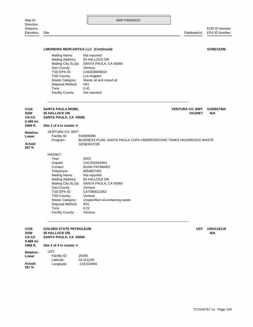
MAP FINDINGSMap IDDirection
EDR ID NumberDistanceEPA ID NumberDatabase(s)SiteElevation
Not reportedFacility County: 0.41Tons: H01Disposal Method: Waste oil and mixed oilWaste Category: Los AngelesTSD County: CAD028409019TSD EPA ID: VenturaGen County: SANTA PAULA, CA 93060Mailing City,St,Zip: 55 HALLOCK DRMailing Address: Not reportedMailing Name:
LIMONEIRA MERCANTILE LLC (Continued) S108212296
VenturaFacility County: 0.22Tons: R01Disposal Method: Unspecified oil-containing wasteWaste Category: VenturaTSD County: CAT080013352TSD EPA ID: VenturaGen County: SANTA PAULA, CA 93060Mailing City,St,Zip: 55 HALLOCK DRMailing Address: Not reportedMailing Name: 8054827451Telephone: BIJAN PAYMARDContact: CAC002562464Gepaid: 2003Year:
HAZNET:
GENERATORBUSINESS PLAN- SANTA PAULA CUPA UNDERGROUND TANKS HAZARDOUS WASTEProgram:FA0006985Facility ID:
VENTURA CO. BWT:
2469 ft. Site 2 of 4 in cluster V0.468 mi.
Relative:Lower
Actual:267 ft.
1/4-1/2 SANTA PAULA, CA 93060SSW HAZNET55 HALLOCK DR N/AV134 VENTURA CO. BWTSANTA PAULA MOBIL S105557464
-119.024945Longitude:34.211235Latitude:20345Facility ID:
UST:
2469 ft. Site 3 of 4 in cluster V0.468 mi.
Relative:Lower
Actual:267 ft.
1/4-1/2 SANTA PAULA, CA 93060SSW 55 HALLOCK DR. N/AV135 USTGOLDEN STATE PETROLEUM U004118118
TC3144757.1s Page 164
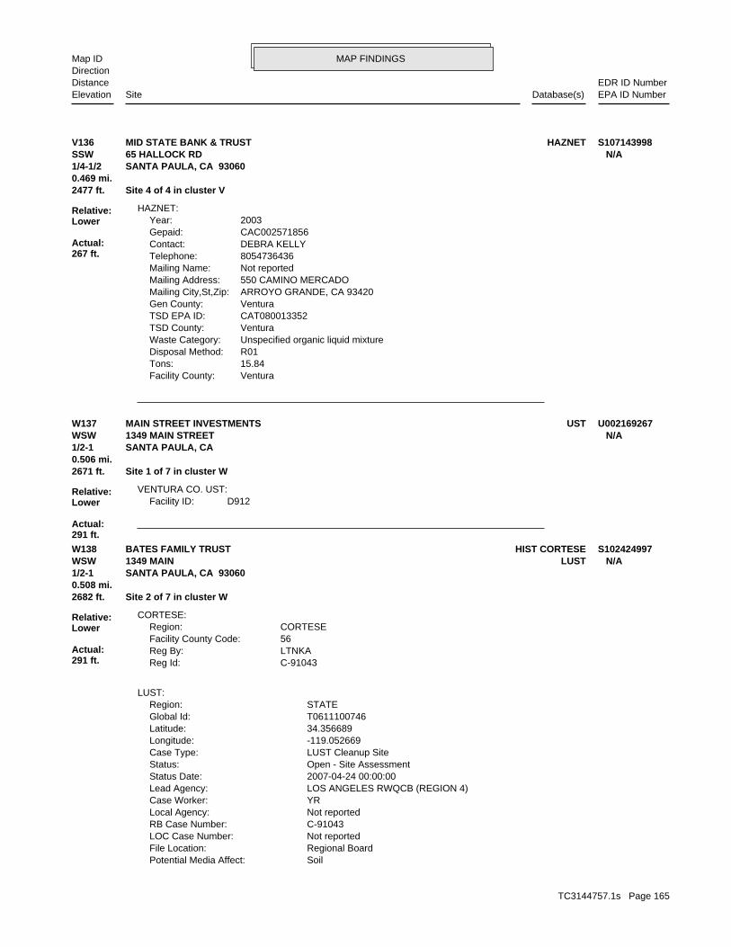
MAP FINDINGSMap IDDirection
EDR ID NumberDistanceEPA ID NumberDatabase(s)SiteElevation
VenturaFacility County: 15.84Tons: R01Disposal Method: Unspecified organic liquid mixtureWaste Category: VenturaTSD County: CAT080013352TSD EPA ID: VenturaGen County: ARROYO GRANDE, CA 93420Mailing City,St,Zip: 550 CAMINO MERCADOMailing Address: Not reportedMailing Name: 8054736436Telephone: DEBRA KELLYContact: CAC002571856Gepaid: 2003Year:
HAZNET:
2477 ft. Site 4 of 4 in cluster V0.469 mi.
Relative:Lower
Actual:267 ft.
1/4-1/2 SANTA PAULA, CA 93060SSW 65 HALLOCK RD N/AV136 HAZNETMID STATE BANK & TRUST S107143998
D912Facility ID:VENTURA CO. UST:
2671 ft. Site 1 of 7 in cluster W0.506 mi.
Relative:Lower
Actual:291 ft.
1/2-1 SANTA PAULA, CA WSW 1349 MAIN STREET N/AW137 USTMAIN STREET INVESTMENTS U002169267
SoilPotential Media Affect: Regional BoardFile Location: Not reportedLOC Case Number: C-91043RB Case Number: Not reportedLocal Agency: YRCase Worker: LOS ANGELES RWQCB (REGION 4)Lead Agency: 2007-04-24 00:00:00Status Date: Open - Site AssessmentStatus: LUST Cleanup SiteCase Type: -119.052669Longitude: 34.356689Latitude: T0611100746Global Id: STATERegion:
LUST:
C-91043Reg Id: LTNKAReg By: 56Facility County Code: CORTESERegion:
CORTESE:
2682 ft. Site 2 of 7 in cluster W0.508 mi.
Relative:Lower
Actual:291 ft.
1/2-1 SANTA PAULA, CA 93060WSW LUST1349 MAIN N/AW138 HIST CORTESEBATES FAMILY TRUST S102424997
TC3144757.1s Page 165

MAP FINDINGSMap IDDirection
EDR ID NumberDistanceEPA ID NumberDatabase(s)SiteElevation
T0611100746Global Id:
Referral to Regional Board - #LAR2Action: 2007-04-23 00:00:00Date: ENFORCEMENTAction Type: T0611100746Global Id:
Staff LetterAction: 2007-12-17 00:00:00Date: ENFORCEMENTAction Type: T0611100746Global Id:
* Historical EnforcementAction: 2003-06-26 00:00:00Date: ENFORCEMENTAction Type: T0611100746Global Id:
Site Visit / Inspection / SamplingAction: 2004-06-16 00:00:00Date: ENFORCEMENTAction Type: T0611100746Global Id:
* Historical Enforcement - #L01Action: 2004-11-17 00:00:00Date: ENFORCEMENTAction Type: T0611100746Global Id:
* No ActionAction: 2007-04-24 00:00:00Date: ENFORCEMENTAction Type: T0611100746Global Id:
* Historical Enforcement - #LAR1Action: 2005-09-15 00:00:00Date: ENFORCEMENTAction Type: T0611100746Global Id:
Notice of ViolationAction: 2003-04-28 00:00:00Date: ENFORCEMENTAction Type: T0611100746Global Id:
LUST:
2135766714Phone Number: [email protected]: R4 UNKNOWNCity: Not reportedAddress: LOS ANGELES RWQCB (REGION 4)Organization Name: DANIEL PIROTTONContact Name: Regional Board CaseworkerContact Type: T0611100746Global Id:
LUST:
Click here to access the California GeoTracker records for this facility:
Not reportedSite History: GasolinePotential Contaminants of Concern:
BATES FAMILY TRUST (Continued) S102424997
TC3144757.1s Page 166
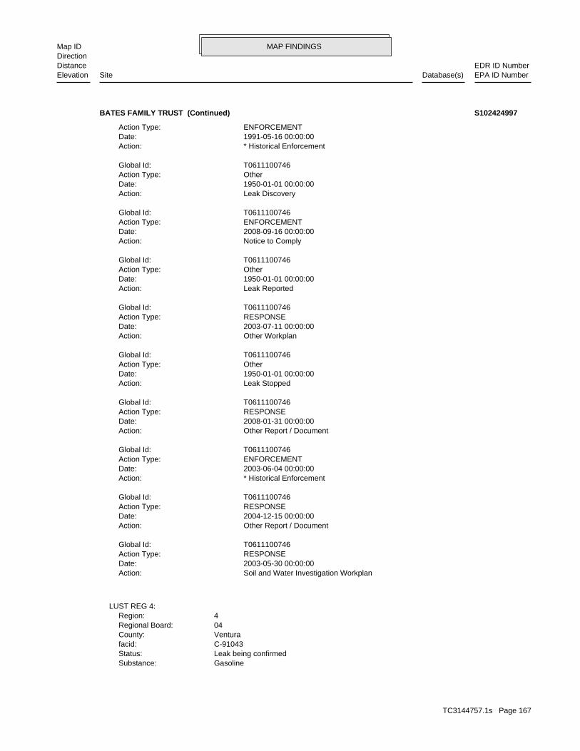
MAP FINDINGSMap IDDirection
EDR ID NumberDistanceEPA ID NumberDatabase(s)SiteElevation
GasolineSubstance: Leak being confirmedStatus: C-91043facid: VenturaCounty: 04Regional Board: 4Region:
LUST REG 4:
Soil and Water Investigation WorkplanAction: 2003-05-30 00:00:00Date: RESPONSEAction Type: T0611100746Global Id:
Other Report / DocumentAction: 2004-12-15 00:00:00Date: RESPONSEAction Type: T0611100746Global Id:
* Historical EnforcementAction: 2003-06-04 00:00:00Date: ENFORCEMENTAction Type: T0611100746Global Id:
Other Report / DocumentAction: 2008-01-31 00:00:00Date: RESPONSEAction Type: T0611100746Global Id:
Leak StoppedAction: 1950-01-01 00:00:00Date: OtherAction Type: T0611100746Global Id:
Other WorkplanAction: 2003-07-11 00:00:00Date: RESPONSEAction Type: T0611100746Global Id:
Leak ReportedAction: 1950-01-01 00:00:00Date: OtherAction Type: T0611100746Global Id:
Notice to ComplyAction: 2008-09-16 00:00:00Date: ENFORCEMENTAction Type: T0611100746Global Id:
Leak DiscoveryAction: 1950-01-01 00:00:00Date: OtherAction Type: T0611100746Global Id:
* Historical EnforcementAction: 1991-05-16 00:00:00Date: ENFORCEMENTAction Type:
BATES FAMILY TRUST (Continued) S102424997
TC3144757.1s Page 167
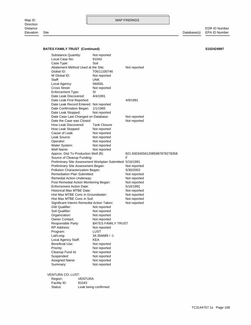
MAP FINDINGSMap IDDirection
EDR ID NumberDistanceEPA ID NumberDatabase(s)SiteElevation
Leak being confirmedStatus:91043Facility ID:VENTURARegion:
VENTURA CO. LUST:
Not reportedSummary: Not reportedAssigned Name: Not reportedSuspended: Not reportedCleanup Fund Id: Not reportedPriority: Not reportedBeneficial Use: KEALocal Agency Staff: 34.356689 / -1Lat/Long: LUSTProgram: Not reportedRP Address: BATES FAMILY TRUSTResponsible Party: Not reportedOwner Contact: Not reportedOrganization: Not reportedSoil Qualifier: Not reportedGW Qualifier: Not reportedSignificant Interim Remedial Action Taken: Not reportedHist Max MTBE Conc in Soil: Not reportedHist Max MTBE Conc in Groundwater: Not reportedHistorical Max MTBE Date: 5/16/1991Enforcement Action Date: Not reportedPost Remedial Action Monitoring Began: Not reportedRemedial Action Underway: Not reportedRemediation Plan Submitted: 5/30/2003Pollution Characterization Began: Not reportedPreliminary Site Assessment Began: 5/16/1991Preliminary Site Assessment Workplan Submitted: FSource of Cleanup Funding: 821.9303455612085987878278358Approx. Dist To Production Well (ft): Not reportedWell Name: Not reportedWater System: Not reportedOperator: Not reportedLeak Source: Not reportedCause of Leak: Not reportedHow Leak Stopped: Tank ClosureHow Leak Discovered: Not reportedDate the Case was Closed: Not reportedDate Case Last Changed on Database: Not reportedDate Leak Stopped: 1/1/1965Date Confirmation Began: Not reportedDate Leak Record Entered: 4/9/1991Date Leak First Reported: 4/4/1991Date Leak Discovered: SIEnforcement Type: Not reportedCross Street: 56000LLocal Agency: UNKStaff: Not reportedW Global ID: T0611100746Global ID: Not reportedAbatement Method Used at the Site: SoilCase Type: 91043Local Case No: Not reportedSubstance Quantity:
BATES FAMILY TRUST (Continued) S102424997
TC3144757.1s Page 168

MAP FINDINGSMap IDDirection
EDR ID NumberDistanceEPA ID NumberDatabase(s)SiteElevation
File review indicates that the site UG tank removal was overseeing byComments: 1994-10-25 00:00:00Completed Date: Site ScreeningCompleted Document Type: Not reportedCompleted Sub Area Name: PROJECT WIDECompleted Area Name:
Completed Info:
Envirostor ID NumberAlias Type: 56730022Alias Name: HWTS Identification CodeAlias Type: CAT080018666Alias Name: EPA Identification NumberAlias Type: CAT080018666Alias Name: Alternate NameAlias Type: STEWART & LAMBERTAlias Name: Alternate NameAlias Type: ORTHO INSECTICIDESAlias Name: Alternate NameAlias Type: MASSONAlias Name: Alternate NameAlias Type: FMC CORPORATION AG CHEMAlias Name: Alternate NameAlias Type: CLARK CORPORATIONAlias Name: Alternate NameAlias Type: AGRICULTURAL LAND SERVICES INCAlias Name: Alternate NameAlias Type: AGRI-SERVICEAlias Name: NONE SPECIFIEDPotential Description: NONE SPECIFIEDConfirmed COC: 10012, 10076, 10077, 10097, 10099Potential COC: NONE SPECIFIEDPast Use: NONE SPECIFIEDAPN: -119.051111111111Longitude: 34.357222222222198Latitude: Not reportedFunding: NONE SPECIFIEDSite Mgmt. Req.: NORestricted Use: 1995-08-15 00:00:00Status Date: Refer: Other AgencyStatus: * CERC2Special Program: 17Senate: 37Assembly: Not reportedSite Code: 56730022Facility ID: Cleanup ChatsworthDivision Branch: * MMONROYSupervisor: Not reportedProgram Manager: NONE SPECIFIEDLead Agency: NONE SPECIFIEDRegulatory Agencies: NONPL: Not reportedAcres: * HistoricalSite Type Detailed: HistoricalSite Type:
ENVIROSTOR:
2682 ft. Site 3 of 7 in cluster W0.508 mi.
Relative:Lower
Actual:291 ft.
1/2-1 SANTA PAULA, CA 93060WSW 1349 EAST MAIN STREET N/AW139 ENVIROSTORAGRI-SERV INCORPORATED S101482915
TC3144757.1s Page 169

MAP FINDINGSMap IDDirection
EDR ID NumberDistanceEPA ID NumberDatabase(s)SiteElevation
Not reportedSchedule Revised Date: Not reportedSchedule Due Date: Not reportedSchedule Document Type: Not reportedSchedule Sub Area Name: Not reportedSchedule Area Name: Not reportedFuture Due Date: Not reportedFuture Document Type: Not reportedFuture Sub Area Name: Not reportedFuture Area Name:
insecticides. Stewart operations included fumigating, termite & weed control, line broke prior to 1981. Agri-Serv operations are pest control. Violation detected in 1981 - anhydrous ammonia release to air when a Facility identified from 1970 Pac Tel Directory. Records Search:Comments: 1983-12-02 00:00:00Completed Date: * DiscoveryCompleted Document Type: Not reportedCompleted Sub Area Name: PROJECT WIDECompleted Area Name:
medium-priority Site Inspection, therefore EPA is the lead. Preliminary Assessment completed. EPA recommendation isComments: 1989-05-30 00:00:00Completed Date: Preliminary Assessment ReportCompleted Document Type: Not reportedCompleted Sub Area Name: PROJECT WIDECompleted Area Name:
underground tanks. Owner is in process of characterizing the site and removal of the Site Inspection completed. No further action for CERCLA and DHS.Comments: 1989-06-30 00:00:00Completed Date: *Site Inspection (SI) ReportCompleted Document Type: Not reportedCompleted Sub Area Name: PROJECT WIDECompleted Area Name:
the County. Staff recommends NFA for DTSC.
AGRI-SERV INCORPORATED (Continued) S101482915
13088738.00000Contact Sequence ID:
9270048.00000Person ID: 13058021.00000Contact Sequence ID:
9271184.00000Person ID: 13051944.00000Contact Sequence ID:
CERCLIS-NFRAP Site Contact Details:
NFRAP-Site does not qualify for the NPL based on existing informationNon NPL Status: Not on the NPLNPL Status: Not a Federal FacilityFederal Facility: 0902694Site ID:
CERC-NFRAP:
2682 ft. Site 4 of 7 in cluster W0.508 mi.
Relative:Lower
Actual:291 ft.
1/2-1 FINDSSANTA PAULA, CA 93060WSW RCRA-SQG1349 MAIN ST CAT080018666W140 CERC-NFRAPAGRI SERV 1000245018
TC3144757.1s Page 170
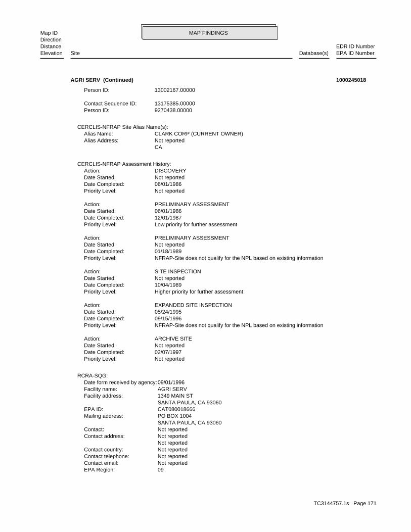
MAP FINDINGSMap IDDirection
EDR ID NumberDistanceEPA ID NumberDatabase(s)SiteElevation
09EPA Region: Not reportedContact email: Not reportedContact telephone: Not reportedContact country: Not reported Not reportedContact address: Not reportedContact: SANTA PAULA, CA 93060 PO BOX 1004Mailing address: CAT080018666EPA ID: SANTA PAULA, CA 93060 1349 MAIN STFacility address: AGRI SERVFacility name: 09/01/1996Date form received by agency:
RCRA-SQG:
Not reportedPriority Level: 02/07/1997Date Completed: Not reportedDate Started: ARCHIVE SITEAction:
NFRAP-Site does not qualify for the NPL based on existing informationPriority Level: 09/15/1996Date Completed: 05/24/1995Date Started: EXPANDED SITE INSPECTIONAction:
Higher priority for further assessmentPriority Level: 10/04/1989Date Completed: Not reportedDate Started: SITE INSPECTIONAction:
NFRAP-Site does not qualify for the NPL based on existing informationPriority Level: 01/18/1989Date Completed: Not reportedDate Started: PRELIMINARY ASSESSMENTAction:
Low priority for further assessmentPriority Level: 12/01/1987Date Completed: 06/01/1986Date Started: PRELIMINARY ASSESSMENTAction:
Not reportedPriority Level: 06/01/1986Date Completed: Not reportedDate Started: DISCOVERYAction:
CERCLIS-NFRAP Assessment History:
CA Not reportedAlias Address: CLARK CORP (CURRENT OWNER)Alias Name:
CERCLIS-NFRAP Site Alias Name(s):
9270438.00000Person ID: 13175385.00000Contact Sequence ID:
13002167.00000Person ID:
AGRI SERV (Continued) 1000245018
TC3144757.1s Page 171

MAP FINDINGSMap IDDirection
EDR ID NumberDistanceEPA ID NumberDatabase(s)SiteElevation
110002948099Registry ID:
FINDS:
No violations foundViolation Status:
Large Quantity GeneratorClassification: AGRI SERVFacility name: 01/15/1981Date form received by agency:
Historical Generators:
NoUsed oil transporter: NoUsed oil transfer facility: NoUsed oil Specification marketer: NoUsed oil fuel marketer to burner: NoUser oil refiner: NoUsed oil processor: NoUsed oil fuel burner: NoFurnace exemption: NoOn-site burner exemption: NoUnderground injection activity: NoTreater, storer or disposer of HW: NoTransporter of hazardous waste: NoRecycler of hazardous waste: NoMixed waste (haz. and radioactive): NoU.S. importer of hazardous waste:
Handler Activities Summary:
Not reportedOwner/Op end date: Not reportedOwner/Op start date: OperatorOwner/Operator Type: PrivateLegal status: (415) 555-1212Owner/operator telephone: Not reportedOwner/operator country: NOT REQUIRED, ME 99999 NOT REQUIREDOwner/operator address: NOT REQUIREDOwner/operator name:
Not reportedOwner/Op end date: Not reportedOwner/Op start date: OwnerOwner/Operator Type: PrivateLegal status: (415) 555-1212Owner/operator telephone: Not reportedOwner/operator country: NOT REQUIRED, ME 99999 NOT REQUIREDOwner/operator address: AG LAND SERVICES INCOwner/operator name:
Owner/Operator Summary:
hazardous waste at any time waste during any calendar month, and accumulates more than 1000 kg of hazardous waste at any time; or generates 100 kg or less of hazardous waste during any calendar month and accumulates less than 6000 kg of Handler: generates more than 100 and less than 1000 kg of hazardousDescription: Small Small Quantity GeneratorClassification:
AGRI SERV (Continued) 1000245018
TC3144757.1s Page 172

MAP FINDINGSMap IDDirection
EDR ID NumberDistanceEPA ID NumberDatabase(s)SiteElevation
corrective action activities required under RCRA.program staff to track the notification, permit, compliance, andand treat, store, or dispose of hazardous waste. RCRAInfo allows RCRAevents and activities related to facilities that generate, transport,Conservation and Recovery Act (RCRA) program through the tracking ofRCRAInfo is a national information system that supports the Resource Environmental Interest/Information System
AGRI SERV (Continued) 1000245018
515Comp Number: AStatus:
SWEEPS UST:
Stock InventorLeak Detection: Not reportedTank Construction: WASTE OILType of Fuel: WASTETank Used for: 00000000Tank Capacity: Not reportedYear Installed: 313Container Num: 003Tank Num:
Stock InventorLeak Detection: Not reportedTank Construction: DIESELType of Fuel: PRODUCTTank Used for: 00000000Tank Capacity: 1980Year Installed: 312Container Num: 002Tank Num:
Stock InventorLeak Detection: Not reportedTank Construction: UNLEADEDType of Fuel: PRODUCTTank Used for: 00000000Tank Capacity: Not reportedYear Installed: 311Container Num: 001Tank Num:
ROSEMEAD, CA 91770Owner City,St,Zip: 2244 WALNUT GROVE AVENUEOwner Address: SOUTHERN CALIFORNIA EDISON CO.Owner Name: 8185721801Telephone: J E WING, MGRContact Name: 0003Total Tanks: ELECTRIC UTILITYOther Type: OtherFacility Type: 00000022250Facility ID: STATERegion:
HIST UST:
2731 ft. Site 5 of 7 in cluster W0.517 mi.
Relative:Lower
Actual:291 ft.
1/2-1 HAZNETSANTA PAULA, CA 93060WSW SWEEPS UST1343 E MAIN ST N/AW141 HIST USTWESTERN DIV TRANSMISSION/SUBST U001580305
TC3144757.1s Page 173

MAP FINDINGSMap IDDirection
EDR ID NumberDistanceEPA ID NumberDatabase(s)SiteElevation
ROSEMEAD, CA 917700000Mailing City,St,Zip: 2244 WALNUT GROVE AVEMailing Address: Not reportedMailing Name: 0Telephone: SCE-SANTA PAULA SUBContact: CAP000145383Gepaid: 2003Year:
HAZNET:
Not reportedNumber Of Tanks: Not reportedContent: PStg: UNKNOWNTank Use: 550Capacity: Not reportedActv Date: 56-000-000515-000003Swrcb Tank Id: Not reportedOwner Tank Id: ATank Status: 02-29-88Created Date: 09-30-92Act Date: 09-30-92Ref Date: 44-030635Board Of Equalization: 9Number: 515Comp Number: AStatus:
Not reportedNumber Of Tanks: Not reportedContent: PStg: UNKNOWNTank Use: 10000Capacity: Not reportedActv Date: 56-000-000515-000002Swrcb Tank Id: Not reportedOwner Tank Id: ATank Status: 02-29-88Created Date: 09-30-92Act Date: 09-30-92Ref Date: 44-030635Board Of Equalization: 9Number: 515Comp Number: AStatus:
3Number Of Tanks: Not reportedContent: PStg: UNKNOWNTank Use: 10000Capacity: Not reportedActv Date: 56-000-000515-000001Swrcb Tank Id: Not reportedOwner Tank Id: ATank Status: 02-29-88Created Date: 09-30-92Act Date: 09-30-92Ref Date: 44-030635Board Of Equalization: 9Number:
WESTERN DIV TRANSMISSION/SUBST (Continued) U001580305
TC3144757.1s Page 174
MAP FINDINGSMap IDDirection
EDR ID NumberDistanceEPA ID NumberDatabase(s)SiteElevation
VenturaFacility County: 0.84Tons: D99Disposal Method: Other inorganic solid wasteWaste Category: VenturaTSD County: CAT000646117TSD EPA ID: VenturaGen County:
WESTERN DIV TRANSMISSION/SUBST (Continued) U001580305
Sensor InstrumentLeak Detection: Not reportedTank Construction: WASTE OILType of Fuel: WASTETank Used for: 00000500Tank Capacity: 1985Year Installed: 452Container Num: 003Tank Num:
Sensor InstrumentLeak Detection: Not reportedTank Construction: DIESELType of Fuel: PRODUCTTank Used for: 00010000Tank Capacity: 1985Year Installed: 451Container Num: 002Tank Num:
Sensor InstrumentLeak Detection: Unkown inchesTank Construction: 1Type of Fuel: WASTETank Used for: 00010000Tank Capacity: 1985Year Installed: 450Container Num: 001Tank Num:
ROSEMEAD, CA 91770Owner City,St,Zip: 2244 WALNUT GROVE AVENUEOwner Address: SOUTHERN CALIFORNIA EDISON COMOwner Name: 8183021801Telephone: J.E. WINGOContact Name: 0003Total Tanks: ELECTRIC UTILITYOther Type: OtherFacility Type: 00000066321Facility ID: STATERegion:
HIST UST:
2731 ft. Site 6 of 7 in cluster W0.517 mi.
Relative:Lower
Actual:291 ft.
1/2-1 SANTA PAULA, CA 93060WSW 1343 E MAIN ST N/AW142 HIST USTWESTERN TRANSMISSION/SUBSTATIO U001580306
TC3144757.1s Page 175

MAP FINDINGSMap IDDirection
EDR ID NumberDistanceEPA ID NumberDatabase(s)SiteElevation
1950-01-01 00:00:00Date: OtherAction Type: T0611139215Global Id:
Closure/No Further Action Letter - #2Action: 2007-03-26 00:00:00Date: ENFORCEMENTAction Type: T0611139215Global Id:
Technical Correspondence / Assistance / Other - #1Action: 2007-02-06 00:00:00Date: ENFORCEMENTAction Type: T0611139215Global Id:
LUST:
2135766714Phone Number: [email protected]: R4 UNKNOWNCity: Not reportedAddress: LOS ANGELES RWQCB (REGION 4)Organization Name: DANIEL PIROTTONContact Name: Regional Board CaseworkerContact Type: T0611139215Global Id:
8056545040Phone Number: [email protected]: VENTURACity: 800 S. VICTORIA AVE.Address: VENTURA COUNTY LOPOrganization Name: DIANE B. WAHLContact Name: Local Agency CaseworkerContact Type: T0611139215Global Id:
LUST:
Click here to access the California GeoTracker records for this facility:
Not reportedSite History: LeadPotential Contaminants of Concern: SoilPotential Media Affect: Regional BoardFile Location: 06008LOC Case Number: C06008RB Case Number: VENTURA COUNTY LOPLocal Agency: DBWCase Worker: VENTURA COUNTY LOPLead Agency: 2007-03-26 00:00:00Status Date: Completed - Case ClosedStatus: LUST Cleanup SiteCase Type: -119.053505Longitude: 34.356166Latitude: T0611139215Global Id: STATERegion:
LUST:
2948 ft. Site 7 of 7 in cluster W0.558 mi.
Relative:Lower
Actual:290 ft.
1/2-1 SANTA PAULA, CA WSW 1315 MAIN ST N/AW143 LUSTR & R PIPELINE INC S108244854
TC3144757.1s Page 176
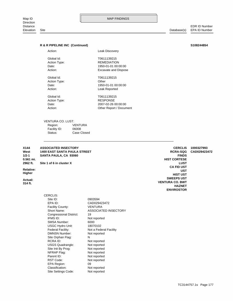
MAP FINDINGSMap IDDirection
EDR ID NumberDistanceEPA ID NumberDatabase(s)SiteElevation
Case ClosedStatus:06008Facility ID:VENTURARegion:
VENTURA CO. LUST:
Other Report / DocumentAction: 2007-02-26 00:00:00Date: RESPONSEAction Type: T0611139215Global Id:
Leak ReportedAction: 1950-01-01 00:00:00Date: OtherAction Type: T0611139215Global Id:
Excavate and DisposeAction: 1950-01-01 00:00:00Date: REMEDIATIONAction Type: T0611139215Global Id:
Leak DiscoveryAction:
R & R PIPELINE INC (Continued) S108244854
Not reportedSite Settings Code: Not reportedClassification: 09EPA Region: Not reportedRST Code: Not reportedParent ID: Not reportedNFRAP Flag: Not reportedSite Init By Prog: Not reportedUSGS Quadrangle: Not reportedRCRA ID: NSite Orphan Flag: Not reportedDMNSN Number: Not a Federal FacilityFederal Facility: 18070102USGC Hydro Unit: 6000SMSA Number: Not reportedIFMS ID: 19Congressional District: ASSOCIATED INSECTORYShort Name: VENTURAFacility County: CAD029423472EPA ID: 0903594Site ID:
CERCLIS:
ENVIROSTORHAZNET
VENTURA CO. BWTSWEEPS UST
HIST USTUST
CA FID UST2962 ft. LUSTSite 1 of 6 in cluster X0.561 mi. HIST CORTESE
Relative:Higher
Actual:314 ft.
1/2-1 FINDSSANTA PAULA, CA 93060West RCRA-SQG1400 EAST SANTA PAULA STREET CAD029423472X144 CERCLISASSOCIATED INSECTORY 1000327993
TC3144757.1s Page 177

MAP FINDINGSMap IDDirection
EDR ID NumberDistanceEPA ID NumberDatabase(s)SiteElevation
PRELIMINARY ASSESSMENTAction: 001Action Code:
For detailed financial records, contact EDR for a Site Report.:
Not reportedAction Anomaly: Not reportedUrgency Indicator: Not reportedPlanning Status: State, Fund FinancedPrimary Responsibility: SITEWIDEOperable Unit: Not reportedPriority Level: 05/03/1989Date Completed: Not reportedDate Started: DISCOVERYAction: 001Action Code:
CERCLIS Assessment History:
Not reportedSite Description: Not reportedAlias Comments:
Not reportedContact Email: Site Assessment Manager (SAM)Contact Title: (415) 972-3097Contact Tel: Dawn RichmondContact Name: 9270438.00000Contact ID:
Not reportedContact Email: Site Assessment Manager (SAM)Contact Title: (415) 972-3814Contact Tel: Carl BricknerContact Name: 13002167.00000Contact ID:
Not reportedContact Email: Site Assessment Manager (SAM)Contact Title: (415) 972-3095Contact Tel: Jeff InglisContact Name: 9270048.00000Contact ID:
Not reportedContact Email: Site Assessment Manager (SAM)Contact Title: (415) 972-3219Contact Tel: Karen JuristContact Name: 9271184.00000Contact ID:
CERCLIS Site Contact Name(s):
Not reportedSite FUDS Flag: Not reportedAlias EPA ID: Not reportedCC Concurrence FY: Not reportedCC Concurrence Date: 06111Site Fips Code: 19960410Non NPL Status Date: SI Start NeededNon NPL Status: Not reportedRResp Fed Agency Code: Not reportedRBRAC Code: Not reportedDMNSN Unit Code: Not on the NPLNPL Status:
ASSOCIATED INSECTORY (Continued) 1000327993
TC3144757.1s Page 178
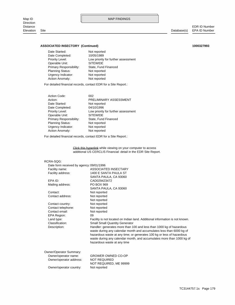
MAP FINDINGSMap IDDirection
EDR ID NumberDistanceEPA ID NumberDatabase(s)SiteElevation
Not reportedOwner/operator country: NOT REQUIRED, ME 99999 NOT REQUIREDOwner/operator address: GROWER OWNED CO-OPOwner/operator name:
Owner/Operator Summary:
hazardous waste at any time waste during any calendar month, and accumulates more than 1000 kg of hazardous waste at any time; or generates 100 kg or less of hazardous waste during any calendar month and accumulates less than 6000 kg of Handler: generates more than 100 and less than 1000 kg of hazardousDescription: Small Small Quantity GeneratorClassification: Facility is not located on Indian land. Additional information is not known.Land type: 09EPA Region: Not reportedContact email: Not reportedContact telephone: Not reportedContact country: Not reported Not reportedContact address: Not reportedContact: SANTA PAULA, CA 93060 PO BOX 969Mailing address: CAD029423472EPA ID: SANTA PAULA, CA 93060 1400 E SANTA PAULA STFacility address: ASSOCIATED INSECTARYFacility name: 09/01/1996Date form received by agency:
RCRA-SQG:
additional US CERCLIS Financial: detail in the EDR Site Report.Click this hyperlink while viewing on your computer to access
For detailed financial records, contact EDR for a Site Report.:
Not reportedAction Anomaly: Not reportedUrgency Indicator: Not reportedPlanning Status: State, Fund FinancedPrimary Responsibility: SITEWIDEOperable Unit: Low priority for further assessmentPriority Level: 04/10/1996Date Completed: Not reportedDate Started: PRELIMINARY ASSESSMENTAction: 002Action Code:
For detailed financial records, contact EDR for a Site Report.:
Not reportedAction Anomaly: Not reportedUrgency Indicator: Not reportedPlanning Status: State, Fund FinancedPrimary Responsibility: SITEWIDEOperable Unit: Low priority for further assessmentPriority Level: 10/05/1989Date Completed: Not reportedDate Started:
ASSOCIATED INSECTORY (Continued) 1000327993
TC3144757.1s Page 179

MAP FINDINGSMap IDDirection
EDR ID NumberDistanceEPA ID NumberDatabase(s)SiteElevation
10/24/1983Date violation determined: Generators - GeneralArea of violation: FR - 262.10-12.ARegulation violated:
0 Paid penalty amount: 0 Final penalty amount: 0 Proposed penalty amount: Not reported Enforcement lead agency: Not reported Enf. disp. status date: Not reported Enf. disposition status: Not reported Enforcement action date: Not reported Enforcement action: StateViolation lead agency: 08/17/1999Date achieved compliance: 08/17/1994Date violation determined: Generators - GeneralArea of violation: FR - 262.10-12.ARegulation violated:
Facility Has Received Notices of Violations:
Large Quantity GeneratorClassification: ASSOCIATED INSECTARYFacility name: 08/19/1980Date form received by agency:
Historical Generators:
NoUsed oil transporter: NoUsed oil transfer facility: NoUsed oil Specification marketer: NoUsed oil fuel marketer to burner: NoUser oil refiner: NoUsed oil processor: NoUsed oil fuel burner: NoFurnace exemption: NoOn-site burner exemption: NoUnderground injection activity: NoTreater, storer or disposer of HW: NoTransporter of hazardous waste: NoRecycler of hazardous waste: NoMixed waste (haz. and radioactive): NoU.S. importer of hazardous waste:
Handler Activities Summary:
Not reportedOwner/Op end date: Not reportedOwner/Op start date: OperatorOwner/Operator Type: PrivateLegal status: (415) 555-1212Owner/operator telephone: Not reportedOwner/operator country: NOT REQUIRED, ME 99999 NOT REQUIREDOwner/operator address: NOT REQUIREDOwner/operator name:
Not reportedOwner/Op end date: Not reportedOwner/Op start date: OwnerOwner/Operator Type: PrivateLegal status: (415) 555-1212Owner/operator telephone:
ASSOCIATED INSECTORY (Continued) 1000327993
TC3144757.1s Page 180
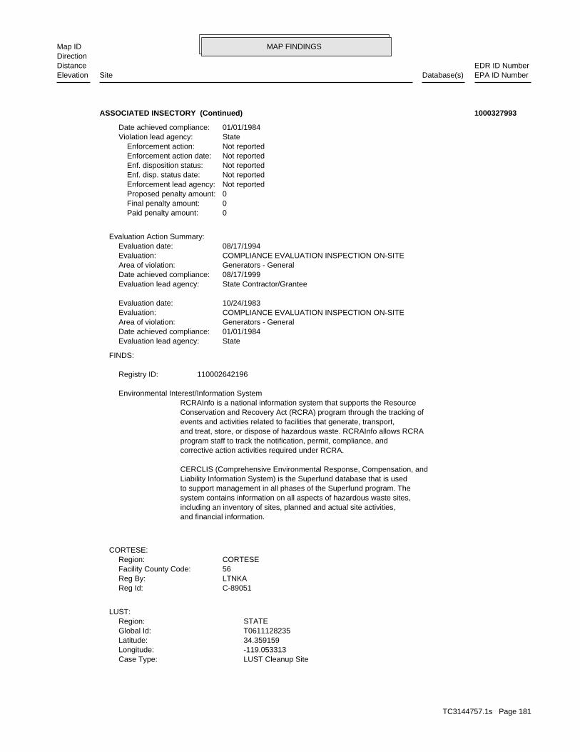
MAP FINDINGSMap IDDirection
EDR ID NumberDistanceEPA ID NumberDatabase(s)SiteElevation
LUST Cleanup SiteCase Type: -119.053313Longitude: 34.359159Latitude: T0611128235Global Id: STATERegion:
LUST:
C-89051Reg Id: LTNKAReg By: 56Facility County Code: CORTESERegion:
CORTESE:
and financial information.including an inventory of sites, planned and actual site activities,system contains information on all aspects of hazardous waste sites,to support management in all phases of the Superfund program. TheLiability Information System) is the Superfund database that is usedCERCLIS (Comprehensive Environmental Response, Compensation, and
corrective action activities required under RCRA.program staff to track the notification, permit, compliance, andand treat, store, or dispose of hazardous waste. RCRAInfo allows RCRAevents and activities related to facilities that generate, transport,Conservation and Recovery Act (RCRA) program through the tracking ofRCRAInfo is a national information system that supports the Resource Environmental Interest/Information System
110002642196Registry ID:
FINDS:
StateEvaluation lead agency: 01/01/1984Date achieved compliance: Generators - GeneralArea of violation: COMPLIANCE EVALUATION INSPECTION ON-SITEEvaluation: 10/24/1983Evaluation date:
State Contractor/GranteeEvaluation lead agency: 08/17/1999Date achieved compliance: Generators - GeneralArea of violation: COMPLIANCE EVALUATION INSPECTION ON-SITEEvaluation: 08/17/1994Evaluation date:
Evaluation Action Summary:
0 Paid penalty amount: 0 Final penalty amount: 0 Proposed penalty amount: Not reported Enforcement lead agency: Not reported Enf. disp. status date: Not reported Enf. disposition status: Not reported Enforcement action date: Not reported Enforcement action: StateViolation lead agency: 01/01/1984Date achieved compliance:
ASSOCIATED INSECTORY (Continued) 1000327993
TC3144757.1s Page 181

MAP FINDINGSMap IDDirection
EDR ID NumberDistanceEPA ID NumberDatabase(s)SiteElevation
Completed - Case ClosedStatus: LUST Cleanup SiteCase Type: -119.053313Longitude: 34.359159Latitude: T0611100471Global Id: STATERegion:
Not reportedAction: 1950-01-01 00:00:00Date: REMEDIATIONAction Type: T0611128235Global Id:
Leak StoppedAction: 1950-01-01 00:00:00Date: OtherAction Type: T0611128235Global Id:
Leak ReportedAction: 1950-01-01 00:00:00Date: OtherAction Type: T0611128235Global Id:
Leak DiscoveryAction: 1950-01-01 00:00:00Date: OtherAction Type: T0611128235Global Id:
Closure/No Further Action LetterAction: 2003-10-29 00:00:00Date: ENFORCEMENTAction Type: T0611128235Global Id:
LUST:
2135766714Phone Number: [email protected]: R4 UNKNOWNCity: Not reportedAddress: LOS ANGELES RWQCB (REGION 4)Organization Name: DANIEL PIROTTONContact Name: Regional Board CaseworkerContact Type: T0611128235Global Id:
LUST:
Click here to access the California GeoTracker records for this facility:
Not reportedSite History: GasolinePotential Contaminants of Concern: SoilPotential Media Affect: Not reportedFile Location: 02017LOC Case Number: C02017RB Case Number: Not reportedLocal Agency: KCKCase Worker: VENTURA COUNTY LOPLead Agency: 2003-10-29 00:00:00Status Date: Completed - Case ClosedStatus:
ASSOCIATED INSECTORY (Continued) 1000327993
TC3144757.1s Page 182

MAP FINDINGSMap IDDirection
EDR ID NumberDistanceEPA ID NumberDatabase(s)SiteElevation
EFEnforcement Type: Not reportedCross Street: 56000LLocal Agency: UNKStaff: Not reportedW Global ID: T0611100471Global ID: Not reportedAbatement Method Used at the Site: SoilCase Type: 89051Local Case No: Not reportedSubstance Quantity: GasolineSubstance: Case ClosedStatus: C-89051facid: VenturaCounty: 04Regional Board: 4Region:
LUST REG 4:
Leak ReportedAction: 1950-01-01 00:00:00Date: OtherAction Type: T0611100471Global Id:
Leak DiscoveryAction: 1950-01-01 00:00:00Date: OtherAction Type: T0611100471Global Id:
* Historical EnforcementAction: 1989-04-25 00:00:00Date: ENFORCEMENTAction Type: T0611100471Global Id:
LUST:
2135766714Phone Number: [email protected]: R4 UNKNOWNCity: Not reportedAddress: LOS ANGELES RWQCB (REGION 4)Organization Name: DANIEL PIROTTONContact Name: Regional Board CaseworkerContact Type: T0611100471Global Id:
LUST:
Click here to access the California GeoTracker records for this facility:
Not reportedSite History: GasolinePotential Contaminants of Concern: SoilPotential Media Affect: Not reportedFile Location: 89051LOC Case Number: C-89051RB Case Number: Not reportedLocal Agency: EHDCase Worker: VENTURA COUNTY LOPLead Agency: 1990-02-01 00:00:00Status Date:
ASSOCIATED INSECTORY (Continued) 1000327993
TC3144757.1s Page 183
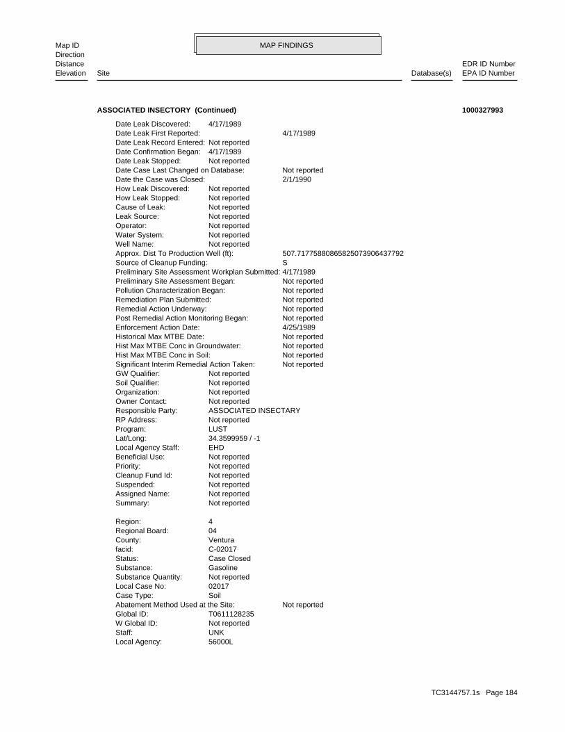
MAP FINDINGSMap IDDirection
EDR ID NumberDistanceEPA ID NumberDatabase(s)SiteElevation
56000LLocal Agency: UNKStaff: Not reportedW Global ID: T0611128235Global ID: Not reportedAbatement Method Used at the Site: SoilCase Type: 02017Local Case No: Not reportedSubstance Quantity: GasolineSubstance: Case ClosedStatus: C-02017facid: VenturaCounty: 04Regional Board: 4Region:
Not reportedSummary: Not reportedAssigned Name: Not reportedSuspended: Not reportedCleanup Fund Id: Not reportedPriority: Not reportedBeneficial Use: EHDLocal Agency Staff: 34.3599959 / -1Lat/Long: LUSTProgram: Not reportedRP Address: ASSOCIATED INSECTARYResponsible Party: Not reportedOwner Contact: Not reportedOrganization: Not reportedSoil Qualifier: Not reportedGW Qualifier: Not reportedSignificant Interim Remedial Action Taken: Not reportedHist Max MTBE Conc in Soil: Not reportedHist Max MTBE Conc in Groundwater: Not reportedHistorical Max MTBE Date: 4/25/1989Enforcement Action Date: Not reportedPost Remedial Action Monitoring Began: Not reportedRemedial Action Underway: Not reportedRemediation Plan Submitted: Not reportedPollution Characterization Began: Not reportedPreliminary Site Assessment Began: 4/17/1989Preliminary Site Assessment Workplan Submitted: SSource of Cleanup Funding: 507.71775880865825073906437792Approx. Dist To Production Well (ft): Not reportedWell Name: Not reportedWater System: Not reportedOperator: Not reportedLeak Source: Not reportedCause of Leak: Not reportedHow Leak Stopped: Not reportedHow Leak Discovered: 2/1/1990Date the Case was Closed: Not reportedDate Case Last Changed on Database: Not reportedDate Leak Stopped: 4/17/1989Date Confirmation Began: Not reportedDate Leak Record Entered: 4/17/1989Date Leak First Reported: 4/17/1989Date Leak Discovered:
ASSOCIATED INSECTORY (Continued) 1000327993
TC3144757.1s Page 184
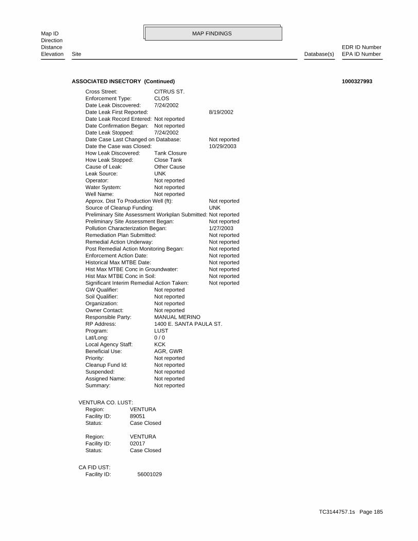
MAP FINDINGSMap IDDirection
EDR ID NumberDistanceEPA ID NumberDatabase(s)SiteElevation
56001029Facility ID:CA FID UST:
Case ClosedStatus:02017Facility ID:VENTURARegion:
Case ClosedStatus:89051Facility ID:VENTURARegion:
VENTURA CO. LUST:
Not reportedSummary: Not reportedAssigned Name: Not reportedSuspended: Not reportedCleanup Fund Id: Not reportedPriority: AGR, GWRBeneficial Use: KCKLocal Agency Staff: 0 / 0Lat/Long: LUSTProgram: 1400 E. SANTA PAULA ST.RP Address: MANUAL MERINOResponsible Party: Not reportedOwner Contact: Not reportedOrganization: Not reportedSoil Qualifier: Not reportedGW Qualifier: Not reportedSignificant Interim Remedial Action Taken: Not reportedHist Max MTBE Conc in Soil: Not reportedHist Max MTBE Conc in Groundwater: Not reportedHistorical Max MTBE Date: Not reportedEnforcement Action Date: Not reportedPost Remedial Action Monitoring Began: Not reportedRemedial Action Underway: Not reportedRemediation Plan Submitted: 1/27/2003Pollution Characterization Began: Not reportedPreliminary Site Assessment Began: Not reportedPreliminary Site Assessment Workplan Submitted: UNKSource of Cleanup Funding: Not reportedApprox. Dist To Production Well (ft): Not reportedWell Name: Not reportedWater System: Not reportedOperator: UNKLeak Source: Other CauseCause of Leak: Close TankHow Leak Stopped: Tank ClosureHow Leak Discovered: 10/29/2003Date the Case was Closed: Not reportedDate Case Last Changed on Database: 7/24/2002Date Leak Stopped: Not reportedDate Confirmation Began: Not reportedDate Leak Record Entered: 8/19/2002Date Leak First Reported: 7/24/2002Date Leak Discovered: CLOSEnforcement Type: CITRUS ST.Cross Street:
ASSOCIATED INSECTORY (Continued) 1000327993
TC3144757.1s Page 185

MAP FINDINGSMap IDDirection
EDR ID NumberDistanceEPA ID NumberDatabase(s)SiteElevation
REGULARType of Fuel: PRODUCTTank Used for: 00010000Tank Capacity: 1959Year Installed: 003Container Num: 003Tank Num:
Stock InventorLeak Detection: Not reportedTank Construction: REGULARType of Fuel: PRODUCTTank Used for: 00008000Tank Capacity: 1974Year Installed: 002Container Num: 002Tank Num:
Stock InventorLeak Detection: Not reportedTank Construction: UNLEADEDType of Fuel: PRODUCTTank Used for: 00001000Tank Capacity: 1980Year Installed: 001Container Num: 001Tank Num:
SANTA PAULA, CA 93060Owner City,St,Zip: 1400 E. SANTA PAULA STREETOwner Address: ASSOCIATES INSECTARYOwner Name: 8059331301Telephone: Not reportedContact Name: 0005Total Tanks: AGRICULTURAL PEST COOther Type: OtherFacility Type: 00000032943Facility ID: STATERegion:
HIST UST:
D1458Facility ID:VENTURA CO. UST:
ActiveStatus: Not reportedComments: Not reportedEPA ID: Not reportedNPDES Number: Not reportedDUNs Number: Not reportedContact Phone: Not reportedContact: SANTA PAULA 93060Mailing City,St,Zip: Not reportedMailing Address 2: 1400 E SANTA PAULA STMailing Address: Not reportedMail To: Not reportedFacility Phone: Not reportedSIC Code: Not reportedCortese Code: CAD029423Regulated ID: UTNKARegulated By:
ASSOCIATED INSECTORY (Continued) 1000327993
TC3144757.1s Page 186
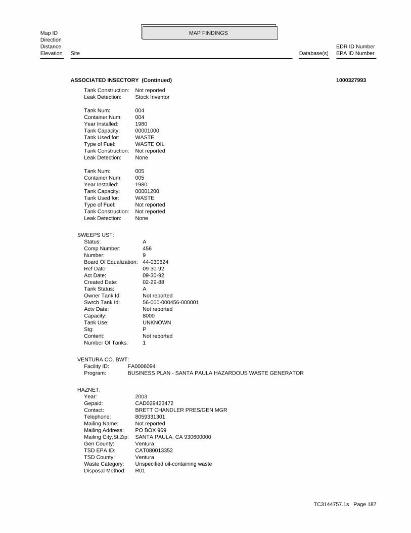
MAP FINDINGSMap IDDirection
EDR ID NumberDistanceEPA ID NumberDatabase(s)SiteElevation
R01Disposal Method: Unspecified oil-containing wasteWaste Category: VenturaTSD County: CAT080013352TSD EPA ID: VenturaGen County: SANTA PAULA, CA 930600000Mailing City,St,Zip: PO BOX 969Mailing Address: Not reportedMailing Name: 8059331301Telephone: BRETT CHANDLER PRES/GEN MGRContact: CAD029423472Gepaid: 2003Year:
HAZNET:
BUSINESS PLAN - SANTA PAULA HAZARDOUS WASTE GENERATORProgram:FA0006094Facility ID:
VENTURA CO. BWT:
1Number Of Tanks: Not reportedContent: PStg: UNKNOWNTank Use: 8000Capacity: Not reportedActv Date: 56-000-000456-000001Swrcb Tank Id: Not reportedOwner Tank Id: ATank Status: 02-29-88Created Date: 09-30-92Act Date: 09-30-92Ref Date: 44-030624Board Of Equalization: 9Number: 456Comp Number: AStatus:
SWEEPS UST:
NoneLeak Detection: Not reportedTank Construction: Not reportedType of Fuel: WASTETank Used for: 00001200Tank Capacity: 1980Year Installed: 005Container Num: 005Tank Num:
NoneLeak Detection: Not reportedTank Construction: WASTE OILType of Fuel: WASTETank Used for: 00001000Tank Capacity: 1980Year Installed: 004Container Num: 004Tank Num:
Stock InventorLeak Detection: Not reportedTank Construction:
ASSOCIATED INSECTORY (Continued) 1000327993
TC3144757.1s Page 187

MAP FINDINGSMap IDDirection
EDR ID NumberDistanceEPA ID NumberDatabase(s)SiteElevation
Not reportedCompleted Sub Area Name: PROJECT WIDECompleted Area Name:
Completed Info:
Envirostor ID NumberAlias Type: 56730038Alias Name: Project Code (Site Code)Alias Type: 300247Alias Name: CERCLIS IDAlias Type: CAD029423472Alias Name: APNAlias Type: 101020020Alias Name: SOILPotential Description: NONE SPECIFIEDConfirmed COC: 10097, 10195, 10196, 20012Potential COC: NONEPast Use: 101020020APN: -119.053312909341Longitude: 34.359158779077802Latitude: Not reportedFunding: NONE SPECIFIEDSite Mgmt. Req.: NORestricted Use: 1996-10-04 00:00:00Status Date: No Further ActionStatus: * CERC2Special Program: 17Senate: 37Assembly: 300247Site Code: 56730038Facility ID: Cleanup ChatsworthDivision Branch: Sayareh AmirebrahimiSupervisor: RITA KAMATProgram Manager: NONE SPECIFIEDLead Agency: NONE SPECIFIEDRegulatory Agencies: NONPL: 4.76Acres: * HistoricalSite Type Detailed: HistoricalSite Type:
ENVIROSTOR:
VenturaFacility County: 6.2550Tons: R01Disposal Method: Waste oil and mixed oilWaste Category: Los AngelesTSD County: CAT080011059TSD EPA ID: VenturaGen County: SANTA PAULA, CA 930600000Mailing City,St,Zip: PO BOX 969Mailing Address: Not reportedMailing Name: 0000000000Telephone: GROWER OWNED CO-OPContact: CAD029423472Gepaid: 1994Year:
VenturaFacility County: 0.41Tons:
ASSOCIATED INSECTORY (Continued) 1000327993
TC3144757.1s Page 188

MAP FINDINGSMap IDDirection
EDR ID NumberDistanceEPA ID NumberDatabase(s)SiteElevation
Not reportedSchedule Revised Date: Not reportedSchedule Due Date: Not reportedSchedule Document Type: Not reportedSchedule Sub Area Name: Not reportedSchedule Area Name: Not reportedFuture Due Date: Not reportedFuture Document Type: Not reportedFuture Sub Area Name: Not reportedFuture Area Name:
FACILITY IDENTIFIED ID FROM 1939-40 PAC TEL DIR EXTERMINATORS.Comments: 1983-12-21 00:00:00Completed Date: * DiscoveryCompleted Document Type: Not reportedCompleted Sub Area Name: PROJECT WIDECompleted Area Name:
METHODS. PROPERLY STORED._PESTICIDE RESIDUES/WASTE NEED TO VERIFY DISPOSAL SITE SCREENING DONE PA HIGH RECOM. DUE TO STAINED SOILS. DRUMS NOTComments: 1988-02-17 00:00:00Completed Date: Site ScreeningCompleted Document Type: Not reportedCompleted Sub Area Name: PROJECT WIDECompleted Area Name:
WHETER SOIL CONTAMINATION IS PRESENT PRELIM ASSESS DONE HIGH PRIORITY SI IS RECOMMENDED TO DETERMINEComments: 1988-12-01 00:00:00Completed Date: Preliminary Assessment ReportCompleted Document Type: Not reportedCompleted Sub Area Name: PROJECT WIDECompleted Area Name:
recommended ’No Further Action.’ submitted 08/15/91. HRS score was revised to 7.95 and DTSC report to the HRS package including requested information was Cleanups were conducted as per County Health’s request. A responseComments: 1994-10-27 00:00:00Completed Date: Site ScreeningCompleted Document Type: Not reportedCompleted Sub Area Name: PROJECT WIDECompleted Area Name:
U.S. EPA proposes low priority groundwater monitoring. grant. It was determined that no further action is warranted by DTSC. A Preliminary Assessment was completed (08/09/1996) under U.S. EPAComments: 1996-08-09 00:00:00Completed Date: Preliminary Assessment ReportCompleted Document Type:
ASSOCIATED INSECTORY (Continued) 1000327993
LUST Cleanup SiteCase Type: -119.053849Longitude: 34.3560891Latitude: T0611101210Global Id: STATERegion:
LUST:
3057 ft. Site 1 of 8 in cluster Y0.579 mi.
Relative:Lower
Actual:289 ft.
1/2-1 SANTA PAULA, CA 93060WSW 1301 MAIN ST N/AY145 LUSTREGENCY SAVINGS BANK S107619895
TC3144757.1s Page 189

MAP FINDINGSMap IDDirection
EDR ID NumberDistanceEPA ID NumberDatabase(s)SiteElevation
2003-06-09 00:00:00Date: ENFORCEMENTAction Type: T0611101210Global Id:
LOP Case Closure Summary to RBAction: 2003-07-30 00:00:00Date: ENFORCEMENTAction Type: T0611101210Global Id:
* Historical EnforcementAction: 2003-09-22 00:00:00Date: ENFORCEMENTAction Type: T0611101210Global Id:
File reviewAction: 2003-07-09 00:00:00Date: ENFORCEMENTAction Type: T0611101210Global Id:
Site Visit / Inspection / SamplingAction: 2003-07-10 00:00:00Date: ENFORCEMENTAction Type: T0611101210Global Id:
LUST:
2135766714Phone Number: [email protected]: R4 UNKNOWNCity: Not reportedAddress: LOS ANGELES RWQCB (REGION 4)Organization Name: DANIEL PIROTTONContact Name: Regional Board CaseworkerContact Type: T0611101210Global Id:
8056545040Phone Number: [email protected]: VENTURACity: 800 S. VICTORIA AVE.Address: VENTURA COUNTY LOPOrganization Name: DIANE B. WAHLContact Name: Local Agency CaseworkerContact Type: T0611101210Global Id:
LUST:
Click here to access the California GeoTracker records for this facility:
Not reportedSite History: GasolinePotential Contaminants of Concern: SoilPotential Media Affect: Not reportedFile Location: 99010LOC Case Number: C99010RB Case Number: VENTURA COUNTY LOPLocal Agency: DBWCase Worker: VENTURA COUNTY LOPLead Agency: 2004-02-02 00:00:00Status Date: Completed - Case ClosedStatus:
REGENCY SAVINGS BANK (Continued) S107619895
TC3144757.1s Page 190

MAP FINDINGSMap IDDirection
EDR ID NumberDistanceEPA ID NumberDatabase(s)SiteElevation
UnknownAction: 2003-06-10 00:00:00Date: RESPONSEAction Type: T0611101210Global Id:
Leak ReportedAction: 1950-01-01 00:00:00Date: OtherAction Type: T0611101210Global Id:
UnknownAction: 2003-12-01 00:00:00Date: RESPONSEAction Type: T0611101210Global Id:
Closure/No Further Action LetterAction: 2004-02-02 00:00:00Date: ENFORCEMENTAction Type: T0611101210Global Id:
Leak DiscoveryAction: 1950-01-01 00:00:00Date: OtherAction Type: T0611101210Global Id:
File reviewAction: 2003-07-29 00:00:00Date: ENFORCEMENTAction Type: T0611101210Global Id:
Notice of ResponsibilityAction:
REGENCY SAVINGS BANK (Continued) S107619895
NONE SPECIFIEDSite Mgmt. Req.: NORestricted Use: 2004-02-24 00:00:00Status Date: Refer: 1248 Local AgencyStatus: Not reportedSpecial Program: 17Senate: 37Assembly: Not reportedSite Code: 56600001Facility ID: Cleanup CypressDivision Branch: Referred - Not AssignedSupervisor: Not reportedProgram Manager: NONE SPECIFIEDLead Agency: NONE SPECIFIEDRegulatory Agencies: NONPL: Not reportedAcres: EvaluationSite Type Detailed: EvaluationSite Type:
ENVIROSTOR:
3057 ft. Site 2 of 8 in cluster Y0.579 mi.
Relative:Lower
Actual:289 ft.
1/2-1 SANTA PAULA, CA 93060WSW 1301 EAST MAIN STREET N/AY146 ENVIROSTORREGENCY SAVINGS BANK S106797761
TC3144757.1s Page 191

MAP FINDINGSMap IDDirection
EDR ID NumberDistanceEPA ID NumberDatabase(s)SiteElevation
Not reportedSchedule Revised Date: Not reportedSchedule Due Date: Not reportedSchedule Document Type: Not reportedSchedule Sub Area Name: Not reportedSchedule Area Name: Not reportedFuture Due Date: Not reportedFuture Document Type: Not reportedFuture Sub Area Name: Not reportedFuture Area Name:
Not reportedComments: Not reportedCompleted Date: Not reportedCompleted Document Type: Not reportedCompleted Sub Area Name: Not reportedCompleted Area Name:
Completed Info:
Envirostor ID NumberAlias Type: 56600001Alias Name: GeoTracker Global IDAlias Type: T0611148140Alias Name: GeoTracker Global IDAlias Type: T0611101210Alias Name: NONE SPECIFIEDPotential Description: NONE SPECIFIEDConfirmed COC: NONE SPECIFIEDPotential COC: NONE SPECIFIEDPast Use: NONE SPECIFIEDAPN: -119.05386830709701Longitude: 34.3563405760829Latitude: Not ApplicableFunding:
REGENCY SAVINGS BANK (Continued) S106797761
UNKStaff: Not reportedW Global ID: T0611101210Global ID: Not reportedAbatement Method Used at the Site: SoilCase Type: 99010Local Case No: Not reportedSubstance Quantity: GasolineSubstance: Case ClosedStatus: C-99010facid: VenturaCounty: 04Regional Board: 4Region:
LUST REG 4:
C-99010Reg Id: LTNKAReg By: 56Facility County Code: CORTESERegion:
CORTESE:
3057 ft. HAZNETSite 3 of 8 in cluster Y0.579 mi. SWEEPS UST
Relative:Lower
Actual:289 ft.
1/2-1 SLICSANTA PAULA, CA 93060WSW LUST1301 MAIN ST N/AY147 HIST CORTESEPW ENVIROMENTAL S103866668
TC3144757.1s Page 192

MAP FINDINGSMap IDDirection
EDR ID NumberDistanceEPA ID NumberDatabase(s)SiteElevation
SLIC:
Remedial action (cleanup) UnderwayStatus:SR010Facility ID:VENTURARegion:
Case ClosedStatus:99010Facility ID:VENTURARegion:
VENTURA CO. LUST:
Not reportedSummary: Not reportedAssigned Name: Not reportedSuspended: Not reportedCleanup Fund Id: Not reportedPriority: Not reportedBeneficial Use: DBWLocal Agency Staff: 34.3560891 / -1Lat/Long: LUSTProgram: Not reportedRP Address: REGENCY SAVINGS BANKResponsible Party: Not reportedOwner Contact: Not reportedOrganization: Not reportedSoil Qualifier: =GW Qualifier: Not reportedSignificant Interim Remedial Action Taken: 240Hist Max MTBE Conc in Soil: 2Hist Max MTBE Conc in Groundwater: 12/14/2001Historical Max MTBE Date: Not reportedEnforcement Action Date: 1/20/2003Post Remedial Action Monitoring Began: 1/20/2003Remedial Action Underway: 7/26/2002Remediation Plan Submitted: Not reportedPollution Characterization Began: Not reportedPreliminary Site Assessment Began: 10/29/1998Preliminary Site Assessment Workplan Submitted: FSource of Cleanup Funding: 970.064531604970151767561927Approx. Dist To Production Well (ft): Not reportedWell Name: Not reportedWater System: Not reportedOperator: Not reportedLeak Source: Not reportedCause of Leak: Not reportedHow Leak Stopped: Not reportedHow Leak Discovered: 2/2/2004Date the Case was Closed: Not reportedDate Case Last Changed on Database: Not reportedDate Leak Stopped: 11/12/1998Date Confirmation Began: Not reportedDate Leak Record Entered: 1/7/1999Date Leak First Reported: 1/7/1999Date Leak Discovered: CLOSEnforcement Type: Not reportedCross Street: 56000LLocal Agency:
PW ENVIROMENTAL (Continued) S103866668
TC3144757.1s Page 193
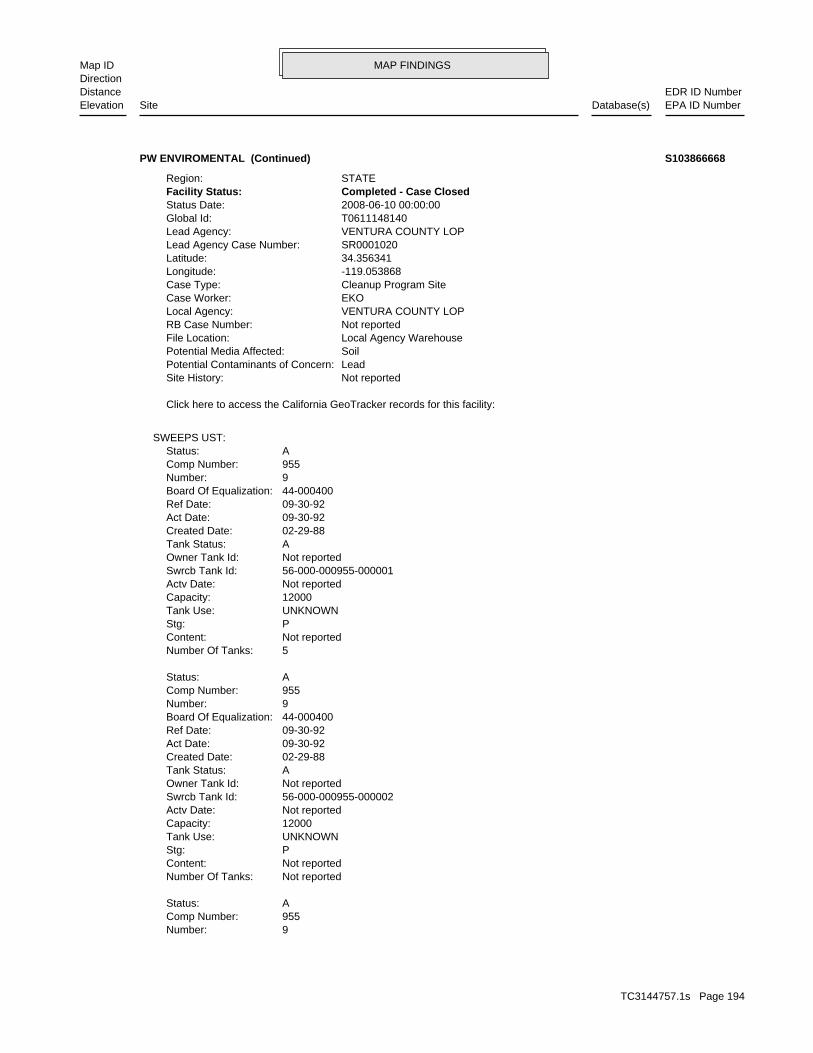
MAP FINDINGSMap IDDirection
EDR ID NumberDistanceEPA ID NumberDatabase(s)SiteElevation
9Number: 955Comp Number: AStatus:
Not reportedNumber Of Tanks: Not reportedContent: PStg: UNKNOWNTank Use: 12000Capacity: Not reportedActv Date: 56-000-000955-000002Swrcb Tank Id: Not reportedOwner Tank Id: ATank Status: 02-29-88Created Date: 09-30-92Act Date: 09-30-92Ref Date: 44-000400Board Of Equalization: 9Number: 955Comp Number: AStatus:
5Number Of Tanks: Not reportedContent: PStg: UNKNOWNTank Use: 12000Capacity: Not reportedActv Date: 56-000-000955-000001Swrcb Tank Id: Not reportedOwner Tank Id: ATank Status: 02-29-88Created Date: 09-30-92Act Date: 09-30-92Ref Date: 44-000400Board Of Equalization: 9Number: 955Comp Number: AStatus:
SWEEPS UST:
Click here to access the California GeoTracker records for this facility:
Not reportedSite History: LeadPotential Contaminants of Concern: SoilPotential Media Affected: Local Agency WarehouseFile Location: Not reportedRB Case Number: VENTURA COUNTY LOPLocal Agency: EKOCase Worker: Cleanup Program SiteCase Type: -119.053868Longitude: 34.356341Latitude: SR0001020Lead Agency Case Number: VENTURA COUNTY LOPLead Agency: T0611148140Global Id: 2008-06-10 00:00:00Status Date: Completed - Case ClosedFacility Status: STATERegion:
PW ENVIROMENTAL (Continued) S103866668
TC3144757.1s Page 194

MAP FINDINGSMap IDDirection
EDR ID NumberDistanceEPA ID NumberDatabase(s)SiteElevation
VenturaGen County: HOUSTON, TX 770460892Mailing City,St,Zip: 8 GREENWAY PLZ STE 1100Mailing Address: Not reportedMailing Name: 7138712080Telephone: JACK QUINNContact: CAC002627344Gepaid: 2008Year:
HAZNET:
Not reportedNumber Of Tanks: Not reportedContent: PStg: UNKNOWNTank Use: Not reportedCapacity: Not reportedActv Date: 56-000-000955-000005Swrcb Tank Id: Not reportedOwner Tank Id: ATank Status: 02-29-88Created Date: 09-30-92Act Date: 09-30-92Ref Date: 44-000400Board Of Equalization: 9Number: 955Comp Number: AStatus:
Not reportedNumber Of Tanks: Not reportedContent: PStg: UNKNOWNTank Use: 12000Capacity: Not reportedActv Date: 56-000-000955-000004Swrcb Tank Id: Not reportedOwner Tank Id: ATank Status: 02-29-88Created Date: 09-30-92Act Date: 09-30-92Ref Date: 44-000400Board Of Equalization: 9Number: 955Comp Number: AStatus:
Not reportedNumber Of Tanks: Not reportedContent: PStg: UNKNOWNTank Use: 12000Capacity: Not reportedActv Date: 56-000-000955-000003Swrcb Tank Id: Not reportedOwner Tank Id: ATank Status: 02-29-88Created Date: 09-30-92Act Date: 09-30-92Ref Date: 44-000400Board Of Equalization:
PW ENVIROMENTAL (Continued) S103866668
TC3144757.1s Page 195

MAP FINDINGSMap IDDirection
EDR ID NumberDistanceEPA ID NumberDatabase(s)SiteElevation
VenturaFacility County: 5.0040Tons: R01Disposal Method: Waste oil and mixed oilWaste Category: Los AngelesTSD County: CAT080013352TSD EPA ID: VenturaGen County: HUSTON, TX 770460000Mailing City,St,Zip: 8 GREENWAY PLZ STE 1100Mailing Address: Not reportedMailing Name: 7138712080Telephone: REGENCY SAVING BANKContact: CAC001174480Gepaid: 1998Year:
VenturaFacility County: 30.34Tons: D80Disposal Method: Other inorganic solid wasteWaste Category: VenturaTSD County: CAT000646117TSD EPA ID: VenturaGen County: HUSTON, TX 77046Mailing City,St,Zip: 8 GREEN WY PLAZA STE 1100Mailing Address: Not reportedMailing Name: 7139651644Telephone: SHELLY HARRISContact: CAC002566008Gepaid: 2003Year:
VenturaFacility County: 17.7Tons: INCLUDE ON-SITE TREATMENT AND/OR STABILIZATION) LANDFILL OR SURFACE IMPOUNDMENT THAT WILL BE CLOSED AS LANDFILL( TODisposal Method: Contaminated soil from site clean-upWaste Category: KingsTSD County: CAT000646117TSD EPA ID:
PW ENVIROMENTAL (Continued) S103866668
GASOLINE STATIONSType: 1961Year: GLEN CITY SERVICEName:
GASOLINE STATIONSType: 1957Year: GLEN CITY SERVICEName:
EDR Historical Auto Stations:
3057 ft. Site 4 of 8 in cluster Y0.579 mi.
Relative:Lower
Actual:289 ft.
1/2-1 SANTA PAULA, CA WSW 1301 E MAIN ST N/AY148 EDR Historical Auto StationsGLEN CITY SERVICE 1009024325
TC3144757.1s Page 196

MAP FINDINGSMap IDDirection
EDR ID NumberDistanceEPA ID NumberDatabase(s)SiteElevation
D1314Facility ID:VENTURA CO. UST:
3068 ft. Site 5 of 8 in cluster Y0.581 mi.
Relative:Lower
Actual:289 ft.
1/2-1 SANTA PAULA, CA WSW 1301 MAIN STREET N/AY149 USTVACANT BUILDING U003913141
Click here to access the California GeoTracker records for this facility:
Not reportedSite History: Other Chlorinated HydrocarbonsPotential Contaminants of Concern: Not reportedPotential Media Affected: Local Agency WarehouseFile Location: Not reportedRB Case Number: VENTURA COUNTY LOPLocal Agency: EKOCase Worker: Cleanup Program SiteCase Type: -119.05452Longitude: 34.357187Latitude: SR3146671Lead Agency Case Number: VENTURA COUNTY LOPLead Agency: T10000000854Global Id: 2002-05-06 00:00:00Status Date: Completed - Case ClosedFacility Status: STATERegion:
SLIC:
3086 ft.0.584 mi.
Relative:Higher
Actual:299 ft.
1/2-1 SANTA PAULA, CA 93060WSW 134 13TH STREET, NORTH N/A150 SLICCHAMNESS S109521342
6/30/2011Expiration Date:245Reg Num:
HWT:
3126 ft. Site 2 of 6 in cluster X0.592 mi.
Relative:Higher
Actual:313 ft.
1/2-1 SANTA PAULA, CA 93060West 1350 E. SANTA PAULA ST. N/AX151 HWTPACIFIC CONSTRUCTION & MAINTENANCE, INC. S109467005
C-90133Reg Id: LTNKAReg By: 56Facility County Code: CORTESERegion:
CORTESE:
3126 ft. Site 3 of 6 in cluster X0.592 mi.
Relative:Higher
Actual:313 ft.
1/2-1 HAZNETSANTA PAULA, CA 93060West LUST1350 SANTA PAULA N/AX152 HIST CORTESEPETROLEUM CONSTRUCTION, I S100869876
TC3144757.1s Page 197

MAP FINDINGSMap IDDirection
EDR ID NumberDistanceEPA ID NumberDatabase(s)SiteElevation
ENFORCEMENTAction Type: T0611100706Global Id:
* Historical EnforcementAction: 2004-04-08 00:00:00Date: ENFORCEMENTAction Type: T0611100706Global Id:
* Historical EnforcementAction: 2003-09-12 00:00:00Date: ENFORCEMENTAction Type: T0611100706Global Id:
Closure/No Further Action LetterAction: 2004-06-08 00:00:00Date: ENFORCEMENTAction Type: T0611100706Global Id:
LUST:
2135766714Phone Number: [email protected]: R4 UNKNOWNCity: Not reportedAddress: LOS ANGELES RWQCB (REGION 4)Organization Name: DANIEL PIROTTONContact Name: Regional Board CaseworkerContact Type: T0611100706Global Id:
8056545040Phone Number: [email protected]: VENTURACity: 800 S. VICTORIA AVE.Address: VENTURA COUNTY LOPOrganization Name: DIANE B. WAHLContact Name: Local Agency CaseworkerContact Type: T0611100706Global Id:
LUST:
Click here to access the California GeoTracker records for this facility:
Not reportedSite History: DieselPotential Contaminants of Concern: SoilPotential Media Affect: Local AgencyFile Location: 90133LOC Case Number: C90133RB Case Number: VENTURA COUNTY LOPLocal Agency: DBWCase Worker: VENTURA COUNTY LOPLead Agency: 2004-06-08 00:00:00Status Date: Completed - Case ClosedStatus: LUST Cleanup SiteCase Type: -119.054527Longitude: 34.3587739Latitude: T0611100706Global Id: STATERegion:
LUST:
PETROLEUM CONSTRUCTION, I (Continued) S100869876
TC3144757.1s Page 198

MAP FINDINGSMap IDDirection
EDR ID NumberDistanceEPA ID NumberDatabase(s)SiteElevation
Other Report / DocumentAction: 2004-06-01 00:00:00Date: RESPONSEAction Type: T0611100706Global Id:
Soil and Water Investigation ReportAction: 2004-04-30 00:00:00Date: RESPONSEAction Type: T0611100706Global Id:
Soil and Water Investigation ReportAction: 2004-04-15 00:00:00Date: RESPONSEAction Type: T0611100706Global Id:
Other Report / DocumentAction: 2004-04-30 00:00:00Date: RESPONSEAction Type: T0611100706Global Id:
* Historical EnforcementAction: 2004-03-03 00:00:00Date: ENFORCEMENTAction Type: T0611100706Global Id:
* Historical EnforcementAction: 2004-02-17 00:00:00Date: ENFORCEMENTAction Type: T0611100706Global Id:
Leak DiscoveryAction: 1950-01-01 00:00:00Date: OtherAction Type: T0611100706Global Id:
* Historical EnforcementAction: 1991-01-04 00:00:00Date: ENFORCEMENTAction Type: T0611100706Global Id:
* Historical EnforcementAction: 2003-08-05 00:00:00Date: ENFORCEMENTAction Type: T0611100706Global Id:
File reviewAction: 2003-08-01 00:00:00Date: ENFORCEMENTAction Type: T0611100706Global Id:
* Historical EnforcementAction: 2004-05-17 00:00:00Date: ENFORCEMENTAction Type: T0611100706Global Id:
File reviewAction: 2003-09-04 00:00:00Date:
PETROLEUM CONSTRUCTION, I (Continued) S100869876
TC3144757.1s Page 199

MAP FINDINGSMap IDDirection
EDR ID NumberDistanceEPA ID NumberDatabase(s)SiteElevation
NDSoil Qualifier: Not reportedGW Qualifier: Not reportedSignificant Interim Remedial Action Taken: 0Hist Max MTBE Conc in Soil: Not reportedHist Max MTBE Conc in Groundwater: Not reportedHistorical Max MTBE Date: 1/4/1991Enforcement Action Date: Not reportedPost Remedial Action Monitoring Began: Not reportedRemedial Action Underway: 8/31/1994Remediation Plan Submitted: 3/29/2004Pollution Characterization Began: 5/20/1991Preliminary Site Assessment Began: 11/6/1990Preliminary Site Assessment Workplan Submitted: FSource of Cleanup Funding: 362.5513105042529320216526749Approx. Dist To Production Well (ft): Not reportedWell Name: Not reportedWater System: Not reportedOperator: Not reportedLeak Source: Not reportedCause of Leak: Not reportedHow Leak Stopped: Not reportedHow Leak Discovered: 6/8/2004Date the Case was Closed: Not reportedDate Case Last Changed on Database: Not reportedDate Leak Stopped: 12/5/1990Date Confirmation Began: Not reportedDate Leak Record Entered: 11/6/1990Date Leak First Reported: 11/6/1990Date Leak Discovered: LFOREnforcement Type: Not reportedCross Street: 56000LLocal Agency: UNKStaff: Not reportedW Global ID: T0611100706Global ID: Not reportedAbatement Method Used at the Site: SoilCase Type: 90133Local Case No: Not reportedSubstance Quantity: DieselSubstance: Case ClosedStatus: C-90133facid: VenturaCounty: 04Regional Board: 4Region:
LUST REG 4:
Other Report / DocumentAction: 2004-05-12 00:00:00Date: RESPONSEAction Type: T0611100706Global Id:
Leak ReportedAction: 1950-01-01 00:00:00Date: OtherAction Type: T0611100706Global Id:
PETROLEUM CONSTRUCTION, I (Continued) S100869876
TC3144757.1s Page 200
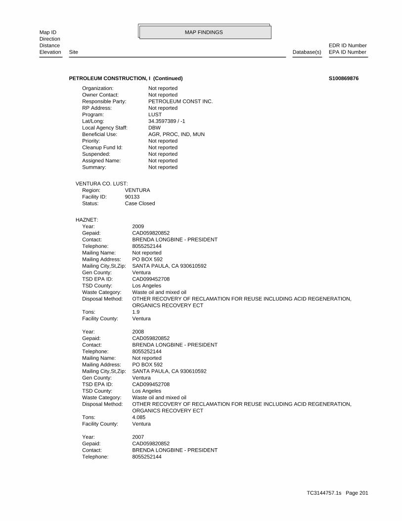
MAP FINDINGSMap IDDirection
EDR ID NumberDistanceEPA ID NumberDatabase(s)SiteElevation
8055252144Telephone: BRENDA LONGBINE - PRESIDENTContact: CAD059820852Gepaid: 2007Year:
VenturaFacility County: 4.085Tons: ORGANICS RECOVERY ECT OTHER RECOVERY OF RECLAMATION FOR REUSE INCLUDING ACID REGENERATION,Disposal Method: Waste oil and mixed oilWaste Category: Los AngelesTSD County: CAD099452708TSD EPA ID: VenturaGen County: SANTA PAULA, CA 930610592Mailing City,St,Zip: PO BOX 592Mailing Address: Not reportedMailing Name: 8055252144Telephone: BRENDA LONGBINE - PRESIDENTContact: CAD059820852Gepaid: 2008Year:
VenturaFacility County: 1.9Tons: ORGANICS RECOVERY ECT OTHER RECOVERY OF RECLAMATION FOR REUSE INCLUDING ACID REGENERATION,Disposal Method: Waste oil and mixed oilWaste Category: Los AngelesTSD County: CAD099452708TSD EPA ID: VenturaGen County: SANTA PAULA, CA 930610592Mailing City,St,Zip: PO BOX 592Mailing Address: Not reportedMailing Name: 8055252144Telephone: BRENDA LONGBINE - PRESIDENTContact: CAD059820852Gepaid: 2009Year:
HAZNET:
Case ClosedStatus:90133Facility ID:VENTURARegion:
VENTURA CO. LUST:
Not reportedSummary: Not reportedAssigned Name: Not reportedSuspended: Not reportedCleanup Fund Id: Not reportedPriority: AGR, PROC, IND, MUNBeneficial Use: DBWLocal Agency Staff: 34.3597389 / -1Lat/Long: LUSTProgram: Not reportedRP Address: PETROLEUM CONST INC.Responsible Party: Not reportedOwner Contact: Not reportedOrganization:
PETROLEUM CONSTRUCTION, I (Continued) S100869876
TC3144757.1s Page 201

MAP FINDINGSMap IDDirection
EDR ID NumberDistanceEPA ID NumberDatabase(s)SiteElevation
1 additional CA_HAZNET: record(s) in the EDR Site Report.Click this hyperlink while viewing on your computer to access
Not reportedFacility County: 0.12Tons: R01Disposal Method: Unspecified solvent mixtureWaste Category: Los AngelesTSD County: Not reportedTSD EPA ID: VenturaGen County: SANTA PAULA, CA 930600000Mailing City,St,Zip: PO BOX 592Mailing Address: Not reportedMailing Name: 8055259300Telephone: BRENDA LONGBINEContact: CAD059820852Gepaid: 2002Year:
VenturaFacility County: 0.17Tons: H01Disposal Method: Other organic solidsWaste Category: Los AngelesTSD County: CAD097030993TSD EPA ID: VenturaGen County: SANTA PAULA, CA 930610592Mailing City,St,Zip: PO BOX 592Mailing Address: Not reportedMailing Name: 8055252144Telephone: BRENDA LONGBINE - PRESIDENTContact: CAD059820852Gepaid: 2006Year:
VenturaFacility County: 2.47Tons: ORGANICS RECOVERY ECT OTHER RECOVERY OF RECLAMATION FOR REUSE INCLUDING ACID REGENERATION,Disposal Method: Waste oil and mixed oilWaste Category: Los AngelesTSD County: CAD099452708TSD EPA ID: VenturaGen County: SANTA PAULA, CA 930610592Mailing City,St,Zip: PO BOX 592Mailing Address: Not reportedMailing Name:
PETROLEUM CONSTRUCTION, I (Continued) S100869876
PO BOX 4129Mailing address: CAD059820852EPA ID: SANTA PAULA, CA 93060 1350 E SANTA PAULA STREETFacility address: PACIFIC CONSTRUCTION AND MAINTENANCEFacility name: 08/04/1980Date form received by agency:
RCRA-NonGen:
3126 ft. Site 4 of 6 in cluster X0.592 mi.
Relative:Higher
Actual:313 ft.
1/2-1 SANTA PAULA, CA 93060West FINDS1350 E SANTA PAULA STREET CAD059820852X153 RCRA-NonGenPACIFIC CONSTRUCTION AND MAINTENANCE 1000250591
TC3144757.1s Page 202
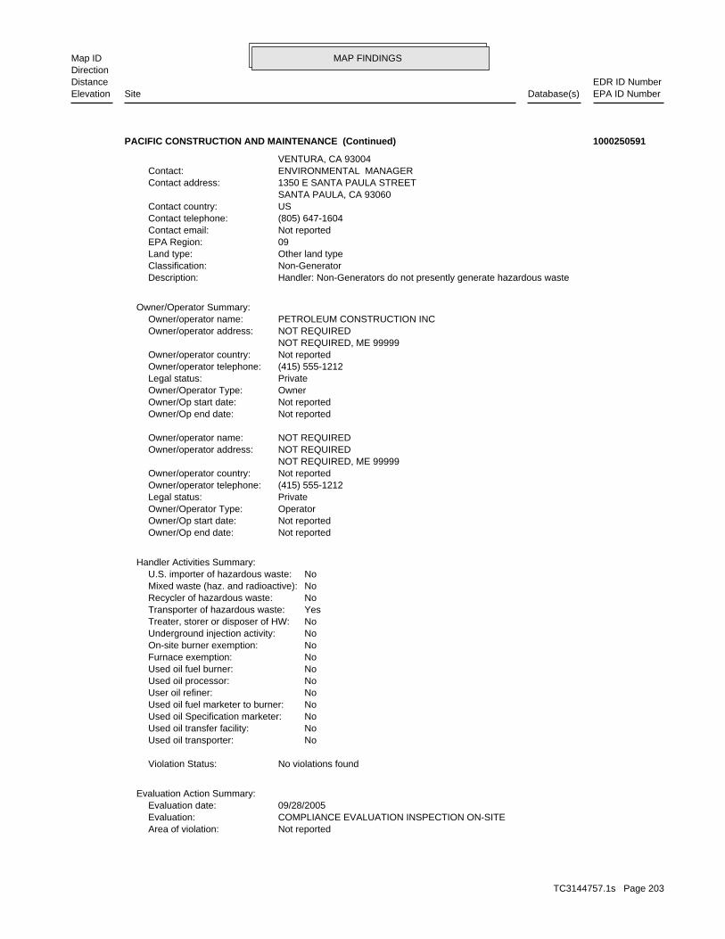
MAP FINDINGSMap IDDirection
EDR ID NumberDistanceEPA ID NumberDatabase(s)SiteElevation
Not reportedArea of violation: COMPLIANCE EVALUATION INSPECTION ON-SITEEvaluation: 09/28/2005Evaluation date:
Evaluation Action Summary:
No violations foundViolation Status:
NoUsed oil transporter: NoUsed oil transfer facility: NoUsed oil Specification marketer: NoUsed oil fuel marketer to burner: NoUser oil refiner: NoUsed oil processor: NoUsed oil fuel burner: NoFurnace exemption: NoOn-site burner exemption: NoUnderground injection activity: NoTreater, storer or disposer of HW: YesTransporter of hazardous waste: NoRecycler of hazardous waste: NoMixed waste (haz. and radioactive): NoU.S. importer of hazardous waste:
Handler Activities Summary:
Not reportedOwner/Op end date: Not reportedOwner/Op start date: OperatorOwner/Operator Type: PrivateLegal status: (415) 555-1212Owner/operator telephone: Not reportedOwner/operator country: NOT REQUIRED, ME 99999 NOT REQUIREDOwner/operator address: NOT REQUIREDOwner/operator name:
Not reportedOwner/Op end date: Not reportedOwner/Op start date: OwnerOwner/Operator Type: PrivateLegal status: (415) 555-1212Owner/operator telephone: Not reportedOwner/operator country: NOT REQUIRED, ME 99999 NOT REQUIREDOwner/operator address: PETROLEUM CONSTRUCTION INCOwner/operator name:
Owner/Operator Summary:
Handler: Non-Generators do not presently generate hazardous wasteDescription: Non-GeneratorClassification: Other land typeLand type: 09EPA Region: Not reportedContact email: (805) 647-1604Contact telephone: USContact country: SANTA PAULA, CA 93060 1350 E SANTA PAULA STREETContact address: ENVIRONMENTAL MANAGERContact: VENTURA, CA 93004
PACIFIC CONSTRUCTION AND MAINTENANCE (Continued) 1000250591
TC3144757.1s Page 203
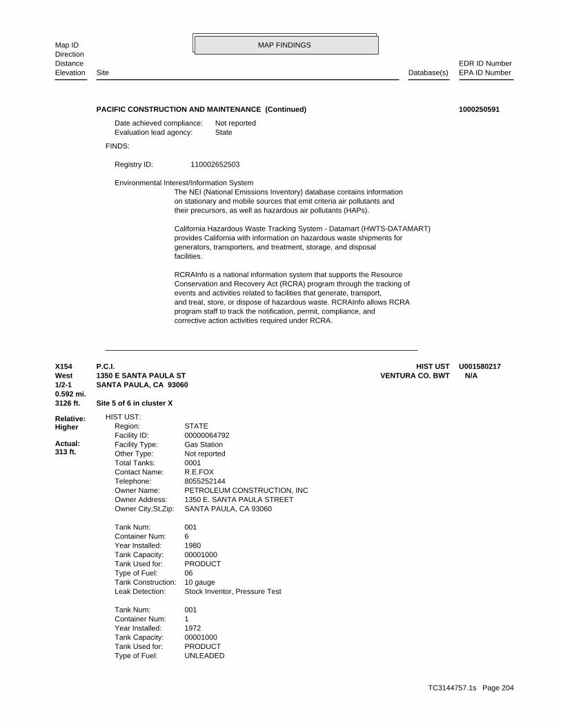
MAP FINDINGSMap IDDirection
EDR ID NumberDistanceEPA ID NumberDatabase(s)SiteElevation
corrective action activities required under RCRA.program staff to track the notification, permit, compliance, andand treat, store, or dispose of hazardous waste. RCRAInfo allows RCRAevents and activities related to facilities that generate, transport,Conservation and Recovery Act (RCRA) program through the tracking ofRCRAInfo is a national information system that supports the Resource
facilities.generators, transporters, and treatment, storage, and disposalprovides California with information on hazardous waste shipments forCalifornia Hazardous Waste Tracking System - Datamart (HWTS-DATAMART)
their precursors, as well as hazardous air pollutants (HAPs).on stationary and mobile sources that emit criteria air pollutants andThe NEI (National Emissions Inventory) database contains information Environmental Interest/Information System
110002652503Registry ID:
FINDS:
StateEvaluation lead agency: Not reportedDate achieved compliance:
PACIFIC CONSTRUCTION AND MAINTENANCE (Continued) 1000250591
UNLEADEDType of Fuel: PRODUCTTank Used for: 00001000Tank Capacity: 1972Year Installed: 1Container Num: 001Tank Num:
Stock Inventor, Pressure TestLeak Detection: 10 gaugeTank Construction: 06Type of Fuel: PRODUCTTank Used for: 00001000Tank Capacity: 1980Year Installed: 6Container Num: 001Tank Num:
SANTA PAULA, CA 93060Owner City,St,Zip: 1350 E. SANTA PAULA STREETOwner Address: PETROLEUM CONSTRUCTION, INCOwner Name: 8055252144Telephone: R.E.FOXContact Name: 0001Total Tanks: Not reportedOther Type: Gas StationFacility Type: 00000064792Facility ID: STATERegion:
HIST UST:
3126 ft. Site 5 of 6 in cluster X0.592 mi.
Relative:Higher
Actual:313 ft.
1/2-1 SANTA PAULA, CA 93060West VENTURA CO. BWT1350 E SANTA PAULA ST N/AX154 HIST USTP.C.I. U001580217
TC3144757.1s Page 204

MAP FINDINGSMap IDDirection
EDR ID NumberDistanceEPA ID NumberDatabase(s)SiteElevation
HAZARDOUS WASTE GENERATOR BUSINESS PLAN - SANTA PAULAProgram:FA0006146Facility ID:
VENTURA CO. BWT:
Stock Inventor, Pressure TestLeak Detection: 12 gaugeTank Construction: 06Type of Fuel: PRODUCTTank Used for: 00000550Tank Capacity: 1978Year Installed: 6Container Num: 006Tank Num:
Stock Inventor, Pressure TestLeak Detection: 1/4 gaugeTank Construction: UNLEADEDType of Fuel: PRODUCTTank Used for: 00005000Tank Capacity: 1979Year Installed: 5Container Num: 005Tank Num:
Stock Inventor, Pressure TestLeak Detection: 1/4 gaugeTank Construction: UNLEADEDType of Fuel: PRODUCTTank Used for: 00010000Tank Capacity: 1978Year Installed: 4Container Num: 004Tank Num:
Stock Inventor, Pressure TestLeak Detection: 1/4 gaugeTank Construction: UNLEADEDType of Fuel: PRODUCTTank Used for: 00010000Tank Capacity: 1978Year Installed: 3Container Num: 003Tank Num:
Stock Inventor, Pressure TestLeak Detection: 10 gaugeTank Construction: UNLEADEDType of Fuel: PRODUCTTank Used for: 00001000Tank Capacity: 1972Year Installed: 2Container Num: 002Tank Num:
Stock Inventor, Pressure TestLeak Detection: 10 gaugeTank Construction:
P.C.I. (Continued) U001580217
TC3144757.1s Page 205

MAP FINDINGSMap IDDirection
EDR ID NumberDistanceEPA ID NumberDatabase(s)SiteElevation
D878Facility ID:VENTURA CO. UST:
3126 ft. Site 6 of 6 in cluster X0.592 mi.
Relative:Higher
Actual:313 ft.
1/2-1 SANTA PAULA, CA West 1350 SANTA PAULA STREET N/AX155 USTPETROLEUM CONSTRUCTION INC U002244219
Leak DiscoveryAction: 1950-01-01 00:00:00Date: OtherAction Type: T0603792964Global Id:
Closure/No Further Action LetterAction: 2000-09-05 00:00:00Date: ENFORCEMENTAction Type: T0603792964Global Id:
Leak ReportedAction: 1950-01-01 00:00:00Date: OtherAction Type: T0603792964Global Id:
LUST:
2135766714Phone Number: [email protected]: R4 UNKNOWNCity: Not reportedAddress: LOS ANGELES RWQCB (REGION 4)Organization Name: DANIEL PIROTTONContact Name: Regional Board CaseworkerContact Type: T0603792964Global Id:
LUST:
Click here to access the California GeoTracker records for this facility:
Not reportedSite History: Waste Oil / Motor / Hydraulic / LubricatingPotential Contaminants of Concern: SoilPotential Media Affect: Not reportedFile Location: 99056LOC Case Number: C99056RB Case Number: Not reportedLocal Agency: EHDCase Worker: VENTURA COUNTY LOPLead Agency: 2000-09-05 00:00:00Status Date: Completed - Case ClosedStatus: LUST Cleanup SiteCase Type: -119.0546582Longitude: 34.3557214Latitude: T0603792964Global Id: STATERegion:
LUST:
3270 ft. Site 6 of 8 in cluster Y0.619 mi.
Relative:Lower
Actual:288 ft.
1/2-1 SANTA PAULA, CA WSW 1255 MAIN ST E N/AY156 LUSTF.M. PEARCE CO S104532763
TC3144757.1s Page 206

MAP FINDINGSMap IDDirection
EDR ID NumberDistanceEPA ID NumberDatabase(s)SiteElevation
Not reportedSuspended: Not reportedCleanup Fund Id: Not reportedPriority: Not reportedBeneficial Use: EHDLocal Agency Staff: 34.355587 / -1Lat/Long: LUSTProgram: 1697 PELICAN AVE., VENTURA CA 93003RP Address: LORYNE F. MORRIS TRUSTResponsible Party: Not reportedOwner Contact: Not reportedOrganization: Not reportedSoil Qualifier: Not reportedGW Qualifier: Not reportedSignificant Interim Remedial Action Taken: Not reportedHist Max MTBE Conc in Soil: Not reportedHist Max MTBE Conc in Groundwater: Not reportedHistorical Max MTBE Date: Not reportedEnforcement Action Date: Not reportedPost Remedial Action Monitoring Began: Not reportedRemedial Action Underway: Not reportedRemediation Plan Submitted: Not reportedPollution Characterization Began: Not reportedPreliminary Site Assessment Began: 9/15/1999Preliminary Site Assessment Workplan Submitted: TankSource of Cleanup Funding: 1193.621151935413938712243453Approx. Dist To Production Well (ft): Not reportedWell Name: Not reportedWater System: ABEL MONTIELOperator: TankLeak Source: Not reportedCause of Leak: Not reportedHow Leak Stopped: Repair TankHow Leak Discovered: 9/5/2000Date the Case was Closed: 9/5/2000Date Case Last Changed on Database: Not reportedDate Leak Stopped: 9/14/1999Date Confirmation Began: Not reportedDate Leak Record Entered: 9/14/1999Date Leak First Reported: 5/10/1999Date Leak Discovered: CLOSEnforcement Type: MAIN & GARCIA STCross Street: 56000LLocal Agency: UNKStaff: Not reportedW Global ID: T0603792964Global ID: Not reportedAbatement Method Used at the Site: SoilCase Type: 99056Local Case No: Not reportedSubstance Quantity: Waste OilSubstance: Case ClosedStatus: C-99056facid: Los AngelesCounty: 04Regional Board: 4Region:
LUST REG 4:
F.M. PEARCE CO (Continued) S104532763
TC3144757.1s Page 207
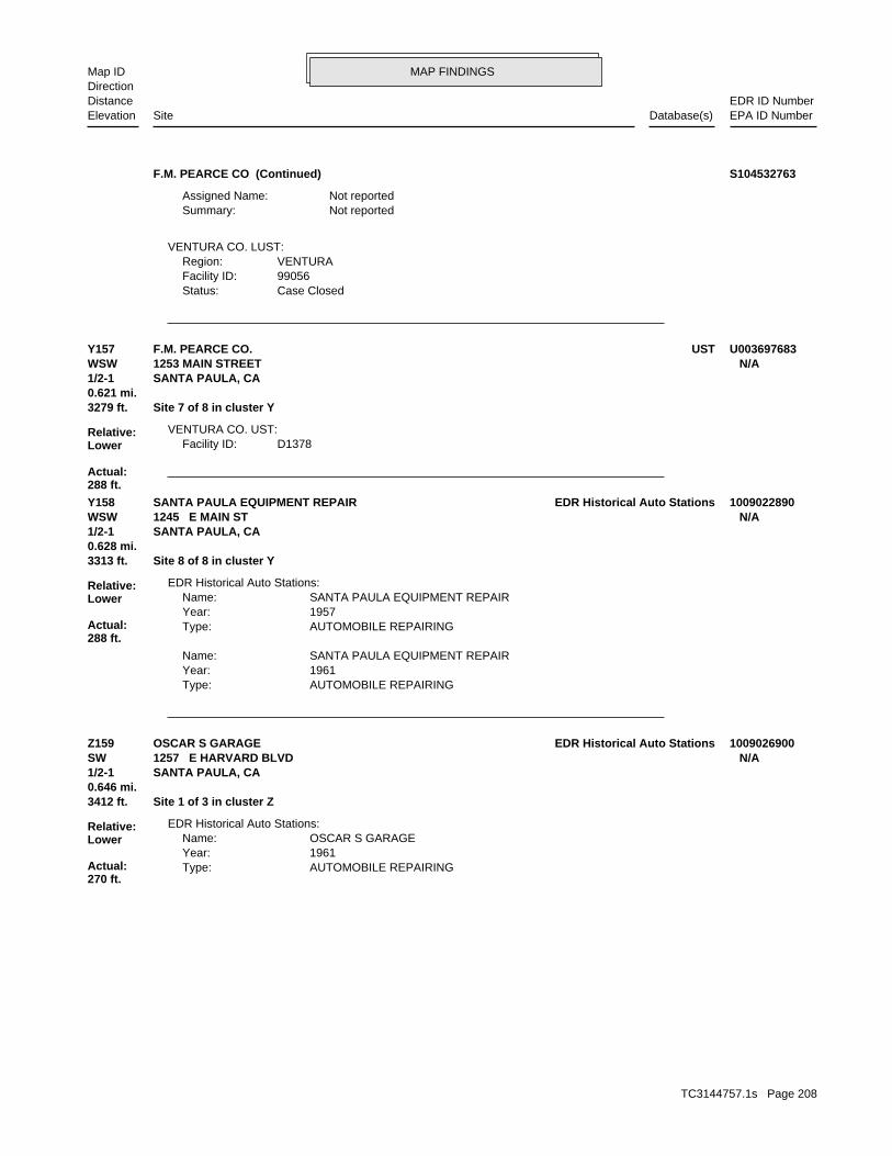
MAP FINDINGSMap IDDirection
EDR ID NumberDistanceEPA ID NumberDatabase(s)SiteElevation
Case ClosedStatus:99056Facility ID:VENTURARegion:
VENTURA CO. LUST:
Not reportedSummary: Not reportedAssigned Name:
F.M. PEARCE CO (Continued) S104532763
D1378Facility ID:VENTURA CO. UST:
3279 ft. Site 7 of 8 in cluster Y0.621 mi.
Relative:Lower
Actual:288 ft.
1/2-1 SANTA PAULA, CA WSW 1253 MAIN STREET N/AY157 USTF.M. PEARCE CO. U003697683
AUTOMOBILE REPAIRINGType: 1961Year: SANTA PAULA EQUIPMENT REPAIRName:
AUTOMOBILE REPAIRINGType: 1957Year: SANTA PAULA EQUIPMENT REPAIRName:
EDR Historical Auto Stations:
3313 ft. Site 8 of 8 in cluster Y0.628 mi.
Relative:Lower
Actual:288 ft.
1/2-1 SANTA PAULA, CA WSW 1245 E MAIN ST N/AY158 EDR Historical Auto StationsSANTA PAULA EQUIPMENT REPAIR 1009022890
AUTOMOBILE REPAIRINGType: 1961Year: OSCAR S GARAGEName:
EDR Historical Auto Stations:
3412 ft. Site 1 of 3 in cluster Z0.646 mi.
Relative:Lower
Actual:270 ft.
1/2-1 SANTA PAULA, CA SW 1257 E HARVARD BLVD N/AZ159 EDR Historical Auto StationsOSCAR S GARAGE 1009026900
TC3144757.1s Page 208

MAP FINDINGSMap IDDirection
EDR ID NumberDistanceEPA ID NumberDatabase(s)SiteElevation
30884Party Number: 2011-05-31 00:00:00As Of: NRural: 01/30/2009Effective Date: NWhether The Facility Is Grandfathered: Not reportedFacility Phone Number:
SWRCY:
3413 ft. Site 2 of 3 in cluster Z0.646 mi.
Relative:Lower
Actual:270 ft.
1/2-1 SANTA PAULA, CA 93060SW 1250 E HARVARD BLVD N/AZ160 SWRCYVENTURA COUNTY RECYCLING & REVERSE VENDING S107137820
01/18/1989Date Completed: Not reportedDate Started: ARCHIVE SITEAction:
Low priority for further assessmentPriority Level: 04/01/1986Date Completed: 07/01/1985Date Started: PRELIMINARY ASSESSMENTAction:
Not reportedPriority Level: 09/01/1985Date Completed: Not reportedDate Started: DISCOVERYAction:
CERCLIS-NFRAP Assessment History:
CA Not reportedAlias Address: DOWELL SCHLUMBERGERAlias Name:
CERCLIS-NFRAP Site Alias Name(s):
9270438.00000Person ID: 13175897.00000Contact Sequence ID:
13002167.00000Person ID: 13089866.00000Contact Sequence ID:
9270048.00000Person ID: 13059142.00000Contact Sequence ID:
9271184.00000Person ID: 13053068.00000Contact Sequence ID:
CERCLIS-NFRAP Site Contact Details:
NFRAP-Site does not qualify for the NPL based on existing informationNon NPL Status: Not on the NPLNPL Status: Not a Federal FacilityFederal Facility: 0901586Site ID:
CERC-NFRAP:
3474 ft. HAZNETSite 1 of 5 in cluster AA0.658 mi. UST
Relative:Higher
Actual:314 ft.
1/2-1 FINDSSANTA PAULA, CA 93060West RCRA-SQG1260 SANTA PAULA STREET CAD076209055AA161 CERC-NFRAPDOWELL SCHLUMBERGER INC 1000204982
TC3144757.1s Page 209

MAP FINDINGSMap IDDirection
EDR ID NumberDistanceEPA ID NumberDatabase(s)SiteElevation
NoTreater, storer or disposer of HW: NoTransporter of hazardous waste: NoRecycler of hazardous waste: NoMixed waste (haz. and radioactive): NoU.S. importer of hazardous waste:
Handler Activities Summary:
Not reportedOwner/Op end date: Not reportedOwner/Op start date: OperatorOwner/Operator Type: PrivateLegal status: (415) 555-1212Owner/operator telephone: Not reportedOwner/operator country: NOT REQUIRED, ME 99999 NOT REQUIREDOwner/operator address: NOT REQUIREDOwner/operator name:
Not reportedOwner/Op end date: Not reportedOwner/Op start date: OwnerOwner/Operator Type: PrivateLegal status: (415) 555-1212Owner/operator telephone: Not reportedOwner/operator country: NOT REQUIRED, ME 99999 NOT REQUIREDOwner/operator address: DOW CHEMICAL COMPANYOwner/operator name:
Owner/Operator Summary:
hazardous waste at any time waste during any calendar month, and accumulates more than 1000 kg of hazardous waste at any time; or generates 100 kg or less of hazardous waste during any calendar month and accumulates less than 6000 kg of Handler: generates more than 100 and less than 1000 kg of hazardousDescription: Small Small Quantity GeneratorClassification: 09EPA Region: Not reportedContact email: Not reportedContact telephone: Not reportedContact country: Not reported Not reportedContact address: Not reportedContact: SANTA PAULA, CA 93060 PO BOX 192Mailing address: CAD076209055EPA ID: SANTA PAULA, CA 93060 1260 SANTA PAULA STREETFacility address: DOWELL SCHLUMBERGER INCFacility name: 09/01/1996Date form received by agency:
RCRA-SQG:
NFRAP-Site does not qualify for the NPL based on existing informationPriority Level: 01/18/1989Date Completed: Not reportedDate Started: PRELIMINARY ASSESSMENTAction:
Not reportedPriority Level:
DOWELL SCHLUMBERGER INC (Continued) 1000204982
TC3144757.1s Page 210

MAP FINDINGSMap IDDirection
EDR ID NumberDistanceEPA ID NumberDatabase(s)SiteElevation
VenturaFacility County: 10.5084Tons: H01Disposal Method: Invalid waste codeWaste Category: Los AngelesTSD County: CAD008302903TSD EPA ID: VenturaGen County: BAKERSFIELD, CA 933800000Mailing City,St,Zip: PO BOX 81437Mailing Address: Not reportedMailing Name: 0000000000Telephone: DOW CHEMICAL COMPANYContact: CAD076209055Gepaid: 1997Year:
HAZNET:
D560Facility ID:VENTURA CO. UST:
corrective action activities required under RCRA.program staff to track the notification, permit, compliance, andand treat, store, or dispose of hazardous waste. RCRAInfo allows RCRAevents and activities related to facilities that generate, transport,Conservation and Recovery Act (RCRA) program through the tracking ofRCRAInfo is a national information system that supports the Resource Environmental Interest/Information System
110002658295Registry ID:
FINDS:
No violations foundViolation Status:
Large Quantity GeneratorClassification: DOWELL SCHLUMBERGER INCFacility name: 08/18/1980Date form received by agency:
Historical Generators:
NoUsed oil transporter: NoUsed oil transfer facility: NoUsed oil Specification marketer: NoUsed oil fuel marketer to burner: NoUser oil refiner: NoUsed oil processor: NoUsed oil fuel burner: NoFurnace exemption: NoOn-site burner exemption: NoUnderground injection activity:
DOWELL SCHLUMBERGER INC (Continued) 1000204982
TC3144757.1s Page 211
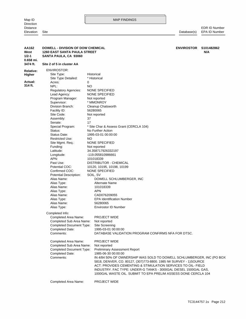
MAP FINDINGSMap IDDirection
EDR ID NumberDistanceEPA ID NumberDatabase(s)SiteElevation
PROJECT WIDECompleted Area Name:
1000GAL WASTE OIL. SUBMIT TO EPA PRELIM ASSESS DONE CERCLA 104 INDUSTRY. FAC TYPE: UNDER-G TANKS - 3000GAL DIESEL 1500GAL GAS, ACT: PROVIDES CEMENTING & STIMULATION SERVICES TO OIL- FIELD 5818, DENVER, CO. 80127, (307)773-8800. 1985 IW SURVEY - 1)SOURCE IN 4/84 50% OF OWNERSHIP WAS SOLD TO DOWELL SCHLUMBERGER, INC (PO BOXComments: 1985-06-30 00:00:00Completed Date: Preliminary Assessment ReportCompleted Document Type: Not reportedCompleted Sub Area Name: PROJECT WIDECompleted Area Name:
DATABASE VALIDATION PROGRAM CONFIRMS NFA FOR DTSC.Comments: 1995-03-01 00:00:00Completed Date: Site ScreeningCompleted Document Type: Not reportedCompleted Sub Area Name: PROJECT WIDECompleted Area Name:
Completed Info:
Envirostor ID NumberAlias Type: 56280065Alias Name: EPA Identification NumberAlias Type: CAD076209055Alias Name: APNAlias Type: 101018339Alias Name: Alternate NameAlias Type: DOWELL SCHLUMBERGER, INCAlias Name: SOIL, SVPotential Description: NONE SPECIFIEDConfirmed COC: 10120, 10195, 10198, 10199Potential COC: DISTRIBUTOR - CHEMICALPast Use: 101018339APN: -119.055810986661Longitude: 34.358717926332197Latitude: Not reportedFunding: NONE SPECIFIEDSite Mgmt. Req.: NORestricted Use: 1995-03-01 00:00:00Status Date: No Further ActionStatus: * Site Char & Assess Grant (CERCLA 104)Special Program: 17Senate: 37Assembly: Not reportedSite Code: 56280065Facility ID: Cleanup ChatsworthDivision Branch: * MMONROYSupervisor: Not reportedProgram Manager: NONE SPECIFIEDLead Agency: NONE SPECIFIEDRegulatory Agencies: NONPL: 0Acres: * HistoricalSite Type Detailed: HistoricalSite Type:
ENVIROSTOR:
3474 ft. Site 2 of 5 in cluster AA0.658 mi.
Relative:Higher
Actual:314 ft.
1/2-1 SANTA PAULA, CA 93060West 1260 EAST SANTA PAULA STREET N/AAA162 ENVIROSTORDOWELL - DIVISION OF DOW CHEMICAL S101482862
TC3144757.1s Page 212

MAP FINDINGSMap IDDirection
EDR ID NumberDistanceEPA ID NumberDatabase(s)SiteElevation
Not reportedSchedule Revised Date: Not reportedSchedule Due Date: Not reportedSchedule Document Type: Not reportedSchedule Sub Area Name: Not reportedSchedule Area Name: Not reportedFuture Due Date: Not reportedFuture Document Type: Not reportedFuture Sub Area Name: Not reportedFuture Area Name:
UNPAVED GROUND. DIRT IS STAINED. OIL & GAS INDUSTRY. SITE ADJACENT TO RR TRACKS. OLD DRUMS ON SITE. FACILITY IDENTIFIED ID FROM DRIVEBY. FACILITY DRIVE-BY SERVICE FORComments: 1983-12-21 00:00:00Completed Date: * DiscoveryCompleted Document Type: Not reportedCompleted Sub Area Name:
DOWELL - DIVISION OF DOW CHEMICAL (Continued) S101482862
Leak DiscoveryAction: 1950-01-01 00:00:00Date: OtherAction Type: T0611100162Global Id:
LUST:
Not reportedPhone Number: Not reportedEmail: R4 UNKNOWNCity: Not reportedAddress: LOS ANGELES RWQCB (REGION 4)Organization Name: JAYDEB DASContact Name: Regional Board CaseworkerContact Type: T0611100162Global Id:
LUST:
Click here to access the California GeoTracker records for this facility:
Not reportedSite History: * SolventsPotential Contaminants of Concern: SoilPotential Media Affect: Not reportedFile Location: Not reportedLOC Case Number: C-86087RB Case Number: Not reportedLocal Agency: JDCase Worker: LOS ANGELES RWQCB (REGION 4)Lead Agency: 1997-10-06 00:00:00Status Date: Completed - Case ClosedStatus: LUST Cleanup SiteCase Type: -119.0560691Longitude: 34.3589329Latitude: T0611100162Global Id: STATERegion:
LUST:
3474 ft. Site 3 of 5 in cluster AA0.658 mi.
Relative:Higher
Actual:314 ft.
1/2-1 SANTA PAULA, CA 93060West 1260 SANTA PAULA ST N/AAA163 LUSTDOWELL-SCHLUMBERGER S105917709
TC3144757.1s Page 213

MAP FINDINGSMap IDDirection
EDR ID NumberDistanceEPA ID NumberDatabase(s)SiteElevation
Not reportedSoil Qualifier: Not reportedGW Qualifier: YesSignificant Interim Remedial Action Taken: Not reportedHist Max MTBE Conc in Soil: Not reportedHist Max MTBE Conc in Groundwater: Not reportedHistorical Max MTBE Date: Not reportedEnforcement Action Date: Not reportedPost Remedial Action Monitoring Began: 4/12/1989Remedial Action Underway: Not reportedRemediation Plan Submitted: 12/12/1986Pollution Characterization Began: Not reportedPreliminary Site Assessment Began: Not reportedPreliminary Site Assessment Workplan Submitted: TankSource of Cleanup Funding: 506.97533717840447370844983482Approx. Dist To Production Well (ft): Not reportedWell Name: Not reportedWater System: CULPEPPER, BARRYOperator: TankLeak Source: CorrosionCause of Leak: Not reportedHow Leak Stopped: Tank ClosureHow Leak Discovered: 10/6/1997Date the Case was Closed: 2/25/1998Date Case Last Changed on Database: 12/12/1986Date Leak Stopped: Not reportedDate Confirmation Began: 7/31/1987Date Leak Record Entered: 12/12/1986Date Leak First Reported: 12/12/1986Date Leak Discovered: Not reportedEnforcement Type: OAKCross Street: 56000LLocal Agency: JDStaff: Not reportedW Global ID: T0611100162Global ID: GTEDAbatement Method Used at the Site: SoilCase Type: Not reportedLocal Case No: Not reportedSubstance Quantity: SolventsSubstance: Case ClosedStatus: C-86087facid: VenturaCounty: 04Regional Board: 4Region:
LUST REG 4:
Leak StoppedAction: 1950-01-01 00:00:00Date: OtherAction Type: T0611100162Global Id:
Leak ReportedAction: 1950-01-01 00:00:00Date: OtherAction Type: T0611100162Global Id:
DOWELL-SCHLUMBERGER (Continued) S105917709
TC3144757.1s Page 214

MAP FINDINGSMap IDDirection
EDR ID NumberDistanceEPA ID NumberDatabase(s)SiteElevation
FOR MONITORING WELL DESTRUCTION CASE 2/25/98 CONDITION OLD CASE #930600016 LOW RISKSummary: Not reportedAssigned Name: Not reportedSuspended: Not reportedCleanup Fund Id: Not reportedPriority: Not reportedBeneficial Use: EHDLocal Agency Staff: 34.3589329 / -1Lat/Long: LUSTProgram: 1260 SANTA PAULA ST, SANTA PAULA, CA 93060RP Address: DOWELL-SCHLUMBERGERResponsible Party: Not reportedOwner Contact: Not reportedOrganization:
DOWELL-SCHLUMBERGER (Continued) S105917709
Stock InventorLeak Detection: 0.188 inchesTank Construction: DIESELType of Fuel: PRODUCTTank Used for: 00003000Tank Capacity: 1980Year Installed: 1Container Num: 002Tank Num:
Stock InventorLeak Detection: 0.188 inchesTank Construction: DIESELType of Fuel: PRODUCTTank Used for: 00001500Tank Capacity: 1980Year Installed: 2Container Num: 001Tank Num:
DENVER, CO 80012Owner City,St,Zip: P.O. BOX 5818Owner Address: DOWELL SCHLUMBERGER INC.Owner Name: 8055257111Telephone: Q. MAPLESContact Name: 0002Total Tanks: OILFIELD SERVICE CO.Other Type: OtherFacility Type: 00000002581Facility ID: STATERegion:
HIST UST:
3474 ft. Site 4 of 5 in cluster AA0.658 mi.
Relative:Higher
Actual:314 ft.
1/2-1 SANTA PAULA, CA 93060West 1260 E SANTA PAULA ST N/AAA164 HIST USTSANTA PAULA U001580256
TC3144757.1s Page 215

MAP FINDINGSMap IDDirection
EDR ID NumberDistanceEPA ID NumberDatabase(s)SiteElevation
GASOLINE STATIONSType: 1957Year: AVERY S FLYING A SERVICEName:
EDR Historical Auto Stations:
3497 ft. Site 3 of 3 in cluster Z0.662 mi.
Relative:Lower
Actual:269 ft.
1/2-1 SANTA PAULA, CA SW 1226 E HARVARD BLVD N/AZ165 EDR Historical Auto StationsAVERY S FLYING A SERVICE 1009022486
Stock InventorLeak Detection: 1/8 inchesTank Construction: UNLEADEDType of Fuel: PRODUCTTank Used for: 00000550Tank Capacity: 1985Year Installed: #3Container Num: 003Tank Num:
Stock InventorLeak Detection: Not reportedTank Construction: REGULARType of Fuel: PRODUCTTank Used for: 00000550Tank Capacity: 1940Year Installed: #2Container Num: 002Tank Num:
Stock InventorLeak Detection: Not reportedTank Construction: UNLEADEDType of Fuel: PRODUCTTank Used for: 00012000Tank Capacity: 1969Year Installed: #1Container Num: 001Tank Num:
SANTA PAULA, CA 93060Owner City,St,Zip: 133 N. 10TH STREETOwner Address: TEAGUE-MCKEVETT COMPANYOwner Name: 8055255583Telephone: TERRY NELSONContact Name: 0003Total Tanks: AGRICULTUREOther Type: OtherFacility Type: 00000065619Facility ID: STATERegion:
HIST UST:
3625 ft.0.687 mi.
Relative:Higher
Actual:373 ft.
1/2-1 SANTA PAULA, CA 93060North 305 PADRE DR N/A166 HIST USTTEAGUE-MCKEVETT DIVISION U001580287
TC3144757.1s Page 216

MAP FINDINGSMap IDDirection
EDR ID NumberDistanceEPA ID NumberDatabase(s)SiteElevation
D866Facility ID:VENTURA CO. UST:
3632 ft. Site 5 of 5 in cluster AA0.688 mi.
Relative:Higher
Actual:312 ft.
1/2-1 SANTA PAULA, CA West 1221 SANTA PAULA STREET N/AAA167 USTGUSTAVO RAMIREZ U002244218
Visual, Stock Inventor, Pressure TestLeak Detection: Not reportedTank Construction: UNLEADEDType of Fuel: PRODUCTTank Used for: 00010000Tank Capacity: 1963Year Installed: 3Container Num: 003Tank Num:
Visual, Stock Inventor, Pressure TestLeak Detection: Not reportedTank Construction: DIESELType of Fuel: PRODUCTTank Used for: 00010000Tank Capacity: 1963Year Installed: 2Container Num: 002Tank Num:
Visual, Stock Inventor, Pressure TestLeak Detection: Not reportedTank Construction: REGULARType of Fuel: PRODUCTTank Used for: 00010000Tank Capacity: 1963Year Installed: 1Container Num: 001Tank Num:
CHATTANOOGA, TN 37408Owner City,St,Zip: 1221 E. MAIN STREETOwner Address: KAYO OIL COMPANYOwner Name: 8055259122Telephone: Not reportedContact Name: 0003Total Tanks: Not reportedOther Type: Gas StationFacility Type: 00000018537Facility ID: STATERegion:
HIST UST:
3660 ft. Site 1 of 12 in cluster AB0.693 mi.
Relative:Lower
Actual:286 ft.
1/2-1 SANTA PAULA, CA 93060WSW 1202 E MAIN ST N/AAB168 HIST USTFAST GAS U001580144
TC3144757.1s Page 217

MAP FINDINGSMap IDDirection
EDR ID NumberDistanceEPA ID NumberDatabase(s)SiteElevation
GASOLINE STATIONSType: 1961Year: SANTA PAULA OIL COName:
GASOLINE STATIONSType: 1957Year: PAT & MARTIN S AUTO & TRUCK SERVICEName:
EDR Historical Auto Stations:
3660 ft. Site 2 of 12 in cluster AB0.693 mi.
Relative:Lower
Actual:286 ft.
1/2-1 SANTA PAULA, CA WSW 1202 E MAIN ST N/AAB169 EDR Historical Auto StationsSANTA PAULA OIL CO 1009024804
2135766714Phone Number: [email protected]: R4 UNKNOWNCity: Not reportedAddress: LOS ANGELES RWQCB (REGION 4)Organization Name: DANIEL PIROTTONContact Name: Regional Board CaseworkerContact Type: T0611100180Global Id:
8056545040Phone Number: [email protected]: VENTURACity: 800 S. VICTORIA AVE.Address: VENTURA COUNTY LOPOrganization Name: DIANE B. WAHLContact Name: Local Agency CaseworkerContact Type: T0611100180Global Id:
LUST:
Click here to access the California GeoTracker records for this facility:
Not reportedSite History: GasolinePotential Contaminants of Concern: Other Groundwater (uses other than drinking water)Potential Media Affect: Local Agency WarehouseFile Location: 87021LOC Case Number: 87021RB Case Number: VENTURA COUNTY LOPLocal Agency: DBWCase Worker: VENTURA COUNTY LOPLead Agency: 2008-03-06 00:00:00Status Date: Completed - Case ClosedStatus: LUST Cleanup SiteCase Type: -119.0556111Longitude: 34.3552011Latitude: T0611100180Global Id: STATERegion:
LUST:
3660 ft. Site 3 of 12 in cluster AB0.693 mi.
Relative:Lower
Actual:286 ft.
1/2-1 SANTA PAULA, CA 93060WSW 1202 MAIN ST N/AAB170 LUSTULTRAMAR SS #755 (BEACON) S104816199
TC3144757.1s Page 218

MAP FINDINGSMap IDDirection
EDR ID NumberDistanceEPA ID NumberDatabase(s)SiteElevation
T0611100180Global Id:
* Historical Enforcement - #3Action: 2003-09-29 00:00:00Date: ENFORCEMENTAction Type: T0611100180Global Id:
Technical Correspondence / Assistance / Other - #16Action: 2006-08-21 00:00:00Date: ENFORCEMENTAction Type: T0611100180Global Id:
* Historical Enforcement - #13Action: 2005-04-25 00:00:00Date: ENFORCEMENTAction Type: T0611100180Global Id:
Electronic Reporting Submittal DueAction: 2007-04-30 00:00:00Date: RESPONSEAction Type: T0611100180Global Id:
* Historical Enforcement - #10Action: 2005-01-18 00:00:00Date: ENFORCEMENTAction Type: T0611100180Global Id:
* Historical Enforcement - #11Action: 2005-02-28 00:00:00Date: ENFORCEMENTAction Type: T0611100180Global Id:
* Historical Enforcement - #12Action: 2005-04-08 00:00:00Date: ENFORCEMENTAction Type: T0611100180Global Id:
Other Report / DocumentAction: 2005-02-25 00:00:00Date: RESPONSEAction Type: T0611100180Global Id:
Corrective Action Plan / Remedial Action PlanAction: 2005-03-04 00:00:00Date: RESPONSEAction Type: T0611100180Global Id:
Technical Correspondence / Assistance / Other - #18Action: 2006-10-30 00:00:00Date: ENFORCEMENTAction Type: T0611100180Global Id:
Technical Correspondence / Assistance / Other - #15Action: 2006-06-19 00:00:00Date: ENFORCEMENTAction Type: T0611100180Global Id:
LUST:
ULTRAMAR SS #755 (BEACON) (Continued) S104816199
TC3144757.1s Page 219

MAP FINDINGSMap IDDirection
EDR ID NumberDistanceEPA ID NumberDatabase(s)SiteElevation
1987-02-26 00:00:00Date: ENFORCEMENTAction Type: T0611100180Global Id:
Other WorkplanAction: 2006-10-16 00:00:00Date: RESPONSEAction Type: T0611100180Global Id:
Meeting - #6Action: 2004-06-07 00:00:00Date: ENFORCEMENTAction Type: T0611100180Global Id:
* Historical Enforcement - #2Action: 2003-06-20 00:00:00Date: ENFORCEMENTAction Type: T0611100180Global Id:
Other Report / DocumentAction: 2007-03-01 00:00:00Date: RESPONSEAction Type: T0611100180Global Id:
CAP/RAP - Other ReportAction: 2005-08-12 00:00:00Date: RESPONSEAction Type: T0611100180Global Id:
Monitoring Report - QuarterlyAction: 2006-07-31 00:00:00Date: RESPONSEAction Type: T0611100180Global Id:
Technical Correspondence / Assistance / Other - #17Action: 2006-09-26 00:00:00Date: ENFORCEMENTAction Type: T0611100180Global Id:
* No ActionAction: 2007-11-27 00:00:00Date: ENFORCEMENTAction Type: T0611100180Global Id:
Technical Correspondence / Assistance / Other - #23Action: 2007-11-26 00:00:00Date: ENFORCEMENTAction Type: T0611100180Global Id:
* Historical Enforcement - #7Action: 2004-06-21 00:00:00Date: ENFORCEMENTAction Type: T0611100180Global Id:
* Historical Enforcement - #9Action: 2004-10-27 00:00:00Date: ENFORCEMENTAction Type:
ULTRAMAR SS #755 (BEACON) (Continued) S104816199
TC3144757.1s Page 220
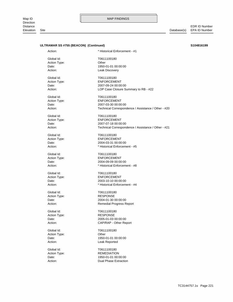
MAP FINDINGSMap IDDirection
EDR ID NumberDistanceEPA ID NumberDatabase(s)SiteElevation
Dual Phase ExtractionAction: 1950-01-01 00:00:00Date: REMEDIATIONAction Type: T0611100180Global Id:
Leak ReportedAction: 1950-01-01 00:00:00Date: OtherAction Type: T0611100180Global Id:
CAP/RAP - Other ReportAction: 2005-01-03 00:00:00Date: RESPONSEAction Type: T0611100180Global Id:
Remedial Progress ReportAction: 2004-01-30 00:00:00Date: RESPONSEAction Type: T0611100180Global Id:
* Historical Enforcement - #4Action: 2003-10-10 00:00:00Date: ENFORCEMENTAction Type: T0611100180Global Id:
* Historical Enforcement - #8Action: 2004-09-09 00:00:00Date: ENFORCEMENTAction Type: T0611100180Global Id:
* Historical Enforcement - #5Action: 2004-03-31 00:00:00Date: ENFORCEMENTAction Type: T0611100180Global Id:
Technical Correspondence / Assistance / Other - #21Action: 2007-07-18 00:00:00Date: ENFORCEMENTAction Type: T0611100180Global Id:
Technical Correspondence / Assistance / Other - #20Action: 2007-03-30 00:00:00Date: ENFORCEMENTAction Type: T0611100180Global Id:
LOP Case Closure Summary to RB - #22Action: 2007-09-24 00:00:00Date: ENFORCEMENTAction Type: T0611100180Global Id:
Leak DiscoveryAction: 1950-01-01 00:00:00Date: OtherAction Type: T0611100180Global Id:
* Historical Enforcement - #1Action:
ULTRAMAR SS #755 (BEACON) (Continued) S104816199
TC3144757.1s Page 221

MAP FINDINGSMap IDDirection
EDR ID NumberDistanceEPA ID NumberDatabase(s)SiteElevation
EDCDAbatement Method Used at the Site: GroundwaterCase Type: 87021Local Case No: Not reportedSubstance Quantity: GasolineSubstance: Remedial action (cleanup) UnderwayStatus: C-87021facid: VenturaCounty: 04Regional Board: 4Region:
LUST REG 4:
Other Report / DocumentAction: 2007-04-30 00:00:00Date: RESPONSEAction Type: T0611100180Global Id:
Corrective Action Plan / Remedial Action PlanAction: 2004-05-28 00:00:00Date: RESPONSEAction Type: T0611100180Global Id:
Soil Vapor Extraction w/OtherAction: 1950-01-01 00:00:00Date: REMEDIATIONAction Type: T0611100180Global Id:
UnknownAction: 2008-02-08 00:00:00Date: RESPONSEAction Type: T0611100180Global Id:
Technical Correspondence / Assistance / Other - #19Action: 2007-01-23 00:00:00Date: ENFORCEMENTAction Type: T0611100180Global Id:
* Historical Enforcement - #14Action: 2005-09-12 00:00:00Date: ENFORCEMENTAction Type: T0611100180Global Id:
Dual Phase ExtractionAction: 1950-01-01 00:00:00Date: REMEDIATIONAction Type: T0611100180Global Id:
Leak StoppedAction: 1950-01-01 00:00:00Date: OtherAction Type: T0611100180Global Id:
Electronic Reporting Submittal DueAction: 2006-09-15 00:00:00Date: RESPONSEAction Type: T0611100180Global Id:
ULTRAMAR SS #755 (BEACON) (Continued) S104816199
TC3144757.1s Page 222

MAP FINDINGSMap IDDirection
EDR ID NumberDistanceEPA ID NumberDatabase(s)SiteElevation
natural attenuation. 12/21/00 FEASIBILITY STUDY AND CAP for limited DPE and monitoredSummary: Not reportedAssigned Name: Not reportedSuspended: Not reportedCleanup Fund Id: Not reportedPriority: AGR, PROC, IND, MUNBeneficial Use: DBWLocal Agency Staff: 34.3552011 / -1Lat/Long: LUSTProgram: 525 W. 3RD ST., HANFORD, CA 93232-0466RP Address: BEACON/ULTRAMARResponsible Party: Not reportedOwner Contact: Not reportedOrganization: Not reportedSoil Qualifier: =GW Qualifier: Not reportedSignificant Interim Remedial Action Taken: 33Hist Max MTBE Conc in Soil: 370Hist Max MTBE Conc in Groundwater: 6/5/2003Historical Max MTBE Date: 2/26/1987Enforcement Action Date: Not reportedPost Remedial Action Monitoring Began: 6/10/2004Remedial Action Underway: 5/26/2004Remediation Plan Submitted: 7/8/1987Pollution Characterization Began: 7/8/1987Preliminary Site Assessment Began: 4/7/1987Preliminary Site Assessment Workplan Submitted: FSource of Cleanup Funding: 1406.1928478148609269910498803Approx. Dist To Production Well (ft): Not reportedWell Name: Not reportedWater System: Not reportedOperator: Not reportedLeak Source: Not reportedCause of Leak: Not reportedHow Leak Stopped: Not reportedHow Leak Discovered: Not reportedDate the Case was Closed: 12/21/2000Date Case Last Changed on Database: Not reportedDate Leak Stopped: 7/1/1988Date Confirmation Began: Not reportedDate Leak Record Entered: 2/26/1987Date Leak First Reported: 2/26/1987Date Leak Discovered: LFOREnforcement Type: Not reportedCross Street: 56000LLocal Agency: UNKStaff: Not reportedW Global ID: T0611100180Global ID:
ULTRAMAR SS #755 (BEACON) (Continued) S104816199
TC3144757.1s Page 223

MAP FINDINGSMap IDDirection
EDR ID NumberDistanceEPA ID NumberDatabase(s)SiteElevation
Not reportedNumber Of Tanks: Not reportedContent: PStg: UNKNOWNTank Use: 10000Capacity: Not reportedActv Date: 56-000-001348-000002Swrcb Tank Id: Not reportedOwner Tank Id: ATank Status: 02-29-88Created Date: 09-30-92Act Date: 09-30-92Ref Date: 44-000202Board Of Equalization: 9Number: 1348Comp Number: AStatus:
3Number Of Tanks: Not reportedContent: PStg: UNKNOWNTank Use: 10000Capacity: Not reportedActv Date: 56-000-001348-000001Swrcb Tank Id: Not reportedOwner Tank Id: ATank Status: 02-29-88Created Date: 09-30-92Act Date: 09-30-92Ref Date: 44-000202Board Of Equalization: 9Number: 1348Comp Number: AStatus:
SWEEPS UST:
ActiveStatus: Not reportedComments: Not reportedEPA ID: Not reportedNPDES Number: Not reportedDUNs Number: Not reportedContact Phone: Not reportedContact: SANTA PAULA 93060Mailing City,St,Zip: Not reportedMailing Address 2: 1202 E MAIN STMailing Address: Not reportedMail To: Not reportedFacility Phone: Not reportedSIC Code: Not reportedCortese Code: 18537Regulated ID: UTNKARegulated By: 56000160Facility ID:
CA FID UST:
3660 ft. Site 4 of 12 in cluster AB0.693 mi.
Relative:Lower
Actual:286 ft.
1/2-1 SANTA PAULA, CA 93060WSW SWEEPS UST1202 E MAIN ST N/AAB171 CA FID USTBEACON #755 S101631217
TC3144757.1s Page 224

MAP FINDINGSMap IDDirection
EDR ID NumberDistanceEPA ID NumberDatabase(s)SiteElevation
Not reportedNumber Of Tanks: Not reportedContent: PStg: UNKNOWNTank Use: 10000Capacity: Not reportedActv Date: 56-000-001348-000003Swrcb Tank Id: Not reportedOwner Tank Id: ATank Status: 02-29-88Created Date: 09-30-92Act Date: 09-30-92Ref Date: 44-000202Board Of Equalization: 9Number: 1348Comp Number: AStatus:
BEACON #755 (Continued) S101631217
Post remedial action monitoringStatus:87021Facility ID:VENTURARegion:
VENTURA CO. LUST:
3666 ft. Site 5 of 12 in cluster AB0.694 mi.
Relative:Lower
Actual:286 ft.
1/2-1 SANTA PAULA, CA WSW 1202 MAIN ST N/AAB172 LUSTULTRAMAR SS #755 (BEACON) S106117195
D1466Facility ID:VENTURA CO. UST:
3666 ft. Site 6 of 12 in cluster AB0.694 mi.
Relative:Lower
Actual:286 ft.
1/2-1 SANTA PAULA, CA WSW 1202 MAIN ST. N/AAB173 USTULTRAMAR STATION #3755 (2) U003933266
GASOLINE STATIONSType: 1961Year: WALTON S TEXACO SERVICEName:
GASOLINE STATIONSType: 1957Year: MARSHALL S TEXACO SERVICEName:
EDR Historical Auto Stations:
3688 ft. Site 7 of 12 in cluster AB0.698 mi.
Relative:Lower
Actual:286 ft.
1/2-1 SANTA PAULA, CA WSW 1203 E MAIN ST N/AAB174 EDR Historical Auto StationsWALTON S TEXACO SERVICE 1009026739
TC3144757.1s Page 225

MAP FINDINGSMap IDDirection
EDR ID NumberDistanceEPA ID NumberDatabase(s)SiteElevation
352Waste name: 352Waste code:
181Waste name: 181Waste code:
Hazardous Waste Summary:
NoUsed oil transporter: NoUsed oil transfer facility: NoUsed oil Specification marketer: NoUsed oil fuel marketer to burner: NoUser oil refiner: NoUsed oil processor: NoUsed oil fuel burner: NoFurnace exemption: NoOn-site burner exemption: NoUnderground injection activity: NoTreater, storer or disposer of HW: NoTransporter of hazardous waste: NoRecycler of hazardous waste: NoMixed waste (haz. and radioactive): NoU.S. importer of hazardous waste:
Handler Activities Summary:
100 kg of that material at any time hazardous waste during any calendar month, and accumulates more than from the cleanup of a spill, into or on any land or water, of acutely of any residue or contaminated soil, waste or other debris resulting kg of acutely hazardous waste at any time; or generates 100 kg or less hazardous waste during any calendar month, and accumulates more than 1 waste during any calendar month; or generates 1 kg or less of acutely cleanup of a spill, into or on any land or water, of acutely hazardous residue or contaminated soil, waste or other debris resulting from the during any calendar month; or generates more than 100 kg of any calendar month; or generates more than 1 kg of acutely hazardous waste Handler: generates 1,000 kg or more of hazardous waste during anyDescription: Large Quantity GeneratorClassification: 09EPA Region: [email protected] email: (626) 302-9711Contact telephone: Not reportedContact country: Not reported Not reportedContact address: STANLEY L MARSHContact: SANTA ANA, CA 92705 SO. GRAND AVE.Mailing address: CAC002253137EPA ID: SANTA PAULA, CA 93060 137 N. 12TH ST.Facility address: WAKEFIELD SUBSTATIONFacility name: 02/28/2002Date form received by agency:
RCRA-LQG:
3711 ft.0.703 mi.
Relative:Lower
Actual:292 ft.
1/2-1 SANTA PAULA, CA 93060WSW 137 N. 12TH ST. CAC002253137175 RCRA-LQGWAKEFIELD SUBSTATION 1007198586
TC3144757.1s Page 226

MAP FINDINGSMap IDDirection
EDR ID NumberDistanceEPA ID NumberDatabase(s)SiteElevation
No violations foundViolation Status:
LEADWaste name: D008Waste code:
WAKEFIELD SUBSTATION (Continued) 1007198586
AUTOMOBILE REPAIRINGType: 1957Year: OSCAR S GARAGEName:
AUTOMOBILE REPAIRINGType: 1949Year: ASHWOOD & COOK (TRACTORS)Name:
EDR Historical Auto Stations:
3746 ft. Site 8 of 12 in cluster AB0.709 mi.
Relative:Lower
Actual:282 ft.
1/2-1 SANTA PAULA, CA WSW 122 S 12TH ST N/AAB176 EDR Historical Auto StationsOSCAR S GARAGE 1009022878
D1205Facility ID:VENTURA CO. UST:
3761 ft. Site 9 of 12 in cluster AB0.712 mi.
Relative:Lower
Actual:286 ft.
1/2-1 SANTA PAULA, CA WSW 1190 MAIN STREET N/AAB177 USTFRANKIE’S RADIATOR SHOP U003042640
Not reportedFile Location: 96004LOC Case Number: C-96004RB Case Number: Not reportedLocal Agency: EHDCase Worker: VENTURA COUNTY LOPLead Agency: 1996-06-10 00:00:00Status Date: Completed - Case ClosedStatus: LUST Cleanup SiteCase Type: -119.0558961Longitude: 34.3551111Latitude: T0611101080Global Id: STATERegion:
LUST:
C-96004Reg Id: LTNKAReg By: 56Facility County Code: CORTESERegion:
CORTESE:
3768 ft. Site 10 of 12 in cluster AB0.714 mi.
Relative:Lower
Actual:285 ft.
1/2-1 SANTA PAULA, CA 93060WSW LUST1190 MAIN N/AAB178 HIST CORTESEFRANKIE’S RADIATOR SHOP S104164818
TC3144757.1s Page 227

MAP FINDINGSMap IDDirection
EDR ID NumberDistanceEPA ID NumberDatabase(s)SiteElevation
Not reportedOperator: Not reportedLeak Source: Not reportedCause of Leak: Not reportedHow Leak Stopped: Not reportedHow Leak Discovered: 6/10/1996Date the Case was Closed: Not reportedDate Case Last Changed on Database: Not reportedDate Leak Stopped: 12/28/1995Date Confirmation Began: Not reportedDate Leak Record Entered: 12/28/1995Date Leak First Reported: 12/28/1995Date Leak Discovered: Not reportedEnforcement Type: Not reportedCross Street: 56000LLocal Agency: UNKStaff: Not reportedW Global ID: T0611101080Global ID: Not reportedAbatement Method Used at the Site: SoilCase Type: 96004Local Case No: Not reportedSubstance Quantity: Waste OilSubstance: Case ClosedStatus: C-96004facid: VenturaCounty: 04Regional Board: 4Region:
LUST REG 4:
Leak ReportedAction: 1950-01-01 00:00:00Date: OtherAction Type: T0611101080Global Id:
Leak DiscoveryAction: 1950-01-01 00:00:00Date: OtherAction Type: T0611101080Global Id:
LUST:
2135766714Phone Number: [email protected]: R4 UNKNOWNCity: Not reportedAddress: LOS ANGELES RWQCB (REGION 4)Organization Name: DANIEL PIROTTONContact Name: Regional Board CaseworkerContact Type: T0611101080Global Id:
LUST:
Click here to access the California GeoTracker records for this facility:
Not reportedSite History: Waste Oil / Motor / Hydraulic / LubricatingPotential Contaminants of Concern: SoilPotential Media Affect:
FRANKIE’S RADIATOR SHOP (Continued) S104164818
TC3144757.1s Page 228
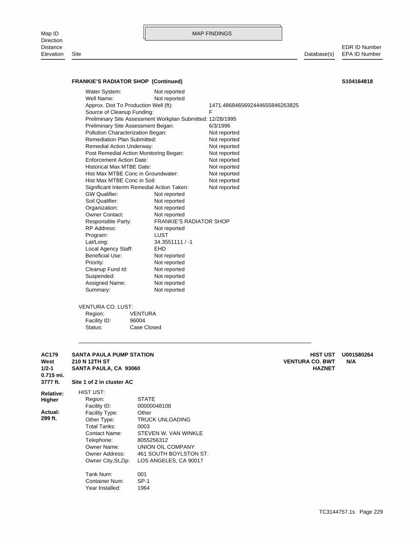
MAP FINDINGSMap IDDirection
EDR ID NumberDistanceEPA ID NumberDatabase(s)SiteElevation
Case ClosedStatus:96004Facility ID:VENTURARegion:
VENTURA CO. LUST:
Not reportedSummary: Not reportedAssigned Name: Not reportedSuspended: Not reportedCleanup Fund Id: Not reportedPriority: Not reportedBeneficial Use: EHDLocal Agency Staff: 34.3551111 / -1Lat/Long: LUSTProgram: Not reportedRP Address: FRANKIE’S RADIATOR SHOPResponsible Party: Not reportedOwner Contact: Not reportedOrganization: Not reportedSoil Qualifier: Not reportedGW Qualifier: Not reportedSignificant Interim Remedial Action Taken: Not reportedHist Max MTBE Conc in Soil: Not reportedHist Max MTBE Conc in Groundwater: Not reportedHistorical Max MTBE Date: Not reportedEnforcement Action Date: Not reportedPost Remedial Action Monitoring Began: Not reportedRemedial Action Underway: Not reportedRemediation Plan Submitted: Not reportedPollution Characterization Began: 6/3/1996Preliminary Site Assessment Began: 12/28/1995Preliminary Site Assessment Workplan Submitted: FSource of Cleanup Funding: 1471.4868465692444655846263825Approx. Dist To Production Well (ft): Not reportedWell Name: Not reportedWater System:
FRANKIE’S RADIATOR SHOP (Continued) S104164818
1964Year Installed: SP-1Container Num: 001Tank Num:
LOS ANGELES, CA 90017Owner City,St,Zip: 461 SOUTH BOYLSTON ST.Owner Address: UNION OIL COMPANYOwner Name: 8055256312Telephone: STEVEN W. VAN WINKLEContact Name: 0003Total Tanks: TRUCK UNLOADINGOther Type: OtherFacility Type: 00000048108Facility ID: STATERegion:
HIST UST:
3777 ft. Site 1 of 2 in cluster AC0.715 mi.
Relative:Higher
Actual:299 ft.
1/2-1 HAZNETSANTA PAULA, CA 93060West VENTURA CO. BWT210 N 12TH ST N/AAC179 HIST USTSANTA PAULA PUMP STATION U001580264
TC3144757.1s Page 229

MAP FINDINGSMap IDDirection
EDR ID NumberDistanceEPA ID NumberDatabase(s)SiteElevation
Pharmaceutical wasteWaste Category: Los AngelesTSD County: CAD028409019TSD EPA ID: VenturaGen County: LONG BEACH, CA 907554020Mailing City,St,Zip: 2459 REDONDO AVEMailing Address: Not reportedMailing Name: 6613433218Telephone: MIKE ROMLEYContact: CAL000335063Gepaid: 2009Year:
VenturaFacility County: 0.2525Tons: (H010-H129) OR (H131-H135) STORAGE, BULKING, AND/OR TRANSFER OFF SITE--NO TREATMENT/REOVERYDisposal Method: Unspecified oil-containing wasteWaste Category: Los AngelesTSD County: CAD028409019TSD EPA ID: VenturaGen County: LONG BEACH, CA 907554020Mailing City,St,Zip: 2459 REDONDO AVEMailing Address: Not reportedMailing Name: 6613433218Telephone: MIKE ROMLEYContact: CAL000335063Gepaid: 2009Year:
HAZNET:
HAZARDOUS WASTE GENERATOR BUSINESS PLAN - SANTA PAULAProgram:FA0006395Facility ID:
VENTURA CO. BWT:
Visual, Stock InventorLeak Detection: Not reportedTank Construction: UNLEADEDType of Fuel: PRODUCTTank Used for: 00001000Tank Capacity: 1974Year Installed: SP-3Container Num: 003Tank Num:
VisualLeak Detection: 6 inchesTank Construction: Not reportedType of Fuel: PRODUCTTank Used for: 00002100Tank Capacity: 1964Year Installed: SP 2Container Num: 002Tank Num:
VisualLeak Detection: 6 inchesTank Construction: Not reportedType of Fuel: PRODUCTTank Used for: 00000688Tank Capacity:
SANTA PAULA PUMP STATION (Continued) U001580264
TC3144757.1s Page 230

MAP FINDINGSMap IDDirection
EDR ID NumberDistanceEPA ID NumberDatabase(s)SiteElevation
18 additional CA_HAZNET: record(s) in the EDR Site Report.Click this hyperlink while viewing on your computer to access
VenturaFacility County: 0.1251Tons: FUEL BLENDING PRIOR TO ENERGY RECOVERY AT ANOTHER SITEDisposal Method: Unspecified oil-containing wasteWaste Category: Los AngelesTSD County: CAD028409019TSD EPA ID: VenturaGen County: LONG BEACH, CA 907554020Mailing City,St,Zip: 2459 REDONDO AVEMailing Address: Not reportedMailing Name: 6613433218Telephone: MIKE ROMLEYContact: CAL000335063Gepaid: 2009Year:
VenturaFacility County: 25.284Tons: INCLUDE ON-SITE TREATMENT AND/OR STABILIZATION) LANDFILL OR SURFACE IMPOUNDMENT THAT WILL BE CLOSED AS LANDFILL( TODisposal Method: Unspecified oil-containing wasteWaste Category: KingsTSD County: CAT000646117TSD EPA ID: VenturaGen County: LONG BEACH, CA 907554020Mailing City,St,Zip: 2459 REDONDO AVEMailing Address: Not reportedMailing Name: 6613433218Telephone: MIKE ROMLEYContact: CAL000335063Gepaid: 2009Year:
VenturaFacility County: 0.8Tons: INCLUDE ON-SITE TREATMENT AND/OR STABILIZATION) LANDFILL OR SURFACE IMPOUNDMENT THAT WILL BE CLOSED AS LANDFILL( TODisposal Method: Asbestos containing wasteWaste Category: Los AngelesTSD County: CAD009007626TSD EPA ID: VenturaGen County: LONG BEACH, CA 907554020Mailing City,St,Zip: 2459 REDONDO AVEMailing Address: Not reportedMailing Name: 6613433218Telephone: MIKE ROMLEYContact: CAL000335063Gepaid: 2009Year:
VenturaFacility County: 0.2085Tons: (H010-H129) OR (H131-H135) STORAGE, BULKING, AND/OR TRANSFER OFF SITE--NO TREATMENT/REOVERYDisposal Method:
SANTA PAULA PUMP STATION (Continued) U001580264
TC3144757.1s Page 231

MAP FINDINGSMap IDDirection
EDR ID NumberDistanceEPA ID NumberDatabase(s)SiteElevation
LONG BEACH, CA 90806 3900 KILROY AIRPORT WAYOwner/operator address: CONOCOPHILLIPSOwner/operator name:
Not reportedOwner/Op end date: 01/01/2003Owner/Op start date: OperatorOwner/Operator Type: PrivateLegal status: Not reportedOwner/operator telephone: USOwner/operator country: Not reported Not reportedOwner/operator address: CONOCOPHILLIPSOwner/operator name:
Not reportedOwner/Op end date: 01/01/2003Owner/Op start date: OwnerOwner/Operator Type: PrivateLegal status: Not reportedOwner/operator telephone: USOwner/operator country: Not reported Not reportedOwner/operator address: CONOCOPHILLIPSOwner/operator name:
Owner/Operator Summary:
100 kg of that material at any time hazardous waste during any calendar month, and accumulates more than from the cleanup of a spill, into or on any land or water, of acutely of any residue or contaminated soil, waste or other debris resulting kg of acutely hazardous waste at any time; or generates 100 kg or less hazardous waste during any calendar month, and accumulates more than 1 waste during any calendar month; or generates 1 kg or less of acutely cleanup of a spill, into or on any land or water, of acutely hazardous residue or contaminated soil, waste or other debris resulting from the during any calendar month; or generates more than 100 kg of any calendar month; or generates more than 1 kg of acutely hazardous waste Handler: generates 1,000 kg or more of hazardous waste during anyDescription: Large Quantity GeneratorClassification: 09EPA Region: [email protected] email: (562) 290-1516Contact telephone: Not reportedContact country: Not reported Not reportedContact address: JIM A ADAMSContact: LONG BEACH, CA 90806 3900 KILROY AIRPORT WAYMailing address: CAR000076927EPA ID: SANTA PAULA, CA 93060 210 N 10TH STFacility address: CONOCOPHILLIPS SANTA PAULA PUMP STATIONFacility name: 02/21/2008Date form received by agency:
RCRA-LQG:
3777 ft. Site 2 of 2 in cluster AC0.715 mi.
Relative:Higher
Actual:299 ft.
1/2-1 SANTA PAULA, CA 93060West FINDS210 N 12TH ST CAR000076927AC180 RCRA-LQGCONOCOPHILLIPS SANTA PAULA PUMP STATION 1004675771
TC3144757.1s Page 232

MAP FINDINGSMap IDDirection
EDR ID NumberDistanceEPA ID NumberDatabase(s)SiteElevation
UNOCAP SANTA PAULA PUMP STATIONSite name: CONOCOPHILLIPS SANTA PAULA PUMP STATIONFacility name: 07/03/2000Date form received by agency:
Large Quantity GeneratorClassification: CONOCOPHILLIPS SANTA PAULA PUMP STATIONFacility name: 01/15/2003Date form received by agency:
Small Quantity GeneratorClassification: CONOCOPHILLIPS SANTA PAULA PUMP STATIONFacility name: 01/15/2003Date form received by agency:
Historical Generators:
NoUsed oil transporter: NoUsed oil transfer facility: NoUsed oil Specification marketer: NoUsed oil fuel marketer to burner: NoUser oil refiner: NoUsed oil processor: NoUsed oil fuel burner: NoFurnace exemption: NoOn-site burner exemption: NoUnderground injection activity: NoTreater, storer or disposer of HW: NoTransporter of hazardous waste: NoRecycler of hazardous waste: NoMixed waste (haz. and radioactive): NoU.S. importer of hazardous waste:
Handler Activities Summary:
Not reportedOwner/Op end date: 09/01/2003Owner/Op start date: OperatorOwner/Operator Type: PrivateLegal status: Not reportedOwner/operator telephone: USOwner/operator country: Not reported Not reportedOwner/operator address: CONOCOPHILLIPSOwner/operator name:
Not reportedOwner/Op end date: Not reportedOwner/Op start date: OwnerOwner/Operator Type: PrivateLegal status: (562) 906-7500Owner/operator telephone: Not reportedOwner/operator country: SANTA FE SPRINGS, CA 90670 P O BOX 2628Owner/operator address: UNOCAPOwner/operator name:
Not reportedOwner/Op end date: 09/01/2003Owner/Op start date: OwnerOwner/Operator Type: PrivateLegal status: Not reportedOwner/operator telephone: USOwner/operator country:
CONOCOPHILLIPS SANTA PAULA PUMP STATION (Continued) 1004675771
TC3144757.1s Page 233
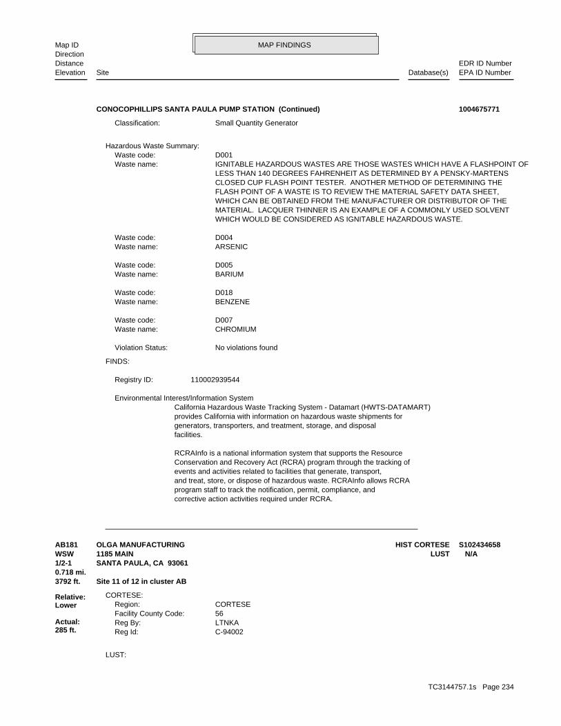
MAP FINDINGSMap IDDirection
EDR ID NumberDistanceEPA ID NumberDatabase(s)SiteElevation
corrective action activities required under RCRA.program staff to track the notification, permit, compliance, andand treat, store, or dispose of hazardous waste. RCRAInfo allows RCRAevents and activities related to facilities that generate, transport,Conservation and Recovery Act (RCRA) program through the tracking ofRCRAInfo is a national information system that supports the Resource
facilities.generators, transporters, and treatment, storage, and disposalprovides California with information on hazardous waste shipments forCalifornia Hazardous Waste Tracking System - Datamart (HWTS-DATAMART) Environmental Interest/Information System
110002939544Registry ID:
FINDS:
No violations foundViolation Status:
CHROMIUMWaste name: D007Waste code:
BENZENEWaste name: D018Waste code:
BARIUMWaste name: D005Waste code:
ARSENICWaste name: D004Waste code:
WHICH WOULD BE CONSIDERED AS IGNITABLE HAZARDOUS WASTE. MATERIAL. LACQUER THINNER IS AN EXAMPLE OF A COMMONLY USED SOLVENT WHICH CAN BE OBTAINED FROM THE MANUFACTURER OR DISTRIBUTOR OF THE FLASH POINT OF A WASTE IS TO REVIEW THE MATERIAL SAFETY DATA SHEET, CLOSED CUP FLASH POINT TESTER. ANOTHER METHOD OF DETERMINING THE LESS THAN 140 DEGREES FAHRENHEIT AS DETERMINED BY A PENSKY-MARTENS IGNITABLE HAZARDOUS WASTES ARE THOSE WASTES WHICH HAVE A FLASHPOINT OFWaste name: D001Waste code:
Hazardous Waste Summary:
Small Quantity GeneratorClassification:
CONOCOPHILLIPS SANTA PAULA PUMP STATION (Continued) 1004675771
LUST:
C-94002Reg Id: LTNKAReg By: 56Facility County Code: CORTESERegion:
CORTESE:
3792 ft. Site 11 of 12 in cluster AB0.718 mi.
Relative:Lower
Actual:285 ft.
1/2-1 SANTA PAULA, CA 93061WSW LUST1185 MAIN N/AAB181 HIST CORTESEOLGA MANUFACTURING S102434658
TC3144757.1s Page 234

MAP FINDINGSMap IDDirection
EDR ID NumberDistanceEPA ID NumberDatabase(s)SiteElevation
Excavate and DisposeAbatement Method Used at the Site: SoilCase Type: 94002Local Case No: Not reportedSubstance Quantity: DieselSubstance: Case ClosedStatus: C-94002facid: VenturaCounty: 04Regional Board: 4Region:
LUST REG 4:
Leak ReportedAction: 1950-01-01 00:00:00Date: OtherAction Type: T0611100870Global Id:
Leak DiscoveryAction: 1950-01-01 00:00:00Date: OtherAction Type: T0611100870Global Id:
* Historical EnforcementAction: 1994-01-20 00:00:00Date: ENFORCEMENTAction Type: T0611100870Global Id:
LUST:
2135766714Phone Number: [email protected]: R4 UNKNOWNCity: Not reportedAddress: LOS ANGELES RWQCB (REGION 4)Organization Name: DANIEL PIROTTONContact Name: Regional Board CaseworkerContact Type: T0611100870Global Id:
LUST:
Click here to access the California GeoTracker records for this facility:
Not reportedSite History: DieselPotential Contaminants of Concern: SoilPotential Media Affect: Not reportedFile Location: 94002LOC Case Number: C-94002RB Case Number: Not reportedLocal Agency: EHDCase Worker: VENTURA COUNTY LOPLead Agency: 1994-05-16 00:00:00Status Date: Completed - Case ClosedStatus: LUST Cleanup SiteCase Type: -119.056439Longitude: 34.355379Latitude: T0611100870Global Id: STATERegion:
OLGA MANUFACTURING (Continued) S102434658
TC3144757.1s Page 235

MAP FINDINGSMap IDDirection
EDR ID NumberDistanceEPA ID NumberDatabase(s)SiteElevation
Case ClosedStatus:94002Facility ID:VENTURARegion:
VENTURA CO. LUST:
Not reportedSummary: Not reportedAssigned Name: Not reportedSuspended: Not reportedCleanup Fund Id: Not reportedPriority: Not reportedBeneficial Use: EHDLocal Agency Staff: 34.3552861 / -1Lat/Long: LUSTProgram: Not reportedRP Address: OLGA MANUFACTURINGResponsible Party: Not reportedOwner Contact: Not reportedOrganization: Not reportedSoil Qualifier: Not reportedGW Qualifier: Not reportedSignificant Interim Remedial Action Taken: Not reportedHist Max MTBE Conc in Soil: Not reportedHist Max MTBE Conc in Groundwater: Not reportedHistorical Max MTBE Date: 1/20/1994Enforcement Action Date: Not reportedPost Remedial Action Monitoring Began: Not reportedRemedial Action Underway: 4/4/1994Remediation Plan Submitted: 3/16/1994Pollution Characterization Began: 12/7/1993Preliminary Site Assessment Began: 7/30/1993Preliminary Site Assessment Workplan Submitted: FSource of Cleanup Funding: 1442.8253560648111663901576945Approx. Dist To Production Well (ft): Not reportedWell Name: Not reportedWater System: Not reportedOperator: Not reportedLeak Source: Not reportedCause of Leak: Not reportedHow Leak Stopped: Not reportedHow Leak Discovered: 5/16/1994Date the Case was Closed: Not reportedDate Case Last Changed on Database: Not reportedDate Leak Stopped: 1/6/1994Date Confirmation Began: Not reportedDate Leak Record Entered: 1/6/1994Date Leak First Reported: 1/6/1994Date Leak Discovered: EFEnforcement Type: Not reportedCross Street: 56000LLocal Agency: UNKStaff: Not reportedW Global ID: T0611100870Global ID:
OLGA MANUFACTURING (Continued) S102434658
TC3144757.1s Page 236
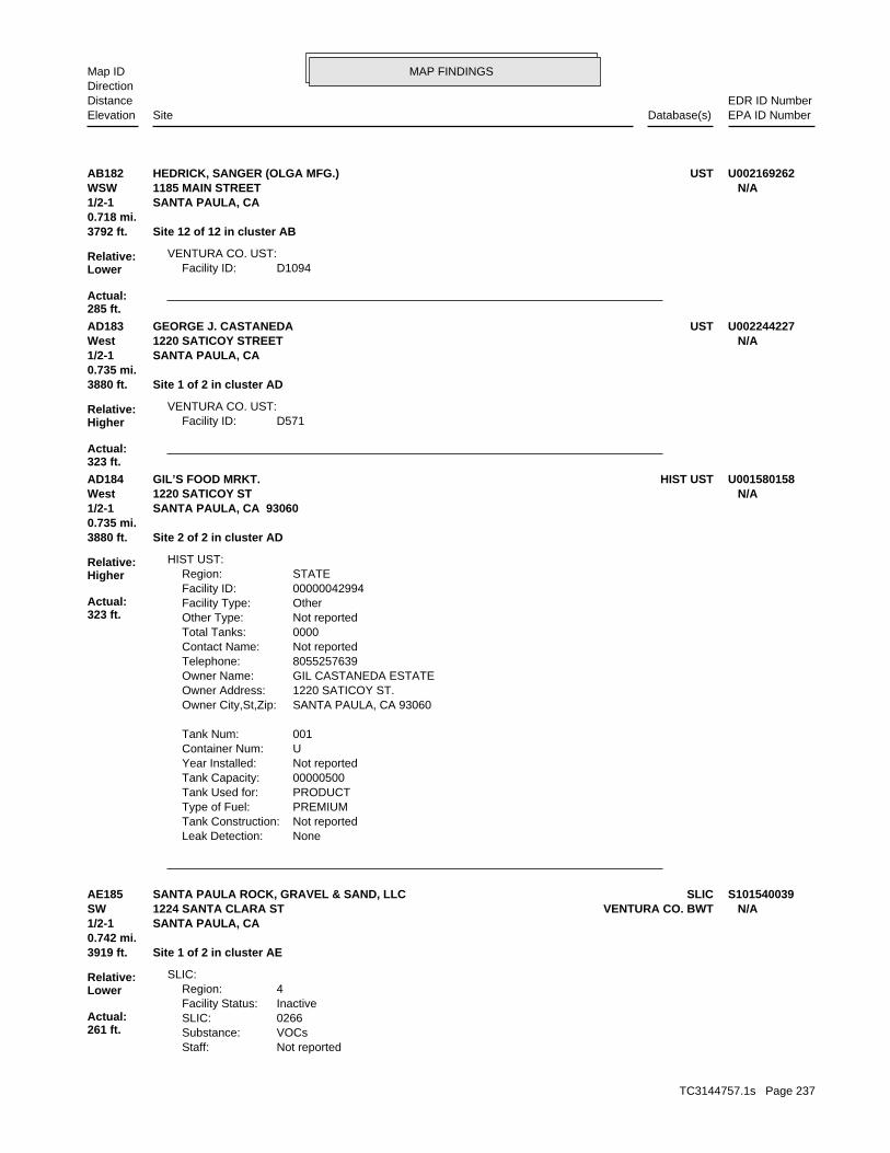
MAP FINDINGSMap IDDirection
EDR ID NumberDistanceEPA ID NumberDatabase(s)SiteElevation
D1094Facility ID:VENTURA CO. UST:
3792 ft. Site 12 of 12 in cluster AB0.718 mi.
Relative:Lower
Actual:285 ft.
1/2-1 SANTA PAULA, CA WSW 1185 MAIN STREET N/AAB182 USTHEDRICK, SANGER (OLGA MFG.) U002169262
D571Facility ID:VENTURA CO. UST:
3880 ft. Site 1 of 2 in cluster AD0.735 mi.
Relative:Higher
Actual:323 ft.
1/2-1 SANTA PAULA, CA West 1220 SATICOY STREET N/AAD183 USTGEORGE J. CASTANEDA U002244227
NoneLeak Detection: Not reportedTank Construction: PREMIUMType of Fuel: PRODUCTTank Used for: 00000500Tank Capacity: Not reportedYear Installed: UContainer Num: 001Tank Num:
SANTA PAULA, CA 93060Owner City,St,Zip: 1220 SATICOY ST.Owner Address: GIL CASTANEDA ESTATEOwner Name: 8055257639Telephone: Not reportedContact Name: 0000Total Tanks: Not reportedOther Type: OtherFacility Type: 00000042994Facility ID: STATERegion:
HIST UST:
3880 ft. Site 2 of 2 in cluster AD0.735 mi.
Relative:Higher
Actual:323 ft.
1/2-1 SANTA PAULA, CA 93060West 1220 SATICOY ST N/AAD184 HIST USTGIL’S FOOD MRKT. U001580158
Not reportedStaff:VOCsSubstance:0266SLIC:InactiveFacility Status:4Region:
SLIC:
3919 ft. Site 1 of 2 in cluster AE0.742 mi.
Relative:Lower
Actual:261 ft.
1/2-1 SANTA PAULA, CA SW VENTURA CO. BWT1224 SANTA CLARA ST N/AAE185 SLICSANTA PAULA ROCK, GRAVEL & SAND, LLC S101540039
TC3144757.1s Page 237

MAP FINDINGSMap IDDirection
EDR ID NumberDistanceEPA ID NumberDatabase(s)SiteElevation
HAZARDOUS WASTE GENERATORProgram:FA0025291Facility ID:
VENTURA CO. BWT:
SANTA PAULA ROCK, GRAVEL & SAND, LLC (Continued) S101540039
NoUsed oil transporter: NoUsed oil transfer facility: NoUsed oil Specification marketer: NoUsed oil fuel marketer to burner: NoUser oil refiner: NoUsed oil processor: NoUsed oil fuel burner: NoFurnace exemption: NoOn-site burner exemption: NoUnderground injection activity: NoTreater, storer or disposer of HW: NoTransporter of hazardous waste: NoRecycler of hazardous waste: NoMixed waste (haz. and radioactive): NoU.S. importer of hazardous waste:
Handler Activities Summary:
Not reportedOwner/Op end date: Not reportedOwner/Op start date: OwnerOwner/Operator Type: PrivateLegal status: (713) 627-8511Owner/operator telephone: Not reportedOwner/operator country: HOUSTON, TX 77098 3355 W ALABAMAOwner/operator address: WEATHERFORDOwner/operator name:
Owner/Operator Summary:
Handler: Non-Generators do not presently generate hazardous wasteDescription: Non-GeneratorClassification: 09EPA Region: Not reportedContact email: (713) 937-3811Contact telephone: USContact country: HOUSTON, TX 77040 9203 EMMOTT RDContact address: BECKY ALBERSContact: HOUSTON, TX 77040 EMMOTT RDMailing address: CAD983664392EPA ID: SANTA PAULA, CA 93060 1224 E SANTA CLARA STFacility address: WEATHERFORDFacility name: 07/11/1996Date form received by agency:
RCRA-NonGen:
3919 ft. Site 2 of 2 in cluster AE0.742 mi.
Relative:Lower
Actual:261 ft.
1/2-1 SANTA PAULA, CA 93060SW FINDS1224 E SANTA CLARA ST CAD983664392AE186 RCRA-NonGenWEATHERFORD 1000820404
TC3144757.1s Page 238

MAP FINDINGSMap IDDirection
EDR ID NumberDistanceEPA ID NumberDatabase(s)SiteElevation
corrective action activities required under RCRA.program staff to track the notification, permit, compliance, andand treat, store, or dispose of hazardous waste. RCRAInfo allows RCRAevents and activities related to facilities that generate, transport,Conservation and Recovery Act (RCRA) program through the tracking ofRCRAInfo is a national information system that supports the Resource Environmental Interest/Information System
110002896395Registry ID:
FINDS:
No violations foundViolation Status:
WEATHERFORD (Continued) 1000820404
T0611112825Global Id:
* Historical Enforcement - #2Action: 2005-06-14 00:00:00Date: ENFORCEMENTAction Type: T0611112825Global Id:
LUST:
2135766714Phone Number: [email protected]: R4 UNKNOWNCity: Not reportedAddress: LOS ANGELES RWQCB (REGION 4)Organization Name: DANIEL PIROTTONContact Name: Regional Board CaseworkerContact Type: T0611112825Global Id:
LUST:
Click here to access the California GeoTracker records for this facility:
Not reportedSite History: DieselPotential Contaminants of Concern: SoilPotential Media Affect: Stored electronically as an E-fileFile Location: 04018LOC Case Number: C04018RB Case Number: Not reportedLocal Agency: GLTCase Worker: VENTURA COUNTY LOPLead Agency: 2006-12-06 00:00:00Status Date: Completed - Case ClosedStatus: LUST Cleanup SiteCase Type: -119.056453Longitude: 34.35475Latitude: T0611112825Global Id: STATERegion:
LUST:
3962 ft.0.750 mi.
Relative:Lower
Actual:284 ft.
1/2-1 SANTA PAULA, CA 93060WSW HAZNET1150 MAIN STREET N/A187 LUSTMAGNUM MANUFACTURING S106091099
TC3144757.1s Page 239

MAP FINDINGSMap IDDirection
EDR ID NumberDistanceEPA ID NumberDatabase(s)SiteElevation
UNKCause of Leak: Close TankHow Leak Stopped: Tank ClosureHow Leak Discovered: Not reportedDate the Case was Closed: Not reportedDate Case Last Changed on Database: 3/16/2004Date Leak Stopped: 3/16/2004Date Confirmation Began: Not reportedDate Leak Record Entered: 3/16/2004Date Leak First Reported: 3/16/2004Date Leak Discovered: Not reportedEnforcement Type: OAK STCross Street: 56000LLocal Agency: UNKStaff: Not reportedW Global ID: T0611112825Global ID: Not reportedAbatement Method Used at the Site: UndefinedCase Type: 04018Local Case No: Not reportedSubstance Quantity: DieselSubstance: Leak being confirmedStatus: C04018facid: VenturaCounty: 04Regional Board: 4Region:
LUST REG 4:
CorrespondenceAction: 2008-09-18 00:00:00Date: RESPONSEAction Type: T0611112825Global Id:
Leak StoppedAction: 1950-01-01 00:00:00Date: OtherAction Type: T0611112825Global Id:
Leak ReportedAction: 1950-01-01 00:00:00Date: OtherAction Type: T0611112825Global Id:
Closure/No Further Action LetterAction: 2006-12-06 00:00:00Date: ENFORCEMENTAction Type: T0611112825Global Id:
Leak DiscoveryAction: 1950-01-01 00:00:00Date: OtherAction Type: T0611112825Global Id:
Soil and Water Investigation WorkplanAction: 2005-07-15 00:00:00Date: RESPONSEAction Type:
MAGNUM MANUFACTURING (Continued) S106091099
TC3144757.1s Page 240

MAP FINDINGSMap IDDirection
EDR ID NumberDistanceEPA ID NumberDatabase(s)SiteElevation
CAL000128560Gepaid: 2002Year:
Not reportedFacility County: 0.31Tons: R01Disposal Method: Unspecified solvent mixtureWaste Category: Los AngelesTSD County: Not reportedTSD EPA ID: VenturaGen County: SANTA PAULA, CA 930600000Mailing City,St,Zip: 1150 E MAIN STMailing Address: Not reportedMailing Name: --Telephone: WILLIAM ODLE/PRESContact: CAL000128560Gepaid: 2002Year:
HAZNET:
Case ClosedStatus:04018Facility ID:VENTURARegion:
VENTURA CO. LUST:
Not reportedSummary: Not reportedAssigned Name: Not reportedSuspended: Not reportedCleanup Fund Id: Not reportedPriority: Not reportedBeneficial Use: KCKLocal Agency Staff: 0 / 0Lat/Long: Not reportedProgram: PO BOX 569RP Address: ROBERT GUERRAResponsible Party: Not reportedOwner Contact: Not reportedOrganization: Not reportedSoil Qualifier: Not reportedGW Qualifier: Not reportedSignificant Interim Remedial Action Taken: Not reportedHist Max MTBE Conc in Soil: Not reportedHist Max MTBE Conc in Groundwater: Not reportedHistorical Max MTBE Date: Not reportedEnforcement Action Date: Not reportedPost Remedial Action Monitoring Began: Not reportedRemedial Action Underway: Not reportedRemediation Plan Submitted: Not reportedPollution Characterization Began: Not reportedPreliminary Site Assessment Began: Not reportedPreliminary Site Assessment Workplan Submitted: UNKSource of Cleanup Funding: Not reportedApprox. Dist To Production Well (ft): Not reportedWell Name: Not reportedWater System: Not reportedOperator: UNKLeak Source:
MAGNUM MANUFACTURING (Continued) S106091099
TC3144757.1s Page 241

MAP FINDINGSMap IDDirection
EDR ID NumberDistanceEPA ID NumberDatabase(s)SiteElevation
Not reportedFacility County: 0.20Tons: R01Disposal Method: Off-specification, aged or surplus inorganicsWaste Category: Los AngelesTSD County: Not reportedTSD EPA ID: VenturaGen County: SANTA PAULA, CA 930600000Mailing City,St,Zip: 1150 E MAIN STMailing Address: Not reportedMailing Name: --Telephone: WILLIAM ODLE/PRESContact: CAL000128560Gepaid: 2002Year:
Not reportedFacility County: Not reportedTons: Not reportedDisposal Method: Unspecified oil-containing wasteWaste Category: Los AngelesTSD County: Not reportedTSD EPA ID: VenturaGen County: SANTA PAULA, CA 930600000Mailing City,St,Zip: 1150 E MAIN STMailing Address: Not reportedMailing Name: --Telephone: WILLIAM ODLE/PRESContact: CAL000128560Gepaid: 2002Year:
Not reportedFacility County: Not reportedTons: Not reportedDisposal Method: Other organic solidsWaste Category: Los AngelesTSD County: Not reportedTSD EPA ID: VenturaGen County: SANTA PAULA, CA 930600000Mailing City,St,Zip: 1150 E MAIN STMailing Address: Not reportedMailing Name: --Telephone: WILLIAM ODLE/PRESContact:
MAGNUM MANUFACTURING (Continued) S106091099
-119.055052Longitude: 34.349616Latitude: SR3146642Lead Agency Case Number: VENTURA COUNTY LOPLead Agency: T10000000837Global Id: 2001-01-10 00:00:00Status Date: Completed - Case ClosedFacility Status: STATERegion:
SLIC:
4423 ft.0.838 mi.
Relative:Lower
Actual:256 ft.
1/2-1 SANTA PAULA, CA 93060SW 1170 MONTEBELLO STREET N/A188 SLICHANSON AGGREGATE S109521403
TC3144757.1s Page 242

MAP FINDINGSMap IDDirection
EDR ID NumberDistanceEPA ID NumberDatabase(s)SiteElevation
Click here to access the California GeoTracker records for this facility:
Not reportedSite History: Not reportedPotential Contaminants of Concern: Not reportedPotential Media Affected: Local Agency WarehouseFile Location: Not reportedRB Case Number: VENTURA COUNTY LOPLocal Agency: DCSCase Worker: Cleanup Program SiteCase Type:
HANSON AGGREGATE (Continued) S109521403
T0611167736Global Id:LUST:
2135766714Phone Number: [email protected]: R4 UNKNOWNCity: Not reportedAddress: LOS ANGELES RWQCB (REGION 4)Organization Name: DANIEL PIROTTONContact Name: Regional Board CaseworkerContact Type: T0611167736Global Id:
Not reportedPhone Number: [email protected]: VENTURACity: 800 S. VICTORIA AVEAddress: VENTURA COUNTY LOPOrganization Name: ERIN K. O’CONNELLContact Name: Local Agency CaseworkerContact Type: T0611167736Global Id:
LUST:
Click here to access the California GeoTracker records for this facility:
Not reportedSite History: Waste Oil / Motor / Hydraulic / LubricatingPotential Contaminants of Concern: SoilPotential Media Affect: Stored electronically as an E-fileFile Location: 03011LOC Case Number: C03011RB Case Number: VENTURA COUNTY LOPLocal Agency: EKOCase Worker: VENTURA COUNTY LOPLead Agency: 2003-04-15 00:00:00Status Date: Completed - Case ClosedStatus: LUST Cleanup SiteCase Type: -119.058298Longitude: 34.35479Latitude: T0611167736Global Id: STATERegion:
LUST:
4490 ft.0.850 mi.
Relative:Lower
Actual:281 ft.
1/2-1 SANTA PAULA, CA WSW 1085 MAIN ST N/A189 LUSTFOX MUFFLER S105857478
TC3144757.1s Page 243
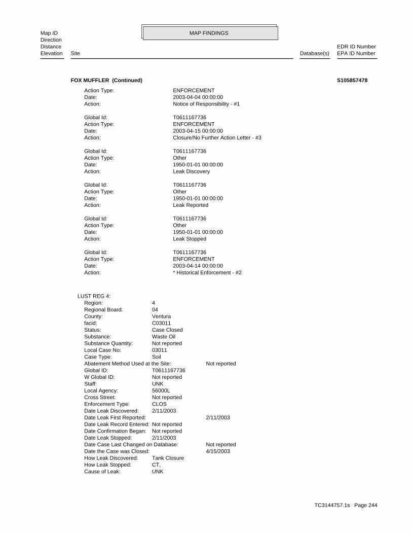
MAP FINDINGSMap IDDirection
EDR ID NumberDistanceEPA ID NumberDatabase(s)SiteElevation
UNKCause of Leak: CT,How Leak Stopped: Tank ClosureHow Leak Discovered: 4/15/2003Date the Case was Closed: Not reportedDate Case Last Changed on Database: 2/11/2003Date Leak Stopped: Not reportedDate Confirmation Began: Not reportedDate Leak Record Entered: 2/11/2003Date Leak First Reported: 2/11/2003Date Leak Discovered: CLOSEnforcement Type: Not reportedCross Street: 56000LLocal Agency: UNKStaff: Not reportedW Global ID: T0611167736Global ID: Not reportedAbatement Method Used at the Site: SoilCase Type: 03011Local Case No: Not reportedSubstance Quantity: Waste OilSubstance: Case ClosedStatus: C03011facid: VenturaCounty: 04Regional Board: 4Region:
LUST REG 4:
* Historical Enforcement - #2Action: 2003-04-14 00:00:00Date: ENFORCEMENTAction Type: T0611167736Global Id:
Leak StoppedAction: 1950-01-01 00:00:00Date: OtherAction Type: T0611167736Global Id:
Leak ReportedAction: 1950-01-01 00:00:00Date: OtherAction Type: T0611167736Global Id:
Leak DiscoveryAction: 1950-01-01 00:00:00Date: OtherAction Type: T0611167736Global Id:
Closure/No Further Action Letter - #3Action: 2003-04-15 00:00:00Date: ENFORCEMENTAction Type: T0611167736Global Id:
Notice of Responsibility - #1Action: 2003-04-04 00:00:00Date: ENFORCEMENTAction Type:
FOX MUFFLER (Continued) S105857478
TC3144757.1s Page 244

MAP FINDINGSMap IDDirection
EDR ID NumberDistanceEPA ID NumberDatabase(s)SiteElevation
Case ClosedStatus:03011Facility ID:VENTURARegion:
VENTURA CO. LUST:
Not reportedSummary: Not reportedAssigned Name: Not reportedSuspended: Not reportedCleanup Fund Id: Not reportedPriority: AGR, GWR, MUNBeneficial Use: EKOLocal Agency Staff: 0 / 0Lat/Long: LUSTProgram: 1085 MAIN STRP Address: GARY FOXResponsible Party: Not reportedOwner Contact: Not reportedOrganization: Not reportedSoil Qualifier: Not reportedGW Qualifier: Not reportedSignificant Interim Remedial Action Taken: Not reportedHist Max MTBE Conc in Soil: Not reportedHist Max MTBE Conc in Groundwater: Not reportedHistorical Max MTBE Date: Not reportedEnforcement Action Date: Not reportedPost Remedial Action Monitoring Began: Not reportedRemedial Action Underway: Not reportedRemediation Plan Submitted: Not reportedPollution Characterization Began: Not reportedPreliminary Site Assessment Began: Not reportedPreliminary Site Assessment Workplan Submitted: UNKSource of Cleanup Funding: Not reportedApprox. Dist To Production Well (ft): Not reportedWell Name: Not reportedWater System: Not reportedOperator: UNKLeak Source:
FOX MUFFLER (Continued) S105857478
Not reportedW Global ID: T0611100265Global ID: Not reportedAbatement Method Used at the Site: SoilCase Type: 88007Local Case No: Not reportedSubstance Quantity: DieselSubstance: Case ClosedStatus: C-88007facid: VenturaCounty: 04Regional Board: 4Region:
LUST REG 4:
4692 ft. Site 1 of 2 in cluster AF0.889 mi.
Relative:Lower
Actual:290 ft.
1/2-1 SANTA PAULA, CA WSW OJAI ST N/AAF190 LUSTGTE CENTRAL OFFICE S103684188
TC3144757.1s Page 245

MAP FINDINGSMap IDDirection
EDR ID NumberDistanceEPA ID NumberDatabase(s)SiteElevation
Case ClosedStatus:88007Facility ID:VENTURARegion:
VENTURA CO. LUST:
Not reportedSummary: Not reportedAssigned Name: Not reportedSuspended: Not reportedCleanup Fund Id: Not reportedPriority: Not reportedBeneficial Use: EHDLocal Agency Staff: 34.3546691 / -1Lat/Long: LUSTProgram: Not reportedRP Address: GTE CALIFORNIA INCResponsible Party: Not reportedOwner Contact: Not reportedOrganization: Not reportedSoil Qualifier: Not reportedGW Qualifier: Not reportedSignificant Interim Remedial Action Taken: Not reportedHist Max MTBE Conc in Soil: Not reportedHist Max MTBE Conc in Groundwater: Not reportedHistorical Max MTBE Date: 1/22/1988Enforcement Action Date: Not reportedPost Remedial Action Monitoring Began: Not reportedRemedial Action Underway: Not reportedRemediation Plan Submitted: Not reportedPollution Characterization Began: 8/2/1988Preliminary Site Assessment Began: 1/22/1988Preliminary Site Assessment Workplan Submitted: SSource of Cleanup Funding: 2132.1981188483928232830823004Approx. Dist To Production Well (ft): Not reportedWell Name: Not reportedWater System: Not reportedOperator: Not reportedLeak Source: Not reportedCause of Leak: Not reportedHow Leak Stopped: Not reportedHow Leak Discovered: 11/28/1988Date the Case was Closed: Not reportedDate Case Last Changed on Database: Not reportedDate Leak Stopped: 7/1/1988Date Confirmation Began: Not reportedDate Leak Record Entered: 1/22/1988Date Leak First Reported: 1/22/1988Date Leak Discovered: EFEnforcement Type: Not reportedCross Street: 56000LLocal Agency: UNKStaff:
GTE CENTRAL OFFICE (Continued) S103684188
TC3144757.1s Page 246

MAP FINDINGSMap IDDirection
EDR ID NumberDistanceEPA ID NumberDatabase(s)SiteElevation
DCSLocal Agency Staff: 34.354056 / -1Lat/Long: LUSTProgram: 3525 HYLAND AVE., COSTA MESA, CA 92626RP Address: TOSCO MARKETING COResponsible Party: Not reportedOwner Contact: Not reportedOrganization: Not reportedSoil Qualifier: Not reportedGW Qualifier: Not reportedSignificant Interim Remedial Action Taken: Not reportedHist Max MTBE Conc in Soil: Not reportedHist Max MTBE Conc in Groundwater: Not reportedHistorical Max MTBE Date: Not reportedEnforcement Action Date: Not reportedPost Remedial Action Monitoring Began: Not reportedRemedial Action Underway: Not reportedRemediation Plan Submitted: Not reportedPollution Characterization Began: Not reportedPreliminary Site Assessment Began: Not reportedPreliminary Site Assessment Workplan Submitted: PipingSource of Cleanup Funding: 2389.7372556262399953421226464Approx. Dist To Production Well (ft): Not reportedWell Name: Not reportedWater System: TOSCOOperator: PipingLeak Source: Not reportedCause of Leak: Not reportedHow Leak Stopped: OMHow Leak Discovered: 6/11/2001Date the Case was Closed: 1/6/2000Date Case Last Changed on Database: Not reportedDate Leak Stopped: 1/6/2000Date Confirmation Began: Not reportedDate Leak Record Entered: 1/6/2000Date Leak First Reported: 4/26/1999Date Leak Discovered: CLOSEnforcement Type: Not reportedCross Street: 56000LLocal Agency: UNKStaff: Not reportedW Global ID: T0611192999Global ID: Not reportedAbatement Method Used at the Site: SoilCase Type: 00012Local Case No: Not reportedSubstance Quantity: PerchlorethyleneSubstance: Case ClosedStatus: C-00012facid: VenturaCounty: 04Regional Board: 4Region:
LUST REG 4:
4834 ft. Site 1 of 4 in cluster AG0.915 mi.
Relative:Lower
Actual:281 ft.
1/2-1 SANTA PAULA, CA 93060WSW HAZNET1033 MAIN ST N/AAG191 LUSTUNOCAL - 76 SS #0079 (FORMER) S104773344
TC3144757.1s Page 247

MAP FINDINGSMap IDDirection
EDR ID NumberDistanceEPA ID NumberDatabase(s)SiteElevation
Not reportedFacility County: 2.29Tons: R01Disposal Method: Waste oil and mixed oilWaste Category: Los AngelesTSD County: Not reportedTSD EPA ID: VenturaGen County: PHOENIX, AZ 850722085Mailing City,St,Zip: PO BOX 52085Mailing Address: Not reportedMailing Name: 6027284180Telephone: HAZMAT SPECIALISTContact: CAL000175886Gepaid: 2001Year:
HAZNET:
Not reportedSummary: Not reportedAssigned Name: Not reportedSuspended: Not reportedCleanup Fund Id: Not reportedPriority: Not reportedBeneficial Use:
UNOCAL - 76 SS #0079 (FORMER) (Continued) S104773344
8056626512Phone Number: [email protected]: VENTURACity: 800 S. VICTORIA AVE.Address: VENTURA COUNTY LOPOrganization Name: DAVID C. SALTERContact Name: Local Agency CaseworkerContact Type: T0611192999Global Id:
LUST:
Click here to access the California GeoTracker records for this facility:
Not reportedSite History: Tetrachloroethylene (PCE)Potential Contaminants of Concern: SoilPotential Media Affect: Not reportedFile Location: 00012LOC Case Number: C00012RB Case Number: VENTURA COUNTY LOPLocal Agency: DCSCase Worker: VENTURA COUNTY LOPLead Agency: 2001-06-11 00:00:00Status Date: Completed - Case ClosedStatus: LUST Cleanup SiteCase Type: -119.059384Longitude: 34.354448Latitude: T0611192999Global Id: STATERegion:
LUST:
4834 ft. Site 2 of 4 in cluster AG0.915 mi.
Relative:Lower
Actual:281 ft.
1/2-1 SANTA PAULA, CA WSW 1033 MAIN ST N/AAG192 LUSTUNOCAL SS #0079 (FORMER) S105974851
TC3144757.1s Page 248
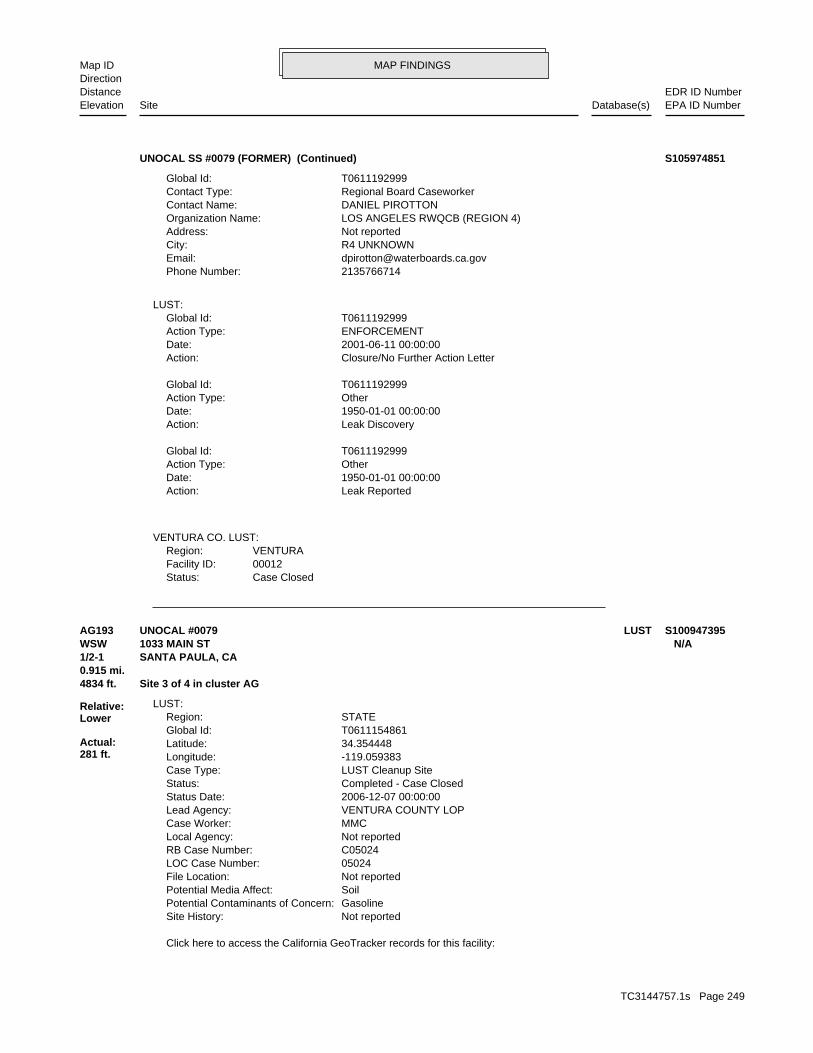
MAP FINDINGSMap IDDirection
EDR ID NumberDistanceEPA ID NumberDatabase(s)SiteElevation
Case ClosedStatus:00012Facility ID:VENTURARegion:
VENTURA CO. LUST:
Leak ReportedAction: 1950-01-01 00:00:00Date: OtherAction Type: T0611192999Global Id:
Leak DiscoveryAction: 1950-01-01 00:00:00Date: OtherAction Type: T0611192999Global Id:
Closure/No Further Action LetterAction: 2001-06-11 00:00:00Date: ENFORCEMENTAction Type: T0611192999Global Id:
LUST:
2135766714Phone Number: [email protected]: R4 UNKNOWNCity: Not reportedAddress: LOS ANGELES RWQCB (REGION 4)Organization Name: DANIEL PIROTTONContact Name: Regional Board CaseworkerContact Type: T0611192999Global Id:
UNOCAL SS #0079 (FORMER) (Continued) S105974851
Click here to access the California GeoTracker records for this facility:
Not reportedSite History: GasolinePotential Contaminants of Concern: SoilPotential Media Affect: Not reportedFile Location: 05024LOC Case Number: C05024RB Case Number: Not reportedLocal Agency: MMCCase Worker: VENTURA COUNTY LOPLead Agency: 2006-12-07 00:00:00Status Date: Completed - Case ClosedStatus: LUST Cleanup SiteCase Type: -119.059383Longitude: 34.354448Latitude: T0611154861Global Id: STATERegion:
LUST:
4834 ft. Site 3 of 4 in cluster AG0.915 mi.
Relative:Lower
Actual:281 ft.
1/2-1 SANTA PAULA, CA WSW 1033 MAIN ST N/AAG193 LUSTUNOCAL #0079 S100947395
TC3144757.1s Page 249

MAP FINDINGSMap IDDirection
EDR ID NumberDistanceEPA ID NumberDatabase(s)SiteElevation
Leak DiscoveryAction: 1950-01-01 00:00:00Date: OtherAction Type: T0611154861Global Id:
Corrective Action Plan / Remedial Action PlanAction: 2006-07-21 00:00:00Date: RESPONSEAction Type: T0611154861Global Id:
* No Action - #-Action: 2006-11-15 00:00:00Date: ENFORCEMENTAction Type: T0611154861Global Id:
Notification - Site Designation - #8Action: 2006-12-12 00:00:00Date: ENFORCEMENTAction Type: T0611154861Global Id:
Closure/No Further Action Letter - #7Action: 2006-12-07 00:00:00Date: ENFORCEMENTAction Type: T0611154861Global Id:
Technical Correspondence / Assistance / Other - #5Action: 2006-09-12 00:00:00Date: ENFORCEMENTAction Type: T0611154861Global Id:
Technical Correspondence / Assistance / Other - #4Action: 2006-06-19 00:00:00Date: ENFORCEMENTAction Type: T0611154861Global Id:
Technical Correspondence / Assistance / Other - #6Action: 2006-11-26 00:00:00Date: ENFORCEMENTAction Type: T0611154861Global Id:
* Historical Enforcement - #2Action: 2006-03-07 00:00:00Date: ENFORCEMENTAction Type: T0611154861Global Id:
LUST:
2135766714Phone Number: [email protected]: R4 UNKNOWNCity: Not reportedAddress: LOS ANGELES RWQCB (REGION 4)Organization Name: DANIEL PIROTTONContact Name: Regional Board CaseworkerContact Type: T0611154861Global Id:
LUST:
UNOCAL #0079 (Continued) S100947395
TC3144757.1s Page 250

MAP FINDINGSMap IDDirection
EDR ID NumberDistanceEPA ID NumberDatabase(s)SiteElevation
REMEDIATIONAction Type: T0611154861Global Id:
Leak ReportedAction: 1950-01-01 00:00:00Date: OtherAction Type: T0611154861Global Id:
Other WorkplanAction: 2006-03-23 00:00:00Date: RESPONSEAction Type: T0611154861Global Id:
Electronic Reporting Submittal DueAction: 2006-02-10 00:00:00Date: RESPONSEAction Type: T0611154861Global Id:
Other WorkplanAction: 2006-05-02 00:00:00Date: RESPONSEAction Type: T0611154861Global Id:
Electronic Reporting Submittal DueAction: 2006-07-21 00:00:00Date: RESPONSEAction Type: T0611154861Global Id:
Soil and Water Investigation ReportAction: 2006-06-16 00:00:00Date: RESPONSEAction Type: T0611154861Global Id:
Other Report / DocumentAction: 2006-02-10 00:00:00Date: RESPONSEAction Type: T0611154861Global Id:
Remedial Progress ReportAction: 2006-11-10 00:00:00Date: RESPONSEAction Type: T0611154861Global Id:
Technical Correspondence / Assistance / Other - #3Action: 2006-05-02 00:00:00Date: ENFORCEMENTAction Type: T0611154861Global Id:
* Historical Enforcement - #1Action: 2005-12-21 00:00:00Date: ENFORCEMENTAction Type: T0611154861Global Id:
Preliminary Site Assessment WorkplanAction: 2006-02-10 00:00:00Date: RESPONSEAction Type: T0611154861Global Id:
UNOCAL #0079 (Continued) S100947395
TC3144757.1s Page 251

MAP FINDINGSMap IDDirection
EDR ID NumberDistanceEPA ID NumberDatabase(s)SiteElevation
Leak ReportedAction: 1950-01-01 00:00:00Date: OtherAction Type: T0611100533Global Id:
* Historical EnforcementAction: 1989-09-27 00:00:00Date: ENFORCEMENTAction Type: T0611100533Global Id:
Leak DiscoveryAction: 1950-01-01 00:00:00Date: OtherAction Type: T0611100533Global Id:
LUST:
2135766714Phone Number: [email protected]: R4 UNKNOWNCity: Not reportedAddress: LOS ANGELES RWQCB (REGION 4)Organization Name: DANIEL PIROTTONContact Name: Regional Board CaseworkerContact Type: T0611100533Global Id:
8056626512Phone Number: [email protected]: VENTURACity: 800 S. VICTORIA AVE.Address: VENTURA COUNTY LOPOrganization Name: DAVID C. SALTERContact Name: Local Agency CaseworkerContact Type: T0611100533Global Id:
LUST:
Click here to access the California GeoTracker records for this facility:
Not reportedSite History: GasolinePotential Contaminants of Concern: SoilPotential Media Affect: Not reportedFile Location: 89128LOC Case Number: C-89128RB Case Number: VENTURA COUNTY LOPLocal Agency: DCSCase Worker: VENTURA COUNTY LOPLead Agency: 1997-05-28 00:00:00Status Date: Completed - Case ClosedStatus: LUST Cleanup SiteCase Type: -119.059384Longitude: 34.354448Latitude: T0611100533Global Id: STATERegion:
Excavate and DisposeAction: 1950-01-01 00:00:00Date:
UNOCAL #0079 (Continued) S100947395
TC3144757.1s Page 252

MAP FINDINGSMap IDDirection
EDR ID NumberDistanceEPA ID NumberDatabase(s)SiteElevation
4Region:LUST REG 4:
Leak ReportedAction: 1950-01-01 00:00:00Date: OtherAction Type: T0611161853Global Id:
Leak DiscoveryAction: 1950-01-01 00:00:00Date: OtherAction Type: T0611161853Global Id:
Closure/No Further Action LetterAction: 2001-10-31 00:00:00Date: ENFORCEMENTAction Type: T0611161853Global Id:
LUST:
2135766714Phone Number: [email protected]: R4 UNKNOWNCity: Not reportedAddress: LOS ANGELES RWQCB (REGION 4)Organization Name: DANIEL PIROTTONContact Name: Regional Board CaseworkerContact Type: T0611161853Global Id:
8056626512Phone Number: [email protected]: VENTURACity: 800 S. VICTORIA AVE.Address: VENTURA COUNTY LOPOrganization Name: DAVID C. SALTERContact Name: Local Agency CaseworkerContact Type: T0611161853Global Id:
LUST:
Click here to access the California GeoTracker records for this facility:
Not reportedSite History: GasolinePotential Contaminants of Concern: SoilPotential Media Affect: Not reportedFile Location: 01020LOC Case Number: C01020RB Case Number: VENTURA COUNTY LOPLocal Agency: DCSCase Worker: VENTURA COUNTY LOPLead Agency: 2001-10-31 00:00:00Status Date: Completed - Case ClosedStatus: LUST Cleanup SiteCase Type: -119.059383Longitude: 34.354448Latitude: T0611161853Global Id: STATERegion:
UNOCAL #0079 (Continued) S100947395
TC3144757.1s Page 253

MAP FINDINGSMap IDDirection
EDR ID NumberDistanceEPA ID NumberDatabase(s)SiteElevation
Not reportedSummary: Not reportedAssigned Name: Not reportedSuspended: Not reportedCleanup Fund Id: Not reportedPriority: Not reportedBeneficial Use: DCSLocal Agency Staff: 34.3543182 / -1Lat/Long: LUSTProgram: Not reportedRP Address: TOSCO MARKETINGResponsible Party: Not reportedOwner Contact: Not reportedOrganization: Not reportedSoil Qualifier: Not reportedGW Qualifier: Not reportedSignificant Interim Remedial Action Taken: Not reportedHist Max MTBE Conc in Soil: Not reportedHist Max MTBE Conc in Groundwater: Not reportedHistorical Max MTBE Date: 9/27/1989Enforcement Action Date: Not reportedPost Remedial Action Monitoring Began: 5/15/1997Remedial Action Underway: 2/25/1991Remediation Plan Submitted: 10/30/1989Pollution Characterization Began: 10/30/1989Preliminary Site Assessment Began: 9/27/1989Preliminary Site Assessment Workplan Submitted: FSource of Cleanup Funding: 2299.0846059138974946836943644Approx. Dist To Production Well (ft): Not reportedWell Name: Not reportedWater System: Not reportedOperator: Not reportedLeak Source: Not reportedCause of Leak: Not reportedHow Leak Stopped: Not reportedHow Leak Discovered: 5/28/1997Date the Case was Closed: Not reportedDate Case Last Changed on Database: Not reportedDate Leak Stopped: 9/27/1989Date Confirmation Began: Not reportedDate Leak Record Entered: 9/27/1989Date Leak First Reported: 9/27/1989Date Leak Discovered: EFEnforcement Type: Not reportedCross Street: 56000LLocal Agency: UNKStaff: Not reportedW Global ID: T0611100533Global ID: Excavate and DisposeAbatement Method Used at the Site: SoilCase Type: 89128Local Case No: Not reportedSubstance Quantity: GasolineSubstance: Case ClosedStatus: C-89128facid: VenturaCounty: 04Regional Board:
UNOCAL #0079 (Continued) S100947395
TC3144757.1s Page 254

MAP FINDINGSMap IDDirection
EDR ID NumberDistanceEPA ID NumberDatabase(s)SiteElevation
Case ClosedStatus:89128Facility ID:VENTURARegion:
Case ClosedStatus:01020Facility ID:VENTURARegion:
VENTURA CO. LUST:
UNOCAL #0079 (Continued) S100947395
Case ClosedStatus:05024Facility ID:VENTURARegion:
VENTURA CO. LUST:
4844 ft. Site 4 of 4 in cluster AG0.917 mi.
Relative:Lower
Actual:281 ft.
1/2-1 SANTA PAULA, CA WSW 1033 MAIN ST N/AAG194 LUSTUNOCAL #0079 S107596385
Not reportedPhone Number: [email protected]: VENTURACity: 800 S. VICTORIA AVEAddress: VENTURA COUNTY LOPOrganization Name: ERIN K. O’CONNELLContact Name: Local Agency CaseworkerContact Type: T0611100312Global Id:
LUST:
Click here to access the California GeoTracker records for this facility:
Not reportedSite History: GasolinePotential Contaminants of Concern: SoilPotential Media Affect: Stored electronically as an E-fileFile Location: 88065LOC Case Number: C88065RB Case Number: VENTURA COUNTY LOPLocal Agency: EKOCase Worker: VENTURA COUNTY LOPLead Agency: 2005-09-28 00:00:00Status Date: Completed - Case ClosedStatus: LUST Cleanup SiteCase Type: -119.059023Longitude: 34.352607Latitude: T0611100312Global Id: STATERegion:
LUST:
4945 ft. Site 2 of 2 in cluster AF0.936 mi.
Relative:Lower
Actual:291 ft.
1/2-1 SANTA PAULA, CA WSW 145 10TH ST N/AAF195 LUSTEDDIE’S EXXON (ZAHID SHAH) S105974803
TC3144757.1s Page 255

MAP FINDINGSMap IDDirection
EDR ID NumberDistanceEPA ID NumberDatabase(s)SiteElevation
ENFORCEMENTAction Type: T0611100312Global Id:
* Historical Enforcement - #34Action: 2003-09-11 00:00:00Date: ENFORCEMENTAction Type: T0611100312Global Id:
LOP Case Closure Summary to RB - #37Action: 2005-05-31 00:00:00Date: ENFORCEMENTAction Type: T0611100312Global Id:
Leak DiscoveryAction: 1950-01-01 00:00:00Date: OtherAction Type: T0611100312Global Id:
* Historical Enforcement - #36Action: 2004-04-28 00:00:00Date: ENFORCEMENTAction Type: T0611100312Global Id:
Other Report / DocumentAction: 2005-07-22 00:00:00Date: RESPONSEAction Type: T0611100312Global Id:
* Historical Enforcement - #31Action: 2003-03-06 00:00:00Date: ENFORCEMENTAction Type: T0611100312Global Id:
* Historical Enforcement - #30Action: 2002-11-20 00:00:00Date: ENFORCEMENTAction Type: T0611100312Global Id:
* Historical Enforcement - #32Action: 2003-05-27 00:00:00Date: ENFORCEMENTAction Type: T0611100312Global Id:
MeetingAction: 2003-04-10 00:00:00Date: ENFORCEMENTAction Type: T0611100312Global Id:
LUST:
2135766714Phone Number: [email protected]: R4 UNKNOWNCity: Not reportedAddress: LOS ANGELES RWQCB (REGION 4)Organization Name: DANIEL PIROTTONContact Name: Regional Board CaseworkerContact Type: T0611100312Global Id:
EDDIE’S EXXON (ZAHID SHAH) (Continued) S105974803
TC3144757.1s Page 256

MAP FINDINGSMap IDDirection
EDR ID NumberDistanceEPA ID NumberDatabase(s)SiteElevation
Closure/No Further Action Letter - #38Action: 2005-09-28 00:00:00Date: ENFORCEMENTAction Type: T0611100312Global Id:
* Historical Enforcement - #1Action: 1988-05-31 00:00:00Date: ENFORCEMENTAction Type: T0611100312Global Id:
Soil and Water Investigation WorkplanAction: 2003-06-16 00:00:00Date: RESPONSEAction Type: T0611100312Global Id:
Leak StoppedAction: 1950-01-01 00:00:00Date: OtherAction Type: T0611100312Global Id:
Leak ReportedAction: 1950-01-01 00:00:00Date: OtherAction Type: T0611100312Global Id:
Soil and Water Investigation ReportAction: 2004-08-14 00:00:00Date: RESPONSEAction Type: T0611100312Global Id:
Other Report / DocumentAction: 2003-10-17 00:00:00Date: RESPONSEAction Type: T0611100312Global Id:
Soil and Water Investigation ReportAction: 2003-11-17 00:00:00Date: RESPONSEAction Type: T0611100312Global Id:
Other Report / DocumentAction: 2003-10-03 00:00:00Date: RESPONSEAction Type: T0611100312Global Id:
Other Report / DocumentAction: 2003-07-28 00:00:00Date: RESPONSEAction Type: T0611100312Global Id:
* Historical Enforcement - #33Action: 2003-07-10 00:00:00Date: ENFORCEMENTAction Type: T0611100312Global Id:
* Historical Enforcement - #35Action: 2003-10-15 00:00:00Date:
EDDIE’S EXXON (ZAHID SHAH) (Continued) S105974803
TC3144757.1s Page 257
MAP FINDINGSMap IDDirection
EDR ID NumberDistanceEPA ID NumberDatabase(s)SiteElevation
Not reportedWell Name: Not reportedWater System: Not reportedOperator: Not reportedLeak Source: Not reportedCause of Leak: Not reportedHow Leak Stopped: Not reportedHow Leak Discovered: Not reportedDate the Case was Closed: Not reportedDate Case Last Changed on Database: 5/31/1988Date Leak Stopped: 7/1/1988Date Confirmation Began: Not reportedDate Leak Record Entered: 5/31/1988Date Leak First Reported: 5/31/1988Date Leak Discovered: LFOREnforcement Type: Not reportedCross Street: 56000LLocal Agency: UNKStaff: Not reportedW Global ID: T0611100312Global ID: Excavate and TreatAbatement Method Used at the Site: SoilCase Type: 88065Local Case No: Not reportedSubstance Quantity: GasolineSubstance: Pollution CharacterizationStatus: C88065facid: VenturaCounty: 04Regional Board: 4Region:
LUST REG 4:
Soil and Water Investigation WorkplanAction: 2003-04-11 00:00:00Date: RESPONSEAction Type: T0611100312Global Id:
Other Report / DocumentAction: 2003-06-16 00:00:00Date: RESPONSEAction Type: T0611100312Global Id:
Electronic Reporting Submittal DueAction: 2003-06-16 00:00:00Date: RESPONSEAction Type: T0611100312Global Id:
Other Report / DocumentAction: 2003-06-16 00:00:00Date: RESPONSEAction Type: T0611100312Global Id:
Soil and Water Investigation WorkplanAction: 2003-09-08 00:00:00Date: RESPONSEAction Type: T0611100312Global Id:
EDDIE’S EXXON (ZAHID SHAH) (Continued) S105974803
TC3144757.1s Page 258

MAP FINDINGSMap IDDirection
EDR ID NumberDistanceEPA ID NumberDatabase(s)SiteElevation
Case ClosedStatus:88065Facility ID:VENTURARegion:
VENTURA CO. LUST:
Not reportedSummary: Not reportedAssigned Name: Not reportedSuspended: Not reportedCleanup Fund Id: Not reportedPriority: AGR, GWR, MUNBeneficial Use: EKOLocal Agency Staff: 34.3527882 / -1Lat/Long: LUSTProgram: Not reportedRP Address: EXXONResponsible Party: Not reportedOwner Contact: Not reportedOrganization: =Soil Qualifier: Not reportedGW Qualifier: Not reportedSignificant Interim Remedial Action Taken: 1500Hist Max MTBE Conc in Soil: Not reportedHist Max MTBE Conc in Groundwater: Not reportedHistorical Max MTBE Date: 5/31/1988Enforcement Action Date: Not reportedPost Remedial Action Monitoring Began: Not reportedRemedial Action Underway: Not reportedRemediation Plan Submitted: 9/10/2003Pollution Characterization Began: Not reportedPreliminary Site Assessment Began: 4/11/2003Preliminary Site Assessment Workplan Submitted: FSource of Cleanup Funding: 2469.1407379740293128948131306Approx. Dist To Production Well (ft):
EDDIE’S EXXON (ZAHID SHAH) (Continued) S105974803
Not reportedSite History: GasolinePotential Contaminants of Concern: SoilPotential Media Affect: Not reportedFile Location: 91102LOC Case Number: C-91102RB Case Number: Not reportedLocal Agency: EHDCase Worker: VENTURA COUNTY LOPLead Agency: 1994-09-14 00:00:00Status Date: Completed - Case ClosedStatus: LUST Cleanup SiteCase Type: -119.061087Longitude: 34.358479Latitude: T0611100794Global Id: STATERegion:
LUST:
5041 ft.0.955 mi.
Relative:Higher
Actual:315 ft.
1/2-1 SANTA PAULA, CA West UST325 OJAI RD N/A196 LUSTDAVID KARLUK U002244128
TC3144757.1s Page 259

MAP FINDINGSMap IDDirection
EDR ID NumberDistanceEPA ID NumberDatabase(s)SiteElevation
Not reportedCause of Leak: Not reportedHow Leak Stopped: Not reportedHow Leak Discovered: 9/14/1994Date the Case was Closed: Not reportedDate Case Last Changed on Database: Not reportedDate Leak Stopped: 10/30/1991Date Confirmation Began: Not reportedDate Leak Record Entered: 10/30/1991Date Leak First Reported: 10/30/1991Date Leak Discovered: EFEnforcement Type: Not reportedCross Street: 56000LLocal Agency: UNKStaff: Not reportedW Global ID: T0611100794Global ID: Not reportedAbatement Method Used at the Site: SoilCase Type: 91102Local Case No: Not reportedSubstance Quantity: Regular GasolineSubstance: Case ClosedStatus: C-91102facid: VenturaCounty: 04Regional Board: 4Region:
LUST REG 4:
Leak ReportedAction: 1950-01-01 00:00:00Date: OtherAction Type: T0611100794Global Id:
Leak DiscoveryAction: 1950-01-01 00:00:00Date: OtherAction Type: T0611100794Global Id:
* Historical EnforcementAction: 1992-03-11 00:00:00Date: ENFORCEMENTAction Type: T0611100794Global Id:
LUST:
2135766714Phone Number: [email protected]: R4 UNKNOWNCity: Not reportedAddress: LOS ANGELES RWQCB (REGION 4)Organization Name: DANIEL PIROTTONContact Name: Regional Board CaseworkerContact Type: T0611100794Global Id:
LUST:
Click here to access the California GeoTracker records for this facility:
DAVID KARLUK (Continued) U002244128
TC3144757.1s Page 260
MAP FINDINGSMap IDDirection
EDR ID NumberDistanceEPA ID NumberDatabase(s)SiteElevation
D1053Facility ID:VENTURA CO. UST:
Case ClosedStatus:91102Facility ID:VENTURARegion:
VENTURA CO. LUST:
Not reportedSummary: Not reportedAssigned Name: Not reportedSuspended: Not reportedCleanup Fund Id: Not reportedPriority: Not reportedBeneficial Use: EHDLocal Agency Staff: 34.357885 / -1Lat/Long: LUSTProgram: Not reportedRP Address: DAVID KARLUKResponsible Party: Not reportedOwner Contact: Not reportedOrganization: Not reportedSoil Qualifier: Not reportedGW Qualifier: Not reportedSignificant Interim Remedial Action Taken: Not reportedHist Max MTBE Conc in Soil: Not reportedHist Max MTBE Conc in Groundwater: Not reportedHistorical Max MTBE Date: 3/11/1992Enforcement Action Date: Not reportedPost Remedial Action Monitoring Began: Not reportedRemedial Action Underway: 8/24/1994Remediation Plan Submitted: 10/30/1991Pollution Characterization Began: 10/30/1991Preliminary Site Assessment Began: 10/30/1991Preliminary Site Assessment Workplan Submitted: FSource of Cleanup Funding: 1744.3053202978463679854465581Approx. Dist To Production Well (ft): Not reportedWell Name: Not reportedWater System: Not reportedOperator: Not reportedLeak Source:
DAVID KARLUK (Continued) U002244128
Not a Federal FacilityFederal Facility: Not reportedUSGC Hydro Unit: Not reportedSMSA Number: Not reportedIFMS ID: Not reportedCongressional District: EDDIE’S EXXONShort Name: VENTURAFacility County: CAN000905881EPA ID: 0905881Site ID:
CERCLIS:
5056 ft.0.958 mi.
Relative:Lower
Actual:273 ft.
1/2-1 SANTA PAULA, CA 93060WSW FINDS145 SOUTH 10TH STREET CAN000905881197 CERCLISEDDIE’S EXXON 1004654578
TC3144757.1s Page 261

MAP FINDINGSMap IDDirection
EDR ID NumberDistanceEPA ID NumberDatabase(s)SiteElevation
Not reportedSite Description: Not reportedAlias Comments: 101Alias ID: SANTA PAULA, CA 145 S. 10TH STREETAlias Address: USA GASOLINEAlias Name: 101Alias ID:
CERCLIS Site Alias Name(s):
Not reportedContact Email: Site Assessment Manager (SAM)Contact Title: (415) 972-3097Contact Tel: Dawn RichmondContact Name: 9270438.00000Contact ID:
Not reportedContact Email: Site Assessment Manager (SAM)Contact Title: (415) 972-3814Contact Tel: Carl BricknerContact Name: 13002167.00000Contact ID:
Not reportedContact Email: Site Assessment Manager (SAM)Contact Title: (415) 972-3095Contact Tel: Jeff InglisContact Name: 9270048.00000Contact ID:
Not reportedContact Email: Site Assessment Manager (SAM)Contact Title: (415) 972-3219Contact Tel: Karen JuristContact Name: 9271184.00000Contact ID:
CERCLIS Site Contact Name(s):
Not reportedSite FUDS Flag: Not reportedAlias EPA ID: Not reportedCC Concurrence FY: Not reportedCC Concurrence Date: 06111Site Fips Code: 20090804Non NPL Status Date: NFRAP-Site does not qualify for the NPL based on existing informationNon NPL Status: Not reportedRResp Fed Agency Code: Not reportedRBRAC Code: Not reportedDMNSN Unit Code: Not on the NPLNPL Status: Not reportedSite Settings Code: Not reportedClassification: 09EPA Region: Not reportedRST Code: Not reportedParent ID: Not reportedNFRAP Flag: SSite Init By Prog: Not reportedUSGS Quadrangle: Not reportedRCRA ID: Not reportedSite Orphan Flag: Not reportedDMNSN Number:
EDDIE’S EXXON (Continued) 1004654578
TC3144757.1s Page 262

MAP FINDINGSMap IDDirection
EDR ID NumberDistanceEPA ID NumberDatabase(s)SiteElevation
Liability Information System) is the Superfund database that is usedCERCLIS (Comprehensive Environmental Response, Compensation, and
their precursors, as well as hazardous air pollutants (HAPs).on stationary and mobile sources that emit criteria air pollutants andThe NEI (National Emissions Inventory) database contains information Environmental Interest/Information System
110013806328Registry ID:
FINDS:
additional US CERCLIS Financial: detail in the EDR Site Report.Click this hyperlink while viewing on your computer to access
For detailed financial records, contact EDR for a Site Report.:
Not reportedAction Anomaly: Not reportedUrgency Indicator: Not reportedPlanning Status: EPA Fund-FinancedPrimary Responsibility: SITEWIDEOperable Unit: NFRAP-Site does not qualify for the NPL based on existing informationPriority Level: 08/04/2009Date Completed: 12/17/2008Date Started: PRELIMINARY ASSESSMENTAction: 001Action Code:
For detailed financial records, contact EDR for a Site Report.:
Not reportedAction Anomaly: Not reportedUrgency Indicator: Not reportedPlanning Status: State, Fund FinancedPrimary Responsibility: SITEWIDEOperable Unit: Not reportedPriority Level: 06/27/2001Date Completed: Not reportedDate Started: PRE-CERCLIS SCREENINGAction: 001Action Code:
For detailed financial records, contact EDR for a Site Report.:
Not reportedAction Anomaly: Not reportedUrgency Indicator: Not reportedPlanning Status: EPA Fund-FinancedPrimary Responsibility: SITEWIDEOperable Unit: Not reportedPriority Level: 06/27/2001Date Completed: Not reportedDate Started: DISCOVERYAction: 001Action Code:
CERCLIS Assessment History:
EDDIE’S EXXON (Continued) 1004654578
TC3144757.1s Page 263
MAP FINDINGSMap IDDirection
EDR ID NumberDistanceEPA ID NumberDatabase(s)SiteElevation
and financial information.including an inventory of sites, planned and actual site activities,system contains information on all aspects of hazardous waste sites,to support management in all phases of the Superfund program. The
EDDIE’S EXXON (Continued) 1004654578
TC3144757.1s Page 264

ORPHAN SUMMARY
City EDR ID Site Name Site Address Zip Database(s)
Count: 20 records.
SOMIS 1011610719 T.A. STABEN, INC. LOS ANGELES AVENUE (P.O. BOX 2 93066 ICISSOMIS S103678919 EQUILON ENTERPRISES LLC HWY 118 BRADLEY 93066 HAZNETOAK HILLS S105087957 UNION PACIFIC RAILROAD N OF HWY 138/4 MI E HWY 15 SUM 93060 HAZNETSANTA PAULA S106089161 COLTON CUSTOM FARMING 12757 S MOUNTAIN RD 93060 HAZNETSANTA PAULA S106571310 STAGECOACH GENERAL STORE COR. SISAR RD & HWY 150 93060 WDSSANTA PAULA S106826187 ARGO PETROLEUM CORP. FERNDALE RANCH LSE.-HWY 150 93060 EMISANTA PAULA S106926623 GENERAL TELEPHONE S MOUNTAIN RD 93060 SWEEPS USTSANTA PAULA S107140642 CITY SANTA PAULA 1150 S ALLEY 93060 HAZNET S107538751 HIGHWAY 33 IN MIRA MONTE CDLSANTA PAULA S108202470 CITY OF SANTA PAULA IN ALLEY BEHIND 100 OAK ST 93060 HAZNETSANTA PAULA S108202471 CITY OF SANTA PAULA IN ALLEY BEHIND 109 N OLIVE ST 93060 HAZNETSANTA PAULA S108203931 COUNTY OF VENTURA PUBLIC WORKS BRIDGE #448 S MOUNTAIN RD 1500 93060 HAZNETSANTA PAULA S108208680 HEDRICK PROPERTIES 1433 E MAIN ST 93060 HAZNETSOMIS S108224237 VANPAK INC HWY 18 AT PRICE RD 93066 HAZNETSANTA PAULA S109454087 PEPPERCORN RANCH 16500 S MOUNTAIN RD 93060 NPDESSANTA PAULA S109456620 ROUTE 150 PROJECT, BETWEEN SANTA P ALONG HIGHWAY 150, BETWEEN SAN NPDESSANTA PAULA S109460555 TEMPORARY SOCCER FIELDS SW OF HAUN CREEK & HWY 126 93060 NPDESSANTA PAULA S109693837 SOUTH MOUNTAIN ROAD BRIDGE, COUNTY 12TH STREET @ HIGHWAY 126 93060 NPDESSOMIS S109927536 MESA UNION SCHOOL DISTRICT HWY 118 PM 7.0 93066 HAZNETSANTA PAULA S109929936 CALTRANS D-7/CONSTR/EA07-1189F4 RTE 150 PM 28.5 93060 HAZNET
TC3144757.1s Page 265

To maintain currency of the following federal and state databases, EDR contacts the appropriate governmental agencyon a monthly or quarterly basis, as required.
Number of Days to Update: Provides confirmation that EDR is reporting records that have been updated within 90 daysfrom the date the government agency made the information available to the public.
STANDARD ENVIRONMENTAL RECORDS
Federal NPL site list
NPL: National Priority ListNational Priorities List (Superfund). The NPL is a subset of CERCLIS and identifies over 1,200 sites for prioritycleanup under the Superfund Program. NPL sites may encompass relatively large areas. As such, EDR provides polygoncoverage for over 1,000 NPL site boundaries produced by EPA’s Environmental Photographic Interpretation Center(EPIC) and regional EPA offices.
Date of Government Version: 03/31/2011Date Data Arrived at EDR: 04/13/2011Date Made Active in Reports: 06/14/2011Number of Days to Update: 62
Source: EPATelephone: N/ALast EDR Contact: 07/12/2011Next Scheduled EDR Contact: 10/24/2011Data Release Frequency: Quarterly
NPL Site Boundaries
Sources:
EPA’s Environmental Photographic Interpretation Center (EPIC)Telephone: 202-564-7333
EPA Region 1 EPA Region 6Telephone 617-918-1143 Telephone: 214-655-6659
EPA Region 3 EPA Region 7Telephone 215-814-5418 Telephone: 913-551-7247
EPA Region 4 EPA Region 8Telephone 404-562-8033 Telephone: 303-312-6774
EPA Region 5 EPA Region 9Telephone 312-886-6686 Telephone: 415-947-4246
EPA Region 10Telephone 206-553-8665
Proposed NPL: Proposed National Priority List SitesA site that has been proposed for listing on the National Priorities List through the issuance of a proposed rulein the Federal Register. EPA then accepts public comments on the site, responds to the comments, and places onthe NPL those sites that continue to meet the requirements for listing.
Date of Government Version: 03/31/2011Date Data Arrived at EDR: 04/13/2011Date Made Active in Reports: 06/14/2011Number of Days to Update: 62
Source: EPATelephone: N/ALast EDR Contact: 07/12/2011Next Scheduled EDR Contact: 10/24/2011Data Release Frequency: Quarterly
NPL LIENS: Federal Superfund LiensFederal Superfund Liens. Under the authority granted the USEPA by CERCLA of 1980, the USEPA has the authorityto file liens against real property in order to recover remedial action expenditures or when the property ownerreceived notification of potential liability. USEPA compiles a listing of filed notices of Superfund Liens.
Date of Government Version: 10/15/1991Date Data Arrived at EDR: 02/02/1994Date Made Active in Reports: 03/30/1994Number of Days to Update: 56
Source: EPATelephone: 202-564-4267Last EDR Contact: 05/16/2011Next Scheduled EDR Contact: 08/29/2011Data Release Frequency: No Update Planned
TC3144757.1s Page GR-1
GOVERNMENT RECORDS SEARCHED / DATA CURRENCY TRACKING

Federal Delisted NPL site list
DELISTED NPL: National Priority List DeletionsThe National Oil and Hazardous Substances Pollution Contingency Plan (NCP) establishes the criteria that theEPA uses to delete sites from the NPL. In accordance with 40 CFR 300.425.(e), sites may be deleted from theNPL where no further response is appropriate.
Date of Government Version: 03/31/2011Date Data Arrived at EDR: 04/13/2011Date Made Active in Reports: 06/14/2011Number of Days to Update: 62
Source: EPATelephone: N/ALast EDR Contact: 07/12/2011Next Scheduled EDR Contact: 10/24/2011Data Release Frequency: Quarterly
Federal CERCLIS list
CERCLIS: Comprehensive Environmental Response, Compensation, and Liability Information SystemCERCLIS contains data on potentially hazardous waste sites that have been reported to the USEPA by states, municipalities,private companies and private persons, pursuant to Section 103 of the Comprehensive Environmental Response, Compensation,and Liability Act (CERCLA). CERCLIS contains sites which are either proposed to or on the National PrioritiesList (NPL) and sites which are in the screening and assessment phase for possible inclusion on the NPL.
Date of Government Version: 02/25/2011Date Data Arrived at EDR: 03/01/2011Date Made Active in Reports: 05/02/2011Number of Days to Update: 62
Source: EPATelephone: 703-412-9810Last EDR Contact: 06/14/2011Next Scheduled EDR Contact: 09/12/2011Data Release Frequency: Quarterly
FEDERAL FACILITY: Federal Facility Site Information listingA listing of National Priority List (NPL) and Base Realignment and Closure (BRAC) sites found in the ComprehensiveEnvironmental Response, Compensation and Liability Information System (CERCLIS) Database where EPAa??s FederalFacilities Restoration and Reuse Office is involved in cleanup activities.
Date of Government Version: 12/10/2010Date Data Arrived at EDR: 01/11/2011Date Made Active in Reports: 02/16/2011Number of Days to Update: 36
Source: Environmental Protection AgencyTelephone: 703-603-8704Last EDR Contact: 07/15/2011Next Scheduled EDR Contact: 10/24/2011Data Release Frequency: Varies
Federal CERCLIS NFRAP site List
CERCLIS-NFRAP: CERCLIS No Further Remedial Action PlannedArchived sites are sites that have been removed and archived from the inventory of CERCLIS sites. Archived statusindicates that, to the best of EPA’s knowledge, assessment at a site has been completed and that EPA has determinedno further steps will be taken to list this site on the National Priorities List (NPL), unless information indicatesthis decision was not appropriate or other considerations require a recommendation for listing at a later time.This decision does not necessarily mean that there is no hazard associated with a given site; it only means that,based upon available information, the location is not judged to be a potential NPL site.
Date of Government Version: 02/25/2011Date Data Arrived at EDR: 03/01/2011Date Made Active in Reports: 05/02/2011Number of Days to Update: 62
Source: EPATelephone: 703-412-9810Last EDR Contact: 06/14/2011Next Scheduled EDR Contact: 09/12/2011Data Release Frequency: Quarterly
Federal RCRA CORRACTS facilities list
CORRACTS: Corrective Action ReportCORRACTS identifies hazardous waste handlers with RCRA corrective action activity.
TC3144757.1s Page GR-2
GOVERNMENT RECORDS SEARCHED / DATA CURRENCY TRACKING

Date of Government Version: 03/09/2011Date Data Arrived at EDR: 03/15/2011Date Made Active in Reports: 06/14/2011Number of Days to Update: 91
Source: EPATelephone: 800-424-9346Last EDR Contact: 05/16/2011Next Scheduled EDR Contact: 08/29/2011Data Release Frequency: Quarterly
Federal RCRA non-CORRACTS TSD facilities list
RCRA-TSDF: RCRA - Treatment, Storage and DisposalRCRAInfo is EPA’s comprehensive information system, providing access to data supporting the Resource Conservationand Recovery Act (RCRA) of 1976 and the Hazardous and Solid Waste Amendments (HSWA) of 1984. The databaseincludes selective information on sites which generate, transport, store, treat and/or dispose of hazardous wasteas defined by the Resource Conservation and Recovery Act (RCRA). Transporters are individuals or entities thatmove hazardous waste from the generator offsite to a facility that can recycle, treat, store, or dispose of thewaste. TSDFs treat, store, or dispose of the waste.
Date of Government Version: 06/15/2011Date Data Arrived at EDR: 07/07/2011Date Made Active in Reports: 08/08/2011Number of Days to Update: 32
Source: Environmental Protection AgencyTelephone: (415) 495-8895Last EDR Contact: 07/07/2011Next Scheduled EDR Contact: 10/17/2011Data Release Frequency: Quarterly
Federal RCRA generators list
RCRA-LQG: RCRA - Large Quantity GeneratorsRCRAInfo is EPA’s comprehensive information system, providing access to data supporting the Resource Conservationand Recovery Act (RCRA) of 1976 and the Hazardous and Solid Waste Amendments (HSWA) of 1984. The databaseincludes selective information on sites which generate, transport, store, treat and/or dispose of hazardous wasteas defined by the Resource Conservation and Recovery Act (RCRA). Large quantity generators (LQGs) generateover 1,000 kilograms (kg) of hazardous waste, or over 1 kg of acutely hazardous waste per month.
Date of Government Version: 06/15/2011Date Data Arrived at EDR: 07/07/2011Date Made Active in Reports: 08/08/2011Number of Days to Update: 32
Source: Environmental Protection AgencyTelephone: (415) 495-8895Last EDR Contact: 07/07/2011Next Scheduled EDR Contact: 10/17/2011Data Release Frequency: Quarterly
RCRA-SQG: RCRA - Small Quantity GeneratorsRCRAInfo is EPA’s comprehensive information system, providing access to data supporting the Resource Conservationand Recovery Act (RCRA) of 1976 and the Hazardous and Solid Waste Amendments (HSWA) of 1984. The databaseincludes selective information on sites which generate, transport, store, treat and/or dispose of hazardous wasteas defined by the Resource Conservation and Recovery Act (RCRA). Small quantity generators (SQGs) generatebetween 100 kg and 1,000 kg of hazardous waste per month.
Date of Government Version: 06/15/2011Date Data Arrived at EDR: 07/07/2011Date Made Active in Reports: 08/08/2011Number of Days to Update: 32
Source: Environmental Protection AgencyTelephone: (415) 495-8895Last EDR Contact: 07/07/2011Next Scheduled EDR Contact: 10/17/2011Data Release Frequency: Quarterly
RCRA-CESQG: RCRA - Conditionally Exempt Small Quantity GeneratorsRCRAInfo is EPA’s comprehensive information system, providing access to data supporting the Resource Conservationand Recovery Act (RCRA) of 1976 and the Hazardous and Solid Waste Amendments (HSWA) of 1984. The databaseincludes selective information on sites which generate, transport, store, treat and/or dispose of hazardous wasteas defined by the Resource Conservation and Recovery Act (RCRA). Conditionally exempt small quantity generators(CESQGs) generate less than 100 kg of hazardous waste, or less than 1 kg of acutely hazardous waste per month.
Date of Government Version: 06/15/2011Date Data Arrived at EDR: 07/07/2011Date Made Active in Reports: 08/08/2011Number of Days to Update: 32
Source: Environmental Protection AgencyTelephone: (415) 495-8895Last EDR Contact: 07/07/2011Next Scheduled EDR Contact: 10/17/2011Data Release Frequency: Varies
TC3144757.1s Page GR-3
GOVERNMENT RECORDS SEARCHED / DATA CURRENCY TRACKING

Federal institutional controls / engineering controls registries
US ENG CONTROLS: Engineering Controls Sites ListA listing of sites with engineering controls in place. Engineering controls include various forms of caps, buildingfoundations, liners, and treatment methods to create pathway elimination for regulated substances to enter environmentalmedia or effect human health.
Date of Government Version: 03/16/2011Date Data Arrived at EDR: 03/25/2011Date Made Active in Reports: 06/14/2011Number of Days to Update: 81
Source: Environmental Protection AgencyTelephone: 703-603-0695Last EDR Contact: 08/08/2011Next Scheduled EDR Contact: 09/26/2011Data Release Frequency: Varies
US INST CONTROL: Sites with Institutional ControlsA listing of sites with institutional controls in place. Institutional controls include administrative measures,such as groundwater use restrictions, construction restrictions, property use restrictions, and post remediationcare requirements intended to prevent exposure to contaminants remaining on site. Deed restrictions are generallyrequired as part of the institutional controls.
Date of Government Version: 03/16/2011Date Data Arrived at EDR: 03/25/2011Date Made Active in Reports: 06/14/2011Number of Days to Update: 81
Source: Environmental Protection AgencyTelephone: 703-603-0695Last EDR Contact: 08/08/2011Next Scheduled EDR Contact: 09/26/2011Data Release Frequency: Varies
Federal ERNS list
ERNS: Emergency Response Notification SystemEmergency Response Notification System. ERNS records and stores information on reported releases of oil and hazardoussubstances.
Date of Government Version: 04/05/2011Date Data Arrived at EDR: 04/05/2011Date Made Active in Reports: 06/14/2011Number of Days to Update: 70
Source: National Response Center, United States Coast GuardTelephone: 202-267-2180Last EDR Contact: 07/05/2011Next Scheduled EDR Contact: 10/17/2011Data Release Frequency: Annually
State- and tribal - equivalent NPL
RESPONSE: State Response SitesIdentifies confirmed release sites where DTSC is involved in remediation, either in a lead or oversight capacity.These confirmed release sites are generally high-priority and high potential risk.
Date of Government Version: 06/15/2011Date Data Arrived at EDR: 06/16/2011Date Made Active in Reports: 07/15/2011Number of Days to Update: 29
Source: Department of Toxic Substances ControlTelephone: 916-323-3400Last EDR Contact: 08/09/2011Next Scheduled EDR Contact: 11/21/2011Data Release Frequency: Quarterly
State- and tribal - equivalent CERCLIS
ENVIROSTOR: EnviroStor DatabaseThe Department of Toxic Substances Control’s (DTSC’s) Site Mitigation and Brownfields Reuse Program’s (SMBRP’s)EnviroStor database identifes sites that have known contamination or sites for which there may be reasons to investigatefurther. The database includes the following site types: Federal Superfund sites (National Priorities List (NPL));State Response, including Military Facilities and State Superfund; Voluntary Cleanup; and School sites. EnviroStorprovides similar information to the information that was available in CalSites, and provides additional site information,including, but not limited to, identification of formerly-contaminated properties that have been released forreuse, properties where environmental deed restrictions have been recorded to prevent inappropriate land uses,and risk characterization information that is used to assess potential impacts to public health and the environmentat contaminated sites.
TC3144757.1s Page GR-4
GOVERNMENT RECORDS SEARCHED / DATA CURRENCY TRACKING
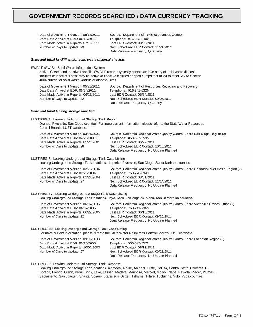
Date of Government Version: 06/15/2011Date Data Arrived at EDR: 06/16/2011Date Made Active in Reports: 07/15/2011Number of Days to Update: 29
Source: Department of Toxic Substances ControlTelephone: 916-323-3400Last EDR Contact: 08/09/2011Next Scheduled EDR Contact: 11/21/2011Data Release Frequency: Quarterly
State and tribal landfill and/or solid waste disposal site lists
SWF/LF (SWIS): Solid Waste Information SystemActive, Closed and Inactive Landfills. SWF/LF records typically contain an inve ntory of solid waste disposalfacilities or landfills. These may be active or i nactive facilities or open dumps that failed to meet RCRA Section4004 criteria for solid waste landfills or disposal sites.
Date of Government Version: 05/23/2011Date Data Arrived at EDR: 05/24/2011Date Made Active in Reports: 06/15/2011Number of Days to Update: 22
Source: Department of Resources Recycling and RecoveryTelephone: 916-341-6320Last EDR Contact: 05/24/2011Next Scheduled EDR Contact: 09/05/2011Data Release Frequency: Quarterly
State and tribal leaking storage tank lists
LUST REG 9: Leaking Underground Storage Tank ReportOrange, Riverside, San Diego counties. For more current information, please refer to the State Water ResourcesControl Board’s LUST database.
Date of Government Version: 03/01/2001Date Data Arrived at EDR: 04/23/2001Date Made Active in Reports: 05/21/2001Number of Days to Update: 28
Source: California Regional Water Quality Control Board San Diego Region (9)Telephone: 858-637-5595Last EDR Contact: 06/27/2011Next Scheduled EDR Contact: 10/10/2011Data Release Frequency: No Update Planned
LUST REG 7: Leaking Underground Storage Tank Case ListingLeaking Underground Storage Tank locations. Imperial, Riverside, San Diego, Santa Barbara counties.
Date of Government Version: 02/26/2004Date Data Arrived at EDR: 02/26/2004Date Made Active in Reports: 03/24/2004Number of Days to Update: 27
Source: California Regional Water Quality Control Board Colorado River Basin Region (7)Telephone: 760-776-8943Last EDR Contact: 08/01/2011Next Scheduled EDR Contact: 11/14/2011Data Release Frequency: No Update Planned
LUST REG 6V: Leaking Underground Storage Tank Case ListingLeaking Underground Storage Tank locations. Inyo, Kern, Los Angeles, Mono, San Bernardino counties.
Date of Government Version: 06/07/2005Date Data Arrived at EDR: 06/07/2005Date Made Active in Reports: 06/29/2005Number of Days to Update: 22
Source: California Regional Water Quality Control Board Victorville Branch Office (6)Telephone: 760-241-7365Last EDR Contact: 06/13/2011Next Scheduled EDR Contact: 09/26/2011Data Release Frequency: No Update Planned
LUST REG 6L: Leaking Underground Storage Tank Case ListingFor more current information, please refer to the State Water Resources Control Board’s LUST database.
Date of Government Version: 09/09/2003Date Data Arrived at EDR: 09/10/2003Date Made Active in Reports: 10/07/2003Number of Days to Update: 27
Source: California Regional Water Quality Control Board Lahontan Region (6)Telephone: 530-542-5572Last EDR Contact: 06/13/2011Next Scheduled EDR Contact: 09/26/2011Data Release Frequency: No Update Planned
LUST REG 5: Leaking Underground Storage Tank DatabaseLeaking Underground Storage Tank locations. Alameda, Alpine, Amador, Butte, Colusa, Contra Costa, Calveras, ElDorado, Fresno, Glenn, Kern, Kings, Lake, Lassen, Madera, Mariposa, Merced, Modoc, Napa, Nevada, Placer, Plumas,Sacramento, San Joaquin, Shasta, Solano, Stanislaus, Sutter, Tehama, Tulare, Tuolumne, Yolo, Yuba counties.
TC3144757.1s Page GR-5
GOVERNMENT RECORDS SEARCHED / DATA CURRENCY TRACKING
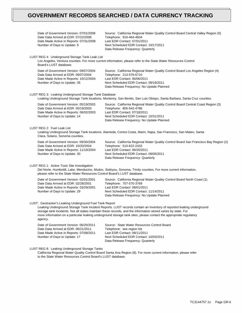
Date of Government Version: 07/01/2008Date Data Arrived at EDR: 07/22/2008Date Made Active in Reports: 07/31/2008Number of Days to Update: 9
Source: California Regional Water Quality Control Board Central Valley Region (5)Telephone: 916-464-4834Last EDR Contact: 07/01/2011Next Scheduled EDR Contact: 10/17/2011Data Release Frequency: Quarterly
LUST REG 4: Underground Storage Tank Leak ListLos Angeles, Ventura counties. For more current information, please refer to the State Water Resources ControlBoard’s LUST database.
Date of Government Version: 09/07/2004Date Data Arrived at EDR: 09/07/2004Date Made Active in Reports: 10/12/2004Number of Days to Update: 35
Source: California Regional Water Quality Control Board Los Angeles Region (4)Telephone: 213-576-6710Last EDR Contact: 06/06/2011Next Scheduled EDR Contact: 09/19/2011Data Release Frequency: No Update Planned
LUST REG 3: Leaking Underground Storage Tank DatabaseLeaking Underground Storage Tank locations. Monterey, San Benito, San Luis Obispo, Santa Barbara, Santa Cruz counties.
Date of Government Version: 05/19/2003Date Data Arrived at EDR: 05/19/2003Date Made Active in Reports: 06/02/2003Number of Days to Update: 14
Source: California Regional Water Quality Control Board Central Coast Region (3)Telephone: 805-542-4786Last EDR Contact: 07/18/2011Next Scheduled EDR Contact: 10/31/2011Data Release Frequency: No Update Planned
LUST REG 2: Fuel Leak ListLeaking Underground Storage Tank locations. Alameda, Contra Costa, Marin, Napa, San Francisco, San Mateo, SantaClara, Solano, Sonoma counties.
Date of Government Version: 09/30/2004Date Data Arrived at EDR: 10/20/2004Date Made Active in Reports: 11/19/2004Number of Days to Update: 30
Source: California Regional Water Quality Control Board San Francisco Bay Region (2)Telephone: 510-622-2433Last EDR Contact: 06/20/2011Next Scheduled EDR Contact: 09/05/2011Data Release Frequency: Quarterly
LUST REG 1: Active Toxic Site InvestigationDel Norte, Humboldt, Lake, Mendocino, Modoc, Siskiyou, Sonoma, Trinity counties. For more current information,please refer to the State Water Resources Control Board’s LUST database.
Date of Government Version: 02/01/2001Date Data Arrived at EDR: 02/28/2001Date Made Active in Reports: 03/29/2001Number of Days to Update: 29
Source: California Regional Water Quality Control Board North Coast (1)Telephone: 707-570-3769Last EDR Contact: 08/01/2011Next Scheduled EDR Contact: 11/14/2011Data Release Frequency: No Update Planned
LUST: Geotracker’s Leaking Underground Fuel Tank ReportLeaking Underground Storage Tank Incident Reports. LUST records contain an inventory of reported leaking undergroundstorage tank incidents. Not all states maintain these records, and the information stored varies by state. Formore information on a particular leaking underground storage tank sites, please contact the appropriate regulatoryagency.
Date of Government Version: 06/20/2011Date Data Arrived at EDR: 06/21/2011Date Made Active in Reports: 07/08/2011Number of Days to Update: 17
Source: State Water Resources Control BoardTelephone: see region listLast EDR Contact: 08/11/2011Next Scheduled EDR Contact: 10/03/2011Data Release Frequency: Quarterly
LUST REG 8: Leaking Underground Storage TanksCalifornia Regional Water Quality Control Board Santa Ana Region (8). For more current information, please referto the State Water Resources Control Board’s LUST database.
TC3144757.1s Page GR-6
GOVERNMENT RECORDS SEARCHED / DATA CURRENCY TRACKING

Date of Government Version: 02/14/2005Date Data Arrived at EDR: 02/15/2005Date Made Active in Reports: 03/28/2005Number of Days to Update: 41
Source: California Regional Water Quality Control Board Santa Ana Region (8)Telephone: 909-782-4496Last EDR Contact: 07/18/2011Next Scheduled EDR Contact: 10/31/2011Data Release Frequency: Varies
SLIC: Statewide SLIC CasesThe SLIC (Spills, Leaks, Investigations and Cleanup) program is designed to protect and restore water qualityfrom spills, leaks, and similar discharges.
Date of Government Version: 06/20/2011Date Data Arrived at EDR: 06/21/2011Date Made Active in Reports: 07/08/2011Number of Days to Update: 17
Source: State Water Resources Control BoardTelephone: 866-480-1028Last EDR Contact: 08/11/2011Next Scheduled EDR Contact: 10/03/2011Data Release Frequency: Varies
SLIC REG 1: Active Toxic Site InvestigationsThe SLIC (Spills, Leaks, Investigations and Cleanup) program is designed to protect and restore water qualityfrom spills, leaks, and similar discharges.
Date of Government Version: 04/03/2003Date Data Arrived at EDR: 04/07/2003Date Made Active in Reports: 04/25/2003Number of Days to Update: 18
Source: California Regional Water Quality Control Board, North Coast Region (1)Telephone: 707-576-2220Last EDR Contact: 08/01/2011Next Scheduled EDR Contact: 11/14/2011Data Release Frequency: No Update Planned
SLIC REG 2: Spills, Leaks, Investigation & Cleanup Cost Recovery ListingThe SLIC (Spills, Leaks, Investigations and Cleanup) program is designed to protect and restore water qualityfrom spills, leaks, and similar discharges.
Date of Government Version: 09/30/2004Date Data Arrived at EDR: 10/20/2004Date Made Active in Reports: 11/19/2004Number of Days to Update: 30
Source: Regional Water Quality Control Board San Francisco Bay Region (2)Telephone: 510-286-0457Last EDR Contact: 06/20/2011Next Scheduled EDR Contact: 09/05/2011Data Release Frequency: Quarterly
SLIC REG 3: Spills, Leaks, Investigation & Cleanup Cost Recovery ListingThe SLIC (Spills, Leaks, Investigations and Cleanup) program is designed to protect and restore water qualityfrom spills, leaks, and similar discharges.
Date of Government Version: 05/18/2006Date Data Arrived at EDR: 05/18/2006Date Made Active in Reports: 06/15/2006Number of Days to Update: 28
Source: California Regional Water Quality Control Board Central Coast Region (3)Telephone: 805-549-3147Last EDR Contact: 07/18/2011Next Scheduled EDR Contact: 10/31/2011Data Release Frequency: Semi-Annually
SLIC REG 4: Spills, Leaks, Investigation & Cleanup Cost Recovery ListingThe SLIC (Spills, Leaks, Investigations and Cleanup) program is designed to protect and restore water qualityfrom spills, leaks, and similar discharges.
Date of Government Version: 11/17/2004Date Data Arrived at EDR: 11/18/2004Date Made Active in Reports: 01/04/2005Number of Days to Update: 47
Source: Region Water Quality Control Board Los Angeles Region (4)Telephone: 213-576-6600Last EDR Contact: 07/01/2011Next Scheduled EDR Contact: 10/17/2011Data Release Frequency: Varies
SLIC REG 5: Spills, Leaks, Investigation & Cleanup Cost Recovery ListingThe SLIC (Spills, Leaks, Investigations and Cleanup) program is designed to protect and restore water qualityfrom spills, leaks, and similar discharges.
TC3144757.1s Page GR-7
GOVERNMENT RECORDS SEARCHED / DATA CURRENCY TRACKING

Date of Government Version: 04/01/2005Date Data Arrived at EDR: 04/05/2005Date Made Active in Reports: 04/21/2005Number of Days to Update: 16
Source: Regional Water Quality Control Board Central Valley Region (5)Telephone: 916-464-3291Last EDR Contact: 06/13/2011Next Scheduled EDR Contact: 09/26/2011Data Release Frequency: Semi-Annually
SLIC REG 6V: Spills, Leaks, Investigation & Cleanup Cost Recovery ListingThe SLIC (Spills, Leaks, Investigations and Cleanup) program is designed to protect and restore water qualityfrom spills, leaks, and similar discharges.
Date of Government Version: 05/24/2005Date Data Arrived at EDR: 05/25/2005Date Made Active in Reports: 06/16/2005Number of Days to Update: 22
Source: Regional Water Quality Control Board, Victorville BranchTelephone: 619-241-6583Last EDR Contact: 05/16/2011Next Scheduled EDR Contact: 08/29/2011Data Release Frequency: Semi-Annually
SLIC REG 6L: SLIC SitesThe SLIC (Spills, Leaks, Investigations and Cleanup) program is designed to protect and restore water qualityfrom spills, leaks, and similar discharges.
Date of Government Version: 09/07/2004Date Data Arrived at EDR: 09/07/2004Date Made Active in Reports: 10/12/2004Number of Days to Update: 35
Source: California Regional Water Quality Control Board, Lahontan RegionTelephone: 530-542-5574Last EDR Contact: 05/16/2011Next Scheduled EDR Contact: 08/29/2011Data Release Frequency: No Update Planned
SLIC REG 7: SLIC ListThe SLIC (Spills, Leaks, Investigations and Cleanup) program is designed to protect and restore water qualityfrom spills, leaks, and similar discharges.
Date of Government Version: 11/24/2004Date Data Arrived at EDR: 11/29/2004Date Made Active in Reports: 01/04/2005Number of Days to Update: 36
Source: California Regional Quality Control Board, Colorado River Basin RegionTelephone: 760-346-7491Last EDR Contact: 08/01/2011Next Scheduled EDR Contact: 11/14/2011Data Release Frequency: No Update Planned
SLIC REG 8: Spills, Leaks, Investigation & Cleanup Cost Recovery ListingThe SLIC (Spills, Leaks, Investigations and Cleanup) program is designed to protect and restore water qualityfrom spills, leaks, and similar discharges.
Date of Government Version: 04/03/2008Date Data Arrived at EDR: 04/03/2008Date Made Active in Reports: 04/14/2008Number of Days to Update: 11
Source: California Region Water Quality Control Board Santa Ana Region (8)Telephone: 951-782-3298Last EDR Contact: 06/13/2011Next Scheduled EDR Contact: 09/13/2011Data Release Frequency: Semi-Annually
SLIC REG 9: Spills, Leaks, Investigation & Cleanup Cost Recovery ListingThe SLIC (Spills, Leaks, Investigations and Cleanup) program is designed to protect and restore water qualityfrom spills, leaks, and similar discharges.
Date of Government Version: 09/10/2007Date Data Arrived at EDR: 09/11/2007Date Made Active in Reports: 09/28/2007Number of Days to Update: 17
Source: California Regional Water Quality Control Board San Diego Region (9)Telephone: 858-467-2980Last EDR Contact: 08/08/2011Next Scheduled EDR Contact: 11/21/2011Data Release Frequency: Annually
INDIAN LUST R10: Leaking Underground Storage Tanks on Indian LandLUSTs on Indian land in Alaska, Idaho, Oregon and Washington.
TC3144757.1s Page GR-8
GOVERNMENT RECORDS SEARCHED / DATA CURRENCY TRACKING

Date of Government Version: 05/17/2011Date Data Arrived at EDR: 05/19/2011Date Made Active in Reports: 06/14/2011Number of Days to Update: 26
Source: EPA Region 10Telephone: 206-553-2857Last EDR Contact: 08/01/2011Next Scheduled EDR Contact: 11/14/2011Data Release Frequency: Quarterly
INDIAN LUST R1: Leaking Underground Storage Tanks on Indian LandA listing of leaking underground storage tank locations on Indian Land.
Date of Government Version: 03/07/2011Date Data Arrived at EDR: 05/20/2011Date Made Active in Reports: 06/14/2011Number of Days to Update: 25
Source: EPA Region 1Telephone: 617-918-1313Last EDR Contact: 08/02/2011Next Scheduled EDR Contact: 11/14/2011Data Release Frequency: Varies
INDIAN LUST R8: Leaking Underground Storage Tanks on Indian LandLUSTs on Indian land in Colorado, Montana, North Dakota, South Dakota, Utah and Wyoming.
Date of Government Version: 05/16/2011Date Data Arrived at EDR: 05/17/2011Date Made Active in Reports: 06/14/2011Number of Days to Update: 28
Source: EPA Region 8Telephone: 303-312-6271Last EDR Contact: 08/01/2011Next Scheduled EDR Contact: 11/14/2011Data Release Frequency: Quarterly
INDIAN LUST R6: Leaking Underground Storage Tanks on Indian LandLUSTs on Indian land in New Mexico and Oklahoma.
Date of Government Version: 05/10/2011Date Data Arrived at EDR: 05/11/2011Date Made Active in Reports: 06/14/2011Number of Days to Update: 34
Source: EPA Region 6Telephone: 214-665-6597Last EDR Contact: 08/01/2011Next Scheduled EDR Contact: 11/14/2011Data Release Frequency: Varies
INDIAN LUST R4: Leaking Underground Storage Tanks on Indian LandLUSTs on Indian land in Florida, Mississippi and North Carolina.
Date of Government Version: 03/03/2011Date Data Arrived at EDR: 03/18/2011Date Made Active in Reports: 05/02/2011Number of Days to Update: 45
Source: EPA Region 4Telephone: 404-562-8677Last EDR Contact: 08/01/2011Next Scheduled EDR Contact: 11/14/2011Data Release Frequency: Semi-Annually
INDIAN LUST R9: Leaking Underground Storage Tanks on Indian LandLUSTs on Indian land in Arizona, California, New Mexico and Nevada
Date of Government Version: 01/31/2011Date Data Arrived at EDR: 02/01/2011Date Made Active in Reports: 03/21/2011Number of Days to Update: 48
Source: Environmental Protection AgencyTelephone: 415-972-3372Last EDR Contact: 08/01/2011Next Scheduled EDR Contact: 11/14/2011Data Release Frequency: Quarterly
INDIAN LUST R7: Leaking Underground Storage Tanks on Indian LandLUSTs on Indian land in Iowa, Kansas, and Nebraska
Date of Government Version: 11/04/2009Date Data Arrived at EDR: 05/04/2010Date Made Active in Reports: 07/07/2010Number of Days to Update: 64
Source: EPA Region 7Telephone: 913-551-7003Last EDR Contact: 08/02/2011Next Scheduled EDR Contact: 11/14/2011Data Release Frequency: Varies
State and tribal registered storage tank lists
TC3144757.1s Page GR-9
GOVERNMENT RECORDS SEARCHED / DATA CURRENCY TRACKING

UST: Active UST FacilitiesActive UST facilities gathered from the local regulatory agencies
Date of Government Version: 06/20/2011Date Data Arrived at EDR: 06/21/2011Date Made Active in Reports: 07/08/2011Number of Days to Update: 17
Source: SWRCBTelephone: 916-480-1028Last EDR Contact: 08/11/2011Next Scheduled EDR Contact: 10/03/2011Data Release Frequency: Semi-Annually
AST: Aboveground Petroleum Storage Tank FacilitiesRegistered Aboveground Storage Tanks.
Date of Government Version: 08/01/2009Date Data Arrived at EDR: 09/10/2009Date Made Active in Reports: 10/01/2009Number of Days to Update: 21
Source: State Water Resources Control BoardTelephone: 916-341-5712Last EDR Contact: 07/08/2011Next Scheduled EDR Contact: 10/24/2011Data Release Frequency: Quarterly
INDIAN UST R10: Underground Storage Tanks on Indian LandThe Indian Underground Storage Tank (UST) database provides information about underground storage tanks on Indianland in EPA Region 10 (Alaska, Idaho, Oregon, Washington, and Tribal Nations).
Date of Government Version: 05/17/2011Date Data Arrived at EDR: 05/19/2011Date Made Active in Reports: 06/14/2011Number of Days to Update: 26
Source: EPA Region 10Telephone: 206-553-2857Last EDR Contact: 08/01/2011Next Scheduled EDR Contact: 11/14/2011Data Release Frequency: Quarterly
INDIAN UST R9: Underground Storage Tanks on Indian LandThe Indian Underground Storage Tank (UST) database provides information about underground storage tanks on Indianland in EPA Region 9 (Arizona, California, Hawaii, Nevada, the Pacific Islands, and Tribal Nations).
Date of Government Version: 05/18/2011Date Data Arrived at EDR: 05/26/2011Date Made Active in Reports: 06/14/2011Number of Days to Update: 19
Source: EPA Region 9Telephone: 415-972-3368Last EDR Contact: 08/01/2011Next Scheduled EDR Contact: 11/14/2011Data Release Frequency: Quarterly
INDIAN UST R8: Underground Storage Tanks on Indian LandThe Indian Underground Storage Tank (UST) database provides information about underground storage tanks on Indianland in EPA Region 8 (Colorado, Montana, North Dakota, South Dakota, Utah, Wyoming and 27 Tribal Nations).
Date of Government Version: 05/16/2011Date Data Arrived at EDR: 05/17/2011Date Made Active in Reports: 06/14/2011Number of Days to Update: 28
Source: EPA Region 8Telephone: 303-312-6137Last EDR Contact: 08/01/2011Next Scheduled EDR Contact: 11/14/2011Data Release Frequency: Quarterly
INDIAN UST R7: Underground Storage Tanks on Indian LandThe Indian Underground Storage Tank (UST) database provides information about underground storage tanks on Indianland in EPA Region 7 (Iowa, Kansas, Missouri, Nebraska, and 9 Tribal Nations).
Date of Government Version: 04/01/2011Date Data Arrived at EDR: 06/01/2011Date Made Active in Reports: 06/14/2011Number of Days to Update: 13
Source: EPA Region 7Telephone: 913-551-7003Last EDR Contact: 08/02/2011Next Scheduled EDR Contact: 11/14/2011Data Release Frequency: Varies
INDIAN UST R6: Underground Storage Tanks on Indian LandThe Indian Underground Storage Tank (UST) database provides information about underground storage tanks on Indianland in EPA Region 6 (Louisiana, Arkansas, Oklahoma, New Mexico, Texas and 65 Tribes).
TC3144757.1s Page GR-10
GOVERNMENT RECORDS SEARCHED / DATA CURRENCY TRACKING

Date of Government Version: 05/10/2011Date Data Arrived at EDR: 05/11/2011Date Made Active in Reports: 06/14/2011Number of Days to Update: 34
Source: EPA Region 6Telephone: 214-665-7591Last EDR Contact: 08/01/2011Next Scheduled EDR Contact: 11/14/2011Data Release Frequency: Semi-Annually
INDIAN UST R5: Underground Storage Tanks on Indian LandThe Indian Underground Storage Tank (UST) database provides information about underground storage tanks on Indianland in EPA Region 5 (Michigan, Minnesota and Wisconsin and Tribal Nations).
Date of Government Version: 01/01/2011Date Data Arrived at EDR: 02/23/2011Date Made Active in Reports: 05/02/2011Number of Days to Update: 68
Source: EPA Region 5Telephone: 312-886-6136Last EDR Contact: 08/01/2011Next Scheduled EDR Contact: 11/14/2011Data Release Frequency: Varies
INDIAN UST R4: Underground Storage Tanks on Indian LandThe Indian Underground Storage Tank (UST) database provides information about underground storage tanks on Indianland in EPA Region 4 (Alabama, Florida, Georgia, Kentucky, Mississippi, North Carolina, South Carolina, Tennesseeand Tribal Nations)
Date of Government Version: 03/03/2011Date Data Arrived at EDR: 03/18/2011Date Made Active in Reports: 05/02/2011Number of Days to Update: 45
Source: EPA Region 4Telephone: 404-562-9424Last EDR Contact: 08/01/2011Next Scheduled EDR Contact: 11/14/2011Data Release Frequency: Semi-Annually
INDIAN UST R1: Underground Storage Tanks on Indian LandThe Indian Underground Storage Tank (UST) database provides information about underground storage tanks on Indianland in EPA Region 1 (Connecticut, Maine, Massachusetts, New Hampshire, Rhode Island, Vermont and ten TribalNations).
Date of Government Version: 03/07/2011Date Data Arrived at EDR: 05/04/2011Date Made Active in Reports: 06/14/2011Number of Days to Update: 41
Source: EPA, Region 1Telephone: 617-918-1313Last EDR Contact: 08/02/2011Next Scheduled EDR Contact: 11/14/2011Data Release Frequency: Varies
FEMA UST: Underground Storage Tank ListingA listing of all FEMA owned underground storage tanks.
Date of Government Version: 01/01/2010Date Data Arrived at EDR: 02/16/2010Date Made Active in Reports: 04/12/2010Number of Days to Update: 55
Source: FEMATelephone: 202-646-5797Last EDR Contact: 07/18/2011Next Scheduled EDR Contact: 10/31/2011Data Release Frequency: Varies
State and tribal voluntary cleanup sites
INDIAN VCP R7: Voluntary Cleanup Priority LisitngA listing of voluntary cleanup priority sites located on Indian Land located in Region 7.
Date of Government Version: 03/20/2008Date Data Arrived at EDR: 04/22/2008Date Made Active in Reports: 05/19/2008Number of Days to Update: 27
Source: EPA, Region 7Telephone: 913-551-7365Last EDR Contact: 04/20/2009Next Scheduled EDR Contact: 07/20/2009Data Release Frequency: Varies
VCP: Voluntary Cleanup Program PropertiesContains low threat level properties with either confirmed or unconfirmed releases and the project proponentshave request that DTSC oversee investigation and/or cleanup activities and have agreed to provide coverage forDTSC’s costs.
TC3144757.1s Page GR-11
GOVERNMENT RECORDS SEARCHED / DATA CURRENCY TRACKING

Date of Government Version: 06/15/2011Date Data Arrived at EDR: 06/16/2011Date Made Active in Reports: 07/15/2011Number of Days to Update: 29
Source: Department of Toxic Substances ControlTelephone: 916-323-3400Last EDR Contact: 08/09/2011Next Scheduled EDR Contact: 11/21/2011Data Release Frequency: Quarterly
INDIAN VCP R1: Voluntary Cleanup Priority ListingA listing of voluntary cleanup priority sites located on Indian Land located in Region 1.
Date of Government Version: 02/25/2011Date Data Arrived at EDR: 04/05/2011Date Made Active in Reports: 06/14/2011Number of Days to Update: 70
Source: EPA, Region 1Telephone: 617-918-1102Last EDR Contact: 07/05/2011Next Scheduled EDR Contact: 10/17/2011Data Release Frequency: Varies
ADDITIONAL ENVIRONMENTAL RECORDS
Local Brownfield lists
US BROWNFIELDS: A Listing of Brownfields SitesIncluded in the listing are brownfields properties addresses by Cooperative Agreement Recipients and brownfieldsproperties addressed by Targeted Brownfields Assessments. Targeted Brownfields Assessments-EPA’s Targeted BrownfieldsAssessments (TBA) program is designed to help states, tribes, and municipalities--especially those without EPABrownfields Assessment Demonstration Pilots--minimize the uncertainties of contamination often associated withbrownfields. Under the TBA program, EPA provides funding and/or technical assistance for environmental assessmentsat brownfields sites throughout the country. Targeted Brownfields Assessments supplement and work with other effortsunder EPA’s Brownfields Initiative to promote cleanup and redevelopment of brownfields. Cooperative AgreementRecipients-States, political subdivisions, territories, and Indian tribes become Brownfields Cleanup RevolvingLoan Fund (BCRLF) cooperative agreement recipients when they enter into BCRLF cooperative agreements with theU.S. EPA. EPA selects BCRLF cooperative agreement recipients based on a proposal and application process. BCRLFcooperative agreement recipients must use EPA funds provided through BCRLF cooperative agreement for specifiedbrownfields-related cleanup activities.
Date of Government Version: 03/29/2011Date Data Arrived at EDR: 03/29/2011Date Made Active in Reports: 06/14/2011Number of Days to Update: 77
Source: Environmental Protection AgencyTelephone: 202-566-2777Last EDR Contact: 06/27/2011Next Scheduled EDR Contact: 10/10/2011Data Release Frequency: Semi-Annually
Local Lists of Landfill / Solid Waste Disposal Sites
ODI: Open Dump InventoryAn open dump is defined as a disposal facility that does not comply with one or more of the Part 257 or Part 258Subtitle D Criteria.
Date of Government Version: 06/30/1985Date Data Arrived at EDR: 08/09/2004Date Made Active in Reports: 09/17/2004Number of Days to Update: 39
Source: Environmental Protection AgencyTelephone: 800-424-9346Last EDR Contact: 06/09/2004Next Scheduled EDR Contact: N/AData Release Frequency: No Update Planned
DEBRIS REGION 9: Torres Martinez Reservation Illegal Dump Site LocationsA listing of illegal dump sites location on the Torres Martinez Indian Reservation located in eastern RiversideCounty and northern Imperial County, California.
Date of Government Version: 01/12/2009Date Data Arrived at EDR: 05/07/2009Date Made Active in Reports: 09/21/2009Number of Days to Update: 137
Source: EPA, Region 9Telephone: 415-947-4219Last EDR Contact: 06/27/2011Next Scheduled EDR Contact: 10/10/2011Data Release Frequency: No Update Planned
TC3144757.1s Page GR-12
GOVERNMENT RECORDS SEARCHED / DATA CURRENCY TRACKING

WMUDS/SWAT: Waste Management Unit DatabaseWaste Management Unit Database System. WMUDS is used by the State Water Resources Control Board staff and theRegional Water Quality Control Boards for program tracking and inventory of waste management units. WMUDS is composedof the following databases: Facility Information, Scheduled Inspections Information, Waste Management Unit Information,SWAT Program Information, SWAT Report Summary Information, SWAT Report Summary Data, Chapter 15 (formerly Subchapter15) Information, Chapter 15 Monitoring Parameters, TPCA Program Information, RCRA Program Information, ClosureInformation, and Interested Parties Information.
Date of Government Version: 04/01/2000Date Data Arrived at EDR: 04/10/2000Date Made Active in Reports: 05/10/2000Number of Days to Update: 30
Source: State Water Resources Control BoardTelephone: 916-227-4448Last EDR Contact: 05/16/2011Next Scheduled EDR Contact: 08/29/2011Data Release Frequency: No Update Planned
SWRCY: Recycler DatabaseA listing of recycling facilities in California.
Date of Government Version: 06/01/2011Date Data Arrived at EDR: 06/21/2011Date Made Active in Reports: 07/15/2011Number of Days to Update: 24
Source: Department of ConservationTelephone: 916-323-3836Last EDR Contact: 06/21/2011Next Scheduled EDR Contact: 10/03/2011Data Release Frequency: Quarterly
HAULERS: Registered Waste Tire Haulers ListingA listing of registered waste tire haulers.
Date of Government Version: 05/24/2011Date Data Arrived at EDR: 05/24/2011Date Made Active in Reports: 06/15/2011Number of Days to Update: 22
Source: Integrated Waste Management BoardTelephone: 916-341-6422Last EDR Contact: 05/24/2011Next Scheduled EDR Contact: 09/05/2011Data Release Frequency: Varies
INDIAN ODI: Report on the Status of Open Dumps on Indian LandsLocation of open dumps on Indian land.
Date of Government Version: 12/31/1998Date Data Arrived at EDR: 12/03/2007Date Made Active in Reports: 01/24/2008Number of Days to Update: 52
Source: Environmental Protection AgencyTelephone: 703-308-8245Last EDR Contact: 08/08/2011Next Scheduled EDR Contact: 11/21/2011Data Release Frequency: Varies
Local Lists of Hazardous waste / Contaminated Sites
US CDL: Clandestine Drug LabsA listing of clandestine drug lab locations. The U.S. Department of Justice ("the Department") provides thisweb site as a public service. It contains addresses of some locations where law enforcement agencies reportedthey found chemicals or other items that indicated the presence of either clandestine drug laboratories or dumpsites.In most cases, the source of the entries is not the Department, and the Department has not verified the entryand does not guarantee its accuracy. Members of the public must verify the accuracy of all entries by, for example,contacting local law enforcement and local health departments.
Date of Government Version: 02/02/2011Date Data Arrived at EDR: 03/17/2011Date Made Active in Reports: 05/02/2011Number of Days to Update: 46
Source: Drug Enforcement AdministrationTelephone: 202-307-1000Last EDR Contact: 06/07/2011Next Scheduled EDR Contact: 09/19/2011Data Release Frequency: Quarterly
HIST CAL-SITES: Calsites DatabaseThe Calsites database contains potential or confirmed hazardous substance release properties. In 1996, CaliforniaEPA reevaluated and significantly reduced the number of sites in the Calsites database. No longer updated by thestate agency. It has been replaced by ENVIROSTOR.
TC3144757.1s Page GR-13
GOVERNMENT RECORDS SEARCHED / DATA CURRENCY TRACKING

Date of Government Version: 08/08/2005Date Data Arrived at EDR: 08/03/2006Date Made Active in Reports: 08/24/2006Number of Days to Update: 21
Source: Department of Toxic Substance ControlTelephone: 916-323-3400Last EDR Contact: 02/23/2009Next Scheduled EDR Contact: 05/25/2009Data Release Frequency: No Update Planned
SCH: School Property Evaluation ProgramThis category contains proposed and existing school sites that are being evaluated by DTSC for possible hazardousmaterials contamination. In some cases, these properties may be listed in the CalSites category depending on thelevel of threat to public health and safety or the environment they pose.
Date of Government Version: 06/15/2011Date Data Arrived at EDR: 06/16/2011Date Made Active in Reports: 07/15/2011Number of Days to Update: 29
Source: Department of Toxic Substances ControlTelephone: 916-323-3400Last EDR Contact: 08/09/2011Next Scheduled EDR Contact: 11/21/2011Data Release Frequency: Quarterly
TOXIC PITS: Toxic Pits Cleanup Act SitesToxic PITS Cleanup Act Sites. TOXIC PITS identifies sites suspected of containing hazardous substances where cleanuphas not yet been completed.
Date of Government Version: 07/01/1995Date Data Arrived at EDR: 08/30/1995Date Made Active in Reports: 09/26/1995Number of Days to Update: 27
Source: State Water Resources Control BoardTelephone: 916-227-4364Last EDR Contact: 01/26/2009Next Scheduled EDR Contact: 04/27/2009Data Release Frequency: No Update Planned
CDL: Clandestine Drug LabsA listing of drug lab locations. Listing of a location in this database does not indicate that any illegal druglab materials were or were not present there, and does not constitute a determination that the location eitherrequires or does not require additional cleanup work.
Date of Government Version: 12/31/2010Date Data Arrived at EDR: 03/04/2011Date Made Active in Reports: 03/24/2011Number of Days to Update: 20
Source: Department of Toxic Substances ControlTelephone: 916-255-6504Last EDR Contact: 08/08/2011Next Scheduled EDR Contact: 10/17/2011Data Release Frequency: Varies
US HIST CDL: National Clandestine Laboratory RegisterA listing of clandestine drug lab locations. The U.S. Department of Justice ("the Department") provides thisweb site as a public service. It contains addresses of some locations where law enforcement agencies reportedthey found chemicals or other items that indicated the presence of either clandestine drug laboratories or dumpsites.In most cases, the source of the entries is not the Department, and the Department has not verified the entryand does not guarantee its accuracy. Members of the public must verify the accuracy of all entries by, for example,contacting local law enforcement and local health departments.
Date of Government Version: 09/01/2007Date Data Arrived at EDR: 11/19/2008Date Made Active in Reports: 03/30/2009Number of Days to Update: 131
Source: Drug Enforcement AdministrationTelephone: 202-307-1000Last EDR Contact: 03/23/2009Next Scheduled EDR Contact: 06/22/2009Data Release Frequency: No Update Planned
Local Lists of Registered Storage Tanks
CA FID UST: Facility Inventory DatabaseThe Facility Inventory Database (FID) contains a historical listing of active and inactive underground storagetank locations from the State Water Resource Control Board. Refer to local/county source for current data.
Date of Government Version: 10/31/1994Date Data Arrived at EDR: 09/05/1995Date Made Active in Reports: 09/29/1995Number of Days to Update: 24
Source: California Environmental Protection AgencyTelephone: 916-341-5851Last EDR Contact: 12/28/1998Next Scheduled EDR Contact: N/AData Release Frequency: No Update Planned
TC3144757.1s Page GR-14
GOVERNMENT RECORDS SEARCHED / DATA CURRENCY TRACKING

UST MENDOCINO: Mendocino County UST DatabaseA listing of underground storage tank locations in Mendocino County.
Date of Government Version: 09/23/2009Date Data Arrived at EDR: 09/23/2009Date Made Active in Reports: 10/01/2009Number of Days to Update: 8
Source: Department of Public HealthTelephone: 707-463-4466Last EDR Contact: 06/06/2011Next Scheduled EDR Contact: 09/19/2011Data Release Frequency: Annually
HIST UST: Hazardous Substance Storage Container DatabaseThe Hazardous Substance Storage Container Database is a historical listing of UST sites. Refer to local/countysource for current data.
Date of Government Version: 10/15/1990Date Data Arrived at EDR: 01/25/1991Date Made Active in Reports: 02/12/1991Number of Days to Update: 18
Source: State Water Resources Control BoardTelephone: 916-341-5851Last EDR Contact: 07/26/2001Next Scheduled EDR Contact: N/AData Release Frequency: No Update Planned
SWEEPS UST: SWEEPS UST ListingStatewide Environmental Evaluation and Planning System. This underground storage tank listing was updated andmaintained by a company contacted by the SWRCB in the early 1990’s. The listing is no longer updated or maintained.The local agency is the contact for more information on a site on the SWEEPS list.
Date of Government Version: 06/01/1994Date Data Arrived at EDR: 07/07/2005Date Made Active in Reports: 08/11/2005Number of Days to Update: 35
Source: State Water Resources Control BoardTelephone: N/ALast EDR Contact: 06/03/2005Next Scheduled EDR Contact: N/AData Release Frequency: No Update Planned
Local Land Records
LIENS 2: CERCLA Lien InformationA Federal CERCLA (’Superfund’) lien can exist by operation of law at any site or property at which EPA has spentSuperfund monies. These monies are spent to investigate and address releases and threatened releases of contamination.CERCLIS provides information as to the identity of these sites and properties.
Date of Government Version: 02/01/2011Date Data Arrived at EDR: 02/04/2011Date Made Active in Reports: 05/02/2011Number of Days to Update: 87
Source: Environmental Protection AgencyTelephone: 202-564-6023Last EDR Contact: 08/01/2011Next Scheduled EDR Contact: 11/14/2011Data Release Frequency: Varies
LUCIS: Land Use Control Information SystemLUCIS contains records of land use control information pertaining to the former Navy Base Realignment and Closureproperties.
Date of Government Version: 12/09/2005Date Data Arrived at EDR: 12/11/2006Date Made Active in Reports: 01/11/2007Number of Days to Update: 31
Source: Department of the NavyTelephone: 843-820-7326Last EDR Contact: 07/11/2011Next Scheduled EDR Contact: 09/05/2011Data Release Frequency: Varies
LIENS: Environmental Liens ListingA listing of property locations with environmental liens for California where DTSC is a lien holder.
Date of Government Version: 06/28/2011Date Data Arrived at EDR: 06/29/2011Date Made Active in Reports: 07/08/2011Number of Days to Update: 9
Source: Department of Toxic Substances ControlTelephone: 916-323-3400Last EDR Contact: 06/27/2011Next Scheduled EDR Contact: 09/26/2011Data Release Frequency: Varies
TC3144757.1s Page GR-15
GOVERNMENT RECORDS SEARCHED / DATA CURRENCY TRACKING

DEED: Deed Restriction ListingSite Mitigation and Brownfields Reuse Program Facility Sites with Deed Restrictions & Hazardous Waste ManagementProgram Facility Sites with Deed / Land Use Restriction. The DTSC Site Mitigation and Brownfields Reuse Program(SMBRP) list includes sites cleaned up under the program’s oversight and generally does not include currentor former hazardous waste facilities that required a hazardous waste facility permit. The list represents deedrestrictions that are active. Some sites have multiple deed restrictions. The DTSC Hazardous Waste ManagementProgram (HWMP) has developed a list of current or former hazardous waste facilities that have a recorded landuse restriction at the local county recorder’s office. The land use restrictions on this list were required bythe DTSC HWMP as a result of the presence of hazardous substances that remain on site after the facility (orpart of the facility) has been closed or cleaned up. The types of land use restriction include deed notice, deedrestriction, or a land use restriction that binds current and future owners.
Date of Government Version: 06/13/2011Date Data Arrived at EDR: 06/14/2011Date Made Active in Reports: 07/15/2011Number of Days to Update: 31
Source: Department of Toxic Substances ControlTelephone: 916-323-3400Last EDR Contact: 06/14/2011Next Scheduled EDR Contact: 09/26/2011Data Release Frequency: Semi-Annually
Records of Emergency Release Reports
HMIRS: Hazardous Materials Information Reporting SystemHazardous Materials Incident Report System. HMIRS contains hazardous material spill incidents reported to DOT.
Date of Government Version: 12/31/2010Date Data Arrived at EDR: 01/05/2011Date Made Active in Reports: 02/25/2011Number of Days to Update: 51
Source: U.S. Department of TransportationTelephone: 202-366-4555Last EDR Contact: 07/05/2011Next Scheduled EDR Contact: 10/17/2011Data Release Frequency: Annually
CHMIRS: California Hazardous Material Incident Report SystemCalifornia Hazardous Material Incident Reporting System. CHMIRS contains information on reported hazardous materialincidents (accidental releases or spills).
Date of Government Version: 12/31/2010Date Data Arrived at EDR: 05/03/2011Date Made Active in Reports: 06/15/2011Number of Days to Update: 43
Source: Office of Emergency ServicesTelephone: 916-845-8400Last EDR Contact: 08/01/2011Next Scheduled EDR Contact: 11/14/2011Data Release Frequency: Varies
LDS: Land Disposal Sites ListingThe Land Disposal program regulates of waste discharge to land for treatment, storage and disposal in waste managementunits.
Date of Government Version: 06/20/2011Date Data Arrived at EDR: 06/21/2011Date Made Active in Reports: 07/08/2011Number of Days to Update: 17
Source: State Water Qualilty Control BoardTelephone: 866-480-1028Last EDR Contact: 08/11/2011Next Scheduled EDR Contact: 10/03/2011Data Release Frequency: Quarterly
MCS: Military Cleanup Sites ListingThe State Water Resources Control Board and nine Regional Water Quality Control Boards partner with the Departmentof Defense (DoD) through the Defense and State Memorandum of Agreement (DSMOA) to oversee the investigationand remediation of water quality issues at military facilities.
Date of Government Version: 06/20/2011Date Data Arrived at EDR: 06/21/2011Date Made Active in Reports: 07/08/2011Number of Days to Update: 17
Source: State Water Resources Control BoardTelephone: 866-480-1028Last EDR Contact: 08/11/2011Next Scheduled EDR Contact: 10/03/2011Data Release Frequency: Quarterly
Other Ascertainable Records
TC3144757.1s Page GR-16
GOVERNMENT RECORDS SEARCHED / DATA CURRENCY TRACKING

RCRA-NonGen: RCRA - Non GeneratorsRCRAInfo is EPA’s comprehensive information system, providing access to data supporting the Resource Conservationand Recovery Act (RCRA) of 1976 and the Hazardous and Solid Waste Amendments (HSWA) of 1984. The databaseincludes selective information on sites which generate, transport, store, treat and/or dispose of hazardous wasteas defined by the Resource Conservation and Recovery Act (RCRA). Non-Generators do not presently generate hazardouswaste.
Date of Government Version: 06/15/2011Date Data Arrived at EDR: 07/07/2011Date Made Active in Reports: 08/08/2011Number of Days to Update: 32
Source: Environmental Protection AgencyTelephone: (415) 495-8895Last EDR Contact: 07/07/2011Next Scheduled EDR Contact: 10/17/2011Data Release Frequency: Varies
DOT OPS: Incident and Accident DataDepartment of Transporation, Office of Pipeline Safety Incident and Accident data.
Date of Government Version: 01/12/2011Date Data Arrived at EDR: 02/11/2011Date Made Active in Reports: 05/02/2011Number of Days to Update: 80
Source: Department of Transporation, Office of Pipeline SafetyTelephone: 202-366-4595Last EDR Contact: 08/09/2011Next Scheduled EDR Contact: 11/21/2011Data Release Frequency: Varies
DOD: Department of Defense SitesThis data set consists of federally owned or administered lands, administered by the Department of Defense, thathave any area equal to or greater than 640 acres of the United States, Puerto Rico, and the U.S. Virgin Islands.
Date of Government Version: 12/31/2005Date Data Arrived at EDR: 11/10/2006Date Made Active in Reports: 01/11/2007Number of Days to Update: 62
Source: USGSTelephone: 888-275-8747Last EDR Contact: 07/22/2011Next Scheduled EDR Contact: 10/31/2011Data Release Frequency: Semi-Annually
FUDS: Formerly Used Defense SitesThe listing includes locations of Formerly Used Defense Sites properties where the US Army Corps of Engineersis actively working or will take necessary cleanup actions.
Date of Government Version: 12/31/2009Date Data Arrived at EDR: 08/12/2010Date Made Active in Reports: 12/02/2010Number of Days to Update: 112
Source: U.S. Army Corps of EngineersTelephone: 202-528-4285Last EDR Contact: 06/14/2011Next Scheduled EDR Contact: 09/26/2011Data Release Frequency: Varies
CONSENT: Superfund (CERCLA) Consent DecreesMajor legal settlements that establish responsibility and standards for cleanup at NPL (Superfund) sites. Releasedperiodically by United States District Courts after settlement by parties to litigation matters.
Date of Government Version: 12/31/2010Date Data Arrived at EDR: 04/05/2011Date Made Active in Reports: 06/14/2011Number of Days to Update: 70
Source: Department of Justice, Consent Decree LibraryTelephone: VariesLast EDR Contact: 07/01/2011Next Scheduled EDR Contact: 10/17/2011Data Release Frequency: Varies
ROD: Records Of DecisionRecord of Decision. ROD documents mandate a permanent remedy at an NPL (Superfund) site containing technicaland health information to aid in the cleanup.
Date of Government Version: 02/25/2011Date Data Arrived at EDR: 03/16/2011Date Made Active in Reports: 03/21/2011Number of Days to Update: 5
Source: EPATelephone: 703-416-0223Last EDR Contact: 06/15/2011Next Scheduled EDR Contact: 09/26/2011Data Release Frequency: Annually
TC3144757.1s Page GR-17
GOVERNMENT RECORDS SEARCHED / DATA CURRENCY TRACKING
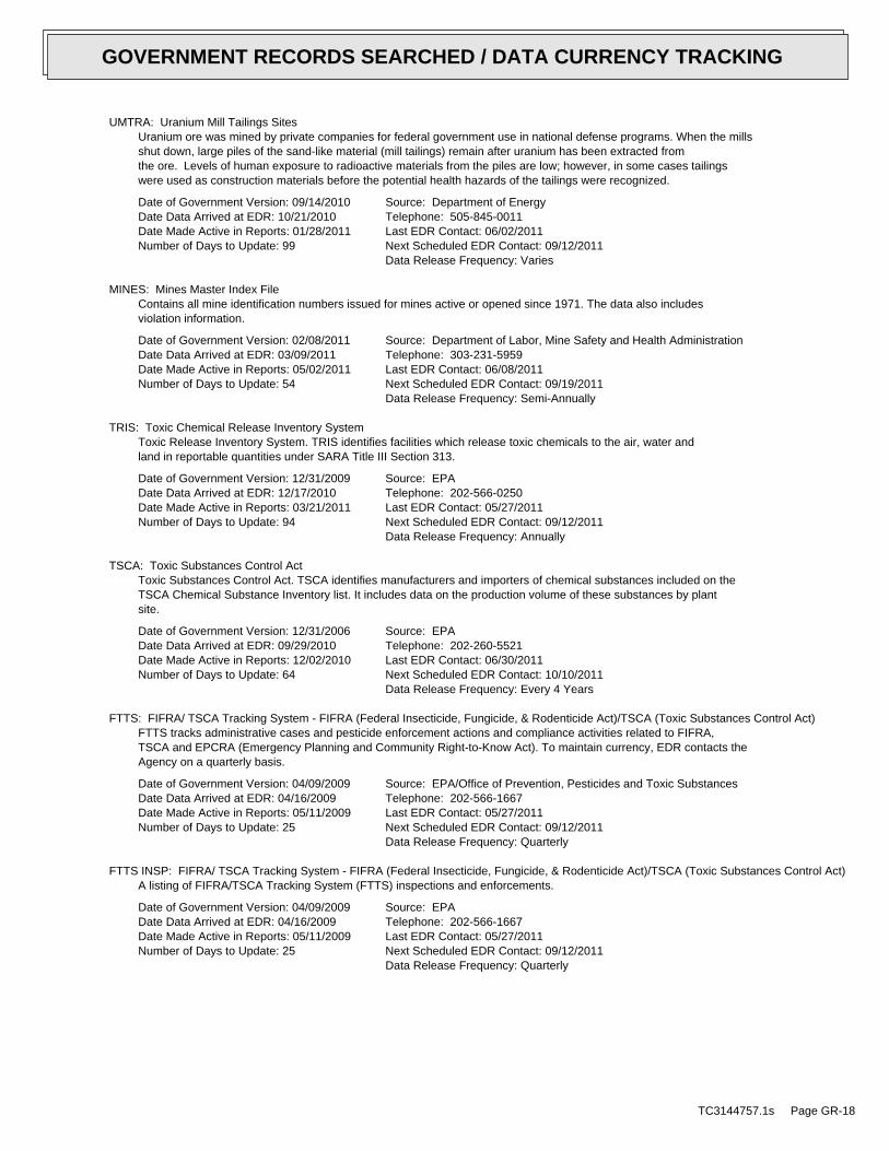
UMTRA: Uranium Mill Tailings SitesUranium ore was mined by private companies for federal government use in national defense programs. When the millsshut down, large piles of the sand-like material (mill tailings) remain after uranium has been extracted fromthe ore. Levels of human exposure to radioactive materials from the piles are low; however, in some cases tailingswere used as construction materials before the potential health hazards of the tailings were recognized.
Date of Government Version: 09/14/2010Date Data Arrived at EDR: 10/21/2010Date Made Active in Reports: 01/28/2011Number of Days to Update: 99
Source: Department of EnergyTelephone: 505-845-0011Last EDR Contact: 06/02/2011Next Scheduled EDR Contact: 09/12/2011Data Release Frequency: Varies
MINES: Mines Master Index FileContains all mine identification numbers issued for mines active or opened since 1971. The data also includesviolation information.
Date of Government Version: 02/08/2011Date Data Arrived at EDR: 03/09/2011Date Made Active in Reports: 05/02/2011Number of Days to Update: 54
Source: Department of Labor, Mine Safety and Health AdministrationTelephone: 303-231-5959Last EDR Contact: 06/08/2011Next Scheduled EDR Contact: 09/19/2011Data Release Frequency: Semi-Annually
TRIS: Toxic Chemical Release Inventory SystemToxic Release Inventory System. TRIS identifies facilities which release toxic chemicals to the air, water andland in reportable quantities under SARA Title III Section 313.
Date of Government Version: 12/31/2009Date Data Arrived at EDR: 12/17/2010Date Made Active in Reports: 03/21/2011Number of Days to Update: 94
Source: EPATelephone: 202-566-0250Last EDR Contact: 05/27/2011Next Scheduled EDR Contact: 09/12/2011Data Release Frequency: Annually
TSCA: Toxic Substances Control ActToxic Substances Control Act. TSCA identifies manufacturers and importers of chemical substances included on theTSCA Chemical Substance Inventory list. It includes data on the production volume of these substances by plantsite.
Date of Government Version: 12/31/2006Date Data Arrived at EDR: 09/29/2010Date Made Active in Reports: 12/02/2010Number of Days to Update: 64
Source: EPATelephone: 202-260-5521Last EDR Contact: 06/30/2011Next Scheduled EDR Contact: 10/10/2011Data Release Frequency: Every 4 Years
FTTS: FIFRA/ TSCA Tracking System - FIFRA (Federal Insecticide, Fungicide, & Rodenticide Act)/TSCA (Toxic Substances Control Act)FTTS tracks administrative cases and pesticide enforcement actions and compliance activities related to FIFRA,TSCA and EPCRA (Emergency Planning and Community Right-to-Know Act). To maintain currency, EDR contacts theAgency on a quarterly basis.
Date of Government Version: 04/09/2009Date Data Arrived at EDR: 04/16/2009Date Made Active in Reports: 05/11/2009Number of Days to Update: 25
Source: EPA/Office of Prevention, Pesticides and Toxic SubstancesTelephone: 202-566-1667Last EDR Contact: 05/27/2011Next Scheduled EDR Contact: 09/12/2011Data Release Frequency: Quarterly
FTTS INSP: FIFRA/ TSCA Tracking System - FIFRA (Federal Insecticide, Fungicide, & Rodenticide Act)/TSCA (Toxic Substances Control Act)A listing of FIFRA/TSCA Tracking System (FTTS) inspections and enforcements.
Date of Government Version: 04/09/2009Date Data Arrived at EDR: 04/16/2009Date Made Active in Reports: 05/11/2009Number of Days to Update: 25
Source: EPATelephone: 202-566-1667Last EDR Contact: 05/27/2011Next Scheduled EDR Contact: 09/12/2011Data Release Frequency: Quarterly
TC3144757.1s Page GR-18
GOVERNMENT RECORDS SEARCHED / DATA CURRENCY TRACKING

HIST FTTS: FIFRA/TSCA Tracking System Administrative Case ListingA complete administrative case listing from the FIFRA/TSCA Tracking System (FTTS) for all ten EPA regions. Theinformation was obtained from the National Compliance Database (NCDB). NCDB supports the implementation of FIFRA(Federal Insecticide, Fungicide, and Rodenticide Act) and TSCA (Toxic Substances Control Act). Some EPA regionsare now closing out records. Because of that, and the fact that some EPA regions are not providing EPA Headquarterswith updated records, it was decided to create a HIST FTTS database. It included records that may not be includedin the newer FTTS database updates. This database is no longer updated.
Date of Government Version: 10/19/2006Date Data Arrived at EDR: 03/01/2007Date Made Active in Reports: 04/10/2007Number of Days to Update: 40
Source: Environmental Protection AgencyTelephone: 202-564-2501Last EDR Contact: 12/17/2007Next Scheduled EDR Contact: 03/17/2008Data Release Frequency: No Update Planned
HIST FTTS INSP: FIFRA/TSCA Tracking System Inspection & Enforcement Case ListingA complete inspection and enforcement case listing from the FIFRA/TSCA Tracking System (FTTS) for all ten EPAregions. The information was obtained from the National Compliance Database (NCDB). NCDB supports the implementationof FIFRA (Federal Insecticide, Fungicide, and Rodenticide Act) and TSCA (Toxic Substances Control Act). SomeEPA regions are now closing out records. Because of that, and the fact that some EPA regions are not providingEPA Headquarters with updated records, it was decided to create a HIST FTTS database. It included records thatmay not be included in the newer FTTS database updates. This database is no longer updated.
Date of Government Version: 10/19/2006Date Data Arrived at EDR: 03/01/2007Date Made Active in Reports: 04/10/2007Number of Days to Update: 40
Source: Environmental Protection AgencyTelephone: 202-564-2501Last EDR Contact: 12/17/2008Next Scheduled EDR Contact: 03/17/2008Data Release Frequency: No Update Planned
SSTS: Section 7 Tracking SystemsSection 7 of the Federal Insecticide, Fungicide and Rodenticide Act, as amended (92 Stat. 829) requires allregistered pesticide-producing establishments to submit a report to the Environmental Protection Agency by March1st each year. Each establishment must report the types and amounts of pesticides, active ingredients and devicesbeing produced, and those having been produced and sold or distributed in the past year.
Date of Government Version: 12/31/2009Date Data Arrived at EDR: 12/10/2010Date Made Active in Reports: 02/25/2011Number of Days to Update: 77
Source: EPATelephone: 202-564-4203Last EDR Contact: 08/03/2011Next Scheduled EDR Contact: 11/14/2011Data Release Frequency: Annually
ICIS: Integrated Compliance Information SystemThe Integrated Compliance Information System (ICIS) supports the information needs of the national enforcementand compliance program as well as the unique needs of the National Pollutant Discharge Elimination System (NPDES)program.
Date of Government Version: 01/07/2011Date Data Arrived at EDR: 01/21/2011Date Made Active in Reports: 03/21/2011Number of Days to Update: 59
Source: Environmental Protection AgencyTelephone: 202-564-5088Last EDR Contact: 06/27/2011Next Scheduled EDR Contact: 10/10/2011Data Release Frequency: Quarterly
PADS: PCB Activity Database SystemPCB Activity Database. PADS Identifies generators, transporters, commercial storers and/or brokers and disposersof PCB’s who are required to notify the EPA of such activities.
Date of Government Version: 11/01/2010Date Data Arrived at EDR: 11/10/2010Date Made Active in Reports: 02/16/2011Number of Days to Update: 98
Source: EPATelephone: 202-566-0500Last EDR Contact: 07/22/2011Next Scheduled EDR Contact: 10/31/2011Data Release Frequency: Annually
TC3144757.1s Page GR-19
GOVERNMENT RECORDS SEARCHED / DATA CURRENCY TRACKING
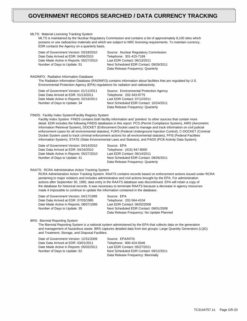
MLTS: Material Licensing Tracking SystemMLTS is maintained by the Nuclear Regulatory Commission and contains a list of approximately 8,100 sites whichpossess or use radioactive materials and which are subject to NRC licensing requirements. To maintain currency,EDR contacts the Agency on a quarterly basis.
Date of Government Version: 03/18/2010Date Data Arrived at EDR: 04/06/2010Date Made Active in Reports: 05/27/2010Number of Days to Update: 51
Source: Nuclear Regulatory CommissionTelephone: 301-415-7169Last EDR Contact: 06/13/2011Next Scheduled EDR Contact: 09/26/2011Data Release Frequency: Quarterly
RADINFO: Radiation Information DatabaseThe Radiation Information Database (RADINFO) contains information about facilities that are regulated by U.S.Environmental Protection Agency (EPA) regulations for radiation and radioactivity.
Date of Government Version: 01/11/2011Date Data Arrived at EDR: 01/13/2011Date Made Active in Reports: 02/16/2011Number of Days to Update: 34
Source: Environmental Protection AgencyTelephone: 202-343-9775Last EDR Contact: 07/12/2011Next Scheduled EDR Contact: 10/24/2011Data Release Frequency: Quarterly
FINDS: Facility Index System/Facility Registry SystemFacility Index System. FINDS contains both facility information and ’pointers’ to other sources that contain moredetail. EDR includes the following FINDS databases in this report: PCS (Permit Compliance System), AIRS (AerometricInformation Retrieval System), DOCKET (Enforcement Docket used to manage and track information on civil judicialenforcement cases for all environmental statutes), FURS (Federal Underground Injection Control), C-DOCKET (CriminalDocket System used to track criminal enforcement actions for all environmental statutes), FFIS (Federal FacilitiesInformation System), STATE (State Environmental Laws and Statutes), and PADS (PCB Activity Data System).
Date of Government Version: 04/14/2010Date Data Arrived at EDR: 04/16/2010Date Made Active in Reports: 05/27/2010Number of Days to Update: 41
Source: EPATelephone: (415) 947-8000Last EDR Contact: 06/14/2011Next Scheduled EDR Contact: 09/26/2011Data Release Frequency: Quarterly
RAATS: RCRA Administrative Action Tracking SystemRCRA Administration Action Tracking System. RAATS contains records based on enforcement actions issued under RCRApertaining to major violators and includes administrative and civil actions brought by the EPA. For administrationactions after September 30, 1995, data entry in the RAATS database was discontinued. EPA will retain a copy ofthe database for historical records. It was necessary to terminate RAATS because a decrease in agency resourcesmade it impossible to continue to update the information contained in the database.
Date of Government Version: 04/17/1995Date Data Arrived at EDR: 07/03/1995Date Made Active in Reports: 08/07/1995Number of Days to Update: 35
Source: EPATelephone: 202-564-4104Last EDR Contact: 06/02/2008Next Scheduled EDR Contact: 09/01/2008Data Release Frequency: No Update Planned
BRS: Biennial Reporting SystemThe Biennial Reporting System is a national system administered by the EPA that collects data on the generationand management of hazardous waste. BRS captures detailed data from two groups: Large Quantity Generators (LQG)and Treatment, Storage, and Disposal Facilities.
Date of Government Version: 12/31/2009Date Data Arrived at EDR: 03/01/2011Date Made Active in Reports: 05/02/2011Number of Days to Update: 62
Source: EPA/NTISTelephone: 800-424-9346Last EDR Contact: 05/27/2011Next Scheduled EDR Contact: 09/12/2011Data Release Frequency: Biennially
TC3144757.1s Page GR-20
GOVERNMENT RECORDS SEARCHED / DATA CURRENCY TRACKING
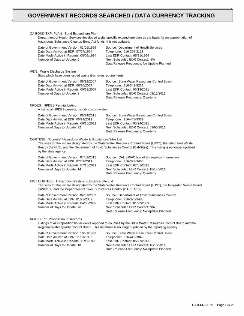
CA BOND EXP. PLAN: Bond Expenditure PlanDepartment of Health Services developed a site-specific expenditure plan as the basis for an appropriation ofHazardous Substance Cleanup Bond Act funds. It is not updated.
Date of Government Version: 01/01/1989Date Data Arrived at EDR: 07/27/1994Date Made Active in Reports: 08/02/1994Number of Days to Update: 6
Source: Department of Health ServicesTelephone: 916-255-2118Last EDR Contact: 05/31/1994Next Scheduled EDR Contact: N/AData Release Frequency: No Update Planned
WDS: Waste Discharge SystemSites which have been issued waste discharge requirements.
Date of Government Version: 06/19/2007Date Data Arrived at EDR: 06/20/2007Date Made Active in Reports: 06/29/2007Number of Days to Update: 9
Source: State Water Resources Control BoardTelephone: 916-341-5227Last EDR Contact: 06/13/2011Next Scheduled EDR Contact: 09/12/2011Data Release Frequency: Quarterly
NPDES: NPDES Permits ListingA listing of NPDES permits, including stormwater.
Date of Government Version: 05/24/2011Date Data Arrived at EDR: 05/24/2011Date Made Active in Reports: 06/15/2011Number of Days to Update: 22
Source: State Water Resources Control BoardTelephone: 916-445-9379Last EDR Contact: 05/24/2011Next Scheduled EDR Contact: 09/05/2011Data Release Frequency: Quarterly
CORTESE: "Cortese" Hazardous Waste & Substances Sites ListThe sites for the list are designated by the State Water Resource Control Board (LUST), the Integrated WasteBoard (SWF/LS), and the Department of Toxic Substances Control (Cal-Sites). This listing is no longer updatedby the state agency.
Date of Government Version: 07/01/2011Date Data Arrived at EDR: 07/01/2011Date Made Active in Reports: 07/15/2011Number of Days to Update: 14
Source: CAL EPA/Office of Emergency InformationTelephone: 916-323-3400Last EDR Contact: 07/01/2011Next Scheduled EDR Contact: 10/17/2011Data Release Frequency: Quarterly
HIST CORTESE: Hazardous Waste & Substance Site ListThe sites for the list are designated by the State Water Resource Control Board [LUST], the Integrated Waste Board[SWF/LS], and the Department of Toxic Substances Control [CALSITES].
Date of Government Version: 04/01/2001Date Data Arrived at EDR: 01/22/2009Date Made Active in Reports: 04/08/2009Number of Days to Update: 76
Source: Department of Toxic Substances ControlTelephone: 916-323-3400Last EDR Contact: 01/22/2009Next Scheduled EDR Contact: N/AData Release Frequency: No Update Planned
NOTIFY 65: Proposition 65 RecordsListings of all Proposition 65 incidents reported to counties by the State Water Resources Control Board and theRegional Water Quality Control Board. This database is no longer updated by the reporting agency.
Date of Government Version: 10/21/1993Date Data Arrived at EDR: 11/01/1993Date Made Active in Reports: 11/19/1993Number of Days to Update: 18
Source: State Water Resources Control BoardTelephone: 916-445-3846Last EDR Contact: 06/27/2011Next Scheduled EDR Contact: 10/10/2011Data Release Frequency: No Update Planned
TC3144757.1s Page GR-21
GOVERNMENT RECORDS SEARCHED / DATA CURRENCY TRACKING
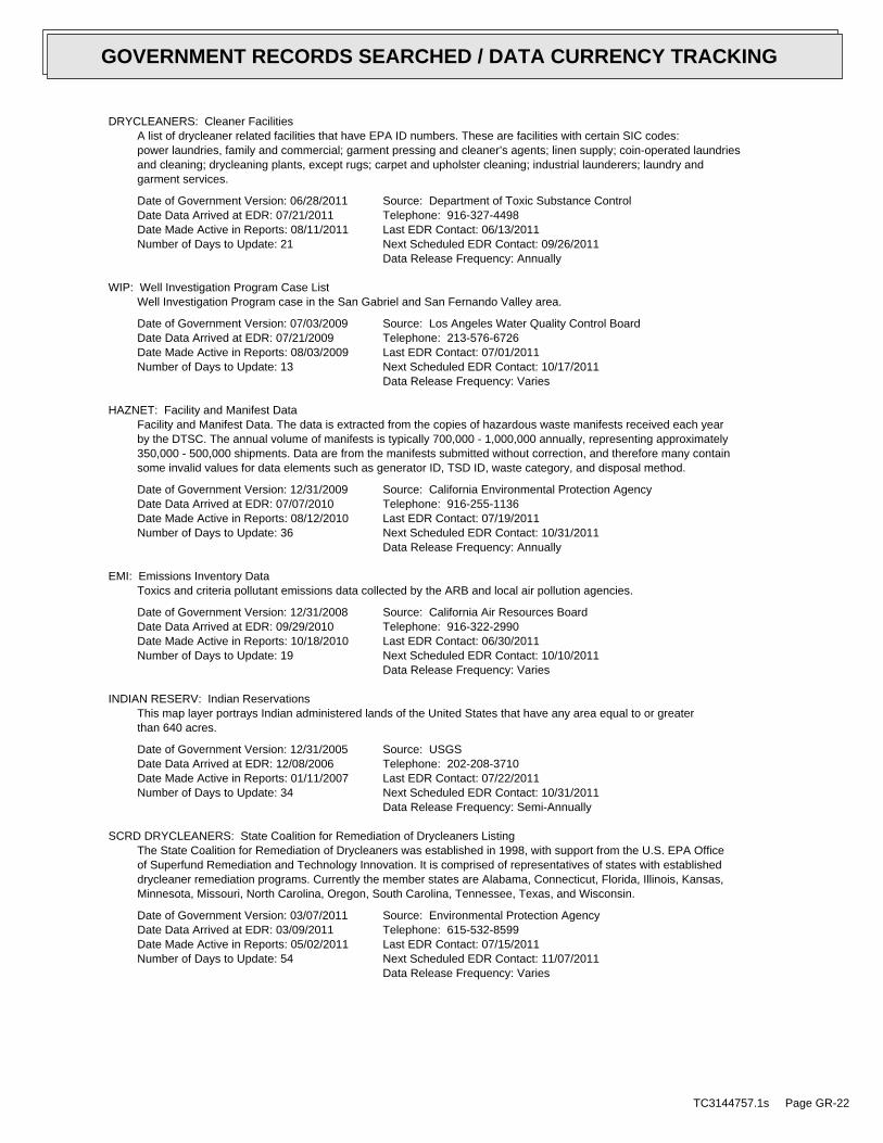
DRYCLEANERS: Cleaner FacilitiesA list of drycleaner related facilities that have EPA ID numbers. These are facilities with certain SIC codes:power laundries, family and commercial; garment pressing and cleaner’s agents; linen supply; coin-operated laundriesand cleaning; drycleaning plants, except rugs; carpet and upholster cleaning; industrial launderers; laundry andgarment services.
Date of Government Version: 06/28/2011Date Data Arrived at EDR: 07/21/2011Date Made Active in Reports: 08/11/2011Number of Days to Update: 21
Source: Department of Toxic Substance ControlTelephone: 916-327-4498Last EDR Contact: 06/13/2011Next Scheduled EDR Contact: 09/26/2011Data Release Frequency: Annually
WIP: Well Investigation Program Case ListWell Investigation Program case in the San Gabriel and San Fernando Valley area.
Date of Government Version: 07/03/2009Date Data Arrived at EDR: 07/21/2009Date Made Active in Reports: 08/03/2009Number of Days to Update: 13
Source: Los Angeles Water Quality Control BoardTelephone: 213-576-6726Last EDR Contact: 07/01/2011Next Scheduled EDR Contact: 10/17/2011Data Release Frequency: Varies
HAZNET: Facility and Manifest DataFacility and Manifest Data. The data is extracted from the copies of hazardous waste manifests received each yearby the DTSC. The annual volume of manifests is typically 700,000 - 1,000,000 annually, representing approximately350,000 - 500,000 shipments. Data are from the manifests submitted without correction, and therefore many containsome invalid values for data elements such as generator ID, TSD ID, waste category, and disposal method.
Date of Government Version: 12/31/2009Date Data Arrived at EDR: 07/07/2010Date Made Active in Reports: 08/12/2010Number of Days to Update: 36
Source: California Environmental Protection AgencyTelephone: 916-255-1136Last EDR Contact: 07/19/2011Next Scheduled EDR Contact: 10/31/2011Data Release Frequency: Annually
EMI: Emissions Inventory DataToxics and criteria pollutant emissions data collected by the ARB and local air pollution agencies.
Date of Government Version: 12/31/2008Date Data Arrived at EDR: 09/29/2010Date Made Active in Reports: 10/18/2010Number of Days to Update: 19
Source: California Air Resources BoardTelephone: 916-322-2990Last EDR Contact: 06/30/2011Next Scheduled EDR Contact: 10/10/2011Data Release Frequency: Varies
INDIAN RESERV: Indian ReservationsThis map layer portrays Indian administered lands of the United States that have any area equal to or greaterthan 640 acres.
Date of Government Version: 12/31/2005Date Data Arrived at EDR: 12/08/2006Date Made Active in Reports: 01/11/2007Number of Days to Update: 34
Source: USGSTelephone: 202-208-3710Last EDR Contact: 07/22/2011Next Scheduled EDR Contact: 10/31/2011Data Release Frequency: Semi-Annually
SCRD DRYCLEANERS: State Coalition for Remediation of Drycleaners ListingThe State Coalition for Remediation of Drycleaners was established in 1998, with support from the U.S. EPA Officeof Superfund Remediation and Technology Innovation. It is comprised of representatives of states with establisheddrycleaner remediation programs. Currently the member states are Alabama, Connecticut, Florida, Illinois, Kansas,Minnesota, Missouri, North Carolina, Oregon, South Carolina, Tennessee, Texas, and Wisconsin.
Date of Government Version: 03/07/2011Date Data Arrived at EDR: 03/09/2011Date Made Active in Reports: 05/02/2011Number of Days to Update: 54
Source: Environmental Protection AgencyTelephone: 615-532-8599Last EDR Contact: 07/15/2011Next Scheduled EDR Contact: 11/07/2011Data Release Frequency: Varies
TC3144757.1s Page GR-22
GOVERNMENT RECORDS SEARCHED / DATA CURRENCY TRACKING

PROC: Certified Processors DatabaseA listing of certified processors.
Date of Government Version: 06/01/2011Date Data Arrived at EDR: 06/21/2011Date Made Active in Reports: 07/15/2011Number of Days to Update: 24
Source: Department of ConservationTelephone: 916-323-3836Last EDR Contact: 06/21/2011Next Scheduled EDR Contact: 10/03/2011Data Release Frequency: Quarterly
MWMP: Medical Waste Management Program ListingThe Medical Waste Management Program (MWMP) ensures the proper handling and disposal of medical waste by permittingand inspecting medical waste Offsite Treatment Facilities (PDF) and Transfer Stations (PDF) throughout thestate. MWMP also oversees all Medical Waste Transporters.
Date of Government Version: 06/09/2011Date Data Arrived at EDR: 06/16/2011Date Made Active in Reports: 07/15/2011Number of Days to Update: 29
Source: Department of Public HealthTelephone: 916-558-1784Last EDR Contact: 06/14/2011Next Scheduled EDR Contact: 09/26/2011Data Release Frequency: Varies
COAL ASH DOE: Sleam-Electric Plan Operation DataA listing of power plants that store ash in surface ponds.
Date of Government Version: 12/31/2005Date Data Arrived at EDR: 08/07/2009Date Made Active in Reports: 10/22/2009Number of Days to Update: 76
Source: Department of EnergyTelephone: 202-586-8719Last EDR Contact: 07/18/2011Next Scheduled EDR Contact: 10/31/2011Data Release Frequency: Varies
COAL ASH EPA: Coal Combustion Residues Surface Impoundments ListA listing of coal combustion residues surface impoundments with high hazard potential ratings.
Date of Government Version: 08/17/2010Date Data Arrived at EDR: 01/03/2011Date Made Active in Reports: 03/21/2011Number of Days to Update: 77
Source: Environmental Protection AgencyTelephone: N/ALast EDR Contact: 06/14/2011Next Scheduled EDR Contact: 09/26/2011Data Release Frequency: Varies
HWT: Registered Hazardous Waste Transporter DatabaseA listing of hazardous waste transporters. In California, unless specifically exempted, it is unlawful for anyperson to transport hazardous wastes unless the person holds a valid registration issued by DTSC. A hazardouswaste transporter registration is valid for one year and is assigned a unique registration number.
Date of Government Version: 07/18/2011Date Data Arrived at EDR: 07/19/2011Date Made Active in Reports: 08/11/2011Number of Days to Update: 23
Source: Department of Toxic Substances ControlTelephone: 916-440-7145Last EDR Contact: 07/19/2011Next Scheduled EDR Contact: 10/31/2011Data Release Frequency: Quarterly
HWP: EnviroStor Permitted Facilities ListingDetailed information on permitted hazardous waste facilities and corrective action ("cleanups") tracked in EnviroStor.
Date of Government Version: 08/09/2010Date Data Arrived at EDR: 08/11/2010Date Made Active in Reports: 08/20/2010Number of Days to Update: 9
Source: Department of Toxic Substances ControlTelephone: 916-323-3400Last EDR Contact: 06/03/2011Next Scheduled EDR Contact: 09/12/2011Data Release Frequency: Quarterly
FINANCIAL ASSURANCE 2: Financial Assurance Information ListingA listing of financial assurance information for solid waste facilities. Financial assurance is intended to ensurethat resources are available to pay for the cost of closure, post-closure care, and corrective measures if theowner or operator of a regulated facility is unable or unwilling to pay.
TC3144757.1s Page GR-23
GOVERNMENT RECORDS SEARCHED / DATA CURRENCY TRACKING

Date of Government Version: 03/15/2011Date Data Arrived at EDR: 03/16/2011Date Made Active in Reports: 04/26/2011Number of Days to Update: 41
Source: California Integrated Waste Management BoardTelephone: 916-341-6066Last EDR Contact: 07/22/2011Next Scheduled EDR Contact: 09/05/2011Data Release Frequency: Varies
FINANCIAL ASSURANCE 1: Financial Assurance Information ListingFinancial Assurance information
Date of Government Version: 03/01/2007Date Data Arrived at EDR: 06/01/2007Date Made Active in Reports: 06/29/2007Number of Days to Update: 28
Source: Department of Toxic Substances ControlTelephone: 916-255-3628Last EDR Contact: 08/05/2011Next Scheduled EDR Contact: 11/14/2011Data Release Frequency: Varies
FEDLAND: Federal and Indian LandsFederally and Indian administrated lands of the United States. Lands included are administrated by: Army Corpsof Engineers, Bureau of Reclamation, National Wild and Scenic River, National Wildlife Refuge, Public Domain Land,Wilderness, Wilderness Study Area, Wildlife Management Area, Bureau of Indian Affairs, Bureau of Land Management,Department of Justice, Forest Service, Fish and Wildlife Service, National Park Service.
Date of Government Version: 12/31/2005Date Data Arrived at EDR: 02/06/2006Date Made Active in Reports: 01/11/2007Number of Days to Update: 339
Source: U.S. Geological SurveyTelephone: 888-275-8747Last EDR Contact: 07/22/2011Next Scheduled EDR Contact: 10/31/2011Data Release Frequency: N/A
PCB TRANSFORMER: PCB Transformer Registration DatabaseThe database of PCB transformer registrations that includes all PCB registration submittals.
Date of Government Version: 01/01/2008Date Data Arrived at EDR: 02/18/2009Date Made Active in Reports: 05/29/2009Number of Days to Update: 100
Source: Environmental Protection AgencyTelephone: 202-566-0517Last EDR Contact: 08/05/2011Next Scheduled EDR Contact: 11/14/2011Data Release Frequency: Varies
EDR PROPRIETARY RECORDS
EDR Proprietary Records
Manufactured Gas Plants: EDR Proprietary Manufactured Gas PlantsThe EDR Proprietary Manufactured Gas Plant Database includes records of coal gas plants (manufactured gas plants)compiled by EDR’s researchers. Manufactured gas sites were used in the United States from the 1800’s to 1950’sto produce a gas that could be distributed and used as fuel. These plants used whale oil, rosin, coal, or a mixtureof coal, oil, and water that also produced a significant amount of waste. Many of the byproducts of the gas production,such as coal tar (oily waste containing volatile and non-volatile chemicals), sludges, oils and other compoundsare potentially hazardous to human health and the environment. The byproduct from this process was frequentlydisposed of directly at the plant site and can remain or spread slowly, serving as a continuous source of soiland groundwater contamination.
Date of Government Version: N/ADate Data Arrived at EDR: N/ADate Made Active in Reports: N/ANumber of Days to Update: N/A
Source: EDR, Inc.Telephone: N/ALast EDR Contact: N/ANext Scheduled EDR Contact: N/AData Release Frequency: No Update Planned
EDR Historical Auto Stations: EDR Proprietary Historic Gas StationsEDR has searched selected national collections of business directories and has collected listings of potentialgas station/filling station/service station sites that were available to EDR researchers. EDR’s review was limitedto those categories of sources that might, in EDR’s opinion, include gas station/filling station/service stationestablishments. The categories reviewed included, but were not limited to gas, gas station, gasoline station,filling station, auto, automobile repair, auto service station, service station, etc.
TC3144757.1s Page GR-24
GOVERNMENT RECORDS SEARCHED / DATA CURRENCY TRACKING

Date of Government Version: N/ADate Data Arrived at EDR: N/ADate Made Active in Reports: N/ANumber of Days to Update: N/A
Source: EDR, Inc.Telephone: N/ALast EDR Contact: N/ANext Scheduled EDR Contact: N/AData Release Frequency: Varies
EDR Historical Cleaners: EDR Proprietary Historic Dry CleanersEDR has searched selected national collections of business directories and has collected listings of potentialdry cleaner sites that were available to EDR researchers. EDR’s review was limited to those categories of sourcesthat might, in EDR’s opinion, include dry cleaning establishments. The categories reviewed included, but werenot limited to dry cleaners, cleaners, laundry, laundromat, cleaning/laundry, wash & dry etc.
Date of Government Version: N/ADate Data Arrived at EDR: N/ADate Made Active in Reports: N/ANumber of Days to Update: N/A
Source: EDR, Inc.Telephone: N/ALast EDR Contact: N/ANext Scheduled EDR Contact: N/AData Release Frequency: Varies
COUNTY RECORDS
ALAMEDA COUNTY:
Contaminated SitesA listing of contaminated sites overseen by the Toxic Release Program (oil and groundwater contamination fromchemical releases and spills) and the Leaking Underground Storage Tank Program (soil and ground water contaminationfrom leaking petroleum USTs).
Date of Government Version: 07/21/2011Date Data Arrived at EDR: 07/21/2011Date Made Active in Reports: 08/11/2011Number of Days to Update: 21
Source: Alameda County Environmental Health ServicesTelephone: 510-567-6700Last EDR Contact: 07/18/2011Next Scheduled EDR Contact: 10/17/2011Data Release Frequency: Semi-Annually
Underground TanksUnderground storage tank sites located in Alameda county.
Date of Government Version: 07/21/2011Date Data Arrived at EDR: 07/21/2011Date Made Active in Reports: 08/11/2011Number of Days to Update: 21
Source: Alameda County Environmental Health ServicesTelephone: 510-567-6700Last EDR Contact: 07/18/2011Next Scheduled EDR Contact: 10/17/2011Data Release Frequency: Semi-Annually
BUTTE COUNTY:
CUPA Facility ListingCupa facility list.
Date of Government Version: 03/29/2011Date Data Arrived at EDR: 04/20/2011Date Made Active in Reports: 05/17/2011Number of Days to Update: 27
Source: Public Health DepartmentTelephone: 530-538-7149Last EDR Contact: 07/18/2011Next Scheduled EDR Contact: 10/31/2011Data Release Frequency: Varies
COLUSA COUNTY:
CUPA Facility ListCupa facility list.
TC3144757.1s Page GR-25
GOVERNMENT RECORDS SEARCHED / DATA CURRENCY TRACKING

Date of Government Version: 12/01/2010Date Data Arrived at EDR: 04/20/2011Date Made Active in Reports: 05/17/2011Number of Days to Update: 27
Source: Health & Human ServicesTelephone: 530-458-0396Last EDR Contact: 08/01/2011Next Scheduled EDR Contact: 10/31/2011Data Release Frequency: Varies
CONTRA COSTA COUNTY:
Site ListList includes sites from the underground tank, hazardous waste generator and business plan/2185 programs.
Date of Government Version: 06/13/2011Date Data Arrived at EDR: 06/14/2011Date Made Active in Reports: 07/15/2011Number of Days to Update: 31
Source: Contra Costa Health Services DepartmentTelephone: 925-646-2286Last EDR Contact: 08/09/2011Next Scheduled EDR Contact: 11/21/2011Data Release Frequency: Semi-Annually
EL DORADO COUNTY:
CUPA Facility ListCUPA facility list.
Date of Government Version: 03/28/2011Date Data Arrived at EDR: 05/13/2011Date Made Active in Reports: 06/15/2011Number of Days to Update: 33
Source: El Dorado County Environmental Management DepartmentTelephone: 530-621-6623Last EDR Contact: 08/08/2011Next Scheduled EDR Contact: 11/21/2011Data Release Frequency: Varies
FRESNO COUNTY:
CUPA Resources ListCertified Unified Program Agency. CUPA’s are responsible for implementing a unified hazardous materials and hazardouswaste management regulatory program. The agency provides oversight of businesses that deal with hazardous materials,operate underground storage tanks or aboveground storage tanks.
Date of Government Version: 07/18/2011Date Data Arrived at EDR: 07/19/2011Date Made Active in Reports: 08/11/2011Number of Days to Update: 23
Source: Dept. of Community HealthTelephone: 559-445-3271Last EDR Contact: 07/18/2011Next Scheduled EDR Contact: 10/31/2011Data Release Frequency: Semi-Annually
HUMBOLDT COUNTY:
CUPA Facility ListCUPA facility list.
Date of Government Version: 02/08/2011Date Data Arrived at EDR: 03/03/2011Date Made Active in Reports: 03/24/2011Number of Days to Update: 21
Source: Humboldt County Environmental HealthTelephone: N/ALast EDR Contact: 06/30/2011Next Scheduled EDR Contact: 10/10/2011Data Release Frequency: Varies
INYO COUNTY:
TC3144757.1s Page GR-26
GOVERNMENT RECORDS SEARCHED / DATA CURRENCY TRACKING

CUPA Facility ListCupa facility list.
Date of Government Version: 06/13/2011Date Data Arrived at EDR: 06/14/2011Date Made Active in Reports: 07/19/2011Number of Days to Update: 35
Source: Inyo County Environmental Health ServicesTelephone: 760-878-0238Last EDR Contact: 06/13/2011Next Scheduled EDR Contact: 09/12/2011Data Release Frequency: Varies
KERN COUNTY:
Underground Storage Tank Sites & Tank ListingKern County Sites and Tanks Listing.
Date of Government Version: 08/31/2010Date Data Arrived at EDR: 09/01/2010Date Made Active in Reports: 09/30/2010Number of Days to Update: 29
Source: Kern County Environment Health Services DepartmentTelephone: 661-862-8700Last EDR Contact: 06/16/2011Next Scheduled EDR Contact: 08/29/2011Data Release Frequency: Quarterly
KINGS COUNTY:
CUPA Facility ListA listing of sites included in the county?s Certified Unified Program Agency database. California?s Secretaryfor Environmental Protection established the unified hazardous materials and hazardous waste regulatory programas required by chapter 6.11 of the California Health and Safety Code. The Unified Program consolidates the administration,permits, inspections, and enforcement activities.
Date of Government Version: 06/09/2011Date Data Arrived at EDR: 06/09/2011Date Made Active in Reports: 07/08/2011Number of Days to Update: 29
Source: Kings County Department of Public HealthTelephone: 559-584-1411Last EDR Contact: 05/31/2011Next Scheduled EDR Contact: 09/12/2011Data Release Frequency: Varies
LOS ANGELES COUNTY:
San Gabriel Valley Areas of ConcernSan Gabriel Valley areas where VOC contamination is at or above the MCL as designated by region 9 EPA office.
Date of Government Version: 03/30/2009Date Data Arrived at EDR: 03/31/2009Date Made Active in Reports: 10/23/2009Number of Days to Update: 206
Source: EPA Region 9Telephone: 415-972-3178Last EDR Contact: 03/28/2011Next Scheduled EDR Contact: 10/10/2011Data Release Frequency: No Update Planned
HMS: Street Number ListIndustrial Waste and Underground Storage Tank Sites.
Date of Government Version: 03/31/2011Date Data Arrived at EDR: 06/09/2011Date Made Active in Reports: 06/15/2011Number of Days to Update: 6
Source: Department of Public WorksTelephone: 626-458-3517Last EDR Contact: 07/18/2011Next Scheduled EDR Contact: 10/31/2011Data Release Frequency: Semi-Annually
List of Solid Waste FacilitiesSolid Waste Facilities in Los Angeles County.
TC3144757.1s Page GR-27
GOVERNMENT RECORDS SEARCHED / DATA CURRENCY TRACKING
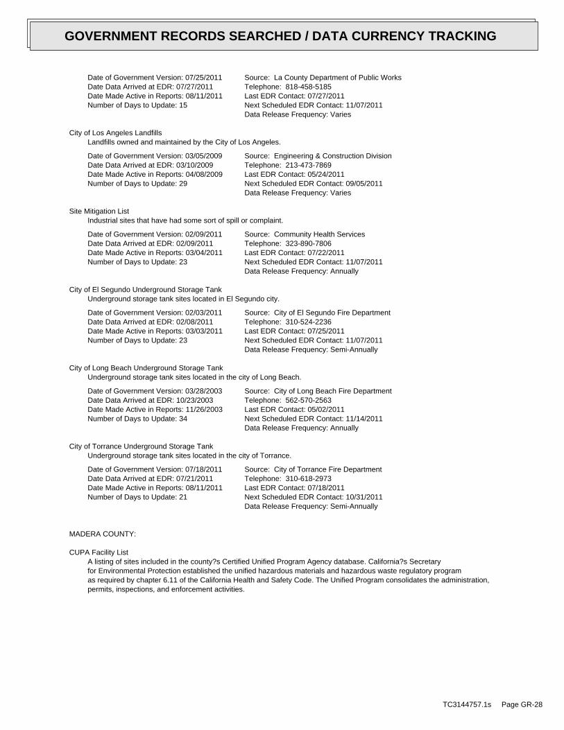
Date of Government Version: 07/25/2011Date Data Arrived at EDR: 07/27/2011Date Made Active in Reports: 08/11/2011Number of Days to Update: 15
Source: La County Department of Public WorksTelephone: 818-458-5185Last EDR Contact: 07/27/2011Next Scheduled EDR Contact: 11/07/2011Data Release Frequency: Varies
City of Los Angeles LandfillsLandfills owned and maintained by the City of Los Angeles.
Date of Government Version: 03/05/2009Date Data Arrived at EDR: 03/10/2009Date Made Active in Reports: 04/08/2009Number of Days to Update: 29
Source: Engineering & Construction DivisionTelephone: 213-473-7869Last EDR Contact: 05/24/2011Next Scheduled EDR Contact: 09/05/2011Data Release Frequency: Varies
Site Mitigation ListIndustrial sites that have had some sort of spill or complaint.
Date of Government Version: 02/09/2011Date Data Arrived at EDR: 02/09/2011Date Made Active in Reports: 03/04/2011Number of Days to Update: 23
Source: Community Health ServicesTelephone: 323-890-7806Last EDR Contact: 07/22/2011Next Scheduled EDR Contact: 11/07/2011Data Release Frequency: Annually
City of El Segundo Underground Storage TankUnderground storage tank sites located in El Segundo city.
Date of Government Version: 02/03/2011Date Data Arrived at EDR: 02/08/2011Date Made Active in Reports: 03/03/2011Number of Days to Update: 23
Source: City of El Segundo Fire DepartmentTelephone: 310-524-2236Last EDR Contact: 07/25/2011Next Scheduled EDR Contact: 11/07/2011Data Release Frequency: Semi-Annually
City of Long Beach Underground Storage TankUnderground storage tank sites located in the city of Long Beach.
Date of Government Version: 03/28/2003Date Data Arrived at EDR: 10/23/2003Date Made Active in Reports: 11/26/2003Number of Days to Update: 34
Source: City of Long Beach Fire DepartmentTelephone: 562-570-2563Last EDR Contact: 05/02/2011Next Scheduled EDR Contact: 11/14/2011Data Release Frequency: Annually
City of Torrance Underground Storage TankUnderground storage tank sites located in the city of Torrance.
Date of Government Version: 07/18/2011Date Data Arrived at EDR: 07/21/2011Date Made Active in Reports: 08/11/2011Number of Days to Update: 21
Source: City of Torrance Fire DepartmentTelephone: 310-618-2973Last EDR Contact: 07/18/2011Next Scheduled EDR Contact: 10/31/2011Data Release Frequency: Semi-Annually
MADERA COUNTY:
CUPA Facility ListA listing of sites included in the county?s Certified Unified Program Agency database. California?s Secretaryfor Environmental Protection established the unified hazardous materials and hazardous waste regulatory programas required by chapter 6.11 of the California Health and Safety Code. The Unified Program consolidates the administration,permits, inspections, and enforcement activities.
TC3144757.1s Page GR-28
GOVERNMENT RECORDS SEARCHED / DATA CURRENCY TRACKING

Date of Government Version: 06/07/2011Date Data Arrived at EDR: 06/08/2011Date Made Active in Reports: 07/08/2011Number of Days to Update: 30
Source: Madera County Environmental HealthTelephone: 559-675-7823Last EDR Contact: 05/31/2011Next Scheduled EDR Contact: 09/12/2011Data Release Frequency: Varies
MARIN COUNTY:
Underground Storage Tank SitesCurrently permitted USTs in Marin County.
Date of Government Version: 07/15/2011Date Data Arrived at EDR: 07/25/2011Date Made Active in Reports: 08/11/2011Number of Days to Update: 17
Source: Public Works Department Waste ManagementTelephone: 415-499-6647Last EDR Contact: 07/11/2011Next Scheduled EDR Contact: 10/24/2011Data Release Frequency: Semi-Annually
MERCED COUNTY:
CUPA Facility ListCUPA facility list.
Date of Government Version: 06/06/2011Date Data Arrived at EDR: 06/06/2011Date Made Active in Reports: 06/15/2011Number of Days to Update: 9
Source: Merced County Environmental HealthTelephone: 209-381-1094Last EDR Contact: 05/31/2011Next Scheduled EDR Contact: 09/12/2011Data Release Frequency: Varies
MONTEREY COUNTY:
CUPA Facility ListingCUPA Program listing from the Environmental Health Division.
Date of Government Version: 07/07/2011Date Data Arrived at EDR: 07/08/2011Date Made Active in Reports: 08/11/2011Number of Days to Update: 34
Source: Monterey County Health DepartmentTelephone: 831-796-1297Last EDR Contact: 06/20/2011Next Scheduled EDR Contact: 09/12/2011Data Release Frequency: Varies
NAPA COUNTY:
Sites With Reported ContaminationA listing of leaking underground storage tank sites located in Napa county.
Date of Government Version: 07/09/2008Date Data Arrived at EDR: 07/09/2008Date Made Active in Reports: 07/31/2008Number of Days to Update: 22
Source: Napa County Department of Environmental ManagementTelephone: 707-253-4269Last EDR Contact: 03/07/2011Next Scheduled EDR Contact: 06/20/2011Data Release Frequency: No Update Planned
Closed and Operating Underground Storage Tank SitesUnderground storage tank sites located in Napa county.
Date of Government Version: 01/15/2008Date Data Arrived at EDR: 01/16/2008Date Made Active in Reports: 02/08/2008Number of Days to Update: 23
Source: Napa County Department of Environmental ManagementTelephone: 707-253-4269Last EDR Contact: 06/06/2011Next Scheduled EDR Contact: 09/19/2011Data Release Frequency: No Update Planned
NEVADA COUNTY:
TC3144757.1s Page GR-29
GOVERNMENT RECORDS SEARCHED / DATA CURRENCY TRACKING

CUPA Facility ListCUPA facility list.
Date of Government Version: 03/04/2011Date Data Arrived at EDR: 05/12/2011Date Made Active in Reports: 06/23/2011Number of Days to Update: 42
Source: Community Development AgencyTelephone: 530-265-1467Last EDR Contact: 08/08/2011Next Scheduled EDR Contact: 11/21/2011Data Release Frequency: Varies
ORANGE COUNTY:
List of Industrial Site CleanupsPetroleum and non-petroleum spills.
Date of Government Version: 05/02/2011Date Data Arrived at EDR: 05/20/2011Date Made Active in Reports: 06/15/2011Number of Days to Update: 26
Source: Health Care AgencyTelephone: 714-834-3446Last EDR Contact: 05/16/2011Next Scheduled EDR Contact: 08/29/2011Data Release Frequency: Annually
List of Underground Storage Tank CleanupsOrange County Underground Storage Tank Cleanups (LUST).
Date of Government Version: 05/05/2011Date Data Arrived at EDR: 05/20/2011Date Made Active in Reports: 06/15/2011Number of Days to Update: 26
Source: Health Care AgencyTelephone: 714-834-3446Last EDR Contact: 05/16/2011Next Scheduled EDR Contact: 08/29/2011Data Release Frequency: Quarterly
List of Underground Storage Tank FacilitiesOrange County Underground Storage Tank Facilities (UST).
Date of Government Version: 05/05/2011Date Data Arrived at EDR: 05/17/2011Date Made Active in Reports: 06/20/2011Number of Days to Update: 34
Source: Health Care AgencyTelephone: 714-834-3446Last EDR Contact: 05/17/2011Next Scheduled EDR Contact: 08/29/2011Data Release Frequency: Quarterly
PLACER COUNTY:
Master List of FacilitiesList includes aboveground tanks, underground tanks and cleanup sites.
Date of Government Version: 06/20/2011Date Data Arrived at EDR: 06/21/2011Date Made Active in Reports: 07/08/2011Number of Days to Update: 17
Source: Placer County Health and Human ServicesTelephone: 530-889-7312Last EDR Contact: 06/13/2011Next Scheduled EDR Contact: 09/26/2011Data Release Frequency: Semi-Annually
RIVERSIDE COUNTY:
Listing of Underground Tank Cleanup SitesRiverside County Underground Storage Tank Cleanup Sites (LUST).
Date of Government Version: 07/14/2011Date Data Arrived at EDR: 07/22/2011Date Made Active in Reports: 08/11/2011Number of Days to Update: 20
Source: Department of Environmental HealthTelephone: 951-358-5055Last EDR Contact: 06/27/2011Next Scheduled EDR Contact: 10/10/2011Data Release Frequency: Quarterly
TC3144757.1s Page GR-30
GOVERNMENT RECORDS SEARCHED / DATA CURRENCY TRACKING

Underground Storage Tank Tank ListUnderground storage tank sites located in Riverside county.
Date of Government Version: 07/20/2011Date Data Arrived at EDR: 07/22/2011Date Made Active in Reports: 08/11/2011Number of Days to Update: 20
Source: Department of Environmental HealthTelephone: 951-358-5055Last EDR Contact: 06/27/2011Next Scheduled EDR Contact: 10/10/2011Data Release Frequency: Quarterly
SACRAMENTO COUNTY:
Toxic Site Clean-Up ListList of sites where unauthorized releases of potentially hazardous materials have occurred.
Date of Government Version: 05/02/2011Date Data Arrived at EDR: 07/19/2011Date Made Active in Reports: 08/11/2011Number of Days to Update: 23
Source: Sacramento County Environmental ManagementTelephone: 916-875-8406Last EDR Contact: 07/08/2011Next Scheduled EDR Contact: 10/24/2011Data Release Frequency: Quarterly
Master Hazardous Materials Facility ListAny business that has hazardous materials on site - hazardous material storage sites, underground storage tanks,waste generators.
Date of Government Version: 05/02/2011Date Data Arrived at EDR: 07/19/2011Date Made Active in Reports: 08/11/2011Number of Days to Update: 23
Source: Sacramento County Environmental ManagementTelephone: 916-875-8406Last EDR Contact: 07/08/2011Next Scheduled EDR Contact: 10/24/2011Data Release Frequency: Quarterly
SAN BERNARDINO COUNTY:
Hazardous Material PermitsThis listing includes underground storage tanks, medical waste handlers/generators, hazardous materials handlers,hazardous waste generators, and waste oil generators/handlers.
Date of Government Version: 06/09/2011Date Data Arrived at EDR: 06/09/2011Date Made Active in Reports: 06/15/2011Number of Days to Update: 6
Source: San Bernardino County Fire Department Hazardous Materials DivisionTelephone: 909-387-3041Last EDR Contact: 05/16/2011Next Scheduled EDR Contact: 08/29/2011Data Release Frequency: Quarterly
SAN DIEGO COUNTY:
Hazardous Materials Management Division DatabaseThe database includes: HE58 - This report contains the business name, site address, business phone number, establishment’H’ permit number, type of permit, and the business status. HE17 - In addition to providing the same informationprovided in the HE58 listing, HE17 provides inspection dates, violations received by the establishment, hazardouswaste generated, the quantity, method of storage, treatment/disposal of waste and the hauler, and informationon underground storage tanks. Unauthorized Release List - Includes a summary of environmental contamination casesin San Diego County (underground tank cases, non-tank cases, groundwater contamination, and soil contaminationare included.)
Date of Government Version: 09/09/2010Date Data Arrived at EDR: 09/15/2010Date Made Active in Reports: 09/29/2010Number of Days to Update: 14
Source: Hazardous Materials Management DivisionTelephone: 619-338-2268Last EDR Contact: 06/17/2011Next Scheduled EDR Contact: 09/26/2011Data Release Frequency: Quarterly
TC3144757.1s Page GR-31
GOVERNMENT RECORDS SEARCHED / DATA CURRENCY TRACKING

Solid Waste FacilitiesSan Diego County Solid Waste Facilities.
Date of Government Version: 10/01/2010Date Data Arrived at EDR: 11/16/2010Date Made Active in Reports: 01/25/2011Number of Days to Update: 70
Source: Department of Health ServicesTelephone: 619-338-2209Last EDR Contact: 08/01/2011Next Scheduled EDR Contact: 11/14/2011Data Release Frequency: Varies
Environmental Case ListingThe listing contains all underground tank release cases and projects pertaining to properties contaminated withhazardous substances that are actively under review by the Site Assessment and Mitigation Program.
Date of Government Version: 03/23/2010Date Data Arrived at EDR: 06/15/2010Date Made Active in Reports: 07/09/2010Number of Days to Update: 24
Source: San Diego County Department of Environmental HealthTelephone: 619-338-2371Last EDR Contact: 06/14/2011Next Scheduled EDR Contact: 09/26/2011Data Release Frequency: No Update Planned
SAN FRANCISCO COUNTY:
Local Oversite FacilitiesA listing of leaking underground storage tank sites located in San Francisco county.
Date of Government Version: 09/19/2008Date Data Arrived at EDR: 09/19/2008Date Made Active in Reports: 09/29/2008Number of Days to Update: 10
Source: Department Of Public Health San Francisco CountyTelephone: 415-252-3920Last EDR Contact: 05/16/2011Next Scheduled EDR Contact: 08/16/2011Data Release Frequency: Quarterly
Underground Storage Tank InformationUnderground storage tank sites located in San Francisco county.
Date of Government Version: 11/29/2010Date Data Arrived at EDR: 03/10/2011Date Made Active in Reports: 03/15/2011Number of Days to Update: 5
Source: Department of Public HealthTelephone: 415-252-3920Last EDR Contact: 05/31/2011Next Scheduled EDR Contact: 08/29/2011Data Release Frequency: Quarterly
SAN JOAQUIN COUNTY:
San Joaquin Co. USTA listing of underground storage tank locations in San Joaquin county.
Date of Government Version: 06/27/2011Date Data Arrived at EDR: 06/29/2011Date Made Active in Reports: 07/08/2011Number of Days to Update: 9
Source: Environmental Health DepartmentTelephone: N/ALast EDR Contact: 06/27/2011Next Scheduled EDR Contact: 10/10/2011Data Release Frequency: Semi-Annually
SAN LUIS OBISPO COUNTY:
CUPA Facility ListCupa Facility List.
Date of Government Version: 05/31/2011Date Data Arrived at EDR: 05/31/2011Date Made Active in Reports: 07/08/2011Number of Days to Update: 38
Source: San Luis Obispo County Public Health DepartmentTelephone: 805-781-5596Last EDR Contact: 05/31/2011Next Scheduled EDR Contact: 09/12/2011Data Release Frequency: Varies
SAN MATEO COUNTY:
TC3144757.1s Page GR-32
GOVERNMENT RECORDS SEARCHED / DATA CURRENCY TRACKING
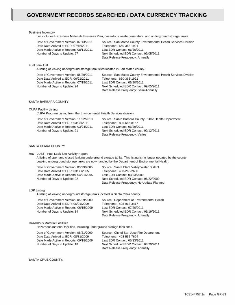
Business InventoryList includes Hazardous Materials Business Plan, hazardous waste generators, and underground storage tanks.
Date of Government Version: 07/13/2011Date Data Arrived at EDR: 07/15/2011Date Made Active in Reports: 08/11/2011Number of Days to Update: 27
Source: San Mateo County Environmental Health Services DivisionTelephone: 650-363-1921Last EDR Contact: 06/20/2011Next Scheduled EDR Contact: 09/05/2011Data Release Frequency: Annually
Fuel Leak ListA listing of leaking underground storage tank sites located in San Mateo county.
Date of Government Version: 06/20/2011Date Data Arrived at EDR: 06/21/2011Date Made Active in Reports: 07/15/2011Number of Days to Update: 24
Source: San Mateo County Environmental Health Services DivisionTelephone: 650-363-1921Last EDR Contact: 06/20/2011Next Scheduled EDR Contact: 09/05/2011Data Release Frequency: Semi-Annually
SANTA BARBARA COUNTY:
CUPA Facility ListingCUPA Program Listing from the Environmental Health Services division.
Date of Government Version: 11/22/2010Date Data Arrived at EDR: 03/03/2011Date Made Active in Reports: 03/24/2011Number of Days to Update: 21
Source: Santa Barbara County Public Health DepartmentTelephone: 805-686-8167Last EDR Contact: 06/29/2011Next Scheduled EDR Contact: 09/12/2011Data Release Frequency: Varies
SANTA CLARA COUNTY:
HIST LUST - Fuel Leak Site Activity ReportA listing of open and closed leaking underground storage tanks. This listing is no longer updated by the county.Leaking underground storage tanks are now handled by the Department of Environmental Health.
Date of Government Version: 03/29/2005Date Data Arrived at EDR: 03/30/2005Date Made Active in Reports: 04/21/2005Number of Days to Update: 22
Source: Santa Clara Valley Water DistrictTelephone: 408-265-2600Last EDR Contact: 03/23/2009Next Scheduled EDR Contact: 06/22/2009Data Release Frequency: No Update Planned
LOP ListingA listing of leaking underground storage tanks located in Santa Clara county.
Date of Government Version: 05/29/2009Date Data Arrived at EDR: 06/01/2009Date Made Active in Reports: 06/15/2009Number of Days to Update: 14
Source: Department of Environmental HealthTelephone: 408-918-3417Last EDR Contact: 07/20/2011Next Scheduled EDR Contact: 09/19/2011Data Release Frequency: Annually
Hazardous Material FacilitiesHazardous material facilities, including underground storage tank sites.
Date of Government Version: 08/31/2009Date Data Arrived at EDR: 08/31/2009Date Made Active in Reports: 09/18/2009Number of Days to Update: 18
Source: City of San Jose Fire DepartmentTelephone: 408-535-7694Last EDR Contact: 06/13/2011Next Scheduled EDR Contact: 08/29/2011Data Release Frequency: Annually
SANTA CRUZ COUNTY:
TC3144757.1s Page GR-33
GOVERNMENT RECORDS SEARCHED / DATA CURRENCY TRACKING

CUPA Facility ListCUPA facility listing.
Date of Government Version: 05/31/2011Date Data Arrived at EDR: 05/31/2011Date Made Active in Reports: 07/08/2011Number of Days to Update: 38
Source: Santa Cruz County Environmental HealthTelephone: 831-464-2761Last EDR Contact: 05/31/2011Next Scheduled EDR Contact: 09/12/2011Data Release Frequency: Varies
SHASTA COUNTY:
CUPA Facility ListCupa Facility List.
Date of Government Version: 05/31/2011Date Data Arrived at EDR: 05/31/2011Date Made Active in Reports: 07/08/2011Number of Days to Update: 38
Source: Shasta County Department of Resource ManagementTelephone: 530-225-5789Last EDR Contact: 05/31/2011Next Scheduled EDR Contact: 09/12/2011Data Release Frequency: Varies
SOLANO COUNTY:
Leaking Underground Storage TanksA listing of leaking underground storage tank sites located in Solano county.
Date of Government Version: 06/09/2011Date Data Arrived at EDR: 06/29/2011Date Made Active in Reports: 07/08/2011Number of Days to Update: 9
Source: Solano County Department of Environmental ManagementTelephone: 707-784-6770Last EDR Contact: 06/20/2011Next Scheduled EDR Contact: 09/05/2011Data Release Frequency: Quarterly
Underground Storage TanksUnderground storage tank sites located in Solano county.
Date of Government Version: 06/09/2011Date Data Arrived at EDR: 07/01/2011Date Made Active in Reports: 07/13/2011Number of Days to Update: 12
Source: Solano County Department of Environmental ManagementTelephone: 707-784-6770Last EDR Contact: 06/20/2011Next Scheduled EDR Contact: 09/05/2011Data Release Frequency: Quarterly
SONOMA COUNTY:
Leaking Underground Storage Tank SitesA listing of leaking underground storage tank sites located in Sonoma county.
Date of Government Version: 04/05/2011Date Data Arrived at EDR: 04/06/2011Date Made Active in Reports: 05/12/2011Number of Days to Update: 36
Source: Department of Health ServicesTelephone: 707-565-6565Last EDR Contact: 07/05/2011Next Scheduled EDR Contact: 10/17/2011Data Release Frequency: Quarterly
SUTTER COUNTY:
Underground Storage TanksUnderground storage tank sites located in Sutter county.
TC3144757.1s Page GR-34
GOVERNMENT RECORDS SEARCHED / DATA CURRENCY TRACKING

Date of Government Version: 06/13/2011Date Data Arrived at EDR: 06/14/2011Date Made Active in Reports: 07/13/2011Number of Days to Update: 29
Source: Sutter County Department of AgricultureTelephone: 530-822-7500Last EDR Contact: 06/13/2011Next Scheduled EDR Contact: 09/26/2011Data Release Frequency: Semi-Annually
VENTURA COUNTY:
Business Plan, Hazardous Waste Producers, and Operating Underground TanksThe BWT list indicates by site address whether the Environmental Health Division has Business Plan (B), WasteProducer (W), and/or Underground Tank (T) information.
Date of Government Version: 04/26/2011Date Data Arrived at EDR: 06/14/2011Date Made Active in Reports: 07/15/2011Number of Days to Update: 31
Source: Ventura County Environmental Health DivisionTelephone: 805-654-2813Last EDR Contact: 05/24/2011Next Scheduled EDR Contact: 09/05/2011Data Release Frequency: Quarterly
Inventory of Illegal Abandoned and Inactive SitesVentura County Inventory of Closed, Illegal Abandoned, and Inactive Sites.
Date of Government Version: 04/01/2011Date Data Arrived at EDR: 04/07/2011Date Made Active in Reports: 05/12/2011Number of Days to Update: 35
Source: Environmental Health DivisionTelephone: 805-654-2813Last EDR Contact: 08/01/2011Next Scheduled EDR Contact: 10/24/2011Data Release Frequency: Annually
Listing of Underground Tank Cleanup SitesVentura County Underground Storage Tank Cleanup Sites (LUST).
Date of Government Version: 05/29/2008Date Data Arrived at EDR: 06/24/2008Date Made Active in Reports: 07/31/2008Number of Days to Update: 37
Source: Environmental Health DivisionTelephone: 805-654-2813Last EDR Contact: 05/24/2011Next Scheduled EDR Contact: 09/05/2011Data Release Frequency: Quarterly
Medical Waste Program ListTo protect public health and safety and the environment from potential exposure to disease causing agents, theEnvironmental Health Division Medical Waste Program regulates the generation, handling, storage, treatment anddisposal of medical waste throughout the County.
Date of Government Version: 04/26/2011Date Data Arrived at EDR: 05/03/2011Date Made Active in Reports: 06/15/2011Number of Days to Update: 43
Source: Ventura County Resource Management AgencyTelephone: 805-654-2813Last EDR Contact: 08/01/2011Next Scheduled EDR Contact: 11/14/2011Data Release Frequency: Quarterly
Underground Tank Closed Sites ListVentura County Operating Underground Storage Tank Sites (UST)/Underground Tank Closed Sites List.
Date of Government Version: 05/25/2011Date Data Arrived at EDR: 06/21/2011Date Made Active in Reports: 07/13/2011Number of Days to Update: 22
Source: Environmental Health DivisionTelephone: 805-654-2813Last EDR Contact: 06/21/2011Next Scheduled EDR Contact: 10/03/2011Data Release Frequency: Quarterly
YOLO COUNTY:
TC3144757.1s Page GR-35
GOVERNMENT RECORDS SEARCHED / DATA CURRENCY TRACKING

Underground Storage Tank Comprehensive Facility ReportUnderground storage tank sites located in Yolo county.
Date of Government Version: 04/26/2011Date Data Arrived at EDR: 05/03/2011Date Made Active in Reports: 06/20/2011Number of Days to Update: 48
Source: Yolo County Department of HealthTelephone: 530-666-8646Last EDR Contact: 08/11/2011Next Scheduled EDR Contact: 10/24/2011Data Release Frequency: Annually
YUBA COUNTY:
CUPA Facility ListCUPA facility listing for Yuba County.
Date of Government Version: 12/31/2010Date Data Arrived at EDR: 05/12/2011Date Made Active in Reports: 06/15/2011Number of Days to Update: 34
Source: Yuba County Environmental Health DepartmentTelephone: 530-749-7523Last EDR Contact: 08/08/2011Next Scheduled EDR Contact: 11/21/2011Data Release Frequency: Varies
OTHER DATABASE(S)
Depending on the geographic area covered by this report, the data provided in these specialty databases may or may not becomplete. For example, the existence of wetlands information data in a specific report does not mean that all wetlands in thearea covered by the report are included. Moreover, the absence of any reported wetlands information does not necessarilymean that wetlands do not exist in the area covered by the report.
CT MANIFEST: Hazardous Waste Manifest DataFacility and manifest data. Manifest is a document that lists and tracks hazardous waste from the generator throughtransporters to a tsd facility.
Date of Government Version: 12/31/2007Date Data Arrived at EDR: 08/26/2009Date Made Active in Reports: 09/11/2009Number of Days to Update: 16
Source: Department of Environmental ProtectionTelephone: 860-424-3375Last EDR Contact: 05/26/2011Next Scheduled EDR Contact: 09/05/2011Data Release Frequency: Annually
NJ MANIFEST: Manifest InformationHazardous waste manifest information.
Date of Government Version: 12/31/2010Date Data Arrived at EDR: 07/20/2011Date Made Active in Reports: 08/11/2011Number of Days to Update: 22
Source: Department of Environmental ProtectionTelephone: N/ALast EDR Contact: 07/20/2011Next Scheduled EDR Contact: 10/31/2011Data Release Frequency: Annually
NY MANIFEST: Facility and Manifest DataManifest is a document that lists and tracks hazardous waste from the generator through transporters to a TSDfacility.
Date of Government Version: 12/31/2010Date Data Arrived at EDR: 05/12/2011Date Made Active in Reports: 05/24/2011Number of Days to Update: 12
Source: Department of Environmental ConservationTelephone: 518-402-8651Last EDR Contact: 08/09/2011Next Scheduled EDR Contact: 11/21/2011Data Release Frequency: Annually
TC3144757.1s Page GR-36
GOVERNMENT RECORDS SEARCHED / DATA CURRENCY TRACKING
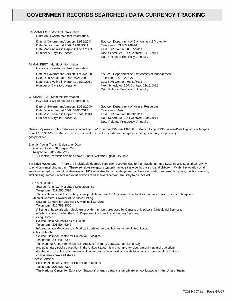
PA MANIFEST: Manifest InformationHazardous waste manifest information.
Date of Government Version: 12/31/2008Date Data Arrived at EDR: 12/01/2009Date Made Active in Reports: 12/14/2009Number of Days to Update: 13
Source: Department of Environmental ProtectionTelephone: 717-783-8990Last EDR Contact: 07/15/2011Next Scheduled EDR Contact: 10/10/2011Data Release Frequency: Annually
RI MANIFEST: Manifest informationHazardous waste manifest information
Date of Government Version: 12/31/2010Date Data Arrived at EDR: 06/24/2011Date Made Active in Reports: 06/30/2011Number of Days to Update: 6
Source: Department of Environmental ManagementTelephone: 401-222-2797Last EDR Contact: 05/31/2011Next Scheduled EDR Contact: 09/12/2011Data Release Frequency: Annually
WI MANIFEST: Manifest InformationHazardous waste manifest information.
Date of Government Version: 12/31/2009Date Data Arrived at EDR: 07/06/2010Date Made Active in Reports: 07/26/2010Number of Days to Update: 20
Source: Department of Natural ResourcesTelephone: N/ALast EDR Contact: 06/20/2011Next Scheduled EDR Contact: 10/03/2011Data Release Frequency: Annually
Oil/Gas Pipelines: This data was obtained by EDR from the USGS in 1994. It is referred to by USGS as GeoData Digital Line Graphsfrom 1:100,000-Scale Maps. It was extracted from the transportation category including some oil, but primarilygas pipelines.
Electric Power Transmission Line DataSource: Rextag Strategies Corp.Telephone: (281) 769-2247U.S. Electric Transmission and Power Plants Systems Digital GIS Data
Sensitive Receptors: There are individuals deemed sensitive receptors due to their fragile immune systems and special sensitivityto environmental discharges. These sensitive receptors typically include the elderly, the sick, and children. While the location of allsensitive receptors cannot be determined, EDR indicates those buildings and facilities - schools, daycares, hospitals, medical centers,and nursing homes - where individuals who are sensitive receptors are likely to be located.
AHA Hospitals:Source: American Hospital Association, Inc.Telephone: 312-280-5991The database includes a listing of hospitals based on the American Hospital Association’s annual survey of hospitals.
Medical Centers: Provider of Services ListingSource: Centers for Medicare & Medicaid ServicesTelephone: 410-786-3000A listing of hospitals with Medicare provider number, produced by Centers of Medicare & Medicaid Services,a federal agency within the U.S. Department of Health and Human Services.
Nursing HomesSource: National Institutes of HealthTelephone: 301-594-6248Information on Medicare and Medicaid certified nursing homes in the United States.
Public SchoolsSource: National Center for Education StatisticsTelephone: 202-502-7300The National Center for Education Statistics’ primary database on elementaryand secondary public education in the United States. It is a comprehensive, annual, national statisticaldatabase of all public elementary and secondary schools and school districts, which contains data that arecomparable across all states.
Private SchoolsSource: National Center for Education StatisticsTelephone: 202-502-7300The National Center for Education Statistics’ primary database on private school locations in the United States.
TC3144757.1s Page GR-37
GOVERNMENT RECORDS SEARCHED / DATA CURRENCY TRACKING
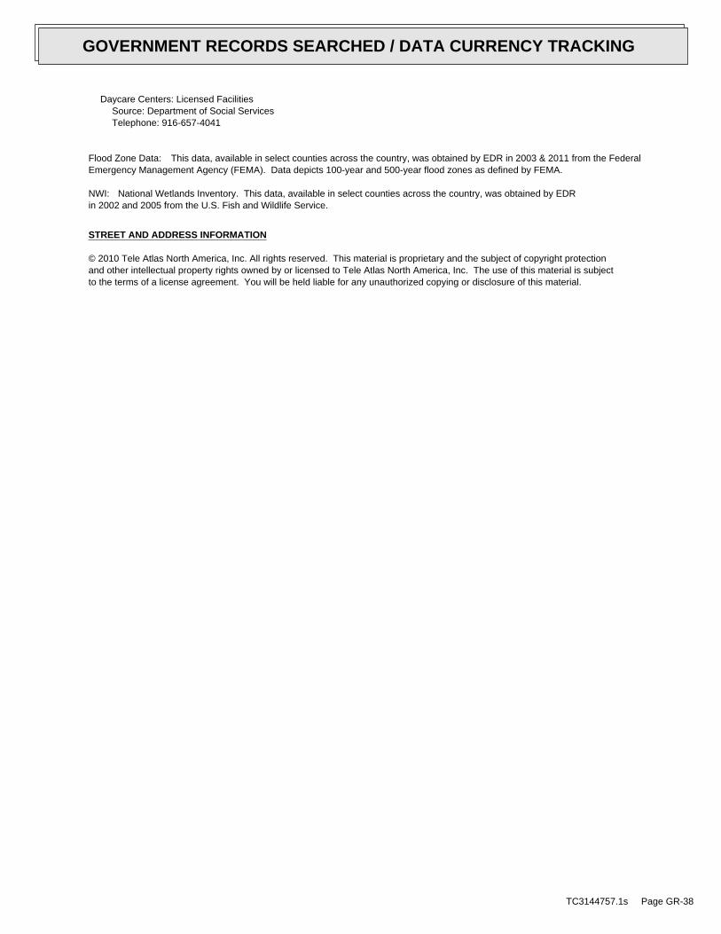
Daycare Centers: Licensed FacilitiesSource: Department of Social ServicesTelephone: 916-657-4041
Flood Zone Data: This data, available in select counties across the country, was obtained by EDR in 2003 & 2011 from the FederalEmergency Management Agency (FEMA). Data depicts 100-year and 500-year flood zones as defined by FEMA.
NWI: National Wetlands Inventory. This data, available in select counties across the country, was obtained by EDRin 2002 and 2005 from the U.S. Fish and Wildlife Service.
STREET AND ADDRESS INFORMATION
© 2010 Tele Atlas North America, Inc. All rights reserved. This material is proprietary and the subject of copyright protectionand other intellectual property rights owned by or licensed to Tele Atlas North America, Inc. The use of this material is subjectto the terms of a license agreement. You will be held liable for any unauthorized copying or disclosure of this material.
TC3144757.1s Page GR-38
GOVERNMENT RECORDS SEARCHED / DATA CURRENCY TRACKING

TC3144757.1s Page A-1
geologic strata.of the soil, and nearby wells. Groundwater flow velocity is generally impacted by the nature of theGroundwater flow direction may be impacted by surface topography, hydrology, hydrogeology, characteristics
2. Groundwater flow velocity. 1. Groundwater flow direction, and
Assessment of the impact of contaminant migration generally has two principle investigative components:
forming an opinion about the impact of potential contaminant migration.EDR’s GeoCheck Physical Setting Source Addendum is provided to assist the environmental professional in
1988Most Recent Revision:34119-D1 SANTA PAULA PEAK, CANorth Map:
1967Most Recent Revision:34119-C1 SANTA PAULA, CATarget Property Map:
USGS TOPOGRAPHIC MAP
297 ft. above sea levelElevation:3803694.0UTM Y (Meters): 311965.4UTM X (Meters): Zone 11Universal Tranverse Mercator: 119.0446 - 119˚ 2’ 40.6’’Longitude (West): 34.35930 - 34˚ 21’ 33.5’’Latitude (North):
TARGET PROPERTY COORDINATES
SANTA PAULA, CA 93060EAST TELEGRAPH ROAD/SOUTH HALLOCK DRIVEEAST AREA 2
TARGET PROPERTY ADDRESS
®GEOCHECK - PHYSICAL SETTING SOURCE ADDENDUM®

TC3144757.1s Page A-2
should be field verified.on a relative (not an absolute) basis. Relative elevation information between sites of close proximitySource: Topography has been determined from the USGS 7.5’ Digital Elevation Model and should be evaluated
SURROUNDING TOPOGRAPHY: ELEVATION PROFILES
Ele
vatio
n (f
t)E
leva
tion
(ft)
TP
TP0 1/2 1 Miles
✩Target Property Elevation: 297 ft.
North South
West East
375
361
255
254
263
261
270
281
282
297
309
321
326
330
340
373
414
482
595320
322
316
313
312
309
314
309
303
297
295
291
288
282
278
278
278
279
280
General SSEGeneral Topographic Gradient:TARGET PROPERTY TOPOGRAPHY
should contamination exist on the target property, what downgradient sites might be impacted.assist the environmental professional in forming an opinion about the impact of nearby contaminated properties or,Surface topography may be indicative of the direction of surficial groundwater flow. This information can be used toTOPOGRAPHIC INFORMATION
collected on nearby properties, and regional groundwater flow information (from deep aquifers).sources of information, such as surface topographic information, hydrologic information, hydrogeologic datausing site-specific well data. If such data is not reasonably ascertainable, it may be necessary to rely on otherGroundwater flow direction for a particular site is best determined by a qualified environmental professionalGROUNDWATER FLOW DIRECTION INFORMATION
®GEOCHECK - PHYSICAL SETTING SOURCE SUMMARY®

TC3144757.1s Page A-3
Not Reported
GENERAL DIRECTIONLOCATIONGROUNDWATER FLOWFROM TPMAP ID
hydrogeologically, and the depth to water table.authorities at select sites and has extracted the date of the report, groundwater flow direction as determinedflow at specific points. EDR has reviewed reports submitted by environmental professionals to regulatoryEDR has developed the AQUIFLOW Information System to provide data on the general direction of groundwater
AQUIFLOW®
Search Radius: 1.000 Mile.
* ©1996 Site−specific hydrogeological data gathered by CERCLIS Alerts, Inc., Bainbridge Island, WA. All rights reserved. All of the information and opinions presented are those of the cited EPA report(s), which were completed undera Comprehensive Environmental Response Compensation and Liability Information System (CERCLIS) investigation.
Information is inferred in the CERCLIS investigation report(s) Data Quality:No information about a sole source aquifer is available Sole Source Aquifer:feet.interbedded with the sand and gravel deposits at depths below 100gravel, and cobbles to a depth of at least 540 feet. Clay deposits areThe site is located in an alluvial valley that consists of sand, Hydraulic Connection:54 feet to 105 feet in the site vicinity. Measured Depth to Water:Southwest Groundwater Flow Direction:CAT080018666 Site EPA ID Number:Agri Serv Inc Site Name:1/4 - 1/2 Mile WSW Location Relative to TP:1.25 miles Search Radius:
Site-Specific Hydrogeological Data*:
* ©1996 Site−specific hydrogeological data gathered by CERCLIS Alerts, Inc., Bainbridge Island, WA. All rights reserved. All of the information and opinions presented are those of the cited EPA report(s), which were completed undera Comprehensive Environmental Response Compensation and Liability Information System (CERCLIS) investigation.
contamination exist on the target property, what downgradient sites might be impacted.environmental professional in forming an opinion about the impact of nearby contaminated properties or, shouldof groundwater flow direction in the immediate area. Such hydrogeologic information can be used to assist theHydrogeologic information obtained by installation of wells on a specific site can often be an indicatorHYDROGEOLOGIC INFORMATION
YES - refer to the Overview Map and Detail MapSANTA PAULA
NATIONAL WETLAND INVENTORYNWI ElectronicData CoverageNWI Quad at Target Property
Not ReportedAdditional Panels in search area:
06111C - FEMA DFIRM Flood dataFlood Plain Panel at Target Property:
YES - refer to the Overview Map and Detail MapVENTURA, CA
FEMA FLOOD ZONEFEMA FloodElectronic DataTarget Property County
and bodies of water).Refer to the Physical Setting Source Map following this summary for hydrologic information (major waterways
contamination exist on the target property, what downgradient sites might be impacted.the environmental professional in forming an opinion about the impact of nearby contaminated properties or, shouldSurface water can act as a hydrologic barrier to groundwater flow. Such hydrologic information can be used to assistHYDROLOGIC INFORMATION
®GEOCHECK - PHYSICAL SETTING SOURCE SUMMARY®
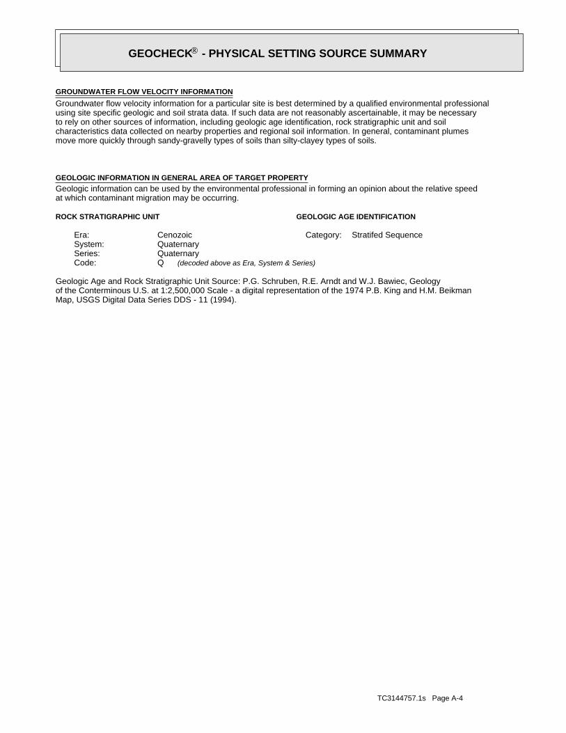
TC3144757.1s Page A-4
Map, USGS Digital Data Series DDS - 11 (1994).of the Conterminous U.S. at 1:2,500,000 Scale - a digital representation of the 1974 P.B. King and H.M. BeikmanGeologic Age and Rock Stratigraphic Unit Source: P.G. Schruben, R.E. Arndt and W.J. Bawiec, Geology
ROCK STRATIGRAPHIC UNIT GEOLOGIC AGE IDENTIFICATION
Stratifed SequenceCategory:CenozoicEra:QuaternarySystem:QuaternarySeries:QCode: (decoded above as Era, System & Series)
at which contaminant migration may be occurring.Geologic information can be used by the environmental professional in forming an opinion about the relative speedGEOLOGIC INFORMATION IN GENERAL AREA OF TARGET PROPERTY
move more quickly through sandy-gravelly types of soils than silty-clayey types of soils.characteristics data collected on nearby properties and regional soil information. In general, contaminant plumesto rely on other sources of information, including geologic age identification, rock stratigraphic unit and soilusing site specific geologic and soil strata data. If such data are not reasonably ascertainable, it may be necessaryGroundwater flow velocity information for a particular site is best determined by a qualified environmental professionalGROUNDWATER FLOW VELOCITY INFORMATION
®GEOCHECK - PHYSICAL SETTING SOURCE SUMMARY®

EDR Inc.EDR Inc.EDR Inc.EDR Inc.EDR Inc.EDR Inc.EDR Inc.EDR Inc.EDR Inc.EDR Inc.EDR Inc.EDR Inc.EDR Inc.EDR Inc.EDR Inc.EDR Inc.EDR Inc.EDR Inc.EDR Inc.EDR Inc.EDR Inc.EDR Inc.EDR Inc.EDR Inc.EDR Inc.EDR Inc.EDR Inc.EDR Inc.EDR Inc.EDR Inc.EDR Inc.EDR Inc.EDR Inc.EDR Inc.EDR Inc.EDR Inc.EDR Inc.EDR Inc.EDR Inc.EDR Inc.
4
2
4
1
5
3
0 1/16 1/8 1/4 Miles

TC3144757.1s Page A-6
Well drainedSoil Drainage Class:
textures.moderately well and well drained soils with moderately coarseClass B - Moderate infiltration rates. Deep and moderately deep,Hydrologic Group:
sandy loamSoil Surface Texture:
PICOSoil Component Name:
Soil Map ID: 2
Min: 7.9Max: 8.4
Min: 4Max: 14
50%), Lean Claylimit less thanClays (liquidSOILS, Silts andFINE-GRAINED
Soils.200), Siltypassing No.than 35 pct.Materials (moreSilt-Claygravelly loam59 inches16 inches 2
Min: 7.9Max: 8.4
Min: 4Max: 14
50%), Lean Claylimit less thanClays (liquidSOILS, Silts andFINE-GRAINED
Soils.200), Siltypassing No.than 35 pct.Materials (moreSilt-Claygravelly loam16 inches 0 inches 1
Soil Layer Information
Boundary Classification Saturatedhydraulicconductivitymicro m/sec
Layer Upper Lower Soil Texture Class AASHTO Group Unified Soil Soil Reaction(pH)
> 0 inchesDepth to Watertable Min:
> 0 inchesDepth to Bedrock Min:
HighCorrosion Potential - Uncoated Steel:
Hydric Status: Not hydric
Well drainedSoil Drainage Class:
textures.moderately well and well drained soils with moderately coarseClass B - Moderate infiltration rates. Deep and moderately deep,Hydrologic Group:
gravelly loamSoil Surface Texture:
MOCHOSoil Component Name:
Soil Map ID: 1
in a landscape. The following information is based on Soil Conservation Service SSURGO data.for privately owned lands in the United States. A soil map in a soil survey is a representation of soil patternsSurvey (NCSS) and is responsible for collecting, storing, maintaining and distributing soil survey informationThe U.S. Department of Agriculture’s (USDA) Soil Conservation Service (SCS) leads the National Cooperative Soil
DOMINANT SOIL COMPOSITION IN GENERAL AREA OF TARGET PROPERTY
®GEOCHECK - PHYSICAL SETTING SOURCE SUMMARY®
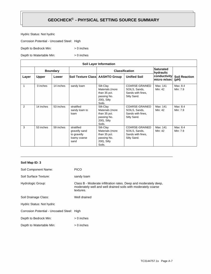
TC3144757.1s Page A-7
> 0 inchesDepth to Watertable Min:
> 0 inchesDepth to Bedrock Min:
HighCorrosion Potential - Uncoated Steel:
Hydric Status: Not hydric
Well drainedSoil Drainage Class:
textures.moderately well and well drained soils with moderately coarseClass B - Moderate infiltration rates. Deep and moderately deep,Hydrologic Group:
sandy loamSoil Surface Texture:
PICOSoil Component Name:
Soil Map ID: 3
Min: 7.9Max: 8.4
Min: 42Max: 141
Silty Sand.Sands with fines,SOILS, Sands,COARSE-GRAINED
Soils.200), Siltypassing No.than 35 pct.Materials (moreSilt-Clay
sandloamy coarseto gravellygravelly sandstratified59 inches53 inches 3
Min: 7.9Max: 8.4
Min: 42Max: 141
Silty Sand.Sands with fines,SOILS, Sands,COARSE-GRAINED
Soils.200), Siltypassing No.than 35 pct.Materials (moreSilt-Clay
loamsandy loam tostratified53 inches14 inches 2
Min: 7.9Max: 8.4
Min: 42Max: 141
Silty Sand.Sands with fines,SOILS, Sands,COARSE-GRAINED
Soils.200), Siltypassing No.than 35 pct.Materials (moreSilt-Claysandy loam14 inches 0 inches 1
Soil Layer Information
Boundary Classification Saturatedhydraulicconductivitymicro m/sec
Layer Upper Lower Soil Texture Class AASHTO Group Unified Soil Soil Reaction(pH)
> 0 inchesDepth to Watertable Min:
> 0 inchesDepth to Bedrock Min:
HighCorrosion Potential - Uncoated Steel:
Hydric Status: Not hydric
®GEOCHECK - PHYSICAL SETTING SOURCE SUMMARY®

TC3144757.1s Page A-8
> 0 inchesDepth to Watertable Min:
> 0 inchesDepth to Bedrock Min:
LowCorrosion Potential - Uncoated Steel:
Hydric Status: Partially hydric
Somewhat excessively drainedSoil Drainage Class:
textures.moderately well and well drained soils with moderately coarseClass B - Moderate infiltration rates. Deep and moderately deep,Hydrologic Group:
stony sandy loamSoil Surface Texture:
CortinaSoil Component Name:
Soil Map ID: 4
Min: 7.9Max: 8.4
Min: 42Max: 141
Silty Sand.Sands with fines,SOILS, Sands,COARSE-GRAINED
Soils.200), Siltypassing No.than 35 pct.Materials (moreSilt-Clay
sandloamy coarseto gravellygravelly sandstratified59 inches53 inches 3
Min: 7.9Max: 8.4
Min: 42Max: 141
Silty Sand.Sands with fines,SOILS, Sands,COARSE-GRAINED
Soils.200), Siltypassing No.than 35 pct.Materials (moreSilt-Clay
loamsandy loam tostratified53 inches14 inches 2
Min: 7.9Max: 8.4
Min: 42Max: 141
Silty Sand.Sands with fines,SOILS, Sands,COARSE-GRAINED
Soils.200), Siltypassing No.than 35 pct.Materials (moreSilt-Claysandy loam14 inches 0 inches 1
Soil Layer Information
Boundary Classification Saturatedhydraulicconductivitymicro m/sec
Layer Upper Lower Soil Texture Class AASHTO Group Unified Soil Soil Reaction(pH)
®GEOCHECK - PHYSICAL SETTING SOURCE SUMMARY®
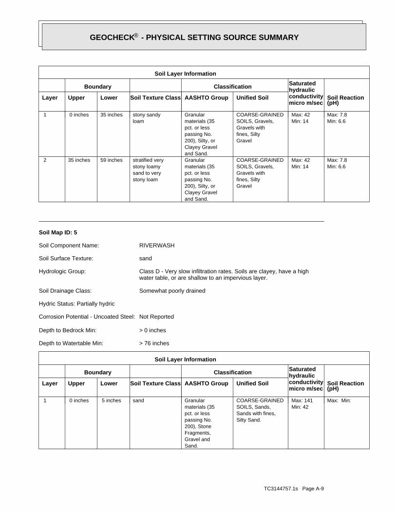
TC3144757.1s Page A-9
Max: Min: Min: 42Max: 141
Silty Sand.Sands with fines,SOILS, Sands,COARSE-GRAINED
Sand.Gravel andFragments,200), Stonepassing No.pct. or lessmaterials (35Granularsand 5 inches 0 inches 1
Soil Layer Information
Boundary Classification Saturatedhydraulicconductivitymicro m/sec
Layer Upper Lower Soil Texture Class AASHTO Group Unified Soil Soil Reaction(pH)
> 76 inchesDepth to Watertable Min:
> 0 inchesDepth to Bedrock Min:
Not ReportedCorrosion Potential - Uncoated Steel:
Hydric Status: Partially hydric
Somewhat poorly drainedSoil Drainage Class:
water table, or are shallow to an impervious layer.Class D - Very slow infiltration rates. Soils are clayey, have a highHydrologic Group:
sandSoil Surface Texture:
RIVERWASHSoil Component Name:
Soil Map ID: 5
Min: 6.6Max: 7.8
Min: 14Max: 42
Gravelfines, SiltyGravels withSOILS, Gravels,COARSE-GRAINED
and Sand.Clayey Gravel200), Silty, orpassing No.pct. or lessmaterials (35Granular
stony loamsand to verystony loamystratified very59 inches35 inches 2
Min: 6.6Max: 7.8
Min: 14Max: 42
Gravelfines, SiltyGravels withSOILS, Gravels,COARSE-GRAINED
and Sand.Clayey Gravel200), Silty, orpassing No.pct. or lessmaterials (35Granular
loamstony sandy35 inches 0 inches 1
Soil Layer Information
Boundary Classification Saturatedhydraulicconductivitymicro m/sec
Layer Upper Lower Soil Texture Class AASHTO Group Unified Soil Soil Reaction(pH)
®GEOCHECK - PHYSICAL SETTING SOURCE SUMMARY®

TC3144757.1s Page A-10
1/2 - 1 Mile WSWCA5601111 26
FEDERAL FRDS PUBLIC WATER SUPPLY SYSTEM INFORMATION
LOCATIONFROM TPWELL IDMAP ID
1/2 - 1 Mile EastUSGS3171031 291/2 - 1 Mile WNWUSGS3171033 H241/2 - 1 Mile WestUSGS3171032 G201/2 - 1 Mile WestUSGS3171030 F181/4 - 1/2 Mile EastUSGS3171029 C101/4 - 1/2 Mile ESEUSGS3171028 B81/4 - 1/2 Mile ESEUSGS3171027 B61/8 - 1/4 Mile SSWUSGS3171026 A4
FEDERAL USGS WELL INFORMATION
LOCATIONFROM TPWELL IDMAP ID
1.000State DatabaseNearest PWS within 1 mileFederal FRDS PWS1.000Federal USGS
WELL SEARCH DISTANCE INFORMATION
SEARCH DISTANCE (miles)DATABASE
opinion about the impact of contaminant migration on nearby drinking water wells.professional in assessing sources that may impact ground water flow direction, and in forming anEDR Local/Regional Water Agency records provide water well information to assist the environmental
LOCAL / REGIONAL WATER AGENCY RECORDS
Max: Min: Min: 42Max: 141
Silty Sand.Sands with fines,SOILS, Sands,COARSE-GRAINED
Sand.Gravel andFragments,200), Stonepassing No.pct. or lessmaterials (35Granular
sandy loamcoarse sand tostratified59 inches 5 inches 2
Soil Layer Information
Boundary Classification Saturatedhydraulicconductivitymicro m/sec
Layer Upper Lower Soil Texture Class AASHTO Group Unified Soil Soil Reaction(pH)
®GEOCHECK - PHYSICAL SETTING SOURCE SUMMARY®

TC3144757.1s Page A-11
1/2 - 1 Mile SECAOG70000037186 F191/2 - 1 Mile SECAOG70000037355 D181/2 - 1 Mile SECAOG70000037335 D171/2 - 1 Mile SSECAOG70000037022 E161/2 - 1 Mile SSECAOG70000037029 E151/2 - 1 Mile SECAOG70000037356 D141/2 - 1 Mile SSECAOG70000037028 A131/2 - 1 Mile SSWCAOG70000037038 C121/2 - 1 Mile SouthCAOG70000037021 B111/2 - 1 Mile SouthCAOG70000037027 B101/2 - 1 Mile SouthCAOG70000037025 B91/2 - 1 Mile SouthCAOG70000037033 B81/2 - 1 Mile SSWCAOG70000037118 71/2 - 1 Mile SSECAOG70000037111 A61/2 - 1 Mile NNWCAOG70000038160 51/2 - 1 Mile SouthCAOG70000037081 A41/2 - 1 Mile SouthCAOG70000037097 A31/2 - 1 Mile SWCAOG70000037380 21/4 - 1/2 Mile SECAOG70000037487 1
STATE OIL/GAS WELL INFORMATION
LOCATIONFROM TPWELL IDMAP ID
OTHER STATE DATABASE INFORMATION
1/2 - 1 Mile EastCADW40000007960 281/2 - 1 Mile NECADW40000007981 271/2 - 1 Mile SWCADW40000007918 251/2 - 1 Mile WNW3419 H231/2 - 1 Mile West3420 G221/2 - 1 Mile WNWCADW40000007963 H211/2 - 1 Mile NECADW40000007971 191/2 - 1 Mile NWCADW40000007974 E171/2 - 1 Mile West3421 F161/2 - 1 Mile ESECADW40000007935 151/2 - 1 Mile NW3413 E141/4 - 1/2 Mile NNECADW40000007977 D131/4 - 1/2 Mile EastCADW40000007947 C121/4 - 1/2 Mile NNECADW40000007975 D111/4 - 1/2 Mile NWCADW40000007966 91/4 - 1/2 Mile ESECADW40000007941 B71/8 - 1/4 Mile SSWCADW40000007938 A51/8 - 1/4 Mile EastCADW40000007948 30 - 1/8 Mile NWCADW40000007953 20 - 1/8 Mile ENE3422 1
STATE DATABASE WELL INFORMATION
LOCATIONFROM TPWELL IDMAP ID
Note: PWS System location is not always the same as well location.
FEDERAL FRDS PUBLIC WATER SUPPLY SYSTEM INFORMATION
LOCATIONFROM TPWELL IDMAP ID
®GEOCHECK - PHYSICAL SETTING SOURCE SUMMARY®

TC3144757.1s Page A-12
1/2 - 1 Mile SouthCAOG70000036913 261/2 - 1 Mile SouthCAOG70000036927 G251/2 - 1 Mile SouthCAOG70000036929 G241/2 - 1 Mile SECAOG70000037187 F231/2 - 1 Mile SSWCAOG70000036961 C221/2 - 1 Mile SSWCAOG70000036965 C211/2 - 1 Mile SECAOG70000037338 D20
STATE OIL/GAS WELL INFORMATION
LOCATIONFROM TPWELL IDMAP ID
®GEOCHECK - PHYSICAL SETTING SOURCE SUMMARY®

EDR Inc.EDR Inc.EDR Inc.EDR Inc.EDR Inc.EDR Inc.EDR Inc.EDR Inc.EDR Inc.EDR Inc.EDR Inc.EDR Inc.EDR Inc.EDR Inc.EDR Inc.EDR Inc.EDR Inc.EDR Inc.EDR Inc.EDR Inc.EDR Inc.EDR Inc.EDR Inc.EDR Inc.EDR Inc.EDR Inc.EDR Inc.EDR Inc.EDR Inc.EDR Inc.EDR Inc.EDR Inc.EDR Inc.EDR Inc.EDR Inc.EDR Inc.EDR Inc.EDR Inc.EDR Inc.EDR Inc.
80
0
1 0 009 6 0
76
0
4 40 72
0
8 80
8
84
0
80
80
0 8 0 0
76
76
0
7 6 0
4 4 0
4 8 0
4 8 0
52
0
5 2 0
5 6 0
60 0
6 4 0
6 8 0
6 80
56
0
60
06
40
68
0
72 0
72
0
72
0 72
0
640
68
0
68
0
6 40
6
4 0
600
6 00
60
0
56
0
5 60
5 20
5 2 04 8 0
4 8 0
4 4 0 4
4 0
4 0 0
6 806 40
64
0 4 0 07
20
6
40
68
0
64
0
60
0
60
0
56
0
5 60
56
052
0
5 2 0
48
0
4 8 0
44
0 4 4 0
840
80
07
60
72
0
68
06
40
60
0
600
56
0
52
0
52
0
48
0
2 8 0
600
60
0
76
5605
20 6 40
6
00
760 720
68
0
840 8 00
5 60
44
0
44
0
4 0 0
40
0
4 0 0
3 6 0360
3 6 0
3 6 0
360
3 2 03 2 0
3 2 0
3 2 0
1 2 0
1
1 6
1 1 2 0
1 08
01
04
0
10
1 00
0
10
0
96
0
9 6 0
9 2 08 8 0 84
0
84
0
80
0
80
0
8 0 0
7
7 6 0
7 6 0
72
0
7 2 0
72
0
68
0
6
8 0
68
0
64
0
64
0
64
0
6 4 0
64 0
6 4 0
6 0 0
60
0
60
0
6 0 0
6 0 0
60 0
6 00
5
60
56
0
5 60
56
0
5 6 0
56
0
56 0
5
5 6 0
5 20
5 2 0
52
0
5 2 0
5 2 0
52
0
5 2 0
4 8 0
48
0
4 8 0
4 80
48
0
4
48
4 4 0
4 4 0
4 4 0
4 4 0
44 04
40
0
4 0 04 0 0
4 0 0
4 0 0
40 04
00
0
2 4 0
2 8 02 8 0
2 8 0
2 8 0
2 8 0
2 8 0
2 8 0
28
0
3 2 0
3 2 0
32
0
3 6 03 6 0
3 6 0
36 0
3 6 0
36
0
CA
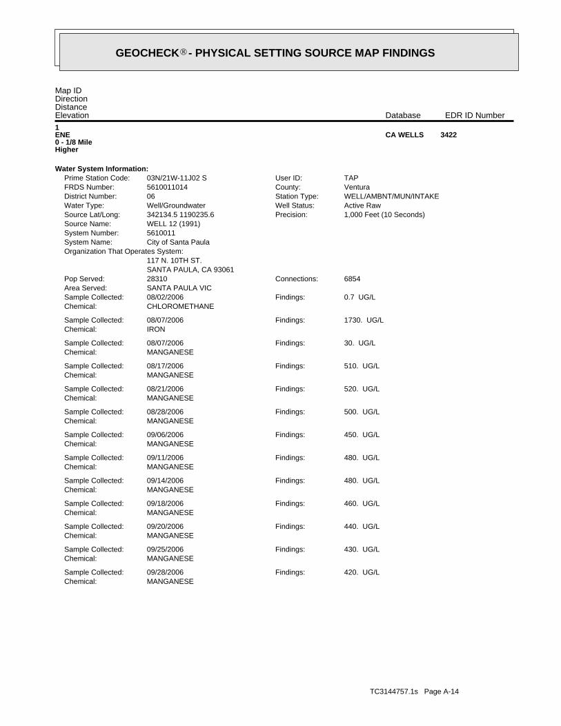
TC3144757.1s Page A-14
MANGANESEChemical:420. UG/LFindings:09/28/2006Sample Collected:
MANGANESEChemical:430. UG/LFindings:09/25/2006Sample Collected:
MANGANESEChemical:440. UG/LFindings:09/20/2006Sample Collected:
MANGANESEChemical:460. UG/LFindings:09/18/2006Sample Collected:
MANGANESEChemical:480. UG/LFindings:09/14/2006Sample Collected:
MANGANESEChemical:480. UG/LFindings:09/11/2006Sample Collected:
MANGANESEChemical:450. UG/LFindings:09/06/2006Sample Collected:
MANGANESEChemical:500. UG/LFindings:08/28/2006Sample Collected:
MANGANESEChemical:520. UG/LFindings:08/21/2006Sample Collected:
MANGANESEChemical:510. UG/LFindings:08/17/2006Sample Collected:
MANGANESEChemical:30. UG/LFindings:08/07/2006Sample Collected:
IRONChemical:1730. UG/LFindings:08/07/2006Sample Collected:
CHLOROMETHANEChemical:0.7 UG/LFindings:08/02/2006Sample Collected:
SANTA PAULA VICArea Served:6854Connections:28310Pop Served:
SANTA PAULA, CA 93061117 N. 10TH ST.
Organization That Operates System:City of Santa PaulaSystem Name:5610011System Number:WELL 12 (1991)Source Name:
1,000 Feet (10 Seconds)Precision:342134.5 1190235.6Source Lat/Long:Active RawWell Status:Well/GroundwaterWater Type:WELL/AMBNT/MUN/INTAKEStation Type:06District Number:VenturaCounty:5610011014FRDS Number:TAPUser ID:03N/21W-11J02 SPrime Station Code:
Water System Information:
1ENE0 - 1/8 MileHigher
3422CA WELLS
Map IDDirectionDistanceElevation EDR ID NumberDatabase
®GEOCHECK - PHYSICAL SETTING SOURCE MAP FINDINGS®

TC3144757.1s Page A-15
MANGANESEChemical:420. UG/LFindings:11/06/2006Sample Collected:
BORONChemical:710. UG/LFindings:11/06/2006Sample Collected:
FLUORIDE (F) (NATURAL-SOURCE)Chemical:0.5 MG/LFindings:11/06/2006Sample Collected:
CHLORIDEChemical:43. MG/LFindings:11/06/2006Sample Collected:
POTASSIUMChemical:5. MG/LFindings:11/06/2006Sample Collected:
SODIUMChemical:108. MG/LFindings:11/06/2006Sample Collected:
MAGNESIUMChemical:48. MG/LFindings:11/06/2006Sample Collected:
CALCIUMChemical:139. MG/LFindings:11/06/2006Sample Collected:
HARDNESS (TOTAL) AS CACO3Chemical:544. MG/LFindings:11/06/2006Sample Collected:
BICARBONATE ALKALINITYChemical:270. MG/LFindings:11/06/2006Sample Collected:
ALKALINITY (TOTAL) AS CACO3Chemical:220. MG/LFindings:11/06/2006Sample Collected:
PH, LABORATORYChemical:7.6Findings:11/06/2006Sample Collected:
SPECIFIC CONDUCTANCEChemical:1360. USFindings:11/06/2006Sample Collected:
COLORChemical:5. UNITSFindings:11/06/2006Sample Collected:
MANGANESEChemical:380. UG/LFindings:10/30/2006Sample Collected:
MANGANESEChemical:390. UG/LFindings:10/23/2006Sample Collected:
MANGANESEChemical:420. UG/LFindings:10/16/2006Sample Collected:
MANGANESEChemical:320. UG/LFindings:10/12/2006Sample Collected:
CHLORIDEChemical:45. MG/LFindings:10/12/2006Sample Collected:
MANGANESEChemical:450. UG/LFindings:10/09/2006Sample Collected:
MANGANESEChemical:350. UG/LFindings:10/04/2006Sample Collected:
MANGANESEChemical:450. UG/LFindings:10/02/2006Sample Collected:
®GEOCHECK - PHYSICAL SETTING SOURCE MAP FINDINGS®

TC3144757.1s Page A-16
MANGANESEChemical:390. UG/LFindings:04/03/2007Sample Collected:
MANGANESEChemical:350. UG/LFindings:03/26/2007Sample Collected:
MANGANESEChemical:380. UG/LFindings:03/18/2007Sample Collected:
MANGANESEChemical:380. UG/LFindings:03/11/2007Sample Collected:
MANGANESEChemical:340. UG/LFindings:03/05/2007Sample Collected:
MANGANESEChemical:360. UG/LFindings:02/26/2007Sample Collected:
MANGANESEChemical:350. UG/LFindings:02/05/2007Sample Collected:
MANGANESEChemical:320. UG/LFindings:01/30/2007Sample Collected:
MANGANESEChemical:390. UG/LFindings:12/18/2006Sample Collected:
IRONChemical:110. UG/LFindings:12/18/2006Sample Collected:
MANGANESEChemical:390. UG/LFindings:12/10/2006Sample Collected:
MANGANESEChemical:410. UG/LFindings:12/04/2006Sample Collected:
MANGANESEChemical:450. UG/LFindings:11/27/2006Sample Collected:
MANGANESEChemical:410. UG/LFindings:11/20/2006Sample Collected:
MANGANESEChemical:390. UG/LFindings:11/13/2006Sample Collected:
MANGANESEChemical:420. UG/LFindings:11/06/2006Sample Collected:
NITRATE + NITRITE (AS N)Chemical:1900. UG/LFindings:11/06/2006Sample Collected:
AGGRSSIVE INDEX (CORROSIVITY)Chemical:12.5Findings:11/06/2006Sample Collected:
NITRATE (AS NO3)Chemical:8.4 MG/LFindings:11/06/2006Sample Collected:
LANGELIER INDEX AT SOURCE TEMP.Chemical:0.6Findings:11/06/2006Sample Collected:
TOTAL DISSOLVED SOLIDSChemical:1030. MG/LFindings:11/06/2006Sample Collected:
SELENIUMChemical:6. UG/LFindings:11/06/2006Sample Collected:
®GEOCHECK - PHYSICAL SETTING SOURCE MAP FINDINGS®

TC3144757.1s Page A-17
TOTAL DISSOLVED SOLIDSChemical:1000. MG/LFindings:05/24/2007Sample Collected:
MANGANESEChemical:390. UG/LFindings:05/24/2007Sample Collected:
BORONChemical:670. UG/LFindings:05/24/2007Sample Collected:
FLUORIDE (F) (NATURAL-SOURCE)Chemical:0.6 MG/LFindings:05/24/2007Sample Collected:
CHLORIDEChemical:40. MG/LFindings:05/24/2007Sample Collected:
POTASSIUMChemical:5. MG/LFindings:05/24/2007Sample Collected:
SODIUMChemical:100. MG/LFindings:05/24/2007Sample Collected:
MAGNESIUMChemical:45. MG/LFindings:05/24/2007Sample Collected:
CALCIUMChemical:143. MG/LFindings:05/24/2007Sample Collected:
HARDNESS (TOTAL) AS CACO3Chemical:542. MG/LFindings:05/24/2007Sample Collected:
BICARBONATE ALKALINITYChemical:270. MG/LFindings:05/24/2007Sample Collected:
ALKALINITY (TOTAL) AS CACO3Chemical:220. MG/LFindings:05/24/2007Sample Collected:
PH, LABORATORYChemical:6.9Findings:05/24/2007Sample Collected:
SPECIFIC CONDUCTANCEChemical:1340. USFindings:05/24/2007Sample Collected:
COLORChemical:5. UNITSFindings:05/24/2007Sample Collected:
MANGANESEChemical:380. UG/LFindings:05/21/2007Sample Collected:
MANGANESEChemical:370. UG/LFindings:05/14/2007Sample Collected:
MANGANESEChemical:380. UG/LFindings:05/07/2007Sample Collected:
MANGANESEChemical:360. UG/LFindings:05/02/2007Sample Collected:
MANGANESEChemical:360. UG/LFindings:04/23/2007Sample Collected:
MANGANESEChemical:370. UG/LFindings:04/16/2007Sample Collected:
MANGANESEChemical:360. UG/LFindings:04/10/2007Sample Collected:
®GEOCHECK - PHYSICAL SETTING SOURCE MAP FINDINGS®

TC3144757.1s Page A-18
MANGANESEChemical:380. UG/LFindings:09/25/2007Sample Collected:
MANGANESEChemical:360. UG/LFindings:09/17/2007Sample Collected:
MANGANESEChemical:380. UG/LFindings:09/11/2007Sample Collected:
MANGANESEChemical:370. UG/LFindings:09/05/2007Sample Collected:
MANGANESEChemical:370. UG/LFindings:08/28/2007Sample Collected:
MANGANESEChemical:370. UG/LFindings:08/20/2007Sample Collected:
MANGANESEChemical:360. UG/LFindings:08/13/2007Sample Collected:
MANGANESEChemical:360. UG/LFindings:08/07/2007Sample Collected:
MANGANESEChemical:370. UG/LFindings:07/30/2007Sample Collected:
MANGANESEChemical:360. UG/LFindings:07/24/2007Sample Collected:
MANGANESEChemical:360. UG/LFindings:07/16/2007Sample Collected:
MANGANESEChemical:370. UG/LFindings:07/09/2007Sample Collected:
MANGANESEChemical:390. UG/LFindings:07/02/2007Sample Collected:
MANGANESEChemical:360. UG/LFindings:06/24/2007Sample Collected:
MANGANESEChemical:380. UG/LFindings:06/18/2007Sample Collected:
MANGANESEChemical:380. UG/LFindings:06/11/2007Sample Collected:
MANGANESEChemical:380. UG/LFindings:06/03/2007Sample Collected:
MANGANESEChemical:370. UG/LFindings:05/29/2007Sample Collected:
NITRATE + NITRITE (AS N)Chemical:1700. UG/LFindings:05/24/2007Sample Collected:
AGGRSSIVE INDEX (CORROSIVITY)Chemical:11.8Findings:05/24/2007Sample Collected:
NITRATE (AS NO3)Chemical:7.6 MG/LFindings:05/24/2007Sample Collected:
LANGELIER INDEX AT SOURCE TEMP.Chemical:- 0.1Findings:05/24/2007Sample Collected:
®GEOCHECK - PHYSICAL SETTING SOURCE MAP FINDINGS®
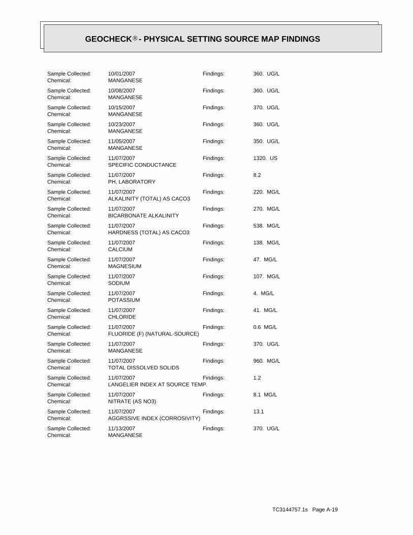
TC3144757.1s Page A-19
MANGANESEChemical:370. UG/LFindings:11/13/2007Sample Collected:
AGGRSSIVE INDEX (CORROSIVITY)Chemical:13.1Findings:11/07/2007Sample Collected:
NITRATE (AS NO3)Chemical:8.1 MG/LFindings:11/07/2007Sample Collected:
LANGELIER INDEX AT SOURCE TEMP.Chemical:1.2Findings:11/07/2007Sample Collected:
TOTAL DISSOLVED SOLIDSChemical:960. MG/LFindings:11/07/2007Sample Collected:
MANGANESEChemical:370. UG/LFindings:11/07/2007Sample Collected:
FLUORIDE (F) (NATURAL-SOURCE)Chemical:0.6 MG/LFindings:11/07/2007Sample Collected:
CHLORIDEChemical:41. MG/LFindings:11/07/2007Sample Collected:
POTASSIUMChemical:4. MG/LFindings:11/07/2007Sample Collected:
SODIUMChemical:107. MG/LFindings:11/07/2007Sample Collected:
MAGNESIUMChemical:47. MG/LFindings:11/07/2007Sample Collected:
CALCIUMChemical:138. MG/LFindings:11/07/2007Sample Collected:
HARDNESS (TOTAL) AS CACO3Chemical:538. MG/LFindings:11/07/2007Sample Collected:
BICARBONATE ALKALINITYChemical:270. MG/LFindings:11/07/2007Sample Collected:
ALKALINITY (TOTAL) AS CACO3Chemical:220. MG/LFindings:11/07/2007Sample Collected:
PH, LABORATORYChemical:8.2Findings:11/07/2007Sample Collected:
SPECIFIC CONDUCTANCEChemical:1320. USFindings:11/07/2007Sample Collected:
MANGANESEChemical:350. UG/LFindings:11/05/2007Sample Collected:
MANGANESEChemical:360. UG/LFindings:10/23/2007Sample Collected:
MANGANESEChemical:370. UG/LFindings:10/15/2007Sample Collected:
MANGANESEChemical:360. UG/LFindings:10/08/2007Sample Collected:
MANGANESEChemical:360. UG/LFindings:10/01/2007Sample Collected:
®GEOCHECK - PHYSICAL SETTING SOURCE MAP FINDINGS®

TC3144757.1s Page A-20
MANGANESEChemical:360. UG/LFindings:04/14/2008Sample Collected:
MANGANESEChemical:360. UG/LFindings:04/07/2008Sample Collected:
MANGANESEChemical:360. UG/LFindings:04/01/2008Sample Collected:
MANGANESEChemical:340. UG/LFindings:03/24/2008Sample Collected:
MANGANESEChemical:360. UG/LFindings:03/19/2008Sample Collected:
MANGANESEChemical:350. UG/LFindings:03/11/2008Sample Collected:
MANGANESEChemical:360. UG/LFindings:03/04/2008Sample Collected:
IRONChemical:120. UG/LFindings:03/04/2008Sample Collected:
MANGANESEChemical:360. UG/LFindings:02/25/2008Sample Collected:
MANGANESEChemical:350. UG/LFindings:02/19/2008Sample Collected:
MANGANESEChemical:360. UG/LFindings:02/11/2008Sample Collected:
MANGANESEChemical:330. UG/LFindings:02/05/2008Sample Collected:
MANGANESEChemical:360. UG/LFindings:01/22/2008Sample Collected:
MANGANESEChemical:350. UG/LFindings:01/15/2008Sample Collected:
MANGANESEChemical:350. UG/LFindings:01/07/2008Sample Collected:
MANGANESEChemical:350. UG/LFindings:01/02/2008Sample Collected:
MANGANESEChemical:360. UG/LFindings:12/23/2007Sample Collected:
MANGANESEChemical:360. UG/LFindings:12/17/2007Sample Collected:
MANGANESEChemical:370. UG/LFindings:12/10/2007Sample Collected:
MANGANESEChemical:360. UG/LFindings:12/04/2007Sample Collected:
MANGANESEChemical:370. UG/LFindings:11/26/2007Sample Collected:
MANGANESEChemical:380. UG/LFindings:11/19/2007Sample Collected:
®GEOCHECK - PHYSICAL SETTING SOURCE MAP FINDINGS®

TC3144757.1s Page A-21
MANGANESEChemical:360. UG/LFindings:05/13/2008Sample Collected:
AGGRSSIVE INDEX (CORROSIVITY)Chemical:12.3Findings:05/08/2008Sample Collected:
NITRATE (AS NO3)Chemical:6.7 MG/LFindings:05/08/2008Sample Collected:
LANGELIER INDEX AT SOURCE TEMP.Chemical:0.4Findings:05/08/2008Sample Collected:
TOTAL DISSOLVED SOLIDSChemical:960. MG/LFindings:05/08/2008Sample Collected:
SELENIUMChemical:6. UG/LFindings:05/08/2008Sample Collected:
MANGANESEChemical:340. UG/LFindings:05/08/2008Sample Collected:
BORONChemical:600. UG/LFindings:05/08/2008Sample Collected:
FLUORIDE (F) (NATURAL-SOURCE)Chemical:0.3 MG/LFindings:05/08/2008Sample Collected:
CHLORIDEChemical:39. MG/LFindings:05/08/2008Sample Collected:
POTASSIUMChemical:4. MG/LFindings:05/08/2008Sample Collected:
SODIUMChemical:97. MG/LFindings:05/08/2008Sample Collected:
MAGNESIUMChemical:43. MG/LFindings:05/08/2008Sample Collected:
CALCIUMChemical:135. MG/LFindings:05/08/2008Sample Collected:
HARDNESS (TOTAL) AS CACO3Chemical:514. MG/LFindings:05/08/2008Sample Collected:
BICARBONATE ALKALINITYChemical:280. MG/LFindings:05/08/2008Sample Collected:
ALKALINITY (TOTAL) AS CACO3Chemical:230. MG/LFindings:05/08/2008Sample Collected:
PH, LABORATORYChemical:7.4Findings:05/08/2008Sample Collected:
SPECIFIC CONDUCTANCEChemical:1350. USFindings:05/08/2008Sample Collected:
MANGANESEChemical:320. UG/LFindings:05/05/2008Sample Collected:
IRONChemical:210. UG/LFindings:05/05/2008Sample Collected:
MANGANESEChemical:360. UG/LFindings:05/01/2008Sample Collected:
®GEOCHECK - PHYSICAL SETTING SOURCE MAP FINDINGS®

TC3144757.1s Page A-22
MANGANESEChemical:340. UG/LFindings:10/13/2008Sample Collected:
MANGANESEChemical:370. UG/LFindings:10/01/2008Sample Collected:
MANGANESEChemical:350. UG/LFindings:09/22/2008Sample Collected:
MANGANESEChemical:360. UG/LFindings:09/15/2008Sample Collected:
MANGANESEChemical:370. UG/LFindings:09/08/2008Sample Collected:
MANGANESEChemical:380. UG/LFindings:09/03/2008Sample Collected:
IRONChemical:120. UG/LFindings:09/03/2008Sample Collected:
MANGANESEChemical:360. UG/LFindings:08/25/2008Sample Collected:
MANGANESEChemical:320. UG/LFindings:08/18/2008Sample Collected:
MANGANESEChemical:330. UG/LFindings:08/11/2008Sample Collected:
MANGANESEChemical:350. UG/LFindings:08/04/2008Sample Collected:
MANGANESEChemical:330. UG/LFindings:07/28/2008Sample Collected:
MANGANESEChemical:350. UG/LFindings:07/21/2008Sample Collected:
MANGANESEChemical:360. UG/LFindings:07/14/2008Sample Collected:
MANGANESEChemical:330. UG/LFindings:07/08/2008Sample Collected:
MANGANESEChemical:370. UG/LFindings:07/01/2008Sample Collected:
MANGANESEChemical:350. UG/LFindings:06/23/2008Sample Collected:
MANGANESEChemical:320. UG/LFindings:06/16/2008Sample Collected:
MANGANESEChemical:350. UG/LFindings:06/09/2008Sample Collected:
MANGANESEChemical:330. UG/LFindings:06/03/2008Sample Collected:
MANGANESEChemical:350. UG/LFindings:05/27/2008Sample Collected:
MANGANESEChemical:350. UG/LFindings:05/19/2008Sample Collected:
®GEOCHECK - PHYSICAL SETTING SOURCE MAP FINDINGS®

TC3144757.1s Page A-23
NITRATE (AS NO3)Chemical:7.3 MG/LFindings:11/18/2008Sample Collected:
LANGELIER INDEX AT SOURCE TEMP.Chemical:0.2Findings:11/18/2008Sample Collected:
TOTAL DISSOLVED SOLIDSChemical:940. MG/LFindings:11/18/2008Sample Collected:
SELENIUMChemical:6. UG/LFindings:11/18/2008Sample Collected:
MANGANESEChemical:360. UG/LFindings:11/18/2008Sample Collected:
BORONChemical:600. UG/LFindings:11/18/2008Sample Collected:
FLUORIDE (F) (NATURAL-SOURCE)Chemical:0.5 MG/LFindings:11/18/2008Sample Collected:
CHLORIDEChemical:42. MG/LFindings:11/18/2008Sample Collected:
POTASSIUMChemical:5. MG/LFindings:11/18/2008Sample Collected:
SODIUMChemical:102. MG/LFindings:11/18/2008Sample Collected:
MAGNESIUMChemical:46. MG/LFindings:11/18/2008Sample Collected:
CALCIUMChemical:141. MG/LFindings:11/18/2008Sample Collected:
HARDNESS (TOTAL) AS CACO3Chemical:541. MG/LFindings:11/18/2008Sample Collected:
BICARBONATE ALKALINITYChemical:270. MG/LFindings:11/18/2008Sample Collected:
ALKALINITY (TOTAL) AS CACO3Chemical:220. MG/LFindings:11/18/2008Sample Collected:
PH, LABORATORYChemical:7.2Findings:11/18/2008Sample Collected:
SPECIFIC CONDUCTANCEChemical:1360. USFindings:11/18/2008Sample Collected:
MANGANESEChemical:340. UG/LFindings:11/17/2008Sample Collected:
MANGANESEChemical:360. UG/LFindings:11/10/2008Sample Collected:
MANGANESEChemical:350. UG/LFindings:11/03/2008Sample Collected:
MANGANESEChemical:360. UG/LFindings:10/27/2008Sample Collected:
MANGANESEChemical:350. UG/LFindings:10/20/2008Sample Collected:
®GEOCHECK - PHYSICAL SETTING SOURCE MAP FINDINGS®

TC3144757.1s Page A-24
PH, LABORATORYChemical:7.4Findings:05/06/2009Sample Collected:
SPECIFIC CONDUCTANCEChemical:1330. USFindings:05/06/2009Sample Collected:
MANGANESEChemical:350. UG/LFindings:05/04/2009Sample Collected:
MANGANESEChemical:350. UG/LFindings:04/27/2009Sample Collected:
MANGANESEChemical:350. UG/LFindings:04/20/2009Sample Collected:
MANGANESEChemical:370. UG/LFindings:04/14/2009Sample Collected:
MANGANESEChemical:360. UG/LFindings:04/13/2009Sample Collected:
MANGANESEChemical:360. UG/LFindings:04/06/2009Sample Collected:
MANGANESEChemical:380. UG/LFindings:03/26/2009Sample Collected:
MANGANESEChemical:330. UG/LFindings:03/16/2009Sample Collected:
MANGANESEChemical:360. UG/LFindings:03/11/2009Sample Collected:
MANGANESEChemical:360. UG/LFindings:03/02/2009Sample Collected:
MANGANESEChemical:350. UG/LFindings:02/23/2009Sample Collected:
MANGANESEChemical:350. UG/LFindings:02/17/2009Sample Collected:
MANGANESEChemical:360. UG/LFindings:02/11/2009Sample Collected:
MANGANESEChemical:350. UG/LFindings:02/02/2009Sample Collected:
MANGANESEChemical:360. UG/LFindings:01/26/2009Sample Collected:
MANGANESEChemical:350. UG/LFindings:12/15/2008Sample Collected:
MANGANESEChemical:350. UG/LFindings:12/08/2008Sample Collected:
MANGANESEChemical:340. UG/LFindings:12/01/2008Sample Collected:
MANGANESEChemical:340. UG/LFindings:11/24/2008Sample Collected:
AGGRSSIVE INDEX (CORROSIVITY)Chemical:12.1Findings:11/18/2008Sample Collected:
®GEOCHECK - PHYSICAL SETTING SOURCE MAP FINDINGS®
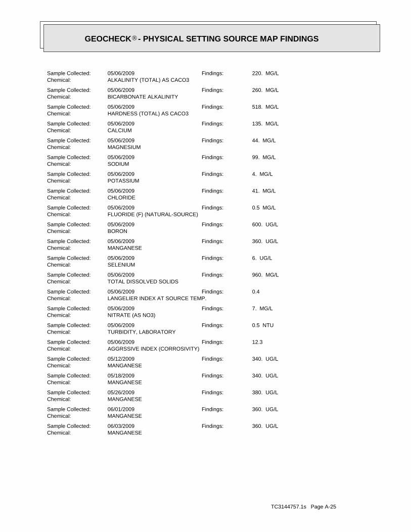
TC3144757.1s Page A-25
MANGANESEChemical:360. UG/LFindings:06/03/2009Sample Collected:
MANGANESEChemical:360. UG/LFindings:06/01/2009Sample Collected:
MANGANESEChemical:380. UG/LFindings:05/26/2009Sample Collected:
MANGANESEChemical:340. UG/LFindings:05/18/2009Sample Collected:
MANGANESEChemical:340. UG/LFindings:05/12/2009Sample Collected:
AGGRSSIVE INDEX (CORROSIVITY)Chemical:12.3Findings:05/06/2009Sample Collected:
TURBIDITY, LABORATORYChemical:0.5 NTUFindings:05/06/2009Sample Collected:
NITRATE (AS NO3)Chemical:7. MG/LFindings:05/06/2009Sample Collected:
LANGELIER INDEX AT SOURCE TEMP.Chemical:0.4Findings:05/06/2009Sample Collected:
TOTAL DISSOLVED SOLIDSChemical:960. MG/LFindings:05/06/2009Sample Collected:
SELENIUMChemical:6. UG/LFindings:05/06/2009Sample Collected:
MANGANESEChemical:360. UG/LFindings:05/06/2009Sample Collected:
BORONChemical:600. UG/LFindings:05/06/2009Sample Collected:
FLUORIDE (F) (NATURAL-SOURCE)Chemical:0.5 MG/LFindings:05/06/2009Sample Collected:
CHLORIDEChemical:41. MG/LFindings:05/06/2009Sample Collected:
POTASSIUMChemical:4. MG/LFindings:05/06/2009Sample Collected:
SODIUMChemical:99. MG/LFindings:05/06/2009Sample Collected:
MAGNESIUMChemical:44. MG/LFindings:05/06/2009Sample Collected:
CALCIUMChemical:135. MG/LFindings:05/06/2009Sample Collected:
HARDNESS (TOTAL) AS CACO3Chemical:518. MG/LFindings:05/06/2009Sample Collected:
BICARBONATE ALKALINITYChemical:260. MG/LFindings:05/06/2009Sample Collected:
ALKALINITY (TOTAL) AS CACO3Chemical:220. MG/LFindings:05/06/2009Sample Collected:
®GEOCHECK - PHYSICAL SETTING SOURCE MAP FINDINGS®

TC3144757.1s Page A-26
MANGANESEChemical:340. UG/LFindings:11/02/2009Sample Collected:
MANGANESEChemical:420. UG/LFindings:10/26/2009Sample Collected:
MANGANESEChemical:380. UG/LFindings:10/19/2009Sample Collected:
MANGANESEChemical:330. UG/LFindings:10/12/2009Sample Collected:
MANGANESEChemical:340. UG/LFindings:10/05/2009Sample Collected:
MANGANESEChemical:340. UG/LFindings:09/28/2009Sample Collected:
MANGANESEChemical:340. UG/LFindings:09/21/2009Sample Collected:
MANGANESEChemical:340. UG/LFindings:09/14/2009Sample Collected:
MANGANESEChemical:350. UG/LFindings:09/09/2009Sample Collected:
MANGANESEChemical:350. UG/LFindings:09/01/2009Sample Collected:
MANGANESEChemical:350. UG/LFindings:08/24/2009Sample Collected:
MANGANESEChemical:370. UG/LFindings:08/17/2009Sample Collected:
MANGANESEChemical:350. UG/LFindings:08/11/2009Sample Collected:
MANGANESEChemical:370. UG/LFindings:08/05/2009Sample Collected:
MANGANESEChemical:350. UG/LFindings:07/27/2009Sample Collected:
MANGANESEChemical:360. UG/LFindings:07/20/2009Sample Collected:
MANGANESEChemical:360. UG/LFindings:07/14/2009Sample Collected:
MANGANESEChemical:350. UG/LFindings:07/06/2009Sample Collected:
MANGANESEChemical:350. UG/LFindings:07/01/2009Sample Collected:
MANGANESEChemical:340. UG/LFindings:06/22/2009Sample Collected:
MANGANESEChemical:340. UG/LFindings:06/15/2009Sample Collected:
MANGANESEChemical:340. UG/LFindings:06/08/2009Sample Collected:
®GEOCHECK - PHYSICAL SETTING SOURCE MAP FINDINGS®

TC3144757.1s Page A-27
MANGANESEChemical:330. UG/LFindings:11/23/2009Sample Collected:
MANGANESEChemical:340. UG/LFindings:11/16/2009Sample Collected:
MANGANESEChemical:340. UG/LFindings:11/09/2009Sample Collected:
AGGRSSIVE INDEX (CORROSIVITY)Chemical:12.1Findings:11/05/2009Sample Collected:
TURBIDITY, LABORATORYChemical:0.2 NTUFindings:11/05/2009Sample Collected:
NITRATE (AS NO3)Chemical:7.1 MG/LFindings:11/05/2009Sample Collected:
LANGELIER INDEX AT SOURCE TEMP.Chemical:0.2Findings:11/05/2009Sample Collected:
TOTAL DISSOLVED SOLIDSChemical:930. MG/LFindings:11/05/2009Sample Collected:
SELENIUMChemical:6. UG/LFindings:11/05/2009Sample Collected:
MANGANESEChemical:380. UG/LFindings:11/05/2009Sample Collected:
BORONChemical:600. UG/LFindings:11/05/2009Sample Collected:
FLUORIDE (F) (NATURAL-SOURCE)Chemical:0.5 MG/LFindings:11/05/2009Sample Collected:
CHLORIDEChemical:41. MG/LFindings:11/05/2009Sample Collected:
POTASSIUMChemical:4. MG/LFindings:11/05/2009Sample Collected:
SODIUMChemical:99. MG/LFindings:11/05/2009Sample Collected:
MAGNESIUMChemical:47. MG/LFindings:11/05/2009Sample Collected:
CALCIUMChemical:155. MG/LFindings:11/05/2009Sample Collected:
HARDNESS (TOTAL) AS CACO3Chemical:580. MG/LFindings:11/05/2009Sample Collected:
BICARBONATE ALKALINITYChemical:260. MG/LFindings:11/05/2009Sample Collected:
ALKALINITY (TOTAL) AS CACO3Chemical:210. MG/LFindings:11/05/2009Sample Collected:
PH, LABORATORYChemical:7.2Findings:11/05/2009Sample Collected:
SPECIFIC CONDUCTANCEChemical:1330. USFindings:11/05/2009Sample Collected:
®GEOCHECK - PHYSICAL SETTING SOURCE MAP FINDINGS®

TC3144757.1s Page A-28
MAGNESIUMChemical:46. MG/LFindings:05/11/2010Sample Collected:
CALCIUMChemical:143. MG/LFindings:05/11/2010Sample Collected:
HARDNESS (TOTAL) AS CACO3Chemical:546. MG/LFindings:05/11/2010Sample Collected:
BICARBONATE ALKALINITYChemical:260. MG/LFindings:05/11/2010Sample Collected:
ALKALINITY (TOTAL) AS CACO3Chemical:210. MG/LFindings:05/11/2010Sample Collected:
PH, LABORATORYChemical:7.2Findings:05/11/2010Sample Collected:
SPECIFIC CONDUCTANCEChemical:1340. USFindings:05/11/2010Sample Collected:
MANGANESEChemical:360. UG/LFindings:05/10/2010Sample Collected:
MANGANESEChemical:350. UG/LFindings:05/04/2010Sample Collected:
IRONChemical:140. UG/LFindings:05/04/2010Sample Collected:
MANGANESEChemical:350. UG/LFindings:02/16/2010Sample Collected:
MANGANESEChemical:330. UG/LFindings:02/08/2010Sample Collected:
MANGANESEChemical:340. UG/LFindings:02/02/2010Sample Collected:
MANGANESEChemical:350. UG/LFindings:01/25/2010Sample Collected:
MANGANESEChemical:340. UG/LFindings:01/20/2010Sample Collected:
MANGANESEChemical:340. UG/LFindings:01/11/2010Sample Collected:
MANGANESEChemical:370. UG/LFindings:01/04/2010Sample Collected:
MANGANESEChemical:350. UG/LFindings:12/28/2009Sample Collected:
MANGANESEChemical:350. UG/LFindings:12/21/2009Sample Collected:
MANGANESEChemical:350. UG/LFindings:12/14/2009Sample Collected:
MANGANESEChemical:350. UG/LFindings:12/08/2009Sample Collected:
MANGANESEChemical:340. UG/LFindings:12/02/2009Sample Collected:
®GEOCHECK - PHYSICAL SETTING SOURCE MAP FINDINGS®
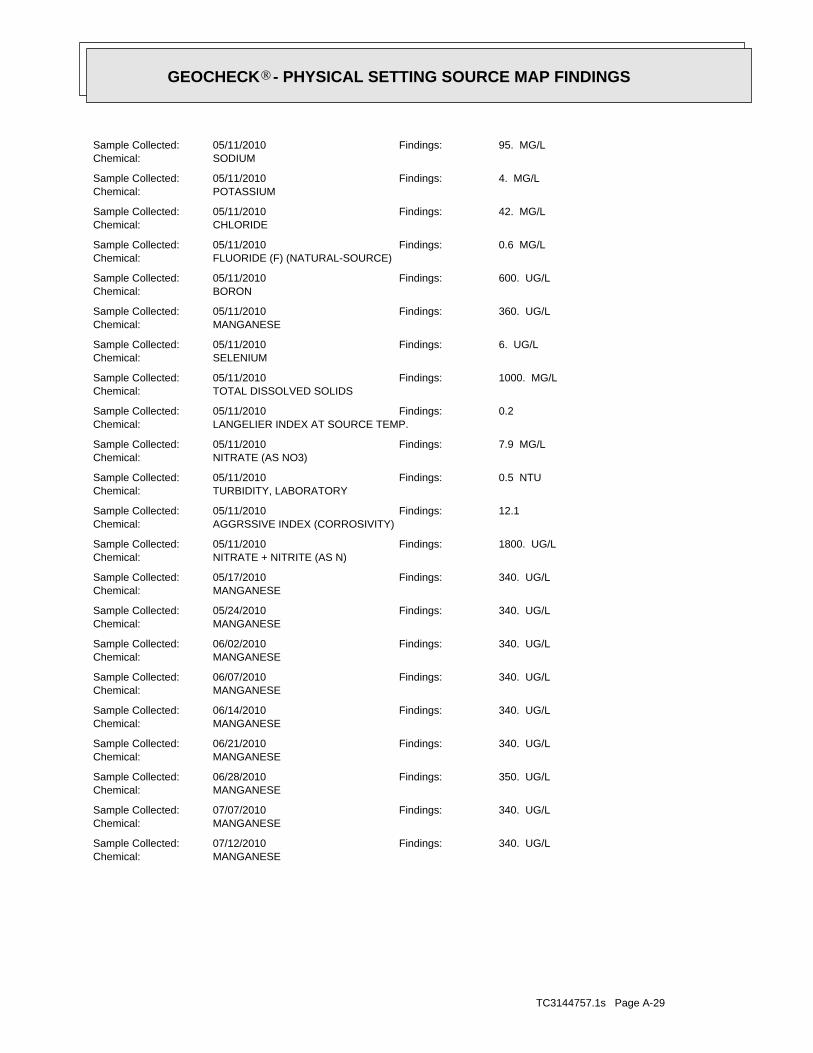
TC3144757.1s Page A-29
MANGANESEChemical:340. UG/LFindings:07/12/2010Sample Collected:
MANGANESEChemical:340. UG/LFindings:07/07/2010Sample Collected:
MANGANESEChemical:350. UG/LFindings:06/28/2010Sample Collected:
MANGANESEChemical:340. UG/LFindings:06/21/2010Sample Collected:
MANGANESEChemical:340. UG/LFindings:06/14/2010Sample Collected:
MANGANESEChemical:340. UG/LFindings:06/07/2010Sample Collected:
MANGANESEChemical:340. UG/LFindings:06/02/2010Sample Collected:
MANGANESEChemical:340. UG/LFindings:05/24/2010Sample Collected:
MANGANESEChemical:340. UG/LFindings:05/17/2010Sample Collected:
NITRATE + NITRITE (AS N)Chemical:1800. UG/LFindings:05/11/2010Sample Collected:
AGGRSSIVE INDEX (CORROSIVITY)Chemical:12.1Findings:05/11/2010Sample Collected:
TURBIDITY, LABORATORYChemical:0.5 NTUFindings:05/11/2010Sample Collected:
NITRATE (AS NO3)Chemical:7.9 MG/LFindings:05/11/2010Sample Collected:
LANGELIER INDEX AT SOURCE TEMP.Chemical:0.2Findings:05/11/2010Sample Collected:
TOTAL DISSOLVED SOLIDSChemical:1000. MG/LFindings:05/11/2010Sample Collected:
SELENIUMChemical:6. UG/LFindings:05/11/2010Sample Collected:
MANGANESEChemical:360. UG/LFindings:05/11/2010Sample Collected:
BORONChemical:600. UG/LFindings:05/11/2010Sample Collected:
FLUORIDE (F) (NATURAL-SOURCE)Chemical:0.6 MG/LFindings:05/11/2010Sample Collected:
CHLORIDEChemical:42. MG/LFindings:05/11/2010Sample Collected:
POTASSIUMChemical:4. MG/LFindings:05/11/2010Sample Collected:
SODIUMChemical:95. MG/LFindings:05/11/2010Sample Collected:
®GEOCHECK - PHYSICAL SETTING SOURCE MAP FINDINGS®
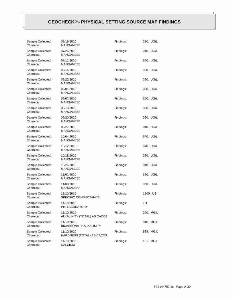
TC3144757.1s Page A-30
CALCIUMChemical:151. MG/LFindings:11/10/2010Sample Collected:
HARDNESS (TOTAL) AS CACO3Chemical:558. MG/LFindings:11/10/2010Sample Collected:
BICARBONATE ALKALINITYChemical:310. MG/LFindings:11/10/2010Sample Collected:
ALKALINITY (TOTAL) AS CACO3Chemical:260. MG/LFindings:11/10/2010Sample Collected:
PH, LABORATORYChemical:7.4Findings:11/10/2010Sample Collected:
SPECIFIC CONDUCTANCEChemical:1300. USFindings:11/10/2010Sample Collected:
MANGANESEChemical:360. UG/LFindings:11/08/2010Sample Collected:
MANGANESEChemical:360. UG/LFindings:11/01/2010Sample Collected:
MANGANESEChemical:340. UG/LFindings:10/25/2010Sample Collected:
MANGANESEChemical:350. UG/LFindings:10/18/2010Sample Collected:
MANGANESEChemical:370. UG/LFindings:10/12/2010Sample Collected:
MANGANESEChemical:340. UG/LFindings:10/04/2010Sample Collected:
MANGANESEChemical:340. UG/LFindings:09/27/2010Sample Collected:
MANGANESEChemical:350. UG/LFindings:09/20/2010Sample Collected:
MANGANESEChemical:350. UG/LFindings:09/13/2010Sample Collected:
MANGANESEChemical:360. UG/LFindings:09/07/2010Sample Collected:
MANGANESEChemical:360. UG/LFindings:09/01/2010Sample Collected:
MANGANESEChemical:360. UG/LFindings:08/23/2010Sample Collected:
MANGANESEChemical:350. UG/LFindings:08/16/2010Sample Collected:
MANGANESEChemical:360. UG/LFindings:08/12/2010Sample Collected:
MANGANESEChemical:340. UG/LFindings:07/26/2010Sample Collected:
MANGANESEChemical:330. UG/LFindings:07/19/2010Sample Collected:
®GEOCHECK - PHYSICAL SETTING SOURCE MAP FINDINGS®
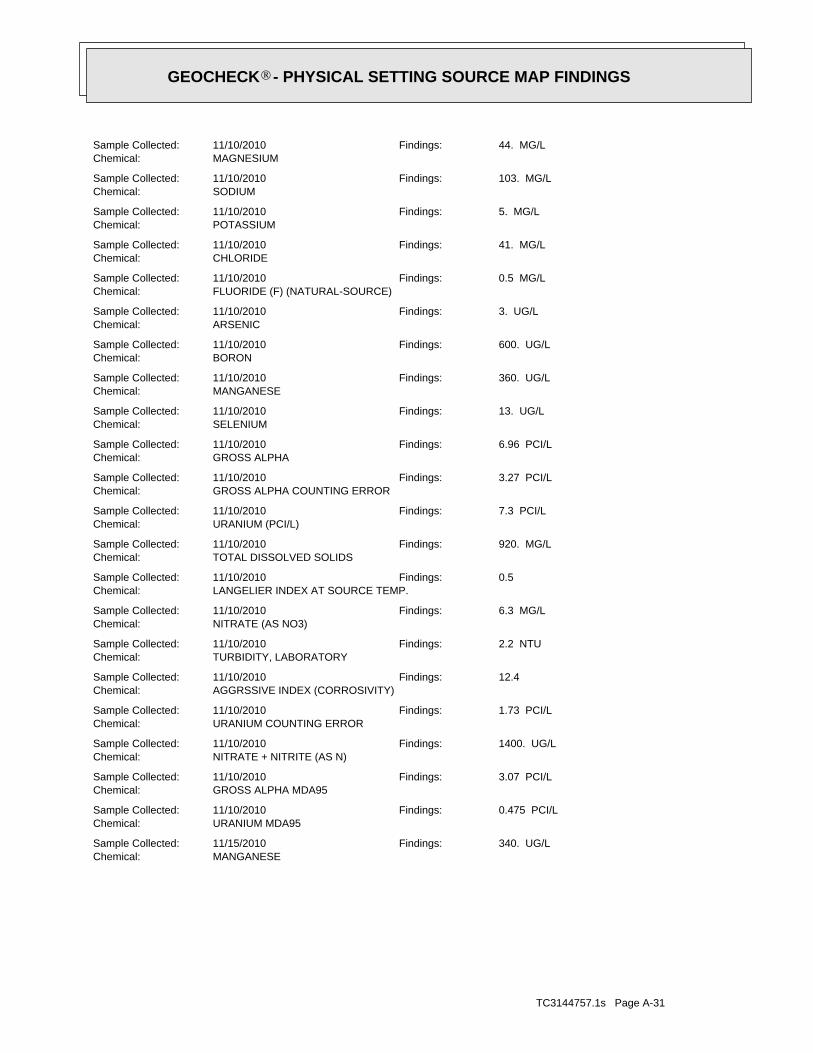
TC3144757.1s Page A-31
MANGANESEChemical:340. UG/LFindings:11/15/2010Sample Collected:
URANIUM MDA95Chemical:0.475 PCI/LFindings:11/10/2010Sample Collected:
GROSS ALPHA MDA95Chemical:3.07 PCI/LFindings:11/10/2010Sample Collected:
NITRATE + NITRITE (AS N)Chemical:1400. UG/LFindings:11/10/2010Sample Collected:
URANIUM COUNTING ERRORChemical:1.73 PCI/LFindings:11/10/2010Sample Collected:
AGGRSSIVE INDEX (CORROSIVITY)Chemical:12.4Findings:11/10/2010Sample Collected:
TURBIDITY, LABORATORYChemical:2.2 NTUFindings:11/10/2010Sample Collected:
NITRATE (AS NO3)Chemical:6.3 MG/LFindings:11/10/2010Sample Collected:
LANGELIER INDEX AT SOURCE TEMP.Chemical:0.5Findings:11/10/2010Sample Collected:
TOTAL DISSOLVED SOLIDSChemical:920. MG/LFindings:11/10/2010Sample Collected:
URANIUM (PCI/L)Chemical:7.3 PCI/LFindings:11/10/2010Sample Collected:
GROSS ALPHA COUNTING ERRORChemical:3.27 PCI/LFindings:11/10/2010Sample Collected:
GROSS ALPHAChemical:6.96 PCI/LFindings:11/10/2010Sample Collected:
SELENIUMChemical:13. UG/LFindings:11/10/2010Sample Collected:
MANGANESEChemical:360. UG/LFindings:11/10/2010Sample Collected:
BORONChemical:600. UG/LFindings:11/10/2010Sample Collected:
ARSENICChemical:3. UG/LFindings:11/10/2010Sample Collected:
FLUORIDE (F) (NATURAL-SOURCE)Chemical:0.5 MG/LFindings:11/10/2010Sample Collected:
CHLORIDEChemical:41. MG/LFindings:11/10/2010Sample Collected:
POTASSIUMChemical:5. MG/LFindings:11/10/2010Sample Collected:
SODIUMChemical:103. MG/LFindings:11/10/2010Sample Collected:
MAGNESIUMChemical:44. MG/LFindings:11/10/2010Sample Collected:
®GEOCHECK - PHYSICAL SETTING SOURCE MAP FINDINGS®

TC3144757.1s Page A-32
MANGANESEChemical:350. UG/LFindings:04/18/2011Sample Collected:
MANGANESEChemical:360. UG/LFindings:04/11/2011Sample Collected:
MANGANESEChemical:340. UG/LFindings:04/04/2011Sample Collected:
MANGANESEChemical:350. UG/LFindings:03/28/2011Sample Collected:
MANGANESEChemical:350. UG/LFindings:03/21/2011Sample Collected:
MANGANESEChemical:360. UG/LFindings:03/14/2011Sample Collected:
MANGANESEChemical:340. UG/LFindings:03/07/2011Sample Collected:
MANGANESEChemical:350. UG/LFindings:03/01/2011Sample Collected:
MANGANESEChemical:340. UG/LFindings:02/21/2011Sample Collected:
MANGANESEChemical:340. UG/LFindings:02/14/2011Sample Collected:
MANGANESEChemical:340. UG/LFindings:02/08/2011Sample Collected:
MANGANESEChemical:350. UG/LFindings:02/01/2011Sample Collected:
MANGANESEChemical:360. UG/LFindings:01/24/2011Sample Collected:
MANGANESEChemical:350. UG/LFindings:01/18/2011Sample Collected:
MANGANESEChemical:360. UG/LFindings:01/12/2011Sample Collected:
MANGANESEChemical:350. UG/LFindings:01/04/2011Sample Collected:
MANGANESEChemical:340. UG/LFindings:12/27/2010Sample Collected:
MANGANESEChemical:350. UG/LFindings:12/20/2010Sample Collected:
MANGANESEChemical:380. UG/LFindings:12/13/2010Sample Collected:
MANGANESEChemical:340. UG/LFindings:12/06/2010Sample Collected:
MANGANESEChemical:340. UG/LFindings:12/02/2010Sample Collected:
MANGANESEChemical:340. UG/LFindings:11/22/2010Sample Collected:
®GEOCHECK - PHYSICAL SETTING SOURCE MAP FINDINGS®

TC3144757.1s Page A-33
SILICAChemical:34. MG/LFindings:07/25/2006Sample Collected:
FLUORIDE (F) (NATURAL-SOURCE)Chemical:0.6 MG/LFindings:07/25/2006Sample Collected:
CHLORIDEChemical:60. MG/LFindings:07/25/2006Sample Collected:
POTASSIUMChemical:4. MG/LFindings:07/25/2006Sample Collected:
SODIUMChemical:99. MG/LFindings:07/25/2006Sample Collected:
MAGNESIUMChemical:47. MG/LFindings:07/25/2006Sample Collected:
CALCIUMChemical:150. MG/LFindings:07/25/2006Sample Collected:
HARDNESS (TOTAL) AS CACO3Chemical:568. MG/LFindings:07/25/2006Sample Collected:
BICARBONATE ALKALINITYChemical:280. MG/LFindings:07/25/2006Sample Collected:
ALKALINITY (TOTAL) AS CACO3Chemical:230. MG/LFindings:07/25/2006Sample Collected:
PH, LABORATORYChemical:6.9Findings:07/25/2006Sample Collected:
SPECIFIC CONDUCTANCEChemical:1450. USFindings:07/25/2006Sample Collected:
MANGANESEChemical:670. UG/LFindings:07/24/2006Sample Collected:
MANGANESEChemical:770. UG/LFindings:07/17/2006Sample Collected:
MANGANESEChemical:870. UG/LFindings:07/10/2006Sample Collected:
IRONChemical:130. UG/LFindings:07/10/2006Sample Collected:
MANGANESEChemical:940. UG/LFindings:07/05/2006Sample Collected:
IRONChemical:150. UG/LFindings:07/05/2006Sample Collected:
MANGANESEChemical:310. UG/LFindings:04/11/2006Sample Collected:
MANGANESEChemical:330. UG/LFindings:03/06/2006Sample Collected:
RADIUM 228 COUNTING ERRORChemical:0.372 PCI/LFindings:02/06/2006Sample Collected:
MANGANESEChemical:340. UG/LFindings:02/06/2006Sample Collected:
®GEOCHECK - PHYSICAL SETTING SOURCE MAP FINDINGS®

TC3144757.1s Page A-34
A4SSW1/8 - 1/4 MileLower
USGS3171026FED USGS
CADW40000007948Site id:400404Gwcode:56Countyco:ZWelluseco:3Districtco:03N21W12E004SStwellno:34.3592Latiude:-119.0406Longitude:
3East1/8 - 1/4 MileLower
CADW40000007948CA WELLS
CADW40000007953Site id:400404Gwcode:56Countyco:ZWelluseco:3Districtco:03N21W11H003SStwellno:34.3603Latiude:-119.045Longitude:
2NW0 - 1/8 MileHigher
CADW40000007953CA WELLS
MANGANESEChemical:580. UG/LFindings:08/02/2006Sample Collected:
NITRATE + NITRITE (AS N)Chemical:1700. UG/LFindings:07/25/2006Sample Collected:
AGGRSSIVE INDEX (CORROSIVITY)Chemical:11.8Findings:07/25/2006Sample Collected:
NITRATE (AS NO3)Chemical:7.6 MG/LFindings:07/25/2006Sample Collected:
LANGELIER INDEX AT SOURCE TEMP.Chemical:- 0.1Findings:07/25/2006Sample Collected:
TOTAL DISSOLVED SOLIDSChemical:1070. MG/LFindings:07/25/2006Sample Collected:
MANGANESEChemical:660. UG/LFindings:07/25/2006Sample Collected:
BORONChemical:600. UG/LFindings:07/25/2006Sample Collected:
®GEOCHECK - PHYSICAL SETTING SOURCE MAP FINDINGS®

TC3144757.1s Page A-35
B6ESE1/4 - 1/2 MileLower
USGS3171027FED USGS
CADW40000007938Site id:400404Gwcode:56Countyco:ZWelluseco:3Districtco:03N21W11J001SStwellno:34.3564Latiude:-119.0453Longitude:
A5SSW1/8 - 1/4 MileLower
CADW40000007938CA WELLS
Ground-water levels, Number of Measurements: 0
Not ReportedGround water data count:Not ReportedGround water data end date:Ground water data begin date: Not ReportedNot ReportedWater quality data count:Not ReportedWater quality data end date:Not ReportedWater quality data begin date:Not ReportedPeak flow data count:Not ReportedPeak flow data end date:Not ReportedPeak flow data begin date:Not ReportedDaily flow data count:Not ReportedDaily flow data end date:Not ReportedDaily flow data begin date:Not ReportedReal time data flag:
470642400Project number:drillerSource of depth data:
1100Hole depth:700Well depth:Not ReportedAquifer:Not ReportedAquifer Type:Single well, other than collector or Ranney typeType of ground water site:YLocal standard time flag:
PSTMean greenwich time offset:19911104Date inventoried:199110Date construction:Ground-water other than SpringSite type:
Valley flatTopographic:Calleguas. California. Area = 377 sq.mi.Hydrologic:National Geodetic Vertical Datum of 1929Altitude datum:10Altitude accuracy:Interpolated from topographic mapAltitude method:282Altitude:
24000Map scale:SANTA PAULALocation map:Not ReportedLand net:USCountry:111County:06State:06District:NAD83Dec latlong datum:NAD27Latlong datum:FCoor accr:MCoor meth:-119.04593672Dec lon:34.35638796Dec lat:1190242Longitude:USGS3171026EDR Site id:342123Latitude:
003N021W11J005SSite name:342123119024201Site no:USGSAgency cd:
®GEOCHECK - PHYSICAL SETTING SOURCE MAP FINDINGS®
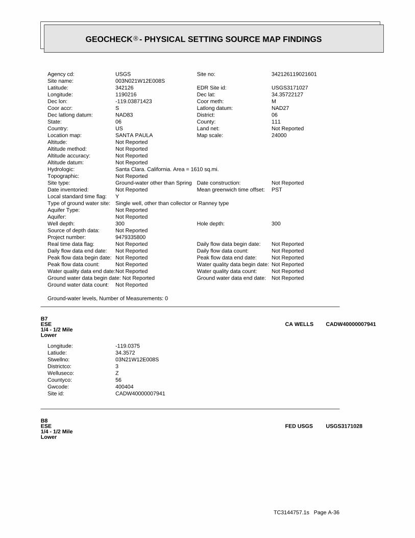
TC3144757.1s Page A-36
B8ESE1/4 - 1/2 MileLower
USGS3171028FED USGS
CADW40000007941Site id:400404Gwcode:56Countyco:ZWelluseco:3Districtco:03N21W12E008SStwellno:34.3572Latiude:-119.0375Longitude:
B7ESE1/4 - 1/2 MileLower
CADW40000007941CA WELLS
Ground-water levels, Number of Measurements: 0
Not ReportedGround water data count:Not ReportedGround water data end date:Ground water data begin date: Not ReportedNot ReportedWater quality data count:Not ReportedWater quality data end date:Not ReportedWater quality data begin date:Not ReportedPeak flow data count:Not ReportedPeak flow data end date:Not ReportedPeak flow data begin date:Not ReportedDaily flow data count:Not ReportedDaily flow data end date:Not ReportedDaily flow data begin date:Not ReportedReal time data flag:
9479335800Project number:Not ReportedSource of depth data:
300Hole depth:300Well depth:Not ReportedAquifer:Not ReportedAquifer Type:Single well, other than collector or Ranney typeType of ground water site:YLocal standard time flag:
PSTMean greenwich time offset:Not ReportedDate inventoried:Not ReportedDate construction:Ground-water other than SpringSite type:
Not ReportedTopographic:Santa Clara. California. Area = 1610 sq.mi.Hydrologic:Not ReportedAltitude datum:Not ReportedAltitude accuracy:Not ReportedAltitude method:Not ReportedAltitude:
24000Map scale:SANTA PAULALocation map:Not ReportedLand net:USCountry:111County:06State:06District:NAD83Dec latlong datum:NAD27Latlong datum:SCoor accr:MCoor meth:-119.03871423Dec lon:34.35722127Dec lat:1190216Longitude:USGS3171027EDR Site id:342126Latitude:
003N021W12E008SSite name:342126119021601Site no:USGSAgency cd:
®GEOCHECK - PHYSICAL SETTING SOURCE MAP FINDINGS®

TC3144757.1s Page A-37
C10East1/4 - 1/2 MileLower
USGS3171029FED USGS
CADW40000007966Site id:400404Gwcode:56Countyco:ZWelluseco:3Districtco:03N21W11B001SStwellno:34.3639Latiude:-119.0475Longitude:
9NW1/4 - 1/2 MileHigher
CADW40000007966CA WELLS
Ground-water levels, Number of Measurements: 0
Not ReportedGround water data count:Not ReportedGround water data end date:Ground water data begin date: Not ReportedNot ReportedWater quality data count:Not ReportedWater quality data end date:Not ReportedWater quality data begin date:Not ReportedPeak flow data count:Not ReportedPeak flow data end date:Not ReportedPeak flow data begin date:Not ReportedDaily flow data count:Not ReportedDaily flow data end date:Not ReportedDaily flow data begin date:Not ReportedReal time data flag:
9479335800Project number:Not ReportedSource of depth data:
300Hole depth:300Well depth:Not ReportedAquifer:Not ReportedAquifer Type:Single well, other than collector or Ranney typeType of ground water site:YLocal standard time flag:
PSTMean greenwich time offset:Not ReportedDate inventoried:Not ReportedDate construction:Ground-water other than SpringSite type:
Not ReportedTopographic:Santa Clara. California. Area = 1610 sq.mi.Hydrologic:Not ReportedAltitude datum:Not ReportedAltitude accuracy:Not ReportedAltitude method:Not ReportedAltitude:
24000Map scale:SANTA PAULALocation map:Not ReportedLand net:USCountry:111County:06State:06District:NAD83Dec latlong datum:NAD27Latlong datum:SCoor accr:MCoor meth:-119.03815866Dec lon:34.3577768Dec lat:1190214Longitude:USGS3171028EDR Site id:342128Latitude:
003N021W12E004SSite name:342128119021401Site no:USGSAgency cd:
®GEOCHECK - PHYSICAL SETTING SOURCE MAP FINDINGS®

TC3144757.1s Page A-38
C12East1/4 - 1/2 MileLower
CADW40000007947CA WELLS
CADW40000007975Site id:400404Gwcode:56Countyco:ZWelluseco:3Districtco:03N21W01N001SStwellno:34.3653Latiude:-119.0414Longitude:
D11NNE1/4 - 1/2 MileHigher
CADW40000007975CA WELLS
Ground-water levels, Number of Measurements: 0
0Ground water data count:0000-00-00Ground water data end date:Ground water data begin date: 0000-00-001Water quality data count:1991-08-27Water quality data end date:1991-08-27Water quality data begin date:0Peak flow data count:0000-00-00Peak flow data end date:0000-00-00Peak flow data begin date:0Daily flow data count:0000-00-00Daily flow data end date:0000-00-00Daily flow data begin date:0Real time data flag:
9479335800Project number:Not ReportedSource of depth data:
300Hole depth:300Well depth:Not ReportedAquifer:Not ReportedAquifer Type:Single well, other than collector or Ranney typeType of ground water site:YLocal standard time flag:
PSTMean greenwich time offset:Not ReportedDate inventoried:Not ReportedDate construction:Ground-water other than SpringSite type:
Not ReportedTopographic:Santa Clara. California. Area = 1610 sq.mi.Hydrologic:National Geodetic Vertical Datum of 1929Altitude datum:5Altitude accuracy:Interpolated from topographic mapAltitude method:300Altitude:
24000Map scale:SANTA PAULALocation map:Not ReportedLand net:USCountry:111County:06State:06District:NAD83Dec latlong datum:NAD27Latlong datum:SCoor accr:MCoor meth:-119.0373253Dec lon:34.35833233Dec lat:1190211Longitude:USGS3171029EDR Site id:342130Latitude:
003N021W12F003SSite name:342130119021101Site no:USGSAgency cd:
®GEOCHECK - PHYSICAL SETTING SOURCE MAP FINDINGS®

TC3144757.1s Page A-39
CADW40000007935Site id:400404Gwcode:56Countyco:ZWelluseco:3Districtco:03N21W01P002SStwellno:34.3561Latiude:-119.0347Longitude:
15ESE1/2 - 1 MileLower
CADW40000007935CA WELLS
COLORChemical:5. UNITSFindings:09/11/2001Sample Collected:
Not ReportedArea Served:15Connections:48Pop Served:
SANTA PAULA, CA 93060133 N. TENTH ST
Organization That Operates System:LIMONEIRA CO. - MCKEVETTSystem Name:5601206System Number:WELL 03Source Name:
100 Feet (one Second)Precision:342153.0 1190300.0Source Lat/Long:Active RawWell Status:Well/GroundwaterWater Type:WELL/AMBNT/MUN/INTAKEStation Type:06District Number:VenturaCounty:5601206001FRDS Number:TAPUser ID:03N/21W-02Q01 SPrime Station Code:
Water System Information:
E14NW1/2 - 1 MileHigher
3413CA WELLS
CADW40000007977Site id:400404Gwcode:56Countyco:ZWelluseco:3Districtco:03N21W02R002SStwellno:34.3656Latiude:-119.0417Longitude:
D13NNE1/4 - 1/2 MileHigher
CADW40000007977CA WELLS
CADW40000007947Site id:400404Gwcode:56Countyco:ZWelluseco:3Districtco:03N21W12F003SStwellno:34.3583Latiude:-119.0361Longitude:
®GEOCHECK - PHYSICAL SETTING SOURCE MAP FINDINGS®

TC3144757.1s Page A-40
PSTMean greenwich time offset:Not ReportedDate inventoried:Not ReportedDate construction:Ground-water other than SpringSite type:
Not ReportedTopographic:Santa Clara. California. Area = 1610 sq.mi.Hydrologic:Not ReportedAltitude datum:Not ReportedAltitude accuracy:Not ReportedAltitude method:Not ReportedAltitude:
24000Map scale:SANTA PAULALocation map:Not ReportedLand net:USCountry:111County:06State:06District:NAD83Dec latlong datum:NAD27Latlong datum:SCoor accr:MCoor meth:-119.05482595Dec lon:34.35888782Dec lat:1190314Longitude:USGS3171030EDR Site id:342132Latitude:
003S021W11F003SSite name:342132119031401Site no:USGSAgency cd:
F18West1/2 - 1 MileHigher
USGS3171030FED USGS
CADW40000007974Site id:400404Gwcode:56Countyco:ZWelluseco:3Districtco:03N21W02P001SStwellno:34.3653Latiude:-119.0506Longitude:
E17NW1/2 - 1 MileHigher
CADW40000007974CA WELLS
SANTA PAULA VICArea Served:6854Connections:28310Pop Served:
SANTA PAULA, CA 93061117 N. 10TH ST.
Organization That Operates System:City of Santa PaulaSystem Name:5610011System Number:WELL 09 (1958)Source Name:
1,000 Feet (10 Seconds)Precision:342131.5 1190313.6Source Lat/Long:Active RawWell Status:Well/GroundwaterWater Type:WELL/AMBNT/MUN/INTAKEStation Type:06District Number:VenturaCounty:5610011011FRDS Number:TAPUser ID:03N/21W-11F03 SPrime Station Code:
Water System Information:
F16West1/2 - 1 MileHigher
3421CA WELLS
Map IDDirectionDistanceElevation EDR ID NumberDatabase
®GEOCHECK - PHYSICAL SETTING SOURCE MAP FINDINGS®

TC3144757.1s Page A-41Not ReportedPeak flow data end date:Not ReportedPeak flow data begin date:Not ReportedDaily flow data count:Not ReportedDaily flow data end date:Not ReportedDaily flow data begin date:Not ReportedReal time data flag:
9479335800Project number:Not ReportedSource of depth data:
478Hole depth:478Well depth:Not ReportedAquifer:Not ReportedAquifer Type:Single well, other than collector or Ranney typeType of ground water site:YLocal standard time flag:
PSTMean greenwich time offset:Not ReportedDate inventoried:Not ReportedDate construction:Ground-water other than SpringSite type:
Not ReportedTopographic:Santa Clara. California. Area = 1610 sq.mi.Hydrologic:Not ReportedAltitude datum:Not ReportedAltitude accuracy:Not ReportedAltitude method:Not ReportedAltitude:
24000Map scale:SANTA PAULALocation map:Not ReportedLand net:USCountry:111County:06State:06District:NAD83Dec latlong datum:NAD27Latlong datum:SCoor accr:MCoor meth:-119.05649268Dec lon:34.35972111Dec lat:1190320Longitude:USGS3171032EDR Site id:342135Latitude:
003N021W11E003SSite name:342135119032001Site no:USGSAgency cd:
G20West1/2 - 1 MileHigher
USGS3171032FED USGS
CADW40000007971Site id:400404Gwcode:56Countyco:ZWelluseco:3Districtco:03N21W01P007SStwellno:34.3647Latiude:-119.0342Longitude:
19NE1/2 - 1 MileHigher
CADW40000007971CA WELLS
Ground-water levels, Number of Measurements: 0
Not ReportedGround water data count:Not ReportedGround water data end date:Ground water data begin date: Not ReportedNot ReportedWater quality data count:Not ReportedWater quality data end date:Not ReportedWater quality data begin date:Not ReportedPeak flow data count:Not ReportedPeak flow data end date:Not ReportedPeak flow data begin date:Not ReportedDaily flow data count:Not ReportedDaily flow data end date:Not ReportedDaily flow data begin date:Not ReportedReal time data flag:
9479335800Project number:Not ReportedSource of depth data:
540Hole depth:540Well depth:Not ReportedAquifer:Not ReportedAquifer Type:Single well, other than collector or Ranney typeType of ground water site:YLocal standard time flag:
®GEOCHECK - PHYSICAL SETTING SOURCE MAP FINDINGS®

TC3144757.1s Page A-42
WELL 05 (1947) - DESTROYEDSource Name:1,000 Feet (10 Seconds)Precision:342144.8 1190320.2Source Lat/Long:DestroyedWell Status:Well/GroundwaterWater Type:WELL/AMBNT/MUN/INTAKEStation Type:06District Number:VenturaCounty:5610011007FRDS Number:TAPUser ID:03N/21W-11D02 SPrime Station Code:
Water System Information:
H23WNW1/2 - 1 MileHigher
3419CA WELLS
SANTA PAULA VICArea Served:6854Connections:28310Pop Served:
SANTA PAULA, CA 93061117 N. 10TH ST.
Organization That Operates System:City of Santa PaulaSystem Name:5610011System Number:WELL 08 (1956)Source Name:
1,000 Feet (10 Seconds)Precision:342137.0 1190320.2Source Lat/Long:Active RawWell Status:Well/GroundwaterWater Type:WELL/AMBNT/MUN/INTAKEStation Type:06District Number:VenturaCounty:5610011010FRDS Number:TAPUser ID:03N/21W-11E03 SPrime Station Code:
Water System Information:
G22West1/2 - 1 MileHigher
3420CA WELLS
CADW40000007963Site id:400404Gwcode:56Countyco:XWelluseco:3Districtco:03N21W11D002SStwellno:34.3625Latiude:-119.055Longitude:
H21WNW1/2 - 1 MileHigher
CADW40000007963CA WELLS
Ground-water levels, Number of Measurements: 0
Not ReportedGround water data count:Not ReportedGround water data end date:Ground water data begin date: Not ReportedNot ReportedWater quality data count:Not ReportedWater quality data end date:Not ReportedWater quality data begin date:Not ReportedPeak flow data count:
®GEOCHECK - PHYSICAL SETTING SOURCE MAP FINDINGS®

TC3144757.1s Page A-43
CADW40000007918Site id:400404Gwcode:56Countyco:ZWelluseco:3Districtco:03N21W11P001SStwellno:34.35Latiude:-119.0519Longitude:
25SW1/2 - 1 MileLower
CADW40000007918CA WELLS
Ground-water levels, Number of Measurements: 0
0Ground water data count:0000-00-00Ground water data end date:Ground water data begin date: 0000-00-001Water quality data count:1991-08-28Water quality data end date:1991-08-28Water quality data begin date:0Peak flow data count:0000-00-00Peak flow data end date:0000-00-00Peak flow data begin date:0Daily flow data count:0000-00-00Daily flow data end date:0000-00-00Daily flow data begin date:0Real time data flag:
9479335800Project number:Not ReportedSource of depth data:
570Hole depth:570Well depth:Not ReportedAquifer:Not ReportedAquifer Type:Single well, other than collector or Ranney typeType of ground water site:YLocal standard time flag:
PSTMean greenwich time offset:Not ReportedDate inventoried:Not ReportedDate construction:Ground-water other than SpringSite type:
Not ReportedTopographic:Santa Clara. California. Area = 1610 sq.mi.Hydrologic:National Geodetic Vertical Datum of 1929Altitude datum:5Altitude accuracy:Interpolated from topographic mapAltitude method:330Altitude:
24000Map scale:SANTA PAULALocation map:Not ReportedLand net:USCountry:111County:06State:06District:NAD83Dec latlong datum:NAD27Latlong datum:SCoor accr:MCoor meth:-119.05677048Dec lon:34.36249875Dec lat:1190321Longitude:USGS3171033EDR Site id:342145Latitude:
003N021W11D002SSite name:342145119032101Site no:USGSAgency cd:
H24WNW1/2 - 1 MileHigher
USGS3171033FED USGS
SANTA PAULA VICArea Served:6854Connections:28310Pop Served:
SANTA PAULA, CA 93061117 N. 10TH ST.
Organization That Operates System:City of Santa PaulaSystem Name:5610011System Number:
®GEOCHECK - PHYSICAL SETTING SOURCE MAP FINDINGS®
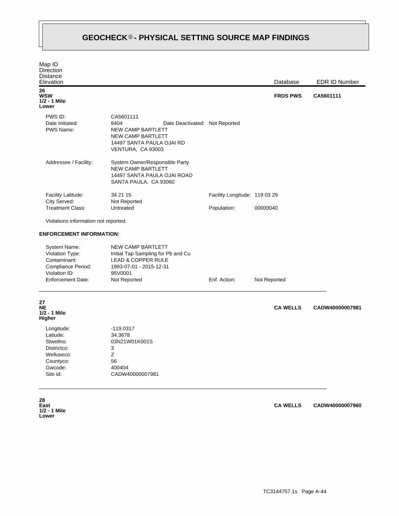
TC3144757.1s Page A-44
28East1/2 - 1 MileLower
CADW40000007960CA WELLS
CADW40000007981Site id:400404Gwcode:56Countyco:ZWelluseco:3Districtco:03N21W01K001SStwellno:34.3678Latiude:-119.0317Longitude:
27NE1/2 - 1 MileHigher
CADW40000007981CA WELLS
Not ReportedEnf. Action:Not ReportedEnforcement Date:95V0001Violation ID:1993-07-01 - 2015-12-31Compliance Period:LEAD & COPPER RULEContaminant:Initial Tap Sampling for Pb and CuViolation Type:NEW CAMP BARTLETTSystem Name:
ENFORCEMENT INFORMATION:
Violations information not reported.
00000040Population:UntreatedTreatment Class:Not ReportedCity Served:
119 03 29Facility Longitude:34 21 15Facility Latitude:
SANTA PAULA, CA 9306014497 SANTA PAULA OJAI ROADNEW CAMP BARTLETTSystem Owner/Responsible PartyAddressee / Facility:
VENTURA, CA 9300314497 SANTA PAULA OJAI RDNEW CAMP BARTLETTNEW CAMP BARTLETTPWS Name:
Not ReportedDate Deactivated:8404Date Initiated:CA5601111PWS ID:
26WSW1/2 - 1 MileLower
CA5601111FRDS PWS
Map IDDirectionDistanceElevation EDR ID NumberDatabase
®GEOCHECK - PHYSICAL SETTING SOURCE MAP FINDINGS®

TC3144757.1s Page A-45
Ground-water levels, Number of Measurements: 0
0Ground water data count:0000-00-00Ground water data end date:Ground water data begin date: 0000-00-001Water quality data count:1991-08-22Water quality data end date:1991-08-22Water quality data begin date:0Peak flow data count:0000-00-00Peak flow data end date:0000-00-00Peak flow data begin date:0Daily flow data count:0000-00-00Daily flow data end date:0000-00-00Daily flow data begin date:0Real time data flag:
470642400Project number:otherSource of depth data:
158.0Hole depth:150.0Well depth:Not ReportedAquifer:Not ReportedAquifer Type:Single well, other than collector or Ranney typeType of ground water site:YLocal standard time flag:
PSTMean greenwich time offset:19910916Date inventoried:195602Date construction:Ground-water other than SpringSite type:
Flood plainTopographic:Santa Clara. California. Area = 1610 sq.mi.Hydrologic:National Geodetic Vertical Datum of 1929Altitude datum:10Altitude accuracy:Interpolated from topographic mapAltitude method:277.0Altitude:
24000Map scale:SANTA PAULALocation map:Not ReportedLand net:USCountry:111County:06State:06District:NAD83Dec latlong datum:NAD27Latlong datum:UCoor accr:MCoor meth:-119.02732493Dec lon:34.35972118Dec lat:1190135Longitude:USGS3171031EDR Site id:342135Latitude:
003N021W12H001SSite name:342135119013501Site no:USGSAgency cd:
29East1/2 - 1 MileLower
USGS3171031FED USGS
CADW40000007960Site id:400404Gwcode:56Countyco:ZWelluseco:3Districtco:03N21W12B001SStwellno:34.3614Latiude:-119.0281Longitude:
®GEOCHECK - PHYSICAL SETTING SOURCE MAP FINDINGS®
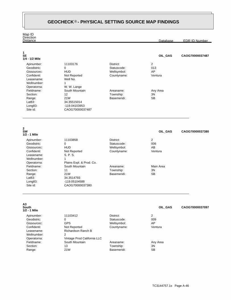
TC3144757.1s Page A-46
SBBasemeridi:21WRange:3NTownship:13Section:Any AreaAreaname:South MountainFieldname:
Vintage Prod California LLCOperatorna:2Wellnumber:Richardson Ranch BLeasename:
VenturaCountyname:Not ReportedConfidenti:APWellsymbol:GPSGissourcec:009Statuscode:0Geodistric:2District:11103412Apinumber:
A3South1/2 - 1 Mile
CAOG70000037097OIL_GAS
CAOG70000037380Site id:-119.05104588Long83:34.3514793Lat83:
SBBasemeridi:21WRange:3NTownship:11Section:Main AreaAreaname:South MountainFieldname:
Plains Expl. & Prod. Co.Operatorna:1Wellnumber:S. P. S.Leasename:
VenturaCountyname:Not ReportedConfidenti:ABWellsymbol:HUDGissourcec:006Statuscode:0Geodistric:2District:11103858Apinumber:
2SW1/2 - 1 Mile
CAOG70000037380OIL_GAS
CAOG70000037487Site id:-119.04103953Long83:34.35515014Lat83:
SBBasemeridi:21WRange:3NTownship:12Section:Any AreaAreaname:South MountainFieldname:
W. W. LangeOperatorna:1Wellnumber:Well No.Leasename:
VenturaCountyname:Not ReportedConfidenti:APWellsymbol:HUDGissourcec:013Statuscode:0Geodistric:2District:11103176Apinumber:
1SE1/4 - 1/2 Mile
CAOG70000037487OIL_GAS
Map IDDirectionDistance EDR ID NumberDatabase
®GEOCHECK - PHYSICAL SETTING SOURCE MAP FINDINGS®

TC3144757.1s Page A-47
SBBasemeridi:21WRange:3NTownship:13Section:Any AreaAreaname:South MountainFieldname:
Vintage Prod California LLCOperatorna:3Wellnumber:Richardson Ranch BLeasename:
VenturaCountyname:Not ReportedConfidenti:APWellsymbol:GPSGissourcec:009Statuscode:0Geodistric:2District:11103413Apinumber:
A6SSE1/2 - 1 Mile
CAOG70000037111OIL_GAS
CAOG70000038160Site id:-119.05211799Long83:34.36970041Lat83:
SBBasemeridi:21WRange:3NTownship:2Section:Any AreaAreaname:Any FieldFieldname:
Chevron U.S.A. Inc.Operatorna:1Wellnumber:VanderkarrLeasename:
VenturaCountyname:Not ReportedConfidenti:DHWellsymbol:HUDGissourcec:006Statuscode:0Geodistric:2District:11105914Apinumber:
5NNW1/2 - 1 Mile
CAOG70000038160OIL_GAS
CAOG70000037081Site id:-119.04200064Long83:34.34742021Lat83:
SBBasemeridi:21WRange:3NTownship:13Section:Any AreaAreaname:South MountainFieldname:
Vintage Prod California LLCOperatorna:4Wellnumber:Richardson Ranch BLeasename:
VenturaCountyname:Not ReportedConfidenti:APWellsymbol:GPSGissourcec:008Statuscode:0Geodistric:2District:11103414Apinumber:
A4South1/2 - 1 Mile
CAOG70000037081OIL_GAS
CAOG70000037097Site id:-119.04181453Long83:34.34750594Lat83:
®GEOCHECK - PHYSICAL SETTING SOURCE MAP FINDINGS®

TC3144757.1s Page A-48
SBBasemeridi:21WRange:3NTownship:14Section:Any AreaAreaname:South MountainFieldname:
Vintage Prod California LLCOperatorna:7Wellnumber:T-U TaylorLeasename:
VenturaCountyname:Not ReportedConfidenti:APWellsymbol:GPSGissourcec:008Statuscode:0Geodistric:2District:11103715Apinumber:
B9South1/2 - 1 Mile
CAOG70000037025OIL_GAS
CAOG70000037033Site id:-119.04596768Long83:34.34673254Lat83:
SBBasemeridi:21WRange:3NTownship:14Section:Any AreaAreaname:South MountainFieldname:
Vintage Prod California LLCOperatorna:5Wellnumber:T-U TaylorLeasename:
VenturaCountyname:Not ReportedConfidenti:ABWellsymbol:HUDGissourcec:015Statuscode:0Geodistric:2District:11103713Apinumber:
B8South1/2 - 1 Mile
CAOG70000037033OIL_GAS
CAOG70000037118Site id:-119.0491268Long83:34.34762249Lat83:
SBBasemeridi:21WRange:3NTownship:14Section:Bridge AreaAreaname:South MountainFieldname:
Vintage Prod California LLCOperatorna:2Wellnumber:T-U Van LenteLeasename:
VenturaCountyname:Not ReportedConfidenti:ABWellsymbol:HUDGissourcec:015Statuscode:0Geodistric:2District:11103717Apinumber:
7SSW1/2 - 1 Mile
CAOG70000037118OIL_GAS
CAOG70000037111Site id:-119.04063909Long83:34.34758755Lat83:
®GEOCHECK - PHYSICAL SETTING SOURCE MAP FINDINGS®

TC3144757.1s Page A-49
SBBasemeridi:21WRange:3NTownship:14Section:Any AreaAreaname:South MountainFieldname:
Vintage Prod California LLCOperatorna:2Wellnumber:T-U TaylorLeasename:
VenturaCountyname:Not ReportedConfidenti:APWellsymbol:GPSGissourcec:009Statuscode:0Geodistric:2District:11103710Apinumber:
C12SSW1/2 - 1 Mile
CAOG70000037038OIL_GAS
CAOG70000037021Site id:-119.04483854Long83:34.34657969Lat83:
SBBasemeridi:21WRange:3NTownship:14Section:Any AreaAreaname:South MountainFieldname:
Vintage Prod California LLCOperatorna:4Wellnumber:T-U TaylorLeasename:
VenturaCountyname:Not ReportedConfidenti:APWellsymbol:GPSGissourcec:009Statuscode:0Geodistric:2District:11103712Apinumber:
B11South1/2 - 1 Mile
CAOG70000037021OIL_GAS
CAOG70000037027Site id:-119.04617479Long83:34.34665697Lat83:
SBBasemeridi:21WRange:3NTownship:14Section:Any AreaAreaname:South MountainFieldname:
Vintage Prod California LLCOperatorna:6Wellnumber:T-U TaylorLeasename:
VenturaCountyname:Not ReportedConfidenti:ABWellsymbol:GPSGissourcec:014Statuscode:0Geodistric:2District:11103714Apinumber:
B10South1/2 - 1 Mile
CAOG70000037027OIL_GAS
CAOG70000037025Site id:-119.04474683Long83:34.34663433Lat83:
®GEOCHECK - PHYSICAL SETTING SOURCE MAP FINDINGS®

TC3144757.1s Page A-50
SBBasemeridi:21WRange:3NTownship:13Section:Any AreaAreaname:South MountainFieldname:
Vintage Prod California LLCOperatorna:5Wellnumber:Richardson Ranch BLeasename:
VenturaCountyname:Not ReportedConfidenti:ABWellsymbol:HUDGissourcec:014Statuscode:0Geodistric:2District:11103415Apinumber:
E15SSE1/2 - 1 Mile
CAOG70000037029OIL_GAS
CAOG70000037356Site id:-119.03217919Long83:34.35092236Lat83:
SBBasemeridi:21WRange:3NTownship:13Section:Main AreaAreaname:South MountainFieldname:
S. I. WilliamsOperatorna:1Wellnumber:Harvey-SnyderLeasename:
VenturaCountyname:Not ReportedConfidenti:ABWellsymbol:HUDGissourcec:006Statuscode:0Geodistric:2District:11121381Apinumber:
D14SE1/2 - 1 Mile
CAOG70000037356OIL_GAS
CAOG70000037028Site id:-119.04090759Long83:34.34665981Lat83:
SBBasemeridi:21WRange:3NTownship:13Section:Any AreaAreaname:South MountainFieldname:
Vintage Prod California LLCOperatorna:1Wellnumber:T-U Richardson Ranch CLeasename:
VenturaCountyname:Not ReportedConfidenti:APWellsymbol:GPSGissourcec:009Statuscode:0Geodistric:2District:11103696Apinumber:
A13SSE1/2 - 1 Mile
CAOG70000037028OIL_GAS
CAOG70000037038Site id:-119.04765954Long83:34.34676298Lat83:
®GEOCHECK - PHYSICAL SETTING SOURCE MAP FINDINGS®

TC3144757.1s Page A-51
SBBasemeridi:21WRange:3NTownship:12Section:Bridge AreaAreaname:South MountainFieldname:
Vintage-Omniferous FJVOperatorna:1Wellnumber:Shell-Universal Consolidateds HarveyLeasename:
VenturaCountyname:Not ReportedConfidenti:ABWellsymbol:HUDGissourcec:006Statuscode:0Geodistric:2District:11103342Apinumber:
D18SE1/2 - 1 Mile
CAOG70000037355OIL_GAS
CAOG70000037335Site id:-119.03198778Long83:34.35065169Lat83:
SBBasemeridi:21WRange:3NTownship:12Section:Any AreaAreaname:South MountainFieldname:
Hunter Oil & Gas Inc.Operatorna:1Wellnumber:Harvey-SnyderLeasename:
VenturaCountyname:Not ReportedConfidenti:APWellsymbol:GPSGissourcec:009Statuscode:0Geodistric:2District:11120967Apinumber:
D17SE1/2 - 1 Mile
CAOG70000037335OIL_GAS
CAOG70000037022Site id:-119.03937874Long83:34.34659103Lat83:
SBBasemeridi:21WRange:3NTownship:13Section:Main AreaAreaname:South MountainFieldname:
Vintage Prod California LLCOperatorna:1Wellnumber:Richardson Ranch BLeasename:
VenturaCountyname:Not ReportedConfidenti:ABWellsymbol:GPSGissourcec:036Statuscode:0Geodistric:2District:11103411Apinumber:
E16SSE1/2 - 1 Mile
CAOG70000037022OIL_GAS
CAOG70000037029Site id:-119.03942144Long83:34.34666756Lat83:
®GEOCHECK - PHYSICAL SETTING SOURCE MAP FINDINGS®

TC3144757.1s Page A-52
SBBasemeridi:21WRange:3NTownship:14Section:Any AreaAreaname:South MountainFieldname:
Vintage Prod California LLCOperatorna:1Wellnumber:T-U Mark RichardsonLeasename:
VenturaCountyname:Not ReportedConfidenti:APWellsymbol:GPSGissourcec:009Statuscode:0Geodistric:2District:11103684Apinumber:
C21SSW1/2 - 1 Mile
CAOG70000036965OIL_GAS
CAOG70000037338Site id:-119.03185197Long83:34.35070199Lat83:
SBBasemeridi:21WRange:3NTownship:12Section:Any AreaAreaname:South MountainFieldname:
Hunter Oil & Gas Inc.Operatorna:2Wellnumber:Harvey-SnyderLeasename:
VenturaCountyname:Not ReportedConfidenti:APWellsymbol:GPSGissourcec:009Statuscode:0Geodistric:2District:11121022Apinumber:
D20SE1/2 - 1 Mile
CAOG70000037338OIL_GAS
CAOG70000037186Site id:-119.03448526Long83:34.34857647Lat83:
SBBasemeridi:21WRange:3NTownship:13Section:Main AreaAreaname:South MountainFieldname:
Chevron U.S.A. Inc.Operatorna:1Wellnumber:Harvey-SnyderLeasename:
VenturaCountyname:Not ReportedConfidenti:ABWellsymbol:HUDGissourcec:006Statuscode:0Geodistric:2District:11103136Apinumber:
F19SE1/2 - 1 Mile
CAOG70000037186OIL_GAS
CAOG70000037355Site id:-119.03168817Long83:34.35091837Lat83:
®GEOCHECK - PHYSICAL SETTING SOURCE MAP FINDINGS®

TC3144757.1s Page A-53
SBBasemeridi:21WRange:3NTownship:14Section:Any AreaAreaname:South MountainFieldname:
Vintage Prod California LLCOperatorna:1Wellnumber:T-U TaylorLeasename:
VenturaCountyname:Not ReportedConfidenti:APWellsymbol:GPSGissourcec:009Statuscode:0Geodistric:2District:11103709Apinumber:
G24South1/2 - 1 Mile
CAOG70000036929OIL_GAS
CAOG70000037187Site id:-119.03423225Long83:34.34859047Lat83:
SBBasemeridi:21WRange:3NTownship:13Section:Bridge AreaAreaname:South MountainFieldname:
Vintage-Omniferous FJVOperatorna:2Wellnumber:Shell-Universal Consolidated HarveyLeasename:
VenturaCountyname:Not ReportedConfidenti:ABWellsymbol:HUDGissourcec:006Statuscode:0Geodistric:2District:11103343Apinumber:
F23SE1/2 - 1 Mile
CAOG70000037187OIL_GAS
CAOG70000036961Site id:-119.04865018Long83:34.34600096Lat83:
SBBasemeridi:21WRange:3NTownship:24Section:Any AreaAreaname:South MountainFieldname:
Vintage Prod California LLCOperatorna:1Wellnumber:Mark RichardsonLeasename:
VenturaCountyname:Not ReportedConfidenti:APWellsymbol:GPSGissourcec:009Statuscode:0Geodistric:2District:11103822Apinumber:
C22SSW1/2 - 1 Mile
CAOG70000036961OIL_GAS
CAOG70000036965Site id:-119.04864358Long83:34.34600658Lat83:
®GEOCHECK - PHYSICAL SETTING SOURCE MAP FINDINGS®

TC3144757.1s Page A-54
CAOG70000036913Site id:-119.04223844Long83:34.34516913Lat83:
SBBasemeridi:21WRange:3NTownship:13Section:Any AreaAreaname:South MountainFieldname:
Vintage Prod California LLCOperatorna:3Wellnumber:T-U Richardson RanchLeasename:
VenturaCountyname:Not ReportedConfidenti:APWellsymbol:GPSGissourcec:009Statuscode:0Geodistric:2District:11103695Apinumber:
26South1/2 - 1 Mile
CAOG70000036913OIL_GAS
CAOG70000036927Site id:-119.04412251Long83:34.34532298Lat83:
SBBasemeridi:21WRange:3NTownship:14Section:Any AreaAreaname:South MountainFieldname:
Vintage Prod California LLCOperatorna:3Wellnumber:T-U TaylorLeasename:
VenturaCountyname:Not ReportedConfidenti:APWellsymbol:GPSGissourcec:009Statuscode:0Geodistric:2District:11103711Apinumber:
G25South1/2 - 1 Mile
CAOG70000036927OIL_GAS
CAOG70000036929Site id:-119.04414691Long83:34.34536861Lat83:
®GEOCHECK - PHYSICAL SETTING SOURCE MAP FINDINGS®

TC3144757.1s Page A-55
Not ReportedNot ReportedNot ReportedNot ReportedBasement0%0%100%1.200 pCi/LLiving Area - 2nd Floor0%0%100%0.820 pCi/LLiving Area - 1st Floor
% >20 pCi/L% 4-20 pCi/L% <4 pCi/LAverage ActivityArea
Number of sites tested: 5
Federal Area Radon Information for Zip Code: 93060
: Zone 3 indoor average level < 2 pCi/L. : Zone 2 indoor average level >= 2 pCi/L and <= 4 pCi/L. Note: Zone 1 indoor average level > 4 pCi/L.
Federal EPA Radon Zone for VENTURA County: 1
26193060
______________________> 4 pCi/LNum TestsZipcode
Radon Test Results
State Database: CA Radon
AREA RADON INFORMATION
®GEOCHECK - PHYSICAL SETTING SOURCE MAP FINDINGSRADON
®
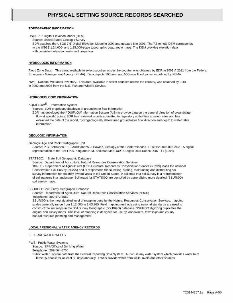
TOPOGRAPHIC INFORMATION
USGS 7.5’ Digital Elevation Model (DEM)Source: United States Geologic SurveyEDR acquired the USGS 7.5’ Digital Elevation Model in 2002 and updated it in 2006. The 7.5 minute DEM correspondsto the USGS 1:24,000- and 1:25,000-scale topographic quadrangle maps. The DEM provides elevation datawith consistent elevation units and projection.
HYDROLOGIC INFORMATION
Flood Zone Data: This data, available in select counties across the country, was obtained by EDR in 2003 & 2011 from the FederalEmergency Management Agency (FEMA). Data depicts 100-year and 500-year flood zones as defined by FEMA.
NWI: National Wetlands Inventory. This data, available in select counties across the country, was obtained by EDRin 2002 and 2005 from the U.S. Fish and Wildlife Service.
HYDROGEOLOGIC INFORMATION
AQUIFLOW Information SystemR
Source: EDR proprietary database of groundwater flow informationEDR has developed the AQUIFLOW Information System (AIS) to provide data on the general direction of groundwater
flow at specific points. EDR has reviewed reports submitted to regulatory authorities at select sites and hasextracted the date of the report, hydrogeologically determined groundwater flow direction and depth to water tableinformation.
GEOLOGIC INFORMATION
Geologic Age and Rock Stratigraphic UnitSource: P.G. Schruben, R.E. Arndt and W.J. Bawiec, Geology of the Conterminous U.S. at 1:2,500,000 Scale - A digitalrepresentation of the 1974 P.B. King and H.M. Beikman Map, USGS Digital Data Series DDS - 11 (1994).
STATSGO: State Soil Geographic DatabaseSource: Department of Agriculture, Natural Resources Conservation ServicesThe U.S. Department of Agriculture’s (USDA) Natural Resources Conservation Service (NRCS) leads the nationalConservation Soil Survey (NCSS) and is responsible for collecting, storing, maintaining and distributing soilsurvey information for privately owned lands in the United States. A soil map in a soil survey is a representationof soil patterns in a landscape. Soil maps for STATSGO are compiled by generalizing more detailed (SSURGO)soil survey maps.
SSURGO: Soil Survey Geographic DatabaseSource: Department of Agriculture, Natural Resources Conservation Services (NRCS)Telephone: 800-672-5559SSURGO is the most detailed level of mapping done by the Natural Resources Conservation Services, mappingscales generally range from 1:12,000 to 1:63,360. Field mapping methods using national standards are used toconstruct the soil maps in the Soil Survey Geographic (SSURGO) database. SSURGO digitizing duplicates theoriginal soil survey maps. This level of mapping is designed for use by landowners, townships and countynatural resource planning and management.
LOCAL / REGIONAL WATER AGENCY RECORDS
FEDERAL WATER WELLS
PWS: Public Water SystemsSource: EPA/Office of Drinking WaterTelephone: 202-564-3750Public Water System data from the Federal Reporting Data System. A PWS is any water system which provides water to at
least 25 people for at least 60 days annually. PWSs provide water from wells, rivers and other sources.
TC3144757.1s Page A-56
PHYSICAL SETTING SOURCE RECORDS SEARCHED
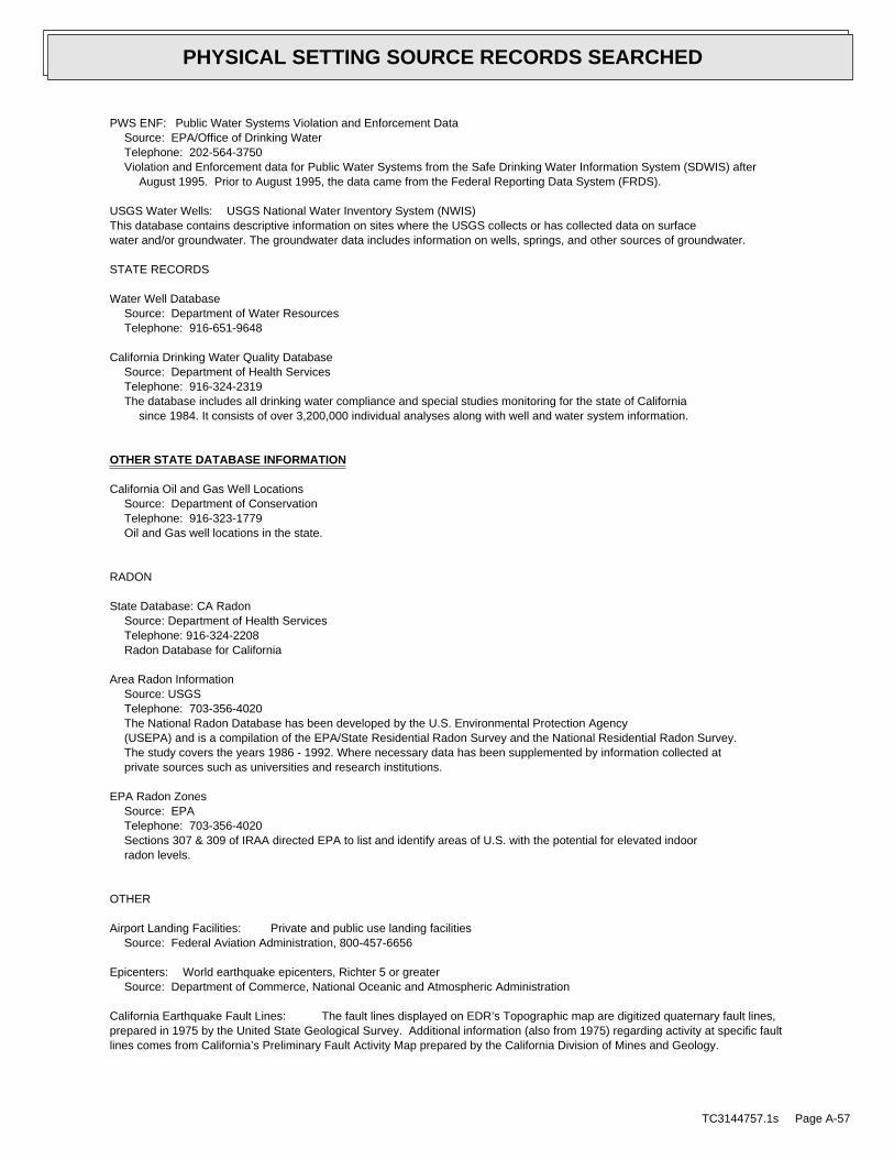
PWS ENF: Public Water Systems Violation and Enforcement DataSource: EPA/Office of Drinking WaterTelephone: 202-564-3750Violation and Enforcement data for Public Water Systems from the Safe Drinking Water Information System (SDWIS) after
August 1995. Prior to August 1995, the data came from the Federal Reporting Data System (FRDS).
USGS Water Wells: USGS National Water Inventory System (NWIS)This database contains descriptive information on sites where the USGS collects or has collected data on surfacewater and/or groundwater. The groundwater data includes information on wells, springs, and other sources of groundwater.
STATE RECORDS
Water Well DatabaseSource: Department of Water ResourcesTelephone: 916-651-9648
California Drinking Water Quality DatabaseSource: Department of Health ServicesTelephone: 916-324-2319The database includes all drinking water compliance and special studies monitoring for the state of California
since 1984. It consists of over 3,200,000 individual analyses along with well and water system information.
OTHER STATE DATABASE INFORMATION
California Oil and Gas Well LocationsSource: Department of ConservationTelephone: 916-323-1779Oil and Gas well locations in the state.
RADON
State Database: CA RadonSource: Department of Health ServicesTelephone: 916-324-2208Radon Database for California
Area Radon InformationSource: USGSTelephone: 703-356-4020The National Radon Database has been developed by the U.S. Environmental Protection Agency(USEPA) and is a compilation of the EPA/State Residential Radon Survey and the National Residential Radon Survey.The study covers the years 1986 - 1992. Where necessary data has been supplemented by information collected atprivate sources such as universities and research institutions.
EPA Radon ZonesSource: EPATelephone: 703-356-4020Sections 307 & 309 of IRAA directed EPA to list and identify areas of U.S. with the potential for elevated indoorradon levels.
OTHER
Airport Landing Facilities: Private and public use landing facilitiesSource: Federal Aviation Administration, 800-457-6656
Epicenters: World earthquake epicenters, Richter 5 or greaterSource: Department of Commerce, National Oceanic and Atmospheric Administration
California Earthquake Fault Lines: The fault lines displayed on EDR’s Topographic map are digitized quaternary fault lines,prepared in 1975 by the United State Geological Survey. Additional information (also from 1975) regarding activity at specific faultlines comes from California’s Preliminary Fault Activity Map prepared by the California Division of Mines and Geology.
TC3144757.1s Page A-57
PHYSICAL SETTING SOURCE RECORDS SEARCHED

STREET AND ADDRESS INFORMATION
© 2010 Tele Atlas North America, Inc. All rights reserved. This material is proprietary and the subject of copyright protectionand other intellectual property rights owned by or licensed to Tele Atlas North America, Inc. The use of this material is subjectto the terms of a license agreement. You will be held liable for any unauthorized copying or disclosure of this material.
TC3144757.1s Page A-58
PHYSICAL SETTING SOURCE RECORDS SEARCHED