PPDM Data Management Symposium March 7, 2012 · PDF filePPDM Data Management Symposium March...
44
PPDM HOUSTON 2012 Experts in Geomatics, Surveying, Positioning, Geospatial Data, and Mapping Sciences 1 Michael Barnes APSG Foundation Chair 2010-2015 APSG Chair 2008-2009 PPDM Data Management Symposium March 7, 2012 Houston
Transcript of PPDM Data Management Symposium March 7, 2012 · PDF filePPDM Data Management Symposium March...

PPDM HOUSTON 2012
Experts in Geomatics, Surveying, Positioning,
Geospatial Data, and Mapping Sciences
1
Michael Barnes APSG Foundation Chair 2010-2015
APSG Chair 2008-2009
PPDM Data Management Symposium March 7, 2012 Houston

PPDM HOUSTON 2012
Experts in Geomatics, Surveying, Positioning,
Geospatial Data, and Mapping Sciences
Geodetic Integrity:
The Essential Basics for Data Managers and Users
2
Michael Barnes Cain & Barnes LP
The Geomatic Experts Group
PPDM HOUSTON 2012
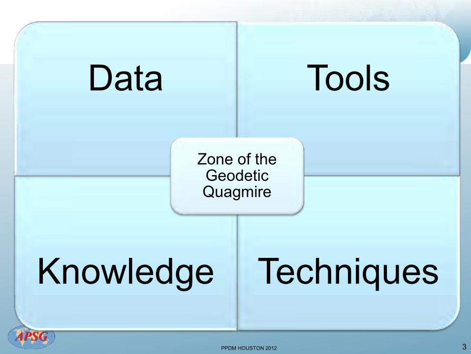
Data Tools
Knowledge Techniques
Zone of the Geodetic Quagmire
3
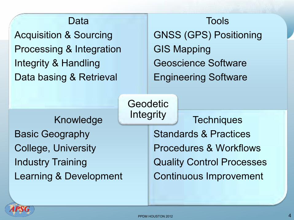
PPDM HOUSTON 2012 4
Data Acquisition & Sourcing Processing & Integration Integrity & Handling Data basing & Retrieval
Tools GNSS (GPS) Positioning GIS Mapping Geoscience Software Engineering Software
Knowledge Basic Geography College, University Industry Training Learning & Development
Techniques Standards & Practices Procedures & Workflows Quality Control Processes Continuous Improvement
Geodetic Integrity
PPDM HOUSTON 2012
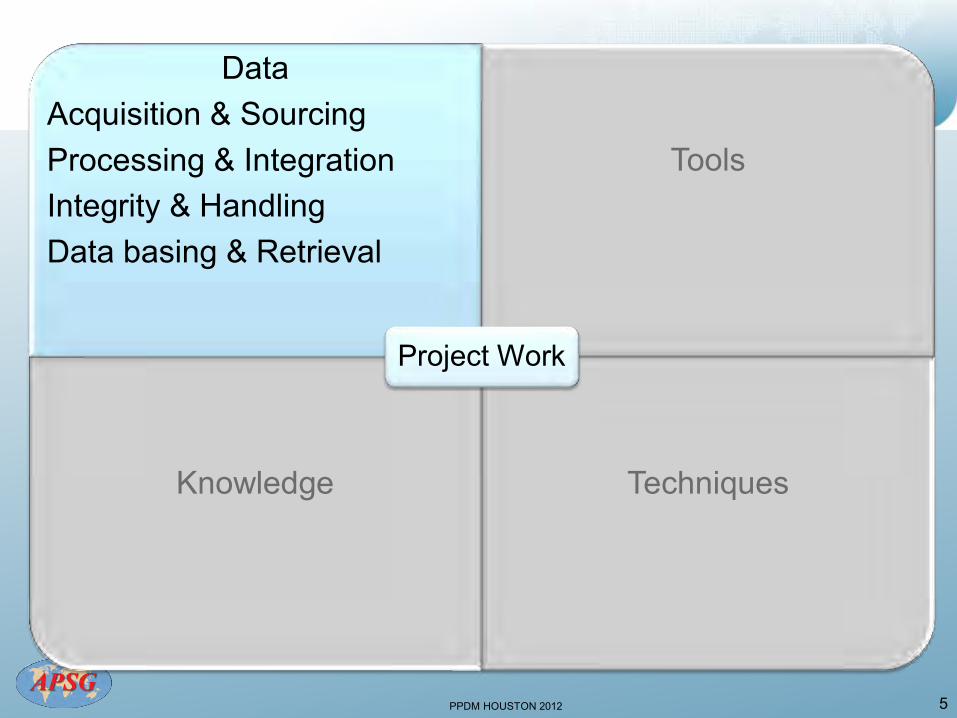
Data Acquisition & Sourcing Processing & Integration Integrity & Handling Data basing & Retrieval
Tools
Knowledge
Techniques
Project Work
5
PPDM HOUSTON 2012
6

PPDM HOUSTON 2012 7 Source: OGP
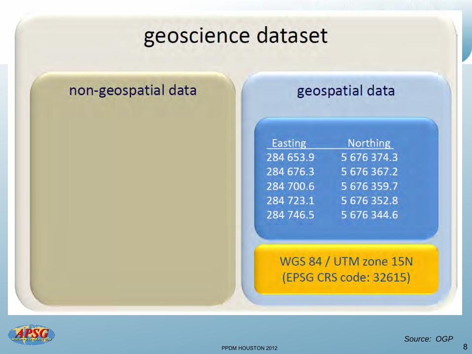
PPDM HOUSTON 2012 8 Source: OGP
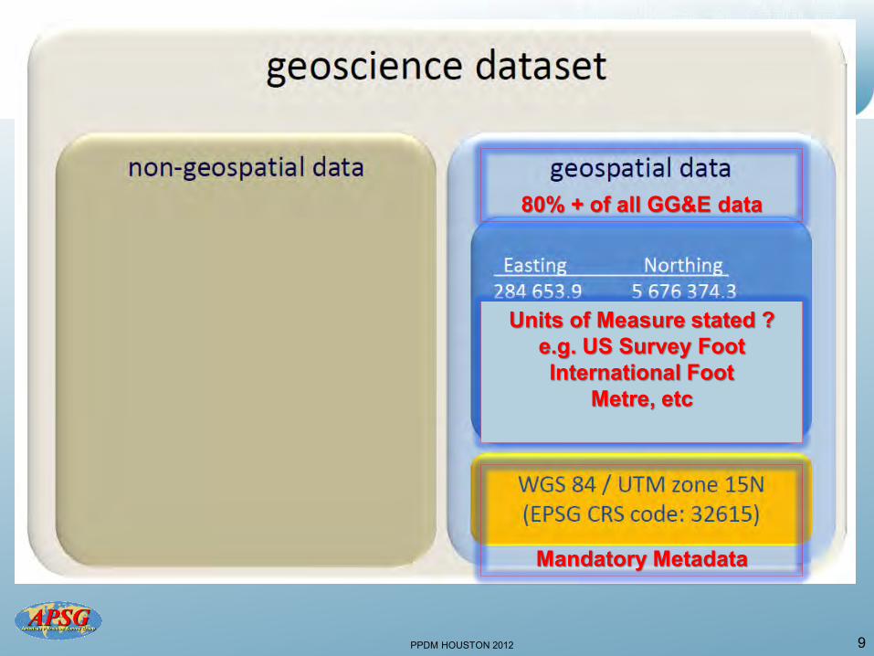
PPDM HOUSTON 2012 9
80% + of all GG&E data
Mandatory Metadata
Units of Measure stated ? e.g. US Survey Foot International Foot
Metre, etc
PPDM HOUSTON 2012
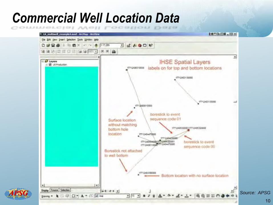
Commercial Well Location Data
10
Source: APSG
PPDM HOUSTON 2012
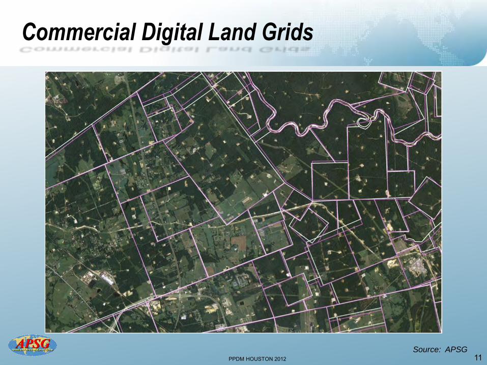
Commercial Digital Land Grids
11 Source: APSG
PPDM HOUSTON 2012
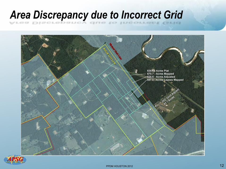
Area Discrepancy due to Incorrect Grid
12
PPDM HOUSTON 2012
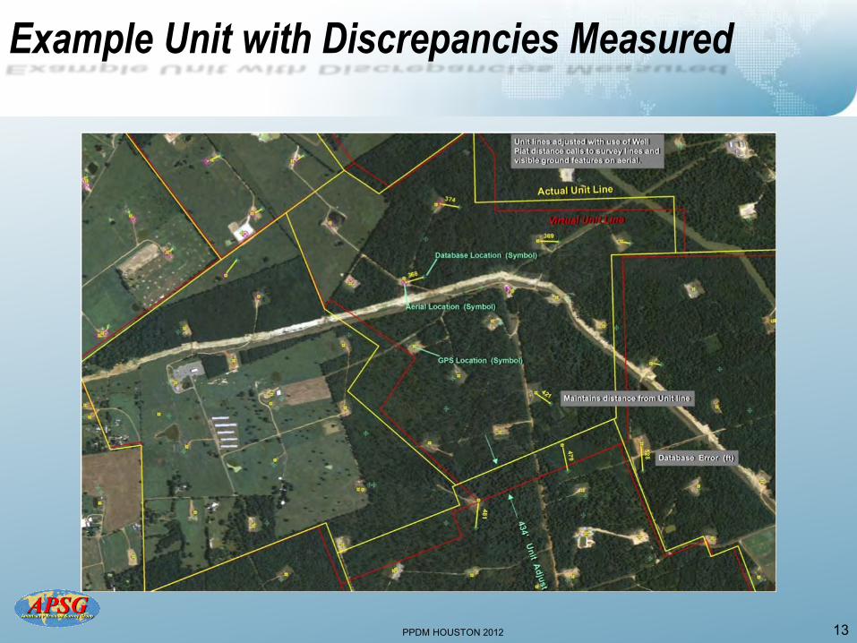
Example Unit with Discrepancies Measured
13
PPDM HOUSTON 2012
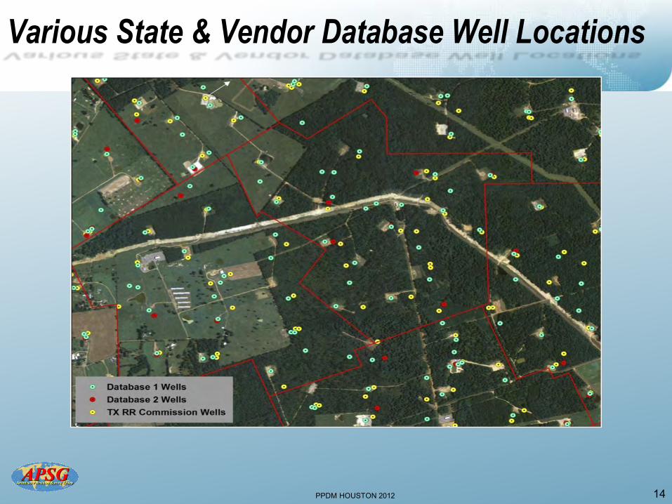
Various State & Vendor Database Well Locations
14
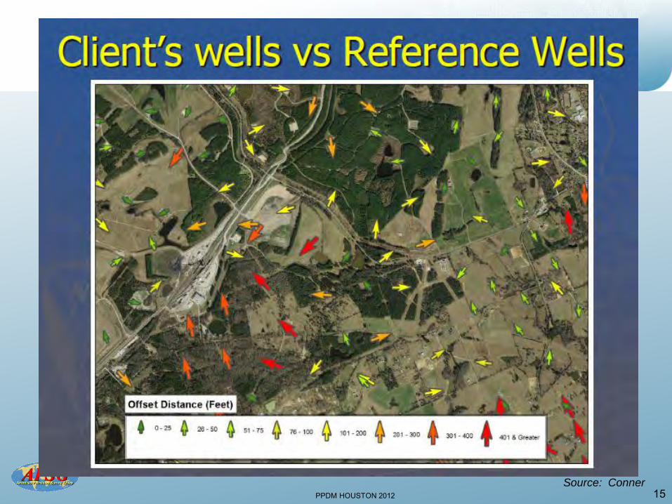
PPDM HOUSTON 2012 15 Source: Conner
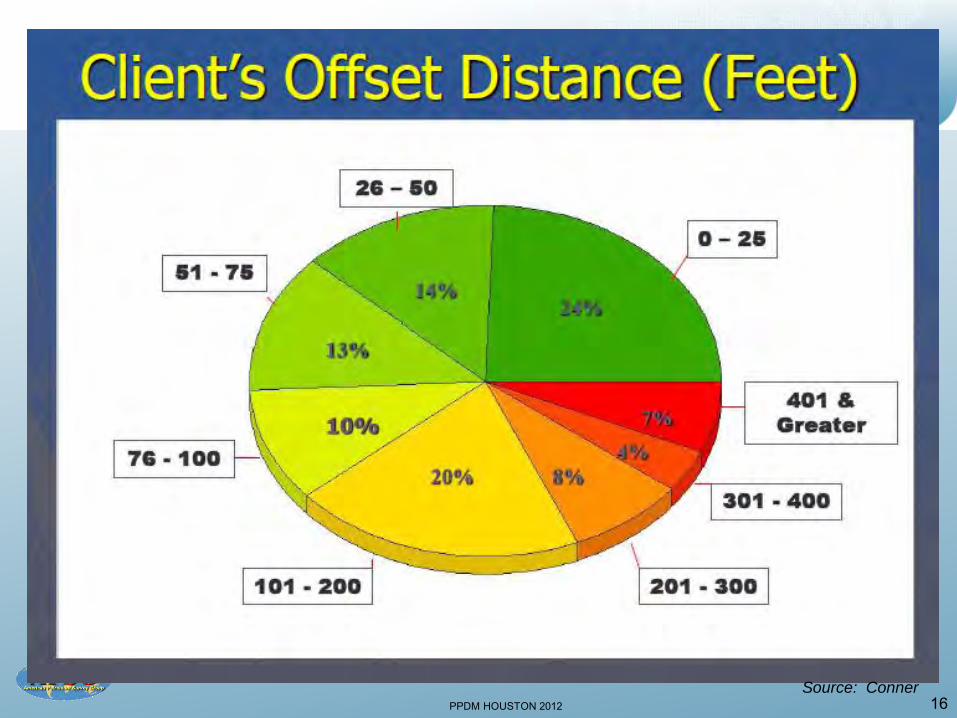
PPDM HOUSTON 2012 16 Source: Conner
PPDM HOUSTON 2012 17
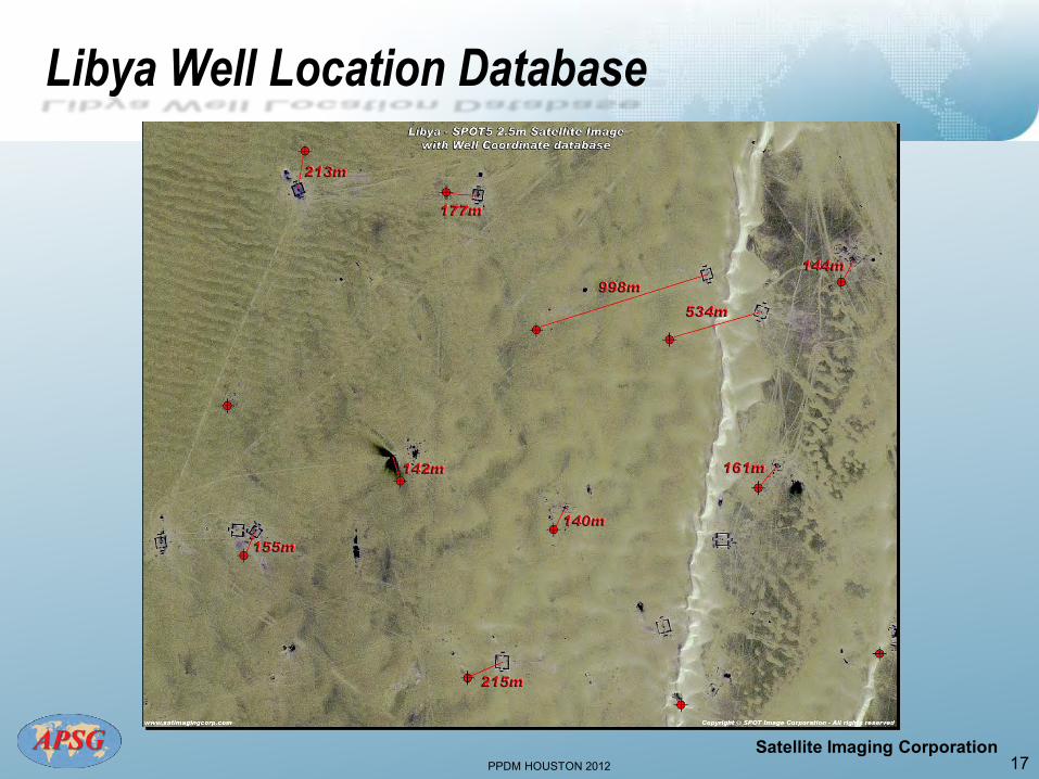
Libya Well Location Database
Satellite Imaging Corporation
PPDM HOUSTON 2012 18
Potential Causes of Well Positioning Errors
Why are the wells plotted at incorrect locations in the
previous Libyan example?
• Possibly some have used the wrong geodetic datum • Or incorrect datum transformations to WGS 84 were
used • Perhaps some were plotted from “pre-plot” locations • Different positioning technologies over many years
• The mis-positioning here is probably from a number
of different causes as the errors are of varying magnitudes and in different directions
PPDM HOUSTON 2012
Forensic Geodetics of One Well Location (US GOM)
• Cost of well was …… • Followed the data from G&G through
Drilling Ops • 486 documents with location (x,y) • 40% had no datum stated • NAD 27, NAD 83, WGS 84 datums are
all relevant for this process • In UTM grid, positioning difference
is? 19
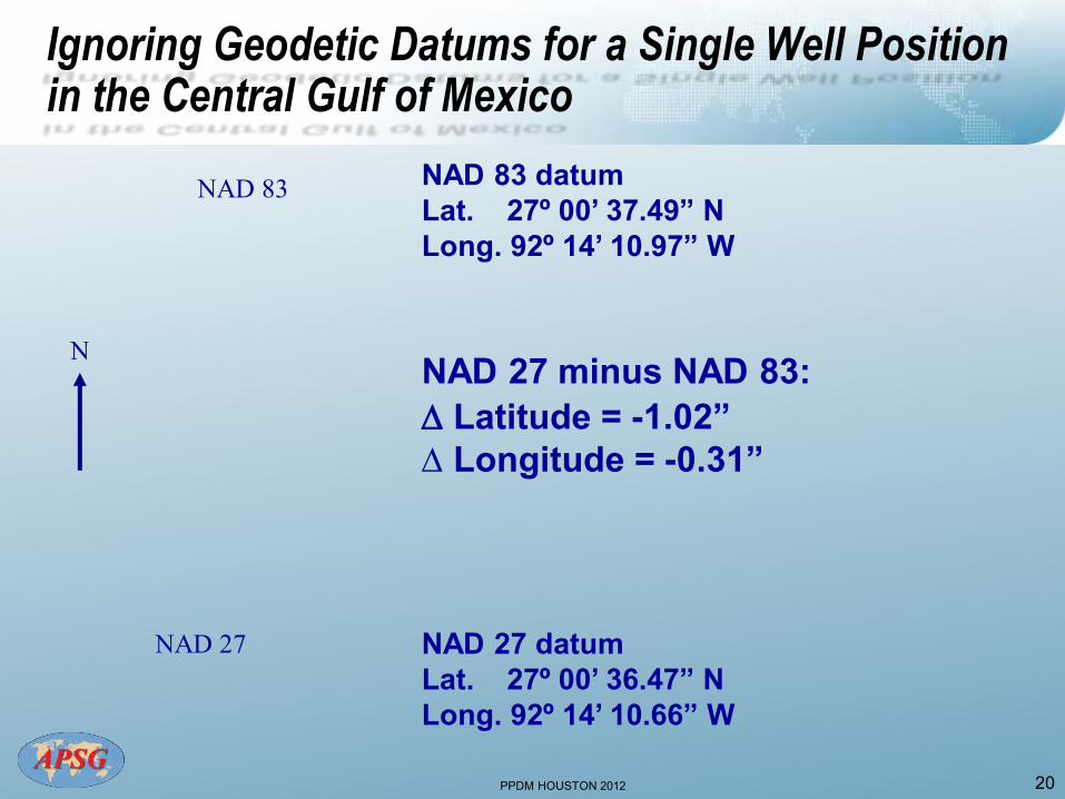
PPDM HOUSTON 2012 20
N
NAD 27
NAD 83 NAD 83 datum Lat. 27º 00’ 37.49” N Long. 92º 14’ 10.97” W
NAD 27 datum Lat. 27º 00’ 36.47” N Long. 92º 14’ 10.66” W
NAD 27 minus NAD 83: Latitude = -1.02” Longitude = -0.31”
Ignoring Geodetic Datums for a Single Well Position in the Central Gulf of Mexico
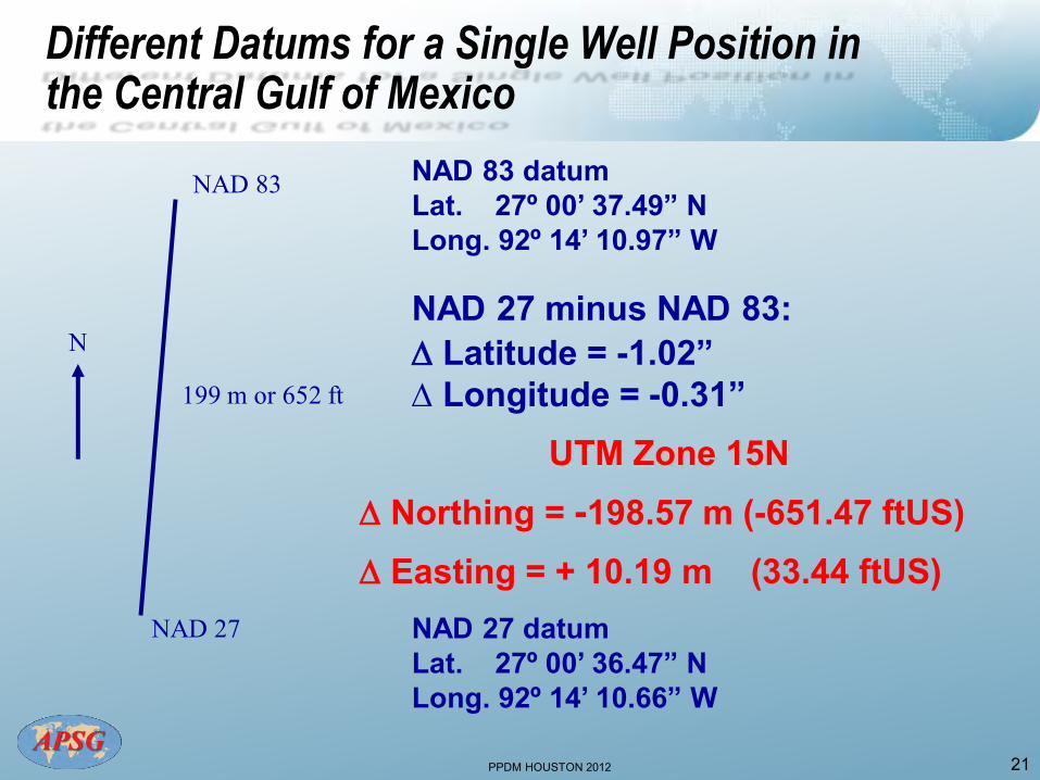
PPDM HOUSTON 2012 21
N
NAD 27
NAD 83
199 m or 652 ft
NAD 83 datum Lat. 27º 00’ 37.49” N Long. 92º 14’ 10.97” W
NAD 27 datum Lat. 27º 00’ 36.47” N Long. 92º 14’ 10.66” W
NAD 27 minus NAD 83: Latitude = -1.02” Longitude = -0.31”
UTM Zone 15N Northing = -198.57 m (-651.47 ftUS) Easting = + 10.19 m (33.44 ftUS)
Different Datums for a Single Well Position in the Central Gulf of Mexico
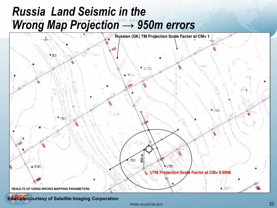
PPDM HOUSTON 2012 22
Russia Land Seismic in the Wrong Map Projection → 950m errors
Example courtesy of Satellite Imaging Corporation

PPDM HOUSTON 2012
Geodesy: Essentials for Geospatial Data
• Geodetic Datum
• Map Projection
• Vertical
• Orientation
• Unit of Measure
23
PPDM HOUSTON 2012
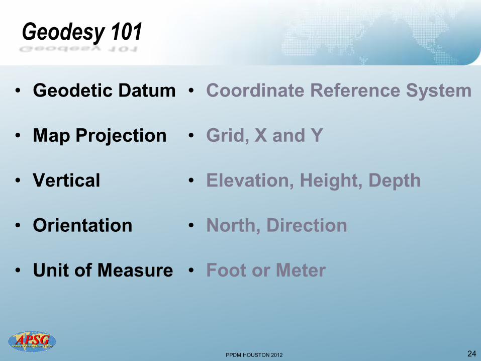
Geodesy 101
• Geodetic Datum
• Map Projection
• Vertical
• Orientation
• Unit of Measure
• Coordinate Reference System
• Grid, X and Y
• Elevation, Height, Depth
• North, Direction
• Foot or Meter
24
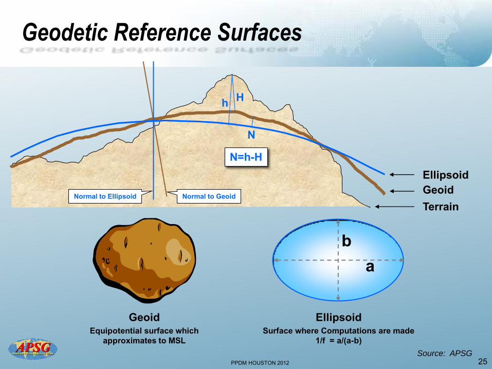
PPDM HOUSTON 2012
Terrain
Geodetic Reference Surfaces
25
Geoid Equipotential surface which
approximates to MSL
Geoid Normal to Geoid
a b
Ellipsoid Surface where Computations are made
1/f = a/(a-b)
Ellipsoid
Normal to Ellipsoid
h H
N
N=h-H
Source: APSG
PPDM HOUSTON 2012
The one thing you need to know about a Geodetic Datum is..
YOU NEED ONE
26
PPDM HOUSTON 2012 27
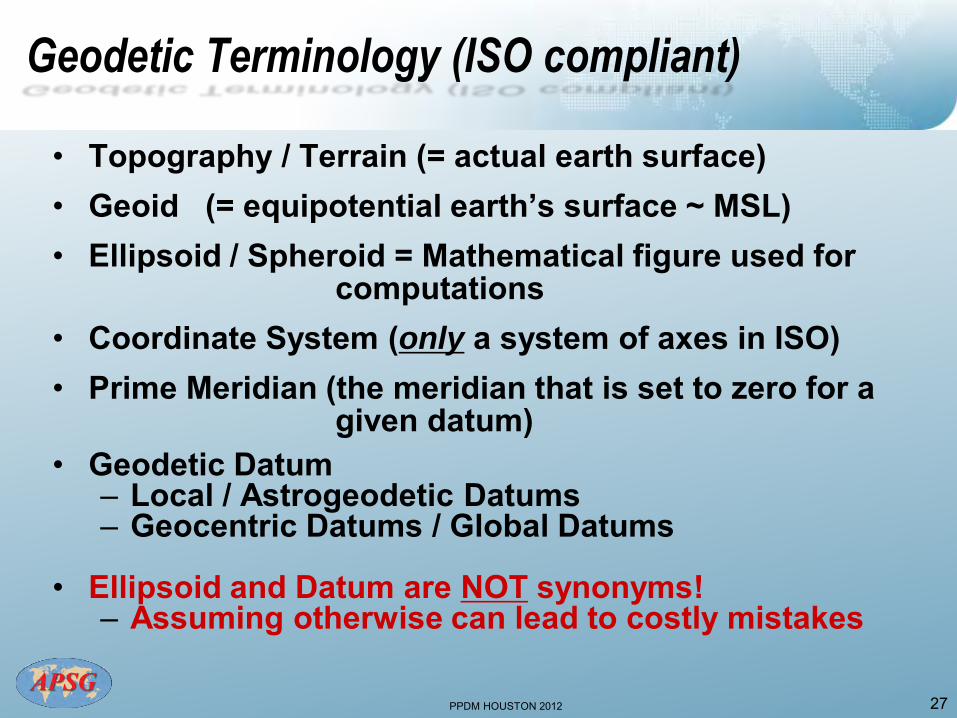
Geodetic Terminology (ISO compliant)
• Topography / Terrain (= actual earth surface) • Geoid (= equipotential earth’s surface ~ MSL) • Ellipsoid / Spheroid = Mathematical figure used for
computations • Coordinate System (only a system of axes in ISO) • Prime Meridian (the meridian that is set to zero for a
given datum) • Geodetic Datum
– Local / Astrogeodetic Datums – Geocentric Datums / Global Datums
• Ellipsoid and Datum are NOT synonyms!
– Assuming otherwise can lead to costly mistakes
PPDM HOUSTON 2012
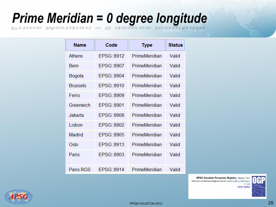
Prime Meridian = 0 degree longitude
28
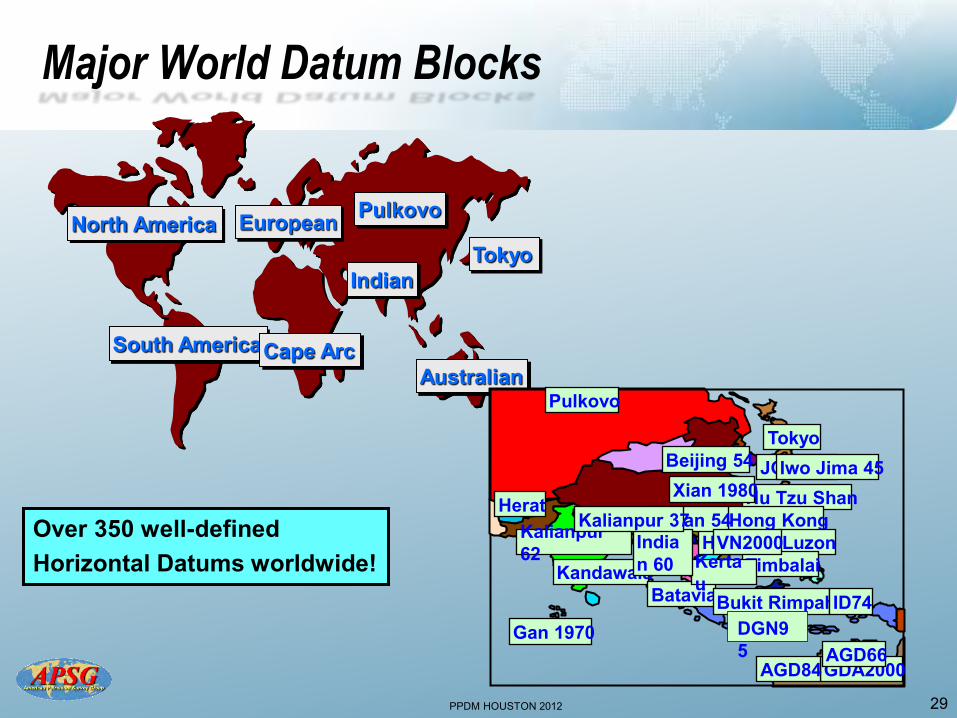
PPDM HOUSTON 2012 29
Major World Datum Blocks
North America European Pulkovo
South America Cape Arc Australian
Tokyo Indian
Over 350 well-defined Horizontal Datums worldwide!
Samboja
DGN95
GDA2000
JGD2000
Hanoi
Hu Tzu Shan Hong Kong Indian 54
AGD84
Kandawala
Tokyo
AGD66
Pulkovo
Herat Xian 1980
Gan 1970
Batavia Bukit Rimpah
Luzon Timbalai Kerta
u
Indian 60
Kalianpur 62
Beijing 54 Iwo Jima 45
ID74
VN2000 Kalianpur 37
DGN95
PPDM HOUSTON 2012 30
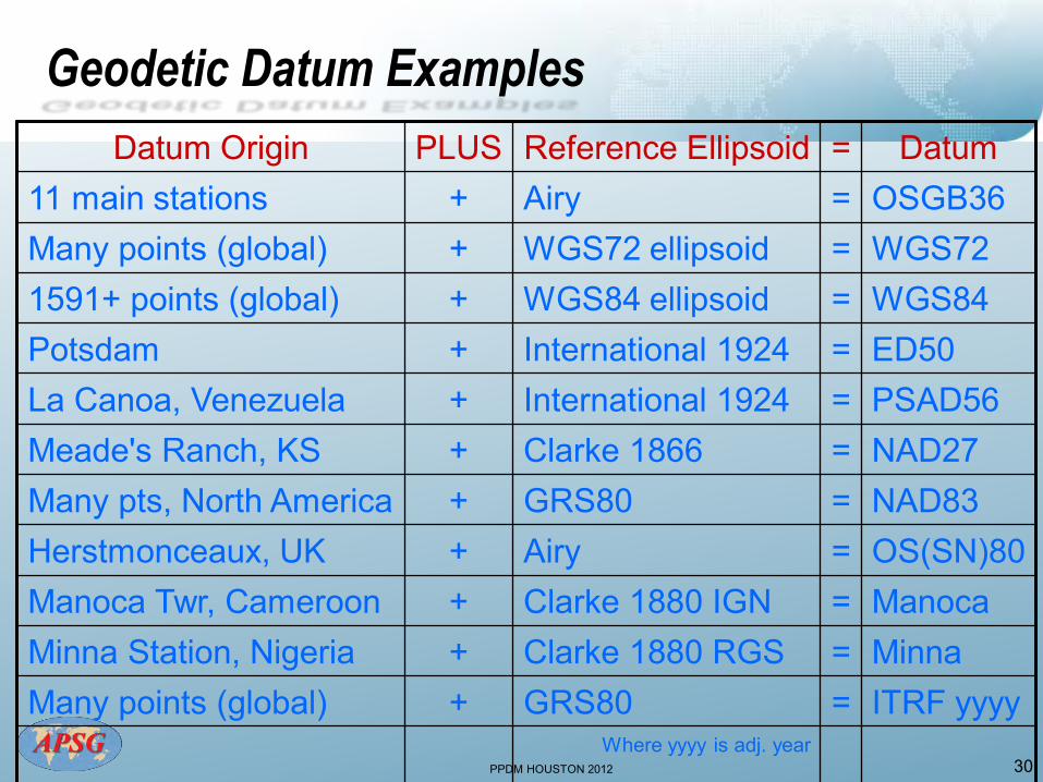
Geodetic Datum Examples
Datum Origin PLUS Reference Ellipsoid = Datum 11 main stations + Airy = OSGB36 Many points (global) + WGS72 ellipsoid = WGS72 1591+ points (global) + WGS84 ellipsoid = WGS84 Potsdam + International 1924 = ED50 La Canoa, Venezuela + International 1924 = PSAD56 Meade's Ranch, KS + Clarke 1866 = NAD27 Many pts, North America + GRS80 = NAD83 Herstmonceaux, UK + Airy = OS(SN)80 Manoca Twr, Cameroon + Clarke 1880 IGN = Manoca Minna Station, Nigeria + Clarke 1880 RGS = Minna Many points (global) + GRS80 = ITRF yyyy
Where yyyy is adj. year
PPDM HOUSTON 2012
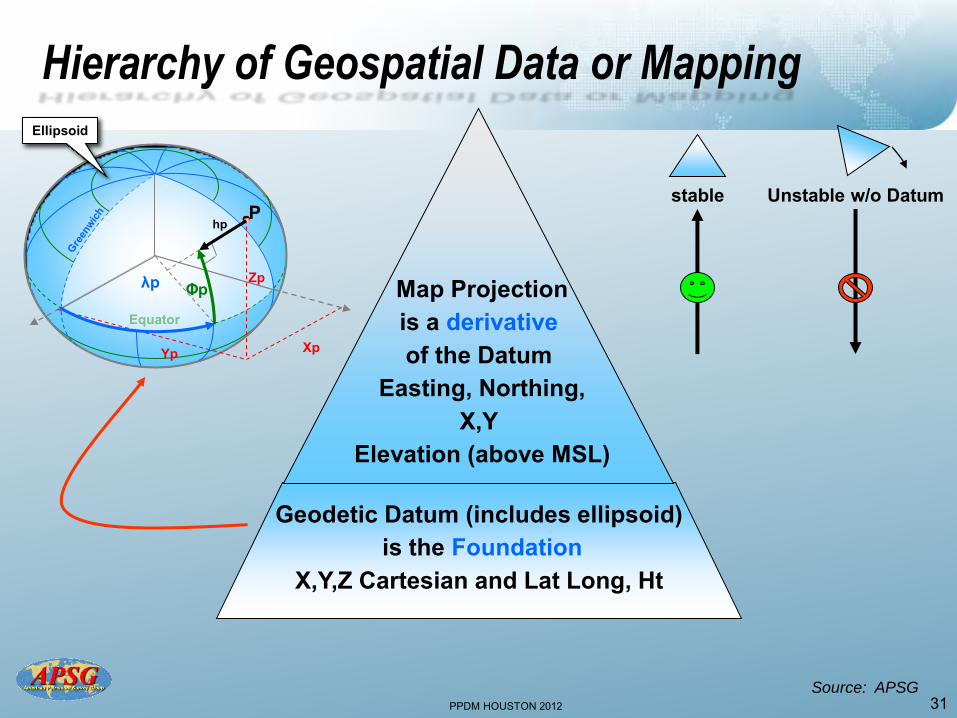
Hierarchy of Geospatial Data or Mapping
31
Geodetic Datum (includes ellipsoid) is the Foundation
X,Y,Z Cartesian and Lat Long, Ht
Equator
Zp
Xp Yp
P hp
Ellipsoid
λp Φp
stable Unstable w/o Datum
Map Projection is a derivative of the Datum
Easting, Northing, X,Y
Elevation (above MSL)
Source: APSG
PPDM HOUSTON 2012 32
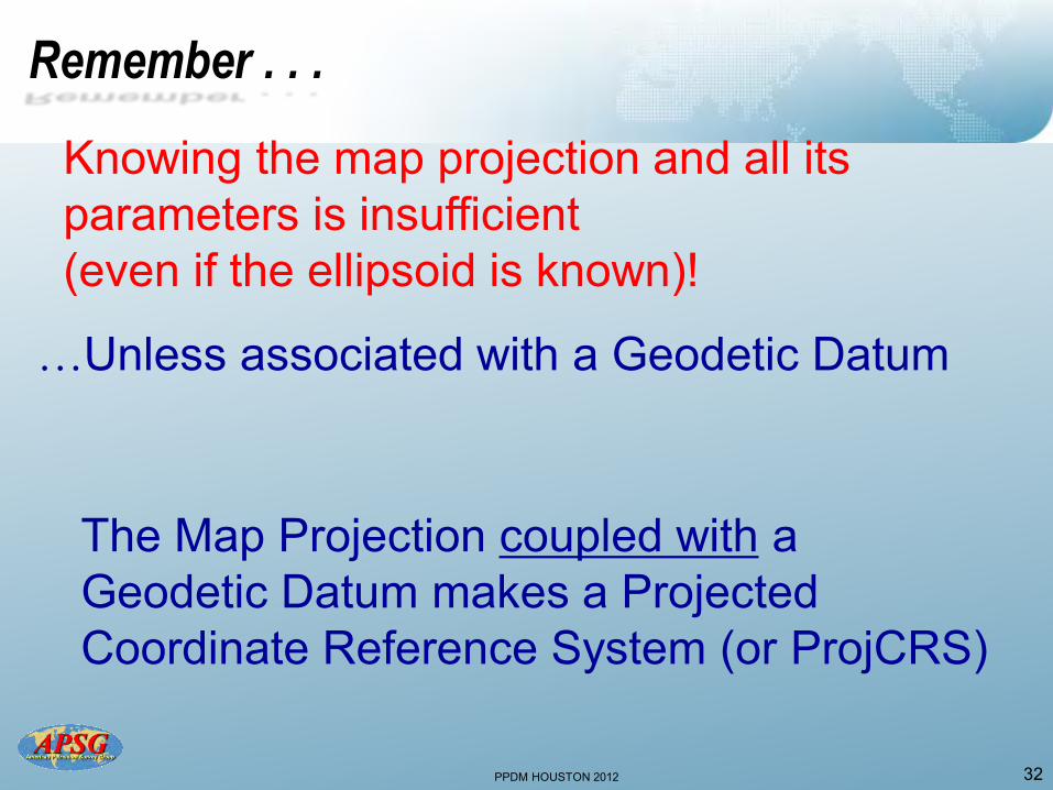
Remember . . .
Knowing the map projection and all its parameters is insufficient (even if the ellipsoid is known)!
…Unless associated with a Geodetic Datum
The Map Projection coupled with a Geodetic Datum makes a Projected Coordinate Reference System (or ProjCRS)
PPDM HOUSTON 2012 33
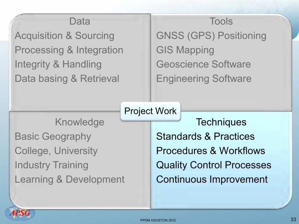
Data Acquisition & Sourcing Processing & Integration Integrity & Handling Data basing & Retrieval
Tools GNSS (GPS) Positioning GIS Mapping Geoscience Software Engineering Software
Knowledge Basic Geography College, University Industry Training Learning & Development
Techniques Standards & Practices Procedures & Workflows Quality Control Processes Continuous Improvement
Project Work
PPDM HOUSTON 2012 34
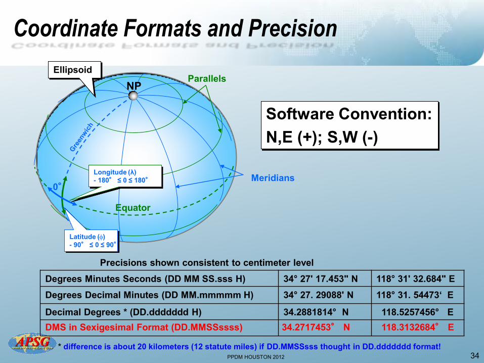
Coordinate Formats and Precision
Meridians
Parallels
Longitude (λ) - 180° ≤ 0 ≤ 180°
Software Convention: N,E (+); S,W (-)
Latitude () - 90° ≤ 0 ≤ 90°
Precisions shown consistent to centimeter level Degrees Minutes Seconds (DD MM SS.sss H) 34° 27' 17.453" N 118° 31' 32.684" E Degrees Decimal Minutes (DD MM.mmmmm H) 34° 27. 29088' N 118° 31. 54473‘ E
Decimal Degrees * (DD.ddddddd H) 34.2881814° N 118.5257456° E
0°
NP
Equator
Ellipsoid
* difference is about 20 kilometers (12 statute miles) if DD.MMSSsss thought in DD.ddddddd format!
DMS in Sexigesimal Format (DD.MMSSssss) 34.2717453° N 118.3132684° E
PPDM HOUSTON 2012
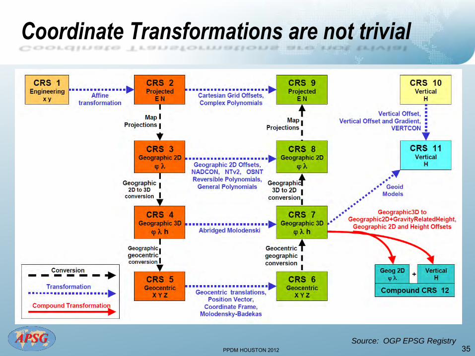
Coordinate Transformations are not trivial
35 Source: OGP EPSG Registry

PPDM HOUSTON 2012 36
More Confusion in Geodesy
Reference Orientations: (5 types of North) • True North = direction of the meridian through a point • Magnetic North = differs from True N by Declination • Grid North = differs from True North by convergence
• Gyro North = a measurement of True North by
instrument • Plant North = strictly a “local” non-georeferenced
orientation
PPDM HOUSTON 2012 37
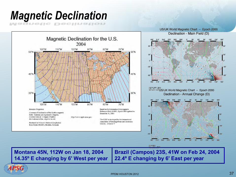
Magnetic Declination
Montana 45N, 112W on Jan 18, 2004 14.35º E changing by 6' West per year
Brazil (Campos) 23S, 41W on Feb 24, 2004 22.4º E changing by 6' East per year
PPDM HOUSTON 2012 38
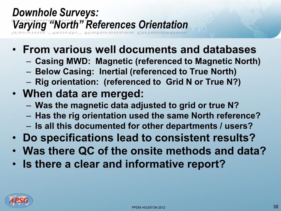
Downhole Surveys: Varying “North” References Orientation
• From various well documents and databases – Casing MWD: Magnetic (referenced to Magnetic North) – Below Casing: Inertial (referenced to True North) – Rig orientation: (referenced to Grid N or True N?)
• When data are merged: – Was the magnetic data adjusted to grid or true N? – Has the rig orientation used the same North reference? – Is all this documented for other departments / users?
• Do specifications lead to consistent results? • Was there QC of the onsite methods and data? • Is there a clear and informative report?
PPDM HOUSTON 2012
39
PPDM HOUSTON 2012
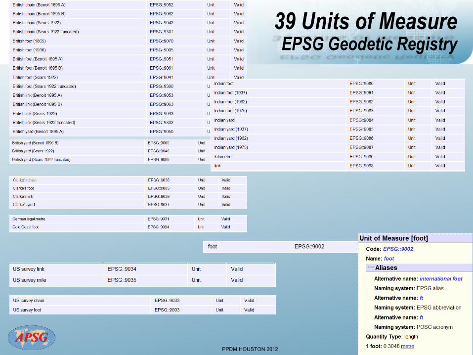
39 Units of Measure EPSG Geodetic Registry
40
PPDM HOUSTON 2012 41
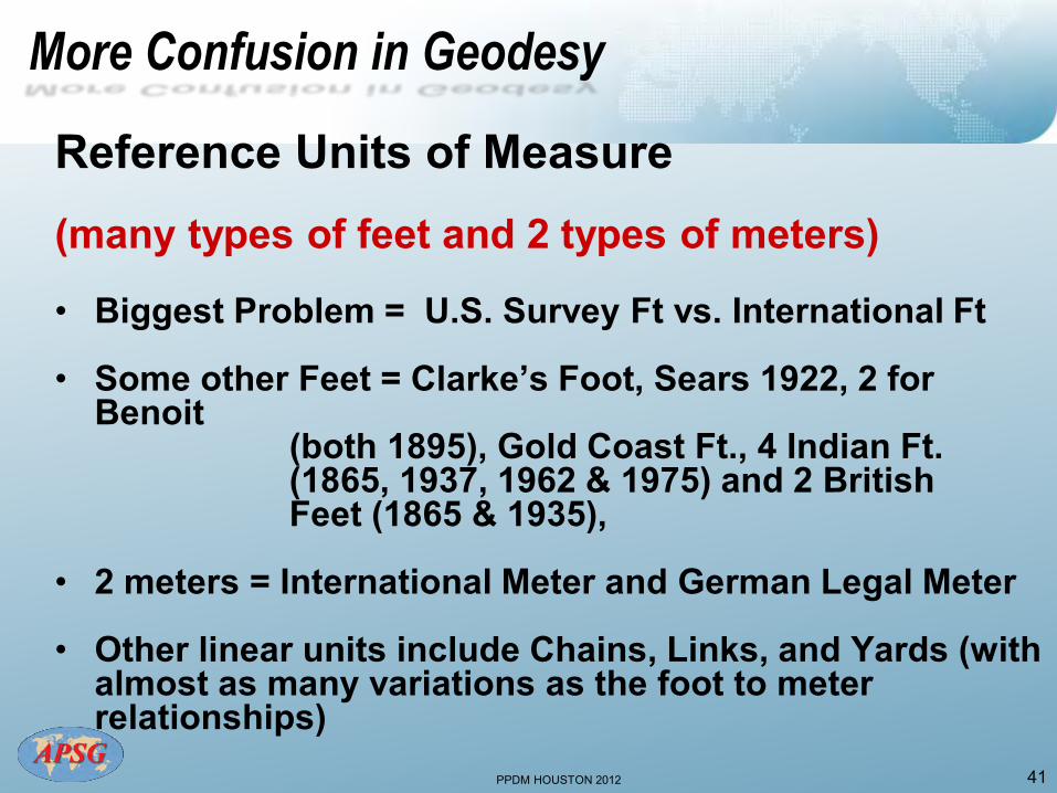
More Confusion in Geodesy
Reference Units of Measure (many types of feet and 2 types of meters) • Biggest Problem = U.S. Survey Ft vs. International Ft • Some other Feet = Clarke’s Foot, Sears 1922, 2 for
Benoit (both 1895), Gold Coast Ft., 4 Indian Ft. (1865, 1937, 1962 & 1975) and 2 British Feet (1865 & 1935),
• 2 meters = International Meter and German Legal Meter • Other linear units include Chains, Links, and Yards (with
almost as many variations as the foot to meter relationships)

PPDM HOUSTON 2012
If you remember nothing else…..
• Latitudes and Longitudes are not unique unless qualified with datum name!
• Projection Coordinates are not unique unless qualified with Projection name, Zone and Datum!
• Heights are not unique unless qualified with Surface Reference (Vertical Datum)!
• Orientations are not unique unless qualified with Heading Reference!
• Units are not unique unless qualified with Unit Reference!
42
PPDM HOUSTON 2012
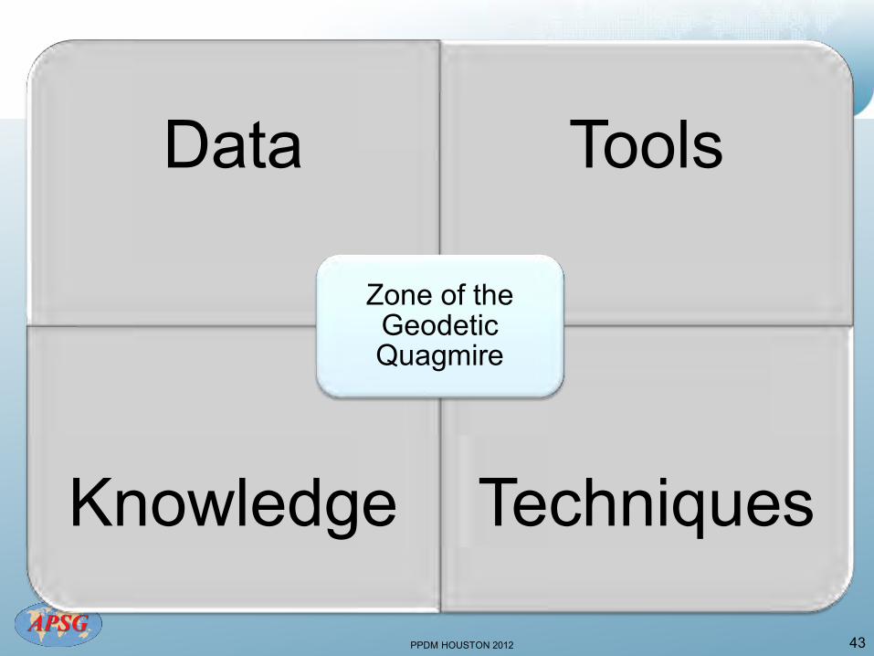
Data Tools
Knowledge Techniques
Zone of the Geodetic Quagmire
43

PPDM HOUSTON 2012
Experts in Geomatics, Surveying, Positioning,
Geospatial Data, and Mapping Sciences
Geodetic Integrity:
The Essential Basics for Data Managers and Users
44
Michael Barnes
www.apsg.info