POTENTIAL OF SENTINEL-1A FOR NATION-WIDE … · available until 2015 (Gaprindashvili and van...
7
POTENTIAL OF SENTINEL-1A FOR NATION-WIDE ROUTINE UPDATES OF ACTIVE LANDSLIDE MAPS M. Lazecky a * F. Canaslan Comut b , E. Nikolaeva c , M. Bakon d , J. Papco d , A. M. Ruiz-Armenteros e , Y. Qin f , J. J. M. de Sousa g , P. Ondrejka h * a IT4Innovations, VSB-TU Ostrava, Czech Republic – [email protected] b Turkey Disaster & Emergency Directorate (AFAD) of Denizli, Turkey - [email protected] c Ilia State University, Tbilisi, Georgia - [email protected] d Dept. of Theoretical Geodesy, STU Bratislava, Slovakia – [email protected], [email protected] e Departamento de Ingeniería Cartográfica, Geodésica y Fotogrametría, CEAC Tierra, Universidad de Jaén, Spain - [email protected] f Lyles School of Civil Engineering, Purdue University, USA - [email protected] g UTAD, Vila Real and INESC-TEC (formerly INESC Porto), Portugal - [email protected] h State Geological Institute of Dionýz Štúr, Slovakia - [email protected] Theme Session ThS 3 KEY WORDS: Landslide activity, Public authorities, SAR Interferometry, Landslide inventory map, Sentinel-1A ABSTRACT: Slope deformation is one of the typical geohazards that causes an extensive economic damage in mountainous regions. As such, they are usually intensively monitored by means of modern expertise commonly by national geological or emergency services. Resulting landslide susceptibility maps, or landslide inventories, offer an overview of areas affected by previously activated landslides as well as slopes known to be unstable currently. Current slope instabilities easily transform into a landslide after various triggering factors, such as an intensive rainfall or a melting snow cover. In these inventories, the majority of the existing landslide-affected slopes are marked as either stable or active, after a continuous investigative work of the experts in geology. In this paper we demonstrate the applicability of Sentinel-1A satellite SAR interferometry (InSAR) to assist by identifying slope movement activity and use the information to update national landslide inventories. This can be done reliably in cases of semi-arid regions or low vegetated slopes. We perform several analyses based on multitemporal InSAR techniques of Sentinel-1A data over selected areas prone to landslides. 1. INTRODUCTION 1.1 Current practices in landslide inventory maps Landslides are present in all continents, and play an important role in the evolution of landscapes. They also represent a serious hazard in many areas of the world. Preparing landslide maps is important to document the extent of landslide phenomena in a region, to investigate the distribution, types, pattern, recurrence and statistics of slope failures, to determine landslide susceptibility, hazard, vulnerability and risk, and to study the evolution of landscapes dominated by mass-wasting processes. Conventional methods for the production of landslide maps rely chiefly on the visual interpretation of stereoscopic aerial photography, aided by field surveys. These methods are time consuming and resource intensive. New and emerging techniques based on satellite, airborne, and terrestrial remote sensing technologies, promise to facilitate the production of landslide maps, reducing the time and resources required for their compilation and systematic update. A concise review of the used methods for landslide inventory can be found in Guzzetti et al. (2012). The main scopes for landslide inventory maps cover: (i) documenting the extent of landslide phenomena in areas ranging from small to large watersheds, and from region to state or nations, (ii) as a preliminary step toward landslide susceptibility, hazard, and risk assessment, (iii) the investigation of the distribution, types, and patterns of landslides in relation to morphological and geological characteristics, and (iv) to study the evolution of landscapes dominated by mass-wasting processes. Landslide maps can be prepared using different techniques depending on the purpose of the inventory, the extent of the study area, the scale of the base maps, the scale, resolution and characteristics of the available imagery (e.g., aerial photographs, satellite images, LIDAR elevation data), the skills and experience of the investigators, and the resources available to complete the work. Landslide maps are classified by their scale and the type of mapping. Small-scale inventories (<200.000) are compiled from archive studies, medium-scale (1:25.000 to 1:200.000) mainly from the interpretation of aerial photographs, and large-scale (>1:25.000) using both the interpretation of aerial photograhs, very high resolution satellite images or digital terrain models, and extensive field investigations. Landslide inventory maps are produced using conventional methods like geomorphological field mapping and the visual interpretation of stereoscopic aerial photographs, and new moderm techniques. These new and recent methods include the use of very-high resolution digital elevation models (DEMs) as the obtained from LIDAR technology, and the interpretation and analysis of images from passive and active remote sensing techniques. In the case of optical images (medium and high-resolution), the techniques use panchromatic (single band), composite, false-color, pan sharpened images, and multispectral (multiple bands) images, including image classification methods and semi-automatic detection and mapping of landslides. For active remote sensing, the new * Corresponding author The International Archives of the Photogrammetry, Remote Sensing and Spatial Information Sciences, Volume XLI-B7, 2016 XXIII ISPRS Congress, 12–19 July 2016, Prague, Czech Republic This contribution has been peer-reviewed. doi:10.5194/isprsarchives-XLI-B7-775-2016 775
Transcript of POTENTIAL OF SENTINEL-1A FOR NATION-WIDE … · available until 2015 (Gaprindashvili and van...
POTENTIAL OF SENTINEL-1A FOR NATION-WIDE ROUTINE UPDATES OF ACTIVELANDSLIDE MAPS
M. Lazecky a* F. Canaslan Comut b, E. Nikolaevac, M. Bakond , J. Papcod, A. M. Ruiz-Armenterose, Y. Qinf, J. J. M. de Sousag, P.Ondrejkah *
a IT4Innovations, VSB-TU Ostrava, Czech Republic – [email protected] Turkey Disaster & Emergency Directorate (AFAD) of Denizli, Turkey - [email protected]
c Ilia State University, Tbilisi, Georgia - [email protected] Dept. of Theoretical Geodesy, STU Bratislava, Slovakia – [email protected], [email protected]
e Departamento de Ingeniería Cartográfica, Geodésica y Fotogrametría, CEAC Tierra, Universidad de Jaén, Spain [email protected]
f Lyles School of Civil Engineering, Purdue University, USA - [email protected] UTAD, Vila Real and INESC-TEC (formerly INESC Porto), Portugal - [email protected]
h State Geological Institute of Dionýz Štúr, Slovakia - [email protected]
Theme Session ThS 3
KEY WORDS: Landslide activity, Public authorities, SAR Interferometry, Landslide inventory map, Sentinel-1A
ABSTRACT:
Slope deformation is one of the typical geohazards that causes an extensive economic damage in mountainous regions. As such,they are usually intensively monitored by means of modern expertise commonly by national geological or emergency services.Resulting landslide susceptibility maps, or landslide inventories, offer an overview of areas affected by previously activatedlandslides as well as slopes known to be unstable currently. Current slope instabilities easily transform into a landslide after varioustriggering factors, such as an intensive rainfall or a melting snow cover. In these inventories, the majority of the existinglandslide-affected slopes are marked as either stable or active, after a continuous investigative work of the experts in geology. In thispaper we demonstrate the applicability of Sentinel-1A satellite SAR interferometry (InSAR) to assist by identifying slope movementactivity and use the information to update national landslide inventories. This can be done reliably in cases of semi-arid regions orlow vegetated slopes. We perform several analyses based on multitemporal InSAR techniques of Sentinel-1A data over selectedareas prone to landslides.
1. INTRODUCTION
1.1 Current practices in landslide inventory maps
Landslides are present in all continents, and play an importantrole in the evolution of landscapes. They also represent aserious hazard in many areas of the world. Preparing landslidemaps is important to document the extent of landslidephenomena in a region, to investigate the distribution, types,pattern, recurrence and statistics of slope failures, to determinelandslide susceptibility, hazard, vulnerability and risk, and tostudy the evolution of landscapes dominated by mass-wastingprocesses. Conventional methods for the production oflandslide maps rely chiefly on the visual interpretation ofstereoscopic aerial photography, aided by field surveys. Thesemethods are time consuming and resource intensive. New andemerging techniques based on satellite, airborne, and terrestrialremote sensing technologies, promise to facilitate theproduction of landslide maps, reducing the time and resourcesrequired for their compilation and systematic update. A concisereview of the used methods for landslide inventory can befound in Guzzetti et al. (2012).
The main scopes for landslide inventory maps cover: (i)documenting the extent of landslide phenomena in areasranging from small to large watersheds, and from region tostate or nations, (ii) as a preliminary step toward landslidesusceptibility, hazard, and risk assessment, (iii) theinvestigation of the distribution, types, and patterns oflandslides in relation to morphological and geological
characteristics, and (iv) to study the evolution of landscapesdominated by mass-wasting processes.
Landslide maps can be prepared using different techniquesdepending on the purpose of the inventory, the extent of thestudy area, the scale of the base maps, the scale, resolution andcharacteristics of the available imagery (e.g., aerialphotographs, satellite images, LIDAR elevation data), the skillsand experience of the investigators, and the resources availableto complete the work. Landslide maps are classified by theirscale and the type of mapping. Small-scale inventories(<200.000) are compiled from archive studies, medium-scale(1:25.000 to 1:200.000) mainly from the interpretation of aerialphotographs, and large-scale (>1:25.000) using both theinterpretation of aerial photograhs, very high resolution satelliteimages or digital terrain models, and extensive fieldinvestigations.
Landslide inventory maps are produced using conventionalmethods like geomorphological field mapping and the visualinterpretation of stereoscopic aerial photographs, and newmoderm techniques. These new and recent methods include theuse of very-high resolution digital elevation models (DEMs) asthe obtained from LIDAR technology, and the interpretationand analysis of images from passive and active remote sensingtechniques. In the case of optical images (medium andhigh-resolution), the techniques use panchromatic (singleband), composite, false-color, pan sharpened images, andmultispectral (multiple bands) images, including imageclassification methods and semi-automatic detection andmapping of landslides. For active remote sensing, the new
* Corresponding author
The International Archives of the Photogrammetry, Remote Sensing and Spatial Information Sciences, Volume XLI-B7, 2016 XXIII ISPRS Congress, 12–19 July 2016, Prague, Czech Republic
This contribution has been peer-reviewed. doi:10.5194/isprsarchives-XLI-B7-775-2016
775

techniques make use of synthetic aperture radar (SAR) imagesthrought out the analysis of time series of surface deformationat specific points obtained by radar interferometric techniques.Finally, the modern approaches include the use of new tools tofacilitate field mapping such a GNSS data, modern digitalcameras with build-in GPS capabilities, laser distance meters,digital compasses, hand-held devices for the acquisition of datain the field assited with dedicated GIS technology.
In practice, national geological surveys usually do notperiodically update their landslide inventories. Newly detectedand reported landslides are mapped into the inventory usingmentioned capabilities, very often with support of a highresolution DEM model, and its spatial information is connectedwith its database entry. The evaluation of activity of olderknown landslides is in many countries done based on existingconcluding reports by investigating geological companies.
Landslide inventories and especially landslide maps are notnecessarily present in every country. For example in Georgia,despite the known landslide hazards causing infrastructuraldamage and fatalities (Jibson et al., 1994; van Westen et al.,2012; Gracheva and Golyeva, 2010), a national digitallandslide inventory covering the entire country was notavailable until 2015 (Gaprindashvili and van Westen, 2015).National scale landslide susceptibility map was generated by aSpatial Multi Criteria Evaluation method using an available(incomplete) landslide inventory from the NationalEnvironmental Agency, the Forest Management Department,and mass media. Also, supplement maps were used such aslithology, DEM, land cover, hydrology, geomorphology,precipitation and physical geography. However, this landslidesusceptibility map is only an approximation and contains ahigh degree of uncertainty (Gaprindashvili and van Westen,2015). To improve landslide susceptibility map, the landinventory should be improved. Until now, the main monitoringsystem of the mass movement is a field survey in Georgia. Ahuge landslide in Tbilisi from July 2015 is an indicator of theneed of a remote monitoring system and experts to analyzeremote sensing data that would allow to monitor and study thedynamics of landslides in Georgia. Several publicationsdemonstrate application of remote sensing data to detect,analyze and monitor landslides for local Georgian areas(Nikolaeva et al., 2013; Nikolaeva and Walter, 2012, 2013;Elashvili et al., 2012). Landslides were detected and analyzedusing various SAR data and techniques and supplemented withoptical data, demonstrating the potential to use remote sensingdata to detect, monitor and analyze mass movement activity.Demonstrated possibilities await their practical service.
1.2 SAR Interferometry for landslide identification
Satellite SAR interferometry (InSAR) has the potential todetect ground surface motion phenomena with the accuracy ofa small fraction of the radar wavelength, usually from 3(X-band) to 24 cm (L-band) on large areas with high spatialresolution (up to 1 m in the case of the new generation sensorsonboard of the German TERRASAR-X and the ItalianCOSMO-SkyMed). Thanks to its capability in detectingmillimeter level displacements over long periods and largeareas, multi-temporal interferometric (MT-InSAR) techniquesanalysis can be considered complementary to conventionalgeological and geomorphological studies in landslide detectionand monitoring. Indeed the landslide mechanism is seatedbelow the surface but for observing the creeping movements ofthe slope surface, InSAR is evaluated as a promising remotesensing technology (Scaioni et al., 2014).
In the last years, several studies have proven MT-InSARfeasibility in landslide detection and monitoring using the
whole range of wavelength, depending on the phenomena andthe characteristics of the area under analysis. For instance,Vöge et al. (2015) used MT-InSAR techniques applied toC-band ASAR and ERS images to identify and map landslidesin a very sensitive area located in the India Himalayan region.Xue et al. (2016) used C-band ASAR images obtained fromJuly 2003 to March 2010 to slope monitoring in the over 3.5million inhabitants Lanzhou city area (China). Sun et al. (2015)used ALOS L-band images acquired between January 2007 andMay 2010 to conclude that Zhouqu giant landslide that causedover than 1700 fatalities in 2010, shown instabilities before theevent and Novellino et al. (2015) present a MT-InSAR analysisto monitor landslide in Costa Della Gaveta (Italy) usingTerraSAR-X images acquired between February 2010 andApril 2011. Macciotta et al. (2016) proposed an early warningsystem for a very slow landslide displacement monitoring byintegrating MT-InSAR techniques with a set of in situ deployedtechniques/equipment. Other authors focus also into the field ofInSAR application for landslide early warning and concludeabout a possibility of monitoring slow creeping slopemovements and their dynamics while for a specific landslide, ahigh acquisition frequency of ground-based SAR instrument ismore suitable (Del Ventisette et al., 2015).
Within current SAR systems, the main limitations lie in theorientation and a vegetation coverage of the observed slopes.The ascending and descending tracks offer observation of slopemovements that are not oriented towards N or S. Moderntechniques such as multiple-aperture InSAR (MAI) mayovercome this limitation but deal with other specific issues(Jung et al., 2013). The vegetation coverage causes temporaldecorrelation and thus inability to distinguish between localslope and a vegetation movement. Low frequency SAR systemscan overcome this limitation to some extent (e.g. L-band SARsatellites such as Japanese ALOS-2) by its canopy penetratingabilities. Instruments using shorter wavelength overcome thedecorrelation due to vegetation growth by a higher revisit time.European Sentinel-1A (S-1A) revisits a track every 12 days.
1.3 New possibilities using Sentinel-1 interferometry
Comparing with other C-band satellites in the past (forexample, Envisat) or at current (for example, Radarsat-2), S-1Aadvantages come from three aspects: wide range coverage, highspatial resolution and shorter revisit time. Specifically, S-1Atakes the wide swath (IW) mode as its default scanning mode.The IW mode allows the satellite to scan up to 240 km in therange direction. Meanwhile, by using a larger bandwidth (of56.50-42.80 MHz) comparing with the previous generation ofESA satellites (ERS and Envisat), S-1A IW mode is able tomaintain a finer resolution of 5 meters in range and 20 metersin azimuth direction. In addition to the wide area coverage andhigh scanning resolution, S-1A has a 12-days revisit time.Comparing with the 35-day-Envisat and 24-day-Radarsat-2,S-1A greatly improved the temporal resolution forinterferometry applications. Furthermore, with the launch of itstwin satellite S-1B scheduled in April 2016, the revisit timebetween the twins will be decreased to 6 days. Last but not theleast, Sentinel datasets are free to public, which gives thescience community more opportunities to explore.
All these advantages of S-1A data provide a lot of newpossibilities for real time monitoring work with S-1Ainterferograms. To start with, the wide coverage allowsmonitoring of wide range earth surface dynamic movements,such as earthquakes, volcano activities, glacier drifts and so on.In the second place, the fine temporal resolution allowsinterferograms to keep a close track of ground motions with ahigh temporal correlation. Nevertheless, with its high spatialresolution S-1A is also capable of monitoring smaller scale
The International Archives of the Photogrammetry, Remote Sensing and Spatial Information Sciences, Volume XLI-B7, 2016 XXIII ISPRS Congress, 12–19 July 2016, Prague, Czech Republic
This contribution has been peer-reviewed. doi:10.5194/isprsarchives-XLI-B7-775-2016
776

targets, man-made infrastructures, such as dams, buildings andairports. The fast delivery of Sentinel data to the public made itpossible to do real time monitoring and publish usefulinformation at first time. A number of projects alreadydemonstrated the potential of S-1A interferometry, includingfor instance application to volcano monitoring (González et al.,2015) or observation of effects of the earthquake in Chile(Grandin et al., 2016), South Napa (Polcari et al., 2014) orPishan in China (Wen et al., 2016).
2. INHABITED SLOPES
The strategy of applying common multitemporal InSARtechniques such as Permanent/Persistent Scatterers (PS) InSARyields in very reliable results and possibility to obtaindynamics of the movement within estimated data time series.However the reliability depends on the presence of temporallycoherent scatterers, such as buildings or at least bare rocks. Thehigh revisit time of S-1A allows frequent measurements thatcaptures PS dynamics in a higher temporal detail than usinge.g. Envisat ASAR system and thus may evaluate alsomovements with a higher velocity rate.
2.1 Babadag, Turkey
Babadag is a small town of Turkey and 30 km away from thecentre of the city Denizli in Aegean region (Lat:37°48'38.37"N, Lon: 28°51'33.38"E) which has been seriouslyaffected by a landslide phenomena since last 60 years. TheBabadag landslide has been evaluated from Envisat in aprevious work (Lazecký et al., 2015). Because of low numberof images and high rate of decorrelation in the area (also due tofast movements), the result could be achieved only using anMT-InSAR methodology using only coherent spatially filteredinterferograms rather than the whole time series in the PSalgorithm. In this case, Quasi-PS technique was used (Perissinet al., 2007). In case of processing based on S-1A, a higher rateof deformation could be captured reliably due to a higher revisittime. With only 12 images used from 10 th September 2015 –20th March 2016, the PS processing allowed detection ofmovement in the rate of almost 100 mm/year in the satelliteline-of-sight (LOS). The result is shown in Fig. 1. Thetechnology reveals a continuous movement of the slope in arelatively high rate. Babadag village has been evacuatedalready in 2006 (Canaslan-Comut et al., 2015a).
Figure 1. A high rate of landslide movement detected bySentinel-1A PS InSAR over Babadag village, Turkey.
2.2 Prievidza, Slovakia
The region of Prievidza, in the central part of Slovakia, isaffected by various types of slope failures, especiallylandslides. The 2012-2013 reactivation of slope deformations inHradec and Velka Lehotka suburbs of the Prievidza city(Slovakia) caused serious damage to the local infrastructureand buildings. The assessment of the physical activity in theselocations of active landslides becomes crucial after attainingemergency conditions in June 2013. Current monitoringtechniques were focused in observation of the groundwaterlevel and precise inclinometer measurements. While the method
of precise inclinometer provides information on thedeformation evolution directly on the shear zone over thepoints within surroundings of monitored objects, the InSARobservations enable to assess the deformation phenomena fullyacross the sliding areas.
In the area of 4.5 x 4 km (18 km2) 391 and 425 radar scatteringtargets have been identified in ascending and descending track,respectively. The multivariate outlier removal procedure(Bakon et al., 2016) have been applied in order to preservespatial and statistical dependency among low coherentobservations, preserving 122 and 39 targets that would bediscarded by the standard thresholding with 0.7 on ensemblecoherence value. The deformation maps (Fig. 2) are the resultof PS InSAR analysis of 52 S-1A images acquired overascending 175 (29) and descending track 175 (23) in the periodfrom 10/2014 to 11/2015. Both ascending and descendingvelocities were referenced to the same reference point locatedin the most stable northern part of the Hradec village, that restexclusively upon the jointing edges of the landslide, on theblock formed by lava flows of pyroxene andesites.
Figure 2. Deformation maps with mean LOS velocities obtainedby PS InSAR analysis of Sentinel-1 radar imagery from
ascending and descending track.
Thanks to availability of both sensing geometries, adecomposition to vertical and one horizontal component indescending azimuth look direction is possible. The strategy for3D decomposition holds for: i) subdivision of the area into theregular grid of 50 x 50 m; ii) obtaining geographicalcoordinates for the centres of each grid cell; iii) computingmean LOS velocities for the cell centres using all the scatterersallocated within the same cell and separately for ascending anddescending track; iv) computing vertical and horizontaldisplacement velocities (Fig. 3) based on (Samieie-Esfahany etal., 2009).
Figure 3. Horizontal (descending azimuth look direction) andvertical (up and down direction) displacement velocities in
centres of the regular grid (50 x 50 m).
The areas affected by strong deformation process are evidentover vast majority of Hradec and Velka Lehotka suburbs (Fig.1, 3). The active parts of the area are corresponding mainly tothe landslide deluvia and they are in agreement with boundariesof active landslides that were geologically mapped by (Malgotet al., 1983). Since the deformation process detected inascending track (towards the satellite) occurs in opposite
The International Archives of the Photogrammetry, Remote Sensing and Spatial Information Sciences, Volume XLI-B7, 2016 XXIII ISPRS Congress, 12–19 July 2016, Prague, Czech Republic
This contribution has been peer-reviewed. doi:10.5194/isprsarchives-XLI-B7-775-2016
777
direction in comparison to descending track (away from thesatellite), the real movement vector of the monitored areaappears to have significant transition in horizontal direction.
It is necessarily to be noted that while exploiting former ERSand ENVISAT missions, this deformation processes remainedunnoticed due to rapid changes that were undetectable utilisingrevisit periods of 35 days (and more). Since the deformationphenomena is persistent over recent days and the area is undervital monitoring efforts, this underlines the operationalcapability of S-1A observations for routine updates of activelandslide maps.
3. NATURAL SLOPES
Majority of landslide threats are at slopes covered byvegetation in variable density and very often without anyartificial object that would allow application of PS InSAR.While some other MT-InSAR techniques are widely used, theirsuccess depends mostly on amount of vegetation cover and thevelocity of slope movement. A family of techniques usingconnections of short temporal and geometrical baselines isoften called Small Baselines MT-InSAR (SB). The success ofSB lies in that only interferograms with short temporalbaselines are applied for the processing. This way thevegetation has a smaller effect, but thus only moderatelymoving slopes can be detected. With increasing temporalbaseline that would reliably distinguish slower slopemovements, however, the temporal decorrelation due tovegetation rapidly increases.
3.1 Landslides at Sarez lake, Tajikistan
Least-squares or another algorithm used for estimation ofannual velocity of the movement from the family of SBmethods usually overrates the velocity. This is probably thecase of the estimated rate of a landslide at Sarez lake inTajikistan, as computed using SB processing of 15 S-1Aimages between 17th March 2015 - 11th March 2016. Themovement is detected at one slope but the areas known to besliding slowly are not captured or visible in the Fig. 4 due to thelarge scale of estimated values. The detected active landslide(red spot on the W), however, has an important qualitativeinformation value. Though there are various projects existingfor monitoring the dangerous situation around Sarez lake, thereis a persisting problem with an inaccessibility of the area forinsitu measurements, thus the need for remote sensingapproaches (Abdullaev et al., 2011).
Figure 4. Small Baseline approach for detection of landslide(s)at Sarez lake, Tajikistan from S-1A data.
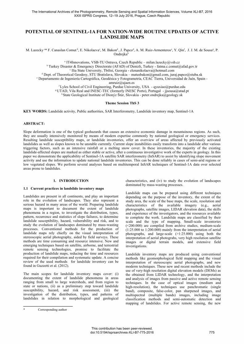
3.2 Rules Reservoir, Spain
Rules Reservoir is a reservoir in Vélez de Benaudalla, provinceof Granada, Andalusia, Spain. The Rules Dam is located on the
river Guadalfeo, downstream from its confluence with the Izborriver, in the municipality of Vélez de Benaudalla and collectsthe water from the southern slopes of Sierra Nevada mountainrange, from Sierra de Lújar and from La Contraviesa.
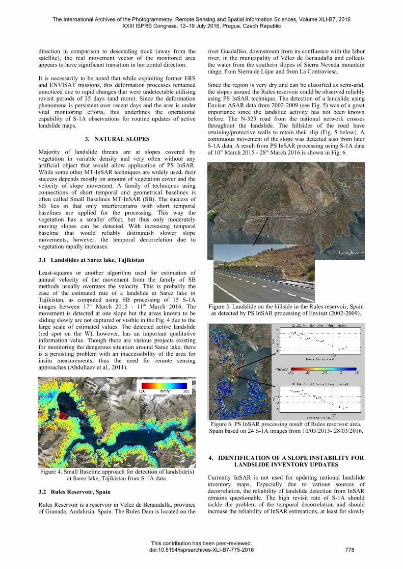
Since the region is very dry and can be classified as semi-arid,the slopes around the Rules reservoir could be observed reliablyusing PS InSAR technique. The detection of a landslide usingEnvisat ASAR data from 2002-2009 (see Fig. 5) was of a greatimportance since the landslide activity has not been knownbefore. The N-323 road from the national network crossesthroughout the landslide. The hillsides of the road haveretaining/protective walls to retain their slip (Fig. 5 below). Acontinuous movement of the slope was detected also from laterS-1A data. A result from PS InSAR processing using S-1A dataof 10th March 2015 - 28th March 2016 is shown in Fig. 6.
Figure 5. Landslide on the hillside in the Rules reservoir, Spainas detected by PS InSAR processing of Envisat (2002-2009).
Figure 6. PS InSAR processing result of Rules reservoir area,Spain based on 24 S-1A images from 10/03/2015- 28/03/2016.
4. IDENTIFICATION OF A SLOPE INSTABILITY FORLANDSLIDE INVENTORY UPDATES
Currently InSAR is not used for updating national landslideinventory maps. Especially due to various sources ofdecorrelation, the reliability of landslide detection from InSARremains questionable. The high revisit rate of S-1A shouldtackle the problem of the temporal decorrelation and shouldincrease the reliability of InSAR estimations, at least for slowly
The International Archives of the Photogrammetry, Remote Sensing and Spatial Information Sciences, Volume XLI-B7, 2016 XXIII ISPRS Congress, 12–19 July 2016, Prague, Czech Republic
This contribution has been peer-reviewed. doi:10.5194/isprsarchives-XLI-B7-775-2016
778
moving slopes of a moderate extent. The preliminary analyzesdescribed in this section approach towards an identification of alandslide activity. An experimental validation of the qualitativeinformation that can be achieved using S-1 InSAR in this fieldtogether with improvements of the briefly introducedtechniques in this section is a matter of ongoing investigations.
4.1 Taskent area, Turkey
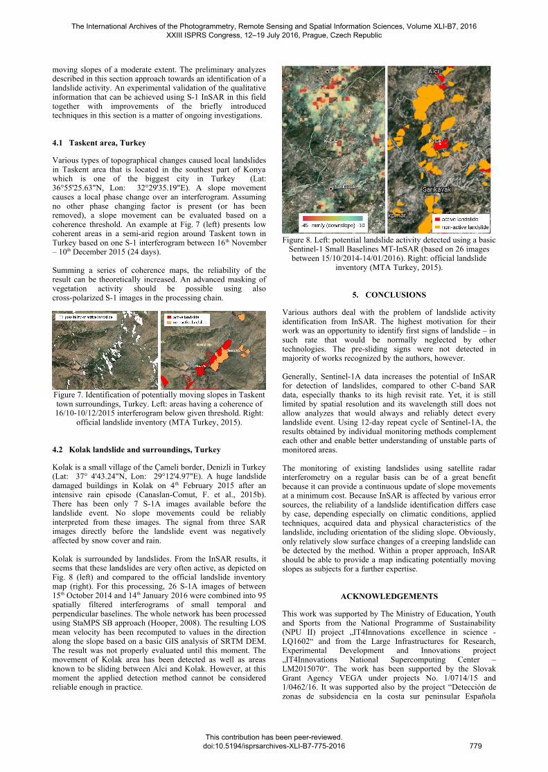
Various types of topographical changes caused local landslidesin Taskent area that is located in the southest part of Konyawhich is one of the biggest city in Turkey (Lat:36°55'25.63"N, Lon: 32°29'35.19"E). A slope movementcauses a local phase change over an interferogram. Assumingno other phase changing factor is present (or has beenremoved), a slope movement can be evaluated based on acoherence threshold. An example at Fig. 7 (left) presents lowcoherent areas in a semi-arid region around Taskent town inTurkey based on one S-1 interferogram between 16 th November– 10th December 2015 (24 days).
Summing a series of coherence maps, the reliability of theresult can be theoretically increased. An advanced masking ofvegetation activity should be possible using alsocross-polarized S-1 images in the processing chain.
Figure 7. Identification of potentially moving slopes in Taskenttown surroundings, Turkey. Left: areas having a coherence of16/10-10/12/2015 interferogram below given threshold. Right:
official landslide inventory (MTA Turkey, 2015).
4.2 Kolak landslide and surroundings, Turkey
Kolak is a small village of the Çameli border, Denizli in Turkey(Lat: 37° 4'43.24"N, Lon: 29°12'4.97"E). A huge landslidedamaged buildings in Kolak on 4 th February 2015 after anintensive rain episode (Canaslan-Comut, F. et al., 2015b).There has been only 7 S-1A images available before thelandslide event. No slope movements could be reliablyinterpreted from these images. The signal from three SARimages directly before the landslide event was negativelyaffected by snow cover and rain.
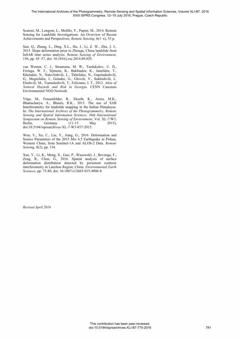
Kolak is surrounded by landslides. From the InSAR results, itseems that these landslides are very often active, as depicted onFig. 8 (left) and compared to the official landslide inventorymap (right). For this processing, 26 S-1A images of between15th October 2014 and 14th January 2016 were combined into 95spatially filtered interferograms of small temporal andperpendicular baselines. The whole network has been processedusing StaMPS SB approach (Hooper, 2008). The resulting LOSmean velocity has been recomputed to values in the directionalong the slope based on a basic GIS analysis of SRTM DEM.The result was not properly evaluated until this moment. Themovement of Kolak area has been detected as well as areasknown to be sliding between Alci and Kolak. However, at thismoment the applied detection method cannot be consideredreliable enough in practice.
Figure 8. Left: potential landslide activity detected using a basicSentinel-1 Small Baselines MT-InSAR (based on 26 imagesbetween 15/10/2014-14/01/2016). Right: official landslide
inventory (MTA Turkey, 2015).
5. CONCLUSIONS
Various authors deal with the problem of landslide activityidentification from InSAR. The highest motivation for theirwork was an opportunity to identify first signs of landslide – insuch rate that would be normally neglected by othertechnologies. The pre-sliding signs were not detected inmajority of works recognized by the authors, however.
Generally, Sentinel-1A data increases the potential of InSARfor detection of landslides, compared to other C-band SARdata, especially thanks to its high revisit rate. Yet, it is stilllimited by spatial resolution and its wavelength still does notallow analyzes that would always and reliably detect everylandslide event. Using 12-day repeat cycle of Sentinel-1A, theresults obtained by individual monitoring methods complementeach other and enable better understanding of unstable parts ofmonitored areas.
The monitoring of existing landslides using satellite radarinterferometry on a regular basis can be of a great benefitbecause it can provide a continuous update of slope movementsat a minimum cost. Because InSAR is affected by various errorsources, the reliability of a landslide identification differs caseby case, depending especially on climatic conditions, appliedtechniques, acquired data and physical characteristics of thelandslide, including orientation of the sliding slope. Obviously,only relatively slow surface changes of a creeping landslide canbe detected by the method. Within a proper approach, InSARshould be able to provide a map indicating potentially movingslopes as subjects for a further expertise.
ACKNOWLEDGEMENTS
This work was supported by The Ministry of Education, Youthand Sports from the National Programme of Sustainability(NPU II) project „IT4Innovations excellence in science -LQ1602“ and from the Large Infrastructures for Research,Experimental Development and Innovations project„IT4Innovations National Supercomputing Center –LM2015070“. The work has been supported by the SlovakGrant Agency VEGA under projects No. 1/0714/15 and1/0462/16. It was supported also by the project “Detección dezonas de subsidencia en la costa sur peninsular Española
The International Archives of the Photogrammetry, Remote Sensing and Spatial Information Sciences, Volume XLI-B7, 2016 XXIII ISPRS Congress, 12–19 July 2016, Prague, Czech Republic
This contribution has been peer-reviewed. doi:10.5194/isprsarchives-XLI-B7-775-2016
779

mediante interferometría radar de satélite (PRX 14/00340) bythe Spanish Ministry of Education, Culture and Sport”.Sentinel-1A data were provided by ESA under free, full andopen data policy adopted for the Copernicus programme. Datahave been processed by StaMPS and SARPROZ© usingMatlab® and Google Maps™.
REFERENCES
Abdullaev, U., Abdullaev, S., Blaha, P., Akhmedov, A.,Khudobakhshova, G., 2011. The Usoy Dam, Lake Sarez andPossibilities of Geophysical Methods. In: The InternationalJournal on Hydropower & Dams, HYDRO 2011, Prague, CzechRepublic, 9 p. (17-19 Oct. 2011).
Bakon, M., Oliveira, I., Perissin, D., Sousa, J. J. M., Papco, J.,2016. A data mining approach for multivariate outlier detectionin heterogeneous 2D point clouds: An application topost-processing of multi-temporal InSAR results. In:Geoscience and Remote Sensing Symposium (IGARSS) 2016,IEEE International, Beijing, China.
Canaslan-Çomut, F., Gurboga, S., Ustun, A., 2015a. Initialresults of a surface deformation by using InSAR techniques:Case study of Babadağ (Denizli), Turkey. Surface Models forGeosciences, Vol. 05/2015, chapter 7, pp. 73-86, ISBN:978-3-319-18406-7, DOI: 10.1007/978-3-319-18407-4_7.
Canaslan-Çomut, F., Durgun, M., Dilmen, H., Onuncuyıl, R.,Atilla, Ö. F., 2015b. Geological Survey Report for ÇameliKolak Landslides, Report, AFAD Denizli, Turkey.
Del Ventisette, Ch., Gigli, G., Tofani, V., Lu, P., Casagli, N.,2015. Radar Technologies for Landslide Detection, Monitoring,Early Warning and Emergency Management. In: ModernTechnologies for Landslide Monitoring and Prediction,Springer Natural Hazards, Springer-Verlag Berlin, pp. 209-232.
Elashvili, M., Javakhishvili, Z., Godoladze, T., Karakhanyan,A., Sukhishvili, L., Nikolaeva, E., Sokhadze, G., Avanesyan,M., 2012. Historical and paleo events as an input for seismicand associated natural hazard assessment of Javakheti highland(South Georgia).
Gaprindashvili, G. and van Westen, C. J., 2015. Generation of anational landslide hazard and risk map for the country ofGeorgia. Natural Hazards.
González, P. J., Bagnardi, M., Hooper, A. J., Larsen, Y.,Marinkovic, P., Samsonov, S. V., Wright, T. J., 2015. The2014–2015 eruption of Fogo volcano: Geodetic modeling ofSentinel 1 TOPS interferometry. ‐ Geophysical Research Letters,42(21), pp. 9239-9246.
Gracheva, R., Golyeva, A., 2010. Landslides in mountainregions: hazards, resources and information. In: GeophysicalHazards, International Year of Planet Earth, SpringerDordrecht, Netherlands, pp. 249–260.
Grandin, R., Klein, E., Métois, M., Vigny, C., 2016.Three dimensional displacement field of the 2015 Mw8.3‐Illapel earthquake (Chile) from across and along track‐ ‐Sentinel 1 TOPS interferometry. ‐ Geophysical Research Letters.
Guzzetti, F. Mondini, A. C., Cardinali, M., Fiorucci, F.,Santagelo, M., Chang, K-T., 2012. Landslide inventory maps:New tools for an old problem. Earth-Science Reviews, 112(1-2), pp. 42-66.
Hooper, A., 2008. A multi-temporal InSAR methodincorporating both persistent scatterer and small baselineapproaches. Geophysical Research Letters, 35 (16).
Jibson, R. W., Prentice, C. S., Borissoff, B. A., Rogozhin, E.A., Langer, C. J., 1994. Some observations of landslidestriggered by the 29 April 1991 Racha earthquake, Republic ofGeorgia. Bull. Seismol. Soc. Am., 84(4), pp. 963–973.
Jung, H. S., Lu, Z., Zhang, L., 2013. Feasibility of Along-TrackDisplacement Measurement From Sentinel-1 InterferometricWide-Swath Mode. IEEE Transactions on Geoscience andRemote Sensing, 51(1), pp. 573-578.
Lazecký, M., Canaslan-Çomut, F., Hlaváčová, I., Gürboğa, Ş.,2015. Practical applicability of satellite-based SARinterferometry for detection of landslide activity. In: ProcediaEarth and Planetary Science WMESS 2015, Prague, CzechRepublic, 10 p. (7-11 Sep. 2015).
Macciotta, R., Hendry, M., Derek Martin, C., 2016. Developingan early warning system for a very slow landslide based ondisplacement monitoring. Natural Hazards, 81(2), pp 887-907.doi: 10.1007/s11069-015-2110-2.
Malgot, M., Baliak, F., Mahr, T., 1983. Map of Vtacnik slopefailures 1:10 000. Slovak cartography.
MTA Turkey, 2015. Geoscience Map Viewer and DrawingEditor. General Directorate of Mineral Research andExploration - The Department of Scientific Documentation andPublicity. URL: http://yerbilimleri.mta.gov.tr/anasayfa.aspx .
Nikolaeva, E., Walter, T. R., 2012. Comparison of InSARtwo-pass and time series methods for analysing landslides incentral Georgia, Caucasus. In: IEEE International Geoscienceand Remote Sensing Symposium 2012, pp. 7573–7576.
Nikolaeva, E., Walter, T. R., 2013. Integration of InSAR resultsfrom TerraSAR-X with ALOS(PALSAR) data for the landslidearea, case study from Sachkhere region, Georgia.
Nikolaeva, E., Walter, T. R., Shirzaei, M., Zschau, J., 2013.Landslide dynamics and coupling revealed by L-band InSAR incentral Georgia. Natural Hazards Earth Syst. Sci. Discuss.,1(5), pp. 4925–4962.
Novellino, A., Cigna, F., Sowter, A., Syafiudin, M. F., DiMartire, D., Ramondini, M., Calcaterra, D., 2015. IntermittentSmall Baseline Subset (ISBAS) InSAR analysis to monitorlandslides in Costa Della Gaveta, Southern Italy. In: IEEEGeoscience and Remote Sensing Symposium (IGARSS) 2015,pp. 3536–3539, doi: 10.1109/IGARSS.2015.7326584.
Perissin, D., Rocca, F., Wang, T., 2007. DEM Retrieval andLandslide Monitoring in Badong, Three Gorges, China byMeans of InSAR Partially Coherent Targets. In: Proceedings ofDragon Symposium 2007, Aix En Provence, France.
Polcari, M., Palano, M., Fernández Torres, J., Samsonov, S.,Stramondo, S., Zerbini, S., 2016. 3D displacement fieldretrieved by integrating Sentinel-1 InSAR and GPS data: the2014 South Napa earthquake.
Samieie-Esfahany, S., Hanssen, R. F., van Thienen-Visser, K.,Muntendam-Bos, A., 2009. On the Effect of HorizontalDeformation on InSAR Subsidence Estimates. In: Proceedingsof The Fringe 2009 Workshop, Frascati, Italy, Vol. 30.
The International Archives of the Photogrammetry, Remote Sensing and Spatial Information Sciences, Volume XLI-B7, 2016 XXIII ISPRS Congress, 12–19 July 2016, Prague, Czech Republic
This contribution has been peer-reviewed. doi:10.5194/isprsarchives-XLI-B7-775-2016
780
Scaioni, M., Longoni, L., Melillo, V., Papini, M., 2014. RemoteSensing for Landslide Investigations: An Overview of RecentAchievements and Perspectives, Remote Sensing, 6(1–x), 53 p.
Sun, Q., Zhang, L., Ding, X.L., Hu, J., Li, Z. W., Zhu, J. J.,2015. Slope deformation prior to Zhouqu, China landslide fromInSAR time series analysis. Remote Sensing of Environment,156, pp. 45–57, doi: 10.1016/j.rse.2014.09.029.
van Westen, C. J., Straatsma, M. W., Turdukulov, U. D.,Feringa, W. F., Sijmons, K., Bakhtadze, K., Janelidze, T.,Kheladze, N., Natsvlishvili, L., Tkhelidze, N., Gaprindashvili,G., Megrelidze, I., Geladze, G., Gloveli, V., Sukhishvili, L.Elashvili, M., Tsamalashvili, T., Feliciano, I. T., 2012. Atlas ofNatural Hazards and Risk in Georgia. CENN CaucasusEnvironmental NGO Network.
Vöge, M., Frauenfelder, R., Ekseth, K., Arora, M.K.,Bhattacharya, A., Bhasin, R.K., 2015. The use of SARInterferometry for landslide mapping in the Indian Himalayas.In: The International Archives of the Photogrammetry, RemoteSensing and Spatial Information Sciences, 36th InternationalSymposium on Remote Sensing of Environment, Vol. XL-7/W3,Berlin, Germany (11-15 May 2015),doi:10.5194/isprsarchives-XL-7-W3-857-2015.
Wen, Y., Xu, C., Liu, Y., Jiang, G., 2016. Deformation andSource Parameters of the 2015 Mw 6.5 Earthquake in Pishan,Western China, from Sentinel-1A and ALOS-2 Data. RemoteSensing, 8(2), pp. 134.
Xue, Y., Li, K., Meng, X., Guo, P., WasowskI, J., Bovenga, F.,Zeng, R., Chen, G., 2016. Spatial analysis of surfacedeformation distribution detected by persistent scattererinterferometry in Lanzhou Region, China. Environmental EarthSciences, pp. 75-80, doi: 10.1007/s12665-015-4806-8.
Revised April 2016
The International Archives of the Photogrammetry, Remote Sensing and Spatial Information Sciences, Volume XLI-B7, 2016 XXIII ISPRS Congress, 12–19 July 2016, Prague, Czech Republic
This contribution has been peer-reviewed. doi:10.5194/isprsarchives-XLI-B7-775-2016
781