portrait global 2008 e - Accueil - Plan d'action...
30
Transcript of portrait global 2008 e - Accueil - Plan d'action...


You may obtain fact sheets and additional information on the State of the St. Lawrence Monitoring Programby visiting the following Web site: www.planstlaurent.qc.ca
PRODUCTION COORDINATORS
Hélène Bouchard, Environment CanadaNathalie Gratton, Environment Canada
AUTHORS
Nicolas Audet, Stratégies Saint-LaurentLouise Champoux, Environment CanadaCharley Cyr, Fisheries and Oceans CanadaCaroline Girard, Environment CanadaNathalie Gratton, Environment CanadaSerge Hébert, Ministère du Développement durable, de l’Environnement et des Parcs du QuébecMarc Mingelbier, Ministère des Ressources naturelles et de la Faune du Québec
CONTRIBUTORS
Environment CanadaAlain Armellin, André Bouchard, Christiane Hudon, Martin Jean, Paul Milot, Guy Létourneau, Magella Pelletier,Jean-François Rail, Louis-Filip Richard, Bernard Rondeau, and Jacques Sénéchal
Fisheries and Oceans CanadaPeter Galbraith, Denis Gilbert, Michel Gilbert, Jean-François Gosselin, Mike Hammill, Michel Harvey,Lena Measures, Michel Lebeuf, and Michel Starr
Lac Saint-Pierre ZIP CommitteeLouise Corriveau
Ministère du Développement durable, de l’Environnement et des Parcs du QuébecDenis Laliberté and Linda Tapin
Ministère des Ressources naturelles et de la Faune du QuébecFrancis Bouchard, Philippe Brodeur, Chantale Cote, Denise Deschamps, Alain Desrosiers, Pierre Dumont,Nathalie La Violette, Michel Legault, Suzanne Lepage, Yves Mailhot, and Yorick Reyjol
Nature QuebecMathieu Avery
Parks CanadaSuzan Dionne
EDITING AND TRANSLATION
Jacinthe Bouchard, Ministère des Ressources naturelles et de la Faune du QuébecTranslation Brokering and Editing Services, Environment Canada
GRAPHIC DESIGN
Denise Séguin, Environment Canada
ACKNOWLEDGMENTS
Haut Saint-Laurent ZIP Committee, Jacques-Cartier ZIP Committee, Lac Saint-Pierre ZIP Committee, Les Deux Rives ZIPCommittee, Société d’aménagement de la baie Lavallière, Association des propriétaires et locataires de l’île Saint-Eugène
COVER PHOTOGRAPHS
Jean Robitaille, Bureau d’écologie appliquéMichel Arseneau, Christiane Hudon, Clauded Lessard, Chip Weseloh, Environment CanadaLyne Blanchet, Ministère du Développement durable, de l’Environnement et des Parcs du QuébecVeronique Lesage, Fisheries and Oceans Canada
Published by Authority of the Minister of the Environment© Her Majesty the Queen in Right of Canada, 2008
Published by Authority of the Ministre du Développement durablede l’Environnement et des Parcs du Québec© Gouvernement du Québec, 2008
Catalogue No.: En154-53/2008E-PDFISBN 978-1-100-10539-0Legal deposit – National Library of Canada, 2008
Aussi disponible en français sous le titre : Portrait global de l’état du Saint-Laurent 2008
Cite as: State of the St. Lawrence Monitoring Committee. Overview of the State of the St. Lawrence River 2008. St. Lawrence Plan. EnvironmentCanada, Ministère du Développement durable, de l’Environnement et des Parcs du Québec, Ministère des Ressources naturelles etde la Faune du Québec, Fisheries and Oceans Canada, and Stratégies Saint-Laurent. 28 pp.

OVERVIEW OF THE STATE OF THE ST. LAWRENCE RIVER – 2008
WATER, SEDIMENTS, SHORELINES, BIOLOGICAL RESOURCES AND USES
1
FOREWORD
Establishing an overview of the state of the St. Lawrence River is both complex and
stimulating—a challenge that the State of the St. Lawrence Monitoring Program
Coordination Committee enthusiastically took up as part of the Canada–Quebec
Agreement under the St. Lawrence Plan for a Sustainable Development 2005–2010. To
accomplish this task, we have used the findings of a number of scientists from organiza-
tions involved in implementing the State of the St. Lawrence Monitoring Program. This
overview cannot claim to take all studies on the state of the St. Lawrence into considera-
tion; rather, it provides an account of the findings that are a direct result of the program.
In 2008, the river’s bill of health could be described as moderate to good for several indi-
cators. Sediment contamination in Lake Saint Pierre has dropped. The reintroduction of the
Striped Bass is going well and the Beluga Whale population remains stable, although it
shows no major signs of recovery. The health of shellfish waters shows an improving trend.
Overall, however, the St. Lawrence remains relatively vulnerable. Few changes have been
observed in bird populations or in wetlands and swimming areas. Shoreline erosion, water
turbidity and contamination by toxic substances in certain tributaries crossing farmland are
of special concern, as is biotic integrity as based on freshwater fish communities.
Concentrations of new substances such as polybrominated diphenyl ethers (PBDEs) are
also cause for concern, since they are on the rise in all compartments of the ecosystem.
We hope that the results of our work will help in making decisions that concern the
St. Lawrence. The Program is one of the basic components of the movement toward the
integrated management of the river. The cooperation and commitment of our government
partners and non-governmental organizations remain key factors in ensuring the continu-
ity of our work in monitoring the state of the St. Lawrence and in preparing reports on this
subject.
We are very pleased to present this 2008 Overview of the State of the St. Lawrence River
and wish to thank sincerely all the members of our committee as well as those who
contributed, in various capacities, to its production.
Hélène Bouchard
Canada Co-chairState of the St. Lawrence MonitoringProgram Coordination CommitteeEnvironment Canada
Linda Tapin
Quebec Co-chairState of the St. Lawrence MonitoringProgram Coordination CommitteeMinistère du Développement durable,de l’Environnement et des Parcs

OVERVIEW OF THE STATE OF THE ST. LAWRENCE RIVER – 2008
WATER, SEDIMENTS, SHORELINES, BIOLOGICAL RESOURCES AND USES
2
The St. Lawrence River originates in the Great
Lakes, in the heart of one of the largest indus-
trial centres in North America. It has experienced
numerous impacts throughout the 20th century:
alteration of its flow regime, degradation of water
quality, riverbank denaturalization and erosion,
decline of certain plant and animal communities,
etc. Despite the efforts made over the last 30 years
to reduce these impacts, this major watercourse
remains vulnerable to intensive farming, encroachment
on the floodplain, dredging of the shipping channel,
and flow regulation. To these stresses can be added
new environmental challenges such as climate
change, invasive species and toxic substances
whose effects are poorly understood.
Is the overall health of the St. Lawrence improving?
To answer this question, a long-term monitoring
program on the state of the St. Lawrence was
launched in 2003 as part of a Canada–Quebec
agreement. Different partners monitor a series of
1000 300 km200
UNITED STATES
CANADA
Lake Superior
Lake
Mich
igan
LakeH
uron
Lake Erie
Lake Ontario
Ottawa River
ONTARIO
JamesBay
Toronto
Sault Ste. Marie
NorthBay
ThunderBay
Kingston
Fluvialsection
Fluvialestuary
Upperestuary
Pointe-des-Monts
Montréal
QuébecCity
Cornwall
Pointe-du-Lac
Baie Saint-Paul
TadoussacSaguenay R.
CANADAUNITED STATES
Montmagny
Gaspé
Lower estuary and Gulf of St. LawrenceSept-Îles
Blanc-Sablon
Matane
Rivière-du-LoupSt.
Lawren
ce River
QUEBEC
N.B.
P.E.I.
N.S.
N.L.
Gulf ofSt. Lawrence
ATLANTICOCEANWater characteristics
SaltBrackish
Fresh
The St. Lawrence hydrographic system, including the Great Lakes, is one of the largest in the world. Its surface area of 1.6 million km2 isthe third largest in North America, after the Mississippi and Mackenzie rivers. It drains more than 25% of the Earth’s freshwater reserves andinfluences the environmental processes of the entire North American continent. Over 30 million Americans and 15 million Canadians live in thisimmense basin.
INTRODUCTION
OVERVIEW OF THE STATE OF THE ST. LAWRENCE RIVER – 2008
WATER, SEDIMENTS, SHORELINES, BIOLOGICAL RESOURCES AND USES
3
environmental indicators on a regular basis. The
area covered extends from the Quebec–Ontario
border to the Gulf of St. Lawrence.
This document follows the first assessment
published in 2003, presenting a new overview of the
state of the St. Lawrence based on the most recent
results. The first part of the document describes the
program, the second deals with the state of the
St. Lawrence and how it has changed, and part three
discusses more global issues. In part four, future
prospects and the monitoring of this ecosystem are
identified.
1. Boulanger, F. et al. 1998. Étude économique du programme SLV 2000: un exemple concret de développement durable. Environment Canada andSt. Lawrence Vision 2000.
Photo
:Ren
éTh
erre
ault
,Min
istè
redu
Dév
eloppem
ent
dura
ble
,de
l’Envi
ronnem
ent
etdes
Par
cs
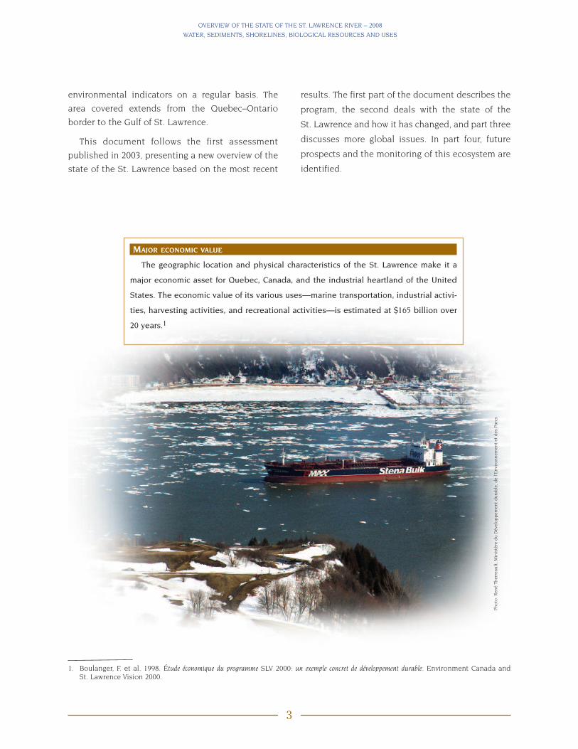
MAJOR ECONOMIC VALUE
The geographic location and physical characteristics of the St. Lawrence make it a
major economic asset for Quebec, Canada, and the industrial heartland of the United
States. The economic value of its various uses—marine transportation, industrial activi-
ties, harvesting activities, and recreational activities—is estimated at $165 billion over
20 years.1

OVERVIEW OF THE STATE OF THE ST. LAWRENCE RIVER – 2008
WATER, SEDIMENTS, SHORELINES, BIOLOGICAL RESOURCES AND USES
4
1. THE STATE OF THE ST. LAWRENCEMONITORING PROGRAM
Background
The State of the St. Lawrence Monitoring Program,
established as part of the Canada–Quebec
agreement, brings together six government part-
ners—Environment Canada (EC), the Ministère du
Développement durable, de l'Environnement et des
Parcs du Québec (MDDEP) , Fisheries and Oceans
Canada (DFO), the Ministère des Ressources
naturelles et de la Faune du Québec (MRNF), the
Canadian Space Agency (CSA), and Parks Canada—
as well as Stratégies Saint Laurent (SSL), a non-gov-
ernmental organization working with riverside com-
munities. These partners are pooling their expertise
to report regularly on the state of the St. Lawrence
and how it is changing.
Initial monitoring results for the St. Lawrence
were released in February 2003 at the Rendez-vous
St. Lawrence forum, when an overview of the state of
the St. Lawrence was published for the first time.
The outlook: though it remains vulnerable, the
ecosystem appears to be in better shape than at any
other time during the second half of the 20th centu-
ry. This assessment, focused mainly on water, sedi-
ments, and biological resources, is encouraging
news. However, despite these signs of improvement,
the integrity of the ecosystem could be weakened by
the cumulative impact of many pressures, including
invasion by exotic species and the presence of new
contaminants.
COMMUNITY INVOLVEMENT IN MONITORINGTHE STATE OF THE ST. LAWRENCE
In addition to lending their expertise and
knowledge on the state of the St. Lawrence, non-
governmental organizations contribute to the collec-
tion of data and the dissemination of information
generated by the program. In 2007–2008, eight
organizations, including four ZIP (Zones d’interven-
tion prioritaires) committees, participated in moni-
toring the St. Lawrence, especially with respect to
invasive plant species, shoreline erosion, and recre-
ational uses. To allow them to contribute effectively,
the communities received specific training and
scientific and technical support tailored to local
situations.
Photo
:Car
oline
Gir
ard,E
nvi
ronm
ent
Can
ada
Photo
:Jea
n-F
ranço
isTh
erre
ault

OVERVIEW OF THE STATE OF THE ST. LAWRENCE RIVER – 2008
WATER, SEDIMENTS, SHORELINES, BIOLOGICAL RESOURCES AND USES
5
Objectives
The program arose out of the need expressed by
numerous stakeholders for information that was as
up to date as possible on the overall state of the
St. Lawrence. Hence, the primary objective is to
provide, from a sound scientific basis, integrated
information to support the protection and sustain-
ability of the ecosystem for current and future
generations.
First, the data help in assessing the condition of
the ecosystem. Second, they guide the decision-
making process to ensure the protection of the
ecosystem. The challenge consists of integrating the
data obtained from the environmental indicators
to reach a better understanding of the state of the
St. Lawrence and how it is changing. To meet this
challenge, the partners intend to adopt a progres-
sive approach to transform and gradually add to the
program in light of the knowledge acquired and the
new partnerships formed.
Frame of Reference
The St. Lawrence River is a complex ecosystem,
made up of lakes and freshwater reaches, a long
estuary, and a gulf with marine features. Its physical
properties (e.g. current, depth, water masses, salinity,
ENVIRONMENTAL INDICATORS
Indicators are statistics or parameters that, tracked over time, provide information on trends in the condition
of a phenomenon and have significance extending beyond that associated with the properties of the statistics
themselves. Environmental indicators are key statistics that represent or summarize a significant aspect of the state
of the environment, natural resource sustainability and related human activities.
Environment Canada Web site – National Environmental Indicator Series
http://www.ec.gc.ca/soer-ree/English/Indicators/what/default.cfm
tides) change from upstream to downstream, giving
the river a dynamic quality. It shelters a wide variety
of freshwater, estuarine and marine habitats,and a
rich diversity of flora and fauna. Since the natural
physical characteristics of the St. Lawrence have a
tremendous influence on biodiversity and habitats,
it is important that they be considered in assessing
the state of the St. Lawrence; and also that natural
impacts be distinguished from those induced by
anthropogenic disturbances.
The complex nature of the St. Lawrence may be
approached through a simple frame of reference
comprising five components that form the basis
of the ecosystem: water, sediments, biological
resources, shorelines, and uses. The indicators used
in the program fall under one of the above compo-
nents. When an indicator is associated with a use,
it is also identified with this component. This is the
case, for instance, of contamination by fecal
coliforms of the water at swimming sites and
shellfish gathering areas.
According to the Pressure-State-Response frame-
work used to report on the changes experienced
by the system, three categories of environmental
indicators are usually selected. However, the State
of the St. Lawrence Monitoring Program documents
only the indicators for the state of the biophysical
environment and natural processes.

OVERVIEW OF THE STATE OF THE ST. LAWRENCE RIVER – 2008
WATER, SEDIMENTS, SHORELINES, BIOLOGICAL RESOURCES AND USES
6
Monitoring Activities
The State of the St. Lawrence Monitoring
Program is characterized by progressive continuous
improvement. Hence, since the program was
launched, the spatial and temporal coverage of
existing activities has been improved, new activities
and indicators have been added, and new partners
have become involved.
covering all of the environmental variables of the St.
Lawrence River. They were chosen for their repre-
sentativeness and relevance in view of assessing the
state of the St. Lawrence and because they provide
adequate spatial and temporal coverage. These
activities pertain to several current environmental
issues:
• water and sediment quality and contamination of
biological resources;
• recovery of uses;
• biodiversity, especially wetland vegetation, fish,
birds, marine mammals, and various exotic
species;
• fluctuations in physical processes (water level
and flow, movement of water masses);
• climate change.
The indicators are described in the fact sheets
available on the St. Lawrence Plan’s Web site at:
www.planstlaurent.qc.ca/sl_obs/sesl/publications/
fiches_indicateurs/fiches_e.html
STATE OF THE GREAT LAKES–ST. LAWRENCEECOSYSTEM
In 2005, Environment Canada drew up a partial
profile of the state of the Great Lakes–St. Lawrence
ecosystem, which extends from Lake Superior to the
Gulf of St. Lawrence. Electronic fact sheets on the
contamination of water by toxic substances, mercury
contamination of sediments, the surface area of wet-
lands, and the state of aquatic bird populations are
available online at:
www.planstlaurent.qc.ca/sl_obs/sesl/publications/fiches_ecosysteme/accueil_e.html
IMPROVEMENTS TO THE PROGRAMSINCE 2003
• Three water-quality sampling stations were
added: one at Carillon (Ottawa River), one at the
mouth of the Richelieu River, and one at the
mouth of the Yamaska River.
• New analyses of substances such as polybromi-
nated diphenyl ethers (PBDEs), pharmaceutical
products, and pesticides were added to assess
the contamination of the water, sediments, and
birds.
• Sediment characterization work was extended to
lakes Saint-Pierre and Saint-Louis.
• Involvement of riverside communities in the mon-
itoring of invasive plant species, shoreline ero-
sion, and recreational uses of the St. Lawrence.
• Monitoring of freshwater benthic communities
was added.
• Monitoring of land use along the St. Lawrence and
Great Lakes in conjunction with the Canadian
Space Agency.
Figure 1 shows the program’s environmental
monitoring activities in 2008. They consist of data
collection performed by the partners under their
respective mandates. These activities are far from

OVERVIEW OF THE STATE OF THE ST. LAWRENCE RIVER – 2008
WATER, SEDIMENTS, SHORELINES, BIOLOGICAL RESOURCES AND USES
7
100 km0
23
1 2 3 4
201711 16
6 9 108
22
Fluvialsection
Fluvialestuary
Upperestuary
Saguenay R.
CANADAUNITED STATES
Lower estuary and Gulf of St. Lawrence
AnticostiIsland
St.Law
rence River
QUEBEC
N.B.
P.E.I.
N.S.
N.L.Gulf of
St. Lawrence
Magdalen Islands
Water
1 Monitoring of flows and/or levels through the hydrometric network – Several partners*2 Contamination of water by toxic substances at one inlet (Carillon) and one outlet (Lévis) – EC3 Contamination of water by organic toxic substances at the mouths of the Richelieu and Yamaska rivers – MDDEP4 Physico-chemical and bacteriological parameters – MDDEP5 Oceanographic processes – DFO6 Water quality of potential swimming areas** – MDDEP7 Shellfish water quality** – EC
Sediments
8 Toxic contamination of sediments in fluvial lakes – EC
Shorelines
9 Shoreline erosion in the fluvial environment – EC10 Changes in land use along shorelines in the Great Lakes–St. Lawrence system – EC and CSA
Biological resources
11 Benthic communities – EC12 Phytoplankton communities – DFO13 Zooplankton communities – DFO14 Monitoring of toxic algae** – DFO15 Status of Striped Bass population – MRNF16 Contamination of freshwater fish by toxic substances** – MDDEP17 Monitoring of freshwater fish communities – MRNF18 Status of the Beluga Whale population – DFO19 Status of the Northern Gannet population – EC20 Status of the Great Blue Heron population – EC21 Status of seabird populations – EC22 Surface area of wetlands – EC23 Invasive plant species in wetlands – EC
* MDDEP, Hydro-Québec, DFO, EC, U.S. Geological Survey, New York Power Authority/Ontario Power, St. Lawrence Seaway.** Related to usage criteria.
5 7 212013 14 19181512
2 4
23
10 15
16 17 22
6
7
20
22
18
10 15
FIGURE 1. ACTIVITIES UNDER THE STATE OF THE ST. LAWRENCE MONITORING PROGRAM

Photo
:R
ené
Ther
reau
lt,M
inis
tère
du
Dév
eloppem
ent
dura
ble
,de
l’Envi
ronnem
ent
etdes
Par
cs
OVERVIEW OF THE STATE OF THE ST. LAWRENCE RIVER – 2008
WATER, SEDIMENTS, SHORELINES, BIOLOGICAL RESOURCES AND USES
8
SECT ION 1
2. STATE OF THE ST. LAWRENCEAND HOW IT IS CHANGING
In 2003, an initial assessment of the state of the St.
Lawrence revealed some improvements. However,
certain indicators also showed vulnerability, espe-
cially with respect to water quality, biodiversity, and
wetlands. Since then, new indicators have been
added and new data gathered, so that the reference
years differ from one indicator to another.
The information available in 2008 led to a new
assessment: while several indicators reveal that the
St. Lawrence ecosystem is in a state considered
moderate to good, the St. Lawrence River remains
relatively vulnerable as a whole. Sediment contami-
nation in Lake Saint-Pierre has declined. The rein-
troduction of the Striped Bass seems to be well
under way and the Beluga Whale population is
stable, without, however, showing any major signs
of recovery. Monitoring of shellfish water quality
points to an improving trend, but few changes were
noted in bird populations, wetlands or swimming
areas. However, shore erosion, water turbidity, con-
tamination by toxic substances in some tributaries
in agricultural areas, and biotic integrity (based
on studies of freshwater fish communities) are of
concern. Concentrations of emerging substances
such as polybrominated diphenyl ethers (PBDEs)
are just as worrisome since they are increasing in all
compartments of the ecosystem (Figure 2 and
Table 1).
Water: Quantity and Quality
The quantity and quality of St. Lawrence River
water are determining factors for the river’s health.
By decreasing fluctuations in water levels throughout
the year, the regulation of water flows in the
St. Lawrence may have a major impact on the fluvial
lakes. Water quality shows considerable temporal
and spatial variability, which is mainly due to such
factors as seasonal variations, sources of pollution,
and the presence of three distinct water masses: the
Great Lakes, the tributaries of the north shore, and
the tributaries of the south shore. At Quebec City,
these water masses mix together under the influ-
ence of the tides and lose their distinguishing phys-
ical and chemical characteristics.
FLUVIAL SECTIONWater Levels and Flows
Following the low flows observed in the St.
Lawrence in the late 1990s and early 2000s, flows
recorded since 2003 have been closer to the long-
term average. It should be noted that flow affects
certain water-quality parameters such as turbidity,
phosphorus and suspended solids. For the first half
of 2007, the average monthly water level in the Port
of Montréal was below the 1967–2006 average, but
above the chart datum level. In Lake Ontario, the
current level is slightly below average, while the
flows measured in the Ottawa River, which is the
main tributary of the St. Lawrence, are near the
long-term average.

OVERVIEW OF THE STATE OF THE ST. LAWRENCE RIVER – 2008
WATER, SEDIMENTS, SHORELINES, BIOLOGICAL RESOURCES AND USES
9
100 km0
Great Blue Heron (2002–2007)
Fish communities (2001–2006)
Shellfish water quality* (2003–2005)
Beluga Whale population (2001–2007)
Wetlands and exotic plants(2005)
Reintroduction of the Striped Bass(2002–2007)
Seabirds (2000–2005)
Northern Gannet (1999–2004)
Benthiccommunities(2002–2006)
Shor
elin
es
Riverbankerosion
(1998–2007)
Land use along shorelines(1975–2001
Sedi
men
ts Toxiccontaminationof sediments in
fluvial lakes(1985–2003)
Oceanographic processes (2002–2006)Physico-chemical andbiological parameters
(2002–2005)
Changes in waterlevels and flows(2003–2007)
Contaminationof the Richelieuand Yamaskarivers by toxicsubstances**(2001–2003)
Contamination of the river bytoxic substances(1995–2005)
Water quality at potentialswimming areas* (2003–2005)
Wat
er
STATUS
PoorModerateGoodReference years( )
Biol
ogic
alre
sour
ces
Fluvialsection
Fluvialestuary
Upperestuary
Saguenay R.
CANADAUNITED STATES
Lower estuary and Gulf of St. Lawrence
AnticostiIsland
St.Law
rence River
QUEBEC
N.B.
P.E.I.
N.S.
N.L.Gulf of
St. Lawrence
Magdalen Islands
Pointe-des-Monts
Montréal
QuébecCity
Cornwall
Pointe-du-Lac
Baie Saint-Paul
Trois-RivièresMontmagny
Gaspé
Sept-Îles
Matane
Rivière-du-Loup
Blanc-Sablon
Tadoussac
FIGURE 2. STATE OF THE ST. LAWRENCE IN 2008
* Related to usage criteria.** The state of the water quality for the Richelieu and Yamaska rivers was determined using quality criteria designed to protect piscivorous
land animals (more stringent criteria), while the criteria applied to the St. Lawrence are designed to protect aquatic life.

OVERVIEW OF THE STATE OF THE ST. LAWRENCE RIVER – 2008
WATER, SEDIMENTS, SHORELINES, BIOLOGICAL RESOURCES AND USES
10
TABLE 1. STATE OF THE ST. LAWRENCE IN 2003 (�) AND 2008 (�)
* Reference years correspond to the periods during which data used for the 2003 and 2008 assessments were collected.** The state of the water quality for the Richelieu and Yamaska rivers was determined using quality criteria designed to protect piscivorous
land animals (more stringent criteria), while the criteria applied to the St. Lawrence are designed to protect aquatic life.*** Related to usage criteria.
COMPONENTACTIVITY(Reference years)*
STATUSPoor Moderate Good
Water Changes in water levels and flows• 2003–2007 �
Contamination by toxic substances, fluvial section• 1995–2002 �
• 1995–2005 �
Contamination by toxic substances, Richelieuand Yamaska rivers**
• 2001–2003 �
Physico-chemical and bacteriological parameters• 1995–2001• 2002–2005 �
Oceanographic processes, estuary and gulf• multiple yrs–2001 �
• 2002–2006 �
Water quality at potential swimming areas***• 1999–2001 �
• 2003–2005 �
Shellfish water quality***• 1988–2002 �
• 2003–2005 ��
Sediments Contamination of sediments by toxic substances,Lake Saint-François• 1979–1999 ��
Contamination of sediments by toxic substances,lakes Saint-Pierre and Saint-Louis• 1985–2003 �
Shorelines Riverbank erosion• 1998–2007 �
Land use along shorelines• 1975–2001 �
Biologicalresources
Benthic communities• 2004–2006 �
Reintroduction of Striped Bass• 1998–2001 �
• 2002–2007 �
Contamination of freshwater fish by toxic substances***• 1976–1995 ��
Freshwater fish communities• 1995–1997 �
• 2001–2006 �
Beluga Whale population in the estuary• 1988–2000 �
• 2001–2007 �
Contamination of marine resources bytoxic substances ***• 1990–2001 ��
Northern Gannet• 1887–2001 �
• 1999–2004 �
Great Blue Heron• 1977–2001 �
• 2002–2007 �
Seabirds• 1925–1999 �
• 2000–2005 �
Wetlands and exotic plants• 1976–2002 �
• 2005 �
��
OVERVIEW OF THE STATE OF THE ST. LAWRENCE RIVER – 2008
WATER, SEDIMENTS, SHORELINES, BIOLOGICAL RESOURCES AND USES
11
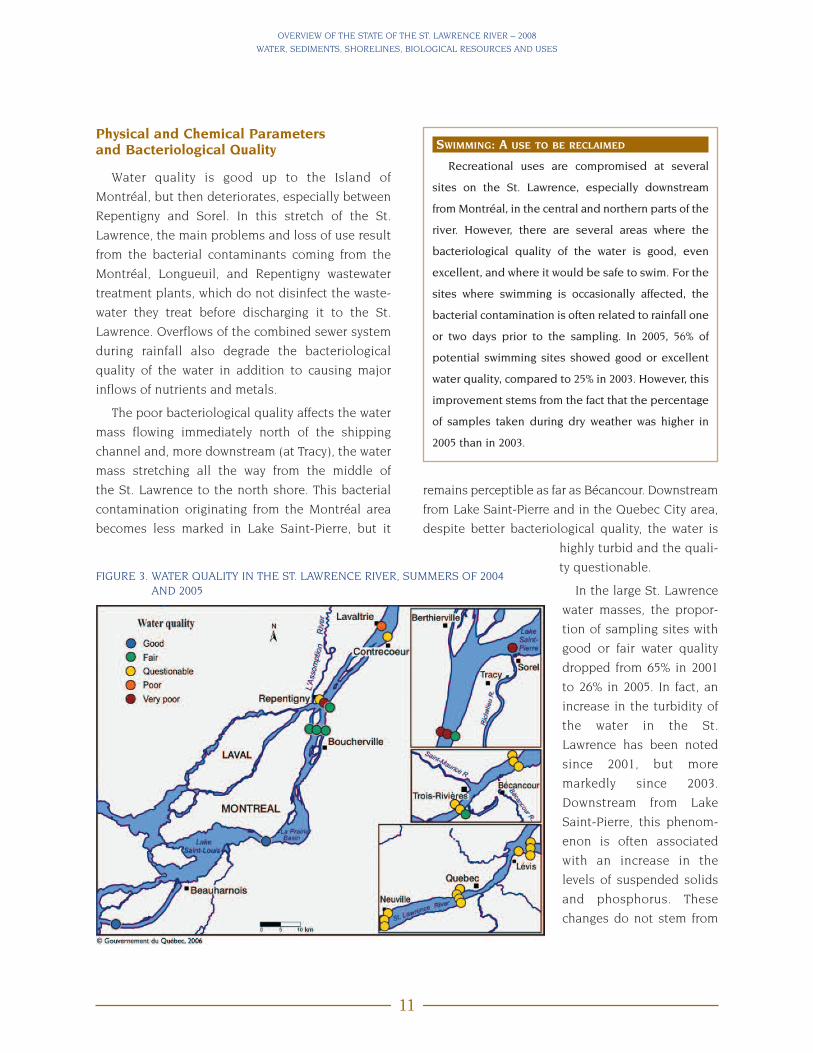
Physical and Chemical Parametersand Bacteriological Quality
Water quality is good up to the Island of
Montréal, but then deteriorates, especially between
Repentigny and Sorel. In this stretch of the St.
Lawrence, the main problems and loss of use result
from the bacterial contaminants coming from the
Montréal, Longueuil, and Repentigny wastewater
treatment plants, which do not disinfect the waste-
water they treat before discharging it to the St.
Lawrence. Overflows of the combined sewer system
during rainfall also degrade the bacteriological
quality of the water in addition to causing major
inflows of nutrients and metals.
The poor bacteriological quality affects the water
mass flowing immediately north of the shipping
channel and, more downstream (at Tracy), the water
mass stretching all the way from the middle of
the St. Lawrence to the north shore. This bacterial
contamination originating from the Montréal area
becomes less marked in Lake Saint-Pierre, but it
SWIMMING: A USE TO BE RECLAIMED
Recreational uses are compromised at several
sites on the St. Lawrence, especially downstream
from Montréal, in the central and northern parts of the
river. However, there are several areas where the
bacteriological quality of the water is good, even
excellent, and where it would be safe to swim. For the
sites where swimming is occasionally affected, the
bacterial contamination is often related to rainfall one
or two days prior to the sampling. In 2005, 56% of
potential swimming sites showed good or excellent
water quality, compared to 25% in 2003. However, this
improvement stems from the fact that the percentage
of samples taken during dry weather was higher in
2005 than in 2003.
remains perceptible as far as Bécancour. Downstream
from Lake Saint-Pierre and in the Quebec City area,
despite better bacteriological quality, the water is
highly turbid and the quali-
ty questionable.
In the large St. Lawrence
water masses, the propor-
tion of sampling sites with
good or fair water quality
dropped from 65% in 2001
to 26% in 2005. In fact, an
increase in the turbidity of
the water in the St.
Lawrence has been noted
since 2001, but more
markedly since 2003.
Downstream from Lake
Saint-Pierre, this phenom-
enon is often associated
with an increase in the
levels of suspended solids
and phosphorus. These
changes do not stem from
FIGURE 3. WATER QUALITY IN THE ST. LAWRENCE RIVER, SUMMERS OF 2004AND 2005
OVERVIEW OF THE STATE OF THE ST. LAWRENCE RIVER – 2008
WATER, SEDIMENTS, SHORELINES, BIOLOGICAL RESOURCES AND USES
12
an increase in urban effluent discharges or farming
activities, but rather from a change in the river’s flow
regime and an increase in runoff and erosion.
From 1995 to 2000, when the river’s flow declined,
a drop in turbidity and phosphorus levels was
observed at Quebec City. However, the opposite was
noted from 2001 to 2005, when there was an increase
in flow. If the periods are considered as a whole,
phosphorus levels returned to their initial values and
there was a slight increase in turbidity.
ESTUARY AND GULF OF ST. LAWRENCEPhysical and Chemical Parameters
The monitoring of physical variables such as tem-
perature, dissolved oxygen, and salinity allows the
different water masses in the estuary and the Gulf
of St. Lawrence to be characterized and the changes
they undergo over time to be determined. One of the
most important characteristics is undoubtedly the
interannual variability of the cold intermediate
layer (CIL) of the Gulf of St. Lawrence as well as the
depletion of dissolved oxygen in deep water.
The annual temperature cycle of the water in the
Gulf of St. Lawrence is dominated by the cooling
of the surface water in the winter. After this cooling,
25 to 45% of the entire volume of water in the gulf
nears the freezing point. This drop in temperature is
felt on average to a depth of 75 metres (m) and down
to 235 m in the northeastern part of the gulf. The
summer CIL is the remnant of the winter cooling of
the surface layer, which gradually disperses and
maintains the temperature in some places below 0ºC
for the remainder of the year. As this layer represents
a large proportion of the water in the gulf after
the winter, the considerable interannual variability
in temperature (which affects a host of physico-
chemical and biological processes as well as habitat
availability) is all the more important.
Based on the data gathered since 1946, scientists
have noted a succession of warm and cold periods in
the gulf CIL since 1965. The longest and most severe
cold period lasted from 1986 to 1998. Since then,
temperatures have been above and below the aver-
age observed from 1971 to 2000 with variations. In
1950 1955 1960 1965 1970 1975 1980 1985 1990 1995 2000 2005
Average 1971–2000: -0.32°C
1.5
1
0.5
0
-0.5
-1
Tem
pera
ture
inde
x(°
C)
FIGURE 4. TEMPERATURES IN THE COLD INTERMEDIATE LAYER OF THE GULF OF ST. LAWRENCE
Photo
:Gilber
tFo
nta
ine,
©Q
uéb
ecen
imag
es,C
CD
MD

OVERVIEW OF THE STATE OF THE ST. LAWRENCE RIVER – 2008
WATER, SEDIMENTS, SHORELINES, BIOLOGICAL RESOURCES AND USES
13
fact, the temperature of the intermediate layer in
2003 was as low as temperatures observed during
the cold period, whereas temperatures in 2006 were
the highest since 1983. However, there was a return
to near-average temperatures in 2007 and 2008, thus
putting an end to the warming trend. This relatively
rapid succession of warm and cold periods is charac-
teristic of the cold intermediate layer.
In the lower estuary, concentrations of dissolved
oxygen at a depth of 300 m have decreased by close
to 50% since the 1930s. An increase in the proportion
of warm, oxygen-poor water coming from the Gulf
Stream and a corresponding decrease in cold, well-
oxygenated water from the Labrador Current
accounts for 50 to 66% of this decrease. An other
likely explanation has to do with an increased flow of
organic matter from the surface water to the seabed,
where oxygen consumption is increased as a result
of decomposition. Since 2003, hypoxic conditions in
the Laurentian Channel have been relatively stable,
though with a slight increase in the concentrations
of dissolved oxygen in the estuary in 2006.
Bacteriological Quality
The wastewater coming from municipalities and
isolated residences is the main source of bacterial
contamination in coastal waters. Many municipali-
ties either have no wastewater treatment systems in
place or have sewer systems that overflow during
rainfall episodes. In addition, many rural residences
are connected to inadequately operating septic
tanks. Bacterial contamination from these sources
causes the loss of uses such as shellfish harvesting.
Note that the bacteriological quality of the coastal
waters of the Magdalen Islands and the Quebec
North Shore is superior to that of the Gaspé region
and the Lower St. Lawrence.
SHELLFISH HARVESTING: ANOTHER USE TO BERECLAIMED
Since 1992, major efforts have gone into control-
ling sources of contamination and improving the
bacteriological quality of 49 areas under sanitary
closure for shellfish harvesting. Starting in 2002, when
certain sources of pollution were resolved, improved
water quality has led to the reopening of four areas:
one on the North Shore, two on the Magdalen
Islands, and one in the Gaspé region. In 2005, of the
254 shellfish-harvesting areas in Quebec, 124 had
been opened (103 permanently and 21 for part of the
year). However, 130 areas remained closed due to
ongoing bacterial contamination.
Photo
:Fis
her
ies
and
Oce
ans
Can
ada

OVERVIEW OF THE STATE OF THE ST. LAWRENCE RIVER – 2008
WATER, SEDIMENTS, SHORELINES, BIOLOGICAL RESOURCES AND USES
14
Biological Resources: Diversity andAbundance
There is a wide range of information available to
describe the St. Lawrence’s biological resources. At
times precise and systematic and at other times
fragmentary, the information truly reflects the diver-
sity of this major ecosystem and the difficulty
involved in obtaining a complete picture. Although
small in number, the selected indicators, which
allow the organisms in the St. Lawrence River to be
viewed from specific angles and their (changing)
status assessed, are very useful.
Plankton Communities
From 2004 to 2006, the phytoplankton biomass in
the lower estuary of the St. Lawrence was much
lower than the historical average (1992–2006).
Changes in wind direction and speed are suspected
of causing this decrease. In 2007, the biomass was
once again near the average. The spatial distribution
of the various species of toxic algae seems to have
increased over the last decade in the estuary and the
Gulf of St. Lawrence, and some species seem to
have appeared for the first time during this period.
The zooplankton biomass assessed in November
2006 in the lower estuary and in the northwestern
part of the Gulf of St. Lawrence was lower than in
2005, and it was among the lowest values observed
over the last 13 years in these areas. Another signif-
icant fact in 2006 (compared to the last 13 years)
was the lower average abundance of the krill
Thysanoessa raschii (a member of the Euphausiidae)
and the pelagic amphipod Themisto libellula.
Benthic Communities
At Lake Saint-Pierre, preliminary results show
that the characteristics of the habitat, water masses,
and contamination affect the diversity, abundance,
and structure of benthic communities. Because they
are sedentary, benthic invertebrates have biological
features that make them powerful indicators of local
sources of contamination and the effects of chronic
or point sources of contamination. Specialists have
observed that benthic fauna such as crustaceans
and insect larvae predominate in emergent vegeta-
tion and that there is greater species diversity in the
dispersion plumes of tributaries. Environmental
variables such as the type of emergent vegetation,
nutrient levels in the water, and metal concentra-
tions in the sediment account for this variability.
Freshwater Fish Communities andPopulations
The experimental fisheries conducted as part of
the fish monitoring network confirmed that close to
100 species of freshwater and migratory fish are
found throughout the St. Lawrence. This diversity of
species is a function of the physical conditions
found in the habitats and related to water mass,
water level, current, and coastal and riparian plant
communities.
Lake Saint-Louis and Lake Saint-Pierre and its
archipelago are the richest areas with regard to the
number and abundance of species. The free move-
ment of fish and the availability of suitable and
varied fish habitat support this biodiversity.
Photo
:Yve
sC
hag
non,M
inis
tère
des
Res
sourc
esnat
ure
lles
etde
laFa
une
Spawning Lake Sturgeon
DID YOU KNOW THAT…In the 1990s, Lake Sturgeon and Atlantic Sturgeon
had an uncertain future? Today, these two species
support sustainable fisheries in the fresh and brack-
ish waters of the St. Lawrence, thanks to efforts made
to protect and enhance their habitats and improved
population management.

OVERVIEW OF THE STATE OF THE ST. LAWRENCE RIVER – 2008
WATER, SEDIMENTS, SHORELINES, BIOLOGICAL RESOURCES AND USES
15
before definite success is achieved. Fish caught
since stocking the St. Lawrence reveal that habitats
are good, since healthy fish are surviving, growing
and dispersing over a large area. The objective is to
release 50 000 fall fry 8 to 10 cm long each year in
order to obtain a viable population that can be
maintained without human intervention. Ultimately,
it will be important to ensure that the Striped Bass
that are introduced are in good condition, that they
reproduce in a natural environment, and that their
populations are large enough to support a sustain-
able fishery.
Birds
Despite a decrease in the number of pairs in
certain colonies, the total number of Great Blue
Heron nests observed in 2006 and 2007 remained
stable and even appears to have increased slightly.
Although these preliminary results are encouraging,
they must be interpreted with caution since the
survey does not cover all of the heronries but only
those that are known. The observed trends are
therefore not necessarily representative of the
actual Great Blue Heron population in Quebec. The
Double-crested Cormorant, which is increasing in
the freshwater portion of the St. Lawrence, com-
petes with the Great Blue Heron for nesting sites.
The cormorant thus constitutes a disruptive ele-
ment for colonies of the Great Blue Heron, a species
that is also sensitive to human disturbance.
In the marine portion of the St. Lawrence, birds
constitute an important element of the ecosystem,
where they serve as indicators of the abundance of
prey and the degree of contamination. Some, like
the Northern Gannet, occasionally consume fish
opportunistically over a large area. After the decline
of the Northern Gannet in the 1970s as a result of
dichlorodiphenyltrichloroethane (DDT) contamina-
tion, the population increased in the 1980s and
1990s and it continues to grow, from 54 000 pairs
in 1999 to 77 000 in 2004. The species’s breeding
success suggests that the population may continue
to expand unless habitat availability causes the
number of pairs to level off.Stocking Striped Bass
Photo
:Jea
nR
obit
aille,
Bure
aud’é
colo
gie
appliquée
Conversely, the potential of Lake Saint-François as a
fish-bearing habitat is considerably reduced by
dams that isolate it from the rest of the St. Lawrence
ecosystem. The river corridors, which are narrower
and subject to faster currents as well as to the tides
downstream of Trois-Rivières, have lower fish diver-
sity than the fluvial lakes.
Even though the available habitats have experi-
enced no fundamental changes since the 2003
overview, several observations give cause for
concern. For instance, the Index of Biotic Integrity,
developed to assess the health of the communities
living in the river, remains moderate to poor for
the entire freshwater part of the St. Lawrence.
Populations of some species such as eel, Yellow
Perch, and Copper Redhorse are in a critical state.
Reintroduction of the Striped Bass
Downstream from Lake Saint-Louis, the fluvial
section of the river provides excellent growing
conditions for several migratory species. The free
movement of these species among the habitats crit-
ical to their various life stages, which are distributed
throughout the St. Lawrence, is crucial for maintain-
ing these communities. This is the case for the
Striped Bass, whose reintroduction seems to be well
under way. Several milestones have been success-
fully crossed since the project was officially started
in 2002, but there are major issues to be verified

OVERVIEW OF THE STATE OF THE ST. LAWRENCE RIVER – 2008
WATER, SEDIMENTS, SHORELINES, BIOLOGICAL RESOURCES AND USES
16
Photo
:Jea
n-F
ranço
isR
ail,
Envi
ronm
ent
Can
ada
The situation is different for other seabirds that
have a more specialized diet or are very sensitive to
human activity. Some populations of the 14 species
that breed on the North Shore appear healthy while
others seem to be having problems that are some-
times difficult to pinpoint and control. Since 1993,
the Herring Gull population has stayed at a very low
level, which is linked to the moratorium on the cod
fishery. (Cod fishing generated a considerable
volume of fish waste that was thrown into the water
and on which Herring Gulls would feed).
Furthermore, certain alcids, such as the Common
Murre and the Atlantic Puffin, are having difficulty
achieving past high levels of abundance, although
Razorbill populations have been on the rise for
nearly 30 years. The Caspian Tern, which had been
observed in only 1993 and 1998 at its sole nesting
site on Île à la Brume, reappeared in 2005 surveys
but in very small numbers. The Common Eider
experienced a record year in 2005, while Leach's
Storm-petrel disappeared from its last nesting
refuge.
Beluga Whales in the Estuary
Since 1983, Beluga Whales in the St. Lawrence
estuary were considered an endangered species by
the Committee on the Status of Endangered Wildlife
in Canada (COSEWIC). Following the 2003 survey
and in the absence of any notable changes in the
number of strandings since the 1980s, the popula-
tion was estimated at 1100 individuals. In 2004, the
status of the population was reassessed and
changed to “threatened.” This revision is based
on the application of quantitative criteria by
COSEWIC, the size of the population (more than
1000 individuals), the stability of the population
over several years, and the elimination of threats
related to hunting through changes in regulations
and the local appreciation of this resource. However,
there are no major signs of recovery despite the
many protective measures implemented over
the past years. The St. Lawrence beluga population
continues to be exposed to many toxic chemicals,
and habitat disruption is still a threat to these
whales, which live in a relatively restricted area
heavily used by people.
Photo
:Vér
oniq
ue
Les
age,
Fish
erie
san
dO
cean
sC
anad
a

Freshwater Wetlands and Invasive Plants
In 1990–91 and 2000–2002, the freshwater section
of the St. Lawrence, where most of the wetlands
are found, underwent complex transformations. At
Lake Saint-Pierre, where there are 16 098 hectares
(ha) of wetlands, the transformation took the form
of new losses of about 0.5% over ten years, which is
considerable given that this area is a designated
World Biosphere Reserve. A remarkable change to
OVERVIEW OF THE STATE OF THE ST. LAWRENCE RIVER – 2008
WATER, SEDIMENTS, SHORELINES, BIOLOGICAL RESOURCES AND USES
17
COMMUNITY INVOLVEMENT IN THE MONITORINGOF INVASIVE PLANT SPECIES
To date, six community groups (the Haut Saint-
Laurent, Jacques-Cartier, Lac Saint-Pierre, and
Les Deux Rives ZIP committees, the Société d’amé-
nagement de la baie Lavallière, and the Association
des propriétaires et locataires de l’île Saint-Eugène)
have been participating in the State of the
St. Lawrence Monitoring Program to document the
presence of invasive plants in the wetlands in their
areas. The groups have identified eight plants
targeted by the Program: Purple
Loosestrife, Reed Canary Grass,
Flowering Rush, Common Reed,
European Frogbit, Eurasian
Water-Milfoil, Japanese
Knotweed, and Water
Chestnut. In 2007, over 120
sites were visited. The
invasion of Lake Saint-
Pierre by Common Reed
is a concern. In addition,
new invaders—Japanese
Knotweed and Water
Chestnut—have been ob-
served around the Island of
Montréal as well as in the
Ottawa and Châteauguay rivers.
Photo
:Mar
tin
Jean
,Envi
ronm
ent
Can
ada
the ecosystem at Lake Saint-Pierre involves the
transformation of over 1000 ha of low marsh into
high marsh, dominated primarily by Reed Canary
Grass (Phalaris arundinacea), an invasive species that
is harmful to plant diversity. In the Boucherville and
Varennes islands, there has been a net gain of 10%
in wetland surface area since 1990–91. Here again,
the transformation of low marsh into high marsh
and the strong presence of Reed Canary Grass and
Common Reed (Phragmites australis) were noted. Low
water levels were most likely a major contributing
factor. The fluvial estuary between Lake Saint-Pierre
and Cap-Tourmente now shelters close to 4000 ha of
wetlands, an 18% gain.
Wetland monitoring reveals that these fragile
ecosystems, affected by multiple factors, are chang-
ing rapidly. Though necessary, conservation efforts
cannot guarantee the stability of these environ-
ments over time. To better assess the state of
wetlands, we need to consider how their ecological
functions are changing, not just their size.

OVERVIEW OF THE STATE OF THE ST. LAWRENCE RIVER – 2008
WATER, SEDIMENTS, SHORELINES, BIOLOGICAL RESOURCES AND USES
18
Sediment Dynamics ofLakes Saint-Pierre andSaint-Louis
Sediment constitutes a dy-
namic environment subject to
biological, chemical and physi-
cal changes. It is also an envi-
ronment where pollutants are
retained and transformed. The
re-suspension of sediment can
be a major vector of the contam-
ination associated with these
materials. Lake Saint-Pierre is a
major component of the fluvial
ecosystem, and its sedimentary
processes are typical of those
found in deltas. The area, locat-
ed downstream of the Sorel
delta, receives an average of
1.9 cm of sediment each year. In the elongation of
the islands, sediment thickness can reach 250 cm,
thus forming a zone of permanent sediment accu-
mulation where inputs exceed losses. In the south-
ern portion of the lake, the area downstream of the
delta of the Saint-François River, where sediments
are composed largely of fine, compacted sand, the
sediment accumulation rate has ranged from 1 to
1.5 cm a year. In the temporary sediment accumula-
tion and transport areas, there are few sediment
deposits.
Located southwest of the Island of Montréal,
Lake Saint-Louis is fed by two major water masses:
the green waters of the Great Lakes (which flow
along the south shore and the St. Lawrence
Seaway), and the brown waters of the Ottawa River
(which mix with the waters of the Great Lakes on the
north shore). Sandy shoals to the north and to the
south of the Seaway are formed from the erosion of
the banks of Île Perrot and the Îles de la Paix. On the
north side of the lake opposite Beaconsfield, sus-
pended particulate matter from the Ottawa River is
deposited to form an accumulation of silty sediment
several kilometres wide. A second zone, between the
Îles de la Paix and the south shore of the lake, accu-
mulates sediments originating from the waters of
the Great Lakes, the Saint-Louis River, and the ero-
sion of the Îles de la Paix.
Shoreline Erosion and Use
Shoreline erosion is a major concern for the
stakeholders taking part in the St. Lawrence ecosys-
tem study. Between Montréal and Lake Saint-Pierre,
the shorelines have retreated by an average of 80 cm
per year since the early 1980s, and up to 3 m per year
in some locations, particularly on the Boucherville
and Berthier–Sorel islands.
In April 2007, specialists measured an average of
1.85 m of erosion, a 68% increase since April 2006,
when the average erosion was 0.6 m. The biggest
losses occurred between November 2006 and April
2007, when water levels were particularly high: the
average level was 15 cm higher between April 2006
and April 2007 than the previous year. When water
levels are high enough to reach the banks, the wash
from commercial ships and pleasure boats is one of
the main causes of erosion in this sector.
0 2 4 6 8 10 km
Sorel
Nicolet
Trois-Rivières
Berthierville
Îles de la Girondeau
Île de Grâce
Grande Island
Louiseville
Yamachiche
Pointe-du-Lac
Erosion/transport zones
Temporary accumulation zone
Permanent accumulation zone
Accumulation/transport zone
Rich
elie
uR.
Legend
Nicolet R.
Maskinongé
R.
YamaskaR.
Saint-François R.
Riv. duLoup
Riv. Yamachiche
St. LawrenceSeaway
FIGURE 5. SEDIMENT DEPOSITION IN LAKE SAINT-PIERRE

OVERVIEW OF THE STATE OF THE ST. LAWRENCE RIVER – 2008
WATER, SEDIMENTS, SHORELINES, BIOLOGICAL RESOURCES AND USES
19
In addition to erosion, the shoreline component
of the program includes another St. Lawrence mon-
itoring activity: shoreline land use. Specialists are
using remote sensing techniques to draw up a peri-
odic assessment of the use of the shoreline along
the St. Lawrence Lowlands, in order to visualize the
changes that have occurred since the 1970s. A com-
parative analysis of two maps, one from 1970 and
one from 2000, shows changes over close to 5% of
the land, representing an area of about 30 000 km2.
WORKING WITH RIVERSIDE COMMUNITIESTO MONITOR EROSION
Under the shoreline erosion monitoring network,
part of the Monitoring the State of the St. Lawrence
Program, there are more than 100 sampling stations
between Lake Saint-Louis and Lake Saint-Pierre.
Since 2005, the Les Deux Rives and Lac Saint-Pierre
ZIP committees have taken part in gathering, compil-
ing, and interpreting erosion data from more than
30 stations in their areas.
MAIN LAND-USE CHANGES IN THE ST. LAWRENCELOWLANDS BETWEEN 1970 AND 2000
Area (km2)
Agriculture → built-up area 250
Agriculture → forest 210
Forest → built-up area 80
Forest → agriculture 300
Forest → forest regeneration 90
Overall, the changes are more pronounced near
urban centres and affect forests and farming most
especially. About 300 km2 of forest in certain areas of
the Laurentians and Montérégie has been converted
to farmland. In addition, forests have been convert-
ed to urban use at either end of the Island of
Montréal as well as in the Quebec City area. Lastly,
there has been a major shift from agriculture to
urban use, mainly in Laval, in the suburbs along the
north shore of Montréal, and in Quebec City.
Photo
:Louis
-Filip
Ric
har
d,E
nvi
ronm
ent
Can
ada

OVERVIEW OF THE STATE OF THE ST. LAWRENCE RIVER – 2008
WATER, SEDIMENTS, SHORELINES, BIOLOGICAL RESOURCES AND USES
20
SECT ION 1
3. THE ST. LAWRENCE: A VIBRANTAND FRAGILE MOSAIC
Signs of both improvement and deterioration
can be detected in the state of the St. Lawrence,
depending on the area in question and the type of
indicator examined. This suggests that the river is
a living mosaic. Despite the protection and conser-
vation measures that have been put in place, the
St. Lawrence is still fragile in several respects. For
instance, the levels of some contaminants had
dropped prior to 2003 but they have since remained
stable, and new contaminants are now detected.
Assessments of biological resources vary depending
on the community, species, and population, indicat-
ing that all of the components of the St. Lawrence
ecosystem are fragile, and that protection and
conservation efforts must be adapted to the new
realities.
Contamination by ToxicSubstances
The network of water-quality monitoring stations
has been expanded over the last few years, and this
has led to a better understanding of inputs of toxic
substances. The analysis of the period from 1995 to
2005 reveals no upward or downward trends in the
quality of the water in the St. Lawrence. As in 2003,
water contamination by metals remains low relative
to the quality criteria. The same goes for organic
contaminants, for which levels remain relatively low.
Little change was noted in polycyclic aromatic
hydrocarbons (PAHs), which originate from the
combustion of wood and fossil fuels, as well as
pesticides.
On the other hand, PBDEs, a group of substances
used as flame retardants, show a definite increase.
These emerging substances are worrisome since
they have properties similar to those of polychlori-
nated biphenyls (PCBs). They accumulate in the
environment and in living organisms and can have
toxic effects. Pharmaceutical and personal hygiene
products, such as ethinylestradiol, antibiotics
(triclosan) and carbamazepine are also a cause for
concern because of their potential toxic and
endocrine-disrupting effects in molluscs and fish.
Lastly, in the majority of cases, concentrations of
PCBs and dioxins/furans measured in the Richelieu
and Yamaska rivers exceed the quality-
criteria thresholds for the protection of piscivorous
terrestrial wildlife. Consequently, the presence of
these bioaccumulative substances in the food chain
could result in the contamination of mammals and
birds that feed primarily on fish. Of all the Quebec
rivers that were investigated, the Yamaska and
Richelieu rivers showed the highest concentrations
of these substances.
The 2003 overview revealed major reductions in
contaminant levels in the sediments in Lake Saint-
François. In the present overview, the focus is on
Lake Saint-Pierre and Lake Saint Louis. For the past
Photo
:Chri
stia
ne
Hudon,E
nvi
ronm
ent
Can
ada

30 years, there has been a downward trend of 50 to
90% in the concentrations of several contaminants
(PCBs, metals, PAHs and mercury) in the sediments
in Lake Saint-Pierre. Current concentrations are
generally below the levels that produce toxic effects
in benthic organisms. However, the situation is
different in some
areas of Lake Saint-
Louis, where there
has been little or no
decrease in the con-
centrations of metals
and mercury in the
past 20 years.
Furthermore, PBDEs,
whose levels have
been steadily rising since the mid-1980s, have been
studied since 2004 as part of the sediment-quality
monitoring project. At Lake Saint-Pierre, concen-
trations of PBDEs have more than doubled over
the past ten years and show the highest values
observed in the sediments in the fluvial section
overall.
Animals are equally exposed to all these contam-
inants. As to the Beluga Whale population, it
remains stable, but continues to be afflicted by
infectious diseases and cancers. The concentrations
of some contaminants that are regulated in Canada,
such as PCBs, several organochlorine pesticides,
and toxaphene, and contained in the blubber of the
belugas remain stable or have decreased slightly
over the past 15 years. Few significant changes have
been observed during the same period with respect
to mercury concentrations. However, PBDEs are on
the rise, as are several perfluorinated compounds,
for which preliminary results show increased
concentrations.
In the eggs of St. Lawrence Great Blue Herons
collected in 2001–2002, total concentrations of
PBDEs were comparable to the concentrations
measured in the eggs of Herring Gulls in the Great
Lakes. We will need to await the results of the next
OVERVIEW OF THE STATE OF THE ST. LAWRENCE RIVER – 2008
WATER, SEDIMENTS, SHORELINES, BIOLOGICAL RESOURCES AND USES
21
sampling campaigns before being able to deter-
mine the trend for this group of substances.
Concentrations of PCBs, which had decreased in
Great Blue Heron eggs in 2001–2002, remained
stable in 2006 in the freshwater colonies. There was
little change in concentrations of organochlorine
pesticides between the two periods. Mercury con-
centrations in the eggs gathered in 2006–2007
remained unchanged. The young in the freshwater
colonies had higher levels of contaminants than
those from colonies in the estuary and gulf, but the
level of contamination remains below the concen-
trations considered toxic. However, some health
indicators remain low, and this means that these
concentrations could be hindering the development
and survival of the young birds. Great Blue Herons
seem to be able to tolerate contamination, but not
much is known about the levels above which
substances could have a serious effect on their
health.
An analysis of
mercury in the eggs
of Northern Gannet
show that concen-
trations of mercury
decreased by about
26% between 1969
and 2004 and are
below the levels associated with toxicity in birds.
Concentrations of PCBs, DDT and several other
organochlorine pesticides in Northern Gannet eggs
fell by as much as 75% between 1989 and 2004.
These data generally indicate that residues of
PCBs and organochlorine pesticides, which were
widely used in the past, are decreasing in the
St. Lawrence but there is little change with respect
to mercury. Some of the mercury appears to be of
anthropogenic origin and sourced from outside the
St. Lawrence basin. This confirms current informa-
tion on the trends and transport of this metal world-
wide. PBDEs were also measured and detected in all
compartments of the St. Lawrence ecosystem.
Photo
:Nat
hal
ieG
ratt
on,E
nvi
ronm
ent
Can
ada
Photo
:Jea
n-F
ranço
isR
ail,
Envi
ronm
ent
Can
ada
OVERVIEW OF THE STATE OF THE ST. LAWRENCE RIVER – 2008
WATER, SEDIMENTS, SHORELINES, BIOLOGICAL RESOURCES AND USES
22
Biodiversity and Habitats
The St. Lawrence River is an aquatic environment
of great biological diversity. This is a result of many
factors, including its vast geographic scope, its posi-
tion between the Great Lakes and the Atlantic
Ocean, its connection with southward-flowing
rivers, the availability of a variety of aquatic habi-
tats, and the introduction of non-native species like
carp, Tench, and Round Goby.
The upstream portion of the fluvial section con-
tinues to be affected by the construction of dams at
both ends of Lake Saint-François. Other impacts
include the stabilization of water levels, habitat
fragmentation and the loss of large areas of rapids.
The fluvial section downstream from Lake Saint-
Louis still allows the free movement of migratory
fish and provides good habitat, which the fish
depend on for their growth and development.
Certain American Shad stocks from the Bay of
Fundy still swim up the St. Lawrence each spring as
far as above Montréal to spawn. Though the reintro-
duction of the Striped Bass seems to be well under
way, other migratory species are at risk. Commercial
catches of American Eel, a species that has histori-
cally played a key role in the food web and the econ-
omy of the St. Lawrence, dropped by 99% in less
than 25 years. On a smaller scale, the Rainbow
Smelt population on the south shore of the estuary
remains small, despite the efforts invested in its
re-establishment.
The situation is also variable for species typically
found in fresh water. Cut off from its migratory routes
and subject to increasing water transparency caused
by the introduction of Zebra Mussels to the Great
Lakes, the Sauger is no longer found in Lake Saint-
François. The Walleye is at risk in Lake Saint-François
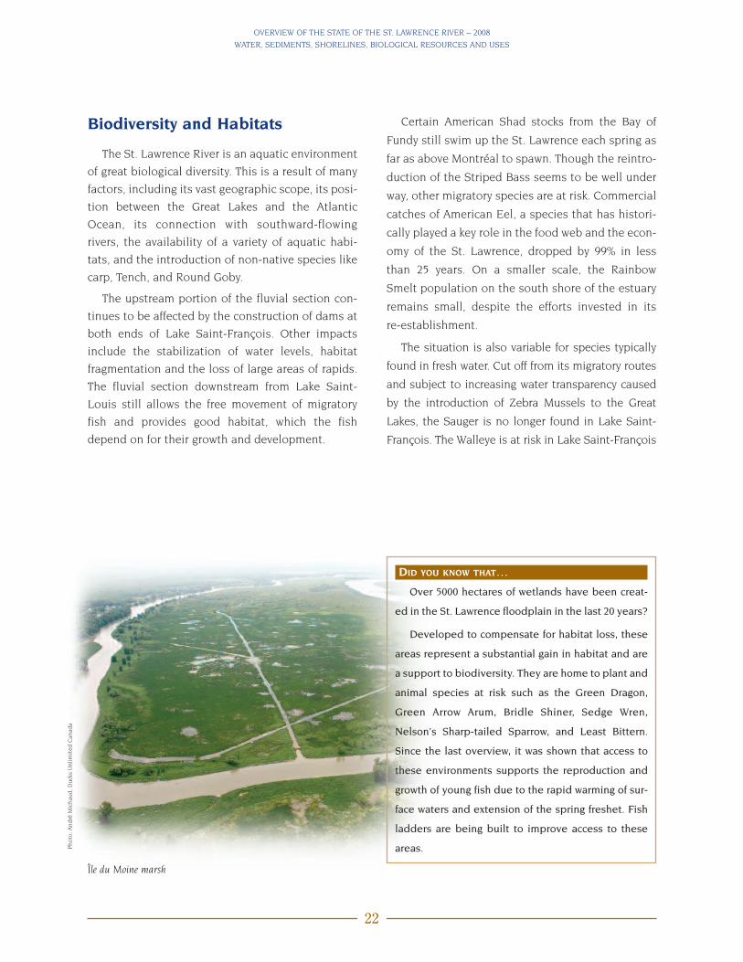
DID YOU KNOW THAT…Over 5000 hectares of wetlands have been creat-
ed in the St. Lawrence floodplain in the last 20 years?
Developed to compensate for habitat loss, these
areas represent a substantial gain in habitat and are
a support to biodiversity. They are home to plant and
animal species at risk such as the Green Dragon,
Green Arrow Arum, Bridle Shiner, Sedge Wren,
Nelson's Sharp-tailed Sparrow, and Least Bittern.
Since the last overview, it was shown that access to
these environments supports the reproduction and
growth of young fish due to the rapid warming of sur-
face waters and extension of the spring freshet. Fish
ladders are being built to improve access to these
areas.Photo
:André
Mic
hau
d,D
uck
sU
nlim
ited
Can
ada
Île du Moine marsh

OVERVIEW OF THE STATE OF THE ST. LAWRENCE RIVER – 2008
WATER, SEDIMENTS, SHORELINES, BIOLOGICAL RESOURCES AND USES
23
for the same reasons
but its status is
good in the other
areas. The Bridle
Shiner, a species
at risk in the tri-
butaries of the
St . Lawrence
because of the
degradation of its
habitat, still has
healthy popula-
tions, in particular in Lake Saint Pierre. However, the
decline of Yellow Perch populations has continued
in Lake Saint-Pierre and can be reversed only in
the medium term, despite the protective measures
currently in place. The St. Lawrence contains the
world’s only Copper Redhorse population, an
endangered species whose survival depends, over
the medium term, on the continued protection and
recovery efforts that have been in place for a decade.
Among the fish species found in Quebec, one is cur-
rently deemed threatened, three are vulnerable, and
18 species are likely to be designated as threatened
or vulnerable under Quebec law; most of these fish
are found in the St. Lawrence. Seven of these
species are protected under the federal Species At
Risk Act. Changes to habitats also affect amphibian
and reptile populations, including DeKay’s Brown
Snake, which is also at risk.
Changes being experienced by wetlands reflect
the complex dynamics of these ecosystems. The loss
of some wetlands to drought conditions, primarily
between 1990 and 2001, is associated with a drop in
water levels in the fluvial St. Lawrence. The intro-
duction of invasive plant species has changed the
composition of wetland species. In fact, the most
recent results indicate that these exotic plants take
up a considerable proportion of the plant cover in
some areas of the St. Lawrence. Crucial to the main-
tenance of biodiversity, wetlands are prime habitats
for flora and fauna. Though there is not much docu-
mentation on the impact of these introductions,
there is concern that their growing presence will
reduce plant diversity in wetlands and consequently
alter habitats.
A total of 399 species of birds are known to occur
at specific sites in the Quebec portion of the
St. Lawrence system2. Several of them are at risk,
including the Roseate Tern, Piping Plover and
Barrow's Goldeneye. Monitoring of the various bird
species shows the intermediate status of St.
Lawrence birds. Some species have shown progress
(e.g. Northern Gannet, Razorbill), while others are
experiencing difficulties (e.g. Caspian Tern).
Colonial-nesting birds make good indicators
because they are relatively easy to count compared
to species that nest over a wide area. However, they
provide only a partial picture of the state of avian
biodiversity in the St. Lawrence.
2. DesGranges, J-L. and B. Jobin. 2002. Biodiversity Portrait of the St. Lawrence. Environment Canada Web site:http://www.qc.ec.gc.ca/faune/biodiv/en/birds/total_sp_richness.html
Photo
:Ser
geH
éber
t,M
inis
tère
du
Dév
eloppem
ent
dura
ble
,de
l’Envi
ronnem
ent
etdes
Par
cs
The endangered Copper Redhorse, a speciesthat only exists in southwestern Quebec
Photo
:Dan
ielH
atin
,min
istè
redes
Res
sourc
esnat
ure
lles
etde
laFa
une
OVERVIEW OF THE STATE OF THE ST. LAWRENCE RIVER – 2008
WATER, SEDIMENTS, SHORELINES, BIOLOGICAL RESOURCES AND USES
24
SECT ION 1
4. ISSUES AND OUTLOOK
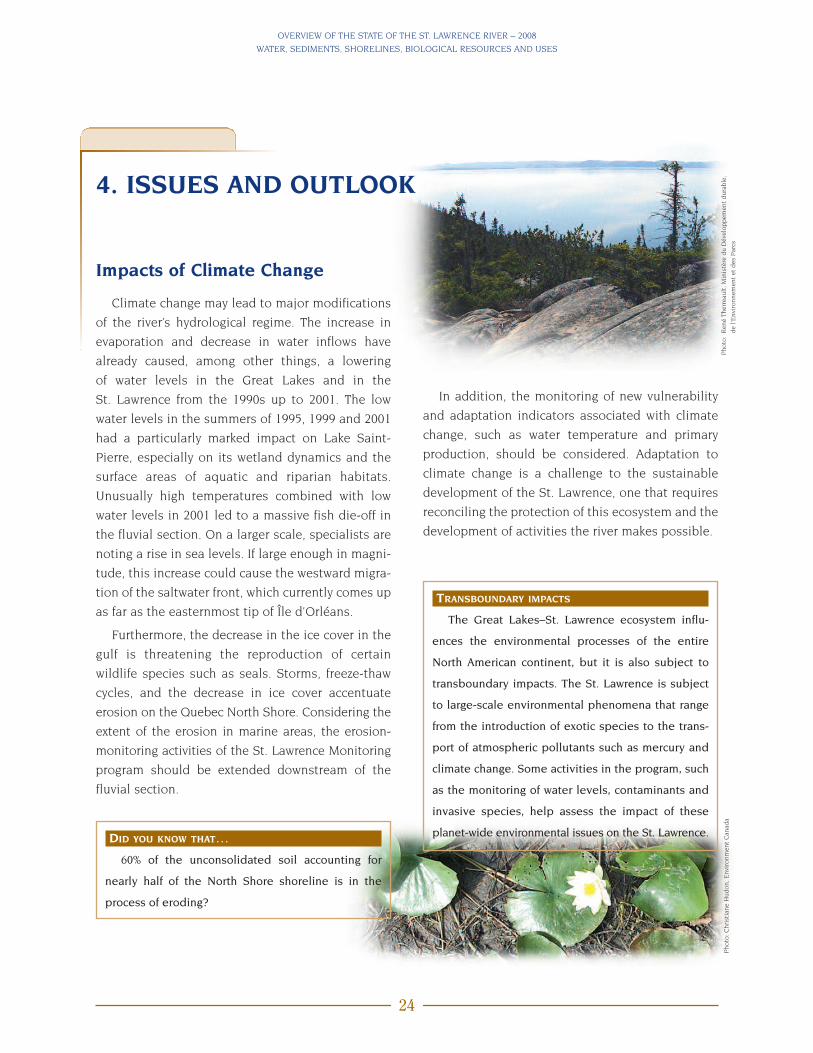
Impacts of Climate Change
Climate change may lead to major modifications
of the river’s hydrological regime. The increase in
evaporation and decrease in water inflows have
already caused, among other things, a lowering
of water levels in the Great Lakes and in the
St. Lawrence from the 1990s up to 2001. The low
water levels in the summers of 1995, 1999 and 2001
had a particularly marked impact on Lake Saint-
Pierre, especially on its wetland dynamics and the
surface areas of aquatic and riparian habitats.
Unusually high temperatures combined with low
water levels in 2001 led to a massive fish die-off in
the fluvial section. On a larger scale, specialists are
noting a rise in sea levels. If large enough in magni-
tude, this increase could cause the westward migra-
tion of the saltwater front, which currently comes up
as far as the easternmost tip of Île d’Orléans.
Furthermore, the decrease in the ice cover in the
gulf is threatening the reproduction of certain
wildlife species such as seals. Storms, freeze-thaw
cycles, and the decrease in ice cover accentuate
erosion on the Quebec North Shore. Considering the
extent of the erosion in marine areas, the erosion-
monitoring activities of the St. Lawrence Monitoring
program should be extended downstream of the
fluvial section.
TRANSBOUNDARY IMPACTS
The Great Lakes–St. Lawrence ecosystem influ-
ences the environmental processes of the entire
North American continent, but it is also subject to
transboundary impacts. The St. Lawrence is subject
to large-scale environmental phenomena that range
from the introduction of exotic species to the trans-
port of atmospheric pollutants such as mercury and
climate change. Some activities in the program, such
as the monitoring of water levels, contaminants and
invasive species, help assess the impact of these
planet-wide environmental issues on the St. Lawrence.DID YOU KNOW THAT…60% of the unconsolidated soil accounting for
nearly half of the North Shore shoreline is in the
process of eroding?
In addition, the monitoring of new vulnerability
and adaptation indicators associated with climate
change, such as water temperature and primary
production, should be considered. Adaptation to
climate change is a challenge to the sustainable
development of the St. Lawrence, one that requires
reconciling the protection of this ecosystem and the
development of activities the river makes possible.
Photo
:Chri
stia
ne
Hudon,E
nvi
ronm
ent
Can
ada
Photo
:R
ené
Ther
reau
lt,M
inis
tère
du
Dév
eloppem
ent
dura
ble
,
de
l’Envi
ronnem
ent
etdes
Par
cs

OVERVIEW OF THE STATE OF THE ST. LAWRENCE RIVER – 2008
WATER, SEDIMENTS, SHORELINES, BIOLOGICAL RESOURCES AND USES
25
Oxygen Depletion in the LowerEstuary and Gulf
The increase in the proportion of water from the
Gulf Stream to the detriment of the proportion of
cold water from the Labrador Current appears to be
one of the reasons for decreased oxygen levels in
the deep waters of the lower estuary and Gulf of St.
Lawrence. In 2003, the hypoxic (oxygen-poor) zone
covered about 1300 km2 of the seabed of the lower
estuary. This has a direct impact on aquatic species.
and cannot all be detected. Obviously, the
researchers studying these many substances must
establish priorities based on certain known criteria
(e.g. bioaccumulation, persistence, toxicity). Among
all of these substances, ethoxylated nonylphenols—
surfactants used in the manufacture of textiles, pulp
and paper, and petroleum—are known as endocrine
disruptors in aquatic organisms. They act at the bio-
chemical, genetic and physiological level. Nonyl-
phenols have been detected in the St. Lawrence,
though at very low concentrations.
Other substances, such as antibiotics and
nanotechnology products, also need to be moni-
tored given their potential environmental impacts. A
monitoring network to detect emerging contami-
nants should ideally be set up alongside the regular
St. Lawrence monitoring activities.
DID YOU KNOW THAT…Current hypoxic conditions in the estuary and Gulf
of St. Lawrence result in a loss of 10% in the surface
area of suitable habitat for cod as well as a 15–20% loss
in productivity?
DID YOU KNOW THAT…The feminization of several aquatic organisms,
attributed to the presence of estrogen in wastewater
discharge, has been observed in the St. Lawrence?
In some areas, 30–50% of Spottail Shiners have
become hermaphroditic and males have decreased
reproductory function.
Tolerance to low oxygen levels varies from one
species to another. Northern Shrimp and turbot
thrive in oxygen-poor areas, whereas cod does not
occur there. Hypoxia is not exclusive to marine envi-
ronments. Inputs of nutrients and organic matter
originating from urban wastewater discharges and
farming could have an impact on dissolved-oxygen
levels in some parts of Lake Saint-Pierre. This is a
hypothesis that still needs to be confirmed. Studies
are continuing to advance knowledge of the impacts
of depleted oxygen levels in the St. Lawrence on
biodiversity and ecosystem function.
Emerging Contaminants: LittleUnderstood
There are roughly 100 000 chemicals in commer-
cial use today, with 500 to 1000 new ones being
added each year. A good portion of these synthetic
molecules accumulate in the environment after use
Urban effluent dispersion plume
Photo
:Chri
stia
ne
Hudon,E
nvi
ronm
ent
Can
ada

OVERVIEW OF THE STATE OF THE ST. LAWRENCE RIVER – 2008
WATER, SEDIMENTS, SHORELINES, BIOLOGICAL RESOURCES AND USES
26
Invasive Aquatic and ExoticSpecies
Over 170 non-native species live in the Great
Lakes, while 86 such species have been surveyed in
the St. Lawrence, most of which were first intro-
duced to the Great Lakes. The Zebra Mussel, Round
Goby, Chinese Mitten
Crab, Tench and
Water Chestnut are
among the invasive
exotic species that
cause the most con-
cern in freshwater
areas. The St. Lawrence
marine environment, for its part, is home to about
40 such invasive species, including the European
Green Crab and a green alga, Codium fragile, referred
to as “dead man’s fingers” or “oyster thief.”
Though the real impacts of exotic species on an
environment’s biodiversity have not been extensive-
ly documented, researchers agree that invasive
species can create major and unforeseeable imbal-
ances, such as modifying energy, nutrient, contami-
nant and pathogen transfer routes in the ecosystem.
Species invasion can also be indicative of an under-
lying environmental problem, such as nonpoint-
source pollution, which causes the proliferation of
aquatic plants, some of which are invasive.
Some measures have been taken in this respect,
including the monitoring of invasive species in the
St. Lawrence wetlands and warning systems for
reporting a specimen’s capture. It would be worth-
while to consider consolidating these initiatives
into an integrated monitoring network for invasive
species in the St. Lawrence.
DID YOU KNOW THAT…Ballast water, pleasure boating, aquariophilia, the
pet trade, and the horticultural trade are all routes of
entry (or vectors) for exotic species? Two-thirds of
the 170 exotic species found in the Great Lakes–St.
Lawrence ecosystem originate from the ballast water
of commercial ships.
Photo
:Yve
sde
Laf
onta
ine,
Envi
ronm
ent
Can
ada
Photo
:Car
oline
Sav
age,
Envi
ronm
ent
Can
ada

OVERVIEW OF THE STATE OF THE ST. LAWRENCE RIVER – 2008
WATER, SEDIMENTS, SHORELINES, BIOLOGICAL RESOURCES AND USES
27
Unwanted Blue-green Algae
For the past few years, two species of benthic
blue-green algae that form filamentous (Lyngbia
wollei) or gelatinous (Gloeotrichia pisum) masses were
observed in lakes Saint Louis and Saint-Pierre. In
Lake Saint Louis, they were mainly
found along the north shore,
in the waters originating
from the Ottawa River.
Their presence in Lake
Saint-Pierre was docu-
mented near both shores,
but abundance was
greater near the south
shore, in the area of influ-
ence of the Saint-François
and Yamaska rivers. Benthic
blue-green algae are potentially
toxic and produce volatile organic compounds that
can create taste and odour problems. They are gen-
erally found in shallow water and benefit from the
higher nutrient levels, high temperatures and slow
currents. The mechanisms that control their devel-
opment as well as the impact of their proliferation
on the ecosystem are still not well known and are
being studied. Their presence in the St. Lawrence
may intensify with global warming and the potential
decrease in water levels and currents in fluvial lakes.
MONITORING RECREATIONAL USES
Certain recreational activities can create various
pressures on vulnerable environments in the St.
Lawrence. On the other hand, the fact that riverside
users are back is indicative of an improvement in the
accessibility or in the chemical, physical and biolog-
ical quality of the St. Lawrence. The monitoring of the
recreational use of the St. Lawrence, a new activity
under the program, is being conducted jointly by the
Lac Saint-Pierre ZIP Committee, Nature Québec,
Stratégies Saint-Laurent and Environment Canada.
The objective is first to observe trends in how the St.
Lawrence has been used over time and second, as a
result of the integrative nature of the monitoring, to
report on the state of the ecosystem in terms of envi-
ronmental quality and accessibility. For instance, a
change in a site’s use on the part of swimmers or fish-
ers may reveal a change in the state of the river-
banks, water quality or biological resources. In 2006
and 2007, the Lac Saint-Pierre ZIP Committee gath-
ered data on the use of sites intended for nature
watching, sport fishing, pleasure boating, and swim-
ming in its area. Based on a scientific approach and
with expert support, the monitoring of St. Lawrence
recreational uses may require the involvement of
several riverside communities recognized for their
knowledge of the area and their ability for coopera-
tion and action at a local level.Photo
:R
ené
Ther
reau
lt,M
inis
tère
du
Dév
eloppem
ent
dura
ble
,de
l’Envi
ronnem
ent
etdes
Par
cs
Photo
:Chri
stia
ne
Hudon,E
nvi
ronm
ent
Can
ada
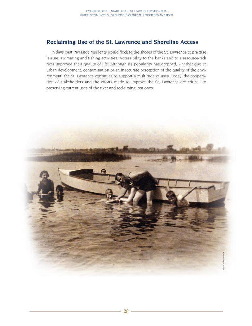
OVERVIEW OF THE STATE OF THE ST. LAWRENCE RIVER – 2008
WATER, SEDIMENTS, SHORELINES, BIOLOGICAL RESOURCES AND USES
28
Reclaiming Use of the St. Lawrence and Shoreline Access
In days past, riverside residents would flock to the shores of the St. Lawrence to practise
leisure, swimming and fishing activities. Accessibility to the banks and to a resource-rich
river improved their quality of life. Although its popularity has dropped, whether due to
urban development, contamination or an inaccurate perception of the quality of the envi-
ronment, the St. Lawrence continues to support a multitude of uses. Today, the coopera-
tion of stakeholders and the efforts made to improve the St. Lawrence are critical, to
preserving current uses of the river and reclaiming lost ones.
Photo
:Rober
tB
urt
on