Port of Hastings: Flora and Fauna Assessment of Crown land ......Port of Hastings: Flora and Fauna...
100
© Biosis September 2012 – Leading ecology and heritage consultants 1 © Biosis September 2012 – Leading ecology and heritage consultan ts 1 Port of Hastings: Flora and Fauna Assessment of Crown l and and BlueScope Steel property (within SUZ1) DRAFT REPORT Prepared for AECOM and GHD Joint Venture 2 March 2015 GHD Ref: AGH-CEP0-EV-REP
Transcript of Port of Hastings: Flora and Fauna Assessment of Crown land ......Port of Hastings: Flora and Fauna...

© Biosis September 2012 – Leading ecology and heritage consultants 1 © Biosis September 2012 – Leading ecology and heritage consultants 1
Port of Hastings: Flora and Fauna Assessment of Crown land and BlueScope Steel property (within SUZ1)
DRAFT REPORT
Prepared for AECOM and GHD Joint Venture
2 March 2015
GHD Ref: AGH-CEP0-EV-REP

In May 2016 the Special Minister of State asked Infrastructure Victoria to provide advice on the future capacity of Victoria’s commercial ports. Specifically, the Minister has asked for advice on when the need for a second container port is likely to arise and which variables may alter this timeline. The Minister has also asked for advice on where a second container port would ideally be located and under what conditions, including the suitability of, and barriers to investing in, sites at the Port of Hastings and the Bay West location.
In undertaking this task, Infrastructure Victoria reviewed work that was completed as part of the Port of Hastings development project before it was cancelled in 2014. This document forms part of the initial work undertaken for the proposed port development at Hastings. Infrastructure Victoria considers that much of the previous Hastings work, although preliminary in nature, is relevant and suitable for informing a strategic assessment. Therefore, Infrastructure Victoria has made the reports previously commissioned for the development project part of the evidence base on which Infrastructure Victoria will use in providing the Minister with advice.
The opinions, conclusions and any recommendations in this document are based on conditions encountered and information reviewed at the date of preparation of the document and for the purposes of the Port of Hastings Development Project.
Infrastructure Victoria and its consultants have used the information contained in these reports as an input but have not wholly relied on all the information presented in these reports.

© Biosis 2015 – Leaders in Ecology and Heritage Consulting www.biosis.com.au Draft for discussion purposes I
Biosis Pty Ltd
This document is and shall remain the property of Biosis Pty Ltd. The document may only be used for the purposes for which it was commissioned and in accordance with the Terms of the Engagement for the commission. Unauthorised use of this document in any form whatsoever is prohibited.
Disclaimer:
Biosis Pty Ltd has completed this assessment in accordance with the relevant federal, state and local legislation and current industry best practice. The company accepts no liability for any damages or loss incurred as a result of reliance placed upon the report content or for any purpose other than that for which it was intended.
Biosis offices
AUSTRALIAN CAPITAL TERRITORY
Canberra
Floor 1, Unit 3, 38 Essington Street Mitchell ACT 2911
Phone: (02) 6241 2333 Fax: (03) 9646 9242 Email: [email protected]
NEW SOUTH WALES
Newcastle
39 Platt Street Waratah NSW 2298
Phone: (02) 4968 4901 Email: [email protected]
Sydney
Unit 14 17-27 Power Avenue Alexandria NSW 2015
Phone: (02) 9690 2777 Fax: (02) 9690 2577 Email: [email protected]
Wollongong
8 Tate Street Wollongong NSW 2500
Phone: (02) 4229 5222 Fax: (02) 4229 5500 Email: [email protected]
QUEENSLAND
Brisbane
Suite 4 First Floor, 72 Wickham Street Fortitude Valley QLD 4006
Phone: (07) 3831 7400 Fax: (07) 3831 7411 Email: [email protected]
VICTORIA
Ballarat
506 Macarthur Street Ballarat VIC 3350
Phone: (03) 5331 7000 Fax: (03) 5331 7033 Email: [email protected]
Melbourne (Head Office)
38 Bertie Street Port Melbourne VIC 3207
Phone: (03) 9646 9499 Fax: (03) 9646 9242 Email: [email protected]
Wangaratta
16 Templeton Street Wangaratta VIC 3677
Phone: (03) 5721 9453 Fax: (03) 5721 9454 Email: [email protected]
Document information
Report to: AECOM and GHD Joint Venture
Prepared by: Matt Dell, Ian Smales & Kirsty Kay
Biosis project no.: 19075
File name: 19075.PoH.FFA.DFT04.020315.docx
Citation: Biosis 2015. Port of Hastings: Flora and Fauna Assessment of Crown land and BlueScope Steel property (within SUZ1). Report for AECOM and GHD Joint Venture. Authors: Dell M, Smales I and Kay K. Biosis Pty Ltd, Melbourne. Project no. 19075.
Document control
Version Internal reviewer Date issued
Draft version 01 Ian Smales 21/01/15
Draft version 02 Kirsty Kay 30/01/15
Draft version 03 Kirsty Kay 27/02/15
Draft version 04 Kirsty Kay 02/03/15
Acknowledgements
Biosis acknowledges the contribution of the following people and organisations in undertaking this study:
Port of Hastings Development Authority: Rohan Henry
GHD/AECOM: David May, Megan Shaw and David Hyett
BlueScope Steel: Kristen Skewes
Department of Environment, Land, Water and Planning for access to the Victorian Biodiversity Atlas and Native Vegetation Information Tools.
The following Biosis staff were involved in this project:
Dr Matthew Dell, Stephen Mueck, Ian Smales, Kirsty Kay, Dan Gilmore, Kailash Willis, Karina Salmon and Michael Goddard for field work
Marion Shadbolt and Dan Lim for research assistance
Sally Mitchell and Lachlan Milne for mapping.
© Biosis 2015 – Leaders in Ecology and Heritage Consulting Draft for discussion purposes II
Contents Executive Summary ............................................................................................................................................... 1 1. Introduction .................................................................................................................................................... 3 1.1 Project background ......................................................................................................................................................... 3 1.2 Purpose and scope of this report ................................................................................................................................ 3 2. Biodiversity Legislation, Policy and Guidelines ........................................................................................ 5 2.1 International ..................................................................................................................................................................... 5 Ramsar Convention on Wetlands of International Importance (Ramsar Convention) ........................... 5 2.1.1
2.2 Commonwealth ............................................................................................................................................................... 5 Environment Protection and Biodiversity Conservation Act 1999 (EPBC Act) ............................................ 5 2.2.1
2.3 State Legislation ............................................................................................................................................................... 6 Major Transport Project Facilitation Act 2009 (MTPF Act) ........................................................................... 6 2.3.1 Flora and Fauna Guarantee Act 1988 (FFG Act) ............................................................................................ 6 2.3.2 Catchment and Land Protection Act 1994 (CaLP Act) ................................................................................... 6 2.3.3 Planning and Environment Act 1987 (incl. Planning Schemes) ................................................................. 6 2.3.4 Victoria's Biodiversity Assessment Guidelines ........................................................................................... 7 2.3.5 State Advisory list of rare or threatened species ....................................................................................... 8 2.3.6
3. Methods ........................................................................................................................................................... 9 3.1 Literature and database review ................................................................................................................................... 9 3.2 Definitions of significance ........................................................................................................................................... 10 Species and ecological communities......................................................................................................... 10 3.2.1
3.3 Likelihood of occurrence ............................................................................................................................................ 10 3.4 Site investigation........................................................................................................................................................... 11 Definition of native vegetation ................................................................................................................... 11 3.4.1
3.5 Vegetation Mapping..................................................................................................................................................... 11 3.6 Vegetation Quality Assessment ................................................................................................................................ 12 3.7 Targeted species surveys ............................................................................................................................................ 12 Flora .................................................................................................................................................................. 12 3.7.1 Fauna ................................................................................................................................................................ 13 3.7.2 Permits ............................................................................................................................................................. 15 3.7.3
3.8 Limitations ..................................................................................................................................................................... 15 4. Results ............................................................................................................................................................ 17 4.1 Landscape context ....................................................................................................................................................... 17 4.2 Vegetation & fauna habitat ........................................................................................................................................ 18 4.3 Significant species and ecological communities ................................................................................................... 29 EPBC Act and FFG Act listed species .......................................................................................................... 29 4.3.1 Targeted survey results ................................................................................................................................ 31 4.3.2

© Biosis 2015 – Leaders in Ecology and Heritage Consulting Draft for discussion purposes III
EPBC Act listed ecological communities ................................................................................................... 33 4.3.3 FFG Act listed community ............................................................................................................................ 34 4.3.4
4.4 Habitat hectares ........................................................................................................................................................... 35 4.5 Other ecological values ............................................................................................................................................... 37 Western Port Ramsar wetland .................................................................................................................... 37 4.5.1 Locally or regionally significant flora species .......................................................................................... 37 4.5.2 NaturePrint and Strategic Biodiversity Score .......................................................................................... 38 4.5.3
4.6 Implications under State and Commonwealth Legislation ................................................................................. 39 EPBC Act ........................................................................................................................................................... 39 4.6.1 FFG Act ............................................................................................................................................................. 39 4.6.2 CaLP Act ........................................................................................................................................................... 39 4.6.3 Planning and Environment Act 1987 (incl. Planning Schemes) .............................................................. 40 4.6.4 State Advisory list of rare or threatened species .................................................................................... 40 4.6.5
5. Conclusion ..................................................................................................................................................... 41 5.1 Key biodiversity values ................................................................................................................................................ 41 5.2 Avoidance and minimisation of biodiversity impacts .......................................................................................... 41 5.3 Considerations for project design ............................................................................................................................ 42 5.4 Further surveys ............................................................................................................................................................. 42 References ............................................................................................................................................................. 43 Appendix A. Figures ............................................................................................................................................. 46 Appendix B. Flora ................................................................................................................................................. 50 Appendix C. Fauna ............................................................................................................................................... 70 Appendix D. Photos .............................................................................................................................................. 85 Appendix E. Ecology Glossary ............................................................................................................................. 86
List of Tables
Table 1: Criteria for determining significance of species & ecological communities ................................... 10 Table 2: Summary of vegetation and habitat types within the study area ................................................... 19 Table 3: Summary of listed flora and fauna species most likely to occur in the study area ...................... 29 Table 4: Habitat hectares of native vegetation within the study area ........................................................... 36

© Biosis 2015 – Leaders in Ecology and Heritage Consulting Draft for discussion purposes 1
Executive Summary
Biosis Pty Ltd was appointed by AECOM/GHD Joint Venture on behalf of the Port of Hastings Development Authority (the Authority) to undertake a flora and fauna assessment of land within BlueScope Steel and areas of Crown land within the Hastings Special Use Zone (SUZ1) for the Port of Hastings Development Project (the Project). This information is required to understand the condition, presence and extent of terrestrial biodiversity values within the study area to inform port design decisions and support future impact assessments and approvals.
The study area contains a range of ecological values on land that is largely occupied by native vegetation of varying quality. It is included within the Western Port Biosphere Reserve and the Western Port Ramsar Wetland site (in part). The Ramsar wetland includes permanent and semi-permanent saline wetlands, including intertidal mud and sand flats, and areas of saltmarsh and mangroves. The biosphere reserve was declared on the basis that it contains significant natural values including internationally important wetlands as well as nationally significant values.
Key ecological values
Key ecological values identified within the study area are as follows:
approximately 330 ha of native vegetation including large, high quality, intact patches of woodland, and coastal EVCs, scattered remant trees, and regionally significant coastal-inland ecosystem gradients
shallow intertidal habitats, mangroves, saltmarsh and adjacent coastal land which form a significant component of the Western Port Ramsar wetland
approximately 43.4 ha of the EPBC Act listed ecological community: Subtropical and Temperate Coastal Saltmarsh and approximately 3 ha of the EPBC Act listed community: Seasonal Herbaceous Wetland (Freshwater) of the Temperate Lowland Plains
a population of the EPBC Act listed flora species River Swamp Wallaby-grass (Amphibromus fluitans), twelve State Advisory List species and three FFG Act listed fauna species
potential presence of additional EPBC Act, State Advisory List and FFG Act listed species and suitable habitats for them.
High value areas
Large patches of contiguous native vegetation generally provide the highest flora and fauna values. Loss or fragmentation of such areas can be detrimental to the species and ecosystems they support. Relevant areas within the study area include:
Crown land containing native heathy or grassy woodland and the coastal zone supporting saltmarsh and mangrove shrublands which form part of the Western Port Ramsar wetland.
large intact areas of native woodland and coastal vegetation within the eastern part of the BlueScope Steel property.
© Biosis 2015 – Leaders in Ecology and Heritage Consulting Draft for discussion purposes 2
Considerations for project design
Planning for project infrastructure layout from an ecological perspective (with respect to State and Commonwealth biodiversity legislation and policies) should give consideration to:
design options which avoid or minimise direct or indirect impacts on the Western Port Ramsar site including its foreshore habitats
design options that avoid or minimise removal of remnant native vegetation and scattered native trees, particularly larger areas of intact vegetation such as those within BlueScope Steel land, by locating infrastructure in previously cleared land or predominantly non-native vegetation (e.g. existing transport corridors, urban areas and non-native agricultural areas)
design options that avoid fragmentation of native vegetation patches, and avoid severance of important vegetation and habitat linkages
the potential challenges and costs associated with locating and securing sufficient offsets for biodiversity assets that cannot be protected on-site (as required to comply with relevant State and Commonwealth offset policies).
Further survey
The surveys reported here were undertaken in a season not suitable for detection of all target species. Further surveys are recommended for detection of Southern Toadlet in autumn, Orange-bellied Parrot between April and September inclusive and Green-striped Greenhood during August to early September.
The survey reported here is one of a number of investigations of biodiversity values planned to be undertaken for the Project. Other investigations yet to be undertaken may provide information that further refines understanding of aspects covered by this report.

© Biosis 2015 – Leaders in Ecology and Heritage Consulting Draft for discussion purposes 3
1. Introduction
1.1 Project background
The Victorian Government has identified the Port of Hastings as a key area for port expansion.
An expanded Port of Hastings would increase capacity and competition in the container ports sector servicing Melbourne and Victoria helping to manage the expected growth in container trade.
The Port of Hastings Development Authority (the Authority) and its board were established in January 2012 under the Transport Integration Act 2010. The primary objectives of the Authority are to:
manage and operate the Port of Hastings, and
facilitate the development of the Port of Hastings as a viable alternative to the Port of Melbourne as a container port to increase capacity and competition in the container ports sector to accommodate future growth in trade, consistent with the vision statement and the transport system objectives.
Over the next three to four years, the Authority will be working to develop a business case for an expanded Port of Hastings and undertake comprehensive environmental assessment. This business case will include:
preferred project design/scope (including transport connections)
necessary environmental approvals (including impact assessment)
preferred governance and delivery strategy.
In May 2014, the Port of Hastings Development Project (the Project) was declared a 'Major Transport Project' under the Major Transport Project Facilitation Act 2009 (MTPF Act).
In July 2014, the then Minister for Ports, Mr David Hodgett, formally appointed the Authority as the Project Proponent under the MTPF Act.
1.2 Purpose and scope of this report
The purpose of this report is to present an assessment of the condition, presence and extent of terrestrial biodiversity values in BlueScope Steel and coastal Crown land within SUZ1, including threatened species. The assessment has been developed to:
understand the significance of terrestrial and coastal biodiversity in accordance with State and Federal biodiversity legislation
enable port design decisions to be informed by an understanding of terrestrial biodiversity values, their significance and location across the landscape
obtain further information for potential inclusion in the EPBC referral and Project Proposal
collect information to inform future impact assessments that will be carried out once the reference design has been developed.
The scope of this assessment is to:
review the results of a desktop flora and fauna report prepared by Biosis (2014b)
undertake mapping at 1:5,000 scale of Ecological Vegetation Classes, remnant scattered trees, EPBC Act listed ecological communities and FFG Act listed communities

© Biosis 2015 – Leaders in Ecology and Heritage Consulting Draft for discussion purposes 4
assess the condition of native vegetation
undertake targeted surveys and habitat evaluation for threatened flora and fauna species (EPBC Act and FFG Act) that were determined in the desktop of having at least a medium likelihood of presence
identify any other relevant ecological values.
The study area for this assessment is shown in Appendix A - Figure A1 and is confined within the Hastings SUZ1 component of the port landside development. Some areas within BlueScope and Crown land were not available to be assessed in the present investigation and it is recommended that they are included in any subsequent assessment(s). The operational area of BlueScope was not surveyed due to safety access requirements. The Gordon Rolfe Bushland Reserve, Yaringa, was assessed for flora but fauna surveys were not possible due to a feral animal control program at the time of survey.
The properties included in the scope of works for the present investigation cover a portion of the SUZ1. The entire SUZ1 area includes various land parcels under different tenures and land management from those covered here. Future investigations are proposed to investigate biodiversity values of these additional land parcels within SUZ1.
The scope for the present investigations excluded marine (refer Figure A1) and freshwater environments, other than consideration of vegetation and frogs of freshwater habitats.
Results of the assessment are presented variously in Appendices B (Flora), C (Fauna) and D (Photos). A glossary of terms is provided in Appendix E.
The contents of this document reflect the current position on the subject matter held by Biosis. It is provided for discussion or information purposes and is intended to be a guide only. The contents of this document should not be relied upon as representing the final position of Biosis on the subject matter, unless stated otherwise. Any views expressed by Biosis in this document may change as a consequence of Biosis undertaking further technical studies or specifications, or legislative, or procedure and regulatory developments. Any figures provided are indicative only and may be subject to change.

© Biosis 2015 – Leaders in Ecology and Heritage Consulting Draft for discussion purposes 5
2. Biodiversity Legislation, Policy and Guidelines
This section provides a summary of relevant biodiversity legislation and government policies and guidelines. Legislation and policy are not described in detail and guidance provided here does not constitute legal advice. Prescriptions and guidance for flora and fauna survey and assessment methods are provided in a number of policies associated with relevant legislation.
Generally, biodiversity legislation aims to avoid or minimise impacts on import biodiversity values. In particular lists of rare or threatened species and ecological communities are provided with the aim of avoiding further fragmentation or loss of these values. The approvals process requires demonstation of efforts to optimise the design of developments to minimise these environmental impacts. Where impacts on biodiversity are unavoidable following an iterative design optimisation process, offsets may be sought to adequately compensate for residual adverse impacts. Both Commonwealth and State systems provide calculators to be used to determine offset size, type and location of offsets.
Offsets can only be secured however where they are available, and it is important to note that not in every case the required equivalent offsets for clearance of habitats or species are available. This is particularly relevant for large areas of listed threatened native vegetation communities or extensive areas of high quality habitat for threatened species, thus potentially providing a challenge to obtaining permission to remove those values from an area.
2.1 International
Ramsar Convention on Wetlands of International Importance (Ramsar Convention) 2.1.1
Australia became a signatory to the Ramsar Convention in 1974 and commited to designating sites for inclusion in the List of Wetlands of International Importance. A large portion of Western Port was designated in 1982. Australia has a number of obligations pertinent to the management of wetlands of international importance and is expected to manage Ramsar wetlands so as to maintain their ecological character, remain informed of any changes to their character, and notify the Ramsar Secretariat of any changes at the earliest opportunity.
National Guidelines for Ramsar Wetlands are currently being developed by the Department of Environment in consultation with the states and territories. The aim of the guidelines is to facilitate improved management of Ramsar sites in line with Australia's commitments under the Ramsar Convention and responsibilities under the Environment Protection and Biodiversity Conservation Act 1999 (below).
2.2 Commonwealth
Environment Protection and Biodiversity Conservation Act 1999 (EPBC Act) 2.2.1
The aim of the EPBC Act is to provide a legal framework to protect nationally and internationally important flora, fauna and ecological communities. These values are defined as matters of national environmental significance (MNES). The EPBC Act applies to developments and associated activities that have the potential to significantly impact MNES protected under the Act including Ramsar wetlands of international importance, nationally threatened species and communities and migratory species. The EPBC Act also relates to ations that affect Commonwealth land (DEWHA 2010). Actions that may have a 'significant impact' on MNES or
© Biosis 2015 – Leaders in Ecology and Heritage Consulting Draft for discussion purposes 6
Commonwealth land are subject to approval by the Australian Government Minister for the Environment (DEWHA 2009a). Where significant impacts are deemed likely, measures to avoide and mitigation those impacts are required. As a final measure, offsets can be deemed to compensate for the residual adverse impacts of an action on the environment. The suitability of a proposed offset is considered as part of the decision to approve or not approve a proposed action under the EPBC Act.
The Authority is concurrently seeking agreement to accredit the assessment process under the MTPF Act for assessment of the impacts to MNES as listed under the EPBC Act.
2.3 State Legislation
Major Transport Project Facilitation Act 2009 (MTPF Act) 2.3.1
The Project has been declared under the MTPF Act. The Authority is preparing a Project Proposal as part of the decision-making and approval process under the MTPF Act to inform a decision by the Minister for Planning on the appropriate assessment pathway for the project. The primary State approvals required for the project, and that are capable of being granted under the MTPF Act, are called Applicable Approvals. At this stage of the Project development, the Applicable Approvals relevant to biodiversity that may be sought for the Project under the MTPF Act include:
consent under the Coastal Management Act 1995
planning scheme amendment under the Planning and Environment Act 1987
licence to take and use water, and works on waterways licence under the Water Act 1989
consent under the Conservation, Forest and Lands Act 1987.
Permits under the Flora and Fauna Guarantee Act 1988 and the Wildlife Act 1975 would be sought following the MTPF Act approval process as these require a more detailed level of design.
Flora and Fauna Guarantee Act 1988 (FFG Act) 2.3.2
The FFG Act is the key piece of Victorian legislation for the conservation of threatened species and communities and for the management of potentially threatening processes. Under the FFG Act a permit is required from the Department of Environment, Land, Water and Planning (DELWP) to 'take' protected flora species from public land, which in this case would apply to the Crown land parcels. A permit is generally not required for removal of protected flora from private land.
Catchment and Land Protection Act 1994 (CaLP Act) 2.3.3
The CaLP Act identifies and classifies certain species as noxious weeds or pest animals, and provides a system of controls on noxious species.
The land owner must take all reasonable steps to eradicate regionally prohibited weeds, prevent the growth and spread of regionally controlled weeds, and prevent the spread of and as far as possible eradicate established pest animals. The State is responsible for eradicating State prohibited weeds from all land in Victoria.
Planning and Environment Act 1987 (incl. Planning Schemes) 2.3.4
The Planning and Environment Act 1987 controls the planning and development of land in Victoria, and provides for the development of planning schemes for all municipalities. This Act would be addressed under Applicable Approvals of the MTPF Act.
© Biosis 2015 – Leaders in Ecology and Heritage Consulting Draft for discussion purposes 7
Reforms to the native vegetation permitted clearing regulations were gazetted on 20 December 2013 through planning scheme amendment VC105. The reforms made changes to the Victoria Planning Provisions including the State Planning Policy Framework (SPPF), Clause 52.16 and 52.17 of all planning scheme within Victoria and introduced the Permitted clearing of native vegetation: Biodiversity Assessment Guidelines (DEPI 2013b).
Of particular relevance to the Project are controls relating to the removal, destruction or lopping of native vegetation contained within the Planning Scheme, including permit requirements. The Scheme defines ‘native vegetation’ as 'plants that are indigenous to Victoria, including trees, shrubs, herbs and grasses'. It is an objective of Clause 12.01-2 of the SPPF (Native Vegetation Management) that permitted clearing of native vegetation results in no net loss in the contribution made by native vegetation to Victoria’s biodiversity. For more information on these reforms refer to http://www.depi.vic.gov.au/environment-and-wildlife/biodiversity/native-vegetation.
Overlays in the planning scheme relevant to the study area and final development layout should also be reviewed to assist in the determination of whether a permit to remove native vegetation is required.
Victoria's Biodiversity Assessment Guidelines 2.3.5
The Guidelines are incorporated into the Victoria Planning Provisions and all planning schemes in Victoria (DEPI 2013b). The purpose of the Guidelines is to guide how impacts to biodiversity should be considered when assessing a permit application to remove, destroy or lop native vegetation.
The Guidelines describe the following objective for permitted clearing of native vegetation in Victoria:
'No net loss in the contribution made by native vegetation to Victoria's biodiversity'.
This objective is to be achieved through Victoria's planning system using a risk-based approach that relies on strategic planning and the permit and offset system. The key strategies for achieving no net loss at the permit level are:
avoiding the removal of native vegetation that makes a significant contribution to Victoria's biodiversity
minimising impacts to Victoria's biodiversity from the removal of native vegetation
where native vegetation is permitted to be removed, ensuring it is offset in a manner that makes a contribution to Victoria's biodiversity that is equivalent to the contribution made by the native vegetation to be removed.
Under the Guidelines, there are three risk-based pathways for assessing an application for a permit to remove native vegetation: low, moderate and high. A planning application for removal of native vegetation must meet the requirements of, and be assessed in, the appropriate risk pathway. Given the scale of the Project and requirements for native vegetation removal, it is likely to be assessed under the high risk-based pathway.
Consideration to the design and layout of the Project infrastructure would be required to avoid and minimise clearance of native vegetation and scattered trees as far as possible. Offsets for permitted native vegetation clearance would be required and can be calculated using the DELWP Native Vegetation Information Management (NVIM) system online tool once a development footprint is known. Various options can be sumitted throught the NVIM tool to establish the layout which results in the lowest impacts on biodiversity values.
© Biosis 2015 – Leaders in Ecology and Heritage Consulting Draft for discussion purposes 8
State Advisory list of rare or threatened species 2.3.6
The State Advisory Lists (e.g. DEPI 2013a, DEPI 2013d) are intended to be used in a range of planning processes, although there are no direct legal requirements or consequences that flow from inclusion of a species in advisory lists. Some species in these advisory lists are also listed as threatened under the FFG Act.
To support decision making under the Guidelines, DELWP has produced models for Victoria describing the extent of habitat for most listed rare or threatened species. These models are called 'habitat importance models' and they assign a 'habitat importance score' to a location based on its importance in the landscape as habitat for a particular rare or threatened species relative to other suitable habitat for the species elsewhere in the State (DEPI 2013b).
Under the Guidelines, these models form the basis for determining the impact of potential native vegetation clearing on rare and threatened species where the proposal is considered to be on the moderate or high risk-based application pathways. The habitat importance scores are used to calculate the type and extent of biodiversity offsets required for native vegetation removal that impacts on individual rare or threatened species habitat for moderate or high risk application pathways.
© Biosis 2015 – Leaders in Ecology and Heritage Consulting Draft for discussion purposes 9
3. Methods
3.1 Literature and database review
Information about flora and fauna was obtained from relevant public databases for the study area and from within 5 km of the study area (the ‘local area’). These data provide an indication of species and ecosystems that may exist within the study area. Records from the following databases were collated and reviewed:
Flora Information System which includes records from the Victorian Biodiversity Atlas ‘VBA_FLORA25, FLORA100 & FLORA Restricted’ August 2012 © The State of Victoria, DEPI (the contribution of the Royal Botanical Gardens Melbourne to the database is acknowledged)
Victorian Biodiversity Atlas ‘VBA_FAUNA25, FAUNA100 & FAUNA Restricted’ August 2012 © The State of Victoria
DELWP Biodiversity Interactive Map (BIM)
BirdLife Australia, the New Atlas of Australian Birds 1998–2012 (BA)
Protected Matters Search Tool of the Australian Government Department of the Environment for MNES under the EPBC Act.
Other sources of biodiversity information:
DELWP Native Vegetation Information Management (NVIM) system and BIM
DELWP NaturePrint; accessed through the BIM
DELWP Arthur Rylah Institute.
The following studies and consultant reports relating to the study area were reviewed in preparation of this report. The main focus in the review of these documents was to validate EVC distribution for the study area and to determine any implications of threatened species survey results:
AECOM 2013. Western Port Highway Planning Study – Ballarto Road to Hodgins Road: Desktop Flora and Fauna Assessment. Report to VicRoads. Author: White, C. AECOM, Melbourne. Job No. 60308273.
Biosis 2014a. Port of Hastings Development Authority: Flora and fauna assessment for the geophysical and geotechnical surveys. Report to Port of Hastings Development Authority. Authors: Mueck S. and Smales I. Biosis Pty Ltd, Melbourne. Project no. 17228
Biosis 2014b. Port of Hastings: SUZ1 and Land Transport Corridor, Desktop Flora and Fauna Assessment. Report for AECOM and GHD Joint Venture. Authors: Dell M, Kay K and Gilmore D – Biosis; Harrow, S, Lind P. - GHD. Biosis Pty Ltd, Melbourne. Project no. 18568.
Biosis Research 2012. Scoping framework for the terrestrial ecological assessment of the expansion of the Port of Hastings. Report to Major Projects Victoria. Author: Venosta, M. Biosis Research, Melbourne. Matter No. 14062.
Biosis Research 2011. Port of Hastings Stage 1 Investigation Area: Threatened flora and fauna survey and habitat hectare assessment. Report to Port of Melbourne Corporation. Authors: Venosta, M., Mueck, S. and Bloink, C. Biosis Research Pty Ltd, Melbourne. Matter No. 11173.

© Biosis 2015 – Leaders in Ecology and Heritage Consulting Draft for discussion purposes 10
Biosis Research 2009. Flora and fauna assessment of Port of Hastings Stage One Investigation area, Victoria. Report to AECOM Pty Ltd. Authors: Venosta, M., Mueck, S. and Bloink, C. Biosis Research Pty Ltd, Melbourne. Project no. 7540 & 7930.
DEPI 2014. Sub-regional Species Strategy for the Southern Brown Bandicoot. Victorian Government Department of Environment and Primary Industries, Melbourne.
GHD 2013. Port of Hastings Development Authority, Port Container Expansion Project: Preliminary Ecological Assessment. Report to Port of Hastings Development Authority. Job No. 31/29838/06.
Legg 2006. Flora and Fauna Survey and Management Prescriptions for Crib Point Stony Point Foreshore, Crib Point, October, 2005 to October, 2006. Report to Crib Point Stony Point Foreshore Committee of Management Inc. Author: Legg, M. Mal’s Environmental and Ecological Services.
A catalogue of literature relating to the Western Port Biosphere Project was updated by Mungere (2008) which includes ecological studies and other literature (1800 references) (MPWPBRF 2014). A full list of literature used in preparation of this report is contained in the references section.
3.2 Definitions of significance
Species and ecological communities 3.2.1
The significance of a species or community is determined by its listing as rare or threatened under Commonwealth or State legislation / policy. The sources for categories of significance of species and communities are summarised below in Table 1.
Table 1: Criteria for determining significance of species & ecological communities
Significance
National Listed as threatened (critically endangered, endangered, vulnerable or conservation dependent) under the EPBC Act and/or a component of a Ramsar wetland.
State Listed as threatened (critically endangered, endangered, vulnerable) or rare for flora species, in Victoria on a State Advisory List (DEPI 2013a, DEPI 2013d) Listed as threatened under the FFG Act.
Fauna species listed on State Advisory lists as near threatened or data deficient are listed in Appendix B, however in accordance with advice from DELWP these fauna species are not considered to be at the same level of risk as higher categories of threat. These species are generally not discussed in detail in this report.
3.3 Likelihood of occurrence
The likelihood of occurrence is a broad categorisation used by Biosis to indicate the potential for a species to occur within the study area. It implies the relative value of a site for a particular species. The categorisation is based on documentary evidence for the presence of relevant species; the existence of suitable habitat within the study area; and, experience, particularly for species that are cryptic and have never been recorded in the study area or have not been recorded for a substantial period. Account is taken of the rigour, and effort of surveys for particular taxa and the time that has elapsed since field investigations were undertaken.
Likelihood of occurrence is assessed only for species listed under the EPBC Act or listed as threatened under the FFG Act (hereafter referred to as 'listed species'). The habitat value for species listed on the State Advisory

© Biosis 2015 – Leaders in Ecology and Heritage Consulting Draft for discussion purposes 11
Lists is calculated by the Habitat Importance Modelling produced by the then DEPI (2013b). Where State Advisory List species are recorded in the study area this is noted in Appendix B1.1 and Appendix B2.1.
The likelihood of listed species occurring within the study area is ranked as negligible, low, medium or high.
Species which have medium or high likelihood of occurrence are given further consideration in this report.
3.4 Site investigation
Definition of native vegetation 3.4.1
Native vegetation is defined in the Victoria Planning Provisions as 'plants that are indigenous to Victoria, including trees, shrubs, herbs and grasses'. Native vegetation is classified by Victoria's Biodiversity Assessment Guidelines into two categories (DEPI 2013b):
A remnant patch of native vegetation (measured in hectares) is either:
– An area of native vegetation, with or without trees, where at least 25 percent of the total perennial understorey cover is native plants.
– An area with three or more indigenous canopy trees where the tree canopy cover is at least 20 percent.
Remnant patch vegetation is classified into ecological vegetation classes (EVCs). An EVC contains one or more floristic (plant) communities, and represents a grouping of broadly similar environments. Definitions of EVCs and benchmarks (condition against which vegetation quality at the site can be compared) are determined by DELWP.
A scattered tree is defined as (extent measured by number of trees):
– An indigenous canopy tree that does not form part of a remnant patch of native vegetation.
A canopy tree is a mature tree that is greater than three metres in height and is normally found in the upper layer of a vegetation type. Ecological Vegetation Class descriptions provide a list of the typical canopy species. A condition score and extent is applied to each scattered tree based on information provided by DELWP’s online Native Vegetation Information Management (NVIM) system.
Species nomenclature for flora follows the Victorian Flora Information System (FIS). The FIS and the Victorian Fauna Database (VFD) are fully-functional geographically-registered, relational databases of distribution and descriptive data on Victorian plants and animals. Together they contain over five million records of over 8000 species, sub-species, varieties, forms, hybrids and undescribed taxa of plants and animals from over 900,000 survey or collection sites (Viridans 2015).
3.5 Vegetation Mapping
The study area boundaries for the project were provided by the Authority and are shown in Figure A1.
Mapping reviewed for this assessment include:
EVC mapping within Mornington Peninsula Shire, available at 1:10 000 scale (Sinclair et al. 2006)
Victorian Saltmarsh Study (Boon et al. 2011), which entailed detailed mapping of saltmarsh communities and provides accurate information about the extent of intertidal EVCs
EVC mapping within BlueScope Steel (Biosis 2014b) available at 1:10 000 scale
DEPI modeled 2005 EVCs generally available at 1:25 000 scale (DELWP 2015).

© Biosis 2015 – Leaders in Ecology and Heritage Consulting Draft for discussion purposes 12
Updated vegetation mapping was conducted in the field using hand-held (uncorrected) GPS units (WGS84) and aerial photo interpretation. The locations of EPBC Act listed species recorded during the current assessment are shown in Figure A2. The accuracy of this mapping is therefore subject to the accuracy of the GPS units (generally ± 7 metres) and dependent on the limitations of aerial photo rectification and registration.
Mapping for the report has been produced using a Geographic Information System (GIS). Electronic GIS files which contain our flora and fauna spatial data are available to incorporate into design concept plans. However this mapping may not be sufficiently precise for detailed design purposes.
3.6 Vegetation Quality Assessment
A Vegetation Quality Assessment was undertaken for all remnant patch native vegetation identified in the study area (Appendix A2 and Section 4.4). This assessment is consistent with the Habitat hectare methodology (DSE 2004) and the Biodiversity Assessment Guidelines (DEPI 2013b). The method involves the assessment of a number of site-based habitat and landscape components agains a pre-determined 'benchmark' relevant to the vegetation type being assessed.
A Habitat Zone is a discrete area of native vegetation consisting of a single vegetation type (EVC) with an assumed similar averaged quality. This is the base spatial unit for conducting a habitat hectare assessment. Habitat Zones are illustrated on Figure A2.
For the purposes of this assessment the limit of the resolution for the Habitat hectare assessment process is taken to be 0.001 Habitat hectares (Hha). That is, if native vegetation is present with sufficient cover but its condition and extent would not result in the identification of at least 0.001 Habitat hectares then that vegetation will not be mapped or assessed as a separate habitat zone.
Where relevant, notes were made on specific issues such as noxious weed infestations, evidence of management works, current grazing impacts and the regeneration capacity of the vegetation.
3.7 Targeted species surveys
Flora 3.7.1
Targeted flora surveys were undertaken on 15, 16, 20–24, 29–31 October and 26–28 November 2014. Survey efforts focused on areas of native vegetation as determined by botanists who carried out the initial inspection. These areas were identified as having the highest habitat suitability for target threatened flora species. For each survey, the entire area was traversed on foot by two botanists. Survey lines were spaced 10 m apart and generally undertaken in an east-west orientation and the locations of any threatened species were recorded using a hand-held GPS unit (+/- 7 m accuracy). A brief description of the habitat was documented for areas found to be containing a threatened species.
Within vegetated portions of the study area grassy and heathy woodlands as well as freshwater wetlands were surveyed. Following surveys of vegetated areas, nearby farmland and non-operational areas of BlueScope were also searched for threatened flora. Some areas of non-native vegetation were surveyed if they were already known to contain threatened species. For example, ephemeral wetlands on farmland were targeted for the presence of River Swamp Wallaby-grass (Amphibromus fluitans).
© Biosis 2015 – Leaders in Ecology and Heritage Consulting Draft for discussion purposes 13
Investigations were undertaken with the following species as primary targets, listed in order of threat significnace:
Matted Flax-lily Dianella amoena - EPBC Act listed as endangered. FFG Act listed
Swamp Everlasting Xerochrysum palustre - EPBC Act listed as vulnerable. FFG Act listed
River Swamp Wallaby-grass Amphibromus fluitans - EPBC Act listed as vulnerable
Swamp Fireweed Senecio psilocarpus - EPBC Act listed as vulnerable
Purple Diuris Diuris punctata var. punctata - FFG Act listed.
Biosis undertook a flora survey along the Esso Longford to Hastings pipeline easement in the north-west of the BlueScope Steel property in late spring 2013. No significant flora species additional to those recorded during the present survey were detected (Biosis 2013a).
The locations of State Advisory Listed species were not recorded as the planning requirements in relation to these species are restricted to the Biodiversity Assessment Guidelines and associated modelled data. However, occurrences of these species and their significance are recorded in Appendix B for reference.
Fauna 3.7.2
Targeted fauna surveys were undertaken on 23 October; 10–14 and 19–21 November; and 11 December 2014. Nocturnal surveys for frogs were undertaken on the nights of 12 and 13 November and 15 December. On each day and night two zoologists were on site.
Active searching and observation to detect fauna was carried out and all species of fauna detected during investigations of the site were recorded.
Investigations were undertaken with the following species as primary targets and specific survey methods used for particular species are detailed below. Species are listed in order of threat significance:
Southern Brown Bandicoot Isoodon obesulus - EPBC Act listed as endangered, FFG Act listed, DEPI (2013a) near threatened
Growling Grass Frog Litoria raniformis- EPBC Act listed as vulnerable, FFG Act listed, DEPI (2013a) endangered
New Holland Mouse Pseudomys novaehollandiae - EPBC Act listed as vulnerable, FFG Act listed, DEPI (2013a) vulnerable
Lace Monitor Varanus varius- DEPI (2013a) endangered
Swamp Skink Lissolepis coventryi - FFG Act listed, DEPI (2013a) vulnerable
White-footed Dunnart Sminthopsis leucopus - FFG Act listed, DEPI (2013a) near threatened
Glossy Grass Skink Pseudemoia rawlinsoni - DEPI (2013a) near threatened
Latham's Snipe Gallinago hardwickii- EPBC Act listed as migratory, DEPI (2013a) near threatened.
A variety of survey techniques were used for their potential to detect different suites of species and for their capacity to detect particular species by more than one method.
Surveys targeted at detection of mammals, including species too large to enter Elliott traps, were undertaken using motion- and infra-red-sensitive remote cameras within areas identified as potentially suitable habitat for relevant species. Standard small bait was used as an attractant set in a bait-station on which each camera was focussed. A total of 20 cameras were deployed for between 20 and 22 days from 19 November to 11 December 2014. Cameras were deployed for a total of 410 camera-days/nights. All photographs were
© Biosis 2015 – Leaders in Ecology and Heritage Consulting Draft for discussion purposes 14
viewed post-fieldwork to identify fauna recorded. Camera locations were selected with a view to the suitability of habitats for key species and to survey different vegetation communities. Locations of remote cameras are shown in Figure A3a. Cameras were deployed in the following EVCs:
Estuarine Scrub: camera 1
Damp Heathy Woodland: cameras 2, 3, 4, 5, 8, 19
Damp Heathland: cameras 6, 7, 9, 10
Grassy Woodland: cameras 11, 16, 17, 18, 20
Damp Sands Herb-rich Woodland: cameras 12, 14
Heathy Woodland: cameras 13, 15.
Surveys for threatened small mammals and skinks were carried out with nocturnal and diurnal deployment of Elliott traps. Trapping locations were selected with a view to the suitability of habitats for key species and to survey different vegetation communities and gradients through differing vegetation communities. Traps were baited with standard small mammal bait (targeting small mammals) or with sardines (targeting skinks). In total, trapping was carried out for 440 trap-days/nights from 10–14 November 2014 (inclusive). Traps were set out in transects of 25 traps. Locations of trap transects are shown in Figure A3b and were in the following EVCs:
Damp Heathland transitioning into Damp Heathy Woodland: mammal trapline 1 (northern-most trapline)
Estuarine Scrub transitioning into Damp Heathy Woodland: mammal trapline 2 (south of trapline 1)
Grassy Woodland: mammal trapline 3 (north and south of Whitney's Rd)
Damp Sands Herb-rich Woodland transitioning into Heathy Woodland and Grassy Woodland: mammal trapline 4 (southern-most trapline)
Coastal Saltmarsh (at ecotone dominated by Melaleuca): skink traplines 5 and 6 (shown as dashed pale blue in Figure A3b.
Observational surveys for threatened reptiles entailed diurnal observational searches within Swamp Scrub, other damp terrestrial habitats and within woodland habitats.
Surveys for Growling Grass Frog entailed initial evaluation of freshwater wetlands for their suitability as habitat for the species. Eighteen wetlands were evaluated. Ten wetlands were considered to offer potential habitat (DEPI 2013c) and were then subject to nocturnal surveys entailing listening for characteristic calls of the species and the use of call playback and spotlight investigations. Locations of all wetlands evaluated and surveyed for Growling Grass Frogs are shown in Figure A3b. Surveys for this species were undertaken to comply with guidelines under a species-specific Commonwealth EPBC Act policy.
Biosis undertook fauna survey along the Esso Longford to Hastings pipeline easement in the north-west of the BlueScope Steel property in late spring 2013. Seven remote cameras and 60 Elliott traps were deployed to detect small mammals. The survey regime for both techniques was the same as that used in the current survey. No fauna species additional to those recorded during the present survey were detected (Biosis 2013a).

© Biosis 2015 – Leaders in Ecology and Heritage Consulting Draft for discussion purposes 15
Permits 3.7.3
Biosis undertakes flora and fauna assessments under the following permits and approvals:
Research Permit/Management Authorisation and Permit to Take Protected Flora & Protected Fish issued by the Department of Environment and Primary Industries under the Wildlife Act 1975, Flora and Fauna Guarantee Act 1988 and National Parks Act 1975 (Permit number 10006240, expiry date 9 May 2015)
Approvals 04.12 and 14.12 from the Wildlife and Small Institutions Animal Ethics Committee
3.8 Limitations
Ecological surveys provide a sampling of flora and fauna at a given time and season. There are a number of reasons why not all species that might be present will be detected at a site during survey, such as low abundance, patchy distribution, species dormancy, seasonal conditions, and migration and breeding behaviours. In many cases these factors do not present a significant limitation to assessing the overall biodiversity values of a site.
For individual species assessments, the disturbance history of the vegetation is given particular consideration. Many flora species may be present as underground storage organs or as viable seed in the soil. For such species, the disturbance regime of a site is typically a determining factor for detecting presence using standard survey methods e.g. targeted surveys for flowering material. Disturbance may include frequency and duration of inundation, frequency and intensity of fire, land clearing history, effects of domestic stock and fauna activity. Orchids in particular have irregular annual growth and flowering patterns which vary considerably in response to site disturbance, particularly fire. Success in detecting species varies between and within flowering seasons and according to factors such as time since fire and amount of rainfall leading into spring. For some species, competition with other plants in long-unburnt areas may prevent annual growth from underground tubers. This has been recorded in Dense Leek-orchid Prasophyllum spicatum which is capable of producing flowers in the absence of fire although dense understorey growth in heathy vegetation can inhibit flowering (Duncan 2010). In other Prasophyllum species, a more direct requirement for fire seems apparent, to stimulate abundant annual growth and flowering in the one or two seasons that follow. Such species may the present only as underground storage organs, awaiting fire for several decades. As such, the influence of disturbance history is assessed on a species by species basis. The shrub and woodland vegetation within most areas assessed showed little evidence of having been burnt in the last 20 years. Understorey vegetation was quite dense in many areas as a result. Grassy Woodland vegetation had a high cover of shrubs (particularly Hedge Wattle Acacia paradoxa) compared with what is typically expected in more frequently burnt examples elsewhere.
Some threatened fauna species that may utilise the site occur seasonally or are most readily detected at times of the year other than the spring/early summer period in which the present investigations were carried out. These include Orange-bellied Parrot Neophema chrysogaster, which is routinely not present on the Australian mainland at this time of year, and Southern Toadlet Pseudophryne semimarmorata, which is cryptic and best detected in autumn when males call. Future surveys for such species would be required during the appropriate seasons. Assessments in this report of the likelihood of occurrence for such species are preliminary and subject to change following future surveys.
The present investigation for fauna did not include birds that are wholly or substantially reliant on the waters of Western Port. We recognize that many of such species may utilize the terrestrial coastal environments included within the current study area and that the ecologies of such species are not exclusively ‘marine’ or ‘terrestrial’. However, as this suite of birds is proposed to be investigated separately

© Biosis 2015 – Leaders in Ecology and Heritage Consulting Draft for discussion purposes 16
(Biosis 2014c), survey for coastal and marine birds was not included in the current project and such species included in this report represent incidental observations only.
A bat survey was not undertaken as the present investigation was primarily focused on significant species and the study area is not considered likely to be inhabited by any threatened microbats. A survey for bats is proposed to be included in future fauna survey across the wider SUZ1 area.
Targeted investigations of freshwater environments, other than those for frogs, were not part of the scope of present investigations by Biosis.
Database records of flora and fauna species are vetted for authenticity by authorities responsible for their management. For the purposes of this assessment, the species identities and metadata associated with them are accepted at face value. Some of these records are historic but a paucity of recent records does not necessarily reflect the current local status of the species in question. It may simply be the result of a lack of recent survey for the species. This appears to be the case especially within the BlueScope Steel property where little flora and fauna investigation has been undertaken in recent decades.
© Biosis 2015 – Leaders in Ecology and Heritage Consulting Draft for discussion purposes 17
4. Results
The study area is located approximately 70 km to the south east of the Melbourne central business district on the Mornington Peninsula. It includes private land owned by BlueScope Steel and Crown land located within the Hastings SUZ1 (Figure A1).
The study area is within the:
Gippsland Plain bioregion
Management area of Melbourne Water and/or the Port Phillip and Western Port Catchment Management Authority (CMA)
Mornington Peninsula Shire.
The ecological features of the study area are described below and mapped in Figure A2.
Species recorded during the flora and fauna assessment are listed in Appendix B (flora) and Appendix C (fauna). Unless of particular note, these species are not discussed further.
Species recorded or predicted to occur in the local area are also listed in the relevant appendices along with an assessment of the likelihood of each species occurring within the study area. Likelihood of occurrence for species in this list has been updated since the desktop assessment (Biosis 2014b) based on the findings of this flora and fauna assessment.
4.1 Landscape context
The study area borders part of the Western Port shoreline and coastal ecosystems within the Western Port Ramsar wetland. The Ramsar wetland includes the whole of Western Port with an arbitrary boundary line between Point Leo and Silverleaves, near Cowes (excluding the land area of French Island). It includes 26,272 ha of permanent and semi-permanent saline wetlands comprising marine sub-tidal aquatic beds, intertidal mud and sand flats, intertidal marshes (including saltmarshes) and intertidal forested wetlands (mangroves) (DSEWPaC 2010). The status of Western Port as a Ramsar wetland of international importance is due to the ability of the area to support a large number of waterbirds and other key habitat features.
Land to the north, west and south of the study area includes farmland with modified pasture and some remnant native scrub, woodland and forest. To the north, native vegetation patches within the local area are remnants of the largely cleared Koo-wee-rup Swamp (Yugovic 2011) and retain some ecological connectivity with more elevated land around Cranbourne and Pakenham. The native vegetation remnants of the Koo-wee-rup Swamp contribute to a significant area of the lower Western Port catchment and support a number of significant ecological features including nationally threatened flora and fauna species. The linear network of vegetated and well-connected drains and roadsides in the Koo Wee Rup-Tooradin area are well known for their habitat value for fauna including Southern Brown Bandicoot and Swamp Skink. These species have persisted in areas of both native and substantially non-native vegetation along these linear corridors by virtue of their high level of landscape connectivity.
Land within 2 km of the study area has largely the same geomorphology as the study area. The Langwarrin Flora and Fauna Reserve to the northwest, includes a large area of native vegetation with a high diversity of native species. The landscape to the west has largely been cleared of native vegetation in lowland areas and extant native vegetation is mostly restricted to roadsides, waterways and smaller private and public reserves.
© Biosis 2015 – Leaders in Ecology and Heritage Consulting Draft for discussion purposes 18
4.2 Vegetation & fauna habitat
The study area supports a large extent (330 ha) of native vegetation within BlueScope Steel and Crown land in reserves and the coastal zone. A large area of land within BlueScope is also leased for agricultural use.
Most of the native vegetation comprises coastal eucalypt woodland communities or areas of Swamp Scrub, Estuarine Shrub, Mangrove Shrubland and Coastal Saltmarsh. The study area supports a range of ecological features including large intact and high quality areas of native vegetation, native vegetation within conservation reserves, smaller patches of native vegetation in Crown land, the coastal zone, scattered trees and minor waterways. The coastal zone (within 0.5 km of the shoreline) comprises largely native vegetation and represents a high diversity of plant communities and associated fauna habitats which grade into other natural environments further inland. Extant native vegetation within the study area represents several different ecosystems within a relatively short distance along the coastal–inland gradient. There are few similar examples within the Port Phillip and Western Port region where this gradient is relatively contiguous and occupied by native vegetation of good quality. The BlueScope Steel property and adjoining areas represent one of the largest and most diverse, intact areas of native vegetation within the Port Phillip and Western Port coastal region.
These vegetation communities and fauna habitat features are described further in Table 2 and mapped in Figure A2. Photos of some EVCs and surveyed fauna are provided in Appendix D.

© B
iosi
s 20
15 –
Lea
ders
in E
colo
gy a
nd H
erita
ge C
onsu
lting
Dra
ft fo
r dis
cuss
ion
purp
oses
19
Tabl
e 2:
Sum
mar
y of
veg
etat
ion
and
habi
tat
type
s w
ithi
n th
e st
udy
area
Vege
tati
on o
r ha
bita
t typ
e D
escr
ipti
on
Loca
tion
M
appe
d ar
ea
Sign
ifica
nt v
alue
s
Ecol
ogic
al V
eget
atio
n Cl
asse
s
Dam
p Sa
nds
Her
b-ri
ch
Woo
dlan
d
EVC
3
Dam
p Sa
nds
Her
b-ric
h W
oodl
and
occu
rs in
land
on
sand
y su
bstr
ates
with
a c
laye
y up
per h
oriz
on.
This
EVC
is
char
acte
rised
by
an o
vers
tore
y co
ntai
ning
Sw
amp
Gum
Eu
caly
ptus
ova
ta a
nd m
ay in
clud
e as
sub
-dom
inan
t spe
cies
Ro
ugh-
bark
ed M
anna
-gum
Euc
alyp
tus v
imin
alis
subs
p.
pryo
riana
and
Nar
row
-leaf
Pep
perm
int.
The
gro
und
laye
r is
mod
erat
ely
rich
in g
rass
spe
cies
and
oth
er h
erbs
. Sh
rub
spec
ies
incl
ude
Blac
k W
attle
Aca
cia
mea
rnsii
, Sce
nted
Pa
perb
ark
Mel
aleu
ca sq
uarr
osa,
Sno
wy
Dai
sy-b
ush
Ole
aria
lir
ata
and
Smoo
th P
arro
t-pea
Dill
wyn
ia g
labe
rrim
a.
Und
erst
orey
veg
etat
ion
may
be
dom
inat
ed b
y gr
asse
s,
rush
es a
nd/o
r sed
ges
in s
ome
exam
ples
incl
udin
g Zi
g-za
g Bo
g-se
dge
Scho
enus
bre
vifo
lius,
Com
mon
Sca
le-r
ush
Lepy
rodi
a m
uelle
ri, K
nobb
y Cl
ub-s
edge
, Tha
tch
Saw
-sed
ge
Gahn
ia ra
dula
, wal
laby
-gra
sses
Ryt
idos
perm
a sp
p. a
nd
spea
r-gr
asse
s Au
stro
stip
a sp
p. I
n su
ch a
reas
the
com
bina
tion
of s
hrub
spe
cies
and
dom
inan
t can
opy
tree
de
term
ine
the
EVC.
Alon
g th
e pr
imar
y du
ne o
f som
e se
ctio
ns o
f the
Wes
tern
Po
rt c
oast
line,
a w
oodl
and
com
mun
ity o
ccur
s w
hich
has
th
e ca
nopy
spe
cies
Coa
st M
anna
-gum
. Its
und
erst
orey
co
mpo
sitio
n in
clud
es a
mix
of s
peci
es th
at a
re to
lera
nt o
f sa
line
cond
ition
from
hig
h tid
e se
epag
e e.
g. K
nobb
y Cl
ub-
sedg
e Fi
cini
a no
dosa
, Sea
Rus
h Ju
ncus
kra
ussii
and
Spi
ny-
head
ed M
at-r
ush
Lom
andr
a lo
ngifo
lia.
Shal
low
root
ed
glyc
ophy
tes
are
also
pre
sent
. Th
e co
mpo
sitio
n of
the
unde
rsto
rey
vege
tatio
n an
d th
e la
ndsc
ape
cont
ext o
f thi
s
Spre
ad th
roug
hout
th
e Bl
ueSc
ope
prop
erty
.
62.6
ha
Appr
opria
te h
abita
t for
Sou
ther
n Br
own
Band
icoo
t and
Whi
te-fo
oted
Dun
nart
.
Hab
itat f
or P
urpl
e D
iuris
.

© B
iosi
s 20
15 –
Lea
ders
in E
colo
gy a
nd H
erita
ge C
onsu
lting
Dra
ft fo
r dis
cuss
ion
purp
oses
20
Vege
tati
on o
r ha
bita
t typ
e D
escr
ipti
on
Loca
tion
M
appe
d ar
ea
Sign
ifica
nt v
alue
s
com
mun
ity is
unu
sual
and
mak
e it
wor
thy
of s
epar
ate
EVC
rank
as
it do
es n
ot fi
t nea
tly in
to a
ny e
xtan
t EVC
. It
is m
ost
clos
ely
alig
ned
with
this
com
mun
ity a
nd a
s su
ch is
map
ped
as D
amp
Sand
s H
erb-
rich
Woo
dlan
d fo
r the
pur
pose
s of
th
is re
port
.
Coas
tal S
altm
arsh
EV
C 9
Occ
urs
on c
oast
al fl
ats
and
estu
arie
s w
hich
are
sub
ject
to
tidal
flow
s. T
his
EVC
is tr
eele
ss a
nd c
omm
only
com
pris
es a
su
ite o
f hal
ophy
tic h
erb
and
shru
b sp
ecie
s su
ch a
s Te
ctic
orni
a ar
busc
ula
Shru
bby
Gla
ssw
ort,
Suae
da a
ustr
alis
Aust
ral S
eabl
ite, C
reep
ing
Broo
kwee
d Sa
mol
us re
pens
, Co
ast S
aw-s
edge
Gah
nia
filum
, Aus
tral
ian
Salt-
gras
s Di
stic
hlis
dist
icho
phyl
la, K
nobb
y Cl
ub-s
edge
Fici
nia
nodo
sa
and
Roun
ded
Noo
n-flo
wer
Disp
hym
a cr
assif
oliu
m.
A la
rge
cont
iguo
us
area
alo
ng th
e co
asta
l edg
e of
Bl
ueSc
ope
as w
ell
as s
mal
l are
as to
th
e no
rth
and
sout
h on
Cro
wn
land
.
39.3
ha
Hab
itat f
or O
rang
e-be
llied
Par
rot,
Swam
p Sk
ink
and
mig
rato
ry s
hore
bird
s.
Estu
arin
e W
etla
nd
EVC
10
Estu
arin
e W
etla
nd o
ccur
s in
upp
er a
nd lo
wer
reac
hes
of
estu
arie
s, w
here
ther
e is
tida
l inf
luen
ce.
This
EVC
is
tree
less
and
is d
omin
ated
by
Chaf
fy S
aw-s
edge
Gah
nia
filum
and
Coa
st S
aw-s
edge
Gah
nia
trifi
da b
oth
of w
hich
pr
ovid
e re
lativ
ely
high
cov
er.
Oth
er c
o-oc
curr
ing
spec
ies
incl
ude
a su
ite o
f hal
ophy
tes
typi
cally
foun
d in
Coa
stal
Sa
ltmar
sh; t
hese
EVC
s of
ten
occu
r in
a m
osai
c.
Scat
tere
d al
ong
the
coas
tal m
argi
n ge
nera
lly o
n th
e in
land
sid
e of
sa
ltmar
sh.
4.1
ha
Appr
opria
te h
abita
t for
Ora
nge-
belli
ed
Parr
ot a
nd m
igra
tory
sho
rebi
rds.
Hea
thy
Woo
dlan
d
EVC
48
Hea
thy
Woo
dlan
d oc
curs
inla
nd o
n ol
der s
and
dune
s an
d el
evat
ed a
reas
of m
ore
free
ly d
rain
ing
sand
y so
ils.
This
EV
C in
clud
es th
e do
min
ant c
anop
y sp
ecie
s Co
ast M
anna
-gu
m E
ucal
yptu
s vim
inal
is su
bsp.
pry
oria
na.
Com
mon
talle
r sh
rub
spec
ies
incl
ude
Hea
th T
ea-tr
ee L
epto
sper
mum
m
yrsin
oide
s, Pr
ickl
y Te
a-tr
ee L
epto
sper
mum
con
tinen
tale
and
W
eddi
ng B
ush
Rici
noca
rpos
pin
ifoliu
s. T
he g
roun
d flo
ra
may
be
rich
in s
peci
es a
nd c
omm
only
incl
ude
Pric
kly
Gui
nea-
flow
er H
ibbe
rtia
acic
ular
is, S
how
y Pa
rrot
-pea
Di
llwyn
ia se
ricea
, Hor
ny C
one-
bush
Isop
ogon
cer
atop
hyllu
s,
In th
e re
serv
e of
f Ya
ringa
Rd,
with
pa
tche
s in
the
nort
h an
d ce
ntre
of
Blue
Scop
e.
35.8
ha
Appr
opria
te h
abita
t for
Sou
ther
n Br
own
Band
icoo
t and
Whi
te-fo
oted
Dun
nart
.

© B
iosi
s 20
15 –
Lea
ders
in E
colo
gy a
nd H
erita
ge C
onsu
lting
Dra
ft fo
r dis
cuss
ion
purp
oses
21
Vege
tati
on o
r ha
bita
t typ
e D
escr
ipti
on
Loca
tion
M
appe
d ar
ea
Sign
ifica
nt v
alue
s
spea
r gra
sses
Aus
tros
tipa
spp.
, wal
laby
gra
sses
Ry
tidos
perm
a sp
p. a
nd A
ustr
al B
rack
en P
terid
ium
es
cule
ntum
.
Swam
p Sc
rub
EV
C 53
Sw
amp
Scru
b oc
curs
thro
ugho
ut n
umer
ous
drai
nage
line
s,
flood
plai
ns, s
wam
ps a
nd ri
paria
n zo
nes
whe
re th
ere
is
negl
igib
le in
fluen
ce o
f sal
ine
grou
ndw
ater
. Th
is E
VC is
do
min
ated
by
Swam
p Pa
perb
ark
Mel
aleu
ca e
ricifo
lia a
nd
may
als
o in
clud
e Bl
ackw
ood
Acac
ia m
elan
oxyl
on, B
lack
W
attle
Aca
cia
mea
rnsii
and
occ
asio
nal e
ucal
ypts
. U
nder
stor
ey c
ompo
nent
s in
clud
e W
eepi
ng G
rass
M
icrol
aena
stip
oide
s, ru
shes
Junc
us s
pp. a
nd B
rack
en
Pter
idiu
m e
scul
entu
m.
Goo
d qu
ality
exa
mpl
es a
re ra
re
with
in th
e st
udy
area
. Th
e cr
eekl
ine
to th
e so
uth
of T
yabb
W
aste
Dis
posa
l Cen
tre
incl
udes
a h
igh
qual
ity e
xam
ple
of
this
EVC
with
a m
ore
natu
ral u
nder
stor
ey p
lant
co
mpo
sitio
n an
d fe
w w
eed
spec
ies.
It a
lso
prov
ided
ha
bita
t for
Riv
er S
wam
p W
alla
by-g
rass
whe
re S
wam
p Pa
perb
ark
cano
py o
peni
ngs
occu
r.
Scat
tere
d th
roug
hout
Bl
ueSc
ope
and
Crow
n la
nd a
long
dr
aina
ge li
nes.
9 ha
Ap
prop
riate
hab
itat f
or S
wam
p Sk
ink
and
Glo
ssy
Gra
ss S
kink
.
Hab
itat f
or R
iver
Sw
amp
Wal
laby
-gra
ss.
Wet
land
For
mat
ion
EVC
74
A br
oad
EVC
that
inco
rpor
ates
a ra
nge
of fr
eshw
ater
w
etla
nds,
ofte
n of
art
ifici
al o
rigin
. O
ccur
s in
topo
grap
hic
depr
essi
ons
asso
ciat
ed w
ith s
tand
ing
wat
er ra
ngin
g fr
om
perm
anen
t to
ephe
mer
al w
ater
bod
ies.
Str
uctu
rally
, thi
s EV
C ca
n co
nsis
t of h
erbl
and,
sed
gela
nd a
nd ru
shla
nd
elem
ents
and
is c
hara
cter
ised
by
the
lack
of w
oody
pla
nts
(shr
ubs
and
tree
s).
Wet
land
For
mat
ion
is c
lose
ly re
late
d to
Se
dge
Wet
land
that
dom
inat
es s
imila
r wat
erlo
gged
site
s in
lo
w ra
infa
ll ar
eas
of th
e G
ipps
land
pla
ins.
The
EPB
C Ac
t lis
ted
spec
ies
Rive
r Sw
amp
Wal
laby
-gra
ss A
mph
ibro
mus
flu
itans
is p
rese
nt in
this
veg
etat
ion
type
.
In th
e no
rthw
est o
f Bl
ueSc
ope
sout
h of
th
e Es
so e
asem
ent.
9.7
ha
Hab
itat f
or S
outh
ern
Toad
let.

© B
iosi
s 20
15 –
Lea
ders
in E
colo
gy a
nd H
erita
ge C
onsu
lting
Dra
ft fo
r dis
cuss
ion
purp
oses
22
Vege
tati
on o
r ha
bita
t typ
e D
escr
ipti
on
Loca
tion
M
appe
d ar
ea
Sign
ifica
nt v
alue
s
Swam
py R
ipar
ian
Woo
dlan
d (S
RW) E
VC
83 /
Swam
py
Woo
dlan
d (S
W)
EVC
937
Occ
urs
in lo
w ly
ing
area
s w
ith o
ften
poor
ly d
rain
ed
seas
onal
ly w
ater
logg
ed s
oils
and
in ri
paria
n zo
nes
of
smal
ler w
ater
way
s. T
he d
omin
ant c
anop
y sp
ecie
s is
ty
pica
lly S
wam
p G
um E
ucal
yptu
s ova
ta a
nd th
e un
ders
tore
y sh
rub
Swam
p Pa
perb
ark
Mel
aleu
ca e
ricifo
lia is
com
mon
. Th
e gr
ound
flor
a is
usu
ally
mod
ified
and
incl
udes
Wee
ping
G
rass
Mic
rola
ena
stip
oide
s, Co
mm
on T
usso
ck-g
rass
Poa
la
billa
rdie
rei,
Shru
bby
Fire
wee
d Se
neci
o m
inim
us, r
ushe
s an
d se
dges
. Sw
ampy
Rip
aria
n W
oodl
and
occu
rs in
ripa
rian
zone
s an
d Sw
ampy
Woo
dlan
d oc
curs
on
flood
plai
ns
asso
ciat
ed w
ith w
ater
way
s. A
s su
ch, S
wam
py W
oodl
and
may
occ
upy
flats
ove
r lar
ger a
reas
and
tend
s to
ther
efor
e ex
tend
into
agr
icul
tura
l lan
d.
Gen
eral
ly o
ccur
s al
ong
edge
s of
Sw
amp
Scru
b or
Es
tuar
ine
Scru
b be
fore
Mel
aleu
ca
erici
folia
bec
omes
do
min
ant.
5.4
ha
Appr
opria
te h
abita
t for
Sw
amp
Skin
k an
d G
loss
y G
rass
Ski
nk.
Hab
itat f
or S
outh
ern
Toad
let.
Plai
ns G
rass
y W
etla
nd
EVC
125
The
char
acte
ristic
gro
und
cove
r is
dom
inat
ed b
y gr
asse
s an
d sm
all s
edge
s an
d he
rbs.
The
veg
etat
ion
is ty
pica
lly
spec
ies-
rich
on th
e ou
ter v
erge
s bu
t is
usua
lly s
peci
es-p
oor
in th
e w
ette
r cen
tral
are
as.
The
EPBC
Act
list
ed s
peci
es
Rive
r Sw
amp
Wal
laby
-gra
ss A
mph
ibro
mus
flui
tans
is
pres
ent i
n se
vera
l exa
mpl
es o
f thi
s ve
geta
tion
type
.
Sout
h of
Den
ham
Ro
ad in
Blu
eSco
pe.
1.1
ha
Hab
itat f
or th
reat
ened
and
/or m
igra
tory
w
etla
nd b
irds.
Hab
itat f
or R
iver
Sw
amp
Wal
laby
-gra
ss,
Swam
p Fi
rew
eed
and
Swam
p Ev
erla
stin
g.
Sedg
e W
etla
nd
EVC
136
Sedg
e W
etla
nd o
ccur
s in
sea
sona
lly in
unda
ted
or
perm
anen
t fre
sh w
ater
bodi
es.
This
EVC
typi
cally
incl
udes
fe
w s
peci
es w
here
wat
er is
una
ble
to re
cede
but
may
in
clud
e a
suite
of s
mal
ler h
erb
in s
hallo
w w
ater
. Ty
pica
l sp
ecie
s in
clud
e Co
mm
on S
pike
-sed
ge E
leoc
haris
acu
ta, T
all
Spik
e-se
dge
Eleo
char
is s
phac
elat
a, tw
ig-s
edge
s Ba
umea
sp
p., C
ente
lla C
ente
lla c
ordi
folia
, milf
oils
Myr
ioph
yllu
m s
pp.,
Rive
r But
terc
up R
anun
culu
s inu
ndat
us, r
ushe
s Ju
ncus
spp
., Sm
all L
oose
strif
e Ly
thru
m h
ysso
pifo
lia a
nd R
unni
ng M
arsh
-flo
wer
Vill
arsia
reni
form
is.
Occ
urs
in v
ery
smal
l pat
ches
th
roug
hout
the
Blue
Scop
e pr
oper
ty.
0.7
ha
Hab
itat f
or S
outh
ern
Toad
let.
Hab
itat f
or R
iver
Sw
amp
Wal
laby
-gra
ss.

© B
iosi
s 20
15 –
Lea
ders
in E
colo
gy a
nd H
erita
ge C
onsu
lting
Dra
ft fo
r dis
cuss
ion
purp
oses
23
Vege
tati
on o
r ha
bita
t typ
e D
escr
ipti
on
Loca
tion
M
appe
d ar
ea
Sign
ifica
nt v
alue
s
Man
grov
e Sh
rubl
and
EV
C 14
0 M
angr
ove
Shru
blan
d oc
curs
on
coas
tal m
udfla
ts a
nd in
es
tuar
ies.
Thi
s EV
C al
mos
t ent
irely
com
pris
es th
e sh
rub
Whi
te M
angr
ove
Avic
enni
a m
arin
a su
bsp.
aus
tral
asic
a w
hich
us
ually
is <
2 m
tall.
Sev
eral
hal
ophy
tes
spec
ies
occu
r as
min
or c
ompo
nent
s to
this
EVC
. W
here
sal
tmar
sh s
peci
es
mak
e up
50%
cov
er o
r mor
e, th
is m
ay b
e re
gard
ed a
s th
e EP
BC A
ct c
omm
unity
Sub
trop
ical
and
Tem
pera
te C
oast
al
Saltm
arsh
.
A la
rge
strip
alo
ng
the
coas
tal r
egio
n of
Blu
eSco
pe a
nd
patc
hes
furt
her
sout
h.
33.3
ha
Appr
opria
te h
abita
t for
Sw
amp
Skin
k an
d G
loss
y G
rass
Ski
nk.
Gra
ssy
Woo
dlan
d
EVC
175
Occ
urs
inla
nd o
n lo
amy
soils
. Th
e do
min
ant c
anop
y sp
ecie
s Co
ast M
anna
Gum
. Th
e un
ders
tore
y is
dom
inat
ed
by n
ativ
e gr
asse
s su
ch a
s w
alla
by g
rass
es R
ytid
ospe
rma
spp.
spe
ar g
rass
es A
ustr
ostip
a sp
p., p
lum
e gr
asse
s Di
chel
achn
e sp
p. a
nd K
anga
roo
Gra
ss T
hem
eda
tria
ndra
; an
d it
has
scat
tere
d sh
rubs
suc
h as
Hed
ge W
attle
Aca
cia
para
doxa
, Bla
ck S
heoa
k Al
loca
suar
ina
litto
ralis
and
Bl
ackw
ood
Acac
ia m
elan
oxyl
on.
Goo
d qu
ality
exa
mpl
es
occu
r with
in th
e Bl
ueSc
ope
Stee
l lan
d at
Tya
bb w
here
co
mm
on s
peci
es in
clud
ed C
oast
Man
na-g
um, H
edge
W
attle
, Pric
kly
Tea-
tree
, Bris
tly W
alla
by-g
rass
Ryt
idos
perm
a se
tace
um, S
lend
er W
alla
by-g
rass
Ryt
idos
perm
a ra
cem
osum
, Su
pple
Spe
ar-g
rass
Aus
tros
tipa
mol
lis, V
eine
d Sp
ear-
gras
s Au
stro
stip
a ru
dis s
ubsp
. rud
is, P
ale
Gra
ss-li
ly C
aesia
pa
rvifl
ora,
sun
-orc
hids
The
lym
itra
spp.
, oni
on-o
rchi
ds
Micr
otis
spp.
, Lon
g Pu
rple
Fla
g Pa
ters
onia
occ
iden
tals,
M
ilkm
aids
Bur
char
dia
umbe
llata
and
Cho
cola
te L
ily
Arth
ropo
dium
stric
tum
.
Vario
us p
atch
es in
Bl
ueSc
ope
and
with
in s
mal
ler
poly
gons
alo
ng th
e co
ast.
33.3
ha
Appr
opria
te h
abita
t for
Sou
ther
n Br
own
Band
icoo
t and
Whi
te-fo
oted
Dun
nart
.

© B
iosi
s 20
15 –
Lea
ders
in E
colo
gy a
nd H
erita
ge C
onsu
lting
Dra
ft fo
r dis
cuss
ion
purp
oses
24
Vege
tati
on o
r ha
bita
t typ
e D
escr
ipti
on
Loca
tion
M
appe
d ar
ea
Sign
ifica
nt v
alue
s
Aqua
tic
Her
blan
d
EVC
653
Occ
urs
in s
hallo
w d
epre
ssio
n of
bla
ck c
lays
or p
eat,
on
flood
plai
ns a
nd d
une
depr
essi
on w
hich
are
sea
sona
lly
inun
date
d. T
his
EVC
is tr
eele
ss a
nd ty
pica
lly c
onta
ins
the
dom
inan
t spe
cies
Wat
er R
ibbo
n Tr
iglo
chin
pro
cera
, St
reak
ed A
rrow
gras
s Tr
iglo
chin
stria
ta, S
wam
p Li
ly O
ttelia
ov
alifo
lia, R
ed P
ondw
eed
Pota
mog
eton
che
esem
anii,
Whi
te
Purs
lane
Mon
tia a
ustr
alas
ica, S
oft T
wig
-sed
ge B
aum
ea
rubi
gino
sa, W
ater
Pla
ntai
n Al
isma
Plan
tago
-aqu
atic
a, m
ilfoi
ls
Myr
ioph
yllu
m s
pp.,
Com
mon
Ree
d Ph
ragm
ites a
ustr
alis,
Tal
l Se
dge
Care
x ap
pres
sa a
nd ru
shes
Junc
us s
pp.
The
EPBC
Act
lis
ted
spec
ies
Rive
r Sw
amp
Wal
laby
-gra
ss A
mph
ibro
mus
flu
itans
is p
rese
nt in
this
veg
etat
ion
type
.
Nor
ther
n pa
rt o
f Bl
ueSc
ope.
0.
4 ha
H
abita
t for
thre
aten
ed a
nd/o
r mig
rato
ry
wet
land
bird
s.
Hab
itat f
or R
iver
Sw
amp
Wal
laby
-gra
ss,
Swam
p Fi
rew
eed
and
Swam
p Ev
erla
stin
g.
Dam
p H
eath
land
EV
C 71
0 O
ccur
s in
pea
ty s
ands
in d
rain
age
lines
am
ongs
t Dam
p H
eath
y W
oodl
and.
Thi
s EV
C is
a tr
eele
ss v
eget
atio
n ty
pe
that
is d
omin
ated
by
a nu
mbe
r of s
hrub
spe
cies
and
gr
amin
oids
(gra
sses
, sed
ges
and
rush
es).
Tot
al v
eget
atio
n co
ver i
s ty
pica
lly h
igh
(>50
%) w
ith s
hrub
s to
abo
ut 3
m ta
ll an
d ta
ller g
ram
inoi
d w
ith fe
w a
reas
of o
pen
grou
nd.
With
in th
e lo
cal a
rea,
this
EVC
typi
cally
incl
udes
the
char
acte
ristic
spe
cies
Allo
casu
arin
a pa
ludo
sa, M
anuk
a Le
ptos
perm
um sc
opar
ium
, Silv
er B
anks
ia B
anks
ia m
argi
nata
, Ba
re T
wig
-sed
ge B
aum
ea ju
ncea
, Com
mon
Sca
le-r
ush
Lepy
rodi
a m
uelle
ri, P
ithy
Swor
d-se
dge
Lepi
dosp
erm
a lo
ngitu
dina
le, S
prea
ding
Rop
e-ru
sh E
mpo
dism
a m
inus
, Zig
-Za
g Bo
g-se
dge
Scho
enus
bre
vifo
lius a
nd S
lend
er B
og-s
edge
Sc
hoen
us le
pido
sper
ma.
Patc
hes
scat
tere
d th
rout
h bu
shla
nd
in th
e no
rth
of
Blue
Scop
e pr
oper
ty
sout
h of
Pik
es R
d an
d w
est o
f W
hitn
eys
Rd.
9.1
ha
Pote
ntia
lly a
ppro
pria
te h
abita
t for
So
uthe
rn B
row
n Ba
ndic
oot a
nd W
hite
-fo
oted
Dun
nart
. H
igh
dens
ities
of s
mal
l na
tive
mam
mal
s re
cord
ed d
urin
g pr
esen
t in
vest
igat
ions
.

© B
iosi
s 20
15 –
Lea
ders
in E
colo
gy a
nd H
erita
ge C
onsu
lting
Dra
ft fo
r dis
cuss
ion
purp
oses
25
Vege
tati
on o
r ha
bita
t typ
e D
escr
ipti
on
Loca
tion
M
appe
d ar
ea
Sign
ifica
nt v
alue
s
Dam
p H
eath
y W
oodl
and
EV
C 79
3
Dam
p H
eath
y W
oodl
and
is a
tree
d ve
geta
tion
type
that
oc
curs
on
larg
ely
sand
y-cl
ay s
oils
. It
incl
udes
a m
oder
atel
y sh
rubb
y un
ders
tore
y w
ith a
usu
ally
den
se c
over
of
gram
inoi
ds a
nd lo
w c
over
of f
orbs
. W
ithin
the
loca
l are
a,
this
EVC
typi
cally
incl
udes
the
follo
win
g flo
ristic
s. T
he
cano
py is
usu
ally
dom
inat
ed b
y N
arro
w-le
af P
eppe
rmin
t an
d Sw
amp
Gum
Euc
alyp
tus o
vata
may
occ
ur o
ccas
iona
lly.
The
shru
b la
yer t
ypic
ally
incl
udes
Scr
ub S
heoa
k Al
loca
suar
ina
palu
dosa
and
Silv
er B
anks
ia a
nd th
e gr
ound
flo
ra is
usu
ally
dom
inat
ed b
y Th
atch
Saw
-sed
ge G
ahni
a ra
dula
, Pith
y Sw
ord-
sedg
e Le
pido
sper
ma
long
itudi
nale
and
ot
her c
omm
on s
edge
s/ru
shes
foun
d in
Dam
p H
eath
land
.
This
EVC
is g
ener
ally
dis
tingu
ishe
d fr
om D
amp
Sand
s H
erb-
rich
Woo
dlan
d by
hav
ing
only
sub
-dom
inan
ce o
f Sw
amp
Gum
and
relia
bly
incl
udin
g th
e ch
arac
teris
tic s
peci
es S
crub
Sh
eoak
. Th
ere
are
also
few
er fo
rbs
in th
e gr
ound
laye
r, al
thou
gh g
roun
d flo
ra c
ompo
sitio
n va
ries
with
in E
VCs
depe
ndin
g on
mic
ro-v
aria
tion
in s
oil c
ompo
sitio
n. T
his
EVC
can
usua
lly b
e di
stin
guis
hed
by th
e hi
gher
cov
er o
f sed
ges
and
rush
es a
nd a
can
opy
that
is d
omin
ated
by
Nar
row
-leaf
Pe
pper
min
t.
Foun
d in
the
nort
hern
par
t of
Blue
Scop
e as
wel
l as
a p
ortio
n of
the
vege
tatio
n so
uth
of
Den
ham
Roa
d.
51.9
ha
Appr
opria
te h
abita
t for
Sou
ther
n Br
own
Band
icoo
t and
Whi
te-fo
oted
Dun
nart
.
Hab
itat f
or P
urpl
e D
iuris
.
Estu
arin
e Sc
rub
EV
C 95
3 Es
tuar
ine
Scru
b us
ually
in a
coa
stal
bel
t beh
ind
Coas
tal
Saltm
arsh
, oth
er lo
w-s
tatu
red
coas
tal v
eget
atio
n or
a s
mal
l pr
imar
y du
ne w
oodl
and
betw
een
saltm
arsh
and
inla
nd
vege
tatio
n ty
pes.
Thi
s EV
C ap
pear
s st
ruct
ural
ly a
s Sw
amp
Scru
b an
d ha
s th
e sa
me
dom
inan
t shr
ubs
spec
ies
Swam
p Pa
perb
ark
Mel
aleu
ca e
ricifo
lia to
abo
ut 6
m ta
ll. T
he
unde
rsto
rey
vege
tatio
n in
clud
es a
mod
erat
e di
vers
ity o
f ha
loph
ytes
as
wel
l as
glyc
ophy
tes
whi
ch to
lera
te p
erio
dic
expo
sure
to s
alin
e co
nditi
ons.
Dom
inan
t und
erst
orey
A la
rge
exte
nt o
f th
e co
mm
unity
oc
curs
with
in
Blue
Scop
e be
twee
n th
e co
asta
l sa
ltmar
sh
com
mun
ities
, as
wel
l as
smal
l pa
tche
s in
oth
er
34.3
ha
Appr
opria
te h
abita
t for
Sw
amp
Skin
k an
d G
loss
y G
rass
Ski
nk.

© B
iosi
s 20
15 –
Lea
ders
in E
colo
gy a
nd H
erita
ge C
onsu
lting
Dra
ft fo
r dis
cuss
ion
purp
oses
26
Vege
tati
on o
r ha
bita
t typ
e D
escr
ipti
on
Loca
tion
M
appe
d ar
ea
Sign
ifica
nt v
alue
s
spec
ies
incl
ude
Gah
nia
filum
Cha
ffy S
aw-s
edge
, Bar
e-tw
ig
Sedg
e Ba
umea
junc
ea a
nd n
eare
r to
the
coas
t, gr
ound
co
ver s
peci
es ty
pica
l of C
oast
al S
altm
arsh
may
dom
inat
e;
in p
artic
ular
Kno
bby
Club
-sed
ge F
icin
ia n
odos
a, R
ound
ed-
Noo
n Fl
ower
Disp
hym
a cr
assif
oliu
m a
nd A
ustr
alia
n Sa
lt-gr
ass
Dist
ichlis
dist
icho
phyl
la.
The
grou
nd m
ay b
e do
min
ated
by
leaf
litte
r or b
are
soil
(pea
ts).
area
s.
List
ed E
colo
gica
l Com
mun
itie
s
EPBC
Act
Sub
trop
ical
an
d Te
mpe
rate
Co
asta
l Sal
tmar
sh
Area
s w
hich
cor
resp
ond
with
Coa
stal
Sal
tmar
sh E
VC 9
and
Es
tuar
ine
Wet
land
EVC
10
qual
ify a
s th
e EP
BC A
ct li
sted
co
mm
unity
on
the
basi
s of
the
defin
ition
thre
shol
d cr
iteria
.
The
liste
d ec
olog
ical
com
mun
ity (D
SEW
PaC
2013
a) in
clud
es
a ra
nge
of lo
w s
tatu
re, p
lant
com
mun
ities
with
var
ying
co
mpo
sitio
n an
d st
ruct
ure.
The
y in
clud
e gr
assl
and
dom
inat
ed b
y Pr
ickl
y Sp
ear-
gras
s Au
stro
stip
a st
ipoi
des,
sedg
elan
d do
min
ated
by
saw
-sed
ges
Gahn
ia s
pp.,
rush
land
do
min
ated
by
Sea
Rush
Junc
us k
raus
sii a
nd h
alop
hyte
sh
rubl
and
dom
inat
ed b
y gl
assw
orts
Tec
ticor
nia
arbu
scul
a an
d Sa
rcoc
orni
a sp
p. T
he li
sted
com
mun
ity in
clud
es a
reas
th
at a
re e
coto
nes
with
oth
er c
omm
uniti
es p
rovi
ded
that
m
ore
than
50%
of t
he g
roun
d co
ver i
s m
ade
up o
f sa
ltmar
sh c
omm
unity
spe
cies
. Pa
tche
s m
ay e
ither
be
a si
ngle
isol
ated
pat
ch >
0.1
ha o
r mul
tiple
sm
all p
atch
es
with
in a
mos
aic
of o
ther
veg
etat
ion
whe
re th
e m
osai
c is
>0
.1 h
a. I
n th
e la
tter e
xam
ple,
ther
e sh
ould
be
<30
m
dist
ance
bet
wee
n sa
ltmar
sh p
atch
es.
A la
rge
cont
iguo
us
area
alo
ng th
e co
asta
l edg
e of
Bl
ueSc
ope
as w
ell
as s
mal
l are
as to
th
e no
rth
and
sout
h on
Cro
wn
land
.
43.4
ha
EPBC
Act
list
ed e
colo
gica
l com
mun
ity.
Hab
itat f
or O
rang
e-be
llied
Par
rot,
Swam
p Sk
ink
and
mig
rato
ry s
hore
bird
s.
EPBC
Act
Sea
sona
l H
erba
ceou
s W
etla
nd
(Fre
shw
ater
) of t
he
The
pres
ence
of t
hese
com
mun
ities
is d
eter
min
ed b
y th
e si
ze a
nd d
istr
ibut
ion
of w
etla
nd p
atch
es a
s w
ell a
s th
e co
mpo
sitio
n of
spe
cies
. Ar
eas
whi
ch c
orre
spon
d w
ith
Scat
tere
d th
roug
hout
Bl
ueSc
ope
to th
e
3 ha
H
abita
t for
thre
aten
ed a
nd/o
r mig
rato
ry
wet
land
bird
s.
Hab
itat f
or R
iver
Sw
amp
Wal
laby
-gra
ss,

© B
iosi
s 20
15 –
Lea
ders
in E
colo
gy a
nd H
erita
ge C
onsu
lting
Dra
ft fo
r dis
cuss
ion
purp
oses
27
Vege
tati
on o
r ha
bita
t typ
e D
escr
ipti
on
Loca
tion
M
appe
d ar
ea
Sign
ifica
nt v
alue
s
Tem
pera
te L
owla
nd
Plai
ns /
FFG
Act
Her
b-ri
ch P
lain
s G
rass
y W
etla
nd (W
est
Gip
psla
nd)
Plai
ns G
rass
y W
etla
nd E
VC 1
25 a
nd A
quat
ic H
erbl
and
EVC
653
and
som
e hi
gher
qua
lity
area
s of
Wet
land
For
mat
ion
EVC
74 q
ualif
y as
bot
h of
thes
e co
mm
uniti
es o
n th
e ba
sis
of th
e de
finiti
on th
resh
old
crite
ria.
Area
s m
appe
d as
the
thre
aten
ed c
omm
uniti
es a
re in
dica
ted
in F
igur
e A2
.
sout
h of
Pik
es R
oad
and
sout
h of
D
enha
m R
oad.
Swam
p Fi
rew
eed
and
Swam
p Ev
erla
stin
g.
Oth
er h
abit
at fe
atur
es
Scat
tere
d tr
ees
Scat
tere
d re
mna
nt a
nd p
lant
ed tr
ees
with
in th
e st
udy
area
pr
ovid
e a
fora
ging
reso
urce
for m
obile
faun
a sp
ecie
s.
Som
e of
the
tree
s co
ntai
n ho
llow
s.
Thro
ugho
ut th
e st
udy
area
. -
Fora
ging
and
roos
ting
habi
tat f
or m
icro
bat
spec
ies.
Intr
oduc
ed p
astu
res
Thes
e ar
eas
supp
ort g
rass
land
s do
min
ated
by
indi
geno
us
and
non-
nativ
e gr
asse
s th
at a
re re
gula
rly g
raze
d.
Agric
ultu
ral l
and
scat
tere
d th
roug
hout
.
- Th
ese
area
s ha
ve li
ttle
valu
e fo
r sig
nific
ant
flora
and
faun
a sp
ecie
s. N
ativ
e bi
rd s
peci
es
that
typi
cally
occ
upy
farm
land
are
as m
ay
occa
sion
ally
use
intr
oduc
ed p
astu
res
for
fora
ging
.
Cons
truc
ted
dam
s Se
vera
l con
stru
cted
dam
s oc
cur w
ithin
the
stud
y ar
ea.
Thes
e va
ry in
thei
r pla
nt c
ompo
sitio
n w
ith n
ativ
e sp
ecie
s be
ing
dom
inan
t aro
und
the
edge
s of
som
e.
Scat
tere
d am
ongs
t di
suse
d an
d cu
rren
t agr
icul
tura
l la
nd.
- Al
l will
be
used
occ
asio
nally
by
sign
ifica
nt
wat
erbi
rds
but n
one
offe
r im
port
ant o
r lim
iting
reso
urce
s to
any
suc
h. L
arge
, de
nsel
y ve
geta
ted
artif
icia
l wet
land
s on
M
cKird
y’s C
reek
may
repr
esen
t hab
itat
suita
ble
for L
ittle
Bitt
ern
and
Aust
rala
sian
Bi
ttern
.
Dam
s pr
ovid
e pr
imar
y ha
bita
t for
mos
t fr
og s
peci
es w
ithin
the
stud
y ar
ea.
Edge
s of
da
ms
prov
ide
habi
tat f
or R
iver
Sw
amp
Wal
laby
-gra
ss.
Oth
er m
an-m
ade
stru
ctur
es
Oth
er m
an-m
ade
stru
ctur
es a
re s
catte
red
thro
ugh
the
stud
y ar
ea.
Thes
e al
so p
rovi
de s
ome
habi
tat f
eatu
res
for
A co
nstr
ucte
d le
vee
occu
rs a
djac
ent t
o -
Thes
e st
ruct
ures
con
tain
nat
ural
ly re
crui
ted
or p
lant
ed n
ativ
e sp
ecie
s th
at in
som
e
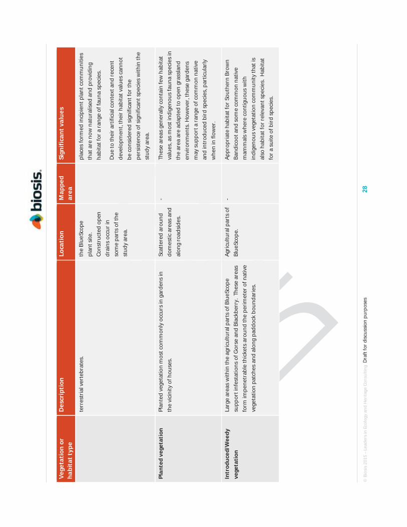
© B
iosi
s 20
15 –
Lea
ders
in E
colo
gy a
nd H
erita
ge C
onsu
lting
Dra
ft fo
r dis
cuss
ion
purp
oses
28
Vege
tati
on o
r ha
bita
t typ
e D
escr
ipti
on
Loca
tion
M
appe
d ar
ea
Sign
ifica
nt v
alue
s
terr
estr
ial v
erte
brat
es.
the
Blue
Scop
e pl
ant s
ite.
Cons
truc
ted
open
dr
ains
occ
ur in
so
me
part
s of
the
stud
y ar
ea.
plac
es fo
rmed
inci
pien
t pla
nt c
omm
uniti
es
that
are
now
nat
ural
ised
and
pro
vidi
ng
habi
tat f
or a
rang
e of
faun
a sp
ecie
s.
Due
to th
eir a
rtifi
cial
con
text
and
rece
nt
deve
lopm
ent,
thei
r hab
itat v
alue
s ca
nnot
be
con
side
red
sign
ifica
nt fo
r the
pe
rsis
tenc
e of
sig
nific
ant s
peci
es w
ithin
the
stud
y ar
ea.
Plan
ted
vege
tati
on
Plan
ted
vege
tatio
n m
ost c
omm
only
occ
urs
in g
arde
ns in
th
e vi
cini
ty o
f hou
ses.
Sc
atte
red
arou
nd
dom
estic
are
as a
nd
alon
g ro
adsi
des.
- Th
ese
area
s ge
nera
lly c
onta
in fe
w h
abita
t va
lues
, as
mos
t ind
igen
ous
faun
a sp
ecie
s in
th
e ar
ea a
re a
dapt
ed to
ope
n gr
assl
and
envi
ronm
ents
. How
ever
, the
se g
arde
ns
may
sup
port
a ra
nge
of c
omm
on n
ativ
e an
d in
trod
uced
bird
spe
cies
, par
ticul
arly
w
hen
in fl
ower
.
Intr
oduc
ed/W
eedy
ve
geta
tion
La
rge
area
s w
ithin
the
agric
ultu
ral p
arts
of B
lueS
cope
su
ppor
t inf
esta
tions
of G
orse
and
Bla
ckbe
rry.
The
se a
reas
fo
rm im
pene
trab
le th
icke
ts a
roun
d th
e pe
rimet
er o
f nat
ive
vege
tatio
n pa
tche
s an
d al
ong
padd
ock
boun
darie
s.
Agric
ultu
ral p
arts
of
Blue
Scop
e.
- Ap
prop
riate
hab
itat f
or S
outh
ern
Brow
n Ba
ndic
oot a
nd s
ome
com
mon
nat
ive
mam
mal
s w
here
con
tiguo
us w
ith
indi
geno
us v
eget
atio
n co
mm
unity
that
is
also
hab
itat f
or re
leva
nt s
peci
es.
Hab
itat
for a
sui
te o
f bird
spe
cies
.
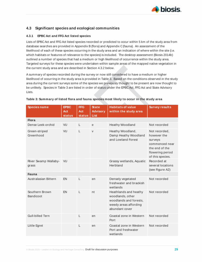
© Biosis 2015 – Leaders in Ecology and Heritage Consulting Draft for discussion purposes 29
4.3 Significant species and ecological communities
EPBC Act and FFG Act listed species 4.3.1
Lists of EPBC Act and FFG Act listed species recorded or predicted to occur within 5 km of the study area from database searches are provided in Appendix B (flora) and Appendix C (fauna). An assessment of the likelihood of each of these species occurring in the study area and an indication of where within the site (i.e. which habitats or features of relevance to the species) is included. The desktop assessment (Biosis 2014b) outlined a number of species that had a medium or high likelihood of occurrence within the study area. Targeted surveys for these species were undertaken within sample areas of the mapped native vegetation in the current study area and are described in Section 4.3.2 below.
A summary of species recorded during the survey or now still considered to have a medium or higher likelihood of occurring in the study area is provided in Table 3. Based on the conditions observed in the study area during the current surveys some of the species we previously thought to be present are now thought to be unlikely. Species in Table 3 are listed in order of status under the EPBC Act, FFG Act and State Advisory Lists.
Table 3: Summary of listed flora and fauna species most likely to occur in the study area
Species name EPBC Act status
FFG Act status
State Advisory List
Habitats of value within the study area
Survey results
Flora Dense Leek-orchid VU L e Heathy Woodland Not recorded
Green-striped Greenhood
VU L v Heathy Woodland, Damp Heathy Woodland and Lowland Forest
Not recorded, however the surveys commenced near the end of the flowering period of this species.
River Swamp Wallaby-grass
VU Grassy wetlands, Aquatic Herbland
Recorded at several locations (see Figure A2)
Fauna Australasian Bittern EN L en Densely vegetated
freshwater and brackish wetlands
Not recorded
Southern Brown Bandicoot
EN L nt Heathlands and heathy woodlands, other woodlands and forests, weedy areas affording abundant cover
Not recorded
Gull-billed Tern L en Coastal zone in Western Port
Not recorded
Little Egret L en Coastal zone in Western Port and freshwater wetlands
Not recorded
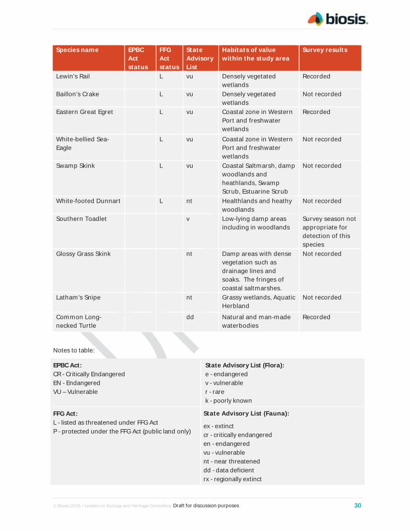
© Biosis 2015 – Leaders in Ecology and Heritage Consulting Draft for discussion purposes 30
Species name EPBC Act status
FFG Act status
State Advisory List
Habitats of value within the study area
Survey results
Lewin's Rail L vu Densely vegetated wetlands
Recorded
Baillon's Crake L vu Densely vegetated wetlands
Not recorded
Eastern Great Egret L vu Coastal zone in Western Port and freshwater wetlands
Recorded
White-bellied Sea-Eagle
L vu Coastal zone in Western Port and freshwater wetlands
Not recorded
Swamp Skink L vu Coastal Saltmarsh, damp woodlands and heathlands, Swamp Scrub, Estuarine Scrub
Not recorded
White-footed Dunnart L nt Healthlands and heathy woodlands
Not recorded
Southern Toadlet v Low-lying damp areas including in woodlands
Survey season not appropriate for detection of this species
Glossy Grass Skink nt Damp areas with dense vegetation such as drainage lines and soaks. The fringes of coastal saltmarshes.
Not recorded
Latham's Snipe nt Grassy wetlands, Aquatic Herbland
Not recorded
Common Long-necked Turtle
dd Natural and man-made waterbodies
Recorded
Notes to table:
EPBC Act: CR - Critically Endangered EN - Endangered VU – Vulnerable
State Advisory List (Flora): e - endangered v - vulnerable r - rare k - poorly known
FFG Act: L - listed as threatened under FFG Act P - protected under the FFG Act (public land only)
State Advisory List (Fauna):
ex - extinct cr - critically endangered en - endangered vu - vulnerable nt - near threatened dd - data deficient rx - regionally extinct

© Biosis 2015 – Leaders in Ecology and Heritage Consulting Draft for discussion purposes 31
Targeted survey results 4.3.2
The following provides a brief outline of species that were the focus of targeted surveys in the current survey. For each species the status code under the EPBC Act, FFG Act or the State Advisory List is provided in brackets.
Flora
Dense Leek-orchid (VU, e) was not recorded during the current survey. The species typically occupies heathy vegetation. It is strongly dependant on an appropriate fire regime to stimulate growth of above ground parts. It typically flowers prolifically in spring following fire and then to a lesser extent in a small number of successive seasons. Given the absence of fire for several years from the heathy vegetation surveyed, it is not unexpected that this species was not detected. The vegetation can be regarded as providing optimal habitat for this species, and while this species was not recorded during the targeted surveys, the absence of individuals during the survey does not preclude its presence in the study area. The nearest records of this species are from Crib Point where several plants have been recorded. Following targeted surveys in areas of most suitable habitat, we consider there to be medium likelihood that Dense Leek-orchid inhabits part of the study area.
Green-striped Greenhood (VU, L, v) was not recorded during the current survey. The species occupies a range of mostly forest and woodland vegetation types. The targeted surveys commenced towards the end of the flowering seasons for this species. Areas of Damp Heathy Woodland and some other vegetation can be regarded as suitable habitat. The nearest records are attributed to French Island although they have poor spatial accuracy. The fruiting material of a number of plants identified in the broader species group (Pterostylis longifolia) was observed in parts of the Heathy Woodland in BlueScope. The material was insufficient for an accurate determination of the species. We consider it possible that Green-striped Greenhood inhabits parts of the study area and survey is required at the appropriate time of year to determine this.
River Swamp Wallaby-grass (VU) was recorded in a number of wetland areas within BlueScope including farm dams, open areas of Swamp Scrub and larger patches of Wetland Formation. This species was recorded by Biosis during surveys in BlueScope in 2014, but has otherwise been seldom recorded on the Mornington Peninsula.
Purple Eyebright (EN, L, e) was not recorded during the current survey. The nearest record of this species is from approximately 10 km to the west where it was recorded in 1986. The majority of records for this species on the peninsula are from Greens Bush and Arthurs Seat. There are several areas of heathy and grassy vegetation within the study area where this species could be expected to occur. However, it is more readily detected following fire or other disturbance resulting in open, sun-lit vegetation (Murphy and Downe 2006). Most areas of native vegetation within the study area have not been subject to such disturbance for some time. The resulting closed structure of the vegetation prevents the detectability of this species. Following targeted surveys in areas of most suitable habitat, we consider it unlikelythat Purple Eyebright inhabits the study area.
Clover Glycine (VU, L, v) was not recorded during the current survey. It typically occupies grassy vegetation including grassland, grassy woodland and grassy forest (DoE 2014). Areas of Grassy Woodland within the study area are the most likely areas where this species would occur. In the absence of flowers it is easily overlooked due to its size and as it tends to grow amongst grass tussocks and other herbaceous plants. The closest record of this species (2009) occurs on the northwest corner of French Island. Following targeted surveys in areas of most suitable habitat, we consider it unlikely that Clover Glycine inhabits the study area.
Matted Flax-lily (EN, L, e) was not recorded during the current survey. The species typically occupies grassy woodland vegetation. Plants can be difficult to detect amongst other graminoids and when

© Biosis 2015 – Leaders in Ecology and Heritage Consulting Draft for discussion purposes 32
not flowering. Survey was undertaken during suitable conditions and at the appropriate time of year. The nearest records of this species are from VicTrack rail land in Clyde to the north of the study area, where they occur in Grassy Woodland. There are no historical records within the Hastings or Tyabb areas. Following targeted surveys in areas of most suitable habitat, we consider there to be low likelihood that Matted Flax-lily inhabits part of the study area.
Swamp Everlasting (VU, L, v) was not recorded during the current survey. The species typically occupies grassy wetland areas, which are present within the study area. It is a relatively large herb with persistent yellow bracts at the base of its flower-heads. It is conspicuous where present and unlikely to be overlooked, particularly when flowering. The nearest records of this species are from VicTrack rail land in Clyde to the north of the study area. There are no historical records within the Hastings or Tyabb areas. Following targeted surveys in areas of most suitable habitat, we consider it unlikely that Swamp Everlasting inhabits the study area.
Swamp Fireweed (VU, v) was not recorded during the current survey. The species typically occupies wetland vegetation. It is a relatively large forb which is usually conspicuous where present, when wetlands are sufficiently watered. The nearest records of this species are from VicTrack rail land in Clyde to the north of the study area. There are no historical records within the Hastings or Tyabb areas. Following targeted surveys in areas of most suitable habitat, we consider it unlikely that Swamp Fireweed inhabits the study area.
Purple Diuris (L, v) was not recorded during the current survey. The species typically occupies Grassy Woodland and the study area provides suitable habitat for this species. When flowering it has large conspicuous purple flowers that are unlikely to be overlooked during survey. The nearest record of this species is at Crib Point. It may be found under a suitable disturbance regime. In particular the absence of fire in recent years may be contributing to it not being detected within the study area. Other records occur in the west of the Mornington Peninsula around Mt Martha and further to the north at Langwarrin. Following targeted surveys in areas of most suitable habitat, we consider it unlikely that Purple Diuris inhabits part of the study area.
Fauna
Southern Brown Bandicoot (EN, L, nt) was not detected with certainty during the present investigation. Camera surveys were the primary mechanism used to survey for this species. Active observation for bandicoot diggings was also undertaken. A possible observation of a single Southern Brown Bandicoot was made during active searching involving turning of metal debris from an old car close to the location of camera 17 (see Map A4a), although the animal was not captured and its identity could not be verified. All EVCs throughout the study area appear to be suitable for the species and it has been recorded from the local area near Yaringa in recent years. Following targeted surveys in areas of suitable habitat, we consider there is still a high likelihood that Southern Brown Bandicoots inhabit parts of the study area.
Growling Grass Frog (VU, L, en) was not detected during the present investigation, although survey conditions were ideal and a variety of other frog species was recorded. Habitat was evaluated at 18 wetlands. All were farm dams and no natural freshwater wetlands suitable for the species exist within the study area. Ten wetlands were considered to offer potential habitat for Growling Grass Frog and were subject to nocturnal surveys entailing listening for characteristic calls of the species and the use of call playback and spotlight investigations. There are two old records of the species that appear to be from, or close to, the north of the study area, but few previous records from the local area generally. Following targeted surveys in areas of suitable habitat, we consider there is a low likelihood that Growling Grass Frogs inhabit the study area.

© Biosis 2015 – Leaders in Ecology and Heritage Consulting Draft for discussion purposes 33
New Holland Mouse (VU, L, vu) was not detected during the present investigation. Elliott trapping was used to survey for New Holland Mice. It was recorded during the 1970s and early 1980s from heathy vegetation communities near Hastings, apparently including from the study area. Seebeck & Menkhorst (2000) considered that it had become extinct on the Mornington Peninsula within the preceding 15 years and it has been documented to have become locally extinct at a number of other Victorian locations. Vegetation communities within the study area are appropriate but appear to be too long unburnt to be suitable for the species. Following targeted surveys in areas of suitable habitat, we consider there is a low likelihood that the New Holland Mouse inhabits the study area.
Swamp Skink (L, vu) and Glossy Grass Skink (nt) were not detected during the present investigation. Elliott trapping and active searching were used to survey for these skinks. There are multiple records of both species from the Hastings area and damp portions of EVCs throughout the study area, including saltmarsh communities, are suitable for these species. Following targeted surveys in areas of suitable habitat, we consider there is a high likelihood that both species inhabit the study area.
Lace Monitor (vu) was not detected during the present investigation. Active searching in woodland EVCs was the primary survey technique for this species. There are very few records of the species from Mornington Peninsula or the former Koo-wee-rup Swamp catchment of Western Port. Whilst woodland communities within the study area appear suitable for Lace Monitors, the species may be naturally absent from the local area or now exist there at a very low density. Following surveys in areas of suitable habitat, we consider there is a low likelihood that Lace Monitors inhabit the study area.
White-footed Dunnart (L, nt) was not detected during the present investigation. Camera surveys and Elliott trapping were used to survey for White-footed Dunnarts. All EVCs throughout the study area appear to be suitable, however it is possible that the long-unburnt advanced successional stage of the various vegetation communities does not meet the habitat requirements of the species. A population has been documented from the Somers, Crib Point and Stony Point area south of Hastings. The lack of previous records from the study area and its immediate vicinity may reflect a lack of survey effort. Following targeted surveys in areas of suitable habitat, we consider there is a medium likelihood that the White-footed Dunnart inhabits parts of the study area.
Latham's Snipe (nt) was not detected during the present investigation however, Latham's Snipe are highly mobile and the area contains suitable habitat. Observations were made at multiple areas of low-lying pasture and in suitable vegetation around the margins of artificial wetlands. Following targeted surveys in areas of suitable habitat, we consider there is a high likelihood that this migratory species will occur in portions of the study area on occasions.
EPBC Act listed ecological communities 4.3.3
The study area contains two ecological communities listed under the EBPC Act: Subtropical and Temperate Coastal Saltmarsh, and Seasonal Herbaceous Wetland (Freshwater) of the Temperate Lowland Plains.
There are 43.4 ha of Subtropical and Temperate Coastal Saltmarsh (Figure A2 and Appendix D). This community is listed as vulnerable under the EPBC Act. The Coastal Saltmarsh ecological community corresponds with two EVCs that are limited to the coastal bioregions in Victoria (DSEWPaC 2013a):
EVC 9 Coastal Saltmarsh aggregate, and
EVC 10 Estuarine Wetland.
EVC 9 is recognised to be an aggregate mapping unit that comprises a variety of shrubby to herbaceous to grassy/sedge vegetation.

© Biosis 2015 – Leaders in Ecology and Heritage Consulting Draft for discussion purposes 34
The listed community within the study area is represented by a large contiguous patch around the tidal zone of Western Port's shoreline. There are few weed species in Victoria that succeed in saltmarsh vegetation and the examples within the study area are largely free of weeds. Due to their condition and size, areas of the EVCs Coastal Saltmarsh and Estuarine Wetland mapped in the study area have been used to determine the boundaries of the EPBC Act listed community Subtropical and Temperate Coastal Saltmarsh.
There are 3 ha of Seasonal Herbaceous Wetland (Freshwater) of the Temperate Lowland Plains (hereafter referred to as Seasonal Herbaceous Wetlands) in the study area located south of Denham Road within the BlueScope property (Figure A2). This community is listed as critically endangered under the EPBC Act. The ecological community corresponds with the EVC 125 Plains Grassy Wetland, parts of EVC 74 Wetland Formation and EVC 653 Aquatic Herbland.
Seasonal Herbaceous Wetlands are temporary freshwater wetlands that are inundated on a seasonal basis, typically filling after winter-spring rains, and then drying out. The vegetation is generally treeless and dominated by a herbaceous ground layer, often with a considerable graminoid component and with forbs present. The herbaceous species present are characteristic of wetter locations and are typically absent or uncommon in any adjoining dryland grasslands and woodlands (DSEWPac 2012).
Modifications to other types of wetland may result in the ecological community being present where it was formerly absent. These modified wetland sites are included as part of the national ecological community, if they remain a functional natural wetland and conform to the description of the ecological community.
The definition of the ecological community excludes the mapped EVC 135 Sedge Wetland.
FFG Act listed community 4.3.4
The areas of Seasonal Herbaceous Wetlands that occur within the study area would also meet the definition of the FFG Act listed community Herb-rich Plains Grassy Wetland (West Gippsland). This community typically occurs in shallow seasonal wetlands that fill in winter and spring and are dry by summer. Some may retain water for longer periods, but typically only have surface water for up to six months. The community contains a rich plant association of grasses, sedges and aquatic herbs.
This community is characterized by a strong zonation pattern from emergent sedges, grasses and amphibious herbs in the fringing/littoral zone, through to deeper water dominated by submergent species together with a few sedges. Within the study area species typical of the fringing zone, and subject to shallow inundation, include Common Tussock-grass (Poa labillardierei) and Common Spike-sedge (Eleocharis acuta). This zone also supports a suite of other species including Joint-leaf Rush (Juncus holoschoenus), Running Marsh-flower (Villarsia reniformis), Prickfoot (Eryngium vesiculosum), Floating Club-sedge (Isolepis fluitans), Small Loosestrife (Lythrum hyssopifolia), Poison Lobelia (Lobelia pratoides) and Small Spike-sedge (Eleocharis pusilla). The fringing zone may include Swamp Daisy (Allitia cardiocarpa). The central zone, when inundated, is dominated by Common Spike Sedge (Eleocharis acuta) in association with Australian Sweet-grass (Glyceria australis) and/or swamp wallaby grasses (Amphibromus nervosus and A. fluitans). Other plants that may be abundant in this zone include Water Purslane (Neopaxia australasica), Running Marsh-flower, Soft Twig-sedge (Baumea arthrophylla), pondweeds Potamogeton spp., Water Ribbons (Triglochin procerum), Buttercup (Ranunculus spp.) and Water-milfoil (Myriophyllum spp).
Shrubs, where present, tend to be sparse and only on the fringe of the community. These may include Blackwood (Acacia melanoxylon), Swamp Paperbark (Melaleuca ericifolia) and Prickly Tea-tree (Leptospermum continentale).

© Biosis 2015 – Leaders in Ecology and Heritage Consulting Draft for discussion purposes 35
4.4 Habitat hectares
The extent of native vegetation patches and the number of scattered trees were mapped within the study area (Figure A2) and the condition was assessed using standard methods provided by DSE (2004). The condition of native vegetation was assessed using the DSE Vegetation Quality Assessment Sheet (DSE 2004) and pre-determined EVC benchmarks.
Areas of uniform quality for each EVC within the patches are termed ‘habitat zones’ and are assessed separately. The condition score of the habitat zone is multiplied by the extent of the zone to give a value in Habitat hectares.
A total of 22 habitat zones were identified during surveys with a total of 258.7 habitat hectares recorded. The results of the condition assessment are provided in Table 4, with the number of habitat hectares in each habitat zone. The habitat zone identification numbers for each patch of vegetation are illustrated in Figure A2.

© B
iosi
s 20
15 –
Lea
ders
in E
colo
gy a
nd H
erita
ge C
onsu
lting
Dra
ft fo
r dis
cuss
ion
purp
oses
36
Tabl
e 4:
Hab
itat
hec
tare
s of
nat
ive
vege
tati
on w
ithi
n th
e st
udy
area
EVC
#: N
ame
EVC
3: D
amp
Sand
s H
erb-
rich
Woo
dlan
d
EVC
9:
Coas
tal
Saltm
arsh
EVC
10:
Estu
arin
e W
etla
nd
EVC
48: H
eath
y W
oodl
and
EVC
53: S
wam
p Sc
rub
EVC
74:
Wet
land
Fo
rmat
ion
/ EVC
136
: Se
dge
Wet
land
EVC
83:
Swam
py
Ripa
rian
Woo
dlan
d
EVC
125:
Pl
ains
G
rass
y W
etla
nd
EVC
140:
M
angr
ove
Shru
blan
d
EVC
175:
G
rass
y W
oodl
and
EVC
653:
Aq
uatic
H
erbl
and
EVC
710:
D
amp
Hea
thla
nd
EVC
793:
Dam
p H
eath
y W
oodl
and
EVC
953:
Es
tuar
ine
Scru
b
EVC
973:
Sw
ampy
W
oodl
and
Tota
ls
Hab
itat
Zon
e ID
# (F
igur
e A
2)
1 2
7 16
18
5
11
12
15
17
19
13
21
6 10
22
14
3
4 9
8 20
Max
. sc
ore
Scor
e Sc
ore
Scor
e Sc
ore
Scor
e Sc
ore
Scor
e Sc
ore
Scor
e Sc
ore
Scor
e Sc
ore
Scor
e Sc
ore
Scor
e Sc
ore
Scor
e Sc
ore
Scor
e Sc
ore
Scor
e Sc
ore
Site
Co
ndit
ion
Larg
e O
ld T
rees
10
10
10
10
-
- 10
0
- -
- 4
- -
10
3 -
- 10
10
-
4 -
Cano
py C
over
5
5 5
3 -
- 5
5 3
3 -
3 -
- 3
3 -
- 5
5 3
3 -
Lack
of W
eeds
15
2
11
11
11
11
15
7 11
11
7
11
11
5 15
13
7
11
11
11
13
11
7
Und
erst
orey
25
20
20
15
25
20
20
20
15
20
20
15
20
25
20
15
15
20
25
15
25
15
15
Recr
uitm
ent
10
10
10
10
6 6
10
10
10
10
6 5
6 10
10
6
6 10
10
10
6
10
6
Org
anic
Mat
ter
5 5
5 5
3 5
5 3
5 5
5 5
5 5
5 5
5 3
5 5
3 4
5
Logs
5
3 5
5 -
- 5
4 -
- -
3 -
- 5
4 -
- 5
5 5
5 -
Tota
l Site
Sco
re
55
66
59
45
42
70
49
44
49
45
46
42
45
68
49
33
44
71
61
55
52
33
EVC
Stan
dard
iser
(x 7
5/55
) 1
1 1
1.37
1.
37
1 1
1.25
1.
25
1.37
1
1.37
1.
37
1 1
1.37
1.
36
1 1
1.16
1
1.37
Adj
uste
d Si
te S
core
55
66
59
62
58
70
49
55
61
62
46
58
62
68
49
45
60
71
61
64
52
45
Land
scap
e Va
lue
Patc
h Si
ze
10
8 8
8 8
8 8
8 8
4 8
8 1
8 1
8 4
8 8
8 8
8 4
Nei
ghbo
urho
od
10
3 5
5 6
5 3
5 5
4 5
5 8
5 1
5 4
5 5
5 5
5 4
Dis
tanc
e to
Cor
e 5
4 4
4 4
4 5
4 4
4 4
4 4
4 5
4 4
4 4
4 4
4 4
Tota
l Lan
dsca
pe S
core
15
17
17
18
17
16
17
17
12
17
17
13
17
7
17
12
17
17
17
17
17
12
HA
BITA
T SC
ORE
10
0 70
83
76
80
76
86
66
72
73
76
63
71
79
75
66
57
77
88
78
81
69
57
Hab
itat
poi
nts
= #/
100
1 0.
7 0.
83
0.76
0.
8 0.
76
0.86
0.
66
0.72
0.
73
0.76
0.
63
0.71
0.
79
0.75
0.
66
0.57
0.
77
0.88
0.
78
0.81
0.
69
0.57
Hab
itat
Zon
e ar
ea (h
a)
6.6
52.4
3.
6 39
.3
4.1
14
21.8
8.
8 0.
2 10
.4
1.8
1.1
33.3
19
.9
13.4
0.
4 9.
1 27
.7
24.2
34
.3
2.9
0.7
330
Hab
itat
hec
tare
s (H
ha)
4.6
43.5
2.
7 31
.4
3.1
12
14.4
6.
3 0.
2 7.
9 1.
1 0.
8 26
.3
14.9
8.
8 0.
2 7
24.4
18
.9
27.8
2
0.4
258.
7

© Biosis 2015 – Leaders in Ecology and Heritage Consulting Draft for discussion purposes 37
4.5 Other ecological values
Western Port Ramsar wetland 4.5.1
In 1982, a large portion of Western Port was designated as a wetland of international importance under the Convention on Wetlands of International Importance especially as Waterfowl Habitat (Ramsar Convention). The site consists of large shallow intertidal areas and a narrow strip of adjacent coastal land within parts of Western Port.
The Ramsar wetland is recognised for its diversity of native flora and fauna, particularly for its ability to support diverse assemblages of waterbirds and wetland vegetation, including seagrass, saltmarsh and mangroves. Australia is obliged to manage Ramsar wetlands so as to maintain their ecological character, remain informed of any changes to their character, and notify the Ramsar Secretariat of any changes at the earliest opportunity.
The saltmarsh and mangrove communities of the study area and some adjacent coastal areas are located within the boundary of the Western Port Ramsar wetland (Figure A2) and adjacent to the site. Therefore assessment and efforts to minimise adverse impacts of the Project on the character of the Ramsar wetland would be required.
Locally or regionally significant flora species 4.5.2
A small number of species that were recorded during this assessment, whilst not considered state or nationally threatened, are notable for being uncommon locally or within the Port Philip and Western Port region, or for having biogeographic interest:
Allocasuarina paradoxa Green Sheoke is a Victorian and South Australian species with disjunct sub-arid and coastal humid populations. Damp Heathland within BlueScope provides suitable habitat for this species. While it is well reserved to the north of Mornington Peninsula and on French Island, it is poorly represented on the peninsula.
Cassinia trinerva Three-veined Cassinia is a species of ranges in the southern Great Dividing Range, Strzelecki Ranges and East Gippsland. It was recorded in a drainage line within the study area and extends the western most limit of its distribution within Victoria.
Entolasia stricta Upright Panic is a sparsely distributed and largely coastal species. It is represented in the Western Port area by only a small number of records, mainly on the eastern side of the bay. Where recorded it forms spreading patches in peaty soils.
Eryngium vesiculosum Prickfoot is a herbaceous species which typically grows in grassy wet areas on heavy clay soils. These habitats are more common around Melbourne to the north of the study area an on the coastal and basalt plains of western Victoria. There are very few records of this species on the Mornington Peninsula and Western Port area where its habitat is restricted to small isolated occurrences.
Leptoceras menziesii Hare Orchid is represented by a small number of records on the Mornington Peninsula and Western Port, of which some are more than 20 years old. It was recorded within BlueScope land during the current assessment where a population of many individuals was found. This species typically flowers prolifically following fire.
Orthoceras strictum Horned Orchid is sparsely distribution on the Mornington Peninsula and Westerport Bay areas. There are 10 existing records of which the most recent is from 2003 on French Island; all other records are more than 20 years old. The record taken during the current assessment

© Biosis 2015 – Leaders in Ecology and Heritage Consulting Draft for discussion purposes 38
provides important information about a previously unreported population on the peninsula. It was recorded on disturbed soil and adjacent to saltmarsh vegetation.
Pultenaea daphnoides Large-leaf Bush-pea was recorded on a levee to the east of the BlueScope plant site. This species is relatively common on French Island and Arthurs Seat, although otherwise uncommon on the Mornington Peninsula.
Thelymitra juncifolia Rush-leaf Sun-orchid was recorded within BlueScope land. There are a small number of other records of this orchid on the Mornington Peninsula and several on French Island. The records from this assessment add to existing records at Crib Point for the broader Hastings area.
Xanthosia huegelii Heath Xanthosia is distributed along the southern coast of the mainland. It is represented by only two records in the Port Phillip and Western Port areas.
The abovementioned species are worthy of planning consideration as the study area provides regionally important and high quality habitat for their ongoing persistence. These species whilst not listed under the EPBC Act or the FFG Act may need to be considered for a planning permit.
NaturePrint and Strategic Biodiversity Score 4.5.3
Within this flora and fauna assessment the values of the study area are assessed for their biodiversity values against standard criteria. These include the presence of listed species or communities that have statutory planning weight. Relevant State and Commonwealth government authorities also use other criteria to assess biodiversity value. A statewide assessment of biodiversity values, threatening processes and ecosystem function has been modelled and mapped for all parts of Victoria. The resulting product NaturePrint (http://www.depi.vic.gov.au/environment-and-wildlife/biodiversity/natureprint) considers threatened species habitat, vegetation condition and a range of other biodiversity variables to indicate the relative importance of a site in Victoria, compared to all other areas of the State. Its intent is to provide quantification of these values for strategic planning and assessment against other project values.
The majority of land within BlueScope is ranked as the second highest category of contribution to natural values in Victoria in NaturePrint. Many areas fringing the shoreline have the highest possible contribution for the state. Areas of native vegetation further inland fragmented by agricultural uses have moderate to low contribution, although most areas within the study area make some contribution to the state's biodiversity. A subset of variables from NaturePrint are used for Victoria's Strategic Biodiversity Map, which is another model explaining biodiversity importance, although more heavily weighted towards threatened species presence and habitat. The Strategic Biodiversity Score (a score between 0 and 1) requires consideration under all Victorian planning schemes where removal of native vegetation is proposed. The score from this model gives a similar view of the value of native vegetation within the study area. Within this model BlueScope and its surrounds have a score of >0.8 while more fragmented areas of the landscape have a score between 0.2 and 0.6.
NaturePrint provides a summary of the interaction of values and processes that are associated with an area of native vegetation. The terms of ecological and spatial values used in the model are complex and combine the richness of the vegetation, the size of patches, their connectivity in the landscape, their capacity to support significant species and their rarity within Victoria, amongst other things. The larger blocks of native vegetation within the study area have been modelled as significant within the State, or as having high strategic biodiversity value. Observations from the current field assessments endorse the output from these models.
The vegetation within BlueScope and other larger blocks are relatively intact examples of their constituent ecosystems. Their ranking is considered with regard to previous land use disturbance, present surrounding land use and a number of ecological considerations. Generally the vegetation types assessed have low
© Biosis 2015 – Leaders in Ecology and Heritage Consulting Draft for discussion purposes 39
fertility and, for their area, have high plant species diversity. All but the immediate coastal fringe vegetation has a regeneration cycle which is fire driven. The capacity for fire of appropriate frequency and intensity to further improve the ecological value of the native vegetation is noted in the current assessment of biodiversity values.
The intact nature of the ecological communities in the study area and the absence of large-scale adverse disturbance processes make them resilient to natural disturbance and encroachment of introduced plant and animals. It is probable that past disturbance of the broader surrounding landscape may have caused the decline or loss of some fauna species (e.g. Southern Brown Bandicoot, Brown 2010) within BlueScope. However, high densities of some other native mammals, good bird diversity and presence of a range of habitat types indicate the persistence of other important ecological processes that are not retained in surrounding agricultural areas. Restricted access into BlueScope and some other areas of the study area has resulted in these areas showing few signs of disease such as tree dieback or fungal infections that lead to broad scale impacts on vegetation.
The BlueScope property and the adjoining areas of coastal vegetation within the study area can be regarded as one of the most important sites for biodiversity in the Port Phillip and Western Port area. Despite its much smaller area, the diversity of its vegetation types is comparable with that of French Island. It provides an important western range limit of the Western Port Biosphere including examples of communities that extend across French Island to other significant blocks that fringe the Biosphere; within the inlets of KooWeeRup Swamp, Holden Proving Ground, Grantville, and Adams Creek Nature Conservation Reserve.
4.6 Implications under State and Commonwealth Legislation
EPBC Act 4.6.1
The flora and fauna assessment results show that MNES listed under the EPBC Act exist or may sometimes utilise the habitats within the study area. These include listed threatened flora and fauna species, two ecological communities, listed migratory species (DEWHA 2009c) and the Western Port wetland of international importance (Ramsar).
The Project would therefore need to be referred under the EPBC Act to the Minister for Environment for a decision on whether the Project has the potential to impact MNES, and therefore constitute a controlled action. The Authority is anticipating that the Project will be declared a controlled action, as it is being proposed within a Ramsar wetland and is likely to substantially modify an area of the wetland among other terrestrial MNES.
The EPBC Act offset policy (DSEWPaC 2013b) prescribes offsets as mitigation for residual impacts on MNES following actions to avoid or minimise impacts, and therefore offsets are likely to be required for the Project. It is recommended that calculations of likely offsets to be required to compensate for vegetation clearing as a result of the Project are made at an early stage, to ascertain whether offsets for the scale of impacts on a large area of high biodiversity values would be realistically achievable.
FFG Act 4.6.2
One FFG Act listed community, Herb-rich Plains Grassy Wetland (West Gippsland) has been identified within BlueScope in addition to listed fauna species. A permit under the FFG Act would therefore be required with respect to the Crown land parcels. A permit is generally not required for private land.
CaLP Act 4.6.3
Declared noxious weeds and established pest animals listed under the CaLP Act identified in the study area during the survey are listed in Appendices B (flora) and C (fauna). The land owner must take all reasonable

© Biosis 2015 – Leaders in Ecology and Heritage Consulting Draft for discussion purposes 40
steps to eradicate regionally prohibited weeds, prevent the growth and spread of regionally controlled weeds, and prevent the spread of and as far as possible eradicate established pest animals.
Planning and Environment Act 1987 (incl. Planning Schemes) 4.6.4
One of the Applicable Approvals relevant to biodiversity that may be sought for the Project under the MTPF Act includes a planning scheme amendment under the Planning and Environment Act 1987.
In addition, Clause 52.17 (Native Vegetation) requires a planning permit to remove, destroy or lop native vegetation including some dead native vegetation. Under Clause 66.02 a permit application to remove, destroy or lop native vegetation is required to be referred to DELWP as a recommending referral authority if any of the following apply:
the area of native vegetation to be removed is greater than 0.5 hectares
the class of application is on the high risk-based pathway
a property vegetation precinct plan applies to the site or
the native vegetation is on Crown land occupied or managed by the Responsible Authority.
This assessment has identified approximately 330 ha of native vegetation within the study area. Due to the likely scale of the Project, it is considered that a permit under the Act would be required to remove native vegetation.
State Advisory list of rare or threatened species 4.6.5
For any proposal to remove native vegetation from the study area, habitat for one or more state threatened species is likely to be impacted. If the impact to that species at state level exceeds certain thresholds a 'specific offset' would be be required in addition to 'general offsets' (refer Appendix E).
© Biosis 2015 – Leaders in Ecology and Heritage Consulting Draft for discussion purposes 41
5. Conclusion
5.1 Key biodiversity values
Key ecological values identified within the study area are as follows:
approximately 330 ha of native vegetation including large, high quality, intact patches of woodland, and coastal EVCs, scattered remant trees, and regionally significant coastal-inland ecosystem gradients
shallow intertidal habitats, mangroves, saltmarsh and adjacent coastal land which form a significant component of the internationally important Western Port Ramsar wetland
approximately 43.4 ha of the EPBC Act listed ecological community: Subtropical and Temperate Coastal Saltmarsh and approximately 3 ha of the EPBC Act listed community: Seasonal Herbaceous Wetland (Freshwater) of the Temperate Lowland Plains
a population of the EPBC Act listed flora species River Swamp Wallaby-grass (Amphibromus fluitans), twelve State Advisory List species and three FFG Act listed fauna species
potential presence of additional EPBC Act, State Advisory List and FFG Act listed species and suitable habitats for them.
The highest value areas of native vegetation are the large, high quality, intact areas of woodland and coastal saltmarsh vegetation located in the northern and eastern parts of BlueScope as well as heathy woodland in the Gordon Rolfe Reserve. The contiguous woodland and estuarine scrub vegetation within BlueScope grades into extensive saltmarsh and mangrove habitats of Western Port which also form a significant part of ecological character of the Western Port Ramsar wetland.
This occurrence of a large intact area of native vegetation is rare on the Mornington Peninsula and provides habitat to a diverse range of flora and fauna, which is otherwise absent from parts of the Peninsula. This significance is also reflected in NaturePrint which ranks the majority of land within BlueScope in the second highest category of contribution to natural values in Victoria. Many areas fringing the shoreline have the highest possible contribution for the state.
The results of the assessment of native vegetation condition indicate that patches are in relatively high condition with a total of 258 habitat hectares calculated from the study area.
Cryptic and disturbance adapted species such as some of the listed orchid species were not recorded during the current study, however, habitat within the study area is suitable for these species and their presence cannot be discounted due to a long absence of fire from the study area.
5.2 Avoidance and minimisation of biodiversity impacts
The largest patches of native vegetation and those that are contiguous with other such patches both within the study area and beyond it offer the most significant flora and fauna values. Loss or fragmentation of such areas is likely to be detrimental to the species and ecosystems they support.
As a general principle, impacts on MNES (as defined under the EPBC Act) should firstly be avoided, then minimised and this must be demonstrated through the approval process. Residual adverse impacts that cannot be avoided must be offset in accordance with the EPBC Act Environmental Offsets Policy (DSEWPaC 2013b). Biosis (2013b) provided an overview of the EPBC Act Offsets Policy as it may relate to the Project.

© Biosis 2015 – Leaders in Ecology and Heritage Consulting Draft for discussion purposes 42
Similarly, the objective of Victoria's Biodiversity Assessment Guidelines is to achieve "no net loss in the contribution made by native vegetation to Victoria's biodiversity" and requires the implementation of key strategies as follows:
avoiding the removal of native vegetation that makes a significant contribution to Victoria's biodiversity
minimising impacts to Victoria's biodiversity from the removal of native vegetation
where native vegetation is permitted to be removed, ensuring it is offset in a manner that makes a contribution to Victoria's biodiversity that is equivalent to the contribution made by the native vegetation to be removed.
5.3 Considerations for project design
The intention of this report is to document existing biodiversity values within the area assessed. At the time of preparation of this report a detailed port design is not available and an impact assessment is therefore not feasible. Nonetheless, planning for project infrastructure layout should give consideration to:
design options which avoid or minimise direct or indirect impacts on the Western Port Ramsar site including its foreshore habitats
design options that avoid or minimise removal of remnant native vegetation and scattered native trees, particularly larger areas of intact vegetation such as those within BlueScope Steel land, by locating infrastructure in previously cleared land or predominantly non-native vegetation (e.g. existing transport corridors, urban areas and non-native agricultural areas)
design options that avoid fragmentation of native vegetation patches, and avoid severance of important vegetation and habitat linkages
the potential challenges and costs associated with locating and securing sufficient offsets for biodiversity assets that cannot be protected on-site (as required to comply with relevant State and Commonwealth offset policies).
5.4 Further surveys
The surveys reported here were undertaken in a season not suitable for detection of all target species. Further surveys are recommended for detection of Southern Toadlet in autumn, Orange-bellied Parrot between April and September inclusive, and Green-striped Greenhood during August to early September.
The survey reported here is one of a number of field investigations planned to be undertaken for the project. Other investigations not yet undertaken include assessment of the biodiversity values of the balance of land within SUZ1 and the waterbirds of Western Port. These further studies may provide information that further refines understanding of aspects covered by the present report.

© Biosis 2015 – Leaders in Ecology and Heritage Consulting Draft for discussion purposes 43
References
AECOM 2013. Western Port Highway Planning Study – Ballarto Road to Hodgins Road: Desktop Flora and Fauna Assessment. Report to VicRoads. Author: White, C. AECOM, Melbourne. Job No. 60308273.
Biosis 2013a. Esso Pipeline Replacement Project –Longford to Hastings: Flora and fauna survey and impact mitigation. Report to Worley Parsons. Authors: Dell, M., Sofo, K., Byrne A. & Smales I. Biosis Pty Ltd, Melbourne. Project 16955/16956.
Biosis 2013b. Briefing paper: Legislative process for offsets related to Port of Hastings development. Report to Port of Hastings Development Authority. Authors: Westcott, V, Dell, M, Smales I and Harvey, A. Biosis Pty Ltd, Melbourne. Project no. 16681.
Biosis 2014a. Port of Hastings Development Authority: Flora and fauna assessment for the geophysical and geotechnical surveys. Report to Port of Hastings Development Authority. Authors: Mueck S. and Smales I. Biosis Pty Ltd, Melbourne. Project no. 17228.
Biosis 2014b. Port of Hastings: SUZ1 and Land Transport Corridor, Desktop Flora and Fauna Assessment. Report for AECOM and GHD Joint Venture. Authors: Dell M, Kay K and Gilmore D – Biosis; Harrow, S, Lind P. - GHD. Biosis Pty Ltd, Melbourne. Project no. 18568.
Biosis 2014c. Port of Hastings: Waterbirds Desktop Review. Report for AECOM and GHD Joint Venture. Author: Smales, I. Biosis Pty Ltd, Melbourne. Project no. 19147.
Biosis Research 2009. Flora and fauna assessment of Port of Hastings Stage One Investigation area, Victoria. Report to AECOM Pty Ltd. Authors: Venosta, M., Mueck, S. and Bloink, C. Biosis Research Pty Ltd, Melbourne. Project no. 7540 & 7930.
Biosis Research 2011. Port of Hastings Stage 1 Investigation Area: Threatened flora and fauna survey and habitat hectare assessment. Report to Port of Melbourne Corporation. Authors: Venosta, M., Mueck, S. and Bloink, C. Biosis Research Pty Ltd, Melbourne. Matter No. 11173.
Biosis Research 2012. Scoping framework for the terrestrial ecological assessment of the expansion of the Port of Hastings. Report to Major Projects Victoria. Author: Venosta, M. Biosis Research, Melbourne. Matter No. 14062.
Brown GW. 2010. National Recovery Plan for the Southern Brown Bandicoot Isoodon obesulus obesulus. Draft for Comment. Department of Sustainability and Environment, Victoria.
Boon P, Allen T, Brook J, Carr G, Frood D, Harty C, Hoye J, McMahon A, Mathews S, Rosengren N, Sinclair S, White M and Yugovic J 2011. Mangroves and coastal saltmarsh of Victoria. Distribution, condition, threats and management. Institute for Sustainability and Innovation, Victoria University, Melbourne.
Carter O. 2010. National Recovery Plan for the Matted Flax-lily Dianella amoena. Department of Sustainability and Environment, Victoria.
Carter O and Walsh N. 2011. National Recovery Plan for the Swamp Everlasting Xerochrysum palustre. Department of Sustainability and Environment, Melbourne.
Coates F, Jeanes J and Pritchard A. 2002. Recovery Plan for Twenty-five Threatened Orchids of Victoria, South Australia and New South Wales 2003 - 2007. Department of Sustainability and Environment, Melbourne.
Cogger H. 2014. Reptiles and Amphibians of Australia (7th edition). CSIRO Publishing, Collingwood.

© Biosis 2015 – Leaders in Ecology and Heritage Consulting Draft for discussion purposes 44
DELWP 2015. Biodiversity Interactive Maps. http://mapshare2.dse.vic.gov.au/MapShare2EXT/imf.jsp?site=bim. Last accessed 08/01/15.
DEPI 2012. Victorian Biodiversity Atlas ‘VBA_FAUNA25, FAUNA100 & FAUNARestricted, FLORA25, FLORA100 & FLORARestricted’ August 2012. Victorian Government Department of Sustainability & Environment, Melbourne.
DEPI 2013a. Advisory List of Threatened Vertebrate Fauna in Victoria – 2013. Victorian Government Department of Environment & Primary Industries, Melbourne.
DEPI 2013b. Permitted clearing of native vegetation - Biodiversity assessment guidelines. Victorian Government Department of Environment and Primary Industries, Melbourne (September 2013).
DEPI 2013c. Sub-Regional Species Strategy for the Growling Grass Frog. The Victorian Government Department of Environment and Primary Industries, East Melbourne.
DEPI 2013d. Advisory List of Rare or Threatened Plants in Victoria – 2005. Victorian Government Department of Sustainability & Environment, East Melbourne.
DEPI 2014. Sub-regional Species Strategy for the Southern Brown Bandicoot. Victorian Government Department of Environment and Primary Industries, Melbourne (January 2014)
DEWHA 2009a. Matters of National Environmental Significance. Significant impact guidelines 1.1. Environment Protection and Biodiversity Conservation Act 1999. Australian Government Department of the Environment, Water, Heritage & the Arts, Canberra.
DEWHA 2009b. Significant impact guidelines for the vulnerable Growling Grass Frog (Litoria raniformis). Nationally threatened species and ecological communities EPBC Act policy statement 3.14, Department of the Environment, Water, Heritage & the Arts, Australian Government, Canberra.
DEWHA 2009c. Significant impact guidelines for 36 migratory shorebird species: Migratory species. Draft EPBC Act policy statement 3.21. Australian Government Department of the Environment, Water, Heritage & the Arts, Canberra.
DEWHA 2010. Actions on, or impacting upon, Commonwealth land, and actions by Commonwealth agencies. Significant impact guidelines 1.2. Australian Government Department of the Environment, Water, Heritage and the Arts, Canberra.
DoE 2014. Glycine latrobeana in Species Profile and Threats Database, Department of the Environment, Canberra. Available from: http://www.environment.gov.au/sprat. Accessed Mon, 18 Aug 2014 12:54:43 +1000.
DSE 2003. Flora and Fauna Guarantee Action Statement No. 74: New Holland Mouse Pseudomys novaehollandiae. The Victorian Department of Sustainability and Environment, East Melbourne.
DSE (2004) Vegetation Quality Assessment Manual–Guidelines for applying the habitat hectares scoring method. Version 1.3. Victorian Government Department of Sustainability and Environment, Melbourne.
DSEWPaC 2010, Western Port Ramsar Wetland Ecological Character Description. Report for Department of Sustainability, Environment, Water, Population and Communities, Canberra.
DSEWPaC 2012. Seasonal Herbaceous Wetlands (Freshwater) of the Temperate Lowland Plains, listing advice. Threatened Species Scientific Committee, Department of Sustainability, Environment, Water, Populations and Communities, Canberra.
DSEWPaC 2013a. Subtropical and Temperate Coastal Saltmarsh, listing advice. Threatened Species Scientific Committee, Department of Sustainability, Environment, Water, Populations and Communities, Canberra.

© Biosis 2015 – Leaders in Ecology and Heritage Consulting Draft for discussion purposes 45
DSEWPaC 2013b. Environment Protection and Biodiversity Conservation Act 1999 Environmental Offsets Policy. Department of Sustainability, Environment, Water, Populations and Communities, Canberra.
Duncan, M. 2010. National Recovery Plan for the Dense Leek Orchid Prasophyllum spicatum. Department of Sustainability and Environment, Melbourne.
GHD 2013. Port of Hastings Development Authority, Port Container Expansion Project: Preliminary Ecological Assessment. Report to Port of Hastings Development Authority. Job No. 31/29838/06.
Jeanes J and Backhouse G. 2006. Wild Orchids of Victoria Australia. Aquatic Photographics, Australia.
Legg M. 2006. Flora and Fauna Survey and Management Prescriptions for Crib Point Stony Point Foreshore, Crib Point, October, 2005 to October, 2006. Report to Crib Point Stony Point Foreshore Committee of Management Inc. Author: Legg, M. Mal’s Environmental and Ecological Services.
Mungere J. 2008. Mornington Peninsula and Western Port Biosphere Reserve Foundation LTD Information Resource Database Updating Project. School of Geography and Environmental Science / Mornington Peninsula and Wester Port Biosphere Reserve Foundation Board, Melbourne.
Murphy AH and Downe J 2006. National Recovery Plan for the Purple Eyebright Euphrasia collina subspecies muelleri. Department of Sustainability and Environment, Melbourne.
MPWPBRF (Mornington Peninsula & Western Port Biosphere Reserve Foundation Ltd). 2014. Western Port Biosphere. http://www.biosphere.org.au/index.html. Accessed 4th August 2014.
Seebeck J. and Menkhorst P. 2000. Status and conservation of the rodents of Victoria. Wildlife Research 27: 357–369.
Sinclair S, Tonkinson D, Downe J, Taranto M, Kefford E and White M. 2006. Remnant Native Vegetation on the Mornington Peninsula: Mapping and Condition Assessment. Final Report. Arthur Rylah Institute for Environmental Research Heidelberg, Victoria.
Van Dyck and Strahan. 2008. The Mammals of Australia. Reed New Holland, Sydney.
Viridans 2015. Flora Information System. http://www.viridans.com/pagezero.html.
Yugovic J. 2011. Ecology of the Kooweerup Swamp and associated grasslands. Proceeding of The Royal Society of Victoria: 123(2): 172–188.

© Biosis 2015 – Leaders in Ecology and Heritage Consulting Draft for discussion purposes 46
Appendix A. Figures

CASEYCASEYCITYCITY
MORNINGTONMORNINGTONPENINSULAPENINSULA
SHIRESHIRE
GordonRolfe Bushland
Reserve
Olivers Creek
Kings
Creek
Mornington - Tyabb Rd
Jone
s Rd Park Lane
Tyab
b - T
oora
din
Rd
Barclay Cr
Frankston- Flinders
Rd
Eramosa Rd East
High St
Cem
eter
y Rd
Outlook Av
Bungower Rd
Station St
Gra
nt R
d
Bayview Rd
Queens Rd
Long Island Dr
Graydens Rd
Fran
ksto
n - F
linde
rs R
d
Salm
on S
tKing
St
Dan
deno
ng-H
astin
gsRd
Acknowledgement:VicMap Data Copyright © The State of Victoria, Department of Environment and Primary Industries 2014
Matter: 19075,Date: 25 February 2015,Checked by: KJK, SGM, Drawn by: SKM, Last edited by: jshepherdLocation:P:\19000s\19075\Mapping\19075_A1_Locality.mxd
Legend
Study Area
BluescopeSteel
Crown Land
Marine area not surveyed
Scale 1:45,000 @ A4, GDA 1994 MGA Zone 55
0 450 900 1,350 1,800
MetresBiosis Pty LtdBallarat, Brisbane, Canberra, Melbourne,
Sydney, Wangaratta & Wollongong
Figure A1: Location of the Study Area - Hastings,Victoria
Melbourne
Werribee
Dandenong
Frankston
RingwoodLilydale
Pakenham
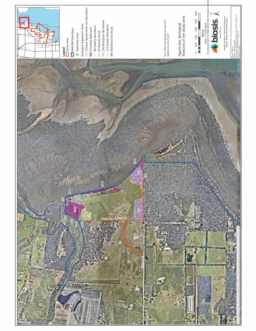
North Rd
Bembridge
Rd
Bung
ower
Rd
Tyabb - Tooradin Rd
HZ9
HZ1
6
HZ1
1
HZ1
6
HZ1
2HZ2
1
HZ1
6
HZ1
6
HZ1
6
HZ7
HZ7
HZ7
HZ1
1
HZ1
0H
Z16
010
020
030
040
050
0
Metres
Lege
nd Stud
y ar
ea
RAM
SAR
boun
dary
Scat
tere
d tr
ees
Ecol
ogic
al V
eget
atio
n Cl
ass
3 D
amp
Sand
s H
erb-
rich
Woo
dlan
d9
Coas
tal S
altm
arsh
48 H
eath
y W
oodl
and
53 S
wam
p Sc
rub
140
Man
grov
e Sh
rubl
and
175
Gra
ssy
Woo
dlan
d95
3 Es
tuar
ine
Scru
b
Mat
ter:
1907
5,
Dat
e: 2
7 Fe
brua
ry 2
015,
Ch
ecke
d by
: KJK
, Dra
wn
by: S
KM, L
ast e
dite
d by
: jsh
ephe
rdLo
catio
n:P:
\190
00s\
1907
5\M
appi
ng\
1907
5_A2
_EVC
s
Bios
is P
ty L
td
Balla
rat,
Bris
bane
, Can
berr
a, M
elbo
urne
, Sy
dney
, Wan
gara
tta &
Wol
long
ong
Tyab
b
Old
Tyab
b
Som
ervi
lle
Has
tings
a
c
b
e
d
Scal
e: 1
:10,
000
@ A
3
Figu
re A
2a: E
colo
gica
lFe
atur
es o
f the
stu
dy a
rea
Coor
dina
te S
yste
m: W
GS
1984
Web
Mer
cato
r Au
xilia
r
Ackn
owle
dgem
ents
: Im
ager
y: N
earM
ap 2
014,
Vic
Map
Dat
a Co
pyri
ght ©
The
Sta
te o
f Vic
tori
a, D
epar
tmen
t of E
nvir
onm
ent a
nd P
rimar
y In
dust
ries
201
4
Not
e: E
VCs
are
labe
lled
on m
ap w
ith
Hab
itat Z
one
ID ("
HZ#
")
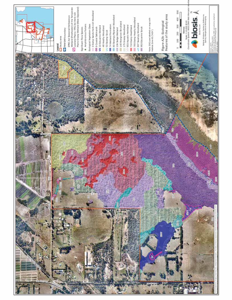
Yarin
ga R
d
One
ills
Rd
Thor
nells
Rd
Katandra Rd
Pike
s Rd
Iluka
Rd
Whitneys Rd
Mckirdys Rd
Tyabb - T
ooradin Rd
Dandenong-HastingsRd
HZ4
HZ9 H
Z2
HZ1
6
HZ2
1
HZ1
7
HZ6
HZ1
2
HZ1
7
HZ8
HZ1
HZ2
HZ3
HZ1
9
HZ1
4
HZ1
4H
Z2
HZ3
HZ6
HZ5
HZ6
HZ5
HZ5
HZ8
HZ2
1H
Z21
HZ1
8H
Z16
HZ9
HZ1
7
HZ1
6
HZ1
6
HZ1
6
HZ1
7
HZ1
2
HZ1
9
HZ1
2
HZ1
4
HZ1
4H
Z14
HZ1
HZ1
4H
Z3
HZ2
0H
Z14
HZ1
4H
Z12
HZ2
2
HZ2
2
HZ3
17
17
17
22
22
010
020
030
040
050
0
Metres
Legend Stud
y ar
ea
RAM
SAR
boun
dary
EPB
C Ac
t Sea
sona
l Her
bace
ous
Wet
land
(Fre
shw
ater
) of t
he T
empe
rate
Lo
wla
nd P
lain
s / F
FG A
ct H
erb-
rich
Pl
ains
Gra
ssy
Wet
land
(Wes
t Gip
psla
nd)
Sign
ifica
nt F
lora
Spe
cies
Amph
ibro
mus
flui
tans
Ecol
ogic
al V
eget
atio
n Cl
ass
3 D
amp
Sand
s H
erb-
rich
Woo
dlan
d9
Coas
tal S
altm
arsh
10 E
stua
rine
Wet
land
48 H
eath
y W
oodl
and
53 S
wam
p Sc
rub
74 W
etla
nd F
orm
atio
n83
Sw
ampy
Rip
aria
n W
oodl
and
136
Sedg
e W
etla
nd14
0 M
angr
ove
Shru
blan
d17
5 G
rass
y W
oodl
and
653
Aqua
tic H
erbl
and
710
Dam
p H
eath
land
793
Dam
p H
eath
y W
oodl
and
937
Swam
py W
oodl
and
953
Estu
arin
e Sc
rub
Mat
ter:
1907
5,
Dat
e: 2
7 Fe
brua
ry 2
015,
Ch
ecke
d by
: KJK
, Dra
wn
by: S
KM, L
ast e
dite
d by
: jsh
ephe
rdLo
catio
n:P:
\190
00s\
1907
5\M
appi
ng\
1907
5_A2
_EVC
s
Bios
is P
ty L
td
Balla
rat,
Bris
bane
, Can
berr
a, M
elbo
urne
, Sy
dney
, Wan
gara
tta &
Wol
long
ong
Tyab
b
Old
Tyab
b
Som
ervi
lle
Has
tings
a
c
b
e
d
Scal
e: 1
:10,
000
@ A
3
Figu
re A
2b: E
colo
gica
lFe
atur
es o
f the
stu
dy a
rea
Coor
dina
te S
yste
m: W
GS
1984
Web
Mer
cato
r Au
xilia
r
Ackn
owle
dgem
ents
: Im
ager
y: N
earM
ap 2
014,
Vic
Map
Dat
a Co
pyri
ght ©
The
Sta
te o
f Vic
tori
a, D
epar
tmen
t of E
nvir
onm
ent a
nd P
rimar
y In
dust
ries
201
4
Not
e: E
VCs
are
labe
lled
on m
ap w
ith
Hab
itat Z
one
ID ("
HZ#
")

Old
Tyab
b
Robe
rtso
n St
Burke St
Bayv
iew
Rd
Callanan St
Kipp
es
Lane
Railway
Rd
Will
s St
Had
dock
St
Lyall St
Jeremiahs Rd
Marine Pde
Frankston - Flinders Rd
Morrah St
Stuart Rd
Kanowna St
Den
ham
Rd
Olivers
Creek
Oliv
ers
Cree
k
Marine Pde
Bayv
iew
Rd
Barc
lay
Cr
Frankston - Flinders Rd
Gra
yden
s Rd
Frankston - Flinders Rd
Danden
ong-Has
tings
Rd
Frankston - Flinders Rd
HZ1
2
HZ1
1
HZ1
1H
Z10
HZ1
0
HZ1
HZ1
HZ1
2
HZ1
2
HZ8
010
020
030
040
050
0
Metres
Lege
nd Stud
y ar
ea
RAM
SAR
boun
dary
Scat
tere
d tr
ees
Ecol
ogic
al V
eget
atio
n Cl
ass
3 D
amp
Sand
s H
erb-
rich
Woo
dlan
d48
Hea
thy
Woo
dlan
d53
Sw
amp
Scru
b17
5 G
rass
y W
oodl
and
937
Swam
py W
oodl
and
Mat
ter:
1907
5,
Dat
e: 2
7 Fe
brua
ry 2
015,
Ch
ecke
d by
: KJK
, Dra
wn
by: S
KM, L
ast e
dite
d by
: jsh
ephe
rdLo
catio
n:P:
\190
00s\
1907
5\M
appi
ng\
1907
5_A2
_EVC
s
Bios
is P
ty L
td
Balla
rat,
Bris
bane
, Can
berr
a, M
elbo
urne
, Sy
dney
, Wan
gara
tta &
Wol
long
ong
Tyab
b
Old
Tyab
b
Som
ervi
lle
Has
tings
a
c
b
e
d
Scal
e: 1
:10,
000
@ A
3
Figu
re A
2c: E
colo
gica
lFe
atur
es o
f the
stu
dy a
rea
Coor
dina
te S
yste
m: W
GS
1984
Web
Mer
cato
r Au
xilia
r
Ackn
owle
dgem
ents
: Im
ager
y: N
earM
ap 2
014,
Vic
Map
Dat
a Co
pyri
ght ©
The
Sta
te o
f Vic
tori
a, D
epar
tmen
t of E
nvir
onm
ent a
nd P
rimar
y In
dust
ries
201
4
Not
e: E
VCs
are
labe
lled
on m
ap w
ith
Hab
itat Z
one
ID ("
HZ#
")
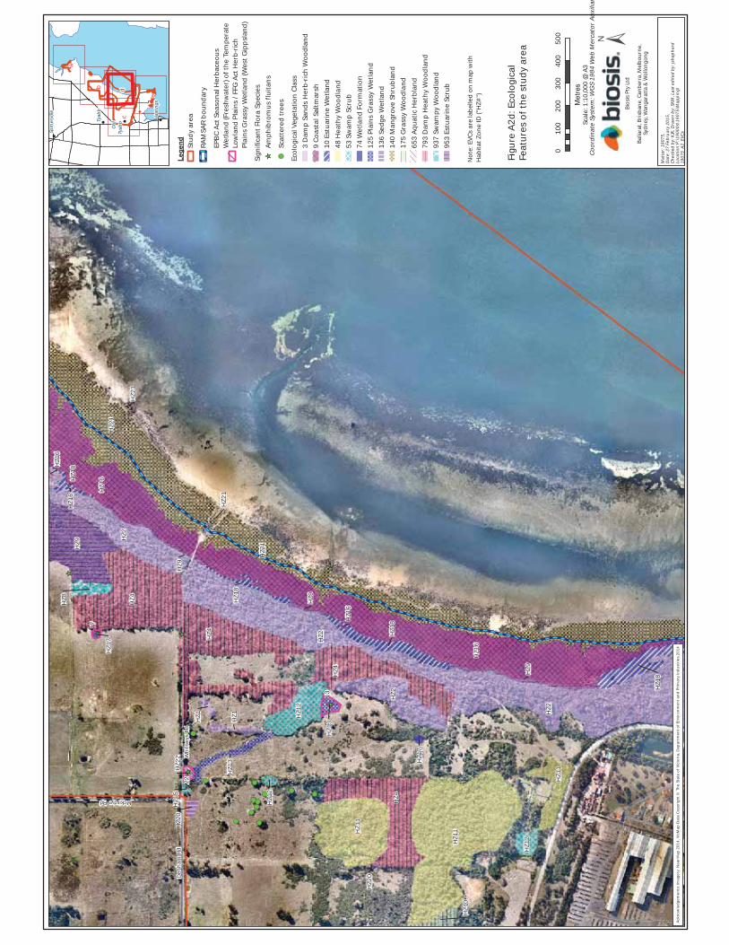
Whi
tney
s Rd
Den
ham
Rd
Mckirdys Rd
HZ2
HZ2
HZ1
6
HZ2
1
HZ1
1
HZ1
2
HZ1
1
HZ2
HZ4
HZ4
HZ1
1
HZ1
2
HZ4
HZ2
1
HZ4
HZ2
HZ1
6
HZ9
HZ1
8HZ9
HZ1
0
HZ1
8
HZ1
7
HZ2
0
HZ1
3
HZ1
6
HZ9HZ1
8
HZ1
2
HZ1
3H
Z1
HZ2
1
HZ2
0
HZ1
HZ2
2H
Z15
HZ9
HZ2
1
HZ8
HZ1
7
HZ1
8H
Z16
HZ1
6
13
22
17
010
020
030
040
050
0
Metres
Legend Stud
y ar
ea
RAM
SAR
boun
dary
EPB
C Ac
t Sea
sona
l Her
bace
ous
Wet
land
(Fre
shw
ater
) of t
he T
empe
rate
Lo
wla
nd P
lain
s / F
FG A
ct H
erb-
rich
Pl
ains
Gra
ssy
Wet
land
(Wes
t Gip
psla
nd)
Sign
ifica
nt F
lora
Spe
cies
Amph
ibro
mus
flui
tans
Scat
tere
d tr
ees
Ecol
ogic
al V
eget
atio
n Cl
ass
3 D
amp
Sand
s H
erb-
rich
Woo
dlan
d9
Coas
tal S
altm
arsh
10 E
stua
rine
Wet
land
48 H
eath
y W
oodl
and
53 S
wam
p Sc
rub
74 W
etla
nd F
orm
atio
n12
5 Pl
ains
Gra
ssy
Wet
land
136
Sedg
e W
etla
nd14
0 M
angr
ove
Shru
blan
d17
5 G
rass
y W
oodl
and
653
Aqua
tic H
erbl
and
793
Dam
p H
eath
y W
oodl
and
937
Swam
py W
oodl
and
953
Estu
arin
e Sc
rub
Mat
ter:
1907
5,
Dat
e: 2
7 Fe
brua
ry 2
015,
Ch
ecke
d by
: KJK
, Dra
wn
by: S
KM, L
ast e
dite
d by
: jsh
ephe
rdLo
catio
n:P:
\190
00s\
1907
5\M
appi
ng\
1907
5_A2
_EVC
s
Bios
is P
ty L
td
Balla
rat,
Bris
bane
, Can
berr
a, M
elbo
urne
, Sy
dney
, Wan
gara
tta &
Wol
long
ong
Tyab
b
Old
Tyab
b
Som
ervi
lle
Has
tings
a
c
b
e
d
Scal
e: 1
:10,
000
@ A
3
Figu
re A
2d: E
colo
gica
lFe
atur
es o
f the
stu
dy a
rea
Coor
dina
te S
yste
m: W
GS
1984
Web
Mer
cato
r Au
xilia
r
Ackn
owle
dgem
ents
: Im
ager
y: N
earM
ap 2
014,
Vic
Map
Dat
a Co
pyri
ght ©
The
Sta
te o
f Vic
tori
a, D
epar
tmen
t of E
nvir
onm
ent a
nd P
rimar
y In
dust
ries
201
4
Not
e: E
VCs
are
labe
lled
on m
ap w
ith
Hab
itat Z
one
ID ("
HZ#
")

War
ram
unga
Dr
Stuart Ct
Barbecue Ct
Qui
ckm
atch
St
Arun
ta A
v
Vendetta St
Cemetery Rd
Voyager St
Picnic Av
Jeremiahs Rd
Hig
hlan
d Av
Foreshore Av
Out
look
Av
Beac
h D
r
Cemetery Rd
Bayv
iew
Rd
Out
look
Av
Cemetery Rd
Long Island Dr
HZ1
HZ9
HZ1
0
HZ2
1H
Z18
HZ2
1
HZ1
6
HZ2
1H
Z16
HZ1
6
HZ2
1
HZ1
2H
Z16
HZ1
6H
Z9
HZ1
6
HZ1
0
HZ2
1
HZ2
1
HZ2
1
HZ2
1
HZ1
HZ1
0H
Z10
HZ1
5H
Z10
HZ1
0
HZ1
0
HZ1
0
HZ1
0
HZ1
0
010
020
030
040
050
0
Metres
Lege
nd Stud
y ar
ea
RAM
SAR
boun
dary
Sign
ifica
nt F
lora
Spe
cies
Lim
oniu
m a
ustr
ale
Ecol
ogic
al V
eget
atio
n Cl
ass
3 D
amp
Sand
s H
erb-
rich
Woo
dlan
d9
Coas
tal S
altm
arsh
10 E
stua
rine
Wet
land
53 S
wam
p Sc
rub
140
Man
grov
e Sh
rubl
and
175
Gra
ssy
Woo
dlan
d93
7 Sw
ampy
Woo
dlan
d95
3 Es
tuar
ine
Scru
b
Mat
ter:
1907
5,
Dat
e: 2
7 Fe
brua
ry 2
015,
Ch
ecke
d by
: KJK
, Dra
wn
by: S
KM, L
ast e
dite
d by
: jsh
ephe
rdLo
catio
n:P:
\190
00s\
1907
5\M
appi
ng\
1907
5_A2
_EVC
s
Bios
is P
ty L
td
Balla
rat,
Bris
bane
, Can
berr
a, M
elbo
urne
, Sy
dney
, Wan
gara
tta &
Wol
long
ong
Tyab
b
Old
Tyab
b
Som
ervi
lle
Has
tings
a
c
b
e
d
Scal
e: 1
:10,
000
@ A
3
Figu
re A
2e: E
colo
gica
lFe
atur
es o
f the
stu
dy a
rea
Coor
dina
te S
yste
m: W
GS
1984
Web
Mer
cato
r Au
xilia
r
Ackn
owle
dgem
ents
: Im
ager
y: N
earM
ap 2
014,
Vic
Map
Dat
a Co
pyri
ght ©
The
Sta
te o
f Vic
tori
a, D
epar
tmen
t of E
nvir
onm
ent a
nd P
rimar
y In
dust
ries
201
4
Not
e: E
VCs
are
labe
lled
on m
ap w
ith
Hab
itat Z
one
ID ("
HZ#
")

Old
Tyab
b
Tyab
b
Whi
tney
s Rd
Bayv
iew
Rd
Callanan St
Iluka
Rd
Kipp
es
Lane
Bett
ina
St Railway Rd
Dal
ton
Dr
Lim
a Av
Tiga
Ct
Had
dock
St
Elle
Way
Jeremiahs Rd
Lyall St
Crai
g AvDe
nnis
St
Marine Pde
Har
rison
Ct
Kath
leen
Cr
Morrah St
William St
The Crescent
Dele
pan
Dr
Pine
Gr
Pike
s Rd
KanownaSt
Mckirdys Rd
Thor
nells
Rd
Den
ham
Rd
One
ills
Rd
Cent
ralA
v
Orc
hard
Gr
Olivers Creek
Marine Pde
Bayv
iew
Rd
Mor
ning
ton
- Tya
bb R
d
Fran
ksto
n - F
linde
rs R
d
Barc
lay
Cr
Frankston-FlindersRd
Dandenong -
Hasti
ngs Rd
1512
13
14
1917
18
16
1120
41
25
3
6
108
97
015
030
045
060
075
0
Metres
Lege
nd Faun
a ca
mer
a lo
catio
nSt
udy
area
Mat
ter:
1907
5/19
076,
D
ate:
25
Febr
uary
201
5,
Chec
ked
by: I
S, D
raw
n by
: SKM
, Las
t edi
ted
by: j
shep
herd
Loca
tion:
P:\1
9000
s\19
075\
Map
ping
\19
075_
A3a_
Cam
era_
loca
tionsBios
is P
ty L
td
Balla
rat,
Bris
bane
, Can
berr
a, M
elbo
urne
, Sy
dney
, Wan
gara
tta &
Wol
long
ong
Tyab
b
Old
Tyab
b
Som
ervi
lle
Has
tings
Scal
e: 1
:15,
000
@ A
3
Figu
re A
3a: F
auna
Sur
vey
Loca
tions
, cam
eras
Coor
dina
te S
yste
m: G
DA
1994
MG
A Zo
ne 5
5
Ackn
owle
dgem
ents
: Vic
Map
Dat
a Co
pyri
ght ©
The
Sta
te o
f Vic
toria
, Dep
artm
ent o
f Env
ironm
ent a
nd P
rimar
y In
dust
ries
201
4

!
!
Old
Tyab
b
Tyab
b
Whi
tney
s Rd
Bayv
iew
Rd
Callanan St
Iluka
Rd
Kipp
es
Lane
Bett
ina
St Railway Rd
Dal
ton
Dr
Lim
a Av
Tiga
Ct
Had
dock
St
Elle
Way
Jeremiahs Rd
Lyall St
Crai
g AvDe
nnis
St
Marine Pde
Har
rison
Ct
Kath
leen
Cr
Morrah St
William St
The Crescent
Dele
pan
Dr
Pine
Gr
Pike
s Rd
KanownaSt
Mckirdys Rd
Thor
nells
Rd
Den
ham
Rd
One
ills
Rd
Cent
ralA
v
Orc
hard
Gr
Olivers Creek
Marine Pde
Bayv
iew
Rd
Fran
ksto
n - F
linde
rs R
d
Barc
lay
Cr
Frankston-FlindersRd
Dandenong - Hasti
ngs R
d
015
030
045
060
075
0
Metres
Lege
ndSt
udy
area
Ellio
t Tr
aplin
esTa
rget
ani
mal
sm
amm
als
skin
ksG
row
ling
Gra
ss F
rog
surv
eySu
itabl
e ha
bita
t, su
rvey
edU
nsui
tabl
e ha
bita
t, no
t sur
veye
d ±M
atte
r: 19
075/
1907
6,
Date
: 30
Janu
ary
2015
, Ch
ecke
d by
: IS,
Dra
wn
by: S
KM, L
ast e
dite
d by
: lm
ilne
Loca
tion:
P:\1
9000
s\19
075\
Map
ping
\19
075_
A3b_
Trap
lines
&G
GF
Bios
is P
ty L
td
Balla
rat,
Bris
bane
, Can
berr
a, M
elbo
urne
, Sy
dney
, Wan
gara
tta &
Wol
long
ong
! !
!
!Tyab
b
Old
Tyab
b
Som
ervi
lle Hast
ings
Scal
e: 1
:15,
000
@ A
3
Figu
re A
3b: F
auna
Sur
vey
Loca
tion
s, G
row
ling
Gra
ssFr
og s
urve
y an
d El
liot
trap
loca
tion
s
Coor
dina
te S
yste
m: G
DA 1
994
MG
A Zo
ne 5
5
Ackn
owle
dgem
ents
: Vic
Map
Dat
a Co
pyri
ght ©
The
Sta
te o
f Vic
tori
a, D
epar
tmen
t of E
nvir
onm
ent a
nd P
rim
ary
Indu
stri
es 2
014

© Biosis 2015 – Leaders in Ecology and Heritage Consulting Draft for discussion purposes 50
Appendix B. Flora
Notes to tables:
EPBC Act: CR - Critically Endangered EN - Endangered VU – Vulnerable PMST – Protected Matters Search Tool
State Advisory List: e - endangered v - vulnerable r - rare k - poorly known
FFG Act: L - listed as threatened under FFG Act P - protected under the FFG Act (public land only)
Noxious weed status: SP - State prohibited species RP - Regionally prohibited species RC - Regionally controlled species RR - Regionally restricted species
# - Native species outside natural range
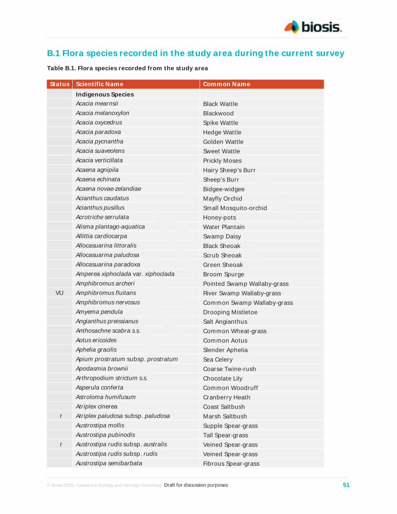
© Biosis 2015 – Leaders in Ecology and Heritage Consulting Draft for discussion purposes 51
B.1 Flora species recorded in the study area during the current survey Table B.1. Flora species recorded from the study area
Status Scientific Name Common Name Indigenous Species Acacia mearnsii Black Wattle Acacia melanoxylon Blackwood Acacia oxycedrus Spike Wattle Acacia paradoxa Hedge Wattle Acacia pycnantha Golden Wattle Acacia suaveolens Sweet Wattle Acacia verticillata Prickly Moses Acaena agnipila Hairy Sheep's Burr Acaena echinata Sheep's Burr Acaena novae-zelandiae Bidgee-widgee Acianthus caudatus Mayfly Orchid Acianthus pusillus Small Mosquito-orchid Acrotriche serrulata Honey-pots Alisma plantago-aquatica Water Plantain Allittia cardiocarpa Swamp Daisy Allocasuarina littoralis Black Sheoak Allocasuarina paludosa Scrub Sheoak Allocasuarina paradoxa Green Sheoak Amperea xiphoclada var. xiphoclada Broom Spurge Amphibromus archeri Pointed Swamp Wallaby-grass
VU Amphibromus fluitans River Swamp Wallaby-grass Amphibromus nervosus Common Swamp Wallaby-grass Amyema pendula Drooping Mistletoe Angianthus preissianus Salt Angianthus Anthosachne scabra s.s. Common Wheat-grass Aotus ericoides Common Aotus Aphelia gracilis Slender Aphelia Apium prostratum subsp. prostratum Sea Celery Apodasmia brownii Coarse Twine-rush Arthropodium strictum s.s. Chocolate Lily Asperula conferta Common Woodruff Astroloma humifusum Cranberry Heath Atriplex cinerea Coast Saltbush
r Atriplex paludosa subsp. paludosa Marsh Saltbush Austrostipa mollis Supple Spear-grass Austrostipa pubinodis Tall Spear-grass
r Austrostipa rudis subsp. australis Veined Spear-grass Austrostipa rudis subsp. rudis Veined Spear-grass Austrostipa semibarbata Fibrous Spear-grass
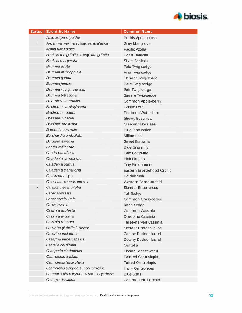
© Biosis 2015 – Leaders in Ecology and Heritage Consulting Draft for discussion purposes 52
Status Scientific Name Common Name Austrostipa stipoides Prickly Spear-grass
r Avicennia marina subsp. australasica Grey Mangrove Azolla filiculoides Pacific Azolla Banksia integrifolia subsp. integrifolia Coast Banksia Banksia marginata Silver Banksia Baumea acuta Pale Twig-sedge Baumea arthrophylla Fine Twig-sedge Baumea gunnii Slender Twig-sedge Baumea juncea Bare Twig-sedge Baumea rubiginosa s.s. Soft Twig-sedge Baumea tetragona Square Twig-sedge Billardiera mutabilis Common Apple-berry Blechnum cartilagineum Gristle Fern Blechnum nudum Fishbone Water-fern Bossiaea cinerea Showy Bossiaea Bossiaea prostrata Creeping Bossiaea Brunonia australis Blue Pincushion Burchardia umbellata Milkmaids Bursaria spinosa Sweet Bursaria Caesia calliantha Blue Grass-lily Caesia parviflora Pale Grass-lily Caladenia carnea s.s. Pink Fingers Caladenia pusilla Tiny Pink-fingers Caladenia transitoria Eastern Bronzehood Orchid Callistemon spp. Bottlebrush Calochilus robertsonii s.s. Western Beard-orchid
k Cardamine tenuifolia Slender Bitter-cress Carex appressa Tall Sedge Carex breviculmis Common Grass-sedge Carex inversa Knob Sedge Cassinia aculeata Common Cassinia Cassinia arcuata Drooping Cassinia Cassinia trinerva Three-nerved Cassinia Cassytha glabella f. dispar Slender Dodder-laurel Cassytha melantha Coarse Dodder-laurel Cassytha pubescens s.s. Downy Dodder-laurel Centella cordifolia Centella Centipeda elatinoides Elatine Sneezeweed Centrolepis aristata Pointed Centrolepis Centrolepis fascicularis Tufted Centrolepis Centrolepis strigosa subsp. strigosa Hairy Centrolepis Chamaescilla corymbosa var. corymbosa Blue Stars Chiloglottis valida Common Bird-orchid

© Biosis 2015 – Leaders in Ecology and Heritage Consulting Draft for discussion purposes 53
Status Scientific Name Common Name k Clematis decipiens Slender Clematis
Clematis microphylla s.s. Small-leaved Clematis Comesperma volubile Love Creeper Coprosma quadrifida Prickly Currant-bush Coronidium scorpioides s.s. Button Everlasting Correa reflexa Common Correa Corybas spp. Helmet Orchid Cotula australis Common Cotula Craspedia paludicola Swamp Billy-buttons Crassula decumbens var. decumbens Spreading Crassula Crassula sieberiana s.l. Sieber Crassula Cryptostylis subulata Large Tongue-orchid Deyeuxia quadriseta Reed Bent-grass Dianella admixta Black-anther Flax-lily Dianella brevicaulis Small-flower Flax-lily
v Dianella sp. aff. longifolia (Benambra) Arching Flax-lily Dichondra repens Kidney-weed Dillwynia cinerascens s.s. Grey Parrot-pea Dillwynia glaberrima Smooth Parrot-pea Dillwynia sericea Showy Parrot-pea Disphyma crassifolium subsp. clavellatum Rounded Noon-flower Distichlis distichophylla Australian Salt-grass Diuris sulphurea Tiger Orchid Drosera aberrans Scented Sundew Drosera peltata s.l. Pale Sundew Drosera pygmaea Tiny Sundew Dysphania spp. Pigweed Eleocharis acuta Common Spike-sedge Eleocharis pusilla Small Spike-sedge Eleocharis sphacelata Tall Spike-sedge Empodisma minus Spreading Rope-rush
k Entolasia stricta Upright Panic Epacris impressa Common Heath Epilobium billardierianum Variable Willow-herb Epilobium hirtigerum Hairy Willow-herb Eragrostis brownii Common Love-grass Eryngium vesiculosum Prickfoot Eucalyptus ovata var. ovata Swamp Gum Eucalyptus radiata subsp. radiata Narrow-leaf Peppermint Eucalyptus viminalis subsp. pryoriana Coast Manna-gum Eucalyptus viminalis subsp. viminalis Manna Gum Euchiton involucratus s.l. Common Cudweed Euchiton japonicus s.s. Creeping Cudweed

© Biosis 2015 – Leaders in Ecology and Heritage Consulting Draft for discussion purposes 54
Status Scientific Name Common Name Euchiton sphaericus Annual Cudweed Exocarpos cupressiformis Cherry Ballart Exocarpos strictus Pale-fruit Ballart Ficinia nodosa Knobby Club-sedge Gahnia filum Chaffy Saw-sedge Gahnia radula Thatch Saw-sedge Gahnia trifida Coast Saw-sedge Galium binifolium Reflexed Bedstraw Geranium retrorsum s.s. Grassland Crane's-bill Geranium sp. 2 Variable Crane's-bill Geranium sp. 5 Naked Crane's-bill Geranium spp. Crane's Bill Glossodia major Wax-lip Orchid Glyceria australis Australian Sweet-grass Glycine clandestina Twining Glycine Gonocarpus humilis Shade Raspwort Gonocarpus micranthus Creeping Raspwort Gonocarpus tetragynus Common Raspwort Goodenia geniculata Bent Goodenia Goodenia gracilis Slender Goodenia Goodenia humilis Swamp Goodenia Goodenia lanata Trailing Goodenia Goodenia ovata Hop Goodenia Gratiola peruviana Austral Brooklime Hakea nodosa Yellow Hakea Hakea ulicina Furze Hakea Haloragis heterophylla Varied Raspwort Helichrysum luteoalbum Jersey Cudweed Hemarthria uncinata var. uncinata Mat Grass Hemichroa pentandra Trailing Hemichroa Hibbertia acicularis Prickly Guinea-flower Hibbertia fasciculata var. prostrata Bundled Guinea-flower Hibbertia riparia Erect Guinea-flower Hydrocotyle callicarpa Small Pennywort Hydrocotyle hirta Hairy Pennywort Hypericum gramineum spp. agg. Small St John's Wort Hypolaena fastigiata Tassel Rope-rush Hypoxis hygrometrica var. hygrometrica Golden Weather-glass Hypoxis hygrometrica var. villosisepala Golden Weather-glass Hypoxis vaginata Yellow Star Isolepis cernua var. cernua Nodding Club-sedge Isolepis cernua var. platycarpa Broad-fruit Club-sedge Isolepis fluitans Floating Club-sedge

© Biosis 2015 – Leaders in Ecology and Heritage Consulting Draft for discussion purposes 55
Status Scientific Name Common Name Isolepis hookeriana Grassy Club-sedge Isolepis inundata Swamp Club-sedge Isopogon ceratophyllus Horny Cone-bush Juncus amabilis Hollow Rush Juncus bufonius Toad Rush Juncus gregiflorus Green Rush Juncus holoschoenus Joint-leaf Rush Juncus kraussii subsp. australiensis Sea Rush Juncus pallidus Pale Rush Juncus planifolius Broad-leaf Rush
Juncus prismatocarpus subsp. prismatocarpus Branching Rush
Juncus procerus Tall Rush r Juncus revolutus Creeping Rush Juncus sarophorus Broom Rush Juncus subsecundus Finger Rush Kennedia prostrata Running Postman Kunzea ericoides spp. agg. Burgan Lachnagrostis aemula s.s. Leafy Blown-grass Lachnagrostis billardierei subsp. billardierei Coast Blown-grass Lachnagrostis filiformis s.s. Common Blown-grass
r Lachnagrostis robusta Salt Blown-grass Lagenophora gracilis Slender Bottle-daisy Lagenophora stipitata Common Bottle-daisy Lepidosperma concavum Sandhill Sword-sedge Lepidosperma filiforme Common Rapier-sedge Lepidosperma gunnii Slender Sword-sedge Lepidosperma laterale var. laterale Variable Sword-sedge Lepidosperma laterale var. majus Variable Sword-sedge Lepidosperma longitudinale Pithy Sword-sedge Lepilaena preissii Slender Water-mat Leptoceras menziesii Hare Orchid Leptorhynchos squamatus Scaly Buttons Leptorhynchos tenuifolius Wiry Buttons Leptospermum continentale Prickly Tea-tree Leptospermum lanigerum Woolly Tea-tree Leptospermum myrsinoides Heath Tea-tree Leptospermum scoparium Manuka Lepyrodia muelleri Common Scale-rush Leucopogon australis Spike Beard-heath Leucopogon ericoides Pink Beard-heath Leucopogon parviflorus Coast Beard-heath Leucopogon virgatus var. virgatus Common Beard-heath

© Biosis 2015 – Leaders in Ecology and Heritage Consulting Draft for discussion purposes 56
Status Scientific Name Common Name r Limonium australe Yellow Sea-lavender Lindsaea linearis Screw Fern Lobelia anceps Angled Lobelia Lomandra filiformis Wattle Mat-rush Lomandra longifolia Spiny-headed Mat-rush Lomandra nana Dwarf Mat-rush Lotus spp. Trefoil Luzula meridionalis Common Woodrush Luzula spp. Woodrush Lythrum hyssopifolia Small Loosestrife Mazus pumilio Swamp Mazus Melaleuca squarrosa Scented Paperbark Microlaena stipoides var. stipoides Weeping Grass Microtis parviflora Slender Onion-orchid Microtis unifolia Common Onion-orchid Monotoca scoparia Prickly Broom-heath Montia australasica White Purslane Muellerina eucalyptoides Creeping Mistletoe Myriophyllum crispatum Upright Water-milfoil Myriophyllum simulans Amphibious Water-milfoil Olearia lirata Snowy Daisy-bush Olearia phlogopappa Dusty Daisy-bush Olearia ramulosa Twiggy Daisy-bush Opercularia ovata Broad-leaf Stinkweed Opercularia varia Variable Stinkweed Orthoceras strictum Horned Orchid Oxalis perennans Grassland Wood-sorrel Ozothamnus ferrugineus Tree Everlasting Pandorea pandorana subsp. pandorana Wonga Vine Parietaria debilis s.s. Shade Pellitory Patersonia fragilis Short Purple-flag Patersonia occidentalis var. occidentalis Long Purple-flag Pelargonium rodneyanum Magenta Stork's-bill Persicaria decipiens Slender Knotweed Persoonia juniperina Prickly Geebung Phragmites australis Common Reed Pimelea glauca Smooth Rice-flower Pimelea humilis Common Rice-flower Pimelea octophylla Woolly Rice-flower Plantago gaudichaudii Narrow Plantain Platylobium formosum spp. agg. Handsome Flat-pea Platylobium obtusangulum Common Flat-pea Poa clelandii Noah's Ark

© Biosis 2015 – Leaders in Ecology and Heritage Consulting Draft for discussion purposes 57
Status Scientific Name Common Name Poa labillardierei Common Tussock-grass Poa morrisii Soft Tussock-grass Poa poiformis Coast Tussock-grass Poa sieberiana var. sieberiana Grey Tussock-grass Podolobium spp. Podolobium Poranthera microphylla s.s. Small Poranthera
k Potamogeton perfoliatus Perfoliate Pondweed Potamogeton tricarinatus s.l. Floating Pondweed Pteridium esculentum Austral Bracken Pterostylis concinna Trim Greenhood Pterostylis melagramma Tall Greenhood Pterostylis nana Dwarf Greenhood Pterostylis nutans Nodding Greenhood Pterostylis parviflora s.s. Tiny Greenhood Pterostylis pedunculata Maroonhood Pterostylis spp. Greenhood Ptychomnion aciculare Paper Moss Puccinellia stricta s.s. Australian Saltmarsh-grass Pultenaea daphnoides Large-leaf Bush-pea Pultenaea gunnii Golden Bush-pea Ranunculus amphitrichus Small River Buttercup Ranunculus inundatus River Buttercup Ranunculus lappaceus Australian Buttercup Ranunculus spp. Buttercup Rhagodia candolleana subsp. candolleana Seaberry Saltbush Ricinocarpos pinifolius Wedding Bush Ruppia megacarpa Large-fruit Tassel Ruppia spp. Tassel Rytidosperma caespitosum Common Wallaby-grass Rytidosperma fulvum Copper-awned Wallaby-grass Rytidosperma geniculatum Kneed Wallaby-grass Rytidosperma laeve Smooth Wallaby-grass Rytidosperma penicillatum Weeping Wallaby-grass Rytidosperma racemosum var. racemosum Slender Wallaby-grass Rytidosperma semiannulare Wetland Wallaby-grass Rytidosperma setaceum var. setaceum Bristly Wallaby-grass Samolus repens var. repens Creeping Brookweed Sarcocornia blackiana Thick-head Glasswort Sarcocornia quinqueflora Beaded Glasswort Schoenus apogon Common Bog-sedge Schoenus brevifolius Zig-zag Bog-sedge Schoenus lepidosperma Slender Bog-sedge Schoenus nitens Shiny Bog-sedge

© Biosis 2015 – Leaders in Ecology and Heritage Consulting Draft for discussion purposes 58
Status Scientific Name Common Name Schoenus tesquorum Soft Bog-sedge Selaginella uliginosa Swamp Selaginella Selliera radicans Shiny Swamp-mat Senecio bathurstianus Dissected Fireweed Senecio glomeratus subsp. glomeratus Annual Fireweed Senecio hispidulus Rough Fireweed Senecio minimus Shrubby Fireweed Senecio odoratus Scented Groundsel Senecio pinnatifolius var. lanceolatus Lance-leaf Groundsel Senecio quadridentatus Cotton Fireweed Senecio tenuiflorus spp. agg. Slender Fireweed Solanum laciniatum Large Kangaroo Apple Spergularia sp. 1 Native Sea-spurrey Spergularia spp. Sand Spurrey Spinifex sericeus Hairy Spinifex Stackhousia viminea Slender Stackhousia Stylidium graminifolium s.s. Grass Triggerplant Suaeda australis Austral Seablite Tecticornia arbuscula Shrubby Glasswort Tecticornia arbuscula Shrubby Glasswort Tetragonia implexicoma Bower Spinach Tetratheca ciliata Pink-bells Tetratheca pilosa Hairy Pink-bells Thelionema caespitosum Tufted Lily Thelymitra brevifolia Peppertop Sun-orchid Thelymitra carnea Pink Sun-orchid Thelymitra flexuosa Twisted Sun-orchid Thelymitra holmesii s.s. Blue-star Sun-orchid Thelymitra ixioides s.s. Spotted Sun-orchid Thelymitra juncifolia Rush-leaf Sun-orchid Thelymitra media s.s. Tall Sun-orchid Thelymitra nuda Plain Sun-orchid
e Thelymitra pallidiflora Pallid Sun-orchid Thelymitra pauciflora s.s. Slender Sun-orchid Thelymitra peniculata Trim Sun-orchid Thelymitra rubra Salmon Sun-orchid Themeda triandra Kangaroo Grass Thysanotus patersonii Twining Fringe-lily Thysanotus tuberosus Common Fringe-lily Trachymene composita Parsnip Trachymene Tricoryne elatior Yellow Rush-lily Triglochin procera s.s. Common Water-ribbons Triglochin striata Streaked Arrowgrass

© Biosis 2015 – Leaders in Ecology and Heritage Consulting Draft for discussion purposes 59
Status Scientific Name Common Name Typha domingensis Narrow-leaf Cumbungi Utricularia dichotoma s.s. Fairies' Aprons Veronica gracilis Slender Speedwell Villarsia exaltata Erect Marsh-flower Villarsia reniformis Running Marsh-flower Viminaria juncea Golden Spray Viola cleistogamoides Hidden Violet Viola hederacea sensu Entwisle (1996) Ivy-leaf Violet Wahlenbergia gracilis Sprawling Bluebell Wahlenbergia stricta subsp. stricta Tall Bluebell Xanthorrhoea minor subsp. lutea Small Grass-tree Xanthosia dissecta s.s. Native Parsley Xanthosia huegelii Heath Xanthosia Introduced Species Acacia baileyana Cootamundra Wattle
# Acacia longifolia subsp. longifolia Sallow Wattle # Acacia longifolia subsp. sophorae Coast Wattle Acacia saligna Golden Wreath Wattle Acetosella vulgaris Sheep Sorrel Agrostis capillaris var. capillaris Brown-top Bent Agrostis stolonifera Creeping Bent Aira caryophyllea subsp. caryophyllea Silvery Hair-grass Aira cupaniana Quicksilver Grass Aira elegantissima Delicate Hair-grass Aira praecox Early Hair-grass Aira spp. Hair Grass
RR Allium triquetrum Angled Onion Anthoxanthum odoratum Sweet Vernal-grass Arctotheca calendula Cape Weed Arrhenatherum elatius var. bulbosum False Oat-grass
RR Asparagus asparagoides Bridal Creeper Asparagus scandens Asparagus Fern Aster subulatus Aster-weed Atriplex prostrata Hastate Orache Avena barbata Bearded Oat Billardiera heterophylla Bluebell Creeper Brassica fruticulosa Twiggy Turnip Brassica rapa White Turnip Briza maxima Large Quaking-grass Briza minor Lesser Quaking-grass Bromus catharticus Prairie Grass Bromus diandrus Great Brome Bromus hordeaceus subsp. hordeaceus Soft Brome

© Biosis 2015 – Leaders in Ecology and Heritage Consulting Draft for discussion purposes 60
Status Scientific Name Common Name Cakile maritima subsp. maritima Sea Rocket
RP Calicotome spinosa Spiny Broom Callitriche stagnalis Common Water-starwort
RC Carduus pycnocephalus Slender Thistle Catapodium rigidum Fern Grass Cenchrus clandestinus Kikuyu Cenchrus clandestinus Kikuyu Centaurium erythraea Common Centaury Centaurium tenuiflorum Slender Centaury Cerastium glomeratum s.s. Sticky Mouse-ear Chickweed
RC Chrysanthemoides monilifera Boneseed Cicendia quadrangularis Square Cicendia
RC Cirsium vulgare Spear Thistle Conyza bonariensis Flaxleaf Fleabane Cortaderia selloana Pampas Grass
v, # Corymbia maculata Spotted Gum Cotoneaster pannosus Velvet Cotoneaster Cotula coronopifolia Water Buttons Crassula natans var. minus Water Crassula
RC Crataegus monogyna Hawthorn Cupressus macrocarpa Monterey Cypress
RC Cynara cardunculus subsp. flavescens Artichoke Thistle Cynodon dactylon var. dactylon Couch Cyperus eragrostis Drain Flat-sedge Dactylis glomerata Cocksfoot Danthonia decumbens Heath Grass Daucus carota Carrot
RC Dittrichia graveolens Stinkwort Ehrharta erecta var. erecta Panic Veldt-grass Ehrharta longiflora Annual Veldt-grass Erica lusitanica Spanish Heath # Eucalyptus globulus Southern Blue-gum Festuca arundinacea Tall Fescue Festuca rubra s.s. Creeping Fescue
RR Foeniculum vulgare Fennel Fraxinus angustifolia Desert Ash Fumaria bastardii Bastard's Fumitory Galium aparine Cleavers Galium murale Small Goosegrass Gamochaeta purpurea s.s. Spiked Cudweed Gaudinia fragilis Fragile Oat
RC Genista linifolia Flax-leaf Broom RC Genista monspessulana Montpellier Broom

© Biosis 2015 – Leaders in Ecology and Heritage Consulting Draft for discussion purposes 61
Status Scientific Name Common Name Geranium dissectum Cut-leaf Crane's-bill Geranium molle Dove's Foot Gladiolus tristis Evening-flower Gladiolus Glyceria declinata Manna Grass Hakea drupacea Sweet Hakea Hedera helix English Ivy Helminthotheca echioides Ox-tongue Holcus lanatus Yorkshire Fog Hordeum leporinum Barley-grass
RC Hypericum perforatum subsp. veronense St John's Wort Hypochaeris glabra Smooth Cat's-ear Hypochaeris radicata Flatweed # Imperata cylindrica Blady Grass Isolepis hystrix Awned Club-sedge Isolepis levynsiana Tiny Flat-sedge
RC Jacobaea vulgaris Ragwort RC Juncus acutus subsp. acutus Spiny Rush Juncus articulatus subsp. articulatus Jointed Rush Juncus capitatus Capitate Rush Juncus microcephalus Tiny-headed Rush Lactuca serriola Prickly Lettuce
Leontodon taraxacoides subsp. taraxacoides Hairy Hawkbit
Lepidium africanum Common Peppercress # Leptospermum laevigatum Coast Tea-tree Linaria pelisseriana Pelisser's Toad-flax Linum trigynum French Flax Lolium perenne Perennial Rye-grass Lolium rigidum Wimmera Rye-grass Lonicera japonica Japanese Honeysuckle Lophopyrum ponticum Tall Wheat-grass Lotus corniculatus Bird's-foot Trefoil Lotus subbiflorus Hairy Bird's-foot Trefoil Lysimachia arvensis Pimpernel Lysimachia arvensis (Blue-flowered variant) Blue Pimpernel Lysimachia arvensis (Red-flowered variant) Scarlet Pimpernel Lythrum junceum Mediterranean Loosestrife Malus pumila Apple Malva parviflora Small-flower Mallow Medicago polymorpha Burr Medic Medicago sativa subsp. sativa Lucerne
r, # Melaleuca armillaris subsp. armillaris Giant Honey-myrtle # Melaleuca ericifolia Swamp Paperbark
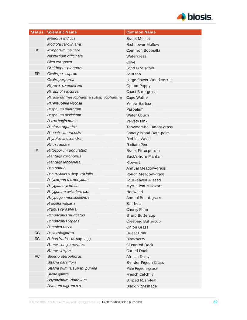
© Biosis 2015 – Leaders in Ecology and Heritage Consulting Draft for discussion purposes 62
Status Scientific Name Common Name Melilotus indicus Sweet Melilot Modiola caroliniana Red-flower Mallow # Myoporum insulare Common Boobialla Nasturtium officinale Watercress Olea europaea Olive Ornithopus pinnatus Sand Bird's-foot
RR Oxalis pes-caprae Soursob Oxalis purpurea Large-flower Wood-sorrel Papaver somniferum Opium Poppy Parapholis incurva Coast Barb-grass Paraserianthes lophantha subsp. lophantha Cape Wattle Parentucellia viscosa Yellow Bartsia Paspalum dilatatum Paspalum Paspalum distichum Water Couch Petrorhagia dubia Velvety Pink Phalaris aquatica Toowoomba Canary-grass Phoenix canariensis Canary Island Date-palm Phytolacca octandra Red-ink Weed Pinus radiata Radiata Pine # Pittosporum undulatum Sweet Pittosporum Plantago coronopus Buck's-horn Plantain Plantago lanceolata Ribwort Poa annua Annual Meadow-grass Poa trivialis subsp. trivialis Rough Meadow-grass Polycarpon tetraphyllum Four-leaved Allseed Polygala myrtifolia Myrtle-leaf Milkwort Polygonum aviculare s.s. Hogweed Polypogon monspeliensis Annual Beard-grass Prunella vulgaris Self-heal Prunus cerasifera Cherry Plum Ranunculus muricatus Sharp Buttercup Ranunculus repens Creeping Buttercup Romulea rosea Onion Grass
RC Rosa rubiginosa Sweet Briar RC Rubus fruticosus spp. agg. Blackberry Rumex conglomeratus Clustered Dock Rumex crispus Curled Dock
RC Senecio pterophorus African Daisy Setaria parviflora Slender Pigeon Grass Setaria pumila subsp. pumila Pale Pigeon-grass Silene gallica French Catchfly Sisyrinchium iridifolium Striped Rush-leaf Solanum nigrum s.s. Black Nightshade

© Biosis 2015 – Leaders in Ecology and Heritage Consulting Draft for discussion purposes 63
Status Scientific Name Common Name Soliva sessilis Jo Jo Sonchus asper s.s. Rough Sow-thistle Sonchus oleraceus Common Sow-thistle Sporobolus africanus Rat-tail Grass Stellaria media Chickweed Stenotaphrum secundatum Buffalo Grass Taraxacum officinale spp. agg. Garden Dandelion Tradescantia fluminensis Wandering Jew Tragopogon porrifolius subsp. porrifolius Salsify Trifolium angustifolium var. angustifolium Narrow-leaf Clover Trifolium arvense var. arvense Hare's-foot Clover Trifolium campestre var. campestre Hop Clover Trifolium dubium Suckling Clover Trifolium glomeratum Cluster Clover Trifolium repens var. repens White Clover Trifolium striatum Knotted Clover Trifolium subterraneum Subterranean Clover
RC Ulex europaeus Gorse Ulmus spp. Elm Vellereophyton dealbatum White Cudweed Verbena bonariensis var. bonariensis s.s. Purple-top Verbena Vicia hirsuta Tiny Vetch Vicia sativa Common Vetch Vicia tetrasperma Slender Vetch Vulpia bromoides Squirrel-tail Fescue Vulpia muralis Wall Fescue Vulpia myuros f. myuros Rat's-tail Fescue
RC Watsonia meriana var. bulbillifera Bulbil Watsonia Zantedeschia aethiopica White Arum-lily

© B
iosi
s 20
15 –
Lea
ders
in E
colo
gy a
nd H
erita
ge C
onsu
lting
D
raft
for d
iscu
ssio
n pu
rpos
es
64
B.2
List
ed fl
ora
spec
ies
from
dat
abas
e se
arch
es
The
follo
win
g ta
ble
incl
udes
the
liste
d flo
ra s
peci
es th
at h
ave
pote
ntia
l to
occu
r w
ithin
the
stud
y ar
ea. T
he li
st o
f spe
cies
is s
ourc
ed fr
om th
e FI
S,
Vict
oria
n Bi
odiv
ersi
ty A
tlas
and
the
Prot
ecte
d M
atte
rs S
earc
h To
ol (D
oE; a
cces
sed
on 0
5.08
.14)
, or
adde
d by
Bio
sis
on th
e ba
sis
of e
xper
t opi
nion
.
Tabl
e B.
2. L
iste
d fl
ora
spec
ies
reco
rded
/ pr
edic
ted
to o
ccur
wit
hin
5 km
of t
he s
tudy
are
a
Scie
ntif
ic n
ame
Com
mon
nam
e Co
nser
vati
on
stat
us
Mos
t re
cent
da
taba
se
reco
rd
Oth
er
reco
rds
Hab
itat
des
crip
tion
Li
kely
occ
urre
nce
in S
tudy
Are
a
EPBC
St
ate
List
FF
G
Nat
iona
l Sig
nifi
canc
e Am
phib
rom
us
fluita
ns
Rive
r Sw
amp
Wal
laby
-gra
ss
VU
2007
PM
ST
Swam
py a
reas
, mai
nly
alon
g th
e M
urra
y Ri
ver
betw
een
Wod
onga
an
d Ec
huca
with
sca
tter
ed
reco
rds
from
sou
ther
n Vi
ctor
ia.
Pres
ent –
rec
orde
d in
mul
tiple
lo
catio
ns w
ithin
Blu
eSco
pe, r
efer
Fi
gure
A2.
Cala
deni
a in
sula
ris
Fren
ch Is
land
Sp
ider
-orc
hid
VU
v L
-
Den
se, w
et h
eath
and
hea
thy
woo
dlan
d (Je
anes
and
Bac
khou
se
2006
).
Low
– w
hile
this
spe
cies
app
ears
co
nfin
ed to
Fre
nch
Isla
nd, i
ts h
abita
t is
pre
sent
with
the
stud
y ar
ea a
nd it
co
ncei
vabl
e th
at it
s ra
nge
coul
d ex
tend
into
this
are
a.
Cala
deni
a or
ient
alis
Ea
ster
n Sp
ider
-or
chid
EN
e
L -
H
eath
and
hea
thy
woo
dlan
ds in
co
asta
l are
as b
etw
een
the
Mor
ning
ton
Peni
nsul
a an
d W
ilson
s Pr
omon
tory
.
Low
– H
abita
t for
this
spe
cies
is fo
und
with
in th
e st
udy
area
alth
ough
it h
as
not b
een
reco
rded
with
in th
e W
este
rn P
ort a
rea.
Cala
deni
a ro
bins
onii
Fran
ksto
n Sp
ider
-or
chid
EN
e
L -
Co
asta
l hea
thy
woo
dlan
d; o
nly
conf
irm
ed p
opul
atio
n is
nea
r Ro
sebu
d.
Neg
ligib
le –
ass
ocia
ted
vege
tatio
n ty
pes
pres
ent a
lthou
gh n
ot r
ecor
ded
in th
e W
este
rn P
ort a
rea.
Dia
nella
am
oena
M
atte
d Fl
ax-li
ly
EN
e L
-
Low
land
gra
ssla
nd a
nd g
rass
y w
oodl
and,
on
wel
l-dra
ined
to
seas
onal
ly w
ater
logg
ed fe
rtile
sa
ndy
loam
soi
ls to
hea
vy
crac
king
cla
ys (C
arte
r 20
10).
Low
– a
ssoc
iate
d ve
geta
tion
type
s ge
nera
lly s
carc
e.

© B
iosi
s 20
15 –
Lea
ders
in E
colo
gy a
nd H
erita
ge C
onsu
lting
D
raft
for d
iscu
ssio
n pu
rpos
es
65
Scie
ntif
ic n
ame
Com
mon
nam
e Co
nser
vati
on
stat
us
Mos
t re
cent
da
taba
se
reco
rd
Oth
er
reco
rds
Hab
itat
des
crip
tion
Li
kely
occ
urre
nce
in S
tudy
Are
a
EPBC
St
ate
List
FF
G
Euph
rasi
a co
llina
su
bsp.
mue
lleri
Purp
le E
yebr
ight
EN
e
L 19
19
G
rass
land
s an
d gr
assy
w
oodl
ands
; few
pop
ulat
ions
are
kn
own
to s
till e
xist
(Mur
phy
and
Dow
ne 2
006)
.
Low
– a
ssoc
iate
d ve
geta
tion
type
s ge
nera
lly s
carc
e.
Gly
cine
latr
obea
na
Clov
er G
lyci
ne
VU
v L
2009
PM
ST
Gra
ssla
nds
and
gras
sy
woo
dlan
ds, p
artic
ular
ly th
ose
dom
inat
ed b
y Th
emed
a tr
iand
ra.
Low
– a
ssoc
iate
d ve
geta
tion
type
s ge
nera
lly s
carc
e.
Pras
ophy
llum
fr
ench
ii M
aroo
n Le
ek-
orch
id
EN
e L
-
Gra
ssla
nd a
nd g
rass
y w
oodl
and
envi
ronm
ents
on
sand
y or
bla
ck
clay
loam
soi
ls th
at a
re g
ener
ally
da
mp
but w
ell d
rain
ed.
Low
– a
ssoc
iate
d ve
geta
tion
type
s ge
nera
lly s
carc
e.
Pras
ophy
llum
sp
icat
um
Den
se L
eek-
orch
id
VU
e
-
Hea
thla
nd a
nd H
eath
y W
oodl
ands
. M
ediu
m –
ass
ocia
ted
vege
tatio
n ty
pes
pres
ent.
Foun
d to
the
sout
h of
H
astin
gs a
t Cri
bb P
oint
.
Pter
osty
lis
chlo
rogr
amm
a G
reen
-str
iped
G
reen
hood
VU
v
L -
H
eath
y W
oodl
and,
Dam
p H
eath
y W
oodl
and
and
Low
land
For
est
(Coa
tes
et a
l. 20
02).
Med
ium
– a
ssoc
iate
d ve
geta
tion
type
s pr
esen
t. S
urve
ys h
ave
not b
een
unde
rtak
en d
urin
g th
e flo
wer
ing
seas
on o
f thi
s sp
ecie
s.
Pter
osty
lis c
ucul
lata
Le
afy
Gre
enho
od
VU
v L
-
Alka
line
scru
b do
min
ated
by
tea
tree
, she
oak
and
othe
r sh
rubs
N
eglig
ible
– li
mite
d ha
bita
t pre
sent
.
Sene
cio
psilo
carp
us
Swam
p Fi
rew
eed
VU
v
-
Seas
onal
ly-in
unda
ted
herb
-ric
h sw
amps
, gro
win
g on
pea
ty s
oils
or
vol
cani
c cl
ays
Low
– m
ay b
e fo
und
in w
etla
nd
vege
tatio
n.
Thel
ymitr
a ep
ipac
toid
es
Met
allic
Sun
-or
chid
EN
e
L -
M
oist
or
dry
sand
y lo
ams
or
loam
y sa
nds,
pri
mar
ily in
coa
stal
he
aths
, gra
ssla
nds
and
woo
dlan
ds, b
ut a
lso
in s
imila
r co
mm
uniti
es a
t dri
er in
land
site
s
Low
– s
ome
habi
tat p
rese
nt a
lthou
gh
not r
ecor
ded
in th
e W
este
rn P
ort
area
.
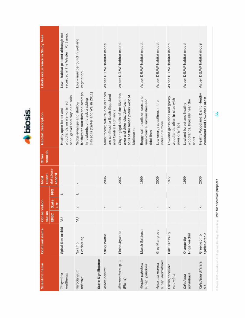
© B
iosi
s 20
15 –
Lea
ders
in E
colo
gy a
nd H
erita
ge C
onsu
lting
D
raft
for d
iscu
ssio
n pu
rpos
es
66
Scie
ntif
ic n
ame
Com
mon
nam
e Co
nser
vati
on
stat
us
Mos
t re
cent
da
taba
se
reco
rd
Oth
er
reco
rds
Hab
itat
des
crip
tion
Li
kely
occ
urre
nce
in S
tudy
Are
a
EPBC
St
ate
List
FF
G
Thel
ymitr
a m
atth
ewsi
i Sp
iral
Sun
-orc
hid
VU
L
-
Hea
thy
open
fore
st a
nd
woo
dlan
ds, o
n w
ell-d
rain
ed
sand
, gra
vel a
nd c
lay
loam
soi
ls
Low
– h
abita
t pre
sent
alth
ough
not
re
cord
ed in
the
Wes
tern
Por
t are
a.
Xero
chry
sum
pa
lust
re
Swam
p Ev
erla
stin
g VU
v
L -
Se
dge-
swam
ps a
nd s
hallo
w
fres
hwat
er m
arsh
es a
nd s
wam
ps
in lo
wla
nds,
on
blac
k cr
acki
ng
clay
soi
ls (C
arte
r an
d W
alsh
201
1)
Low
– m
ay b
e fo
und
in w
etla
nd
vege
tatio
n.
Stat
e Si
gnif
ican
ce
Acac
ia h
owitt
ii St
icky
Wat
tle
r
2006
Moi
st fo
rest
; Nat
ural
occ
urre
nces
ar
e co
nfin
ed to
Sou
th G
ipps
land
an
d Ce
ntra
l Hig
hlan
ds
As p
er D
ELW
P ha
bita
t mod
el.
Alte
rnan
ther
a sp
. 1
(Pla
ins)
Pl
ains
Joyw
eed
k
20
07
Cl
ay o
r gi
lgai
soi
ls o
f the
Riv
erin
a ar
ea a
nd d
rier
cla
y/cl
ay-lo
am
soils
of t
he b
asal
t pla
ins
wes
t of
Mel
bour
ne
As p
er D
ELW
P ha
bita
t mod
el.
Atrip
lex
palu
dosa
su
bsp.
pal
udos
a M
arsh
Sal
tbus
h
r
1999
Bogg
y, s
alin
e so
ils o
n co
asta
l or
near
-coa
stal
sal
tmar
shes
and
tid
al-fl
ats
As p
er D
ELW
P ha
bita
t mod
el.
Avic
enni
a m
arin
a su
bsp.
aus
tral
asic
a G
rey
Man
grov
e
r
2009
Low
ene
rgy
coas
tline
s in
the
inte
r-tid
al z
one
As p
er D
ELW
P ha
bita
t mod
el.
Caes
ia p
arvi
flora
va
r. m
inor
Pa
le G
rass
-lily
k
1977
Low
land
gra
ssla
nds
and
gras
sy
woo
dlan
ds, o
ften
in s
ites
with
po
or d
rain
age
As p
er D
ELW
P ha
bita
t mod
el.
Cala
deni
a au
rant
iaca
O
rang
e-tip
Fi
nger
-orc
hid
r
19
99
Lo
wla
nd fo
rest
and
hea
thy
woo
dlan
ds, t
ypic
ally
nea
r th
e co
ast
As p
er D
ELW
P ha
bita
t mod
el
Cala
deni
a di
lata
ta
s.s.
G
reen
-com
b Sp
ider
-orc
hid
k
20
06
H
eath
y W
oodl
and,
Dam
p H
eath
y W
oodl
and
and
Low
land
For
est
As p
er D
ELW
P ha
bita
t mod
el

© B
iosi
s 20
15 –
Lea
ders
in E
colo
gy a
nd H
erita
ge C
onsu
lting
D
raft
for d
iscu
ssio
n pu
rpos
es
67
Scie
ntif
ic n
ame
Com
mon
nam
e Co
nser
vati
on
stat
us
Mos
t re
cent
da
taba
se
reco
rd
Oth
er
reco
rds
Hab
itat
des
crip
tion
Li
kely
occ
urre
nce
in S
tudy
Are
a
EPBC
St
ate
List
FF
G
Cala
deni
a m
entie
ns
Cryp
tic P
ink-
finge
rs
k
20
03
H
eath
land
and
Hea
thy
Woo
dlan
d As
per
DEL
WP
habi
tat m
odel
Card
amin
e pa
uciju
ga s
.s.
Annu
al B
itter
-cr
ess
v
19
98
M
oist
fore
sts
and
ripa
rian
ha
bita
ts
As p
er D
ELW
P ha
bita
t mod
el
Chilo
glot
tis X
pe
scot
tiana
Br
onze
Bir
d-or
chid
r
1997
Low
land
For
est
As p
er D
ELW
P ha
bita
t mod
el
Chor
izan
dra
aust
ralis
So
uthe
rn B
rist
le-
sedg
e
k
1995
Swam
ps a
nd w
ater
hole
s.
As p
er D
ELW
P ha
bita
t mod
el
Corr
ea re
flexa
var
. lo
bata
Po
wel
ltow
n Co
rrea
r
1981
Hea
thla
nd a
nd H
eath
y W
oodl
and
As p
er D
ELW
P ha
bita
t mod
el
Coru
nast
ylis
cili
ata
Frin
ged
Mid
ge-
orch
id
k
19
65
H
eath
and
hea
thy
and
gras
sy
woo
dlan
ds
As p
er D
ELW
P ha
bita
t mod
el
Cory
mbi
a m
acul
ata
Spot
ted
Gum
v
2009
In V
icto
ria
natu
rally
con
fined
to a
sm
all p
opul
atio
n ne
ar M
t Tar
a in
th
e ea
st o
f the
sta
te
As p
er D
ELW
P ha
bita
t mod
el
Cras
pedi
a ca
nens
G
rey
Billy
-bu
tton
s
e L
1920
Low
alti
tude
gra
ssla
nds
betw
een
Cran
bour
ne a
nd T
rara
lgon
N
eglig
ible
– n
o ha
bita
t pre
sent
.
Dia
nella
sp.
aff
. lo
ngifo
lia
(Ben
ambr
a)
Arch
ing
Flax
-lily
v
2008
The
habi
tat r
equi
rem
ents
of t
his
spec
ies
are
poor
ly k
now
n As
per
DEL
WP
habi
tat m
odel
Diu
ris p
unct
ata
var.
pu
ncta
ta
Purp
le D
iuri
s
v L
1997
Fert
ile, l
oam
y so
ils a
nd
peri
odic
ally
wet
are
as in
low
land
gr
assl
ands
, gra
ssy
woo
dlan
ds,
heat
hy w
oodl
ands
and
ope
n he
athl
ands
Low
– a
ssoc
iate
d ve
geta
tion
type
s pr
esen
t. Re
cent
rec
ords
from
nea
rby.
Diu
ris s
ubal
pina
Sm
all S
nake
-or
chid
e
1919
Vari
ous
woo
dlan
ds a
nd fo
rest
As
per
DEL
WP
habi
tat m
odel
Ento
lasi
a st
ricta
U
prig
ht P
anic
k
2008
Dam
p H
eath
land
Pr
esen
t - r
ecor
ded
in B
lueS
cope
.
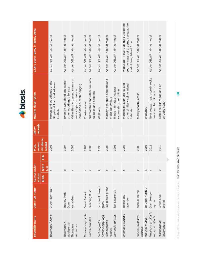
© B
iosi
s 20
15 –
Lea
ders
in E
colo
gy a
nd H
erita
ge C
onsu
lting
D
raft
for d
iscu
ssio
n pu
rpos
es
68
Scie
ntif
ic n
ame
Com
mon
nam
e Co
nser
vati
on
stat
us
Mos
t re
cent
da
taba
se
reco
rd
Oth
er
reco
rds
Hab
itat
des
crip
tion
Li
kely
occ
urre
nce
in S
tudy
Are
a
EPBC
St
ate
List
FF
G
Euca
lypt
us fu
lgen
s G
reen
Sce
ntba
rk
r
20
06
Fo
rest
s an
d w
oodl
ands
of t
he
Gip
psla
nd P
lain
and
adj
acen
t fo
othi
lls
As p
er D
ELW
P ha
bita
t mod
el
Euca
lypt
us X
st
udle
yens
is
Stud
ley
Park
G
um
e
19
94
Sw
ampy
Woo
dlan
d an
d so
me
othe
r w
oodl
and
/ for
ests
As
per
DEL
WP
habi
tat m
odel
Euca
lypt
us
yarr
aens
is
Yarr
a G
um
r
20
05
Va
lley
flats
and
alo
ng s
trea
m o
n so
ils s
ubje
ct to
per
iodi
c in
unda
tion
or w
ater
logg
ing
As p
er D
ELW
P ha
bita
t mod
el
Exoc
arpo
s sy
rtic
ola
Coas
t Bal
lart
r
1988
Coas
tal a
reas
As
per
DEL
WP
habi
tat m
odel
Junc
us re
volu
tus
Cree
ping
Rus
h
r
2008
Saltm
arsh
es a
nd o
ther
sim
ilarl
y sa
line
inla
nd h
abita
ts
As p
er D
ELW
P ha
bita
t mod
el
Lach
nagr
ostis
pe
renn
is s
pp. a
gg.
Pere
nnia
l Blo
wn-
gras
s
k
1990
Wet
land
s
As p
er D
ELW
P ha
bita
t mod
el
Lach
nagr
ostis
ro
bust
a Sa
lt Bl
own-
gras
s
r
2008
Mar
shy,
est
uari
ne h
abita
ts a
nd
moi
st s
andy
flat
s As
per
DEL
WP
habi
tat m
odel
Law
renc
ia s
pica
ta
Salt
Law
renc
ia
r
19
91
Fr
inge
hab
itats
of c
oast
al
saltm
arsh
com
mun
ities
As
per
DEL
WP
habi
tat m
odel
Lim
oniu
m a
ustr
ale
Yello
w S
ea-
lave
nder
r
2008
Mar
gins
of s
altm
arsh
es a
nd
othe
r si
mila
rly
salin
e in
land
ha
bita
ts
Mod
erat
e –
Reco
rded
just
out
side
the
sout
hern
par
t of t
he s
tudy
are
a at
the
end
of L
ong
Isla
nd D
rive
.
Lotu
s au
stra
lis v
ar.
aust
ralis
Au
stra
l Tre
foil
k
20
03
M
ostly
coa
stal
are
as
As p
er D
ELW
P ha
bita
t mod
el
Mar
sile
a m
utic
a Sm
ooth
Nar
doo
k
19
98
W
etla
nds
Mel
aleu
ca a
rmill
aris
su
bsp.
arm
illar
is
Gia
nt H
oney
-m
yrtle
r
2011
Nea
r co
asta
l hea
th/s
crub
, roc
ky
coas
t and
foot
hill
outc
rops
As
per
DEL
WP
habi
tat m
odel
Pras
ophy
llum
lin
dley
anum
G
reen
Lee
k-or
chid
v
1919
Fert
ile s
oils
in w
oodl
and
or
scru
bby
heat
h As
per
DEL
WP
habi
tat m
odel

© B
iosi
s 20
15 –
Lea
ders
in E
colo
gy a
nd H
erita
ge C
onsu
lting
D
raft
for d
iscu
ssio
n pu
rpos
es
69
Scie
ntif
ic n
ame
Com
mon
nam
e Co
nser
vati
on
stat
us
Mos
t re
cent
da
taba
se
reco
rd
Oth
er
reco
rds
Hab
itat
des
crip
tion
Li
kely
occ
urre
nce
in S
tudy
Are
a
EPBC
St
ate
List
FF
G
Pter
osty
lis
pedo
glos
sa
Praw
n G
reen
hood
v
1997
Hea
th a
nd h
eath
y w
oodl
and
near
the
coas
t As
per
DEL
WP
habi
tat m
odel
Pter
osty
lis tu
nsta
llii
Gra
nite
G
reen
hood
v
1960
Low
land
and
foot
hill
fore
sts,
of
ten
on a
nd a
roun
d th
e ba
se o
f la
rge
gran
ite b
ould
ers
As p
er D
ELW
P ha
bita
t mod
el
Rupp
ia m
ariti
ma
s.s.
W
ater
Tas
sel
k
19
80
W
ater
way
s As
per
DEL
WP
habi
tat m
odel
Sene
cio
glom
erat
us
subs
p. lo
ngifr
uctu
s An
nual
Fir
ewee
d
r
1921
Area
s ad
jace
nt to
str
eam
s,
swam
ps a
nd s
alin
e fla
ts
As p
er D
ELW
P ha
bita
t mod
el
Spar
gani
um
subg
lobo
sum
Fl
oatin
g Bu
r-re
ed
k
19
54
W
ater
way
s As
per
DEL
WP
habi
tat m
odel
Thel
ione
ma
umbe
llatu
m
Clus
tere
d Li
ly
r
19
88
Sa
ndy,
oft
en p
oorl
y dr
aine
d so
ils
of h
eath
y w
oodl
ands
and
he
athl
ands
As p
er D
ELW
P ha
bita
t mod
el
Thel
ymitr
a ci
rcum
sept
a N
aked
Sun
-or
chid
v
2007
In d
amp,
sha
ded
area
s in
hea
th,
woo
dlan
ds a
nd fo
rest
As p
er D
ELW
P ha
bita
t mod
el
Thel
ymitr
a pa
llidi
flora
Pa
llid
Sun-
orch
id
e
20
08
H
eath
y W
oodl
and
As p
er D
ELW
P ha
bita
t mod
el
Trig
loch
in
min
utis
sim
a Ti
ny A
rrow
gras
s
r
2008
Scat
tere
d oc
curr
ence
s on
dam
p sa
line
soils
nea
r sa
lt-la
kes,
and
fo
rmin
g pa
rt o
f her
bfie
lds
in
coas
tal s
altm
arsh
es
As p
er D
ELW
P ha
bita
t mod
el
Utr
icul
aria
gib
ba
Floa
ting
Blad
derw
ort
v
19
96
Aq
uatic
Her
blan
d As
per
DEL
WP
habi
tat m
odel
Utr
icul
aria
uni
flora
Si
ngle
Bl
adde
rwor
t
k
1980
Aqua
tic H
erbl
and
As p
er D
ELW
P ha
bita
t mod
el

© Biosis 2015 – Leaders in Ecology and Heritage Consulting Draft for discussion purposes 70
Appendix C. Fauna
Notes to tables:
EPBC Act:
EX - Extinct CR - Critically Endangered EN - Endangered VU - Vulnerable CD - Conservation dependent
State Advisory List:
ex - extinct cr - critically endangered en - endangered vu - vulnerable nt - near threatened dd - data deficient rx - regionally extinct
FFG Act:
L - listed as threatened under FFG Act
N - nominated for listing as threatened
I - determined ineligible for listing
Most recent database records are from the Victorian Biodiversity Atlas unless otherwise specified as follows
# – Protected Matters Search Tool
BA – Birds Australia
Fauna species in these tables are listed within their taxonomic group.

© Biosis 2015 – Leaders in Ecology and Heritage Consulting Draft for discussion purposes 71
C.1 Fauna species recorded from in the study area during the current survey Table C.1. Vertebrate fauna recorded from the study area
Status Scientific name Common name
INDIGENOUS SPECIES
Mammals
Antechinus agilis Agile Antechinus
Petaurus breviceps Sugar Glider
Phascolarctos cinereus Koala
Pseudocheirus peregrinus Ringtailed Possum
Rattus lutreolus Swamp Rat
Tachyglossus aculeatus Short beaked Echidna
Trichosurus vulpecula Common Brushtailed Possum
Wallabia bicolor Black Wallaby
Birds
Acanthiza chrysorrhoa Yellow-rumped Thornbill
Acanthiza pusilla Brown Thornbill
Acanthorhynchus tenuirostris Eastern Spinebill
Acrocephalus stentoreus Clamorous Reed Warbler
Aegotheles cristatus Australian Owlet-nightjar
Anas castanea Chestnut Teal
Anas gracilis Grey Teal
Anas superciliosa Pacific Black Duck
Anthochaera carunculata Red Wattlebird
Anthochaera chrysoptera Little Wattlebird
Anthus novaeseelandiae Australasian Pipit
Aquila audax Wedge-tailed Eagle
Artamus cyanopterus Dusky Woodswallow
vu Aythya australis Hardhead
Cacatua galerita Sulphur-crested Cockatoo
Cacatua sanguinea Little Corella
Cacomantis flabelliformis Fantail Cuckoo
Calamanthus fuliginosus Striated Fieldwren

© Biosis 2015 – Leaders in Ecology and Heritage Consulting Draft for discussion purposes 72
Status Scientific name Common name
Calyptorhynchus funereus Yellow-tailed Black Cockatoo
Chenonetta jubata Australian Wood Duck
Chroicocephalus novaehollandiae Silver Gull
Chrysococcyx lucidus Shining Bronze-Cuckoo
Circus approximans Swamp Harrier
Cisticola exilis Golden-headed Cisticola
Colluricincla harmonica Grey Shrike-thrush
Coracina novaehollandiae Black-faced Cuckoo-shrike
Cormobates leucophaeus White-throated Treecreeper
Corvus mellori Little Raven
Coturnix pectoralis Stubble Quail
Cracticus tibicen Australian Magpie
Cracticus torquatus Grey Butcherbird
Cygnus atratus Black Swan
Dacelo novaeguineae Laughing Kookaburra
Dicaeum hirundinaceum Mistletoebird
Elanus axillaris Black-shouldered Kite
Eolophus roseicapillus Galah
Eopsaltria australis Eastern Yellow Robin
Epthianura albifrons White-fronted Chat
Falco berigora Brown Falcon
Falco cenchroides Nankeen Kestrel
Falco longipennis Australian Hobby
Falco peregrinus Peregrine Falcon
Falcunculus frontatus Crested Shrike-tit
Fulica atra Eurasian Coot
Grallina cyanoleuca Magpielark
Hirundo ariel Fairy Martin
Hirundo neoxena Welcome Swallow
nt, L Hydroprogne caspia Caspian Tern
nt Larus pacificus Pacific Gull
vu, L Lewinia pectoralis Lewin's Rail

© Biosis 2015 – Leaders in Ecology and Heritage Consulting Draft for discussion purposes 73
Status Scientific name Common name
Lichenostomus chrysops Yellow-faced Honeyeater
Lichenostomus leucotis White-eared Honeyeater
Lichenostomus penicillatus White-plumed Honeyeater
Malurus cyaneus Superb Fairy-wren
Manorina melanocephala Noisy Miner
Manorina melanophrys Bell Miner
Melithreptus lunatus White-naped Honeyeater
Morus serrator Australasian Gannet
Neochmia temporalis Red-browed Finch
Ocyphaps lophotes Crested Pigeon
en, L Oxyura australis Blue-billed Duck
Pachycephala pectoralis Golden Whistler
Pardalotus punctatus Spotted Pardalote
Pardalotus striatus Striated Pardalote
Pelecanus conspicillatus Australian Pelican
Phalacrocorax carbo Great Cormorant
Phalacrocorax sulcirostris Little Black Cormorant
nt Phalacrocorax varius Pied Cormorant
Phaps chalcoptera Common Bronzewing
Phaps elegans Brush Bronzewing
Phylidonyris novaehollandiae New Holland Honeyeater
Platycercus elegans Crimson Rosella
Platycercus eximius Eastern Rosella
Podargus strigoides Tawny Frogmouth
Poliocephalus poliocephalus Hoary-headed Grebe
Porphyrio porphyrio Purple Swamphen
Porzana tabuensis Spotless Crake
Rhipidura albiscapa Grey Fantail
Rhipidura leucophrys Willie Wagtail
Sericornis frontalis White-browed Scrubwren
Strepera versicolor Grey Currawong
Tadorna tadornoides Australian Shelduck

© Biosis 2015 – Leaders in Ecology and Heritage Consulting Draft for discussion purposes 74
Status Scientific name Common name
Thalaseus bergii Crested Tern
Todiramphus sanctus Sacred Kingfisher
Trichoglossus haematodus Rainbow Lorikeet
Zoothera lunulata Bassian Thrush
Zosterops lateralis Silvereye
Reptiles
Amphibolurus muricatus Jacky Lizard
Austrelaps superbus Lowland Copperhead
dd Chelodina longicollis Common Long-necked Turtle
Lampropholis guichenoti Garden Skink
Notechis scutatus Mainland Tiger Snake
Tiliqua nigrolutea Blotched Blue-tongued Lizard
Frogs
Crinia signifera Common Froglet
Limnodynastes dumerilli Eastern Banjo Frog
Litoria peronii Peron's Tree Frog
Limnodynastes tasmaniensis Spotted Grass Frog
Limnodynastes peronii Striped Marsh Frog
Litoria verreauxii Whistling Tree Frog
INTRODUCED SPECIES
Mammals
Cervus unicolor Sambar
Lepus europeaus Brown Hare
Mus musculus House Mouse
Oryctolagus cuniculus European Rabbit
Rattus rattus Black Rat
Vulpes vulpes Red Fox
Birds
Alauda arvensis European Skylark
Carduelis carduelis European Goldfinch
Passer domesticus House Sparrow
Streptopelia chinensis Spotted Turtle-dove

© Biosis 2015 – Leaders in Ecology and Heritage Consulting Draft for discussion purposes 75
Status Scientific name Common name
Sturnus tristis Common Myna
Sturnus vulgaris Common Starling
Turdus merula Common Blackbird

© B
iosi
s 20
15 –
Lea
ders
in E
colo
gy a
nd H
erita
ge C
onsu
lting
D
raft
for d
iscu
ssio
n pu
rpos
es
76
C.2
List
ed fa
una
spec
ies
from
dat
abas
e se
arch
es
The
follo
win
g ta
ble
incl
udes
a li
st o
f the
list
ed fa
una
spec
ies
that
hav
e po
tent
ial t
o oc
cur
with
in th
e st
udy
area
. The
list
of s
peci
es is
sou
rced
from
the
Vict
oria
n Bi
odiv
ersi
ty A
tlas
and
the
Prot
ecte
d M
atte
rs S
earc
h To
ol (D
oE; a
cces
sed
on 0
5.08
.14)
, or
adde
d by
Bio
sis
on th
e ba
sis
of e
xper
t opi
nion
.
Tabl
e C.
2: L
iste
d fa
una
spec
ies
reco
rded
, or
pred
icte
d to
occ
ur, w
ithi
n 5
km o
f the
stu
dy a
rea
Scie
ntif
ic
nam
e Co
mm
on
nam
e Co
nser
vati
on
stat
us
Mos
t re
cent
da
taba
se
reco
rd
Oth
er
reco
rds
Hab
itat
des
crip
tion
Li
kely
oc
curr
ence
in
Stu
dy A
rea
EPBC
St
ate
List
FF
G
Mam
mal
s Is
oodo
n ob
esul
us
obes
ulus
Sout
hern
Br
own
Band
icoo
t
EN
nt
L 20
08
PMST
Th
e sp
ecie
s in
habi
ts h
eath
y w
oodl
ands
and
oth
er v
eget
atio
n co
mm
uniti
es o
f san
dy s
oils
. The
pre
senc
e of
the
spec
ies
was
no
t con
firm
ed d
urin
g th
e pr
esen
t inv
estig
atio
n. It
is k
now
n fr
om th
e H
astin
gs a
nd Y
arin
ga a
reas
and
hab
itats
with
in th
e st
udy
area
are
sui
tabl
e. T
he s
peci
es is
like
ly to
occ
ur th
ere.
Hig
h
Poto
rous
tr
idac
tylu
s tr
idac
tylu
s
Long
-nos
ed
Poto
roo
VU
en
L 19
78
PMST
Si
x po
pula
tions
of L
ong-
nose
d Po
toro
o oc
cur
in V
icto
ria
with
in
a ra
nge
of h
abita
ts fr
om o
pen
fore
sts
to h
eath
y w
oodl
ands
. Th
is s
peci
es d
oes
not o
ccur
on
the
Mor
ning
ton
Peni
nsul
a or
vi
cini
ty o
f Wes
tern
Por
t.
Neg
ligib
le
Pseu
dom
ys
fum
eus
Smok
y M
ouse
EN
cr
L
- PM
ST
Dis
junc
t Vic
tori
an d
istr
ibut
ion
with
pop
ulat
ions
in th
e Sn
owfie
lds,
Eas
tern
Hig
hlan
ds, E
ast G
ipps
land
, Otw
ay R
ange
an
d th
e G
ram
pian
s. T
his
spec
ies
does
not
occ
ur o
n th
e M
orni
ngto
n Pe
nins
ula.
Neg
ligib
le
Pseu
dom
ys
nova
ehol
land
iae
New
Hol
land
M
ouse
VU
vu
L
1984
PM
ST
The
spec
ies
is n
ow c
onsi
dere
d to
be
conf
ined
to tw
o lo
calit
ies
in V
icto
ria.
It w
as r
ecor
ded
duri
ng th
e 19
70s
and
earl
y 19
80s
from
hea
thy
vege
tatio
n co
mm
uniti
es n
ear
Has
tings
and
Cri
b Po
int.
See
beck
& M
enkh
orst
(200
0) c
onsi
dere
d th
at it
had
ap
pare
ntly
bec
ome
extin
ct o
n M
orni
ngto
n Pe
nins
ula
with
in th
e pr
eced
ing
15 y
ears
. The
spe
cies
was
not
det
ecte
d du
ring
the
pres
ent i
nves
tigat
ion.
Veg
etat
ion
com
mun
ities
with
in th
e st
udy
area
are
app
ropr
iate
but
app
ear
to b
e to
o-lo
ng u
nbur
nt to
be
suita
ble
for
the
spec
ies
(DSE
200
3).
Low
Pter
opus
po
lioce
phal
us
Gre
y-he
aded
Fl
ying
-fox
VU
vu
L -
PMST
Th
is s
peci
es u
tilis
es a
ran
ge o
f hab
itats
from
low
land
rai
nfor
est
in E
ast G
ipps
land
and
coa
stal
Str
ingy
bark
fore
sts
to a
gric
ultu
ral
land
and
orn
amen
tal a
nd fr
uitin
g tr
ees,
with
per
man
ently
Low

© B
iosi
s 20
15 –
Lea
ders
in E
colo
gy a
nd H
erita
ge C
onsu
lting
D
raft
for d
iscu
ssio
n pu
rpos
es
77
Scie
ntif
ic
nam
e Co
mm
on
nam
e Co
nser
vati
on
stat
us
Mos
t re
cent
da
taba
se
reco
rd
Oth
er
reco
rds
Hab
itat
des
crip
tion
Li
kely
oc
curr
ence
in
Stu
dy A
rea
EPBC
St
ate
List
FF
G
esta
blis
hed
colo
nies
in M
elbo
urne
, Gee
long
and
Mal
laco
ota
(Van
Dyc
k an
d St
raha
n 20
08).
It is
not
like
ly to
occ
ur w
ithin
the
stud
y ar
ea.
Smin
thop
sis
leuc
opus
W
hite
-foo
ted
Dun
nart
nt
L 19
70
Th
is s
peci
es in
habi
ts d
iver
se v
eget
atio
n ty
pes
but o
n th
e G
ipps
land
Pla
in it
is fr
eque
ntly
ass
ocia
ted
with
hea
thy
vege
tatio
n co
mm
uniti
es. I
t was
not
det
ecte
d du
ring
the
pres
ent
inve
stig
atio
n. T
here
are
rec
ords
of t
his
spec
ies
to th
e so
uth
of
Has
tings
and
sui
tabl
e ha
bita
t occ
urs
with
in th
e st
udy
area
, al
thou
gh it
is u
nlik
ely
to in
habi
t the
site
.
Med
ium
Bird
s
Acci
pite
r no
vaeh
olla
ndia
e G
rey
Gos
haw
k
vu
L 20
11
Re
liant
on
mat
ure
fore
sts
for
bree
ding
. N
ot r
esid
ent o
n M
orni
ngto
n Pe
nins
ula
or v
icin
ity o
f Wes
tern
Por
t and
ext
rem
ely
rare
ly d
ocum
ente
d fr
om th
ese
area
s.
Neg
ligib
le
Anas
rhyn
chot
is
Aust
rala
sian
Sh
ovel
er
vu
2013
Pref
ers
larg
e, p
erm
anen
t lak
es a
nd s
wam
ps w
ith a
bund
ant
aqua
tic v
eget
atio
n. A
ppro
pria
te h
abita
t for
the
spec
ies
was
id
entif
ied
at la
rge
artif
icia
l wet
land
s on
McK
irdy
’s Ck
, eas
t of
McK
irdy
’s Rd
.
As p
er
DEL
WP’
s ha
bita
t mod
el
Anse
rana
s se
mip
alm
ata
Mag
pie
Goo
se
nt
L
2008
Use
s aq
uatic
and
terr
estr
ial h
abita
t, al
thou
gh m
ost a
ctiv
ity
occu
rs o
n w
etla
nds
such
as
thos
e as
soci
ated
with
floo
d pl
ains
. H
isto
rica
lly o
ccur
red
in s
outh
-eas
tern
Aus
tral
ia, b
ut lo
ss o
f w
etla
nd h
abita
ts m
eant
the
spec
ies
beca
me
extin
ct in
Vic
tori
a in
the
earl
y 19
00s.
Re-
intr
oduc
tions
hav
e re
sulte
d in
som
e re
-es
tabl
ishe
d po
pula
tions
. Ra
re r
ecor
ds e
xist
from
the
vici
nity
of
Wes
tern
Por
t.
Low
Anth
ocha
era
phry
gia
Rege
nt
Hon
eyea
ter
EN
cr
L -
PMST
In
habi
ts d
ry w
oodl
ands
dom
inat
ed b
y Bo
x Ir
onba
rk e
ucal
ypts
. D
istr
ibut
ion
in V
icto
ria
curr
ently
res
tric
ted
to th
e Ch
ilter
n - M
t Pi
lot N
atio
nal P
ark
in n
orth
-eas
t of t
he s
tate
follo
win
g se
vere
ra
nge
cont
ract
ion
and
popu
latio
n de
clin
e. T
here
are
no
rece
nt
reco
rds
of th
e sp
ecie
s fr
om th
e vi
cini
ty o
f Wes
tern
Por
t.
Neg
ligib
le
Arde
a in
term
edia
In
term
edia
te
Egre
t
cr
L 20
01
O
ccup
ies
a w
ide
rang
e of
wet
land
s an
d ty
pica
lly p
refe
rs th
e sh
allo
ws
of w
etla
nds
for
fora
ging
act
iviti
es.
The
spec
ies
rare
ly
visi
ts s
outh
ern
Vict
oria
.
Low

© B
iosi
s 20
15 –
Lea
ders
in E
colo
gy a
nd H
erita
ge C
onsu
lting
D
raft
for d
iscu
ssio
n pu
rpos
es
78
Scie
ntif
ic
nam
e Co
mm
on
nam
e Co
nser
vati
on
stat
us
Mos
t re
cent
da
taba
se
reco
rd
Oth
er
reco
rds
Hab
itat
des
crip
tion
Li
kely
oc
curr
ence
in
Stu
dy A
rea
EPBC
St
ate
List
FF
G
Arde
a m
odes
ta
East
ern
Gre
at
Egre
t
vu
L 20
13
PMST
Th
e sp
ecie
s ut
ilise
s a
wid
e ra
nge
of w
etla
nds
and
pref
ers
the
shal
low
s of
wet
land
s fo
r fo
ragi
ng a
ctiv
ities
. U
ses
estu
arin
e m
udfla
ts a
s su
mm
er-a
utum
n or
dro
ught
ref
uges
. It
was
re
cord
ed d
urin
g th
e pr
esen
t inv
estig
atio
n.
Hig
h
Ayth
ya a
ustr
alis
H
ardh
ead
vu
2013
A m
ainl
y aq
uatic
spe
cies
pre
ferr
ing
larg
e, d
eep
fres
hwat
er
envi
ronm
ents
with
abu
ndan
t aqu
atic
veg
etat
ion.
Occ
asio
nally
in
est
uari
ne a
nd li
ttor
al h
abita
ts a
nd s
helte
red
insh
ore
wat
ers.
Re
cord
ed d
urin
g th
e pr
esen
t inv
estig
atio
n.
As p
er
DEL
WP’
s ha
bita
t mod
el
Bizi
ura
loba
ta
Mus
k D
uck
vu
2010
A la
rgel
y aq
uatic
spe
cies
pre
ferr
ing
deep
wat
er o
f per
man
ent
wet
land
s, e
stua
ries
and
pro
tect
ed b
ays.
App
ropr
iate
hab
itat
for
the
spec
ies
was
iden
tifie
d at
larg
e ar
tific
ial w
etla
nds
on
McK
irdy
’s Ck
, eas
t of M
cKir
dy’s
Rd.
As p
er
DEL
WP’
s ha
bita
t mod
el
Bota
urus
po
icilo
ptilu
s Au
stra
lasi
an
Bitt
ern
EN
en
L 20
07
PMST
O
ccur
s in
per
man
ent f
resh
wat
er w
etla
nds
with
tall,
den
se
vege
tatio
n w
here
it fo
rage
s in
sha
llow
wat
er.
The
spec
ies
has
prev
ious
ly b
een
reco
rded
in th
e lo
cal a
rea.
App
ropr
iate
hab
itat
for
the
spec
ies
was
iden
tifie
d at
larg
e ar
tific
ial w
etla
nds
on
McK
irdy
’s Ck
, eas
t of M
cKir
dy’s
Rd.
Hig
h
Ceyx
azu
reus
Az
ure
King
fishe
r
nt
20
11
As
soci
ated
with
wel
l veg
etat
ed fr
eshw
ater
wet
land
s an
d oc
casi
onal
ly a
mon
g m
angr
oves
in s
helte
red
coas
tal a
reas
. Ra
rely
rec
orde
d fr
om W
este
rn P
ort b
ut h
abita
t in
part
s of
site
ar
e su
itabl
e.
As p
er
DEL
WP’
s ha
bita
t mod
el
Chlid
onia
s hy
brid
a W
hisk
ered
Te
rn
nt
2006
A br
eedi
ng m
igra
nt to
Aus
tral
ia fr
om S
epte
mbe
r to
Mar
ch
whe
re it
occ
urs
at w
etla
nds
with
sub
mer
ged
and
emer
gent
ve
geta
tion
such
as
gras
ses,
sed
ges,
ree
ds a
nd r
ushe
s. S
ome
coas
tal a
reas
of t
he s
ite a
ppea
r su
itabl
e fo
r it.
Hig
h
Chth
onic
ola
sagi
ttata
Sp
eckl
ed
War
bler
vu
L 19
09
O
ccur
s in
ope
n fo
rest
and
Box
Iron
bark
Woo
dlan
ds. G
ener
ally
ab
sent
from
hig
her
rain
fall
area
s of
Vic
tori
a. T
here
are
no
reco
rds
of th
e sp
ecie
s fr
om M
orni
ngto
n Pe
nins
ula
or v
icin
ity o
f W
este
rn P
ort.
Neg
ligib
le
Cinc
loso
ma
punc
tatu
m
Spot
ted
Qua
il-th
rush
nt
19
29
O
ccur
s in
dri
er fo
rest
s an
d w
oodl
ands
of s
outh
eas
tern
Au
stra
lia.
Mai
nly
asso
ciat
ed w
ith h
ill c
ount
ry a
nd v
ery
rare
ly
reco
rded
from
vic
inity
of W
este
rn P
ort.
As p
er
DEL
WP’
s ha
bita
t mod
el

© B
iosi
s 20
15 –
Lea
ders
in E
colo
gy a
nd H
erita
ge C
onsu
lting
D
raft
for d
iscu
ssio
n pu
rpos
es
79
Scie
ntif
ic
nam
e Co
mm
on
nam
e Co
nser
vati
on
stat
us
Mos
t re
cent
da
taba
se
reco
rd
Oth
er
reco
rds
Hab
itat
des
crip
tion
Li
kely
oc
curr
ence
in
Stu
dy A
rea
EPBC
St
ate
List
FF
G
Circ
us a
ssim
ilis
Spot
ted
Har
rier
nt
20
13
In
habi
ts o
pen
and
woo
ded
coun
try
of in
land
and
sub
-inla
nd
Aust
ralia
, whe
re th
ey h
unt o
ver
flat o
r un
dula
ting
coun
try
with
lo
w v
eget
atio
n co
ver.
Mos
t com
mon
ove
r th
e M
urra
y Va
lley
with
occ
asio
nal v
isits
to c
oast
al V
icto
ria.
As p
er
DEL
WP’
s ha
bita
t mod
el
Egre
tta g
arze
tta
Litt
le E
gret
en
L 20
12
O
ccup
ies
a w
ide
rang
e of
wet
land
s an
d ty
pica
lly p
refe
rs th
e sh
allo
ws
of w
etla
nds
for
fora
ging
act
iviti
es.
Such
are
as in
the
site
are
sui
tabl
e fo
r th
e sp
ecie
s.
Hig
h
Exca
lfact
oria
ch
inen
sis
King
Qua
il
en
L 19
81
Th
e sp
ecie
s ha
s a
pref
eren
ce fo
r w
et h
eath
env
iron
men
ts
whe
re th
ey fe
ed a
nd n
est o
n th
e gr
ound
, but
hav
e al
so b
een
reco
rded
in c
oast
al h
eath
. W
hile
ther
e is
a p
opul
atio
n on
Fr
ench
Isla
nd in
Wes
tern
Por
t, th
ere
are
no r
ecor
ds o
f it o
n M
orni
ngto
n Pe
nins
ula
and
it is
unl
ikel
y th
at a
pop
ulat
ion
exis
ts
ther
e.
Low
Falc
o su
bnig
er
Blac
k Fa
lcon
vu
20
08
Pr
imar
ily o
ccur
s in
ari
d an
d se
mi-a
rid
zone
s in
nor
th a
nd w
est
of V
icto
ria.
Not
res
iden
t on
Mor
ning
ton
Peni
nsul
a or
vic
inity
of
Wes
tern
Por
t and
ext
rem
ely
rare
ly d
ocum
ente
d fr
om th
ese
area
s.
As p
er
DEL
WP’
s ha
bita
t mod
el
Gal
linag
o ha
rdw
icki
i La
tham
's
Snip
e
nt
20
13
PMST
A
mig
rant
to A
ustr
alia
from
July
to A
pril
occu
rrin
g in
a w
ide
vari
ety
of p
erm
anen
t and
eph
emer
al w
etla
nds
and
thei
r m
argi
ns.
Such
are
as in
the
site
are
sui
tabl
e fo
r th
e sp
ecie
s.
As p
er
DEL
WP’
s ha
bita
t G
eloc
helid
on
nilo
tica
Gul
l-bill
ed
Tern
en
L 20
07
Th
e sp
ecie
s oc
curs
on
shal
low
terr
estr
ial w
etla
nds,
less
oft
en
usin
g sh
elte
red
coas
tal e
nvir
onm
ents
. In
Aus
tral
ia m
ainl
y br
eeds
in in
land
are
as fo
llow
ing
maj
or fl
oodi
ng e
vent
s.
Hig
h
Geo
pelia
cu
neat
a D
iam
ond
Dov
e
nt
L 20
12
Th
is s
peci
es is
not
indi
geno
us to
the
Mor
ning
ton
Peni
nsul
a an
d re
cord
s m
ost l
ikel
y re
late
to a
viar
y es
cape
es.
Neg
ligib
le
Gra
ntie
lla p
icta
Pa
inte
d H
oney
eate
r
vu
L 20
12
A
mig
rato
ry s
peci
es th
at b
reed
s in
sou
ther
n Au
stra
lia, i
t oc
cupi
es d
ry o
pen
woo
dlan
ds a
nd fo
rest
s pr
imar
ily o
n th
e in
land
foot
hills
of t
he G
reat
Div
ing
Rang
e. T
here
are
no
reco
rds
of th
e sp
ecie
s fr
om th
e vi
cini
ty o
f Wes
tern
Por
t.
Neg
ligib
le
Gru
s ru
bicu
nda
Brol
ga
vu
L
1845
Pref
ers
shal
low
mar
shla
nd a
reas
. Vi
ctor
ian
popu
latio
ns a
re
conf
ined
to th
e so
uth-
wes
t and
the
Nor
ther
n Pl
ains
. Th
is
spec
ies
does
not
occ
ur o
n th
e M
orni
ngto
n Pe
nins
ula.
Neg
ligib
le
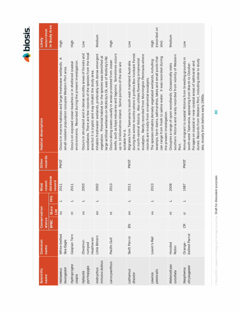
© B
iosi
s 20
15 –
Lea
ders
in E
colo
gy a
nd H
erita
ge C
onsu
lting
D
raft
for d
iscu
ssio
n pu
rpos
es
80
Scie
ntif
ic
nam
e Co
mm
on
nam
e Co
nser
vati
on
stat
us
Mos
t re
cent
da
taba
se
reco
rd
Oth
er
reco
rds
Hab
itat
des
crip
tion
Li
kely
oc
curr
ence
in
Stu
dy A
rea
EPBC
St
ate
List
FF
G
Hal
iaee
tus
leuc
ogas
ter
Whi
te-b
ellie
d Se
a-Ea
gle
vu
L
2011
PM
ST
Occ
urs
in m
arin
e ha
bita
ts a
nd la
rge
fres
hwat
er w
etla
nds.
A
smal
l res
iden
t pop
ulat
ion
occu
pies
Wes
tern
Por
t are
a.
Hig
h
Hyd
ropr
ogne
ca
spia
Ca
spia
n Te
rn
nt
L
2011
Occ
urs
on e
xpos
ed o
cean
bea
ches
or
in s
helte
red
coas
tal
envi
ronm
ents
. Re
cord
ed d
urin
g th
e pr
esen
t inv
estig
atio
n.
Hig
h
Hyl
acol
a py
rrho
pygi
a Ch
estn
ut-
rum
ped
Hea
thw
ren
vu
L
2003
Occ
urs
in s
hrub
land
and
in d
ense
scr
ubby
are
as o
f for
ests
and
w
oodl
ands
. The
re a
re fe
w r
ecor
ds o
f the
spe
cies
from
the
loca
l ar
ea b
ut it
is c
rypt
ic a
nd m
ay in
habi
t the
stu
dy a
rea.
Low
Ixob
rych
us
min
utus
dub
ius
Litt
le B
itter
n
en
L 20
02
In
habi
ts fr
eshw
ater
wet
land
s, p
refe
rabl
y w
ith d
ense
em
erge
nt
vege
tatio
n. P
oten
tial h
abita
t for
the
spec
ies
was
iden
tifie
d at
la
rge
artif
icia
l wet
land
s on
McK
irdy
’s Ck
, eas
t of M
cKir
dy’s
Rd.
Med
ium
Laru
s pa
cific
us
Paci
fic G
ull
nt
2013
Occ
urs
alon
g co
asts
usu
ally
in a
reas
pro
tect
ed fr
om o
cean
sw
ells
, suc
h as
bay
s es
tuar
ies
and
lago
ons.
Som
etim
es o
ccur
s up
to 1
0 ki
lom
etre
s in
land
. So
me
port
ions
of t
he s
ite a
re
suita
ble
for
it.
Hig
h
Lath
amus
di
scol
or
Swift
Par
rot
EN
en
L 20
11
PMST
M
igra
tes
from
Tas
man
ia to
sou
th-e
ast m
ainl
and
Aust
ralia
du
ring
the
win
ter
mon
ths
whe
re it
pre
fers
Box
Iron
bark
For
est
in n
orth
-cen
tral
Vic
tori
a. A
lso
utili
ses
flow
erin
g or
nam
enta
l eu
caly
pts.
Rar
ely
reco
rded
from
Mor
ning
ton
Peni
nsul
a w
here
re
cord
s ar
e m
ostly
from
orn
amen
tal e
ucal
ypts
.
Low
Lew
inia
pe
ctor
alis
Le
win
's R
ail
vu
L
2013
The
spec
ies
inha
bits
den
sely
veg
etat
ed w
etla
nds,
incl
udin
g sw
amps
, far
m d
ams,
sal
tmar
shes
, lak
es a
nd s
mal
l poo
ls th
at
can
rang
e fr
om fr
esh
to s
alin
e w
ater
. It
was
rec
orde
d du
ring
th
e pr
esen
t inv
estig
atio
n.
Hig
h (r
ecor
ded
on
site
)
Mel
anod
ryas
cu
culla
ta
Hoo
ded
Robi
n
nt
L 20
08
O
ccup
ies
a ra
nge
of o
pen
woo
dlan
ds. O
ccas
iona
lly v
isits
so
uthe
rn V
icto
ria
and
rare
ly r
ecor
ded
from
vic
inity
of W
este
rn
Port
.
Med
ium
Neo
phem
a ch
ryso
gast
er
Ora
nge-
belli
ed P
arro
t CR
cr
L
1987
PM
ST
Annu
al m
igra
nt to
coa
stal
Vic
tori
a fr
om b
reed
ing
grou
nds
in
sout
h-w
est T
asm
ania
, app
eari
ng fr
om M
arch
to O
ctob
er.
Fora
ges
on c
oast
al o
r ne
ar-c
oast
al a
reas
of s
altm
arsh
and
du
nes.
Rec
ords
from
Wes
tern
Por
t, in
clud
ing
clos
e to
stu
dy
site
, mos
tly fr
om b
efor
e ea
rly
1990
s.
Low

© B
iosi
s 20
15 –
Lea
ders
in E
colo
gy a
nd H
erita
ge C
onsu
lting
D
raft
for d
iscu
ssio
n pu
rpos
es
81
Scie
ntif
ic
nam
e Co
mm
on
nam
e Co
nser
vati
on
stat
us
Mos
t re
cent
da
taba
se
reco
rd
Oth
er
reco
rds
Hab
itat
des
crip
tion
Li
kely
oc
curr
ence
in
Stu
dy A
rea
EPBC
St
ate
List
FF
G
Neo
phem
a pu
lche
lla
Turq
uois
e Pa
rrot
nt
L 19
82
O
ccup
ies
woo
dlan
ds a
nd o
pen
fore
sts
in th
e fo
othi
lls o
f the
G
reat
Div
idin
g Ra
nge.
Not
res
iden
t on
Mor
ning
ton
Peni
nsul
a an
d ex
trem
ely
rare
ly d
ocum
ente
d fr
om v
icin
ity o
f Wes
tern
Po
rt.
Neg
ligib
le
Nin
ox c
onni
vens
Ba
rkin
g O
wl
en
L
2005
Pref
ers
dry,
ope
n sc
lero
phyl
l for
ests
and
woo
dlan
ds.
Not
re
side
nt o
n M
orni
ngto
n Pe
nins
ula
and
extr
emel
y ra
rely
do
cum
ente
d fr
om v
icin
ity o
f Wes
tern
Por
t.
Neg
ligib
le
Nin
ox s
tren
ua
Pow
erfu
l Ow
l
vu
L 20
13
Pr
efer
s ta
ll op
en s
cler
ophy
ll fo
rest
and
woo
dlan
ds.
Not
re
side
nt o
n M
orni
ngto
n Pe
nins
ula
and
extr
emel
y ra
rely
do
cum
ente
d fr
om v
icin
ity o
f Wes
tern
Por
t.
Neg
ligib
le
Nyc
ticor
ax
cale
doni
cus
hilli
i N
anke
en
Nig
ht H
eron
nt
20
13
O
ccup
ies
a w
ide
rang
e of
wet
land
s an
d ty
pica
lly p
refe
rs th
e sh
allo
ws
of w
etla
nds
for
fora
ging
act
iviti
es.
The
spec
ies
has
been
rec
ently
rec
orde
d in
the
stud
y ar
ea.
As p
er
DEL
WP’
s ha
bita
t O
xyur
a au
stra
lis
Blue
-bill
ed
Duc
k
en
L 20
13
U
sual
ly fo
und
on d
ense
ly v
eget
ated
fres
hwat
er w
etla
nds,
in
clud
ing
Mel
aleu
ca s
wam
ps. A
ppro
pria
te h
abita
t for
the
spec
ies
was
iden
tifie
d at
larg
e ar
tific
ial w
etla
nds
on M
cKir
dy’s
Ck, e
ast o
f McK
irdy
’s Rd
.
Hig
h
Pezo
poru
s w
allic
us
Gro
und
Parr
ot
en
L
1845
Occ
urs
in h
eath
land
, sed
gela
nd o
r bu
tton
gras
s pl
ains
of e
ast
Gip
psla
nd, W
ilson
's P
rom
onto
ry a
nd fa
r w
este
rn V
icto
ria.
No
reco
rds
or s
uita
ble
habi
tats
nea
r W
este
rn P
ort.
Neg
ligib
le
Phal
acro
cora
x va
rius
Pied
Co
rmor
ant
nt
2011
The
spec
ies
is d
istr
ibut
ed a
long
the
Vict
oria
n co
ast.
It w
as
reco
rded
from
cro
wn
coas
tal l
and
near
the
Esso
faci
lity.
It i
s lik
ely
to u
se th
e en
tire
coas
tal f
ring
e of
the
stud
y ar
ea.
Hig
h (r
ecor
ded
on
site
) Pl
atal
ea re
gia
Roya
l Sp
oonb
ill
vu
2013
Use
s sh
allo
w fr
eshw
ater
wet
land
s an
d co
asta
l hab
itats
suc
h as
es
tuar
ies,
inle
ts a
nd in
tert
idal
mud
flats
. It
was
rec
orde
d du
ring
th
e pr
esen
t inv
estig
atio
n.
As p
er
DEL
WP’
s ha
bita
t mod
el
Pleg
adis
fa
lcin
ellu
s G
loss
y Ib
is
nt
2006
Glo
ssy
Ibis
are
usu
ally
foun
d fo
ragi
ng in
wet
pas
ture
en
viro
nmen
ts a
nd lo
w ly
ing
wet
land
are
as.
This
spe
cies
is o
nly
rare
ly r
ecor
ded
in V
icto
ria.
As p
er
DEL
WP’
s ha
bita
t mod
el
Pom
atos
tom
us
tem
pora
lis
Gre
y-cr
owne
d Ba
bble
r
en
L 20
00
Ty
pica
lly o
ccup
ies
open
fore
sts
and
woo
dlan
ds. V
icto
rian
po
pula
tion
is n
ow la
rgel
y co
nfin
ed to
are
as n
orth
of t
he G
reat
D
ivid
ing
Rang
e. A
form
er p
opul
atio
n on
Mor
ning
ton
Peni
nsul
a is
con
side
red
to b
e ex
tinct
sin
ce a
ppro
xim
atel
y 20
00.
Neg
ligib
le
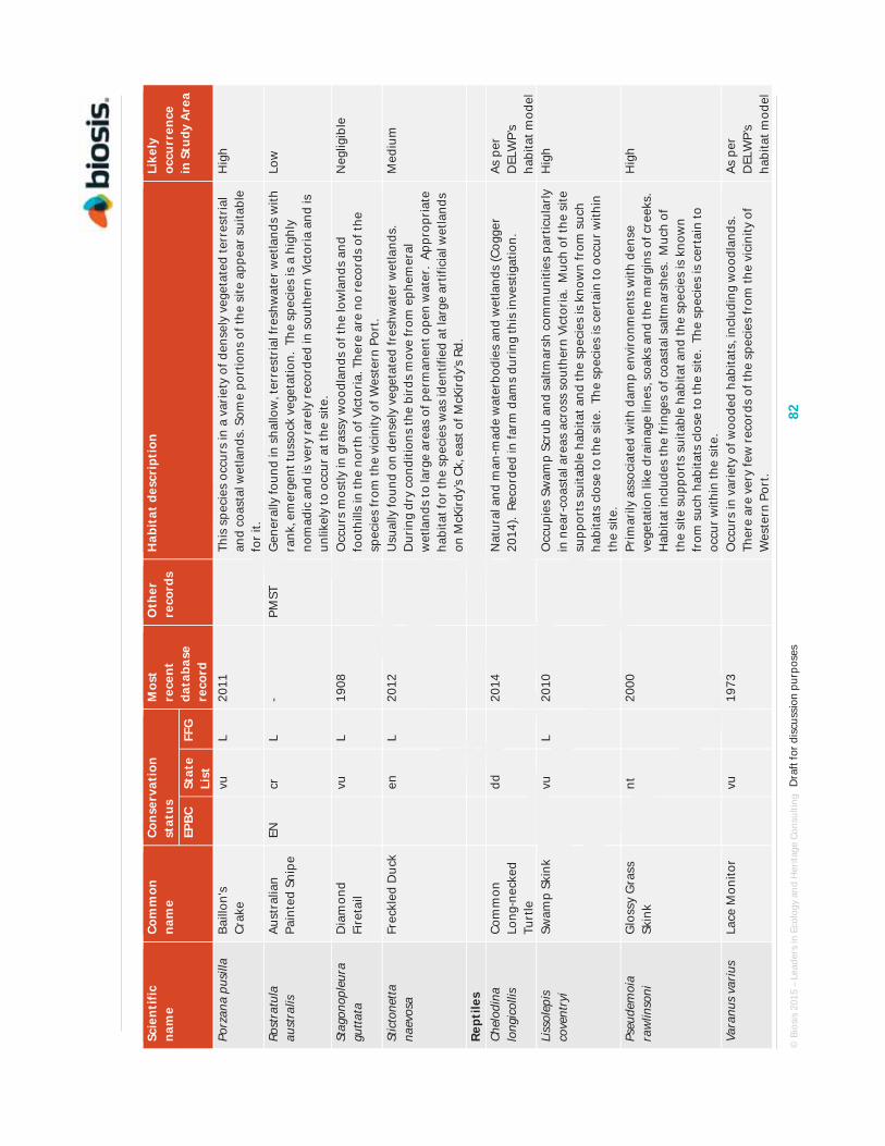
© B
iosi
s 20
15 –
Lea
ders
in E
colo
gy a
nd H
erita
ge C
onsu
lting
D
raft
for d
iscu
ssio
n pu
rpos
es
82
Scie
ntif
ic
nam
e Co
mm
on
nam
e Co
nser
vati
on
stat
us
Mos
t re
cent
da
taba
se
reco
rd
Oth
er
reco
rds
Hab
itat
des
crip
tion
Li
kely
oc
curr
ence
in
Stu
dy A
rea
EPBC
St
ate
List
FF
G
Porz
ana
pusi
lla
Baill
on's
Cr
ake
vu
L
2011
This
spe
cies
occ
urs
in a
var
iety
of d
ense
ly v
eget
ated
terr
estr
ial
and
coas
tal w
etla
nds.
Som
e po
rtio
ns o
f the
site
app
ear
suita
ble
for
it.
Hig
h
Rost
ratu
la
aust
ralis
Au
stra
lian
Pain
ted
Snip
e EN
cr
L
- PM
ST
Gen
eral
ly fo
und
in s
hallo
w, t
erre
stri
al fr
eshw
ater
wet
land
s w
ith
rank
, em
erge
nt tu
ssoc
k ve
geta
tion.
The
spe
cies
is a
hig
hly
nom
adic
and
is v
ery
rare
ly r
ecor
ded
in s
outh
ern
Vict
oria
and
is
unlik
ely
to o
ccur
at t
he s
ite.
Low
Stag
onop
leur
a gu
ttata
D
iam
ond
Fire
tail
vu
L
1908
Occ
urs
mos
tly in
gra
ssy
woo
dlan
ds o
f the
low
land
s an
d fo
othi
lls in
the
nort
h of
Vic
tori
a. T
here
are
no
reco
rds
of th
e sp
ecie
s fr
om th
e vi
cini
ty o
f Wes
tern
Por
t.
Neg
ligib
le
Stic
tone
tta
naev
osa
Frec
kled
Duc
k
en
L 20
12
U
sual
ly fo
und
on d
ense
ly v
eget
ated
fres
hwat
er w
etla
nds.
D
urin
g dr
y co
nditi
ons
the
bird
s m
ove
from
eph
emer
al
wet
land
s to
larg
e ar
eas
of p
erm
anen
t ope
n w
ater
. Ap
prop
riat
e ha
bita
t for
the
spec
ies
was
iden
tifie
d at
larg
e ar
tific
ial w
etla
nds
on M
cKir
dy’s
Ck, e
ast o
f McK
irdy
’s Rd
.
Med
ium
Rept
iles
Chel
odin
a lo
ngic
ollis
Co
mm
on
Long
-nec
ked
Turt
le
dd
2014
Nat
ural
and
man
-mad
e w
ater
bodi
es a
nd w
etla
nds
(Cog
ger
2014
). R
ecor
ded
in fa
rm d
ams
duri
ng th
is in
vest
igat
ion.
As
per
D
ELW
P’s
habi
tat m
odel
Li
ssol
epis
co
vent
ryi
Swam
p Sk
ink
vu
L
2010
Occ
upie
s Sw
amp
Scru
b an
d sa
ltmar
sh c
omm
uniti
es p
artic
ular
ly
in n
ear-
coas
tal a
reas
acr
oss
sout
hern
Vic
tori
a. M
uch
of th
e si
te
supp
orts
sui
tabl
e ha
bita
t and
the
spec
ies
is k
now
n fr
om s
uch
habi
tats
clo
se to
the
site
. Th
e sp
ecie
s is
cer
tain
to o
ccur
with
in
the
site
.
Hig
h
Pseu
dem
oia
raw
linso
ni
Glo
ssy
Gra
ss
Skin
k
nt
20
00
Pr
imar
ily a
ssoc
iate
d w
ith d
amp
envi
ronm
ents
with
den
se
vege
tatio
n lik
e dr
aina
ge li
nes,
soa
ks a
nd th
e m
argi
ns o
f cre
eks.
H
abita
t inc
lude
s th
e fr
inge
s of
coa
stal
sal
tmar
shes
. M
uch
of
the
site
sup
port
s su
itabl
e ha
bita
t and
the
spec
ies
is k
now
n fr
om s
uch
habi
tats
clo
se to
the
site
. Th
e sp
ecie
s is
cer
tain
to
occu
r w
ithin
the
site
.
Hig
h
Vara
nus
variu
s La
ce M
onito
r
vu
19
73
O
ccur
s in
var
iety
of w
oode
d ha
bita
ts, i
nclu
ding
woo
dlan
ds.
Ther
e ar
e ve
ry fe
w r
ecor
ds o
f the
spe
cies
from
the
vici
nity
of
Wes
tern
Por
t.
As p
er
DEL
WP’
s ha
bita
t mod
el

© B
iosi
s 20
15 –
Lea
ders
in E
colo
gy a
nd H
erita
ge C
onsu
lting
D
raft
for d
iscu
ssio
n pu
rpos
es
83
Scie
ntif
ic
nam
e Co
mm
on
nam
e Co
nser
vati
on
stat
us
Mos
t re
cent
da
taba
se
reco
rd
Oth
er
reco
rds
Hab
itat
des
crip
tion
Li
kely
oc
curr
ence
in
Stu
dy A
rea
EPBC
St
ate
List
FF
G
Am
phib
ians
Lito
ria
rani
form
is
Gro
wlin
g G
rass
Fro
g VU
en
L
1999
PM
ST
Occ
upie
s a
vari
ety
of p
erm
anen
t and
sem
i-per
man
ent w
ater
bo
dies
gen
eral
ly c
onta
inin
g ab
unda
nt s
ubm
erge
d an
d em
erge
nt v
eget
atio
n (D
EWH
A 20
09b)
. Th
e sp
ecie
s w
as n
ot
dete
cted
by
the
pres
ent i
nves
tigat
ion.
The
re a
re v
ery
few
old
re
cord
s fr
om th
e lo
cal a
rea
and
the
spec
ies
is c
onsi
dere
d un
likel
y to
occ
ur a
t the
site
.
Low
Pseu
doph
ryne
se
mim
arm
orat
a So
uthe
rn
Toad
let
vu
2013
Occ
upie
s a
vari
ety
of h
abita
ts in
sou
th-e
aste
rn A
ustr
alia
, suc
h as
ope
n fo
rest
s, lo
wla
nd w
oodl
ands
and
hea
thla
nds
whe
re
adul
ts s
helte
r be
neat
h le
af li
tter
and
oth
er d
ebri
s in
moi
st
soak
s an
d de
pres
sion
s. M
uch
of th
e si
te s
uppo
rts
suita
ble
habi
tat a
nd th
e sp
ecie
s is
kno
wn
from
suc
h ha
bita
ts c
lose
to
the
site
. Th
e sp
ecie
s is
hig
hly
likel
y to
occ
ur w
ithin
the
site
.
As p
er
DEL
WP’
s ha
bita
t mod
el
Inve
rteb
rate
s
Sy
nem
on p
lana
G
olde
n Su
n M
oth
CR
cr
L -
PMST
Th
is d
iurn
al m
oth
inha
bits
nat
ive
and
som
e in
trod
uced
gr
assl
and
vege
tatio
n co
mm
uniti
es. T
here
are
no
reco
rds
of th
e sp
ecie
s fr
om M
orni
ngto
n Pe
nins
ula
or th
e vi
cini
ty o
f Wes
tern
Po
rt a
nd n
o su
itabl
e ha
bita
t occ
urs
at th
e si
te.
Neg
ligib
le

© Biosis 2015 – Leaders in Ecology and Heritage Consulting Draft for discussion purposes 84
C.3 Migratory species (EPBC Act listed) Table C.3. Migratory fauna species recorded or predicted to occur within 5 km of the study area. N.B. species reliant on marine environments are not included in the present investigation.
Scientific Name Common Name Most recent record
Acrocephalus stentoreus Clamorous Reed Warbler 2013
Apus pacificus Fork-tailed Swift 1986
Bubulcus ibis Cattle Egret 2013
Hirundapus caudacutus White-throated Needletail 2013
Merops ornatus Rainbow Bee-eater 2011
Monarcha melanopsis Black-faced Monarch -
Myiagra cyanoleuca Satin Flycatcher 2013
Rhipidura rufifrons Rufous Fantail 2010

© Biosis 2015 – Leaders in Ecology and Heritage Consulting Draft for discussion purposes 85
Appendix D. Photos

© Biosis 2015 – Leaders in Ecology and Heritage Consulting Draft for discussion purposes 86
Appendix E. Ecology Glossary
Avoid
Avoiding removing any native vegetation when undertaking a use or development. This can be either by not permitting or not going ahead with the use or development, or locating it elsewhere so that removing native vegetation is not required.
Biodiversity
The variety of all life forms, the different plants, animals and microorganisms, the genes they contain, and the ecosystems of which they form a part.
Biodiversity Interactive Map (BIM)
Web based interactive map available on the DSE website that provides information on the biodiversity of Victoria and displays flora and fauna data from the Victorian Biodiversity Atlas.
Bioregion
Biogeographic areas that capture the patterns of ecological characteristics in the landscape or seascape, providing a natural framework for recognising and responding to biodiversity values. A landscape based approach to classifying the land surface using a range of environmental attributes such as climate, geomorphology, lithology and vegetation.
Canopy Tree
Is a mature tree greater than 3 m in height and is normally found in the upper layer of a vegetation type. Immature trees that are not yet able to flower and are less than three metres in height are considered part of the understorey (see definition of understorey).
Condition score
The score assigned to a habitat zone that indicates the quality of the vegetation relative to the ecological vegetation class benchmark, usually expressed as a percentage or on a scale of 0 to 1.
Ecological vegetation class (EVC)
A native vegetation type classified on the basis of a combination of its floristic, life form, environmental and ecological characteristics.
Forb
A herbaceous flowering plant that is not a graminoid (grass, sedge or rush).
General biodiversity equivalence score / units
Score or units used to quantify the relative overall contribution of a site to Victoria’s biodiversity.
General offset
An offset that is required when a proposal to remove native vegetation is not deemed, by application of the specific-general offset test, to have a significant impact on habitat for any rare or threatened species.
Habitat importance map
A map that indicates the importance of locations as habitat for a particular rare or threatened species. This map is based on modelled data.
© Biosis 2015 – Leaders in Ecology and Heritage Consulting Draft for discussion purposes 87
Habitat importance score
Measure of the importance of the habitat located on a site for a particular rare or threatened species.
Habitat zone
A discrete area of native vegetation consisting of a single vegetation type (EVC) within an assumed similar quality. This is the base spatial unit for conducting a Habitat hectare assessment. Separate Vegetation Quality Assessments (or Habitat hectare assessments) are conducted for each habitat zone within the designated assessment area.
Highly localised habitat
Habitat for rare or threatened species whose habitat is spread over a very restricted area (i.e. less than 2,000 ha). This can also be applied to a similarly limited sub-habitat that is disproportionately important for a wide-ranging rare or threatened species.
Incorporated document
A document that is included in the list of incorporated documents in a planning scheme. These documents affect the operation of the planning scheme.
Indigenous vegetation
The type of native vegetation that would have normally been expected to occur on the site prior to European settlement.
Landholder
An owner, occupier, proprietor or holder of land.
Landscape scale information
Mapped or modelled information based on data collected across the landscape rather than just on a particular site.
Listed species
A flora or fauna species listed under the Commonwealth Environment Protection and Biodiversity Act 1999 or listed as threatened under the Victorian Flora and Fauna Guarantee Act 1988.
Local Planning Policy Framework
Framework outlining a Municipal Strategic Statement and the Local Planning Policies that apply to the local government area.
Location risk
The risk that removing native vegetation in a particular location will have an impact on the persistence of a rare or threatened species.
Loss
Loss in the contribution to Victoria’s biodiversity when native vegetation is fully or partially removed, as measured in biodiversity equivalence scores or units.
Minimise
Locating, designing or managing a use or development to reduce the impacts on biodiversity from the removal of native vegetation.
Native (indigenous) vegetation
Native vegetation is plants that are indigenous to Victoria, including trees, shrubs, herbs and grasses (as defined in Clause 72 of the planning scheme).

© Biosis 2015 – Leaders in Ecology and Heritage Consulting Draft for discussion purposes 88
Native vegetation extent
Area of land covered by native vegetation or the number of scattered trees.
Native Vegetation Information Management (NVIM) system
An online tool used to access information about Victoria's native vegetation.
No net loss
An outcome where a particular gain in the contribution to Victoria’s biodiversity is equivalent to an associated loss in the contribution to Victoria’s biodiversity from permitted clearing.
Offset
Protection and management (including revegetation) of native vegetation at a site to generate a gain in the contribution that native vegetation makes to Victoria’s biodiversity. An offset is used to compensate for the loss to Victoria’s biodiversity from the removal of native vegetation.
Offset Management Plan (OMP)
A document which sets out the requirements for establishment, protection and management of an offset site.
On-site offset
An offset located on the same property as the clearing.
Particular Provisions
Provisions in the Victoria Planning Provisions that relate to specific activities (for example, native vegetation is a Particular Provision).
Patch (see Remnant Patch)
Permit
A legal document that gives permission for a use or development on a particular piece of land.
Perennial
A plant that lives for more than two years. Perennials include species that are always visible e.g. shrubs and trees, but also include species that are not always visible above ground.
Permitted clearing
Removal of native vegetation for which a planning permit has been granted to remove native vegetation.
Permitted clearing regulations
The rules in the planning system that regulate permits for the removal of native vegetation.
Planning provisions – See Victoria Planning Provisions.
Planning scheme
Policies and provisions for the use, development and protection of land in a local government area.
Planning system
Victoria’s land-use planning system that includes the Victoria Planning Provisions and each local government’s planning scheme.
Protected species
A flora species protected under the Victorian Flora and Fauna Guarantee Act 1988.

© Biosis 2015 – Leaders in Ecology and Heritage Consulting Draft for discussion purposes 89
Rare or threatened species
A species that is listed in:
State Advisory List of Rare or Threatened Plants in Victoria as ‘endangered’, ‘vulnerable’, or ‘rare’, but does not include the ‘poorly known’ category
State Advisory List of Threatened Vertebrate Fauna in Victoria as ‘critically endangered’, ‘endangered’ or ‘vulnerable’, but does not include ‘near threatened’ or ‘data deficient’ categories
State Advisory List of Threatened Invertebrate Fauna in Victoria as ‘critically endangered’, ‘endangered’ or ‘vulnerable’, but does not include ‘near threatened’ or ‘data deficient’ categories.
Referral authority
An authority that a permit application is referred to for decision under Section 55 of the Planning and Environment Act 1987. All referral requirements are specified in Clause 66 of planning schemes.
Remnant patch of native vegetation
Either:
an area of native vegetation , with or without trees, where at least 25 per cent of the total perennial understorey plant cover is native plants
an area with three or more indigenous canopy trees where the tree canopy cover is at least 20 per cent.
Remnant vegetation
Native vegetation that is established or has regenerated on a largely natural landform. The species present are those normally expected in that vegetation community. Largely natural landforms may have been subject to some past surface disturbance such as some clearing or cultivation (or even the activities of the nineteenth century gold rushes) but do not include man-made structures such as dam walls and quarry floors.
Responsible authority
The authority charged with the responsibility for administering and enforcing particular aspects of a planning scheme.
Scattered tree
An indigenous canopy tree that does not form part of a remnant patch of native vegetation (see definition of remnant patch of native vegetation).
sp.
Species (one species).
spp.
Species (more than one species).
spp. agg.
Species aggregate
Specific biodiversity equivalence score / units
With reference to a specific species, a score or units used to quantify the relative contribution of a site to Victoria’s biodiversity.

© Biosis 2015 – Leaders in Ecology and Heritage Consulting Draft for discussion purposes 90
Specific offset
If the removal of native vegetation has a significant impact on habitat for a specific rare or threatened species, offsets must compensate for the removal of that particular species' habitat. This is referred to as a specific offset.
State Planning Policy Framework
A collection of clauses in the Victoria Planning Provisions that inform planning authorities and responsible authorities of those aspects of state planning policy which they are to take into account and give effect to in planning and administering their respective areas.
Strategic biodiversity map
A map that shows the relative value of a location in the landscape with regard to its condition, extent, connectivity and the support function it plays for species. The map is based on modelled data.
Strategic biodiversity score
A score that quantifies the relative value of a location in the landscape with regard to its condition, extent, connectivity and the support function it plays for species.
Taxon (plural taxa)
A term used to describe any taxonomic unit. This term is typically used when referring broadly to any scientifically recognised species, subspecies or variety.
Third-party offset
An offset located on a property owned by a person other than the landowner who incurs the native vegetation loss being offset.
Understorey
Understorey is all vegetation other than mature canopy trees – includes immature trees, shrubs, grasses, herbs, mosses, lichens and soil crust. It does not include dead plant material that is not attached to a living plant. More information on understorey life forms is set out in the Vegetation Quality Assessment Manual (DSE 2004).
Victoria Planning Provisions
A list of planning provisions that provides a standard template for individual planning schemes.
Zone
A zone in the Victoria Planning Provisions is a set of permitted uses of land which are defined spatially.