POPULATION MOBILITY MAPPING (PMM) SOUTH SUDAN: …
10
POPULATION MOBILITY MAPPING (PMM) SOUTH SUDAN: EBOLA VIRUS DISEASE (EVD) PREPAREDNESS
Transcript of POPULATION MOBILITY MAPPING (PMM) SOUTH SUDAN: …
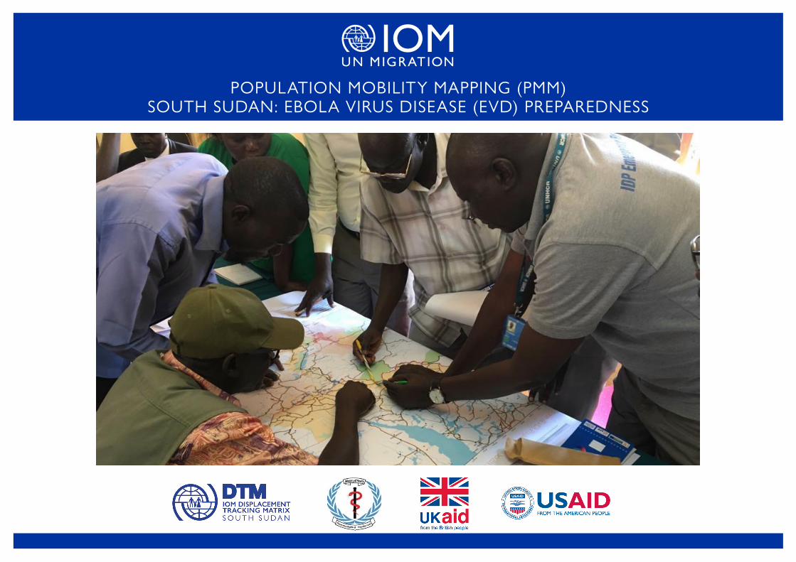
POPULATION MOBILITY MAPPING (PMM) SOUTH SUDAN: EBOLA VIRUS DISEASE (EVD) PREPAREDNESS

The tenth EVD outbreak in the Democratic Republic of Congo (DRC) is still ongoing, with a total of 3,428 EVD cases reported as of 2 February 2020, including 3,305 confirmed and 123 probable cases. A total of 2,250 deaths have been reported, with a case fatality ratio of 65.6 per cent. Although the rate of new cases in DRC has decreased and stabilized, two health zones reported 25 new confirmed cases within the 21-day period from 13 January to 2 February 2019: Beni (n=18) and Mabalako (n=7).1
The EVD outbreak in DRC is the second largest in history and is affecting the north-eastern provinces of the country, which border Uganda, Rwanda and South Sudan. South Sudan, labeled a 'priority 1' preparedness country, has continued to scale up preparedeness efforts since the outbreak was confirmed in Kasese district in South Western Uganda on 11 June 2019 and in Ariwara, DRC (70km from the South Sudan border) on 30 June 2019. South Sudan remains at risk while there is active transmission in DRC, due to cross-border population movements and a weak health system. To support South Sudan’s Ministry of Health and other partners in their planning for EVD preparedness, the International Organization for Migration (IOM) has applied its Population Mobility Mapping (PMM) approach to inform the prioritization of locations for preparedness activities.
Aim and Objectives
The aim of PMM in South Sudan is to inform the 2020 EVD National Preparedness Plan by providing partners with relevant information on population mobility and cross-border movements. More broadly, it aims to improve prevention, detection and response to the spread of infectious diseases through an improved understanding of prevailing human mobility patterns. The specific objectives of this exercise are:
• Provide information on the dynamics and characteristics of mobility between DRC, particularly EVD-affected areas, other countries at risk of EVD transmission and South Sudan to help prevent and detect the potential spread of EVD to South Sudan
• Identify priority locations in high risk areas, for the implementation of public health emergency preparedness measures.
PMM FOR EVD PREPAREDNESS IN SOUTH SUDAN 2
CONTEXT
1Ebola Virus Disease Democratic Republic of Congo, WHO External Situation Report 78, 04 February 2020
APPROACHIn collaboration, IOM’s Displacement Tracking Matrix (DTM) and Migration Health teams rolled out PMM in South Sudan in two stages:
1. Population Flow Monitoring: As part of IOM’s EVD preparedness activities, DTM has been operating 26 Flow Monitoring Points (FMPs) on the borders with DRC, Uganda and the Central African Republic. Enumerators at the FMPs conduct anonymous, voluntary surveys with all passing travellers to capture daily information on the number of travellers, their areas of departure and destination, the respective length of stay / intended length of stay, reasons for travelling, demographic profiles and vulnerabilities. Individuals travelling together are surveyed as a group, which usually corresponds to the household. DTM has been producing monthly EVD-dedicated flow monitoring dashboards since January 2019. The findings presented in this report cover the period of 1 January to 31 October 2019.
2. Participatory Mapping Exercises (PMEs): IOM, in coordination with South Sudan's Ministry of Health, carried out two PMEs in South Sudan to complement flow monitoring results and inform preparedness activities. The participatory mapping approach involves collecting information from key informants through facilitated group discussions. The current methodology draws from IOM’s past experience in participatory mobility mapping, specifically for preparedness and response efforts in the context of epidemics in West Africa, DRC and its neighboring countries, and is the result of a collaboration between IOM and the World Health Organization (WHO).
Key informants were identified collaboratively by South Sudan's Ministry of Health and IOM based on their knowledge of population mobility, public health and, more generally, their knowledge with respect to the area of assessment. The key informants were selected among local government authorities, immigration personnel, representatives of the formal and informal economic sector, the health and education sector, local communities and community leaders. IOM facilitated two PMEs in South Sudan:
• National-level exercise for currently designated high-risk states ( Juba, 3 December 2019) to validate and complement flow monitoring data on mobility dynamics in the assessment area and identify high priority locations, i.e. key transit and destination hubs, such as cities, towns and villages, where travelers interact with each other and the local community
• Exercise for Yei River State (Yei, 5 December 2019) to validate and complement flow monitoring data on mobility dynamics in the assessment area, re-prioritize points of entry (POEs), collect information on health facilities in closest proximity to prioritized POEs and identify key points of congregation, namely gathering places within a community, such as markets, places of worship, health facilities, among others, where travelers interact with each other and the local community

Overall Movements
• Between 1 January and 31 October 2019, a total of 254,313 individuals were surveyed at a total of 26 EVD-dedicated FMPs
• 63.5 per cent of respondents came from Uganda (n=161,464 individuals), 33.5 per cent came from DRC (n=85,242 individuals), while 1.64 per cent came from Kenya and 1.34 per cent came from Central African Republic
• 30.3 per cent of respondents were travelling for economic reasons, while 13.7 per cent of respondents were travelling for healthcare
• 22 per cent of those surveyed were coming from displacement camps
• Most movement is circular, with 80.2 per cent of respondents intending to travel for a week or less
Movements from Affected Areas
• Between 1 January and 31 October 2019, only 0.19 per cent of all surveyed individuals came from territories in DRC (level 2 administrative subdivision) affected by EVD over the course of the current outbreak or from Kasese district in Uganda (n=489 individuals)
• Of those coming from affected areas, nearly 77 per cent were travelling for economic reasons, while only 3.3 per cent were travelling for healthcare
• No respondents from affected areas came from displacement camps
• Most movement from affected areas is circular, with 70 per cent of respondents intending to travel for a week or less
• Key departure locations for these respondents included Kasese, Ariwara and Bunia, while key destination payams included Yambio in Western Equatoria, Gulumbi (Morobo County) and Juba in Central Equatoria
• The most common routes among these respondents were Ariwara-Yambio (20.4%, n=100 individuals) and Bunia-Gulumbi (18%, n=88 individuals)
Geographical distribution of at-risk flows
• Figures 3-6 show the geographical distribution of overall incoming flows to the three high-risk states (Eastern, Central and Western Equatoria) (figure 3), flows from EVD-affected areas including Kasese district in Uganda (figure 4) and incoming flows by individuals seeking healthcare in South Sudan (figures 5-6) through borders with countries at risk of EVD. Darker areas in the figures indicate higher flows.
• The figures, which are based on data for 1 January – 31 October 2019, are monthly projections of the number of individual movements for each type of flow weighted by the number of days each FMP had been active2 during the period. While this represents an approximation, assuming constant flows over the period of inactivity, it provides a more accurate picture than total (un-weighted) surveyed flows in that it avoids underrepresenting flows through FMPs that were activated later or suffered operational interruptions.
PMM FOR EVD PREPAREDNESS IN SOUTH SUDAN 3
POPULATION FLOW MONITORING: Findings
2Active days are considered to be days in which at least one interview was carried out at the Flow Monitoring Point
Figure 2. Departure territories (DRC and Kasese district in Uganda) and intended destination payams (South Sudan) for all surveyed individuals from affected areas. Most common routes are highlighted.
Bunia
Kasese
Goma
Irumu
Ariwara
Beselia
Gulumbi
Muniki
Yambio
Juba
Other
Yei Town
LiwoloKimba
Kator
Rejaf
Nimule
Tambura
Mambasa
Djugu
Departure Intended Destination
Figure 1. Countries of departure for all surveyed individuals
Uganda
DRC
Kenya

POPULATION FLOW MONITORING: Movements by Areas of Destination (Overall and from Affected Territories)January – October 2019
Figure 3. Projected monthly flows by areas of destination from all areas of origin, based on Flow Monitoring Registry surveys conducted during the period 1 January - 31 October 2019 © IOM 2019
Figure 4. Projected monthly flows by areas of destination from all EVD-affected territories, based on Flow Monitoring Registry surveys conducted during the period 1 January - 31 October 2019 © IOM 2019
PMM FOR EVD PREPAREDNESS IN SOUTH SUDAN 4
Flow Monitoring Point
Number of incoming individuals
This map is for illustration purposes only. The boundaries and names shown and the designations used on this map do not imply official endorsement or acceptance by the International Organization for Migration. Source: DTM
Flow Monitoring PointNumber of incoming individualsfrom affected areas
This map is for illustration purposes only. The boundaries and names shown and the designations used on this map do not imply official endorsement or acceptance by the International Organization for Migration. Source: DTM

POPULATION FLOW MONITORING: Movements by Areas of Destination and Reason for Movement (Healthcare-seeking Behavior)January – October 2019
Figure 5. Projected monthly flows by areas of destination for travellers seeking healthcare from all areas of origin, based on Flow Monitoring Registry surveys conducted during the period 1 January - 31 October 2019 © IOM 2019
Figure 6. Travel for healthcare as share of projected monthly flows by areas of destination, based on Flow Monitoring Registry surveys conducted during the period 1 January - 31 October 2019 © IOM 2019
PMM FOR EVD PREPAREDNESS IN SOUTH SUDAN 5
Flow Monitoring Point
Number of incoming individuals for Healthcare
This map is for illustration purposes only. The boundaries and names shown and the designations used on this map do not imply official endorsement or acceptance by the International Organization for Migration. Source: DTM
Flow Monitoring PointShare of incoming individuals for Healthcare
This map is for illustration purposes only. The boundaries and names shown and the designations used on this map do not imply official endorsement or acceptance by the International Organization for Migration. Source: DTM
National-level Participatory Mapping Exercise: Juba, 3 December 2019
Number of participants: 19
Profiles of participants:
• County commissioners
• Ministry of Health representative
• Humanitarian and development partners3
Objectives:
• Validate and complement flow monitoring data on mobility dynamics in the high risk states
• Identify high priority locations in the high risk states based on prevailing human mobility patterns and connections with DRC
High priority locations
The following high priority locations identified in the national-level PME are key transit and destination hubs, such as cities, towns and villages, where travelers interact with stationary, local communities.
1. Morobo: Morobo town and the surrounding villages witness important circular flows by South Sudanese refugees living in cross-border host communities in DRC and Uganda, who return to Morobo on a daily or weekly basis to access healthcare, for primary education and to engage in commercial and other livelihood activities. Transit flows are primarily from Koboko (Uganda) and sometimes Aru and Ariwara territories in DRC to Yei Town. Trucks operating between Koboko and Aru and Ariwara territories in DRC cross Morobo County between Kaya and Bazi.
2. Yei: As the capital of Yei River State, Yei Town is an important destination for healthcare and refugee movements, as well as commercial movements from both DRC and Uganda. It is a key transit point for longer-distance movements to Tore, Maridi, Lainya and Juba for commercial and healthcare purposes, though movements from DRC to Yei are primarily short-distance movements from nearby localities rather than long-distance movements from affected areas close to the epicenter of the current outbreak. Yei is also linked to Rasolo, a crossing point to the Garamba National Park in DRC commonly used for hunting and bush meat trading.
3. Yambio: Yambio is a growing urban center and important regional commercial center with a large market. Long-distance movements, especially by truck, link areas in Uganda and DRC (including Ariwara) with Yambio.
PMM FOR EVD PREPAREDNESS IN SOUTH SUDAN 6
PARTICIPATORY MAPPING OF POPULATION MOBILITY: Findings
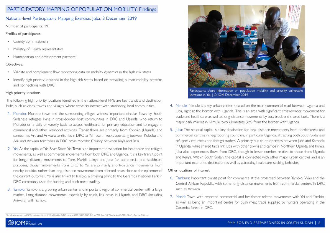
Participants share information on population mobility and priority vulnerable locations in Yei. | © IOM December 2019
4. Nimule: Nimule is a key urban center located on the main commercial road between Uganda and Juba, right at the border with Uganda. This is an area with significant cross-border movement for trade and healthcare, as well as long-distance movements by bus, truck and shared taxis. There is a major daily market in Nimule, two kilometres (km) from the border with Uganda.
5. Juba: The national capital is a key destination for long-distance movements from border areas and commercial centres in neighbouring countries, in particular Uganda, attracting both South Sudanese refugees / returnees and foreign traders. A primary bus route operates between Juba and Kampala in Uganda, while shared taxis link Juba with other towns and camps in Northern Uganda and Kenya. Juba also experiences flows from DRC, though in lesser number relative to those from Uganda and Kenya. Within South Sudan, the capital is connected with other major urban centres and is an important economic destination as well as attracting healthcare-seeking behavior.
Other locations of interest
6. Tambura: Important transit point for commerce at the crossroad between Yambio, Wau and the Central African Republic, with some long-distance movements from commercial centers in DRC such as Ariwara.
7. Maridi: Town with reported commercial and healthcare related movements with Yei and Yambio, as well as being an important centre for bush meat trade supplied by hunters operating in the Garamba forest in DRC.
3The following agencies and NGOs participated to the PME held in Juba: EVD Secretariat, CDC, WHO, DFID, OCHA, WFP, CordAid, World Vision, CUAMM, REACH, Save the Children.

PMM FOR EVD PREPAREDNESS IN SOUTH SUDAN 7
Yei River State Participatory Mapping Exercise: Yei, 5 December 2019
Number of participants: 43
Profiles of participants:
• County commissioners
• Paramount and Head chiefs
• Health workers
• Community representatives (including representatives from the boda boda association, women’s association and media representatives)
• Humanitarian and development partners
Objectives:
• Validate and complement flow monitoring data on mobility dynamics in Yei River State
• Identify high priority POEs and points of congregation in Yei River State based on their connections with DRC, particularly outbreak affected areas, and the volume of population flows at these points
High priority Points of Entry in Yei River State
Name of POE
County Name
Connections with DRC/outbreak af-fected areas
Flow of Travellers
Average Num-ber of Weekly
Screenings4
Nearest Health Facility
Distance from PoE
Salia Musala Morobo High High 3,642 Kaya PHCC 8 km
Okaba Morobo High High 1,447 Morobo PHCC
0.25 km
Bazi Morobo High High 1,514 Rodoba PHCU
0.5 km
Kaya Morobo High High 3,399 Kaya PHCC 1 km
Lasu (Libogo) Yei High Low 79 Lasu PHCC 1 km
Tokori Yei High Low 114 Tokori PHCU
0.25 km
In addition to the above POEs, Nyei village in Morobo county was identified as an important conver-gence point for travellers moving on secondary roads (known as "panya") from across the border in DRC to other destinations. It is in close proximity to the former POE in Isebi and sees heavy flows on market days as multiple routes connect through Nyei.
High priority Points of Congregation in Yei River State
Points of congregation are gathering places within a community, where travelers interact with each other and the local community. Participants identified health facilities and markets as key congregation points to target for EVD preparedness, given the cross-border links between DRC and Yei River State for both commmerce and healthcare. While there are no significant connections between EVD affec-ted areas and health facilities in Yei River State, participants noted the importance of prioritizing health facilities given the critical need to rehabilitate/reinforce the capacity of health facilities and considering healthcare-related movements from towns in DRC on the border with South Sudan.
Health facilities:
Name of Health Facility County Name Connections with DRC Flow of Travellers5
Yei Hospital Yei Medium/Low High
Lasu PHCC Yei High High
Tore PHCC Yei Medium/Low High
Tokori/Kirikwa PHCU Yei Medium High
Rodoba PHCU Morobo High High
Morobo PHCC Morobo High High
Lainya PHCC Lainya Low High
Markets:
Name of Market
Connec-tions with
DRC/outbreak affected areas
Flow of Travel-
lers
Market Days Day with Higher Flows
Estimated Volume of Flow (High Flow Day)
Morobo High High Monday, Thursday Monday >1000
Ombasi High High Tuesday, Thursday, Saturday
Saturday >700
Mugwo High High Wednesday, Saturday Saturday 500 – 1000
Mitika High High Wednesday, Saturday Wednesday >600
Udabi High Medium Monday, Saturday Saturday >400
Mapoko High Medium Wednesday, Saturday Saturday 400 – 500
Feedback from PME participants
• Participants at the national level strongly agreed that insights from the exercise will be helpful to inform preparedness measures. A key recommendation is to focus these exercises at the state-level.
• Awareness raising events can complement PMEs in high risk states.4EVD POE screening data, Week 475Average daily volume of patients at each health facility should be verified with South Sudan's Ministry of Health

PARTICIPATORY MAPPING OF POPULATION MOBILITY: Mobility Corridors and High Priority LocationsNational-level ( Juba, December 3, 2019) and Yei River State (Yei, December 5, 2019)
PMM FOR EVD PREPAREDNESS IN SOUTH SUDAN 8
!
!
!
!
!
!
!
!
!
ÔÔÔÔÔÔ
Ô
Ô
ÔÔ
Ô
ÔÔ
Ô
Ô
ÔÔÔÔÔ
Ô
Ô
Ô
Ô
Ô
Ô
Ô
ÔÔÔ
Ô
Ô
Ô
Ô
!
!
!
!
Ô
Ô
Ô
Ô
!
!
!
ÆÆ
Æ
Æ
Æ
ÆÆÆ
ÆÆ
ÆÆ
Æ
Æ
Æ
Æ
Æ Æ
Æ
ÆÆ
Æ
Æ
ÆÆ
ÆÆ
Æ
ÆÆ
Æ
s
s
s
s!
!
!
!
!
!
!
!
!
!
!
!
!
!
!
!
!
!
!
!
!
!
!
!
^
!
!
!
!
-Haut Uele
IturiBas-Uele
Dungu
Faradje
Aru
Watsa
Niangara
Rungu
Poko
MahagiWamba
Mugwo
Udabi
Lujule
Koboko
Yei
Morobo
Kilak
Lamwo
Aruu
Aringa
Aswa
ChuaEast MoyoTerego
Vurra
West Moyo
Madi-Okollo
Koboko
Obongi
Ayivu
Maracha
AgagoJonam
Kitgum Municipality
Yambio Hospital
Nimule Hospital
Dr John Garang Diagnostic Centre
Yei Hospital
Bazue
Ingbokolo
Meri
Nambili
Kaka1&2
Arua
Gulu
Yumbe
Aba
Wamba
Watsa
DunguMangai
Niangara
Aru
Ariwara
Ezo
Ibba
Tali
Juba
ToreTorit
Magwi
Nzara
Ikotos
Kediba
Mundri
Maruka
Maridi
Lainya
Yangiri
Gangura
Tambura
Imehejek
Terakeka
Kajo Keji
Owiny kibul
Uganda
Ezo
BoriPure
Kaya
Kerwa
Busia Lobone
Sakure
Khorijo
Sangua 1
Bangagai
Basukangbi
James Diko
Berigo/Pakire
Maridi airport
Nimule Airstrip
Nimule River port
Gangura
Lasu
Isebi
Tokori
Western Equatoria
Central Equatoria Eastern Equatoria
Lakes JongleiLakes
Juba
Lafon
Yei
Ibba
EzoMaridi
Torit
Yambio
TerekekaNzara
Magwi
Lainya
Mvolo
Mundri West Mundri East
Tambura
Ikotos
Wulu
Kajo-keji
Morobo
Budi
PiborBor South
Bazi
Makpandu
Yei SSRRC
OwinyKibul
Yei Airstrip
Yambio airport
Nimule checkpoint
Juba International Airport
Ethiopia
Uganda
±0 25 50 75 10012.5
Kilometers
!
!
ÆÆ
Æ
Æ
Æ
Æ
Æ
Æ
Æ
! !
KobokoAru
Lujule
Bazue
Kengezi Base
Morobo
Bazi
BusiaOkaba
Salia Musala
IsebiMorobo
Kaya
Ô
Ô
ÆÆ
ÆÆ Æ
ÆÆ
ÆÆÆÆÆ Æ
ÆÆ
Æ
Æ
s
!
!
Dungu
Nzara
Yambio
Sangua 1
James Diko
Yambio airport
Yambio
NzaraBasukangbi
International BoundaryNational Adm 1
National Adm 2
^
!
!
Primary Road
River
Lakes and Ma rshland
Preparedness Priority Level 1
Preparedness Priority Level 2
Affected Health Zones
(DRC)
Number of days since last
reported case
<21
42
>42
Preparedness Priority Levels ! High priority location
Movement for Bush meat/Hunting
Aerial movement (from Kampala)
Long-distance Movements (Truck/Bus)
Refugee Movements (Returns, Healthcare, Family)
Commercial/Trade Movements
County CapitalLarge Town/Locality in Bordering Country
Ô IDP/Refugee Camp
Functional POE
Temporarily Suspended POE
National Capital s
Æ
Æ
Æ
Isolation Unit
Functional
Non-Functional
Unknown
Health Facility Status
Mobility Information Collected Through Participatory MappingAvailable Information/Information Collected from Partners
DRC
Garamba National Park
This map is for illustration purposes only. The boundaries and names shown and the designations used on this mapdo not imply official endorsement or acceptance by the International Organization for Migration.
Source: IOM, WFP, OCHA, WHO, MoH, UNHCR, OSM, Participatory Mapping Exercises (December 3-5, 2019)
Rasolo
Democratic Republic of Congo
!

PARTICIPATORY MAPPING OF POPULATION MOBILITY: High Priority Points of Entry and Congregation in Yei River State
PMM FOR EVD PREPAREDNESS IN SOUTH SUDAN 9
!
!
ÔÔ
Ô
Ô
Ô
ÔÔ
ÔÔ
Ô
Ô
!
Ô
!
!
!
Æ
Æ
Æ
Æ
Æ
ÆÆ
Æ
Æ
Æ
Æ
ÆÆ
Æ
Æ
Æ
Æ
Æ
Æ Æ
Æ
Æ
Æ
Æ
Æ
Æ
Æ
Æ
Æ
Æ
Æ
Æ
Æ
Æ
Æ
Æ
Æ
Æ
Æ
s
!
!!
!
!
!
!
!
! !!!!
!
!!
!
!
!
!!
!
!
!
!!!
!!
!
!
!
!
!
!
!
!
AringaKoboko
Obongi
Maracha Terego
Koboko Municipality
West Moyo
Mugwo
Udabi
LujuleFaradje
Dungu
Aru
Watsa
Haut-Uele
Ituri
Yei Hospital
WUJI PHCU
Rijongu PHCC
NYAGANDO PHCU
YEI RIVER PHCC PARASAK / Barajak (?) PHCU
TORE PHCC
LASU PHCC
LORA PHCUMUGWO PHCC
KIMBA PHCU
GANJI PHCC
KAJIKO PHCU
RWONYI PHCU
OMBASI PHCC
MOROBO PHCC
JAMARA PHCC
BANDAME PHCU
PANYUME PHCU
KK KALA PHCU
KIRIKWAT PHCU
BORI PHCC
KIRIKWA PHCU
RODOBA PHCU
Lainya County Hospital
Bazue
Ingbokolo
Kengezi Base
Meri
Yumbe
Aba
Mangai
Baka
Tore Ueli
Layo
Madi
Lasu
Nyei
Kaya
Nyigo
Arado
Mugwa
Nyori
Kanga
Rasolo
Marawa
LainyaMaradu
Mapoko
Pakula
MitikaGaderuMorsak
Ombasi
Morobo
Gulumbi
Bamurye
New Lasu
Loka West
Tukudungwen
Uganda
Bori
Bazi
Kaya
Kerwa
BusiaOkaba
Khorijo
Salia Musala
Lasu
Isebi
Tokori Central Equatoria
Western Equatoria
Western Equatoria
Yei
Juba
Lainya
Kajo-keji
Morobo
IbbaMaridi
MaridiMundri West
Koboko
Yei SSRRCYei Airstrip
Berigo/Pakire
Ethiopia
Uganda
±0 10 20 30 405
Kilometers
!
Æ
Æ
ÆÆ
Æ
Æ
!
!
!!
AruIturi
Lujule
KIMBA PHCU
MOROBO PHCC
RODOBA PHCU
Kengezi Base
Nyei Morobo
Gulumbi
Bazi
Okaba
Isebi
Central Equatoria
Morobo
This map is for illustration purposes only. The boundaries and names shown and the designations used on this mapdo not imply official endorsement or acceptance by the International Organization for Migration.
! High priority POE/Health Facility
Mobility Information Collected Through Participatory Mapping
International BoundarySouth Sudan Adm 1
South Sudan Adm 2
^
!
!
Primary Road
River
Lakes and Ma rshland
Preparedness Priority Level 1
Preparedness Priority Level 2
Affected Health Zones
(DRC)
Number of days since last
reported case
<21
42
>42
Preparedness Priority LevelsCounty CapitalLarge Town/Locality in Bordering Country
Ô IDP/Refugee Camp
Functional POE
Temporarily Suspended POE
National Capital s
Æ
Æ
Æ
Isolation Unit
Functional
Non-Functional
Unknown
Health Facility Status
Available Information/Information Collected from Partners
M High priority Market
Source: IOM, WFP, OCHA, WHO, MoH, UNHCR, OSM, Participatory Mapping Exercises (December 3-5, 2019)
DRC
Mitika MarketMarket Days: Wednesday, Saturday
Estimated Flow: >600
M
Mapoko MarketMarket Days: Wednesday, Saturday
Estimated Flow: 400 – 500
M
Ombasi MarketMarket Days: Tuesday, Thursday, Saturday
Estimated Flow: >700
M
Udabi MarketMarket Days: Monday, Saturday
Estimated Flow: >400
M
Morobo MarketMarket Days: Monday, Thursday
Estimated Flow: >1000
M
Garamba National Park
Democratic Republic of Congo
Mugwo MarketMarket Days: Wednesday, Saturday
Estimated Flow: 500 – 1000
M
ÆPure
PMM FOR EVD PREPAREDNESS IN SOUTH SUDAN 10
IOM
Feb
ruar
y 20
20
Information from IOM's PMM has been shared with South Sudan's Ministry of Health and preparedness partners to help inform the EVD strategic planning workshop for 2020, held from 11 to 12 December 2019. The results of this exercise contribute to a better understanding of the dynamics and characteristics of population mobility between DRC and South Sudan, and facilitates the prioritization of POEs and congregation points in South Sudan for the implementation of public health measures in line with the International Health Regulations (IHR 2005).
While South Sudan has important cross-border links with DRC associated with trade, healthcare-seeking behaviour and movements of refugees and returnees, no significant long-distance movements from the epicenter of the outbreak in North Kivu province, DRC, have been reported. Movements from affected areas, based on findings from both PMEs and flow monitoring data, are primarily from the nearby locality of Ariwara, in DRC, which reported 1 case in July 20196, and limited movements have been reported from Bunia.
While active transmission remains ongoing in DRC, preparedness measures should continue – and where appropriate be reinforced – in South Sudan at high priority locations, taking into account the risks of transmission associated with population mobility, local capacities and security constraints. Security issues, in particular, pose a challenge to preparedness efforts in South Sudan and constitute a major risk to the response in DRC, complicating efforts to contain the outbreak.
Specific recommendations based on mapping results include:
• Border health and POEs: Six POEs in Yei River State (Salia Musala, Okaba, Bazi, Kaya, Lasu and Tokori) have been prioritized for the implementation of the minimum package for POEs, including surveillance activities and support for appropriate referral mechanisms.
• Infection Prevention and Control/Water, Sanitation and Hygiene (IPC/WASH): Six Markets, six POEs and seven health facilities have been prioritized in Yei River State for consideration by the IPC/WASH technical working group for the reinforcement of WASH interventions. After the phasing out of most POEs during the transition phase, support to the nearby health facilities will be crucial to sustain EVD preparedness efforts and contribute to health system strengthening.
• Risk communication and community engagement: Six POEs and six markets have been prioritized in Yei River State for risk communication and community engagement activities, including hygiene promotion, and will be integrated into existing activities as part of the transition phase.
• Support to health facilities: The functionality of health facilities remains in question and should be verified. The seven health facilities that have been prioritized in Yei River State should be assessed for any required support, and health facilities should be prioritized and assessed for support at the high priority locations identified through the national-level PME. In general, support to health facilities should be prioritized during the transition phase as POEs are phased out and in order to contribute to health system strengthening. This is particularly the case for health facilities that have been receiving support only through EVD preparedness programs.
• Priority cross-border populations: While long-distance movements from DRC are limited, truck drivers have been identified as a priority target population for health screening and risk communication. Yambio (through Gangura POE), Kaya and Nimule are important convergence points for such movements. Since the most common mode of transport for cross-border movements are boda bodas (motorbike taxis), boda boda drivers should also be targeted with risk communication.
Implementation of the above prioritization and recommendations should be conditional on there being appropriate security conditions for preparedness activities. In November 2019 IOM suspended its operations in Lasu and Tokori as a result of access constraints due to a local escalation in the conflict.
CONCLUSION AND RECOMMENDATIONS
International Organization for Migration
New Industrial Area, Northern Bari, Juba, South Sudan+211 912 380 [email protected]
All our products are available on displacement.iom.int/south-sudan For more information, please contact [email protected]
CONTACTS AND PARTNERS
6Ebola Virus Disease Democratic Republic of Congo, WHO External Situation Report 48, 02 July 2019