Poppasquash Farms Historic District - Rhode Island Historical
50
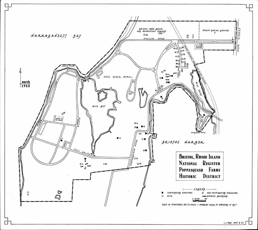
*-r UnitS States Department of the Interior HerJtage Conservation and Recreation Service National Register of Historic Places Inventory-Nomination Form See instructions in How to Complete National Register Forms Type all entries-complete applicablesections -fl.. For HCRS us. only L’- -. **-- - ‘- r,clved $i rç ,dat* entered 1.211 1. Name historic PoppasgiiachFarms Historir Dictrirt and/or common 2. Location Hon. congressional district city,town Bristol 1 state Rhode Island code 44 county Bristol code ooi 3. Classification Category - Ownership Status Present Use .JL district public ..X. occupied agriculture *X museum - buildings .X_ private - unoccupied commercial X park structure - both - work in progress educational 4_ private residence - site Public Acquisition Accessible - entertainment - religious - object - in process yes: restricted - government scientific - being considered - yes: unrestricted industrial transportation - no X_ military other:cemotory 4. Ownel of Property name Multiple, public and private. street & number - city, town - vicinity of state 5. Location of Legal Description courthouse, registryofdeeds.etc. Bristol Town Hall street&number 9 Court Street - clty,town Bristol state Rhode Island 6. Representation in Existing Surveys title Bristol, Rhode Island * has this property been determined elegible? - yes no date 1972-1981 depository for survey records Rhode Island Historical Preservation Commission street & number Between RI. Route 114 and Marrac’ansett R’i’ __not for publication Fernand J. StGermajn city, town Providence state Rhode Island
Transcript of Poppasquash Farms Historic District - Rhode Island Historical

*-r
UnitS States Department of the InteriorHerJtage Conservation and Recreation Service
National Register of Historic PlacesInventory-Nomination FormSee instructions in How to Complete National Register FormsType all entries-complete applicablesections
-fl..
For HCRS us. onlyL’- -. **--
- ‘-
r,clved $i
rç
,dat* entered1.211
1. Name
historicPoppasgiiachFarms HistorirDictrirt
and/or common
2. Location
Hon.congressional districtcity,town Bristol 1
state Rhode Island code 44 county Bristol code ooi3. ClassificationCategory - Ownership Status Present Use.JL district public ..X. occupied agriculture *X museum- buildings .X_ private - unoccupied commercial X park
structure - both - work in progress educational 4_ private residence- site Public Acquisition Accessible - entertainment - religious- object - in process yes: restricted - government scientific
- being considered - yes: unrestricted industrial transportation- no X_ military other:cemotory
4. Ownel of Propertyname Multiple, public and private.
street & number -
city, town - vicinity of state
5. Location of Legal Descriptioncourthouse, registryofdeeds.etc. Bristol Town Hall
street&number 9 Court Street -
clty,town Bristol state Rhode Island
6. Representation in Existing Surveystitle Bristol, Rhode Island * has thispropertybeen determined elegible? - yes no
date 1972-1981
depositoryfor survey records Rhode Island Historical Preservation Commission
street & number Between RI. Route 114 and Marrac’ansett R’i’ __not for publication
Fernand J. StGermajn
city, town Providence state RhodeIsland

Lptionition
- xcellentfgoodfair
1the present and original if known physical appearance
J the PoppasquashFarm Historic District, containing twenty-threestoric buildings, structures, and seven sites, lies at the head ofppasquash Neck, a large penninsula formed by retreating glaciers,futting southwesterly into Narragansett Bay, and defining the northernEnd western- boundaries of Bristol Harbor. Today, nearly ninety percentof the district is in public ownership. Colt State Park, contains fourhundred and sixty-siX acres, including the thirty-four acre Mill Gut and!fifteen acre Mill Pond. The remaining ten percent, approximating fiftyacres, contains the historic buildings rimming the perimeter of Br i stol
Harbor and one mid-twentieth century subdivision of fourteen houses,built just before acquisition of the Colt estate by the State of RhodeIsland in 1965. Only the vision of Colonel Samuel Pomeroy Colt, who
began acquiring the PoppasquashFarms in 1903 with the clear intent of
ceating a public park, prevented this district from intensive residential development. Perhaps nowhere else in Rhode-Island can the publictoday experience the unique interface of land, water, and sky, accentuated by outstanding examples of architecture and sculpture representingeighteenth, nineteenth, and twentieth century life styles that are represented in this district.
Check one Check one- deteriorated - unaltered original site.X_ ruins- unexposed
altered - moved date-
*
The PoppasquashFarms district begins on the north off Hope StreetRoute 114 at the famous Bull Gates map #1 of Colt State Park, createdin 1913 for Colonel Samuel PomeroyColt, by sculptor Isadore Bonbeursee Photo 1. Asylum Road, laid out in 1822 for the Town Poor Farmmap #3 and lined with chestnut trees, runs due west from the gates pastthe North Burial Ground map #2, opened in 1823. A new exit road forColt State Park parallels Asylum Road, which slopes down a gentle hill toa panoramic overlook of the head of BristolHarbor, crosses the Providence,Warren and Bristol Railroad opened in 1855 and now abandoned thensplits southerly into Colt Park Drive, and continues to Bristol Town Beachwhere an expanded town recreation complex map #25 and #26 is under development. Colt Park Drive meanders westerly through open fields accentuatedby formal plantings of rhododendrons, pines, quince and hawthorn bushes.The drive divides at the shore of Narragansett Bay offering a sweepingview westerly across the Bay to the low hills of the west -shore and northerly to the landmark spires of the adjacent towns of Barrington and Warren.To the south an unspoiled landscape is revealed with extensive salt marshes
*leading to tidal Mill Gut, filled with mussel beds and sand bars , and r I minedby old cherry,’s’ycamore, and oak trees. Very little change has come tothis open space since the first proprietors laid out the PoppasquashFarmsfrom 1689 to 1696.
Continuingsouthwesterly, Mill Gut Bridge 1906; map #4, now denuded of its famous classical statuary and closed to automobile traffic,arches over the inlet evoking-a picture of medieval Lombardy see photo2. A modern concrete-and-timber bridge 1967; map #4A, parallels thehistoric span. The park drive continues to North Point, site of the OldNorth Point or Chase Farm, a complex of three houses and five outbuildings,
see continuation sheet #1

t*** 9? * -*4- p * -
HR-8-300k -
1i/8 -- *
* *
UNITED STATES DEPARTMENT OF THE INTERIOR 4;HERITAGE CONSERVATION AND RECREATION SERVICE
NATIONAL REGISTER OF HISTORIC PLACESINVENTORY-- NOMINATION FORM k-
* -tCONTI NUATION SHEET 1 ITEM NUMBER 7 PAGE 2
dating from the eighteenth and nineteenth centuries, demolished bythe Rhode Island Department of Natural Resources after 1965. TheNorth Point overlook, frequented all year long, offers an unexcelledview of Narragansett Bay and chance to experience the endless rhythmof waves breaking on the shore.
The long, elliptical modern park drive continues- south, pastold fields now used for kite-flying, baseball, picnics, games andsunbathing. At the crest of a low hill to the east, eighteenth-century stone walls define an outdoor chapel map #28. Just south ofthe lane leading to the chapel is the site map #5 of Colonel SamuelPomeroy Colt’s famous Casino 1907; demolished 1960s, frequented bymany of the most prominent leaders of the period; all that remains -. --
are broken fragments of two massive Borghese urns that flanked thefront terrace overlooking Narragansett Bay. The drive turns easterlythrough a clump of woods to open meadows and the magnificent Coltdairy barns 1917; map #7, designed by Wallis B. Howe, for ColonelColt’s prize Jersey herd. The barns arenow re-used for park offices Z- -
and maintenance see photo 3. * To the east of the barns, rollingmeadows slope gently down to Mill Gut.
- -
A narrow, treelined section of Colt Drive branches easterly * -
along the old "way from Mazzard Cherry Lane" to Coggeshall Farm map * a.#8, operated by the Coggeshall Farm Museum, Inc., an offshoot of the
____
Bristol Historical and Preservation Society. Original elements include the Coggeshall Farmhouse c.1760 and 1799--a modest, four-bay,mid-eighteenth century dwelling see photo 4; the ruins of a random
___
fieldstone spring house map 118A at the head of Mill Gut, and the * -one-story, stone, well house map #8B, dating from the Colt estateperiod of 1907-1921. RecOnstructed elements include a blacksmithshop map #8C, sheep-pen map #8D, barn map #8E, pottery shedmap #8F, and pole barn map #86. The way continues easterly pastopen fields, defined by rough, post-and-rail fences, past Byfield’stomb map #8H, to meet PoppasquashRoad.
PoppasquashRoad contains a cluster of eighteenth-., nineteenth-,and twentieth-century houses, hugging the shore of Bristol Harborand reflecting changing architectural styles over a two-hundred-yearspan. Four out of five homes built by the Church family from 1770
____
to 1886 survive, with two remaining in family ownership today. PoppasquashRoad runs north from Colt State Park past the site map 119
?
FOR HCRS USE ONLY
RECEIVÜD
DATE ENTERED - - -, -

‘H-$30OA’. .-
* - * -
Y
:ii/f8 -P-- -
*UNITED STATES DEPARTMENT OF THE INTERIORHERITAGE CONSERVATION AND RECREATION SERVICE
NATIONAL REGISTER OF HISTORIC PLACESINVENTORY-- NOMINATION FORM siCONTINUATION SHEET 2 ITEM NUMBER 7 AGE 3
of Major William D’Wolf’s mansion, -"Hey Bonnie Hall" 1808 et seq;
exponent of the Greek Revival style, for one of the great merchantdemolished 1944, designed by Russell Warren, Rhode Island’s leading
___
princes of Bristol see photo 5 . On the west stands the Mervvn
the firm of Church Howe see photo 6, it reproduces the wide gam
___
Clay House 1953; map #11; designed by Wallis B. Howe, a member of
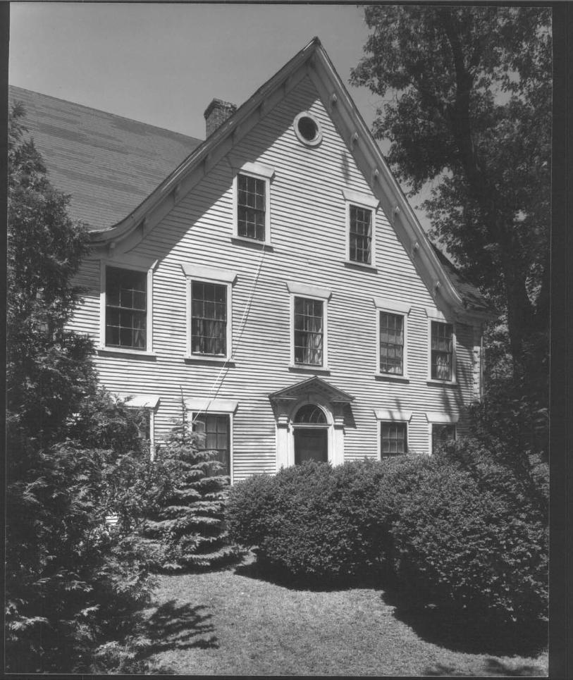
brel ropf form of Nathaniel Byfield’s "Point Pleasant," built in 1690,which stood just south of this district and burned in 1925. At thebend in the -road stands the Stephen Church House c.l790, a fine,Federal, hip-roofed, house Map #15, one of four surviving properties 3built by members of the Church family see photo 7. Next door isthe Colonial, gable-roofed, center-chimney Thomas Manchester Housec.l770; map #16, built on land willed in 1749 by Samuel Vialltohis grand-son, Samuel N. Church see photo 8 . -
The upper section of PoppasquashRoad winds past "Hribor Point"c.l900; remodeled 1954, a gambrel-roofed Queen Anne su,Thmer cottagemap #17 , moved from the -site of the "The Castle" in i,i917 by StephenW. Church and remodeled after the 1938 hurricane by j.ohn W. Church.The Thomas Church Homesteadc.1780 and c.1860 stas on the north
____
side of the road at the end of a short dirt lane mai #19. It isdistinguished by its curving gable-breakinq-gab’ Victorian roof,
____
built over the original gable roof by Samuel ‘‘. Church, who returned
to the family farm in 1854, continuing its iëvelopment into a "model
_____
farm" recognized throughout Rhode Island photo 9. Directly eastare two Late Victorian country houses bui iLt by two of Samuel IV. Clitircli’ sthree sons from 1880 to 1886. Still in r-iurch family ownership, thecomplex of the James C. Church House cv 1886; map #20 and Charles H.Church House c.l880; map #21, with irror-image barns and outbuild
___
- ings map #20A, 20B, 20C and 2lA , se ‘vjc by- a narrow driveway,offers a remarkable image of country ‘ife in the late nineteenth - -
century see photo 10 and 11. 1 .
The PoppasquashiFarms district. ends at W.indui [11 Po I it * now oc -
cupied by ‘‘The Castle’’ restaurant iii’’l 1/22, a Sprawling eomnplex oh-scuring the outline of a private iortt" begUn in the early 1910’s.No sign remains of the site of a 5enteenth-century windmill litiap #23recorded in 1690 as Bristol’s first Fiill, and a later "Spicier Mill "
see photo 12 . To the north of the small bridge, -the Mill Pond,
____
survives, used today only by fisherm41 and for experimental oysterbeds in an attempt to revive a tradit?0l Narragansett Bay industry.PoppasquashRoad continues to interseç busy Hope Street Route 114 ,
FOR HCRS USE ONLY
RECEIVED
DATE ENTERED. - - - -

ILLOA
Map #1
STATES DEPARTMENT OF THE INTERIORHERITAGE CONSERVATION AND RECREATION SERVICE
NATIONAL REGISTER OF HISTORIC PLACESINVENTORY-- NOMINATION FORM
CONTINUATION SHEET 3 ITEM NUMBER 7 PAGE 4
an historic road now serving the needs of modern Bristol
The following Inventory lists contributing and non-contributingstructures and sites within the PoppasquashFarms District:
PoppàsguashFarms IlistoricDistrict
Inventory -
ContributingStructures andSites
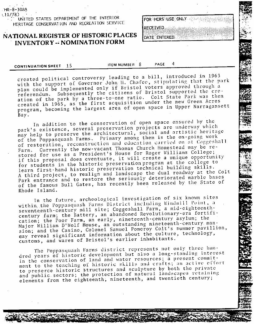
Bull Gates 1913: Two great bronze bulls, each over sixfeet tall and weighing more than a ton, modelled by sculptorIsadore Bonheur and cast in Paris by the Val d’ Onse Company,with bases of White Georgia marble odeled on the sentry boxesat the Petit Trianon, Versialles flank the main entranceto Colt State Park on the west side of Hope Street on the siteof the old North District School House. Dedicated onSeptember 26, 1913, the gates carry the inscription, "Colt
- Farm. Private property, public welcome" See photo 1
Map #2 Rhode Island Uistorica]. Cemetery, Town of Bristol, Number 11822 et seq.: The North Burial ground, bought by the townof Bristol in 1822,- contains gravestones of many prominentBristolians , including the Church, Spooner, Bourn, lierreshioff,and Gooding families. At the north side at the top of aslight knoll is a Civil War monumental column with a Unionsoldier holding a furled flag, erected by the state of RhodeIsland in 1902, surrounded by graves of Civil War veterans.
Site of the Town Asylum 1822, demolished l9SOs. Built byBenjamin Norris of native stone for the town’s "House ofIndustry," Poor Farm, or Asylum, a nine-bay, gable-roofedstructure burned in 1952; the derelict structure and outbuildings were demolished by the early l9SOs.
*Mill Gut Bridge 1906 : This three arch span of rouh granite, the largest private bridge in Rhode Island at date ofconstruction, was originally adorned with five bronze andseven stone statues including Cupid and- Apollo and Venuson the north abutments, the "Maiden of the Bath" and "Dianaof the Bath" and two wild boars copies from originals in
-Map #3
Map #4A
FOR HCRSkJSE ONLY
RECEIVED
DATE ENTERED
S
$
-
- -- - :‘ -

,/HR-8-3-o-QA
. -
.
CONTINUATION SHEET 4 ITEM NUMBER 7 PAGE 5
UNiITED STATES DEPARTMENT OF THE INTERIORHERITAGE CONSERVATION AND RECREATION SERVICE
NATIONAL REGISTER OF HISTORIC PLACESINVENTORY-- NOMINATION FORM
the Vatican on each end of the main arch; and "Diana of theHunt" and "The Gladiator" on the south abutments. Othernearby statues include a bronze dog sitting on a rock and the"Neapolitan Fisher Children," and "Child and Frog" and "Childand Tortoise" on the right and left of a long drive leadingsouth. By 1959 vandalism and defacement forced reinova 1 of the
* statues, and the beloved bronze dog had been stolen. Nostatues exist on the bridge today - - now used for pedestriantraffic only see photo 2
Mill Gut Bridge 1967 This modern, single-span bridge ofconcrete and heavy timber is dedicated to P.F.C. Joseph TV.Borges, U.S.M.C, "first Bristolian who gave his life serving
- his country in Viet Nam, May 6, 1969." Designed to carryautomobile traffic , the bridge is sited parallel to thehistoric Colt Mill Gut Bridge, compromising the integrity ofthe original bridge’s setting.
Stone Marker at Mill Gut 1965: A bronze plaque, set into alarge; rough, boulder carries tile inscription "Colt .State Park,named in honor of Colonel Samuel P. Colt who generously madethis property, his family estate, available for the eilj oymentof the public for over forty years. "Dedicated August 21,1968, John H. Chafee, Governor." This marker, located on aknoll overlooking the saltmarshes and mill gut, just beforeMill Gut Bridge, celebrates the acquisition of the Colt
* Estate, August 3, 1965, as the first purchase ofthe Stateof Rhode Island’s Green Acres Program.
Map #5 Site of "The Casino" c. 1907, demolished 1970s: Originallybuilt for entertaining prominent guests by Colonel SamuelPomeroy Colt, the two and one-half-story, hip-roof, shingledpavillion had extensive porches; it was demo1ihed by theRhode Island Department of Natural Resources for a moremodern recreational facility. Statues of colts, the family
* symbol, and two large Borghese urns flanked the entrance inthe Casino’s heyday. -
Map #6 Site of the Revolutionary Battery 1776-1780: Overgrowndepressions in the earth indicate the approximate locationof a battery on the shore of Narragansett Bay, identifiedby Caleb Harris on, "A Map of the State of Rhode Island,"
Fr:
-p
:‘--- s
11E78
Map #4B
Map #4C

- -HR-8-30&A--
UNITED STATES DEPARTMENT OF THE INTERIOR FOR HCRS USE ONLY - *
HERITAGE CONSERVATION AND RECREATION SERVICE ***-***** ** --
RECEIVED ** ** *
NATIONAL REGISTER OF HISTORIC PLACES DATEENTEREDINVENTORY-- NOMINATION FORM
___________________-
CONTINUATION SHEET 5 ITEM NUMBER 7 PAGE 6
printed in 1795. Future investigation of this site may reveal valuable information about the construction of colonialdefenses along Narragansett Bay during the Revolutionary era.
Map #7 Colt Dairy Barns 1917: Designed by architect iVal Ii s U. Howeto house Colonel Samuel Pomeroy Colt’ s pri Le herd ot’ Jercvcattle. The picturesque and rustic fieldstone barn complexhas a one-and-one-half-story, gable-roofed, steel framed central section with a two-story, ogee-domed towerat the southwest corner to house Colonel Colt’s office and two dramaticlarge silos. Originally the entire complex, including a cowbarn, calf barn, maternity ward, bull pen, and dairy, designed around a spacious courtyard, was roofed with red-glazedpantilles. Due to a fire in the 1930s , the cow barn is todaycovered with red asphalt shingles. Park offices and maintenance facilities are now housed in the Colt barns. A pair ofbronze lions guard the gate see photo 3
Map #8 Coggeshall Farm c. 1750 et. seq.: This simple, one-and-a-half-story, four-bay, gable-roofed, shingle-clad cottage witha large central chimney and one-story eli may have been started
- by Samuel Viall who purchased the land from Samuel Byfieldin 1723. The house and well, "being a few rods northeast Fromthe dwelling house", are specifically mentioned in two deedsof March 8, 1799, from Samuel Viall Peck to Sliearj ashiub Bournalong with the "Way from the Cherry Street Walk Drive" referring to Mazzard Cherry trees, imported and grown in Bristol
* in the eighteenth century. Leased by the Bristol Historicaland Preservation Society from the state since 1968, the farmhouse is today the center of a "Living Farm Museum" of eighteenth-century life, containing several new outbuildings anda small barn and attracting over 30,000 visitors-annually.The name "Coggeshall Farm" refers to the tenant fami lv i’howorked the land from the early l830s. Chandler Coggeshalland his brothers lived at the farm in 1895 and until its ptirchase in 1903 by Samuel Pomeroy Colt. -
Map #9 Site of the William D-’Wolf House or "I-Icy Bonnie Hall"1808; demolished 1944: Russell Warren, leading exponentof the Greek Revival style in Rhode Island, designed thistwo-story, hip-roofed, five -bay mansion w I th Flank lug , hi p -

-- VP
11/78 -- -
___________________________________
- -- UNITED STATES DEPARTMENT OF THE INTERIOR POR HCRS USE ONLYHERITAGE CONSERVATION AND RECREATION SERVICE -
RECEIVED
NATIONAL REGISTER OF HISTORIC PLACES DATE ENTERED.INVENTORY-- NOMINATION FORM
CONTINUATION SHEET 6 ITEM NUMBER 7 PAGE
roofed wings, for William D’Wolf, one of Bristol’s leadingmerchant princes, in 1808. Drawings and photographs of "HeyBonnie Hall," the name given to the mansion by Annie DeWoifMiddleton in 1895 following a long court battle and partitionof major William D’Wolf’-s estate, were published in the WhitePine Series monograph on "The Bristol Renaissance" in 1917.
____
Damage due to the 1938 hurricane/and lack of preservation"awareness" in the l940s resulted in demolition of "HeyBonnie Hall" in 1944; elements of the house and some furnitureare incorporated into a contemporary bungalow erected on thesouthern half of the original eleven-acre site of Maj or 1’Wol f’sHouse.
Map #10 John S. Palmer House 1937: A large-sc:il e , two-story, t:iM e -
roofed, five-bay, Colonial Revival country home with brick,
____
end chimneys, and brick-and-shingle wall cover, was designedby Providence architect Albert Harkness on the northern halfof the D’Wolf estate. The main two-level entrance on thenorth side has a flat-roofed portico supported by round Doriccolumns. The house commands a sweeping view of Bristol Harbor and has a private dock.
Map #11 Mervin Clay House or "Point Pleasant" 1953 : ArchitectWallis E. Howe of the firm of Church and I-lowe, Providence, ‘
designed this replica of "Point Pleasant" for Mervin Clay,secretary of the Bristol Lace Works. The original "PointPleasant," built by Nathaniel Byfield in the late bOOsand willed to Sarah Brown and Carl Frederick Herreshoff by *
her father John Nicholas Brown in 1801. Burned in 1925, itstood just south of the border of the PoppasquashFarms District. The one-and-one-half-story, gambrel-roofed, ColonialRevival, brick country house, with addition of a modern ser- -- -
vice wing and garage, commands a sweeping view northerlyacross meadows to Mill Gut and Narragnasett Bay. Outbuildingsinclude a shed and gambrel-roof play house see photo 6
Map #12 "Red Crest: or Kortwright House, now the Bristol Yacht Club1868, remodeled c. 1955 : Originally this two-story, three-bay, steeply-pitched, hip-roofed house had a hexagonal turret *
_____-
on the east and the three-story, flat-roofed tower with crest- - -
ing on the west side. These elements and a wrap-around porch

i-IR-8-300A - -
11/78 -- -
- ‘- UNITED STATES DEPARTMENT OF THE INTERIORHERITAGE CONSERVATION AND RECREATION SERVICE
NATIONAL REGISTER OF HISTORIC PLACESINVENTORY -- NOMINATION FORM
with currvilinear brackets and projecting central portico wereall removed and first-floor windows altered with conversion toyacht club use in the 1950s.
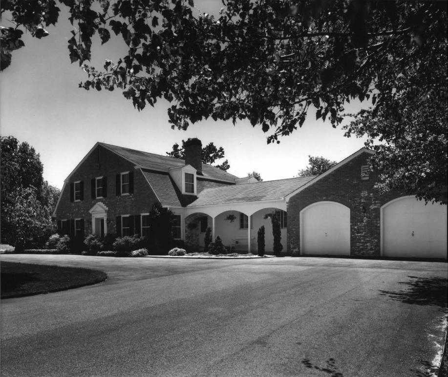
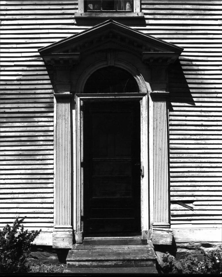
Map #15 Stephen Church House or "Yankee Hearths" c.l790: Thistwo-story, hip-roofed, center-chimney, four-bay, woodclapLboarded house was built by Charles DelVoif, one of Bristol’sleading merchants, shipbuilders and banker, for his daughter;it remained in Church family ownership until purchased bySamuel PomeroyColt in 1904. Modern additions including aswimming pool and field house, two-car garage, and two ohshave not marred the integrity of the original house. Exterior detailing includes .a fine pedimented entry with cli iptical pierced fanlight and arched frame with a center, conLsole block. A well scaled Creek Key Cr ieze surrounds three-sides and handsome quoins trim the corners see photo #7.Outbuildings include the large Early Victorian barn, directlyto the north standing on land leased from Colt State Park.
FOR HCRS’kiSE ONLY
RECEIVED
DATE ENTERED
CONTINUATION SHEET 7 ITEM NUMBER 7 PAGE 8
Map #13 Atlantic Sailing Yachts 1948 et seq.: The main building- is a two- story, shingled struc Lure it Ii a bo-ed - gab te ro
- used for a boatyard with an attached two-story, gable-roofshingled ell used for a clothing and boat shop.
b3A Boat Shed 1948- roof,’ board-and
west end of the
14 Stone Piertending apused todayD.C. Beers
et seq.: A one-story, ten-bay, saw-toothbatten, auxiliary building, located on theboatyard site.
c. l87Os et seq. : This roughproximately eighty feet into Brifor a modern boatyard, appearsMap of is tol , RI rsto 1 Count’.’
stone wharf, cxstol Harbor andon the 1870,
Itliode I s I :tud
‘.:-
I
I
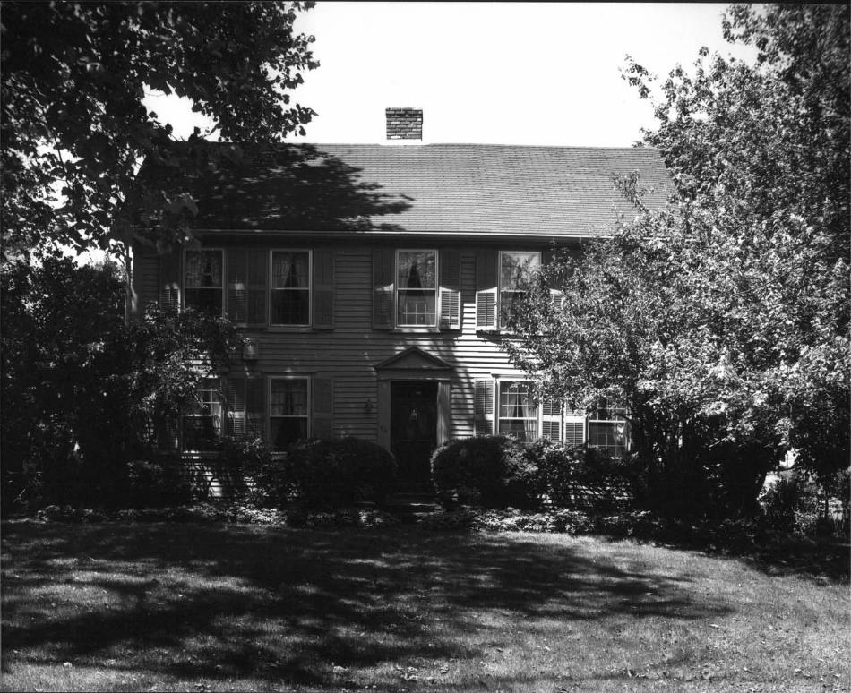
Map #16 Thomas Manchester Mouse c.1770: Thi.s two-story, gable-roofed claphoarded, house wi tli an rregu1arIy -spaced center-chimney, five-bay facade and a replaced front -door frame,was built for one o C the Church family on laud willed bySamuel Viall in June, 1749, to his grandson Samuel Church.The house, today, is in an excellent state of preservation.see photo #8.
-
- 4-:
‘HR-8-30OA - - --
11/78 - . - --
UNITED STATES DEPARTMENT OF THE INTERIOR FOR HCRS USE ONLYHERITAGE CONSERVATION AND RECREATION SERVICE
RECEIVED
NATIONAL REGISTER OF HISTORIC PLACES CE ENTERED- -- IINVENTORY-- NOMINATION FORM - - -
CONTINUATION SHEET 3 1CM NUMBER 7 PAGE
Map #17 Grumont House or "Harbour Point" c.1900, moved 1917; remodeled 1954: This one-and-one-half-story, gambrel roofedQueen Anne summercottage, with a two-story tower on the west
____
side, aitd three patterns of cut shingle wall cover, wasmoved from the site of ‘‘‘the Cast Ic’’ iii I ¶117 by SamtieI IV.Church; robu ii t :1 11cr d;imate c;itised by the I 9-I 1w iii e:-IlIt’
by John IV. Church; and now used for an all year round residence.
Map #18 Site of Samuel IV. Church Ilouse c. 1890; demolished 1971:This two-story, asymmetrical, three-bay, Late Victorian house,with a complex hip roof trimmed with a shaped-block cornice
____
and front porch facing Bristol Harbor, was built by one ofSamuel IV. Church’s three sons, and later known as theTvheelwright House. The Rhode Island Department of Natural - -
Resources demolishedthe house in 1971; vandals burned thebarn in 1979. -
j:’ -‘:.‘
Map #19 Thomas TV. Church House c.1790/c.l860: This two-and-one-half-story, five-bay house with a steeply pitched, curving,gable-breaking-gable, Victorian roof di splay lug pa i red
_____
Victorian bracket and heavy returns, built over the original- colonial roof, was built by Thomas IV. Church who served in
the Revolution and died in 1843. Ills son, Samuel IV. Church, -
a successful merchant and one of the incorporators of theProvidence, Warren and Bristol Railroad, returned to thefamily homesteadwith eleven children to develop this "modelfarm." Changes in the house probably took place followinghis second marriage in 1853. - - -
Nap #20 James C.- Church House c.l886: This two-story three-bay,Late Victorian house, with a gable-on-hip with intersecting-front-gable roof, was built by James C. Church, one of Samuel -
TV. Church’s three sons; a two-story barn repeats the basic- form of the house. Detailing includes a full front porch
- with triangular brac-kets accented by a cut-out circularpattern and dentil frieze under the cornice. The house remains today in Church family ownership see photo #10.
Map #21 Charles H. Church House c.1880: This two-story, LateVictorian, L-shaped country villa with a main gable roof andgabled projection punctured by multiple, triangular dormers

- . - --
HR-8-3U0A11/78 - - - -
-
UNITED STATES DEPARTMENT OF THE INTERIORFOR HCRS USE ONLY
HERITAGE CONSERVATION AND RECREATION SERVICERECEIVED
NATIONAL REGISTER OF HISTORIC PLACES DATE ENTEREDINVENTORY-- NOMINATION FORM - - ---.::----- :---::v- -
CONTINUATION SHEET 9 ITEM NUMBER 7 PAGE 10
with bargeboard and finials, was built for one of Samuel IV.Church’s sons. Original details include a compound front door
- with etched-glass panels in a floral pattern and the wrap-around porch now screened accented by strap-work bracketswith chamfered edges supporting a saw-tooth frieze and rowof dentils. Set back from the James C. Church House and serviced by a-common driveway. This house is also owned by members of the Church family see photo 11 . - -‘ --
Map #23 Windmill Point Site 1690-mid 19th century. Now abandoned,the Point was the site of a very early, possibly 17th-centurywater mill and the Spider i’lill, illustrated in a handwritten
_____
book "My Winter Morning Walk" poem by Eliza DelVolf Vernon,illustrated by Martha Gibbs French and published in 1846.see photo #12. - -t
PoppasquashFarms HistoricDistrict
Noncontributingstructures:
Map #22 The Castle c.1920; renovated: This two-story, castle--like complex, originally was begun as a private house inthe early 1920s, following the depression, the structure was
- used for the large Jamiel family, then converted and en- . - -
larged into a restaurant in the 1950s. The original block
____
surface is today coveredwith stucco; many additions ob- - -
scure the original -form of the Castle.
Map #24 U. S. Army Reserve Center c.l957: A utilitarian, one- -
story, seventeen- bay, brick - and - concrete building with a -
shallow gable roof Plus a two-story wing with mu] tiple -
windows offset on the north side. The center, inc intl lug - -
a two-bay, flat-roofed garage and a fenced yard was built -
- on 5.3 acres of the "Poor Farm" after its demolition in
____
the early 1950s. The location is on a slight knoll northof Asylum Road overlooking Bristol Harbor. -
Map #25 Recreation Building under construction, 1980 : A two-
____
story, cinder-block, community-recreation building with a -
____
hip roof now under construction for the Town of Bristol’srecreation complex.
Map # 26 Pavillion, Bristol Town Beach 1950s: A one-story, three
M

- -HR-8-3GGA - -
1-1/78 -. -- - -
- UNJTEb STATES DEPARTMENT OF THE INTERIORHERITAGE CONSERVATION AND RECREATION SERVICE
- NATIONAL REGISTER OF HISTORIC PLACESINVENTORY -- NOMINATION FORM
CONTINUATION SHEET 10 - ITEM NUMBER 7 PAGE 11
Map #27 Restrooms 1960s : Abuilding, constructedpiei-s under a pyrautd:iDepartment of Nafli ra I
Map #28 Restrooms 196Os: A one-story; hexagonal, utilitarianbuilding constructed of patterned blocks and fieldstonepiers, under a pyramidal roof, erected by’ the Rhode IslandDepartment of Natural Resources.
7 Harbor View Avenue c.1955 : Flie first iii a row offourteen houses lining both sides of a curving, dead-end,road laid out in- 1953 before development of Colt State Park.This one-and-one-half-story, five-bar Cape with gable roofand gabled dormers, clapboarded on the front elevation andshingled on the other elevations, is screened from ColtPark Drive by a row of mature evergreens.
Map #31 9 Harbour View Avenue c.1960: A two-story, three-bay,Colonial reproduction, with a gable roof and breezewayattached to a one-story, two-car garage; typical of suburbanpostwar homes. -
Map #32 17 Harbour View Avenue c.1level, four-bay house withcontaining a two-car garagewith living quarters above.
955: A onea gable roof
andand
two-story,projecting
split-wing
on the lower level below grade
Map #33 19 Harbour View Avenue 1956: A one-and-one-half, five-- bay, center-chimney Cape with a gable roof and gahied dor
mers, with a breezeway and one-car garage attached on the
FOR HCRS USE ONLY
RECEIVED
DATE ENTERED.
bay, brick structure with central-gable roof flanmatching two-hay, flat-roofed wings; open in thefor Bristol residents using beach and playground
Pitt’ - St 0 iv , hexa otta I , tit I I Iol patterned blocks and fit’
1 root’; erected by the RhodeIto soii rees
Iced byS IJflhliIe Ifacilities.
t :i I- I :i U1 d s I one
I S I a itt]
Map #29
Map #30
Restrooms l96Os : Aitarian building consstone piers, under aof Natural ResourcesSamuel Pomeroy Colt’s
duplicate one-story, hexagonal, utiltructed of patterned blocks and fieldp’ramidal roof; erected liv rIte Iepa itnienton the site of "The Casino’’, Colonel
famous summer pavillion.
L :1I - - - --
--I
- -
111*
-rt.
HR-8-300A - - - . . . -
- - - - - -. .-
UNITED STATES DEPARTMENT OF THE INTERIOR FflR’I4CRSHERITAGE CONSERVATION PND RECREATION SERVICE
NATIONAL REGISTER OF HISTORIC PLACES- INVENTORY--NOMINATION FORM
CONTINUATION SHEET 11 ITEM NUMBER- 7 PAGE 12
- north side. - -
Map #34 Harbour View c.l960: -A large, one-and-one half-story,- three-bay Cape, with a gable roof and projecting, gabled
ell breaking the line of the facade. The house is set- back from the street on a slight rise with a large, nicely
- landscaped lot, including low, stone walls.* :
Map #35 Off Harbour View c.1955: This large, two-story, three-bay-, shingled house with a gable roof and gabled dormer,has a one-story, flat-roofed sun room added onto the south- -
west corner commanding aspectacular view south across
_____
Bristol Harbor to Narragansett Bay and the Portsmouth shores.
Map #36 Off Harbour Road c.1960: This two-story, three-bay house- with a gable roof and offset, gabled, garage ell, has a full-
width, two-story portico with four columns, or its southside overlooking Bristol Harbor. Set at the end of a lane,-Anthony A. Nunes, local Bristol contractor, who developedthis street after 1953, built this house for himself. - _
Map #37 33 Harbour View c.1955 A one-and-one-hal I-story, three-bay Cape with a gable roof and five-unit bay window topped - -
by an ogee-curved roof on the main elevation. This house hasa one-story wing connecting a two-story wing with a gable roofand full-width shed dormers, containing a two-car garage withliving space above. Beautifully landscaped grounds include . *
- terraces, greenhouse, and shed-roof, contemporary, auxiliary- building. . - . - -
Map #38 End of Harbour View 1950: This small, two-hay, summercottage with a shallow gable roof extended on the northside to form a salt box, may have beenconverted from one ofthe outbuildings originally belonging to the large Church farm.
itj -
Pc.Map-#39 26 Harbor View c.1955: A typical, postwar, one-story, five-
- bay ranch house with gable roof and attached garage displaysa muiti-paned, bowed, bay window, in a slightly projecting -
- front bay on the- main elevation;- landscaped grounds includea swimming pool. - - - - - - - - -
Map #40 20 Harbour View c.1955: A one-and-one-half-story, three-
-
-
- -
-
-HR-8-3OQA --Li/is - - - -
-
- - UNJTED STATES DEPARTMENT OF THE INTERIOR- FOR HCRSUSE: ONLY -
HERITAGE CONSERVATION N’JD RECREATLON SERVICE -
- RECEIVED
NATIONAL REGISTER OF HISTORIC PLACES DATE ENTEREDINVENTORY-- NOMINATION FORM
CONTINUATION SHEET 12 ITEM NUMBER 7 PAGE 13 - -
bay, center-chimney Cape with a steeply pitched gable roofwith gabled dormers , including a one- story wing on the southwith a low-gable roof and one-car garage on the north side.
Map #41 Anthony Nunes House, 16 Harbour View 1953 This contemporary,one-story, L-shaped, five-bay house with a shallow gablemain roof and flat roof over the projecting garage dl, hasvertical lattice work on the north section of the facade;
- originally built for Mr. Nunes own use. This house does notrelate stylistically to other colonial types along the street.
Map #42 10 Harbour View c. 1955 A one-story, four-hay, shingledCape, with a gahle roof and offset, gabled ell; breezeway;and attached, two-car garage.
Map #43 6-Harbour View c.1955 This one-story, two-bay, cottagewith a steeply pitched gable roof, and an offset, one-bay elion the north side, has a one-story, flat roof addition at therear and full-width dormer to give more space on the second .‘
floor. A small breezeway leads to a large, two-storygarage with gable roof and full-width shed dormer on thesouth side. Good landscaping and stockade fence screen thehouse from nearby Colt Drive.
Map #44 Caretaker’s Cottage l970s This one-story, three-hay,shingled cottage with a gable roof and end chiIIiII’, W15
- constructed for Nanny Andrade, long-time park supervisor,just north of the historic Thomas Church Homestead, usedformerly for the caretaker’s residence.
Map #45 Paul C. Bruno Cottage c.l944: A one-story, shingled, -
cottage with hip roof and glassed-in porch, built justsouth of the site of "Hey Bonnie Jiall , " demolished in themid-I 94Os contains a marble mantle from the historic MajorWilliam D Wolf mansion. -
‘
8. . Significance -
Period - Areas of Significance-Chock and lustily belowprehistoric archeology-prehistoric ._ community planning ..2L landscape architecture - religion1400-1499 - archeology-historic DL conservation law - - science
- 1500-1599 L agriculture - - economics literature 4_ sculptureL 1 600-i 699 _ç architecture DC education - military - sociai/
1700-1799 - art engineering - music humanitarian-IC 1800-1899 commerce DL exploration/settlement - philosophy - theater
1900- - communications ___ industry - politics/government transportation-
Invention other specity-2_rccreation
- Sjiecific dates 16 -t_ñt Builder/Architect _&_higrici
i oStatement of Significance in one paragraph - -
The development of the PoppasquashFarms District, reflecting thesocial and architectural heritage of Bristol Rhode Island, spans threehundred years. The district deserves recognition by entry in the NationalRegister of Historic Sites and Places for its significance in the areasof agriculture, architecture, conservation, social and humanitarian con- -
cerns, sculpture, education, recreation, and historic preservation. Outstanding Bristolians and leading Rhode Islanders, including Nathaniel
- Byfield, one of the first four Proprietors, Major William D’Wolf, merchantprince, Russel Warren, architect, Samuel lv: Church, agriculturist, ColonelSamuel Pomeroy Colt, industrial leader and philanthropist, and John H.Chafee, governorof the State of Rhode Island, have been influential inthe growth and preservation of this unique area.
Historically, this land has been identified as Poppoose-SquawNeck,PapasquashNeck, Poppysquashand PopasquashNeck. The name Pappoose-Squawmay reflect the use of the Neck by the Ivampanoag Indians as a refuge forwomen and children in time of war, before the English settiellient of Bristolin 1680. The Bristol Proprietors recognized thevalue of this neck, withits dual access to water, its extensive saltmarshes and fertile soil, inthe Grand Articles of 1680, which declared that "a farm was to he laidout upon PopasquashNeck for the first four proprietors and other purchasers, a mill was to be built upon it, and a road laid out to it, also aferry was to be established and a house built." To accomplish this, fourequal divisions of1 eighty-six acres each del incated on the Plan of Bristolfrom 1680 to 1696were laid out on PoppasquashNeck for John Ivalley,Nathaniel Byfield, Nathaniel Oliver, and Stephen Burton, the four foundersof Bristol. Smaller divisions were set off to fifteen other signers ofthe Grand Articles including Captain Benjamin Church. Place names surviving today, including Windmill Point, Mill Pond, and Mill Gut, are evidence of this settlcnient period.
By 1723, Nathaniel Byfield had accumulated six hundred and sixtyacres comprising almost all of the Poppasquash Patins District , which liesold that year to Samuel Via 11 . SamtieI Vial] wi lie.’ the northern ha I I ofhis holdings to his grandson Samuel - Church and granddaughter Ma rtha Churchin 1749, thereby confi rining CIiu rch owitersh I p tdi I cli continued nut I I ¶920when most of the Church property was - purchased by Samuel Pomeroy Colt.The southern half, willed to SusannahRichmond, Viall’s daughter, passedthrough her heirs to Shearjashub Bourn, an early nineteenth-century land.developer, who.in turn-sold the farms to Major William IJ’Wolf. Furtherpurchases from 1802 to 1823 resulted in D’Wolf ownership of two hundred and
tjohn-W. Church, "Pla- of Btistol, 1680--1696, A True Copy;" Original inPlat Book 2 page 32, Town Hall, Bristol. Copy made mid-nineteenth century.
see continuation sheet #13

-‘HRW3O9A:11/7-8. -. -
________________________________________
-- - k
UNITED STATES DEPARTMENT-OF THE INTERIORHERITAGE CONSERVATION AND RECREATION SERVICE -
NATIONAL REGISTEROF HISTORIC PLACESINVENTORY--NOMINATION FORM
I’
CONTINUATION SHEET 13 ITEM NUMBER 3 PAGE 2- --:
fifty seven and one-quarter acres of Poppasquashland including thesouth end of Mill Gut. Following D’h’olf’s death in April of 1829,a lengthy and complicated battle over his will, involving both legitimate and illegitimate heirs, ensued, which was not settled until1895. At public auction, held September 4, 1895, Augustus StoutVanh’ickle , PennsvIvan in coal haron, purchased the hit 1k oF tlu’ Hit’--titioned estate of Major William U’ Wolf, including the tenant farm-house occupied by the Coggeshall family. After his death, the Van- tj
,Wickle holdings on Poppasquashwere sold to Samuel Pomeroy Colt in1903. The southern boundary of this district,today corresponds toa plat map defining the original D’Wolf farm .
From the settlement of Bristol in 1680 leading to the originaldivision of the lands on PoppasquashNeck in which Nathaniel Byfield,received eighty-six acres, use of this district has remained primarily
____
agricultural. The Byfield farm, totalling six hundred and sixty acresby 1723, became the basis for todays historic district. By the mid-eighteenth century the northern section of Byfield’s farm passed intoownership of the Church family, descendentsof Captain Benjamin Church,the famous Indian fighter. Centered aroung the Thomas Church homestead1801 and c.186O, Samuel IV. Church, successful merchant and notedagriculturist, developed a "model farm", recognized throughout RI-judeIsland in the years between 1843 and his death in 1886. The southernsections of Byfield’s farm came into the ownership of Major William
____
D’Wolf, between 1802 and 1823, remaining in D’lVolf ownership until1895. Tenant farmers, including Villiam and Chandler Coggeshall, liv-ing at the Coggeshall Farmhouse, worked the land on the IJ’Wolf estate. -
Beginning in 1903, Colonel Samuel Pomeroy Colt, founder of the Indus-trial National Bank and Treasurer of the National Rubber Company, be-gan acquiring the former D’Ivolf Farm, the old Chase Farm at North Point,and the Samuel IV. Church Farm, a great estate, fatuous for its herd ofJersey cattle. The Colt estate, opened to the public in 1913, remainedin agricultural use, under the trusteeship of the Industrial NationalBank after Colonel Colt’s death in 1921. The continued agTiciilturaiuse o I’ tli is land, uninterrupted over nearly three-liund red yeavs , etidedonly in 1965 with the condemnation of four hundred and sixty-six acresfor Colt State Park.
The PoppasquashFarms district contains several fine examples of
2, "Land of Mark-A. Dewolf, drawn to a scale of 1- rods to an-inch mostly from three original deeds of 182?;" Roger Williams
College Archives, Bristol.
FOR HCRS USE ONLY
RECEIVED - - -
DATE ENTERED.
- ---:

- -
- FHR-8-3OQA -
11/,78 - . . - -
UNITED STATES DEPARTMENT OF THE INTERIORORHCRS USE ONLY -.
-, - --j---
HERITAGE CONSERVATION N’1D RECREATION SERVICERECEIVED
NATIONAL REGISTER OF HISTORIC PLACES- -:-.y
- -: - -:--::--:- -
INVENTORY--NOMINATION FORM - - - -
CONTINUATION SHEET 14 ITEM NUMBER 3 PAGE 3
the colonial, Federal, Early Victorian and Late Victorian styles.Of particular note are theCoggeshall Farmhouse c.1750 and c.1799
____
a typical, central-chimney, gable-roof, one-story cottage; the StephenChurch House c.1790, a handsome, hip-roof, two-story house with excellent Federal detailing; Thomas Church Homestead IJSOI and c . ISIOdisplaying a Victorian, curving, gable-breaking-gable roof; the JamesC. Church House and Charles H. Church House, built by two of Samuel IV.Church’s three sons from 1880 to 1886, each an excellent example ofLate Victorian eclectic taste; the Colt Dairy Barns 1917, designedby lYallis B.- Howe, a leading early twentieth-century architect, tohouse Colonel Samuel Pomeroy Colt’s prize cattle; and the Merwyn Clay
____
House 1953, also designed by Wallis E. Howe, to replicate "PointPleasant", Nathaniel Byfield’s house of 1690. Unfortunately lost is - -
the Major William D’Wolf Mansion, known as "Fley Bonnie f-fall", designedin 1808 by Russell Warren, Rhode Island’s leading exponent of the
____
Greek Revival style, and demolished in the -early 1910’s due to dam:uesustained in the 1938 hurricane. -
- Conservation of the PoppasquashFarms, the largest open space inthe town of Bristol, and its enjoyment by the public, was realized
____
through the efforts of philanthropist Colonel Samuel Pomeroy Colt,Bristol’s leading benefactor in the early twentieth century. ColonelColt’s dream to create a public park included the construction of t.
the largest private bridge in the state over Mill But 1906’ ; the
____
placement of large, bronze and marble, classic statuary throughout thepark; the construction of a summer pavillion known as "Casino" for . , -
distinguished guests; creation of a winding drive throughout the vastestate; and the dedication of the famous Bull Gates on September 2u,1913--inscribed "Private.Property, Samuel P. Colt, Open to the Public."
The issue of conservation and open space became a matter of public concern following Colonel Colt’s death in 1921. In 1957,- the --*. --
Colt heirs sought court approval to sell the total acreage for sub-division into upper-class residential housing. Only the objectionof Elizabeth Colt Morey, Colonel Colt’s granddaughter saved the his- rrtoric Poppasquashfarms from intense development. As early as 1935,the Metropolitan Park Commission, recognizing the need for public openspace in the Upper Bay and growing pressures for development of primewaterfront land, recommendedthat the State of Rhode Is land purchasethe Colt estate for a public park. For thirty years, the question
-- HR-8-30kA - - - -
LI1/78 - . - - - - /-
UNHTED STATES DEPARTMENT OF THE INTERIORHERITAGE CONSERVATION AND RECREATION SI:RvICII -
- NATIONAL REGISTER OF HISTORIC PLACES- INVENTORY--NOMINATIONFORM
CONTINUATION SHEET 15 ITEM NUMBEI1 - 8 PAGE 4
created political controversy leading to a bill, introduced in 1963with the support of Governor John II. Cha fee, - st ipii-ia ring that the parkplan could be implemented only if Bristol voters approved through areferendum. Subsequently the citizens of Bristol supported the creation of the park by a three-to-one ratio. Colt State Park was thencreated in 1965, as the first acquisition under the new Green Acresprogram, becoming the largest area of open space in Upper NarragansettBay. -
In addition to the conservation of open space ensured by thepark’ s existence, several preservation proj ects are underway whichmay help to preserve the architectural, social and artistic heritageof the PoppasquashFarms. Primary among them is the on-going workof restoration, reconstruction and education ci yr i ed on at Coc’peslial IFarm. Currently the now-vacant Thomas Church Homesteadmay be restored for use as a President’s House for Roger Williams College;if this proposal does eventuate, it will create a unique opportunityfor students in the historic preservation program at the college tolearn first-hand historic preservation technical building skills.A third project, to realign and landscape the dual roadway at the ColtPark entrance and to restore the seriously deteriorated marble basesof the famous Bull Gates, has recently been released by the State ofRhode Island. -
In the future, archeological investigation of six known siteswithin, the PoppasquashFarms District including Windmill h’ jut , a -
sevnteenth-century mill site; Coggeshall Farm, a mid-eighteenth-century farm; the Battery, an abandoned Revolutionary-era fortification; the Poor Farm, an early, nineteenth-century asylum; the -
Major William D’Wolf House, an outstanding nineteenth-century- mansion; and the Casino, Colonel Samuel PomeroyColt’s summer pavillion,may reveal significant information about the culture, technology,customs, and wares of Bristol’s earlier inhabitants.
Tue Poppasquasli Farms district represents not only three hundred years of historic development hut also a long-standing interestin the conservation of land and water resources; a present commitment to the teaching of historic skills and crafts; an act lvi’ effortto preserce historic tructures and sculpture by both the privateand public- sectors; the protection of natural landscapes retainingelements from the eighteenth; nineteenth, and twentieth century;
FOR HCRS USE ONLY
RECEIVED -
DATE ENTERED-

FHR-8-3OO11178 -
- UNITED STATES DEPARTMENT OF THE INTERIORHERITAGE CONSERVATION AND RECREATION SERVICE
NATIONAL REGISTER OF HISTORIC PLACESINVENTORY-- NOMINATION FORM
CONTINUATION SHEET 16 ITEM NUMBER 8
the commemoration of the role played by major figureshistory, and recognition of twentieth-century man’s barecreation and green space. During the Tercentennialof the founding of Bristol in 1680, it is appropriatethe significance of the PoppasquashFarms District bythe National Register of historic Places.
in Bristol’ssic need forcc1 ehra t io ii
to recogni :ei t S C’IIV I III
FOR HCRS USE ONLY
RECEIVED
DATE ENTERED
PAGE 5

-Major Bibliographical References
Bristol historical and Preservation Society, "The P lan of Bristol 1680-l696,"-a true copy by John W. Chinch. Original on file at the BristolTown Hall, plat book 2, p.32.
- See continuation sheet 17.
10. Geographical DataAcreage of nominated property 516 acres -
Quadrangle name -Bristol - Quadrangle scale _L24,00UUMT References
A1191 I 3111 ol 216101 14611171615i ol B I
ZoneII i10L1 H 0i Lad 1171 l
NorthingEastingZone Easting Northing
- CI1I91-13101912,711I 1416111cl314l01I 31 GiSt liOi oi I4i di i7l 31 RIM
I I I I I I
o C!
FluHill
131117171 S 111 I dl fI 11 Si I in IIII Ill I it! ii Ii
iIIjIIIllI ii iii
Verbal boundary description and justification
See Continuation Sheet #18
List all states and counties for properties overlapping state or county boundaries
state code county code
codestate code county
11. Form Prepared By
name/title Elizabeth S. Warren, Principal Historic Preservation Planner
organization Rhode Island Historical PreservatioñateCommission March 1980
street&number 150 Benefit Street telephone 401-277-2678
cIty or town Providence state Rhode I s I a in! C903
12. State Historic Preservation Officer CertificationThe evaluated significance of th is property within the state is:
- national A... state - local
As the designated State Historic Preservation Ott icer for the National Historic Preservation Act of 1966 Public Law 89-665, I hereby nominate this property for incluslo in e National Register and certify that it has been evaluatedaccording to the criteria and procedures set fort by t Her ge Conservation and Recreation Service.
StateHistoric Preservation Officer signature -.
_____________________________
Ell9i
cii I
State Historic PreservationOfficer
Chief of Registration

. . . - -- F -fl
-+lR-8-3OOA .-
:11/78 . -
UNITED STATES DEPARTMENT OF THE INTERIOR ro RCRS USE ONLY -
HERITAGE CONSERVATION PND RECREATION SERVICE - - - --
- RECEIVED-
NATIONAL REGISTER OF HISTORIC PLACES DATE ENTERED.-- INVENTORY-- NOMINATION FORM
CONTINUATION SHEET 17 ITEM NUMBER 9 PAGE 2
.-‘Ie ?¼Baber, David and Coulter, Eugene, "Papoose-Squaw,A Report on theOwnership of Coggeshall Farm," unpublished paper on file at RogerWilliams College, Bristol, Rhode island, 1977.
Dow, Joyce Wheeler, The White Pine Sc ries of Arch 11cc III FI I Mona graplis"The Bristol Renaissance," preparedfor publication by Russell F.Whitchead, New York, New YoTk, 1917. -
--, "Land of Mark A. Deh’olf, drawn to a scale oF lb rods
to an inch and mostly from three original deeds of 182?;" RogerWilliams College Archives, Bristol, Rhode Island.
"S
"‘ 1-Middletown, Alicia Hopton. Life in Carolina and New EnglandDuring
¼
theNineteenthCentury, probably printed, David Davidson, Providence,Rhode Island, 1929.
Munro, Wilfred II. , The Story of the Mount hopeLands, J . A. It. A.Reid, Printers and Publishers, Providence, Rhode Island, 1880.
Thompson, Charles 0. F., Sketches of OldBristol, Roger WilliamsPress, Providence, Rhode Island, 1942. -
Town of Bristol, Deeds, Probate and Municipal Records, I’owti Hal I ,
Bristol, Rhode Island.
250thAnniversary of the Town ofBristol, Rhode Island, 1680-1930;pamphlet, Bristol, Rhode Island; 1930.
4.

FHR-85U’0A - -. -- - -
UNITED STATES DEPARTMENT OF THE INTERIORHERITAGE CONSERVATION AND RECREATION SERVICE -
NATIONAL REGISTER OF HISTORIC PLACESINVENTORY-- NOMINATION FORM
CONTINUATION SHEET ITEM NUMBER p PAGE18 1 2
Beginning at a point on the east shoreline of Narragansett Bayat the northwest corner of Colt State Park, lot 1, plat 80, and con-tinuing easterly along the northern border of lot 1 just south oflots fronting northerly on Melrose Road and Duffield Road to inter-sect the west edge of Hope Street Rhode Island Route 114 ; thenturning south along Hope Street to the southeast corner of Colt StatePark, lot 2, pint 82; then turning and running westerly for approxi -
mately 1100 feet along the southern border of lot 2, plat 82, and lot I, :‘*plat 82, to a mid-point on the east boundary of lot 1, plat 85; thenturning and running southeasterly for144.05 feet to the southeastcorner of this lot; then turning and running westerly for approximately100 feet, to meet -the railroad right-of-way now owned by the Providenceand Worcester Railroad Corporation. The boundary then runs southeasterly along the tracks for approximately 500 feet to the north endof the Mill Pond and continues southeasterly along the east side ofMill Pond to lot 28, plat 5, and continues along its east boundaiy,then across PoppasquashRoad to lot 29, plat S and along its eastboundary to the shore of Bristol Harbor; then runs westerly and south- H.erly along the mean high water line of Bristol harbor to the southeastcorner of lot 3, plat 131; then turns west and runs along the southborder of lot 3 :and across PoppasquashRoad to meet the south borderof lot 21, plat 131; it then continues along the south border of lot21, plat 131, to meet the shoreline of Narragansett Bay; then runsnortheasterly along the mean high water line of Narragansett Bay tothe northwest corner of lot-i, plat 80, being the point of beginning.The district includes 466 acres of Colt State Park and approximately50 acres - retained in private ownership circumscribing tho head ofBristol Harbor at the beginning of PoppasquashNeck. -
FOR HCRS USE ONLY
RECEIVED
DATE ENTERED

Colt Park Bull GatesThe PoppasquashFarms Historic DistrictBristol, Rhode Island
Photographer: warren Jagger October, :979Location of negative:Rhode Island Historical Preservation CommissiGri
View from Hope Street looking esterly at the bronzeand arble Bull Gate 1913. , designed by IsadoreBonheur, to flank the mair. entrance to the Co Estate,now Colt State Park.
Photo #1

j’?

Mill Gut BridgeThe PoppasquashFarms Historic DistrictBristol, Rhode Island
Photographer: Warren Jagger October, 1979Location of negative:Rhode Island Historical Preservation Commission
View looking west to the Mill Gut Bridge 1906originally oi’namented with thirteen classical statues
Photo #2

C4 /JZ

Charles H. ChurchThe PoppasquashFarms Historic DistrictBristol, Rhode Island
Photographer: Warren Jagger October, 1979Location of negative:Rhode Island Historical Preservation Commission
Vie: of the south facade of the Charles H. Church Housec. 1880, built by one of the three sons of Samuel l.Church, and still in family ownership.
Photo #11
‘I


‘r :
Coggeshall FarmhouseThe Poppasquash FarrisHistoric DistrictBristol, Rhode Island
Photographei: Warren Jagger October, 1979Location Of negativeRhode Island. Historical Preservation Commission
View looking northwest at the Coggeshall FarmhouseIc. 1750 and c. 1799, now the center of the CoggeshallFarm Museum Inc., complex.
Photo #4


James C. Church houseThe PoppasquashFarms Historic DistrictBristol, Rhode Island
Photographer: Varren Jagger October, 1979Location of negative:Rhode Island Historical Preservation Commission
View looking northeast at the James C. Church Housec. 1886, built for one of the three sons ofSamuel l. Church and still in family ownership.
Photo =10

.
/ 1.

Major William D’Vo1f HousePoppasquashFarms Historic DistrictBristol, Rhode Island
Photographer: Flistoric American Buildings Survey 193Copy negative: Lombard John Pozzi, A.I.A.
View of the east facade of the .Iajor cillian DTolfHouse 1808 st seq; demolished1944; designed byRussell iVarren; demolished after extensive danagefrom the 1938 hurricane.
Photo 5
4

Mervyn Clay HouseThe PoppasquashFarms Historic DistrictBristol, Rhode Island
Photographer: Warren Jagger October, l9Location of negative:Thode Island Historical Preservation Comissin
ew of the east facade of the Mervyn Clay Hc’ise953, designed by Wallis E. Howe to reDlicaoint Pleasant."
Photo #6

Stephen Church HouseThe PoppasquashFarms Historic DistrictBristol, Rhode Island
Photographer: Warren Jagger October, l97Location of negative:Rhode Island Historical Preservation Commission
View of the south facade of the Stephen Church Hcseor "Yankee Hearths" c.1790 et seq., one of foursurviving properties built by meibers of the Churchfamily.
Photo =7

Thomas Manchester HouseThe PoppasquashFarms Historic DistrictBristol, Rhode Island
Photographer: Warren Jagger October, 1979Location of negative:Rhode Island Historical Preservation Commission
View of the south facade of the Thomas ManchesterHouse c.l770, built on land willed in l49 bySamuel Viall to his grand-son, Samuel W. Church.
Photo 8
4
*_
I* -.---.----.

Thomas Church HomesteadThe PoppasquashFarms Historic DistrictBristol, Rhode Island
Photographer: Warren Jagger October, 1979Location of negative:Rhode Island Historical Preservation Commission
View of the west facade of the Thomas Church Homestead1801 and c. 1860, displaying the great, curving,gable-breaking-gable, Victorian roof, added bySamuel W. Church.
Photo #9
U- -
-- -
II.
I’

Main entrance, Thomas Church HomesteadThe Poppasqiiash Farms Historic DistrictBristol, Rhode Island
Photographer: Warren Jagger October, 1979Location of negative:ithode 1 sland 1Iistorca1 PreservationCommission
Looking west at the main entrance of theThomas Church homestead c. 1780 and c. 1860,displaying a handsome, Late-Georgian, pedimentedframe.
Photo #9A

A
*1S
In
U-
, -.
f/iifL
, -I ,ap

Old Spider MillThe PoppasquashFarms Historic DistrictBristol, Rhode Island
Copy negative: October, 1979Location of negative:Lombard John Pozzi, A.I.A., Hope StreetBristol, Rhode Island
Drawing of the Old Spider Ii11 at the head ofPoppasuash Neck by Eliza DeWoif Vernon, 1946.
Photo #12
Pi4J41f5L7T j4J
1t/57OZ c1A-&5 OR
* CONTX/L/J/1I 3Tfli./CURL 0 .4’&l- COA?UO7/A9 Sf,UCTVR&
511L .-D/SR/CTjOIJA.4RJ
5/US 5TRIICTURL5 110110 5CAZL - 11I/MjL5 gLYL IV /IYL47OJ /11
I I I0/. .40CM.’
LDL
north1980
BRISTOL, RHODE ISLAND
NATIONAL REGISTER
POPPASQUASH FARMS
HISTORIC DISTRICT

-
22
LI ,!
/
A
ê
/
4
PoppasquashFarms Historic DistrictBristol , Rhode Island
A 19 310260 4617650B 19 310260 4617330C 19 309270 4615340D 19 307780 4615350E 19 308100 4617380
N
*
Usher Pt0*
-
* Castle
.9’’
_- ,0WTP1
I -0
ST COL1IA,4SM
23
22
35
I,.
.4-,
/