Pontypool Understanding Urban Character -...
83
Pontypool: Understanding Urban Character
Transcript of Pontypool Understanding Urban Character -...
Pontypool: Understanding Urban Character

CadwWelsh GovernmentPlas CarewUnit 5/7 Cefn CoedParc NantgarwCardiff CF15 7QQ
Telephone: 01443 33 6000Fax: 01443 33 6001
First published by Cadw in 2012ISBN 978-1-85760-297-5© Crown Copyright 2012
Cadw is the Welsh Government’s historic environment service, working for an accessible and well-protected historic environment for Wales.

1
Pontypool: Understanding Urban Character

2
Acknowledgements
In carrying out this study, Cadw grant-aidedGlamorgan-Gwent Archaeological Trust toundertake mapping and database work tracingurban development during the nineteenthcentury, and to identify relevant data in theNational Monuments Record of Wales and theregional Historic Environment Record. Themapped data and database generated by thisproject is held as a digital record by Cadw andGlamorgan-Gwent Archaeological Trust.
Photography for this study was provided by theRoyal Commission on the Ancient and HistoricalMonuments of Wales, and information on somespecific sites within the study area is held onCoflein, the online digital database of RCAHMW.

3
Contents
Introduction 5Aims of the Study 5
Historical Background 6Founded on Iron: The Industrial
History of Pontypool 6The Growth of Urban Settlement 10
Origins and Early Growth 10Late Nineteenth-century Expansion 13The Twentieth Century 14
Landownership 16Connections: Transport Networks 16
Historical Topography 21
The Character of Building 25The Chronology of Building 25Building Materials 26Building Types 29
Commercial Building 29Civic and Religious Buildings 31Residential Development 32Urban Residential Building 33
Character Areas 361. Town Centre 362. Hanbury Road 423. Trosnant 434. Pontypool Park 485. Pontymoile 496. Osborne Road 517. Penygarn and East of the River 538. Sow Hill 549. Wainfelin 58
Statement of Significance 60
Selected Sources 61Cartographic Sources 61Published Sources 61
Endnotes 63
List of Maps pages 65–80
1. The Extent of Urban Development by 1844(Tithe Map data on First Edition OrdnanceSurvey map base)
2. The Extent of Urban Development by 1882(on First Edition Ordnance Survey map base)
3. Detail of Urban Development in CentralPontypool, Sow Hill and Trosnant by 1882 (onFirst Edition Ordnance Survey map base)
4. The Extent of Urban Development by 1901 (on Second Edition Ordnance Surveymap base)
5. Detail of Urban Development in CentralPontypool, Sow Hill and Trosnant by 1901 (onSecond Edition Ordnance Survey map base)
6. All Character Areas7. All Character Areas with Listed Buildings,
Registered Park, and Conservation Area8. Town Centre9. Hanbury Road10. Trosnant11. Pontypool Park12. Pontymoile13. Osborne Road14. Penygarn and East of the River15. Sow Hill16. Wainfelin

PONTYPOOL: UNDERSTANDING URBAN CHARACTER
4

Introduction
Aims of the Study
Historic character lies at the heart of localdistinctiveness and sense of place. No two places share a history, so every place has a unique historic character, which is a powerfulasset in regeneration. Responding to localcharacter is an important objective of gooddesign; sustaining it can bring social, economic and environmental benefits.
Urban characterization is a tool that can help us use historic character to create sustainable and distinctive places for the future. It aims todescribe and explain the historic character oftowns, to give a focus to local distinctiveness and help realise the full value of the historicenvironment. It seeks to inform and supportpositive planning, regeneration, and conservationprogrammes, help improve the quality of planning
advice, and contribute to local interpretation and education strategies.
Urban characterization defines the unique historiccharacter of individual towns, and identifies thevariety of character within them. It looks at thehistory of a town and identifies its expression inpatterns of space and connection and in traditionsof building, which are the fundamental ingredientsof historic character.
The purpose of this study is threefold: it is intended tocontribute to a Townscape Heritage Initiative for thetown centre; to inform emerging proposals for broaderregeneration in Pontypool; and to offer support forpolicies in the Local Development Plan, which areintended to sustain local distinctiveness. The study areahas been defined to provide specific support for workin the town centre and its immediate environs, whilstalso setting out a context for physical regenerationactivity and planning in the wider settlement area.
PONTYPOOL: UNDERSTANDING URBAN CHARACTER
5
Different epochs of commercial buildingin the town centre(Crown Copyright:RCAHMW).

Historical Background
Founded on Iron: The Industrial History of Pontypool
‘The situation of Pont y Pool, near a region rich in mineral treasures, in the midst of forges andcollieries, and at the head of the canal, render it peculiarly commodious for the establishment of iron manufactories; and perhaps anothergeneration may see a new Birmingham start up in the wilds of Monmouthshire.’ 1
‘...the town now derives its consequence from themineral treasures abounding in the surroundingcountry. Immense quantities of iron ore and coalbeing found in the neighbourhood, and there are alsono fewer than 13 iron furnaces, besides tin-works,forges etc, within about five miles of the town.’ 2
Pontypool has a particular claim to fame in theindustrial history of Wales, as perhaps its firstindustrial town and the first centre for theproduction of tin-coated iron sheets in the country.Development began in the late seventeenthcentury, but the area was already established as anindustrial centre associated with the iron industryby the sixteenth century. There are documentaryreferences to a bloomery furnace at Pontymoile in the early fifteenth century.
Pontypool lies in the valley of the Afon Llwyd,which was rich in natural resources for ironproduction. Charcoal, coal and iron ore wereavailable in abundance, and the river and itstributaries provided water power. Technologicaldevelopments in the sixteenth century, notablythe introduction of the blast furnace, enabledthese resources to be exploited for larger-scaleproduction by enterprising individuals. They leasedland not only to construct furnaces, but also toextract the raw materials for iron production andthe fuel to feed the furnaces.
One of the first blast furnaces in Wales wasestablished at Monkswood (between Pontypooland Usk) in 1536. In the decades that followed, a cluster of furnaces was established in the vicinity
PONTYPOOL: UNDERSTANDING URBAN CHARACTER
6
of Pontypool by several entrepreneurs. One ofthese was Richard Hanbury from Worcestershirewho ran a furnace at Cwmffrwdoer from about1579, and had assumed control over a furnace atAbercarn in the Ebbw Valley later in the century. A furnace at Pontymoile (within what is nowPontypool Park) was established in about 1575–76by John Truve, but was a Hanbury enterprise bythe late seventeenth century. Another furnacenear Trosnant (‘Old Furnace’ on modern maps)was leased to John Hanbury in 1698. 3
The conversion of cast iron into wrought irontook place in forges, which were established close to the furnaces. Pontymoile ironworksincluded a forge as well as a furnace, whichoperated until about 1831 when it was shutdown as part of a programme of improvementsat Pontypool Park. By about 1577, Town Forgewas probably also in existence, immediatelybelow the bridge close to the present towncentre. There is a detailed plan of the site made in 1834, but it closed down not long afterwardsand its site was a park or gardens by 1881. 4
Osborne Forge, just below the bridge atPontnewynydd, was probably at least as old as the other two; it made Osmond or Osborn iron, which was prized for its exceptional quality. 5
Later, New Forge was established immediatelyeast of the town centre and to the north of the bridge. It became known as Town Forgefollowing the closure of the original Town Forgebelow the bridge, and it remained in operationuntil the 1950s.
These enterprises depended on a reliable supply of raw materials derived from substantiallandholdings. It has been estimated that a largecharcoal-fired blast furnace needed about 7,000acres (2,832.8 hectares) of woodland, and a forge 6,000 acres (2,428.11 hectares). RichardHanbury acquired large areas of woodland; by1576 he also had rights to iron ore and coal over800 acres (323.74 hectares) around Pontymoile,Mynyddislwyn and Panteg, as well as rights to iron ore over an extensive acreage in the lordship of Abergavenny (Blaenavon area). The Hanburyfamily also worked coal at Lower Race,Cwmlickey and Blaendare from the seventeenth

century. Coal became an increasingly importantpart of the local economy as it supplantedcharcoal as the fuel for the iron industry. 6
The first specific reference, by name, to activity atPontypool comes in 1665, when Capel Hanburyleased ‘a parcel of waste called Pontypoole,together with the forge thereon’. This wasprobably the ironworks that was sited withinwhat became the park, and it was either Capel orhis son, Major John Hanbury, who built PontypoolPark House. Major Hanbury had established thefirst rolling mill for the production of black plate
in the park by 1697. By about 1706, theproduction of tinplate had also commenced. 7
By 1728 a new rolling mill had been built atPontyfelin (the site of the Panteg Steelworks) tosupply a tin mill at Pontymoile; this was probablythe first place in Britain capable of manufacturingviable quantities of tinplate. The site of this tin millwas probably at Old Estate Yard. Other tinworkswere soon established elsewhere in the town,including substantial works at Lower Mill andanother south-west of the bridge at Pontymoile(established in 1806, and later known as thePontymoile Tinworks). 8
PONTYPOOL: UNDERSTANDING URBAN CHARACTER
7
Pontypool Park, as depicted in about1860 (The National Library of Wales).

PONTYPOOL: UNDERSTANDING URBAN CHARACTER
8
Above: Long-lostbuildings traditionallythought to be associatedwith the japanningindustry (TorfaenMuseum TrustCollection).
Right: Traces ofindustrial activity stillline the river banks(Crown Copyright:RCAHMW).

PONTYPOOL: UNDERSTANDING URBAN CHARACTER
9
The flat valley floor was only developed for housing relativelyrecently, once industrialactivity had ceased(Crown Copyright:RCAHMW).
During the eighteenth century, other centres ofiron production developed elsewhere (Merthyr,Bersham, and later Blaenavon), but Pontypool hadconsolidated an important specialist role in theproduction of tinplate. 9 By 1732, a particularmethod of treating the metal plate, resulting in alacquered finish that was highly prized, had beendeveloped. The process was called japanning, andit was first developed by Thomas Allgood andtaken up by his son Edward, who commencedlarge-scale production in 1732. There is somedoubt as to the exact location of the early japanworks. Tradition has it that the first site was ahouse in Trosnant at the back of The Star Inn, nowlong demolished. Another tradition suggests thatthe Allgoods also had japanning premises at WestPlace, to the rear of Crane Street (there is adrawing of it dated 1871). Nichols writes oflarge-scale demolition at the top of Crane Streetin about 1970, which exposed a row of possiblekilns, but they were not recorded. 10 Another siteassociated with japanning was on Lower CraneStreet, which was known as Japan Street in 1836.
Production of japanware had diminished by theearly nineteenth century (the Allgoods’ factoryclosed in 1817) and, by 1858, was ‘totally extinct
and the town now entirely depends upon theiron and coal works, and manufacturing tinplate,boilerplate, and rail for railways. These branchesare carried on extensively within a radius of eight miles from the town’. 11 The heavierindustries came to dominate the local economyduring the nineteenth century. They weresupported by the large-scale exploitation of rawmaterials (including coal) within the hinterland of the town.
Much of this industrial base collapsed during the twentieth century, and there are now onlyscant remains directly associated with theindustries that had underpinned the town.Nonetheless, there remain many reminders of industry in the topography of the area: theriver and its tributary streams were managed as a source of power and, although manywatercourses have disappeared, the river banks are still lined with substantial remnants ofindustrial activity. The pattern of settlement itselfreflects historic land use. The valley floor was the valuable land for specialist production anddistribution — it is only in modern times that other development has moved in to occupy the space left behind as industry moved out.

PONTYPOOL: UNDERSTANDING URBAN CHARACTER
10
Above: The bridge inPontypool, drawn by G. Samuel and engravedby J. Walker in 1801(The National Library of Wales).
The Growth of Urban Settlement
‘One of the most singular and irregularly built townsin the kingdom.’ 12
Origins and Early Growth
Industrial activity encouraged the growth ofsettlement in the valley, in which scatteredfarmsteads were supplemented with clusters ofdwellings. The hamlets of Pontymoile and Trosnantwere probably amongst the early focal points, but it was probably the decision of the Hanburysto invest in the area of Pontypool itself thatencouraged the development of a fully-fledgedtown here. All we know of this particular locationbefore the late sixteenth century is that there wasa river crossing here — there is a reference to abridge called Pont Poell in a document of 1490. 13
The early history of the town is elusive, but bythe late seventeenth century aspiring urban statuswas rewarded by a successful petition for the
establishment of a market — a Saturday marketand three annual fairs were granted by theCrown in 1690. The market building was providedin 1730 by Frances Bray, whose family were lordsof the manor of Wentsland and Bryngwyn, andwho had extensive landholdings west of the river.It was also in this period that the Hanbury familyestablished Pontypool Park as their permanentresidence. This, together with the development of new works in the vicinity, probably providedfurther stimulus for urban development.
Pontypool had become ‘a little compact town’ by1756. The author of this description attributed itsdevelopment to the Hanbury family’s ironworks.He also noted that ‘the houses and buildingsbelonging to this manufacture are scattered and extend far above a mile along the river’,implying perhaps that the town itself was already something of a focal point in an otherwisescattered settlement pattern. 14 By this time, too, the status of the town was well marked by themarket and assembly rooms, which had beenestablished in 1731. Pontypool was by nowdeveloping a role as a commercial and social focal point for the wider area.
Opposite: Theeighteenth-centurymarket hall is probablythe oldest survivingbuilding in the towncentre (CrownCopyright: RCAHMW).

PONTYPOOL: UNDERSTANDING URBAN CHARACTER
11
PONTYPOOL: UNDERSTANDING URBAN CHARACTER
12
Map evidence confirms that there was a significantnucleus of settlement at Pontypool by the lateeighteenth century. In Emmanuel and ThomasBowen’s map of Monmouthshire of about 1767, 15
Pontypool is portrayed as similar in size toCaerleon and Usk. Some years later, when a mapwas prepared to show the line of the proposedcanal from Newport to Pontnewynydd, the layoutof the town was clear : it stretched along the roadrunning up the valley, at a junction of north–southand east–west routes.
A Swedish visitor to Wales in the mid-eighteenthcentury was not impressed, however. Accordingto R. R. Angerstein, ‘Pontypool is a town of littleimportance, and only worth mentioning becauseof its ironworks and its mills for rolling and tinningsheets and wire drawing’. He noted that all was inthe hands of a single owner, Mr R. Hanbury, who
had a well-built house which ‘lies in a deer parkon the side of the river on which the ironworkshave been erected, though they are at somedistance from the house’. 16
Despite little direct physical evidence, we mustimagine that the town continued to thrive and grow during the eighteenth century for, by 1801,‘Pont y Pool is a large straggling place, containing 250houses, and 1,500 souls. Several neat habitations, andnumerous shops, present an appearance of thrivingprosperity, notwithstanding the dusky aspect of thetown, occasioned by the adjacent forges. Theinhabitants derive great support from the ironworksand collieries, and have been recently benefited bythe trade of the canal. The place is the principal martfor the natives of the mountainous district, and theweekly market is not the least considerable, and thecheapest in Monmouthshire.’ 17
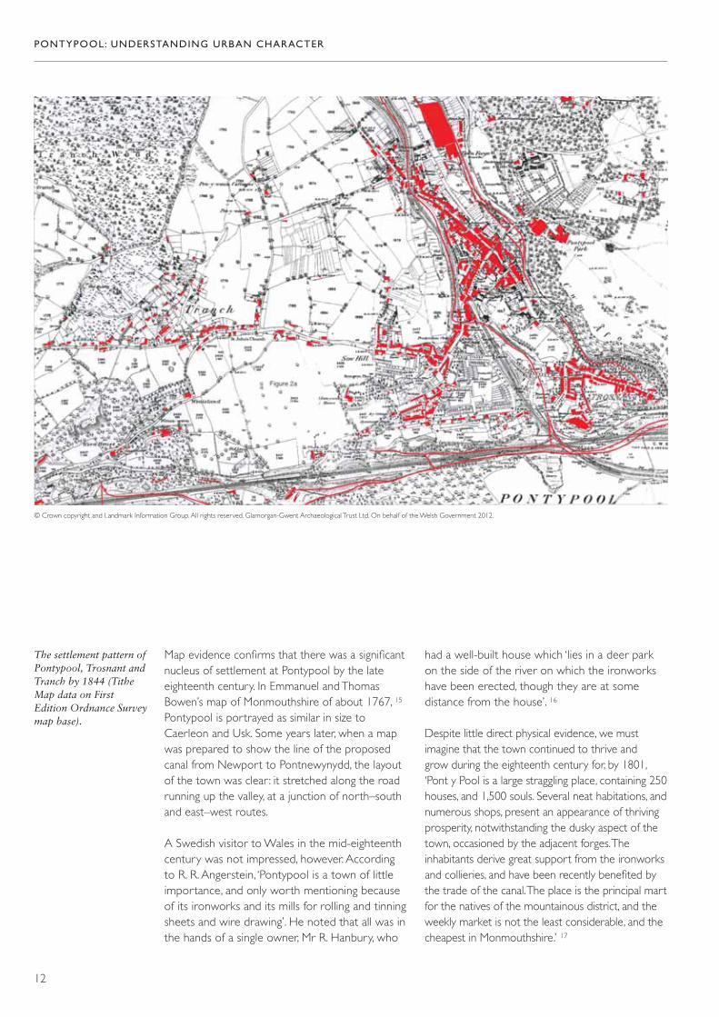
© Crown copyright and Landmark Information Group. All rights reserved. Glamorgan-Gwent Archaeological Trust Ltd. On behalf of the Welsh Government 2012.
The settlement pattern ofPontypool, Trosnant andTranch by 1844 (TitheMap data on FirstEdition Ordnance Surveymap base).
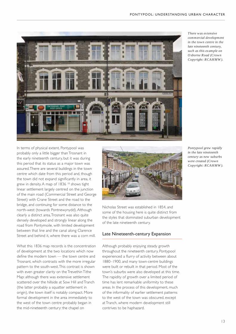
There was extensivecommercial developmentin the town centre in thelate nineteenth century,such as this example onOsborne Road (CrownCopyright: RCAHMW).
Pontypool grew rapidlyin the late nineteenthcentury as new suburbswere created (CrownCopyright: RCAHMW).
In terms of physical extent, Pontypool wasprobably only a little bigger than Trosnant in the early nineteenth century, but it was duringthis period that its status as a major town wasassured. There are several buildings in the towncentre which date from this period and, thoughthe town did not expand significantly in area, itgrew in density. A map of 1836 18 shows tightlinear settlement largely centred on the junctionof the main road (Commercial Street and GeorgeStreet) with Crane Street and the road to thebridge, and continuing for some distance to thenorth-west (towards Pontnewynydd). Althoughclearly a distinct area, Trosnant was also quitedensely developed and strongly linear along theroad from Pontymoile, with limited developmentbetween that line and the canal along ClarenceStreet and behind it, where there was a corn mill.
What this 1836 map records is the concentrationof development at the two locations which nowdefine the modern town — the town centre andTrosnant, which contrasts with the more irregularpattern to the south-west. This contrast is shownwith even greater clarity on the Trevethin TitheMap: although there was extensive settlementscattered over the hillside at Sow Hill and Tranch(the latter probably a squatter settlement inorigin), the town itself is notably compact. Moreformal development in the area immediately tothe west of the town centre probably began inthe mid-nineteenth century: the chapel on
Nicholas Street was established in 1854, andsome of the housing here is quite distinct fromthe styles that dominated suburban developmentof the late nineteenth century.
Late Nineteenth-century Expansion
Although probably enjoying steady growththroughout the nineteenth century, Pontypoolexperienced a flurry of activity between about1880–1900, and many town-centre buildings were built or rebuilt in that period. Most of thetown’s suburbs were also developed at this time.The rapidity of growth over a limited period oftime has lent remarkable uniformity to theseareas. In the process of this development, much of the informality of earlier settlement patterns to the west of the town was obscured, except at Tranch, where modern development stillcontrives to be haphazard.
PONTYPOOL: UNDERSTANDING URBAN CHARACTER
13
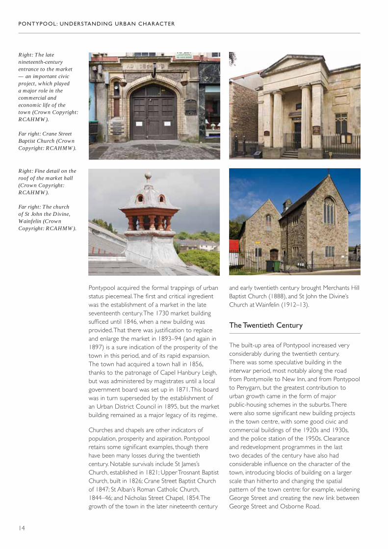
Right: The latenineteenth-centuryentrance to the market— an important civicproject, which played a major role in thecommercial andeconomic life of the town (Crown Copyright:RCAHMW).
Far right: Crane StreetBaptist Church (CrownCopyright: RCAHMW).
Right: Fine detail on theroof of the market hall(Crown Copyright:RCAHMW).
Far right: The church of St John the Divine,Wainfelin (CrownCopyright: RCAHMW).
Pontypool acquired the formal trappings of urbanstatus piecemeal. The first and critical ingredientwas the establishment of a market in the lateseventeenth century. The 1730 market buildingsufficed until 1846, when a new building wasprovided. That there was justification to replaceand enlarge the market in 1893–94 (and again in1897) is a sure indication of the prosperity of thetown in this period, and of its rapid expansion.The town had acquired a town hall in 1856,thanks to the patronage of Capel Hanbury Leigh,but was administered by magistrates until a localgovernment board was set up in 1871. This boardwas in turn superseded by the establishment ofan Urban District Council in 1895, but the marketbuilding remained as a major legacy of its regime.
Churches and chapels are other indicators ofpopulation, prosperity and aspiration. Pontypoolretains some significant examples, though therehave been many losses during the twentiethcentury. Notable survivals include St James’sChurch, established in 1821; Upper Trosnant BaptistChurch, built in 1826; Crane Street Baptist Churchof 1847; St Alban’s Roman Catholic Church,1844–46; and Nicholas Street Chapel, 1854. Thegrowth of the town in the later nineteenth century
and early twentieth century brought Merchants HillBaptist Church (1888), and St John the Divine’sChurch at Wainfelin (1912–13).
The Twentieth Century
The built-up area of Pontypool increased veryconsiderably during the twentieth century. There was some speculative building in theinterwar period, most notably along the roadfrom Pontymoile to New Inn, and from Pontypoolto Penygarn, but the greatest contribution tourban growth came in the form of majorpublic-housing schemes in the suburbs. Therewere also some significant new building projectsin the town centre, with some good civic andcommercial buildings of the 1920s and 1930s, and the police station of the 1950s. Clearanceand redevelopment programmes in the last two decades of the century have also hadconsiderable influence on the character of thetown, introducing blocks of building on a largerscale than hitherto and changing the spatialpattern of the town centre: for example, wideningGeorge Street and creating the new link betweenGeorge Street and Osborne Road.
PONTYPOOL: UNDERSTANDING URBAN CHARACTER
14

PONTYPOOL: UNDERSTANDING URBAN CHARACTER
15
The town centre,showing the extent of the market buildings(Crown Copyright:RCAHMW).
The modern-day town ofPontypool, surroundedby nineteenth- andtwentieth-centurysuburbs and satellitesettlements (CrownCopyright: RCAHMW).
The results of twentieth-century redevelopment inthe town centre (CrownCopyright: RCAHMW).

The canal at Pontymoile— once the junction ofthe MonmouthshireCanal with theBrecknock andAbergavenny Canal(Crown Copyright:RCAHMW).
Landownership
The land on which the town was built hadformed part of the property of LlantarnamAbbey, which was owned in the sixteenth centuryby the Morgan family of Tredegar. By the earlyeighteenth century, the estate had effectively been partitioned, and the land west of the riverbelonged to Frances Morgan, who had marriedEdmund Bray, whose family were lords of themanor of Bryngwyn and Wentsland. The manorstill owned substantial holdings in the earlynineteenth century. Meanwhile, the Hanburyfamily were consolidating their hold on the eastside of the river. This was partly about controllingresources for iron production, but also aboutacquiring sufficient land to establish a domesticholding — the family were not resident in thearea until about 1679, when land for a house andpark was purchased by Capel Hanbury (his sonwas Major John Hanbury, to whom theintroduction of tinplating is owed). By the lateseventeenth century, the Hanbury family hadestablished a significant estate. They went on to
dominate the area, acquiring extensive holdingson the west side of the river also, though theywere never the sole owners of property here, asthe Tithe Survey records.
Both the Hanbury estate and the Wentsland estate owned key industrial sites, but they also had substantial agricultural holdings. Land in agricultural use sat comfortably alongside industry, as nineteenth-century estate records show. 19
Connections: Transport Networks
The industries in the immediate vicinity ofPontypool were necessarily part of a complicatednetwork, both for the supply of raw materials and for the distribution of finished goods.Industrialization was extensive across the region,wherever it was possible to exploit the plentifulnatural resources of the area. Pontypool and its
PONTYPOOL: UNDERSTANDING URBAN CHARACTER
16

These arches once took a tram road and a watersupply underneath thecanal to the tinplateworks at Lower Mill(Crown Copyright:RCAHMW).
Far left: The mouth of an industrial tram roadtunnel in the ItalianGardens (CrownCopyright: RCAHMW).
immediate environs came to benefit in particularfrom an amenable siting, which favoured thedevelopment of an important transport corridorand hub for a much wider area, from Blaenavon in the north to Crumlin in the west.
The production of iron and its derivativesdepended on good transport links, both to bring raw materials to the sites of production and to take finished products towards theirmarkets. It was a recognition of the growingimportance of the area that a series of canalswere projected here in the late eighteenthcentury. The Monmouthshire Canal waspromoted by an Act of Parliament in 1792 — it ran from Newport to Pontnewynydd. A yearlater, a second canal was proposed: this was theBrecknock and Abergavenny Canal, which fromBrecon reached a terminus at Llanfoist in 1805. In 1812, the canal was extended as far asPontymoile, establishing a link with theMonmouthshire Canal.
The prime purpose of these canals was toprovide industrial transport; just as important was
the network of tram roads which linked individualindustrial sites with the canals. The Acts ofParliament, which enabled the canals, madespecific provision for the construction of tramroads as an integral part of the canal system.Provision was also made for other tram roads tobe built to any ironworks, quarry or coal minewithin eight miles (12.87km) of the canal and itsauthorized tram roads. Pontypool served as animportant hub in this system: a tram road fromBlaenavon and Varteg connected with the canalterminus at Pontnewynydd, and further tramroads ran from Lower Race and Blaendare to thecanal at Pontymoile, and between Pontypool andTrosnant. By 1836, there were also tram roadsconnecting Cwmynyscoy with the canal atPontymoile, which had become a significanttransport hub.
The canal age proved to be short-lived, however. Almost from the outset there weredifficulties supplying water to the canal betweenPontnewynydd and Pontymoile. It may have been for this reason that the Trosnant tram road was extended alongside the canal fromPontypool to Pontymoile in 1810, and thatanother tram road from Pontnewynydd toPontypool was completed alongside the canal in 1829. In addition, a tram road ran from either the Osborne Forge or the New Forge inPontypool to Lower Mill at Pontymoile. It ranclose to the river through the site of the TownForge (its route clearly shown on the 1834 planof the forge), 20 and through a tunnel at what isnow the Italian Gardens before again followingthe line of the river.
PONTYPOOL: UNDERSTANDING URBAN CHARACTER
17

Above: This engine shedis one of the few railwaystructures to havesurvived in Pontypool(Crown Copyright:RCAHMW).
Some of these tram roads survived until the end of the nineteenth century. Some routes havebeen virtually completely obliterated, whilst otherssurvive in part, such as the riverside route toPontymoile; others have been subsumed in modern roads (the route from Blaendare), and others survive as footpaths (the route from Cwmynyscoy).
In 1845 the canal company obtained an Act ofParliament enabling them to build a new railwayfrom Newport to Pontypool (Crane Street), toimprove their tram roads, and abandon the canalabove Pontymoile. By the time this line hadopened for passenger traffic in 1852, the canalbetween Pontypool and Pontnewynydd hadalready been closed and the section betweenPontymoile and Pontypool was closed in thefollowing year. By 1854 the railway extendednorthwards as far as Blaenavon, carrying mineraltraffic as well as passengers. By 1855, all its tramroads had been converted into standard-gaugelines, eventually supplemented by new branchlines serving collieries at Varteg, Cwmffrwdoer and Cwmnantddu.
This railway was initially run by the canalcompany, renamed as the Monmouthshire Railway
and Canal Company, but it was leased to theGreat Western Railway (GWR) in 1875 andamalgamated with it in 1880. Meanwhile, theGWR had built another line from Newport toPontypool via Caerleon (initiated in 1865 andcompleted in 1878), east of the earlier railway.The two railway lines intersected at PontypoolRoad, one mile (1.6km) from the town. Here too,the railway of the Monmouthshire Railway andCanal Company also connected with theNewport, Abergavenny and Hereford Railway in 1853, which ran from Hereford to Pontypool.This line was worked initially by the London and North Western Railway (LNWR), which had obtained powers to build a line fromPontypool to the Taff Vale Railway (TVR) atQuakers Yard in 1847. This was the Taff Valeextension, and from Pontypool Road, this railway,which was completed in 1858, took the line ofthe canal as far as Trosnant. It then continuedwest from Pontypool to a junction with the TVRat Quakers Yard. The LNWR, which operated this route as well as the line from Hereford toPontypool, was absorbed by the GWR in 1863.There were stations at Clarence Street andCrane Street as well as at Pontypool Road. The lines had all closed by the late 1970s andwere replaced by roads. 21
PONTYPOOL: UNDERSTANDING URBAN CHARACTER
18
Opposite: The modernroad occupies the site of an earlier railway,itself partially built over the line of theMonmouthshire Canal(Crown Copyright:RCAHMW).

PONTYPOOL: UNDERSTANDING URBAN CHARACTER
19

PONTYPOOL: UNDERSTANDING URBAN CHARACTER
20
Osborne Road, createdat the end of thenineteenth century as a more direct route north from the towncentre (CrownCopyright: RCAHMW).
In addition to these industrial transport systems,and in many cases preceding them, was animportant network of roads. River crossings at Pontymoile, Pontypool and Pontnewynyddwere nodal points for the development of bothsettlement and industry, and routes following the Llwyd and Glyn Valleys converged at Trosnant. Industrial and urban developmentbrought changes to the road network, including: a new road from Old Furnace toTrosnant in 1820 (Albion Road), which was an easier route than High Street, Tranch; and a new road ‘to obviate the dangerous declivitiesin Trosnant’, 22 from what is now Clarence Cornerto the top of Rockhill Road in 1822 (Clarence
Street). Osborne Road was created at the end of the nineteenth century to replace the earlier through-route which ran by GeorgeStreet, Wainfelin Road and Merchants Hill to Pontnewynydd.
In the late twentieth century, the construction of major new routes in place of former railwaysentailed radical change to the inherited roadpattern. It brought with it the loss of some of the local road connections and created biggerbarriers between places. Redevelopment alsobrought with it the loss of some local roads, most notably Bridge Street, which disappearedunder the site of the Tesco store.
PONTYPOOL: UNDERSTANDING URBAN CHARACTER
21
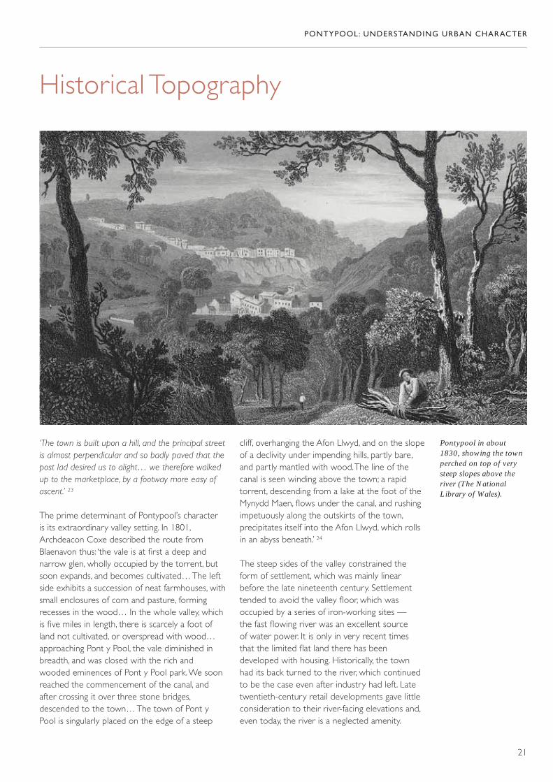
Historical Topography
Pontypool in about1830, showing the townperched on top of verysteep slopes above theriver (The NationalLibrary of Wales).
‘The town is built upon a hill, and the principal streetis almost perpendicular and so badly paved that thepost lad desired us to alight… we therefore walkedup to the marketplace, by a footway more easy ofascent.’ 23
The prime determinant of Pontypool’s character is its extraordinary valley setting. In 1801,Archdeacon Coxe described the route fromBlaenavon thus: ‘the vale is at first a deep andnarrow glen, wholly occupied by the torrent, butsoon expands, and becomes cultivated… The leftside exhibits a succession of neat farmhouses, withsmall enclosures of corn and pasture, formingrecesses in the wood… In the whole valley, whichis five miles in length, there is scarcely a foot ofland not cultivated, or overspread with wood…approaching Pont y Pool, the vale diminished inbreadth, and was closed with the rich andwooded eminences of Pont y Pool park. We soonreached the commencement of the canal, andafter crossing it over three stone bridges,descended to the town… The town of Pont yPool is singularly placed on the edge of a steep
cliff, overhanging the Afon Llwyd, and on the slopeof a declivity under impending hills, partly bare,and partly mantled with wood. The line of thecanal is seen winding above the town; a rapidtorrent, descending from a lake at the foot of theMynydd Maen, flows under the canal, and rushingimpetuously along the outskirts of the town,precipitates itself into the Afon Llwyd, which rollsin an abyss beneath.’ 24
The steep sides of the valley constrained theform of settlement, which was mainly linearbefore the late nineteenth century. Settlementtended to avoid the valley floor, which wasoccupied by a series of iron-working sites — the fast flowing river was an excellent source of water power. It is only in very recent times that the limited flat land there has beendeveloped with housing. Historically, the town had its back turned to the river, which continuedto be the case even after industry had left. Latetwentieth-century retail developments gave littleconsideration to their river-facing elevations and,even today, the river is a neglected amenity.

PONTYPOOL: UNDERSTANDING URBAN CHARACTER
22

Above: Wainfelin grewup in former fields(Crown Copyright:RCAHMW).
If there were strong natural constraints on thenature of settlement, there were others that were historical and man-made. Landownershipinfluenced the distribution of land use to a verymarked degree, and the land on the east side ofthe river was reserved for the interests of theHanbury family and remains remarkablyundeveloped. A more fragmented pattern ofownership on the west side allowed the townand its environs to develop in relatively piecemealfashion, plot-by-plot or field-by-field. The growthof the suburbs to the west clearly shows howdevelopment was accommodated to the earlierfield pattern. For example, the area bounded byAlbion Road, Upper Bridge Street, Crumlin Streetand Lower Park Terrace was a field in the 1830s— its name, Cai Nicholas, is recalled in NicholasStreet. In Wainfelin, Edward Street was fitted intoa narrow field and Wainfelin Avenue marks aformer field boundary.
Transport routes have also helped to shapesettlement. The first framework for settlement was provided by roads that were probably
long-established. The route from Pontymoile toTrosnant continued via Bridge Street towards SowHill and served as the main axis of settlement inthis area. The new road from Trosnant to Rockhill,created in the 1820s, followed the line of the canal, and the space between the old road and the canal was rapidly developed, as the 1836 mapof Pontypool records. Similarly, the route through the town centre, which originally went via HanburyRoad, Commercial Street and George Street, toWainfelin and Merchants Hill, was probably an old one. It was only supplanted in importance inthe late nineteenth century when Osborne Roadwas created as a more amenable connection fromthe town centre to Pontnewynydd and Blaenavon(it was initiated by the Local Government Board in 1878). Crane Street was probably also an earlyroad line; it continues as a footpath droppingsteeply down the hill below Commercial Streetand aligns directly with the bridge. The modernroad up the hill (Park Road) was in existence by1835, but may have been a relatively recentcontrivance to allow easier access to and from the bridge.
PONTYPOOL: UNDERSTANDING URBAN CHARACTER
23
Opposite: Pontypoolgrew in linear fashion,following the valley toeither side of the crossingpoint at the bridge(Crown Copyright:RCAHMW).

The Tesco supermarketand its car park, builtover the original line ofUpper Bridge Street, anddiverting the direct routefrom Trosnant to SowHill (Crown Copyright:RCAHMW).
Away from the town centre to the west, the1836 map of Pontypool records a settlementpattern that was more scattered, though stillstrung out along roads. Late nineteenth-centurysuburban growth in this area also used existingarteries, but filled in the fields between them. Inthe process, many of the earlier buildings at SowHill and Crumlin Street (once Wesley Street)were replaced.
First the canal and then the railway createdboundaries between one area and another,establishing a firm separation between the towncentre and its western suburbs, for example. Thecanal arrived before the major urban development
of the nineteenth century and was one of thefactors that helped to contain and shape it. As thecanal was replaced by the railway, and as railwaysin turn were replaced by major roads, theseboundaries have hardened, leading to a muchgreater separation between areas. Some of theoriginal connections have also been severed, mostnotably the direct link from Trosnant to Sow Hillvia Upper Bridge Street, which is now blocked by the Tesco site, and the direct route from thesouthern part of Pontymoile at Maesderwen tothe crossroads near the bridge.
PONTYPOOL: UNDERSTANDING URBAN CHARACTER
24
The Character of Building
Vernacular cottages atTranch are a reminder ofrural traditions (CrownCopyright: RCAHMW).
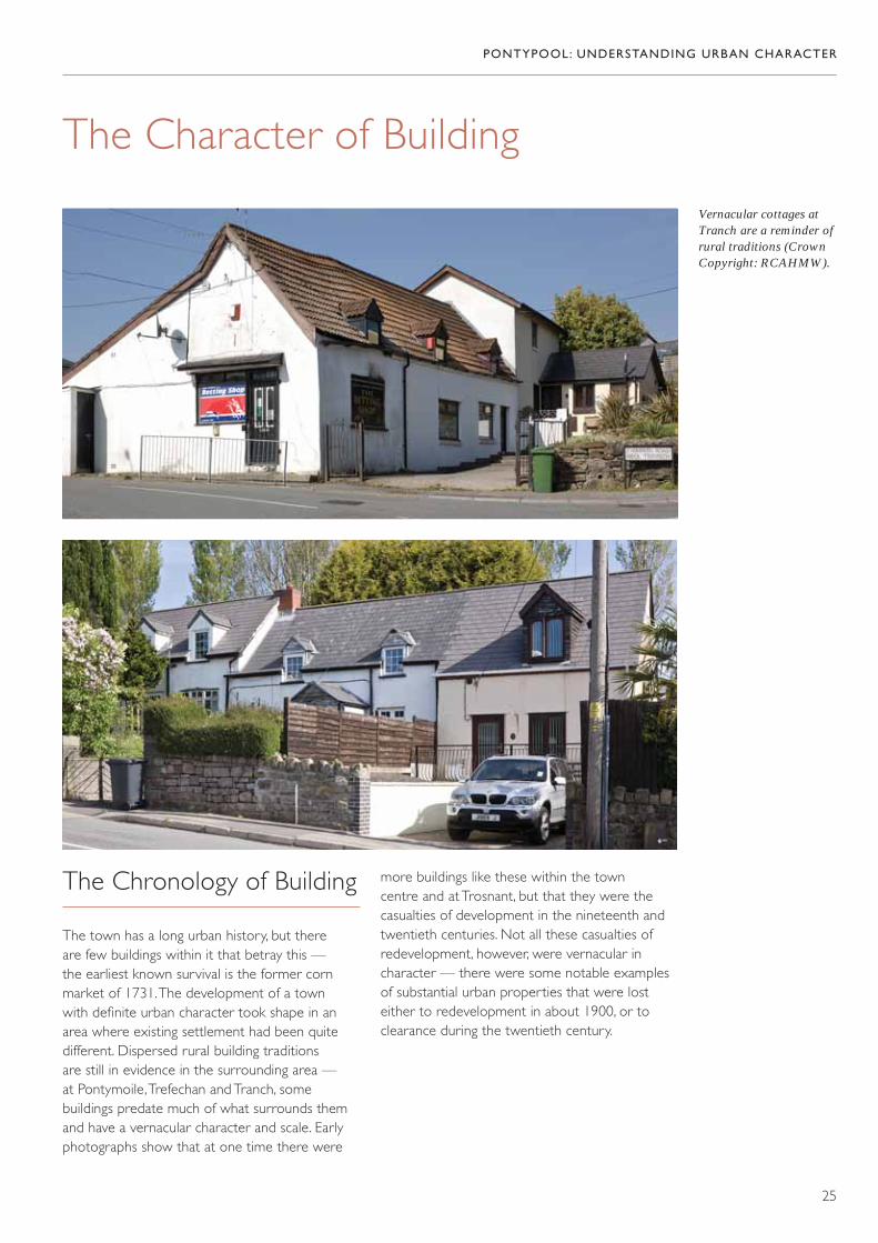
The Chronology of Building
The town has a long urban history, but there are few buildings within it that betray this — the earliest known survival is the former cornmarket of 1731. The development of a town with definite urban character took shape in anarea where existing settlement had been quitedifferent. Dispersed rural building traditions are still in evidence in the surrounding area — at Pontymoile, Trefechan and Tranch, somebuildings predate much of what surrounds themand have a vernacular character and scale. Earlyphotographs show that at one time there were
more buildings like these within the town centre and at Trosnant, but that they were thecasualties of development in the nineteenth andtwentieth centuries. Not all these casualties ofredevelopment, however, were vernacular incharacter — there were some notable examplesof substantial urban properties that were losteither to redevelopment in about 1900, or toclearance during the twentieth century.
PONTYPOOL: UNDERSTANDING URBAN CHARACTER
25

Early houses inTrosnant, cleared intwentieth-centuryredevelopment (Torfaen Museum Trust Collection).
The early decades of the nineteenth century arethe first period to have left a real mark on thecharacter of the town; but another significant periodof investment at the end of the century introducedsome of its most striking buildings, as well as most of the residential areas surrounding it. This wasfollowed by another period of settlement growth in the 1920s, with limited speculative developmentand extensive public-housing schemes. Furtherpublic-housing schemes followed the Second WorldWar. There was also small-scale, but cumulativelyextensive, private housing development, for exampleat Tranch.
Building Materials
The immediate area yielded plentiful supplies ofstone, with Pennant sandstone the predominantbuilding material. This stone did not readily lenditself to fine dressing and coursing however, and was seldom exposed before the late nineteenthcentury. Traditionally, stone was limewashed, but a characteristic of more polite urban building
PONTYPOOL: UNDERSTANDING URBAN CHARACTER
26
traditions is the use of render. In Pontypool,limewash is still occasionally found on ancillarybuildings, but render is much more common.Notwithstanding extensive renewal, there are stillbuildings in the town displaying their historicalrendered finish, with scribed courses in imitation of ashlar. A render finish also distinguishes some ofthe earliest suburban houses in the area aroundNicholas Street and Park Terrace. The influence ofthe gothic revival reached even relatively humblebuilding projects after about 1870, and stone beganto be exposed in commercial and residentialdevelopment. Pennant sandstone naturally occurs in a range of colours. This is exhibited in the towneither in a polychrome effect in single buildings, or inthe careful sourcing of stone to achieve a uniformityof finish, which varied from one building to the next.The stone could be rough-dressed or rock-faced togive a rugged, muscular effect.

Far left: Distinctiverubble stone at The Globe Hotel (CrownCopyright: RCAHMW).
Left: Bath stone ashlar on the formerMidland Bank (CrownCopyright: RCAHMW).
Rock-faced rubblecombined with brick and terracotta (CrownCopyright: RCAHMW).
Render was typicallyused in building projectsof the early and mid-nineteenth century(Crown Copyright:RCAHMW).
Brick was also in widespread use, especially as dressings on stone buildings. It was not often used as the principal building material until thetwentieth century, notwithstanding the presenceof several brickworks in the vicinity of the town. There are, however, some good examplesof its use, including glazed brick and terracotta.Even though the regional vernacular tradition had been for split stone-tiled roofs, by thenineteenth century slate had become ubiquitous.It still dominates the town and the use of othermaterials, even as replacements, is rare.
Prestigious projects were more likely to useimported materials; for example, Bath stone ashlar was used for Crane Street Baptist Church,for Barclays Bank (built as the London andProvincial Bank in 1893), and for the Midland Bank of 1910–11.
Whatever the material, it is common to finddistinctions between the main façade and the sideand rear elevations. Façades are usually emphasizedby the quality of finish and detail, with a rougherfinish used elsewhere, and for ancillary buildings.
PONTYPOOL: UNDERSTANDING URBAN CHARACTER
27

PONTYPOOL: UNDERSTANDING URBAN CHARACTER
28
Right: An unusual andstylish example of theuse of glazed brick(Crown Copyright:RCAHMW).
Far right: Contrastingstone used for side andmain façades (CrownCopyright: RCAHMW).
Right: Brick began tosupplant stone as themain building material in the early twentiethcentury (CrownCopyright: RCAHMW).
Far right: Split stone tileswere the traditionalroofing material beforeslate became widelyavailable in thenineteenth century(Crown Copyright:RCAHMW).
Decorative brickwork isa striking feature of theseterraced houses (CrownCopyright: RCAHMW).

Early nineteenth-centurycommercial building in a Georgian tradition(Crown Copyright:RCAHMW).
Far left: A latenineteenth-centurycommercial buildingusing varied materialsand forms to strikingeffect (Crown Copyright:RCAHMW).
Left: This row onOsborne Road is a goodexample of large-scaleplanned development(Crown Copyright:RCAHMW).
The market is anexcellent, large-scaleexample of a singlecommercial development(Crown Copyright:RCAHMW).
Building Types
Commercial Building
‘Demolition of the old Crown Hotel, and erection of fine modern hotel, and great development inOsborne Road, and erection of palatial premises for the London and Provincial bank speak volumesfor the go-ahead character of the townspeople.’ 25
As it developed in the nineteenth century,Pontypool became the commercial hub of itsextensive hinterland, and the town centre isessentially a highly specialized commercial quarter where almost every building was built forcommerce, the main exceptions being civic and
PONTYPOOL: UNDERSTANDING URBAN CHARACTER
29

religious institutions. Commercial building has itsown style, various permutations of which arereadily apparent here. Early examples respect aGeorgian tradition with restrained classicism,symmetry and generally simple rendered surfaces.In the later nineteenth century, a more expressivestyle was characterized by greater modelling offaçades, using a variety of materials and detail.
This was the general development of architecturalfashion but, within these broad parameters, thereare three main distinctions in commercial buildingin the town: buildings can be individualdevelopments lacking exceptional features, theycan be individual developments with strongindividual character, or they can be large-scale
speculative developments with a unified design. In much of the town, individual buildingspredominate with a variety of scale and size thatlends considerable character to the streetscape,notwithstanding extensive loss of original detail.Many of these buildings are relatively simple instyle, but Pontypool has a particularly fine seriesof ‘signature buildings’ with strong individualcharacter. Some of the most prominent are banksoccupying prime positions at road junctions,designed to make full use of their sites (HSBC,about 1910–15; Barclays, about 1880; andNational Westminster, converted from an earlieroffice building in 1905 and making the most ofthe new junction formed by the creation ofOsborne Road in 1878).
Banks are amongst the most strikingindividual commercialdevelopments in thetown centre, each with a distinctive signaturestyle (Crown Copyright:RCAHMW).
PONTYPOOL: UNDERSTANDING URBAN CHARACTER
30

Far left: Fine commercialarchitecture at TheGeorge (CrownCopyright: RCAHMW).
Left: The former Crown Hotel (CrownCopyright: RCAHMW).
Far left: The formerClarence Hotel (CrownCopyright: RCAHMW).
Left: The formerCo-operative building isan excellent example ofthe art deco style (CrownCopyright: RCAHMW).
Far left: Individualbuildings in an identicalstyle make up this terraceof shops on OsborneRoad (Crown Copyright:RCAHMW).
Left: Lion Buildingsprovide an early example of commercialdevelopment designed as a unit (CrownCopyright: RCAHMW).
Public houses and hotels were also oftendesigned to attract attention. Good examplesinclude: The George (1905), The Crown Hotel,and The Clarence Hotel. There were also some flamboyant individual shops, such asManchester House and the art deco formerCo-operative building. The market itself alsorepresents an individual development, albeit on an exceptional scale.
Pontypool also boasts some very good examples of large-scale planned developmentsfrom different periods, notably the Lion Buildings,built as a row of shops by G. V. Maddox ofMonmouth in 1840, and the Osborne Roaddevelopment. Maintaining or reinforcing the
PONTYPOOL: UNDERSTANDING URBAN CHARACTER
31
essential unity of these developments on the one hand, and respecting the diversity ofindividual building projects on the other, areimportant keys to reinforcing the character of the town centre.
Civic and Religious Buildings
Civic and religious buildings are an extremelyimportant component of the scene, wheredistinctive individual design was often a reflectionof patronage. This is certainly true for the townhall (1854), St James’s Church (1821 and 1854)and the library (1908). These buildings are notablefor the use of imported materials, often finely
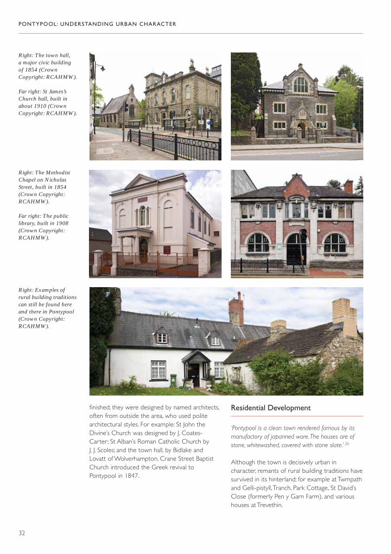
finished; they were designed by named architects,often from outside the area, who used politearchitectural styles. For example: St John theDivine’s Church was designed by J. Coates-Carter ; St Alban’s Roman Catholic Church by J. J. Scoles; and the town hall, by Bidlake and Lovatt of Wolverhampton. Crane Street BaptistChurch introduced the Greek revival toPontypool in 1847.
Residential Development
‘Pontypool is a clean town rendered famous by itsmanufactory of japanned ware. The houses are ofstone, whitewashed, covered with stone slate.’ 26
Although the town is decisively urban incharacter, remants of rural building traditions havesurvived in its hinterland; for example at Twmpathand Gelli-pistyll, Tranch, Park Cottage, St David’sClose (formerly Pen y Garn Farm), and varioushouses at Trevethin.
PONTYPOOL: UNDERSTANDING URBAN CHARACTER
32
Right: The town hall, a major civic building of 1854 (CrownCopyright: RCAHMW).
Far right: St James’sChurch hall, built inabout 1910 (CrownCopyright: RCAHMW).
Right: The MethodistChapel on NicholasStreet, built in 1854(Crown Copyright:RCAHMW).
Far right: The publiclibrary, built in 1908(Crown Copyright:RCAHMW).
Right: Examples of rural building traditionscan still be found hereand there in Pontypool(Crown Copyright:RCAHMW).

Examples of decorativeironwork (CrownCopyright: RCAHMW).
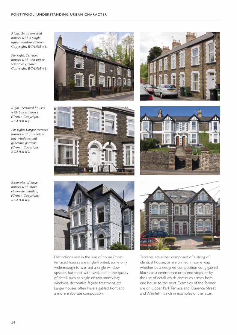
Urban Residential Building
The vast majority of residential building beforethe twentieth century in Pontypool and itssuburbs dates from the two decades at the endof the nineteenth century. Most is terracedhousing, or small rows and pairs, with only arelatively few individually built houses. There is aclear hierarchy of housing types, ranging frommodest terraced houses to quite substantial villas;because of the limited period of building, there isquite a simple set of variations. The few early tomid-nineteenth-century buildings are usually
rendered but, for the majority of developmentdating from the late nineteenth century, buildingmaterials are generally either rock-faced rubblebrought to courses (often snecked androck-faced and combined with brick fordressings), or brick (often used as a facing onrubble buildings). The brick used for dressings isgenerally a bright facing brick in red and yellow.The majority of the houses, of whatever scale,have small front gardens. Boundary detail is a veryimportant feature of the town — rubble or brickwalls and gate piers, with cast-iron railings, oftenvery decorative, and perhaps made locally.
PONTYPOOL: UNDERSTANDING URBAN CHARACTER
33
PONTYPOOL: UNDERSTANDING URBAN CHARACTER
34
Right: Small terracedhouses with a singleupper window (CrownCopyright: RCAHMW).
Far right: Terracedhouses with two upperwindows (CrownCopyright: RCAHMW).
Right: Terraced houseswith bay windows(Crown Copyright:RCAHMW).
Far right: Larger terracedhouses with full-heightbay windows andgenerous gardens(Crown Copyright:RCAHMW).
Examples of largerhouses with moreelaborate detailing(Crown Copyright:RCAHMW).
Distinctions rest in the size of house (mostterraced houses are single-fronted, some onlywide enough to warrant a single window upstairs, but most with two), and in the quality of detail, such as single or two-storey baywindows, decorative façade treatment, etc. Larger houses often have a gabled front and a more elaborate composition.
Terraces are either composed of a string ofidentical houses, or are unified in some way,whether by a designed composition using gabledblocks as a centrepiece or as end-stops, or by the use of detail which continues across from one house to the next. Examples of the formerare on Upper Park Terrace and Clarence Street,and Wainfelin is rich in examples of the latter.

Far left: A simple terraceof repeated identicalhouses (CrownCopyright: RCAHMW).
Left: A terrace designedas a symmetricalcomposition, withadvanced gables at eitherend of the row (CrownCopyright: RCAHMW).
PONTYPOOL: UNDERSTANDING URBAN CHARACTER
35
Far left: A simple terrace,the houses unified bycontinuous stonedetailing (CrownCopyright: RCAHMW).
Left and below: Terracedhouses, linked by richbrick detailing (CrownCopyright: RCAHMW).

This fine building wasprobably built in theeighteenth century —The George replaced it in 1905 (© The FrancisFrith Collection).
Character Areas
1. Town Centre
Historical Background
The early development of the town centre isobscure, but we know that there was enough of a town to warrant the establishment of amarket in the late seventeenth century, followedby the purpose-built market house and assemblyroom in 1730. The Corn Market is the earlieststanding building in the town centre. Otherbuildings that date from before the nineteenthcentury were replaced when the town’scommercial importance consolidated in thenineteenth and early twentieth centuries. There are some images that give an indication
of what has been lost, including some buildings of real vernacular character, as well as some more sophisticated urban buildings, probably from the eighteenth century.
The modern town centre is very much theproduct of nineteenth-century growth temperedby twentieth-century renewal. The map of 1836shows that most of the modern street patternwas already in place, with two main axes ofdevelopment. One of these was the line ofCommercial Street (originally Caroline Street)and George Street as far as the canal bridge (now the junction with Malthouse Lane), whichwas probably an early route up the valley, goingthence via what is now Wainfelin Road, with asecondary line following the east bank of thecanal. The second axis was Crane Street, which
PONTYPOOL: UNDERSTANDING URBAN CHARACTER
36
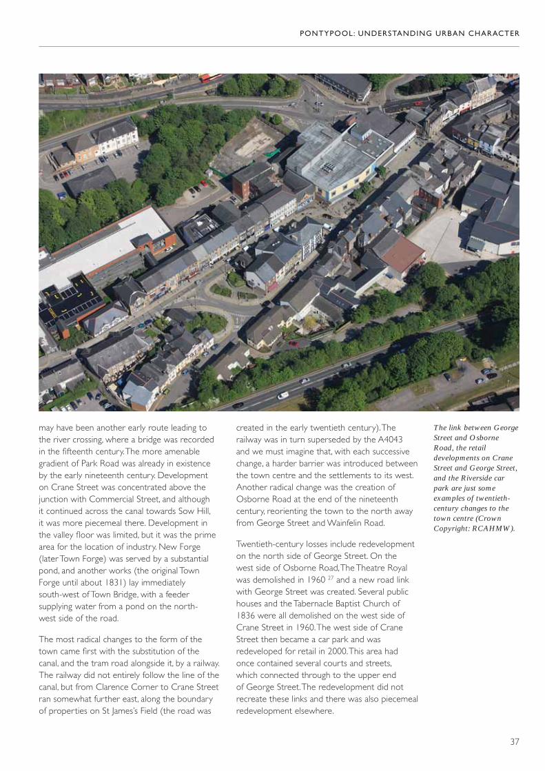
may have been another early route leading to the river crossing, where a bridge was recorded in the fifteenth century. The more amenablegradient of Park Road was already in existence by the early nineteenth century. Development on Crane Street was concentrated above thejunction with Commercial Street, and although it continued across the canal towards Sow Hill, it was more piecemeal there. Development in the valley floor was limited, but it was the primearea for the location of industry. New Forge (later Town Forge) was served by a substantialpond, and another works (the original Town Forge until about 1831) lay immediatelysouth-west of Town Bridge, with a feedersupplying water from a pond on the north-west side of the road.
The most radical changes to the form of thetown came first with the substitution of the canal, and the tram road alongside it, by a railway.The railway did not entirely follow the line of thecanal, but from Clarence Corner to Crane Streetran somewhat further east, along the boundary of properties on St James’s Field (the road was
created in the early twentieth century). Therailway was in turn superseded by the A4043 and we must imagine that, with each successivechange, a harder barrier was introduced betweenthe town centre and the settlements to its west.Another radical change was the creation ofOsborne Road at the end of the nineteenthcentury, reorienting the town to the north awayfrom George Street and Wainfelin Road.
Twentieth-century losses include redevelopmenton the north side of George Street. On the west side of Osborne Road, The Theatre Royalwas demolished in 1960 27 and a new road linkwith George Street was created. Several publichouses and the Tabernacle Baptist Church of1836 were all demolished on the west side ofCrane Street in 1960. The west side of CraneStreet then became a car park and wasredeveloped for retail in 2000. This area had once contained several courts and streets, which connected through to the upper end of George Street. The redevelopment did notrecreate these links and there was also piecemealredevelopment elsewhere.
PONTYPOOL: UNDERSTANDING URBAN CHARACTER
37
The link between GeorgeStreet and OsborneRoad, the retaildevelopments on CraneStreet and George Street,and the Riverside carpark are just someexamples of twentieth-century changes to thetown centre (CrownCopyright: RCAHMW).

Dense developmentpatterns in the towncentre (CrownCopyright: RCAHMW).
Glantorfaen House — a grandiose residence on the edge of the town centre (CrownCopyright: RCAHMW).
The Character of Building
The town centre is tightly developed as a seriesof near continuous frontages. Space for buildingwas constrained, and many occupied virtually thewhole of their plots; vacant space is rare, and TheGlobe Hotel is exceptional in having a clearlydefined rear yard. The small yard at the rear ofthe former Crown Hotel is another example ofenclosed space within the town centre. Other
PONTYPOOL: UNDERSTANDING URBAN CHARACTER
38
courts and back lanes to the north-west of Crane Street and at Rosemary Lane were lost in modern redevelopment, though the openingup of space and through routes betweenGlantorfaen Road and Market Street is also a consequence of modern redevelopment,following the closure of Crane Street Station.Buildings are strongly oriented to the streets, andwhere rear elevations are exposed to view, it isoften to the detriment of the townscape. Notableexceptions to this are those banks which weredesigned to exploit prominent corner sites, andthe large houses on the southern edge of thetown centre (such as Glantorfaen House).
The town centre is dominated by commercialbuilding, and the main distinction is betweenindividual developments and unified planneddevelopments. Amongst the former there isconsiderable variety in size and scale, rangingfrom narrow frontages to such largedevelopments as the former Crown Hotel or the HSBC Bank. These developments span from
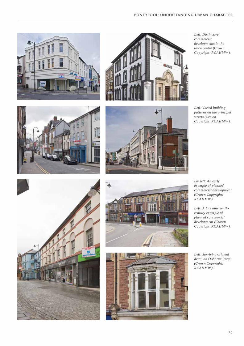
PONTYPOOL: UNDERSTANDING URBAN CHARACTER
39
Far left: An earlyexample of plannedcommercial development(Crown Copyright:RCAHMW).
Left: A late nineteenth-century example ofplanned commercialdevelopment (CrownCopyright: RCAHMW).
Left: Surviving originaldetail on Osborne Road(Crown Copyright:RCAHMW).
Left: Distinctivecommercialdevelopments in thetown centre (CrownCopyright: RCAHMW).
Left: Varied buildingpatterns on the principalstreets (CrownCopyright: RCAHMW).

about 1830 to about 1930 and this relatively longperiod of development, coupled with the varietyof individual projects, lends considerabledistinction to the town centre. Examples can befound along Commercial Street, where PearlHouse and the former Co-operative store arehigh-quality art deco buildings, whose large-scaleand relatively austere surface treatment is incontrast to the piecemeal development patternelsewhere along the street, which is mostlyassembled from single buildings with differentstorey heights and façade treatment. Some of themost distinctive individual buildings are the banksand public houses — amongst the latter, forexample, The George and The White Hart.
Unified planned developments are also animportant feature of the town centre, rangingfrom the Lion House development of 1840, tothe Osborne Road development of about 1890.Both of these are unified by the rhythm of façadedetail — the repeated windows in plain recessesin Lion House, and a more elaborate scheme inOsborne Road that includes pilasters, acontinuous eaves band, and the line of shalloworiel bays. Piecemeal renewal of detail hasundermined some of the unity of this terrace, but it remains a very strong composition.
Variety in the organization of development, andits relatively long chronology, has led to a very
PONTYPOOL: UNDERSTANDING URBAN CHARACTER
40
Above: A mix ofmaterials and stylescharacterizesdevelopment on the westside of George Street(Crown Copyright:RCAHMW).
Right: The exuberant use of materials on TheGeorge contrast with thesimple renders used onearlier buildings (CrownCopyright: RCAHMW).
Far right: The Bath stoneashlar façades of thebank buildings flank therendered front of theearly market hall (CrownCopyright: RCAHMW).

Left: A rare survivingexample of an originalshopfront on MarketStreet (Crown Copyright:RCAHMW).
Far left: Rough rubble in a rare survivingindustrial building —part of the former CastleBrewery (CrownCopyright: RCAHMW).
Left: A fine example of alate nineteenth-centurycommercial building,with display windows on two floors (CrownCopyright: RCAHMW).
varied palette of materials. The earliertown-centre buildings had render finishes, someof which survive (the west side of George Streetincludes some good examples interspersed withEdwardian and art deco building). Render wassupplanted by exposed stone and brick in thelater nineteenth century, best exemplified indevelopments on Crane Street, including themarket, Jubilee Buildings and some shops. Earlytwentieth-century building schemes often usedimported materials, for example faience andPortland stone.
Although the general form of buildingdevelopment of all kinds remains strong, the
retention rate for original detail is poor, especiallyat ground-floor level. Early shop fronts are rare survivals indeed and should be treasured.Upper floors have fared better, and manybuildings retain original detail at this level,including some examples of nineteenth-century fenestration.
On the edge of the town centre, some residentialdevelopment also survives — large houses at thesouthern end, and a cluster of small terracedhouses to the north. In this area too, there is onesurviving industrial building, a relic of The CastleBrewery and a rare example of the rough use of local stone with no attempt at dressing.
PONTYPOOL: UNDERSTANDING URBAN CHARACTER
41

ight: The town hall,anbury Road (Crownopyright: RCAHMW).
ar right: The spaciousayout of buildingsmongst greenery isharacteristic ofanbury Road (Crownopyright: RCAHMW).
RHC
FlacHC
Right: A fine earlytwentieth-century house,built as the vicarage to StJames’s Church (CrownCopyright: RCAHMW).
2. Hanbury Road
Historical Background
Pontypool town centre has remained resolutelyseparate from Trosnant, and the distinctivecharacter of Hanbury Road perpetuates thisseparation. Possibly the land here came early intothe ownership of the Hanbury family and was not released for development. It was certainly the Hanbury family who funded the building ofthe town hall here in 1854, and they may haveprovided patronage for St James’s Church, whichwas originally built in 1821. In the twentiethcentury, development remained limited, confinedto civic and religious building, and a smallresidential development.
The Character of Building
Pontypool gains considerable character from thegrouping of civic and religious buildings alongHanbury Road and its immediate environs, notonly from the strong design of individual buildings,but also from the spaciousness of layout whichcharacterizes them. Unlike the town centre andTrosnant, the civic and religious buildings here are set in well-defined individual plots, and aredesigned to be seen from more than oneposition. Individually designed, often by namedarchitects, they adopt strong architectural styles,and their individuality is reinforced by the use ofexotic materials. The small housing developmenton St James’s Field is a good group of typicalPontypool villas, their brick façades lively with baywindows, gables, and decorative detail.
PONTYPOOL: UNDERSTANDING URBAN CHARACTER
42

3. Trosnant
‘Trosnant is the most ancient part of Pontypool and contains many dwellings, mostly cottages of great age.’ 28
Historical Background
Trosnant is generally thought to be one of theearliest focal points for settlement in the area, and the site of one of the early japanning works inthe eighteenth century. The map of 1836 clearlyshows it as a separate settlement, almost as largein extent as Pontypool town. Its main axis is theline of what is now Bridge Street, which thencontinued across the canal to Sow Hill. Extensiveclearance in the second half of the twentiethcentury damaged all sense of a coherentstreetscape here, but it was only the creation ofthe A4043 and later of the Tesco supermarket,which virtually obliterated what had once been asignificant through-route. There was also somedevelopment along what is now Clarence Street as far as The Clarence Inn, but the section west ofBridge Street probably dates from the creation of
the new road to Rockhill in 1820. This new road (Clarence Road) swung round towardsPontymoile, closely following the line of the canal.It effectively bypassed the original through-route(Bridge Street and Trosnant Street), which wasfinally severed by the development of the leisurecentre car park. Further development took placebetween Bridge Street and Clarence Road,including housing and a corn mill, presumablypowered by the Glyn Brook. In the laternineteenth century the town gasworks wasestablished in previously open ground to the east of this lane.
Trosnant occupied a pivotal position in the valley,sited along the principal through-route, and at a junction with what was to become the mainway into the town centre. This position wasconsolidated by the creation of Albion Road inthe early nineteenth century as a direct route tothe town from the west. The canal and later therailway strengthened these local connections;Clarence Street Station was one of three stationsserving Pontypool. The closure of the railways inthe twentieth century and the substitution oftheir lines by new roads, as well as the loss of theoriginal through-route via Bridge Street, meantthat some of this connectivity was lost.
PONTYPOOL: UNDERSTANDING URBAN CHARACTER
43
Trosnant beforeredevelopment in the mid-twentieth century(Crown Copyright:MOD).
PONTYPOOL: UNDERSTANDING URBAN CHARACTER
44
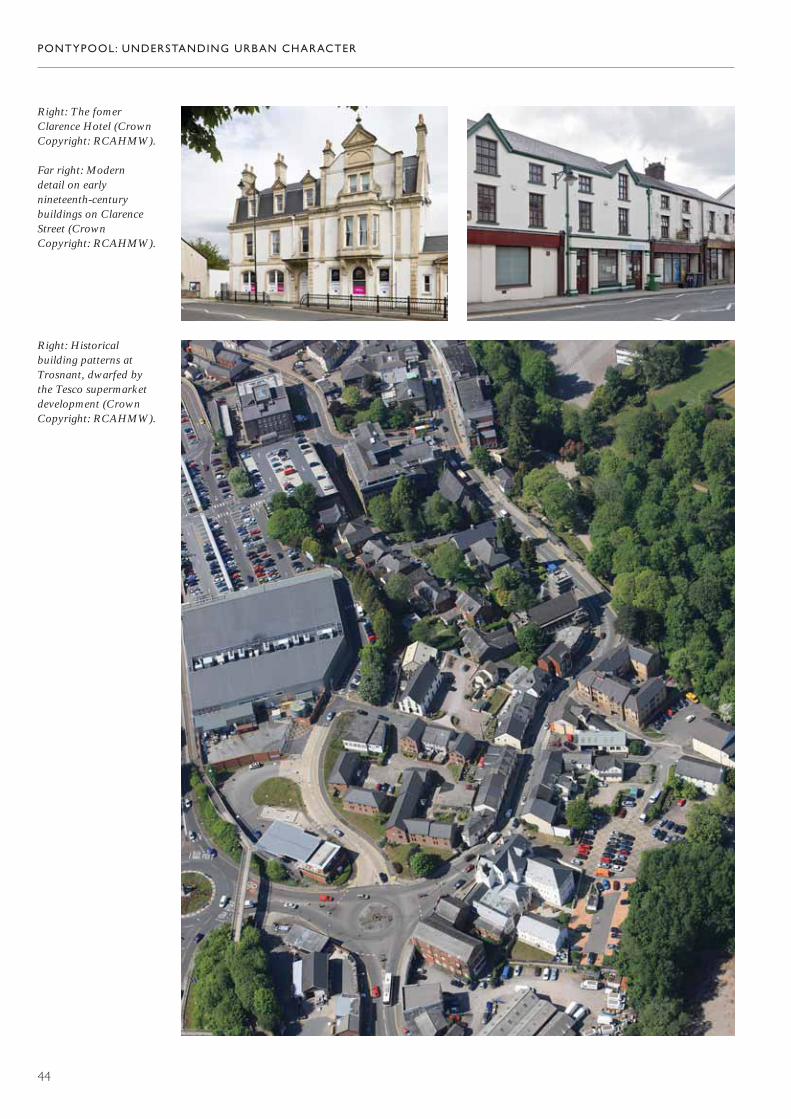
Right: The fomerClarence Hotel (CrownCopyright: RCAHMW).
Far right: Modern detail on earlynineteenth-centurybuildings on ClarenceStreet (Crown Copyright: RCAHMW).
Right: Historicalbuilding patterns atTrosnant, dwarfed by the Tesco supermarketdevelopment (CrownCopyright: RCAHMW).
PONTYPOOL: UNDERSTANDING URBAN CHARACTER
45
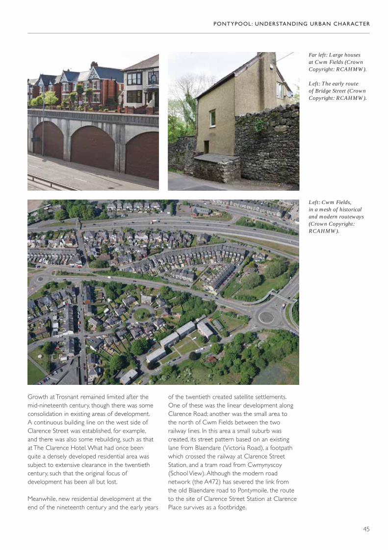
Far left: Large houses at Cwm Fields (CrownCopyright: RCAHMW).
Left: The early route of Bridge Street (CrownCopyright: RCAHMW).
Left: Cwm Fields, in a mesh of historicaland modern routeways(Crown Copyright:RCAHMW).
Growth at Trosnant remained limited after themid-nineteenth century, though there was someconsolidation in existing areas of development. A continuous building line on the west side ofClarence Street was established, for example, and there was also some rebuilding, such as thatat The Clarence Hotel. What had once been quite a densely developed residential area wassubject to extensive clearance in the twentiethcentury, such that the original focus ofdevelopment has been all but lost.
Meanwhile, new residential development at theend of the nineteenth century and the early years
of the twentieth created satellite settlements.One of these was the linear development alongClarence Road; another was the small area to the north of Cwm Fields between the tworailway lines. In this area a small suburb wascreated, its street pattern based on an existinglane from Blaendare (Victoria Road), a footpath which crossed the railway at Clarence StreetStation, and a tram road from Cwmynyscoy(School View). Although the modern roadnetwork (the A472) has severed the link from the old Blaendare road to Pontymoile, the routeto the site of Clarence Street Station at ClarencePlace survives as a footbridge.
PONTYPOOL: UNDERSTANDING URBAN CHARACTER
46
Right: The formerQuaker Meeting House,Bridge Street (CrownCopyright: RCAHMW).
Far right: TrosnantHouse (CrownCopyright: RCAHMW).
Right: Rare originaldetail on Clarence Street(Crown Copyright:RCAHMW).
Far right: UpperTrosnant Baptist Church dates back to 1826 (CrownCopyright: RCAHMW).
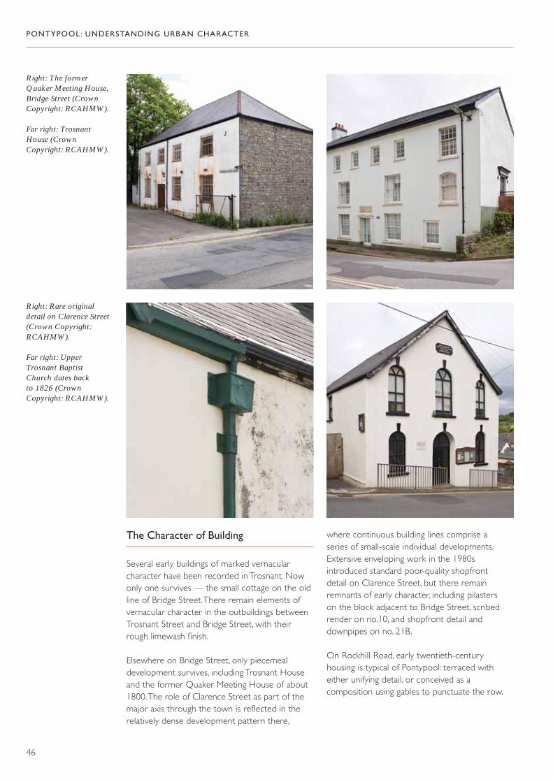
The Character of Building
Several early buildings of marked vernacularcharacter have been recorded in Trosnant. Nowonly one survives — the small cottage on the oldline of Bridge Street. There remain elements ofvernacular character in the outbuildings betweenTrosnant Street and Bridge Street, with theirrough limewash finish.
Elsewhere on Bridge Street, only piecemealdevelopment survives, including Trosnant Houseand the former Quaker Meeting House of about1800. The role of Clarence Street as part of themajor axis through the town is reflected in therelatively dense development pattern there,
where continuous building lines comprise a series of small-scale individual developments.Extensive enveloping work in the 1980sintroduced standard poor-quality shopfront detail on Clarence Street, but there remainremnants of early character, including pilasters on the block adjacent to Bridge Street, scribedrender on no.10, and shopfront detail anddownpipes on no. 21B.
On Rockhill Road, early twentieth-centuryhousing is typical of Pontypool: terraced witheither unifying detail, or conceived as acomposition using gables to punctuate the row.

The development to the north of Cwm Fieldsaround Victoria Road is a remarkably coherentsettlement area that had its own small church. It includes a particularly good range of housetypes, including some substantial villas in spaciousgardens, which are distinguished both by theirscale and architectural flamboyance. There arealso good examples of terraced houses linked bythe use of strong polychrome brick detailing or as designed compositions. Brick is not just usedfor dressing here, but also as the main buildingmaterial in the larger houses and in one of thesmaller terraces.
PONTYPOOL: UNDERSTANDING URBAN CHARACTER
47
Rich architecturaldetailing at Cwm Fields(Crown Copyright:RCAHMW).

Pontypool Park (CrownCopyright: RCAHMW).
4. Pontypool Park
Historical Background
‘The mansion is singularly situated at the extremityof the grounds, a small distance from the town,which (though seated on the perpendicular of the cliff, rising from the opposite bank of the Avon) is so judiciously concealed by plantations of oak,beech, and poplars, that scarcely a single house is discerned.’ 29
Pontypool Park was the seat of the Hanburyfamily who developed industries in the area fromabout 1576, but did not establish a residence hereuntil the late seventeenth century. It is possiblethat land on the east side of the river formedpart of Richard Hanbury’s original land lease atthe end of the sixteenth century, since it wouldhave provided a good source of timber forcharcoal; but the ironworks established here in1575–76 did not come into Hanbury hands untilthe late seventeenth century. Capel Hanbury waspurchasing land for the park in 1677 and 1689,and the first house was built in about 1694; it was then successively extended and altered in
1752–65, 1800–10 and 1872. A deer park wascreated in about 1700 by Major John Hanbury,and the main drive from the gates at PontymoileBridge was in existence by about 1720. Variouschanges to the layout and character of the parkand garden were made during the nineteenthcentury. Amongst the most important of thesewas: the removal of the ironworks from theiroriginal site on the north side of the river (westof where the leisure centre now is) in 1831, thereconstruction of the entrance gates, and theconstruction of a bank planted with trees toscreen the town from the house and park. Otherimportant nineteenth-century components of thepark are the American Gardens, established in1851, and the kitchen gardens, which had beenestablished by the 1880s. Public ownership of the house and park in 1920 inaugurated anotherepoch of change, as the house became a schooland various recreational additions were made to the park: tennis courts (1924), bowling green(1925), rugby ground (1925), and bandstand(1931). The kitchen gardens were partiallydeveloped for housing, and a major public-housingdevelopment at Penygarn was inserted into whathad previously been part of the park. The leisurecentre and ski slope were added in 1974.
PONTYPOOL: UNDERSTANDING URBAN CHARACTER
48
The Rustic Lodge in the American Gardens,built in 1841 (CrownCopyright: RCAHMW).
The Character of Building
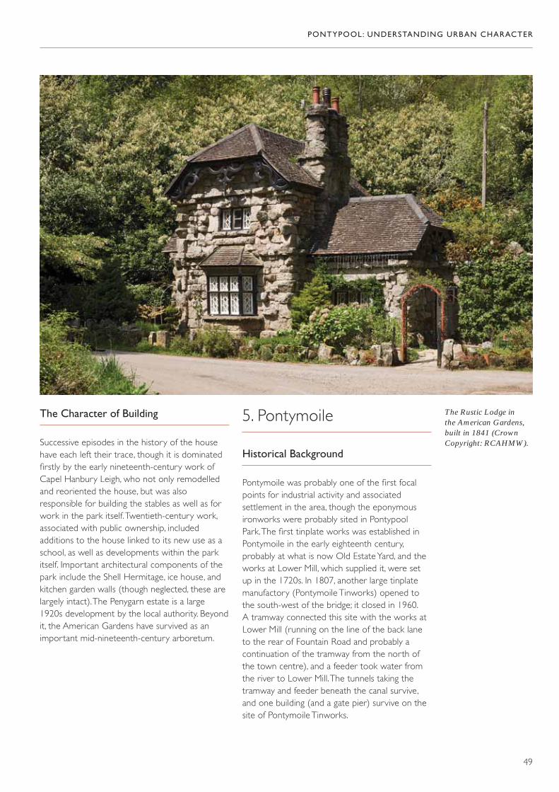
Successive episodes in the history of the househave each left their trace, though it is dominatedfirstly by the early nineteenth-century work ofCapel Hanbury Leigh, who not only remodelledand reoriented the house, but was alsoresponsible for building the stables as well as forwork in the park itself. Twentieth-century work,associated with public ownership, includedadditions to the house linked to its new use as aschool, as well as developments within the parkitself. Important architectural components of thepark include the Shell Hermitage, ice house, andkitchen garden walls (though neglected, these arelargely intact). The Penygarn estate is a large1920s development by the local authority. Beyondit, the American Gardens have survived as animportant mid-nineteenth-century arboretum.
5. Pontymoile
Historical Background
Pontymoile was probably one of the first focalpoints for industrial activity and associatedsettlement in the area, though the eponymousironworks were probably sited in Pontypool Park. The first tinplate works was established inPontymoile in the early eighteenth century,probably at what is now Old Estate Yard, and theworks at Lower Mill, which supplied it, were setup in the 1720s. In 1807, another large tinplatemanufactory (Pontymoile Tinworks) opened tothe south-west of the bridge; it closed in 1960. A tramway connected this site with the works atLower Mill (running on the line of the back laneto the rear of Fountain Road and probably acontinuation of the tramway from the north ofthe town centre), and a feeder took water fromthe river to Lower Mill. The tunnels taking thetramway and feeder beneath the canal survive,and one building (and a gate pier) survive on thesite of Pontymoile Tinworks.
PONTYPOOL: UNDERSTANDING URBAN CHARACTER
49

Pontymoile was also a significant interchangepoint, not only as an early river crossing point and junction of north–south and east–westroutes, but also as the junction of theMonmouthshire Canal and the Brecknock andAbergavenny Canal to the south-east. Here tootram roads from Cwymynyscoy and Blaendwrterminated adjacent to the canal, south-west ofthe river crossing. The construction of the GreatWestern Railway on the line of the canaldisrupted but did not entirely destroy this
connectivity — indeed the roads which hadconverged here from Cwmynyscoy and Penyrheolwere taken under the railway via a new link,creating a crossroads at the intersection ofFountain Road and Rockhill Road. The creation of the A472 on the line of the railway, and otherhighway improvements, have done extensivedamage to local links, isolating the Maesderwenarea and severing the original line of FountainRoad and Rockhill Road.
This area was a natural focus for settlement, andthere is still a small nucleus of relatively earlybuildings at the foot of Rockhill Road, thoughthere have been considerable losses in this area. One of the survivals is a formaleighteenth-century house, which is thought to have become the truck house of theMonmouthshire Canal Company in the earlynineteenth century; the terrace adjoining it is anunusual example of early nineteenth-centuryformality. Residential development here waslimited until the 1920s, when terraced houseslinked this nucleus with the secondary focus atthe junction of the canals.
PONTYPOOL: UNDERSTANDING URBAN CHARACTER
50
Above: The toll housebuilt at the junction ofthe MonmouthshireCanal with theBrecknock andAbergavenny Canal(Crown Copyright:RCAHMW).
Right: The last survivingbuilding on the site of the PontymoileTinworks (CrownCopyright: RCAHMW).

The Character of Building
The main focus of settlement in Pontymoile was the road junction close to the river crossing. Here a single small vernacular cottage survives, together with the altogethergrander group comprising The Old Truck House and nos 64–72 Rockhill Road. Despiteconsiderable alteration to detail, this group retains remnants of the original scribed render,and a formality of design that is a clear indication of status. The junction was once more defined, with housing on the opposite side of the road that was replaced in the latetwentieth century by commercial developmenton a different alignment. Public housing (of the 1920s) links this area with the Old EstateYard, where various former industrial buildingsand a cottage row of possible eighteenth- or early nineteenth-century origins survives, albeitmuch altered. Another significant focal point of early development is at Maesderwen, whichwas once directly linked by road to the rest of Pontymoile.
6. Osborne Road
Historical Background
Osborne Road is a development of the latenineteenth century. It was initiated in 1878 andthe 1882 Ordance Survey map shows thebeginnings of development along its line. Dateson the buildings themselves show that much ofthe development was taking place in the 1890sand was substantially complete by 1901. A secondlink to George Street was created in about 1970.
Osborne Road supplanted George Street–Merchants Hill as the main road route up the valley,itself supplanted by the creation of the A4043 onthe line of the former railway in the 1970s. It wasalso severed by the creation of a second road —Riverside — in the valley bottom. The northernsection of road beyond the junction with Riversidemay have been an existing route, perhaps even thetramway from Pontnewynydd to Pontypool, whichwas built in 1829 and ran parallel to the canal.
PONTYPOOL: UNDERSTANDING URBAN CHARACTER
51
Far left: An eighteenth-century house, thoughtto have been used as the truck house of the MonmouthshireCanal Company in thenineteenth century, withearly nineteenth-centuryterraced houses beyond(Crown Copyright:RCAHMW).
Left: A small vernacularhouse close to the rivercrossing at Pontymoile(Crown Copyright:RCAHMW).
Far left: An earlyvernacular building atMaesderwen (CrownCopyright: RCAHMW).
Left: A group of housesbuilt in about 1845 bythe Pontypool Parkestate (Crown Copyright:RCAHMW).
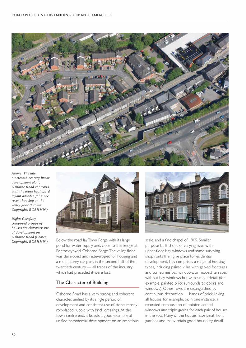
Below the road lay Town Forge with its largepond for water supply and, close to the bridge atPontnewynydd, Osborne Forge. The valley floorwas developed and redeveloped for housing anda multi-storey car park in the second half of thetwentieth century — all traces of the industrywhich had preceded it were lost.
The Character of Building
Osborne Road has a very strong and coherentcharacter, unified by its single period ofdevelopment and consistent use of stone, mostlyrock-faced rubble with brick dressings. At thetown-centre end, it boasts a good example ofunified commercial development on an ambitious
PONTYPOOL: UNDERSTANDING URBAN CHARACTER
52
Above: The latenineteenth-century lineardevelopment alongOsborne Road contrastswith the more haphazardlayout adopted for morerecent housing on thevalley floor (CrownCopyright: RCAHMW).
Right: Carefullycomposed groups ofhouses are characteristicof development onOsborne Road (CrownCopyright: RCAHMW). scale, and a fine chapel of 1905. Smaller
purpose-built shops of varying sizes withupper-floor bay windows and some survivingshopfronts then give place to residentialdevelopment. This comprises a range of housingtypes, including paired villas with gabled frontagesand sometimes bay windows, or modest terraceswithout bay windows but with simple detail (forexample, painted brick surrounds to doors andwindows). Other rows are distinguished bycontinuous decoration — bands of brick linkingall houses, for example, or, in one instance, arepeated composition of pointed archedwindows and triple gables for each pair of housesin the row. Many of the houses have small frontgardens and many retain good boundary detail.

Far left: Modest terracedhouses characterize the northern end ofOsborne Road (CrownCopyright: RCAHMW).
Left: An interestingmodern interpretation ofterraced housing (CrownCopyright: RCAHMW).
Inter-war public housingat Penygarn (CrownCopyright: RCAHMW).
With the exception of a single large gothic house,the northern section of the road consists of moremodest terraces with limited detail. An interestingmodern interpretation of the terrace occupiesthe site of the Drill Hall.
7. Penygarn and East of the River
Historical Background
Development on the east side of the river waslimited until the twentieth century. This wasessentially an agricultural landscape, withsmall-scale industrial activity (quarrying) close tothe river, and a pattern of woodland and fields tothe north of the road from Pontypool bridge tomedieval St Cadoc’s Church. South of the road,the expanse of Pontypool Park was onlyinterrupted by Pen y Garn Farm. Into thisessentially agricultural landscape, small-scale
development was gradually introduced in thecourse of the nineteenth century. One of the firstbuildings here was probably the Baptist Chapel,followed by the Baptist College (later theIntermediate School) in 1835. It was only in thetwentieth century that residential developmenton any scale took place here. Old Penygarn is an oddly isolated development comprising smallterraces and some distinctive large villas. Perhapsits developer intended to create a moresubstantial suburb here but, if so, it did not takeoff. It was only after the council had acquired thepark that development of any significance tookplace — Penygarn is a large public-housingscheme of the 1920s and 1930s, with limitedspeculative development at its southern edge.
The Character of Building
Close to the river, the clustered buildings atWoodhouse represent a forge manager’s houseand associated cottages, almost the only intrusionof industrial settlement onto the east bank of theriver. Pen y Garn Farm survives as Park Cottage.
PONTYPOOL: UNDERSTANDING URBAN CHARACTER
53

PONTYPOOL: UNDERSTANDING URBAN CHARACTER
54
Above: Distinctive streetpatterns and buildinglayouts at Penygarn(Crown Copyright:RCAHMW).
Right: High-qualityarchitectural detailing atOld Penygarn (CrownCopyright: RCAHMW).
Old Penygarn is a development of about 1905; itsterraces are typical of Pontypool, but the largerhouses are very distinctive and very wellpreserved. Penygarn represents a good exampleof public-housing development, with its carefullyplanned layouts and use of a limited range ofhouse types combined in groups of two or four.Roughcast render predominates, though this may
originally have been contrasted with exposedbrick. Although little original detail survives, theestate retains a coherent character.
8. Sow Hill
Historical Background
The 1836 map of Pontypool shows that therewas already significant development in this area.The complicated pattern of roads suggestsdevelopment along earlier tracks and fieldboundaries, with a new road from Old Furnace to Trosnant (Albion Road) on a more amenablegradient than the earlier route, which ran viaTranch High Street. Development wasconcentrated along this earlier line and onCrumlin Street (then known as Wesley Street). By 1881, this area had massively expanded and

Innovative patterns ofdevelopment highlightedin this mid-twentieth-century view (CrownCopyright: MOD).
An older survival on Twmpath Road(Crown Copyright:RCAHMW).
new streets had been established in former fields.This development probably began in the 1850s(the Wesleyan Methodist Chapel is dated 1854),immediately following the construction of therailway, which provided a firm boundary to theeast. By 1881, Upper Bridge Street (originallyPound Lane), Park Terrace and Albion Road weredeveloped, as was the upper end of NicholasStreet. Twenty years later Nicholas Street had
been completed, along with John Street andCapel Street. By 1881 also, there had beendevelopment further west around Gwent Streetand, in the early twentieth century, there wasfurther expansion west around Twmpath Road.Housing schemes from the mid-twentieth centuryintroduced designed layouts, contrasting with themore informal patterns of historical settlement inthe area.
PONTYPOOL: UNDERSTANDING URBAN CHARACTER
55

PONTYPOOL: UNDERSTANDING URBAN CHARACTER
56
Right: A symmetricalcomposition on UpperPark Terrace (CrownCopyright: RCAHMW).
Far right: Unusualclassical detailing(Crown Copyright:RCAHMW).
Right and far right:Modern finishes mar the quality of thesenineteenth- centuryterraced houses, whichwere originally rendered,but they still retain somegood original detail(Crown Copyright:RCAHMW).
Right: A survivingexample of scribedrender (CrownCopyright: RCAHMW).
The Character of Building
Very little of the early settlement of this area has survived its comprehensive suburbandevelopment from the late nineteenth centuryonwards, but there is an important early survivalat Twmpath Farm, and a handful of smallvernacular buildings on Tranch High Street.Nineteenth-century residential developmentincludes some mid-century housing with its owndistinctive character. Before about 1880, renderwas commonly used as the finish on stonebuildings and, on Upper Park Terrace, UpperBridge Street and the top end of Nicholas Street, some houses retain their original scribedrender. Several of the developments here aredistinguished by the use of overtly classical detail,with pedimented doorcases. Later development isthe more typical Pontypool terrace, with exposedrubble and brick dressings.
Park Terrace stands out not only for the quality ofdetail and composition at Upper Park Terrace, butalso for the larger houses at Lower Park Terracewith their bay windows and gables. The muchlater development on Twmpath Road takes up akey theme of housing in Pontypool — its pairsand terraces are carefully composed as designedgroups. The area as a whole represents aninteresting mix of different types of house.

PONTYPOOL: UNDERSTANDING URBAN CHARACTER
57
High-quality housing onPark Terrace (CrownCopyright: RCAHMW).
Distinctive pairs onTwmpath Road (CrownCopyright: RCAHMW).

PONTYPOOL: UNDERSTANDING URBAN CHARACTER
58
9. Wainfelin
Historical Background
In the early nineteenth century, the area to thesouth-west of the town was largely agricultural,with a pattern of small fields and scattereddwellings. The main route north from Pontypoolonce came this way. It is now Wainfelin Road and,at its junction with Merchants Hill, there is at leastone building which predates the development of this area in the late nineteenth century.Penywain Road may have developed from earlier farm tracks or paths, but the TrevethinTithe Map does not show it as a through-route.The area retained this open character until theend of the nineteenth century when, piecemeal atfirst, the fields began to be built over and lineardevelopment took place along the through-road.The process of development left many pockets of land untouched, however, and it was only thepublic-housing programme after the SecondWorld War that initiated development on a scale larger than that of single fields. Even now,some of the old fields remain.
The Character of Building
The limited period of development has lent astrong coherence to this area, but there isconsiderable variation of character within it. The cluster of buildings close to St Alban’sChurch on Wainfelin Road represent some of the earliest buildings here (they are shown on the map of 1836 and are probably earlynineteenth century in origin), whilst at thenorthern end of the street is another survival,probably even earlier. Along Wainfelin Road thehousing is a mix of large semi-detached villas,characterized by bold massing and big gables, andintermediate-sized houses with two-storey bay
Above: Wainfelin fromacross the valley (CrownCopyright: RCAHMW).
Right: An early survivalat Wainfelin (CrownCopyright: RCAHMW).

windows and gabled fronts. All havecharacteristically long gardens and good boundarydetail. The streets behind this main axis weredeveloped with smaller terraced housing, mostlyof similar plan, but with variety in detail. Eachstreet (and sometimes each block of housing)
has its own style. Flamboyant use of decorativebrick, with subtle distinctions such as whether or not there are bay windows, lend a strong sense of colour and rhythm to the streetscape.Good surviving boundary wall detail contributesto the strong character of this area.
PONTYPOOL: UNDERSTANDING URBAN CHARACTER
59
Left: Stone and brick in both simple andelaborate combinations(Crown Copyright:RCAHMW).
Far left: Ornate use ofbrickwork links theseterraced houses (CrownCopyright: RCAHMW).
Left: Larger terracedhouses, with gables,full-height bay windows,and long gardens (CrownCopyright: RCAHMW).
Left: Substantial houseswith lively façades(Crown Copyright:RCAHMW).

Statement of Significance
shared characteristics arising from commonmodels of building and materials, and a distinctivestyle. Architectural detail is used here to mark outmany types and grades of house, and its survivallends real distinction to the town, displaying a richsocial history even from the relatively recent past.
Pontypool Park is another remarkable assertionof history — as the site of some of its earliestindustry and the home of its dominantlandowning dynasty, it is an area absolutely centralto the fortunes of the town. Though not quiteimmune to the processes of change that havedone so much to model the town, the park hasresisted many of them and survives not only as animportant legacy of the past, but as a valuable foilto the dense development patterns whichcharacterize the town itself.
The whole settlement of Pontypool shares animportant industrial history. Extraction andproduction generated a mesh of connectionsbetween disparate areas, and together supporteda town with a clearly defined centre and acoherent series of satellite settlements. Some ofthe broken threads that bound the settlementtogether could be repaired but, at the same time,the separate physical character of its componentparts is a distinctive feature of the town, whichshould be reinforced.
Pontypool has a distinguished history and canclaim to be the first truly industrial town in Wales.Within the limits of the modern settlement areamajor technological developments in the ironindustry took place, and these have also given thetown a place in the history books. Like othersuccessful industrial towns, however, developmentpressures brought a relentless cycle of changeand there is now little in the standing fabric of thetown to suggest its early origins and growth.Direct evidence of its industrial base is nowelusive. The cycle of change has also ensured thatmany of the historic transport networks thatserved the town and its hinterland have beenoverlooked, lost, or replaced by modern roads.The river too, which was integral to industrialdevelopment, has been neglected. Nevertheless,one legacy of past industrial prosperity is anarchitecturally sophisticated town centre. Animpressive series of civic and commercialbuildings crowded into a topographicallyconstrained site have produced a townscape ofconsiderable quality.
In common with other industrial towns, thecharacter of modern Pontypool was defined in arelatively short time in the late nineteenthcentury by the development of extensiveresidential suburbs. The topography and transportroutes served to divide these areas, each of whichhas a strong individual identity, notwithstanding
PONTYPOOL: UNDERSTANDING URBAN CHARACTER
60

Selected Sources
Cartographic Sources
Ordnance Survey, 6” to one mile,Monmouthshire, First Edition (1886).Monmouthshire XXIII NW, XXIII NE, XVIII SW, XVIII SE.
Ordnance Survey, 25” to one mile,Monmouthshire, First Edition (1880–1882).
Ordnance Survey, 25” to one mile,Monmouthshire, Second Edition (1901).
Plan of a canal from Newport to Pontnewynyddwith a branch to Crumlin Bridge, T. Dadford,1792 (Pontypool Museum).
Plan of a canal from the town of Brecknock to join the Monmouthshire Canal near the town of Pontypool, T. Dadford, 1793(Pontypool Museum).
Plan of Pontypool in 1836 (Pontypool Museum).
Plan of the Town Forge and Appendages,Pontypool, 1834 (Gwent Record Office).
Pontypool Park Estate maps (Pontypool Museum).
Tithe Map, Parish of Llanfihangel Pontymoel, 1839(The National Library of Wales).
Tithe Map, Parish of Panteg, 1839 (The National Library of Wales).
Tithe Map, Parish of Trefethin, 1841–44 (The National Library of Wales).
Wentsland Estate maps (Pontypool Museum).
Published Sources
R. R. Angerstein, R. R. Angerstein’s Illustrated TravelDiary, 1753–1755 (London, 2001).
C. Barber, Eastern Valley; The Story of Torfaen(Llanfoist, 1999).
D. S. M. Barrie, A Regional History of the Railways of Great Britain: South Wales, Vol 12 (NewtonAbbot, 1980).
Emmanuel and Thomas Bowen, ‘MonmouthshireDivided into Hundreds’, from D. P. M. Michael,The Mapping of Monmouthshire (Bristol andAbergavenny, 1985).
Joseph Bradney, A History of Monmouthshire, Vol. 1,Part 2b, The Hundred of Abergavenny (part 2)(London, 1992).
Arthur Clark, The Story of Pontypool(Pontypool, 1958).
William Coxe, An Historical Tour in Monmouthshire(London, 1801).
Arthur Crane, Bernard Derrick and EdwardDonovan, Pontypool’s Heritage in Pictures and Post Cards (Newport, 1989).
John Davies, A History of Wales (London, 1994).
D. D. & J. M. Gladwin, The Canals of the WelshValleys and their Tramroads (Headington, 1991).
Madeleine Gray and Prys Morgan, eds, The GwentCounty History, Vol. 3, The Making ofMonmouthshire, 1536–1780 (Cardiff, 2009).
Charles Hadfield, The Canals of South Wales andthe Border (Newton Abbot, 1967).
L. Ince, South Wales Iron Industry 1750–1885(Birmingham, 1993).
PONTYPOOL: UNDERSTANDING URBAN CHARACTER
61

R. H. Johns, Johns Directory of Pontypool andEastern Valleys (R. H. Johns, 1906).
W. G. Lloyd, Pontypool: The Heart of the Valley(Cwmbran, 2009).
John Newman, The Buildings of Wales:Monmouthshire (London, 2000).
Reginald Nichols, Pontypool and Usk Japan Ware(Pontypool, 1981).
J. Pigot, National Commercial Directory(London, 1830).
Philip Riden, A Gazetteer of Charcoal-Fired BlastFurnaces in Great Britain in Use since 1660(Cardiff, 1993).
H. R. Schubert, History of the British Iron and Steel Industry (London, 1957).
Isaac Slater, Slater’s Royal National and CommercialDirectory and Topography of the Counties ofGloucestershire and Monmouthshire, and Northand South Wales (Manchester, 1858).
Torfaen Museum Trust,The Story of Pontypool and Usk Japanware (Pontypool, 2009).
PONTYPOOL: UNDERSTANDING URBAN CHARACTER
62
1. William Coxe, An Historical Tour inMonmouthshire (London, 1801).
2. J. Pigot, National Commercial Directory(London, 1830).
3. Madeleine Gray and Prys Morgan, eds, TheGwent County History, Vol. 3, The Making ofMonmouthshire, 1536–1780 (Cardiff, 2009).
4. Plan of the Town Forge and Appendages,Pontypool, 1834, Gwent Record Office.
5. Reginald Nichols, Pontypool and Usk JapanWare (Pontypool, 1981).
6. Madeleine Gray and Prys Morgan, eds, TheGwent County History, Vol. 3, The Making ofMonmouthshire, 1536–1780 (Cardiff, 2009).
7. Reginald Nichols, Pontypool and Usk JapanWare (Pontypool, 1981).
8. Torfaen Museum Trust,The Story of Pontypooland Usk Japanware (Pontypool, 2009).
9. John Davies, A History of Wales (London, 1994).
10. Reginald Nichols, Pontypool and Usk JapanWare (Pontypool, 1981).
11. Isaac Slater, Slater’s Royal National andCommercial Directory and Topography of theCounties of Gloucestershire andMonmouthshire, and North and South Wales(Manchester, 1858).
12. J. Pigot, National Commercial Directory(London, 1830).
13. W. G. Lloyd, Pontypool: The Heart of the Valley(Cwmbran, 2009).
14. Dr Richard Pococke, quoted in TorfaenMuseum Trust, The Story of Pontypool and UskJapanware (Pontypool, 2009).
15. Emmanuel and Thomas Bowen,‘Monmouthshire Divided into Hundreds’,from D. P. M. Michael, The Mapping ofMonmouthshire (Bristol and Abergavenny,1985), pp. 49, 81.
16. R. R. Angerstein, R. R. Angerstein’s IllustratedTravel Diary, 1753–1755 (London, 2001).
17. William Coxe, An Historical Tour inMonmouthshire (London, 1801).
18. Plan of Pontypool in 1836, Pontypool Museum.
19. Estate Papers, Torfaen Museum.
20. Plan of the Town Forge and Appendages,Pontypool, 1834, Gwent Record Office.
21. C. Barber, Eastern Valley; The Story of Torfaen(Llanfoist, 1999).
22. Reginald Nichols, Pontypool and Usk JapanWare (Pontypool, 1981).
23. Torfaen Museum Trust, The Story of Pontypooland Usk Japanware (Pontypool, 2009), fromThomas Martyn, A Tour of South Wales, 1801(available at: www. gtj.org.uk/en/small/item/gtj27000).
24. William Coxe, An Historical Tour inMonmouthshire (London, 1801).
25. R. H. Johns, Johns Directory of Pontypool andEastern Valleys (R. H. Johns, 1906).
26. A Collection of Welsh Tours; or, A Display of the Beauties of Wales 1797; quoted in W. G. Lloyd, Pontypool: The Heart of the Valley (Cwmbran, 2009).
27. Arthur Crane, Bernard Derrick and EdwardDonovan, Pontypool’s Heritage in Pictures andPost Cards (Newport, 1989).
PONTYPOOL: UNDERSTANDING URBAN CHARACTER
63
Endnotes

28. Joseph Bradney, A History of Monmouthshire,Vol. 1, Part 2b, The Hundred of Abergavenny(part 2), (London, 1992).
29. William Coxe, An Historical Tour inMonmouthshire (London, 1801).
PONTYPOOL: UNDERSTANDING URBAN CHARACTER
64

PONTYPOOL: UNDERSTANDING URBAN CHARACTER
65
© Crown copyright and Landmark Information Group. All rights reserved. Glamorgan-Gwent Archaeological Trust Ltd. On behalf of the Welsh Government 2012.
1. The Extent of Urban Development by 1844 (Tithe Map data on First Edition Ordnance Survey map base)

PONTYPOOL: UNDERSTANDING URBAN CHARACTER
66
© Crown copyright and Landmark Information Group. All rights reserved. Glamorgan-Gwent Archaeological Trust Ltd. On behalf of the Welsh Government 2012.
2. The Extent of Urban Development by 1882 (on First Edition Ordnance Survey map base)

PONTYPOOL: UNDERSTANDING URBAN CHARACTER
67
© Crown copyright and Landmark Information Group. All rights reserved. Glamorgan-Gwent Archaeological Trust Ltd. On behalf of the Welsh Government 2012.
3. Detail of Urban Development in Central Pontypool, Sow Hill and Trosnant by 1882 (on First EditionOrdnance Survey map base)

PONTYPOOL: UNDERSTANDING URBAN CHARACTER
68
4. The Extent of Urban Development by 1901 (on Second Edition Ordnance Survey map base)
© Crown copyright and Landmark Information Group. All rights reserved. Glamorgan-Gwent Archaeological Trust Ltd. On behalf of the Welsh Government 2012.

PONTYPOOL: UNDERSTANDING URBAN CHARACTER
69
5. Detail of Urban Development in Central Pontypool, Sow Hill and Trosnant by 1901 (on Second Edition Ordnance Survey map base)
© Crown copyright and Landmark Information Group. All rights reserved. Glamorgan-Gwent Archaeological Trust Ltd. On behalf of the Welsh Government 2012.

PONTYPOOL: UNDERSTANDING URBAN CHARACTER
70
6. All Character Areas

PONTYPOOL: UNDERSTANDING URBAN CHARACTER
71
7. All Character Areas with Listed Buildings, Registered Park, and Conservation Area
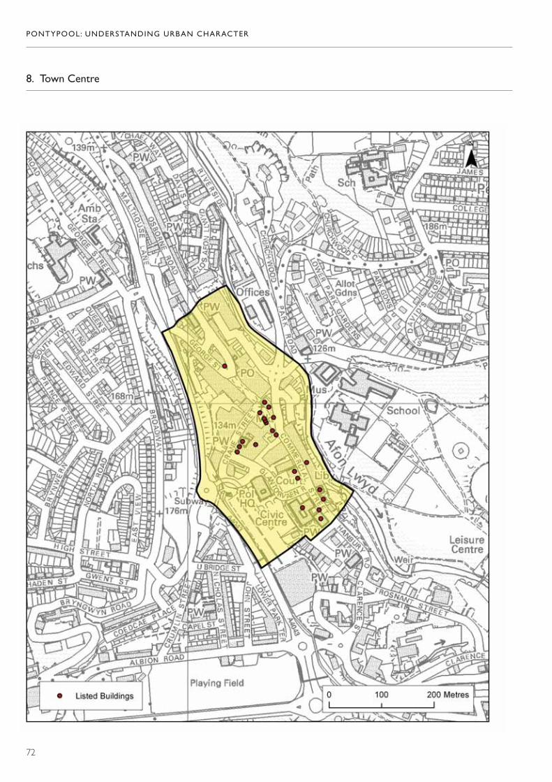
PONTYPOOL: UNDERSTANDING URBAN CHARACTER
72
8. Town Centre
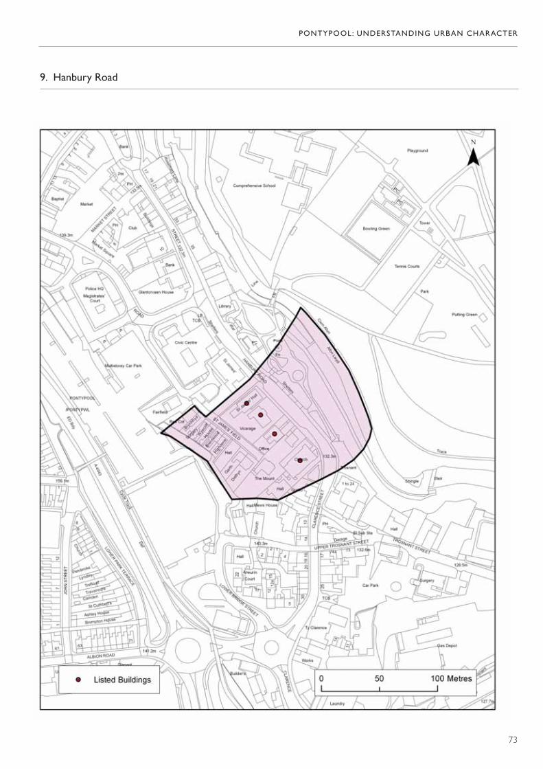
PONTYPOOL: UNDERSTANDING URBAN CHARACTER
73
9. Hanbury Road
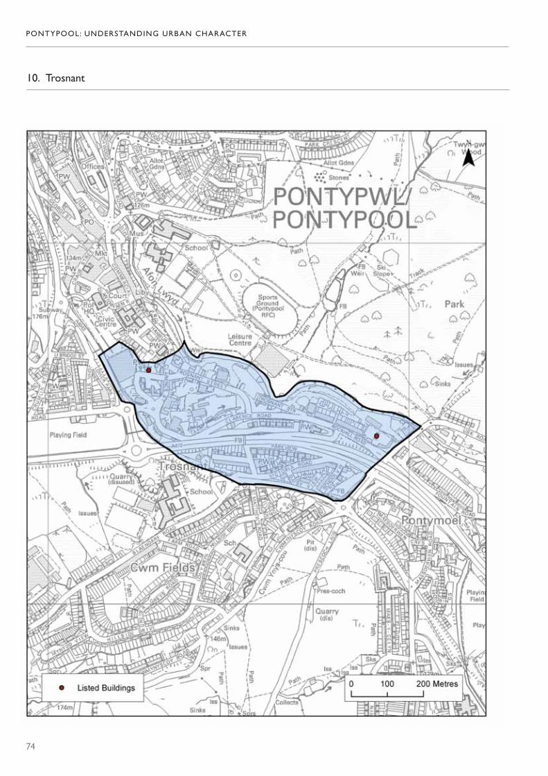
PONTYPOOL: UNDERSTANDING URBAN CHARACTER
74
10. Trosnant

PONTYPOOL: UNDERSTANDING URBAN CHARACTER
75
11. Pontypool Park
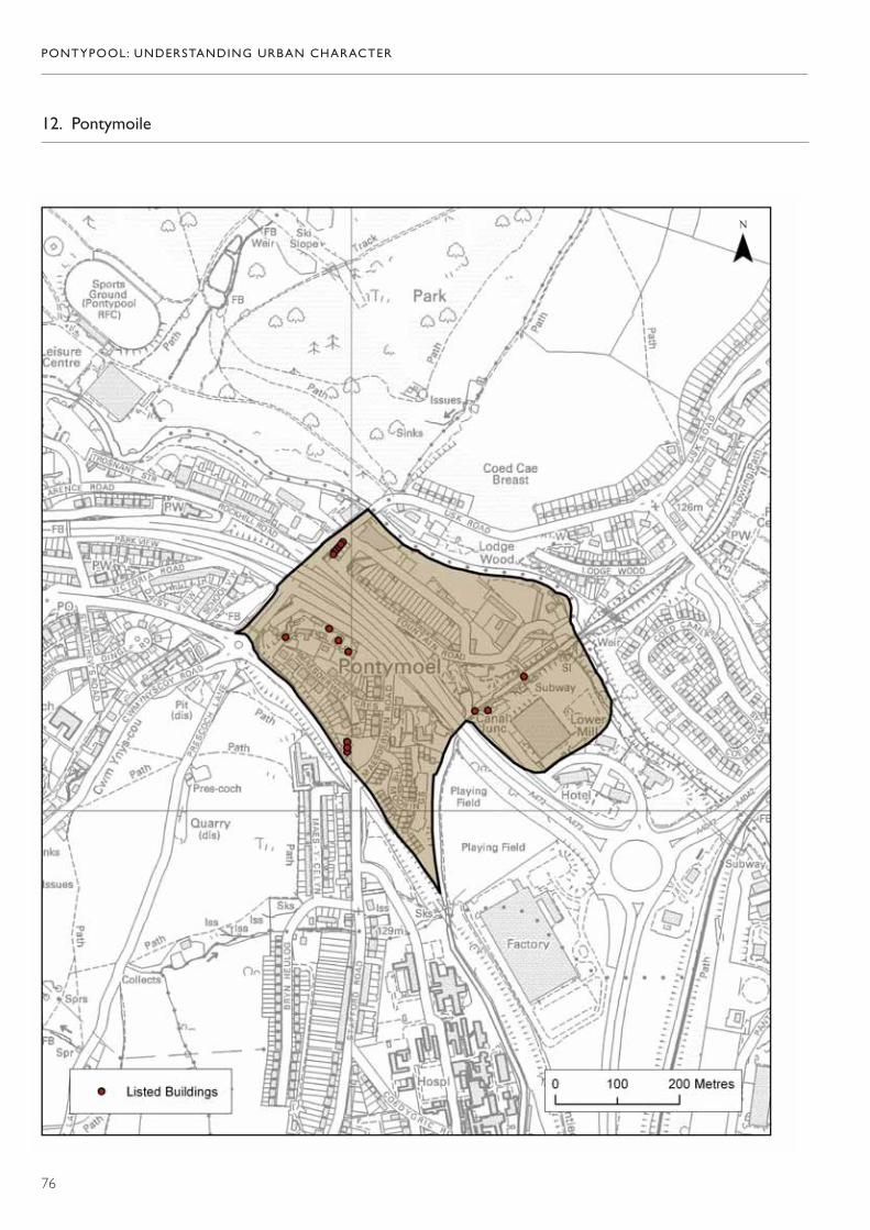
PONTYPOOL: UNDERSTANDING URBAN CHARACTER
76
12. Pontymoile

PONTYPOOL: UNDERSTANDING URBAN CHARACTER
77
13. Osborne Road

PONTYPOOL: UNDERSTANDING URBAN CHARACTER
78
14. Penygarn and East of the River
PONTYPOOL: UNDERSTANDING URBAN CHARACTER
79
15. Sow Hill

PONTYPOOL: UNDERSTANDING URBAN CHARACTER
80
16. Wainfelin
Cadw is the Welsh Government’s historic environment service, working for an accessible and well-protected historic environment for Wales.
CadwWelsh GovernmentPlas CarewUnit 5/7 Cefn CoedParc NantgarwCardiff CF15 7QQ