POINT DUME STATE BEACH STAIRCASE … IS-MND Point Dume...final initial study (is)/ mitigated...
108
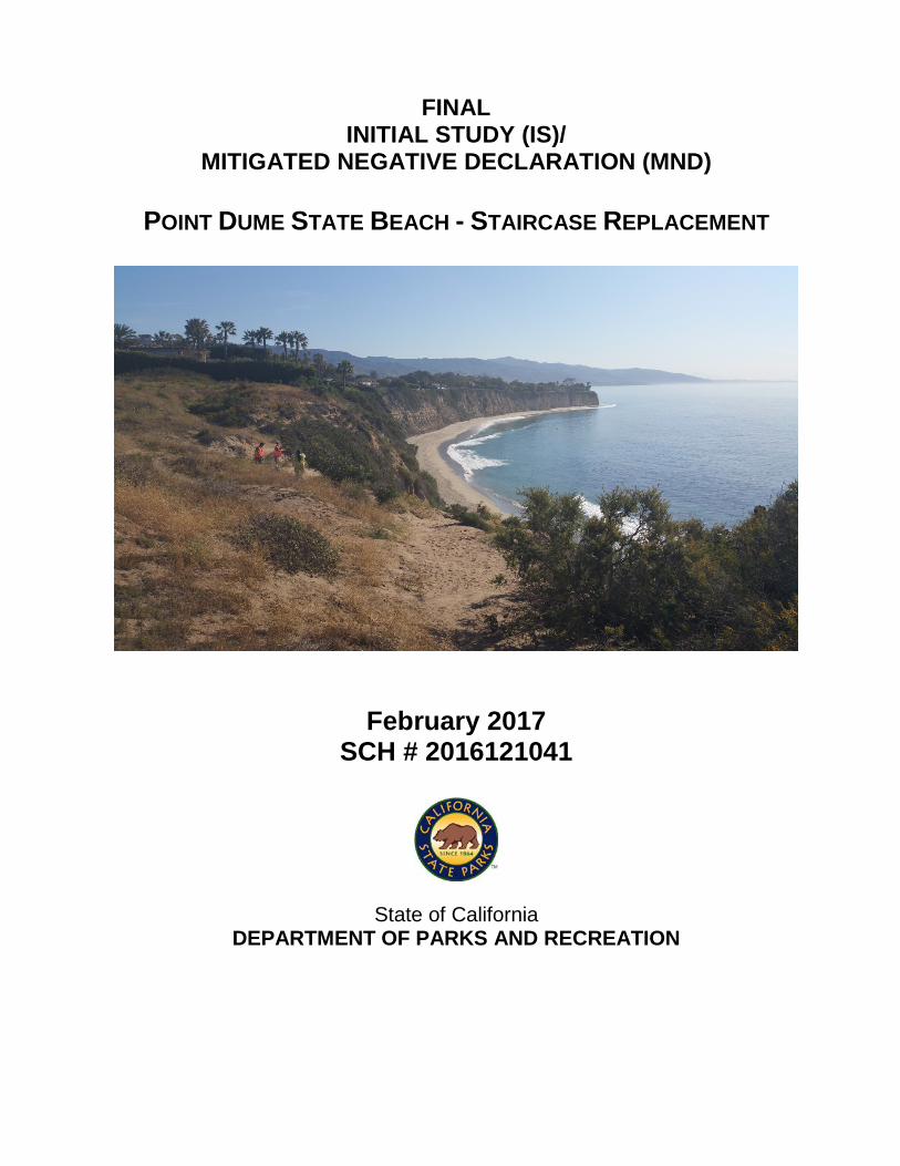
FINAL INITIAL STUDY (IS)/ MITIGATED NEGATIVE DECLARATION (MND) POINT DUME STATE BEACH - STAIRCASE REPLACEMENT February 2017 SCH # 2016121041 State of California DEPARTMENT OF PARKS AND RECREATION
Transcript of POINT DUME STATE BEACH STAIRCASE … IS-MND Point Dume...final initial study (is)/ mitigated...
FINAL INITIAL STUDY (IS)/
MITIGATED NEGATIVE DECLARATION (MND)
POINT DUME STATE BEACH - STAIRCASE REPLACEMENT
February 2017 SCH # 2016121041
State of California DEPARTMENT OF PARKS AND RECREATION

i Initial Study/Mitigated Negative Declaration for Staircase Replacement Point Dume State Beach California Department of Parks & Recreation
MITIGATED NEGATIVE DECLARATION
PROJECT: POINT DUME STATE BEACH - STAIRCASE REPLACEMENT LEAD AGENCY: California Department of Parks and Recreation AVAILABILITY OF DOCUMENTS: The Initial Study for this Mitigated Negative Declaration has been made available for review at:
• California Department of Parks & Recreation Malibu Sector Office, Angeles District 39996 West Pacific Coast Highway Malibu, CA 90265
• Malibu Public Library 23519 Civic Center Way Malibu, CA 90265
• https://www.parks.ca.gov/?page_id=983
PROJECT DESCRIPTION: The proposed project would replace the existing steel staircase at Point Dume State Beach with a new replacement staircase. The existing staircase is deteriorated, functionally substandard and does not meet current code. The new staircase will be located downcoast to address issues of bluff erosion and vegetation trampling as a result of off-trail visitor use. Primary project elements are provided below. Please refer to Chapter 2 of this document for further project detail:
• Staging areas • Construction of replacement staircase • Removal of existing staircase • Access trails • Haul path along beach • Revegetation of impacted areas with native plant species

ii Initial Study/Mitigated Negative Declaration for Staircase Replacement Point Dume State Beach California Department of Parks & Recreation

iv Initial Study/Mitigated Negative Declaration for Staircase Replacement Point Dume State Beach California Department of Parks & Recreation
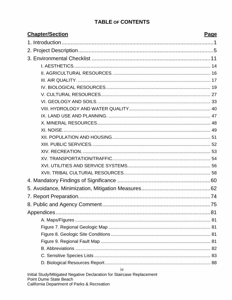
TABLE OF CONTENTS
Chapter/Section Page 1. Introduction ..................................................................................................... 1
2. Project Description .......................................................................................... 5
3. Environmental Checklist ............................................................................... 11
I. AESTHETICS. .......................................................................................................... 14
II. AGRICULTURAL RESOURCES. ............................................................................ 16
III. AIR QUALITY. ........................................................................................................ 17
IV. BIOLOGICAL RESOURCES. ................................................................................. 19
V. CULTURAL RESOURCES. ..................................................................................... 27
VI. GEOLOGY AND SOILS. ........................................................................................ 33
VIII. HYDROLOGY AND WATER QUALITY................................................................ 40
IX. LAND USE AND PLANNING. ................................................................................ 47
X. MINERAL RESOURCES. ........................................................................................ 48
XI. NOISE. ................................................................................................................... 49
XII. POPULATION AND HOUSING. ............................................................................ 51
XIII. PUBLIC SERVICES. ............................................................................................ 52
XIV. RECREATION. .................................................................................................... 53
XV. TRANSPORTATION/TRAFFIC. ............................................................................ 54
XVI. UTILITIES AND SERVICE SYSTEMS. ................................................................ 56
XVII. TRIBAL CULTURAL RESOURCES. ................................................................... 58
4. Mandatory Findings of Significance .............................................................. 60
5. Avoidance, Minimization, Mitigation Measures .............................................. 62
7. Report Preparation........................................................................................ 74
8. Public and Agency Comment ........................................................................ 75
Appendices ....................................................................................................... 81
A. Maps/Figures .......................................................................................................... 81
Figure 7. Regional Geologic Map ................................................................................ 81
Figure 8. Geologic Site Conditions .............................................................................. 81
Figure 9. Regional Fault Map ...................................................................................... 81
B. Abbreviations .......................................................................................................... 82
C. Sensitive Species Lists ........................................................................................... 83
D. Biological Resources Report ................................................................................... 88

v
E. Archaeological Testing Report (CONFIDENTIAL) .............................................. 89
1 Initial Study/Mitigated Negative Declaration for Staircase Replacement Point Dume State Beach California Department of Parks & Recreation
CHAPTER 1 1. INTRODUCTION
1.1 INTRODUCTION AND REGULATORY GUIDANCE This Initial Study/Mitigated Negative Declaration (IS/MND) has been prepared by the California Department of Parks and Recreation (CDPR) to evaluate the potential environmental effects of a proposed replacement staircase at Point Dume State Beach (the Park), Malibu, California. This document has been prepared in accordance with the California Environmental Quality Act (CEQA), Public Resources Code §21000 et seq., and the State CEQA Guidelines, California Code of Regulations (CCR) §15000 et seq. An IS is conducted by a lead agency to determine if a project may have a significant effect on the environment [CEQA Guidelines §15063(a)]. If there is substantial evidence that a project may have a significant effect on the environment, an Environmental Impact Report (EIR) must be prepared, in accordance with CEQA Guidelines §15064(a). However, if the lead agency determines that revisions in the project plans or proposals made by or agreed to by the applicant mitigate the potentially significant effects to a less-than-significant level, a MND may be prepared instead of an EIR [CEQA Guidelines §15070(b)]. The lead agency prepares a written statement describing the reasons a proposed project would not have a significant effect on the environment and, therefore, why an EIR need not be prepared. This IS/MND conforms to the content requirements under CEQA Guidelines §15071. 1.2 LEAD AGENCY The lead agency is the public agency with primary approval authority over the proposed project. In accordance with CEQA Guidelines §15051(b)(1), "the lead agency will normally be an agency with general governmental powers, such as a city or county, rather than an agency with a single or limited purpose." The lead agency for the proposed project is CDPR. The contact person for the lead agency is: Jim Engelke, Project Manager California Department of Parks & Recreation Southern Service Center 2797 Truxtun Rd, Barracks 26 San Diego, CA 92106 Fax: (619) 221-7082 [email protected] All inquiries regarding environmental compliance for this project, including comments on this environmental document should be addressed to: Mike Yengling, Associate Park & Recreation Specialist California Department of Parks & Recreation Southern Service Center

2 Initial Study/Mitigated Negative Declaration for Staircase Replacement Point Dume State Beach California Department of Parks & Recreation
2797 Truxtun Rd, Barracks 26 San Diego, CA 92106 Fax: (619) 221-7082 [email protected]
3 Initial Study/Mitigated Negative Declaration for Staircase Replacement Point Dume State Beach California Department of Parks & Recreation
1.3 PURPOSE AND DOCUMENT ORGANIZATION The purpose of this document is to evaluate the potential environmental effects of the proposed project on the Park. Mitigation measures have also been incorporated into the project to eliminate any potentially significant impacts or reduce them to a less-than-significant level. This document is organized as follows: • Chapter 1 - Introduction. • Chapter 2 - Project Description.
This chapter describes the purpose of the project, the need for the project, and how the project will be carried out.
• Chapter 3 - Environmental Setting, Impacts, and Mitigation Measures. This chapter identifies the significance of potential environmental impacts, explains
the environmental setting for each environmental resource or impact, and evaluates each through the CEQA Environmental (Initial Study) Checklist. Mitigation measures are incorporated, where appropriate, to reduce all potentially significant impacts to a less-than-significant level.
• Chapter 4 - Mandatory Findings of Significance
The overall significance of any potential impacts to natural and cultural resources, cumulative impacts and impacts to humans shall be identified and summarized within this chapter as required by the Initial Study guidelines.
• Chapter 5 - Summary of Mitigation Measures. This chapter includes the mitigation measures incorporated into the project as a
result of the Initial Study. • Chapter 6 - References. This chapter identifies the references and sources used in the preparation of this
IS/MND. • Chapter 7 - Report Preparation This chapter provides a list of those involved in the preparation of this document. • Chapter 8 – Public and Agency Comment (* Final document only)
Summary of the public review process for the IS/MND and comments received.
4 Initial Study/Mitigated Negative Declaration for Staircase Replacement Point Dume State Beach California Department of Parks & Recreation
1.4 SUMMARY OF FINDINGS Chapter 3 of this document contains the Environmental (Initial Study) Checklist that identifies potential environmental impacts (by environmental issue) which may result from implementation of the project. Avoidance, minimization and/or mitigation measures have been included that result in impacts that are less-than-significant or result in no impact. Based on the IS and supporting environmental analysis provided in this document, the proposed project would result in less-than-significant impacts to the following resources or issues: aesthetics, agricultural resources, air quality, biological resources, cultural resources, geology and soils, hazards and hazardous materials, hydrology and water quality, land use and planning, mineral resources, noise, population and housing, public services, recreation, transportation/traffic, and utilities and service systems. In accordance with §15064(f) of the CEQA Guidelines, an MND shall be prepared if the proposed project will not have a significant effect on the environment after the inclusion of mitigation measures. Based on the available project information and the environmental analysis presented in this document, there is no substantial evidence that, after the incorporation of mitigation measures, the proposed project would have a significant effect on the environment. It is proposed that a Mitigated Negative Declaration be adopted in accordance with CEQA Guidelines.
5 Initial Study/Mitigated Negative Declaration for Staircase Replacement Point Dume State Beach California Department of Parks & Recreation
CHAPTER 2 2. PROJECT DESCRIPTION
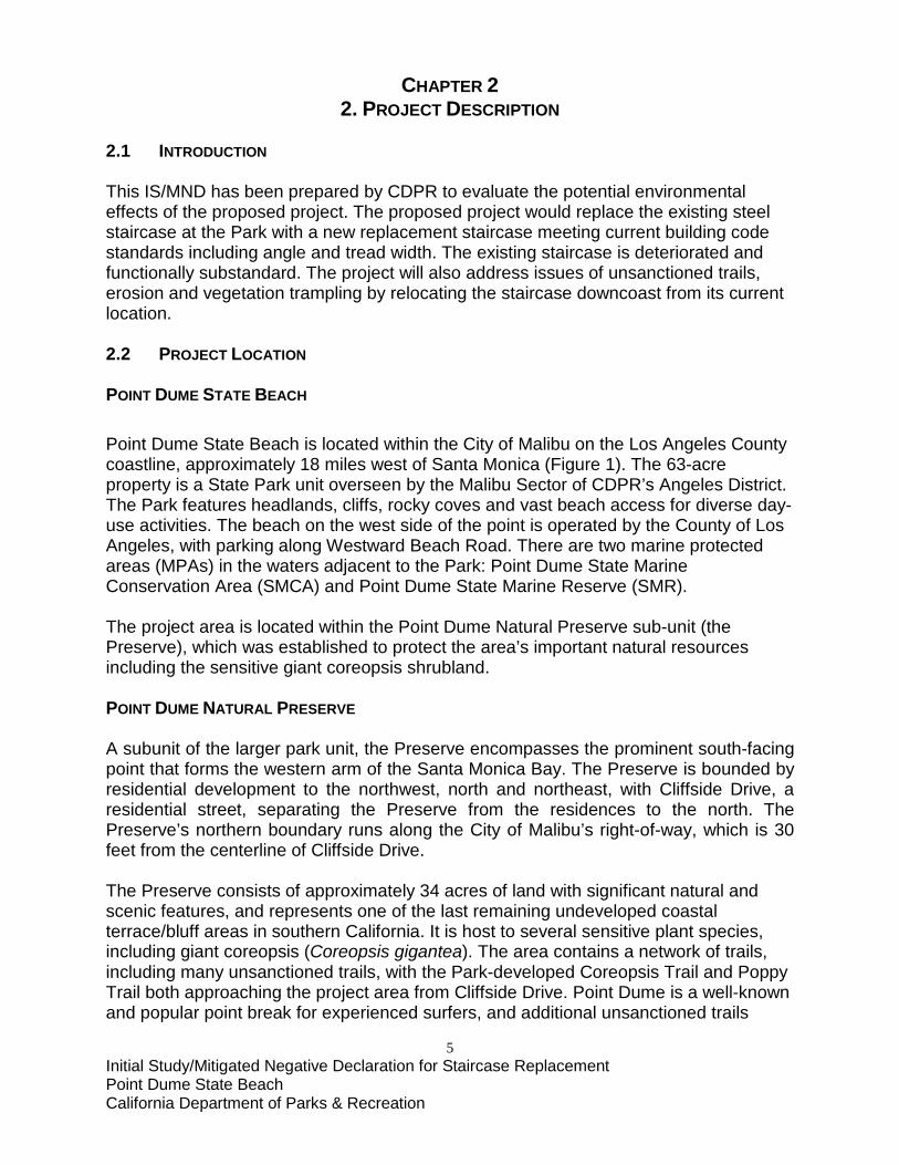
2.1 INTRODUCTION This IS/MND has been prepared by CDPR to evaluate the potential environmental effects of the proposed project. The proposed project would replace the existing steel staircase at the Park with a new replacement staircase meeting current building code standards including angle and tread width. The existing staircase is deteriorated and functionally substandard. The project will also address issues of unsanctioned trails, erosion and vegetation trampling by relocating the staircase downcoast from its current location. 2.2 PROJECT LOCATION POINT DUME STATE BEACH Point Dume State Beach is located within the City of Malibu on the Los Angeles County coastline, approximately 18 miles west of Santa Monica (Figure 1). The 63-acre property is a State Park unit overseen by the Malibu Sector of CDPR’s Angeles District. The Park features headlands, cliffs, rocky coves and vast beach access for diverse day-use activities. The beach on the west side of the point is operated by the County of Los Angeles, with parking along Westward Beach Road. There are two marine protected areas (MPAs) in the waters adjacent to the Park: Point Dume State Marine Conservation Area (SMCA) and Point Dume State Marine Reserve (SMR). The project area is located within the Point Dume Natural Preserve sub-unit (the Preserve), which was established to protect the area’s important natural resources including the sensitive giant coreopsis shrubland. POINT DUME NATURAL PRESERVE A subunit of the larger park unit, the Preserve encompasses the prominent south-facing point that forms the western arm of the Santa Monica Bay. The Preserve is bounded by residential development to the northwest, north and northeast, with Cliffside Drive, a residential street, separating the Preserve from the residences to the north. The Preserve’s northern boundary runs along the City of Malibu’s right-of-way, which is 30 feet from the centerline of Cliffside Drive. The Preserve consists of approximately 34 acres of land with significant natural and scenic features, and represents one of the last remaining undeveloped coastal terrace/bluff areas in southern California. It is host to several sensitive plant species, including giant coreopsis (Coreopsis gigantea). The area contains a network of trails, including many unsanctioned trails, with the Park-developed Coreopsis Trail and Poppy Trail both approaching the project area from Cliffside Drive. Point Dume is a well-known and popular point break for experienced surfers, and additional unsanctioned trails
6 Initial Study/Mitigated Negative Declaration for Staircase Replacement Point Dume State Beach California Department of Parks & Recreation
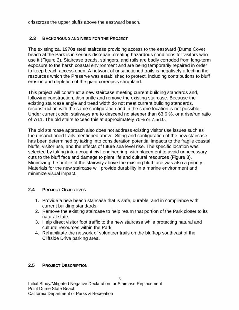
crisscross the upper bluffs above the eastward beach. 2.3 BACKGROUND AND NEED FOR THE PROJECT The existing ca. 1970s steel staircase providing access to the eastward (Dume Cove) beach at the Park is in serious disrepair, creating hazardous conditions for visitors who use it (Figure 2). Staircase treads, stringers, and rails are badly corroded from long-term exposure to the harsh coastal environment and are being temporarily repaired in order to keep beach access open. A network of unsanctioned trails is negatively affecting the resources which the Preserve was established to protect, including contributions to bluff erosion and depletion of the giant coreopsis shrubland. This project will construct a new staircase meeting current building standards and, following construction, dismantle and remove the existing staircase. Because the existing staircase angle and tread width do not meet current building standards, reconstruction with the same configuration and in the same location is not possible. Under current code, stairways are to descend no steeper than 63.6 %, or a rise/run ratio of 7/11. The old stairs exceed this at approximately 75% or 7.5/10. The old staircase approach also does not address existing visitor use issues such as the unsanctioned trails mentioned above. Siting and configuration of the new staircase has been determined by taking into consideration potential impacts to the fragile coastal bluffs, visitor use, and the effects of future sea level rise. The specific location was selected by taking into account civil engineering, with placement to avoid unnecessary cuts to the bluff face and damage to plant life and cultural resources (Figure 3). Minimizing the profile of the stairway above the existing bluff face was also a priority. Materials for the new staircase will provide durability in a marine environment and minimize visual impact. 2.4 PROJECT OBJECTIVES
1. Provide a new beach staircase that is safe, durable, and in compliance with current building standards.
2. Remove the existing staircase to help return that portion of the Park closer to its natural state.
3. Help direct visitor foot traffic to the new staircase while protecting natural and cultural resources within the Park.
4. Rehabilitate the network of volunteer trails on the blufftop southeast of the Cliffside Drive parking area.
2.5 PROJECT DESCRIPTION
7 Initial Study/Mitigated Negative Declaration for Staircase Replacement Point Dume State Beach California Department of Parks & Recreation
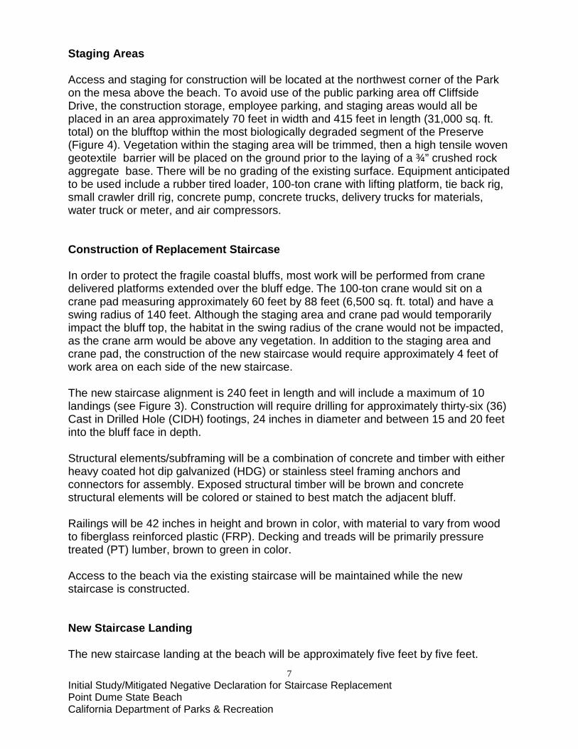
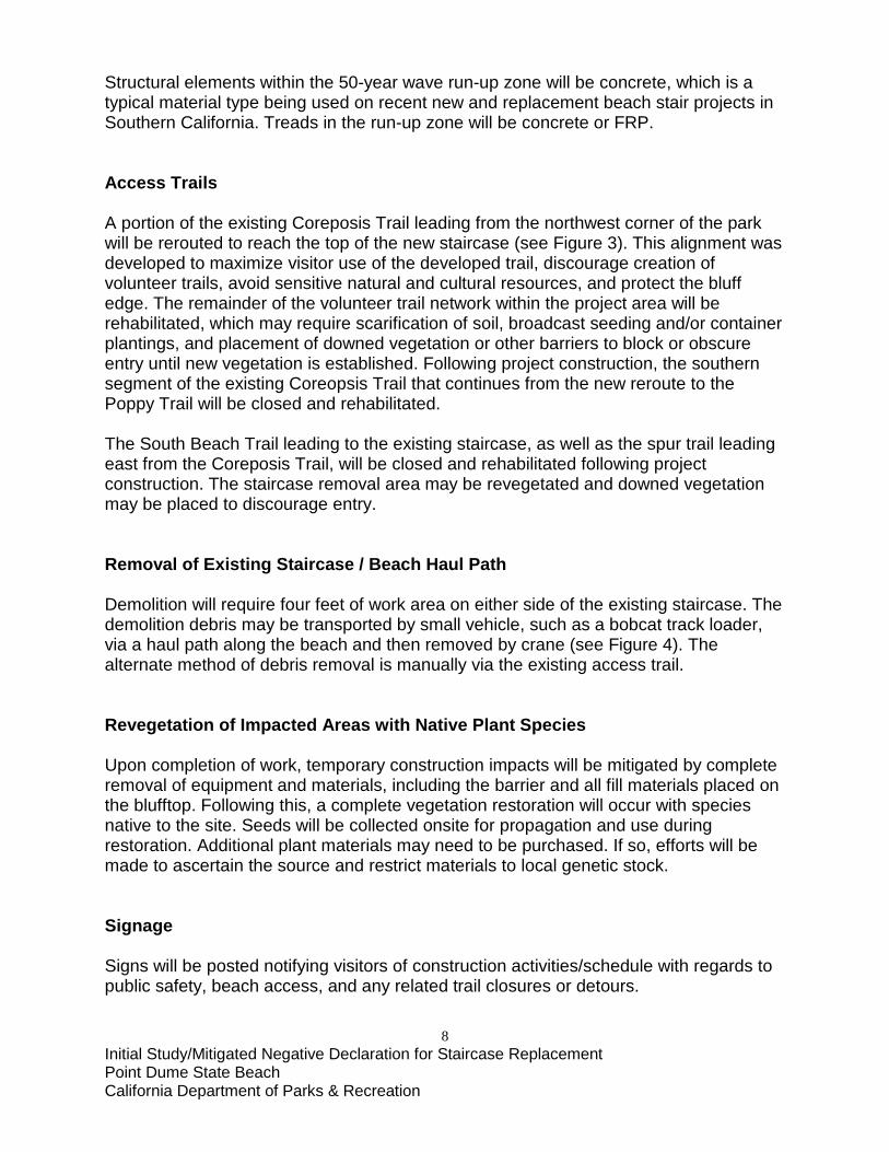
Staging Areas Access and staging for construction will be located at the northwest corner of the Park on the mesa above the beach. To avoid use of the public parking area off Cliffside Drive, the construction storage, employee parking, and staging areas would all be placed in an area approximately 70 feet in width and 415 feet in length (31,000 sq. ft. total) on the blufftop within the most biologically degraded segment of the Preserve (Figure 4). Vegetation within the staging area will be trimmed, then a high tensile woven geotextile barrier will be placed on the ground prior to the laying of a ¾” crushed rock aggregate base. There will be no grading of the existing surface. Equipment anticipated to be used include a rubber tired loader, 100-ton crane with lifting platform, tie back rig, small crawler drill rig, concrete pump, concrete trucks, delivery trucks for materials, water truck or meter, and air compressors. Construction of Replacement Staircase In order to protect the fragile coastal bluffs, most work will be performed from crane delivered platforms extended over the bluff edge. The 100-ton crane would sit on a crane pad measuring approximately 60 feet by 88 feet (6,500 sq. ft. total) and have a swing radius of 140 feet. Although the staging area and crane pad would temporarily impact the bluff top, the habitat in the swing radius of the crane would not be impacted, as the crane arm would be above any vegetation. In addition to the staging area and crane pad, the construction of the new staircase would require approximately 4 feet of work area on each side of the new staircase. The new staircase alignment is 240 feet in length and will include a maximum of 10 landings (see Figure 3). Construction will require drilling for approximately thirty-six (36) Cast in Drilled Hole (CIDH) footings, 24 inches in diameter and between 15 and 20 feet into the bluff face in depth. Structural elements/subframing will be a combination of concrete and timber with either heavy coated hot dip galvanized (HDG) or stainless steel framing anchors and connectors for assembly. Exposed structural timber will be brown and concrete structural elements will be colored or stained to best match the adjacent bluff. Railings will be 42 inches in height and brown in color, with material to vary from wood to fiberglass reinforced plastic (FRP). Decking and treads will be primarily pressure treated (PT) lumber, brown to green in color. Access to the beach via the existing staircase will be maintained while the new staircase is constructed. New Staircase Landing The new staircase landing at the beach will be approximately five feet by five feet.
8 Initial Study/Mitigated Negative Declaration for Staircase Replacement Point Dume State Beach California Department of Parks & Recreation
Structural elements within the 50-year wave run-up zone will be concrete, which is a typical material type being used on recent new and replacement beach stair projects in Southern California. Treads in the run-up zone will be concrete or FRP. Access Trails A portion of the existing Coreposis Trail leading from the northwest corner of the park will be rerouted to reach the top of the new staircase (see Figure 3). This alignment was developed to maximize visitor use of the developed trail, discourage creation of volunteer trails, avoid sensitive natural and cultural resources, and protect the bluff edge. The remainder of the volunteer trail network within the project area will be rehabilitated, which may require scarification of soil, broadcast seeding and/or container plantings, and placement of downed vegetation or other barriers to block or obscure entry until new vegetation is established. Following project construction, the southern segment of the existing Coreopsis Trail that continues from the new reroute to the Poppy Trail will be closed and rehabilitated. The South Beach Trail leading to the existing staircase, as well as the spur trail leading east from the Coreposis Trail, will be closed and rehabilitated following project construction. The staircase removal area may be revegetated and downed vegetation may be placed to discourage entry. Removal of Existing Staircase / Beach Haul Path Demolition will require four feet of work area on either side of the existing staircase. The demolition debris may be transported by small vehicle, such as a bobcat track loader, via a haul path along the beach and then removed by crane (see Figure 4). The alternate method of debris removal is manually via the existing access trail. Revegetation of Impacted Areas with Native Plant Species Upon completion of work, temporary construction impacts will be mitigated by complete removal of equipment and materials, including the barrier and all fill materials placed on the blufftop. Following this, a complete vegetation restoration will occur with species native to the site. Seeds will be collected onsite for propagation and use during restoration. Additional plant materials may need to be purchased. If so, efforts will be made to ascertain the source and restrict materials to local genetic stock. Signage Signs will be posted notifying visitors of construction activities/schedule with regards to public safety, beach access, and any related trail closures or detours.
9 Initial Study/Mitigated Negative Declaration for Staircase Replacement Point Dume State Beach California Department of Parks & Recreation
2.6 PROJECT IMPLEMENTATION Construction work is projected to start in August 2017, or soon thereafter, and continue for approximately 6 months. Work would occur only during daylight hours and not during weekends or on State Holidays in order to avoid unnecessary impact to visitors; however, weekend or holiday work could be implemented to address emergencies or unforeseen circumstances impacting construction. Heavy equipment, such as a loader, crane, compressor, and concrete pump will be used during construction. All equipment would be transported to the site and be parked within the construction staging area/temporary impact zone identified in Figure 4. The crane may remain until staircase construction and demolition are both completed. Transport vehicles for material, equipment delivery trucks, and crew vehicles would also be present intermittently at the site. Best Management Practices (BMPs) will be incorporated into this project design to ensure that the natural and cultural resources in and around the project area are adequately protected during and after construction. The BMPs discussed in this document and used in the implementation of this project were obtained from the California Stormwater Quality Association (CSQA), Stormwater Best Management Practices Construction Handbook. Temporary BMPs will be used to keep sediment on-site throughout the duration of the project; during construction, BMPs will be checked weekly, maintained, and modified as needed. Some BMPs will be left in place after construction if needed to stabilize the site and minimize erosion. The Department of Parks and Recreation has consistently referenced CSQA BMPs and has identified them as an acceptable standard for use in all State Parks. 2.7 VISITATION TO POINT DUME STATE BEACH Point Dume State Beach is open for day use only. The Park has had an estimated average of 238,130 annual visitors for the last five years (2010-2015), with 246,000 in 2015. 2.8 CONSISTENCY WITH LOCAL PLANS AND POLICIES The City of Malibu's General Plan Land Use Element designates the project site as Open Space, and the City's Municipal Code (Title 17, Chapter 17.32) includes public beaches and parks as allowable uses for Open Space. The City of Malibu Local Coastal Program (LCP)’s Land Use Plan (Section 5.2.86) requires that vertical access to the beach from the bluff top headlands be provided within the Park. Public Resources Code, Sec. 5019.71, California State Park and Recreation Commission Policy II.3 (amended May 04, 1994), and State Park Resource
10 Initial Study/Mitigated Negative Declaration for Staircase Replacement Point Dume State Beach California Department of Parks & Recreation
Management Directives 9 and 27 (adopted May 1979) govern the establishment and management of Natural Preserves. The purpose of Natural Preserves is to protect distinct areas of outstanding natural or scientific significance within state park system units. Relevant to this project, developments in Natural Preserves are limited to trails and interpretive facilities required for visual and sensory enjoyment of the resources by visitors. 2.9 DISCRETIONARY APPROVALS City of Malibu Local Coastal Program - Coastal Development Permit State Fire Marshall - exemption U.S. Access Board (ADA) - exemption 2.10 RELATED PROJECTS Point Dume State Beach Trail Improvements (15/16-A-9; CEQA ID No. 11569) This project includes reconstruction of, and accessibility improvements to, portions of the Poppy Trail and Coreopsis Trail, as well as construction of an overlook near the intersection of these two trails.

11 Initial Study/Mitigated Negative Declaration for Staircase Replacement Point Dume State Beach California Department of Parks & Recreation
CHAPTER 3 3. ENVIRONMENTAL CHECKLIST
PROJECT INFORMATION
1. Project Title: Point Dume State Beach Staircase Replacement 2. Lead Agency Name & Address: California Department of Parks and Recreation 3. Contact Person & Phone Number: Jim Engelke, Project Manager, (619) 221-7061 4. Project Location: Point Dume State Beach, Malibu, CA
5. Project Sponsor Name & Address: California Department of Parks and Recreation Craig Sap, Angeles District Superintendent 1925 Las Virgenes Road
Calabasas, CA 91302
6. General Plan Designation: State Beach; Natural Preserve 7. Zoning/Classification: Open Space 8. Description of Project: Refer to Chapter 2, Section 5
9. Approval Required from Other City of Malibu Public Agencies
12 Initial Study/Mitigated Negative Declaration for Staircase Replacement Point Dume State Beach California Department of Parks & Recreation
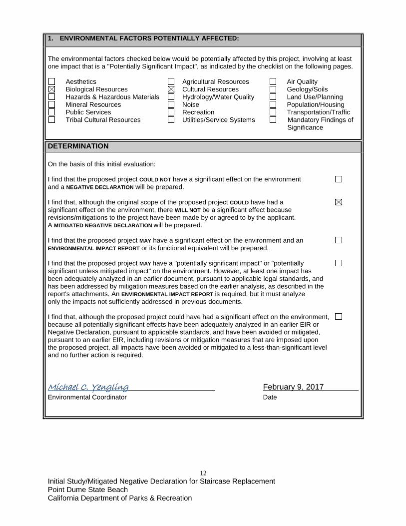
1. ENVIRONMENTAL FACTORS POTENTIALLY AFFECTED:
The environmental factors checked below would be potentially affected by this project, involving at least one impact that is a "Potentially Significant Impact", as indicated by the checklist on the following pages.
Aesthetics Agricultural Resources Air Quality Biological Resources Cultural Resources Geology/Soils Hazards & Hazardous Materials Hydrology/Water Quality Land Use/Planning Mineral Resources Noise Population/Housing Public Services Recreation Transportation/Traffic Tribal Cultural Resources Utilities/Service Systems Mandatory Findings of
Significance
DETERMINATION On the basis of this initial evaluation: I find that the proposed project COULD NOT have a significant effect on the environment and a NEGATIVE DECLARATION will be prepared. I find that, although the original scope of the proposed project COULD have had a significant effect on the environment, there WILL NOT be a significant effect because revisions/mitigations to the project have been made by or agreed to by the applicant. A MITIGATED NEGATIVE DECLARATION will be prepared. I find that the proposed project MAY have a significant effect on the environment and an ENVIRONMENTAL IMPACT REPORT or its functional equivalent will be prepared. I find that the proposed project MAY have a "potentially significant impact" or "potentially significant unless mitigated impact" on the environment. However, at least one impact has been adequately analyzed in an earlier document, pursuant to applicable legal standards, and has been addressed by mitigation measures based on the earlier analysis, as described in the report's attachments. An ENVIRONMENTAL IMPACT REPORT is required, but it must analyze only the impacts not sufficiently addressed in previous documents. I find that, although the proposed project could have had a significant effect on the environment, because all potentially significant effects have been adequately analyzed in an earlier EIR or Negative Declaration, pursuant to applicable standards, and have been avoided or mitigated, pursuant to an earlier EIR, including revisions or mitigation measures that are imposed upon the proposed project, all impacts have been avoided or mitigated to a less-than-significant level and no further action is required. Michael C. Yengling February 9, 2017 Environmental Coordinator Date
13 Initial Study/Mitigated Negative Declaration for Staircase Replacement Point Dume State Beach California Department of Parks & Recreation
EVALUATION OF ENVIRONMENTAL IMPACTS 1. A brief explanation is required for all answers, except "No Impact", that are adequately supported by the
information sources cited. A "No Impact" answer is adequately supported if the referenced information sources show that the impact does not apply to the project being evaluated (e.g., the project falls outside a fault rupture zone). A "No Impact" answer should be explained where it is based on general or project-specific factors (e.g., the project will not expose sensitive receptors to pollutants, based on a project-specific screening analysis).
2. All answers must consider the whole of the project-related effects, both direct and indirect, including off-site,
cumulative, construction, and operational impacts. 3. Once the lead agency has determined that a particular physical impact may occur, the checklist answers must
indicate whether that impact is potentially significant, less than significant with mitigation, or less than significant. "Potentially Significant Impact" is appropriate when there is sufficient evidence that a substantial or potentially substantial adverse change may occur in any of the physical conditions within the area affected by the project that cannot be mitigated below a level of significance. If there are one or more "Potentially Significant Impact" entries, an Environmental Impact Report (EIR) is required.
4. A "Mitigated Negative Declaration" (Negative Declaration: Less Than Significant with Mitigation Incorporated)
applies where the incorporation of mitigation measures, prior to declaration of project approval, has reduced an effect from "Potentially Significant Impact" to a "Less Than Significant Impact with Mitigation." The lead agency must describe the mitigation measures and briefly explain how they reduce the effect to a less than significant level.
5. Earlier analyses may be used where, pursuant to the tiering, program EIR, or other CEQA process, an effect
has been adequately analyzed in an earlier EIR (including a General Plan) or Negative Declaration [CCR, Guidelines for the Implementation of CEQA, § 15063(c)(3)(D)]. References to an earlier analysis should:
a) Identify the earlier analysis and state where it is available for review. b) Indicate which effects from the environmental checklist were adequately analyzed in the earlier document,
pursuant to applicable legal standards, and whether these effects were adequately addressed by mitigation measures included in that analysis.
c) Describe the mitigation measures in this document that were incorporated or refined from the earlier
document and indicate to what extent they address site-specific conditions for this project.
6. Lead agencies are encouraged to incorporate references to information sources for potential impacts into the checklist or appendix (e.g., general plans, zoning ordinances, biological assessments). Reference to a previously prepared or outside document should include an indication of the page or pages where the statement is substantiated.
7. A source list should be appended to this document. Sources used or individuals contacted should be listed in
the source list and cited in the discussion. 8. Explanation(s) of each issue should identify: a) the criteria or threshold, if any, used to evaluate the significance of the impact addressed by each
question and b) the mitigation measures, if any, prescribed to reduce the impact below the level of significance.
14 Initial Study/Mitigated Negative Declaration for Staircase Replacement Point Dume State Beach California Department of Parks & Recreation
ENVIRONMENTAL ISSUES
I. AESTHETICS. ENVIRONMENTAL SETTING As the westernmost terminus of Santa Monica Bay, the rocky headland of Point Dume has been an important landmark for navigators dating at least as far back as the 1542 Juan Rodríguez Cabrillo expedition. In 1793, English explorer George Vancouver named it in honor of his friend Father Francisco Dumetz of Mission San Buenaventura to the north. Point Dume is also a registered California Historical Landmark (No. 965). From the tip of the point, the views extend as far east as Surfrider Beach and as far west as the craggy ridges of the Boney Mountains State Wilderness Area. The draft Management Plan for the Point Dume Natural Preserve describes the setting as follows:
“Hemmed in on two sides by urban development, Point Dume Natural Preserve represents an isolated portal in which people experience the grand sweep of the Pacific Ocean and Santa Monica Bay. After only a short stroll, visitors exchange the intensity of cars, houses and street signs for the crashing waves, the barking seals and the uninterrupted vistas across the blue horizon. The contrast is striking and the brief recuperative effects to the human spirit are real.” (CDPR 2000:9)
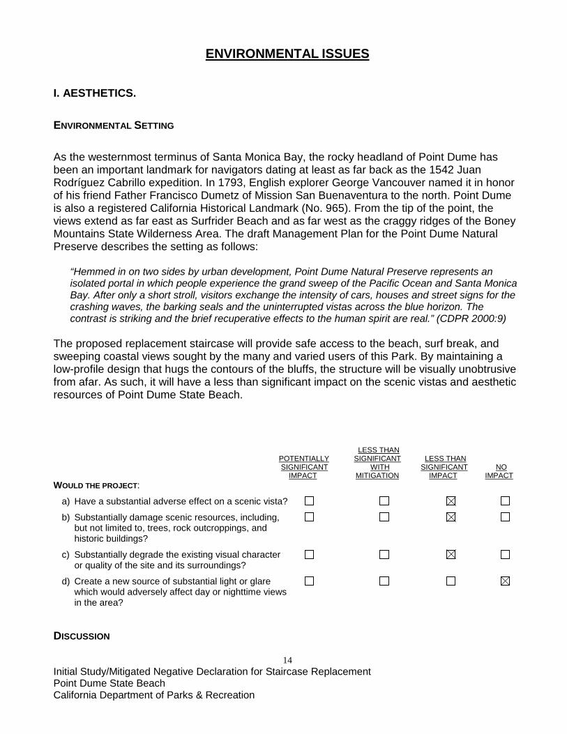
The proposed replacement staircase will provide safe access to the beach, surf break, and sweeping coastal views sought by the many and varied users of this Park. By maintaining a low-profile design that hugs the contours of the bluffs, the structure will be visually unobtrusive from afar. As such, it will have a less than significant impact on the scenic vistas and aesthetic resources of Point Dume State Beach. LESS THAN POTENTIALLY SIGNIFICANT LESS THAN SIGNIFICANT WITH SIGNIFICANT NO IMPACT MITIGATION IMPACT IMPACT WOULD THE PROJECT:
a) Have a substantial adverse effect on a scenic vista?
b) Substantially damage scenic resources, including, but not limited to, trees, rock outcroppings, and historic buildings?
c) Substantially degrade the existing visual character or quality of the site and its surroundings?
d) Create a new source of substantial light or glare which would adversely affect day or nighttime views in the area? DISCUSSION
15 Initial Study/Mitigated Negative Declaration for Staircase Replacement Point Dume State Beach California Department of Parks & Recreation
a) Access to scenic vistas shall be maintained, with visitor foot traffic directed to the new staircase to discourage creation of unsanctioned trails down the bluff to the beach. Post-construction restoration work with native plantings will further enhance scenic vistas.
b) There are no trees, rock outcroppings or historic buildings within the project area. The design of the proposed replacement staircase shall minimize impacts to the bluffs to the extent practicable while maintaining public access to the beach.
c) The visual character of Point Dume State Beach shall not be degraded, and the existing staircase location will be returned to a more natural state following its removal.
d) There is no proposed lighting that would affect either day or nighttime views.
AVOIDANCE, MINIMIZATION, MITIGATION MEASURES - AESTHETIC RESOURCES (AR) AR 1: To the extent practicable, the proposed replacement staircase has been designed to blend with the natural setting to minimize its impact on the aesthetics of the surrounding landscape.
16 Initial Study/Mitigated Negative Declaration for Staircase Replacement Point Dume State Beach California Department of Parks & Recreation
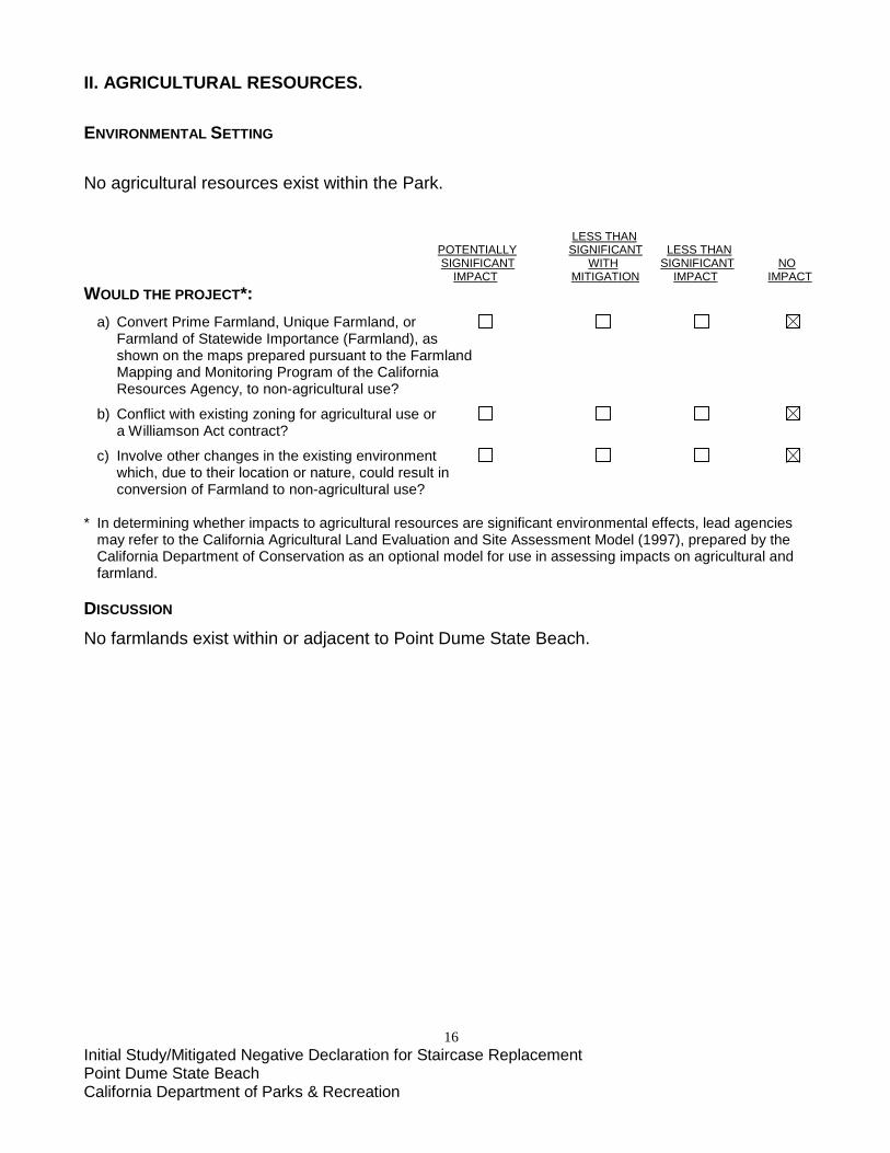
II. AGRICULTURAL RESOURCES. ENVIRONMENTAL SETTING No agricultural resources exist within the Park. LESS THAN POTENTIALLY SIGNIFICANT LESS THAN SIGNIFICANT WITH SIGNIFICANT NO IMPACT MITIGATION IMPACT IMPACT WOULD THE PROJECT*: a) Convert Prime Farmland, Unique Farmland, or Farmland of Statewide Importance (Farmland), as shown on the maps prepared pursuant to the Farmland Mapping and Monitoring Program of the California Resources Agency, to non-agricultural use?
b) Conflict with existing zoning for agricultural use or a Williamson Act contract?
c) Involve other changes in the existing environment which, due to their location or nature, could result in
conversion of Farmland to non-agricultural use? * In determining whether impacts to agricultural resources are significant environmental effects, lead agencies
may refer to the California Agricultural Land Evaluation and Site Assessment Model (1997), prepared by the California Department of Conservation as an optional model for use in assessing impacts on agricultural and farmland.
DISCUSSION
No farmlands exist within or adjacent to Point Dume State Beach.
17 Initial Study/Mitigated Negative Declaration for Staircase Replacement Point Dume State Beach California Department of Parks & Recreation
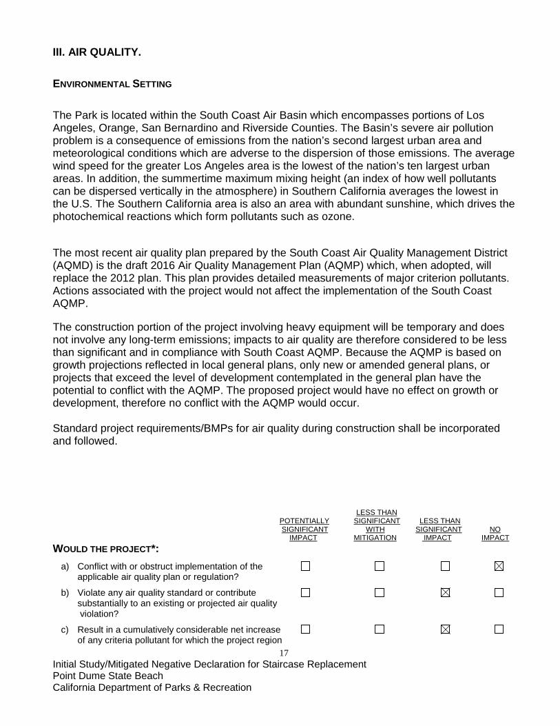
III. AIR QUALITY. ENVIRONMENTAL SETTING The Park is located within the South Coast Air Basin which encompasses portions of Los Angeles, Orange, San Bernardino and Riverside Counties. The Basin’s severe air pollution problem is a consequence of emissions from the nation’s second largest urban area and meteorological conditions which are adverse to the dispersion of those emissions. The average wind speed for the greater Los Angeles area is the lowest of the nation’s ten largest urban areas. In addition, the summertime maximum mixing height (an index of how well pollutants can be dispersed vertically in the atmosphere) in Southern California averages the lowest in the U.S. The Southern California area is also an area with abundant sunshine, which drives the photochemical reactions which form pollutants such as ozone.
The most recent air quality plan prepared by the South Coast Air Quality Management District (AQMD) is the draft 2016 Air Quality Management Plan (AQMP) which, when adopted, will replace the 2012 plan. This plan provides detailed measurements of major criterion pollutants. Actions associated with the project would not affect the implementation of the South Coast AQMP.
The construction portion of the project involving heavy equipment will be temporary and does not involve any long-term emissions; impacts to air quality are therefore considered to be less than significant and in compliance with South Coast AQMP. Because the AQMP is based on growth projections reflected in local general plans, only new or amended general plans, or projects that exceed the level of development contemplated in the general plan have the potential to conflict with the AQMP. The proposed project would have no effect on growth or development, therefore no conflict with the AQMP would occur. Standard project requirements/BMPs for air quality during construction shall be incorporated and followed. LESS THAN POTENTIALLY SIGNIFICANT LESS THAN SIGNIFICANT WITH SIGNIFICANT NO IMPACT MITIGATION IMPACT IMPACT WOULD THE PROJECT*: a) Conflict with or obstruct implementation of the applicable air quality plan or regulation?
b) Violate any air quality standard or contribute substantially to an existing or projected air quality violation?
c) Result in a cumulatively considerable net increase of any criteria pollutant for which the project region
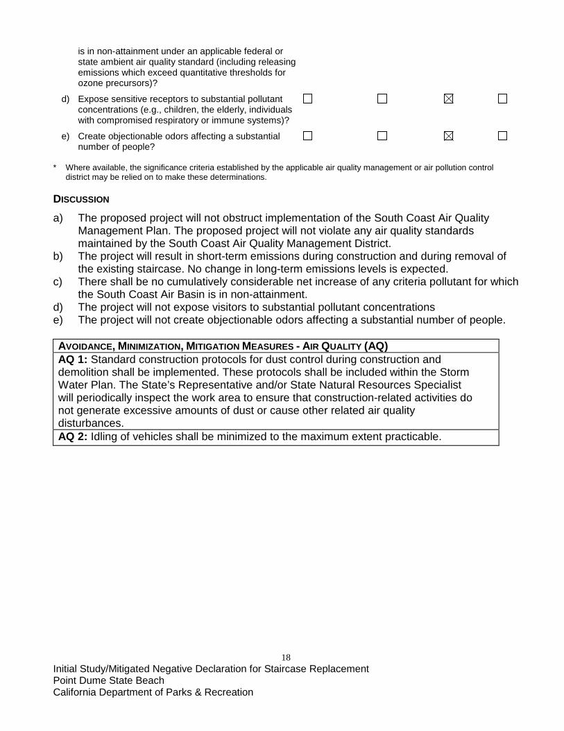
18 Initial Study/Mitigated Negative Declaration for Staircase Replacement Point Dume State Beach California Department of Parks & Recreation
is in non-attainment under an applicable federal or state ambient air quality standard (including releasing emissions which exceed quantitative thresholds for ozone precursors)?
d) Expose sensitive receptors to substantial pollutant concentrations (e.g., children, the elderly, individuals with compromised respiratory or immune systems)?
e) Create objectionable odors affecting a substantial number of people? * Where available, the significance criteria established by the applicable air quality management or air pollution control
district may be relied on to make these determinations. DISCUSSION
a) The proposed project will not obstruct implementation of the South Coast Air Quality Management Plan. The proposed project will not violate any air quality standards maintained by the South Coast Air Quality Management District.
b) The project will result in short-term emissions during construction and during removal of the existing staircase. No change in long-term emissions levels is expected.
c) There shall be no cumulatively considerable net increase of any criteria pollutant for which the South Coast Air Basin is in non-attainment.
d) The project will not expose visitors to substantial pollutant concentrations e) The project will not create objectionable odors affecting a substantial number of people.
AVOIDANCE, MINIMIZATION, MITIGATION MEASURES - AIR QUALITY (AQ) AQ 1: Standard construction protocols for dust control during construction and demolition shall be implemented. These protocols shall be included within the Storm Water Plan. The State’s Representative and/or State Natural Resources Specialist will periodically inspect the work area to ensure that construction-related activities do not generate excessive amounts of dust or cause other related air quality disturbances. AQ 2: Idling of vehicles shall be minimized to the maximum extent practicable.
19 Initial Study/Mitigated Negative Declaration for Staircase Replacement Point Dume State Beach California Department of Parks & Recreation
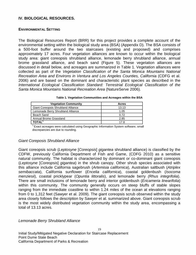
IV. BIOLOGICAL RESOURCES. ENVIRONMENTAL SETTING The Biological Resources Report (BRR) for this project provides a complete account of the environmental setting within the biological study area (BSA) (Appendix D). The BSA consists of a 500-foot buffer around the two staircases (existing and proposed) and comprises approximately 17 acres. Four vegetation alliances are known to occur within the biological study area: giant coreopsis shrubland alliance, lemonade berry shrubland alliance, annual brome grassland alliance, and beach sand (Figure 5). These vegetation alliances are discussed in detail below, and acreages are summarized in Table 1. Vegetation alliances were collected as part of the Vegetation Classification of the Santa Monica Mountains National Recreation Area and Environs in Ventura and Los Angeles Counties, California (CDFG et al. 2006) and are based on the dominant and characteristic plant species as described in the International Ecological Classification Standard: Terrestrial Ecological Classification of the Santa Monica Mountains National Recreation Area (NatureServe 2006).
Table 1. Vegetation Communities and Acreages within the BSA
Vegetation Community Acres Giant Coreopsis Shrubland Alliance 13.13 Lemonade Berry Shrubland Alliance 1.05 Beach Sand 0.72 Annual Brome Grassland 2.85 TOTAL1 17.8 1 Exact acreages were calculated using Geographic Information System software; small discrepancies are due to rounding.
Giant Coreposis Shrubland Alliance Giant coreopsis scrub (Leptosyne [Coreopsis] gigantea shrubland alliance) is classified by the CDFW, previously California Department of Fish and Game, (CDFG 2010) as a sensitive natural community. The habitat is characterized by dominant or co-dominant giant coreopsis (Leptosyne [Coreopsis] gigantea) in the shrub canopy. Other shrub species associated with this alliance include California sagebrush (Artemisia californica), Australian saltbush (Atriplex semibaccata), California sunflower (Encelia californica), coastal goldenbush (Isocoma menziesii), coastal pricklypear (Opuntia littoralis), and lemonade berry (Rhus integrifolia). There are small inclusions of lemonade berry and interior goldenbush (Ericameria linearifolia) within this community. The community generally occurs on steep bluffs of stable slopes ranging from the immediate coastline to within 1.24 miles of the ocean at elevations ranging from 0 to 1,312 feet (Sawyer et al. 2009). The giant coreopsis scrub observed within the study area closely follows the description by Sawyer et al. summarized above. Giant coreopsis scrub is the most widely distributed vegetation community within the study area, encompassing a total of 13.13 acres. Lemonade Berry Shrubland Alliance
20 Initial Study/Mitigated Negative Declaration for Staircase Replacement Point Dume State Beach California Department of Parks & Recreation
Lemonade berry scrub (Rhus integrifolia shrubland alliance) is classified by the CDFW (CDFG 2010) as a sensitive natural community. The habitat is characterized by dominant or co-dominant lemonade berry in the shrub canopy, within an open to continuous and two-tiered canopy. Other shrub species associated with this alliance include California sagebrush, California sunflower, toyon (Heteromeles arbutifolia), black sage (Salvia mellifera), and blue elderberry (Sambucus nigra). Sparse cover of emergent trees may also be present within the community. The community generally occurs on gentle to abrupt slopes and coastal bluffs with variable aspect at elevations ranging from 0 to 2,460 feet (Sawyer et al. 2009). The lemonade berry scrub observed within the study area closely follows the description by Sawyer et al. summarized above, except there are no trees present. Within the study area, lemonade berry scrub occurs in the interior of the study area surrounded by giant coreopsis scrub, as well as the southeastern edge of the study area. Lemonade berry scrub within the study area totals 1.05 acres. Beach Sand Alliance The beach sand alliance consists of non-vegetated beach that is the result of ongoing deposition of sands by the Pacific Ocean. Within the study area, a total of 0.72 acre of beach sand cover is present at the foot of the bluff, extending from northeast of the proposed staircase location to approximately 75 feet past the existing staircase between the base of the bluffs and the Pacific Ocean. Annual Brome Grassland Alliance The annual brome grassland alliance is characterized by dominant or co-dominant Bromus species with other non-native species in the herbaceous layer (Sawyer et al. 2009). Emergent trees and shrubs may be present at low cover. Herbs are less than 2.5 feet tall. Annual non-native grasslands occur on all topographic settings in foothills, previously disturbed places, rangelands, and openings in woodlands. Elevations range from sea level to 7,200 feet (Sawyer et al. 2009). Annual non-native grasslands are a naturalized vegetation community prevalent throughout the state. A total of 2.85 acres of annual brome grasslands occurs within the northeastern corner of the study area. This area is the most disturbed within the study area, and a concrete channel conveying flows from the road bisects the area. This grassland area is generally dominated by invasive non-native ripgut brome (Bromus diandrus). Other species present include the invasive non-native Mediterranean grass (Schismus arabicus/barbatus), short podded mustard (Hirschfeldia incana), and Saharan mustard (Brassica tournefortii). LISTED/SENSITIVE SPECIES Chapter 5 of the BRR provides a complete account of the sensitive plants and wildlife with the potential to occur within the biological study area. The California Natural Diversity Database (CNDDB), the California Native Plant Society (CNPS) Inventory of Rare and Endangered Plants, and the Calflora database and records of reported sensitive species within a 5-mile radius of the proposed project were reviewed to identify potentially occurring listed and
21 Initial Study/Mitigated Negative Declaration for Staircase Replacement Point Dume State Beach California Department of Parks & Recreation
sensitive species (Figure 6). This literature review identified 20 special-status plant species that occur within a 5-mile radius and 10 special-status wildlife species that occur within a 5-mile radius. All of these species were evaluated for their potential to occur within the biological study area resulting in 7 plant species that were either present or had a high to moderate potential to occur within the biological study area and 6 wildlife species that were present or had a high to moderate potential to occur within the biological study area (see Appendix C). Sensitive Plant Surveys Surveys for sensitive plants were conducted in the spring of 2016 and of the 20 species evaluated, three were detected in the biological study area: Coulter’s saltbush (Atriplex coulteri) (CNPS 1B.2), wedge-leaved horkelia (Horkelia cuneata var. cuneata x H.c. var. puberula) (CNPS 1B.1), and potentially the south coast branching phacelia (Phacelia ramosissima var. austrolitoralis) (CNPS 3.2) (see Figure 5). Although not detected during sensitive plant surveys, the results of the species evaluations identified four species with high to moderate potential to occur within the biological study area: Blochman's dudleya (Dudleya blochmaniae ssp. blochmaniae) has high potential to occur within the biological study area, and Catalina mariposa lily (Calochortus catalinae), Lyon's pentachaeta (Pentachaeta lyonii), and Hubby's phacelia (Phacelia hubbyi) have moderate potential to occur within the biological study area. The remaining species were considered to have low potential to occur within the biological study area (see Appendix C). Special Status Wildlife Surveys Surveys for special status wildlife were conducted in the spring of 2016. The evaluation of CNDDB results identified six special-status wildlife species that have the potential to occur in the biological study area (see Appendix C). Of these, the California brown pelican (California Department of Fish and Wildlife, Fully Protected), was observed within the biological study area. Additionally, silvery legless lizards (Anniella pulchra pulchra), coast horned lizards (Phrynosoma blainvillii), western snowy plovers (Charadrius alexandrinus nivosus), and American peregrine falcons (Falco peregrinus anatum) are considered to have moderate to high potential to occur within the biological study area. The coastal California gnatcatcher (Polioptila californica californica) is a federally endangered species that also has moderate potential to occur in the study area. A U.S. Fish and Wildlife Service (USFWS) presence/absence survey protocol (USFWS 1997) requiring six protocol surveys during breeding season, was conducted from March 18 through May 2, 2016, by a permitted biologist and no coastal California gnatcatchers were detected. JURISDICTIONAL WETLANDS/WATERS Point Dume is a coastal bluff adjacent to Point Dume State Beach and the Pacific Ocean. The U.S. Army Corps of Engineers regulates Clean Water Act Section 404 waters below the high tide line, and Rivers and Harbors Act Section 10 waters below the mean high tide line. The high tide line is at approximately 6.9 feet NAVD88. The mean high tide line is at approximately 4.5 feet NAVD88. While jurisdictional waters are adjacent to the study area, the proposed
22 Initial Study/Mitigated Negative Declaration for Staircase Replacement Point Dume State Beach California Department of Parks & Recreation
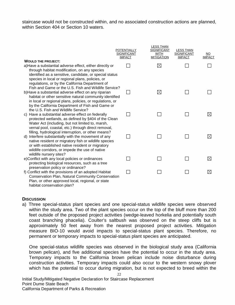
staircase would not be constructed within, and no associated construction actions are planned, within Section 404 or Section 10 waters. LESS THAN POTENTIALLY SIGNIFICANT LESS THAN SIGNIFICANT WITH SIGNIFICANT NO IMPACT MITIGATION IMPACT IMPACT WOULD THE PROJECT: a) Have a substantial adverse effect, either directly or through habitat modification, on any species identified as a sensitive, candidate, or special status species in local or regional plans, policies, or regulations, or by the California Department of Fish and Game or the U.S. Fish and Wildlife Service? b) Have a substantial adverse effect on any riparian habitat or other sensitive natural community identified in local or regional plans, policies, or regulations, or by the California Department of Fish and Game or the U.S. Fish and Wildlife Service? c) Have a substantial adverse effect on federally protected wetlands, as defined by §404 of the Clean Water Act (including, but not limited to, marsh, vernal pool, coastal, etc.) through direct removal, filling, hydrological interruption, or other means? d) Interfere substantially with the movement of any native resident or migratory fish or wildlife species or with established native resident or migratory wildlife corridors, or impede the use of native wildlife nursery sites? e) Conflict with any local policies or ordinances protecting biological resources, such as a tree preservation policy or ordinance? f) Conflict with the provisions of an adopted Habitat Conservation Plan, Natural Community Conservation Plan, or other approved local, regional, or state habitat conservation plan?
DISCUSSION a) Three special-status plant species and one special-status wildlife species were observed
within the study area. Two of the plant species occur on the top of the bluff more than 200 feet outside of the proposed project activities (wedge-leaved horkelia and potentially south coast branching phacelia). Coulter’s saltbush was observed on the steep cliffs but is approximately 50 feet away from the nearest proposed project activities. Mitigation measure BIO-10 would avoid impacts to special-status plant species. Therefore, no permanent or temporary impacts to special-status plant species are anticipated.
One special-status wildlife species was observed in the biological study area (California brown pelican), and five additional species have the potential to occur in the study area. Temporary impacts to the California brown pelican include noise disturbance during construction activities. Temporary impacts could also occur to the western snowy plover which has the potential to occur during migration, but is not expected to breed within the
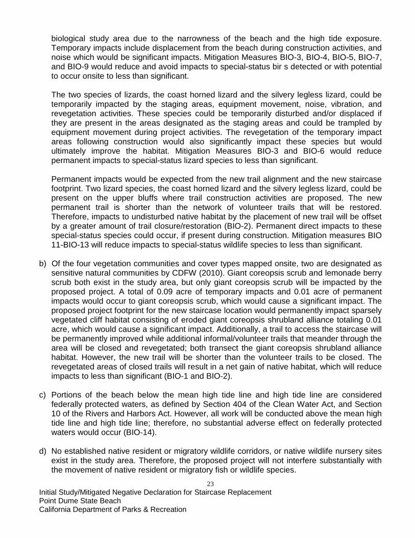
23 Initial Study/Mitigated Negative Declaration for Staircase Replacement Point Dume State Beach California Department of Parks & Recreation
biological study area due to the narrowness of the beach and the high tide exposure. Temporary impacts include displacement from the beach during construction activities, and noise which would be significant impacts. Mitigation Measures BIO-3, BIO-4, BIO-5, BIO-7, and BIO-9 would reduce and avoid impacts to special-status bir s detected or with potential to occur onsite to less than significant.
The two species of lizards, the coast horned lizard and the silvery legless lizard, could be temporarily impacted by the staging areas, equipment movement, noise, vibration, and revegetation activities. These species could be temporarily disturbed and/or displaced if they are present in the areas designated as the staging areas and could be trampled by equipment movement during project activities. The revegetation of the temporary impact areas following construction would also significantly impact these species but would ultimately improve the habitat. Mitigation Measures BIO-3 and BIO-6 would reduce permanent impacts to special-status lizard species to less than significant.
Permanent impacts would be expected from the new trail alignment and the new staircase footprint. Two lizard species, the coast horned lizard and the silvery legless lizard, could be present on the upper bluffs where trail construction activities are proposed. The new permanent trail is shorter than the network of volunteer trails that will be restored. Therefore, impacts to undisturbed native habitat by the placement of new trail will be offset by a greater amount of trail closure/restoration (BIO-2). Permanent direct impacts to these special-status species could occur, if present during construction. Mitigation measures BIO 11-BIO-13 will reduce impacts to special-status wildlife species to less than significant.
b) Of the four vegetation communities and cover types mapped onsite, two are designated as
sensitive natural communities by CDFW (2010). Giant coreopsis scrub and lemonade berry scrub both exist in the study area, but only giant coreopsis scrub will be impacted by the proposed project. A total of 0.09 acre of temporary impacts and 0.01 acre of permanent impacts would occur to giant coreopsis scrub, which would cause a significant impact. The proposed project footprint for the new staircase location would permanently impact sparsely vegetated cliff habitat consisting of eroded giant coreopsis shrubland alliance totaling 0.01 acre, which would cause a significant impact. Additionally, a trail to access the staircase will be permanently improved while additional informal/volunteer trails that meander through the area will be closed and revegetated; both transect the giant coreopsis shrubland alliance habitat. However, the new trail will be shorter than the volunteer trails to be closed. The revegetated areas of closed trails will result in a net gain of native habitat, which will reduce impacts to less than significant (BIO-1 and BIO-2).
c) Portions of the beach below the mean high tide line and high tide line are considered
federally protected waters, as defined by Section 404 of the Clean Water Act, and Section 10 of the Rivers and Harbors Act. However, all work will be conducted above the mean high tide line and high tide line; therefore, no substantial adverse effect on federally protected waters would occur (BIO-14).
d) No established native resident or migratory wildlife corridors, or native wildlife nursery sites
exist in the study area. Therefore, the proposed project will not interfere substantially with the movement of native resident or migratory fish or wildlife species.
24 Initial Study/Mitigated Negative Declaration for Staircase Replacement Point Dume State Beach California Department of Parks & Recreation
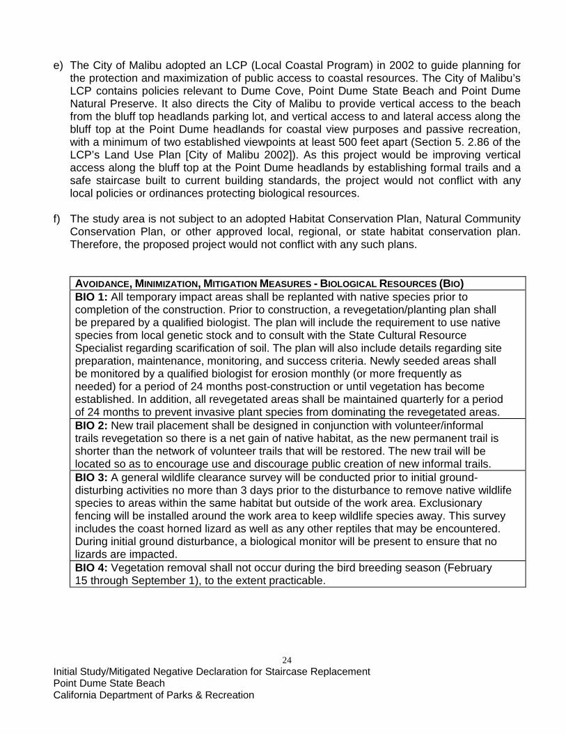
e) The City of Malibu adopted an LCP (Local Coastal Program) in 2002 to guide planning for
the protection and maximization of public access to coastal resources. The City of Malibu’s LCP contains policies relevant to Dume Cove, Point Dume State Beach and Point Dume Natural Preserve. It also directs the City of Malibu to provide vertical access to the beach from the bluff top headlands parking lot, and vertical access to and lateral access along the bluff top at the Point Dume headlands for coastal view purposes and passive recreation, with a minimum of two established viewpoints at least 500 feet apart (Section 5. 2.86 of the LCP’s Land Use Plan [City of Malibu 2002]). As this project would be improving vertical access along the bluff top at the Point Dume headlands by establishing formal trails and a safe staircase built to current building standards, the project would not conflict with any local policies or ordinances protecting biological resources.
f) The study area is not subject to an adopted Habitat Conservation Plan, Natural Community
Conservation Plan, or other approved local, regional, or state habitat conservation plan. Therefore, the proposed project would not conflict with any such plans.
AVOIDANCE, MINIMIZATION, MITIGATION MEASURES - BIOLOGICAL RESOURCES (BIO) BIO 1: All temporary impact areas shall be replanted with native species prior to completion of the construction. Prior to construction, a revegetation/planting plan shall be prepared by a qualified biologist. The plan will include the requirement to use native species from local genetic stock and to consult with the State Cultural Resource Specialist regarding scarification of soil. The plan will also include details regarding site preparation, maintenance, monitoring, and success criteria. Newly seeded areas shall be monitored by a qualified biologist for erosion monthly (or more frequently as needed) for a period of 24 months post-construction or until vegetation has become established. In addition, all revegetated areas shall be maintained quarterly for a period of 24 months to prevent invasive plant species from dominating the revegetated areas. BIO 2: New trail placement shall be designed in conjunction with volunteer/informal trails revegetation so there is a net gain of native habitat, as the new permanent trail is shorter than the network of volunteer trails that will be restored. The new trail will be located so as to encourage use and discourage public creation of new informal trails. BIO 3: A general wildlife clearance survey will be conducted prior to initial ground-disturbing activities no more than 3 days prior to the disturbance to remove native wildlife species to areas within the same habitat but outside of the work area. Exclusionary fencing will be installed around the work area to keep wildlife species away. This survey includes the coast horned lizard as well as any other reptiles that may be encountered. During initial ground disturbance, a biological monitor will be present to ensure that no lizards are impacted. BIO 4: Vegetation removal shall not occur during the bird breeding season (February 15 through September 1), to the extent practicable.
25 Initial Study/Mitigated Negative Declaration for Staircase Replacement Point Dume State Beach California Department of Parks & Recreation
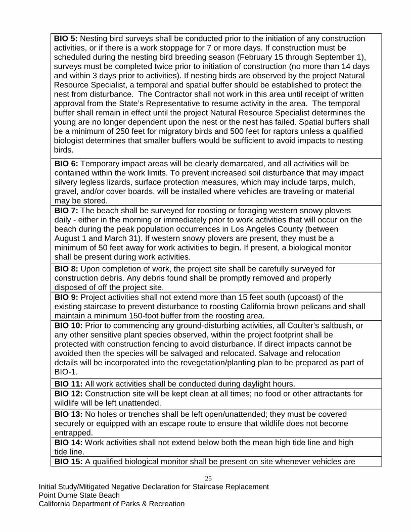
BIO 5: Nesting bird surveys shall be conducted prior to the initiation of any construction activities, or if there is a work stoppage for 7 or more days. If construction must be scheduled during the nesting bird breeding season (February 15 through September 1), surveys must be completed twice prior to initiation of construction (no more than 14 days and within 3 days prior to activities). If nesting birds are observed by the project Natural Resource Specialist, a temporal and spatial buffer should be established to protect the nest from disturbance. The Contractor shall not work in this area until receipt of written approval from the State’s Representative to resume activity in the area. The temporal buffer shall remain in effect until the project Natural Resource Specialist determines the young are no longer dependent upon the nest or the nest has failed. Spatial buffers shall be a minimum of 250 feet for migratory birds and 500 feet for raptors unless a qualified biologist determines that smaller buffers would be sufficient to avoid impacts to nesting birds.
BIO 6: Temporary impact areas will be clearly demarcated, and all activities will be contained within the work limits. To prevent increased soil disturbance that may impact silvery legless lizards, surface protection measures, which may include tarps, mulch, gravel, and/or cover boards, will be installed where vehicles are traveling or material may be stored. BIO 7: The beach shall be surveyed for roosting or foraging western snowy plovers daily - either in the morning or immediately prior to work activities that will occur on the beach during the peak population occurrences in Los Angeles County (between August 1 and March 31). If western snowy plovers are present, they must be a minimum of 50 feet away for work activities to begin. If present, a biological monitor shall be present during work activities. BIO 8: Upon completion of work, the project site shall be carefully surveyed for construction debris. Any debris found shall be promptly removed and properly disposed of off the project site. BIO 9: Project activities shall not extend more than 15 feet south (upcoast) of the existing staircase to prevent disturbance to roosting California brown pelicans and shall maintain a minimum 150-foot buffer from the roosting area. BIO 10: Prior to commencing any ground-disturbing activities, all Coulter’s saltbush, or any other sensitive plant species observed, within the project footprint shall be protected with construction fencing to avoid disturbance. If direct impacts cannot be avoided then the species will be salvaged and relocated. Salvage and relocation details will be incorporated into the revegetation/planting plan to be prepared as part of BIO-1. BIO 11: All work activities shall be conducted during daylight hours. BIO 12: Construction site will be kept clean at all times; no food or other attractants for wildlife will be left unattended. BIO 13: No holes or trenches shall be left open/unattended; they must be covered securely or equipped with an escape route to ensure that wildlife does not become entrapped. BIO 14: Work activities shall not extend below both the mean high tide line and high tide line. BIO 15: A qualified biological monitor shall be present on site whenever vehicles are

26 Initial Study/Mitigated Negative Declaration for Staircase Replacement Point Dume State Beach California Department of Parks & Recreation
on the beach. BIO 16: Prior to the start of on-site construction activities, a State Natural Resource Specialist will train on-site construction personnel on the life history of sensitive species work constraints, and any other pertinent information related to the species. BIO 17: To prevent the spread of noxious weeds, all construction vehicles and equipment will enter and leave the project site free of soil, vegetative matter or other debris that could contain weed seeds. BIO 18: If sea lions are present on the beach, then no construction personnel or equipment may approach within 100 feet unless a biological monitor is present and determines that construction activities are not a disturbance. Construction may resume in the temporary protection area after the sea lions depart of their own accord.
27 Initial Study/Mitigated Negative Declaration for Staircase Replacement Point Dume State Beach California Department of Parks & Recreation
V. CULTURAL RESOURCES. ENVIRONMENTAL SETTING Precontact and Ethnographic Information The area along the Santa Monica coastline has had a long history of aboriginal occupation, spanning from at least 5,000 B.C. to A.D. 1810 (Dallas and Mealey 1995). Other scattered occupation sites have been noted, dated even earlier, but the assemblages have been too few and too scattered to provide a full picture of occupation before 5,000 B.C. (Glassow 2007:192). Early Period and Late Period sites are the most commonly found in this area, while Middle Period sites are less common, suggesting a settlement pattern change (Dallas et al. 1998:2). The area from San Luis Obispo to Malibu Canyon is within the traditional territory of the Chumash. During the Early Period, dating from approximately 6000-600 B.C., a high density of grinding stones as well as beads, projectile points and knives dominated the artifact assemblage in the archaeological record. Burials are often found at the larger, more permanent sites. The early settlements on the mainland are on elevated landforms and are typically located near points and sloughs (King 1994:114) with fairly easy access to fresh water. Although Point Dume is an elevated landform, the nearest slough was at Zuma Creek, 1.2 miles to the northwest. From approximately 600 B.C. to A.D. 1100, the Middle Period Chumash became more sedentary. There was an increase in the production and trade of shell beads and the tomol, or plank canoe, allowed for the increase and broadening of trading patterns (King 1990). In addition, the mortar and pestle became more common compared to the mano and metate (Dallas et al. 1998:3). The Late Period saw an increase in population as well as more seasonal movement between inland and the coast. This increase in population prompted a change in settlement distribution, from smaller settlements to larger villages. With this change also came a change in the political complexity of the Chumash. Each village had at least one “head man” which was determined via the hereditary patrilineal line (Dallas et al. 1998:3). Historic Information The Proposed Project is located within the amorphous eastern boundary of California State Historic Landmark No. 965, which consists primarily of the Point Dume promontory. The latter is a tangible link to California’s early maritime exploration period. On November 24, 1793, English Explorer Captain George Vancouver sighted and documented the 208’-tall headland on charts. However, his ship’s cartographer misspelled it as “Point Dume.” Subsequent cartographers have unwittingly continued to use the misspelling. Point Dume and the surrounding area is also associated with one of the earliest Spanish land grants in California, Rancho Topanga Malibu Sostomo Simi Sequit. Established in 1804, it survived intact until 1936. Besides cattle ranching, other land uses near the area were encroachments by the Hueneme, Malibu, and Port Los Angeles Railway (1903-1918), recreational automobile trailer camping (ca. 1936-1960), and U.S. Army anti-aircraft gunnery training exercises (1942-1945). While Point Dume’s location, geographical features, and native plant communities continue to

28 Initial Study/Mitigated Negative Declaration for Staircase Replacement Point Dume State Beach California Department of Parks & Recreation
evoke its ranching heritage, other than being within the eastern-most limits of a California State Historic Landmark status, there are no recorded or potentially significant above-ground historical resources within the proposed project’s Area of Potential Effect (APE). However, there is always the potential for the discovery of historic features or artifacts associated with its rich land use history.
Early European Contact Cabrillo was the first European explorer to come into contact with the Chumash, during his 1542 expedition. Sailing north from the port of San Miguel [present day San Diego], he made note of the many campfires he saw along the coast of Santa Monica Bay. He names this bay “La Bahia de Los Fumos” or “The Bay of the Smokes.” He anchored at Point Dume and was met by a group of Chumash from the village of Maliwu. The Point Dume region wasn’t documented again until November 24, 1793, when Captain George Vancouver’s ship sailed past, naming the promontory “Point Dume” after Father Francisco Dumetz, a Spanish Friar he had met at Mission San Buenaventura (Dallas et al. 1998). It wasn’t until 1796 that the next documented expedition explored the coastal Chumash territory. Captain Gaspar de Portola, along with three others on his ship, documented their encounters with the coastal Chumash. At the time of contact, there was thought to be anywhere from 8,000-10,000 Chumash in the coastal area or according to Kroeber in 1925 or as many as 18,000-22,000 according to Cook and Heizer (Grant 1978:506). The accounts written by Portola’s expedition provided insight into the Chumash way of life and political system.
Missionization Period Shortly after Portola’s expedition, the first mission in Chumash territory was founded. San Luis Obispo mission was followed by San Buenaventura (1782), Santa Barbara (1798), La Purísima Concepción (1787) and Santa Ynez (1804). It was not long until all of the coastal Chumash had either been incorporated into the mission system or fled inland. The population of the Chumash quickly declined due to European diseases to which they had no immunity as well as the sometimes harsh treatment by the missionaries. There was only one attempt at revolt, in 1824, which led to many Chumash fleeing to their neighbor’s territory, the Yokuts. In 1834, the missions were secularized and they aimed to transform the remaining Chumash into workers on the rancheros. In theory, civil administrators had planned to allot land to the Chumash and turn them into Mexican citizens. Rarely did this happen though; more often they were just made to work for these administrators. What little land they did possess was often lost through drinking and gambling (Grant 1978:507).
Spanish/Mexican Rancho Period In 1804, the Spanish Crown granted over 13,000 acres of land surrounding Point Dume to Jose Bartolome Tapía, of the Los Angeles pueblo. This large land grant was one of the few granted under Spanish rule in California. Rancho Malibu (originally Rancho Topanga Malibu Sostomo Simi Sequit) was used for cattle and horse grazing as well as illegal smuggling. The coves and canyons in the area provided ideal cover for exchanging goods such as otter pelts. This area was even used by bootleggers in the 1920s as drop off points for illegal alcohol
29 Initial Study/Mitigated Negative Declaration for Staircase Replacement Point Dume State Beach California Department of Parks & Recreation
(Dallas et al. 1998:5). When Tapía died in 1828, his estate passed on to his wife Doña María Francísca Villalobos Tapía. Her eldest son, Tiburcio, took control of Rancho Malibu for his family. Tiburcio Tapía was a successful merchant as well as actively involved in local politics. He also acquired Rancho Cucamonga, where he later built his residence. When Tiburcio Tapía died, the estate went back to his mother, Doña María, who later sold it to her grandson-in-law, Leon Victor Prudhomme. Prudhomme became active in the area’s wine industry. The land stayed in his hands, even after a legal battle regarding ownership claims in 1854, and he owned the title to Rancho Malibu and Rancho Cucamonga until his death in 1871. He did however sell the land to an Irish immigrant, Matthew Keller, in 1857 (Bevil 2000:39). Keller was also deeply involved in the local wine industry and was responsible for making California wines known throughout the world. Keller kept this land until he leased it to Louis Sentous in 1875. Even after Keller’s death, he continued leasing the property, however Keller’s son, Henry W. Keller, ended up selling the land in 1892 to the Frederick and May Knight Rindge (Bevil 2000:40). The Rindge family was an important player in the rancho’s history. Ridge was also actively involved in local politics as well as real estate and was a founder of Conservative Life (Pacific Mutual), the Union Oil Company and the Los Angeles Edison Electric Company. In addition, he introduced dry farming to the land and planted an orchard. As population in the area began to increase, he had to fight to thwart a public road and railroad that threatened to go through his property. Rindge managed to prevent the Southern Pacific Railway from building a railroad by building one of his own. After creating Hueneme, Malibu and Port Los Angeles Railway, plans began for a line linking Port Hueneme and Santa Monica. While Fredrick Rindge died before worked even commenced, his wife, May Knight Rindge, took over the project as the new president. The railway was never fully completed, only extending between Las Flores and Encinal canyons. A potential piece of steel rail was found near the Point Dume hilltop, suggesting that construction may have begun in this area, and was later abandoned. The Rindge’s had made plans for a hotel on the top of the point, but the railroad never reached that area. It is possible that this piece of railroad was a fragment of the potential track to Point Dume (Bevil 2000:42). Mrs. Rindge continued to fight for her land against the state, who still wanted to build a through way across her property. After many legal battles, in 1925 Mrs. Rindge eventually lost the battle and the Alternate State Highway 101 was constructed through her ranch. Mrs. Rindge was awarded just $107,289 in damages, after spending most of her fortune in fighting the legal battles (Gilliland 1947:82). In the 1930s, developers in the area began splitting up the land around Malibu in an attempt to attract the rich and famous of Los Angeles. Many amenities were planned, such as spas, golf courses and casinos; however with the onset of World War II, development was put on hold.
Point Dume and World War II The United States Army placed anti-aircraft artillery (AAA) at Point Dume during World War II. However, after looking at historic aerial photographs, it is clear that this AAA was not the cause of the bulldozing of the peak at Point Dume. Reports from John J. Merrick, who was stationed in Los Angeles during World War II provided insight into the trainings that went on at Point Dume. According to Merrick, “…the guns were located at the end of a dirt road that traveled
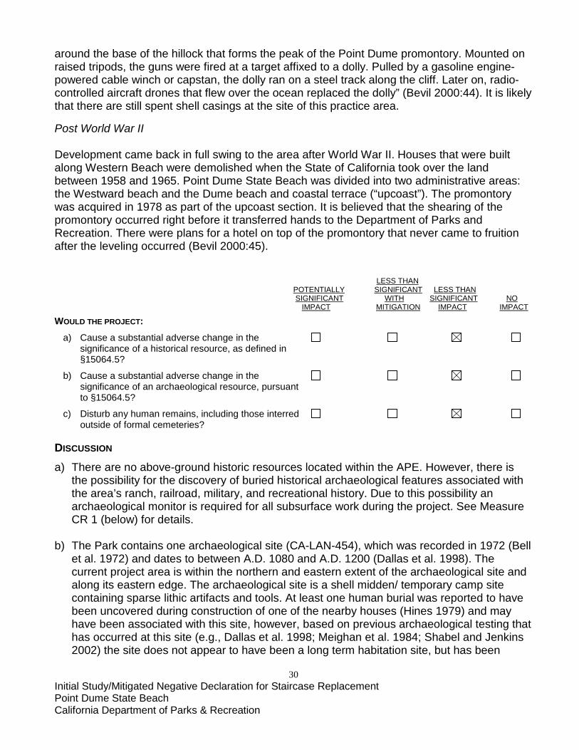
30 Initial Study/Mitigated Negative Declaration for Staircase Replacement Point Dume State Beach California Department of Parks & Recreation
around the base of the hillock that forms the peak of the Point Dume promontory. Mounted on raised tripods, the guns were fired at a target affixed to a dolly. Pulled by a gasoline engine-powered cable winch or capstan, the dolly ran on a steel track along the cliff. Later on, radio-controlled aircraft drones that flew over the ocean replaced the dolly” (Bevil 2000:44). It is likely that there are still spent shell casings at the site of this practice area.
Post World War II Development came back in full swing to the area after World War II. Houses that were built along Western Beach were demolished when the State of California took over the land between 1958 and 1965. Point Dume State Beach was divided into two administrative areas: the Westward beach and the Dume beach and coastal terrace (“upcoast”). The promontory was acquired in 1978 as part of the upcoast section. It is believed that the shearing of the promontory occurred right before it transferred hands to the Department of Parks and Recreation. There were plans for a hotel on top of the promontory that never came to fruition after the leveling occurred (Bevil 2000:45). LESS THAN POTENTIALLY SIGNIFICANT LESS THAN SIGNIFICANT WITH SIGNIFICANT NO IMPACT MITIGATION IMPACT IMPACT WOULD THE PROJECT:
a) Cause a substantial adverse change in the significance of a historical resource, as defined in §15064.5?
b) Cause a substantial adverse change in the significance of an archaeological resource, pursuant to §15064.5?
c) Disturb any human remains, including those interred outside of formal cemeteries? DISCUSSION
a) There are no above-ground historic resources located within the APE. However, there is the possibility for the discovery of buried historical archaeological features associated with the area’s ranch, railroad, military, and recreational history. Due to this possibility an archaeological monitor is required for all subsurface work during the project. See Measure CR 1 (below) for details.
b) The Park contains one archaeological site (CA-LAN-454), which was recorded in 1972 (Bell
et al. 1972) and dates to between A.D. 1080 and A.D. 1200 (Dallas et al. 1998). The current project area is within the northern and eastern extent of the archaeological site and along its eastern edge. The archaeological site is a shell midden/ temporary camp site containing sparse lithic artifacts and tools. At least one human burial was reported to have been uncovered during construction of one of the nearby houses (Hines 1979) and may have been associated with this site, however, based on previous archaeological testing that has occurred at this site (e.g., Dallas et al. 1998; Meighan et al. 1984; Shabel and Jenkins 2002) the site does not appear to have been a long term habitation site, but has been

31 Initial Study/Mitigated Negative Declaration for Staircase Replacement Point Dume State Beach California Department of Parks & Recreation
interpreted as more of a temporary camp. The project area was surveyed and tested for archaeological resources in May 2016
by archaeologists from State Parks’ Southern Service Center and Angeles District. A Native Chumash monitor was present for all of the testing. Very little surface evidence of archaeological material was observed during the site survey. The archaeological testing included excavation of hand-dug auger test holes across the project area.
Only 453 archaeological resources were recovered from 54 hand-dug auger test holes. This included 400 small to medium fragments of marine shell, 10 small fragments of faunal bone (including 5 that were identifiable as fishbone and one that was burned), 34 pieces of lithic debitage, 1 volcanic core, and 4 fragments of historical/modern material (glass, metal, and asphalt). There were additional modern items (such as plastic, cigarette butts, glass fragments, rusted metal fragments, asphalt chunks, concrete chunks, etc.) that were not collected, but attested to the mixed and disturbed nature of the deposit in this northern portion of the site. These modern intrusive items were common in the 0-80cm levels while two auger units contained modern intrusive items at deeper levels: EMJ-11 contained a piece of aluminum foil at 90-100cm, and MB-15 had a piece of clear glass at 110-120cm.
The project was modified to shift the staging area away from the identified higher density of cultural materials. The use of geotextile fabric and gravel will further prevent project work from damaging known and unknown buried cultural deposits. However, some project work will still require subsurface disturbance, so in order to avoid impacts to potentially significant, unknown cultural deposits - archaeological monitors will be required for all ground disturbing work. See CR 1 below for details.
c) No human remains or burial sites have been documented within the Park. Anecdotal
information indicates that there may have been human remains uncovered during construction of a house across the road from the park (Hines 1978), but nothing else is known about the remains, their cultural affiliation, or date.
Although unlikely, the inadvertent discovery of human remains is always possible and must
be considered. The following mitigation measures will reduce potential impacts to a less than significant level. See Measure CR 2 (below) for details.
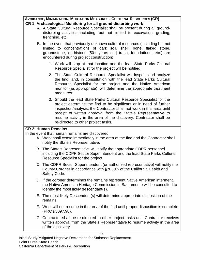
32 Initial Study/Mitigated Negative Declaration for Staircase Replacement Point Dume State Beach California Department of Parks & Recreation
AVOIDANCE, MINIMIZATION, MITIGATION MEASURES - CULTURAL RESOURCES (CR) CR 1: Archaeological Monitoring for all ground-disturbing work
A. A State Cultural Resource Specialist shall be present during all ground-disturbing activities including, but not limited to excavation, grading, trenching, etc.
B. In the event that previously unknown cultural resources (including but not limited to concentrations of dark soil, shell, bone, flaked stone, groundstone, or historic [50+ years old] trash, foundations, etc.) are encountered during project construction:
1. Work will stop at that location and the lead State Parks Cultural Resource Specialist for the project will be notified.
2. The State Cultural Resource Specialist will inspect and analyze the find, and, in consultation with the lead State Parks Cultural Resource Specialist for the project and the Native American monitor (as appropriate), will determine the appropriate treatment measures.
3. Should the lead State Parks Cultural Resource Specialist for the project determine the find to be significant or in need of further inspection/analysis, the Contractor shall not work in this area until receipt of written approval from the State’s Representative to resume activity in the area of the discovery. Contractor shall be re-directed to other project tasks.
CR 2: Human Remains In the event that human remains are discovered:
A. Work shall cease immediately in the area of the find and the Contractor shall notify the State’s Representative.
B. The State’s Representative will notify the appropriate CDPR personnel including the CDPR Sector Superintendent and the lead State Parks Cultural Resource Specialist for the project.
C. The CDPR Sector Superintendent (or authorized representative) will notify the County Coroner in accordance with §7050.5 of the California Health and Safety Code.
D. If the coroner determines the remains represent Native American interment, the Native American Heritage Commission in Sacramento will be consulted to identify the most likely descendant(s).
E. The most likely Descendent(s) will determine appropriate disposition of the remains.
F. Work will not resume in the area of the find until proper disposition is complete (PRC §5097.98).
G. Contractor shall be re-directed to other project tasks until Contractor receives written approval from the State’s Representative to resume activity in the area of the discovery.

33 Initial Study/Mitigated Negative Declaration for Staircase Replacement Point Dume State Beach California Department of Parks & Recreation
VI. GEOLOGY AND SOILS. ENVIRONMENTAL SETTING The project area is located on the southern limit of a marine terrace near the base of the Santa Monica Mountains, within the Transverse Ranges geomorphic province (Figure 7). The east-west trending Transverse Ranges, a group of mountain ranges in Southern California that span between Point Conception to the west and the San Bernardino Mountains to the east, also include the San Gabriel Mountains, the Santa Ynez Mountains, and several of the northerly Channel Islands. The Santa Monica Mountains generally consist of layers of sedimentary rock forming a broad but complex anticline, containing intrusive and extrusive volcanics. The proposed staircase alignment is located southeast of Cliffside Drive on, and adjacent to, the existing bluff that extends down to Dume Cove. The property is generally bounded by the beach and Pacific Ocean to the southeast, Cliffside Drive to the northwest, and residences to the northeast. Existing site conditions and geologic classifications are illustrated in Figure 8. The site currently consists of an undeveloped, approximately 100-foot high, roughly 2:1 (horizontal: vertical) bluff that increases in inclination to approximately 1:3 near the top. There are also isolated near-vertical portions of the bluff. Site elevations range from approximately 110 feet above mean sea level (MSL) at the top of the bluff to approximately 10 feet above MSL on the beach at the base of the bluff. Geotechnical investigations for the project location were performed in April 2016 and consisted of site reconnaissance and the excavation of four borings. Due to limited site access, borings were performed at the top of the bluff and on the beach by utilizing a manually operated three-inch diameter solid flight auger. Surface geologic mapping of exposed Formational materials on the bluff face was performed by rappelling down, directly measuring in-place bedding attitudes, and collecting relatively undisturbed chunk samples of representative site materials. Bulk soils and relatively undisturbed samples were collected from the cuttings, and by driving a Modified California sampler. The soils were logged in the field by a Certified Engineering Geologist and were visually classified in general accordance with the Unified Soil Classification System. The field descriptions have been modified, where appropriate, to reflect laboratory test results (CTE 2016: 2-3). LESS THAN POTENTIALLY SIGNIFICANT LESS THAN SIGNIFICANT WITH SIGNIFICANT NO IMPACT MITIGATION IMPACT IMPACT WOULD THE PROJECT:
a) Expose people or structures to potential substantial adverse effects, including the risk of loss, injury, or death involving: i) Rupture of a known earthquake fault, as delineated on the most recent Alquist-Priolo Earthquake Fault Zoning Map, issued by the State Geologist for the area, or based on other substantial evidence of a known fault?
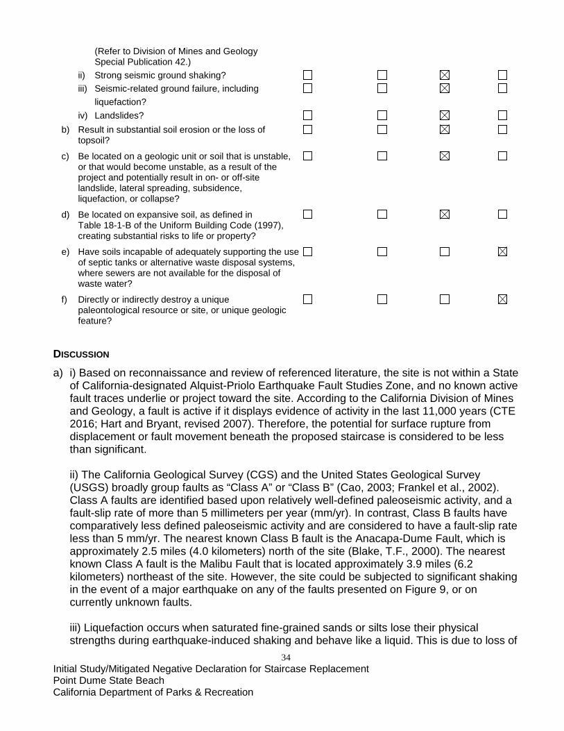
34 Initial Study/Mitigated Negative Declaration for Staircase Replacement Point Dume State Beach California Department of Parks & Recreation
(Refer to Division of Mines and Geology Special Publication 42.) ii) Strong seismic ground shaking? iii) Seismic-related ground failure, including liquefaction? iv) Landslides? b) Result in substantial soil erosion or the loss of topsoil?
c) Be located on a geologic unit or soil that is unstable, or that would become unstable, as a result of the project and potentially result in on- or off-site landslide, lateral spreading, subsidence, liquefaction, or collapse?
d) Be located on expansive soil, as defined in Table 18-1-B of the Uniform Building Code (1997), creating substantial risks to life or property?
e) Have soils incapable of adequately supporting the use of septic tanks or alternative waste disposal systems, where sewers are not available for the disposal of waste water?
f) Directly or indirectly destroy a unique paleontological resource or site, or unique geologic feature? DISCUSSION
a) i) Based on reconnaissance and review of referenced literature, the site is not within a State of California-designated Alquist-Priolo Earthquake Fault Studies Zone, and no known active fault traces underlie or project toward the site. According to the California Division of Mines and Geology, a fault is active if it displays evidence of activity in the last 11,000 years (CTE 2016; Hart and Bryant, revised 2007). Therefore, the potential for surface rupture from displacement or fault movement beneath the proposed staircase is considered to be less than significant. ii) The California Geological Survey (CGS) and the United States Geological Survey (USGS) broadly group faults as “Class A” or “Class B” (Cao, 2003; Frankel et al., 2002). Class A faults are identified based upon relatively well-defined paleoseismic activity, and a fault-slip rate of more than 5 millimeters per year (mm/yr). In contrast, Class B faults have comparatively less defined paleoseismic activity and are considered to have a fault-slip rate less than 5 mm/yr. The nearest known Class B fault is the Anacapa-Dume Fault, which is approximately 2.5 miles (4.0 kilometers) north of the site (Blake, T.F., 2000). The nearest known Class A fault is the Malibu Fault that is located approximately 3.9 miles (6.2 kilometers) northeast of the site. However, the site could be subjected to significant shaking in the event of a major earthquake on any of the faults presented on Figure 9, or on currently unknown faults.
iii) Liquefaction occurs when saturated fine-grained sands or silts lose their physical strengths during earthquake-induced shaking and behave like a liquid. This is due to loss of
35 Initial Study/Mitigated Negative Declaration for Staircase Replacement Point Dume State Beach California Department of Parks & Recreation
point-to-point grain contact and transfer of normal stress to the pore water. Liquefaction potential varies with water level, soil type, material gradation, relative density and probable intensity and duration of ground shaking. Seismic settlement can occur with or without liquefaction and results from densification of loose soils. The Marine Beach Deposits are located within a mapped liquefaction zone (Figure 10). However, the liquefiable Beach Deposits are underlain at shallow depths by very dense/hard formational material, into which the proposed staircase’s pilings are recommended to extend. Therefore, the potential for liquefaction or seismic settlement impacts to properly embedded foundations is considered to be low. iv) The Liquefaction and Landslides Hazard Zone map indicates that the bluff is in a zone of potential earthquake-induced landsliding (see Figure 10). In addition, the bluff is steep and exposed to wave erosion that could result in an undercut unstable condition over time. Minor amounts of slope wash resulting from surficial erosion were observed at the base of the bluff. However, according to the Seismic Hazard Zone Report for the Point Dume 7.5 Minute Quadrangle (2001), landslides are not mapped in the site area and field observations did not indicate the presence of deep gross instabilities. Additionally, the bedding throughout the site area is generally oriented in neutral to favorable attitudes. Based on these findings, deep-seated landsliding is not considered to be a significant hazard with the proposed project. b) Bluff Erosion: The proposed staircase is intended to provide public access to the beach and therefore is a structure allowed to be constructed within typical coastal bluff setback limits according the City of Malibu LCP Local Implementation Plan. While the project should not contribute significantly to soil erosion, the bluff face itself could erode to an equivalent of 8.3 feet over the next 100 years (based on typical coastal bluff erosion rates for the area of approximately one inch per year). c) See (a) iii and iv, above, and (d), below. The use of sufficiently deep (15-20 feet) Cast in
Drilled Hole (CIDH) type footings will anchor the project on suitably dense substrate material, minimizing any likelihood of subsidence or collapse. Additionally, the crane that will be used to move material onto and off of the project site will be set back approximately 35 feet from the bluff edge and has a swing radius of 140 feet.
d) Based on geologic observation and experience with similar geologic units, site soils are generally anticipated to exhibit Very Low to Low expansion potential (Expansion Index of 50 or less). Therefore, expansive soils are not anticipated to present significant adverse impacts to site development. e) The project does not involve an increase in capacity of existing septic systems and/or
construction of new systems. f) No unique paleontological resources or unique geologic features shall be directly or
indirectly destroyed by the proposed project.
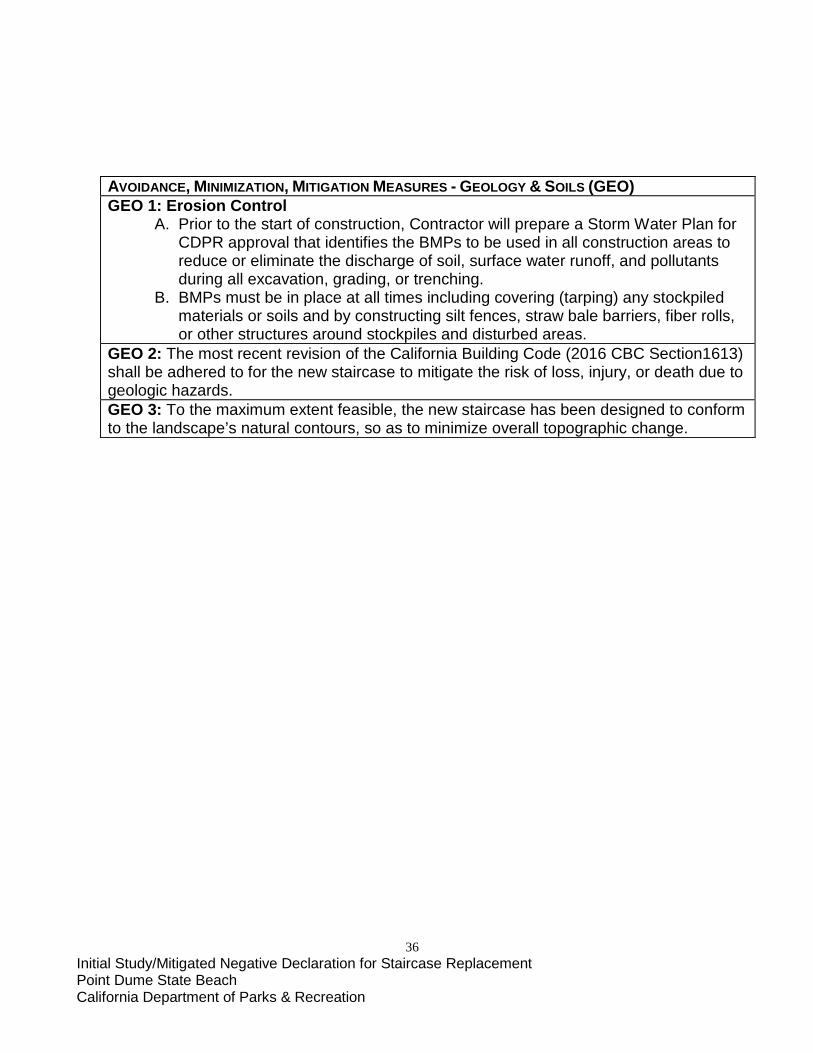
36 Initial Study/Mitigated Negative Declaration for Staircase Replacement Point Dume State Beach California Department of Parks & Recreation
AVOIDANCE, MINIMIZATION, MITIGATION MEASURES - GEOLOGY & SOILS (GEO) GEO 1: Erosion Control
A. Prior to the start of construction, Contractor will prepare a Storm Water Plan for CDPR approval that identifies the BMPs to be used in all construction areas to reduce or eliminate the discharge of soil, surface water runoff, and pollutants during all excavation, grading, or trenching.
B. BMPs must be in place at all times including covering (tarping) any stockpiled materials or soils and by constructing silt fences, straw bale barriers, fiber rolls, or other structures around stockpiles and disturbed areas.
GEO 2: The most recent revision of the California Building Code (2016 CBC Section1613) shall be adhered to for the new staircase to mitigate the risk of loss, injury, or death due to geologic hazards. GEO 3: To the maximum extent feasible, the new staircase has been designed to conform to the landscape’s natural contours, so as to minimize overall topographic change.

37 Initial Study/Mitigated Negative Declaration for Staircase Replacement Point Dume State Beach California Department of Parks & Recreation
VII. HAZARDS AND HAZARDOUS MATERIALS. ENVIRONMENTAL SETTING The California Department of Environmental Protection (CALEPA) has the responsibility for compiling (pursuant to Government Code §65962.5) information on hazardous material sites in California that together comprise the “Cortese” list. A review of this list found the closest identified site to be the Malibu High School Project site, located approximately 2.6 miles northwest of Point Dume. It is not anticipated that any hazardous materials will be encountered during demolition of the existing staircase, which is of steel-and-concrete construction. Standard project requirements and BMPs will be followed to prevent accidental spills associated with construction equipment operation, maintenance, and repair.
LESS THAN POTENTIALLY SIGNIFICANT LESS THAN SIGNIFICANT WITH SIGNIFICANT NO IMPACT MITIGATION IMPACT IMPACT WOULD THE PROJECT:
a) Create a significant hazard to the public or the environment through the routine transport, use, or disposal of hazardous materials?
b) Create a significant hazard to the public or the environment through reasonably foreseeable upset and/or accident conditions involving the release of hazardous materials, substances, or waste into the environment?
c) Emit hazardous emissions or handle hazardous or acutely hazardous materials, substances, or waste within one-quarter mile of an existing or proposed school?
d) Be located on a site which is included on a list of hazardous materials sites, compiled pursuant to Government Code §65962.5, and, as a result, create a significant hazard to the public or environment?
e) Be located within an airport land use plan or, where such a plan has not been adopted, within two miles of a public airport or public use airport? If so, would the project result in a safety hazard for people residing or working in the project area?
f) Be located in the vicinity of a private airstrip? If so, would the project result in a safety hazard for people residing or working in the project area?
g) Impair implementation of or physically interfere with an adopted emergency response plan or emergency evacuation plan?

38 Initial Study/Mitigated Negative Declaration for Staircase Replacement Point Dume State Beach California Department of Parks & Recreation
h) Expose people or structures to a significant risk of loss, injury, or death from wildland fires, including areas where wildlands are adjacent to urbanized areas or where residences are intermixed with wildlands? DISCUSSION
a-d) The proposed project is not anticipated to transport, use or dispose of any hazardous materials, accidentally release hazardous material, substance or waste, emit or handle hazardous waste within one-quarter mile of an existing or proposed school or be located on a site which is listed as a hazardous material site
e-f) The project is not within two miles of a public airport, public use airport or private
airstrip. The closest airports are Los Angeles International Airport, located approximately 28.5 miles to the east-southeast, and Van Nuys Airport, located approximately 32 miles to the northeast.
g) Neither emergency response plans nor emergency evaluation plans shall be impaired
by implementation of the project. h) The project shall not expose people or structures to a significant risk of loss, injury or
death from wildland fires.
AVOIDANCE, MINIMIZATION, MITIGATION MEASURES - HAZARDS/HAZARDOUS MATERIALS (HAZ) HAZ 1: Hazardous Material Spills
A. Prior to the start of construction, the contractor shall clean all equipment before entering the project site. Equipment shall be cleaned and repaired (other than emergency repairs) outside the project site boundaries. All contaminated water, sludge, spill residue, or other hazardous compounds shall be contained and disposed of outside the boundaries of the site, at a lawfully permitted or authorized destination.
B. Prior to the start of construction, the contractor shall inspect all equipment for leaks and regularly inspect thereafter until equipment is removed from the project site.
C. Prior to the start of construction, CDPR’s contractor shall prepare a Spill Prevention and Response Plan (SPRP) to provide protection to on-site workers, the public, and the environment from accidental leaks or spills of vehicle fluids or other potential contaminants. This plan shall include (but not be limited to):
1. A map with both primary and secondary containment areas with a listing of BMPs to be used to prevent the accidental release of fluid materials, including concrete.
2. A map that delineates construction staging areas, where refueling, lubrication, and maintenance of equipment will occur.
3. A list of items required in a spill kit on-site that will be maintained throughout the life of the project.

39 Initial Study/Mitigated Negative Declaration for Staircase Replacement Point Dume State Beach California Department of Parks & Recreation
4. Identification of lawfully permitted or authorized disposal outside of the project site.
HAZ 2: Fire Safety A. Prior to the start of construction, the Project Contractor shall develop a CDPR-
approved Fire Safety Plan. The plan will include the emergency calling procedures for the Local Fire Department.
B. Spark arrestors or turbo chargers (which eliminate sparks in exhaust) and fire extinguishers will be required for all heavy equipment.
C. Cutting of vegetation within the staging area and the use a ground barrier covered with leveling fill will keep construction vehicles away from flammable material, such as dry grass or brush.
HAZ 3: Worker Safety Require construction personal to have appropriate training in compliance with 29 CFR, §§1910, et seq. (Occupational Safety and Health Standards), 1926 et seq (Safety and Health Regulations for Construction) and 8 CCR § 5192 (Hazardous Waste Operations and Emergency Response) to protect workers.
40 Initial Study/Mitigated Negative Declaration for Staircase Replacement Point Dume State Beach California Department of Parks & Recreation
VIII. HYDROLOGY AND WATER QUALITY. ENVIRONMENTAL SETTING The project location consists of undeveloped, mostly undisturbed natural areas. Outside the boundaries of the Park, development consists predominantly of single-family residences. There is an existing stairway located approximately 630 feet southwest of the proposed stairway, with existing dirt access trails leading from the north and northeast. Cliffside Drive, a two-way public road with parking, is approximately 300 feet northwest of the proposed stairway. The closest residence stands approximately 300 feet north of the proposed stairway, on the southeast side of Cliffside Drive. The Pacific Ocean coastline is located towards the east. The Park is located within the California Floristic Province, Southwest Region, Transverse Ranges Subregion (Hickman 1993). The climate is considered Mediterranean and fluctuates with seasons of hot dry summers and mild wet winters. Elevations range from approximately 110 feet above MSL at the top of the bluff to approximately 10 feet above MSL on the beach at the base of the bluff. Average annual rainfall is approximately 24 inches, which falls as rain primarily in the winter. Rainfall depth at the project site is 6.4 inches for 50-year, 0.75 inches for the 85th percentile rainfall in a 24-hour period, and 1.4 inches for the 95th percentile rainfall in a 24-hour period (CTE 2016: 4). The area receives runoff from adjacent developed areas, including Cliffside Drive, but hydrology is otherwise limited to on-site surface drainage. Culvert pipes take some local surface runoff over the bluff and to the beach. The graded areas on top of the hill, as well as some of the existing unofficial trails, collect rainwater and channel it down the bluff face causing erosion. The erosion is enhanced in these areas by continuing off-trail pedestrian traffic. Impervious Surfaces An existing concrete drainage ditch (approximately 285 feet in length and having an area of approximately 1,237 sq. ft.) is located on the project site. Ther.e will be no significant differences between the amounts of impervious surfaces for the existing condition compared to the amount of impervious surfaces for the proposed condition. General Drainage Characteristics The general topography around the project site slopes from northwest to southeast, generally guiding storm water in the same direction. A majority of the storm water runoff flows directly into an existing concrete drainage ditch approximately 200 feet north of the project site. The drainage ditch discharges storm water off of the bluff, creating a ravine along the steep face of the cliff. The storm water that sheet flows from northwest to southeast drains over the ridge line along the cliff’s edge causing mechanical weathering and scouring. The observed erosion is thought to be attributed to this existing sheet flow. All onsite storm water runoff flows offsite without any treatment and discharges directly into the Pacific Ocean. The drainage characteristics for the existing condition and the proposed condition remain the same.
41 Initial Study/Mitigated Negative Declaration for Staircase Replacement Point Dume State Beach California Department of Parks & Recreation
Water Quality Regulation
Point Dume State Beach is within the jurisdiction of the Los Angeles Regional Water Quality Control Board (LARWQCB) Region 4, which includes Los Angeles and Ventura Counties along with very small portions of Kern and Santa Barbara Counties. Within this region, the project area falls within the 414-square mile Santa Monica Bay Watershed Management Area (WMA) (Figure 11). The LARWQCB “Basin Plan” refers to the Water Quality Control Plan: Los Angeles Region, Basin Plan for the Coastal Watersheds of Los Angeles and Ventura Counties. Last updated in 2014, the Basin Plan characterizes watersheds within the region, identifies beneficial uses that exist or have the potential to exist in each water body, establishes water quality objectives for each water body to protect beneficial uses or allow their restoration and provides an implementation program that achieves water quality objectives. Per the requirements of the Federal Clean Water Act (CWA) Section 303(c), Water Quality Control Plans are reviewed every three years and revised as necessary to address problems with the plan, and meet new legislative requirements.
Point Dume State Beach has been identified by Los Angeles County as an ESA (Ecologically Significant Area) within the Santa Monica Bay WMA due to its unique, uncommon, or scientifically interesting features. As a nationally significant water body, Santa Monica Bay was included in the National Estuary Program in 1989. It has been extensively studied by the Santa Monica Bay Restoration Project (now the Santa Monica Bay Restoration Commission or SMBRC) and a watershed plan was developed in 1995. The Santa Monica Bay Watershed Commission was established in 2002 to oversee implementation of this plan.
The project site is located near the Santa Monica Bay Offshore/Nearshore waterbody, which is included on the CWA Section 303(d) List. The site is not located near any high risk receiving watersheds. Sea Level Rise Mean sea level rise (MSLR) and extreme event impacts are expected to dramatically increase into the foreseeable future. Although impacts will vary locally, research has projected that sea levels along the California coast will increase by as much as 56-66 inches over the next 100 years (CDPR 2015: 4). MSLR and associated increases in extreme event impacts are anticipated to permanently inundate large amounts of coastal land and subject current upland areas to increased flooding. As the caretaker of more than 300 miles of the California coastline, California State Parks is uniquely suited to play a leading role in coastal protection by proactively evaluating and attempting to minimize the effects of MSLR. MSLR, combined with an increase in extreme events, is expected to result in significant impacts to state parks located along coastal, bay, and Delta shorelines. These may include: • Loss of significant cultural and natural resources; • Loss of beach area and width; • Damage to park facilities and infrastructure owned by CDPR and others;
42 Initial Study/Mitigated Negative Declaration for Staircase Replacement Point Dume State Beach California Department of Parks & Recreation
• Decreased public access; • Altered recreational opportunities; and • Change in revenue generation opportunities Coastal engineering analysis for the proposed staircase was undertaken to aid in its design and to conform to the California Coastal Commission’s 2015 Sea Level Rise Policy Guidance and 1999 Beach Erosion and Response (BEAR) Guidance Document (CCC 1999), as well as CDPR’s 2015 Sea-level Rise and Extreme Events Guidance document. Extreme Events The nearest long-term tide station to Point Dume State Beach is the National Oceanic and Atmospheric Administration /National Ocean Service (NOAA/NOS) Santa Monica tide station, which has been operational since 1932. Water elevation records from 1933 to 2006 were used to develop extreme high water elevations for a range of probabilistic recurrence intervals using the North American Datum of 1988 (NAVD88). The resulting extreme still water elevations for the 50-year and 100-year storm intervals were +7.8 feet and +7.9 feet, respectively (Moffat & Nichol 2016: 15). Geotechnical investigations performed in April 2016 (CTE 2016) indicate that the bedrock elevation on the beach near the proposed stairway location is +6.5 feet NAVD88 (the base of the stairs will be at approximately +10.5 feet). The study indicates, therefore, that the foundation for the bottom landing of the proposed staircase may be subject to inundation of up to 1.3 feet as a result of extreme storm events during its expected lifetime (50 years). Still Water Levels Water level is important because it has a direct impact on the breaking wave height and thus on the wave runup elevation that will occur at the site. Water levels are affected by tide cycles, coastal storm surge and long-term MSLR. In turn, MSLR rates experienced at a specific location can also be influenced by shorter time-scale climatological effects such as the El Niño Southern Oscillation and the Pacific Decadal Oscillation. A wide range of future potential global eustatic sea level rise scenarios exists. At the low end of the range is the historic sea level rise. Based on NOAA/NOS (2013), the historic rate at the Santa Monica tide station is 0.057 in/yr, which corresponds to a rise of approximately 3 inches over the next 50 years and 6 inches over the next 100 years. However, recent data strongly indicates that the future sea level rise rate will be greater than the historic rate, therefore, the “Low” rate of MSLR considered in the analysis is higher than the historic rate (Moffat & Nichol 2016: 16). To understand the implications of high water elevations and wave runup, varying future MSLR predictions over the next 50 years were analyzed (consistent with the expected design life of the structure). For the year 2070, the projected range of MSLR for the Los Angeles region is from 0.7 to 3.2 feet (NRC 2012). The proposed project location is outside this 50-year MSLR zone. Wave Runup Study
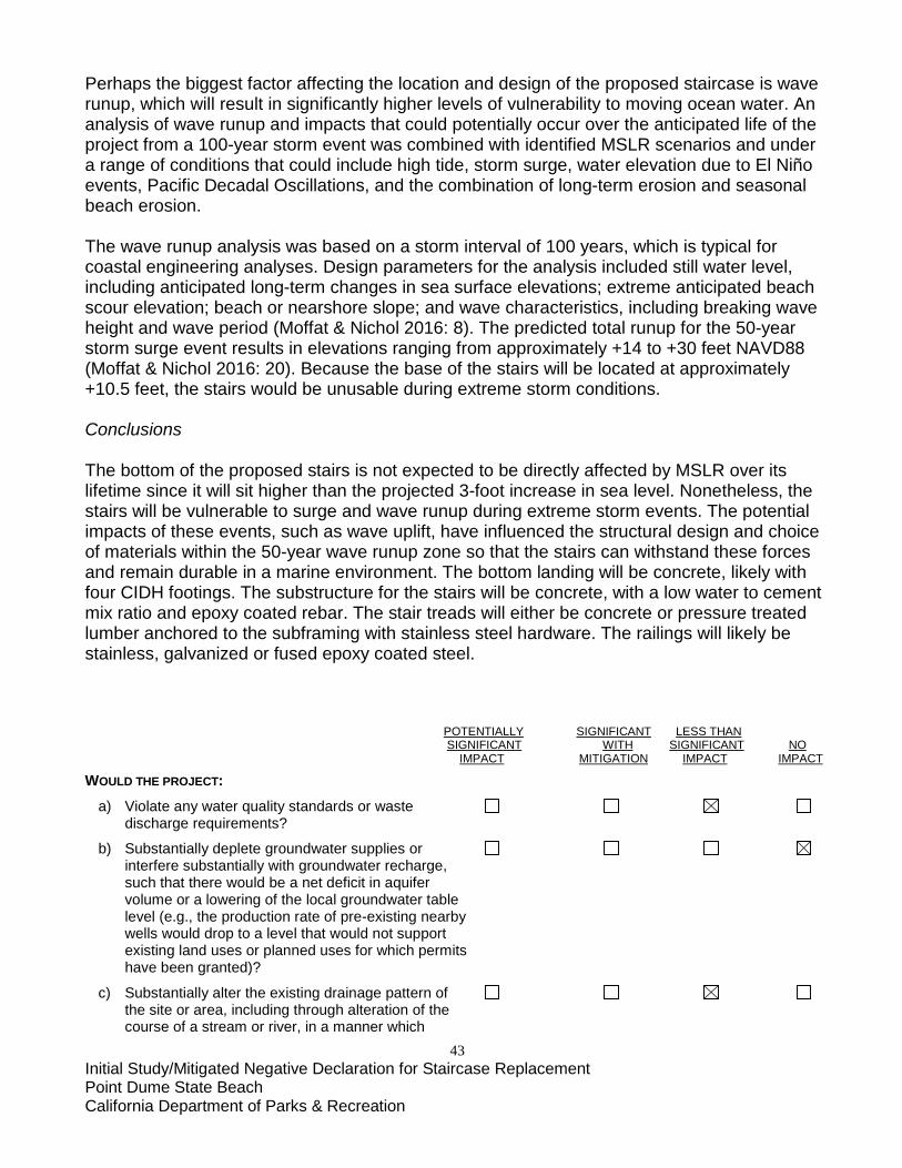
43 Initial Study/Mitigated Negative Declaration for Staircase Replacement Point Dume State Beach California Department of Parks & Recreation
Perhaps the biggest factor affecting the location and design of the proposed staircase is wave runup, which will result in significantly higher levels of vulnerability to moving ocean water. An analysis of wave runup and impacts that could potentially occur over the anticipated life of the project from a 100-year storm event was combined with identified MSLR scenarios and under a range of conditions that could include high tide, storm surge, water elevation due to El Niño events, Pacific Decadal Oscillations, and the combination of long-term erosion and seasonal beach erosion. The wave runup analysis was based on a storm interval of 100 years, which is typical for coastal engineering analyses. Design parameters for the analysis included still water level, including anticipated long-term changes in sea surface elevations; extreme anticipated beach scour elevation; beach or nearshore slope; and wave characteristics, including breaking wave height and wave period (Moffat & Nichol 2016: 8). The predicted total runup for the 50-year storm surge event results in elevations ranging from approximately +14 to +30 feet NAVD88 (Moffat & Nichol 2016: 20). Because the base of the stairs will be located at approximately +10.5 feet, the stairs would be unusable during extreme storm conditions. Conclusions The bottom of the proposed stairs is not expected to be directly affected by MSLR over its lifetime since it will sit higher than the projected 3-foot increase in sea level. Nonetheless, the stairs will be vulnerable to surge and wave runup during extreme storm events. The potential impacts of these events, such as wave uplift, have influenced the structural design and choice of materials within the 50-year wave runup zone so that the stairs can withstand these forces and remain durable in a marine environment. The bottom landing will be concrete, likely with four CIDH footings. The substructure for the stairs will be concrete, with a low water to cement mix ratio and epoxy coated rebar. The stair treads will either be concrete or pressure treated lumber anchored to the subframing with stainless steel hardware. The railings will likely be stainless, galvanized or fused epoxy coated steel. POTENTIALLY SIGNIFICANT LESS THAN SIGNIFICANT WITH SIGNIFICANT NO IMPACT MITIGATION IMPACT IMPACT WOULD THE PROJECT:
a) Violate any water quality standards or waste discharge requirements?
b) Substantially deplete groundwater supplies or interfere substantially with groundwater recharge, such that there would be a net deficit in aquifer volume or a lowering of the local groundwater table level (e.g., the production rate of pre-existing nearby wells would drop to a level that would not support existing land uses or planned uses for which permits have been granted)?
c) Substantially alter the existing drainage pattern of the site or area, including through alteration of the course of a stream or river, in a manner which

44 Initial Study/Mitigated Negative Declaration for Staircase Replacement Point Dume State Beach California Department of Parks & Recreation
would result in substantial on- or off-site erosion or siltation?
d) Substantially alter the existing drainage pattern of the site or area, including through alteration of the course of a stream or river, or substantially increase the rate or amount of surface runoff in a manner which would result in on- or off-site flooding?
e) Create or contribute runoff water which would exceed the capacity of existing or planned stormwater drainage systems or provide substantial additional sources of polluted runoff?
f) Substantially degrade water quality?
g) Place housing within a 100-year flood hazard area, as mapped on a federal Flood Hazard Boundary or Flood Insurance Rate Map, or other flood hazard delineation map?
h) Place structures that would impede or redirect flood flows within a 100-year flood hazard area?
i) Expose people or structures to a significant risk of loss, injury, or death from flooding, including flooding resulting from the failure of a levee or dam?
j) Result in inundation by seiche, tsunami, or mudflow? DISCUSSION
a) Construction of the proposed staircase will comply with the NPDES General Permit for Storm Water Discharges Associated with Construction Activities (Order No 2009-0009-DWQ). The Clean Water Act prohibits the discharging of pollutants through a point source into a water of the United States without a National Pollutant Discharge Elimination System (NPDES) permit. The permit contains limits on what can be discharged, monitoring and reporting requirements, and other provisions to ensure that the discharge does not hurt water quality or people’s health.
b) This project is not anticipated to substantially deplete groundwater supplies or interfere substantially with groundwater recharge, such that there would be a net deficit in aquifer volume or a lowering of the local groundwater table level. There are no active or inactive wells located on the site. Project water will be supplied by a metered City hydrant. The supplier, Water Works District No. 29, purchases water from the Metropolitan Water District (MWD) of Southern California, which imports water from the Colorado River Aqueduct and the State Water Project. c) The project site topography generally slopes from northwest to southeast. The project is
located on the coastal cliff of the Los Angeles watershed, which drains directly into the Pacific Ocean. As the site does not contain naturally occurring drainage features such as a stream or river, construction of the proposed staircase would not alter the course of said features. The site provides large areas of pervious surfaces that provide infiltration of storm water during rain events.
45 Initial Study/Mitigated Negative Declaration for Staircase Replacement Point Dume State Beach California Department of Parks & Recreation
Project implementation is anticipated to result in minor modifications to the site topography and drainage; however, these modifications would largely replicate the existing condition where the storm water discharges mimic the current condition. Since the project site will be improved by rehabilitation and stabilization of existing trails with revegetation as well as the protection of the existing concrete culvert in place, the site will be largely stabilized and will not result in substantial erosion or siltation offsite. Therefore, impacts will be less than significant.
d) See (c), above. e) See (c), above. f) See (a), above. g) The project does not propose any new residential uses. h) The lower portion of the proposed staircase would be placed within a Zone VE (100-year)
flood hazard area as defined by FEMA. As such, part of the structure will be vulnerable to impacts resulting from surge and wave runup during extreme storm events. The stairs will not, however, impede or significantly redirect flood flows.
i) The project site is not located near, or adjacent to, a drainage feature (such as a river) that
is retained with a levee, or with a reservoir that is retained by a dam. As mentioned in (g), above, the project site is not located within a 100-year flood hazard area. Therefore the site would not be subject to flooding, and consequently, would not expose people or structures to significant risks from flooding. The potential for a levee or dam failure does not exist.
j) According to mapping performed by the California Emergency Management Agency (Point Dume Quadrangle-2009) the area at the base of the bluff containing the proposed staircase landing is located within a tsunami inundation zone (Figure 12). The potential for tsunami waves from distant sources affecting the California coast are rare, however, such waves could be generated from local seismic events along an offshore fault and/or submarine landslides. A study of tsunami risk to Southern California modeled potential run-up heights ranging between approximately six to twelve feet from potential M7 to M7.4 earthquake on the offshore Catalina Fault (Legg, et al. 2003). According to the City of Malibu General Plan, potential run-up from offshore displacements could result in run-up heights of approximately 12 feet above Mean Lower Low Water (MLLW), and in general, the run-up heights for 100-year and 500-year storm events could range from five to seven feet and eight to twelve feet, respectively. Therefore, the potential for tsunami run-up within lower elevation areas of the site cannot be precluded. The project site has a potential for significant inundation by seiche, tsunami, or mudflow. An earthquake could produce waves in the Pacific Ocean that would be large enough to result in flooding of the lower stair. Additionally, the project is located along a steep slope and potentially subject to considerable mudflows.
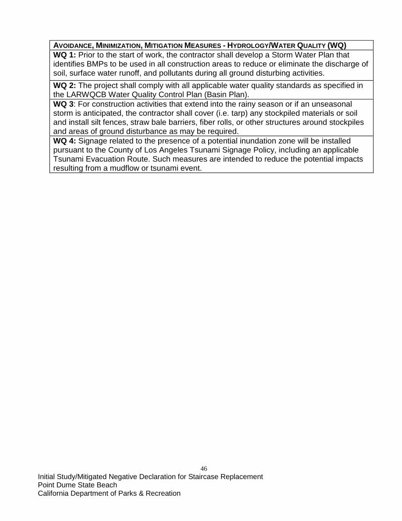
46 Initial Study/Mitigated Negative Declaration for Staircase Replacement Point Dume State Beach California Department of Parks & Recreation
AVOIDANCE, MINIMIZATION, MITIGATION MEASURES - HYDROLOGY/WATER QUALITY (WQ) WQ 1: Prior to the start of work, the contractor shall develop a Storm Water Plan that identifies BMPs to be used in all construction areas to reduce or eliminate the discharge of soil, surface water runoff, and pollutants during all ground disturbing activities. WQ 2: The project shall comply with all applicable water quality standards as specified in the LARWQCB Water Quality Control Plan (Basin Plan). WQ 3: For construction activities that extend into the rainy season or if an unseasonal storm is anticipated, the contractor shall cover (i.e. tarp) any stockpiled materials or soil and install silt fences, straw bale barriers, fiber rolls, or other structures around stockpiles and areas of ground disturbance as may be required. WQ 4: Signage related to the presence of a potential inundation zone will be installed pursuant to the County of Los Angeles Tsunami Signage Policy, including an applicable Tsunami Evacuation Route. Such measures are intended to reduce the potential impacts resulting from a mudflow or tsunami event.
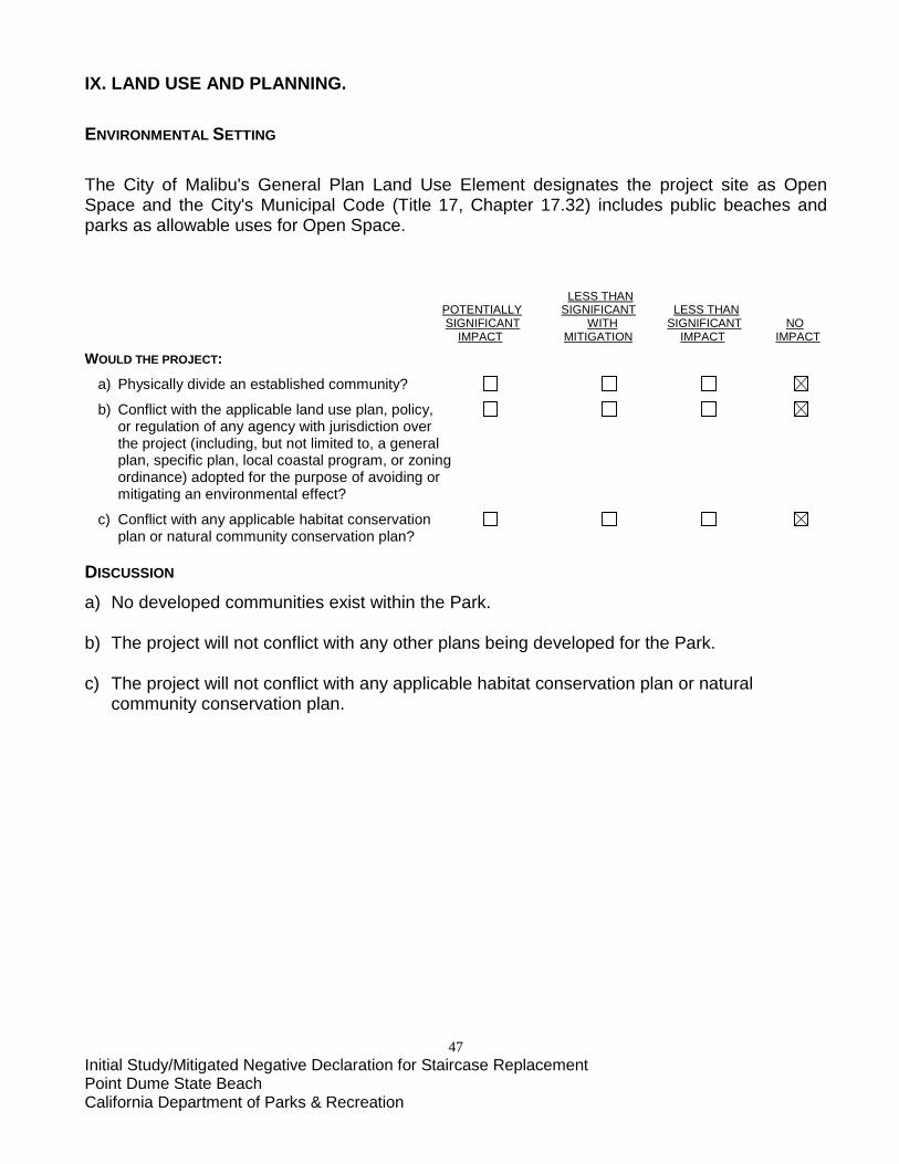
47 Initial Study/Mitigated Negative Declaration for Staircase Replacement Point Dume State Beach California Department of Parks & Recreation
IX. LAND USE AND PLANNING. ENVIRONMENTAL SETTING The City of Malibu's General Plan Land Use Element designates the project site as Open Space and the City's Municipal Code (Title 17, Chapter 17.32) includes public beaches and parks as allowable uses for Open Space. LESS THAN POTENTIALLY SIGNIFICANT LESS THAN SIGNIFICANT WITH SIGNIFICANT NO IMPACT MITIGATION IMPACT IMPACT WOULD THE PROJECT: a) Physically divide an established community?
b) Conflict with the applicable land use plan, policy, or regulation of any agency with jurisdiction over the project (including, but not limited to, a general plan, specific plan, local coastal program, or zoning ordinance) adopted for the purpose of avoiding or mitigating an environmental effect?
c) Conflict with any applicable habitat conservation plan or natural community conservation plan? DISCUSSION
a) No developed communities exist within the Park. b) The project will not conflict with any other plans being developed for the Park. c) The project will not conflict with any applicable habitat conservation plan or natural
community conservation plan.

48 Initial Study/Mitigated Negative Declaration for Staircase Replacement Point Dume State Beach California Department of Parks & Recreation
X. MINERAL RESOURCES. ENVIRONMENTAL SETTING There is no mineral resource extraction associated with this project. Moreover, it is a land use that is not compatible with the mission of CDPR. LESS THAN POTENTIALLY SIGNIFICANT LESS THAN SIGNIFICANT WITH SIGNIFICANT NO IMPACT MITIGATION IMPACT IMPACT WOULD THE PROJECT:
a) Result in the loss of availability of a known mineral resource that is or would be of value to the region and the residents of the state?
b) Result in the loss of availability of a locally important mineral resource recovery site delineated on a local general plan, specific plan, or other land use plan? DISCUSSION
a-b) No mineral sources of value locally, to the region or to residents of the state are known to exist within Point Dume State Beach.

49 Initial Study/Mitigated Negative Declaration for Staircase Replacement Point Dume State Beach California Department of Parks & Recreation
XI. NOISE. ENVIRONMENTAL SETTING
Point Dume State Beach is largely a quiet destination for recreational activity, being bordered by the ocean on one side and single-family residences on the other. California State Route 1 (Pacific Coast Highway), a four-lane road, is located approximately one mile to the north. With regards to construction-related noise, the City of Malibu’s Noise Control Ordinance prohibits “Operating or causing the operation of any tools, equipment, impact devices, derricks or hoists used in construction, drilling, repair, alteration, demolition or earthwork, between weekday hours of 7:00 p.m. and 7:00 a.m. or at any time on Sundays or holidays”. The proposed project shall adhere to this ordinance. The primary noises occurring in the vicinity of the project area include vehicular traffic, ocean wave action, and sounds associated with park operations (e.g. trash collection) and day use activities. One private residence on the southeast side of Cliffside Drive is adjacent to the project area; the other residences in the vicinity are separated from the Park by Cliffside Drive and Birdview Avenue, both two-way streets. The nearest public facilities to the project site are Los Angeles County Fire Department Station #71, approximately 1.5 miles to the northeast at 28722 Pacific Coast Hwy, and Point Dume Elementary School, approximately 0.5 mile to the northeast at 6955 Fernhill Drive. LESS THAN POTENTIALLY SIGNIFICANT LESS THAN SIGNIFICANT WITH SIGNIFICANT NO IMPACT MITIGATION IMPACT IMPACT WOULD THE PROJECT:
a) Generate or expose people to noise levels in excess of standards established in a local general plan or noise ordinance, or in other applicable local, state, or federal standards?
b) Generate or expose people to excessive groundborne vibrations or groundborne noise levels?
c) Create a substantial permanent increase in ambient noise levels in the vicinity of the project (above levels without the project)?
d) Create a substantial temporary or periodic increase in ambient noise levels in the vicinity of the project, in excess of noise levels existing without the project?
e) Be located within an airport land use plan or, where such a plan has not been adopted, within two miles of a public airport or public use airport? If so, would the project expose people residing or working in the project area to excessive noise levels?
f) Be in the vicinity of a private airstrip? If so, would the project expose people residing or working in the project area to excessive noise levels?
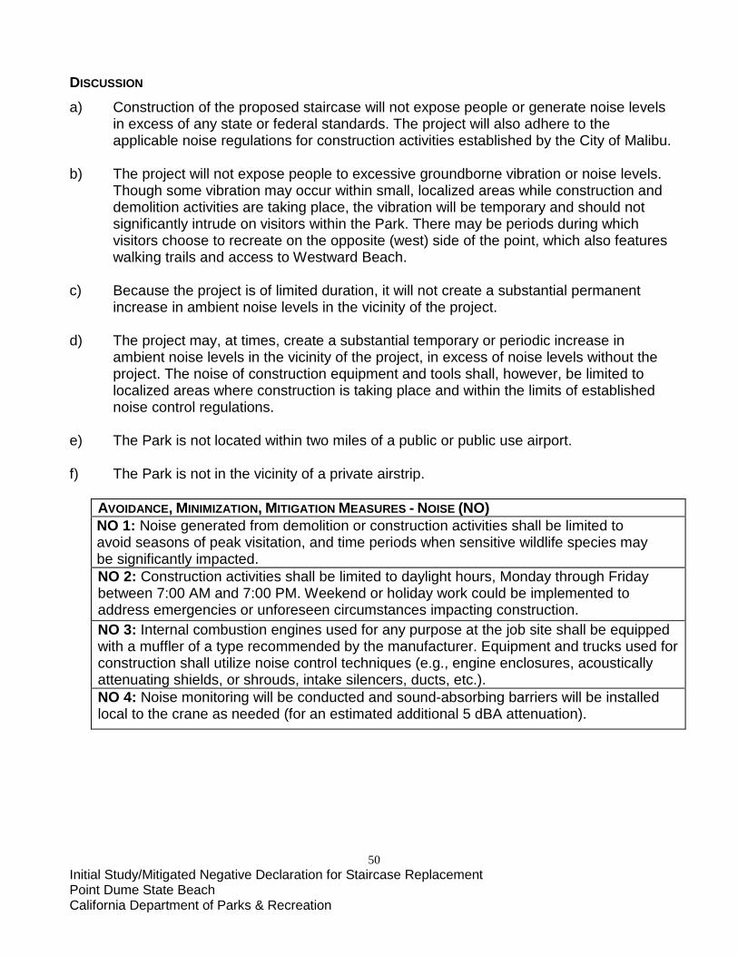
50 Initial Study/Mitigated Negative Declaration for Staircase Replacement Point Dume State Beach California Department of Parks & Recreation
DISCUSSION
a) Construction of the proposed staircase will not expose people or generate noise levels in excess of any state or federal standards. The project will also adhere to the applicable noise regulations for construction activities established by the City of Malibu.
b) The project will not expose people to excessive groundborne vibration or noise levels.
Though some vibration may occur within small, localized areas while construction and demolition activities are taking place, the vibration will be temporary and should not significantly intrude on visitors within the Park. There may be periods during which visitors choose to recreate on the opposite (west) side of the point, which also features walking trails and access to Westward Beach.
c) Because the project is of limited duration, it will not create a substantial permanent increase in ambient noise levels in the vicinity of the project. d) The project may, at times, create a substantial temporary or periodic increase in
ambient noise levels in the vicinity of the project, in excess of noise levels without the project. The noise of construction equipment and tools shall, however, be limited to localized areas where construction is taking place and within the limits of established noise control regulations.
e) The Park is not located within two miles of a public or public use airport. f) The Park is not in the vicinity of a private airstrip.
AVOIDANCE, MINIMIZATION, MITIGATION MEASURES - NOISE (NO) NO 1: Noise generated from demolition or construction activities shall be limited to avoid seasons of peak visitation, and time periods when sensitive wildlife species may be significantly impacted. NO 2: Construction activities shall be limited to daylight hours, Monday through Friday between 7:00 AM and 7:00 PM. Weekend or holiday work could be implemented to address emergencies or unforeseen circumstances impacting construction. NO 3: Internal combustion engines used for any purpose at the job site shall be equipped with a muffler of a type recommended by the manufacturer. Equipment and trucks used for construction shall utilize noise control techniques (e.g., engine enclosures, acoustically attenuating shields, or shrouds, intake silencers, ducts, etc.). NO 4: Noise monitoring will be conducted and sound-absorbing barriers will be installed local to the crane as needed (for an estimated additional 5 dBA attenuation).
51 Initial Study/Mitigated Negative Declaration for Staircase Replacement Point Dume State Beach California Department of Parks & Recreation
XII. POPULATION AND HOUSING. ENVIRONMENTAL SETTING There is no population living within the project area, or the Park. LESS THAN POTENTIALLY SIGNIFICANT LESS THAN SIGNIFICANT WITH SIGNIFICANT NO IMPACT MITIGATION IMPACT IMPACT WOULD THE PROJECT:
a) Induce substantial population growth in an area, either directly (for example, by proposing new homes and businesses) or indirectly (for example, through extension of roads or other infrastructure)? b) Displace substantial numbers of existing housing, necessitating the construction of replacement housing elsewhere? c) Displace substantial numbers of people, necessitating the construction of replacement housing elsewhere?
DISCUSSION
a) The proposed project will not induce any population growth, nor is it anticipated that it would directly result in a substantial increase in visitation. It will be replacing the existing staircase with a new one, which will preserve access to the beach with no substantial increase in capacity.
b-c) No housing or people will be displaced or as a result of this project.
52 Initial Study/Mitigated Negative Declaration for Staircase Replacement Point Dume State Beach California Department of Parks & Recreation
XIII. PUBLIC SERVICES. ENVIRONMENTAL SETTING The closest fire station to the project site is Los Angeles County Fire Department Station #71, approximately 1.5 miles to the northeast at 28722 Pacific Coast Hwy. Westward Beach, managed by the Los Angeles County Department of Beaches and Harbors, is located to the immediate west of Point Dume and is accessed from Westward Beach Road. Other public facilities in the vicinity are Point Dume Elementary School, approximately 0.5 mile to the northeast; and Malibu High School and the Malibu Equestrian Park, both approximately 2.5 miles to the northwest. LESS THAN POTENTIALLY SIGNIFICANT LESS THAN SIGNIFICANT WITH SIGNIFICANT NO IMPACT MITIGATION IMPACT IMPACT WOULD THE PROJECT: a) Result in significant environmental impacts from construction associated with the provision of new or physically altered governmental facilities, or the need for new or physically altered governmental facilities, to maintain acceptable service ratios, response times, or other performance objectives for any of the public services:
Fire protection?
Police protection?
Schools?
Parks?
Other public facilities? DISCUSSION
a) Construction of the proposed staircase would result in a less than significant impact to fire protection, police protection, schools, parks, or other public facilities and services. The staircase design will comply with the latest California Building Code and will include review by the State Fire Marshall.
53 Initial Study/Mitigated Negative Declaration for Staircase Replacement Point Dume State Beach California Department of Parks & Recreation
XIV. RECREATION. ENVIRONMENTAL SETTING One of the most important missions of CDPR is to provide recreational resources to the people of the State of California and elsewhere. This project is being phased to preserve public access to the Dume Cove beach on the east side of the Park with minimal interruption. Construction of the new staircase is to be completed prior to demolition and removal of the existing staircase. It is anticipated that there will be a maximum of three weeks during which the new staircase could be closed during demolition/removal of the old staircase, and during construction staging area de-mobilization. Overall, the new staircase will preserve existing recreational opportunities at the Park by providing a safe, code-compliant beach stairway. LESS THAN POTENTIALLY SIGNIFICANT LESS THAN SIGNIFICANT WITH SIGNIFICANT NO IMPACT MITIGATION IMPACT IMPACT
WOULD THE PROJECT: a) Increase the use of existing neighborhood and regional parks or other recreational facilities, such that substantial physical deterioration of the facility would occur or be accelerated?
b) Include recreational facilities or require the construction or expansion of recreational facilities that might have an adverse physical effect on the environment? DISCUSSION
a) The proposed project will not induce substantial increased use of the Park. b) The proposed project is replacing an existing staircase with a new one, and will not require the expansion of recreational facilities.
54 Initial Study/Mitigated Negative Declaration for Staircase Replacement Point Dume State Beach California Department of Parks & Recreation
XV. TRANSPORTATION/TRAFFIC. ENVIRONMENTAL SETTING Point Dume State Beach is located in a predominantly suburban coastal setting, bordered by the ocean on one side and single-family residences on the other. California State Route 1 (Pacific Coast Highway), the primary east-west thoroughfare along the Malibu coastline, is located approximately one mile to the north. Vehicular access to the Preserve is located is via Birdview Avenue and Cliffside Drive, which converge near the Hilltop Trail trailhead that leads to an overlook on the Point Dume promontory. The existing beach staircase is located approximately 630 feet southwest of the proposed replacement staircase, with existing dirt access trails leading south and southwest from Cliffside Drive. Visitor parking (10 spaces, two of which are designated ADA accessible) is located on the southeast side of Cliffside Drive, between the Poppy Trail and Coreopsis Trail trailheads. Parking along Cliffside Drive adjacent to the Natural Preserve is enforced by the City of Malibu, though California State Parks Rangers may also issue citations for parking violations. More parking is available to the west, along Westward Beach Road and in a designated paid lot (approximately $6/day). LESS THAN POTENTIALLY SIGNIFICANT LESS THAN SIGNIFICANT WITH SIGNIFICANT NO IMPACT MITIGATION IMPACT IMPACT
WOULD THE PROJECT: a) Cause a substantial increase in traffic, in relation to existing traffic and the capacity of the street system (i.e., a substantial increase in either the number of vehicle trips, the volume to capacity ratio on roads, or congestion at intersections)?
b) Exceed, individually or cumulatively, the level of service standards established by the county congestion management agency for designated roads or highways?
c) Cause a change in air traffic patterns, including either an increase in traffic levels or a change in location, that results in substantial safety risks?
d) Contain a design feature (e.g., sharp curves or a dangerous intersection) or incompatible uses (e.g., farm equipment) that would substantially increase hazards?
e) Result in inadequate emergency access?
f) Result in inadequate parking capacity?
g) Conflict with adopted policies, plans, or programs supporting alternative transportation (e.g., bus
55 Initial Study/Mitigated Negative Declaration for Staircase Replacement Point Dume State Beach California Department of Parks & Recreation
turnouts, bicycle racks)? DISCUSSION
a) There is no increase in capacity; therefore the proposed project is not expected to result in any substantial increase in traffic to Point Dume State Beach and Point Dume Natural Preserve.
b) The Level of Service standards will not change based on the proposed project. c) There willl be no changes to air traffic patterns as a result of the project. d) There will be no design features or incompatible uses that would increase hazards. e) Emergency access will remain sufficient. f) The proposed replacement staircase is not expected to substantially increase visitation,
therefore current parking capacity will not be directly impacted by this project in excess of current demands.
g) No policies, plans or programs supporting alternative transportation will be affected by the
project.
AVOIDANCE, MINIMIZATION, MITIGATION MEASURES – TRANSPORTATION/TRAFFIC (TR) TR 1: Construction equipment and employee parking will be confined to the construction staging area identified in Figure 4 so as not to impact limited visitor parking on Cliffside Drive.

56 Initial Study/Mitigated Negative Declaration for Staircase Replacement Point Dume State Beach California Department of Parks & Recreation
XVI. UTILITIES AND SERVICE SYSTEMS. ENVIRONMENTAL SETTING There are no public services in the immediate vicinity of the project area, apart from trash receptacles that are serviced daily. Restrooms in the form of a standard comfort station can be found on Westward Beach Road to the west, outside the Natural Preserve, and are maintained by the County. The contractor’s water truck will be supplied by a metered City hydrant. Restroom facilities for construction workers will consist of a portable chemical toilet located within the fenced parking/staging area enclosure and shall be locked after hours. Construction waste from the demolition of the existing staircase is estimated to amount to five tons of steel, which will be recycled, and approximately one ton of concrete from the abandoned piers. The removed concrete will likely also be recycled (typically for road base). LESS THAN POTENTIALLY SIGNIFICANT LESS THAN SIGNIFICANT WITH SIGNIFICANT NO IMPACT MITIGATION IMPACT IMPACT
WOULD THE PROJECT: a) Exceed wastewater treatment restrictions or standards of the applicable Regional Water Quality Control Board?
b) Require or result in the construction of new water or wastewater treatment facilities or expansion of existing facilities?
Would the construction of these facilities cause significant environmental effects?
c) Require or result in the construction of new storm water drainage facilities or expansion of existing facilities?
Would the construction of these facilities cause significant environmental effects?
d) Have sufficient water supplies available to serve the project from existing entitlements and resources or are new or expanded entitlements needed?
e) Result in a determination, by the wastewater treatment provider that serves or may serve the project, that it has adequate capacity to service the project’s anticipated demand, in addition to the provider’s existing commitments?
f) Be served by a landfill with sufficient permitted capacity to accommodate the project’s solid waste disposal needs?

57 Initial Study/Mitigated Negative Declaration for Staircase Replacement Point Dume State Beach California Department of Parks & Recreation
g) Comply with federal, state, and local statutes and regulations as they relate to solid waste? DISCUSSION
a) The project will not exceed wastewater treatment restrictions or standards of the LARWQCB. b) The project does not involve the construction of new water or wastewater treatment facilities or expansion of existing facilities c) The project does not involve the construction of new storm water drainage facilities or expansion of existing facilities. d) Existing water resources will suffice to meet the water demands of the project. Water is to be conveyed via the contractor’s water truck and will be supplied by a metered City hydrant. The supplier, Water Works District No. 29, purchases water from the Metropolitan Water District (MWD) of Southern California, which imports water from the Colorado River Aqueduct and the State Water Project. e) There are no wastewater facilities within the Natural Preserve at Point Dume State Beach.
A portable chemical toilet is to be provided for project construction staff.
f) The project will be served by a landfill with sufficient permitted capacity to accommodate the project’s solid waste disposal needs.
g) The project shall comply with federal, state, and local statutes and regulations as they relate to solid waste
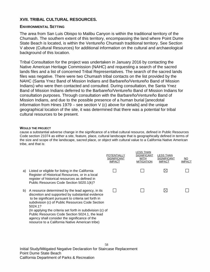
58 Initial Study/Mitigated Negative Declaration for Staircase Replacement Point Dume State Beach California Department of Parks & Recreation
XVII. TRIBAL CULTURAL RESOURCES. ENVIRONMENTAL SETTING The area from San Luis Obispo to Malibu Canyon is within the traditional territory of the Chumash. The southern extent of this territory, encompassing the land where Point Dume State Beach is located, is within the Ventureño Chumash traditional territory. See Section V above (Cultural Resources) for additional information on the cultural and archaeological background of this location. Tribal Consultation for the project was undertaken in January 2016 by contacting the Native American Heritage Commission (NAHC) and requesting a search of the sacred lands files and a list of concerned Tribal Representatives. The search of the sacred lands files was negative. There were two Chumash tribal contacts on the list provided by the NAHC (Santa Ynez Band of Mission Indians and Barbareño/Ventureño Band of Mission Indians) who were then contacted and consulted. During consultation, the Santa Ynez Band of Mission Indians deferred to the Barbareño/Ventureño Band of Mission Indians for consultation purposes. Through consultation with the Barbareño/Ventureño Band of Mission Indians, and due to the possible presence of a human burial [anecdotal information from Hines 1979 – see section V (c) above for details] and the unique geographical location of the site, it was determined that there was a potential for tribal cultural resources to be present. WOULD THE PROJECT cause a substantial adverse change in the significance of a tribal cultural resource, defined in Public Resources Code section 21074 as either a site, feature, place, cultural landscape that is geographically defined in terms of the size and scope of the landscape, sacred place, or object with cultural value to a California Native American tribe, and that is: LESS THAN POTENTIALLY SIGNIFICANT LESS THAN SIGNIFICANT WITH SIGNIFICANT NO IMPACT MITIGATION IMPACT IMPACT a) Listed or eligible for listing in the California Register of Historical Resources, or in a local register of historical resources as defined in Public Resources Code Section 5020.1(k)? b) A resource determined by the lead agency, in its discretion and supported by substantial evidence to be significant pursuant to criteria set forth in subdivision (c) of Public Resources Code Section 5024.1? (In applying the criteria set forth in subdivision (c) of Public Resources Code Section 5024.1, the lead agency shall consider the significance of the resource to a California Native American tribe)
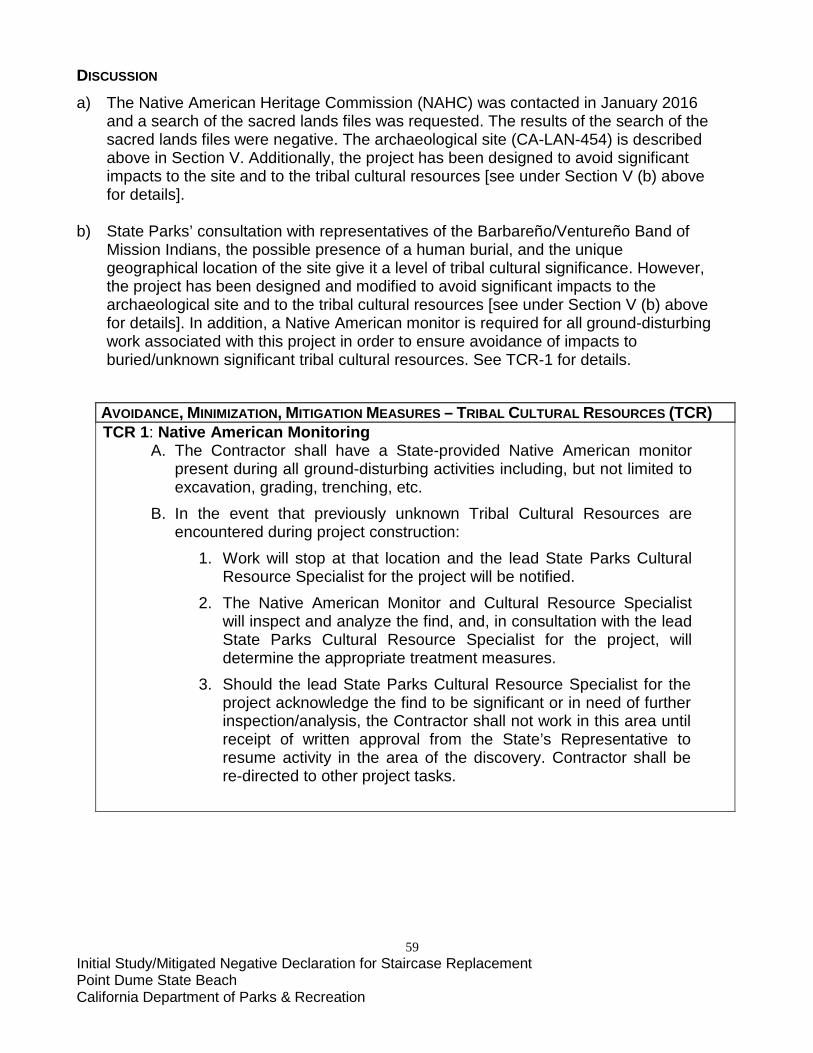
59 Initial Study/Mitigated Negative Declaration for Staircase Replacement Point Dume State Beach California Department of Parks & Recreation
DISCUSSION
a) The Native American Heritage Commission (NAHC) was contacted in January 2016 and a search of the sacred lands files was requested. The results of the search of the sacred lands files were negative. The archaeological site (CA-LAN-454) is described above in Section V. Additionally, the project has been designed to avoid significant impacts to the site and to the tribal cultural resources [see under Section V (b) above for details].
b) State Parks’ consultation with representatives of the Barbareño/Ventureño Band of
Mission Indians, the possible presence of a human burial, and the unique geographical location of the site give it a level of tribal cultural significance. However, the project has been designed and modified to avoid significant impacts to the archaeological site and to the tribal cultural resources [see under Section V (b) above for details]. In addition, a Native American monitor is required for all ground-disturbing work associated with this project in order to ensure avoidance of impacts to buried/unknown significant tribal cultural resources. See TCR-1 for details.
AVOIDANCE, MINIMIZATION, MITIGATION MEASURES – TRIBAL CULTURAL RESOURCES (TCR) TCR 1: Native American Monitoring
A. The Contractor shall have a State-provided Native American monitor present during all ground-disturbing activities including, but not limited to excavation, grading, trenching, etc.
B. In the event that previously unknown Tribal Cultural Resources are encountered during project construction:
1. Work will stop at that location and the lead State Parks Cultural Resource Specialist for the project will be notified.
2. The Native American Monitor and Cultural Resource Specialist will inspect and analyze the find, and, in consultation with the lead State Parks Cultural Resource Specialist for the project, will determine the appropriate treatment measures.
3. Should the lead State Parks Cultural Resource Specialist for the project acknowledge the find to be significant or in need of further inspection/analysis, the Contractor shall not work in this area until receipt of written approval from the State’s Representative to resume activity in the area of the discovery. Contractor shall be re-directed to other project tasks.
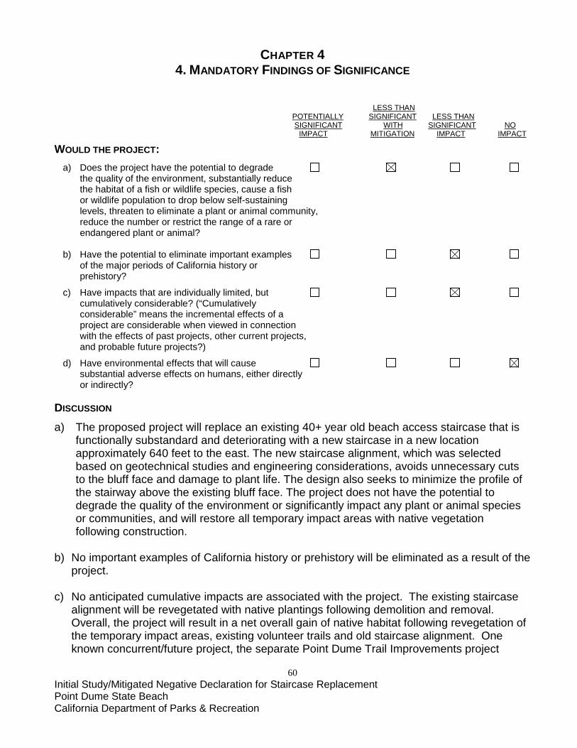
60 Initial Study/Mitigated Negative Declaration for Staircase Replacement Point Dume State Beach California Department of Parks & Recreation
CHAPTER 4 4. MANDATORY FINDINGS OF SIGNIFICANCE
LESS THAN POTENTIALLY SIGNIFICANT LESS THAN SIGNIFICANT WITH SIGNIFICANT NO IMPACT MITIGATION IMPACT IMPACT WOULD THE PROJECT: a) Does the project have the potential to degrade the quality of the environment, substantially reduce the habitat of a fish or wildlife species, cause a fish or wildlife population to drop below self-sustaining levels, threaten to eliminate a plant or animal community, reduce the number or restrict the range of a rare or endangered plant or animal? b) Have the potential to eliminate important examples of the major periods of California history or prehistory?
c) Have impacts that are individually limited, but cumulatively considerable? (“Cumulatively considerable” means the incremental effects of a project are considerable when viewed in connection with the effects of past projects, other current projects, and probable future projects?)
d) Have environmental effects that will cause substantial adverse effects on humans, either directly or indirectly? DISCUSSION
a) The proposed project will replace an existing 40+ year old beach access staircase that is functionally substandard and deteriorating with a new staircase in a new location approximately 640 feet to the east. The new staircase alignment, which was selected based on geotechnical studies and engineering considerations, avoids unnecessary cuts to the bluff face and damage to plant life. The design also seeks to minimize the profile of the stairway above the existing bluff face. The project does not have the potential to
degrade the quality of the environment or significantly impact any plant or animal species or communities, and will restore all temporary impact areas with native vegetation following construction.
b) No important examples of California history or prehistory will be eliminated as a result of the
project. c) No anticipated cumulative impacts are associated with the project. The existing staircase
alignment will be revegetated with native plantings following demolition and removal. Overall, the project will result in a net overall gain of native habitat following revegetation of the temporary impact areas, existing volunteer trails and old staircase alignment. One known concurrent/future project, the separate Point Dume Trail Improvements project

61 Initial Study/Mitigated Negative Declaration for Staircase Replacement Point Dume State Beach California Department of Parks & Recreation
(CEQA ID No. 11569), seeks to better define and stabilize existing trails impacted by erosion and visitors wandering off of established trails, and will result in a net benefit to the Natural Preserve.
d) No substantial adverse effects to humans, direct or indirect, are anticipated.
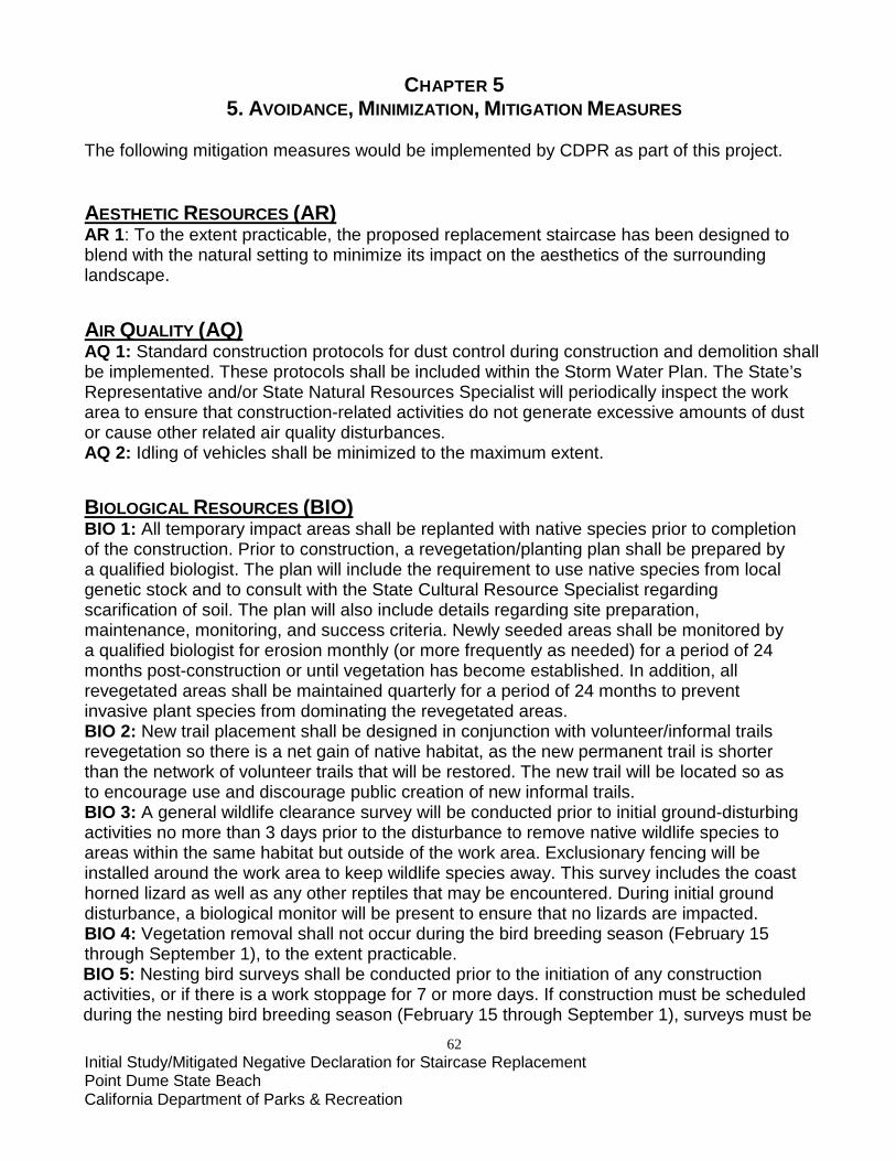
62 Initial Study/Mitigated Negative Declaration for Staircase Replacement Point Dume State Beach California Department of Parks & Recreation
CHAPTER 5 5. AVOIDANCE, MINIMIZATION, MITIGATION MEASURES
The following mitigation measures would be implemented by CDPR as part of this project. AESTHETIC RESOURCES (AR) AR 1: To the extent practicable, the proposed replacement staircase has been designed to blend with the natural setting to minimize its impact on the aesthetics of the surrounding landscape. AIR QUALITY (AQ) AQ 1: Standard construction protocols for dust control during construction and demolition shall be implemented. These protocols shall be included within the Storm Water Plan. The State’s Representative and/or State Natural Resources Specialist will periodically inspect the work area to ensure that construction-related activities do not generate excessive amounts of dust or cause other related air quality disturbances. AQ 2: Idling of vehicles shall be minimized to the maximum extent. BIOLOGICAL RESOURCES (BIO) BIO 1: All temporary impact areas shall be replanted with native species prior to completion of the construction. Prior to construction, a revegetation/planting plan shall be prepared by a qualified biologist. The plan will include the requirement to use native species from local genetic stock and to consult with the State Cultural Resource Specialist regarding scarification of soil. The plan will also include details regarding site preparation, maintenance, monitoring, and success criteria. Newly seeded areas shall be monitored by a qualified biologist for erosion monthly (or more frequently as needed) for a period of 24 months post-construction or until vegetation has become established. In addition, all revegetated areas shall be maintained quarterly for a period of 24 months to prevent invasive plant species from dominating the revegetated areas. BIO 2: New trail placement shall be designed in conjunction with volunteer/informal trails revegetation so there is a net gain of native habitat, as the new permanent trail is shorter than the network of volunteer trails that will be restored. The new trail will be located so as to encourage use and discourage public creation of new informal trails. BIO 3: A general wildlife clearance survey will be conducted prior to initial ground-disturbing activities no more than 3 days prior to the disturbance to remove native wildlife species to areas within the same habitat but outside of the work area. Exclusionary fencing will be installed around the work area to keep wildlife species away. This survey includes the coast horned lizard as well as any other reptiles that may be encountered. During initial ground disturbance, a biological monitor will be present to ensure that no lizards are impacted. BIO 4: Vegetation removal shall not occur during the bird breeding season (February 15 through September 1), to the extent practicable. BIO 5: Nesting bird surveys shall be conducted prior to the initiation of any construction activities, or if there is a work stoppage for 7 or more days. If construction must be scheduled during the nesting bird breeding season (February 15 through September 1), surveys must be
63 Initial Study/Mitigated Negative Declaration for Staircase Replacement Point Dume State Beach California Department of Parks & Recreation
completed twice prior to initiation of construction (no more than 14 days and within 3 days prior to activities). If nesting birds are observed by the project Natural Resource Specialist, a temporal and spatial buffer should be established to protect the nest from disturbance. The Contractor shall not work in this area until receipt of written approval from the State’s Representative to resume activity in the area. The temporal buffer shall remain in effect until the project Natural Resource Specialist determines the young are no longer dependent upon the nest or the nest has failed. Spatial buffers shall be a minimum of 250 feet for migratory birds and 500 feet for raptors unless a qualified biologist determines that smaller buffers would be sufficient to avoid impacts to nesting birds. BIO 6: Temporary impact areas will be clearly demarcated, and all activities will be contained within the work limits. To prevent increased soil disturbance that may impact silvery legless lizards, surface protection measures, which may include tarps, mulch, gravel, and/or cover boards, will be installed where vehicles are traveling or material may be stored. BIO 7: The beach shall be surveyed for roosting or foraging western snowy plovers daily - either in the morning or immediately prior to work activities that will occur on the beach during the peak population occurrences in Los Angeles County (between August 1 and March 31). If western snowy plovers are present, they must be a minimum of 50 feet away for work activities to begin. If present, a biological monitor shall be present during work activities. BIO 8: Upon completion of work, the project site shall be carefully surveyed for construction debris. Any debris found shall be promptly removed and properly disposed of off the project site. BIO 9: Project activities shall not extend more than 15 feet south (upcoast) of the existing staircase to prevent disturbance to roosting California brown pelicans and shall maintain a minimum 150-foot buffer from the roosting area. BIO 10: Prior to commencing any ground-disturbing activities, all Coulter’s saltbush, or any other sensitive plant species observed, within the project footprint shall be protected with construction fencing to avoid disturbance. If direct impacts cannot be avoided then the species will be salvaged and relocated. Salvage and relocation details will be incorporated into the revegetation/planting plan to be prepared as part of BIO-1. BIO 11: All work activities shall be conducted during daylight hours. BIO 12: Construction site will be kept clean at all times; no food or other attractants for wildlife will be left unattended. BIO 13: No holes or trenches shall be left open/unattended; they must be covered securely or equipped with an escape route to ensure that wildlife does not become entrapped. BIO 14: Work activities shall not extend below both the mean high tide line and high tide line. BIO 15: A qualified biological monitor shall be present on site whenever vehicles are on the beach. BIO 16: Prior to the start of on-site construction activities, a State Natural Resource Specialist will train on-site construction personnel on the life history of sensitive species work constraints, and any other pertinent information related to the species. BIO 17: To prevent the spread of noxious weeds, all construction vehicles and equipment will enter and leave the project site free of soil, vegetative matter or other debris that could contain weed seeds. BIO 18: If sea lions are present on the beach, then no construction personnel or equipment
64 Initial Study/Mitigated Negative Declaration for Staircase Replacement Point Dume State Beach California Department of Parks & Recreation
may approach within 100 feet unless a biological monitor is present and determines that construction activities are not a disturbance. Construction may resume in the temporary protection area after the sea lions depart of their own accord. CULTURAL RESOURCES (CR) CR 1: Archaeological Monitoring for all ground-disturbing work
A. A State Cultural Resource Specialist shall be present during all ground-disturbing activities including, but not limited to excavation, grading, trenching, etc.
B. In the event that previously unknown cultural resources (including but not limited to concentrations of dark soil, shell, bone, flaked stone, groundstone, or historic [50+ years old] trash, foundations, etc.) are encountered during project construction:
1. Work will stop at that location and the lead State Parks Cultural Resource Specialist for the project will be notified.
2. The State Cultural Resource Specialist will inspect and analyze the find, and, in consultation with the lead State Parks Cultural Resource Specialist for the project and the Native American monitor (as appropriate), will determine the appropriate treatment measures.
3. Should the lead State Parks Cultural Resource Specialist for the project determine the find to be significant or in need of further inspection/analysis, the Contractor shall not work in this area until receipt of written approval from the State’s Representative to resume activity in the area of the discovery. Contractor shall be re-directed to other project tasks.
CR 2: Human Remains In the event that human remains are discovered:
A. Work shall cease immediately in the area of the find and the Contractor shall notify the State’s Representative.
B. The State’s Representative will notify the appropriate CDPR personnel including the CDPR Sector Superintendent and the lead State Parks Cultural Resource Specialist for the project.
C. The CDPR Sector Superintendent (or authorized representative) will notify the County Coroner in accordance with §7050.5 of the California Health and Safety Code.
D. If the coroner determines the remains represent Native American interment, the Native American Heritage Commission in Sacramento will be consulted to identify the most likely descendant(s).
E. The most likely Descendent(s) will determine appropriate disposition of the remains. F. Work will not resume in the area of the find until proper disposition is complete (PRC
§5097.98).
65 Initial Study/Mitigated Negative Declaration for Staircase Replacement Point Dume State Beach California Department of Parks & Recreation
G. Contractor shall be re-directed to other project tasks until Contractor receives written approval from the State’s Representative to resume activity in the area of the discovery.
GEOLOGY AND SOILS (GS) GEO 1: Erosion Control
A. Prior to the start of construction, Contractor will prepare a Storm Water Plan for CDPR approval that identifies the BMPs to be used in all construction areas to reduce or eliminate the discharge of soil, surface water runoff, and pollutants during all excavation, grading, or trenching.
B. BMPs must be in place at all times including covering (tarping) any stockpiled materials or soils and by constructing silt fences, straw bale barriers, fiber rolls, or other structures around stockpiles and disturbed areas.
GEO 2: The most recent revision of the California Building Code (2016 CBC Section 1613) shall be adhered to for the new staircase to mitigate the risk of loss, injury, or death due to geologic hazards. GEO 3: To the maximum extent feasible, the new staircase has been designed to conform to the landscape’s natural contours, so as to minimize overall topographic change. HAZARDS AND HAZARDOUS MATERIALS (HAZ) HAZ 1: Hazardous Material Spills
A. Prior to the start of construction, the contractor will clean all equipment before entering the project site. Equipment will be cleaned and repaired (other than emergency repairs) outside the project site boundaries. All contaminated water, sludge, spill residue, or other hazardous compounds will be contained and disposed of outside the boundaries of the site, at a lawfully permitted or authorized destination.
B. Prior to the start of construction, the contractor will inspect all equipment for leaks and regularly inspect thereafter until equipment is removed from the project site.
C. Prior to the start of construction, CDPR’s contractor will prepare a Spill Prevention and Response Plan (SPRP) to provide protection to on-site workers, the public, and the environment from accidental leaks or spills of vehicle fluids or other potential contaminants. This plan will include (but not be limited to):
1. A map with both a primary and secondary containment area with a listing of BMPs to be used to prevent the accidental release of fluid materials, including concrete.
2. A map that delineates construction staging areas, where refueling, lubrication, and maintenance of equipment will occur.
3. A list of items required in a spill kit on-site that will be maintained throughout the life of the project.
4. Identification of lawfully permitted or authorized disposal outside of the project site.
HAZ 2: Fire Safety A. Prior to the start of construction, the Project Contractor will develop a CDPR-
approved Fire Safety Plan. The plan will include emergency calling procedures for the local fire department.

66 Initial Study/Mitigated Negative Declaration for Staircase Replacement Point Dume State Beach California Department of Parks & Recreation
B. Spark arrestors or turbo chargers (which eliminate sparks in exhaust) and fire extinguishers will be required for all heavy equipment.
C. Cutting of vegetation within the staging area and the use a ground barrier covered with leveling fill will keep construction vehicles away from flammable material, such as dry grass or brush.
HAZ 3: Worker Safety Require construction personal to have appropriate training in compliance with 29 CFR, §§1910, et seq. (Occupational Safety and Health Standards), 1926 et seq (Safety and Health Regulations for Construction) and 8 CCR § 5192 (Hazardous Waste Operations and Emergency Response) to protect workers. HYDROLOGY AND WATER QUALITY (WQ) WQ 1: Prior to the start of work, the contractor will develop a Storm Water Plan that identifies BMPs to be used in all construction areas to reduce or eliminate the discharge of soil, surface water runoff, and pollutants during all ground disturbing activities. WQ 2: The project shall comply with all applicable water quality standards as specified in the LARWQCB Water Quality Control Plan (Basin Plan). WQ 3: For construction activities that extend into the rainy season or if an unseasonal storm is anticipated, the contractor would cover (i.e. tarp) any stockpiled materials or soil and install silt fences, straw bale barriers, fiber rolls, or other structures around stockpiles and areas of ground disturbance. WQ 4: Signage related to the presence of a potential inundation zone will be installed pursuant to the County of Los Angeles Tsunami Signage Policy, including an applicable Tsunami Evacuation Route. Such measures are intended to reduce the potential impacts resulting from a mudflow or tsunami event.
NOISE (NO) NO 1: Noise generated from demolition or construction activities shall be limited to avoid seasons of peak visitation, and time periods when sensitive wildlife species may be significantly impacted. NO 2: Construction activities would be limited to daylight hours, Monday through Friday between 7:00 AM and 7:00 PM. Weekend or holiday work could be implemented to address emergencies or unforeseen circumstances impacting construction. NO 3: Internal combustion engines used for any purpose at the job site would be equipped with a muffler of a type recommended by the manufacturer. Equipment and trucks used for construction would utilize the best available noise control techniques (e.g., engine enclosures, acoustically attenuating shields, or shrouds, intake silencers, ducts, etc.). NO 4: Noise monitoring will be conducted and sound-absorbing barriers will be installed local to the crane as needed (for an estimated additional 5 dBA attenuation). TRANSPORTATION/TRAFFIC (TR) TR 1: Construction equipment and employee parking will be confined to the construction staging area identified in Figure 4 so as not to impact limited visitor parking on Cliffside Drive.
67 Initial Study/Mitigated Negative Declaration for Staircase Replacement Point Dume State Beach California Department of Parks & Recreation
TRIBAL CULTURAL RESOURCES (TCR) TCR 1: Native American Monitoring
A. The Contractor shall have a State-provided Native American monitor present during all ground-disturbing activities including, but not limited to excavation, grading, trenching, etc.
B. In the event that previously unknown Tribal Cultural Resources are encountered during project construction:
1. Work will stop at that location and the lead State Parks Cultural Resource Specialist for the project will be notified.
2. The Native American Monitor and State Cultural Resource Specialist will inspect and analyze the find, and, in consultation with the lead State Parks Cultural Resource Specialist for the project, will determine the appropriate treatment measures.
3. Should the lead State Parks Cultural Resource Specialist for the project acknowledge the find to be significant or in need of further inspection/analysis, the Contractor shall not work in this area until receipt of written approval from the State’s Representative to resume activity in the area of the discovery. Contractor shall be re-directed to other project tasks.
68 Initial Study/Mitigated Negative Declaration for Staircase Replacement Point Dume State Beach California Department of Parks & Recreation
CHAPTER 6 6. REFERENCES
California Building Standards Commission 2016 California Building Standards Code (Title 24, California Code of Regulations) California Department of Parks and Recreation (CDPR) 2016 Project Evaluation Form (CDPR 183) for Point Dume State Beach Trail Improvements (CEQA ID No. 11569). Angeles District, Calabasas, CA. 2016 Project Evaluation Form (CDPR 183) for Geotechnical and Archaeological Investigations for Point Dume State Beach Staircase Replacement (CEQA ID No. 11687). Southern Service Center, San Diego, CA. 2000 Point Dume Natural Preserve Management Plan (Draft). City of Malibu 2002 City of Malibu Local Coastal Program Land Use Plan. 2002 City of Malibu Local Coastal Program Local Implementation Plan. Federal Highway Administration (FHWA) 2006 Construction Noise Handbook. U.S. Department of Transportation, Federal Highway Administration, Office of Natural and Human Environment. Washington, D.C. Air Quality South Coast Air Quality Management District (SCAQMD) 2016 Air Quality Management Plan. Biological Resources AECOM 2016 Biological Resources Report: Point Dume Staircase Removal and Replacement Project. San Diego, CA. November 2016. Calflora 2016 The Calflora Database: Information on California plants for education, research and conservation. Berkeley, California. Accessed online through September 2016: http://www.calflora.org/ California Department of Fish and Game (CDFG) 2010 List of California Terrestrial Natural Communities Recognized by the Natural
Diversity Data Base. Natural Heritage Division, The Resources Agency. September 2010. Accessed online through September 2016:
http://www.dfg.ca.gov/biogeodata/vegcamp/pdfs/natcomlist.pdf

69 Initial Study/Mitigated Negative Declaration for Staircase Replacement Point Dume State Beach California Department of Parks & Recreation
2006 Vegetation Classification of the Santa Monica Mountains National Recreation Area
and Environs in Ventura and Los Angeles Counties, California, Version 1 - Association Level and Specific Alliances. CDFG Wildlife and Habitat Data Analysis Branch and California Native Plant Society, January 2006.
California Department of Fish and Wildlife (CDFW) 2016 State and Federally Listed Endangered, Threatened, and Rare Plants of California. California Natural Diversity Data Base. Accessed online through September 2016: https://nrm.dfg.ca.gov/FileHandler.ashx?DocumentID=109390&inline=1 California Native Plant Society (CNPS) 2016 Inventory of Rare and Endangered Plants of California (online edition, v8-02). CNPS Rare Plant Program. Sacramento, CA. Available at: http://www.rareplants.cnps.org NatureServe. 2006 International Ecological classification Standard: Terrestrial Ecological Classification
of the Santa Monica Mountains National Recreation Area. January 2006.
Sawyer, J.O., T. Keeler-Wolf and J. Evens 2009 A Manual of California Vegetation, Second Edition. California Native Plant Society.
Sacramento, California. U.S. Fish and Wildlife Service (USFWS) 1997 Coastal California Gnatcatcher (Polioptila californica californica) Presence/Absence Survey Protocol. Department of the Interior, U.S. Fish and Wildlife Service. Coastal Engineering and Sea Level Rise California Coastal Commission (CCC) 2015 Interpretive Guidelines for Addressing Sea Level Rise in Local Coastal Programs and Coastal Development Permits. August 12, 2015. 1999 Beach Erosion and Response (BEAR) Guidance Document. December 1999. Die Kuste 2007 EurOtop: Wave Overtopping of Sea Defenses and Related Structures Assessment Manual. California Department of Parks and Recreation (CDPR) 2016 NOAA Sea Level Rise and California State Parks Facilities (mapping tool). http://mshqgisweb11/flex/SeaLevelRise/ 2015 Sea-Level Rise and Extreme Events Guidance document (2013; revised November 2015)
70 Initial Study/Mitigated Negative Declaration for Staircase Replacement Point Dume State Beach California Department of Parks & Recreation
Moffat & Nichol 2016 Public Stairway at Point Dume State Beach: Wave Runup Study. Long Beach, CA.
July 2016. National Oceanic and Atmospheric Administration (NOAA) 2016 NOAA Sea Level Rise Viewer (mapping tool) https://coast.noaa.gov/digitalcoast/tools/slr
NOAA and National Ocean Service 2013 NOAA/NOS Tides and Currents Map, Santa Monica Tide Station (ID 9410840). https://tidesandcurrents.noaa.gov/stationhome.html?id=9410840 National Research Council (NRC) 2012 Sea-Level Rise of the Coasts of California, Oregon, and Washington: Past, Present, and Future. National Research Council (NRC) 2012 Sea-Level Rise for the Coasts of California, Oregon, and Washington. June 2012. U.S. Army Corps of Engineers (USACE) 2015 Wave Information Studies (WIS) Wave Hindcast Model Domains for U.S. Coasts website: http://wis.usace.army.mil/ 2003 Coastal Engineering Manual. Cultural Resources Bell, Evans, Coleman, Leonard 1972 Archaeological Site Survey Record for CA-LAN-454. On file at the South Central
Coastal Information Center.
Bevil, Alexander 2000 Point Dume State Beach Historical Background. Report on file at California State
Parks (CSP), Southern Service Center (SSC), San Diego.
Dallas, Herb, Alex Bevil, and Marla Mealey 2000 An Archaeological Assessment of Pt. Dume State Reserve: CA-LAN-454: An
investigation of LAN-454 for the proposed boardwalk at Pt. Dume Natural Preserve. Report on file at CSP, SSC, San Diego.
Dallas Jr., Herb and Marla M. Mealey 1995 “Preliminary Survey and Testing Results at Leo Carrillo State Beach.” Paper
presented at the Society for California Data Sharing Meeting, at UCLA, October 1995.
71 Initial Study/Mitigated Negative Declaration for Staircase Replacement Point Dume State Beach California Department of Parks & Recreation
Hines, Phil 1979 Archaeological Site Survey Record Supplement for CA-LAN-454. On file at the
South Central Coastal Information Center.
King, Chester 1994 Prehistoric Native American Cultural Sites in the Santa Monica Mountains. Topanga
Anthropological Consultants. Topanga, CA.
Meighan, Clement, Douglas Armstrong, and Audrey McNulty 1984 Archaeological Investigation of Site LAN-454 [Pt. Dume State Park]. Report
prepared by the Archaeological Survey, UCLA for the California Department of Parks and Recreation. On file at CSP, SSC, San Diego.
Shabel, Karen, and Sarah Jenkins 2002 Archaeological Testing at CA-LAN-454 Boardwalk Construction Project. Point
Dume State Preserve, Malibu, California. Report on file at CSP, SSC, San Diego. Geology and Soils American Society for Testing and Materials (ASTM) 2002 “Test Method for Laboratory Compaction Characteristics of Soil Using Modified Effort,” Volume 04.08. Blake, Thomas F. 2000 “EQFAULT,” Version 3.00b, Thomas F. Blake Computer Services and Software. California Building Standards Commission (CBSC) 2013 California Building Code (California Code of Regulations, Title 24, Part 2, Volume 2 of 2). Published by the International Code Council. California Department of Conservation, Division of Mines and Geology 2001 Seismic Hazard Zone Report for the Point Dume 7.5-Minute Quadrangle, Los Angeles and Ventura Counties, California, Report 056. 2000 CD 2000-003 “Digital Images of Official Maps of Alquist-Priolo Earthquake Fault Zones of California, Southern Region,” compiled by Martin and Ross. California Geological Survey 2009 Tsunami Inundation Map for Emergency Planning, State of California, County of Los Angeles, Point Dume Quadrangle. 2008 Guidelines for Evaluating and Mitigating Seismic Hazards in California, Special Publication 117A. Cao, T., Bryant, W.A., Rowshandel, B., Branum, D., and Willis, C.J. 2003 California probabilistic seismic hazard maps, revised 2002.
72 Initial Study/Mitigated Negative Declaration for Staircase Replacement Point Dume State Beach California Department of Parks & Recreation
California Geological Survey webpage: http://www.consrv.ca.gov/cgs/rghm/psha/fault_parameters/pdf/2002_CA_Hazard_M aps.pdf Construction Testing & Engineering, Inc. (CTE) 2016 Geotechnical Investigation for Proposed Beach Stairway Access Structure, Point Dume State Beach. Escondido, CA. 17 October 2016. Frankel, A.D., Petersen, M.D., Mueller, C.S., Haller, K.M., Wheeler, R.L., Leyendecker, E.V., Wesson, R.L. Harmsen, S.C., Cramer, C.H., Perkins, D.M., and Rukstales, K.S. 2002 Documentation for the 2002 update of the National Seismic Hazard Maps: U.S. Geological Survey Open-File Report 02-420. GeoConcepts, Inc. 2015 Supplemental Report No. 1, 29140 Cliffside Drive, Malibu, California, Project No. 4917. November 17, 2015. Hart, Earl W., and Bryant, William A. 2007 “Fault-Rupture Hazard Zones in California, Alquist Priolo, Special Studies Zones Act of 1972” (revised 2007). California Division of Mines and Geology, Special Publication 42. Jennings, Charles W. 1994 “Fault Activity Map of California and Adjacent Areas” with Locations and Ages of Recent Volcanic Eruptions. Russell H. Campbell, Chris J. Wills, Pamela J. Irvine, and Brian J. Swanson 2014 “Geologic Map of the Los Angeles 30’ x 60’ Quadrangle, California”. California Geological Survey. Seed, H.B., and R.V. Whitman 1970 “Design of Earth Retaining Structures for Dynamic Loads,” in Proceedings, ASCE Specialty Conference on Lateral Stresses in the Ground and Design of Earth- Retaining Structures. Ithaca, New York: Cornell University. Wood, J.H. 1973 Earthquake-Induced Soil Pressures on Structures, Report EERL 73-05. Pasadena: California Institute of Technology. Zony, J. I. 1985 Evaluating Earthquake Hazards in the Los Angeles Region-an EarthScience Perspective, U. S. Geological Survey Professional Paper 1360. Hazardous Materials California Department of Environmental Protection (CALEPA) 2016 Hazardous Waste and Substances site “Cortese” list.
73 Initial Study/Mitigated Negative Declaration for Staircase Replacement Point Dume State Beach California Department of Parks & Recreation
Accessed online November 29, 2016: http://www.envirostor.dtsc.ca.gov/public/search.asp?cmd=search&reporttype=CORT
ESE&site_type=CSITES,OPEN,FUDS,CLOSE&status=ACT,BKLG,COM&reporttitle=HAZARDOUS+WASTE+AND+SUBSTANCES+SITE+LIST
Hydrology Construction Testing & Engineering, Inc. (CTE) 2016 Point Dume Stairway Replacement: Preliminary Hydrology & Water Quality Control Research Documentation. Escondido, CA. 8 September 2016.
Hickman, J. C. 1993 The Jepson Manual: Higher Plants of California. University of California Press,
Berkeley, CA.

74 Initial Study/Mitigated Negative Declaration for Staircase Replacement Point Dume State Beach California Department of Parks & Recreation
CHAPTER 7 7. REPORT PREPARATION
CALIFORNIA DEPARTMENT OF PARKS AND RECREATION Mike Yengling, Environmental Coordinator, Associate Park and Recreation Specialist,
Southern Service Center Jim Engelke, Project Manager, Southern Service Center Robert Robinson, Associate Civil Engineer, Southern Service Center Lisa Fields, Environmental Scientist, Southern Service Center Danielle LeFer, Environmental Scientist, Angeles District Marla Mealey, Associate State Archaeologist, Southern Service Center Alexander Bevil, Historian II, Southern Service Center Jeff Brown, Senior Landscape Architect, Southern Service Center Craig Sap, District Superintendent, Angeles District
75 Initial Study/Mitigated Negative Declaration for Staircase Replacement Point Dume State Beach California Department of Parks & Recreation
CHAPTER 8 8. PUBLIC AND AGENCY COMMENT
The draft IS/MND was circulated for a 30-day public review period, beginning on December 16, 2016 and closing on January 16, 2017. Notices were sent to property owners and residents within 500 feet of the project area as well as known agencies and organizations that may have interest in the project. Copies of the document were sent to the State Clearinghouse as required under CEQA §15073. Copies of the Draft IS/MND were made available at the Malibu Public Library and at CDPR’s Malibu Sector office. Tribal Consultation for the project was undertaken in January 2016 by contacting the Native American Heritage Commission (NAHC) and requesting a search of the sacred lands files and a list of concerned Tribal Representatives. The search of the sacred lands files was negative. The two Chumash tribal contacts on the list provided by the NAHC (Santa Ynez Band of Mission Indians and Barbareño/Ventureño Band of Mission Indians) were contacted and consulted. During consultation, the Santa Ynez Band of Mission Indians deferred to the Barbareño/Ventureño Band of Mission Indians for consultation purposes. Through consultation with the Barbareño/Ventureño Band of Mission Indians it was determined that there was a potential for tribal cultural resources to be present within the project area, and Native American monitoring was requested. A total of five (5) comment letters were received, all via e-mail – one from the California Department of Transportation (Caltrans) and four from individuals. Compiled comments and responses can be found below. Comment 1: CEQA Requires Preparation of an EIR Because the Project Will Result in Potentially Significant Traffic Impacts Response 1: There is no indication that the proposed project will result in impacts to traffic, as there is no proposed change in capacity or use. Visitation to Point Dume State Beach has been consistent over the past five years, with 2015’s figure of 246,000 closely corresponding to the estimated average of 238,130 annual visitors from 2010-2015. The existing beach access staircase will be removed following construction of the replacement staircase, which will serve the same function. Such actions are frequently exempt under CEQA §15302 (Class 2 - “Replacement or Reconstruction”); however, given the change in alignment, location within a Natural Preserve, and the presence of sensitive resources within the Park it was determined that a Mitigated Negative Declaration was the appropriate environmental document. The City of Malibu is currently creating a Traffic Management Plan for the Point Dume neighborhood area, with the intent of reducing vehicle speeds and improving safety for vehicles, pedestrians, and cyclists. More information can be found here: https://www.malibucity.org/PDTraffic
76 Initial Study/Mitigated Negative Declaration for Staircase Replacement Point Dume State Beach California Department of Parks & Recreation
Comment 2: The IS/MND Completely Ignores Point Dume's Historic Status and Designation Response 2: The MND contains more than six pages dedicated to cultural resources, including the explicit mention of Point Dume’s status as California State Historic Landmark No. 965. Although Point Dume is associated with the 1542 Cabrillo expedition, the 1793 expedition of English explorer Captain George Vancouver, and the 1796 Portolá expedition, there are no above-ground historic resources associated with any of these early events. Mitigation Measure CR 1 in the MND addresses the potential presence of unknown or subsurface archaeological resources. Comment 3.1: CEQA Requires Preparation of an EIR Because the Stairs Project Will Result in Potentially Significant Noise Impacts Response 3.1: There is no indication that the proposed project would result in noise impacts in excess of those permitted by the applicable noise regulations for construction activities established by the City of Malibu, or other applicable state or federal standards. The City of Malibu General Plan Noise Element’s “Maximum Exterior Noise Limits for Non-Transportation Sources” has an established noise (sound) level of 75 dBA between 7:00AM and 7:00PM for both Residential and Open Space districts. Per the Federal Highway Administration (FHWA)’s Construction Noise Handbook, maximum sound levels (in dBA, or A-Weighted Sound Level, at a distance of 50 feet from the source) for the following types of equipment are: Auger Drill Rig - Lmax 85 dBA Compressor (air) - Lmax 80 dBA Concrete Mixer Truck - Lmax 85 dBA Concrete Pump Truck - Lmax 82 dBA Crane - Lmax 85 dBA Drill Rig Truck - Lmax 84 dBA Flat Bed Truck - Lmax 84 dBA
Front End Loader - Lmax 80 dBA Generator - Lmax 82 dBA Pickup Truck - Lmax 55 dBA Pneumatic Tools - Lmax 85 dBA Pumps - Lmax 77 dBA Welder/Torch - Lmax 73 dBA
The nearest residential properties are 300 feet and 440 feet from the project’s largest point source (the crane); over 300 feet the sound level will attenuate to approximately 68 dBA, well within the allowed threshold. To provide further control, the following Mitigation Measure has been incorporated into the final MND for this project: NO 4: Noise monitoring will be conducted and sound-absorbing barriers will be installed local to the crane as needed (for an estimated additional 5 dBA attenuation). There will be no blasting or pile driving. Comment 3.2: The IS/MND fails to provide analysis or mitigation measures to ensure that the new staircase will only be used during daytime hours, and this not impact [sic] the evening
77 Initial Study/Mitigated Negative Declaration for Staircase Replacement Point Dume State Beach California Department of Parks & Recreation
noise levels. Additionally, the IS/MND fails to account for the noise from overnight parking in the area, which has been a recent problem. Response 3.2: Point Dume State Beach is officially open from sunrise to sunset, and violators are subject to citations. The proposed project does not include changes to hours of operation. Parking along Cliffside Drive adjacent to the Natural Preserve is enforced by the City of Malibu, though California State Parks Rangers may also issue citations for parking violations. Comment 4: CEQA Requires the Preparation of an EIR Because the Stairs Project Will Result in Potentially Significant Aesthetic Impacts Response 4: Placement and configuration of the new staircase has been determined by taking into consideration avoiding unnecessary cuts to the bluff face as well as minimizing the profile of the stairway above the bluff face (MND Mitigation Measure AR 1). The new staircase will be visible largely only by its users and from the beach, as the design hugs the contours of the bluff to the greatest extent possible. Materials have been chosen for both durability and their ability to blend into the surrounding landscape, with colors ranging from brown to green including staining of concrete elements to best match the adjacent bluff. Comment 5.1: CEQA Requires Preparation of an EIR Because the Project Will Result in Potentially Significant Impacts to Biological Resources Although the IS/MND provides for mitigation measures, these measures are inadequate to prevent the loss of habitat for these species. Most notably, the IS/MND and its mitigation measures fail to account for the increase [sic] pedestrian and vehicular use of the area and the impacts associated with these increases.
Response 5.1: There should be no loss of habitat for sensitive species as a result of this project. In fact, this project will result in a net gain of habitat for sensitive and common species. The staging and storage area and the crane pad, which are the primary disturbances, were preferentially placed within the Annual Brome Grassland Vegetation Alliance, which is dominated by non-native species and therefore is not considered an Environmentally Sensitive Habitat Area (ESHA). This habitat provides low to no suitable habitat for sensitive species found within Point Dume State Beach. No sensitive species were observed within the project area during targeted surveys, although sensitive plants and animals were observed within the larger Biological Study Area (see Figure 5 in the MND). Mitigation measure BIO 1 requires the construction disturbance area to be restored with native plant species. Therefore, following completion of this project the habitat suitability should improve to be consistent with the surrounding native habitat. Mitigation measure BIO 2 requires the new access trail to the staircase to utilize the existing volunteer trail network as much as possible to decrease the removal of vegetation and for design to take into account current user patterns to encourage use of the new trail instead of continued creation of volunteer trails. Further, Mitigation measures BIO 3 through BIO 17 were developed to ensure that the sensitive and common natural resources present within the project area are protected, and therefore impacts are less than significant, by requiring pre-construction surveys, installation of exclusion fencing, and having a biological monitor onsite, among other

78 Initial Study/Mitigated Negative Declaration for Staircase Replacement Point Dume State Beach California Department of Parks & Recreation
measures. This project is not expected to result in an increase in pedestrian or vehicular use. Comment 5.2: The IS/MND fails to list any specific measures that will be implemented to prevent pedestrians from created [sic] new unsanctioned trails around the Stairs Project, as has occurred around the current staircase. Response 5.2: This project design is intended to help prevent pedestrians from creating new trails. It was designed by evaluating where visitors are going (i.e. the location of volunteer trails) and placing the new staircase and access paths as close to that as possible (Mitigation Measure BIO 2). Since the new trail will be located in areas already used by visitors there shouldn’t be a need to create new trails. In fact, over half of the new access trail will be created by converting the heaviest used volunteer trails to State Parks maintained trails. Physical barriers and signs may be placed at the trail closure locations until the planted vegetation is established. Comment 5.3: In light of the sensitive ecological setting and the significance of the proposed Stairs Project, any credible environmental impact analysis must specify and detail the measures to be implemented to protect important biological resources at and around the Site. Response 5.3: Please see Mitigation Measures BIO 1 through BIO 17 and NO 1 for detailed measures that will be implemented to protect the biological resources that have the potential to be impacted by the proposed project. In addition, in response to other comments received we have added BIO 18 to explicitly define sea lion protection measures (Response 8 below), and NO 4 which calls for the erection of sound-absorbing barriers as needed to attenuate equipment noise (Response 3.1 above). Comment 6.1: CEQA Requires Preparation of an EIR Because the Project Will Result in Potentially Significant Impacts to Recreational Uses Response 6.1: Staging of the project has been planned to minimize impacts to recreation activities at Point Dume State Beach, most notably by retaining the existing staircase until the new staircase is complete so as to have as little disruption of recreational activities as possible. As stated in the MND, it is anticipated that there will be a maximum of three weeks during which the new staircase could be closed during demolition/removal of the old staircase, and during construction staging area de-mobilization. Furthermore, construction work will not take place on weekends, which is when the Park receives the most visitors. Comment 6.2: Moreover, since the access staircase will be located further east from the current access staircase, recreational activity will likely also move further east, and thus create potentially significant impacts at, in, and around the area of the Site and the replacement staircase's access point. Response 6.2: Access points to the replacement staircase are not being altered, with the Coreopsis and Poppy Trails still providing access from Cliffside Drive. The most notable change is that the spur trail leading to the top of the new staircase is being designed in
79 Initial Study/Mitigated Negative Declaration for Staircase Replacement Point Dume State Beach California Department of Parks & Recreation
conjunction with revegetation of the existing network of unsanctioned informal/”volunteer” trails, and will be located in order to encourage its use and discourage public creation of new informal trails. Additionally, there is a net overall gain of native habitat as the new permanent trail is shorter than the network of volunteer trails that will be restored. Comment 7: The IS/MND Fails to Include Any Analysis of Cumulative Impacts Response 7: Any potential individual impacts associated with this project shall be avoided, minimized or mitigated to a less-than-significant level. Consideration has been given to past and known or probable future projects when assessing the cumulatively considerable effects of the current project, including the Point Dume Trail Improvements project (CEQA ID No. 11569). This separate project includes reconstruction of, and accessibility improvements to, portions of the Poppy Trail and Coreopsis Trail, as well as construction of an overlook near the intersection of these two trails. Due to the sensitive location within a Natural Preserve projects are infrequent and, as State property, are also all subject to environmental review under CEQA. Overall, this project will result in a net overall gain of native habitat following revegetation of the temporary impact areas, existing volunteer trails and old staircase alignment. Comment 8: Not only will there be a substantial increase in parking, but other potential impacts as they relate to traffic, air quality, vibration & noise during construction, have not been adequately addressed to evaluate their adverse effect on the natural preserve/vegetation, nesting, historic trail, and sensitive elements like the resting seal [sic] lions that are constantly disturbed by visitors, etc. Response 8: Refer to responses #1 and #3, above, regarding traffic and noise. Regarding vibration, there will be no blasting or pile driving thus no sources of excessive vibration. Regarding sea lions: The biological monitor onsite will ensure that if there are sea lions present on the beach, they are not disturbed by construction activities. The following Mitigation Measure has been incorporated into the final MND: BIO 18: If sea lions are present on the beach, then no construction personnel or equipment may approach within 100 feet unless a biological monitor is present and determines that construction activities are not a disturbance. Construction may resume in the temporary protection area after the sea lions depart of their own accord. Comment 9: Do you plan to construct better trails that will keep visitors from making their own paths, and trampling the delicate coastal vegetation? Response 9: Yes, this project addresses that directly. See response #5, above, as well as Mitigation Measure BIO 2 in the MND, which discusses new trail placement and revegetation of existing unsanctioned trails through the Preserve. Comment 10: How do you plan to address the existing nuisance with regards to chronic parking issues, partying, use of alcohol on the beach etc.
80 Initial Study/Mitigated Negative Declaration for Staircase Replacement Point Dume State Beach California Department of Parks & Recreation
Response 10: This is a law enforcement issue independent of the scope of this project, the primary purpose of which is to provide safe public access to the beach by replacing an outdated structure. Comment 11: Why can't you just replace the existing steps which are in desperate need of being replaced as oppose [sic] to relocating it? Response 11: Construction of a replacement staircase in the same location as the existing one was explored, but determined to not be feasible while meeting current building standards. Under current code, stairways are to descend no steeper than 63.6%, or a rise/run ratio of 7/11. The old stairs exceed this at approximately 75% or 7.5/10. As discussed in Section 2.3 of the MND (“Background and Need for the Project”), the new location was selected based on a variety of factors including potential impacts to the fragile coastal bluffs, visitor use, engineering constraints, and minimizing damage to plant life and cultural resources. Comment 12: Although the project primarily consists of replacing and relocating an existing stairway, some consideration should be given to also incorporating quality bicycle parking along Cliffside Drive to accommodate those who may arrive by bicycle. This could encourage people to leave their bicycles safely locked before heading down the stairway and discourage people from locking bicycles to the stairway railing itself. Response 12: Although it falls outside the scope of replacing the existing pedestrian access to the beach, consideration will be given to this suggestion.
APPENDICES A. Maps/Figures Figure 1. Project Location Figure 2. Old and New Staircase Alignments Figure 3. New Staircase Alignment with Landings Figure 4. Construction Staging and Temporary Impact Areas Figure 5. Biological Study Area (BSA) and Special-Status Plant Species in the Vicinity of the Project Area Figure 6. CNDDB Results within a 5-Mile Radius Figure 7. Regional Geologic Map Figure 8. Geologic Site Conditions Figure 9. Regional Fault Map Figure 10. Liquefaction and Landslides Hazard Zone Map Figure 11. Los Angeles Regional Water Quality Control Board Map Figure 12. Tsunami Inundation Map
B. Abbreviations ADA Americans with Disabilities Act AQMD Air Quality Management District BSA Biological Study Area BRR Biological Resources Report CCC California Coastal Commission CCR California Code of Regulations CDP Coastal Development Permit CEQA California Environmental Quality Act CDFG California Department of Fish and Game (now CDFW) CDFW California Department of Fish and Wildlife (formerly CDFG) CDPR California Department of Parks and Recreation CNDDB California Natural Diversity Database (maintained by CDFW) CNPS California Native Plant Society FEMA Federal Emergency Management Agency IS Initial Study LCP Local Coastal Program MND Mitigated Negative Declaration NPDES National Pollutant Discharge Elimination System NP Natural Preserve PRC Public Resources Code RWQCB Regional Water Quality Control Board SB State Beach SLR Sea Level Rise
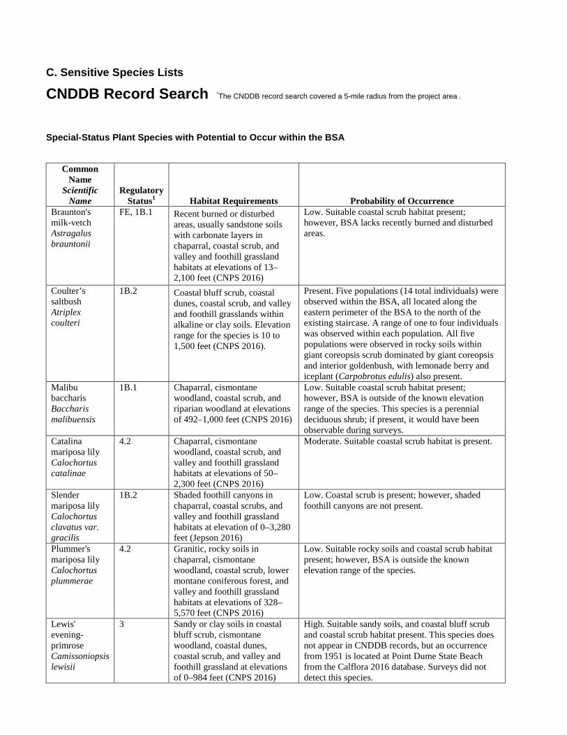
C. Sensitive Species Lists
CNDDB Record Search *The CNDDB record search covered a 5-mile radius from the project area .
Special-Status Plant Species with Potential to Occur within the BSA
Common Name
Scientific Name
Regulatory Status1 Habitat Requirements Probability of Occurrence
Braunton's milk-vetch Astragalus brauntonii
FE, 1B.1 Recent burned or disturbed areas, usually sandstone soils with carbonate layers in chaparral, coastal scrub, and valley and foothill grassland habitats at elevations of 13–2,100 feet (CNPS 2016)
Low. Suitable coastal scrub habitat present; however, BSA lacks recently burned and disturbed areas.
Coulter’s saltbush Atriplex coulteri
1B.2 Coastal bluff scrub, coastal dunes, coastal scrub, and valley and foothill grasslands within alkaline or clay soils. Elevation range for the species is 10 to 1,500 feet (CNPS 2016).
Present. Five populations (14 total individuals) were observed within the BSA, all located along the eastern perimeter of the BSA to the north of the existing staircase. A range of one to four individuals was observed within each population. All five populations were observed in rocky soils within giant coreopsis scrub dominated by giant coreopsis and interior goldenbush, with lemonade berry and iceplant (Carpobrotus edulis) also present.
Malibu baccharis Baccharis malibuensis
1B.1 Chaparral, cismontane woodland, coastal scrub, and riparian woodland at elevations of 492–1,000 feet (CNPS 2016)
Low. Suitable coastal scrub habitat present; however, BSA is outside of the known elevation range of the species. This species is a perennial deciduous shrub; if present, it would have been observable during surveys.
Catalina mariposa lily Calochortus catalinae
4.2 Chaparral, cismontane woodland, coastal scrub, and valley and foothill grassland habitats at elevations of 50–2,300 feet (CNPS 2016)
Moderate. Suitable coastal scrub habitat is present.
Slender mariposa lily Calochortus clavatus var. gracilis
1B.2 Shaded foothill canyons in chaparral, coastal scrubs, and valley and foothill grassland habitats at elevation of 0–3,280 feet (Jepson 2016)
Low. Coastal scrub is present; however, shaded foothill canyons are not present.
Plummer's mariposa lily Calochortus plummerae
4.2 Granitic, rocky soils in chaparral, cismontane woodland, coastal scrub, lower montane coniferous forest, and valley and foothill grassland habitats at elevations of 328–5,570 feet (CNPS 2016)
Low. Suitable rocky soils and coastal scrub habitat present; however, BSA is outside the known elevation range of the species.
Lewis' evening-primrose Camissoniopsis lewisii
3 Sandy or clay soils in coastal bluff scrub, cismontane woodland, coastal dunes, coastal scrub, and valley and foothill grassland at elevations of 0–984 feet (CNPS 2016)
High. Suitable sandy soils, and coastal bluff scrub and coastal scrub habitat present. This species does not appear in CNDDB records, but an occurrence from 1951 is located at Point Dume State Beach from the Calflora 2016 database. Surveys did not detect this species.
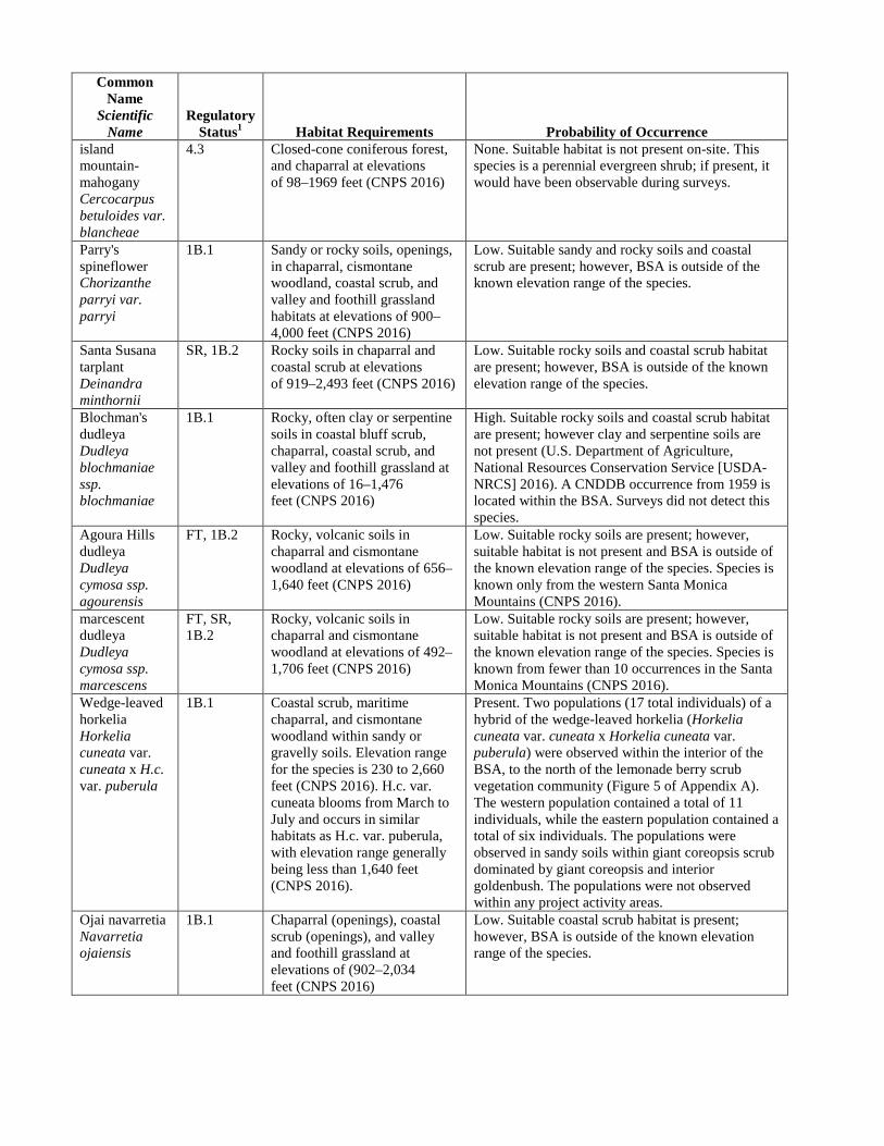
Common Name
Scientific Name
Regulatory Status1 Habitat Requirements Probability of Occurrence
island mountain-mahogany Cercocarpus betuloides var. blancheae
4.3 Closed-cone coniferous forest, and chaparral at elevations of 98–1969 feet (CNPS 2016)
None. Suitable habitat is not present on-site. This species is a perennial evergreen shrub; if present, it would have been observable during surveys.
Parry's spineflower Chorizanthe parryi var. parryi
1B.1 Sandy or rocky soils, openings, in chaparral, cismontane woodland, coastal scrub, and valley and foothill grassland habitats at elevations of 900–4,000 feet (CNPS 2016)
Low. Suitable sandy and rocky soils and coastal scrub are present; however, BSA is outside of the known elevation range of the species.
Santa Susana tarplant Deinandra minthornii
SR, 1B.2 Rocky soils in chaparral and coastal scrub at elevations of 919–2,493 feet (CNPS 2016)
Low. Suitable rocky soils and coastal scrub habitat are present; however, BSA is outside of the known elevation range of the species.
Blochman's dudleya Dudleya blochmaniae ssp. blochmaniae
1B.1 Rocky, often clay or serpentine soils in coastal bluff scrub, chaparral, coastal scrub, and valley and foothill grassland at elevations of 16–1,476 feet (CNPS 2016)
High. Suitable rocky soils and coastal scrub habitat are present; however clay and serpentine soils are not present (U.S. Department of Agriculture, National Resources Conservation Service [USDA-NRCS] 2016). A CNDDB occurrence from 1959 is located within the BSA. Surveys did not detect this species.
Agoura Hills dudleya Dudleya cymosa ssp. agourensis
FT, 1B.2 Rocky, volcanic soils in chaparral and cismontane woodland at elevations of 656–1,640 feet (CNPS 2016)
Low. Suitable rocky soils are present; however, suitable habitat is not present and BSA is outside of the known elevation range of the species. Species is known only from the western Santa Monica Mountains (CNPS 2016).
marcescent dudleya Dudleya cymosa ssp. marcescens
FT, SR, 1B.2
Rocky, volcanic soils in chaparral and cismontane woodland at elevations of 492–1,706 feet (CNPS 2016)
Low. Suitable rocky soils are present; however, suitable habitat is not present and BSA is outside of the known elevation range of the species. Species is known from fewer than 10 occurrences in the Santa Monica Mountains (CNPS 2016).
Wedge-leaved horkelia Horkelia cuneata var. cuneata x H.c. var. puberula
1B.1 Coastal scrub, maritime chaparral, and cismontane woodland within sandy or gravelly soils. Elevation range for the species is 230 to 2,660 feet (CNPS 2016). H.c. var. cuneata blooms from March to July and occurs in similar habitats as H.c. var. puberula, with elevation range generally being less than 1,640 feet (CNPS 2016).
Present. Two populations (17 total individuals) of a hybrid of the wedge-leaved horkelia (Horkelia cuneata var. cuneata x Horkelia cuneata var. puberula) were observed within the interior of the BSA, to the north of the lemonade berry scrub vegetation community (Figure 5 of Appendix A). The western population contained a total of 11 individuals, while the eastern population contained a total of six individuals. The populations were observed in sandy soils within giant coreopsis scrub dominated by giant coreopsis and interior goldenbush. The populations were not observed within any project activity areas.
Ojai navarretia Navarretia ojaiensis
1B.1 Chaparral (openings), coastal scrub (openings), and valley and foothill grassland at elevations of (902–2,034 feet (CNPS 2016)
Low. Suitable coastal scrub habitat is present; however, BSA is outside of the known elevation range of the species.
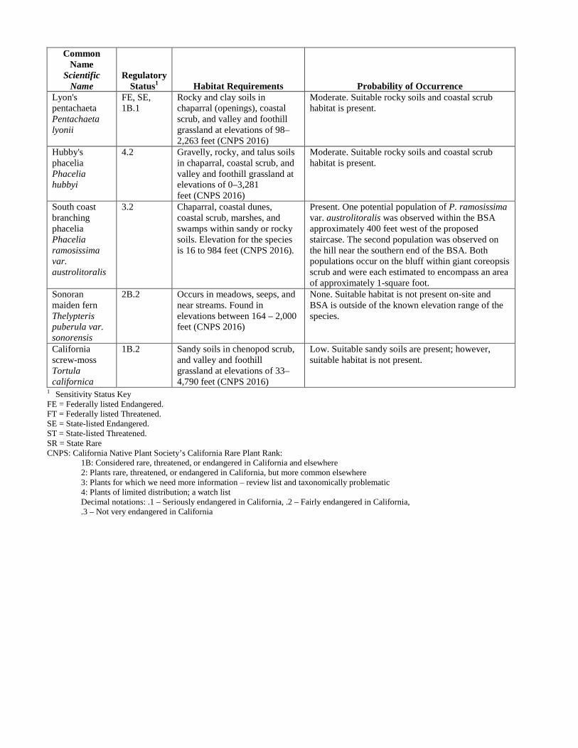
Common Name
Scientific Name
Regulatory Status1 Habitat Requirements Probability of Occurrence
Lyon's pentachaeta Pentachaeta lyonii
FE, SE, 1B.1
Rocky and clay soils in chaparral (openings), coastal scrub, and valley and foothill grassland at elevations of 98–2,263 feet (CNPS 2016)
Moderate. Suitable rocky soils and coastal scrub habitat is present.
Hubby's phacelia Phacelia hubbyi
4.2 Gravelly, rocky, and talus soils in chaparral, coastal scrub, and valley and foothill grassland at elevations of 0–3,281 feet (CNPS 2016)
Moderate. Suitable rocky soils and coastal scrub habitat is present.
South coast branching phacelia Phacelia ramosissima var. austrolitoralis
3.2 Chaparral, coastal dunes, coastal scrub, marshes, and swamps within sandy or rocky soils. Elevation for the species is 16 to 984 feet (CNPS 2016).
Present. One potential population of P. ramosissima var. austrolitoralis was observed within the BSA approximately 400 feet west of the proposed staircase. The second population was observed on the hill near the southern end of the BSA. Both populations occur on the bluff within giant coreopsis scrub and were each estimated to encompass an area of approximately 1-square foot.
Sonoran maiden fern Thelypteris puberula var. sonorensis
2B.2 Occurs in meadows, seeps, and near streams. Found in elevations between 164 – 2,000 feet (CNPS 2016)
None. Suitable habitat is not present on-site and BSA is outside of the known elevation range of the species.
California screw-moss Tortula californica
1B.2 Sandy soils in chenopod scrub, and valley and foothill grassland at elevations of 33–4,790 feet (CNPS 2016)
Low. Suitable sandy soils are present; however, suitable habitat is not present.
1 Sensitivity Status Key FE = Federally listed Endangered. FT = Federally listed Threatened. SE = State-listed Endangered. ST = State-listed Threatened. SR = State Rare CNPS: California Native Plant Society’s California Rare Plant Rank: 1B: Considered rare, threatened, or endangered in California and elsewhere 2: Plants rare, threatened, or endangered in California, but more common elsewhere 3: Plants for which we need more information – review list and taxonomically problematic 4: Plants of limited distribution; a watch list
Decimal notations: .1 – Seriously endangered in California, .2 – Fairly endangered in California, .3 – Not very endangered in California

Special-Status Wildlife Species with Potential to Occur within the BSA
Common Name Scientific Name
Special-Status1 Habitat Requirements Probability of Occurrence
Invertebrates monarch butterfly Danaus plexippus pop 1.-overwintering
G4T2T3S2S3
Overwintering monarchs tend to use relatively undisturbed wind-protected groves of nonnative eucalyptus (Eucalyptus sp.), native pines (Pinus sp.), native cypress (Cupressus sp.) and sycamores (Platanus racemosa). There was a roost site located approximately 1 mile from the BSA, but the trees were subsequently removed.
Absent. There are no potential winter roost sites within the BSA, as there are no trees present.
Reptiles silvery legless lizard Anniella pulchra pulchra
CDFW SSC
Typically restricted to undisturbed moist, loose, mulchy, sandy soils such as sand, loam, or humus. They are commonly found in washes, loose soil near the base of slopes, and in the vicinity of streams.
Potentially present. BSA is within the range of this species and suitable habitat is present. A reference to the presence of this species is noted in the State Parks Nature Preserve brochure, but there are no CNDDB records at Point Dume.
western pond turtle Emys marmorata
CDFW SSC
Requires permanent or nearly permanent freshwater aquatic habitat.
Absent. No freshwater aquatic habitat is present in BSA.
coast horned lizard Phrynosoma blainvillii
CDFW SSC
Variety of habitats including scrublands, grassland, and coniferous forests. Requirements include loose substrate for burying, availability of ants and other insect prey, and open areas for basking.
Potentially present. CNDDB records from 1965 of unknown accuracy are attributed to the Point Dume area. Suitable habitat is present.
Birds western snowy plover Charadrius alexandrinus nivosus
FT CDFW SSC
Nests on beaches, dunes, and salt flats. The nearest breeding concentrations begin in Ventura County with confirmed colonies near Point Mugu and Ormond Beach and continuing northward. Outside of the breeding season, this species is more widespread and congregates in roost areas in fall and winter. The closest roost areas are at Zuma Beach and the Malibu Lagoon (Audubon Society Los Angeles Chapter 2016; eBird 2016)
Moderate. This species is not expected to nest within the BSA due to lack of suitable habitat and narrow beach area below the cliffs. However, there is a low potential for this species to forage during migration through the BSA.
American peregrine falcon Falco peregrinus anatum
CFDW FP
Typically nests on ledges of cliffs or in tall trees or buildings.
Moderate. This species is not expected to nest within the BSA as there is no appropriate habitat. A CNDDB nesting record occurs approximately 7.5 miles from the project area. The cliffs adjacent to the BSA could be used as perches, and this species may forage in the BSA.
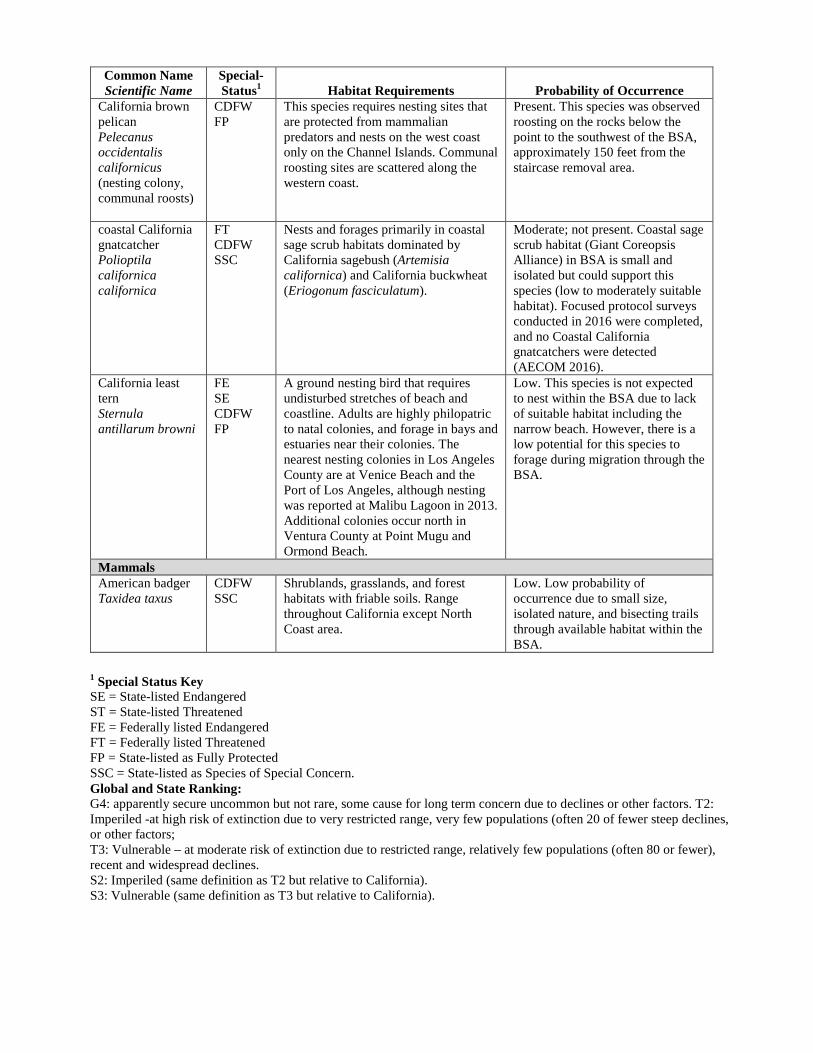
Common Name Scientific Name
Special-Status1 Habitat Requirements Probability of Occurrence
California brown pelican Pelecanus occidentalis californicus (nesting colony, communal roosts)
CDFW FP
This species requires nesting sites that are protected from mammalian predators and nests on the west coast only on the Channel Islands. Communal roosting sites are scattered along the western coast.
Present. This species was observed roosting on the rocks below the point to the southwest of the BSA, approximately 150 feet from the staircase removal area.
coastal California gnatcatcher Polioptila californica californica
FT CDFW SSC
Nests and forages primarily in coastal sage scrub habitats dominated by California sagebush (Artemisia californica) and California buckwheat (Eriogonum fasciculatum).
Moderate; not present. Coastal sage scrub habitat (Giant Coreopsis Alliance) in BSA is small and isolated but could support this species (low to moderately suitable habitat). Focused protocol surveys conducted in 2016 were completed, and no Coastal California gnatcatchers were detected (AECOM 2016).
California least tern Sternula antillarum browni
FE SE CDFW FP
A ground nesting bird that requires undisturbed stretches of beach and coastline. Adults are highly philopatric to natal colonies, and forage in bays and estuaries near their colonies. The nearest nesting colonies in Los Angeles County are at Venice Beach and the Port of Los Angeles, although nesting was reported at Malibu Lagoon in 2013. Additional colonies occur north in Ventura County at Point Mugu and Ormond Beach.
Low. This species is not expected to nest within the BSA due to lack of suitable habitat including the narrow beach. However, there is a low potential for this species to forage during migration through the BSA.
Mammals American badger Taxidea taxus
CDFW SSC
Shrublands, grasslands, and forest habitats with friable soils. Range throughout California except North Coast area.
Low. Low probability of occurrence due to small size, isolated nature, and bisecting trails through available habitat within the BSA.
1 Special Status Key SE = State-listed Endangered ST = State-listed Threatened FE = Federally listed Endangered FT = Federally listed Threatened FP = State-listed as Fully Protected SSC = State-listed as Species of Special Concern. Global and State Ranking: G4: apparently secure uncommon but not rare, some cause for long term concern due to declines or other factors. T2: Imperiled -at high risk of extinction due to very restricted range, very few populations (often 20 of fewer steep declines, or other factors; T3: Vulnerable – at moderate risk of extinction due to restricted range, relatively few populations (often 80 or fewer), recent and widespread declines. S2: Imperiled (same definition as T2 but relative to California). S3: Vulnerable (same definition as T3 but relative to California).

Initial Study/Mitigated Negative Declaration for Point Dume Staircase Replacement Point Dume State Beach California Department of Parks & Recreation
D. Biological Resources Report

Initial Study/Mitigated Negative Declaration for Point Dume Staircase Replacement Point Dume State Beach California Department of Parks & Recreation
E. Archaeological Testing Report (CONFIDENTIAL)
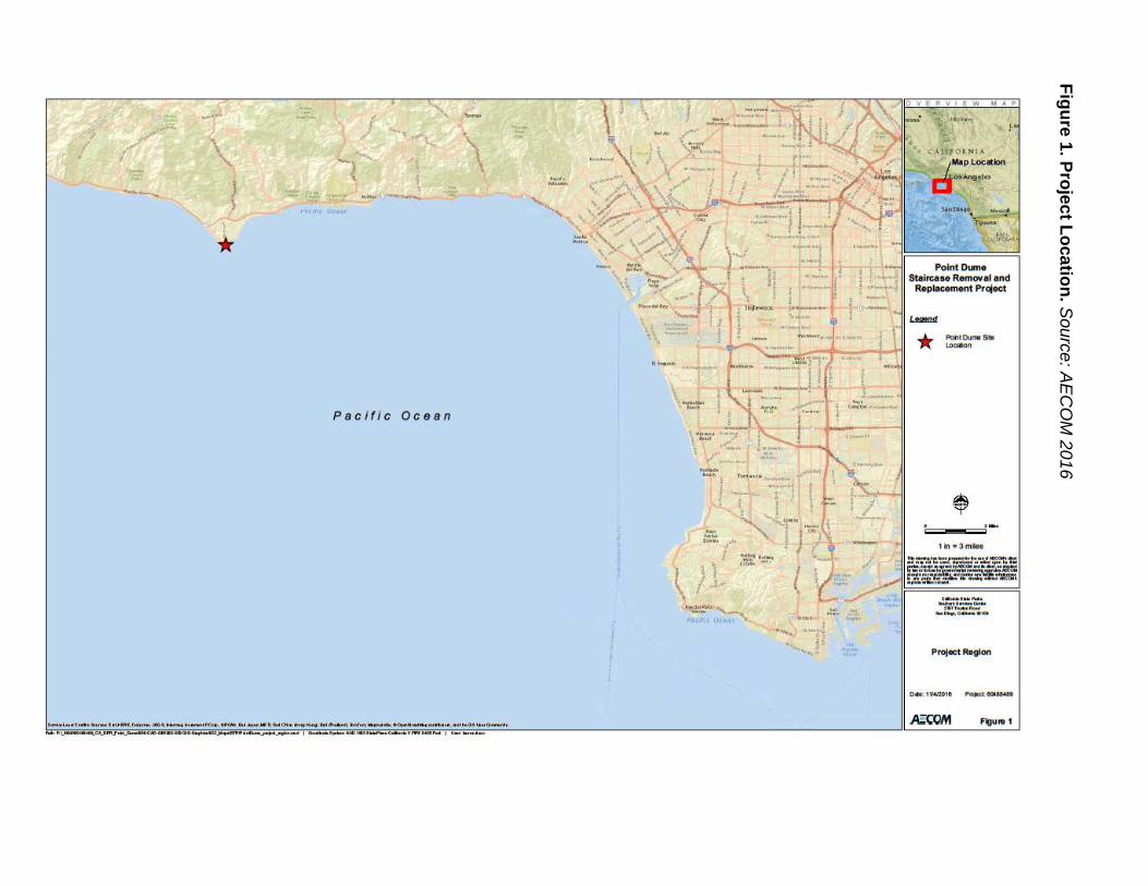
Initial Study/Mitigated N
egative Declaration for Point D
ume Staircase R
eplacement
Point Dum
e State Beach C
alifornia Departm
ent of Parks & Recreation
Figure 1. Project Location. Source: AE
CO
M 2016
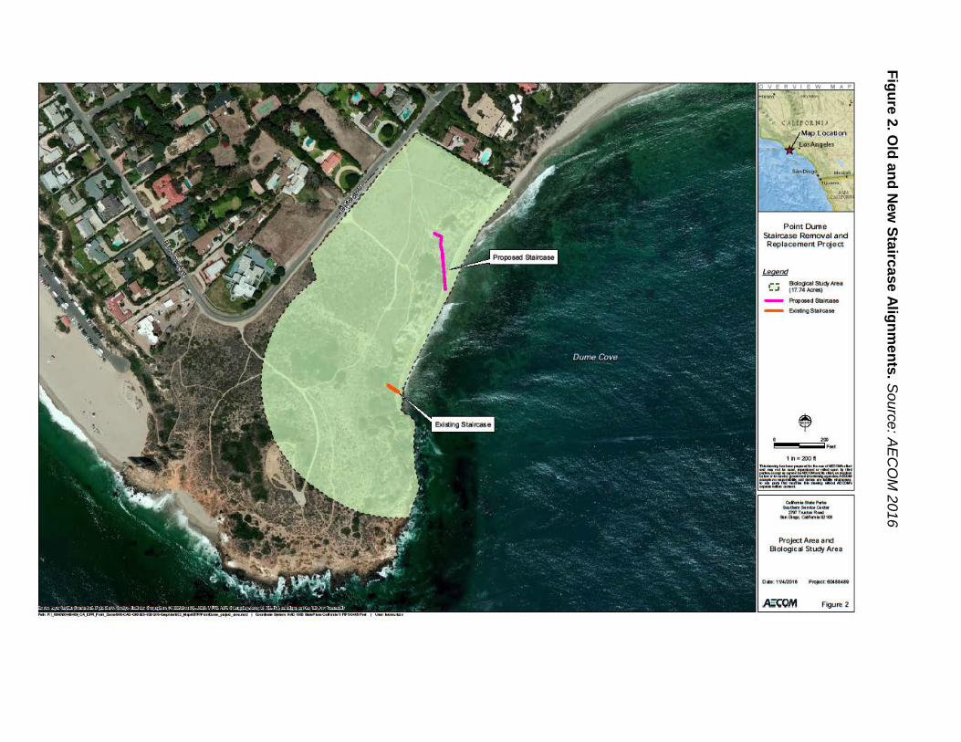
Initial Study/Mitigated N
egative Declaration for Point D
ume Staircase R
eplacement
Point Dum
e State Beach C
alifornia Departm
ent of Parks & Recreation
Figure 2. Old and N
ew Staircase Alignm
ents. Source: AE
CO
M 2016
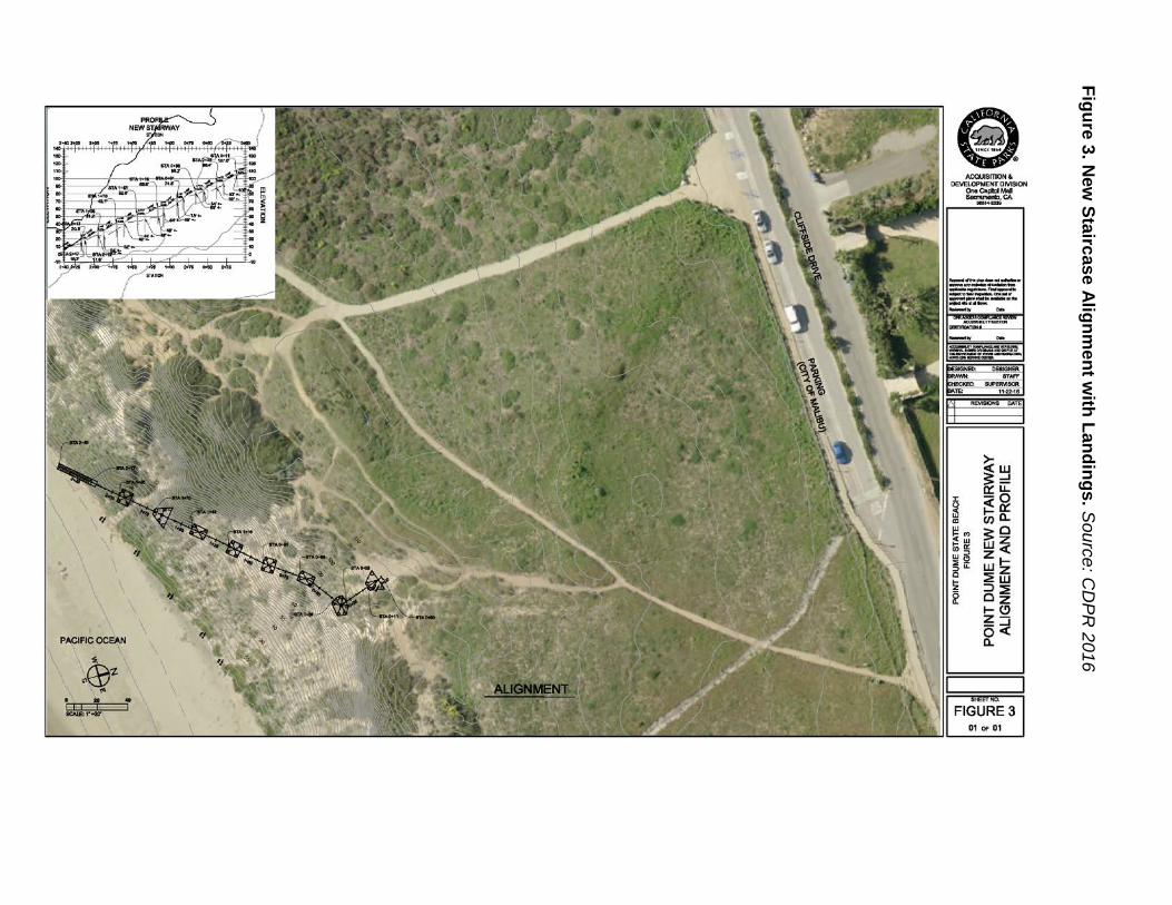
Initial Study/Mitigated N
egative Declaration for Point D
ume Staircase R
eplacement
Point Dum
e State Beach C
alifornia Departm
ent of Parks & Recreation
Figure 3. New
Staircase Alignment w
ith Landings. Source: C
DPR
2016
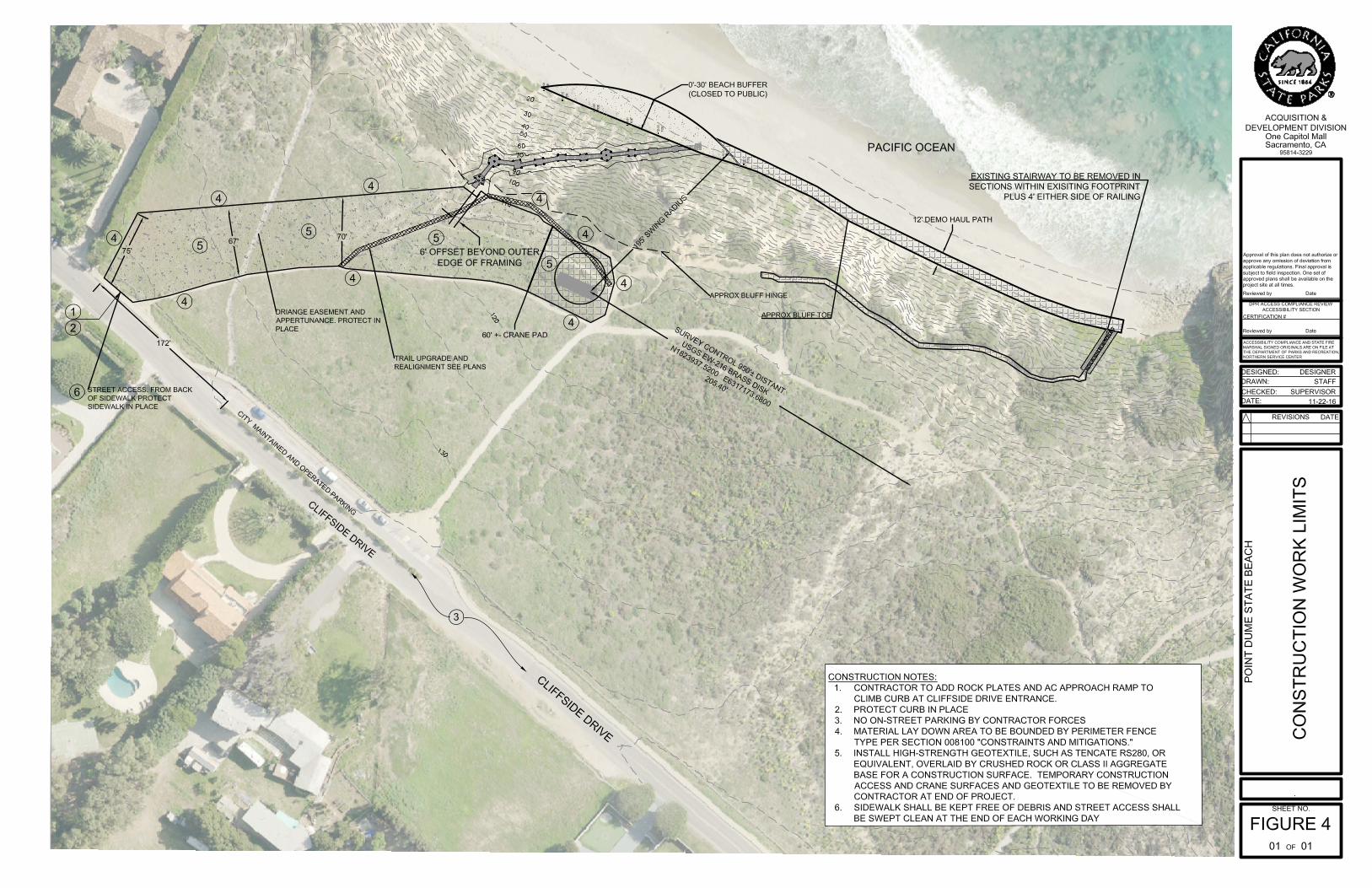
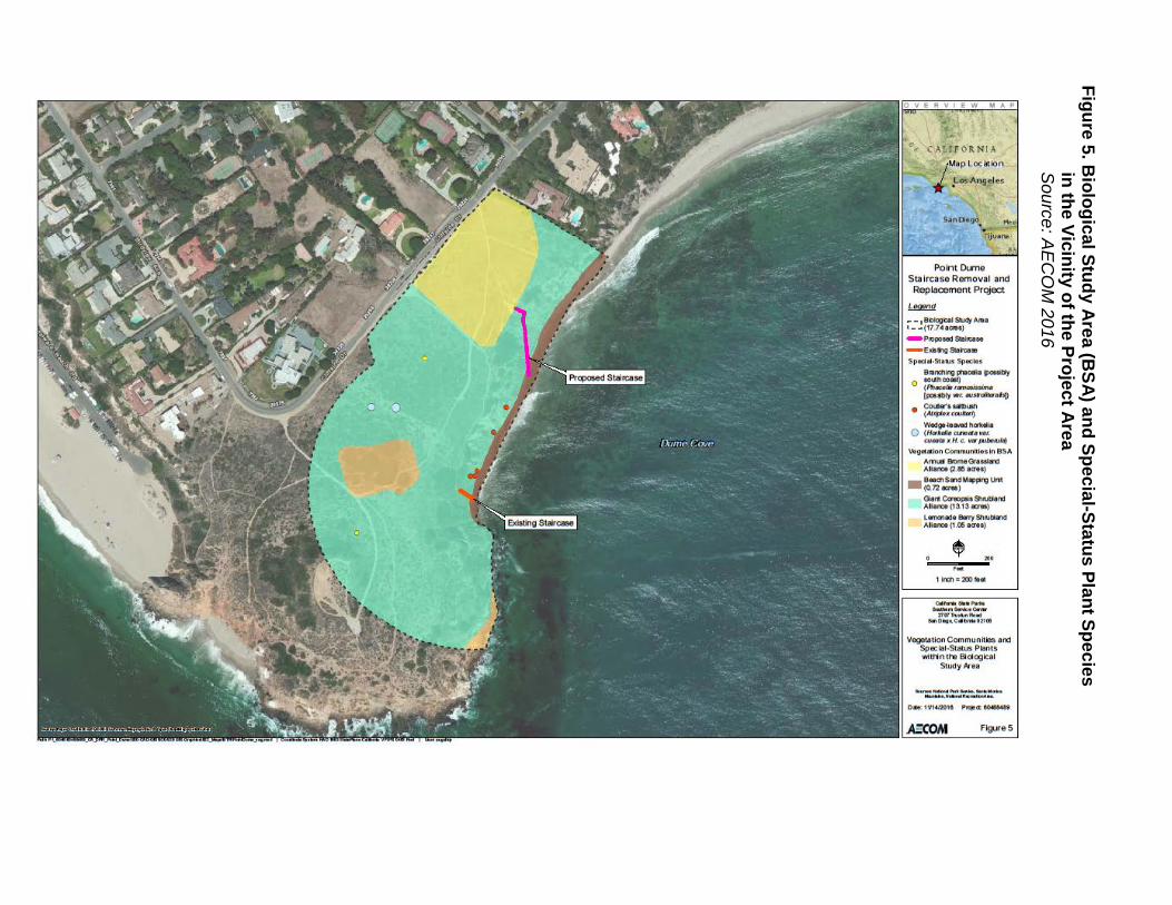
Initial Study/Mitigated N
egative Declaration for Point D
ume Staircase R
eplacement
Point Dum
e State Beach C
alifornia Departm
ent of Parks & Recreation
Figure 5. Biological Study A
rea (BSA
) and Special-Status Plant Species
in the Vicinity of the Project Area
S
ource: AE
CO
M 2016
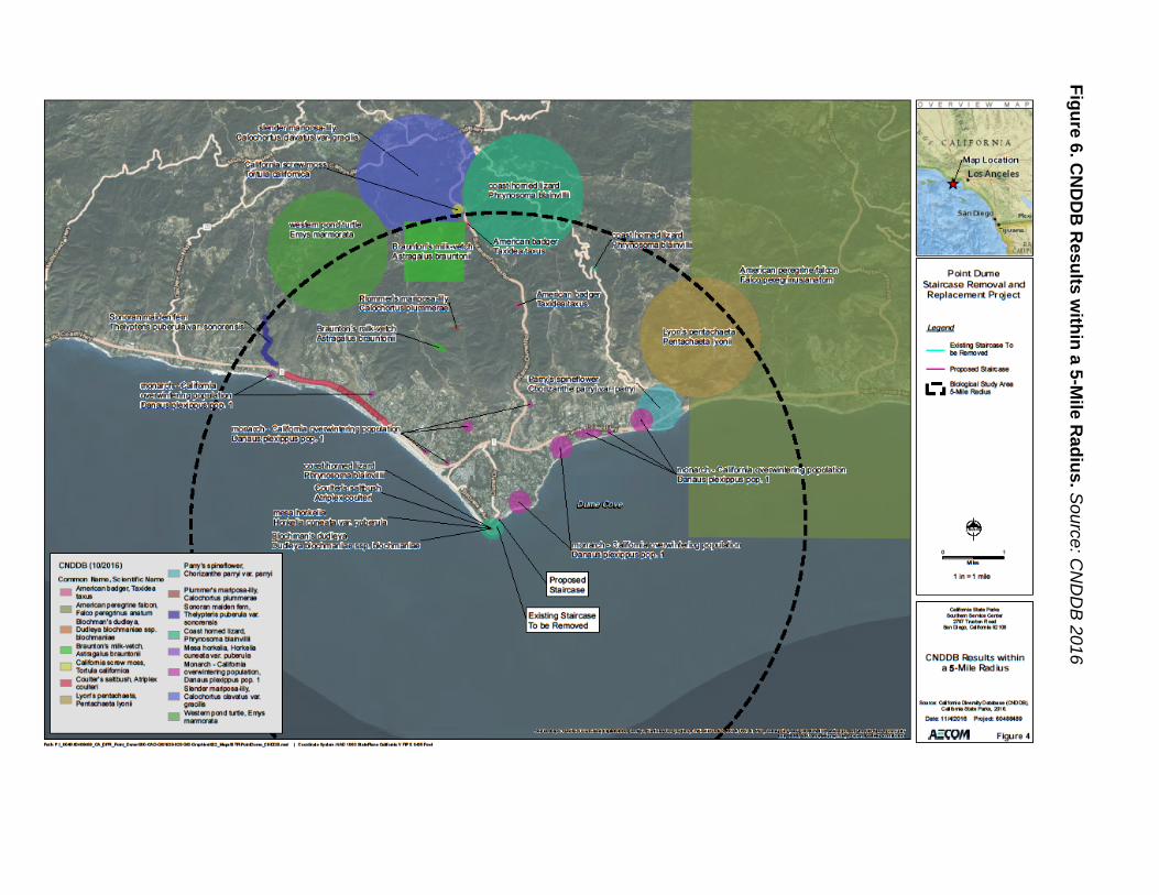
Initial Study/Mitigated N
egative Declaration for Point D
ume Staircase R
eplacement
Point Dum
e State Beach C
alifornia Departm
ent of Parks & Recreation
Figure 6. CN
DD
B R
esults within a 5-M
ile Radius. S
ource: CN
DD
B 2016

Initial Study/Mitigated Negative Declaration for Point Dume Staircase Replacement Point Dume State Beach California Department of Parks & Recreation
Figure 7. Regional Geologic Map. Source: CTE Inc. 2016
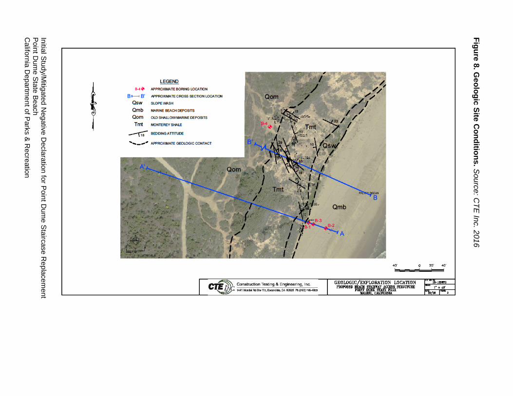
Initial Study/Mitigated N
egative Declaration for Point D
ume Staircase R
eplacement
Point Dum
e State Beach C
alifornia Departm
ent of Parks & Recreation
Figure 8. Geologic Site C
onditions. Source: C
TE Inc. 2016

Initial Study/Mitigated N
egative Declaration for Point D
ume Staircase R
eplacement
Point Dum
e State Beach C
alifornia Departm
ent of Parks & Recreation
Figure 9. Regional Fault M
ap. Source: C
TE Inc. 2016
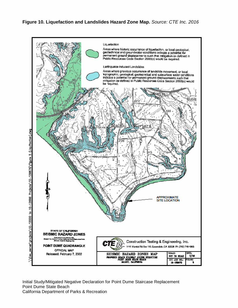
Initial Study/Mitigated Negative Declaration for Point Dume Staircase Replacement Point Dume State Beach California Department of Parks & Recreation
Figure 10. Liquefaction and Landslides Hazard Zone Map. Source: CTE Inc. 2016
Initial Study/Mitigated N
egative Declaration for Point D
ume Staircase R
eplacement
Point Dum
e State Beach C
alifornia Departm
ent of Parks & Recreation
Figure 11. Los Angeles Regional W
ater Quality C
ontrol Board M
ap
(Source: LA
RW
QC
B 2000)

Initial Study/Mitigated N
egative Declaration for Point D
ume Staircase R
eplacement
Point Dum
e State Beach C
alifornia Departm
ent of Parks & Recreation
Figure 12. Tsunami Inundation M
ap. Source: C
TE Inc. 2016