Please download animations in the file format of your choice (MPG format is recommended because AVI...
23
THE SEATTLE REPORT SARAH MINSON USGS SEATTLE Please download animations in the file format of your choice (MPG format is recommended because AVI files are much larger than MPG) August 2010 slow-slip event: ftp://ftp.gps.caltech.edu/pub/minson/chpt_Aug_6-10_2010.avi ftp:// ftp.gps.caltech.edu/pub/minson/chpt_Aug_6-10_2010.mpg Full 2010 time series for whole PANGA network: ftp://ftp.gps.caltech.edu/pub/minson/chpt_one_lin_2010.avi ftp://ftp.gps.caltech.edu/pub/minson/chpt_one_lin_2010.mpg
-
Upload
violet-pierce -
Category
Documents
-
view
218 -
download
0
Transcript of Please download animations in the file format of your choice (MPG format is recommended because AVI...

THE SEATTLE REPORT
SARAH MINSONUSGS SEATTLE
Please download animations in the file format of your choice (MPG format is recommended because AVI files are much larger than MPG)
August 2010 slow-slip event:
ftp://ftp.gps.caltech.edu/pub/minson/chpt_Aug_6-10_2010.aviftp://ftp.gps.caltech.edu/pub/minson/chpt_Aug_6-10_2010.mpg
Full 2010 time series for whole PANGA network:ftp://ftp.gps.caltech.edu/pub/minson/chpt_one_lin_2010.aviftp://ftp.gps.caltech.edu/pub/minson/chpt_one_lin_2010.mpg

ONGOING SCIENCE STUFF*
*Please excuse technical jargon
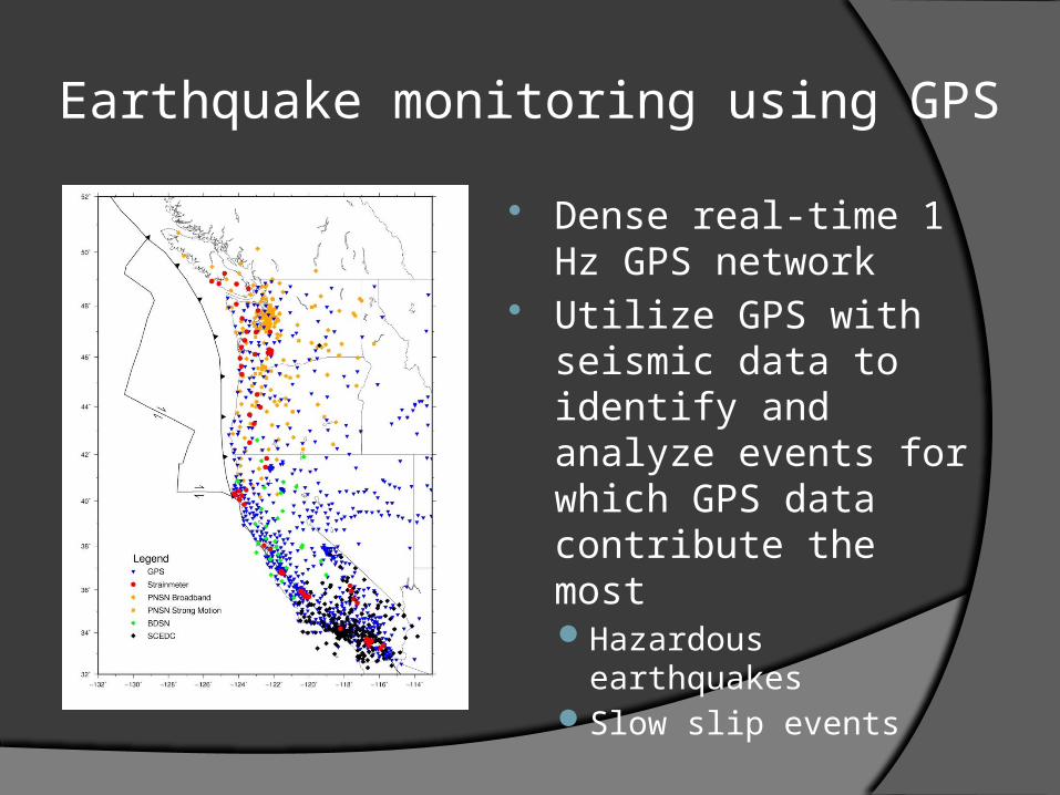
Earthquake monitoring using GPS
Dense real-time 1 Hz GPS network
Utilize GPS with seismic data to identify and analyze events for which GPS data contribute the mostHazardous earthquakesSlow slip events

Rapid response rupture models using real-time GPS
Monte Carlo exploration of fault extent, location, and slipOkada modelConstraints on fault-
finiteness depend greatly on source receiver geometry
Moment is well-determined Need to detect events
and estimate offsets in real-time

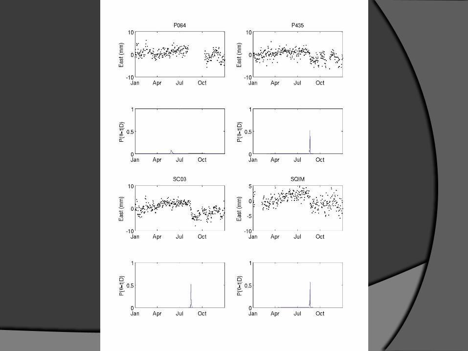
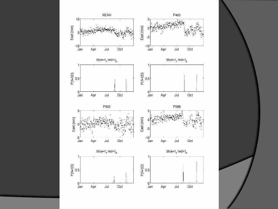
Bayesian changepoint detection
Changepoint: the time that at least one model parameter changes
Can use Bayes’ theorem to compute the probability of a changepoint as a function of time, P(changepoint=t|D)
Can also use Bayes’ theorem to assess significance of potential changepoints

Bayesian changepoint detection
It may sound fancy, but it’s notIt’s just Bayesian piecewise linear
regression
What is P(t=t0)?○ The solution is analytical and ridiculously
cheap
0
0
22
11
)(
)()(
tt
tt
t
ttd
βG
βG
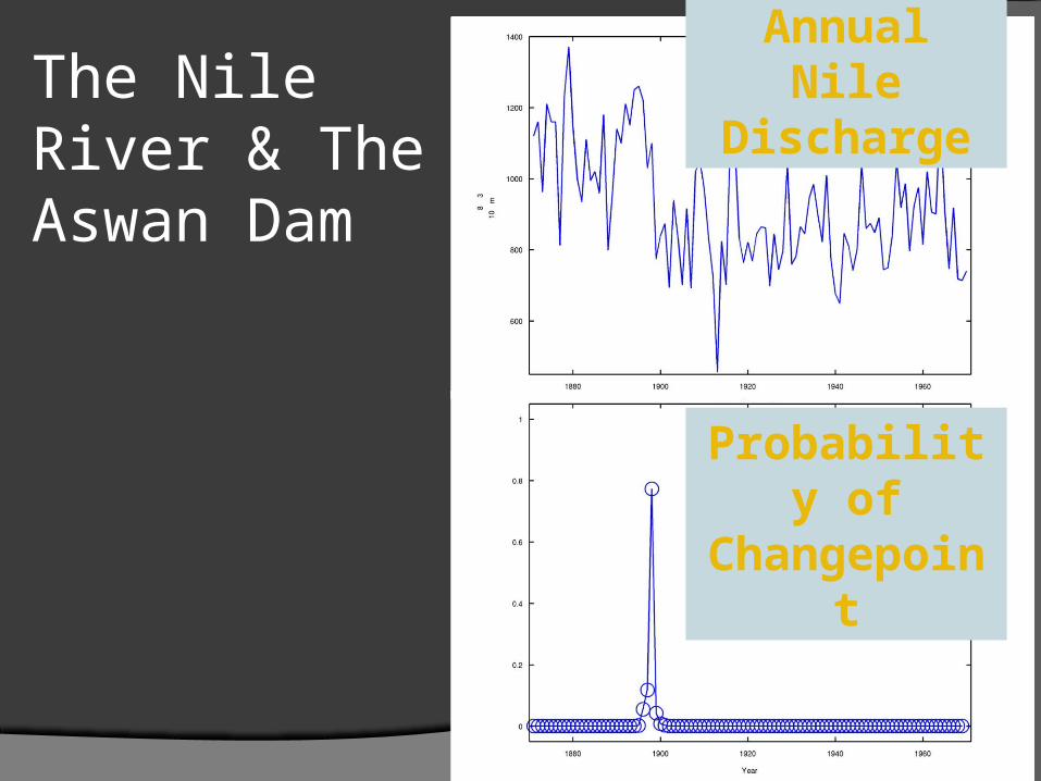
The Nile River & The Aswan Dam
Annual Nile Discharge
Probability of Changepoint
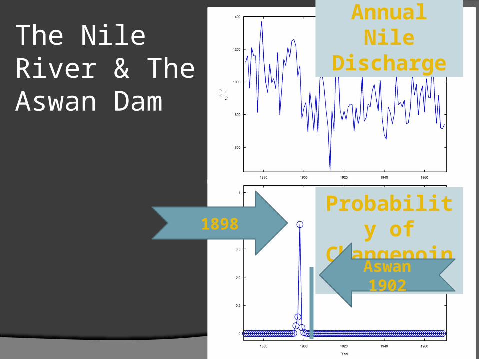
The Nile River & The Aswan Dam
Annual Nile Discharge
Probability of Changepoint1898
Aswan 1902

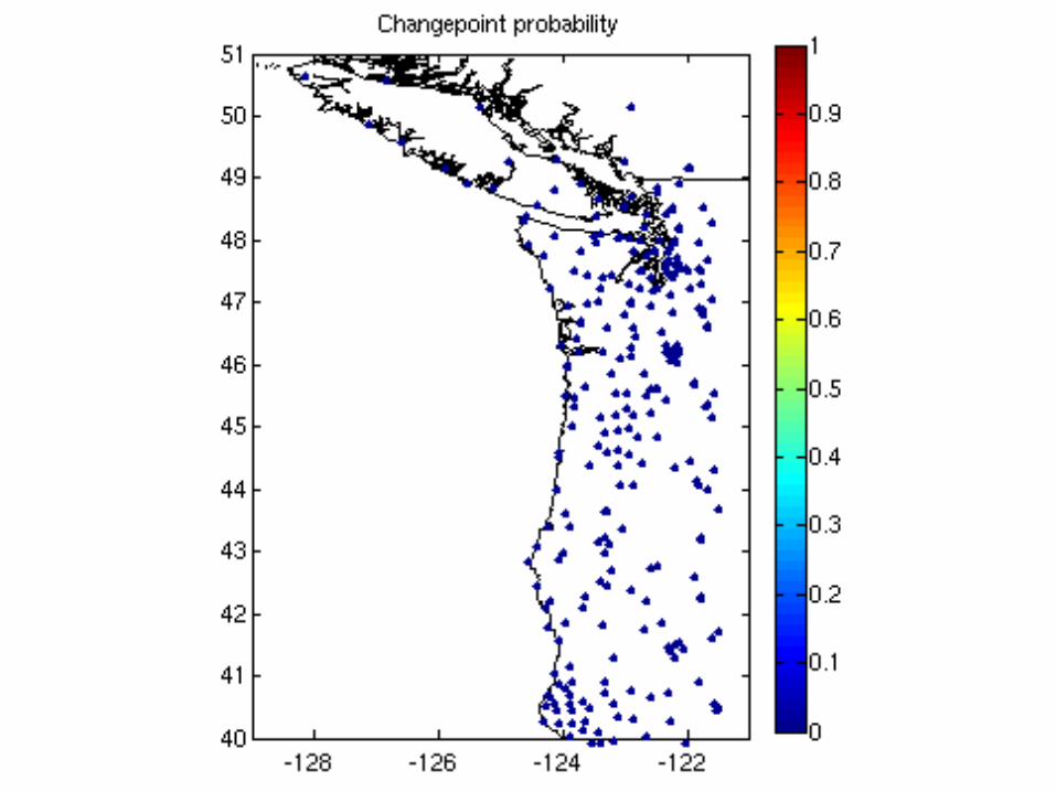
CHANGEPOINT ANALYSIS OF
CASCADIA GPS TIME SERIES
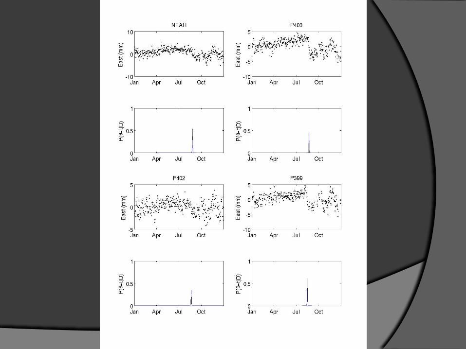


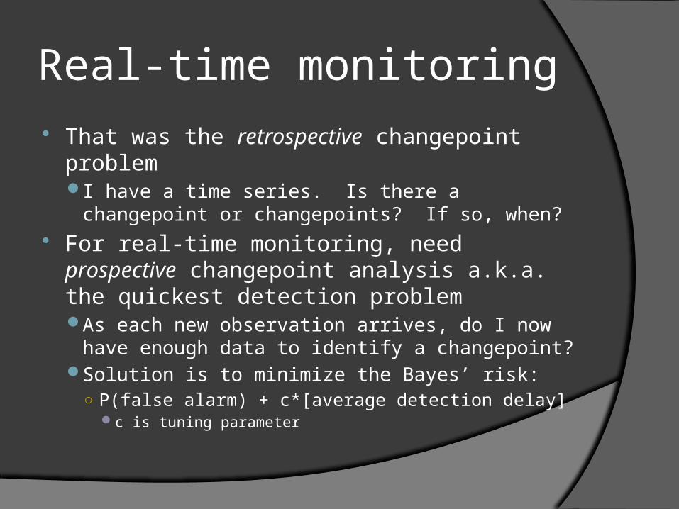
Real-time monitoring That was the retrospective changepoint
problemI have a time series. Is there a changepoint or
changepoints? If so, when? For real-time monitoring, need prospective
changepoint analysis a.k.a. the quickest detection problemAs each new observation arrives, do I now have
enough data to identify a changepoint?Solution is to minimize the Bayes’ risk:
○ P(false alarm) + c*[average detection delay]c is tuning parameter
Some complications – or – what we really want are real-time offsets
For slow slip events, we have a functional form for earthquakesWe get offset as part of change-point
analysis For earthquakes, we could get ramps,
waveforms, anythingFilter the heck out of the GPS time series
until we make it look like a ramp?Window out the earthquake?

One more thing
If we want to use GPS stations to detect events (to trigger rapid response or for EEW) and/or we want to retrospectively search for deformation events, we have to discriminate between changepoints due to signals and those due to noiseNeed to rely on spatio-temporal pattern of
stations with possible detectionsCould treat triggers at GPS stations like
seismic data or could do something new

SEAFLOOR GEODESY IN
CASCADIA WORKSHOP
A little motivation Need offshore measurements to understand
plate locking and ETS, as well as to determinine coseismic slipBasic science could be done with campaign
measurements, but monitoring needs real-time data○ Real-time might not be more expensive due to the
costs of ship time to retrieve instruments and data
The PBO should extend to the plate boundaryEven better, should go beyond trench to understand
deformation of incoming plate
Many kinds of measurements Mature instrumentation:
GPS-acousticOcean bottom pressure sensorsDARTSeafloor fluid flowCampaign relative gravity
○ Japan is deploying 5,100 km of cable to install 154 nodes with OBS/OBP
On the horizon:Seafloor timelapse gravity (absolute gravity)Self-calibrating pressure recorders (decreases
instrument drift)Non-electronic seismometer/tiltmeter (decreases
instrument drift of tiltmeters)Seafloor interferometric optical fiber strainmeter
Q. Who pays?A. No clue
When it comes to monitoring, the USGS is the obvious choiceThe USGS doesn’t have the money
NOAA might want to expand DART network, install more OBP
FEMA? DHS?
Conference Highlights Best factoid:
Turbidite flow from Tohoku hit OBP station P03 and moved it about 1 km to the east
Runner-up best factoid:Largest onshore displacement from Tohoku was 5 m,
but largest offshore displacement was 31 m Best unnecessarily long word:
Seismohydrogeodynamic Best potential pitfall:
Will the U.S. Navy stand in the way of possible future offshore network to protect secrecy of their submarine positions?