Plat & Street Development Specs
43
LIVINGSTON COUNTY ROAD COMMISSION Specifications For Plat Development ADOPTED BY THE BOARD OF COUNTY ROAD COMMISSIONER MAY 23, 1991 EFFECTIVE MAY 24, 1991
-
Upload
livingston-county-road-commission -
Category
Documents
-
view
215 -
download
0
description
Specifications for Plat and Street Development
Transcript of Plat & Street Development Specs
LIVINGSTON COUNTY ROAD COMMISSION
Specifications For
Plat Development
ADOPTED BY THE BOARD OF COUNTY ROAD COMMISSIONER
MAY 23, 1991
EFFECTIVE MAY 24, 1991
1
MAY 23, 1991
WHEREAS, Act 288 of the Public Acts of 1967 provided that the Board of County Road Commissioners may adopt their own rules necessary for the administration of the act, and
WHEREAS, the Board of County Road Commissioners of the County of Livingston has promulgated and adopted rules entitled “SPECIFICATIONS FOR PLAT DEVELOPMENT” for the administration of the aforesaid Act, under date of May 10, 1972, and
WHEREAS, it is the opinion of the Board of County Road Commissioners of the County of Livingston that modifications and amendments to these rules are necessary in order to further the objectives of public safety and durable construction in the public interest, and
WHEREAS, the views of the interested public were heard at a hearing held May 9, 1991, now therefore be it
RESOLVED, that the revised “SPECIFICATIONS FOR PLAT DEVELOPMENT” be and, hereby, are adopted, as attached to the minutes, and be it further
RESOLVED, that all prior rules, standards, and procedures conflicting with this resolution are, hereby, repealed, and be it further
RESOLVED, that the effective date of the aforesaid amendments and modifications shall be the 24th day of May, 1991.
Motion carried.
3. Site Condominiums
Mr. Craine reviewed details with the Board concerning site condominium development activities throughout the County, which continue to increase and require the need to clarify the status of construction criteria for streets in this type of development.
A brief discussion followed. A resolution was prepared for the Board to review and approve on subject matter.
ACTION: Moved by Commissioner Slayton, Supported by Commissioner Dunleavy
WHEREAS, the Board of County Road Commissioners of the County of Livingston is asked from time to time to accept the dedication of new public roads outside of platted subdivisions, and
WHEREAS, this Board has adopted a policy statement on July 13, 1989 for purposes of clarifying the Road Dedication Acceptance Criteria, now therefore be it
RESOLVED, that the Board of County Road Commissioners of the County of Livingston hereby reconfirms and adopts the Road Dedication Acceptance Criteria first adopted July 13, 1989, and be it further
RESOLVED, that the Board hereby requires that the construction standards and procedures outlined in its Specifications for Plat Development are hereby adopted for use in the construction of proposed public roads located outside of platted subdivisions.
Motion carried.
Excerpted from the minutes of the Board of County Road Commissioners of Livingston County meeting on May 23, 1991.
SEPTEMBER 23, 2010
Resolution approving changes to the construction and post-construction runoff controls in the Livingston County Road Commission Specifications and Administrative Rules Regulating Driveways, Road Approaches, Banners and Parades On and Over Highways and the Livingston County Road Commission Specifications for Plat Development.
WHEREAS, the Phase II permit issued by the Michigan Department of Natural Resources and Environment requires the road commission to have specific requirements for post construction stormwater runoff control, and
WHEREAS, the current driveway and plat specifications need to be revised to meet the post construction stormwater runoff control requirements of the Phase II permit, and
WHEREAS, it is the opinion of the Board of County Road Commissioners of the County of Livingston that the amendments to these rules are necessary in order to meet the requirements of the Phase II permit and to further the objectives of public safety and durable construction in the public interest, now therefore be it
RESOLVED, that the changes to the Livingston County Road Commission Specifications and Administrative Rules Regulating Driveways, Road Approaches, Banners and Parades On and Over Highways and the Livingston County Road Commission Specifications for Plat Development be and, herby, are adopted, as attached to the minutes, and be it further
RESOLVED, That the effective date of the aforesaid changes shall be the 23rd day of September, 2010.
Motion carried.

2
TABLE OF CONTENTS SECTION I
TERMINOLOGY 3
SECTION II DEFINITION OF TERMS 4
SECTION III General Requirements 5
SECTION IV PRELIMINARY REQUIREMENTS 7 VARIANCE PROCEDURES 9
SECTION V CONSTRUCTION PLANS 11
SECTION VI RIGHT OF WAY REQUIREMENTS 13
SECTION VII DESIGN REQUIREMENTS 14 SIGHT DISTANCE REQUIREMENTS 17 TYPICAL CROSS SECTION 20 DRAINAGE 22 INSURANCE REQUIREMENTS 23
SECTION VIII INSPECTION AND MATERIAL REQUIREMENTS 25 ROADWAY EARTHWORK 26 SUBBASE 26 AGGREGATE BASE COURSES 26 BITUMINOUS MIXTURES 27 UTILITIES 27 CONCRETE 29 MISCELLANEOUS 30 FINAL ACCEPTANCE 31
SECTION IX FINANCIAL REQUIREMENTS 32

3
4
SECTION II DEFINITION OF TERMS
A.A.S.H.T.O. - American Association of State Highway and Transportation
Officials Alley - A public or private right of way providing a secondary access to
a lot, block or parcel of land. A.S.T.M. - American Society of Testing and Materials Board - The Board Of County Road Commissioners of the County of
Livingston Michigan. County Engineer A registered professional engineer, or a designated
representative, in the employ of the Board acting as its agent. Governing Body - The elected municipal board of the township, village, city, etc. Local Road - Part of the existing local road system as defined in Act 51, of
the Public Acts of 1951 as amended. M.D.O.T. - The Michigan Department of Transportation Master Right of Way Plan - The right of way plan adopted by the board. May - As used within; permissive in nature, no requirement for design
or practice intended. N.G.V. - National Geodetic Vertical - vertical control relative to mean
sea level required for all new subdivisions. Plat - As defined in the Subdivision Control Act (P.A. 288 of the Public
Acts of 1967) Primary Road - Part of the existing primary road system as defined in Act 51,
P.A. of 1951 as amended. Private Road - An easement or dedicated right of way dedicated to the use of a
specific group separate from the public. Proprietor - A person, firm, association, partnership, corporation or a
combination of, which may hold any ownership interest in land whether recorded or not.
Proprietor's Engineer - An Engineer or firm in the employ of the proprietor
supervising design and construction of a subdivision. Public Road - An easement or dedicated right of way which has been dedicated to
the use of the public and accepted into the County Road System by The Board of County Road Commissioners.
Shall - As used within; a mandatory requirement of this department. Should - As used within; something that would be encouraged but not
required by this department. Subdivision - The partitioning of a parcel or tract of land pursuant to the
Subdivision Control Act.

5
SECTION III
General Requirements A. The contents of this publication shall not supersede any portion of the
Subdivision Control Act of 1967 (P.A. 288). If any part of these procedures or requirements are found to be invalid, each invalidity shall not affect the remaining portion of the procedures or requirements which can be given effect without the invalid portion, and to this end the procedures or requirements are declared to be severable.
B. The Proprietor may submit a concept drawing or "Pre-Preliminary Plat" of a
proposed subdivision to the Engineer. This drawing should include basic information about the proposed subdivision for discussion and review before starting with final design on a project.
D. Any street or roadway on unplatted land that is going to be dedicated to the
use of the public and accepted into the Livingston County Road System shall conform to the Board's current Procedures for Plat and Street Development. The standard fees covering engineering and construction review or inspection shall be required for these proposals.
E. A Proprietor may request a variance from the Board to any of the requirements
contained herein. Such requests shall be submitted in writing to the County Engineer for presentation to the Board. The Board may deny any or all requests for variance which the Board considers to be not in the best interest of the public. Conversely, the Board may waive any of these requirements in specific instances.
F. When a subdivision proposes to incorporate an existing county road which is not
up to the current standards of the Livingston County Road Commission, said road shall be reconstructed by the Proprietor, and at the Proprietor's expense, as required to improve the road to the standards applicable for its intended use.
G. Permits, including approach permits, must be obtained by the Proprietor from
the Board before performing any work within the right of way of any existing county roadway. Any work, including plans for such work, within any proposed right of way must be reviewed and approved by the County Engineer prior to construction.
H. The Board encourages the Proprietor to install any public and private utilities
crossing the road right of way before constructing the base or subbase of the proposed road. Once accepted into the County Road System, open cutting any roadway for the installation of utilities will not be permitted. Utilities that run parallel to the road will not be allowed within the road right of way with the exception of water main, storm and sanitary sewer systems. All work required to bring utilities into the subdivision will require a permit for work in existing road right of way.
I. The Board reserves the right to add, delete, or modify any existing
requirements in its authority to maintain the proposed streets in a manner reasonably safe and convenient for public travel.
J. The Board may require service roads to be constructed in proposed commercial
subdivisions. This determination shall be based on traffic volumes and movement patterns on adjoining roads.
K. When a proposed lot is bordered by an interior subdivision street and an
existing county local road, access will only be allowed from the interior street.

6
L. It shall be understood and agreed that any approvals, reviews, or inspections of any nature by the Livingston County Road Commission, its officers, agents, and employees, shall not be construed as a warranty or assumption of liability on the part of the Commission or Board. It shall also be expressly understood and agreed that any such approvals are for the sole and exclusive purposes of the Commission or Board acting in a governmental capacity as authorized by Public Act 288 of the Public Acts of 1967. Any approvals, reviews or inspections made shall not relieve the Proprietor of any of the obligations hereunder unless an expressed variance has been requested and granted. Such approvals, reviews or inspections shall not be construed as a guarantee as to the propriety of the plans or construction performance.

7
SECTION IV PRELIMINARY REQUIREMENTS
The Proprietor is reminded that approvals of the Preliminary Plat by the Local Authority and by the Livingston County Drain Commission are also required under the Subdivision Control Act. If a preliminary plat approved by the Board is revised because of a requirement of a local agency, or if revisions are made by the Proprietor, such revisions shall be submitted to the Board on a revised preliminary plat for approval or disapproval. The Proprietor is further advised that under certain conditions, approval of a preliminary plat must be obtained from one or more of the following agencies, The Michigan Department of Transportation, The Michigan Department of Natural Resources, and The Livingston County Health Department. PRELIMINARY PLAT Two copies of a preliminary plat may be submitted to the County Engineer for initial review. After which, five copies of the preliminary plat layout, drawn to a scale of not less than one inch to 200 feet on a sheet size of 24"x36", shall be submitted to the Board for approval. The preliminary plat layout shall distinctly show and meet each of the following requirements: 1) The type of subdivision (i.e.: commercial, residential, etc). 2) Limits of property, for which approval is being requested, shown with
descriptions (bearing and distance) of each line. 3) The property from which the proposed subdivision is being split in phase
development. 4) The owners of land within 300 feet of the subdivision limits, including
government agencies, along with the recorded liber and page number and tax number where applicable. All public or private streets within this radius shall show the type and size of any existing road right of way.
5) Show the location and names of proposed streets with arrows indicating the
general drainage flow as planned along either side of the roadway, traceable to a destination, e.g.: detention basin, retention basin, stream, etc.
6) Any conditions which may affect design of the subdivision such as:
a. Adjoining subdivisions. b. State highways. c. Rivers, streams, lakes, etc. along with 100 year flood plain datum,
natural water courses, existing drainage facilities - both public and private.
d. Contour lines of the existing site at five foot intervals (maximum).
e. Railroads, cemeteries, buildings or similar cultural features that must be preserved.
7) The proposed right of way shall be a minimum of sixty-six feet wide on
interior residential roadways, and eighty feet wide on all industrial/commercial interior roadways. If the proposed subdivision is a part of phased development, conceptual drawings showing the master plan of development shall be submitted as well. The road right of way shall be described as parallel to the proposed highway center line. The use of "Eyebrows" or "Elbows" or other irregularities in the proposed roadway used to create road frontage for additional lots will not be allowed.
8
8) For a single street subdivision, the Proprietor shall provide additional right of way at the roadways terminus to provide for a turn around (cul-de-sac).
9) The proposed subdivision shall make the most practical use of the land
available in order to provide for the most continuous system of streets possible. The use of cul-de-sacs shall be kept to an absolute minimum. Street length on dead end streets shall be not less than 300 feet or greater than 750 feet measured from the center of the intersection to the end of the proposed pavement in the cul-de-sac. Cul-de-sacs located in the interior of a subdivision (not bordered by the proposed subdivision boundaries) shall not have more than four parcels fronting on the right of way for the cul-de-sac. Cul-de-sacs abutting the subdivision limits shall not have more than two lots fronting the cul-de-sac and shall be located to have a chord along the property line equal in length to the right of way required for the subdivision (see fig 1). The Board reserves the right to reject a preliminary plat, or not accept into the county system, any subdivision whose roadway layout proposes an excessive use of cul-de-sacs. The Board also reserves the right to reject a preliminary plat which proposes the use of cul-de-sacs for reasons other than the physical limitations presented by the site being developed.
10) The Board will not accept the dedication of any alley with a public right of
way less than that required for the streets or roads contained in the subdivision.
11) Any proposed roadway which is an extension of, or in a direct line with, an
existing street shall carry the name of the street that is in existence at the time the proposal is made. Other streets or roads shall be given a name of the owners choice subject to the approval of the Board. Proposed names will be checked against the Livingston County Road Commission road inventory for potential conflicts that may be confusing to emergency services within the county.
12) It is the intent of the Board to encourage individual lot access from
interior subdivision streets as a matter of safety. In no case will there be more than 1000 feet of frontage platted along an existing local road without an intersection. If the shape of the parcel mandates a subdivision one lot deep relative to the existing roadway, then provisions will be made for future development by means of an outlot.
13) There will be no access permitted nor permits issued to individual lots or
homes for any subdivisions along an existing county primary road or major local thoroughfare. The site will be laid out in such ways that all individual access points shall be to roadways that are interior to the proposed subdivision.
14) When a subdivision is proposed along undeveloped land, provisions shall be
made for future development by outlots located not more than 1000 feet from the furthest intersection. Said outlots shall extend from the right of way line of the proposed roadway and extend to the limits of the subdivision. These outlots shall be of the same width as required for the subdivision and shall be laid out in a fashion that will allow for the construction of a roadway intersecting the proposed street at 90ø.
15) Prior to recording the Final Plat, the Proprietor shall warrant and convey to
the Board an easement for public highway purposes for each outlot within the Plat. Said easements shall describe the entire outlot and dedicate its use as being for public highway purposes.
16) There shall be a private easement for public utilities twelve feet wide
located outside and contiguous to the road right of way.

9
PRELIMINARY PLAT (cont.) 17) Intersections shall be laid out so they meet the following criteria:
a. The minimum separation between interior intersections shall be 250 feet. This will hold true regardless of their orientation to one another (i.e.: same side or opposing).
b. The maximum distance between intersections (block length) shall be 1300 feet within the subdivision.
c. The streets used for access to the interior of the subdivision from an existing public highway shall not be less than 660 feet apart and where possible shall be located directly opposite existing approach intersections.
18) The location of soil borings taken on the site of the proposed subdivision
shall be shown on the preliminary plat along with a log describing the soil conditions and water table found at each location. Borings will be of a frequency to classify the entire site.
19) Show the location of the subdivision relative to the existing County Road
System. 20) Show the drainage district limits to be dedicated to the Livingston County
Drain Commission. 21) The tributary area for each discharge location. 22) Title block at the lower right corner of the drawing naming the proprietor
and corporate name, Proprietor's Engineer, scale, etc. 23) Typical cross section showing pavement width and structure for the proposed
subdivision. The preliminary plat shall be filed with the County Engineer for consideration by the Board. The Board will give approval or disapproval of the preliminary plat within thirty days from receipt of same. If a preliminary plat is rejected by the Board, reason(s) for rejection will be provided to the Proprietor so corrections may be made and the proposed subdivision resubmitted. The Boards approval of a preliminary plat will become void two years after the date of approval unless this expiration date is extended, in writing, by the Board. Variance procedures A variance may be allowed by the Board only in cases involving practical difficulties or unnecessary hardship and when the record on the appeal to the Board supports the following affirmative findings: a. That the alleged hardship or difficulties, or both, are exceptional or
peculiar to a given site. b. That the Board's failure to grant the variance will result in substantially
more than an inconvenience or an inability to attain a higher financial return, or both.
c. That allowing the variance will result in substantial justice being done, considering the public benefits and the individual hardships that will be suffered by a failure of the Board to grant the variance.
d. That the conditions and circumstances, which are the basis of the variance request, shall not be self imposed.
If a variance has been granted and the construction authorized with the variance has not commenced within one year from the date of its approval, the grant of the variance shall be automatically withdrawn
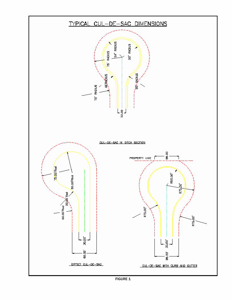
FIGURE 1
11
SECTION V
CONSTRUCTION PLANS General After the preliminary plat is approved, the Proprietor's Engineer shall submit to the County Engineer, three copies of plan and profile construction drawings and proposed cross section plans for approval. These plans must encompass all phases of construction related to the proposed subdivision and shall conform to the current Livingston County Road Commission Specifications for Plat Development or the M.D.O.T. Specifications for Highway Construction whichever is applicable. The construction plans shall show all pertinent data required to layout and construct the proposed subdivision. The plans shall be submitted on a standard sheet size of 24 inch by 36 inch and be drawn to a scale of not less than one inch equal to fifty feet horizontally and one inch equal to five feet vertically. Each drawing will have linear reference markings (stations) in units of one hundred feet for both plan and profile perspectives. Included in the plans as a cover sheet, or an interior sheet, shall be a copy of the approved preliminary plat. Also included in the plans shall be a quantity sheet of standard M.D.O.T. pay items showing the amount required for each item and the unit of payment for each item for each sheet included in the plans. Items of work that are not directly specified in the M.D.O.T. standard specifications for construction shall be detailed clearly within the body of the plans showing material requirements, methods of constructions and methods of measurement and payment. All dead end streets shall be provided with a cul-de-sac. The size, location, and drainage treatments for cul-de-sacs shall be as detailed on page 6 of these specifications. Included in the plans, shall be a typical street cross section showing the proposed pavement structure. The following information must be clearly shown on each page of the plan and profile sheets: 1) North arrow and scale of drawing. 2) Bench marks to N.G.V. Datum - A minimum of one bench mark shall be labeled on
each sheet. The Proprietor's Engineer is encouraged to set permanent vertical control points in the field at a rate of once per street. At least one permanent bench mark for each subdivision, located within the boundaries of the subdivision, will be required.
3) Horizontal control information for each circular curve along the roadway
center line. The label for each curve shall include all the information required for layout (e.g.: degree of curvature - deflection of tangents (delta) - radius of curve - point of curvature - point of tangent - length of chord - tangent length.
4) Vertical control information shall include existing and proposed center line
or top of curb elevations plotted and labeled every fifty feet. Vertical curve information showing the point of curvature - point of tangent - point of vertical intersection and elevation - length of curve - percent of tangent grade in feet per hundred feet.
12
CONSTRUCTION PLANS (cont.) 5) Proposed public and private utility locations:
a. The location, type, class, and size in both plan and profile of all proposed underground drainage.
b. Drainage structure location and type of structure, (manhole, catch basin, inlet, etc.).
c. Pertinent vertical control information clearly pointing out the top of
structure, top of casting (rim) or top of curb, sump or footing elevation, invert or flow line elevation of each pipe, including edge drain and under drain, in the structure.
d. Elevations at each end of the proposed sewer run as well as the grade
of the sewer run in feet of fall per hundred feet (percent of grade). Road crossings in an open ditch section will only require the inlet and outlet elevations labeled and the ending location relative to station and center line offset.
6) Offsite drainage facilities and locations - Preliminary construction plans
indicating the use of offsite drainage facilities or drainage courses will not be approved without the Proprietor first obtaining a recorded easement describing the drainage course and dedicating its use to the proper governing body and its intended purpose. The liber and page number of the instrument as recorded at the Livingston County Register of Deeds shall appear either on the plan sheet depicting its use or on the construction plan copy of the preliminary Plat.
7) Existing topographical features such as trees, buildings, roads (public or
private) etc., along with the location, length, and size of existing drainage facilities.
8) Title block showing the subdivision name, engineer or firm, scale, page
number, etc. All roadways shall be provided with facilities for adequate drainage. This may be accomplished by the use of roadside ditches, county drains, natural water courses, or a constructed tributary to the above. See page 14 for specific requirements on drainage design. The Board strongly recommends the use of underground drainage facilities whenever possible and reserves the right to require the use of underground drainage systems or, parts of systems, within any proposed subdivision. Underground storm drainage will be required in easements between lots outside the road right of way. With the exception of facilities located within the proposed road right of way, the drainage system shall be made a part of the county drain system through proper legal procedures of the Livingston County Drain Commissioner. After construction, said system shall meet all requirements regarding right of way, easements, and use of land, prior to acceptance into the County Road System. Construction on any portion of a subdivision shall not begin until the construction plans have been approved by this department and until permits have been obtained for all work required in an existing county road right of way. When the plans are approved or disapproved, such action, or reasons for such action, shall be given to the Proprietor in writing. Revised plans shall be resubmitted to this office showing all of the required revisions and approved prior to construction. Any major items of work that are to be incorporated into the subdivision must be indicated on the plans submitted for approval.

13
SECTION VI
RIGHT OF WAY REQUIREMENTS The road right of way requirements listed below are the minimum requirements of the Board. All construction shall be built in the center of any dedicated right of way in either road or drainage construction. Section and quarter section line roads shall be constructed centered about these lines unless otherwise approved by the Board. Any residential subdivision or plat shall have a dedicated right of way width of not less than sixty six feet. Any commercial or industrial subdivision shall have a right of way width of not less than eighty feet. Alleys, intended for motor vehicle use, that dedicate publicly owned right of way of anything less than the above dimensions is prohibited. All right of way descriptions shall be parallel to the center line description of the proposed road or street. The right of way on any curvilinear roadways shall be of the same width as that of tangent sections. The minimum widths of right of way stated may be increased by the Board when considered necessary due to, but not limited to, multiple lane roadways, non-motorized transportation facilities, drainage facilities or for reasons considered by the Board to be in the interest of safety. At street intersections, the intersecting lot lines shall be filleted with a radius of twenty feet and monumented accordingly. If a boulevard entrance is proposed, the island shall become a part of the dedicated road right of way. Dedicating the island area for anything other than road purposes under the strict control of the Board will not be allowed. No portion of the pavement structure, drainage or grading required to maintain proper drainage will be allowed outside the dimensions of the proposed right of way. Where special grading or drainage treatments are required to facilitate the construction of a boulevard intersection or cul-de-sac, the right of way width shall be increased accordingly over the minimum dimensions stated. When it is proposed to develop along a roadway that is currently a part of the public road system, right of way shall be dedicated along said road making the right of way equal to half that required in the Livingston County Road Commission Master Right of Way Plan.

14
SECTION VII
DESIGN REQUIREMENTS Alignment All horizontal alignment and intersection design shall follow the American Association of State Highway and Transportation Officials (AASHTO) manual entitled "A Policy On Geometric Design of Highways and Streets" 1990 edition. The design speed on all interior subdivision streets shall be thirty-five miles per hour unless the subdivision intends to make use of an existing local collector or, by way of the development, there is a collector type or through roadway created warranting a greater safety margin. The Board reserves the right to require a greater design speed in the interest of safety, where warranted. Along with the alignment, adjustments to the typical cross section may be required in these instances as well. Horizontal alignment: Minimum center line radius: 230 feet. See section V regarding construction plans for annotation requirements. Excessive use of reverse curves for reasons other than topographical limitations should be avoided. Minimum cul-de-sac radius at outside edge of pavement: fifty feet. The use of center islands in cul-de-sacs will be allowed with an adequate drainage system. The fillet radius from cul-de-sac to tangent sections shall be a minimum of fifty feet (see fig. 1). Vertical alignment: The percent of grade in an open ditch cross section shall not be less than 1.0% (one foot rise per hundred feet of ditch) or more than 5.0% where ditch grades are center line dependent. See the section on drainage design criteria (page 21) for specific requirements on ditch length, volumes, etc. The percent of grade in curb and gutter sections shall not be greater than 6.0% or less than 0.50%. A standard parabolic vertical curve shall be computed and half station elevations shown on the plans whenever the algebraic difference between the grade approaching the point of vertical intersection and that departing the P.V.I. (in percent) is greater than 2.5. The minimum length of vertical curve shall be 100 feet. Refer to page 421 of the AASHTO manual for further information. Intersections: All interior street returns shall have a minimum radius at the edge of pavement of thirty feet. All intersections approaching an existing county highway shall have as a minimum a thirty-five feet paved radius (see fig. 2). All intersections shall meet at right angles and shall be designed such that the first sixty five feet in any direction shall be straight line sections. Boulevard entrances shall have concrete curb and gutter around the island. The Board requires that an approach permit, issued in accordance with its regulations adopted pursuant to Public Act 200 of the Public Acts of 1969 as amended, be obtained for any new street connection to an existing county highway. A left turn passing lane may be required as a condition of this permit. Acceleration, deceleration, and left turn passing lanes shall conform to the general layout shown in figures two and three. The table on page eighteen illustrates the volume warrants for passing lanes. Other situations may warrant special use lanes at a particular site.
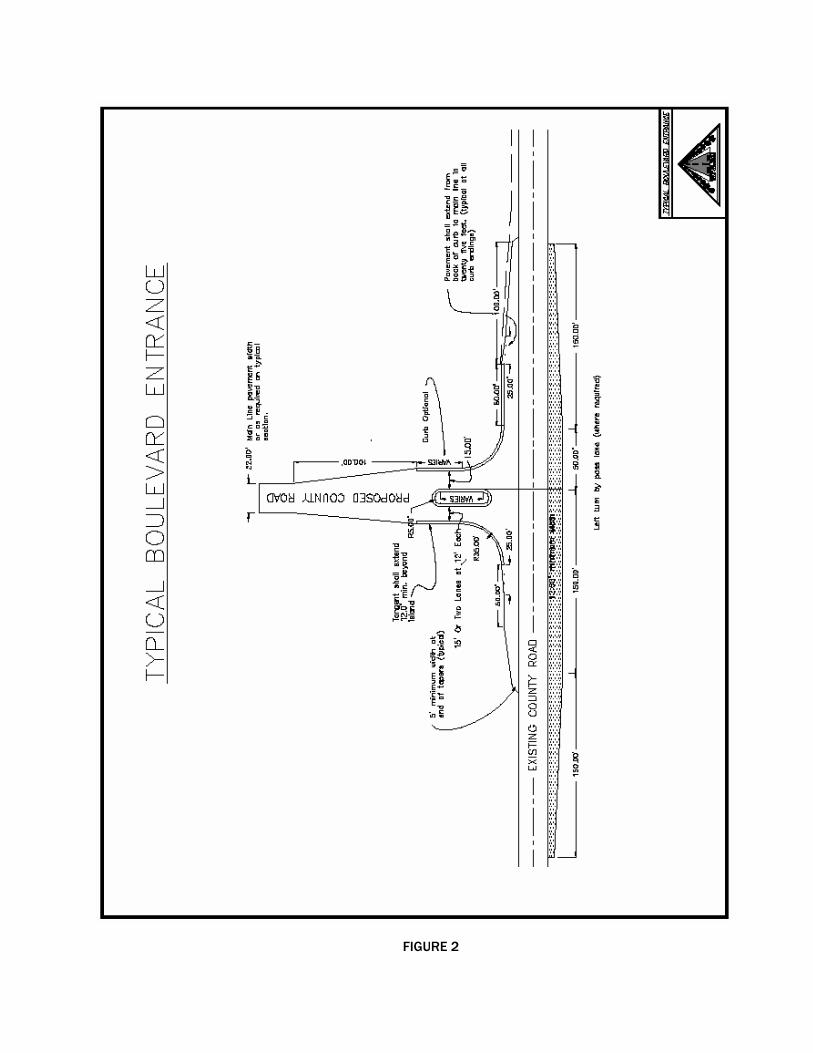
FIGURE 2

Figure 3
17
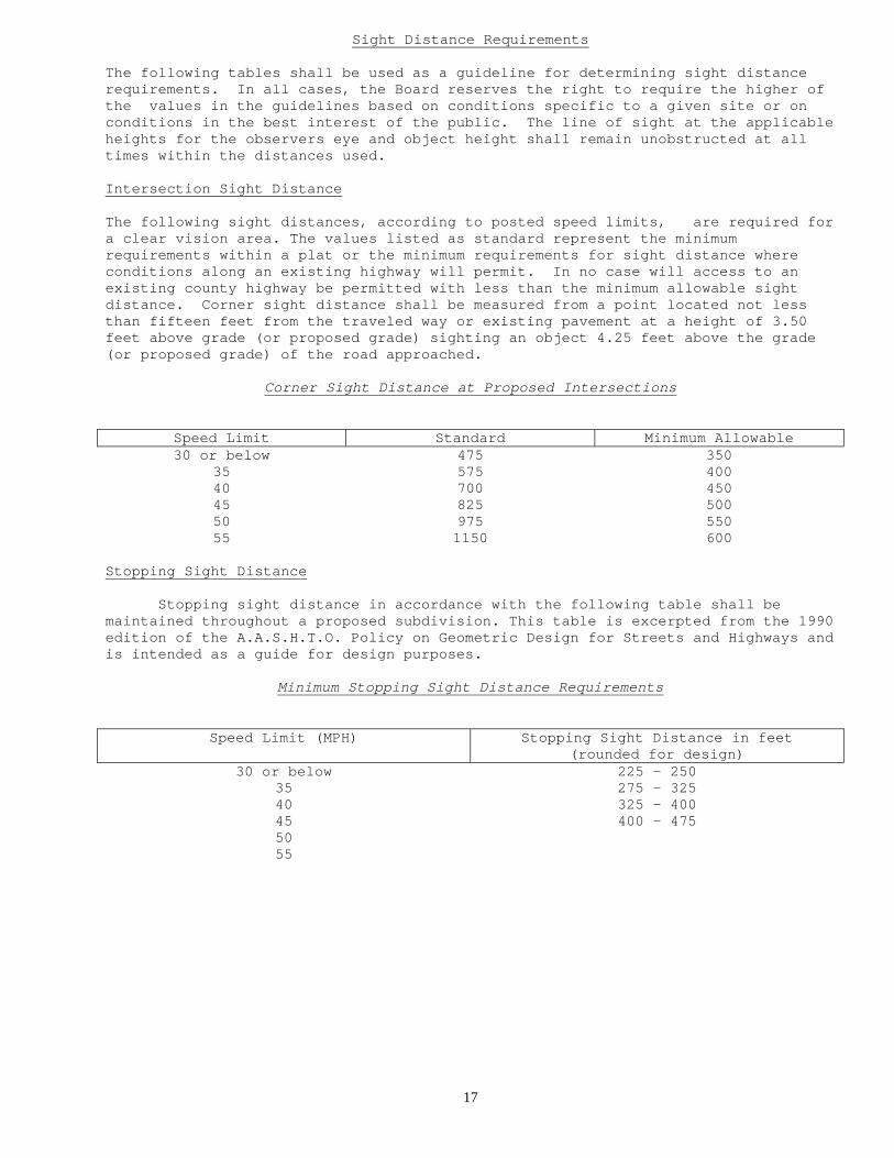
Sight Distance Requirements The following tables shall be used as a guideline for determining sight distance requirements. In all cases, the Board reserves the right to require the higher of the values in the guidelines based on conditions specific to a given site or on conditions in the best interest of the public. The line of sight at the applicable heights for the observers eye and object height shall remain unobstructed at all times within the distances used. Intersection Sight Distance The following sight distances, according to posted speed limits, are required for a clear vision area. The values listed as standard represent the minimum requirements within a plat or the minimum requirements for sight distance where conditions along an existing highway will permit. In no case will access to an existing county highway be permitted with less than the minimum allowable sight distance. Corner sight distance shall be measured from a point located not less than fifteen feet from the traveled way or existing pavement at a height of 3.50 feet above grade (or proposed grade) sighting an object 4.25 feet above the grade (or proposed grade) of the road approached.
Corner Sight Distance at Proposed Intersections
Speed Limit Standard Minimum Allowable 30 or below 475 350
35 575 400 40 700 450 45 825 500 50 975 550 55 1150 600
Stopping Sight Distance Stopping sight distance in accordance with the following table shall be maintained throughout a proposed subdivision. This table is excerpted from the 1990 edition of the A.A.S.H.T.O. Policy on Geometric Design for Streets and Highways and is intended as a guide for design purposes.
Minimum Stopping Sight Distance Requirements
Speed Limit (MPH) Stopping Sight Distance in feet (rounded for design)
30 or below 225 – 250 35 275 – 325 40 325 – 400 45 400 – 475 50 55

18
Minimum Vertical Curve Length For Stopping Sight Distance Stopping sight distance shall be measured from a height of 3.50 feet above the proposed grade sighting an object with a height of 0.50 feet above proposed grade. The stopping sight distance along existing county highways shall be maintained from the center line of the proposed intersection each way for the distance as determined by the operating speed. Within this area stopping sight distance shall be maintained without obstruction. Posted Speed Limit (MPH) *K Value for Crest
Vertical Curves *K Value for Sag Vertical
Curves 30 or Below 40 - 50 50 – 60
35 60 – 80 60 – 70 40 80 – 120 70 – 90 45 110 – 160 90 – 110 50 150 – 220 100 – 130 55 190 - 310 120 - 160
* K Value is a coefficient by which the algebraic difference in grade may be multiplied to determine the length in feet of the vertical curve that will provide the minimum required stopping sight distance.

19
20
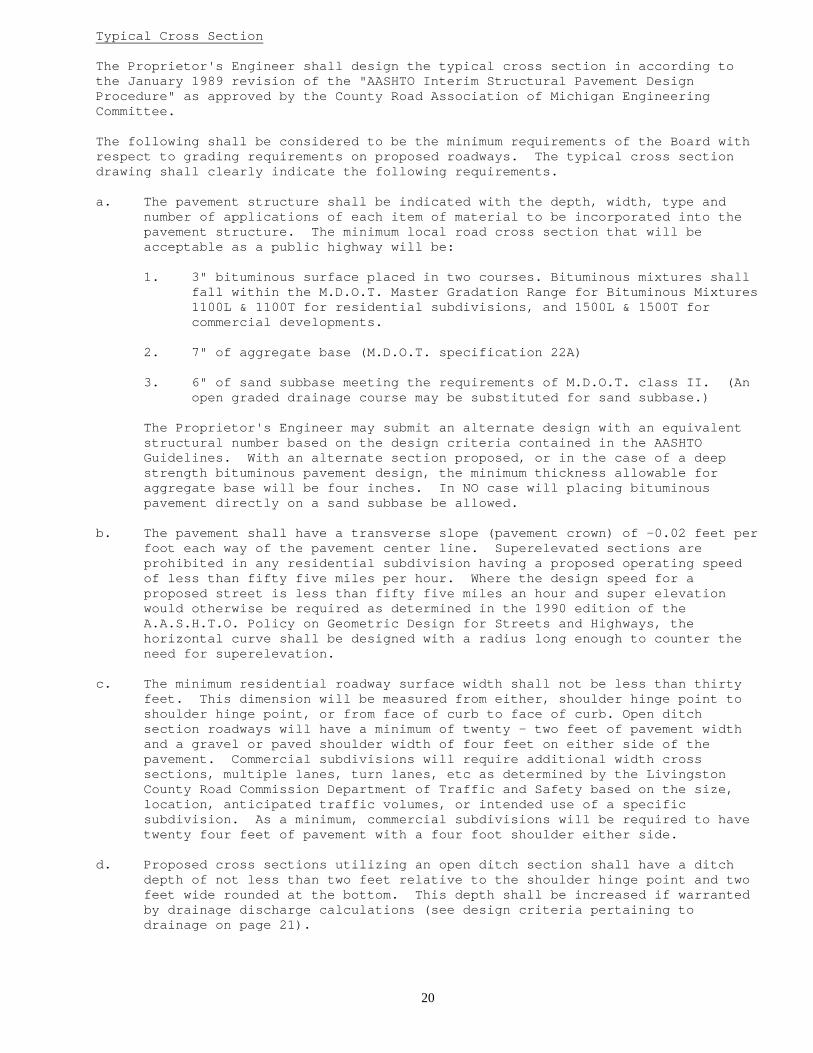
Typical Cross Section The Proprietor's Engineer shall design the typical cross section in according to the January 1989 revision of the "AASHTO Interim Structural Pavement Design Procedure" as approved by the County Road Association of Michigan Engineering Committee. The following shall be considered to be the minimum requirements of the Board with respect to grading requirements on proposed roadways. The typical cross section drawing shall clearly indicate the following requirements. a. The pavement structure shall be indicated with the depth, width, type and
number of applications of each item of material to be incorporated into the pavement structure. The minimum local road cross section that will be acceptable as a public highway will be:
1. 3" bituminous surface placed in two courses. Bituminous mixtures shall
fall within the M.D.O.T. Master Gradation Range for Bituminous Mixtures 1100L & 1100T for residential subdivisions, and 1500L & 1500T for commercial developments.
2. 7" of aggregate base (M.D.O.T. specification 22A)
3. 6" of sand subbase meeting the requirements of M.D.O.T. class II. (An open graded drainage course may be substituted for sand subbase.)
The Proprietor's Engineer may submit an alternate design with an equivalent structural number based on the design criteria contained in the AASHTO Guidelines. With an alternate section proposed, or in the case of a deep strength bituminous pavement design, the minimum thickness allowable for aggregate base will be four inches. In NO case will placing bituminous pavement directly on a sand subbase be allowed.
b. The pavement shall have a transverse slope (pavement crown) of -0.02 feet per
foot each way of the pavement center line. Superelevated sections are prohibited in any residential subdivision having a proposed operating speed of less than fifty five miles per hour. Where the design speed for a proposed street is less than fifty five miles an hour and super elevation would otherwise be required as determined in the 1990 edition of the A.A.S.H.T.O. Policy on Geometric Design for Streets and Highways, the horizontal curve shall be designed with a radius long enough to counter the need for superelevation.
c. The minimum residential roadway surface width shall not be less than thirty
feet. This dimension will be measured from either, shoulder hinge point to shoulder hinge point, or from face of curb to face of curb. Open ditch section roadways will have a minimum of twenty - two feet of pavement width and a gravel or paved shoulder width of four feet on either side of the pavement. Commercial subdivisions will require additional width cross sections, multiple lanes, turn lanes, etc as determined by the Livingston County Road Commission Department of Traffic and Safety based on the size, location, anticipated traffic volumes, or intended use of a specific subdivision. As a minimum, commercial subdivisions will be required to have twenty four feet of pavement with a four foot shoulder either side.
d. Proposed cross sections utilizing an open ditch section shall have a ditch
depth of not less than two feet relative to the shoulder hinge point and two feet wide rounded at the bottom. This depth shall be increased if warranted by drainage discharge calculations (see design criteria pertaining to drainage on page 21).

21
Typical Cross Section (cont.) e. The maximum slope within the proposed road right of way shall be one on four
(rise/distance). The use of slopes steeper than one on four outside the proposed right of way draining towards the roadway should be avoided. As a part of the grading requirements, each lot or proposed building site shall be provided with an access area having a slope not greater than one on ten (rise/distance) within the right of way. After construction the subdivision will be inspected specifically for these requirements, and areas not meeting these requirements shall be corrected prior to final acceptance by the Board.
f. Edge drain location and subgrade treatment to facilitate its use shall be
indicated on the typical cross section as well as the plan and profile drawings. Final placement of edge drain or under drain will be based on field determination during construction.
g. Soil erosion and sedimentation control measures shall be indicated on the
plans. The Proprietor's Engineer shall specify the location and type of control to be used throughout the subdivision during construction. No part of these specifications are intended to supersede any of the requirements of The Michigan Department of Natural Resources, or the Livingston County Drain Commission with respect to soil erosion control or wetlands use and protection.
22
Drainage Any subdivision whose road right of way is to be dedicated to the Livingston County Road Commission shall have petitioned for it a drainage district through the office of the Livingston County drain Commissioner in accordance with Act 40, of Public Acts of 1956, section 280.433. Said district shall meet all the requirements of the Livingston County Drain Commissioner's Subdivision Rules and Drainage Policies, current edition, including supplements, or its current equivalent. The Drain Commissioners standards stated above are hereby established by this department as governing the design of all drainage systems that are to be incorporated in the construction of subdivisions whose streets and roadways are to be dedicated to the use of the public and maintained by this department. When the construction plans are submitted for approval, the Proprietor's Engineer shall submit copies of all worksheets used to design drainage facilities for a subdivision. Retention/Detention Basins Any proposed subdivision shall be designed with detention or retention facilities as detailed in appendix "B" of the Livingston County Drain Commission Standards. Open Ditch Roadways The maximum allowable storm water runoff conveyed overland in drainage ditches shall be not more than six acres (see appendix "D" of the Livingston County Drain Commission standards). When the tributary area as indicated on the plans is more than six acres, or the amount of flow in an open ditch is greater than 8.0 C.F.S., the use of underground drainage facilities and curb and gutter will be required. The percent of grade in an open ditch cross section shall not be less than 1.0 % (one foot rise per hundred feet of ditch) or more than 5.0 % where ditch grades are center line dependant. Any open ditch roadway with a ditch grade in excess of 3 percent shall have a sodded ditch bottom. Sod in these areas shall extend from the ditch bottom up either side of the ditch to a point one foot above the flow line of the ditch. Curb and Gutter Roadways When a subdivision proposes the use of curb and gutter, the use of the M.D.O.T. standard plans is encouraged. Curb and gutter intended for use in public highways shall be concrete and have a minimum width of two feet. Any variation from the M.D.O.T. standard plans for curb and gutter will require the approval of this department prior to use. Concrete curb and gutter will be required in a subdivision when any one of the following conditions occur: a. The lot frontage or building site frontage at the right of way line is less
than 125 feet including frontage along cul-de-sacs. b. The lot or building site size is less than 30,000 square feet. c. The proposed grade center line grade or ditch grade is in excess of 5.0%. Material Requirements All material intended for use in a public roadway shall meet the requirements as detailed in the M.D.O.T. Standard Specifications for Construction, most current edition and supplemental specifications.
23
Soil Erosion & Sedimentation Control Soil erosion and sedimentation controls shall be designed in accordance with current LCDC and MDOT standard plans, special details, and standard specifications for construction to minimize erosion and to control sedimentation from affecting water resources and adjacent properties. No part of these specifications are intended to supersede any of the requirements of the MDNRE, MDOT or LCDC with respect to soil erosion control or wetlands use and protection. A soil erosion and sedimentation permit must be obtained from the LCDC. Soil erosion and sedimentation controls shall be installed and maintained in accordance with current LCDC Specifications. INSURANCE REQUIREMENTS The Proprietor, before performing any work within existing county highway right of way, shall secure and maintain through the completion of construction insurance in accordance with the following requirements. In each instance the Livingston County Road Commission and the Livingston County Board of Road Commissioners shall be named as additional insured and listed as such on a certificate of insurance to be on file with this office. No construction shall be approved before the submission of these certificates. 1) Comprehensive General Liability in the amount of $500,000.00 per person and
$1,000,000.00 for each occurrence as a minimum. The County Engineer may recommend to the Board that a review be conducted to determine whether higher limits of insurance coverage should be required. This determination shall be based on, but not limited to, risk or exposure created by the work, the size of the subdivision, the ultimate size of the development. This determination may also be based on characteristics unique to a specific subdivision.
The policy should protect against all risks of liability typically associated
with the type of work performed, which may include coverage for products and completed operations, coverage for property of others in the contractors care, custody and control, coverage against any perils of explosion, collapse, and underground hazard, or contractual obligations. All policies will be on a per occurrence basis.
2) Workers' Compensation Certificate of Insurance in the amount of the statutory
limit as required under the Michigan Workers' Compensation Act. A sample certificate is provided on page 23 showing the minimum protection required

25
SECTION VIII
INSPECTION AND MATERIAL REQUIREMENTS FOR
PLAT DEVELOPMENT General: The Proprietor shall be responsible for all testing and documentation with respect to construction of any subdivision. All testing shall be done under the direct supervision of a professional engineer licensed in the state. The current edition of the Michigan Department of Transportation (M.D.O.T.) Standard Specifications for Construction and supplemental specifications are hereby established as governing all methods, materials, and equipment used in the construction of new roadways to be dedicated to the public and maintained as a part of the Livingston County Road System. All construction shall be carried out in accordance with: 1: Special details shown on the plans 2: M.D.O.T. Standard Plans if applicable 3: M.D.O.T. Standard Specifications for Construction The Proprietor's Engineer shall use the current edition, including any supplements, of the M.D.O.T. Construction Manual as the source guide for inspection procedures, frequency and documentation for all newly constructed (public) roads except as herein provided. All materials used in the construction of roads or streets to be dedicated to the use of the public shall be physically tested, come from sources on which representative samples have been tested, or come from manufacturers of materials whose name appears on the most current list of "certified suppliers" contained in section eight of the M.D.O.T. Construction Manual. The Livingston County Road Commission shall be notified before the start of each major item of work. In addition, the Livingston County Road Commission shall have access to inspect any and all phases of construction on roadways that are to be dedicated to the public. Any inspections made by the Livingston County Road Commission or its agents shall not relieve the Proprietor's Engineer of any of their obligations with respect to quality control, but shall be deemed to be a form of independent quality assurance for the County. If a dispute between the Proprietor's Engineer and the contractor arises with respect to conformance with specification, or the resulting product, the County Highway Engineer's determination on the matter shall be final in regards to what will or will not be acceptable for the use of the public. All documentation specified herein shall be made available upon demand to the County Highway Engineer or an appointed member of the Road Commission staff. The County Engineer or an appointed member of staff, by authorization of the Board reserves the right to terminate all construction activities when, in the County Engineer's opinion, work in any existing right of way is not being constructed in accordance with these specifications or when there is a clear and immediate danger presented to the users of existing highway facilities. Inspections made, and actions ordered by this department do not represent an obligation to create a safe working environment or represent a source of documentation, but are made solely for the benefit of the Board.

26
Roadway Earthwork M.D.O.T. section 2.08
Earthwork shall be done entirely in accordance with sec. 2.08 of the M.D.O.T. Standard Specifications and shall include the removal of unstable or frost susceptible soils, topsoil, muck, peat, marl, etc. from within the area of influence of the roadbed. Subgrade shall be trimmed to the grade and slope shown on the plans to a tolerance of ñ 0.10'. All base courses shall be trimmed to a tolerance of ñ 0.06'. Line and grade shall be checked with a frequency that assures conformance to the standards above and documented for review by the LCRC. The subgrade shall then be visually inspected and be free from rutting or isolated soft spots before placing any base or subbase material. Any soft or wet spots shall be removed and repaired in accordance with the standards for subgrade undercutting. Special attention shall be paid to embankment sections. Fill material shall be placed in layers not to exceed 12" in depth and extend from toe of slope to toe of slope. Successive layers of fill shall not be placed until the specified density has been attained. Refer to section 2.08.11 for placement methods and density requirements.
Subbase
M.D.O.T. section 2.11
Subbase shall be constructed in accordance with section 2.11 of the M.D.O.T. Standard Specifications. Sand subbase shall meet the specifications for granular materials class II. On all subbase sections, including under concrete curb and gutter, the Proprietor's Engineer shall perform density testing at a rate of not less than once for every 500 feet of roadway with more if failing tests warrant. The minimum allowable density for subbase material will be 95% of maximum unit weight. Grading shall be done to a tolerance of ñ 0.06' checked and documented with a frequency of not less than every 100' of roadway. Material obtained on site may be used for sand subbase provided it meets the physical requirements for class II material. Any material obtained from within the roadbed shall be removed to subgrade elevation and either stockpiled for future use or placed at another location on the site. The Proprietor's Engineer shall perform mechanical analysis tests at a rate not less than once every 1500 cyds.
Aggregate Base Courses M.D.O.T. section 3.01
The methods of constructing aggregate base courses shall be in accordance with section 3.01 of the M.D.O.T. Standard Specifications. Aggregate base courses shall meet the physical requirements of dense graded aggregates, section 8.02 of the M.D.O.T. standard specifications. The material shall not be placed on a subbase that has become rutted or displaced in such a fashion as to affect the density of the underlying material. Density, grading, and mechanical analysis requirements shall be the same as required for sand subbase. NOTE: MAXIMUM UNIT WEIGHT With regard to soil density, all maximum unit weights shall be obtained from material directly adjacent to the test site for on site material. Laboratory proctor values representative of an entire site will not be acceptable. Similarly, where density test results vary by an excessive amount on processed material (i.e.: class II, or dense graded aggregates), a new field proctor value will be obtained.
27
Bituminous Mixtures M.D.O.T. section 4.11
Bituminous mix designs shall be submitted to the County Highway Engineer and approved prior to use on any project. The Proprietor's Engineer shall conduct an extraction test a minimum of once every 1,000 tons of production but not less than once a day or once per mixture type. For small quantities (e.g. less than 100 tons) the basis of acceptance may be on visual inspection up to a maximum of 400 tons per project. The Proprietor's Engineer shall issue a written "permit to place" for each approved section of grade and shall have a representative on site at all times during paving operations. Bituminous placement will be by a mechanical paver with an operating vibrator system. Bituminous surfacing shall not be placed on a base that has become loose or displaced. Minor rutting from truck traffic shall be repaired by hand before the first course of asphalt. Temperature and seasonal limitations will be as dictated in the Standard Specifications but in no case will bituminous pavement be placed on frost.
Utilities M.D.O.T. section 5.13
Utility trenches shall, unless otherwise detailed in the plans, be constructed as shown in M.D.O.T. Standard Plan IV-83 series trench details: 1.(modified) and 2. Trench detail 1 is hereby modified for sewer and water main, in that the first foot above the pipe shall be backfilled with granular material class III compacted to 95% of the maximum unit weight (fig. 1 & 2). The remainder of the trench may be backfilled with select excavated material free of roots, large stones, etc., compacted to not less than 90% of maximum unit weight. Sewer of the type and class specified will be installed to the line and grade set by the Proprietor's Engineer. All sewer shall be placed on a bedding of granular material, "pea stone" or undisturbed earth. The bottom of the pipe shall set uniformly on the bedding material. The bell end of the pipe shall be accommodated by digging a recess for it. Alignment and grade shall be maintained during installation by the use of a laser and target type system on all sewer runs in excess of 100 feet. Concrete pipe shall have a strength designation C76 in accordance with A.S.T.M. specifications. The class of pipe shall be as required for the intended depth of the installation. Corrugated metal culvert shall be steel pipe having a minimum classification of A.S.T.M. - M-36. Acrylonitrile-Butadiene-Styrene (ABS) and Polyvinyl Chloride (PVC) where specified, shall meet the requirements of ASTM D 2680. When specified, the pipe furnished may be ABS or PVC at the contractors option. Corrugated Plastic Pipe (CPP) and Smooth-Lined Corrugated Plastic Pipe shall meet the requirements of AASHTO M 294 Types C and S respectively. These materials will be permitted as specified in the current edition of the Michigan Department of Transportation Specifications for Construction. Composite pipe (plastic) will not be allowed within the influence area of the road bed for storm sewer or culverts. The Proprietor's Engineer shall have a representative on site at all times during sewer and water main installation. Mechanical analysis tests shall be conducted on class III backfill material with a frequency of not less than once per 1,000 cyds. or once per project whichever is less. Density testing shall be done once every 250 foot per lift or once per lift on pipe runs less than 250 feet. Density records shall be available upon demand to the County Highway Engineer or his representative. Backfill of catch basins, manholes, valve boxes, etc within the area of influence of the roadbed shall be in accordance with the requirements for structure backfill. All sewer systems including catch basins, manholes, etc., shall be cleaned before acceptance into the County Road System. All drainage structures in storm systems shall have a six inch diameter, four foot long section of perforated pipe install at the same elevation as the outlet invert.
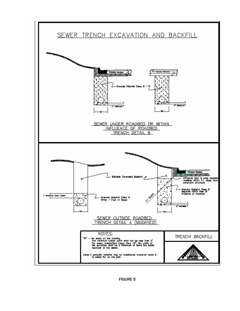
FIGURE 5

29
Concrete M.D.O.T. section 6.09
Prior to the start of concrete operations, the Proprietor's Engineer shall submit to the County Highway Engineer, the mix design, and mechanical analysis reports for fine and coarse aggregates to be incorporated into the mix. The Proprietor's Engineer shall have a representative on site at all times during concrete construction operations. Concrete to be placed with a paver (slipform) shall not be placed until the guide string has been thoroughly inspected. Prior to placing concrete, the guide string will be free from irregular (broken) curves both horizontal and vertical; sags or dips occurring between catch basins that vary substantially from the intended grade, and checked for the proper offset to assure proper alignment (horiz. and vert.) on the approach to catch basins, manholes, etc.. The Proprietor's Engineer shall issue a written "permit to place" for each approved section of grade. On inspection by the County, any concrete in place that is not substantially true to the planned line and grade shall be removed and replaced before acceptance into the County Road System. During paving operations the Proprietor's Engineer shall obtain the following tests: 1) SLUMP 2) AIR ENTRAINMENT - by means of an ASTM approved method, air indicators
(chase meters) will not be allowed. 3) TEMPERATURE - concrete and ambient 4) STRENGTH - flexure or compressive All test methods and frequencies for concrete shall be in accordance with M.D.O.T. procedures.

30
Miscellaneous Restoration and acceptance:
After construction and prior to final acceptance by the Board, the entire project shall be restored in accordance with the following requirements. 1) The site shall be graded within the road right of way in preparation
for a topsoil surface on all areas disturbed during construction. All intersecting slopes shall be rounded over presenting a smooth and natural appearance. The entire site shall be seeded, fertilized, and mulched.
2) Debris created during construction such as trampled brush, broken
trees, large stones shall be removed from within the right of way. 3) Neither the Proprietor or any of their agents shall plant any trees
within the proposed road right of way. Any landscaping done within the right of way shall be done with plantings that, if left unattended, shall have a mature height of less than eighteen inches. The use of rock gardens should be avoided however will be accepted only when the maximum size stone is less than six inches and used as ground cover and are not arranged so that they present a hazard to the public. This determination shall be solely a matter of the Boards opinion based on its authority and responsibility to maintain the proposed streets in a manner reasonably safe and convenient for public travel.
4) The use of signs within the road right of way other than regulatory or
guide signs authorized by the Michigan Manual on Uniform Traffic Control Devices is prohibited and shall be strictly enforced. Advertising or subdivision name signs located within the right of way shall be removed prior to acceptance.
5) If the Proprietor elects to make use of cluster type mail boxes, they
shall be placed in a location meeting the approval of the Livingston County Road Commission. The Livingston County Road Commission reserves the right to require specific types of mail box structures, require additional right of way so that they may be placed in a location that will be in the best interest of safety, or prohibit specific types of mail box systems entirely on a specific plat.
31
Final Acceptance
Prior to final acceptance of a plat, the Proprietor's Engineer shall submit the following items to the County Engineer: 1) As built mylars - The original plans or a reproduction on mylar showing
as built center line or top of curb elevations at station, half station, and low points. All sewer and water main size, invert locations and elevations. All catch basin locations with elevations at the bottom of structure and top of casting. Each sheet of the as built plans shall bear the Proprietor's Engineer's seal, signature, and date of approval.
2) Copies of all inspectors daily reports, test results, and material
certifications as detailed in section eight. 3) The Proprietor's Engineer shall submit his certification with seal and
signature on the attached acceptance report stating that the construction activities, testing, and documentation were carried out under their supervision and meet the specifications contained herein.
4) Prior to acceptance, the County Engineer will review the Proprietor's
Engineers records and make a recommendation to the Board regarding the completeness of the documentation on construction. Notice of non-compliance shall be given to the Proprietor's Engineer in case of deficiencies and corrective action taken before recommendation for approval.
5) The Livingston County Road Commission is required to fulfill its
responsibilities under the National Pollutant Discharge Elimination System (NPDES) for Municipal Separated Storm Sewer Systems (MS4). In order to facilitate meeting these requirements, the Road Commission will require all Developers who will be deeding public roads and land for public use to submit the following items prior to the acceptance of the roads:
a) An Adobe Acrobat pdf or tiff accessible electronic file of the as-built plan, including the following in the County road right-of-way.
1. The location and digital photograph of the most downstream discharge point(s) for the storm sewer system.
2. The location of all stormwater storage facilities, including detention/retention ponds and the location of the detention pond discharge point; and
3. The location of any innovative stormwater management techniques; such as retention/detention ponds, bioretention trenches, infiltration fields, rain gardens, and porous pavements.
b) A table, in electronic format, including the identification, state plane coordinates, and the public road right-of-way name, detention pond discharge points, and any other discharge points to open or enclosed drains.

32
SECTION IX FINANCIAL REQUIREMENTS
If construction is not completed at the time the Final Plat is submitted for approval, one of the following types of surety must be satisfied before the Final Plat can be approved by the Board. Approval of any single phase of construction does not guarantee acceptance of the roads, or approval of the Final Plat by the Board. Further, it will not relieve the proprietor of responsibilities or liabilities incurred by the development of the project. If the Proprietor is granted Final Plat approval by the Board prior to construction, the Proprietor shall maintain all roads in the plat until the construction of said roads has been approved by the County Engineer and accepted by the Board. Maintenance of the roads shall included but not be limited to snow, ice, soil erosion and sedimentation control. The Proprietor shall indemnify and hold the Livingston County Road Commission harmless from any claims which may be made against the Road Commission for damages arising from the use of roads which have not been accepted into the County Road System. During this period the Proprietor shall maintain liability insurance in which the Livingston County Road Commission is named as an additional insured, and in an amount established by the Road Commission, which will insure the Livingston County Road Commission against claims made because of the use of the road(s) prior to final acceptance. 1) Construction Bond - The Proprietor shall submit a guarantee of construction
in the amount of one hundred percent of the anticipated construction cost based on the approved estimate submitted by the Proprietors' Engineer. This requirement may be fulfilled with any of the sureties listed below. With the exception of cash deposits, the issuing agency shall notify the Livingston County Road Commission sixty calendar days in advance of expiration, cancellation or termination of all financial guarantees. a. Plat Bond - Furnished by the Proprietor and approved in form and
content by the general counsel of the Livingston County Road Commission. The bonding company must be approved by this department. The minimum bond shall be not less than $10,000.00. The bond shall be for a period of not less than two years.
b. Cash Deposit - Using a certified check on an open and solvent bank made payable to the Livingston County Road Commission.
c. Escrow Agreement - An escrow agreement approved in form and content by the General Counsel of the Livingston County Road Commission issued for a duration of not less than two years.
d. Irrevocable Bank Letter of Credit - Said bank must be approved by the Board. The letter shall be made payable to the Livingston County Road Commission upon draft authorized by the Board. The letter of credit shall be approved in form and content by the General Counsel of the Livingston County Road Commission and shall be made for a duration of not less than two years. The letter shall have provisions in it stating that it can not be cancelled, expire or otherwise be terminated without sixty days written notice to the County Engineer.
The surety shall be released as the work progresses based on verified progress estimates submitted to this department. Partial releases shall be equal to ninety percent of the work completed to date. The remaining ten percent shall be withheld until after construction has been completed, all the conditions of final review and acceptance have been met.
2) Sign Fees - When the construction plans are approved, the Proprietor will be
advised of the signing requirements for the completed subdivision. Prior to final acceptance, all permanent signing shall be in place as required by this department. The Proprietor shall pay the Livingston County Road Commission with a certified check for sign installation costs.

33
3) Administrative Fees - The proprietor shall pay the Livingston County Road Commission an amount equal to three percent of the approved estimated construction costs to defray the Road Commission's expenses of administration for the subdivision. While there will be inspections made by this department, the Proprietor or his engineer shall be responsible for inspection and testing in accordance with section VIII above. Inspections made by this department shall be for the benefit of the Board and will not be used for quality control. Administrative fees shall be paid by certified check.

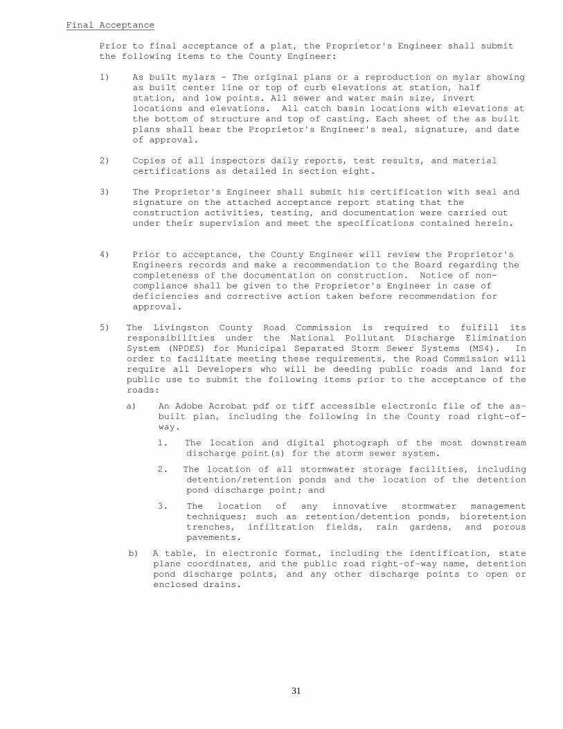
LIVINGSTON COUNTY ROAD COMMISSION PRELIMINARY PLAT & STREET REVIEW
Subdivision Name: Township: Section: Dated: / / Revised: / / Engineer: Contact: Tel: ( ) - Engineers Address: City: State: Zip: Proprietor: Contact: Tel: ( ) - Proprietors Address: City: State: Zip: TYPE OF DEVELOPMENT:
RESIDENTIAL COMMERCIAL
GENERAL: SHOWN APPROVED RESUBMIT 1) Proper sheet size (24” x 36”) 2) Location Map scaled at 1” = 1000’ 3) Topography (trees, streams, buildings, etc.) 4) Contours Shown at (maximum) 5’ Intervals 5) Permanent Bench Marks to U.S.G.S. Datum 6) Reference to Section Monuments 7) Title Block Showing Plat Name, Proprietor, Engineer’s seal etc. 8) North Arrow and Scale (scale to be not less than 1” = 100’) 9) Street Names (previously checked for conflict)
10) Adjacent Streets and Properties Shown with owners name, liber, page, and tax number
11) Area of Plat in Acres 12) Lineal Feet of Proposed Roadways 13) Plat Marked as Preliminary 14) Lot Layout – showing lot numbers, dimensions and overall dimensions of plat 15) Soil Borings Located and Described DRAINAGE: 16) Location Map Shows Overall Watershed Area 17) Existing Drainage Courses shown 18) Proposed Drainage Courses shown (overall plan) 19) Drainage District to be Dedicated to Drain Commission shown 20) Proposed offsite Drainage Courses shown 21) Drainage Calculations at Discharge Points 22) Drainage Areas Within Plat Defined 23) Mean Elevation of Lakes and Streams 24) Wetlands as Defined by D.N.R. shown ROADS: 25) Proposed Right of Way 26) Roadway Alignment Data shown 27) Proposed Alignment Provides Most Continuous Scheme
28) Intersection Sight Distance Recorded at Approaches to Existing Roads
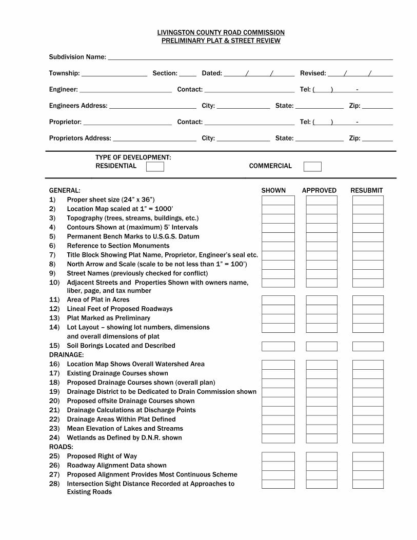
LIVINGSTON COUNTY ROAD COMMISSION PRELIMINARY PLAT & STREET REVIEW
Development Name: Township: Section: Dated: / / Revised: / / Engineer: Contact: Tel: ( ) - Engineers Address: City: State: Zip: Proprietor: Contact: Tel: ( ) - Proprietors Address: City: State: Zip: ROADS (cont): SHOWN APPROVED RESUBMIT 29) Cross Section showing width and type of pav’t structure 30) Right-of-Way Described 31) Use of Cul-De-Sacs as Prescribed in Specifications 32) Right-of-Way at Cul-De-Sacs as Prescribed 33) Maximum Block Length 34) Minimum Block Length 35) Out Lots Provided for Future Development 36) Dedication of Out Lots
Comments: Include in the space provided, any potential conflicts between the proposed development and the existing road network. Explain in detail, any items rejected or any items recommended for approval that do not meet current specifications.
RECOMMENDED FOR APPROVAL PLAT REVIEWED BY: DATE: YES NO SITE REVIEWED BY: DATE: YES NO TRAFFIC AND SAFETY: DATE: YES NO


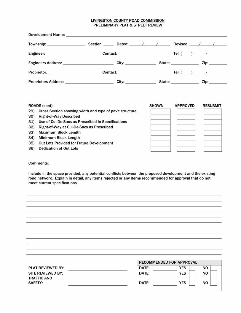
LIVINGSTON COUNTY ROAD COMMISSION CONSTRUCTION PLAN REVIEW
Development Name: Township: Section: Dated: / / Revised: / / Engineer: Contact: Tel: ( ) - Engineers Address: City: State: Zip: Proprietor: Contact: Tel: ( ) - Proprietors Address: City: State: Zip:
TYPE OF DEVELOPMENT:
RESIDENTIAL COMMERCIAL
GENERAL: SHOWN APPROVED RESUBMIT 1) Proper sheet size (24” x 36”) 2) Cover Sheet with Project Name in Right Margin 3) Typical Cross Section Sheet 4) Quantity Sheet 5) Preliminary Plat as Cover or Included in Plans 6) Reference to Section Monuments 7) Title Block Showing Plat Name, Proprietor, Engineer’s seal etc. 8) North Arrow and Scale (scale to be not less than 1” = 50’) 9) Street Names 10) Adjacent Streets and Properties Shown 11) Topography (trees, streams, buildings etc.) 12) Lineal Feet of Proposed Roadways 13) Paving and Drainage Plan (showing all structures) 14) Lot Layout – showing lot numbers, dimensions, etc. 15) Permanent Bench Marks to U.S.G.S. Datum DRAINAGE: 16) Location Map Shows Overall Watershed Area 17) Existing Drainage Courses shown 18) Proposed Drainage Courses shown (overall plan) 19) Retention / Detention Basin: Area ; Drainage Elevation Floor Elevation ; Capacity ; Retention Time
20) Proposed offsite Drainage Courses Secured 21) Drainage Calculations at Discharge Points 22) Drainage Areas Within Development Defined 23) Mean Elevation of Lakes and Streams 24) Wetlands as Defined by D.N.R. shown 25) Ditches Profiles 26) Culverts; (size, location, elevation) 27) Storm Sewer (size, location, grade, material class) 28) Drainage Structures (elevations at inverts, top, ftg., & curb) 29) Structures Labeled per M.D.O.T. (or detailed on separate sheet) 30) Inlet Capacity of Casting Adequate for Anticipated Runoff 31) Pick Up Points of Structures Low Points: 400’ Maximum Spacing between Catch Basins or Inlets 400’ Maximum Spacing between Manholes (sewer less than 30”) 600’ Maximum Spacing between Manholes (sewer greater than 36”)
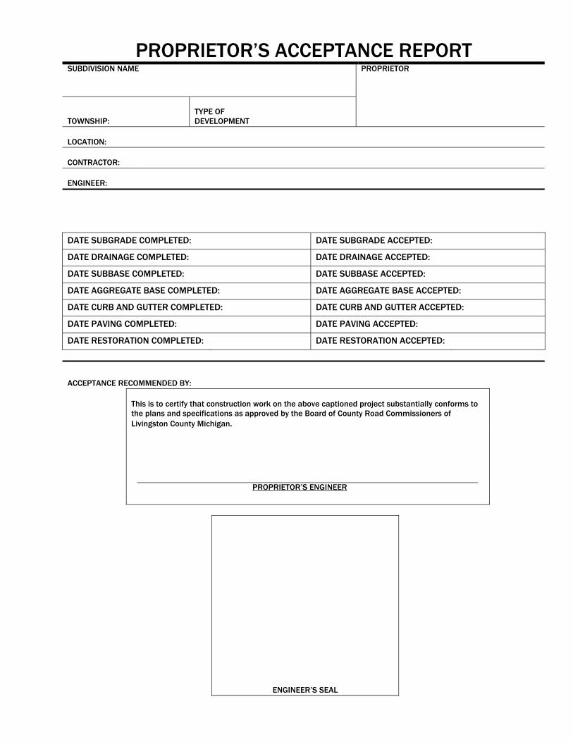
PROPRIETOR’S ACCEPTANCE REPORT SUBDIVISION NAME PROPRIETOR
TOWNSHIP:
TYPE OF DEVELOPMENT
LOCATION: CONTRACTOR: ENGINEER:
DATE SUBGRADE COMPLETED: DATE SUBGRADE ACCEPTED:
DATE DRAINAGE COMPLETED: DATE DRAINAGE ACCEPTED:
DATE SUBBASE COMPLETED: DATE SUBBASE ACCEPTED:
DATE AGGREGATE BASE COMPLETED: DATE AGGREGATE BASE ACCEPTED:
DATE CURB AND GUTTER COMPLETED: DATE CURB AND GUTTER ACCEPTED:
DATE PAVING COMPLETED: DATE PAVING ACCEPTED:
DATE RESTORATION COMPLETED: DATE RESTORATION ACCEPTED:
ACCEPTANCE RECOMMENDED BY: This is to certify that construction work on the above captioned project substantially conforms to
the plans and specifications as approved by the Board of County Road Commissioners of Livingston County Michigan.
PROPRIETOR’S ENGINEER
ENGINEER’S SEAL
FINANCIAL REQUIREMENTS
DEVELOPMENT NAME
PROPRIETOR ENGINEER
TOWNSHIP SECTION ENGINEER’S ESTIMATED CONSTRUCTION COST $
1) SIGN FEES $
2) ADMINISTRATIVE FEE (3% cash deposit) $ TOTAL CASH DEPOSIT $
TYPE OF SURETY
ESTIMATE OF WORK COMPLETED TO DATE $
ESTIMATED PROJECT COMPLETION COSTS $ ENGINEER’S SIGNATURE
DATE
proprietors’ engineer’s seal
CHECKED BY (L.C.R.C.)
DATE