Planning Proposal ATTACHMENT E
34
9 Palaran Avenue, North Kellyville Planning Proposal
Transcript of Planning Proposal ATTACHMENT E
9 Palaran Avenue, North Kellyvi l le
Planning Proposal
gtam
Text Box
ATTACHMENT E

SUTHERLAND & ASSOCIATES PLANNING
NOTE: This document is Copyright. Apart from any fair dealings for the purposes of private study, research, criticism or review, as permitted under the Copyright Act, no part may be reproduced in whole or in part, without the written permission of Sutherland & Associates Planning, PO Box 814, Bowral NSW 2576
ABN 14 118 321 793 ACN 144 979 564
Planning Proposal 9 PALARAN AVENUE, NORTH KELLYVILLE
December 2020
Prepared by
Amy Sutherland B Planning UNSW (Hons)
Tel: 0402 852 034 PO BOX 814 BOWRAL NSW 2576

3
Pla
nnin
g P
ropo
sal -
9 P
alar
an A
venu
e, N
orth
Kel
lyvi
lle
1.0 INTRODUCTION 4
2.0 SITE DESCRIPTION AND LOCATION 6
2.1 Locality Description 6
2.2 Site Description and Surrounding Context 7
3.0 LOCAL PLANNING PROVISIONS 12
3.1 State Environmental Planning Policy (Sydney Region Growth Centres) 2006 12
3.1.1 Zoning and Permissibility 12
3.1.2 Lot Size 13
3.1.3 Preservation of trees or vegetation 14
3.1.4 Subdivision of land in Zone E4 Environmental Living 15
4.0 PLANNING PROPOSAL 16
4.1 Overview 16
4.2 Part 1: Objectives or Intended Outcomes 16
4.3 Part 2: Explanation of Provisions 16
4.3.1 Proposed Changes to State Environmental Planning Policy (Sydney Region Growth
Centres) 2006 16
4.3.2 Concept Plan of Subdivision 17
4.4 Part 3: Justification 17
4.4.1 Need for the Planning Proposal 17
4.4.2 Relationship to Strategic Planning Framework 20
4.4.3 Environmental, Social and Economic Impact 28
4.4.4 State and Commonwealth Interests 29
4.5 Part 4: Mapping 29
4.6 Part 5: Community Consultation 30
4.7 Part 6: Project Timeline 31
5.0 CONCLUSION 32
APPENDIX A 33
Robert Moore & Associates 33
CONCEPT PLAN OF SUBDIVISION 33
CONTENTS

Pla
nnin
g P
ropo
sal -
9 P
alar
an A
venu
e, N
orth
Kel
lyvi
lle
4
This Planning Proposal has been prepared by Sutherland & Associates Planning Pty Ltd in relation to land at 9
Palaran Avenue, North Kellyville (formerly known as 4 Kendall Place, Kellyville).
9 Palaran Avenue, North Kellyville is part zoned R2 Low Density Residential and part zoned E4 Environmental
Living pursuant to Appendix 2 North Kellyville Precinct Plan of the State Environmental Planning Policy (Sydney
Region Growth Centres) 2006.
The objectives of the E4 zone are to provide for low-impact residential development in areas with special
ecological, scientific or aesthetic values and to ensure that residential development does not have an adverse
effect on those values.
The site itself does not contain any Existing Native Vegetation or Native Vegetation Retention Areas as shown
on the North West Growth Centre Native Vegetation Protection Map. The entire site is also located on
‘biodiversity certified land’ and no further assessment of impacts to threatened species, populations or ecological
communities is required under NSW legislation. In addition, the site is now permanently disconnected from land
which does contain vegetation that needs to be managed and conserved.
Accordingly, the part of the site zoned E4 Environmental Living does not have special ecological, scientific or
aesthetic values and therefore there is no longer any basis for the eastern part of the subject site to remain zoned
E4 Environmental Living. This part of the site should be zoned the same as the balance of the site which is
already zoned R2 Low Density Residential given the objectives of the R2 zone are more appropriate and relevant
to the land.
In accordance with Clause 4.1C(3)(b) of Appendix 2 of the Growth Centres SEPP any allotment created from a
subdivision of land within the E4 Environmental Living zone must not be less than the minimum size shown on
the Lot Size Map. A 4,000 square metre minimum lot size applies to the E4 Environmental Living zoned part of
the subject site. Notwithstanding this, Clause 6.5 allows subdivision of land in the Zone E4 Environmental Living
with a minimum lot size of 600 square metres, however, this is only on a Community title basis in accordance
with the Community Land Development Act 1989 for a neighbourhood scheme. The objectives for Clause 6.5
are to provide for residential development that takes account of the special values of land in Zone E4
Environmental Living and to ensure the land is managed and conserved in a holistic and sensitive manner. Clause
6.5 only allows subdivision on a Community title basis because it anticipates that sensitive land and bushfire
asset protection zones in a development will be protected as a neighbourhood allotment, as explained in Section
3.7 of the North Kellyville Precinct Development Control Plan 2018 (DCP 2018).
As detailed above the part of the site zoned E4 Environmental Living does not contain any land that has special
environmental values and has become isolated and disconnected from any other lots with special ecological,
scientific or aesthetic values as a result of recent development approvals to the north, south and east of the site.
Accordingly, the objectives of clause 6.5 have little relevance. Also, the small size of the E4 zoned parcel of
land (4,960.7 square metres) and street frontage that will be provided to this land is such that there is no need
for any new internal roads. Accordingly, the requirement for a neighbourhood allotment in a subdivision of the
site is redundant and there is no need for a requirement for subdivision on a Community title basis.
Whilst Torrens title subdivision of the E4 Environmental Living zoned part of the site is possible, this is only on
the basis of a minimum lot size of 4,000 square metres which is inconsistent with the emerging pattern of
subdivision surrounding the site.
Given the emerging pattern of subdivision surrounding the site and the size of the E4 zoned parcel of land, the
objectives and subdivision controls applicable to E4 zoned land are no longer relevant or appropriate and require
amendment to deliver an orderly pattern of development on this part of the site.
1.0 INTRODUCTION

Pla
nnin
g P
ropo
sal -
9 P
alar
an A
venu
e, N
orth
Kel
lyvi
lle
5
On this basis, the subject Planning Proposal seeks the following amendments to the State Environmental
Planning Policy (Sydney Region Growth Centres) 2006, which are the basis for the assessment in this Planning
Proposal:
• Amend the North West Growth Centre Lot Size Map to change the minimum lot size that applies to part
of the site from 4,000 square metres to 600 square metres; and
• Rezone the subject site from E4 Environmental Living to R2 Low Density Residential.
The purpose of the Planning Proposal is to allow the orderly and economic development of the subject site by
facilitating subdivision of the part of the site currently zoned E4 Environmental Living in a manner which more
appropriately reflects the site characteristics and surrounding context.
This outcome is in the public interest because it allows for an orderly pattern of development to be achieved that
is consistent with the pattern and density of the surrounding development.
The Planning Proposal demonstrates the strategic merit of the proposed amendments to State Environmental
Planning Policy (Sydney Region Growth Centres) 2006 and seeks to commence the statutory process to amend
the State Environmental Planning Policy (Sydney Region Growth Centres) 2006 as requested.
The Planning Proposal has been prepared in accordance with Section 3.33 of the Environmental Planning &
Assessment Act 1979 (EP&A Act). As required by Section 3.33 of the EP&A Act this Planning Proposal includes
the following:
• a statement of the objectives or intended outcomes of the proposed instrument,
• an explanation of the provisions that are to be included in the proposed instrument,
• the justification for those objectives, outcomes and provision and the process for their implementation,
• if maps are to be adopted by the proposed instrument – a version of the maps containing sufficient detail
to indicate the substantive effect of the proposed instrument, and
• details of the community consultation that is to be undertaken before consideration is given to the making
of the proposed instrument.
The Planning Proposal has also been prepared having regard to the ‘Guide to Preparing Planning Proposals’
developed by the NSW Department of Planning and Environment. The report addresses the Proposal’s
consistency with Greater Sydney Region Plan - A Metropolis of Three Cities, the Central City District Plan,
strategic plans and assesses the consistency of the Planning Proposal against relevant State Environmental
Planning Policies and Ministerial Directions.
The Planning Proposal is also supported by a conceptual plan of subdivision prepared by Robert Moore &
Associates Surveyors.

Pla
nnin
g P
ropo
sal -
9 P
alar
an A
venu
e, N
orth
Kel
lyvi
lle
6
2.1 Locality Description
The land to which the Planning Proposal relates is situated within The Hills Shire Local Government Area in the
suburb of North Kellyville.
North Kellyville currently comprises rural residential development interspersed with large areas of land
undergoing redevelopment consistent with the North Kellyville growth centre release area plan. The area was
identified as a growth centre release area and was rezoned in 2008 by the Minister for Planning and Infrastructure
for urban development and is referred to as ‘North Kellyville Precinct’. This area is undergoing a rapid
transformation and is ear marked to deliver approximately 4,500 new dwellings.
The vision for North Kellyville is the creation of vibrant neighbourhoods that provide a range of dwelling types
and opportunities for social interaction for a diverse population in centres, parks and community facilities. The
North Kellyville Precinct will contain three centres that will be become the focal points for social interaction,
community uses and retailing. An integrated public transport, cycle and pedestrian network will facilitate
improved access within the Precinct and to the surrounding areas, particularly to Rouse Hill Regional Centre.
The interface of the built form and the design of the public domain will create an attractive place to live.
Figure 1: Location plan: (Source: Google Maps 2020)
2.0 SITE DESCRIPTION AND LOCATION
Pla
nnin
g P
ropo
sal -
9 P
alar
an A
venu
e, N
orth
Kel
lyvi
lle
7
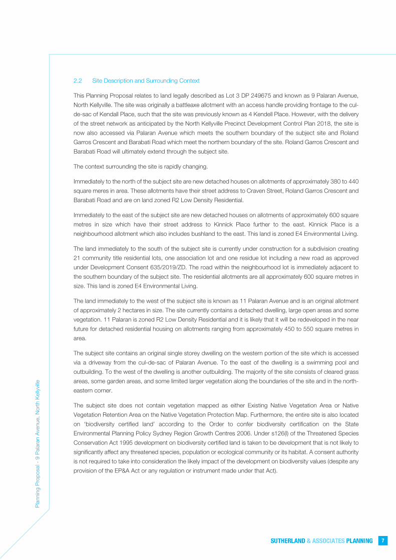
2.2 Site Description and Surrounding Context
This Planning Proposal relates to land legally described as Lot 3 DP 249675 and known as 9 Palaran Avenue,
North Kellyville. The site was originally a battleaxe allotment with an access handle providing frontage to the cul-
de-sac of Kendall Place, such that the site was previously known as 4 Kendell Place. However, with the delivery
of the street network as anticipated by the North Kellyville Precinct Development Control Plan 2018, the site is
now also accessed via Palaran Avenue which meets the southern boundary of the subject site and Roland
Garros Crescent and Barabati Road which meet the northern boundary of the site. Roland Garros Crescent and
Barabati Road will ultimately extend through the subject site.
The context surrounding the site is rapidly changing.
Immediately to the north of the subject site are new detached houses on allotments of approximately 380 to 440
square meres in area. These allotments have their street address to Craven Street, Roland Garros Crescent and
Barabati Road and are on land zoned R2 Low Density Residential.
Immediately to the east of the subject site are new detached houses on allotments of approximately 600 square
metres in size which have their street address to Kinnick Place further to the east. Kinnick Place is a
neighbourhood allotment which also includes bushland to the east. This land is zoned E4 Environmental Living.
The land immediately to the south of the subject site is currently under construction for a subdivision creating
21 community title residential lots, one association lot and one residue lot including a new road as approved
under Development Consent 635/2019/ZD. The road within the neighbourhood lot is immediately adjacent to
the southern boundary of the subject site. The residential allotments are all approximately 600 square metres in
size. This land is zoned E4 Environmental Living.
The land immediately to the west of the subject site is known as 11 Palaran Avenue and is an original allotment
of approximately 2 hectares in size. The site currently contains a detached dwelling, large open areas and some
vegetation. 11 Palaran is zoned R2 Low Density Residential and it is likely that it will be redeveloped in the near
future for detached residential housing on allotments ranging from approximately 450 to 550 square metres in
area.
The subject site contains an original single storey dwelling on the western portion of the site which is accessed
via a driveway from the cul-de-sac of Palaran Avenue. To the east of the dwelling is a swimming pool and
outbuilding. To the west of the dwelling is another outbuilding. The majority of the site consists of cleared grass
areas, some garden areas, and some limited larger vegetation along the boundaries of the site and in the north-
eastern corner.
The subject site does not contain vegetation mapped as either Existing Native Vegetation Area or Native
Vegetation Retention Area on the Native Vegetation Protection Map. Furthermore, the entire site is also located
on ‘biodiversity certified land’ according to the Order to confer biodiversity certification on the State
Environmental Planning Policy Sydney Region Growth Centres 2006. Under s126(l) of the Threatened Species
Conservation Act 1995 development on biodiversity certified land is taken to be development that is not likely to
significantly affect any threatened species, population or ecological community or its habitat. A consent authority
is not required to take into consideration the likely impact of the development on biodiversity values (despite any
provision of the EP&A Act or any regulation or instrument made under that Act).

Pla
nnin
g P
ropo
sal -
9 P
alar
an A
venu
e, N
orth
Kel
lyvi
lle
8
Figure 2: Aerial View of the Site and Surrounds (So
urce: Six Maps, Department of Lands 2020)
Photograph 1:
The existing entrance
driveway to the site
from Palaran Avenue

Pla
nnin
g P
ropo
sal -
9 P
alar
an A
venu
e, N
orth
Kel
lyvi
lle
9
Photograph 2:
View from the eastern end of
the site facing west with the
southern boundary on the left
Photograph 3:
View from the site facing east
with the southern boundary on
the right
Photograph 4:
View from the southern end of
the site facing north-east
towards the eastern boundary

Pla
nnin
g P
ropo
sal -
9 P
alar
an A
venu
e, N
orth
Kel
lyvi
lle
10
Photograph 5:
View of the existing dwelling
and pool facing north-west
Photograph 6:
View of the northern boundary
of the site from the north-
eastern corner
Photograph 7:
View towards the western
boundary of the site taken from
the northern part of the site
Pla
nnin
g P
ropo
sal -
9 P
alar
an A
venu
e, N
orth
Kel
lyvi
lle
11
Photograph 8:
View of western
adjacent site at 11
Palaran Avenue which
is yet to be developed
Photograph 9:
View of southern adjacent site
which is currently under
construction
Photograph 10:
Emerging context in
Palaran Avenue

Pla
nnin
g P
ropo
sal -
9 P
alar
an A
venu
e, N
orth
Kel
lyvi
lle
12
3.1 State Environmental Planning Policy (Sydney Region Growth Centres) 2006
State Environmental Planning Policy (Sydney Region Growth Centres) 2006 applies to the site. Key provisions
applying to the site are identified below:
3.1.1 Zoning and Permissibility
The majority of the site is zoned R2 Low Density Residential and a small area of the site is zoned E4
Environmental Living pursuant to Appendix 2 of State Environmental Planning Policy (Sydney Region
Growth Centres) 2006. An extract of the Land Zoning Map is included as Figure 3.
Figure 3:
Extract from SEPP
(SRGC) 2006 Land
Zoning Map
The objectives of the R2 Low Density Residential zone are:
• To provide for the housing needs of the community within a low-
density residential environment.
• To enable other land uses that provide facilities or services to
meet the day to day needs of residents.
• To provide for a variety of housing types but primarily low
density detached housing.
• To support the wellbeing of the community, including educational,
recreational, community, religious and other activities if there
will be no adverse effect on the amenity of the proposed or
existing nearby residential development.
The following uses are permitted with consent in the R2 Low Density Residential zone:
Centre-based child care facilities; Community facilities; Drainage;
Dual occupancies; Dwelling houses; Earthworks; Educational
establishments; Environmental protection works; Exhibition homes;
Exhibition villages; Group homes; Health consulting rooms; Home
businesses; Information and education facilities; Recreation areas;
3.0 LOCAL PLANNING PROVISIONS

Pla
nnin
g P
ropo
sal -
9 P
alar
an A
venu
e, N
orth
Kel
lyvi
lle
13
Respite day care centres; Roads; Secondary dwellings; Semi-detached
dwellings; Seniors housing; Studio dwellings; Water recycling
facilities; Waterbodies (artificial)
The objectives of the E4 Environmental Living zone are:
• To provide for low-impact residential development in areas with
special ecological, scientific or aesthetic values.
• To ensure that residential development does not have an adverse
effect on those values.
The following uses are permitted with consent in the E4 Environmental Living zone:
Bed and breakfast accommodation; Drainage; Dual occupancies; Dwelling
houses; Earthworks; Electricity generating works; Environmental
facilities; Environmental protection works; Flood mitigation works;
Group homes; Health consulting rooms; Home businesses; Home
industries; Horticulture; Recreation areas; Recreation facilities
(outdoor); Roads; Swimming pools; Water recreation structures; Water
recycling facilities; Waterbodies (artificial.)
3.1.2 Lot Size
Clause 4.1C(3)(b) establishes a minimum lot size of 4,000 square metres for the part of the site which is
zoned E4 Environmental Living. An extract of the Lot Size map is included as Figure 4.
Figure 4:
Extract from the SEPP
(SRGC) 2006 Lot Size
Map
The objectives of the clause are:
(a) to provide for the subdivision of lots that are within Zone R2
Low Density Residential and Zone E4 Environmental Living but cannot
be subdivided under clause 4.1,

Pla
nnin
g P
ropo
sal -
9 P
alar
an A
venu
e, N
orth
Kel
lyvi
lle
14
(b) to ensure that the subdivision occurs in a manner that promotes
suitable land use and development,
(c) to ensure that the subdivision will not compromise the
environmental values of land in Zone E4 Environmental Living.
3.1.3 Preservation of trees or vegetation
Clause 5.9 relates to the preservation of the amenity of the area through the preservation of trees and
other vegetation.
Clauses 6.2 and 6.3 of the Growth Centres SEPP contains controls for the clearing of Existing Native
Vegetation and Native Vegetation Retention Areas as shown on the Native Vegetation Protection Map.
However, the subject site does not contain vegetation mapped in either of these categories and therefore
has no further restriction of clearing of vegetation as illustrated in Figure 5 below.
Figure 5:
Extract from SEPP
Native Vegetation
Protection Map
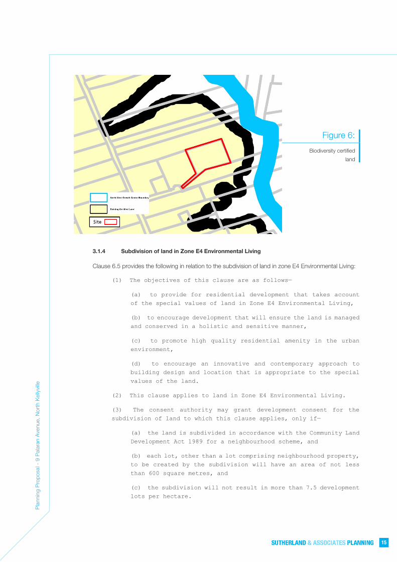
The entire site is also located on ‘biodiversity certified land’ according to the Order to confer biodiversity
certification on the State Environmental Planning Policy Sydney Region Growth Centres 2006 as depicted
in Figure 6 below.
Under s126(l) of the Threatened Species Conservation Act 1995 development on biodiversity certified
land is taken to be development that is not likely to significantly affect any threatened species, population
or ecological community or its habitat. A consent authority is not required to take into consideration the
likely impact of the development on biodiversity values (despite any provision of the EP&A Act or any
regulation or instrument made under that Act). Therefore, it is understood that no further assessment of
impacts to threatened species, populations or ecological communities is required under NSW legislation.
Pla
nnin
g P
ropo
sal -
9 P
alar
an A
venu
e, N
orth
Kel
lyvi
lle
15
Figure 6:
Biodiversity certified
land
3.1.4 Subdivision of land in Zone E4 Environmental Living
Clause 6.5 provides the following in relation to the subdivision of land in zone E4 Environmental Living:
(1) The objectives of this clause are as follows—
(a) to provide for residential development that takes account
of the special values of land in Zone E4 Environmental Living,
(b) to encourage development that will ensure the land is managed
and conserved in a holistic and sensitive manner,
(c) to promote high quality residential amenity in the urban
environment,
(d) to encourage an innovative and contemporary approach to
building design and location that is appropriate to the special
values of the land.
(2) This clause applies to land in Zone E4 Environmental Living.
(3) The consent authority may grant development consent for the
subdivision of land to which this clause applies, only if—
(a) the land is subdivided in accordance with the Community Land
Development Act 1989 for a neighbourhood scheme, and
(b) each lot, other than a lot comprising neighbourhood property,
to be created by the subdivision will have an area of not less
than 600 square metres, and
(c) the subdivision will not result in more than 7.5 development
lots per hectare.
Pla
nnin
g P
ropo
sal -
9 P
alar
an A
venu
e, N
orth
Kel
lyvi
lle
16
4.1 Overview
In accordance with Section 3.33(2) of the Environmental Planning and Assessment Act 1979 (the EP&A Act) a
Planning Proposal is to be comprised of five (5) parts:
• Part 1 – A statement of the objectives and intended outcomes of the proposed instrument.
• Part 2 – An explanation of the provisions that are to be included in the proposed instrument.
• Part 3 – The justification for those objectives, outcomes and the process for their implementation.
• Part 4 – Maps, where relevant, to identify the intent of the Planning Proposal and the area to which it
applies.
• Part 5 – Details of the community consultation that is to be undertaken on the Planning Proposal.
Section 3.33(3) of the Act allows the Secretary to issue requirements with respect to the preparation of a Planning
Proposal. The Secretary’s requirements include:
• Specific matters that must be addressed in the justification (Part 3) of the Planning Proposal
• A project timeline to detail the anticipated timeframe for the plan making process for each Planning
Proposal.
The project timeline forms Part 5 of a Planning Proposal.
Section 4 of this report addresses and responds to the matters for consideration detailed within ‘Planning
Proposals - A Guide to Preparing Planning Proposals’ (NSW Department of Planning and Environment, August
2016).
4.2 Part 1: Objectives or Intended Outcomes
The objective of the Planning Proposal is to amend the State Environmental Planning Policy (Sydney Region
Growth Centres) 2006 as follows:
• Amend the North West Growth Centre Lot Size Map to change the minimum lot size that applies to part
of the site from 4,000 square metres to 600 square metres; and
• Rezone part of the subject site from E4 Environmental Living to R2 Low Density Residential.
The purpose, or intended outcome, of the Planning Proposal is to allow the orderly and economic development
of the subject site by facilitating subdivision of the part of the site currently zoned E4 Environmental Living in a
manner which more appropriately reflects the site characteristics and surrounding context.
4.3 Part 2: Explanation of Provisions
4.3.1 Proposed Changes to State Environmental Planning Policy (Sydney Region Growth
Centres) 2006
The amendments proposed to the State Environmental Planning Policy (Sydney Region Growth Centres)
2006 are as follows:
• Amend the North West Growth Centre Lot Size Map (Sheet LSZ_012) to change the minimum lot
size that applies to part of the site at 9 Palaran Avenue, North Kellyville from 4,000 square metres
to 600 square metres; and
4.0 PLANNING PROPOSAL

Pla
nnin
g P
ropo
sal -
9 P
alar
an A
venu
e, N
orth
Kel
lyvi
lle
17
• Rezone part of the subject site at 9 Palaran Avenue, North Kellyville from E4 Environmental Living
to R2 Low Density Residential. This requires an amendment to the North West Growth Centre
Land Zoning Map (Sheet LZN_012A)
4.3.2 Concept Plan of Subdivision
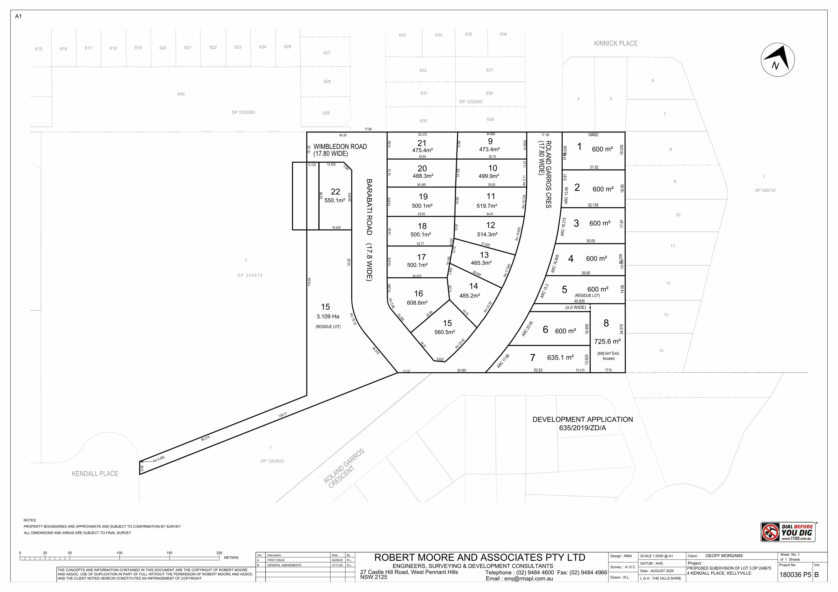
The Planning Proposal is accompanied by a conceptual plan of subdivision prepared by Robert Moore
& Associates Surveyors which illustrates the intended future subdivision of the overall site which would
be facilitated by the proposed amendments to the State Environmental Planning Policy (Sydney Region
Growth Centres) 2006. This is shown in Figure 7 below and included as Appendix A.
Figure 7: Conceptual plan of subdivision prepared by Robert Moore & Associates Surveyors
4.4 Part 3: Justification
This Part of the Planning Proposal sets out the case for the proposed amendments to the minimum lot size and
E4 Environmental Living zones which currently apply to the eastern part of the subject site pursuant to the State
Environmental Planning Policy (Sydney Region Growth Centres) 2006.
4.4.1 Need for the Planning Proposal
Is the Planning Proposal the result of any strategic study or report?
The Planning Proposal is not the result of any strategic study or report.
However, the proposed amendment is not inconsistent with the intended outcomes of the various
planning controls which influenced the application of the E4 Environmental Living zone that applied to
Pla
nnin
g P
ropo
sal -
9 P
alar
an A
venu
e, N
orth
Kel
lyvi
lle
18
the site with the introduction of the State Environmental Planning Policy (Sydney Region Growth Centres)
2006.
In particular, the current planning regime being the State Environmental Planning Policy (Sydney Region
Growth Centres) 2006 and also the North Kellyville Precinct Development Control Plan, anticipated that
the E4 Environmental Living part of the site would be amalgamated with the E4 Environmental Living land
adjacent to the east of the site.
Such an amalgamated outcome would logically lend itself to a Community title subdivision as anticipated
by the planning controls, with the protected vegetation further to the east being retained and managed
as a neighbourhood lot. However, this outcome has already been achieved as a result of the approved
redevelopment and subdivision of the site immediately to the east, on a standalone basis.
As a result, the subject site has become isolated from any land containing vegetation that needs to be
managed and conserved, such that there is no longer a need for a neighbourhood allotment and for
subdivision of the site to be on a Community title basis.
Is the Planning Proposal the best means of achieving the objectives or intended outcomes, or is there a
better way?
The objectives of the E4 zone are to provide for low-impact residential development in areas with special
ecological, scientific or aesthetic values and to ensure that residential development does not have an
adverse effect on those values.
The site itself does not contain any Existing Native Vegetation or Native Vegetation Retention Areas as
shown on the North West Growth Centre Native Vegetation Protection Map. The entire site is also located
on ‘biodiversity certified land’ and no further assessment of impacts to threatened species, populations
or ecological communities is required under NSW legislation.
In addition, the site is now permanently disconnected from land which does contain vegetation that needs
to be managed and conserved.
Accordingly, the part of the site zoned E4 Environmental Living does not have special ecological, scientific
or aesthetic values and therefore there is no longer any basis for the eastern part of the subject site to
remain zoned E4 Environmental Living. This part of the site should be zoned the same as the balance of
the site which is already zoned R2 Low Density Residential given the objectives of the R2 zone are more
appropriate and relevant to the land.
In accordance with Clause 4.1C(3)(b) of Appendix 2 of the Growth Centres SEPP any allotment created
from a subdivision of land within the E4 Environmental Living zone must not be less than the minimum
size shown on the Lot Size Map. A 4,000 square metre minimum lot size applies to the E4 Environmental
Living zoned part of the subject site. Notwithstanding this, Clause 6.5 allows subdivision of land in the
Zone E4 Environmental Living with a minimum lot size of 600 square metres, however, this is only on a
Community title basis in accordance with the Community Land Development Act 1989 for a
neighbourhood scheme. The objectives for Clause 6.5 are to provide for residential development that
takes account of the special values of land in Zone E4 Environmental Living and to ensure the land is
managed and conserved in a holistic and sensitive manner. Clause 6.5 only allows subdivision on a
Community title basis because it anticipates that sensitive land and bushfire asset protection zones in a
development will be protected as a neighbourhood allotment, as explained in Section 3.7 of the North
Kellyville Precinct Development Control Plan 2018 (DCP 2018).

Pla
nnin
g P
ropo
sal -
9 P
alar
an A
venu
e, N
orth
Kel
lyvi
lle
19
As detailed above the part of the site zoned E4 Environmental Living does not contain any land that has
special environmental values and has become isolated and disconnected from any other lots with special
ecological, scientific or aesthetic values as a result of recent development approvals to the north, south
and east of the site. Accordingly, the objectives of clause 6.5 have little relevance. Also, the small size
of the E4 zoned parcel of land (4,960.7 square metres) and street frontage that will be provided to this
land is such that there is no need for any new internal roads. Accordingly, the requirement for a
neighbourhood allotment in a subdivision of the site is redundant and there is no need for a requirement
for subdivision on a Community title basis.
Whilst Torrens title subdivision of the E4 Environmental Living zoned part of the site is possible, this is
only on the basis of a minimum lot size of 4,000 square metres which is inconsistent with the emerging
pattern of subdivision surrounding the site.
Given the emerging pattern of subdivision surrounding the site and the size of the E4 zoned parcel of
land, the objectives and subdivision controls applicable to E4 zoned land are no longer relevant or
appropriate and require amendment to deliver an orderly pattern of development on this part of the site.
In order to facilitate this outcome, there are two potential avenues for amendment to State Environmental
Planning Policy (Sydney Region Growth Centres) 2006, as follows:
Option 1 Option 2
• Amend the North West Growth Centre Lot Size Map to change the minimum lot size that applies to part of the site from 4,000 square metres to 600 square metres. The 600 square metre lot size is consistent with the size of lots on the immediately adjoining land to the north, east and south.
• Rezone the subject site from E4 Environmental Living to R2 Low Density Residential. The R2 zone already applies to the majority of the site. The objectives of the R2 zone are more relevant to the land than those that apply to the E4 zone.
• Amend the North West Growth Centre Lot Size Map to remove the 4,000 square metre affectation which applies to part of the site; and
• Amend Clause 6.5 to exempt this site from the application of the clause.
In considering the two options, it is considered that Option 1 is superior because it avoids the need for a
bespoke provision in Clause 6.5 of Appendix 2 of State Environmental Planning Policy (Sydney Region
Growth Centres) 2006 to specifically exempt its application from the subject site. Option 1 is also
superior as the objectives of the R2 zone are more closely aligned with the characteristics of the land.
The provision of a 600 square metre lot size for the eastern part of the site will also ensure that the pattern
of subdivision relates to the lot sizes on the immediately adjoining land.
The rezoning of the eastern part of the site to R2 Low Density Residential would also remove the
application of Clause 6.5 to the future subdivision of the site. This is appropriate given that the objective
of Clause 6.5, being to provide for residential development that takes account of the special values of
land in Zone E4 Environmental Living and to ensure the land is managed and conserved in a holistic and
sensitive manner, is no longer relevant to the subject site.
The alternative approach of simply leaving the eastern part of the site zoned E4 Environmental Living and
allowing Torrens title subdivision to lots of less than 4,000 square metres is considered inferior as the E4

Pla
nnin
g P
ropo
sal -
9 P
alar
an A
venu
e, N
orth
Kel
lyvi
lle
20
Environmental Living zone no longer reflects the site characteristics and context. Furthermore, this
approach would require a bespoke amendment to Clause 6.5 of Appendix 2 to State Environmental
Planning Policy (Sydney Region Growth Centres) 2006 which is undesirable given it creates further
complexity that can be avoided by adopting a more appropriate zone for the land.
For these reasons the Planning Proposal is the best means of achieving the objectives and intended
outcomes for the site.
4.4.2 Relationship to Strategic Planning Framework
Is the Planning Proposal consistent with the objectives and actions of the applicable regional, sub-
regional or district plan or strategy (including any exhibited draft plans or strategies)?
Greater Sydney Region Plan – A Metropolis of Three Cities
In March 2018 the Greater Sydney Region Plan - A Metropolis of Three Cities was released. The Plan
sets a 40-year vision to 2056 and establishes a 20-year plan to manage growth and change for Greater
Sydney. The vision for Greater Sydney is a metropolis of three cities — the Western Parkland City, the
Central River City and the Eastern Harbour City where most residents live within 30 minutes of their jobs,
education and health facilities, services and great places.
The Plan sets out 10 Directions which set out the aspirations for the region and objectives to support the
Directions. The 10 Directions are:
• A city supported by infrastructure
• A collaborative city
• A city for people
• Housing the city
• A city of great places
• A well-connected city
• Jobs and skills for the city
• A city in its landscape
• An efficient city
• A resilient city
The Plan provides 40 objectives related to these directions and the themes of infrastructure and
collaboration, liveability, productivity, sustainability and implementation. The following table summarises
the proposals consistency with relevant objectives of the Plan:
Objective Comment Consistent
Housing the city
Objective 10 Greater Housing Supply
NSW Government has identified that 725,000 additional homes will be needed by 2036 to meet demand based on current population projections. The proposed amendments will facilitate a residential density for the eastern part of the site is consistent with the density of the adjoining development to the east. This will result in
Yes

Pla
nnin
g P
ropo
sal -
9 P
alar
an A
venu
e, N
orth
Kel
lyvi
lle
21
Objective Comment Consistent
an improvement, albeit relatively minor, to the housing supply which is capable of being delivered by the subject site. This supply is appropriate having regard to the site characteristics and circumstance, and consistent with the housing supply which will occur on the balance of the subject site and within the visual catchment of the site.
A city in its landscape
Objective 27 Biodiversity is protected, urban bushland and remnant vegetation is enhanced
Objective 28 Scenic and cultural landscapes are protected
Objectives 27 and 28 are concerned with the protection of biodiversity and scenic landscapes. However, the subject site itself does not contain any Existing Native Vegetation or Native Vegetation Retention Areas as shown on the North West Growth Centre Native Vegetation Protection Map, and furthermore, the entire site is also located on ‘biodiversity certified land’ and no further assessment of impacts to threatened species, populations or ecological communities is required under NSW legislation. Accordingly, the proposed amendments do not result in any change in relation to the protection of biodiversity and scenic landscapes beyond the existing circumstance.
Yes
Central City District Plan
The Central City District Plan was also released in March 2018 and sets out a 20-year vision for the
Central City District, which includes Blacktown, The Hills, Parramatta and Cumberland local government
areas.
The Central City District Plan sets out priorities and actions for the growth and development of the Central
District. The Plan provides the district level framework to implement the directions, objectives, strategies
and actions outlined in the Greater Sydney Region Plan.
The Central City District is identified as one of the most dynamic and rapidly growing regions in Australia
and one which plays a pivotal role in Greater Sydney’s future as an economic and employment
powerhouse, a core hub for transport and services, and the home of vibrant and diverse centres and
communities.
The following table summarises the Planning Proposal’s consistency with relevant components of the
Central City District Plan:
Chapter Comment Consistent
Infrastructure and Collaboration
The site is within close proximity to the recently completed Kellyville metro station and the proposed amendments to the SEPP will allow for the appropriate development of the site for a commensurate density to that which is consistent with the immediately adjoining land to the east. This will maximise the benefit provided by the recently completed infrastructure.
Yes

Pla
nnin
g P
ropo
sal -
9 P
alar
an A
venu
e, N
orth
Kel
lyvi
lle
22
Chapter Comment Consistent
Liveability The proposed amendments will facilitate a residential density for the eastern part of the site which is consistent with the density of development on the surrounding land, without the restrictions which apply to sensitive land which contains vegetation which needs to be conserved and managed. This will result in an improvement, albeit relatively minor, to the housing supply which is capable of being delivered by the subject site. This supply is appropriate having regard to the site characteristics and circumstance, and the supply of housing which will occur on the balance of the subject site and within the visual catchment of the site.
Yes
Sustainability Planning Priority C15 is concerned with protecting and enhancing bushland, biodiversity and scenic and cultural landscapes.
However, the subject site itself does not contain any Existing Native Vegetation or Native Vegetation Retention Areas as shown on the Native Vegetation Protection Map, and furthermore, the entire site is also located on ‘biodiversity certified land’ and no further assessment of impacts to threatened species, populations or ecological communities is required under NSW legislation. Accordingly, the proposed amendments do not result in any change in relation to protecting and enhancing bushland, biodiversity and scenic and cultural landscapes.
Yes
Is the Planning Proposal consistent with a Council’s local strategy or other local strategic plan?
The Hills Shire Council Local Strategic Planning Statement (LSPS) identifies priorities for new housing in
the right locations and a diversity of housing. In particular, the LSPS identifies:
The greenfield areas of North Kellyville, Box Hill, Box Hill North and
Balmoral Road will continue to provide low and medium density housing,
supported by existing and planned infrastructure, to meet demand for
detached dwellings, which have been the core of The Hills housing
market to date.
It is noted that the site is in a ‘Greenfield Area’ and not a ‘Metropolitan Rural Area’ under the LSPS. The
focus for Greenfield Areas is for low and medium density housing, whilst protection of rural lands and
bushland, biodiversity and scenic landscapes is relevant to the Metropolitan Rural Areas which does not
include the subject site.
The Hills Shire Council Housing Strategy specifically identities a planned 80 per cent increase in
population by 2036, with the population of 290,900 people needing a mix of housing. The Strategy
specifically identifies that Greenfield areas such as North Kellyville will accommodate most of the Shire’s
supply of detached homes.
The Planning Proposal is consistent with the identified role of North Kellyville as a Greenfield area which
is intended to accommodate a large proportion of the Shire’s supply of detached housing, which is a
form of housing that the Shire is well known for and which attracts families to the area. This Planning
Proposal demonstrates that the current zone and minimum lot size requirement for the eastern portion

Pla
nnin
g P
ropo
sal -
9 P
alar
an A
venu
e, N
orth
Kel
lyvi
lle
23
of the subject site have become redundant as a result of the pattern of development that has occurred
surrounding the site, such that it has become permanently isolated from any land required environmental
management. Accordingly, the subject Planning Proposal allows the site to appropriately fulfil its role in
the Greenfield area to deliver detached low-density housing.
Is the Planning Proposal consistent with applicable State Environmental Planning Policies?
The Planning Proposal is of no consequence in relation to any other State Environmental Planning Policies
beyond the proposed amendments to State Environmental Planning Policy (Sydney Region Growth
Centres) 2006.
Is the Planning Proposal consistent with applicable Ministerial Directions (s9.1 directions)?
The following table summarises the Planning Proposal’s consistency with applicable Ministerial
Directions:
S.9.1 Direction No.
and Title
Comment Consistent
Employment and Resources
1.1 Business and Industrial zones
Not applicable. N/a
1.2 Rural Zones Not applicable. N/A
1.3 Mining, Petroleum Production and Extractive Industries
Not applicable. N/A
1.4 Oyster Aquaculture
Not applicable. N/A
1.5 Rural Lands Not applicable. N/A
Environmental and Heritage
2.1 Environment Protection Zones
The Planning Proposal does not impact on any environmentally sensitive areas.
Yes
2.2 Coastal Protection Not applicable. N/A
2.3 Heritage Conservation
Not applicable. N/A
2.4 Recreation Vehicle Areas
Not applicable. N/A
2.5 Application of E2 and E3 Zones and Environmental Overlays in Far North Coast LEPS
Not applicable. N/A
2.6 Remediation of contaminated land
The land is not within an investigation area within the meaning of the Contaminated Land Management Act nor is it on land which
Yes

Pla
nnin
g P
ropo
sal -
9 P
alar
an A
venu
e, N
orth
Kel
lyvi
lle
24
S.9.1 Direction No.
and Title
Comment Consistent
development for a purpose referred to in Table 1 to the contaminated land planning guidelines is being, or is known to have been, carried out.
The Planning Proposal relates to land zoned E4 Environmental Living. This zone permits residential development. The proposed R2 zoning of this land will also permit residential development and so no change of use of land is proposed.
Housing, Infrastructure and Urban Development
3.1 Residential Zones The objectives of this direction are:
(a) To encourage a variety and choice of housing types to provide for existing and future housing needs,
(b) To make efficient use of existing infrastructure and services and ensure that new housing has appropriate access to infrastructure and services, and
(c) To minimise the impact of residential development on the environment and resource lands.
This Planning Proposal demonstrates that the current zone and minimum lot size requirements for the eastern portion of the subject site have become redundant as a result of the pattern of development that has occurred surrounding the site, such that it has become permanently isolated from any land requiring protection or environmental management. Accordingly, the subject Planning Proposal allows the site to appropriately fulfil its role in the Greenfield area to deliver detached low density housing which is a housing type which is well suited to the future housing needs in the area.
The Proposal makes efficient use of existing infrastructure and services, including the recently completed Kellyville metro station.
As the Proposal is for a site with no biodiversity protection requirements, there is no adverse impact on the environment and resource lands.
N/A
3.2 Caravan Parks and Manufactured Home Estates
Not applicable. N/A
3.3 Home Occupations
Not applicable. N/A
3.4 Integrating land use and transport
This Direction applies when a relevant planning authority prepares a planning proposal that will create, alter or remove a zone or a provision relating to urban land, including land zoned for residential, business, industrial, village or tourist purposes.
Yes

Pla
nnin
g P
ropo
sal -
9 P
alar
an A
venu
e, N
orth
Kel
lyvi
lle
25
S.9.1 Direction No.
and Title
Comment Consistent
In accordance with the direction a planning proposal must locate zones for urban purposes and include provisions that give effect to and are consistent with the aims, objectives and principles of:
(a) Improving Transport Choice – Guidelines for planning and development (DUAP 2001), and
(b) The Right Place for Business and Services – Planning Policy (DUAP 2001).
The Improving Transport Choice – Guidelines provide advice on how the development industry, state agencies, other transport providers, and the community can:
• better integrate land use and transport planning and development
• provide transport choice and manage travel demand to improve the environment, accessibility and liveability.
The Right Place for Business and Services – Planning Policy plans for a better arrangement of land uses in support of centres and the transport systems which serve them.
The planning proposal seeks to facilitate the redevelopment of land for low density housing. The density proposed is appropriate having regard to the density of the surrounding allotments and proximity to public transport.
3.5 Development Near License Aerodromes
This Direction applies when a relevant planning authority prepares a planning proposal that will create, alter or remove a zone or a provision relating to land in the vicinity of a licensed aerodrome. This Direction is not applicable to the Planning Proposal.
N/A
3.6 Shooting Ranges Not applicable. N/A
3.7 Reduction in non-hosted short term rental accommodation period
Not applicable. N/A
Hazard and Risk
4.1 Acid Sulfate Soils Not applicable. N/A
4.2 Mine Subsidence and Unstable Land
Not applicable. N/A
4.3 Flood Prone Lane The site is not identified as Flood Prone Land. N/A
4.4 Planning for Bushfire Protection
The site is identified as Bushfire Prone land and is specifically a ‘vegetation buffer’. However, the land immediately to the east contains recently constructed low density housing, such that the development of the site for low density residential housing is unlikely to be incompatible with planning for Bushfire Prone Land.
Yes

Pla
nnin
g P
ropo
sal -
9 P
alar
an A
venu
e, N
orth
Kel
lyvi
lle
26
S.9.1 Direction No.
and Title
Comment Consistent
The detailed assessment of bushfire impact is a matter to be addressed in a subsequent Development Application.
Regional Planning
5.1 Implementation of Regional Strategies (Revoked)
Not applicable. N/A
5.2 Sydney Drinking Water Catchments
Not applicable. N/A
5.3 Farmland of State and Regional Significance on the NSW Far North Coast
Not applicable. N/A
5.4 Commercial and Retail Development along the Pacific Highway, North Coast
Not applicable. N/A
5.5 Development in the vicinity of Ellalong, Paxton and Millfield
Revoked. N/A
5.6 Sydney to Canberra Corridor
Revoked. N/A
5.7 Central Coast Revoked N/A
5.8 Second Sydney Airport: Badgerys Creek
Not applicable. N/A
5.9 North West Rail Link Corridor Strategy
Not applicable. N/A
5.10 Implementation of Regional Plans
This direction applies to land to which a Regional Plan has been released by the Minister for Planning. No specific regional plan applies to the site.
N/A
5.11 Development of Aboriginal Land Council Land
Not applicable. N/A
Local Plan Making
6.1 Approval and Referral Requirements
The objective of this direction is to ensure that LEP provisions encourage the efficient and appropriate assessment of development.
In accordance with the direction the Proposal does not include provisions that require the concurrence, consultation or referral of
Yes

Pla
nnin
g P
ropo
sal -
9 P
alar
an A
venu
e, N
orth
Kel
lyvi
lle
27
S.9.1 Direction No.
and Title
Comment Consistent
development applications to a Minister or public authority. Further the Proposal does not identify future development on the site as designated development.
6.2 Reserving Land for Public Purposes
The Planning Proposal does not create, alter or reduce existing zonings or reservations of land for public purposes.
Yes
6.3 Site Specific Provisions
The objective of this direction is to discourage unnecessarily restrictive site-specific planning controls. The direction applies when a relevant planning authority prepares a Planning Proposal that will allow a particular development to be carried out.
The proposed amendments to State Environmental Planning Policy (Sydney Region Growth Centres) 2006, referred to as Option 1 in the introduction, are preferred in comparison to Option 2 as they avoid the need for site specific provisions in the SEPP.
Yes
Metropolitan Planning
7.1 Implementation of A Plan for Growing Sydney
In accordance with this direction Planning Proposals shall be consistent with the NSW Government’s A Plan for Growing Sydney published in December 2014. As already discussed, the Planning Proposal is consistent with the relevant provisions of A Plan for Growing Sydney (now known as the Greater Sydney Region Plan - A Metropolis of Three Cities) as it will facilitate additional housing supply in an appropriate location.
Yes
7.2 Implementation of Greater Macarthur Land Release Investigation
Not applicable. N/A
7.3 Parramatta Road Corridor Urban Transformation Strategy
Not applicable. N/A
7.4 Implementation of North West Priority Growth Area Land Use and Infrastructure Implementation Plan
The Proposal is not within the North West Priority Growth Area and therefore this direction does not apply
N/A
7.5 Implementation of Greater Parramatta Priority Growth Area Interim Land Use and Infrastructure Implementation Plan
Not applicable. N/A
7.6 Implementation of Wilton Priority Growth
Not applicable. N/A

Pla
nnin
g P
ropo
sal -
9 P
alar
an A
venu
e, N
orth
Kel
lyvi
lle
28
S.9.1 Direction No.
and Title
Comment Consistent
Area Interim Land Use and Infrastructure Implementation Plan
7.7 Implementation of Glenfield to Macarthur Urban Renewal Corridor
Not applicable. N/A
7.8 Implementation of the Western Sydney Aerotropolis Plan
Not applicable. N/A
7.9 Implementation of Bayside West Precincts 2036 Plan
Not applicable. N/A
7.10 Implementation of Planning Principles for the Cooks Cove Precinct
Not applicable. N/A
7.11 Implementation of St Leonards and Crows Nest 2036 Plan
Not applicable. N/A
7.12 Implementation of Greater Macarthur 2040
Not applicable. N/A
4.4.3 Environmental, Social and Economic Impact
Is there any likelihood that critical habitat or threatened species, populations or ecological communities,
or their habitats, will be adversely affected as a result of the Proposal?
The Planning Proposal will not adversely impact any critical habitat, threatened species, populations or
ecological communities, or their habitats. The site itself does not contain any Existing Native Vegetation
or Native Vegetation Retention Areas as shown on the North West Growth Centre Native Vegetation
Protection Map. The entire site is also located on ‘biodiversity certified land’ and no further assessment
of impacts to threatened species, populations or ecological communities is required under NSW
legislation.
Are there any other likely environmental effects as a result of the Planning Proposal and how are they
proposed to be managed?
There are no negative environmental effects which would arise as a result of the Planning Proposal. There
are no hazards that impact the site or environmental effects resulting from the future redevelopment of
the site that would preclude consideration of the Planning Proposal. The proposed amendments to State
Environmental Planning Policy (Sydney Region Growth Centres) 2006 will support the redevelopment of
the eastern portion of the subject site in an appropriate manner which is commensurate with that which

Pla
nnin
g P
ropo
sal -
9 P
alar
an A
venu
e, N
orth
Kel
lyvi
lle
29
is possible on the balance of the site and also within the visual catchment of the site. Therefore, the
proposed amendment will not give rise to any adverse environmental effects.
Has the Planning Proposal adequately addressed any social and economic effects?
The Planning Proposal has no expected negative social effects. The Planning Proposal demonstrates a
commitment to improving housing diversity and supply in the locality and providing housing that responds
to the lifestyle and values of the local community.
4.4.4 State and Commonwealth Interests
Is there adequate public infrastructure for the Planning Proposal?
Required electricity, telecommunication, gas, water, sewer and drainage services are available to the site.
The site is well served by public transport infrastructure in that the site is within close proximity to the
recently completed Kellyville metro station as well as other services and facilities such as the Rouse Hill
shopping centre.
The future subdivision of the site will include a S7.11 contribution to be paid to assist Council to provide
the appropriate public facilities which are required to maintain and enhance amenity and service delivery
in the area. Furthermore, the future subdivision of the site will also include the requirement for the
payment of a special infrastructure contribution in accordance with the Environmental Planning and
Assessment (Special Infrastructure Contribution – Western Sydney Growth Areas) Determination 2011.
What are the views of State and Commonwealth public authorities consulted in accordance with the
Gateway determination?
Relevant public authorities will be consulted following the Gateway determination.
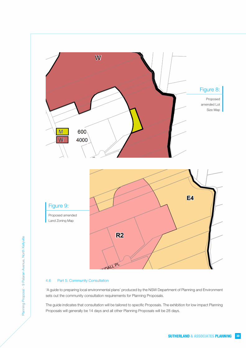
4.5 Part 4: Mapping
The Planning Proposal will require the amendment of the State Environmental Planning Policy (Sydney Region
Growth Centres) 2006:
• North West Growth Centre Lot Size Map - Sheet LSZ_012 to change the minimum lot size that applies
to part of the site from 4,000 square metres to 600 square metres affectation which applies to part of
the site, as illustrated in Figure 8;
• North West Growth Centre Land Zoning Map - sheet LZN_012A to Rezone the subject site from E4
Environmental Living to R2 Low Density Residential, as illustrated in Figure 9 below.
Pla
nnin
g P
ropo
sal -
9 P
alar
an A
venu
e, N
orth
Kel
lyvi
lle
30
Figure 8:
Proposed
amended Lot
Size Map
Figure 9:
Proposed amended
Land Zoning Map
4.6 Part 5: Community Consultation
‘A guide to preparing local environmental plans’ produced by the NSW Department of Planning and Environment
sets out the community consultation requirements for Planning Proposals.
The guide indicates that consultation will be tailored to specific Proposals. The exhibition for low impact Planning
Proposals will generally be 14 days and all other Planning Proposals will be 28 days.

Pla
nnin
g P
ropo
sal -
9 P
alar
an A
venu
e, N
orth
Kel
lyvi
lle
31
A low impact Planning Proposal is described as a Planning Proposal that, in the opinion of the person making
the gateway determination is consistent with the pattern of surrounding land use zones and/or land uses; is
consistent with the strategic planning framework; presents no issues with regard to infrastructure servicing; is
not a principal LEP; and does not reclassify public land.
It would be appropriate to exhibit the Planning Proposal for 14 days as it is considered to be a low impact
Planning Proposal because it is consistent with the pattern of surrounding land use zones, consistent with the
strategic planning framework, and presents no issues with regard to infrastructure servicing.
Community consultation to be commenced by giving notice of the public exhibition of the Planning Proposal in
a local newspaper, on the Council website and in writing to adjoining landowners.
The written notice of the Planning Proposal will:
• give a brief description of the objectives or intended outcomes of the Planning Proposal
• indicate the land affected by the Planning Proposal
• state where and when the Planning Proposal can be inspected
• give the name and address of the relevant planning authority (Canterbury Bankstown Council) for the
receipt of submissions
• indicate the last date for submissions
• confirm whether delegation for making the LEP has been issued to the relevant planning authority.
4.7 Part 6: Project Timeline
The project timeline will be determined by The Hills Shire Council.
Pla
nnin
g P
ropo
sal -
9 P
alar
an A
venu
e, N
orth
Kel
lyvi
lle
32
9 Palaran Avenue, North Kellyville is part zoned R2 Low Density Residential and part zoned E4 Environmental
Living pursuant to Appendix 2 North Kellyville Precinct Plan of the State Environmental Planning Policy (Sydney
Region Growth Centres) 2006.
In accordance with Clause 4.1C(3)(b) of Appendix 2 of the Growth Centres SEPP any allotment created from a
subdivision of land within the E4 Environmental Living zone must not be less than the minimum size shown on
the Lot Size Map. A 4,000 square metre minimum lot size applies to the E4 Environmental Living zoned part of
the subject site. Notwithstanding this, Clause 6.5 allows subdivision of land in the Zone E4 Environmental Living
with a minimum lot size of 600 square metres, however, this is only on a Community title basis in accordance
with the Community Land Development Act 1989 for a neighbourhood scheme. The objectives for Clause 6.5
are to provide for residential development that takes account of the special values of land in Zone E4
Environmental Living and to ensure the land is managed and conserved in a holistic and sensitive manner. Clause
6.5 only allows subdivision on a Community title basis because it anticipates that sensitive land and bushfire
asset protection zones in a development will be protected as a neighbourhood allotment, as explained in Section
3.7 of the North Kellyville Precinct Development Control Plan 2018 (DCP 2018).
The part of the site zoned E4 Environmental Living does not contain any land that has special environmental
values and has become isolated and disconnected from any other lots with special ecological, scientific or
aesthetic values as a result of recent development approvals to the north, south and east of the site. Accordingly,
the objectives of the E4 zone and clause 6.5 have little relevance. Also, the small size of the E4 zoned parcel
of land (4,960.7 square metres) and street frontage that will be provided to this land is such that there is no need
for any new internal roads. Accordingly, the requirement for a neighbourhood allotment in a subdivision of the
site is redundant and there is no need for a requirement for subdivision on a Community title basis.
Whilst Torrens title subdivision of the E4 Environmental Living zoned part of the site is possible, this is only on
the basis of a minimum lot size of 4,000 square metres which is inconsistent with the emerging pattern of
subdivision surrounding the site.
Given the emerging pattern of subdivision surrounding the site and the size of the E4 zoned parcel of land, the
objectives and subdivision controls applicable to E4 zoned land are no longer relevant or appropriate and require
amendment to deliver an orderly pattern of development on this part of the site.
The purpose of the Planning Proposal is to allow the orderly and economic development of the subject site by
facilitating subdivision of the part of the site currently zoned E4 Environmental Living in a manner which more
appropriately reflects the site characteristics and surrounding context.
On this basis, the subject Planning Proposal seeks the following amendments to the State Environmental
Planning Policy (Sydney Region Growth Centres) 2006:
• Amend the North West Growth Centre Lot Size Map to change the minimum lot size that applies to part
of the site at 9 Palaran Avenue from 4,000 square metres to 600 square metres; and
• Rezone the part of the subject site at 9 Palaran Avenue, North Kellyville which is currently zoned E4
Environmental Living to R2 Low Density Residential.
For the reasons outlined in this report it is appropriate for The Hills Shire Council, as the relevant planning
authority, to support the Planning Proposal.
5.0 CONCLUSION

SUTHERLAND & ASSOCIATES PLANNING
APPENDIX A
Robert Moore & Associates
CONCEPT PLAN OF SUBDIVISION A
(RESIDUE LOT)
(RESIDUE LOT)
D P 2 4 9 6 7 5
2
24.96
31.52
120.6
85
70.21526.56517.37
116.9
3
90.215
Arc 0.455
6.09
139.17
26.575
Arc 18.19
34.29
17. 8017.80
40.35
15. 2
2
34.84 35.16
35.63 34.345
33.83 34.91
31.925 32.77
30.075 29.005
25.59
19.70
11.04
16.425
33.98
13.56
14.12
5 14
.68 10
.97 12
.70 7.
465
13.55
14.12
14.67
5 14
.93
15.91
5 10
.285
15.385
18.27
5.625
6.125 12.425 5.66
29.97
5
16.14
5 4.
025
35.315 34.685
13.55
05 11
.41
473.4m²
499.9m²
519.7m²
514.3m²
465.3m²
485.2m²
560.5m²
608.6m²
500.1m²
500.1m²
500.1m²
488.3m²
475.4m²
550.1m²
3.109 Ha
BARABATI R
OAD
(17.8 WID
E)
9
10
11
12
13
14
15
16
17
18
19
20
21
22
15
Arc 2
.71Ar
c 14.7
35
Arc 1
9.925
Arc 1
7.945
Arc 23
.52
Arc 23.4
2
Arc 5.88
ROLAND GARROS CRES(17.80 W
IDE)
ROLAND GARROS
CRESCENTKENDALL PLACE
KINNICK PLACE
(608.5m² ExcLAccess)
(4.0 WIDE)
31.52
32.135
35.05
39.82
45.835
17.6 52.62
31.52
19.03
5 18
.95 17
.97 16
.105
14.06
34.57
5
16.95
5 13
.625
ARC
13.06
ARC
18.21
5
ARC
16.80
5
ARC
15.3
ARC 2
0.09
ARC 17.89
19.03
5 5.
91
1
2
3
4
5
8
600 m²
600 m²
600 m²
600 m²
600 m²
725.6 m²600 m²
635.1 m²
6
7
WIMBLEDON ROAD(17.80 WIDE)
4 5
6
7
8
9
10
11
12
13
14
1
DP 286747
639
638
637
636635634633
632
631
630
DP 1202060
629
628
627625624623622621620619618617616615
640
DP 1202060
1
DP 1262623
Project No.of 1 SheetsSheet No. 1
180036 P5
Client :
PROPOSED SUBDIVISION OF LOT 3 DP 249675Project :
4 KENDALL PLACE, KELLYVILLE
SCALE 1:2000 @ A1Design : RMA
DATUM : AHDSurvey : A' O C
Date : AUGUST 2020
L G A : THE HILLS SHIRE
ROBERT MOORE AND ASSOCIATES PTY LTDENGINEERS, SURVEYING & DEVELOPMENT CONSULTANTS
27 Castle Hill Road, West Pennant HillsNSW 2125
Telephone : (02) 9484 4600 Fax: (02) 9484 4966Email : [email protected]
Description Date By
A1
Drawn : R.L.
GEOFF MORGANS
THE CONCEPTS AND INFORMATION CONTAINED IN THIS DOCUMENT ARE THE COPYRIGHT OF ROBERT MOOREAND ASSOC. USE OF DUPLICATION IN PART OF FULL WITHOUT THE PERMISSION OF ROBERT MOORE AND ASSOC.AND THE CLIENT NOTED HEREON CONSTITUTES AN INFRINGEMENT OF COPYRIGHT
Ver.
Ver.
B
FIRST ISSUE 06/08/20 R.L.A
N
NOTES:
PROPERTY BOUNDARIES ARE APPROXIMATE AND SUBJECT TO CONFIRMATION BY SURVEY
ALL DIMENSIONS AND AREAS ARE SUBJECT TO FINAL SURVEY
METERS2001000 50 15025
DEVELOPMENT APPLICATION635/2019/ZD/A
GENERAL AMENDMENTS 27/11/20 R.L.B