PLANNING IMPLICATIONS OF CLUSTER HOUSING FOR WETLANDS...
97
PLANNING IMPLICATIONS OF CLUSTER HOUSING FOR WETLANDS AND THEIR BUFFERS by Celina Abercrombie A Thesis: Essay of Distinction Submitted in partial fulfillment of the requirements for the degree Master of Environmental Studies The Evergreen State College August 2006
Transcript of PLANNING IMPLICATIONS OF CLUSTER HOUSING FOR WETLANDS...
PLANNING IMPLICATIONS OF CLUSTER HOUSING FOR WETLANDS AND
THEIR BUFFERS
by
Celina Abercrombie
A Thesis: Essay of Distinction Submitted in partial fulfillment
of the requirements for the degree Master of Environmental Studies
The Evergreen State College August 2006
This Thesis for the Master of Environmental Studies Degree by
Celina Abercrombie
has been approved for The Evergreen State College
by
______________________ Edward A. Whitesell
Member of the Faculty
______________________ Date
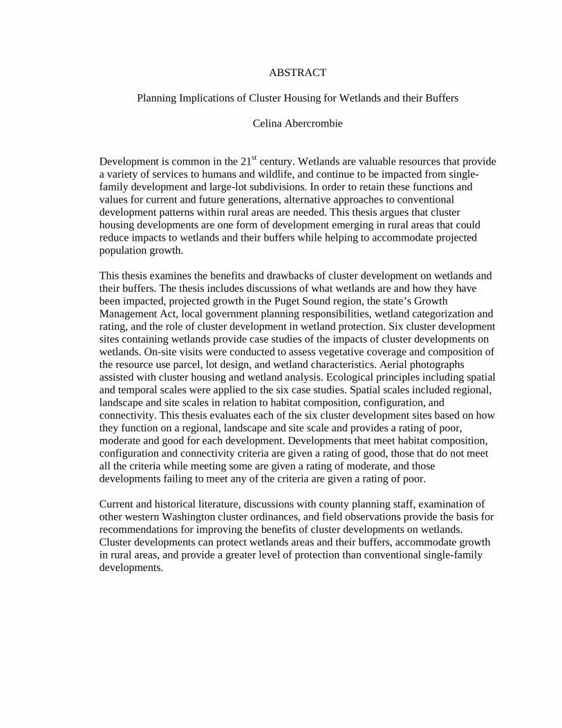
ABSTRACT
Planning Implications of Cluster Housing for Wetlands and their Buffers
Celina Abercrombie
Development is common in the 21st century. Wetlands are valuable resources that provide a variety of services to humans and wildlife, and continue to be impacted from single-family development and large-lot subdivisions. In order to retain these functions and values for current and future generations, alternative approaches to conventional development patterns within rural areas are needed. This thesis argues that cluster housing developments are one form of development emerging in rural areas that could reduce impacts to wetlands and their buffers while helping to accommodate projected population growth. This thesis examines the benefits and drawbacks of cluster development on wetlands and their buffers. The thesis includes discussions of what wetlands are and how they have been impacted, projected growth in the Puget Sound region, the state’s Growth Management Act, local government planning responsibilities, wetland categorization and rating, and the role of cluster development in wetland protection. Six cluster development sites containing wetlands provide case studies of the impacts of cluster developments on wetlands. On-site visits were conducted to assess vegetative coverage and composition of the resource use parcel, lot design, and wetland characteristics. Aerial photographs assisted with cluster housing and wetland analysis. Ecological principles including spatial and temporal scales were applied to the six case studies. Spatial scales included regional, landscape and site scales in relation to habitat composition, configuration, and connectivity. This thesis evaluates each of the six cluster development sites based on how they function on a regional, landscape and site scale and provides a rating of poor, moderate and good for each development. Developments that meet habitat composition, configuration and connectivity criteria are given a rating of good, those that do not meet all the criteria while meeting some are given a rating of moderate, and those developments failing to meet any of the criteria are given a rating of poor. Current and historical literature, discussions with county planning staff, examination of other western Washington cluster ordinances, and field observations provide the basis for recommendations for improving the benefits of cluster developments on wetlands. Cluster developments can protect wetlands areas and their buffers, accommodate growth in rural areas, and provide a greater level of protection than conventional single-family developments.
iii
Table of Contents
Page List of Figures iv
List of Tables iv
List of Plates v
Acknowledgements vi
Introduction 1
Chapters
1 History and Background 5
2 Wetlands and Cluster Housing: A Review of the Literature 16
3 Cluster Housing Developments: A Case Study of
Thurston County 26
4 An Analysis of Benefits and Recommendations 54
Conclusion 83
Appendix 86
Summary of Cluster Housing Development Regulations in Select
Western Washington State Counties
References Cited 88
iv
List of Figures Figure Page
Figure 1 Cluster Development with Density Bonus and On-Site Wetland 32
Figure 2 Conventionally Developed Lot Configuration with On-Site Wetland 33
Figure 3 Selected Cluster Developments in Thurston County 38
List of Tables
Table Page
Table 1 Mason County Wetland Buffers 12
Table 2 Wetland Categorization 13
Table 3 Thurston County Population Growth 27
Table 4 Wetland Buffer Requirements in Thurston County 35
Table 5 Description of Selected Cluster Developments in Thurston County 39
Table 6 Summary of Applied Ecological Principles 56
Table 7 Summary of Spatial Scale Ratings for Selected Cluster Housing Developments in Thurston County 58
v
List of Plates
Plate Page
Plate 1 Field of Dreams Aerial Photo and Wetland Overlay 41
Plate 2 Field of Dreams Wetland Buffer Conditions 42
Plate 3 Field of Dreams Wetland Buffer Fencing 42
Plate 4 North Pointe at Tolmie Aerial Photo and Wetland Overlay 43
Plate 5 Tolmie Development 44
Plate 6 Wetland Buffer Conditions near Tolmie Development 44
Plate 7 Reserve at Cooper Point Aerial Photo and Wetland Overlay 45
Plate 8 Road Construction Adjacent to Wetland Buffer at Cooper Point 46
Plate 9 Northern Portion of Cooper Point Development 46
Plate 10 Countrywood Estates Aerial Photo and Wetland Overlay 47
Plate 11 Debris in Wetland Buffer at Countywood Estates 48
Plate 12 Countrywood Estates Development 48
Plate 13 Talcott Ridge Aerial Photo and Wetland Overlay 49
Plate 14 Wilda Place Aerial Photo and Wetland Overlay 50
Plate 15 Development Adjacent to Wetland Buffer at Wilda Place 51
Plate 16 View of Wetland at Wilda Place 51
vi
Acknowledgements
I would like to thank my thesis reader Ted Whitesell for his critique of this document and providing useful recommendations for improvement. I would also like to thank Jennifer Hayes and other Thurston County Planning Department staff for their willingness to discuss planning-related issues with me and locate information. A special thanks to my parents, Jack and Helen Witschger, who have supported me in my academic and professional endeavors. Finally, I would like to thank my husband, Steve Abercrombie. Without his support, guidance and feedback, this thesis would not be possible.
1
Introduction
Development continues to increase in the 21st century. As population growth
increases in rural areas, development pressure increases as well. Wetlands are valuable
resources that continue to be impacted from single-family development and large-lot
subdivisions. Cluster housing developments are one form of development emerging in
rural areas that have the potential to reduce impacts to wetlands and their buffers while
helping to accommodate projected population growth.
Wetlands provide a variety of functions and values to humans and wildlife, and
serve as vital natural resources that must be protected to the maximum extent possible. In
order to retain these functions and values for current and future generations, alternative
approaches to conventional development patterns within rural areas are needed. A variety
of benefits, including open space and wetland preservation, linking open space via habitat
corridors, and clustering developments to reduce impervious surfaces are just a few of the
benefits associated with cluster housing. Cluster development provides an alternative to
conventional development, and generates a greater level of protection for wetlands and
their buffers.
This thesis argues that cluster developments can protect wetland areas,
accommodate rural growth and provide a greater level of protection than single-family
residential developments in rural areas. This thesis will examine the benefits and
drawbacks of cluster development on wetlands and their buffers, discuss population
growth in rural areas and the implications for future development, look at cluster and
conventional development within the rural landscape, and provide recommendations for
other local government jurisdictions that are updating or adding a cluster development
ordinance.
2
Research questions for this work include:
1) What are the benefits and drawbacks of cluster developments on wetlands and
their buffers?
2) Can cluster developments provide a greater level of protection to wetlands and
their buffers than conventional development?
3) Can cluster developments help accommodate population growth in rural areas?
Chapter two provides background information on cluster housing developments,
wetlands and wetland protection. It discusses what wetlands are and how they have been
impacted, projected growth in the Puget Sound region, the state Growth Management
Act, and local government planning responsibilities. It also examines wetland
categorization and rating, and introduces the role of cluster development in wetland
protection and state and local government planning.
Chapter three includes a review of literature related to cluster housing and
wetlands. Scientific and planning literature was used to develop a foundation for further
discussion of cluster housing developments and wetland protection.
Chapter four examines cluster housing in Thurston County, Washington, and
draws on examples of six cluster developments within the county. This chapter provides
insight to Thurston County’s cluster housing ordinance revision, rural growth within the
county, the cluster housing task force purpose and findings to date, and documents field
observations at six cluster sites within the county.
In order to evaluate the impacts of cluster developments on wetlands, only sites
containing wetland systems were visited. The size of the developments varied from large
(327 acres) to small (19 acres). Different size developments were visited in order to
gauge whether the size of development influenced the on-site wetland and buffer
conditions. The variation in site conditions including topography, relation to adjacent
development (both conventional and clustered), lot configuration, vegetative
3
composition, and other habitat features at each cluster site were examined to determine
beneficial features and additional influences on wetland areas.
Vegetative coverage and composition of the resource use parcel, lot design, and
wetland characteristics were observed using aerial photos and parcel information
obtained from the Thurston County GeoData website, and on-site observations. The
presence of signs and fencing, debris, wildlife use, and the general condition of the
resource use parcel were examined and recorded during site visits. Photographs taken
during field visits and Thurston GeoData aerial photographs are included within the text
of each cluster site discussion to help illustrate observed wetland and buffer conditions.
Chapter five analyzes the benefits and drawbacks of cluster development by
applying ecological principles to the Thurston County case studies, presents the benefits
and drawbacks of clustering on wetlands and their buffers, and provides
recommendations for other rural-based counties in western Washington.
The ecological principles used to evaluate these sites include temporal and spatial
scales. Temporal scales include short and long-term considerations for land use. Spatial
scales include regional, landscape and site scales in relation to habitat composition,
configuration, and connectivity. This thesis evaluates each of the six cluster development
sites based on how they function on a regional, landscape and site scale and provides a
rating of poor, moderate and good for each development. Developments that meet habitat
composition, configuration and connectivity criteria will be given a rating of good, those
that do not meet all the criteria but meet some will be given a rating of moderate, and
those developments failing to meet any of the criteria will be given a rating of poor.
This chapter incorporates information from the literature review, discussions with
county planning staff, other western Washington cluster ordinances, and field
observations, to provide recommendations for improving the benefits of cluster
developments on wetlands.
4
Finally, chapter six presents conclusions for cluster housing and wetland
protection, finding that cluster developments can protect wetlands areas and their buffers,
accommodate growth in rural areas, and provide a greater level of protection than
conventional single-family developments.
Given the need for more information pertaining to cluster developments in
Thurston County and the county’s formation of the cluster housing task force, this thesis
recognizes the need for additional information related to critical area impacts and cluster
housing. Few local government ordinances focus on the potential impacts of cluster
developments on wetland areas, and the lack of literature related to this topic reinforces
this need. This work acknowledges the many potential benefits of cluster development
and seeks to evaluate those impacts from an ecological perspective.
5
Chapter 1 - History and Background
The concept of cluster development has been in existence for millennia. Cluster
development, simply put, is the tight grouping of houses within one area of land,
retaining the remainder of that land for agriculture, forestry, open space, and critical area
protection. Medieval villages and basic community design have used this development
pattern, but it was not until the 1950s and 1960s that its popularity increased in the
United States as a formal building and design concept.
Cluster developments increased popularity is due in part to the exhaustion of the
conventional large lot developments common in the 1940s and 1950s (Whyte, 1964). The
developments of the 1940s and 1950s pushed residential development farther from
community areas such as markets and shopping centers, increased the need and cost for
public infrastructure, and required large areas, which were becoming more expensive as
population growth and property values increased (Whyte, 1964).
As development consumed more of the landscape, critical areas, such as streams,
steep slopes, aquifer and groundwater recharge areas, wetlands and sensitive habitats,
were impacted and often destroyed. Nature performs a number of functions such as flood
retention, food propagation, and fish and wildlife habitat but to developers these areas are
meant to be controlled through filling, damming and conversion for human purposes
(Whyte, 1968). Ian McHarg argued that nature should be at the center of community
design and aquifers, wetlands, slopes and other natural features should be incorporated
into site plans because of the important functions and values they provide (Whyte, 1968).
Wetlands are one of the many critical areas at risk from development. While
regulations are in place through local, state and federal government agencies to protect
this resource, developers often propose impacts to wetlands and their buffers in order to
expand the existing buildable area. Cluster development is one planning mechanism with
the potential to protect wetlands and their buffers, which provide recreational and
educational opportunities to the public.
6
This chapter will provide a brief discussion of what wetlands are and how they
have been impacted, projected growth in the Puget Sound region, the state Growth
Management Act, local government planning responsibilities, wetland categorization and
rating, and the role of cluster development in wetland protection and state and local
government planning.
Wetlands Wetlands have been defined as many things, ranging from swamps and bogs to
ponds and muddy areas. For many years, the functions and values wetlands provided
were a mystery. Over the last 30 to 40 years, our knowledge of wetlands has expanded
dramatically, however, there is still much to be learned about these important
environments and additional research is necessary to fully understand their interaction
with the landscape.
The U.S. Army Corps of Engineers (Corps) and the Washington State Growth
Management Act (GMA) define wetlands as “those areas that are inundated or saturated
by surface or groundwater at a frequency and duration sufficient to support, and under
normal circumstances do support, a prevalence of vegetation typically adapted for life in
saturated soil conditions. Wetlands generally include swamps, marshes, bogs and similar
areas” (U.S. Army Corps of Engineers, 1987; Washington State Growth Management
Act, 1990).
In order for an area to be classified as a wetland it must contain hydrophytic
vegetation, hydric soils and specific hydrology indicators. These three parameters provide
the necessary conditions to meet the above definition of a wetland.
In 1995, Smith et al. developed the hydrogeomorphic classification for assessing
wetland functions. The hydrogeomorphic (HGM) classification applies to a wide
geographic area, is able to assess a variety of wetland types and functions, and has the
ability to assess functions accurately and efficiently. This classification is based on three
factors including geomorphic setting, water source, and hydrodynamics. Wetlands are
7
grouped into seven HGM classes including depression, lacustrine fringe, tidal fringe,
slope, riverine, mineral flat, and organic flat.
Depressional wetlands occur in topographic depressions that allow water to
accumulate. Dominant water sources include precipitation, groundwater discharge, and
interflow from adjacent uplands. Lacustrine fringe, also referred to as lake fringe,
wetlands lie adjacent to lakes where water elevation of the lake controls the water table.
Tidal fringe wetlands occur along coasts and estuaries and are influenced by tidal
fluctuations. Tidal fringe wetlands intergrade landward with riverine wetland systems
where freshwater from a river system becomes the dominant water source. Slope
wetlands occur on steep and slight slopes. They are generally not capable of water
storage because they lack closed contours. Riverine wetlands occur in floodplains and in
association with river and stream systems. The dominant water source is over-bank
flooding. Mineral flats are common on interfluves, relic lake bottoms and large floodplain
terraces with the main source of water from precipitation. Organic flats wetlands also
receive water primarily from precipitation but occur on flat interfluves (Smith et al.,
1995).
The HGM classification is a key component to assessing the functions of any
wetland system. Wetlands occur within a variety of landscapes and provide different
levels of function depending on their location, inputs and outputs. Wetland
categorization, or rating, relies heavily on the HGM system.
Wetlands provide a number of services including water quality improvement, fish
and wildlife habitat, nutrient cycling, aquifer recharge, flood retention, and sediment
control. While many landowners do not recognize the functions wetlands provide, they
often appreciate them for such things as protection of property, and passive and active
recreation such as hunting or bird watching. Wetlands provide a variety of beneficial
functions to both the environment and society, and need to be protected.
8
Filling, Dredging and Alteration of Wetlands The dredging and filling of wetlands is directly related to development as much of
the filling and dredging is performed to improve navigation for the distribution of goods,
and create upland development areas from wetlands. As population growth continues to
rise, pressure to fill and dredge wetland areas increases.
Over 220 million acres of wetlands are thought to have existed in the lower 48
states during the 1600s. Since then, losses have occurred with over half of our original
wetlands having been drained and converted to other uses. The period from the mid-
1950s to the mid- 1970s were a time of major wetland loss, and between 1986 and 1997,
an estimated 58,500 acres of wetlands were lost each year in the United States alone
(EPA, 2006).
In 1977, the Clean Water Act was established to regulate pollutant discharges into
waterways. Section 404 of the Clean Water Act regulates the discharge of dredged or fill
materials into waters of the United States, including wetlands (EPA, 2006).
The United States Army Corps of Engineers (Corps), Environmental Protection
Agency (EPA), and Department of Fish and Wildlife (USFWS) are the three federal
agencies given regulatory authority to protect waters of the United States and regulate
activities in wetlands. Under the Section 404 of the Clean Water Act (1977), the Corps is
given authority to “issue general permits on a State, regional, or nationwide basis for any
category of activities involving discharges of dredged or fill material if the Secretary
determines that the activities in such category are similar in nature, will cause only
minimal adverse environmental effects when performed separately, and will have only
minimal cumulative adverse effects on the environment” (33 CFR Part 320). Through
Section 404 of the Clean Water Act, the Corps is a key player in wetland protection at the
federal level. In 1987, the Corps played an instrumental role in developing a wetland
delineation manual, which remains in use today.
9
Population Growth in the Puget Sound Historically, development has meant a reduction or alteration in wetlands. It was
not until the 1960s and 1970s that wetlands and other critical areas began receiving
significant levels of attention from the scientific community and the services they
provided to society were identified. Over 40 years later, critical areas still remain at risk
from development, largely due to population growth and human induced activities. Steps
have been taken to plan for and control growth, and regulate specific activities within
critical areas reducing many of the historical impacts to wetlands.
Population growth in Puget Sound has contributed significantly to declines in
water quality and biological resources over the past several decades. Unmanaged growth
outside of urban areas, or sprawl, has in many areas led to increased traffic, higher costs
for utility infrastructure and new schools, fire, health and police services, as well as costs
to protect and restore natural resources (PSAT, 2006).
By 2020, population growth in the Puget Sound region is expected to exceed five
million people (a further twenty-nine percent growth) in the Puget Sound region (Georgia
Basin, 2002). “The 12-county Puget Sound region, including Seattle and Tacoma, has
quadrupled to 4 million people since the 1950s, and the state predicts 1 million more
residents by 2025” (Ritter, 2005, p. 3a). Metropolitan areas have accommodated much of
the Puget Sound regions population growth, however, an increased number of
homeowners seek quieter suburban and rural areas for living, which pushes development
farther from the metropolitan core.
While regulations are in place to protect wetlands, these areas and their buffers
are still being altered and developed. Population growth leads to increased pressure for
development in metropolitan fringes and rural areas, and thus the alteration of wetland
areas. Accommodating increased growth must be coupled with wetland protection in
order to ensure that the services wetlands provide are maintained for future generations.
The responsibility for county and city (local) wetland protection lies within the hands of
10
the state Growth Management Act (GMA) and local planning departments, as they work
to comply with the GMA.
Growth Management Act (GMA), Rural Lands and Critical Areas The State of Washington adopted the Growth Management Act (GMA) in 1990
and amended it in 1991 to include growth management hearing boards. This act sets up a
system of state-mandated comprehensive planning for the most populated and fastest
growing counties of the state.
The GMA identifies mandatory elements that must be incorporated into
comprehensive plans, including land use, housing, capital facilities, utilities, rural,
transportation, economic development, parks and recreation. The rural element includes
lands not designated for urban growth, forestry, agriculture, and mineral resources.
Within the rural element requirement, the GMA states:
(b) Rural Development. The rural element shall permit rural development, forestry, and agriculture in rural areas. The rural element shall provide for a variety of rural densities, uses, essential public facilities, and rural governmental services needed to serve the permitted densities and uses. To achieve a variety of rural densities and uses, counties may provide for clustering, density transfer, design guidelines, conservation easements, and other innovative techniques that will accommodate appropriate rural densities and uses that are not characterized by urban growth and that are consistent with rural character (RCW 36.70A.070).
The Growth Management Act (1990) provides the following guidance for rural
development and the protection of rural character:
(i) Containing or otherwise controlling rural development; (ii) Assuring visual compatibility of rural development with the surrounding rural area; (iii) Reducing the inappropriate conversion of undeveloped land into sprawling, low-density development in the rural area; (iv) Protecting critical areas, as provided in RCW 36.70A.060, and surface water and ground water resources; and (v) Protecting against conflicts with the use of agricultural, forest, and mineral resource lands designated under RCW 36.70A.170 (RCW 36.70A).
11
The act emphasizes controlling and reducing low-density developments that result
in sprawl, but lays the foundation for clustering and alternative development techniques
so long as a variety of rural densities are provided and measures are in place to govern
rural development and protect rural character. In addition, the GMA mandates that all
counties adopt an ordinance that classifies, designates, and protects critical areas, not
only in rural environments but also in urban and suburban areas.
The Growth Management Act (2005) defines critical areas as wetlands; areas with
a critical recharging effect on aquifers used for potable water; fish and wildlife habitat
conservation areas; frequently flooded areas; and geologically hazardous areas (RCW
36.70A.030).
While the GMA does not provide local government agencies with wetland buffer
widths and protective measures, it requires each local government to develop its own
protective measures based on land uses and other local factors, to ensure that the
functions and values provided by wetlands are not diminished by development.
Local Government Planning Based on GMA mandates, local government departments use comprehensive
plans to develop regulations that govern a variety of activities, including environmental
protection, zoning and development requirements. These codes provide strict
requirements for development in the form of titles and chapters, and contain information
such as critical area buffer widths, zoning designations, traffic codes and health codes.
Each local government’s comprehensive plan contains a section related to
environmental protection, and defines critical areas and states the purpose for their
protection. Wetlands are listed in virtually every critical area ordinance. In general, local
governments define critical areas as aquifer recharge areas, geologic hazard areas,
important habitats and species, special management areas, floodplains, streams and
wetlands.
12
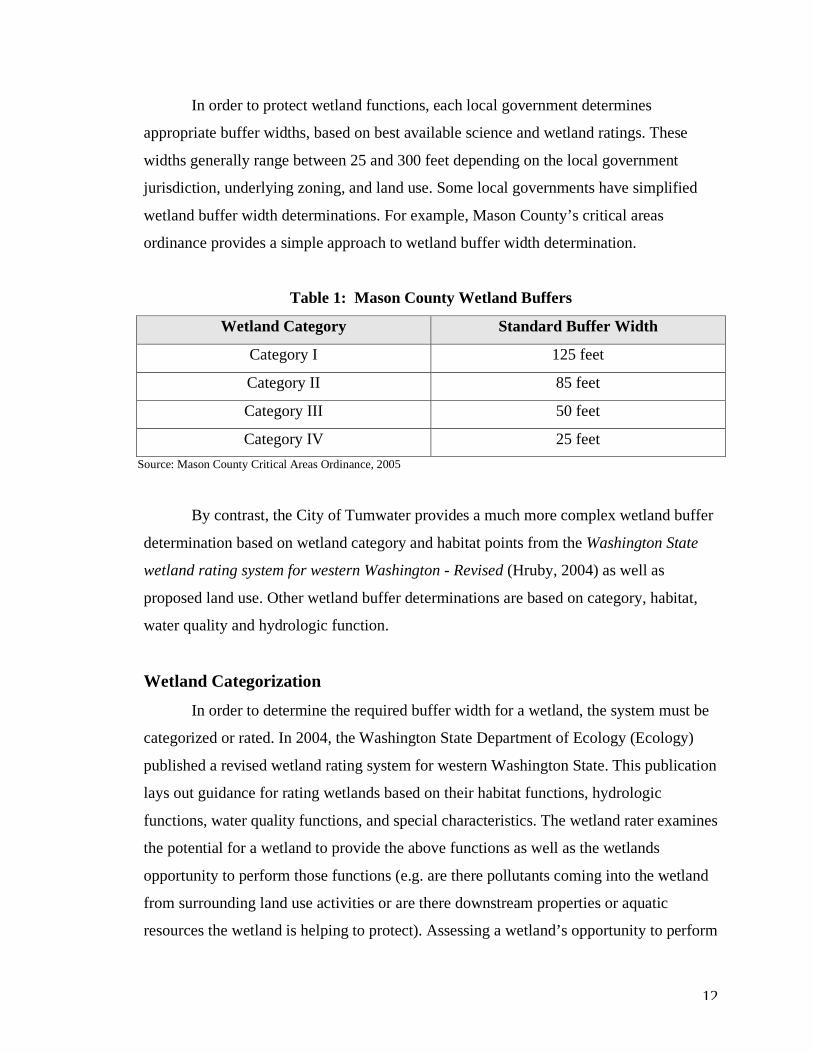
In order to protect wetland functions, each local government determines
appropriate buffer widths, based on best available science and wetland ratings. These
widths generally range between 25 and 300 feet depending on the local government
jurisdiction, underlying zoning, and land use. Some local governments have simplified
wetland buffer width determinations. For example, Mason County’s critical areas
ordinance provides a simple approach to wetland buffer width determination.
Table 1: Mason County Wetland Buffers
Wetland Category Standard Buffer Width
Category I 125 feet
Category II 85 feet
Category III 50 feet
Category IV 25 feet Source: Mason County Critical Areas Ordinance, 2005
By contrast, the City of Tumwater provides a much more complex wetland buffer
determination based on wetland category and habitat points from the Washington State
wetland rating system for western Washington - Revised (Hruby, 2004) as well as
proposed land use. Other wetland buffer determinations are based on category, habitat,
water quality and hydrologic function.
Wetland Categorization In order to determine the required buffer width for a wetland, the system must be
categorized or rated. In 2004, the Washington State Department of Ecology (Ecology)
published a revised wetland rating system for western Washington State. This publication
lays out guidance for rating wetlands based on their habitat functions, hydrologic
functions, water quality functions, and special characteristics. The wetland rater examines
the potential for a wetland to provide the above functions as well as the wetlands
opportunity to perform those functions (e.g. are there pollutants coming into the wetland
from surrounding land use activities or are there downstream properties or aquatic
resources the wetland is helping to protect). Assessing a wetland’s opportunity to perform
13
various functions requires investigating the existing land use to determine whether the
wetland can protect adjacent development.
Four wetland categories have been established and a section on special
characteristics for estuarine wetlands, bogs, natural heritage wetlands, forested wetlands,
wetlands in coastal lagoons, and interdunal wetlands. The following table summarizes the
four categories.
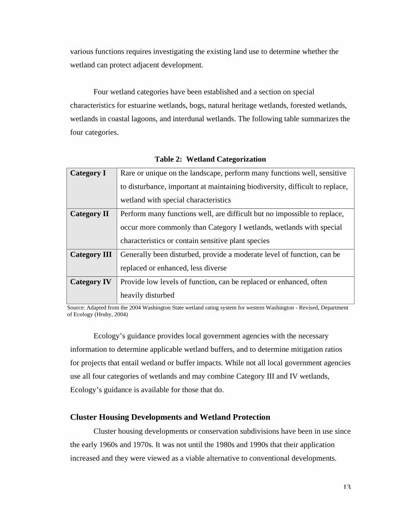
Table 2: Wetland Categorization
Category I Rare or unique on the landscape, perform many functions well, sensitive
to disturbance, important at maintaining biodiversity, difficult to replace,
wetland with special characteristics
Category II Perform many functions well, are difficult but no impossible to replace,
occur more commonly than Category I wetlands, wetlands with special
characteristics or contain sensitive plant species
Category III Generally been disturbed, provide a moderate level of function, can be
replaced or enhanced, less diverse
Category IV Provide low levels of function, can be replaced or enhanced, often
heavily disturbed Source: Adapted from the 2004 Washington State wetland rating system for western Washington - Revised, Department of Ecology (Hruby, 2004)
Ecology’s guidance provides local government agencies with the necessary
information to determine applicable wetland buffers, and to determine mitigation ratios
for projects that entail wetland or buffer impacts. While not all local government agencies
use all four categories of wetlands and may combine Category III and IV wetlands,
Ecology’s guidance is available for those that do.
Cluster Housing Developments and Wetland Protection Cluster housing developments or conservation subdivisions have been in use since
the early 1960s and 1970s. It was not until the 1980s and 1990s that their application
increased and they were viewed as a viable alternative to conventional developments.
14
In conventional developments, parcels are divided into sizes based on the pre-existing or
underlying zoning. For example, if the underlying zoning is 1/5 (one house per five
acres), a 20-acre parcel can be divided into four parcels each five acres in size. This form
of development is often termed “cookie-cutter” in that it indiscriminately divides the land
into rectangles and squares, with each home having a private access road, utilities, and a
septic system.
In a cluster development, the houses are clustered on one portion of the larger
parcel, say five acres, and the remaining acreage is set aside as a resource use parcel. The
resource use parcel can comprise open space, agricultural land, forestry land, passive and
active recreation, or critical area preservation. The developed five acres are divided into
smaller parcels with higher densities than the underlying zoning would allow. In many
cases, a density bonus is provided, allowing for an additional parcel or building site over
what the underlying zoning would allow. For example a 20-acre parcel with a 1/5 zoning
would allow for four building sites, but on a clustered site the local government agency
may allow for five building sites (density bonuses will be discussed in greater detail in
chapter four). Cluster developments provide incentives to developers such as density
bonuses. Other benefits include reduced infrastructure costs because less land is being
developed, requiring fewer access roads and utilities.
Each local government agency has its own requirements and regulations for
cluster developments. Some require the creation of pods, or small groupings of two to
twenty residential lots, for the clusters, which must be certain distances apart depending
on vegetative buffering or screening, minimum and maximum lot sizes, or a minimum or
maximum number of parcels or building sites. In addition, some allow density bonuses
with a specific percent calculation for determining the allowable bonus, whereas others
do not provide for density bonuses.
Typically, cluster site development takes into account where wetlands or critical
areas lie on the landscape, topography, and existing vegetation or features such as mature
15
trees and rock outcrops. The development is planned around existing features and
requires less clearing and grading since a portion of the site is dedicated to open space or
natural resource use.
Population growth, desirability of living in suburban and rural areas, decreases in
land availability, regulations protecting wetlands and critical areas, and pressure placed
on local building departments for infrastructure expansion, all create a need for cluster
housing developments. Since growth is inevitable, planning agencies have recognized
cluster development as one mechanism to protect wetlands while accommodating growth,
particularly in rural areas. In general, cluster developments can help protect wetlands,
maintain active farm and forestry land, and provide habitat corridors for wildlife through
open space connections.
This chapter provided an overview of wetland types and parameters for defining a
wetland, and a framework for wetland regulation through the Corps, Ecology, and local
government planning bodies. It discussed population growth pressures, provided general
information on cluster housing developments, and discussed the role of cluster
developments in wetland protection.
Cluster housing developments and wetlands function within similar regulatory
frameworks. In order to aid in evaluating the benefits and drawbacks of cluster housing
developments on wetlands, this chapter developed a greater understanding of the role
cluster developments and population growth play in relation to wetlands and current
wetland regulations. The following chapter provides a discussion of current and historical
literature related to wetlands and cluster developments.
16
Chapter 2 - Wetlands and Cluster Housing: A Review of the Literature
Wetlands provide a variety of important ecological functions and services, many
of which are highly valuable for humans. In order to retain these functions and values,
development practices that maximize the benefits wetlands provide should be
encouraged. Cluster housing developments have the potential to protect wetlands and
their buffers to a greater extent than conventional developments while helping to
accommodate projected population growth. The cluster design concept has been around
for hundreds of years, however, the present-day application of cluster developments did
not receive much attention until the late 1980s and early 1990s, as will be seen in the
following discussion of literature related to cluster housing developments and wetlands.
Numerous works cite the use and expansion of cluster housing developments but
few provide information on the benefits and drawbacks of cluster housing associated with
wetlands. While work has been prepared on cluster housing benefits for forestry and
agricultural practices, especially the protection of small forestry and farming operations,
there is a lack of information related to environmental impacts. This literature review will
detail the available information, both current and historical, on cluster housing
developments and wetland protection and impacts.
Cluster Housing Developments There is a distinction to be made between clustering in urbanized versus rural
areas. Urban clusters are designed to meet the needs of an urban population. These
clusters generally contain playgrounds, swimming pools, gardens, and recreational spaces
(Whyte, 1964). The intentions of these recreational areas are well taken, however, these
areas are not always used for their intended purpose and formal play areas go unused
(Whyte, 1968). While golf courses and community buildings may be present in rural
cluster applications, their intention in the urban environment is to provide recreational
areas that otherwise may not be available in the city, and to create a sense of community
that is often lacking in large-lot subdivisions. By contrast, rural cluster development is
17
focused on preserving resource lands and creating open space and habitat corridors. This
literature review will focus on cluster developments in rural areas.
The late Ian McHarg, perhaps the most well-known landscape architect and city
planner of the twentieth century, argued that nature should be at the center of community
design and aquifers, wetlands, slopes and other natural features should be incorporated
into site plans because of the important functions and values they provide to man (Whyte,
1968). McHarg’s belief that nature should be at the center of community design is one of
the underlying premises of cluster housing developments, also referred to as
“conservation subdivisions”. Important natural features such as wetlands become focal
points within the development, providing environmental and social benefits.
Site planning for cluster housing can retain a variety of natural features that are
beneficial to humans and the environment, if done properly. One of the goals of cluster
development is to work with nature, and the best way to avoid a problem is not to build
within a problem area (Untermann et al., 1977). In order to identify potential problem
areas prior to development, the McHarg Suitability Method can be employed.
The McHarg Suitabilty Method was developed in the late 1960s and includes the
following steps to developing with nature in mind, a concept discussed in McHarg’s
Design with Nature, published in 1969.
1. Define goals, objectives and land use, and establish study boundaries.
2. Conduct an ecological inventory of the relevant physical and biological processes.
3. Map he inventory.
4. Examine each mapped area for its suitability for the proposed land use activity.
5. Overlay the mapped features such as slopes, wetlands, and drainage on one
another to determine residential suitability.
6. Combine suitability maps for individual land uses. Interpret and document the
maps for allocating land or for larger ecological studies.

18
This method provides an elaborate inventory of site conditions for planning and
development purposes. Suitable soils, vegetative communities, and critical areas can be
avoided once identified and mapped.
Several inventory and suitability methods have been developed over the years for
the application of ecological planning including the first and second landscape-suitability
approaches, the applied human-ecology approach, the applied-ecosystem approach, and
the applied-landscape-ecology approach (Ndubisi, 2002). Each of these approaches
contains one common element – incorporating ecological principles as the basis for
guiding human actions in the landscape (Ndubisi, 2002). Many of these principles are
important elements in cluster housing today.
To further the idea of identifying important natural features for planning and site
development, Richard Untermann et al. (1977) provides the following recommendations
for retaining portions of the site for wildlife use: water features are maintained; natural
areas are maintained, and special attractions for wildlife are incorporated into site plans.
The retention of streams and lakes and associated vegetation provides desirable habitat.
This habitat can be maintained while still allowing people to use these water features in
concentrated areas. Natural areas such as meadows and forested areas should consist of
primarily native vegetation, should not be maintained by man, and should be free of
pesticides and other harmful sprays. Finally, special attractions such as protection from
domestic animals or the addition of wetland plants within stormwater holding facilities
can be incorporated into the site plan to encourage wildlife use (Untermann et al., 1977).
Site inventories and mapping, coupled with the commitment to retain certain
natural features such as waterways and high-quality habitat, protect valuable land that
provides a variety of benefits to humans and the environment. This approach
distinguishes cluster development from conventional development patterns.
Conventional development impacts typically dominate a site rather than being
conducted in limited areas. Impacts can include removal of tree canopy, understory,
19
grass, and debris; shallow and deep soil exposure; unloading or weighting slopes; surface
areal and linear compaction; subsurface water and surface water sheet flow reduction or
alteration; creation of airborne particulates; introduction of exotic plants; and creation of
impervious surfaces (buildings, paving, compacted fill) (Untermann et al., 1977). These
development activities take place at virtually any development site, however, cluster
development limits these activities to certain areas of the overall site and has the potential
for less impact and disturbance in comparison to conventional development.
In addition to protecting natural features, reduced infrastructure from smaller,
more compact lot configurations, reduced pollutant runoff from less impervious surface
coverage, and reduced noise pollution and light infiltration are a few of the social,
economic and environmental benefits associated with these developments.
Incentives are available to developers to examine creative solutions to retaining
open space that can protect wetland areas. One incentive that this thesis examines is the
use of density bonuses, which allow developers to subdivide their land and gain
additional houselots while providing open space. Density bonuses are one financial
incentive to developers, however, without some incentive, few cluster developments
would be built (Arendt et al., 1994). However, with regional and localized housing
demands, this financial incentive can be met.
One of the greatest challenges of clustering is linking open space. Many
developments are planned project-by-project without taking their relation to one another
into account (Whyte, 1968). Recommendations for improving this challenging aspect of
clustering include laying out a framework for open space, in which developers contribute
to that land with each development within the same area (Whyte, 1968). While this
increases long-range planning efforts by local government agencies, it opens the door to
public and private benefits that would otherwise only be private. Today, many local
government regulations provide guidance on retaining large, undivided parcels that can
serve as habitat corridors. For example, the Thurston County cluster housing ordinance
requires wildlife corridors to be linked with other wildlife corridors that abut the
20
proposed cluster site (Chapter 20.30A.070(5)(d), 1997). Providing this language within
regulatory documents reflects the importance of wildlife to local government planning
bodies. While many western Washington county cluster ordinances contain similar
language, not all ordinances incorporate this language, and more should be encouraged to
do so.
While many individuals and planning bodies support clustering, there are always
two sides of a coin with increased development in rural areas. Opponents of clustering
raise many important issues that must be addressed when a cluster development is
proposed within a rural area. Rural residents typically complain about increased traffic,
additional pressures on educational systems to provide for increased growth, degradation
of roadways, potential for property value depreciation, aesthetics or visual impacts, and
loss of rural character. Many in opposition to clustering in rural areas are primarily
interested in the social and economic impacts, and few focus on impacts to wetlands.
Little to no information exists related to the direct benefits of cluster
developments for wetlands and other critical areas. However, there is consensus that
clustering is a tool that can help to establish an interconnected network of open space for
a wide variety of conservation uses (Arendt, 1996). Open space preservation through
clustering is one of the main environmental benefits cited.
The size of a cluster development is oftentimes important when evaluating a
development, especially for a rural area where houses are generally situated on larger
tracts of land than urban areas. Larger projects are generally less pleasing than smaller
ones because they dominate and overwhelm the adjacent landscape (Whyte, 1964). For a
rural development project, this may be undesirable to neighboring property owners who
enjoy a view of trees or mountains and quiet surroundings. Careful planning must be used
when designing larger cluster developments in rural environments. This also brings to the
forefront an important planning element under the GMA, which is the preservation of
rural character. Some doubt whether rural character can be maintained through the
21
development of larger cluster projects. Developing a vision and plan for rural areas can
protect rural character while meeting the needs of this community sector (CTED, 1999).
Through clustering and open space preservation, critical resources including
wetlands can be protected. While there is a lack of information on wetland and wetland
buffer protection through clustering, there is substantial literature on wetland protection
that can be applied to cluster development. One of the aims of this thesis is to make this
apparent, so as to strengthen the ability of planning to effectively protect wetlands
associated with cluster housing developments.
Wetlands Many wetland habitats within western Washington have been mapped and
classified, however, a number of wetland systems remain unidentified. Wetlands vary in
size, function, and diversity. Wetlands recognized as having high value in the Puget
Sound region include those containing juvenile salmonid habitat, herring spawning beds,
surf smelt spawning beds, salt marshes, eelgrass beds, kelp beds, rocky intertidal areas,
bird habitats, endangered species habitat, marine mammal habitat, refuges and
sanctuaries, bogs and swamps (PSWQA, 1986). It is estimated that over 100 million acres
of estuarine and palustrine wetlands existed in the conterminous United States in the mid-
1970s. The mid-1950s through the mid-1970s recorded a net loss of over 11 million acres
and a net gain of two million acres of wetland. Since the 1970s, environmental laws have
been established to protect the remaining wetland areas, however, these areas continue to
be threatened by development activities such as draining, filling, dredging, hydrologic
connection loss, removal and destruction of wetland plants, and activities in non-wetland
areas that impact wetland habitat (PSWQA, 1986).
A variety of city, county, state and federal government agencies maintain
databases of high-quality wetland systems. While these systems receive high levels of
protection, there are a number of undocumented wetland systems that provide important
functions. These undocumented systems are oftentimes the ones that are impacted by
residential development.
22
For many years there has been a controversy over wetlands protection and private
property rights. Developers who have been denied permits for direct wetland impacts
have claimed that the denial of a permit constitutes a “taking” because it restricts use of
their private property (Salvesen, 1994). While these claims have generally not held up in
court, many private property owners feel that wetland protective measures and permit
processes restrict their right to use their property in the manner they see fit and deprives
them of the economic value of the land (Salvesen, 1994). Today, this viewpoint is still
prevalent and may be a factor in wetland and wetland buffer impacts. In some cases,
private property owners see this dilemma as a barrier to reasonable use of their property
and may find it easier to create an impact and resolve it after-the-fact than to wade
through the cumbersome permitting processes and requirements imposed by local, state
and federal governments.
While direct wetland impacts such as dredging and filling are regulated at the
state and federal levels, local governments regulate indirect wetland impacts. Local
governments have established buffer requirements to protect wetlands. These buffers are
based on the category of wetland, which is determined by the level at which the wetland
performs a number of functions such as sediment removal or flood retention. These
buffer ranges vary widely by county or city but provide the minimum level of protection
for the wetland system.
State government bodies, such as the Washington State Department of Ecology,
have examined the effectiveness of wetland buffers based on the buffer width, alterations
within the buffers, and time elapsed from development. Buffers are essential for wetlands
protection. Buffers reduce the adverse impacts of adjacent land uses to wetlands and
provide important habitat for wildlife utilizing wetlands and buffer areas (DOE, 1992).
Buffer effectiveness increases with buffer width and appropriate buffer widths are based
on four variables: (1) existing wetland functions, values and sensitivity to disturbance;
(2) buffer characteristics; (3) land use impacts; and (4) desired buffer functions. In
general, buffers of less than 50 feet in width are generally ineffective in protecting
23
wetlands (DOE, 1992). In western Washington, buffers from 50 to 150 feet are necessary
to protect a wetland from direct human disturbance in the form of human encroachment
(e.g., trampling, debris) (DOE, 1992). While many wetland buffers fit within these
appropriate buffer ranges for protection of wetland functions, impacts are still common
and difficult to avoid, especially with single-family developments surrounding, or
immediately adjacent, to wetland areas. In order to provide needed protection, rural
development patterns must be examined with wetland protection in mind.
Wetland buffers fall victim to a number of impacts associated with adjacent
development. The habitat potential of wetland buffers is generally good but high levels of
human use are often observed, including litter and yard waste disposal in buffers (Dryste,
1995). In order to reduce human impacts on wetlands and their buffers, installation of
fences, signs, designated pathways and boardwalks, and observation platforms are
recommended (Dryste, 1995). These protective features provide opportunities to utilize
wetland areas in environmentally sensitive ways and can increase appreciation and
knowledge of wetland functions and values.
Wetland buffers are a valuable tool for reducing impacts associated with
incompatible adjacent land use, and are considered an effective conservation tool for
wetland species with habitat requirements that extend beyond wetland boundaries
(Houlahan et al., 2006). A strong correlation has been observed between invasive wetland
plant species and greater road densities, likely because disturbed habitats associated with
road construction serve as a conduit for wetland colonization and seed transport
(Houlahan et al., 2006). Wetland protection must manage wetlands and surrounding
habitat at a regional scale by maintaining a heterogenous landscape, including
undisturbed wetland, forests and streams (Houlahan et al., 2006). Wetland systems
cannot be managed as single, isolated units and neighboring land use must be taken into
account for land conservation and long-term wetland preservation.
Buffer areas generally follow a one-size-fits-all approach and fail to take site-
specific information into consideration (McMillan, 2000). A site-specific model for
24
wetland buffer determinations that accounts for wetland functional performance such as
sediment removal, nutrient removal, toxics removal, shading and microclimate
protection, screening, noise, light and intrusion, general wildlife habitat, and habitat for
particular species can be used to identify the appropriate buffer for a particular wetland
system (McMillan, 2000). The potential problem with this approach is that wetland buffer
determinations need to be predictable and easy to apply so that both regulatory staff and
landowners can utilize the system (McMillan, 2000).
Wetlands serve as an exceptional example of applying ecological principles to
assist in understanding the context of future development (Dale et al., 2001). Guidance
provided on wetland protection and development suggests that planning in wetland areas
should be based on ecological guidelines that suggest preservation of rare landscape
elements, retaining large, contiguous, connected areas, and minimizing the introduction
of non-native species (Dale et al., 2001). A landscape approach to planning can eliminate
single approaches to land management as well as landowner frustration, and reduce
demands for exemptions and variances (Dale et al., 2001). Creative and flexible land
management strategies allow local government to modify development with habitat and
ecological principles in mind.
Summary The concept of cluster development has been applied for centuries. This housing
application was primarily used for urban and suburban development, and recently its
application for rural development has become more prominent. Cluster development
incorporates a “design with nature” approach and seeks to retain important natural
features such as wetlands and streams as focal points within the development.
Cluster development allows for flexibility in site planning and design that can
benefit properties containing on-site wetland and buffer areas. These developments can
protect important natural features such as wetlands through a careful site inventory and
by determining the most suitable areas for development. Cluster development limits land
development activities to certain areas of the overall site and has the potential for less
25
impact and disturbance in comparison to conventional development. Reductions in
impervious surface associated with roads and development minimizes the spread of
invasive and non-native plant species that flourish on disturbed sites. By directing
development away from wetlands and their buffers, wetland functional integrity can be
maintained and both humans and wildlife can continue to benefit from the valuable
functions provided by these systems.
Cluster development can also help to maintain large tracts of land for wildlife
movement to on and off-site wetland and upland areas. If properly planned, these
developments preserve connectivity and allow for planning at a regional or landscape
scale, taking into consideration future development.
Wetland buffers suffer a variety of impacts associated with human activity
including dumping of yard waste and debris, trampling and disturbance of vegetation, and
in some cases removal of vegetation. Wetland buffers play a critical role in protection of
wetland systems, and care must be taken to evaluate adjacent land use activities that may
impact wetland functions and species dependent on wetland areas. Cluster development
situates houses and lots outside of wetland buffers, thus reducing the potential for impacts
from adjacent land uses.
A limited amount of information is available on cluster housing developments and
their benefits and drawbacks for wetlands and their buffers. However, the literature
suggests that these developments can help protect wetland areas from human impact and
create connectivity within a fragmented landscape.
The following chapter will examine cluster housing developments in Thurston
County, Washington and provide insight to the benefits and drawbacks associated with
these developments in rural areas.
26
Chapter 3 - Cluster Housing Developments: A Case Study of Thurston County
Thurston County has been at the center of the cluster housing controversy since
2004. In response to numerous letters from individuals and organizations opposed to the
county’s cluster ordinance, the county placed a moratorium on cluster development and,
since then, the county has been revising and updating its existing ordinance. Due to the
recent cluster housing activities in Thurston County, this area of western Washington is
an ideal case study for planners in other government jurisdictions who may be revising
their ordinances or considering implementing cluster ordinances.
The size of approved cluster development applications in all counties varies
greatly, ranging from 3 to 150 houses and/or lots per development. The amount of land
designated as open space or for critical area protection also varies. Designated open space
is generally sixty to eighty percent of the land available. Number of houses, parcel size,
and open space/critical area preservation depend greatly on the initial land available to
the applicant.
This thesis argues that cluster developments can protect wetland areas,
accommodate rural growth and provide a greater level of protection than single-family
residential developments in rural areas. This chapter provides a brief discussion of
population growth in Thurston County followed by a discussion of cluster housing. It will
then discuss wetland protection measures for all development within the county’s
jurisdiction, and provide information on wetland protection in relation to cluster housing.
Finally, it will examine cluster housing development in Thurston County through field
observations taken at six cluster development sites. Examination of Thurston County’s
cluster housing situation will shed light on the benefits and drawbacks of cluster
development on wetlands in rural areas. This chapter incorporates field observations to
illustrate these benefits and drawbacks.
27
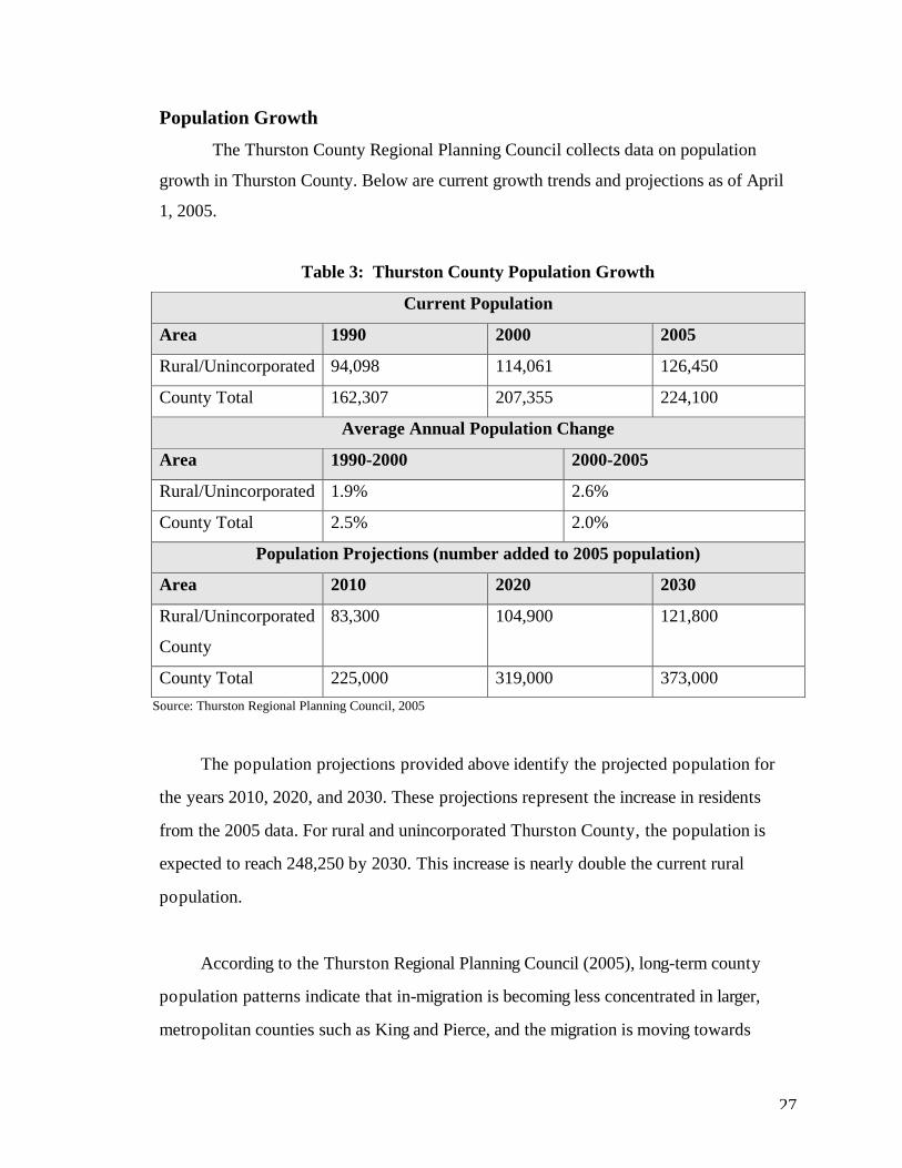
Population Growth The Thurston County Regional Planning Council collects data on population
growth in Thurston County. Below are current growth trends and projections as of April
1, 2005.
Table 3: Thurston County Population Growth
Current Population
Area 1990 2000 2005
Rural/Unincorporated 94,098 114,061 126,450
County Total 162,307 207,355 224,100
Average Annual Population Change
Area 1990-2000 2000-2005
Rural/Unincorporated 1.9% 2.6%
County Total 2.5% 2.0%
Population Projections (number added to 2005 population)
Area 2010 2020 2030
Rural/Unincorporated
County
83,300 104,900 121,800
County Total 225,000 319,000 373,000 Source: Thurston Regional Planning Council, 2005
The population projections provided above identify the projected population for
the years 2010, 2020, and 2030. These projections represent the increase in residents
from the 2005 data. For rural and unincorporated Thurston County, the population is
expected to reach 248,250 by 2030. This increase is nearly double the current rural
population.
According to the Thurston Regional Planning Council (2005), long-term county
population patterns indicate that in-migration is becoming less concentrated in larger,
metropolitan counties such as King and Pierce, and the migration is moving towards
28
neighboring counties such as Thurston, Mason and Kitsap that maintain lower population
densities. Based on current population growth projections, approximately 121,000 new
residents will be moving to rural Thurston County within the next 24 years. This growth
will place tremendous pressure on rural areas.
Another consideration is the amount of land or housing units available at any given
time. This is often referred to as the “build-out” factor, which expects no more than
twenty-five percent of available capacity or number of dwelling units is available at any
given five-year interval (Tabbutt, 2005). Not all vacant land is available or for sale at any
given time (Tabbutt, 2005). Approximately 121,000 new residents are expected to inhabit
rural Thurston County by the year 2030, but there is no guarantee that land will be
available to accommodate this influx.
Density bonuses for cluster development can help accommodate anticipated growth
by allowing additional lots within areas that may only allow one house for every five-acre
parcel. While an additional two to ten houses scattered throughout the county does not
appear to reduce rural growth pressure, it can create a more manageable situation for
short and long-range planners who are grappling with the question of where these new
arrivals will live.
Cluster Housing in Thurston County Cluster development was introduced as an alternative development practice in
Thurston County in 1995. For approximately the first five years, few applications were
submitted for review and approval. Since 2000, over 50 development applications have
been submitted and approved, and over 200 approved since Thurston County
implemented their cluster housing ordinance (Hayes, 2006).
Beginning in April 2004, Thurston County received letters and emails from rural
citizens, environmental organizations and planning organizations voicing concerns about
the county’s ordinance governing planned rural residential developments (PRRD), also
known as cluster housing developments. Letters cited noncompliance with state GMA
29
provisions and general dissatisfaction with existing PRRD regulations. Thurston County
received over one hundred letters and emails from county citizens and a variety of
organizations expressing dissatisfaction with the existing PRRD regulations. Some
citizens and organizations felt the existing regulations did not promote and protect rural
character. A number of letters and emails were also received from citizens and
organizations that supported the regulations and did not want them to change.
On November 8, 2004, after two public hearings regarding cluster housing regulations,
Thurston County adopted interim ordinance number 13222, restricting cluster
developments in rural areas by placing a moratorium on this form of development until
further information could be gathered on clustering in rural areas. The county also
responded by forming a task force to examine the benefits and drawbacks of clustering
and to develop recommendations for permitted uses and activities, density bonuses,
minimum and maximum initial parcel and final lot sizes, and rural character. The task
force is comprised of members of the general public with expertise in particular areas,
such as forestry, development, agriculture, conservation, along with other rural citizens,
to investigate cluster housing in rural Thurston County.
The first interim ordinance was adopted on November 8, 2004. Since 2004 the
interim ordinance has been renewed twice for a total of two 6-month periods. The task
force presented its preliminary recommendations to the Board of County Commissioners
in July of 2006, however, final recommendations will not be available until fall of 2006.
The board will take into account both majority and minority votes for the various topics
examined by the task force, and incorporate these recommendations into the revised
ordinance.
Interim regulations limit the minimum and maximum sizes of cluster
developments, do not allow for a density bonus, prohibit clustering in certain districts,
and lay out the framework for a work plan to study the positive and negative impacts of
clustering in the rural area (Thurston County, Ordinance No. 13222, 2004).
30
“The work plan will consist of: a. Analysis of existing PRD and PRRD developments in the rural area, including
but not limited to: i. Visual impacts;
ii. Perception of adjacent neighbors; iii. Positive or negative impacts on critical areas; iv. Positive or negative impacts on neighboring resource uses
(farming, forestry); v. Traffic impacts; and
vi. Cumulative impacts with nearby cluster developments. b. Research into appropriate standards, based on:
i. Other county ordinances upheld by the Growth Management Hearing Boards;
ii. Cluster design literature; and iii. Other mitigating measures to address the impacts identified
under (1). c. Public review of alternatives, which may include establishment of a special
committee or task force, and d. Amendment proposals to the existing ordinances and Comprehensive Plan
policies” (Thurston County, Ordinance No. 13222, 2004).
Thurston County Cluster Housing Task Force The Cluster Housing Task Force first met on March 24, 2005. Jennifer Hayes,
former Senior Planner for Thurston County facilitated the meetings. Representation on
the task force is comprised of two resource land representatives (forestry and agriculture),
three development community representatives (engineering/designing consultant,
developer, and landowner), two environmental group representatives (conservation
district and natural resource organization), one general contractor and design expert, and
three rural citizen representatives. Approximately 20 meetings have occurred since
January 2005.
The first meetings focused on identifying beneficial and challenging aspects of
cluster developments. The task force generated a list of benefits and challenges (some of
which would be addressed in subsequent meetings) and other items that required
additional information in order to provide a recommendation for the revision of the
ordinance. The list of beneficial aspects included preservation of open space, efficiency
of utilities and infrastructure, opportunity to preserve critical areas, potential to reduce
environmental impacts such as erosion and clearing, enhancement of security (houses
31
closer together), design/architecture as a whole (neighborhood look and feel),
maintaining larger tracts of land, maximizing property ownership and investment,
accessibility for a small builder/business, potential for water conservation, potential for
groundwater protection, reduction in impervious surface, increasing property values, and
promoting affordable housing. The list of challenging aspects of cluster housing included
dumping, noxious weeds, motorcycle/ATV usage, educating adjacent landowners prior to
public hearings, open space liability (land management responsibility), placing covenants
on use of open space, design standards such as open space and connectivity, water rights
and septic issues on small lots, perception of open space by the public, allowed uses in
resource parcels, cluster owners’ opposition of active, open-space use, visual impacts,
profitable use of open space, viability of agriculture and forestry, urbanization of adjacent
clusters, justification of the density bonus, agricultural landowner opposition to adjacent
development, expectations of zoning, identifying possible abuses to rules, encouraging
clustering rather than “cookie cutter” lots, synchronizing road and cluster development
standards, calculating critical areas and bonuses, and the treatment of smaller parcels.
While this thesis will not examine a number of challenges discussed by the task
force and will focus only on cluster development and wetlands, it is important to
acknowledge the complexities involved in revising an ordinance that touches on the
sensitive topic of development in rural areas.
One of the difficult challenges for the task force has been determining appropriate
density bonuses for developments. Density bonuses play several roles in cluster
development. They can help accommodate projected population growth and create
incentives for developers to utilize clustering but also increase density in rural and
relatively unpopulated areas.
The density bonus is generally calculated based on district, land use (forestry,
agriculture, etc.), and underlying or pre-existing zoning. Other factors may be used to
determine allowable bonuses. In general, density bonuses allow for increased density
above the underlying zoning. For example, a 20-acre parcel with an underlying zoning of
32
1/5 (one house per five acres) would allow for the development of four lots. In Thurston
County under the pre-interim ordinance regulations, if an individual decided to cluster on
the property and set aside sixty percent of the initial parcel as open space, a thirty-five
percent density bonus would be allowed. Rather than allowing four lots, the cluster would
be allowed five (five and four tenths, rounded down) lots.
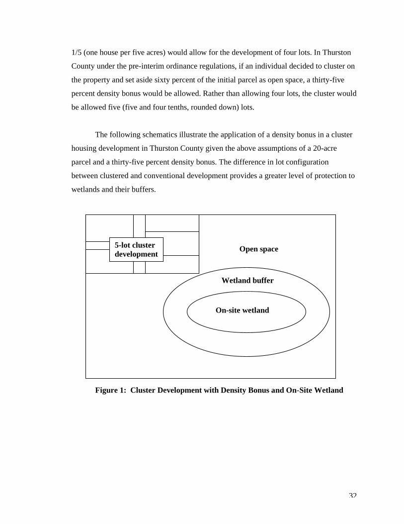
The following schematics illustrate the application of a density bonus in a cluster
housing development in Thurston County given the above assumptions of a 20-acre
parcel and a thirty-five percent density bonus. The difference in lot configuration
between clustered and conventional development provides a greater level of protection to
wetlands and their buffers.
Figure 1: Cluster Development with Density Bonus and On-Site Wetland
5-lot cluster development
On-site wetland
Wetland buffer
Open space
33
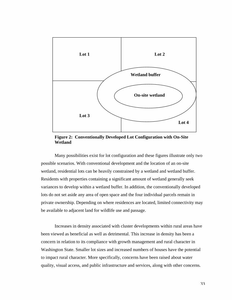
Figure 2: Conventionally Developed Lot Configuration with On-Site Wetland
Many possibilities exist for lot configuration and these figures illustrate only two
possible scenarios. With conventional development and the location of an on-site
wetland, residential lots can be heavily constrained by a wetland and wetland buffer.
Residents with properties containing a significant amount of wetland generally seek
variances to develop within a wetland buffer. In addition, the conventionally developed
lots do not set aside any area of open space and the four individual parcels remain in
private ownership. Depending on where residences are located, limited connectivity may
be available to adjacent land for wildlife use and passage.
Increases in density associated with cluster developments within rural areas have
been viewed as beneficial as well as detrimental. This increase in density has been a
concern in relation to its compliance with growth management and rural character in
Washington State. Smaller lot sizes and increased numbers of houses have the potential
to impact rural character. More specifically, concerns have been raised about water
quality, visual access, and public infrastructure and services, along with other concerns.
On-site wetland
Wetland buffer
Lot 1 Lot 2
Lot 3 Lot 4
34
There are benefits and drawbacks associated with all forms of development.
When done properly, however, clustering can maintain rural character, protect wetlands
and other critical areas, protect viable agricultural and forest land, and help accommodate
anticipated growth in rural areas.
Wetland Protection This section will provide background information related to wetland and wetland
buffer regulations in Thurston County. All forms of development, including cluster
developments, must adhere to the review standards and specified buffer widths.
Thurston County is committed to the protection of wetlands and other critical
areas. Wetland code lays out the framework for avoidance, minimization and mitigation
for critical area impacts within the critical area review standards section 17.15.325.
Thurston County regulations (17.15.940, 2002) require the establishment of
undisturbed vegetative areas surrounding wetlands (referred to as “buffer” areas) to retain
natural functions of wetlands. The standard vegetated area widths are included in Table 3
below. Active recreational areas, commercial, and residential zones permitting a density
greater than one unit per five acres are considered a high-intensity land use. Agriculture,
forestry, passive parks and preserves, and residential density equal to or less than one unit
per five acres are considered a low-intensity land use. Clustered lots, within a low-
intensity zoning district, and their density bonus are considered to be a low-intensity land
use under the existing regulations. However, this may change with revisions to the
county’s ordinance and updates to the critical areas ordinance.
35
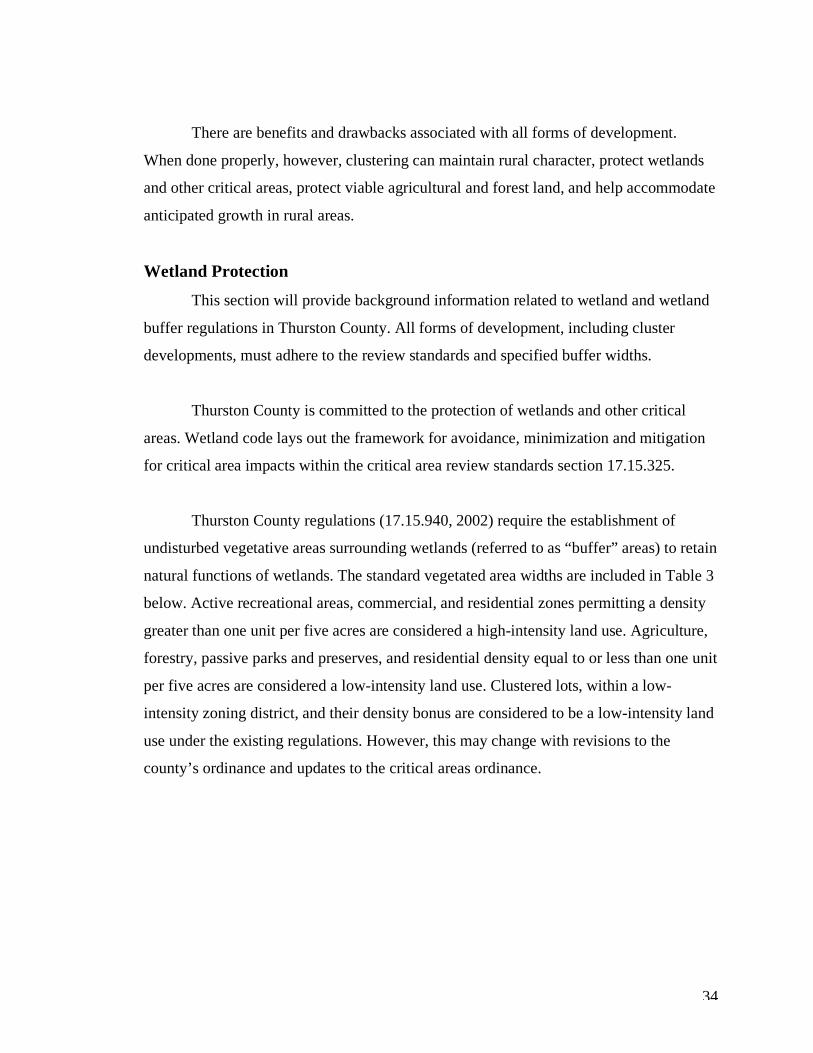
Table 4: Wetland Buffer Requirements in Thurston County
Wetland Category High Intensity
Land Use
Low Intensity
Land Use
I 300 feet 200 feet
II 200 feet 100 feet
III 100 feet 50 feet Source: Thurston County Ordinance No. 17.15.900, 2002
Since 2005, Thurston County has been revising its wetland and critical area
ordinances. It is unknown when these revisions will be adopted. Proposed revisions
include increasing buffer widths by up to 250 feet beyond existing buffers, depending on
the function provided by the wetland being rated. The proposed wetland buffer
regulations would determine appropriate buffer widths based on water quality, habitat
scores, and special characteristics calculated from the Washington State wetland rating
system for western Washington - Revised. Other local government agencies revising their
critical areas ordinances have adopted similar buffer width determinations. It is unclear
whether increased buffer widths are in response to inadequate protection of wetlands
based on new scientific research. More information on this possible trend is likely to
become available in the future.
Cluster development is different from conventional development in many ways,
however, clusters must still adhere to required wetland buffers. In general, clusters are
not permitted to place any portion of the residential lots within wetland buffer areas. In
some cases, clusters can actually provide additional space to buffers, depending on lot
configuration.
Wetland Protection and Cluster Development This section presents the benefits of cluster development related to wetland
protection within Thurston County. The benefits and drawbacks of cluster housing
developments on wetlands and their buffers will be examined in chapter six. The purpose
36
of this section is to bring together the information presented in previous sections on
cluster development and wetland protection.
All proposed PRRD or cluster housing applications must go through a review
process. This process can oftentimes be long and cumbersome, requiring updates to
lot/house sites, stormwater management plans and other proposed land use activities.
Some permit applications have taken up to two years to receive approval.
Discussions with Thurston County planning staff revealed a “no impact” approach
to wetlands and their buffers. The permit approval process requires wetlands to be
delineated and categorized. Wetland buffer signs and fencing are generally required if
development is to occur within 300 feet of wetland areas.
In order for a cluster development to receive permit approval, the landowner or
developer must avoid all impacts to on-site wetlands and buffers. Only a few exceptions
have been granted when no practicable alternative existed. In these situations, direct
wetland impacts would not be allowed but minimal wetland buffer impacts may be
allowed with mitigation (Kain and Pawlawski, 2006).
Project mitigation has included buffer averaging and vegetative mitigation or
enhancement. Buffer averaging involves reducing a portion of an on-site buffer and
increasing the buffer within another portion of the property so that the overall buffer area
remains the same. Vegetative mitigation requires planting of native vegetation within the
buffer at a square footage equal to or greater than the impacted area. The native plantings
can be in the form of buffer enhancement or creation in order to provide additional
protection to the wetland system. Revegetation of an area not part of the wetland buffer is
discouraged and only allowed if absolutely necessary (Kain, 2006).
Approximately one-third of cluster development projects result in a larger wetland
buffers than required by the county (Kain, 2006). The remaining two-thirds are developed
to the site’s full capacity. In general, developers aim to utilize all the land available to
37
them for development (Kain, 2006) resulting in the minimum required land for wetland
protection.
Mike Kain, Thurston County Planning Manager, provided an example of where
clustering could have been used to avoid negative impacts to important habitat. A
development on Yelm Highway near Spurgeon Creek Road contained oak woodlands and
agricultural land. The land was conventionally developed and split into five-acre parcels.
Neighbors removed oak trees adjacent to their properties in order to prevent damage to
their homes. According to Mr. Kain, if the homes had been clustered, no oak impacts
would have occurred. This is one example of why, in his opinion, clustering is
an environmentally beneficial form of development that should become mandatory in
rural areas (2006).
In order to ensure that wetland functions are protected and restored, especially
when impacts have occurred, monitoring of the wetland buffer is required. Since
clustering does not impact wetland buffers, no monitoring requirements are in place for
cluster developments. Once permitted, no follow-up visits for monitoring wetland and
buffer conditions are required. The following section and field observations will bring
insight into why monitoring of wetland buffers at cluster development sites should be
considered as a requirement.
Field Observations of Cluster Housing Development in Thurston County To supplement data derived from the Thurston GeoData Center, an on-line
database of parcel information and maps, field observations were made at six cluster
development sites within rural Thurston County. On April 12 and 19, 2006 field visits
were performed at Field of Dreams, North Pointe at Tolmie, Countrywood Estates,
Talcott Ridge, Reserve at Cooper Point, and Wilda Place. Figure 3 shows the locations of
these six cluster sites.
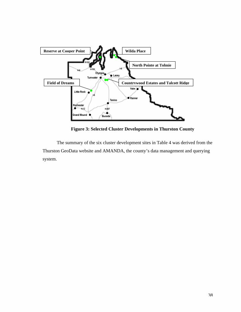
38
Figure 3: Selected Cluster Developments in Thurston County
The summary of the six cluster development sites in Table 4 was derived from the
Thurston GeoData website and AMANDA, the county’s data management and querying
system.
Wilda Place
North Pointe at Tolmie
Countrywood Estates and Talcott Ridge Field of Dreams
Reserve at Cooper Point
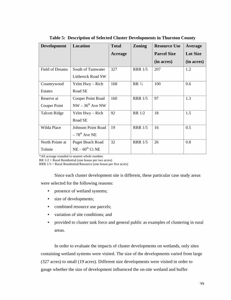
39
Table 5: Description of Selected Cluster Developments in Thurston County
Development Location Total
Acreage
Zoning Resource Use
Parcel Size
(in acres)
Average
Lot Size
(in acres)
Field of Dreams South of Tumwater
Littlerock Road SW
327 RRR 1/5 207 1.2
Countrywood
Estates
Yelm Hwy – Rich
Road SE
168 RR ½ 100 0.6
Reserve at
Cooper Point
Cooper Point Road
NW – 36th Ave NW
160 RRR 1/5 97 1.3
Talcott Ridge Yelm Hwy – Rich
Road SE
92 RR 1/2 18 1.5
Wilda Place Johnson Point Road
– 78th Ave NE
19 RRR 1/5 16 0.5
North Pointe at
Tolmie
Puget Beach Road
NE – 60th Ct NE
32 RRR 1/5 26 0.8
*All acreage rounded to nearest whole number. RR 1/2 = Rural Residential (one house per two acres) RRR 1/5 = Rural Residential/Resource (one house per five acres)
Since each cluster development site is different, these particular case study areas
were selected for the following reasons:
• presence of wetland systems;
• size of developments;
• combined resource use parcels;
• variation of site conditions; and
• provided to cluster task force and general public as examples of clustering in rural
areas.
In order to evaluate the impacts of cluster developments on wetlands, only sites
containing wetland systems were visited. The size of the developments varied from large
(327 acres) to small (19 acres). Different size developments were visited in order to
gauge whether the size of development influenced the on-site wetland and buffer
40
conditions. Two of the cluster developments shared open space and wetland within the
resource use parcel. These developments were visited to identify whether there were any
benefits associated with combined open space and wetland, and what those benefits are.
The variation in site conditions including topography, relation to adjacent development
(both conventional and clustered), lot configuration, vegetative composition, and other
habitat features at each cluster site were examined to determine beneficial features and
additional influences on wetland areas. In addition, these variations illustrate the broad
range of considerations for site planning and development. Finally, these sites were
selected because they are easily accessible to the general public and the cluster task force,
and offer examples of clustering in rural areas of the county. Both of these groups play a
significant role in revising the cluster housing ordinance.
Vegetative coverage and composition of the resource use parcel, lot design, and
wetland characteristics were observed using aerial photos and parcel information
obtained from the Thurston County GeoData website, and on-site observations. In
addition, the presence of signs and fencing, debris, wildlife use, and general condition of
the resource use parcel were examined and recorded during site visits.
The following field observations identify existing site characteristics that will be
evaluated in chapter five, where these observations will be used to illustrate links to key
ecological principles. The principles used to evaluate these sites include temporal and
spatial scales. Temporal scales included short and long-term considerations for land use.
Spatial scales examined included regional, landscape and site scales in relation to habitat
composition, configuration, and connectivity.
Photographs taken during field visits are included within the text of each cluster
site discussion to help illustrate observed wetland and buffer conditions. In addition,
Thurston GeoData aerial photos of each development and approximate wetland area are
also included. The wetland areas are approximate because their location is based on aerial
interpretation and National Wetland Inventory mapping, which are not always accurate.
Several of the wetland areas on the cluster sites are not mapped and therefore are not
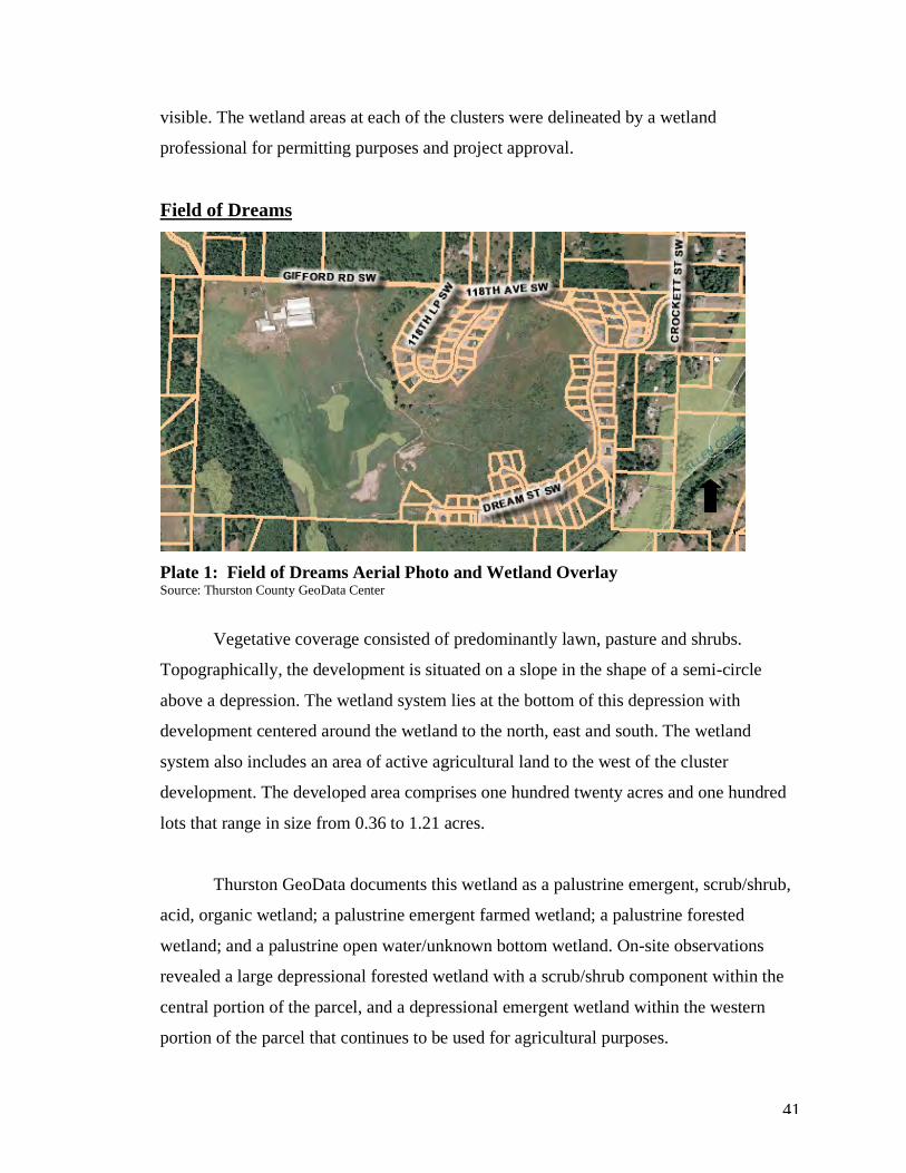
41
visible. The wetland areas at each of the clusters were delineated by a wetland
professional for permitting purposes and project approval.
Field of Dreams
Plate 1: Field of Dreams Aerial Photo and Wetland Overlay Source: Thurston County GeoData Center
Vegetative coverage consisted of predominantly lawn, pasture and shrubs.
Topographically, the development is situated on a slope in the shape of a semi-circle
above a depression. The wetland system lies at the bottom of this depression with
development centered around the wetland to the north, east and south. The wetland
system also includes an area of active agricultural land to the west of the cluster
development. The developed area comprises one hundred twenty acres and one hundred
lots that range in size from 0.36 to 1.21 acres.
Thurston GeoData documents this wetland as a palustrine emergent, scrub/shrub,
acid, organic wetland; a palustrine emergent farmed wetland; a palustrine forested
wetland; and a palustrine open water/unknown bottom wetland. On-site observations
revealed a large depressional forested wetland with a scrub/shrub component within the
central portion of the parcel, and a depressional emergent wetland within the western
portion of the parcel that continues to be used for agricultural purposes.

42
The buffer contains predominantly native vegetation. Some Himalayan blackberry
(Rubus armeniacus) and reed canary grass (Phalaris arundinacea) were observed in
concentrated areas within the buffer. Mowed lawn on the residential properties
surrounding the wetland extends to the wetland buffer fencing. Wetland buffer signs and
white split-rail fencing are present throughout approximately two-thirds of the
development. An individual was observed disturbing vegetation using a tractor within the
fenced wetland buffer. It is unclear whether the individual was a resident or
groundskeeper. One large hawk was observed utilizing the buffer area during the field
visit.
Plate 2: Field of Dreams Wetland Plate 3: Field of Dreams Wetland Buffer Buffer Conditions Fencing Source: Celina Abercrombie, April 2006
Plates 2 and 3 illustrate some of the wetland and buffer conditions observed on
site. Wetland buffer fencing and signs were present and separate residential lots from
vegetated buffer areas. Non-native and invasive plant species are also present within
wetland buffers.
This development maintains a relatively large area of land for wetland
preservation and preserves active farmland. Lot configuration allows for movement to
off-site wetland and upland habitats.
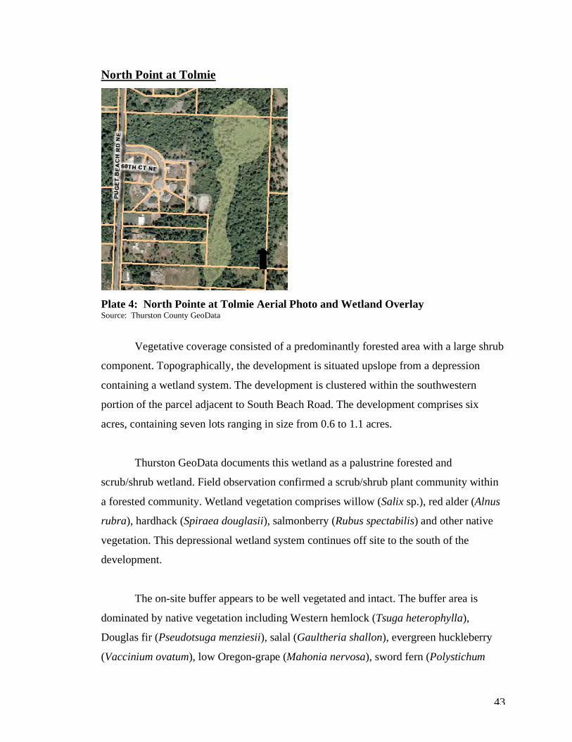
43
North Point at Tolmie
Plate 4: North Pointe at Tolmie Aerial Photo and Wetland Overlay Source: Thurston County GeoData
Vegetative coverage consisted of a predominantly forested area with a large shrub
component. Topographically, the development is situated upslope from a depression
containing a wetland system. The development is clustered within the southwestern
portion of the parcel adjacent to South Beach Road. The development comprises six
acres, containing seven lots ranging in size from 0.6 to 1.1 acres.
Thurston GeoData documents this wetland as a palustrine forested and
scrub/shrub wetland. Field observation confirmed a scrub/shrub plant community within
a forested community. Wetland vegetation comprises willow (Salix sp.), red alder (Alnus
rubra), hardhack (Spiraea douglasii), salmonberry (Rubus spectabilis) and other native
vegetation. This depressional wetland system continues off site to the south of the
development.
The on-site buffer appears to be well vegetated and intact. The buffer area is
dominated by native vegetation including Western hemlock (Tsuga heterophylla),
Douglas fir (Pseudotsuga menziesii), salal (Gaultheria shallon), evergreen huckleberry
(Vaccinium ovatum), low Oregon-grape (Mahonia nervosa), sword fern (Polystichum
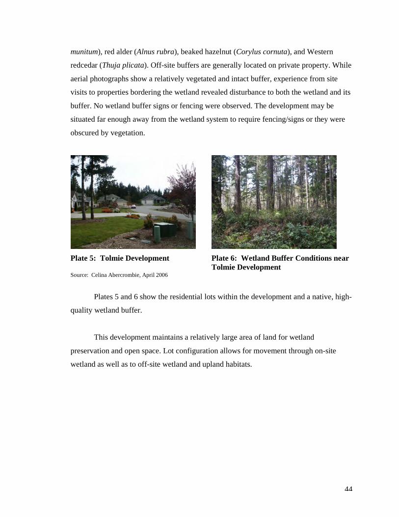
44
munitum), red alder (Alnus rubra), beaked hazelnut (Corylus cornuta), and Western
redcedar (Thuja plicata). Off-site buffers are generally located on private property. While
aerial photographs show a relatively vegetated and intact buffer, experience from site
visits to properties bordering the wetland revealed disturbance to both the wetland and its
buffer. No wetland buffer signs or fencing were observed. The development may be
situated far enough away from the wetland system to require fencing/signs or they were
obscured by vegetation.
Plate 5: Tolmie Development Plate 6: Wetland Buffer Conditions near
Tolmie Development Source: Celina Abercrombie, April 2006
Plates 5 and 6 show the residential lots within the development and a native, high-
quality wetland buffer.
This development maintains a relatively large area of land for wetland
preservation and open space. Lot configuration allows for movement through on-site
wetland as well as to off-site wetland and upland habitats.
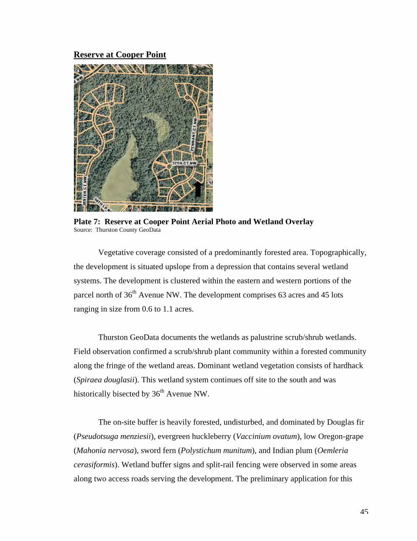
45
Reserve at Cooper Point
Plate 7: Reserve at Cooper Point Aerial Photo and Wetland Overlay Source: Thurston County GeoData
Vegetative coverage consisted of a predominantly forested area. Topographically,
the development is situated upslope from a depression that contains several wetland
systems. The development is clustered within the eastern and western portions of the
parcel north of 36th Avenue NW. The development comprises 63 acres and 45 lots
ranging in size from 0.6 to 1.1 acres.
Thurston GeoData documents the wetlands as palustrine scrub/shrub wetlands.
Field observation confirmed a scrub/shrub plant community within a forested community
along the fringe of the wetland areas. Dominant wetland vegetation consists of hardhack
(Spiraea douglasii). This wetland system continues off site to the south and was
historically bisected by 36th Avenue NW.
The on-site buffer is heavily forested, undisturbed, and dominated by Douglas fir
(Pseudotsuga menziesii), evergreen huckleberry (Vaccinium ovatum), low Oregon-grape
(Mahonia nervosa), sword fern (Polystichum munitum), and Indian plum (Oemleria
cerasiformis). Wetland buffer signs and split-rail fencing were observed in some areas
along two access roads serving the development. The preliminary application for this
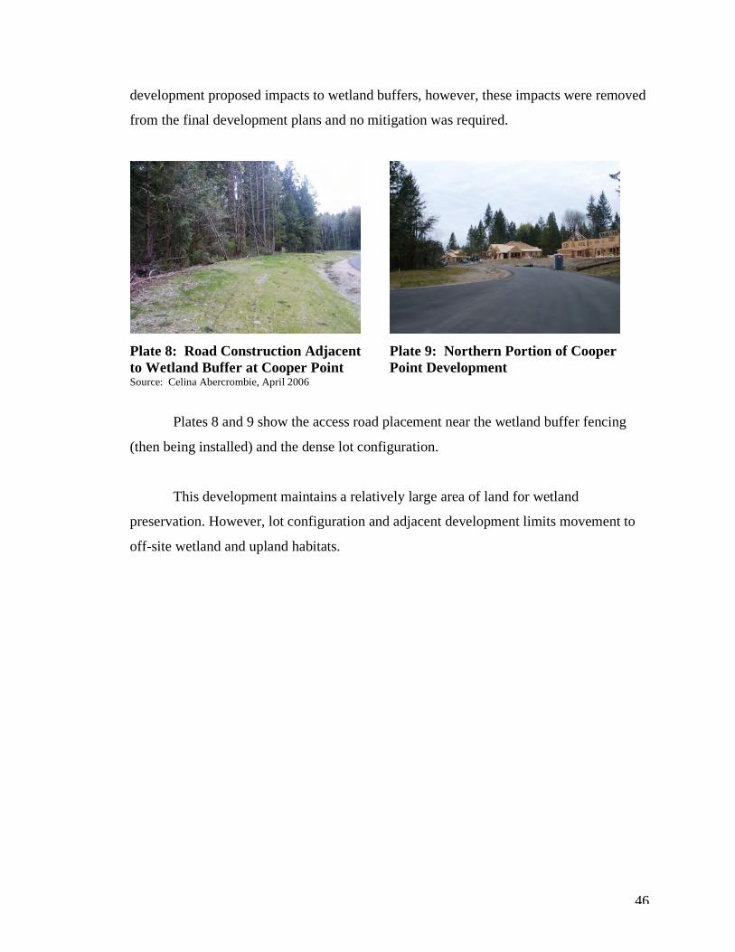
46
development proposed impacts to wetland buffers, however, these impacts were removed
from the final development plans and no mitigation was required.
Plate 8: Road Construction Adjacent Plate 9: Northern Portion of Cooper to Wetland Buffer at Cooper Point Point Development Source: Celina Abercrombie, April 2006
Plates 8 and 9 show the access road placement near the wetland buffer fencing
(then being installed) and the dense lot configuration.
This development maintains a relatively large area of land for wetland
preservation. However, lot configuration and adjacent development limits movement to
off-site wetland and upland habitats.
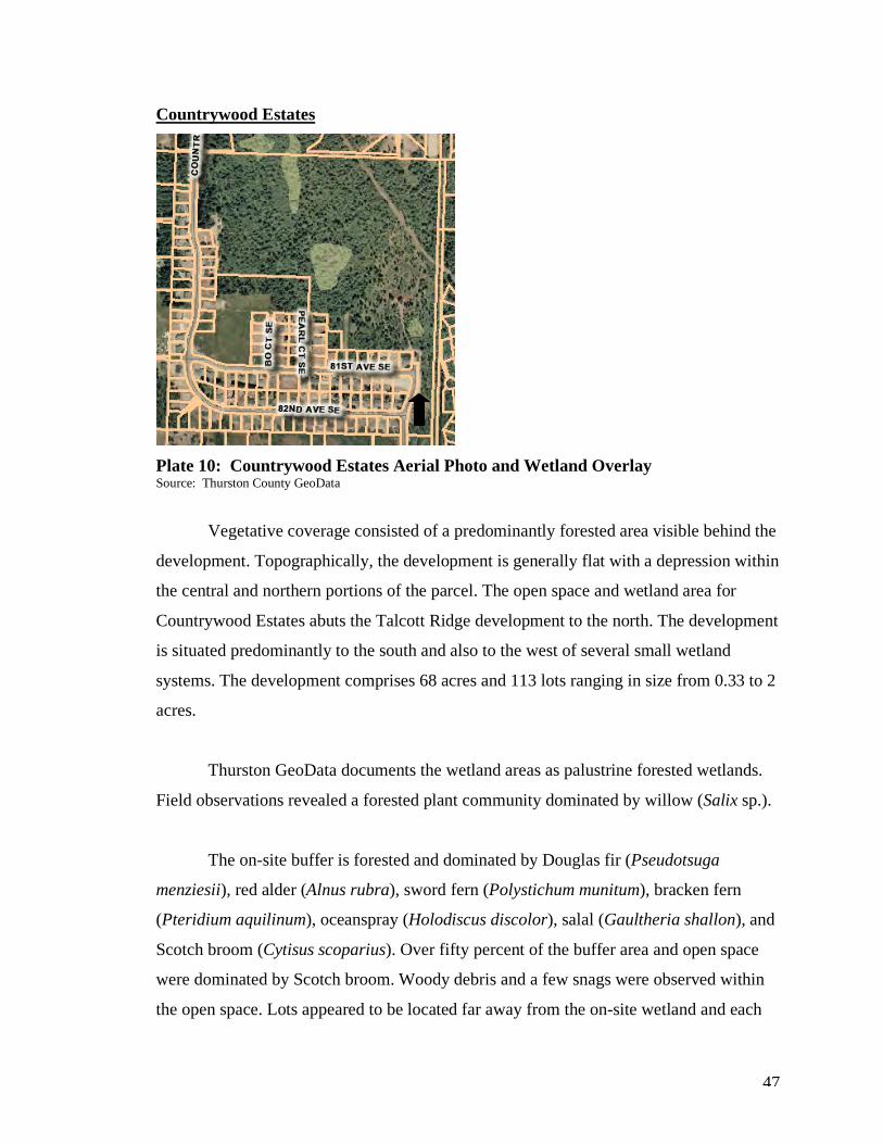
47
Countrywood Estates
Plate 10: Countrywood Estates Aerial Photo and Wetland Overlay Source: Thurston County GeoData
Vegetative coverage consisted of a predominantly forested area visible behind the
development. Topographically, the development is generally flat with a depression within
the central and northern portions of the parcel. The open space and wetland area for
Countrywood Estates abuts the Talcott Ridge development to the north. The development
is situated predominantly to the south and also to the west of several small wetland
systems. The development comprises 68 acres and 113 lots ranging in size from 0.33 to 2
acres.
Thurston GeoData documents the wetland areas as palustrine forested wetlands.
Field observations revealed a forested plant community dominated by willow (Salix sp.).
The on-site buffer is forested and dominated by Douglas fir (Pseudotsuga
menziesii), red alder (Alnus rubra), sword fern (Polystichum munitum), bracken fern
(Pteridium aquilinum), oceanspray (Holodiscus discolor), salal (Gaultheria shallon), and
Scotch broom (Cytisus scoparius). Over fifty percent of the buffer area and open space
were dominated by Scotch broom. Woody debris and a few snags were observed within
the open space. Lots appeared to be located far away from the on-site wetland and each
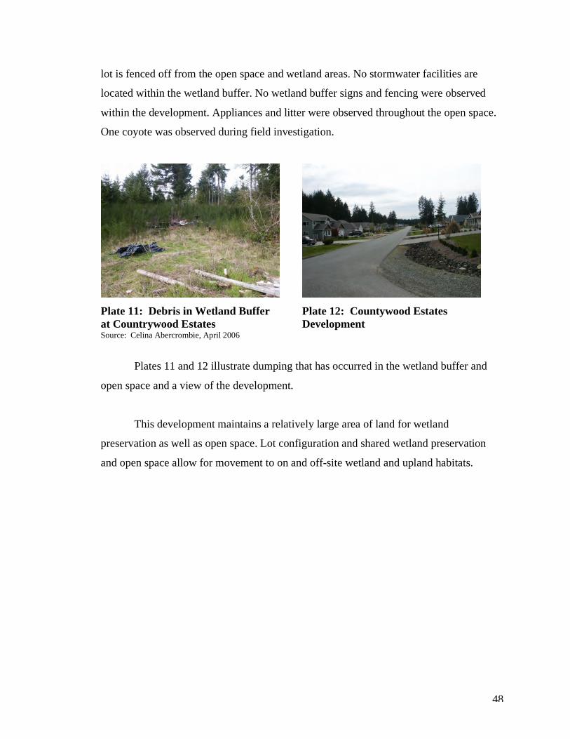
48
lot is fenced off from the open space and wetland areas. No stormwater facilities are
located within the wetland buffer. No wetland buffer signs and fencing were observed
within the development. Appliances and litter were observed throughout the open space.
One coyote was observed during field investigation.
Plate 11: Debris in Wetland Buffer Plate 12: Countywood Estates at Countrywood Estates Development Source: Celina Abercrombie, April 2006
Plates 11 and 12 illustrate dumping that has occurred in the wetland buffer and
open space and a view of the development.
This development maintains a relatively large area of land for wetland
preservation as well as open space. Lot configuration and shared wetland preservation
and open space allow for movement to on and off-site wetland and upland habitats.
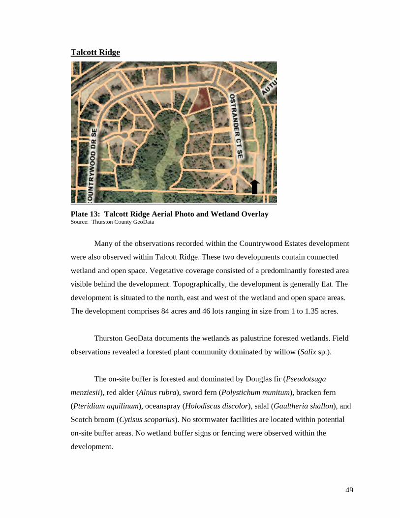
49
Talcott Ridge
Plate 13: Talcott Ridge Aerial Photo and Wetland Overlay Source: Thurston County GeoData
Many of the observations recorded within the Countrywood Estates development
were also observed within Talcott Ridge. These two developments contain connected
wetland and open space. Vegetative coverage consisted of a predominantly forested area
visible behind the development. Topographically, the development is generally flat. The
development is situated to the north, east and west of the wetland and open space areas.
The development comprises 84 acres and 46 lots ranging in size from 1 to 1.35 acres.
Thurston GeoData documents the wetlands as palustrine forested wetlands. Field
observations revealed a forested plant community dominated by willow (Salix sp.).
The on-site buffer is forested and dominated by Douglas fir (Pseudotsuga
menziesii), red alder (Alnus rubra), sword fern (Polystichum munitum), bracken fern
(Pteridium aquilinum), oceanspray (Holodiscus discolor), salal (Gaultheria shallon), and
Scotch broom (Cytisus scoparius). No stormwater facilities are located within potential
on-site buffer areas. No wetland buffer signs or fencing were observed within the
development.
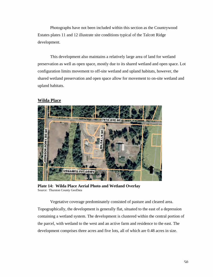
50
Photographs have not been included within this section as the Countrywood
Estates plates 11 and 12 illustrate site conditions typical of the Talcott Ridge
development.
This development also maintains a relatively large area of land for wetland
preservation as well as open space, mostly due to its shared wetland and open space. Lot
configuration limits movement to off-site wetland and upland habitats, however, the
shared wetland preservation and open space allow for movement to on-site wetland and
upland habitats.
Wilda Place
Plate 14: Wilda Place Aerial Photo and Wetland Overlay Source: Thurston County GeoData
Vegetative coverage predominately consisted of pasture and cleared area.
Topographically, the development is generally flat, situated to the east of a depression
containing a wetland system. The development is clustered within the central portion of
the parcel, with wetland to the west and an active farm and residence to the east. The
development comprises three acres and five lots, all of which are 0.48 acres in size.
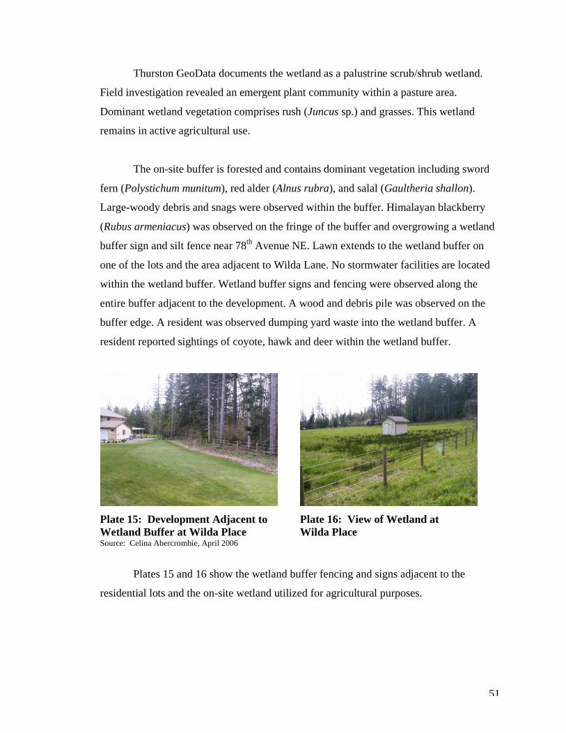
51
Thurston GeoData documents the wetland as a palustrine scrub/shrub wetland.
Field investigation revealed an emergent plant community within a pasture area.
Dominant wetland vegetation comprises rush (Juncus sp.) and grasses. This wetland
remains in active agricultural use.
The on-site buffer is forested and contains dominant vegetation including sword
fern (Polystichum munitum), red alder (Alnus rubra), and salal (Gaultheria shallon).
Large-woody debris and snags were observed within the buffer. Himalayan blackberry
(Rubus armeniacus) was observed on the fringe of the buffer and overgrowing a wetland
buffer sign and silt fence near 78th Avenue NE. Lawn extends to the wetland buffer on
one of the lots and the area adjacent to Wilda Lane. No stormwater facilities are located
within the wetland buffer. Wetland buffer signs and fencing were observed along the
entire buffer adjacent to the development. A wood and debris pile was observed on the
buffer edge. A resident was observed dumping yard waste into the wetland buffer. A
resident reported sightings of coyote, hawk and deer within the wetland buffer.
Plate 15: Development Adjacent to Plate 16: View of Wetland at Wetland Buffer at Wilda Place Wilda Place Source: Celina Abercrombie, April 2006
Plates 15 and 16 show the wetland buffer fencing and signs adjacent to the
residential lots and the on-site wetland utilized for agricultural purposes.
52
This development maintains a small area of land for wetland preservation due to
the size of the original parcel. Lot configuration and, more notably, adjacent development
limits movement to off-site wetland and upland habitats.
These field observations illustrate the large variation in site conditions that create
challenges for cluster development. Buffer conditions vary dramatically. Both large and
small developments maintain high quality, native wetland buffers whereas others contain
non-native and invasive vegetation. In all cases, the cluster developments preserved on-
site wetland and provided for some wildlife movement between on and off-site habitats.
Summary This chapter brought together discussions of cluster development and wetland
protection by examining population growth in Thurston County, cluster development
regulations and cited discussions with planning staff working on wetland and cluster
development projects, and wetland regulations in the county. Field observations taken at
six cluster development sites in Thurston County were used to illustrate the interaction of
wetlands and this form of alternative development. These site locations were selected for
a variety of reasons and illustrate the wide variety of site characteristics of cluster
developments.
Population growth in rural Thurston County will place additional pressure on
available land and rural resources. Rural lands are currently dominated by conventional
development and they are capable of accommodating a portion of the projected
population growth. However, not all land is available to new residents when needed and
alternatives to conventional development should be given consideration for long-range
planning efforts. Cluster development is one mechanism that can aid in accommodating
growth in rural areas through density bonuses that allow for additional building lots.
The cluster housing task force has been given the challenge of providing
recommendations for the revision of the county’s cluster ordinance. The county’s
53
decision to form this task force emphasizes the controversy over cluster housing in rural
areas, and the need for additional information related to this form of development.
Thurston County contains a variety of cluster developments with varying site
conditions. Wetland and buffer conditions vary dramatically depending on site
conditions, size of development, development layout, and continued maintenance and
care of buffer and/or resource use parcel (RUP). The county evaluates each cluster on a
case-by-case basis. Thurston County maintains a no-impact approach to wetland and
wetland buffer regulation, however, in select cases where wetland presence significantly
constrains reasonable use of the property, impacts are permitted and mitigation is
required. In other cases, wetland buffers are increased beyond their required buffer and
provide greater protection to wetlands.
The environmental impacts associated with cluster development are not well
understood and are worthy of further investigation. In general, clustering is desirable and
can increase the minimum number of lots permitted within a parcel through the
application of density bonuses while protecting critical areas. This thesis focuses on the
benefits and drawbacks of cluster development on wetlands and their buffers through the
application of ecological principles including temporal and spatial scales as well as
examining habitat composition, configuration and connectivity. The following chapter
provides an analysis of the benefits of cluster development based on these ecological
principles, in order to provide additional information for regulatory agencies assessing
cluster developments in rural areas. In addition, it will examine implications for other
county planning bodies and provide recommendations for increasing wetland protection
within rural cluster developments.
54
Chapter 4 - An Analysis of Benefits and Recommendations
This chapter will discuss the implications of cluster housing developments in rural
areas in relation to wetland protection. The benefits and drawbacks of cluster
developments on wetlands and their buffers will be addressed as well as how population
growth will influence rural development and what implications this may have for other
growing counties with large rural areas. Finally, this chapter will present
recommendations for counties seeking to increase cluster development in rural areas.
Methodology for assessing benefits to wetlands, including examination of
ecological principles, will be discussed, followed by an analysis of cluster housing in
Thurston County.
Methodology The Ecological Society of America (ESA) identifies five key ecological principles
for land use management. These principles include the time principle, the species
principle, the place principle, the disturbance principle, and the landscape principle. The
time principle states that ecological processes function at many time scales, and
ecosystems change through time. The species principle states that particular species and
networks of interacting species have key, broad-scale ecosystem-level effects. This refers
to indicator species, keystone species, ecological engineers, umbrella species, and link
species. The place principle recognizes that local climatic, hydrologic, soil, and
geomorphologic factors, as well as biotic interactions, strongly affect ecological
properties and the abundance and distribution of species at any one place. The
disturbance principle relates to the type, intensity and duration of disturbance that shape
the characteristics of populations, communities and ecosystems. Finally, the landscape
principle focuses on the size, shape and spatial relationships of landcover types that
influence the dynamics of populations, communities and ecosystems (Dale et al., 2000).
Methodology for analyzing the benefits and drawbacks associated with cluster
housing developments has been derived from the ESA ecological principles and
55
combined with those used by the Washington State Department of Fish and Wildlife
(WDFW). Analysis is based on ecological principles including scale and habitat
composition, configuration, and connectivity. Scale can be broken down into spatial and
temporal scales. Spatial scales include regional, landscape and site levels (WDFW,
2005).
Regional scales encompass one to several counties and large watersheds (WDFW,
2005). Considerations at a regional scale include examining local actions that can help or
harm regional wildlife resources, preserving species and habitat types considered to be
regionally rare or imperiled, maintaining habitat connectivity among regions by
maintaining connectivity across a region, and coordinating actions with other regions to
ensure a sufficient amount of habitat is available across a species’ range. Landscape
scales include multiple developments and medium watersheds. Considerations at a
landscape scale include preserving rare or imperiled habitat types and associated species,
maintaining connectivity among sites, maintaining sufficient habitat (quantity and
quality) within the landscape, maintaining ecological processes such as soil erosion,
forest succession, water regimes, and being able to accommodate change and unexpected
events. A site scale includes one, individual development but site-level activities should
be addressed at multiple scales. At a site scale considerations include preserving rare or
imperiled habitat types and associated species, maintaining connectivity to habitats in
neighboring sites, maintaining compact, less fragmented areas of habitat, maintaining
patches with the highest quality habitat, and maintaining corridors on natural pathways
such as valley bottoms and ridge tops (WDFW, 2005).
Temporal scales are broken down into long and short-term (WDFW, 2005). A
major component of both short and long-term scales is certainty over whether habitat or a
resource will be continuously available, and whether clustered or dispersed habitat is
better and how to improve both types of habitat (WDFW, 2005).
An important element of ecological properties is the “three C’s” – composition,
configuration and connectivity. Composition includes habitat quantity as well as quality.
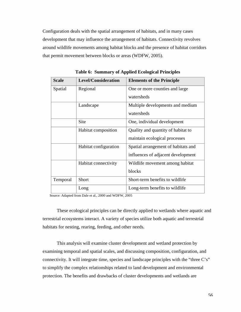
56
Configuration deals with the spatial arrangement of habitats, and in many cases
development that may influence the arrangement of habitats. Connectivity revolves
around wildlife movements among habitat blocks and the presence of habitat corridors
that permit movement between blocks or areas (WDFW, 2005).
Table 6: Summary of Applied Ecological Principles
Scale Level/Consideration Elements of the Principle
Spatial Regional One or more counties and large
watersheds
Landscape Multiple developments and medium
watersheds
Site One, individual development
Habitat composition Quality and quantity of habitat to
maintain ecological processes
Habitat configuration Spatial arrangement of habitats and
influences of adjacent development
Habitat connectivity Wildlife movement among habitat
blocks
Temporal Short Short-term benefits to wildlife
Long Long-term benefits to wildlife Source: Adapted from Dale et al., 2000 and WDFW, 2005
These ecological principles can be directly applied to wetlands where aquatic and
terrestrial ecosystems interact. A variety of species utilize both aquatic and terrestrial
habitats for nesting, rearing, feeding, and other needs.
This analysis will examine cluster development and wetland protection by
examining temporal and spatial scales, and discussing composition, configuration, and
connectivity. It will integrate time, species and landscape principles with the “three C’s”
to simplify the complex relationships related to land development and environmental
protection. The benefits and drawbacks of cluster developments and wetlands are
57
multifaceted. This analysis will attempt to discuss these components as thoroughly as
possible in order to provide recommendations that planners and resource managers can
incorporate into development processes.
Scale When giving consideration to any development project, planners and natural
resource managers must recognize the importance of scale. Temporal and spatial scales
define our landscape, and if not given substantial consideration can result in serious
consequences, both short and long-term. Ecosystems do not stop at property lines and can
span regional, landscape and site scales. Activities at a site level can influence regional
and landscape levels. Likewise, temporal scales should be thoroughly evaluated to
address short and long-term impacts or benefits. This section will begin with a discussion
of spatial scales and move to a brief discussion of temporal scales.
Spatial Scales When preliminary development plans are drafted, they typically address on-site
impacts associated with the concerned development. If documented habitat is present on
and off site, developers must give consideration to a landscape scale, but this is not
always done. Many proposed developments contain isolated or small wetland systems
that do not always extend beyond property boundaries but provide important functions
and values for wildlife and humans. Cluster development generally ignores regional
scales. In some cases this may be appropriate. This section will examine the six Thurston
County cluster developments and analyze them in relation to spatial scale.
These developments will be evaluated and given a score of good, moderate or
poor based on how they function on a regional, landscape and site scale. Developments
that meet the fish and wildlife criteria discussed above will be given a rating of good,
those that do not meet all the criteria but do meet some will be given a rating of
moderate, and those developments failing to meet any of the criteria will be given a rating
of poor. Site level evaluations generally receive a rating of good, with more variation at
larger scales.
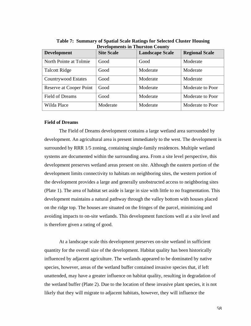
58
Table 7: Summary of Spatial Scale Ratings for Selected Cluster Housing Developments in Thurston County
Development Site Scale Landscape Scale Regional Scale
North Pointe at Tolmie Good Good Moderate
Talcott Ridge Good Moderate Moderate
Countrywood Estates Good Moderate Moderate
Reserve at Cooper Point Good Moderate Moderate to Poor
Field of Dreams Good Moderate Moderate to Poor
Wilda Place Moderate Moderate Moderate to Poor
Field of Dreams
The Field of Dreams development contains a large wetland area surrounded by
development. An agricultural area is present immediately to the west. The development is
surrounded by RRR 1/5 zoning, containing single-family residences. Multiple wetland
systems are documented within the surrounding area. From a site level perspective, this
development preserves wetland areas present on site. Although the eastern portion of the
development limits connectivity to habitats on neighboring sites, the western portion of
the development provides a large and generally unobstructed access to neighboring sites
(Plate 1). The area of habitat set aside is large in size with little to no fragmentation. This
development maintains a natural pathway through the valley bottom with houses placed
on the ridge top. The houses are situated on the fringes of the parcel, minimizing and
avoiding impacts to on-site wetlands. This development functions well at a site level and
is therefore given a rating of good.
At a landscape scale this development preserves on-site wetland in sufficient
quantity for the overall size of the development. Habitat quality has been historically
influenced by adjacent agriculture. The wetlands appeared to be dominated by native
species, however, areas of the wetland buffer contained invasive species that, if left
unattended, may have a greater influence on habitat quality, resulting in degradation of
the wetland buffer (Plate 2). Due to the location of these invasive plant species, it is not
likely that they will migrate to adjacent habitats, however, they will influence the
59
wetland’s ability to provide habitat for a variety of species and become dominated by
Himalayan blackberry and reed canary grass. The configuration of the development on
the ridge and surrounding the eastern portion of the wetland has altered hydrology on
site. In an undeveloped status, water movement down the slope toward the wetland would
be slowed and filtered by vegetation. In a developed situation, some of the water is
infiltrated through lawns and landscaping for each individual lot, however, water
movement is increased by the removal of vegetation and presence of impervious surface
(Plate 3). While wetland buffer vegetation is present, there is less overall vegetation
slowing and filtering sediments from runoff before reaching the wetland. It should also be
noted that the wetland and adjacent agricultural areas offer large, unfragmented areas for
wildlife movement to and from the wetland. Adjacent sites contain forested upland and
wetland areas with few limitations or barriers for access. It is unclear whether this
development is able to accommodate change and unexpected events. This development is
given a rating of moderate. It meets several of the criteria at a landscape scale but not all.
At a regional scale, the Field of Dreams development preserves wetland area
utilized by a variety of species. The development contains a large amount of habitat but is
located within an area of 1/5 zoning and fragmented habitat due to adjacent residential
development and roads. The undeveloped portion of the development abuts larger parcels
to the south that contain portions of Allen Creek, however, there is no certainty that these
parcels will remain undeveloped and available for habitat movement to and from the on-
site wetland to off-site wetlands and other critical areas. This development performs
moderately well in relation to regional scales. This performance level is partially
attributed to the lack of certainty with development activities on adjacent land and is
limited by the presence of adjacent development. The development is given a moderate to
poor rating at a regional scale.
Countrywood Estates
The Countrywood Estates development contains wetland and open space
surrounded by development to the south and west. The development is surrounded by
RRR 1/5 and RR 1/2 zoning containing single-family residences. Multiple wetland
60
systems are documented within the surrounding area. From a site level perspective, this
development preserves wetland areas present on site. Although the western and southern
portions of the development limit connectivity to habitats on neighboring sites, the
northern and eastern portions of the development provide relatively large and generally
unobstructed access to neighboring sites (Plate 10). The southeastern portion of the
developments open space lies adjacent to the Summerwood cluster development. The
configuration of the two developments allows for wildlife movement from on-site
wetlands to off-site wetland areas located on the adjacent development. In addition, the
Talcott Ridge cluster development lies immediately north of the subject development and
shares a common open space and wetlands. The area of habitat set aside is large in size,
with low to moderate fragmentation. The site is generally flat and heavily forested in
areas. Much of this forested habitat remains undeveloped and provides suitable habitat
for some species as documented with coyote presence. The houses are situated on the
fringes of the parcel, minimizing and avoiding impacts to on-site wetlands. This
development functions well at a site level and is therefore given a rating of good.
At a landscape scale, this development preserves on-site wetland in sufficient
quantity for the overall size of the development. Habitat quality has been historically
influenced by forestry activities and resulted in a degraded wetland buffer and open
space. A large portion of the open space and buffer area is dominated by Scotch broom
(Plate 11). While native vegetation is present, it is competing with this non-native species
that dominates the fringes of the developed areas and the southeastern portion of the open
space and wetland buffers. The Scotch broom appears to be expanding and moving closer
to the on-site wetland area. Dumping, which was observed within this disturbed area,
diminishes the quality of habitat. The site is generally flat, and soil erosion and alterations
to hydrologic patterns do not appear to be a major concern. The disturbed forested area
will naturally succeed, and with invasive species control, would return to a predominantly
native state. It is unclear whether this development is able to accommodate change and
unexpected events. This development is given a rating of moderate. It meets several of
the criteria at a landscape scale but not all.

61
At a regional scale, the Countrywood Estates development preserves wetland area
utilized by a variety of species. The development contains a large amount of habitat but is
located within an area of 1/5 and 1/2 zoning and fragmented habitat due to adjacent
residential development and roads. The undeveloped portion of the development abuts
open space and wetland on adjacent cluster developments to the north and east. This
development performs moderately well in relation to regional scales. The development is
given a moderate rating at a regional scale.
Reserve at Cooper Point
The Reserve at Cooper Point development contains a large wetland area with
development to the east and west. The development is surrounded by RRR 1/5 zoning
containing single-family residences. Multiple wetland systems are documented within the
surrounding area. From a site level perspective, this development preserves wetland areas
present on site. The configuration of the development allows habitat movement to the
north with limited connectivity to the south due to roads and residential development
(Plate 7). The area of habitat set aside is large in size with little to no fragmentation. This
development maintains a natural pathway through the depressional wetland and its
associated buffer. The houses are situated on the fringes of the parcel, minimizing and
avoiding impacts to on-site wetlands. This development functions well at a site level and
is therefore given a rating of good.
At a landscape scale, this development preserves on-site wetland in sufficient
quantity for the overall size of the development. Habitat quality is good with a dominance
of native plant species within the wetland and buffer areas (Plate 8). A large amount of
vegetation on each lot is retained with cleared areas are primarily restricted to the
building footprint and surrounding area (Plate 9). Connectivity to surrounding parcels is
limited, with access only through the northern portion of the site. It is unclear whether
this development is able to accommodate change and unexpected events. This
development is given a rating of moderate. It meets several of the criteria at a landscape
scale, but not all.
62
At a regional scale, this development preserves wetland area utilized by a variety
of species. The development contains a large amount of habitat but is located within an
area of 1/5 zoning and fragmented habitat due to adjacent residential development and
roads. The undeveloped portion of the development abuts medium-sized parcels to the
north. There is no certainty that these parcels will remain vegetated and available for
habitat movement to and from the on-site wetland to off-site wetlands and other critical
areas such as shoreline to the west and north. This development performs moderately
well in relation to regional scales. This performance level is partially attributed to the
lack of certainty with development activities on adjacent land and is limited by the
presence of adjacent development. The development is given a moderate to poor rating at
a regional scale.
Talcott Ridge
The Talcott Ridge development contains wetland and open space surrounded by
development to the east, west and south. The development is surrounded by RRR 1/5 and
RR 1/2 zoning containing single-family residences. Multiple wetland systems are
documented within the surrounding area. From a site level perspective, this development
preserves wetland areas present on site. Although the northern, western and eastern
portions of the development limit connectivity to habitats on neighboring sites, the
southern portion of the development provides a relatively large and generally
unobstructed access to neighboring sites. The Talcott Ridge wetland area and open space
are connected to wetland and open space on the Countrywood Estates development to the
south. The Summerwood cluster development lies to the southeast adjacent to the
Countrywood Estates open space/ wetland area. The configuration of the two
developments allows for wildlife movement from on-site wetlands to off-site wetland
areas located on the adjacent development. The area of habitat set aside is large in size
with low to moderate fragmentation as major roads are present to the north, east and west
of the development (Plate 13). The site is generally flat and heavily forested in areas.
Much of this forested habitat remains undeveloped and provides suitable habitat for some
species. The houses are situated on the fringes of the parcel, minimizing and avoiding
63
impacts to on-site wetlands. This development functions well at a site level and is
therefore given a rating of good.
At a landscape scale, this development preserves on-site wetland in sufficient
quantity for the overall size of the development. Habitat quality has been historically
influenced by forestry activities and resulted in a degraded wetland buffer and open
space. While buffer conditions are not dominated by Scotch broom as on the
Countrywood Estates development, non-native species are present. The site is generally
flat and soil erosion and alterations to hydrologic patterns do not appear to be a major
concern. The disturbed forested area will naturally succeed and, with invasive species
control, return to a predominantly native state. It is unclear whether this development is
able to accommodate change and unexpected events. This development is given a rating
of moderate. It meets several of the criteria at a landscape scale but not all.
At a regional scale, Talcott Ridge preserves wetland area utilized by a variety of
species. The development contains a large amount of habitat but is located within an area
of 1/5 and 1/2 zoning and fragmented habitat due to adjacent residential development and
roads. The undeveloped portion of the development abuts open space and wetland on an
adjacent cluster development to the south. This development performs poorly to
moderately well in relation to regional scales. The development is given a moderate
rating at a regional scale.
Wilda Place
The Wilda Place development contains a small wetland area utilized for
agriculture and is surrounded by residential development and roads. The development is
surrounded by RRR 1/5 zoning containing single-family residences. The parcels to the
south contain wetland and appear relatively undeveloped. Several wetland systems are
documented within the surrounding area. From a site level perspective, this development
preserves wetland areas present on site. The area of habitat set aside is small in size, with
connection in the south to forested and undeveloped parcels (Plate 14). There is a lack of
certainty whether the adjacent parcels will remain undeveloped with undisturbed wetland
64
and buffer areas. The location of the development in relation to wetland area avoids
impacts to on-site wetland and buffer areas. This development functions moderately well
at a site level and is therefore given a rating of moderate.
At a landscape scale this development preserves a small quantity of wetland for
the overall size of the development. Habitat quality has been historically influenced by
on-site agriculture. The wetlands appeared to be dominated by native species, however,
areas of the wetland buffer contained invasive species that, if left unattended, may have a
greater influence on habitat quality, resulting in degradation of the wetland buffer. This
development is relatively flat in topography and few erosion concerns exist. Few
opportunities for ecological process retention are possible, due to residential development
and altered landscapes from agricultural practices. To the south, this site maintains
connectivity to adjacent parcels with wetland. It is unclear whether this development is
able to accommodate change and unexpected events. This development is given a rating
of moderate, as it meets some of the landscape-scale criteria.
At a regional scale, the Wilda Place development preserves wetland area utilized
by a variety of species, however, this area is dominated by agriculture, thus limiting
species utilization when agricultural activities are occurring. The development contains a
small amount of habitat and is located within an area of 1/5 zoning and fragmented
habitat due to adjacent residential development and roads. Forested wetland area is
present on adjacent parcels to the south, however, there is no certainty that these parcels
will remain undeveloped and available for habitat movement to and from the on-site
wetland to off-site wetlands and other critical areas. This development performs
moderately well in relation to regional scales. This performance level is partially
attributed to the lack of certainty with development activities on adjacent. The
development is given a moderate to poor rating at a regional scale.
65
North Pointe at Tolmie
The North Pointe at Tolmie development contains a moderate-sized wetland area
with residential development and roads occurring primarily to the west of the wetland.
The development is surrounded by RRR 1/5 zoning containing single-family residences.
Parcels to the south and east contain wetland. Several wetland systems are documented
within the surrounding area. From a site level perspective, this development preserves
wetland areas present on site. The area of habitat set aside is relatively large in size, with
connection to the north, south and east to forested and relatively undeveloped parcels
(Plate 4). Many of the adjacent parcels have been developed to capacity and will remain
undeveloped. However, many of these parcels contain wetland unlike the clustered
parcels and there is potential for impacts to wetland and buffer areas. The location of the
development in relation to wetland area avoids impacts to on-site wetland and buffer
areas. This development functions well at a site level and is therefore given a rating of
good.
At a landscape scale, this development preserves a relatively large quantity of
wetland and forested upland for the overall size of the development. The wetlands
appeared to be dominated by native species with buffer areas appearing to be
predominantly native (Plate 6). This development lies at the top of a ridge, with the
valley below containing wetland. The site configuration and location appears to maintain
ecological processes with erosion control being the only concern. To the north, south and
east this site maintains connectivity to adjacent parcels with wetland and forested habitat.
It is unclear whether this development is able to accommodate change and unexpected
events. This development is given a rating of good as it meets the majority of landscape
scale criteria.
At a regional scale, the North Pointe at Tolmie development preserves wetland
area utilized by a variety of species and a large amount of forested land. The development
contains a moderate amount of habitat with little fragmentation, with residences primarily
along the main road. Many of the adjacent parcels have been developed to capacity,
however, there is no certainty that wetland and forested areas will remain unaltered by
66
human activities. This development performs moderately well in relation to regional
scales and is given a moderate rating.
In summary, site-level considerations dominate the cluster development process.
Developers submit plans illustrating on-site impact areas, building footprints, lot sizes
and configuration, and wetlands and buffers. Site plans generally do not show off-site
features. Some of the developments demonstrated landscape scale considerations but it is
not known whether this was done intentionally given the isolated position of these
developments in the landscape. Two exceptions may be the Countrywood Estates and
Talcott Ridge developments, which were developed with combined open space and
wetland in mind. Few, if any, developments function well at the regional scale, which is
not surprising since many regional-level plans involve coordination of government, non-
profit organizations and developers with long-range planning in mind.
While some developments function better than others at different scales, it is
important to note that the preservation of any wetland area and maintenance of
connectivity is beneficial for the environment. Cluster developments are limited to the
land available and must work with the existing landscape and developed areas, which can
present a challenge to site, landscape and regional scale considerations.
Temporal Scales Temporal scales include short and long-term. The evaluation of temporal
landscapes is challenging due to a variety of factors including, but not limited to, the
nature of development projects, which emphasize site-level considerations and fast
permit approval, the use of best management practices (BMPs) to attenuate short-term
construction impacts such as erosion, and uncertainty of changes to local government
regulations.
One advantage of clustering for both short and long-term scales involves the long-
term preservation of wetland and open space. These areas are generally designated as
open space or for critical area preservation restricting their availability for future
67
development, whereas conventional residential lots may be subdivided if sufficient land
is available or underlying zoning changes. Cluster development clearly encompasses a
long-term consideration for wetland preservation.
Short-term temporal considerations are difficult to evaluate. Site clearing, grading
and other preparation activities create both long and short-term impacts to existing
habitat. Some habitat will return in the form of landscaping and garden areas, which
provide food and shelter. However, the building footprint, roadways and other
impervious surface are long-term and permanent impacts. While clustered lots are
typically smaller than conventionally developed lots and may contain less impervious
surface, the short and long-term temporal impacts remain.
Cluster housing developments provide long-term preservation of wetlands and
critical areas, however, both short and long-term impacts within developed areas are
unavoidable.
Composition, Configuration, Connectivity So far, this examination of the six cluster developments has discussed habitat
composition, configuration and connectivity in relation to scale. This section will provide
a broader discussion of these habitat elements and draw on examples from the six
clusters.
Habitat composition influences species utilization. The quality and quantity of
habitat determine species composition. Larger mammals require larger areas of habitat,
whereas smaller species may require less area. Many species move between different
habitats, and habitat corridors are essential for wildlife movement between these areas.
Mammals utilize wetlands for food and cover. For example, bears feed on fish,
frogs and berries found in wetlands, and are known to spend up to sixty percent of their
time in spring and summer in forested wetlands (Welsch et al., 1995). Mink, deer, beaver
and weasel are other mammals that utilize wetlands for food and cover. Generally, mink
68
require approximately 6 square miles of habitat associated with shoreline or wetland
(Sullivan, 1996). In comparison, the home range of black bears is generally between 30
km2 (7,500 acres2) and 80 km2 (19,700 acres2) (Still, 2006).
Avian species utilize a variety of habitats including, shorelands, forests and
meadows, and particular species rely on certain plant communities for feeding and
breeding. Compared to forested uplands, forested wetlands can support a greater variety
of wildlife (Welsch et al., 1995). Forested wetlands and their associated plant
communities provide habitat for species such as turtles, shrews, muskrat, beaver, ducks,
geese and herons. Waterfowl require wetlands for reproduction, and habitat needs change
with the season, life stage, and species. One-third of bird species in the United States
(approximately 230 out of 686) depend on wetlands for one or more of their life
requirements (Welsch et al., 1995).
Habitat composition, both quantity and quality, are essential to healthy wildlife
populations. Some species are more sensitive to changes in their environment than others.
Large, native habitats are necessary to support avian, mammal, reptile, amphibian, and
invertebrate communities. Degraded habitat may result in the movement of species out of
the area and change species composition, resulting in a less diverse community. In general, large, native habitats are best at supporting diverse wildlife
communities. Many of the cluster developments provide large, connected, and native
habitat. These developments included North Pointe at Tolmie, Countrywood Estates,
Talcott Ridge, Reserve at Cooper Point, and Field of Dreams. However, several of these
developments were noted as containing invasive or non-native plant species within
wetland buffers on site. Non-native intrusion can result in decreased plant diversity and
potentially eliminate food and habitat for species that depend on wetlands and their
buffers for feeding, breeding and cover.
The amount of land available for wildlife in these developments appeared
substantial to support existing and neighboring wildlife populations. All of the
69
developments preserved on-site wetland areas. By comparison, the smaller developments
(Wilda Place and North Pointe at Tolmie) preserved a larger percentage (84 and 81,
respectively) of wetland and open space in relation to the larger developments. The North
Pointe at Tolmie development does not contain agricultural area, whereas the Wilda
Place site is dominated by agricultural practices, and preserved a relatively large area of
wetland and open space. In comparison to the size of development at Tolmie (six acres),
the preserved wetland and open space area is considerably large (26 acres). In general,
the developments retained greater than sixty percent, with the exception of Talcott Ridge,
which maintained only nineteen percent, of wetland and open space. The quantity of
unfragmented land preserved in these clusters is considerable compared to conventional
development that fragments the land with roads and structures.
Habitat configuration is dependent on size, edge/compactness, juxtaposition,
fragmentation and isolation. The configuration of the preserved wetland and open space
is beneficial for wildlife, especially larger or mobile species that require larger,
unfragmented habitat that is more compact and less isolated. These elements can also
reduce potential for human disturbance. For example, the Wilda Place cluster contained a
thin strip of wetland and buffer. Disturbance to any portion of this land would have a
greater impact than the same disturbance would have in an area of compact habitat with a
minimal amount of edge. Since edges are more likely to be impacted, minimizing edge
can help protect wetland and buffer as well as species that utilize that habitat. The North
Pointe at Tolmie, Field of Dreams, Talcott Ridge and Countrywood Estates developments
performed good to moderately well for configuration. The wetland and open space was
arranged in a way that allowed direct access to off-site wetlands and habitat, and in some
cases reduced isolation of habitats.
Connectivity includes corridors, networks and matrices. Larger corridors allow
for better access to off-site wetlands, and networks and matrices allow for multiple access
points to wetland areas and improved ability to move between the habitats (i.e., less
barriers). The Field of Dreams development allows for wildlife movement from the on-
site wetland to off-site upland and wetland habitats. The development limits access to the
70
east but allows for movement to the north, west and south. North Pointe at Tolmie
provides excellent access to the north, south, east and west. The development is situated
in a small area within the southeastern portion of the site and provides a sufficient
amount of open space to the north for wildlife movement. The Countrywood Estates and
Talcott Ridge developments allows for off-site access to the east but constricts access to
the north, south and west with the presence of the development. Reconfiguration of the
developments could have improved connectivity by opening up the southern portion of
the property. Finally, the Reserve at Cooper Point also limits access to off-site habitat by
developing the area to the east and west of the central wetland system. Road and single-
family development is present to the south and serves as a pre-existing barrier to wildlife
movement. A few thin bands of undeveloped area are present within the development but
these bands are surrounded by development, which restrict access.
This section has discussed wetland habitat composition, configuration and
connectivity related to cluster developments. Existing land and natural features can limit
cluster layout options and reduce composition, configuration and connectivity. Some of
the cluster developments functioned better than others on the landscape. In general, all
clusters preserved wetland, and each had its own benefits and drawbacks. These benefits
and drawbacks will be discussed in the next section, followed by a discussion of
clustering in other western Washington counties.
Analysis of Benefits and Drawbacks As with any form of development, there are always benefits and drawbacks.
Economic, social and environmental factors heavily influence development from
planning, regulatory and private development perspectives. This section will focus on the
environmental benefits and drawbacks of cluster developments on wetlands and their
associated buffers. This analysis will begin by drawing on Thurston County’s experience
revising its cluster housing ordinance.
Thurston County’s task force discussed both beneficial and challenging aspects of
cluster development. Environmental benefits included preserving open space and critical
71
areas, reduction in environmental impacts such as site clearing and erosion control,
setting aside of larger areas of land, potential for water conservation and groundwater
protection, and decreased impervious surface area. Cluster housing has the potential to do
all of the above. Specifically within Thurston County, cluster housing has preserved open
space and critical areas. Challenging aspects of cluster development that have been
discussed are dumping, invasive vegetation, density bonuses, standards for open space
and connectivity, and encouraging clustering versus conventional development.
In order to obtain project approval for a cluster development located on a parcel
containing wetlands, the developer must demonstrate that wetlands and their buffers will
be protected. The project site must be delineated, categorized or rated, and site plans
provided to illustrate where the proposed development lies in relation to on-site wetland
and buffer areas. Residential lots are not permitted to overlap wetland buffers, and in
general, no lot will contain wetland or wetland buffer. Cluster development applications
go through several review processes to ensure adequate environmental protective
measures are implemented. This is generally true for all local planning bodies reviewing
cluster development applications. Impacts to wetland buffers may be allowed but only
when the applicant can demonstrate that no alternative exists for the development.
Impacts to buffers must be minimized to the maximum extent practicable and mitigation
is required.
These development requirements provide the minimum level of protection, i.e.,
protection that is enforceable through local wetland codes. The greater benefit of this
process is that, in some cases, wetland buffers are actually increased to greater than that
required by local code, due to site characteristics.
For example, the North Pointe at Tolmie development contains wetland to the east
of the development. The wetland buffer is 50 feet. Lot lines extend to the wetland buffer
and do not encroach upon the buffer, providing the minimum required protection.
However, a large area of undeveloped forested land is present to the north of the
development. This land serves as an additional buffer from Puget Beach Road. Based on
72
aerial photograph interpretation, private residences to the south have encroached on the
wetland buffer. In addition, field observations taken while performing a wetland
reconnaissance in 2004 on a parcel located approximately five parcels south of the
subject cluster revealed clearing of vegetation within the wetland and its buffer for
development of an outbuilding.
This example illustrates the benefits of cluster developments compared to single-
family developments from a land management perspective. The cluster development lot
lines do not encroach upon the wetland buffer, therefore reducing the potential for
impacts from property owners. The conventional single-family lot contains both wetland
and buffer, restricting the amount of available land for use or development by the
property owner. This can oftentimes lead to impacts because property owners are either
unaware that wetland is present on the property or the owners are disgruntled they cannot
use a portion of their land in the manner they choose. Lot configuration of cluster
developments serve as an additional protective measure for wetlands, reducing the
likelihood of impacts to wetlands and their buffers.
In addition, the undeveloped forested land north of the cluster development adds
additional protection to the wetland. This land will remain undeveloped, which
essentially increases the wetland buffer in the northern portion of the site. This is not the
case with conventionally developed residential lots, where each neighboring parcel owner
seeks to develop to the maximum extent allowed by local government. Unless local
government planners require an increased buffer, no additional land will be preserved.
Another example illustrating wetland protection associated with cluster
development is the Reserve at Cooper Point, Wilda Place, and Field of Dreams
developments. These developments contain large wetland systems that lie in the center of
the development. Lots do not encroach into the wetland buffers. Wetland buffer fencing
and signs surround the developments, alerting property owners that a wetland is present.
The presence of fencing and signs provides a clear, visual confirmation, aiding in wetland
protection.
73
The Countrywood Estates and Talcott Ridge developments offer an example of
collaborative development and wetland protection. These developments lie immediately
adjacent to one another and contain connected open space and wetlands. The combined
area of open space is approximately 118 acres. The open space and wetlands provide
connectivity to an adjacent cluster develop and single-family residential properties to the
east. The amount of land designated as open space and wetland is enough to provide
habitat for a number of wildlife species, however, the quality of this habitat is
questionable. The dominance of Scotch broom within the open space and wetland buffer
can compete with native vegetation and degrade the quality of this habitat.
Additional Benefits In general, cluster developments reduce impervious surface area and access road
impacts, due to the compact configuration of residential lots. Residential lot size, on
average, is reduced to approximately one acre. Depending on the underlying zoning, one
house per five acres or one house per two acres would be allowed within these rural
areas. The reduction in lot size reduces the amount of impervious surface that could be
created. Additionally, the compact lot configuration of the clusters eliminates driveway
and access road installation. Typically, one access road is installed for each individual lot.
In some cases, shared access is available through an easement but this is oftentimes at the
discretion of the neighboring resident. Road installation can also lead to the introduction
of invasive and non-native species that favor disturbed conditions. Introduction of
invasive and non-native species can degrade wetland buffer habitat and create additional
land management problems.
Rather than individual roads for each house, the clusters share one common
access road that is typically located off or near an arterial or existing roadway. With
conventional residential development, these access roads may encroach on wetland buffer
area due to the location of the upland or buildable area on site in relation to the wetland
area. Clustering can eliminate direct impacts associated with access road installation by
locating the residential areas away from wetlands and their buffers.
74
The following section of this chapter summarizes the benefits associated with
cluster housing developments.
Summary of Benefits and Drawbacks The following summaries discuss the benefits and drawbacks associated with the
six cluster developments in Thurston County, and cluster developments in general on
wetlands and their buffers.
Benefits • permanent, long-term preservation of wetland and buffer areas (with easements)
• increases and improves connectivity to on and off-site wetland and upland
habitats
• provides visual indicators including fencing and signs
• reduces edge, juxtaposition and isolation of habitats
• increased compactness and size of on-site wetland and habitat within open space
• creates matrices and networks for off-site wetland access
• retain high-quality, native buffer areas for on-site habitat utilization
• potential for regional scale habitat considerations
• encompasses landscape and site-scale habitat considerations
• reduces potential for degradation in the quality of wetland and buffer areas from
human activities
• reduces impervious surface and access road installation impacts
• preserves large, unfragmented tracts of land
• provides recreational and educational opportunities for landowners
• creates diversity in land development patterns within rural areas
Cluster housing developments provide a variety of benefits to wetlands and buffer
areas as well as to the residents who occupy them. While conventional residential
development can also provide many of the benefits identified above, the benefits are
75
generally at the discretion of the property owner who may or may not have a strong
environmental ethic.
Drawbacks • vegetative disturbance within buffer areas
• presence of invasive and non-native plant species within buffer areas
• lack of understanding of wetland functions and values
• increased residential densities and impervious surface adjacent to wetland buffers
• increased traffic
• pressure on public services and infrastructure
• visual impacts
• loss of rural character
Many of the drawbacks associated with cluster developments can also be
observed with conventional developments. For example, with conventional development
the potential for wetland buffer impacts is greater than with cluster development, due to
lot configuration and the location of wetland and buffer areas in relation to the residential
lots. The negative aspects of cluster development could be overcome through education,
improved site planning and annual maintenance and monitoring of wetland and buffer
areas.
The following section will discuss the potential for cluster development to
accommodate project population growth in rural areas. This discussion will focus on
Thurston County but can be applied to other counties as population growth affects the
entire Pacific Northwest region.
Implications of Population Growth in Rural Areas As discussed in chapters two and four, the Puget Sound region is experiencing an
increase in population. Population growth in rural Thurston County and other western
Washington counties is expected to increase dramatically in the next 20 to 40 years.
Thurston County’s rural population is expected to reach 209,750 by 2010, an increase of
76
83,300 residents (TCRP, 2005). Similar outlooks exist for other western Washington
counties.
Population growth in rural areas has the potential to increase impacts on wetlands
and their buffers. Conventional, single-family developments can contain wetlands and
buffer areas. These areas are susceptible to human disturbance from development related
activities.
Impacts to wetlands can be costly and time consuming for property owners as
well as local government planning staff who must review wetland delineation reports,
restoration and mitigation plans to compensate for wetland and buffer impacts, and
monitoring plans to ensure that mitigation has been performed to the minimum standards
as outlined in municipal codes. Mitigation rarely restores the impacted area to a pre-
disturbance condition as trees, shrubs and herbaceous vegetation take many years to grow
and mature. Disturbance associated with site preparation can create niches for undesirable
plant species to flourish. The presence of these undesired plant species harms the
integrity and overall quality of the wetland and buffer areas. Finally, monitoring
requirements generally cover a three-year period after which no additional monitoring or
site visits are necessary. There is no long-term certainty that these areas will continue on
an upward trend back to their native and pre-disturbance conditions.
In order to provide additional protection to wetlands and help accommodate
anticipated growth, alternative development options must be examined. Cluster housing
developments can help accommodate anticipated growth through density bonuses. These
bonuses are dependent on the amount of land designated for open space, critical area
preservation or resource use but can provide additional lots within rural areas.
For example, Thurston County’s cluster housing ordinance prior to the interim
regulations provided the following density bonus scheme, with the percent of density
bonus based on the gross acreage. Setting aside sixty percent open space will provide for
a thirty-five percent density bonus. The bonus increases proportionally by one percent to
77
a maximum of ninety percent open space and a maximum bonus of sixty-five percent.
Mathematically, this calculates out as follows for a forty-acre parcel of land in a one
house per five acres zoning district with sixty percent open space:
40/5 = 8 homes
8 * 1.35 (35% bonus) = 10.8
Total permitted houses = 10 (rounded down)
With clustering, an increase of two homes would be permitted on a forty-acre
parcel of land with sixty percent of the land set aside. The Thurston Regional Planning
Council reports (2005) that the average household size was two and one-half individuals
in the year 2000. Based on the above density bonus example, clustering could
accommodate an additional five individuals. Given the anticipated increase of 83,300
new residents in rural areas within the next four years, this bonus has great potential to
accommodate a large number of rural residents. As an added benefit to wetlands, none of
the clustered lots will contain wetland or buffer area, reducing potential impacts to on-site
wetland systems.
This section argued that density bonuses associated with cluster housing
developments have the potential to help accommodate expected population growth in
rural Thurston County. This scheme could be carried over to other counties in western
Washington. The next section will present information on cluster housing in selected
western Washington counties.
Cluster Housing in Selected Western Washington Counties This section provides examples of cluster housing requirements in selected
western Washington counties including Snohomish, Lewis, Skagit, and Island counties.
This section will provide a brief description of other density bonus schemes and
protective measures for critical areas. A detailed account of cluster development
requirements in these counties can be viewed in the Appendix.
78
In Snohomish County, a maximum bonus of ten percent is permitted on natural
resource lands with a minimum open space area of sixty percent of the total parcel. Other
rural lands are allowed a fifteen percent density bonus with a minimum open space area
of forty-five percent of the total parcel. An additional one percent bonus is allowed for
every additional one percent of open space beyond the minimum (Snohomish County
Code, Chapter 30.42b, 2003).
Critical area protection and conservation are permitted on the open space but must
be designated as “native growth protection areas” (Snohomish County Code, Chapter
30.42b, 2003).
Lewis County does not allow for a density bonus for clusters up to six lots. A
maximum three hundred percent bonus is allowed with a special use permit (SUP) and
would allow up to 24 units on a 40-acre parcel of land. Reserve areas and setbacks must
be doubled for development near wetlands, streams and steep slopes (Lewis County
Code, Chapter 16.10.460, 2000).
In Skagit County, a density bonus of one unit per two and one-half acres is
allowed in rural intermediate zoning districts. In rural village residential zoning districts
with public water and septic system, one unit per one acre is permitted, and one unit per
two and one-half acres is permitted for developments with private water and septic. In a
rural reserve district, a two unit per ten-acre bonus is allowed (Skagit County Code,
Chapter 14.16, 2000).
Finally, Island County’s density bonus is tied to an open-space ratio and the
original parcel size. In a rural district, parcels under 20 acres do not receive a bonus but
require a thirty percent open-space designation. Parcels ranging between 20 and 40 acres
receive a one hundred percent bonus with a sixty-five percent minimum area of open
space. Parcels ranging between 40 and 80 acres receive a one hundred twenty-five
percent bonus with a minimum eighty percent open space requirement. And parcels over
79
80 acres in size do not receive a bonus but must designate thirty percent of the area as
open space (Island County Code, 16.17.110, 1998).
Features of the open space are prioritized as follows: critical areas, prime
agricultural soils, fish and wildlife habitat, and natural features. The open space must
have a conservation easement. Ownership can be joint by all owners within the cluster,
by a homeowners association, or conveyed to a public agency (Island County code,
16.17.110, 1998).
Each county has developed its own cluster housing ordinance. Permitted
jurisdiction, the minimum and maximum size of the clusters and starting parcel sizes,
density bonus schemes, uses, and infrastructure vary by county. The Island and Lewis
county cluster ordinances have withstood the growth management hearing boards and
serve as examples for other local government jurisdictions.
In general, density bonuses for the various county cluster ordinances required a
minimum of thirty percent of the original parcel size to be designated as open space. The
open space can be used for a variety of purposes, including critical area preservation. The
variation in cluster requirements creates difficulties for direct comparison but it must also
be understood that each county has different current and future needs to incorporate into
their ordinances.
Recommendations for Wetland Protection Since cluster housing ordinance requirements vary by county, this section will
present recommendations that all counties can incorporate into their ordinances for
wetland and buffer protection. Some of these recommendations have been incorporated
into cluster ordinances and others are available for consideration by the individual
county.
Wetland and critical area preservation areas should be protected through a
conservation easement. While many of the open space and critical areas are protected in
80
perpetuity through a county’s cluster ordinance, not all ordinances specify this. Long-
term protection may not be achievable if underlying zoning changes allowing for a
greater density on the cluster development. This requirement would provide for that long-
term preservation.
Long-term monitoring and maintenance of wetland buffer areas should be
required. Many wetland buffers contain invasive, non-native and exotic plant species that
degrade the quality of the wetland buffer habitat. These species should be removed, to
promote growth of native vegetation. Monitoring and maintenance of these areas will
help ensure high quality habitats within buffer areas that are designated to protect
wetlands. In addition, monitoring can be used as an adaptive management tool to inform
planners of problems with their ordinance. These concerns can be examined and
addressed to help ensure that similar problems do not occur in the future.
Fencing and signs should be installed at all clusters containing on-site wetlands.
While clustered lots do not contain wetland or buffer areas, they are still prone to impacts
from human activities. Fencing and sign placement provide additional protection of
wetland and buffer areas. These signs also serve as educational features that inform
residents of wetland presence.
Limits on the size of each cluster development should be incorporated into each
ordinance. Larger clusters will contain a greater number of residents and increase the
potential for human impact. Limiting the size of the cluster development based on
underlying zoning and district type has the potential to reduce dumping and vegetative
impacts within wetland buffers.
Residents of cluster developments containing wetlands should be provided with
written notification that a wetland is present. If impacts were to occur adjacent to a
resident’s lot line, this will allow for enforcement actions to be taken to attenuate these
impacts. Written notification also serves as an education tool, informing residents of
81
wetland functions and values, and the need for protection of wetlands and their buffer
areas.
Development practices that have the potential to reduce impacts on wetlands and
their buffers should be given careful consideration. Excessive clearing and grading near
wetland buffers should be minimized to the maximum extent practicable in order to
prevent niches for invasive and non-native species growth. Low-impact development
requirements should be incorporated into ordinances to help reduce the overall potential
for impacts to wetland and buffer areas.
Designated trails should be established in wetland and buffer areas for residents
who enjoy bird watching or other recreational opportunities available in wetlands. Trails
should be situated to provide adequate access to developed areas. These trails will reduce
impacts to vegetation and soils within wetland buffers from multiple access points being
created for exploration of the area.
Residential lots and community areas should retain as much native vegetation as
possible. Greater retention of vegetation, especially adjacent to wetland buffers, will
provide additional buffering and associated benefits of wetland buffers for protecting
vital wetland functions.
Summary This chapter provided an analysis of benefits of cluster housing developments on
wetland and their buffers. First, it discussed ecological principles including temporal and
spatial scales at regional, landscape and site levels. It applied these principles to the six
cluster developments visited within Thurston County and to cluster developments in
general. Second, it examined projected population in growth and the potential for cluster
developments to help accommodate this growth through density bonuses. Third, it
provided a brief discussion of cluster requirements in other western Washington counties.
Finally, it provided recommendations for all counties with regard to wetland protection.
82
Cluster housing developments can retain large, unfragmented areas of land for
wildlife movement and create connectivity to on-and off-site wetland and upland habitats.
Direct impacts to wetlands and their buffers are less likely to occur in a cluster
development because of lot configuration and in some cases the presence of wetland
buffer fencing and signs alerting the property owner that wetland is present. Invasive,
non-native and exotic plant species need to be monitored and maintained in order to
ensure the long-term quality of wetland buffers. Cluster developments can help
accommodate growth in rural areas through density bonuses.
Cluster housing developments provide a variety of beneficial features to wetlands
and their buffers, including long-term preservation of wetland habitats, protection of
buffer areas through lot configuration, increased buffer areas from open space, and
educational opportunities. Wetlands are important natural features that provide a variety
of functions and values to humans. These functions and values must be protected and
cluster development is one form of alternative development with great potential to protect
these unique and irreplaceable habitats.

83
Conclusion
This thesis examined the benefits and drawbacks of cluster housing developments
on wetlands and their buffers. First, it presented background information on cluster
housing developments, wetlands and wetland protection. Then, it reviewed literature
related to cluster housing developments and wetlands. It went on to examine cluster
housing in Thurston County and provided examples of six cluster developments within
the county. Finally, it analyzed the benefits and drawbacks of cluster developments by
applying ecological principles to the cluster housing case studies and provided
recommendations for other local government jurisdictions in western Washington.
This thesis argued that cluster housing developments protect wetlands and their
buffers, provide a greater level of protection than conventional development, and help
accommodate projected population growth. Wetlands provide a number of ecological
functions and services that benefit humans and wildlife. Wetland regulations have been in
place for over 30 years, however, wetlands continue to be impacted by development.
Wetland buffers are oftentimes impacted by single-family developments or by larger
developments, with impacts mitigated through local government regulations. In order to
provide the necessary protection to these important natural features, alternatives to
conventional development are needed and cluster housing is capable of filling this niche.
Cluster housing developments are an alternative form of development that groups
residential lots within one portion of a parcel and retains the remainder of that land for
open space, critical area preservation, and agricultural and forestry use. This form of
development was originally applied within urban and suburban landscapes and recently
has gained acceptance within rural areas. In general, cluster developments utilize a design
with nature approach and seek to retain important natural features such as wetlands and
streams. In addition, they generally do not permit residential lots within wetlands or their
buffers, reducing the potential for impacts associated with human activities. By contrast,
conventional development uses a “cookie-cutter” design and indiscriminately divides lots
into 2 or 5 acre parcels, depending on the existing zoning. These lots may or may not
contain portions of wetland or buffer, which increases the potential for impacts. While
84
mitigation is an option to attenuate for wetland and buffer impacts, mitigation fails to
recapture the mature vegetation that is typically lost.
When carefully designed, cluster developments take into consideration a number
of ecological principles such as, habitat composition, configuration and connectivity into
the development. A clustered lot configuration creates large areas of land for open space
and critical area preservation. The quantity of land set aside is dependent on the initial
land available, and the quality of habitat varies and can be enhanced through invasive and
non-native species removal and native plantings. Cluster developments can create
connectivity to on-and off-site wetlands and uplands, allowing for wildlife movement via
habitat corridors. Through tight lot configurations, retention of large areas of land and
connecting this land to off-site habitats, cluster development reduces habitat
fragmentation, a downfall of conventional development.
In addition, clustering provides for long-term preservation of wetland areas and
open space. Depending on local government regulations, this land is set aside in
perpetuity and will be available for future generations and wildlife. Conventional
development generally does not preserve land, with the exception of private landowners
who voluntarily set aside a portion of their land in a conservation easement or land trust.
Cluster developments help accommodate growth in rural areas through density
bonuses. Density bonuses allow for a greater number of lots within the development.
These additional home sites can house a large number of projected new residents.
Local government jurisdictions manage clusters differently and have their own
development processes and requirements. Each cluster development varies in size, type
of land use, and natural features present on site, creating challenges for management.
This thesis presented a number of recommendations for cluster housing sites containing
wetlands, including a requirement for permanent preservation, monitoring and
maintenance of invasive and non-native plant species within wetlands and their buffers,
placement of fencing and signs, limitations on size, notification to residents, designated
85
trails and observation platforms, environmentally sensitive development practices, and
retention of native vegetation.
Cluster housing developments provide a variety of beneficial features to wetlands
and their buffers and great potential to protect these valuable habitats. As development
continues to increase in rural areas, cluster development should be encouraged in order to
provide greater levels of protection to wetlands and their buffers.
Appendix Summary of Cluster Housing Development Regulations in Select Western Washington State Counties
86
JURISDICTION AREA WHERE PERMITTED
MAX/MIN SIZE OF INITIAL
PARCEL
# LOTS/ LOT ORIENTATION
DENSITY BONUS OPEN SPACE PARCEL USE/ CHARACTERISTICS
INFRASTRUCTURE OTHER SPECIAL CRITERIA
Snohomish
County
Rural forestry (10 and 5-acre),
conservation and urban/rural
transition areas.
Not specified. Max lots per cluster = 30 (multiple
clusters allowed per develoment). Buffers
bewteen clusters = 75'. Min/max lot size
determined by health standards,
except rural/urban transition areas with
max lot size of 20,000 sf.
Based on original gross acreage: (Underlying
density * 1) + density bonus. Rounded up. No
bonus permitted in rural transition overlay areas. Natural resource lands: min open space = 60%,
max bonus = 10%. Other rural lands: min
open space = 45%, density bonus min =
15% with an additional 1% bonus for every
additional 1% restricted open space beyond the
minimum. No more than 65% of the restricted open space area may consist of unbuildable
land.
Buffering, critical area protection, resource production (incl. selective
timber harvesting), conservation, recreation (trails, docs, playgrounds,
equestrian centers, passssive rec), community utility purposes (community
wells, well house, water lines, stormwater ponds, community
drainfields), or general preservation. Ownership - common or single. Must be
protected in perpetuity by covenants approved by the county.
Private or public roads. No more than
two access points per cluster. Screening for utility lines. Must be
located in a rural fire district.
Critical areas must be designated as "native growth
protection areas". In rural/urban transition areas, open space arae designed to
accommodate future development. 100' setbacks
of residential areas from adjacent forest land and 50'
setback from adjacent farmland. Disclosure
statement on final plat when agriculture and forestry is
proposed.
Lewis County R 1/5, R 1/10, and R 1/20
Min. lot size determined by
health department. No
max. lot size. Reserve areas and setbacks
(incl. drainfields) minimums must
be doubled fro wetlands, strams and steep slopes.
Max cluster = 6 units. Upt o 24 units
on 40 acres.
No density bonus for up to 6 lots. With SUP, up
to 300% bonus possible. Limitations on size and density of built
area to avoid urban service requirements.
Reserve tract may have any resource use (agriculture, forestry, recreation or non-industrial/commercial use, and one
residential lot. Private or common ownership
Driveways on internal roads. 500'
separation for arterial access. Short
length/loop roads required. Letter from
local service providers (schools, water district, fire dept) required for adequate service.
Provide adequate buffers between cluster and resource
lands. 1/2-mile radius separation between clusters.
Appendix Summary of Cluster Housing Development Regulations in Select Western Washington State Counties
87
Skagit County Agriculture, Industrial forest,
Secondary forest, Rural resource, Rural reserve,
Rural intermediate, Rural village,
Residential
Min parcel size (some districts):
Ag = 80 acres, Ind forest = 160 acres, Sec forest
= 40 acres, Rural resource = 20
acres
Max 14 units per cluster (rural
residential), Max 6 units per cluster
(resource lands), Min. lots size =
5,000 sf, Max. lot size = 1 acre (unless
needed for septic/water), 200'
setback from natural resource lands
Rural intermed = 1/ 2.5, Rural village = 1/2.5 with private
water/septic, Rural reserve = 2/10,
Agriculture natural resource = 1/40,
Industrial forest = 1/80, Secondary forest =
1/20, Rural resource = 4/40. No density bonus
in areas where water supply from sole source
aquifer.
Depends on district and intensity of use. Easement created in natural resource
land zones.
Utility lines underground when
feasible. Access must minimize interference
with adj roads/properties
Natural vegetation to screen clusters from roads/adj
properties. Shield all lighting. Visual analysis required for approval. No urban service
requirement findings.
Island County Rural 1`/5, Agriculture and
forestry
Min. 20 acres for bonus. No bonus
above 80 acres
Max. 6-units/cluster. Clusters separated
by 200' (unless natural features
obscure).
Open space bonus (acres)/Base density (acres) * Permitted bonus (percent) =
Allowed density (bonus). Base density
(units) + density bonus (units) = Allowed
density (units). Rural district (<20 acres): no
bonus. 20-40 acres: 100% bonus, 65% open
space. 40-80 acres: 125% bonus, 80% open
space. 80+ acres: no bonus, 30% open
space. Agriculture: no bonus, 50% open
space. Forestry (20-80 acres): 100% bonus,
85% open space.
Open space priorities: critical areas, prime ag soils, fish/wildlife habitat,
natural features. Up to 15% of open space designated community area (recreation, wells, septic). Active
recreation not allowed by external roads. Open space = conservation
easement (owned jointly by cluster owners or homeowner assoc). County approves convenants on open space.
Utility lines underground when
feasible. Access must minimize interference
with adj roads/properties
Natural vegetation to screen clusters from roads/adj
properties. Shield all lighting. Visual analysis required for approval. No urban service
requirement findings.
88
References Cited Arendt, R. 1996. Conservation design for subdivisions: a practical guide to creating open space networks. Washington, D.C. Island Press. Arendt, R., Brabec, E.A., Dodson, H.L., Reid, C., and Yaro, R.D. 1994. Rural by Design: maintaining small town character. Chicago, IL. Planners Press, American Planning Association. Dale, V.H., Brown, S., Haeuber, R.A., Hobbs, N.T., Huntly, N.J., Naiman, R.J., Riebsame, W.E., Turner, M.G., and Valone, T.J. 2000. Ecological Principles and Guidelines for Managing the Use of Land. Ecological Applications. 10: 3. June 2000. Dale, Virginia H. and Haeuber, Richard A. Applying ecological principles to land management. 2001. Springer-Verlag New York Inc., New York, NY. Department of Community, Trade and Economic Development (CTED). 1999. Keeping the Rural Vision: Protecting Rural Character and Planning for Rural Development. June 1999. Olympia, Washington. Dryste, R. 1995. Wetland Buffers in the Monterey Bay Region: A Field Study of Function and Effectiveness. San Jose University, California. Thesis. Georgia Basin-Puget Sound Ecosystem Indicators Report. 2002. Transboundary Georgia Basin-Puget Sound Environmental Indicators Working Group. http://www.env.gov.bc.ca/spd/gbpsei/population/. Accessed in 2005. Hayes, J. 2006. Personal communication between Jennifer Hayes, former Thurston County Senior Planner, and Celina Abercrombie. July 13, 2006. Houlahan, J.E., Keddy, P.A., Makkay, K., and Findlay, C.S. 2006. The Effects of Adjacent Land Use on Wetland Species Richness and Community Composition. Wetlands. 26: 1, 79-96. Hruby, T. 2004. Washington State wetland rating system for western Washington-Revised. Washington State Department of Ecology Publication 04-06-025. Island County. 1998. Title 16 – Planning and Subdivisions. Island County, Washington. October 19, 1998. Kain, M. 2006. Personal communication between Michael Kain, Thurston County Planning Manager, and Celina Abercrombie. April 12, 2006. Lewis County. 2000. Title 16 – Subdivision Code. Lewis County, Washington.
89
Mason County. 2005. Title 8 – Environmental Policy. Mason County, Washington. Ordinance 77-93. McHarg, I. 1969. Design with Nature. New York: J. Wiley. McMillan, A. 2000. The Science of Wetland Buffers and Its Implications for Management of Wetlands. The Evergreen State College, Washington. Thesis. Ndubisi, Forster. 2002. Ecological planning; a historical and comparative synthesis. John Hopkins University Press. Baltimore, Maryland. Pawlawski, K. 2006. Personal communication between Kim Pawlawski, Thurston County Planner, and Celina Abercrombie. April 12, 2006. Puget Sound Water Quality Authority. 1986. Issue Paper: Habitat and Wetlands Protection. State document no. WA 574.5 Ec7hab. June 1986. Seattle, Washington. Ritter, J. Puget Sound in declining health. USA Today. 2005. May 11, 2005. Section: News, pg 3a. Salvesen, David. 1994. Wetlands: Mitigating and Regulating Development Impacts. Second Edition. Washington, D.C.: ULI - the Urban Land Institute, 1994. Skagit County. 2000. Title 14 – Unified Development Code and Supporting Documents. Skagit County, Washington. Smith, R. D., Ammann, A., Bartoldus, C., and Brinson, M. M. (1995). “An approach for assessing wetland functions using hydrogeomorphic classification, reference wetlands, and functional indices,” Technical Report WRP-DE-9, U.S. Army Engineer Waterways Experiment Station, Vicksburg, MS. Snohomish County. 2003. Title 30 - Unified Development Code. Snohomish County, Washington. February 1, 2003. Still, S. and Butfiloski, J. 2006. Black bear Ursus americanus. South Carolina Department of Natural Resources. Available at http://www.dnr.sc.gov/cwcs/species.html. Sullivan, J. 1996. Mustela vison. In: Fire Effects Information System, [Online]. U.S. Department of Agriculture, Forest Service, Rocky Mountain Research Station, Fire Sciences Laboratory (Producer). Available at http://www.fs.fed.us/database/feis/ [2006, May 29]. Tabbutt, V. 2005. Thurston Regional Planning Council. Presentation to Thurston County Cluster Housing Task Force on Rural Growth Trends: Population and Employment Forecast Allocations, May 19, 2005.