Planning for biodiversity - Environment - Environment · 2.1 Protecting Victoria’s Environment...
25
Planning for biodiversity Guidance December 2017
Transcript of Planning for biodiversity - Environment - Environment · 2.1 Protecting Victoria’s Environment...

Planning for biodiversity
Guidance
December 2017

© The State of Victoria Department of Environment, Land, Water and Planning 2017
This work is licensed under a Creative Commons Attribution 4.0 International licence. You are free to re-use the work under that licence, on the condition that you credit the State of Victoria as author. The licence does not apply to any images, photographs or branding, including the Victorian Coat of Arms, the Victorian Government logo and the
Department of Environment, Land, Water and Planning (DELWP) logo. To view a copy of this licence, visit http://creativecommons.org/licenses/by/4.0/
ISBN 978-1-76047-858-2 (pdf)
Disclaimer
This publication may be of assistance to you but the State of Victoria and its employees do not guarantee that the publication is without flaw of any kind or is wholly appropriate for your particular purposes and therefore disclaims all liability for any error, loss or other consequence which may arise from you relying on any information in this publication. Cover image: Bauera sessiliflora, DELWP (Ian McCann)
Accessibility
If you would like to receive this publication in an alternative format, please telephone the
DELWP Customer Service Centre on 136186, email [email protected],
or via the National Relay Service on 133 677 www.relayservice.com.au. This document is
also available on the internet at www.delwp.vic.gov.au.
Planning for biodiversity
Guidance
1
1. Introduction ................................................................................................................... 2
1.1 Purpose and content of this document ................................................................................................... 2
1.2 Value of biodiversity ................................................................................................................................. 2
1.3 The role of the planning system in relation to biodiversity conservation ........................................... 3
2. Biodiversity planning policy frameworks ................................................................... 5
2.1 Protecting Victoria’s Environment – Biodiversity 2037 ......................................................................... 5
2.2 State Planning Policy Framework ............................................................................................................ 5
2.3 Australian Government biodiversity requirements ................................................................................ 5
2.4 International biodiversity requirements .................................................................................................. 5
2.5 Flora and Fauna Guarantee act ................................................................................................................ 6
2.6 Regional Catchment Strategies ............................................................................................................... 6
2.7 Bushfire protection.................................................................................................................................... 6
2.8 Guidelines for the removal, lopping and destruction of native vegetation ......................................... 7
2.9 Local Planning Policy Framework ........................................................................................................... 7
2.10 Municipal Strategic Statement ............................................................................................................... 7
2.11 Local Planning Policies .......................................................................................................................... 8
3. Tool kit for biodiversity planning ................................................................................ 9
3.1 Choosing a planning scheme tool ........................................................................................................... 9
3.2 Conservation reserves .............................................................................................................................. 9
3.3 Zoning ......................................................................................................................................................... 9
3.4 Overlays .................................................................................................................................................... 12
3.5 Selecting planning tools for biodiversity .............................................................................................. 13
3.6 Native vegetation precinct plans ........................................................................................................... 14
3.7 Property vegetation plans ...................................................................................................................... 15
3.8 State-wide controls for the removal of native vegetation ................................................................... 15
4. Steps to follow when planning for biodiversity ....................................................... 17
5. Sources of biodiversity information and identifying biodiversity assets, values and threats .......................................................................................................... 19
5.1 Defining biodiversity value ..................................................................................................................... 19
5.2 Threats to biodiversity ............................................................................................................................ 19
5.3 Identifying biodiversity values ............................................................................................................... 19
5.4 Evaluating biodiversity assets ............................................................................................................... 20
Appendix A Planning practice notes .......................................................................... 23
Contents
2 Planning for biodiversity
Guidance
Protecting Victoria’s Environment – Biodiversity
2037, Department of Environment, Land, Water and
Planning (DELWP), 2017 is Victoria’s plan for the
future of its biodiversity. The plan states that a
healthy natural environment provides vital life-
sustaining services for humans, and underpins
many of the productive activities that generate
value for Victorians.
Changing patterns of land use and development
create both threats to, and opportunities for, the
protection of biodiversity and native vegetation. To
address these changes, state level planning can set
goals and priorities for biodiversity protection and
conservation at a strategic level. Local government,
can assist in achieving these goals through
considering biodiversity values when planning for
the use and development of land.
Remove native vegetation
For the purpose of this document, the term ‘remove native vegetation’ also includes to destroy and/or to lop native vegetation.
1.1 Purpose and content of this document
The purpose of this document is to assist local
government use the planning system to meet the
state-wide and local objectives to protect and
conserve Victoria’s biodiversity. This document
includes the following:
• a discussion of the importance of protecting and
managing biodiversity values
• identification of the role of the planning system in
protecting and conserving biodiversity
• the various policy frameworks that guide actions
to protect and conserve biodiversity in Victoria
• guidance for the process of planning for
biodiversity protection and conservation, including
the planning toolkit that can be used
• what biodiversity information tools are available to
inform planning for biodiversity.
This document does not address protecting and
managing native vegetation for other, non-
biodiversity values, including minimising land and
water degradation and landscape values.
‘Planning’ definitions
For the purpose of this document, the term ‘planning’ is defined as activities that occur under the planning system established under the Planning and Environment Act 1987. The term ‘strategic planning’ is, in a broad sense, the process of defining future directions for land use and development and determining the appropriate tools to implement these. Strategic planning includes planning activities that are undertaken at a greater scale than the individual site. Planning for biodiversity is a coordinated approach that strategically identifies areas of biodiversity value to be protected, and areas where uses and development can occur.
1.2 Value of biodiversity
Biodiversity is defined as the variety of all life on
earth. It encompasses all components of the living
world: the number and variety of plants, animals
and other living things, including fungi and micro-
organisms, across land, rivers, coast and ocean. It
includes the diversity of their genetic information,
the habitats and ecosystems within which they live,
and their connections with other life forms and the
natural world.
Biodiversity conservation is an essential component
of responsible environmental and natural resource
management. It is fundamental to our quality of life,
and supports our environment, economy and
community.
1. Introduction
Planning for biodiversity
Guidance
3
What is biodiversity?
Biodiversity encompasses all components of the living world: the number and variety of plants, animals and other living things, including fungi and micro-organisms, across our land, rivers, coast and ocean. It includes the diversity of their genetic information, the habitats and ecosystems within which they live, and their connections with other life forms and the natural world
In Victoria, the diverse and unique mix of plants,
animals, soils, coasts, seas and waterways function
together as ecosystems, which in turn produce
some of humans’ most basic needs – provisions
such as clean air and water, productive soils,
natural pest control, pollination, flood mitigation and
carbon sequestration.
Ecosystems also provide us with food, raw
materials for production (such as timber, pastures
and fertilisers), genetic resources and
pharmaceuticals, while contributing to waste
decomposition and detoxification.
There is a long and compelling list of values and
benefits provided by Victoria’s biodiversity
including:
• assisting agricultural production, such as
enriching soils, providing shade for animals,
pollination of plants and providing goods such as
honey, timber and pasture for grazing
• life support functions including providing clean air,
water and other resources
• helping to reduce the impacts of climate change,
including extreme weather events
• health and wellbeing benefits
• recreation, aesthetic and other social or cultural
uses
• Traditional Owner and Aboriginal values/cultural
significance
• non-use values that the community derives from
knowing that biodiversity exists and that it will be
maintained for the benefit and enjoyment of future
generations.
Native vegetation helps maintain Victoria’s
biodiversity as it forms the basis of Victoria’s
ecological communities.
1.3 The role of the planning system in relation to biodiversity conservation
Planning plays an important role in achieving
biodiversity conservation outcomes in Victoria.
Private land covers two-thirds of the Victorian
landscape and provides habitat for some of the
state’s most threatened species and some of its
most important and irreplaceable native
vegetation.1.
Many of the ecosystems, habitats and threatened
species that exist on private land are inadequately
represented in the reserve system. For example, in
the Victorian Volcanic Plains bioregion, only 1.3 per
cent of the native vegetation is in conservation
reserves, and the corresponding figure for the
Wimmera bioregion is only 1.5 per cent.2
The role of the planning system in protecting and
conserving biodiversity in Victoria is established
through the objectives under the Planning and
Environment Act 1987:
to provide for the protection of natural and
man-made resources and the maintenance of
ecological processes and genetic diversity3
to establish a system of planning schemes
based on municipal districts as the principal
way of setting out objectives, policies and
controls for the use, development and
protection of land.4
to ensure that the effects on the environment
are considered and provide for explicit
consideration of social and economic effects
when decisions are made about the use and
development of land.5
Planning schemes can guide appropriate outcomes
for the use and development of land. Planning
assists in achieving conservation outcomes by
identifying areas with high biodiversity value and
managing uses and development in these areas
1 Protecting Victoria’s Environment – Biodiversity 2037, Department of
Environment, Land Water and Planning, 2017
2 Protecting Victoria’s Environment – Biodiversity 2037, Department of
Environment, Land Water and Planning, 2017
3 Section 4(1)(b)
4 Section 4(2)(b)
5 Section 4(2)(d)
4 Planning for biodiversity
Guidance
such that impacts on biodiversity are avoided or
minimised.
The strategic planning process is the most effective
planning mechanism to protect and conserve
biodiversity and to achieve the objectives of the
State Planning Policy Framework (SPPF) for
biodiversity. Considering biodiversity conservation
and management through strategic planning allows
for:
• identification of areas of higher value biodiversity
at a landscape scale
• indirect and cumulative impacts of use or
development on biodiversity to be understood
and addressed
• the best opportunities to avoid and minimise
impacts on biodiversity to be achieved by
directing use and development away from higher
value areas
• minimising unnecessary or complex regulation by
establishing clear expectations for where use and
development can occur, and/or by coordinating
approvals and offsets.
Decision making and setting conditions for site
scale permits required through the planning
system complements strategic level planning for
biodiversity. Biodiversity related permit
requirements in the planning system create
incentives for proponents to avoid and minimise
impacts, and provide opportunities for biodiversity
to be protected by refusing to grant permits for
activities that will cause serious harm. Conditions
on permits can ensure the effects of development
on biodiversity are mitigated, or require
compensation for impacts, such as offsetting for
native vegetation removal.
It is important to note that planning is only one tool
to achieve biodiversity outcomes in Victoria.
Strategic planning and planning policies can set
directions for the future, however planning
undertaken by local government through their
planning schemes, is limited to regulating new use
and development only. Planning has limitations in
addressing the impacts of historical depletion of
biodiversity, or the impacts of existing uses.
Government organisations, community groups,
research organisations, public land managers and
landholders must all undertake a range of
complementary programs and actions to ensure the
protection and enhancement of biodiversity in
Victoria.
Planning for biodiversity
Guidance
5
There are several policy frameworks that are
relevant when undertaking planning for biodiversity.
These are outlined below.
2.1 Protecting Victoria’s Environment – Biodiversity 2037
The Victorian Government’s long-term plan for
biodiversity Protecting Victoria’s Environment –
Biodiversity 2037, DELWP, 2017 includes the
overarching goal that Victoria’s natural environment
is healthy.
The plan includes the following policy objectives
that relate to land-use planning:
• embed consideration of the natural environment
in decision making and to help create more
liveable and climate-adapted communities
• ensure that there is no ‘net loss’ to biodiversity as
a result of the clearing of native vegetation
• stopping the overall decline of threatened
species, securing the greatest possible number of
species in the wild, and improving the overall
extent and condition of native habitats across
land, waterways, coasts and seas
• preventing the spread and reducing the impact of
weeds and pest animals.
2.2 State Planning Policy Framework
The State Planning Policy Framework (SPPF) sets
the state-wide objectives of the planning system in
relation to biodiversity and includes the strategies
that should be employed to achieve these
objectives.
The strategies included in the SPPF also outline
how the planning system assists in achieving the
objectives of Protecting Victoria’s Environment –
Biodiversity 2037 (DELWP, 2017).
The biodiversity objectives of the SPPF are set out
below.
Clause 12.01-1 Protection of biodiversity
Objective – To assist the protection and
conservation of Victoria’s biodiversity.
This clause requires that important areas of
biodiversity be identified and that planning,
particularly strategic planning, take steps to protect
and conserve of these areas.
A.1.1 Clause 12.01-2 Native vegetation
management
Objective – To ensure that there is no net loss
to biodiversity as a result of the removal,
destruction or lopping of native vegetation.
This clause sets outs the three-step approach for
addressing the removal of native vegetation; avoid,
minimise, offset. This is a precautionary approach
that aims to ensure that the removal of native
vegetation is restricted to only what is reasonably
necessary, and that biodiversity is appropriately
compensated for any removal that is approved. The
clause references the Guidelines for the removal,
destruction or lopping of native vegetation, DELWP
2017 (the Guidelines).
2.3 Australian Government biodiversity requirements
The Commonwealth Environment Protection and
Biodiversity Conservation Act 1999 (EPBC Act) is
the Australian Government’s central piece of
environmental legislation. The EPBC Act identifies
matters of national environmental significance,
including nationally threatened species and
ecological communities, migratory species,
wetlands protected under the Ramsar Convention
and world heritage areas. Any action that is likely to
have a significant impact on a listed matter of
national environmental significance requires
assessment and approval.
Local government is not required to implement the
EPBC Act when undertaking planning. However, it
can consider impacts of use and development on
matters of national environmental significance when
undertaking strategic planning. This has the
potential to assist proponents by reducing
regulatory obligations when they develop land, for
example by minimising the impacts use or
development will have on EPBC matters of national
environmental significance.
The Australian Government provides maps and
data about the locations of EPBC listed threatened
species and communities. For more information
see: www.environment.gov.au/epbc.
2.4 International biodiversity requirements
The SPPF requires that planning considers impacts
from any change in land use or development that
may affect the biodiversity value of sites designated
under the following international conventions:
2. Biodiversity planning policy frameworks
6 Planning for biodiversity
Guidance
• The Convention on Wetlands of International
Importance (commonly known as the ‘Ramsar
Convention’)
• The Japan-Australia Migratory Bird Agreement
(JAMBA)
• The China-Australia Migratory Bird Agreement
(CAMBA)
• The Republic of Korea-Australia Migratory Bird
Agreement (ROKAMBA).
For more information see:
http://www.environment.gov.au/biodiversity.
2.5 Flora and Fauna Guarantee act
The Flora and Fauna Guarantee Act 1988 (FFG
Act) is the key piece of Victorian legislation for the
conservation of threatened species, and for the
management of potentially threatening processes.
The objectives and strategies of State planning
policy for Biodiversity under the SPPF align with
those of the FFG Act. By addressing these when
planning for biodiversity protection and
conservation local government is contributing to
meeting the objectives of the FFG Act.
Specifically, when undertaking planning for
biodiversity local government can give regard to the
threatened species and the threats that are listed
under the FFG Act. Policies and plans for the
management of flora or fauna that are made under
the Act should also be considered when
determining areas for protection, and those where
uses and development can occur.
2.6 Regional Catchment Strategies
Regional catchment strategies are references as
policy guidance in State planning policy for
Biodiversity. Regional catchment strategies are the
primary integrated planning framework for the
management of land, water and biodiversity
resources. They seek to integrate community
values and regional priorities with state and federal
legislation and policies.
Each catchment management authority (CMA)
prepares a regional catchment strategy in
partnership with local communities and partners
involved in integrated catchment management.
The strategy identifies:
• The region’s land, water and biodiversity
resources and how they are used
• The nature, causes, extent and severity of land
degradation of catchments
• A long-term vision for the region
• Regionally significant land, water and biodiversity
assets and landscapes
• Catchment condition objectives
• A program of management measures for the life
of the strategy.
The Regional Catchment Strategies can provide
useful information about the biodiversity values that
should be prioritise for protection when local
government is undertaking planning. By aligning
planning with the relevant Strategy for their area,
local government are contributing to achieving
regional biodiversity objectives.
2.7 Bushfire protection
Often areas with high biodiversity value are also
areas at risk from bushfire. Planning schemes
prioritise the protection of human life over other
policy considerations in planning and decision-
making in areas at risk from bushfire. Managing the
risk of bushfire on life and property in these areas
requires creating defendable space around
dwellings, which can result in significant impacts on
biodiversity.
The Victorian Bushfires Royal Commissions found
that the ‘planning system should prevent, or
strongly discourage, people from living in areas
where it is not possible to have the minimum
defendable space without excessive costs for
biodiversity.’6 Strategic planning can minimise
bushfire risk and biodiversity impact by directing
new development away from these areas.
When considering areas for new settlement and/or
subdivision in locations specified in a Bushfire
Management Overlay, the loss to biodiversity from
defendable space requirements for dwellings and
provision of access associated with subdivisions
and new settlement must be factored into strategic
planning processes and decision making. In
addition, the consequential loss of native vegetation
without an offset, due to the subdivision of land
leading to exemptions from the requirement for a
permit to remove native vegetation under Clause
52.17 - Native Vegetation and Clause 52.48 -
6. http://www.royalcommission.vic.gov.au/Commission-Reports/Final-
Report/Volume-2/Chapters/Planning-and-Building.html
Planning for biodiversity
Guidance
7
Bushfire Protection: Exemptions must also be taken
into account.
Clause 65.02 of planning schemes includes a
decision guideline when considering an application
to subdivide land of the subdivision pattern having
regard to the physical characteristics of the land
including existing vegetation. When a permit is
triggered for subdivision the relevant State and
local planning policies relating to biodiversity must
be considered in the assessment.
2.8 Guidelines for the removal, lopping and destruction of native vegetation
The Guidelines are an incorporated document into
all planning schemes. The main focus of the
Guidelines is the assessment and offsetting of
native vegetation removal. The methods and
approaches outlined in the Guidelines should be
used to inform strategic planning processes and the
application of appropriate planning controls to
ensure Victoria’s native vegetation is well managed
and protected.
Where the responsible authority considers that a
proposed use and/or development is likely to
involve, or lead to, the consequential removal of
native vegetation into the future, as a result of
issuing a permit or approving a plan, the
responsible authority should consider whether there
is a need for a permit application to be lodged in
accordance with Clause 52.17. This ensures
consideration and integration of all issues as part of
decision making about the proposed use and/or
development.
2.9 Local Planning Policy Framework
The Local Planning Policy Framework (LPPF)
provides the ability for a planning authority to
recognise biodiversity at the municipal level and
identify how it is to be protected supporting the
objectives and strategies outlined in the SPPF and
corresponding reference documents. The LPPF
sets a local strategic planning policy context for a
municipality. It comprises a Municipal Strategic
Statement (MSS) and specific Local Planning
Policies (LPP).
Local policy should not duplicate controls that are
already in planning schemes. If there is
inconsistency between content in the SPPF and
LPPF, the SPPF is prioritised in planning decision
making.
2.10 Municipal Strategic Statement
The MSS includes Clause 21 planning policies and
provides the broad local policy basis for making
decisions under a planning scheme. It outlines the
key strategic planning, land use and development
objectives for the municipality, and the strategies
and actions to implement these. It provides the
direction for how planning tools, including zones
and overlays, will be used locally to implement the
State’s, and any local, biodiversity policy.
The MSS provides the opportunity to articulate the
application of the SPPF biodiversity policies at a
local level and the articulation of biodiversity
protection objectives and strategies which will
inform and support the application of relevant zones
and overlay controls.
Biodiversity objectives in an MSS can generally fall
within the following categories:
• protecting native vegetation and species’ habitat
• managing threats to species and ecological
communities
• promoting and protecting links between
fragmented areas of native vegetation
• maintaining and improving the quality and the
health of watercourses, wetlands, terrestrial,
coastal and marine environments
• maintaining and improving the quality of soils and
their structure.
As a guide, the biodiversity component of the MSS
could:
• include a description of the significant threats to
local biodiversity from activities that occur in the
municipality or bioregion
• identify biodiversity assets and locations where
additional policies or controls over the use and
development of land may be warranted to reflect
their significance
• indicate the role of biodiversity in maintaining
ecosystem services
• recognise and apply the precautionary principle
• identify strategies to protect biodiversity. For
example:
– to describe at a local level the native vegetation
that is prioritised for protection
– to ensure that riparian land is used and
managed to protect its biodiversity value
8 Planning for biodiversity
Guidance
– to assist in the restoration of riparian and
wildlife corridors
– to describe the mechanisms for implementing
the MSS objectives and strategies.
Where local government has additional biodiversity
values that it views as locally important, that it
wishes to conserve and manage, the MSS must
clearly articulate:
• these local biodiversity values
• justification for how the biodiversity values have
been determined as locally important
• the planning mechanisms that are to be used to
protect and conserve the biodiversity values.
2.11 Local Planning Policies
The Local Planning Policy’s (LPPs) include Clause
22 planning policies and provide issue specific
policies to assist in exercising discretion when
making decisions about planning permit
applications. LPPs can be applied in a broad
manner covering both strategic directions and
outcomes, such as themes or for specific locations
and guide decision making. LPPs provide guidance
for day-to-day decision making in relation to a
specific discretion provided under the auspices of a
zone, overlay or other relevant provision in the
planning scheme. This helps applicants and the
community to understand how a proposal will be
considered and what will influence decision making.
If the planning authority is satisfied that the SPPF,
the MSS and/or the decision guidelines in the zone
or overlay provide sufficient direction for the
exercise of discretion, there is no need to include a
LPP. A LPP should be practical to implement and
provide clear guidance about on-ground outcomes
that will be expected as a result of exercising a
specific discretion in the planning scheme. LPPs
can be used to protect or manage biodiversity
assets.
A municipality can have a local planning policy for
biodiversity objectives identified in the MSS that
either supplements an overlay, or provides specific
policy guidance for discretions under a zone or the
native vegetation provisions. This type of policy
may be appropriate for use in municipalities where
the application of overlays in a planning scheme is
limited or where biodiversity information is
insufficient for the preparation of overlays.
Planning for biodiversity
Guidance
9
3.1 Choosing a planning scheme tool
The best combination of planning tools to achieve
biodiversity objectives depends on the:
• biodiversity value and characteristics of the area
• intended outcomes of the land-use planning
activity
• predominant or preferred land use (consider the
impact of existing use rights)
• urban or rural land setting
• land tenure
• type of threats.
3.2 Conservation reserves
Local government has the ability to create
conservation reserves for areas that are important
for biodiversity and need to be protected from uses
or development.
Areas that should be prioritised for reserves are
those that are highly sensitive to disturbances,
where uses or development need to be limited to
ensure their biodiversity value is maintained, and
those where the native vegetation types or
communities are under-represented in the State
reserve system.
Care should be taken not to create isolated
reserves, where the necessary links to other
biodiversity sites or areas are not available, as the
value of the area will diminish over time. Local
government should ensure that adequate resources
are given to the management of the reserves to
enable them to continue to deliver biodiversity value
into the future.
Purchasing and rezoning land to be reserved for
public purposes with the priority to protect
biodiversity is effective in conserving biodiversity
values. Reserves established for conservation
purposes should be rezoned to the Public
Conservation and Resource Zone (PCRZ).
Open space, green space and recreational
reserves can have biodiversity values, and can
assist in protecting and enhancing biodiversity
values. These types of reserves would be included
within the Public Park and Recreation Zone
(PPRZ). However, as the purpose of these areas is
not solely biodiversity protection, other uses are
allowed and can be prioritised over the
management of biodiversity. Open space, green
space and recreational reserves offer less
protection for biodiversity values than conservation
reserves.
An alternative mechanism to create conservation
reserves is transferring land to the Crown land
estate. Local government can work with State
government to identify areas that would make
logical inclusions to Victoria’s state conservation
reserves system. Local government, developers
and individuals can transfer land to the Crown to be
reserved under certain circumstances.
For freehold land to be transferred to the Crown it
must meet the DELWP’s assessment criteria for
proposed regional conservation land acquisitions.
These criteria include the biodiversity value of the
land, its proximity and connectivity to existing
conservation reserves, and whether the Victorian
Government can bear the cost and risk of
managing the land.
3.3 Zoning
Zoning can be an effective planning tool for the
protection and conservation of biodiversity as it sets
expectations about what use and development can
occur on land. Zoning can be used to direct
development away from areas of high value
biodiversity and can manage indirect and
cumulative impacts of use and development on
biodiversity. The use of schedules to zones can
also assist in directing use and development to
facilitate the protection and conservation of
biodiversity, such as through specifying particular
conservation values under the schedule to the
Rural Conservation Zone or minimum lot sizes for
subdivision under the schedule to the Farming
Zone.
Appropriate zoning means that decisions about
protection and conservation of biodiversity are not
left solely to the individual site scale permit
application assessment process. This can reduce
conflict and negative outcomes in the permit
application assessment process as the zone sets
out intended uses of the land, can require permits
or prohibit uses and development, and sets limits of
development, like minimum lot sizes.
Zones can be more effective in providing strategic
protection for biodiversity than overlays given their
ability to regulate land use in addition to
development (noting overlays only relate to
development). The role of overlays is discussed in
section 3.4. However, zoning does not provide
blanket protection for biodiversity as not all land
uses are prohibited. If a high level of protection is
3. Tool kit for biodiversity planning
10 Planning for biodiversity
Guidance
required for biodiversity, then land should be
reserved solely for conservation.
In outer urban areas including growth corridors,
biodiversity objectives may influence zoning
decisions. For example, on the urban fringe, zoning
can be used to control the expansion of urban land
uses into areas with higher biodiversity values. In
areas designated for urban development, the
design of new subdivisions should be influenced by
biodiversity objectives. Tools such as the
Development Plan Overlay (DPO), and precinct
planning processes may be used for this purpose.
In predominantly urban environments, zoning may
not be the best way to achieve biodiversity
objectives for locations with high biodiversity
values, such as waterways, open space areas or
recreation uses such as golf courses.
The zones listed below can be used to facilitate the
protection and conservation of biodiversity. All other
zones (while some include references to
biodiversity) are predominately focussed on uses
that are not inherently compatible with the
protection and conservation of biodiversity,
including residential, commercial, farming, and
industrial uses.
The application of zones not listed below in areas of
higher biodiversity value should be considered
carefully as those zones create implied rights for
uses that may be contrary to biodiversity protection.
3.3.1 Public Conservation and Resource Zone
The Public Conservation and Resource Zone
(PCRZ) should be used for conservation reserves
that local government manages. The zone only
applies to land in public ownership, which includes
land owned by the local government. A key purpose
of the zone is to ‘protect and conserve the natural
environment and natural processes for their
historic, scientific, landscape, habitat or cultural
values.’
Note that this zone also allows a range of
recreational and land management activates to
occur. It also has the following purposes:
to provide facilities which assist in public
education and interpretation of the natural
environment with minimal degradation of the
natural environment or natural processes
to provide for appropriate resource based
uses.
3.3.2 Public Park and Recreation Zone
The Public Park and Recreation Zone (PPRZ)
should be used for reserves that local government
manages. The zone only applies to land in public
ownership, which includes land owned by the local
government. Although a key purpose of the zone is
to ‘recognise areas for public recreation and open
space’, it also includes the purpose to ‘protect and
conserve areas of significance where appropriate.’
3.3.3 Rural Conservation Zone
The Rural Conservation Zone (RCZ) is a rural
based zone that can be used to facilitate the
protection and conservation of biodiversity. RCZ
can be applied to private land in areas with high
biodiversity value. Agriculture is allowed in the RCZ
provided it is consistent with the environmental and
landscape values of the area. Unlike the other rural
zones, farming is subordinate to the environmental
values of the land.7
Key features of the RCZ include:
• a purpose ‘to protect and enhance natural
resources and the biodiversity of the area’
• a permit is required for most agricultural activities
• prohibits uses such as intensive animal
husbandry, industry (other than Rural industry)
and warehouses (other than Freezing and cool
storage and Rural store)
• decision guidelines require consideration of
whether a use or development protects and
enhances the environmental, agricultural and
landscape qualities of the site and its surrounds.
3.3.4 Rural Living Zone
The Rural Living Zone (RLZ) is generally used to
facilitate residential use in a rural environment. The
emphasis of this zone is to protect residential
amenity. RLZ is typically applied on the outskirts of
settlements or township areas. This zone can be
used where areas of biodiversity value are
intermixed with residential areas and are not
mutually exclusive. Note that this zone allows land
to be subdivided to smaller lots. When residential
development increases around biodiversity it will
impact on its value.
A proposal for RLZ must include an assessment of
the locality’s environmental features and how these
7. Planning Practice Note 42, Applying the Rural Zones, June 2015
Planning for biodiversity
Guidance
11
features could affect, or be affected by, rural
residential development. The assessment of the
environmental features must include native
vegetation, significant wildlife and associated
habitat or corridors, and any other biodiversity
assets. Natural physical features including
topography, slope, waterways, drainage lines and
wetlands must also be identified.8
Key features of the RLZ include:
• a purpose ‘to protect and enhance the natural
resources, biodiversity and landscape and
heritage values of the area’
• a permit is required for a Broiler farm, Timber
production and Rural industry
• decision guidelines require consideration of the
impact of a use or development and the need to
protect and enhance the biodiversity of the area.
3.3.5 Rural Activity Zone
The Rural Activity Zone (RAZ) is generally used to
facilitate agricultural land use. The zone is used to
enable sustainable agricultural land management
practices that protect and enhance natural
resources and the biodiversity of an area. The
emphasis of this zone is, however, to provide
flexibility for agriculture and other land uses to co-
exist.
Key features of the RAZ include:
• encouraging sustainable farming activities and
providing opportunities for productive agricultural
uses.
• provision for other uses and development, in
appropriate locations, which are compatible with
agriculture and the environmental and landscape
characteristics of the area.
• ensuring use and development does not
adversely affect surrounding land uses.
• providing for use and development of land for
specific purposes identified in a schedule to the
zone.
The RAZ can provide for tourism, commercial and
retail uses to be considered in the zone, but they
need to be compatible with the environmental
qualities of the area. Decision guidelines require
consideration of the impact of a use or development
8. Planning Practice Note 37 June 2015 Rural Residential Development
on the flora, fauna and landscape features of the
locality.
3.3.6 Farming Zone
The Farming Zone (FZ) is generally used to
facilitate agricultural land use. This zone is strongly
focussed on protecting and promoting farming and
agriculture.9 The zone is used to enable sustainable
agricultural land management practices. While
decision guidelines require the need to protect and
enhance the biodiversity of the area to be
considered, the emphasis of this zone is to ensure
that non-agricultural uses, including dwellings, do
not adversely affect the use of land for agriculture.
3.3.7 Green Wedge Zone
The Green Wedge Zone (GWZ) is generally applied
to Melbourne’s green wedge areas and used to
facilitate agricultural land use on the fringe of
metropolitan Melbourne outside the Urban Growth
Boundary. There are 12 municipalities that have
green wedge areas. The GWZ recognises and
protects non-urban land for its agricultural,
environmental, historic, landscape or recreational
values, or mineral and stone resources. GWZ
includes the purpose ‘to protect and enhance the
biodiversity of the area.’
Key features of the GWZ include:
• a purpose ‘to protect and enhance the
biodiversity of the area.’
• decision guidelines require consideration of the
impact of a use or development on the need to
protect and enhance the biodiversity of the area,
including the retention of vegetation and faunal
habitat.
3.3.8 Green Wedge A Zone
Like the Green Wedge Zone the Green Wedge A
Zone (GWAZ) is also applied to Melbourne’s green
wedge areas where rural living development is a
predominant form of existing land use. The GWAZ
is generally used to facilitate and provide for
agricultural land use, whilst recognising and protect
the environmental and amenity value of rural living
areas. The GWAZ is applied to land on the fringe of
metropolitan Melbourne outside the Urban Growth
Boundary. It incudes in its purpose the protection,
conservation and enhancement of biodiversity.
Key differences between the GWAZ and the GWZ
are the greater range of land uses that are
9. Planning Practice Note 42, Applying the Rural Zones, June 2015
12 Planning for biodiversity
Guidance
prohibited under the GWAZ and a smaller State
standard minimum lot size of 8 hectares for
subdivision in the GWAZ compared to a 40 hectare
minimum lot size for subdivision under the GWZ.
Although the greater focus of the GWAZ on rural
living land use may reflect greater development
intensity, both zones promote the protection and
enhancement of biodiversity.
3.3.9 Other zones
All other zones are not considered compatible with
protecting biodiversity values. Site based controls
can still be used to control activities that will
significantly impact on biodiversity, and can require
compensation (offsets) for biodiversity when native
vegetation is removed. However, the purpose of
these zones is to facilitate activities that are not
compatible with the retention of biodiversity value,
and these values are at risk of being degraded or
lost in these areas.
Some areas of biodiversity value exist within areas
zoned for uses incompatible with biodiversity
protection, such as a waterway. In these cases, it
may be appropriate to apply an overlay to give the
additional control over activities that impact on
biodiversity. See section 3.4 below.
3.4 Overlays
Overlays impose additional requirements for
permits, and additional decision making guidelines
in designated areas.
Overlays can be used where there are areas of
important biodiversity value which may not be
addressed through zoning and would benefit from
additional protection. Overlays are supported by
schedules which can be tailored to identify and
respond to the local characteristics of an area.
Schedules to an overlay can relate to a particular
area or issue and can describe the context for how
the overlay is applied. Schedules to an overlay also
include the objectives, permit requirements and
decision guidelines for the overlay.
Schedules to environmental overlays can be used
to either schedule out vegetation which does not
require a permit for removal, or to schedule in
vegetation which does require a permit for removal.
Councils can use this mechanism to distinguish
between the vegetation removal that it wants to
control and that which it doesn’t.
The following principles apply when developing
overlays for biodiversity objectives:
• overlays must link back to an objective in the
SPPF or LPPF
• overlays cannot change the intent of a zone, and
therefore they usually control development but
not uses
• the reason for applying an overlay must align with
its purposes and reflect the roles of any
schedules to the overlay
• application of an overlay should be supported by
a schedule that has a clear statement of
environmental objectives and strategies to
achieve these objectives in their schedule. These
must be able to justify the application of planning
permit conditions or the refusal of a planning
permit
• overlays should be informed by up to date
information and data, see section 5.3
• overlays must not duplicate other controls and
should not be applied where, in most cases, they
would not change the outcome for permit
applicants
• overlays should be developed in consultation with
effected parties and with clear justification that
the costs they impose are outweighed by the
benefit they provide.
The key purposes of developing overlays to meet
biodiversity objectives include:
• to control impacts on biodiversity from
development activities, other than the removal of
native vegetation
• to impose additional controls over an of area of
biodiversity value
• to meet local biodiversity objectives set out in the
LPPF. Note that DELWP will generally not be a
referral authority for overlays designed to meet
local objectives.
Overlays and the removal of native vegetation
Environmental overlays contain less exemptions
from the requirement for a permit to remove native
vegetation, so they require a permit to remove
native vegetation in more circumstances that the
Clause 52.17 Particular Provision for Native
vegetation.
The provisions that control the removal of native
vegetation (Clause 52.16 and Clause 52.17) are
considered sufficient to meet the Victoria
government’s objective to manage the biodiversity
impacts of the removal of native vegetation at the
State level. Overlays that are applied to only control
Planning for biodiversity
Guidance
13
the removal of native vegetation should relate
regional or local biodiversity objectives.
The application of an overlay provides the ability to
schedule in or out the type of vegetation for which
permits are sought. Hence, this mechanism should
be carefully considered to ensure confusion over
what is sought to be regulated does not disrupt any
intention to continue supporting existing uses.
3.4.1 Environmental Significance Overlay
The Environmental Significance Overlay (ESO) can
be used to achieve biodiversity objectives by
identifying areas where development may be
affected by environmental constraints and to ensure
development is compatible with identified
environmental values. The schedule to the ESO
specifies the biodiversity outcome that the overlay
is seeking to achieve and how decision making
when applying the overlay delivers on this
objective. The schedule should give clear guidance
of the outcomes sought to assist in decision making
for a permit application including a statement of
environmental significance, objectives and decision
guidelines.
The ESO contains additional controls over the
construction of buildings, works, fence construction,
subdivision and the removal of vegetation. It can be
used to control impacts on biodiversity from
development activities other than the removal of
native vegetation. The ESO has broader
applicability than the VPO and is the preferred
overlay when seeking to achieve biodiversity
outcomes.
The ESO could be used to control impacts on
biodiversity in the following contexts:
• along waterways
• to rare or threatened species habitat that is non-
native vegetation, for example the golden sun
moth lives in non-native as well as native grasses
• where development or works other than the
removal of native vegetation may have a
significant impact on high value biodiversity, for
example earthworks
• on a biodiversity value that is locally important
and is articulated in the LPPF.
3.4.2 Vegetation Protection Overlay
The Vegetation Protection Overlay (VPO) can be
used to provide additional controls on the removal
of native vegetation. Unlike the ESO, the VPO is
limited to regulation of the removal of vegetation
and does not require permits for buildings and
works or subdivision. The VPO is focussed on
vegetation protection and conservation for habitat,
land management, amenity or cultural purposes. It
is not specifically designed to meet biodiversity
objectives, but does relate to habitat values
provided by vegetation. A VPO should clearly state
which objectives it is seeking to achieve within its
schedule.
The VPO can be used to meet local objectives for
the management of vegetation.
3.4.3 Other environmental overlays
There are a range of other overlays available with
the planning scheme to achieve environmental
objectives. While some may have an indirect
benefit for biodiversity, their objectives are distinct
from biodiversity, and their application should
clearly align with those objectives.
• Significant Landscape Overlay – is designed to
identify significant landscapes and conserve and
enhance their character. This may be for the
aesthetic, amenity or cultural importance of a
landscape. It is not appropriate to use this overlay
for the protection and conservation of biodiversity
values.
• Erosion Management Overlay – is designed to
protect areas prone to erosion, landslip or other
land degradation processes, by minimising land
disturbance and inappropriate development.
• Salinity Management Overlay – is designed
facilitate the stabilisation of areas affected by
salinity, to encourage revegetation of areas which
contribute to salinity and to encourage
development to be undertaken in a manner which
brings about a reduction in salinity recharge.
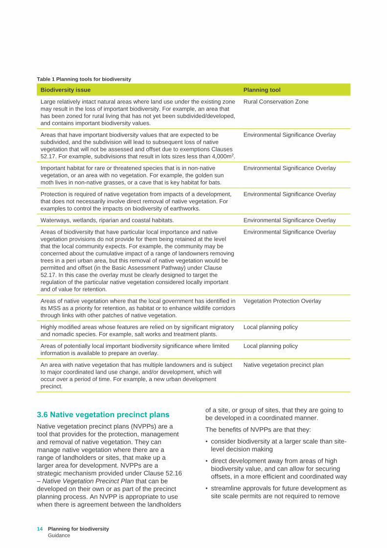
3.5 Selecting planning tools for biodiversity
Table 1 sets out situations where the different
biodiversity planning tools available may be
appropriately utilised.
14 Planning for biodiversity
Guidance
Table 1 Planning tools for biodiversity
Biodiversity issue Planning tool
Large relatively intact natural areas where land use under the existing zone
may result in the loss of important biodiversity. For example, an area that
has been zoned for rural living that has not yet been subdivided/developed,
and contains important biodiversity values.
Rural Conservation Zone
Areas that have important biodiversity values that are expected to be
subdivided, and the subdivision will lead to subsequent loss of native
vegetation that will not be assessed and offset due to exemptions Clauses
52.17. For example, subdivisions that result in lots sizes less than 4,000m2.
Environmental Significance Overlay
Important habitat for rare or threatened species that is in non-native
vegetation, or an area with no vegetation. For example, the golden sun
moth lives in non-native grasses, or a cave that is key habitat for bats.
Environmental Significance Overlay
Protection is required of native vegetation from impacts of a development,
that does not necessarily involve direct removal of native vegetation. For
examples to control the impacts on biodiversity of earthworks.
Environmental Significance Overlay
Waterways, wetlands, riparian and coastal habitats. Environmental Significance Overlay
Areas of biodiversity that have particular local importance and native
vegetation provisions do not provide for them being retained at the level
that the local community expects. For example, the community may be
concerned about the cumulative impact of a range of landowners removing
trees in a peri urban area, but this removal of native vegetation would be
permitted and offset (in the Basic Assessment Pathway) under Clause
52.17. In this case the overlay must be clearly designed to target the
regulation of the particular native vegetation considered locally important
and of value for retention.
Environmental Significance Overlay
Areas of native vegetation where that the local government has identified in
its MSS as a priority for retention, as habitat or to enhance wildlife corridors
through links with other patches of native vegetation.
Vegetation Protection Overlay
Highly modified areas whose features are relied on by significant migratory
and nomadic species. For example, salt works and treatment plants.
Local planning policy
Areas of potentially local important biodiversity significance where limited
information is available to prepare an overlay.
Local planning policy
An area with native vegetation that has multiple landowners and is subject
to major coordinated land use change, and/or development, which will
occur over a period of time. For example, a new urban development
precinct.
Native vegetation precinct plan
3.6 Native vegetation precinct plans
Native vegetation precinct plans (NVPPs) are a
tool that provides for the protection, management
and removal of native vegetation. They can
manage native vegetation where there are a
range of landholders or sites, that make up a
larger area for development. NVPPs are a
strategic mechanism provided under Clause 52.16
– Native Vegetation Precinct Plan that can be
developed on their own or as part of the precinct
planning process. An NVPP is appropriate to use
when there is agreement between the landholders
of a site, or group of sites, that they are going to
be developed in a coordinated manner.
The benefits of NVPPs are that they:
• consider biodiversity at a larger scale than site-
level decision making
• direct development away from areas of high
biodiversity value, and can allow for securing
offsets, in a more efficient and coordinated way
• streamline approvals for future development as
site scale permits are not required to remove
Planning for biodiversity
Guidance
15
native vegetation when this occurs in
accordance with the incorporated NVPP.
Landholders or a group of landholders can initiate
a NVPP and local government usually drafts the
NVPP. NVPPs are incorporated into the planning
scheme and can only be changed through a
planning scheme amendment. Section 10.1 of the
Guidelines sets out what a NVPP must contain.
3.6.1 When to use a NVPP
Developing a NVPP can be an appropriate
strategic planning tool when the following factors
are present:
• the precinct contains native vegetation
• an understanding of the importance of the
native vegetation in the area is required to
inform the planning process
• there are environmental and economic benefits
from consolidating offset requirements
• the area contains a number of properties and
land owners and a plan could coordinate
development and native vegetation
conservation
• the development is to occur over an extended
period of time.
3.6.2 What to consider when developing a
NVPP
The following should be considered when
developing a NVPP:
• the contribution that the native vegetation in the
precinct makes to biodiversity values
• native vegetation that makes a significant
contribution to biodiversity values should be
protected
• any retained native vegetation should remain
viable into the future in the context of
development and other threats
• retained native vegetation can be used to meet,
or partially meet, offset requirements for the
native vegetation to be removed if it meets the
offset site eligibility requirements and can be
secured and conserved in accordance with the
Guidelines
• offset requirements that are unable to be met
using retained native vegetation within the
NVPP area can be sourced elsewhere
• native vegetation does not necessarily have to
be retained within the area.
The NVPP template sets out the detail of how a
NVPP should be developed and is available at
www.environment.vic.gov.au/native-vegetation
3.7 Property vegetation plans
A property Vegetation Plan (PVP) provides for the
long term strategic management of native
vegetation for a single property. A PVP is useful
where a landowner wishes to undertake staged
native vegetation removal on their property over a
longer period of time, for example a timber
harvesting operation over a 10 year period.
A PVP:
• is developed in accordance with the Guidelines,
and in accordance with the relevant PVP
template
• identifies areas of native vegetation that will be
removed
• identities how the native vegetation removal will
be offset
• is approved by the Secretary to DELWP
• is attached to planning permit for the removal of
native vegetation that is valid for 10 years.
Further information on how to develop a PVP is
available on the DELWP website.
3.8 State-wide controls for the removal of native vegetation
The particular provisions in planning schemes
include statewide controls for the removal of
native vegetation at the individual site scale
(Clause 52.16 and Clause 52.17). These controls
require that the statewide biodiversity impacts of
the removal of native vegetation are considered
when assessing an application for a permit to
remove native vegetation.
The controls can help to achieve biodiversity
objectives by:
• providing incentives to avoid and minimise
impacts on biodiversity by requiring a permit
and offsets for the removal of native vegetation
• not granting a permit to remove native
vegetation where the removal will have
significant impacts on Victoria’s biodiversity
• requiring that where a permit is granted, an
offset is secured to compensate for the impact
of the removal of native vegetation on Victoria’s
biodiversity.
16 Planning for biodiversity
Guidance
These provisions operate at the site scale, with
each application to remove native vegetation
being assessed on its stand-alone impact and
merits. They have limitations in addressing
cumulative loss, or in their capacity to provide
coordinated protection of native vegetation. In
addition, they cannot address biodiversity impacts
that do not relate to the removal of native
vegetation.
Local government should not solely rely on the
native vegetation provisions to achieve
biodiversity objectives, but use these controls
alongside the other tools set out in this document.
Planning for biodiversity
Guidance
17
Local government must consider economic, social
and environmental objectives in planning and
decision making. A balance should be sought
between providing for development and growth and
protecting areas of high biodiversity value. The
following steps should be taken in future strategic
planning processes. These steps can be carried out
as a standalone process for biodiversity
considerations, or as part of a broader strategic
planning exercise that includes biodiversity
considerations.
Step 1: Consider broader strategies and responsibilities
Identify international, Commonwealth and State
strategic policy frameworks and determine the roles
and responsibilities of government, organisations,
business and individuals.
Step 2: Identify areas of high biodiversity value
Identify areas of high biodiversity value using the
information outlined in section 5. Any mapped
information should be at an appropriate scale and in
a form suitable for use in planning schemes.
Local government should engage DELWP early in
the process as they can provide advice about the
use of biodiversity information products.
The community, including local indigenous groups,
should also be engaged as they may have valuable
knowledge and information on local biodiversity
assets that have previously not been recorded.
Step 3: Identify any local biodiversity objectives not addressed in step 1 and 2
Identify information gaps and determine how these
may be addressed. Discuss broader strategic
objectives for biodiversity and the practical
application of information in the local planning
scheme such as delineating overlay areas.
Determine if there are any local biodiversity
objectives that are inconsistent with broader
strategies, or that were not identified in step 1.
Step 4: Identify areas where there is demand for development and changes in use
Identify areas where there is likely to be future
demand for development, and changes in use.
Consider the local government’s strategic plans for
growth, any relevant regional and state plans for
development, and any economic and social policies
that will impact on the development of the
municipality.
Step 5: Determine potential conflicts between development and biodiversity values
Consider areas identified in steps 1 - 3 and
determine where this conflicts with areas identified in
step 4.
Determine if these conflicts can be reduced and
where trade-offs are possible that achieve local
government’s objectives for development and
biodiversity. Consider how changes in use and
development can be directed away from areas of
high biodiversity value.
Asses the costs and benefits of taking the planning
action by weighing up the benefits to biodiversity
that it will deliver, compared to any costs that it will
impose on the community and economy.
Step 6: Use the planning tool kit to develop or update the strategic plan accordingly
Review current planning tools including zones,
overlays and other strategic plans, that have
biodiversity objectives, and determine how they align
with the values identified in steps 1 - 3. As required,
consider alternative tools, or update existing tools,
so they address the trade-offs identified in step 5.
Choose the appropriate planning tools mindful of
what protection the existing planning scheme
provides.
Prepare the local provisions (LPPs and schedules to
overlays) and ensure that they provide an adequate
level of protection.
Outdated tools should be removed or updated.
Step 7: Consultation about the proposed planning changes
The community must be consulted with as part of
the strategic planning process. Strategic planning for
biodiversity needs to be supported with clear
objectives and data so that planning decisions can
be justified to affected parties and the community.
Consultation should gather information about any
social or economic impacts the planning action will
have. It needs to be demonstrated that the
environmental benefits of the planning action
outweigh any costs it will impose.
Step 8: Establish a monitoring system, performance targets and indicators
Establish a monitoring system and indicators for
measuring the effectiveness of the planning scheme
tools in achieving biodiversity objectives.
4. Steps to follow when planning for biodiversity
18 Planning for biodiversity
Guidance
Step 9: Amend the planning scheme
Following the required public consultation regarding
any proposed amendments, and once local
government has approved the changes, the planning
scheme amendment is submitted to the Minister for
Planning for approval and gazettal.
Planning for biodiversity
Guidance
19
5.1 Defining biodiversity value
Planning for biodiversity should be informed by up
to date information and focus on the protection
and conservation of high value biodiversity. The
information described in this section can assist in
identifying high value biodiversity in Victoria.
Areas with higher biodiversity values include:
• larger, well connected areas of native
vegetation
• areas with higher strategic biodiversity value
scores
• areas that are highly localised habitat for rare or
threatened species, particularly if they are areas
of highly localised habitat for multiple rare or
threatened species
• important areas of habitat within dispersed
habitats for rare or threatened species or areas
of habitat for many dispersed rare or threatened
species
• native vegetation in good condition (i.e. with
higher condition scores)
• areas with large trees, including consideration of
their age and size
• areas of native vegetation that are an
endangered Ecological Vegetation Class (EVC)
• waterways and sensitive wetlands and coastal
areas including:
– wetlands designated under the Ramsar
Convention
– wetlands listed in the Directory of Important
Wetlands of Australia, and
– internationally important sites for Migratory
Shorebirds of the East Asian-Australasian
Flyway.
• National parks and conservation reserves
• significant roadsides and wildlife corridors
Areas with lower biodiversity values include:
• areas with no native vegetation
• areas with lower strategic biodiversity value
scores
• native vegetation in poor condition (i.e. with
lower condition scores)
• native vegetation that is small in area and
isolated from other native vegetation, unless it
provides highly localised habitat for rare or
threatened species.
5.2 Threats to biodiversity
Victoria’s biodiversity continues to be placed
under threat from land use and development.
Incremental removal of vegetation continues to
occur for housing, infrastructure, subdivision of
land, agricultural activities, and for protection from
bushfire. Degradation in the quality of remaining
vegetation also occurs from uses including from
agricultural runoff and overgrazing, industry, and
recreational activities. Planning can assist in
minimising and managing these threats.
There are other threats to biodiversity that
planning cannot directly control, these include
climate change, and threats caused by past
activities or existing use rights. Planning can
however take these into account in decision
making, to ensure the ongoing impacts from such
threats are minimised. Information products
measuring biodiversity values set out in section 5,
such as the threatened status of EVCs, account
for historic impacts on biodiversity, but not the
potential future impacts.
Some of the key threats to biodiversity that should
be considered when undertaking planning include:
• loss of habitat
• degradation of habitats, including the spread of
weeds and pests
• fragmentation of habitat
• inappropriate fire and flood regimes
• overuse of water resources
• pollution and effluent
• salinity and erosion
• climate change.
5.3 Identifying biodiversity values
Identifying the value and quality of biodiversity
assets within a municipality is an important task
for local government.
Values should be identified using the most up to
date information available on the presence and
significance of biodiversity assets and threatening
processes for the municipality.
5. Sources of biodiversity information and identifying biodiversity assets, values and threats

20 Planning for biodiversity
Guidance
The information used to measure the biodiversity
value of native vegetation is described in the
Guidelines and Biodiversity information
explanatory document – measuring value when
removing or offsetting native vegetation (DELWP,
2017). There are two components to this
information:
• site-based information that can be measured or
observed at a site
• landscape scale information that cannot be
measured or observed at the site and is
included in maps and models.
Mapped products are used to represent site-
based and landscape scale information across
Victoria.
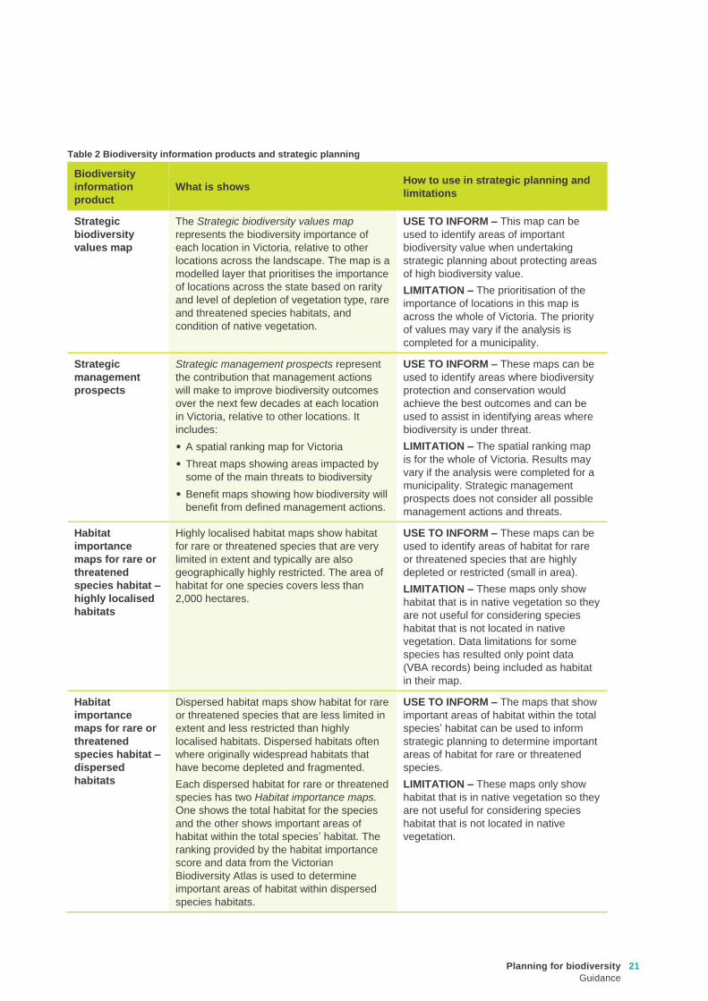
Table 2 (below) sets out biodiversity information
products that DELWP provides and how to use (or
not use) these products when identifying values,
as outlined in section 5, for strategic planning.
Mapped biodiversity information is becoming
increasingly available and accurate. However, the
quality, resolution and completeness of the
information varies across the State and it is
important to note that all maps have limitations in
terms of scale and accuracy. Table 2 includes
limitations associated with the use of mapped
biodiversity information. These limitations should
be considered when undertaking planning for
biodiversity.
For further information about how the products
listed go to www.environment.vic.gov.au/native-
vegetation. To access the mapped products go to
maps.biodiversity.vic.gov.au/viewer/?viewer=Natu
reKit
5.3.1 Local government and site gathered
biodiversity information
Local government may have their own
photography or mapping, or may wish to collect
additional site-based biodiversity information, to
inform strategic planning.
This information should be robust and how it has
been collected and used in strategic planning
must be made transparent.
In many cases mapped information can be used
to inform planning, as set out in Table 2. However,
some level of ground truthing may be required
before it can be relied on in planning, such as to
determine the boundaries of an overlay.
It is important to ensure that information is up to
date, is presented at an appropriate scale for the
purpose it is used for, and that it contains all the
required information to be used for that purpose,
for example native and non-native habitat for a
species.
5.4 Evaluating biodiversity assets
Once biodiversity values have been identified for
a municipality, they can be evaluated to determine
their significance and their influence on planning
decisions.
The more important the biodiversity asset, the
more critical are decisions about its future. The
level of significance of a biodiversity asset may
assist in determining which planning control is
most appropriate.
Whether or not a planning control is effective in
managing biodiversity values will depend on the
size and distribution of the biodiversity asset and
its resilience or sensitivity to change.
Planning for biodiversity
Guidance
21
Table 2 Biodiversity information products and strategic planning
Biodiversity
information
product
What is shows How to use in strategic planning and
limitations
Strategic
biodiversity
values map
The Strategic biodiversity values map
represents the biodiversity importance of
each location in Victoria, relative to other
locations across the landscape. The map is a
modelled layer that prioritises the importance
of locations across the state based on rarity
and level of depletion of vegetation type, rare
and threatened species habitats, and
condition of native vegetation.
USE TO INFORM – This map can be
used to identify areas of important
biodiversity value when undertaking
strategic planning about protecting areas
of high biodiversity value.
LIMITATION – The prioritisation of the
importance of locations in this map is
across the whole of Victoria. The priority
of values may vary if the analysis is
completed for a municipality.
Strategic
management
prospects
Strategic management prospects represent
the contribution that management actions
will make to improve biodiversity outcomes
over the next few decades at each location
in Victoria, relative to other locations. It
includes:
• A spatial ranking map for Victoria
• Threat maps showing areas impacted by
some of the main threats to biodiversity
• Benefit maps showing how biodiversity will
benefit from defined management actions.
USE TO INFORM – These maps can be
used to identify areas where biodiversity
protection and conservation would
achieve the best outcomes and can be
used to assist in identifying areas where
biodiversity is under threat.
LIMITATION – The spatial ranking map
is for the whole of Victoria. Results may
vary if the analysis were completed for a
municipality. Strategic management
prospects does not consider all possible
management actions and threats.
Habitat
importance
maps for rare or
threatened
species habitat –
highly localised
habitats
Highly localised habitat maps show habitat
for rare or threatened species that are very
limited in extent and typically are also
geographically highly restricted. The area of
habitat for one species covers less than
2,000 hectares.
USE TO INFORM – These maps can be
used to identify areas of habitat for rare
or threatened species that are highly
depleted or restricted (small in area).
LIMITATION – These maps only show
habitat that is in native vegetation so they
are not useful for considering species
habitat that is not located in native
vegetation. Data limitations for some
species has resulted only point data
(VBA records) being included as habitat
in their map.
Habitat
importance
maps for rare or
threatened
species habitat –
dispersed
habitats
Dispersed habitat maps show habitat for rare
or threatened species that are less limited in
extent and less restricted than highly
localised habitats. Dispersed habitats often
where originally widespread habitats that
have become depleted and fragmented.
Each dispersed habitat for rare or threatened
species has two Habitat importance maps.
One shows the total habitat for the species
and the other shows important areas of
habitat within the total species’ habitat. The
ranking provided by the habitat importance
score and data from the Victorian
Biodiversity Atlas is used to determine
important areas of habitat within dispersed
species habitats.
USE TO INFORM – The maps that show
important areas of habitat within the total
species’ habitat can be used to inform
strategic planning to determine important
areas of habitat for rare or threatened
species.
LIMITATION – These maps only show
habitat that is in native vegetation so they
are not useful for considering species
habitat that is not located in native
vegetation.
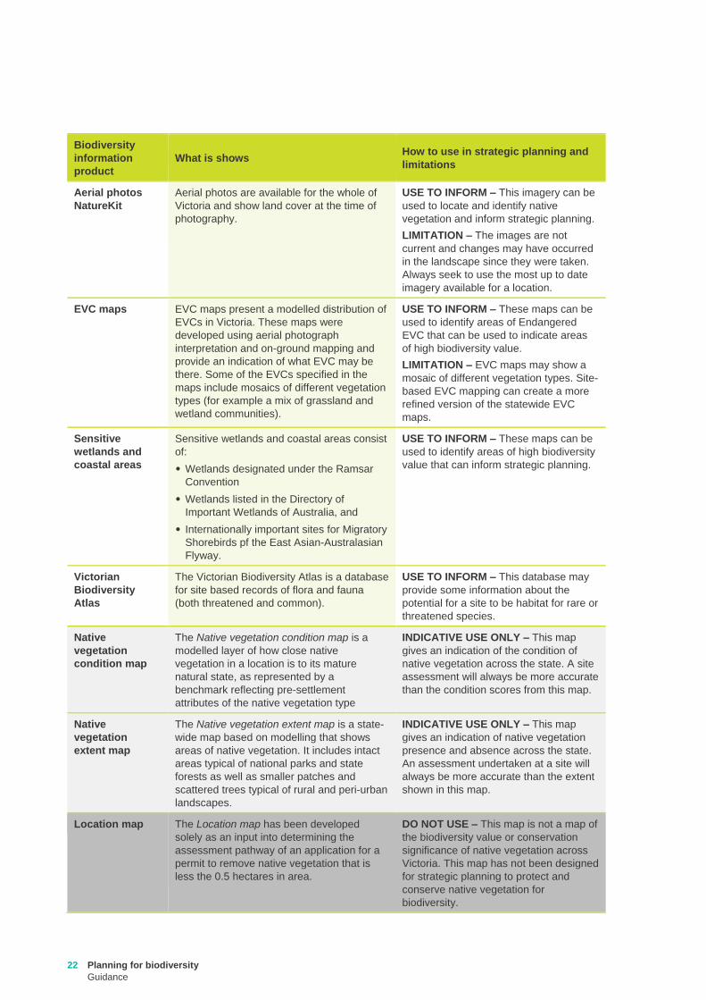
22 Planning for biodiversity
Guidance
Biodiversity
information
product
What is shows How to use in strategic planning and
limitations
Aerial photos
NatureKit
Aerial photos are available for the whole of
Victoria and show land cover at the time of
photography.
USE TO INFORM – This imagery can be
used to locate and identify native
vegetation and inform strategic planning.
LIMITATION – The images are not
current and changes may have occurred
in the landscape since they were taken.
Always seek to use the most up to date
imagery available for a location.
EVC maps EVC maps present a modelled distribution of
EVCs in Victoria. These maps were
developed using aerial photograph
interpretation and on-ground mapping and
provide an indication of what EVC may be
there. Some of the EVCs specified in the
maps include mosaics of different vegetation
types (for example a mix of grassland and
wetland communities).
USE TO INFORM – These maps can be
used to identify areas of Endangered
EVC that can be used to indicate areas
of high biodiversity value.
LIMITATION – EVC maps may show a
mosaic of different vegetation types. Site-
based EVC mapping can create a more
refined version of the statewide EVC
maps.
Sensitive
wetlands and
coastal areas
Sensitive wetlands and coastal areas consist
of:
• Wetlands designated under the Ramsar
Convention
• Wetlands listed in the Directory of
Important Wetlands of Australia, and
• Internationally important sites for Migratory
Shorebirds pf the East Asian-Australasian
Flyway.
USE TO INFORM – These maps can be
used to identify areas of high biodiversity
value that can inform strategic planning.
Victorian
Biodiversity
Atlas
The Victorian Biodiversity Atlas is a database
for site based records of flora and fauna
(both threatened and common).
USE TO INFORM – This database may
provide some information about the
potential for a site to be habitat for rare or
threatened species.
Native
vegetation
condition map
The Native vegetation condition map is a
modelled layer of how close native
vegetation in a location is to its mature
natural state, as represented by a
benchmark reflecting pre-settlement
attributes of the native vegetation type
INDICATIVE USE ONLY – This map
gives an indication of the condition of
native vegetation across the state. A site
assessment will always be more accurate
than the condition scores from this map.
Native
vegetation
extent map
The Native vegetation extent map is a state-
wide map based on modelling that shows
areas of native vegetation. It includes intact
areas typical of national parks and state
forests as well as smaller patches and
scattered trees typical of rural and peri-urban
landscapes.
INDICATIVE USE ONLY – This map
gives an indication of native vegetation
presence and absence across the state.
An assessment undertaken at a site will
always be more accurate than the extent
shown in this map.
Location map The Location map has been developed
solely as an input into determining the
assessment pathway of an application for a
permit to remove native vegetation that is
less the 0.5 hectares in area.
DO NOT USE – This map is not a map of
the biodiversity value or conservation
significance of native vegetation across
Victoria. This map has not been designed
for strategic planning to protect and
conserve native vegetation for
biodiversity.
Planning for biodiversity
Guidance
23
The following are relevant practice notes that can assist when undertaking planning for biodiversity
protection and conservation. For more information see
https://www.planning.vic.gov.au/publications/planning-practice-notes
PPN02: Public Land Zones
PPN04: Writing a Municipal Strategic Statement
PPN07: Vegetation Protection in Urban Areas
PPN08: Writing a Local Planning Policy
PPN10: Writing Schedules
PPN42: Applying the Rural Zones
PPN50: Preparing a native vegetation precinct plan
PPN53: Managing Coastal Hazards and the Coastal Impacts of Climate Change
PPN62: Green Wedge Planning Provisions
PPN64: Local planning for bushfire protection
Appendix A Planning practice notes