![Christmas Cracker - Retford Ukulele RUGs Song Books... · Retford Ukulele Group – Christmas Cracker Page 6 of 24 I Wish It Could Be Christmas Every Day Oh when the [C]snowman brings](https://static.fdocuments.net/doc/165x107/5b6821c57f8b9a24488c5635/christmas-cracker-retford-ukulele-rugs-song-books-retford-ukulele-group.jpg)
PLANNING COMMITTEE · GES UK Ltd Land adjacent to Corner House Farm, 2 Lound Low Road, Sutton Cum...
85
PLANNING COMMITTEE AGENDA Meeting to be held in The Ceres Suite Worksop Town Hall, DN22 6DB on Wednesday 1 st April 2020 at 6.30 p.m. (Please note time and venue) Please turn mobile telephones to silent during meetings. In case of emergency, Members/officers can be contacted on the Council's mobile telephone: 07940 001 705. In accordance with the Openness of Local Government Bodies Regulations 2014, audio/visual recording and photography at Council meetings is permitted in accordance with the Council’s protocol ‘Filming of Public Meetings’. 1
Transcript of PLANNING COMMITTEE · GES UK Ltd Land adjacent to Corner House Farm, 2 Lound Low Road, Sutton Cum...
PLANNING COMMITTEE
AGENDA
Meeting to be held in The Ceres Suite
Worksop Town Hall, DN22 6DB on Wednesday 1st April 2020
at 6.30 p.m.
(Please note time and venue)
Please turn mobile telephones to silent during meetings. In case of emergency, Members/officers can be contacted
on the Council's mobile telephone: 07940 001 705.
In accordance with the Openness of Local Government Bodies Regulations 2014, audio/visual recording and photography at Council meetings is permitted
in accordance with the Council’s protocol ‘Filming of Public Meetings’.
1

PLANNING COMMITTEE Membership 2019/20 Councillors H Brand, D Challinor, M Charlesworth, S J Fielding, G Freeman, G
A N Oxby, D G Pidwell, M W Quigley MBE, M Richardson, N Sanders, L Schuller, B Tomlinson.
Substitute Members: None Quorum: 3 Members Lead Officer for this Meeting John Krawczyk Administrator for this Meeting James Lavender NOTE FOR MEMBERS OF THE PUBLIC (a) Please do not take photographs or make any recordings during the meeting without the
prior agreement of the Chair. (b) Letters attached to Committee reports reflect the views of the authors and not
necessarily the views of the District Council.
2
PLANNING COMMITTEE
Wednesday 1st April 2020
AGENDA
1. APOLOGIES FOR ABSENCE
2. DECLARATIONS OF INTEREST BY MEMBERS AND OFFICERS
(a) Members (b) Officers
3. MINUTES OF MEETING HELD ON 4th MARCH 2020 * (pages 5 - 10)
4. MINUTES OF PLANNING CONSULTATION GROUP MEETINGS HELD BETWEEN 20th
JANUARY and 17th FEBRUARY 2020* (pages 11 - 18)
5. OUTSTANDING MINUTES LIST * (page 19)
SECTION A – ITEMS FOR DISCUSSION IN PUBLIC
Key Decisions
None
Other Decisions
6. REPORT(S) OF THE HEAD OF REGENERATION *
(a) Public Interest Test: (Ms B Alderton-Sambrook, Head of Regeneration, has deemed that all Items on the Agenda are not confidential)
(b)(c)(d)
Planning Applications and Associated ltems (pages 21 - 60) Victoria Institute Article 4(1) Direction - Committee Report (pages 61 - 80)Stats Report 2019-20 Q3 (pages 81 - 85)
Exempt Information Items
The press and public are likely to be excluded from the meeting during the consideration of the following items in accordance with Section 100A(4) of the Local Government Act 1972.
SECTION B - ITEMS FOR DISCUSSION IN PRIVATE
Key Decisions
None
Other Decisions
None.
7. ANY OTHER BUSINESS WHICH THE CHAIR CONSIDERS TO BE URGENT
* Report attached NOTES:
1. The papers enclosed with this Agenda are available in large print if required.2. Copies can be requested by contacting us on 01909 533252 or by e-mail:


PLANNING COMMITTEE
Minutes of the meeting held on Wednesday 4th March 2020 at Worksop Town Hall
Present:
D G Pidwell (Chair) H Brand, M Charlesworth, G Freeman, M Richardson, N Sanders, L Schuller and B Tomlinson.
Officers in attendance: J Krawczyk, J Lavender, S Wormald.
(Meeting commenced at 6.30pm).
(The Chair welcomed all to the meeting and read out the Fire Evacuation Procedure. He also enquired as to whether any member of the public wished to film the meeting or any part thereof; this was not taken up).
64. APOLOGIES FOR ABSENCE
Apologies for absence were received from Councillors D Challinor, S Fielding and G A N Oxby.
65. DECLARATIONS OF INTEREST
(a) Members
There were no declarations of interest by members.
(b) Officers
There were no declarations of interest by officers.
66. MINUTES OF THE MEETING HELD ON 5th FEBRUARY 2020
The Chair announced that Committee members had received direct mailings from a District Councillor objecting to 19/00852/FUL and from a member of the public objecting to 19/01459/PIP. The minutes were updated to reflect this.
RESOLVED that the Minutes of the meeting held on 5th February 2020 be approved.
67. MINUTES OF PLANNING CONSULTATION GROUP MEETINGS HELD BETWEEN 20th
JANUARY 2020 AND 17th FEBRUARY 2020
RESOLVED that the Minutes of the Planning Consultation Group meetings held between 20th January 2020 and 17th February 2020 be received.
68. OUTSTANDING MINUTES LIST
RESOLVED that the Outstanding Minutes List be received.
SECTION A – ITEMS FOR DISCUSSION IN PUBLIC
Key Decisions
None.
Other Decisions
5
Agenda Item No. 3
69. REPORT(S) OF THE DIRECTOR OF REGENERATION AND NEIGHBOURHOODS (a) Public Interest Test The Head of Regeneration had deemed that all Items on the Agenda were of a non-confidential nature. (b) Appeal decisions received Members were presented with one appeal decision. RESOLVED that the appeal decision be received. (c) Planning Applications and Associated Items Application No Applicant Proposal
19/01520/FUL
GES UK Ltd Land adjacent to Corner House Farm, 2 Lound Low Road, Sutton Cum Lound, Retford. Retention of 1.8m high close boarded timber fence on boundary of Plots 2 and 3 Lound Low Road.
Members were advised that Retrospective Planning Permission was being sought for the retention of a 1.8m timber fence on the boundary between Lound Low Road and Plots 2 and 3 of the housing development on Lound Low Road adjacent to Corner House Farm. The timber fence is painted green and has a metal railing fence with a planted laurel hedge in front of it. Nottinghamshire Highways stated that the fence should be located behind the public highway, to which the developer has complied and Nottinghamshire Highways are now content with that the proposal would not result in any detriment to highway safety. The Case Officer presented members with site maps and photos of the development. The Parish Council objected to the development on the following grounds:
The erection of the fence has restricted visibility on this 90 degree bend; The fence is out of character with the historic buildings within the immediate vicinity and
would therefore conflict with Policy DM4 of the Bassetlaw Local Development Framework. A District Councillor has objected to the development on the following grounds;
The fence is an eyesore; The fence obstructs visibility to the detriment of highway safety; The views from the Highways Authority should be sought.
Nine letters of objection were received outlining the following;
The fence obstructs visibility to the detriment of highway safety; The fence will inhibit the growth of the laurel hedge; The fence is unsightly; The existing hedge was removed together with a monkey puzzle tree; Granting permission could set an undesirable precedent for similar fences; The fence will force the laurel hedge to grow over the pavement; The blind corner is dangerous for pedestrians; The fence is unduly suburban in character; The sense of enclosure created by the fence is at odds with the rural character of the village.
6
The criteria as set out in the Sutton Cum Lound Neighbourhood Plan states that development should use a locally inspired range of materials and hedges as boundary treatments. Whilst the fence does appear somewhat stark, over time, the growth of the laurel hedge would mean that the prominence of the fence would diminish. The fence would have no impact on the residential amenity of neighbouring properties in terms of domination or overshadowing. Nottinghamshire Highways have indicated that the development would not obstruct visibility and have no adverse impact on highway safety. The erection of 1.8m high timber fence on these properties would have no adverse impact on the surrounding heritage assets. Andrew Grainger, the Applicant, thanked the members and the officers for considering his application. Members raised questions and concerns regarding:
The fence looked obtrusive and the wrong colour was used on the fence, thus showing that it was not in keeping with the character of the village;
Have Nottinghamshire Highways visited the site and measure the height of the fence and its distance from the road?
Would it be the responsibility of Bassetlaw District Council to maintain the hedge? Would the hedge grow without the need of the fence? If retrospective Planning Permission was refused, would the Applicant have to remove the
fence? In that case, would Permitted Development Rights come into effect and the property owners could then erect whatever fences they wanted?
In response to questions and concerns raised, the Case Officer clarified that:
Nottinghamshire Highways have visited the development and are content with the fence and believe that there will be no adverse impact on highway safety;
Nottinghamshire Highways would also maintain the hedge; Time will weather the colour of the fence and the laurel hedge will obscure the fence, so it
would be more in keeping with the character of the village; If the fence were removed, the hedge would not grow as densely and the owners of the
properties could exercise their Permitted Development Rights to erect whatever fences they liked.
The Chair summarised the arguments for and against the development. RECOMMENDATION OF THE HEAD OF REGENERATION – Grant planning permission. COMMITTEE DECISION – Grant planning permission. Application No Applicant Proposal
19/01581/FUL
Glen Vardy Demolition of garage and side extension to The Hazels and erection of a new detached garage and erection of one new 1.5 storey dwelling with integral garage. The Hazels, Cave’s Lane, Walkeringham.
7

Members were advised that planning permission was being sought for the demolition of the existing garage and construction of a new garage and erection of a 1.5 storey dwelling with integral garage, all located on the site of The Hazels. The Hazels is a large brick-built detached bungalow set within a generous plot. It has been previously extended and is located within the Walkeringham Development Boundary, as identified in their Neighbourhood Plan. The Case Officer presented members with site maps, photos of The Hazels and neighbouring properties, designs and locations of the new garage and bungalow. No objections were raised by Waste and Recycling, Environmental Health and the Parish Council. Two letters of objection and one letter of support were received outlining the following:
Proposed footprint is making maximum use of land and is considerably larger than the existing bungalow, giving the site an over-developed appearance;
Floor to ceiling glass panels are inappropriately squeezed into this location; Elevation E-03 is considerable length approx. 22m along boundary fence (actual length
proposed 19.75m); Design is out of character with other properties within vicinity; The proposal will result in five properties requiring access on the bend of Cave’s Lane; The site has been excluded in the Draft Neighbourhood Plan and is not considered suitable
for development; The new garage would compromise the safety and security of the neighbouring property, as
it would obstruct view of gate entrance and private driveway; The eco-design of the property is in line with Bassetlaw’s Draft Local Plan.
National Planning Policy Framework (NPPF) paragraph 11 contains a presumption in favour of sustainable development unless the adverse impacts of doing so would outweigh the benefits. This is reflected in the Draft Neighbourhood Plan Policy 1 that supports sustainable development within the development boundary, so in principle, the proposed development is acceptable. The design is meant to make efficient use of the shape of the plot. The key part of the bungalow that is visible is the front elevation. The design is single storey close to the boundary with the neighbouring property, with the central apex maximum height of 6.75m and then a reduced height down to the existing bungalow eaves. This design falls in line with Walkeringham Neighbourhood Plan Policy 3: Design Principles for high design quality that will contribute to the character of the area, buildings appropriate to their location and including innovate and contemporary designs, and innovative approaches to the construction of low carbon homes which demonstrate sustainable use of resources and high energy efficient levels being supported. The proposed garage will be made of traditional red bricks which reflect the character of the neighbouring properties. The design of the bungalow will contain a white render and some cedar cladding, in keeping with the surround white rendered properties. Nottinghamshire Highways have stated that there is adequate off-street parking to service all the properties on the bend of Cave’s Lane. The proposed dwelling was designed to maintain privacy for proposed and existing residents. The position of the proposed dwelling has ensured that there is no unacceptable overshadowing of the Rotherholme property 20m north of the site. There is also substantial rear garden areas which separate the site from Everglade House and Sycamore House. There is low risk of flooding on the property and no adverse impact of flooding on neighbouring properties. Mr Neil Cooke, the Architect, spoke in favour of the project, commenting that:
8
The applicant is a member of the Parish Council and consulted them before proceeding
with this application; The site was originally earmarked for four dwellings, so there will be minimal impact with
the building of one new dwelling and a garage compared to four dwellings; The Planning Office raised no objections to this development; Six new dwellings are being constructed on the site of the nearby disused brickworks; This dwelling has strong sustainability credentials.
Members raised questions/concerns regarding:
The garage being located near the road could be dangerous for traffic coming in and out of the property;
The site was excluded from development in the Walkeringham Neighbourhood Plan; The garage restricts the view of the residents of The Wallnuts from being able to see anyone
coming onto their property, thus maximising security concerns; Removal of trees; The design may not be entirely in keeping with the village, but sustainable homes like these
do need building. In response to questions and concerns raised, the Case Officer clarified that:
The garage has a long driveway; The holly trees would be removed, but the others could be kept. There is no tree protection
order in place for this development; The Wallnuts is well concealed and the proposed garage would only restrict the view of the
driveway by 20 yards. The Chair summarised the arguments for and against the development. RECOMMENDATION OF THE HEAD OF REGENERATION – Grant planning permission. COMMITTEE DECISION – Grant planning permission. (d) Proposed confirmation of an Article 4(1) Direction for Worksop Central Area Houses in
Multiple Occupation Members were presented with a report to approve for the confirmation of an Article 4 Direction under Paragraphs 2(6), 2(7), 1(9) and 1(10) of Schedule 3, Article 4(1) of the Town and Country Planning (General Permitted Development) (England) Order 2015, as amended, to restrict permitted development rights in respect of Worksop Central Area Houses in Multiple Occupation. Once approved, authority will be delegated to the Head of Regeneration. Houses in Multiple Occupation (HMOs) are classified as a building or part of a building occupied by 3 unrelated people or more if it consists of one or more units of living accommodation that is not a self-contained flat or flats. Currently, there is an overconcentration of HMOs in Central Worksop. It has a relatively small catchment area which includes the town centre, bus station and railway station, and can provide affordable accommodation for those moving to Worksop to work. The majority of the properties in the area are Victorian or Edwardian semi-detached or detached proposed, as well as high-density Victorian terraced streets, most are capable of conversation into smaller units. To date, at least 48 properties have been converted into HMOs in Central Worksop and can no longer be made available as family accommodation. This is contrary to Core Strategy Policy DM4:
9

Design and Character which seeks to protect and enhance the character of the built and historic environment, ensure new development is of a scale appropriate to the surrounding area and improve the range of houses in the area.
With the clustering of HMOs within Central Worksop, there may be a negative impact on the area in terms of amenities, such as pressures on local public services, increased traffic and noise, all of which can have a detrimental effect to the occupants, neighbours and the physical environment of the neighbourhood.
The making of Article 4(1) Directions in common practice across the country with respect to the restriction of permitted development for change of use rights from C3 to C4. They are common in inner urban areas, such as Sheffield, Nottingham and Lincoln, where loss of family sized properties has caused harm to character and amenity for residents.
A public consultation was carried out between 5th December 2019 and 16th January 2020 involving residential property owners, local ward councillors, the Ministry for Housing, Communities and Local Government and Nottinghamshire County Council.
Members raised questions/concerns regarding:
Other residential parts, such as Elms Road, Wellbeck Street and Sherwood Road should beincluded as they contain Victorian and Edwardian houses which if left off, could bedeveloped into HMOs;
A six-week consultation should take place before it is approved by Planning Committee.
RESOLVED to defer this item until a later date after Planning Officers have consulted with Worksop Councillors and taken the recommendations out for further consultation.
Key Decisions
None.
Other Decisions
None.
70. ANY OTHER BUSINESS WHICH THE CHAIR CONSIDERS TO BE URGENT
As there was no other urgent business to be considered, the Chair closed the meeting.
(Meeting closed at 7:40pm).
10

PLANNING CONSULTATION GROUP
Minutes of the meeting held on Monday 2nd March 2020 at Worksop Town Hall
Present: Councillors H Brand, S Fielding and D Pidwell.
Officers in attendance: E Hinsley and J Krawczyk.
(Meeting opened at 4.00pm).
152. APOLOGIES
Apologies for absence were received from Councillor M W Quigley MBE.
153. DECLARATIONS OF INTEREST
None
154. PLANNING APPLICATIONS
Application No Proposal
19/01638/RES Reserved Matters Application for One Dwelling (Plot One) Following Outline P/A 17/00223/OUT. Seeking Approval for Appearance, Site Layout, Landscaping, Scale and Access. Plot 1, Land To The North East Of Gibdyke, Misson.
Members were informed that outline planning permission had been granted in 2017 and now the developer was seeking a reserved matters application for appearance, landscaping, layout, scale and access for a single dwelling with a detached bungalow and workshop within the development. Originally the site was to be for two detached dwellings but this has been amended to the single dwelling with detached bungalow and workshop.
Members were shown site maps and designs for the dwellings and garage.
Objections were received from Misson Parish Council on the following grounds:
There was no pre-application engagement by the developer Concern regarding highway safety as Gibdyke is narrow and the visibility splay may
need to be increased. The development was contrary to the neighbourhood plan in that it would not enhance
the historic character of this section of the village Significant loss of amenity, particularly to Holly Cottage The dwellings are of an excessive scale that does not reflect the NP requirements for
smaller market dwellings The effect on wildlife and the environment, including from light pollution. An up to date
ecology report has not been provided Clarification required in respect of the maintenance of the private drive Concern regarding the adequacy of the drainage system The dwellings were excessively imposing.
The Planning Development Manager stated that outline planning permission for this development had originally been granted in 2017 for four dwellings. This has now been amended to three detached houses, one with a detached garage and workshop. He also
11
Agenda Item No. 4

commented that while there is a need for smaller homes in the area, these are on the edge of the settlement and in keeping with surrounding dwellings.
The Conservation Manager had not raised any concerns, but suggested conditions relating to brick coursing and rainwater goods. The impact upon ecology was considered at outline planning application and an up to date ecology report has been submitted. The Highways Authority had no objections to the proposal.
Members raised the issues of driveway maintenance and street lighting. The Planning Development Manager stated that responsibility for the driveway would lie with the private home owners and that street lights would not be necessary due to the small number of homes. Members also suggested allocating an area for bins to be collected so as not to block the highway and there is a condition imposed on the outline permission requiring details of this.
Initial officer recommendation – Grant approval for application – refer to PCG.
Outcome following PCG – Delegate for officer decision.
Application No Proposal
19/01639/RES Reserved Matters Application for One Dwelling (Plot Two) Following Outline P/A 17/00223/OUT. Seeking Approval for Appearance, Site Layout, Landscaping, Scale and Access. Plot 2, Land To The North East Of Gibdyke, Misson.
Members were informed that outline planning permission had been granted in 2017 and now the developer was seeking a reserved matters application for appearance, landscaping, layout, scale and access for a single dwelling within the development.
The plans and comments received were outlined in the preceding application.
Initial officer recommendation – Grant approval for application – refer to PCG.
Outcome following PCG – Delegate for officer decision.
Application No
19/01640/RES
Proposal
Reserved Matters Application for One Dwelling (Plot Three) Following Outline P/A 17/00223/OUT. Seeking Approval for Appearance, Site Layout, Landscaping, Scale and Access. Plot 3, Land To The North East Of Gibdyke, Misson.
Members were informed that outline planning permission had been granted in 2017 and now the developer was seeking a reserved matters application for appearance, landscaping, layout, scale and access for a single dwelling within the development.
The plans and comments received were outlined in the preceding application.
Initial officer recommendation – Grant approval for application – refer to PCG.
Outcome following PCG – Delegate for officer decision.
12

Application No Proposal
19/01570/FUL Erect Dormer Bungalow With Detached Double Garage and Alter Existing Access. Land To East And South Of The Old Shop, Main Street, North Leverton
Members were informed that a planning application had been received in December 2019 for an existing residential plot with driveway access and permission was now being sought to erect a dormer bungalow with detached double garage and alter existing access.
Members were shown a site plan and design of the bungalow and garage.
The Parish Council has no concerns and supports the application.
The Planning Development Manager stated that while the plans do include dormer windows, these are to the rear of the property and would not overlook neighbouring properties.
The owner of a neighbouring property had concerns that one of his outbuildings is attached to another belonging to the planned site and that demolition of one could weaken the structure of the other. The Planning Development Manager stated that this would fall under the Party Wall Act, which would mean that the developer would be required to ensure structural integrity is maintained.
Comments were also received from the owners of a nearby working farm, to ensure that the future occupiers are aware of their proximity to reduce complaints relating to noise and smells etc.
Initial officer recommendation – Grant approval for application – refer to PCG.
Outcome following PCG – Delegate for officer decision.
Application No 19/01664/VPO8
Proposal Modification of 106 Agreement Under Planning Permission 16/10/00047 – To allow the public open space to be Maintained by a managementCompany rather than be adopted By Bassetlaw District Council. Development Land At Former Poultry Site, Mark Lane, East Markham
Members were informed that permission was being sought for a Modification of 106 Agreement Under Planning Permission 16/10/00047 – to allow the public open space to be maintained by a management company rather than be adopted by Bassetlaw District Council.
Members were shown a site plan of the development.
The Planning Development Manager stated that this falls in line with the current Bassetlaw District Council policy to not take on additional open spaces.
East Markham Parish Council had raised concerns that the open spaces may not be kept to the same standards as in the rest of the parish. The Planning Development Manager stated that the Parish Council was currently in talks with the developer to adopt the open spaces themselves for a one-off fee of £25,000. If approved, it could be amended in the agreement that, ‘the council’ could refer to either Bassetlaw District Council or East Markham Parish Council.
13

Members raised concerns about a management company having different standards to the council and proposed the idea that a maintenance schedule could be added to the conditions.
Initial officer recommendation – Grant approval for application – refer to PCG.
Outcome following PCG – Delegate for officer decision.
Application No 19/01369/OUT
Proposal Outline Application with All Matters Reserved for Residential Development (Resubmission of P.A. 19/00196/OUT). Land North Of Brindley House, Blyth Road, Ranby
Members were informed that permission was being sought for Outline Planning Application for a residential development The Planning Development Manager stated that this had previously been refused due to the visual impact on the landscape.
Members were shown a site plan of the development.
The Parish Council objected on the following grounds:
It was outside the defined development; Loss of the current greenfield site and potential effect on wildlife; Loss of trees; It would make the area vulnerable to further development.
The Planning Development Manager stated that there were not many trees on site and none were covered by a Tree Protection Order. The submitted ecology survey did not identify any species of note in the area and there were no objections from the Wildlife Trust, subject to conditions. He stated that the site could be sensitively developed, retaining trees as much as possible. The site could potentially include 2 – 3 homes which would be in line with the relevant policies within the local plan.
The Canal and River Trust did not object to the application subject to the imposition of conditions. One letter of support was received which stated future buyers be made aware that there is a mooring and a towpath on site, both of which are well used.
Members commented on the possibility of adding a condition that the developer must add a number of trees for every one removed. The Planning Development Manager stated that they would be looking for strong landscaping plans in any future applications and conditions could be included.
Initial officer recommendation – Grant approval for application – refer to PCG.
Outcome following PCG – Delegate for officer decision.
155. ANY OTHER BUSINESS
As there was no other business to be considered, the Chair closed the meeting.
(Meeting closed at 4:40pm).
14

PLANNING CONSULTATION GROUP
Minutes of the meeting held on Monday 9th March 2020 at Worksop Town Hall
Present: Councillors D G Pidwell, S Fielding, H Brand, G Freeman
Officers in attendance: J Krawczyk, J Lavender.
(Meeting opened at 4.00pm).
156. APOLOGIES
Apologies were received from Councillor M W Quigley MBE.
157. DECLARATIONS OF INTEREST
None
158. PLANNING APPLICATIONS
Application No Proposal
20/00036/FUL One dwelling with detached double garage (Plot 1). Amendment to 17/01660/FUL. Land adjacent to Laburnum House, Low Street, North Wheatley.
Members were informed that permission was being sought for full approval of the construction of a detached double garage on the property of Laburnum House, Low Street, North Wheatley. The dwelling already benefits from planning permission but the detached garage does not.
Members were shown site plans and designs for the garage and dwelling.
Two members of the public made objections on the following grounds:
The garage would have an overshadowing, excessively dominant impact on theneighbouring property;
Adverse impact upon highway safety; The additional building will be an overdevelopment of the plot and lead to drainage
issues.
As a 1.8m fence separated the two properties and the proposed garage faced the neighbours’ garage, it was believed that there was no adverse impact to neighbours’ amenity.
There were no grounds for believing that traffic would increase due to the construction of this garage and planning permission had already been granted previously.
Initial officer recommendation – Grant approval for full planning permission – refer to PCG.
Outcome following PCG – Delegate for officer decision.
Application No Proposal
20/00054/VOC Vary condition 7 of pp 15/00215/FUL for installation of 10MW solar photovoltaic development. Misson Solar Farm, Bryans Close, Misson.
15

Members were informed that permission was being sort to approve the extension of keeping the solar panels at the Misson Solar Farm site from 35 years to 40 years from the date of the original application.
Members were shown site plans.
The Parish Council raised no objections.
One member of the public raised an objection based on increased traffic. It was noted that the development has been constructed and generates very little traffic to the site.
Initial officer recommendation – Grant approval for full planning permission – refer to PCG.
Outcome following PCG – Delegate for officer decision.
Application No Proposal
19/01549/VOC Variation of Conditions 2 and 25 – Amended site layout of PA 18/00337/FUL – Erection of 111 dwellings, construct new access and associated landscaping, amenity space and parking. Land south of Tylden Road, Rhodesia, Worksop.
Members were informed that permission was being sought to amend the site layout for PA 18/00337/FUL by repositioning the highway and dwellings which would result in some of the proposed dwellings being positioned closer to Mary Street. This would mean that the proposed dwellings would be 40 metres away from the existing properties on Mary Street instead of 43 metres in the original application.
Members were shown site plans and observed that four plots that were being moved didn’t seem to possess off-street parking.
No public objections were raised by the residents of Mary Street.
Initial officer recommendation – Grant approval for full planning permission – refer to PCG.
Outcome following PCG – Delegate for officer decision and confirm with the applicant the arrangements for off-street parking regarding four plots.
159. ANY OTHER BUSINESS
As there was no other business to be considered, the Chair closed the meeting.
(Meeting closed at 4:20pm).
16

PLANNING CONSULTATION GROUP
Minutes of the meeting held on Monday 16th March 2020 at Worksop Town Hall
Present: Councillors D G Pidwell, S Fielding, H Brand, M Quigley OBE and M Richardson
Officers in attendance: J Krawczyk and J Lavender
(Meeting opened at 4.00pm).
164. APOLOGIES
None.
165. DECLARATIONS OF INTEREST
None.
166. PLANNING APPLICATIONS
Application No
Proposal
20/00004/FUL Demolition of existing bungalow and outbuildings with proposed residential development of 9 x 3 bedroom detached bungalows. Land at Olinda, Southgore Lane, North Leverton.
Members were advised that permission was being sought to amend a previous planning application for thirteen three-bed bungalows to nine instead.
Members were shown site maps and designs of the three-bed bungalows.
Two letters of objections were received from residents, namely around the surface run-off from the development which could potentially lead to flooding.
The Parish Council raised objections to the application on the following grounds;
Access arrangements are too near the railway crossing; Sewage and drainage issues; The development is not in line with the planning requirements of the Sturton
Neighbourhood Plan.
The development is required to provide a suitable drainage scheme. The Flood Agency made no objections to this development.
The development emphasises the construction of three-bed bungalows, which is a requirement of the Sturton Neighbourhood Plan.
Network Rail requested a sign to be erected at the access point, but members felt that this wasn’t necessary as it was at a distance of 100 metres from the railway crossing.
The District Councillor raised no comments or objections to this application.
Initial officer recommendation – Grant approval for the application – refer to PCG.
Outcome following PCG – Delegate for officer decision.
17

Application No Proposal
20/00113/TPO Black Pine (T1) – Cut large branch overhanging onto road. 1 – 7 Barrowby Court, Highland Grove, Worksop.
A branch of a tree located on the properties around Highland Grove is overhanging onto the highway, which means large delivery trucks and vans keep hitting it. This is a health and safety issue.
One objection was received from a neighbour, who objected to how the Council had previously undertaken works like this.
Bassetlaw District Council carries out all tree felling and reduction to British standards.
Initial officer recommendation – Grant approval for TPO – refer to PCG.
Outcome following PCG – Delegate for officer decision.
Application No Proposal
20/0008/VPO8 Works to trees within a conservation area compromising; Group of Trees (G20) – Fell and Holly Tree (T25) – Reduce by 20%. 1 – 7 Barrowby Court, Highland Grove, Worksop.
Members were notified that the developer of this site was planning to trim a holly tree back and fell twelve trees located on the boundary of the site, which in turn would be replaced by 12 new trees.
Initial officer recommendation – Grant approval – refer to PCG.
Outcome following PCG – Delegate for officer decision.
Application No Proposal
20/20/0080/VPO8 Modification of Section 106 Agreement under Outline Application 15/00690/OUT. Land adjacent to Ashvale Road, Tuxford.
Members were advised that permission was being sought by the developer to amend two conflicting mortgagee clauses and replace with the Council’s standard clause. These clauses concern the protection for mortgagees and banks. Amendments were also being sought regarding the provision of public spaces which the Council would be providing.
PCG’s permission was being sought due to the previous application being approved by Planning Committee.
The Council’s Legal Services had been consulted and they had no objections to the amendments.
Initial officer recommendation – Grant approval – refer to PCG.
Outcome following PCG – Delegate for officer decision.
167. ANY OTHER BUSINESS
As there was no other business to be considered, the Chair closed the meeting.
(Meeting ends at 4:32pm).
18

Agenda Item No. 5
PLANNING COMMITTEE
1st April 2020
OUTSTANDING MINUTES LIST
Members please note that the updated positions are shown in bold type following each item. (DTM = Development Team Manager)
Min. No. Date Subject Decision Officer Responsible
62(d) 05.02.20 Planning Services; Establishment of a viability Protocol.
The process to be reviewed and reported back to Planning Committee in 18 months’ time.
DTM
Report to be presented to a future meeting
62(e) 05.02.20 Development Management Scheme of Delegation for Determining Planning Applications.
The Scheme of Delegation is monitored with a report presented to Planning Committee in 18 months’ time.
DTM
Report to be presented to a future meeting
69(d) 04.03.20 Proposed confirmation of an Article 4(1) Direction for Worksop Central Area Houses in Multiple Occupation.
Planning Officers to consult Worksop Councillors and taken the recommendations out for further consultation.
DTM
Report to be presented to a future meeting


BASSETLAW DISTRICT COUNCIL INDEX FOR PLANNING COMMITTEE 01.04.2020
Sheet No. Ref No. Applicant Location and Proposal Recom. Decision
A1 - pages 23 - 44
19/00852/FUL Gleeson Regeneration Ltd
Land West Of Queen Elizabeth Crescent Rhodesia.
Residential Development of 128 Two, Three and Four Bedroomed Dwellings, Ancillary Works and Construct New Access
Grant
A2 - pages 45 - 60
19/01580/FUL Lilac Homes Land Off Mattersey Road Sutton Cum Lound.
Erect 3 Houses and 6 Bungalows and Construct New Access
Grant
19
Agenda Item No. 6b

ITEM SUBJECT OF A SITE VISIT Item No: a1
Application Ref. 19/00852/FUL
Application Type Full Planning Permission
Site Address Land West Of Queen Elizabeth Crescent, Rhodesia.
Proposal Residential Development of 128 Two, Three and Four Bedroomed Dwellings, Ancillary Works and Construct New Access.
Case Officer Jamie Elliott
Recommendation GRANT
Web Link: Link to Planning Documents
_________________________________________________________________________ THE APPLICATION The application seeks full planning permission for the erection of 128 dwellings, consisting of forty-five 2 bed dwellings, seventy-seven 3 bed dwellings six 4 bed dwellings. Nineteen 2 and 3 bed dwellings would be affordable housing offered to first time buyers at a minimum of 20% below its open market value. The application was the subject of report to the planning committee on 5th February 2020. Members resolved to defer determining the application in order to seek clarification on the secondary means of access to Mary Street. In response to the above, the application site has been now been extended to include a direct access across the land owned by the district council, linking to the previously consented development of 9 dwellings to the east (planning application ref: 17/00506/FUL) When linked to the earlier consented site the completed spine road would connect Mary Street with Cecil Street. The applicant's agents have submitted a number of supporting documents which Include: Design and Access Statement Planning Statement Materials Schedule Affordable Housing Statement Noise Assessment Transport Statement Travel Plan Flood Risk Assessment Arboricultural Impact Assessment and Report Ecological Impact Assessment Ground Investigation Report Economic Benefits Paper
20

All these documents are available for inspection on-line or within the Council's offices. SITE CONTEXT The site currently consists of unmanaged grassland and scrub, located on the southern fringe of Rhodesia. The site in question is located outside the Worksop development boundary as defined in the Bassetlaw Local Development Framework. Rhodesia Bridleway 2 runs adjacent to the western boundary of the site. Lady Lee Quarry Local Wildlife Site (LWS) is located directly to the south. High Grounds Wood local wildlife site is located to the east. Haggonfields School and Haggonfield Farmhouse located to the north are non-designated heritage assets. DEVELOPMENT PLAN AND OTHER MATERIAL CONSIDERATIONS Having regard to Section 54A of the Town and Country Planning Act 1990, the main policy considerations are as follows: NATIONAL PLANNING POLICY FRAMEWORK The National Planning Policy Framework (NPPF) sets out the Government’s approach for the planning system and how these are expected to be applied. Paragraph 8 explains that there are three dimensions to sustainable development: economic, social and environmental. These dimensions give rise to the need for the planning system to perform an economic, social and environmental role. Paragraph 11 explains that at the heart of the National Planning Policy Framework is a presumption in favour of sustainable development. For decision-taking this means approving development proposals that accord with an up to date development plan without delay; and where there are no relevant development plan policies, or the policies which are most important for determining the application are out-of-date, permission shall be granted unless: i. The application of policies in this Framework that protect areas or assets of particular importance provides a clear reason for refusing the development proposed6; or ii. Any adverse impacts of doing so would significantly and demonstrably outweigh the benefits, when assessed against the policies in this Framework taken as a whole. The following paragraphs of the framework are applicable to this development: Para 7 – Achieving sustainable development Para 8 – Three strands to sustainable development Para 10 – Presumption in favour of sustainable development Para 11 – Decision making Para 12 – Development plan as the starting point for decision making
21

Para 33 – Strategic policies in development plans should be reviewed every 5 years. Para 38 – Decision making should be done in a positive way. Para 55 – Planning conditions to be kept to a minimum and to meet the tests. Para 56 – Planning obligations Para 59 – Councils to boost housing supply Para 61 – Meeting housing need Para 73 & 74 – All Councils to have a minimum 5 year supply of housing to meet demand. Para 91 – Planning to achieve healthy, safe and inclusive communities. Para 94 – Provision of sufficient school places Para 96 – provision of high quality open space and opportunities for sport and physical activity. Para 108 – 110 – Highway safety Para 117 – Making effective use of land Para 124 – Good design is a key aspect of sustainable development. Para 127 – Development should reflect local characteristics. Para 130 – Poor design should be refused permission. Para 163 – New development must not increase the risk of flooding elsewhere. Para 170 - Decisions should contribute to protecting and enhancing the natural and local environment. Para 190 – Assessing the significance of a heritage asset BASSETLAW DISTRICT COUNCIL – LOCAL DEVELOPMENT FRAMEWORK Core Strategy & Development Management Policies Development Plan Document (Adopted December 2011):
CS1 - Settlement hierarchy CS2 - Worksop DM4 - Design & character DM5 – Housing Mix and Density DM8 – The Historic Environment DM9 - Delivering open space and sports facilities DM11 - Developer contributions and infrastructure provision DM12 - Flood risk, sewage and drainage DM13 - Sustainable transport
RHODESIA NEIGHBOURHOOD PLAN The Rhodesia Neighbourhood Plan area was designated in December 2015. However, as there is not currently a Draft Plan it cannot be afforded any weight. RELEVANT PLANNING HISTORY There is no relevant planning history. SUMMARY OF CONSULTATION RESPONSES Nottinghamshire County Council (Policy)
22

Minerals Overall, considering the proposal is an extension of Rhodesia, the County Council would not consider the development to be inappropriate in this location, however it should be demonstrated there is a sound argument that identifies a clear and demonstrable need for the non-mineral development and that the practicality of prior extraction has been fully considered. Waste It is unlikely this development would present a significantly additional sterilisation risk to the recycling centre in terms of Nottinghamshire and Nottingham Waste Core Strategy Policy WCS10. Strategic Highways In strategic transport planning terms, the traffic generated from this application site is not likely to have a significant detrimental impact on the operating conditions of the local and strategic highway network, however in combination with other planned development in Worksop the traffic impact is expected to be significant. The necessary road infrastructure improvements would be secured through CILL payments. Planning Obligations Transport and Travel Services A public transport contribution of £90,000 is requested to fund capacity improvements to local bus services to serve the development. Transport and Travel services would also request a condition to be included for bus stop infrastructure. Education In terms of Primary, there is currently insufficient capacity within the Primary Planning Area to accommodate the primary pupils that would be generated by this development. Therefore, the County Council would request a contribution of £219,596 (13 places x £16, 892) to extend Haggonfields Primary School. In terms of Secondary, this development falls within the Outwood Academy Portland catchment area which also has insufficient capacity to accommodate the anticipated secondary pupils generated from this development. Therefore, the County Council would seek a contribution of £450,400 (20 places x £22,520) to extend Outwood Portland Academy. This would be secured through CIL payments. Nottinghamshire County Council (Highways) The opportunity exists to connect the end of the proposed spine road with Mary Street via planning application reference 17/00506/FUL. This was included on the previous iteration of the plan. It is disappointing that this has now been removed presumably due to the land not being in the control of the Applicant. However, as now submitted, the road continues to extend into the adjacent parcel of land albeit without completing the connection. It is therefore not clear what has been achieved by the amendment if the end of the cul-de-sac is still not deliverable. It is over 650m to the nearest
23
bus stop from the furthest dwelling. The opportunity would exist to cater for buses through the site if the link is provided between Cecil Close and Mary Street. In the absence of the link, the Highway Authority has previously sought a commuted sum of £75k to fund the extension of the road to Mary Street. This would be for the road construction cost but would not secure the required land. However, it may encourage the delivery of application reference 17/00506/FUL by funding the cost of the road infrastructure. Notwithstanding the above, as there is now some uncertainty as to whether a link road could be provided between Cecil Close and Mary Street, a turning head must be provided suitable for a refuse vehicle at the end of what could be a long cul-de-sac. Conditions are required to secure the following; 1. Submission and agreement of travel plan; 2. Driveways to be provided in the a bound material (not Gravel); 3. Management and maintenance of streets; 4. Completion of roadways; 5. Details of wheel washing facilities; 6. Details of wheelie bin collection points. Nottinghamshire County Council (Via) As Rhodesia Bridleway 2 runs adjacent to the western boundary of the site require clarification as to: 1. Boundary treatment adjacent to the right of way; 2. Responsibility for maintenance of the boundary; 3. Responsibility for the maintenance of the pedestrian links to the footpath. Nottinghamshire County Council (Flood Risk Management) No objections The District Environmental Health Officer A Construction Environmental Management Plan should be secured by conditions to secure; i.) Hours of construction; ii.) Limitation on noise, dust and light pollution; iii.) No burning on site. In addition a further conditions should be imposed requiring investigations into site contamination. The District Parks Development Officer The following contributions are normally required to provide play equipment:
Play equipped area of 400sqm would result in a contribution of £50,000 (based on providing 5 pieces of equipment).
As the proposed development should provide 386.56qm (based on 128 houses), an off-site contribution of £48,320.00 will be required.
Therefore, a contribution of £48,320.00 towards the provision of new play equipment/improvements to local amenities should be secured. Due to the timescales involved and the level of provision already on the existing play area, the Council would be
24

seeking this contribution for the replacement or to add to this provision within the vicinity and would want 10 years to spend the money upon receipt. The District Strategic Housing Officer We would expect to achieve 15% delivery of affordable housing of all units on site to be affordable, at least 10% of this should be available for affordable market homes, as defined in the National Planning Policy Framework.
The greatest demand is for 2 and 3 bed dwellings.
The District Operational Services Manager The development should be designed to provide sufficient access and manoeuvring facilities within the site `for refuse vehicles. The District Council’s Archaeological Consultant No objections subject to a condition requiring archaeological investigation. Natural England No comment. Nottinghamshire Wildlife Trust has no objections subject to the following: 1. A Construction Environmental Management plan to provide a methodology to avoid harm during site clearance and construction activities; 2. Ecological mitigation and protection measures to reduce impact of light pollution and pollution of the adjacent water body; 3. Ecological enhancements in the form of shrub and tree planting, the provision of bird and bat boxes and hedgehog friendly fencing. Severn Trent Water No objections subject to a condition securing the disposal of foul and surface water. Rhodesia Parish Council Concern is expressed at the increase in vehicular movements adjacent near to the existing school. It is therefore requested that the development is connected to Mary Street via application ref: 17/00506/FUL. The access is not wide enough and too close to the school A District Councillor has written objecting to the development on the following grounds: 1. Rhodesia is a small village with no facilities other than a post office; 2. The development would provide no improvement to the facilities for existing residents; 3. The development would lead to a significant increase in vehicular movements adjacent to an existing school; 4. A further access should be achieved off Mary Street; 5. There is insufficient screening between existing and proposed dwellings; 6. No plans have been provided for open space on the site; 7. The site is located outside of the development boundary.
25
SUMMARY OF PUBLICITY This application was advertised by neighbour letter, site notice and press notice and 14 letters of objection have been received raising the following points: 1. The increase in traffic would be detrimental to highways safety; 2. Would increase noise and disturbance; 3. There are currently no traffic calming measures near the school; 4. Construction traffic should not drive past the school; 5. Access would be better achieved off Mary Street; 6. The development would disturb the pensioner’s bungalows; 7. Cecil Road in not very wide; 8. The school is not large enough to accommodate the increase in demand; 9. The development falls outside of the village boundary; 10. The green belt should be protected; 11. The development exacerbate flooding issues; 12. Why are there links to the right of way; 13. The site is valuable geological asset; 14. The nature reserve and protected species should be preserved; 15. The village has limited amenities or services; 16. Permission has already been granted for 9 dwellings and the bottom of Mary Street; 17. The area is inhabited by Great Crested Newts; 18. Adjacent sites are Local Wildlife Sites; 19. Residents have been informed that the estate will be demolished to make way for new dwellings. CONSIDERATION OF PLANNING ISSUES PRINCIPLE OF THE DEVELOPMENT Paragraph 12 of the National Planning Policy Framework (NPPF) states that the development plan is the starting point for decision making. Policy CS1 of the Core Strategy states that until the adoption of the site allocations DPD, development in the settlements identified in the hierarchy will be restricted to the area inside defined settlement boundaries. However, additional permission may be granted where the development proposal would address a shortfall in the District’s five-year housing supply or its employment land supply. Policy CS2 of the council’s Core Strategy identifies Worksop as a Sub-regional centre, the focus for major housing, employment and town centre retail growth. The application site lies adjacent of the designated development limits. Paragraph 33 of the NPPF states that policies in development plans should be reviewed and where necessary updated every 5 years. The Bassetlaw Core Strategy dates from 2011 and its policies have not been reviewed in the last 5 years as the Council is working on a new local plan to replace it. In this situation, paragraph 213 of the NPPF states that policies in an adopted development plan do not become automatically out of date because they were published before the framework; policies
26

must be considered having regards to their consistency with the framework. The Core Strategy was prepared using a settlement hierarchy which included development limits to control development and it is considered that this approach is now out of step with that identified in the NPPF and the weight given to policy CS1 has to be reduced. Whilst this scheme is contrary to the requirements of policy CS1 of the Core Strategy, part d) of paragraph 11 of the NPPF is engaged as policy CS1 is considered to carry limited weight in the decision making process and this scheme must be considered under the planning balance test where planning permission should be granted unless any adverse impacts of doing so would significantly and demonstrably outweigh the benefits, when assessed against the policies of the NPPF when taken as a whole. In relation to the supply of housing, the NPPF requires Councils to identify and update, on an annual basis, a supply of specific deliverable sites sufficient to provide for five years’ worth of housing provision against identified requirements (paragraphs 73 & 74). For sites to be considered deliverable: they have to be available; suitable; achievable and viable. Under the requirements of the new NPPF, the Council can demonstrate 10.1 years’ worth of housing and as such, a deliverable 5 years supply of housing can be achieved. The fact that the Council has a 5 year supply will be given weight and considered as part of all of the relevant material considerations in the tilted balance test assessment to this scheme. It must be clarified that recent case law and appeal decisions have made it clear that schemes cannot be refused solely on the grounds that a Council has a 5 year supply as the Government sees this as a minimum requirement that each Council should achieve and not a ceiling target where schemes are refused after the target has been achieved. Having regards to the overall policy position as outlined above and the fact that the planning balance test in paragraph 11 of the NPPF applies, consideration of whether this proposal constitutes sustainable development will be assessed in relation to the matters outlined below and a balanced decision will be reached in the conclusion to the report. SUSTAINABILITY OF THE DEVELOPMENT Paragraph 8 of the NPPF sets out three dimensions for sustainable development, economic, social and environmental:
“an economic objective – to help build a strong, responsive and competitive economy, by ensuring that sufficient land of the right types is available in the right places and at the right time to support growth, innovation and improved productivity; and by identifying and coordinating the provision of infrastructure;
a social objective – to support strong, vibrant and healthy communities, by ensuring that a sufficient number and range of homes can be provided to meet the needs of present and future generations; and by fostering a well-designed and safe built environment, with accessible services and open spaces that reflect current and future needs and support communities’ health, social and cultural well-being; and
an environmental objective – to contribute to protecting and enhancing our natural, built and historic environment; including making effective use of land, helping to improve biodiversity, using natural resources prudently, minimising waste and pollution, and mitigating and adapting to climate change, including moving to a low carbon economy.
27

In reaching a decision on this case, the NPPF at paragraph 9 makes it clear that the objectives referred to above should play an active role in guiding development towards sustainable solutions and are not criteria against which every planning application should be judged against. The settlement of Worksop is defined as a Sub-Regional Centre in the Core Strategy where the settlement is expected to be a focus for major housing, employment and town cente retail growth which is commensurate with its status as the primary town in the district. The erection of 128 new dwellings on this site will make a significant and positive contribution to building a strong, responsive and competitive economy through the creation of temporary construction related jobs on site and the on-going contribution to the local economy both in terms of employment, spending and service usage from the creation of 128 additional households in the area. This scheme will also generate contributions towards local service infrastructure improvements, Council Tax and also New Homes Bonus money for Bassetlaw District Council which can potentially be reinvested into the local economy. In assessing the impact of a scheme in terms of the social objective as outlined in the NPPF, it must be remembered that this development meets this requirement as it will provide up to 128 new houses to meet the existing and future housing needs of the residents of Worksop and the wider district. LANDSCAPE CHARACTER The Bassetlaw Local Development Framework contains policy DM4, which states that development should respect its wider surroundings in relation to historic development patterns and landscape character. Similar advice is contained in paragraph 127 of the NPPF which states that development should be sympathetic to local character including the surrounding built environment and landscape setting. In addition policy DM9 states that that new development proposals in and adjoining the countryside will be expected to be designed so as to be sensitive to their landscape setting and expected to enhance the distinctive qualities of the landscape character policy zone in which they would be situated. The site in question is identified in the Bassetlaw Landscape Character Assessment as Magnesium Limestone Ridge, Policy Zone 11: Worksop, which requires that the rural character of the area is conserved and reinforced by concentrating new development around the existing settlements of Worksop and Shireoaks. It also recommends enhancing the visual unity of the area by softening built development through further tree and woodland planting Being sited immediately adjacent to the settlement edge of Rhodesia, the development would be viewed in the context of the existing built form of the village and would appear as a natural extension to Rhodesia. Additional tree planting and landscaping would help assimilate the development into the landscape and would ensure that it would not appear unduly discordant in the landscape. For the reasons outlined above it is considered that the proposal would comply with the policies and guidance outlined above. DESIGN, LAYOUT & VISUAL AMENITY Policy DM4 of the Bassetlaw Local Development Framework also states that permission will only be granted for residential development that is of a high quality design, respects the character of the area. Similar advice is contained in paragraph 127 of the NPPF which states that development should be sympathetic to local character including the surrounding built environment.
28

The District Council’s ‘Successful Places’ Supplementary Planning Document also provides guidance on improving the quality of design and attractiveness of residential development. It is considered that the mix and design of the dwellings together with the layout, would provide a scheme that is generally compatible with the existing village and one which would therefore comply with the provisions of the guidance and policies outlined above. RESIDENTIAL AMENITY The Bassetlaw Local Development Framework contains policy DM4, which states that permission will only be granted for residential development that is of a high quality design that does not have a detrimental effect on the residential amenity of nearby residents. Similar advice is contained in paragraph 127 of the NPPF which states that development should provide a high standard of amenity for existing and future users. It is considered that that the siting and orientation of the new dwellings would ensure that the development would have no adverse impact on the neighbouring properties in terms of overlooking, loss of privacy, domination or overshadowing. The District Council’s 'Successful Places’ Supplementary Planning Document' requires a minimum separation distance between habitable room windows of properties of 21m. In particular, the separation distances between the new dwellings and the existing houses on Queen Elizabeth Crescent is well in excess of this minimum requirement. The District Council’s 'Successful Places’ SPD also states that new dwellings should be normally have a minimum single are of private amenity space of; 50m2 for 2 bed dwellings, 70m2 for 3 bed dwellings and 90m2 for 4 bed dwellings. The new dwellings would be provided with rear gardens that comply with the minimum sizes prescribed above. Accordingly it is considered that the development as proposed would comply with the policies and guidance outlined above. HIGHWAYS MATTERS Paragraph 108 of the NPPF states that schemes can be supported where they provide safe and suitable access for all. This requirement is also contained in policy DM4 of the Council’s Core Strategy. Paragraph 109 of the NPPF makes it clear that development should only be prevented or refused on highway grounds if there would be an unacceptable impact on highway safety, or the residual cumulative impacts on the road network would be severe. In addition, paragraph 110e of the NPPF requires schemes to be designed to enable charging of plug-in electric vehicles (EV) and other ultra-low emission vehicles (ULEV) in safe, accessible and convenient locations. As with mobility vehicles, there are currently no County standards on what provision developers must provide as part of their schemes, but this is to change soon as the County is working on such a policy and has considered it to be appropriate to request provision here in line with the requirements of paragraph 110e of the NPPF. The submitted drawings show the use of gravel drives serving each individual properties. It is considered however that this form of surfacing would be unacceptable as it can appear somewhat unsightly and lead to the loose gravel and materials being deposited on the public
29
highway, to the detriment of highway safety. It is therefore recommended that a condition be applied requiring the prior approval of the surfacing materials for the driveways. Members of the Committee previously deferred the application due to uncertainty regarding the second vehicular access to Mary Street. It is proposed to provide a vehicular access across adjoining land, which is currently in the Council’s ownership, to the adjacent site that that currently has permission for the erection of 9 dwellings (ref: 17/00506/FUL). The adjacent site was sold by the District Council and included a covenant that requires the access to Mary Street be built to an adoptable standard. Once completed the two developments would therefore provide a link between Mary Street and Cecil Street. The Highways Authority have indicated that due to the uncertainty of the spine road between Mary Street and Cecil Street being secured, a turning head should therefore be provided at the end of the proposed development, suitable for refuse vehicles. A turning head is not being proposed by the applicant and it is considered that this is not necessary as the road through to Mary Street will be delivered. Whilst the applicants cannot currently guarantee the construction of the adjacent access arrangements, they have made an undertaking to include £100,000 in the accompanying S106 agreement to enable the construction of the link road to be facilitated. Notwithstanding the comments from the Highways Authority, it is considered that subject to conditions securing the provision, management and maintenance of the agreed road layout and a S106 Legal Agreement to secure a future link through to Mary Street and the submission of a Travel Plan, the proposal would have no adverse impact on highway safety. Accordingly, it is considered that the development would comply with the provisions of the policies and guidance outlined above. OPEN SPACE The Bassetlaw Local Development Framework contains policy DM9, which states that new development proposals will be expected to provide functional on-site open space and/or sports facilities, or to provide contributions towards new or improved facilities elsewhere locally, as well as contributions for on-going maintenance, to meet any deficiencies in local provision that will be caused by the development. Similar advice is contained in paragraph 91 of the NPPF which states that planning decisions should enable and support healthy lifestyles, through the provision of safe and accessible green infrastructure and sports facilities. The application proposes the creation of an informal area of Public Open Space within the south western corner of the site that would provide a buffer between the development and the Local Wildlife Site. In addition, monies to upgrade existing play infrastructure within the village would be secured by S106 agreement. It is considered therefore that subject to securing open space provision and enhancements, the development would comply with the policies outlined above. FLOODING/DRAINAGE Policy DM12 of the Core Strategy Bassetlaw Development Framework states that proposals for new development in in Rhodesia will only be supported where it is demonstrated to the
30

council’s satisfaction that the proposed development will not exacerbate existing land drainage problems. Paragraph 163 of the NPPF states that when determining planning applications local planning authorities should ensure that flood risk not increased elsewhere. The Lead Local Flood Authority have confirmed that the subject to the development being carried out in accordance with the submitted Drainage Strategy, the proposed development would have no adverse impact on flood risk. The management and maintenance of a Sustainable Urban Drainage System (SuDs) would be secured through conditions and a S106 Legal Agreement. Accordingly, it is considered that the proposed development would comply with the provisions of the policies outlined above. ECOLOGY Policy DM9 of the Local Development Framework which states that new development proposals will be expected to demonstrate that they will not adversely affect or result in the loss of features of recognised importance such as protected species. Similar advice is contained in paragraph 174 of the NPPF which states that permission should be refused for development that would harm biodiversity. The application site lies immediately adjacent to Lady Lee Quarry a Local Wildlife Site (LWS) an old magnesium limestone quarry designated for its botanical interest. Nottinghamshire Wildlife Trust (NWT) have indicated that the waterbody within the reserve suffers from fluctuating water levels and has been known to dry out, impacting on the wildlife that uses the pond. They have indicated therefore that the development could therefore benefit the adjacent LWS by diverting surface water run-off into the water into the pond. The NWT have indicated that this would however be conditional on run-off being intercepted by an appropriate Sustainable Drainage System, so that the water is of a satisfactory quality when it enters the reserve. The discharge into the LWS would also have to be managed to minimise the risk of flooding within the reserve. The proximity of the development to the LWS also has the potential to impact on during construction works. It is recommended therefore that a condition be applied, requiring the submission of a ‘Construction Environmental Management Plan’, to prevent damage to trees and hedgerows and to safeguard against pollution of the adjacent waterbody. In addition, it is considered that ecological enhancements in the form shrub and tree planting and the provision of bird and bat boxes and hedgehog friendly fencing, be secured by conditions. The applicant’s Ecological Impact Assessment indicates that further mitigation would also be provided in the form of a year’s subscription to the Nottinghamshire Wildlife Trust, for new householders together with an ecological information pack. In addition a commuted sum would be given to Nottinghamshire Wildlife Trust, in order to improve the footpath network within Lady Lee Quarry. It is considered that subject to securing the ecological mitigation and enhancement measures outlined above the development would accord with the policies and guidance outlined above. ARCHAEOLOGY
31

Para 197 of the NPPF advises that Councils should consider the impact of a proposal on the significance of a non-designated heritage asset when making a decision. Paragraph 199 of the NPPF is also particularly applicable where archaeology has been identified as a potential issue on site. This paragraph requires that applicants record to provide documentary evidence to advance the understanding of the significance of the heritage asset. Policy DM8 of the Bassetlaw Core Strategy states that there will be a presumption against development that detrimentally affects the significance of a heritage asset. The district council’s archaeological consultant has indicated that subject to a condition securing a programme of archaeological work being undertaken prior development commencing, the scheme would provide a sufficient level of mitigation and would therefore comply with the aims of the policies outlined above. RIGHTS OF WAY As indicated above Rhodesia Bridleway 2 runs adjacent to the western boundary of the site. Nottinghamshire County Council (Via) have indicated that the further information is required in respect of boundary treatments adjacent of the right of way, the responsibility for maintaining the boundary and pedestrian links to the footpath. The existing boundary to the bridleway is formed by a hedgerow and it is proposed to retain this as part of the development. The bridleway will continue to be maintained by Nottinghamshire County Council, along with the portion of the hedgerow adjacent to the bridleway. The maintenance of the portion of the hedgerow and the footpath links that lie within the site will be secured through a Section 106 Agreement that will require the developer to provide appropriate maintenance in perpetuity. LOCAL INFRASTRUCTURE CONTRIBUTIONS The NPPF also makes it clear that the planning system must contribute towards the achievement of sustainable development and that it has three objectives: economic, social and environmental. In terms of infrastructure, the economic and social objectives of planning in the decision making are considered to apply. The economic objective requires councils when considering planning applications to consider the impact of the scheme on infrastructure and identifying and coordinating the provision of it. The social role requires schemes to support the needs of the community in terms of health, social and cultural well-being. Paragraph 34 of the NPPF is also applicable as it relates to developer contributions and states that the following should be identified in development plans: the level and type of affordable housing, the need for education, health transport, flood and water management and the green and digital infrastructure requirements. Policy DM11 of the Core Strategy Bassetlaw Development Framework also states that all applications will be expected to demonstrate that the necessary infrastructure (social, physical and green) will be in place in advance of, or can be provided in tandem with, new development and, where appropriate, that arrangements are in place for its subsequent maintenance. Arrangements for the provision or improvement of infrastructure required by the proposed development and/or to mitigate the impact of that development will, in line with national guidance and legislation, be secured by Community Infrastructure Levy (CIL) charge, planning obligation or, where appropriate, via conditions attached to a planning permission. The development would require the following contributions:
15% of the houses on site to be delivered as affordable; £219,596 Primary school contribution;
32

£48,320 Contribution towards new play equipment/improvements; £90,000 Public Transport Contribution; £100,000 to facilitate the link road through to Mary Street; £7,500 Travel Plan review; Open space/play area provision and footpath link management and maintenance; SuDs management and maintenance £33,910 Off-site ecological enhancements (NWT)
OTHER ISSUES Members of Planning Committee had previously expressed concern regarding the potential impact of construction traffic upon the safety of pedestrians and motorists in the vicinity of the nearby school. These concerns are acknowledged but developing new homes in a sustainable location will result in construction traffic passing homes and schools for a limited period of time. It is considered that this impact can be made acceptable by imposing a condition requiring the submission of a Construction Management Plan which requires details of the routing of construction traffic and times of deliveries having regard to the school’s opening hours. The site is located in the Mineral Safeguarding Area for limestone. Policy SP7 of the emerging Minerals Local Plan concerns the safeguarding of these mineral assets. Policy SP7 therefore requires developments within the minerals safeguarding area to demonstrate it will not needlessly sterilise minerals and where this cannot be demonstrated, and there is a clear need for non-mineral development, prior extraction will be sought where practical. In this instance it is considered that being in such close proximity to existing residential properties, the extraction of limestone would be likely to generate significant adverse, environmental impacts for local residents in terms of noise, disturbance, dust and traffic movements. Accordingly it is not considered appropriate to require the developers to investigate the potential for mineral extraction prior to development commencing. CONCLUSION/PLANNING BALANCE Whilst the Council can now demonstrate a 5 year supply of housing, case law has determined that strategic policies such as that contained in the Council’s Core Strategies that have not been reviewed within 5 years of their adoption are now out of date, so therefore the weight to be apportioned to the Core Strategy policies is considered to be limited in decision making. As the Core Strategy is deemed to be out of date having regards to the contents of paragraph 33 of the NPPF, paragraph 11 of the NPPF makes it clear that the scheme should be considered under the planning balance test where planning permission should be granted unless any adverse impacts of doing so would significantly and demonstrably outweigh the benefits, when assessed against the policies in the NPPF when taken as a whole.
33
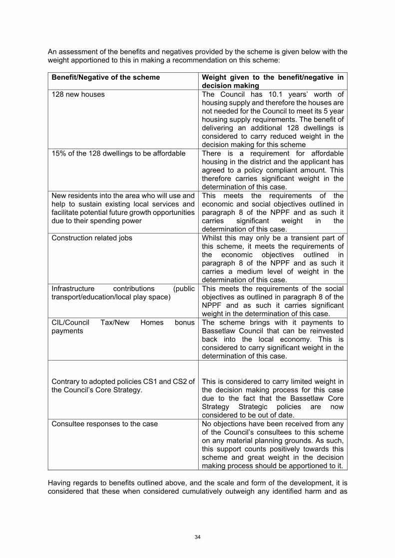
An assessment of the benefits and negatives provided by the scheme is given below with the weight apportioned to this in making a recommendation on this scheme: Benefit/Negative of the scheme Weight given to the benefit/negative in
decision making 128 new houses The Council has 10.1 years’ worth of
housing supply and therefore the houses are not needed for the Council to meet its 5 year housing supply requirements. The benefit of delivering an additional 128 dwellings is considered to carry reduced weight in the decision making for this scheme
15% of the 128 dwellings to be affordable There is a requirement for affordable housing in the district and the applicant has agreed to a policy compliant amount. This therefore carries significant weight in the determination of this case.
New residents into the area who will use and help to sustain existing local services and facilitate potential future growth opportunities due to their spending power
This meets the requirements of the economic and social objectives outlined in paragraph 8 of the NPPF and as such it carries significant weight in the determination of this case.
Construction related jobs Whilst this may only be a transient part of this scheme, it meets the requirements of the economic objectives outlined in paragraph 8 of the NPPF and as such it carries a medium level of weight in the determination of this case.
Infrastructure contributions (public transport/education/local play space)
This meets the requirements of the social objectives as outlined in paragraph 8 of the NPPF and as such it carries significant weight in the determination of this case.
CIL/Council Tax/New Homes bonus payments
The scheme brings with it payments to Bassetlaw Council that can be reinvested back into the local economy. This is considered to carry significant weight in the determination of this case.
Contrary to adopted policies CS1 and CS2 of the Council’s Core Strategy.
This is considered to carry limited weight in the decision making process for this case due to the fact that the Bassetlaw Core Strategy Strategic policies are now considered to be out of date.
Consultee responses to the case No objections have been received from any of the Council’s consultees to this scheme on any material planning grounds. As such, this support counts positively towards this scheme and great weight in the decision making process should be apportioned to it.
Having regards to benefits outlined above, and the scale and form of the development, it is considered that these when considered cumulatively outweigh any identified harm and as
34
such, the proposal would constitute sustainable development as defined in paragraph 11 of the NPPF and accordingly the scheme must be granted planning permission. RECOMMENDATION: Grant subject to a S106 agreement. 1 The development must be begun not later than the expiration of three years beginning
with the date of this permission.
Reason: To comply with Section 51 of the Planning and Compulsory Purchase Act 2004.
2 The development hereby permitted shall be in accordance with details and
specifications included on the submitted application form and shown on the following approved plans:
Drawing No. 19/2184/01 Rev. J received on 9 March 2020; Drawing No. 201/1G Received on 18 June 2019; Drawing No. 212/1 Received on 18 June 2019; Drawing No. 301/1H Received on 18 June 2019; Drawing No. 304/1E Received on 18 June 2019; Drawing No. 307/1B Received on 18 June 2019; Drawing No. 309/1E Received on 18 June 2019; Drawing No. 310/1D Received on 18 June 2019; Drawing No. 313/1 Received on 18 June 2019; Drawing No. 314/1 Received on 18 June 2019; Drawing No. 401/1G Received on 18 June 2019; Drawing No. 403/1J Received on 18 June 2019; Drawing No. 405/1E Received on 27 November 2019; Drawing No. SD700 Rev B Received on 18 June 2019; Drawing No. SD701 Rev C Received on 18 June 2019; Drawing No. 3104/CMP/01 Received on 17 September 2019.
Reason: To ensure the development takes the agreed form envisaged by the Local Planning Authority when determining the application and for the avoidance of doubt.
3. Notwithstanding the submitted details no development shall commence above damp
proof course (DPC) level, until details of the facing and roofing materials to be used in the development hereby permitted have been submitted to and agreed in writing with the local planning authority. The development shall be carried out only in accordance with the agreed facing and roofing materials.
Reason: To ensure the satisfactory appearance of the completed development.
4. No development shall take place until such time as a travel plan has been approved.
The development shall be carried out in accordance with the approved travel plan.
Reason: In the interest of sustainable travel. 5. Notwithstanding the submitted details, no development shall take place above damp
proof course level of any dwelling until full details of hard landscaping works have been
35

submitted to and approved in writing by the Local Planning Authority. These details shall include hard surfacing materials for all driveways and car parking and other vehicular and pedestrian access and circulation areas. The development thereafter shall be undertaken in accordance with the approved details.
Reason: In the interests of visual amenity and in the interests of highway safety
6. No development shall take place until such time as a travel plan has been approved.
The development shall be carried out in accordance with the approved travel plan.
Reason: In the interest of sustainable travel. 7. No dwelling shall be occupied until such time as the access and parking area to that
dwelling has been provided in a bound material (not loose gravel) and which shall be drained to prevent the unregulated discharge of surface water onto adjacent roads and footways.
Reason: To ensure appropriate access and parking arrangements are available.
8. No one phase of development shall be commenced until details of the proposed
arrangements and plan for future management and maintenance of the proposed streets including associated drainage contained within that phase of development have been submitted to and approved by the District Council. The streets and drainage shall for the lifetime of the development be maintained in accordance with the approved private management and maintenance details unless an agreement has been entered into under section 38 of the Highways Act 1980. At which point those streets covered by the agreement will not be subject to the approved management and maintenance details.
Reason: To ensure that the road infrastructure is maintained to an appropriate standard
9. No dwellings within each phase of the development shall be occupied until the roads
and footways affording access to those dwellings have been completed up to binder course level and the visibility splays detailed on plan reference 19/2184/01 Rev I have been incorporated into the footway.
Reasons: To ensure that the roads serving the development are sufficiently completed and are available for use by the occupants and other users of the development in the interest of highway safety.
10. Prior to commencement of the development hereby permitted details of wheel washing facilities and street cleansing (including full details of its specification, siting, and implementation) that maybe varied from time to time with the approval of the District Council and as made necessary by the works or ground conditions shall be submitted to and be approved by the District Council and which shall be utilised in accordance with the approved details for the construction period.
Reason: To minimise the chance of mud and debris being carried onto the public highway.
11. No development shall take place until such time as satisfactory details of bin collection
locations adjacent shared private drives have been submitted to and approved by the Local Planning Authority. The respective bin collection points shall be in place in a hard-bound material prior to the dwellings benefitting from the associated bin store are occupied and retained for the life of the development.
36

Reason: To ensure multiple bins do not block accesses and footways in the interest of road safety
12. Before development commences above damp proof course level (DPC), details of the
Electric Vehicle (EV) and Ultra Low Emission Vehicle (ULEV) charging points within each dwelling shall be submitted to and agreed in writing by the Local Planning Authority. The EV and ULEV charge points shall be provided prior to the occupation of each of the dwellings and shall be maintained and retained as such for the lifetime of the properties.
Reason - To comply with the requirements of paragraph 110(e) of the NPPF which relates to the provision of infrastructure for EV and ULEV charging.
13. Notwithstanding the submitted drawings, the screen fences/walls on plots 4, 5, 6, 7,
8, 11, 12, 15, 16, 17, 18, 19, 20, 21, 22, 23, 24, 25, 27, 36, 39, 44, 50, 51, 53, 59 ,60, 64, 71, 74, 75, 78, 79, 81,82,83,84,85,110,114 and 124 shall be constructed, in accordance with details of form and design previously agreed in writing by the Local Planning Authority, before occupation of the house to which each relates.
Reason: To ensure both the satisfactory appearance of the completed development and an adequate level of amenity for the houses in question.
14. The existing hedge on the western boundary of the site adjacent to Rhodesia Bridleway
2 shall be retained. No part of the hedge shall be removed unless that removal is authorised as part of this grant of planning permission or is the subject of written agreement by the local planning authority.
Reason: To ensure the satisfactory appearance of the completed development and to help assimilated the development into its surroundings.
15. The construction works hereby permitted shall only be carried out only in accordance
with the details shown on the Construction Management Plan drawing No.3104/CMP/01.
Reason: To ensure that the development is carried out in a way which safeguards the amenity of local residents in the area.
16. No development shall commence until a Construction Environmental Management
Plan ("the CEMP") for the development has been submitted to and approved in writing by the local planning authority. Thereafter, the CEMP shall be implemented in full. The CEMP shall include:
i) The parking of vehicles of site operatives and visitors; ii) Loading and unloading of plant and materials; iii) Storage and usage of plant and storage of materials used in constructing the development; iv) Measures to control the emission of dust, dirt and other debris during demolition and construction; v) A scheme for recycling/disposing of waste resulting from demolition and construction works; vi) Delivery and construction working hours; vii) Construction traffic routing;
37

viii) Protection measures for cyclists and pedestrians ix) Mitigation for bats, birds, reptiles amphibians and hedgehogs; x) The implementation of suitable stand-offs with appropriate protection measures for all retained hedgerows and trees; xi) Measures to prevent pollution of the adjacent water body from fuel oil spills and other contaminants.
Reason: In the interest of public safety and amenity and to ensure the development is carried out in a way which safeguards protected species, hedgerows trees and Local Wildlife Site.
17. All site clearance work shall be undertaken outside the bird-breeding season (March –
September inclusive). If clearance works are to be carried out during this time, a suitably qualified ecologist shall be on site to survey for nesting birds in such manner and to such specification as may have been previously agreed in writing by the Local Planning Authority.
Reason: To ensure that birds nests are protected from disturbance and destruction.
18. No development shall commence until a scheme and timetable for the implementation
of biodiversity enhancements has been submitted to and approved in writing by the local planning authority.. The biodiversity enhancements shall include: i.) The provision of bird and bat boxes; ii.) The installation of hedgehog friendly boundary treatments; iii.) The provision of a species rich wildflower meadow.
The agreed biodiversity enhancements shall be completed and available in accordance with the agreed scheme and timetable.
Reason: To ensure that the optimal benefits of biodiversity are achieved.
19. A scheme for tree planting on and landscape treatment of the site shall be submitted
to and agreed in writing by the Local Planning Authority before development commences. The agreed scheme shall be fully implemented within nine months of the date when the last dwelling on the site is first occupied. Any trees or shrubs removed, dying, being severely damaged or becoming seriously diseased within five years of planting shall be replaced by trees or shrubs of a size and species similar to those originally required to be planted.
Reason: To ensure the satisfactory overall appearance of the completed development and to help assimilate the new development into its surroundings.
20. The development hereby permitted shall not commence until drainage plans for the
disposal of surface water and foul sewage have been submitted to and approved by the Local Planning Authority. The scheme shall be implemented in accordance with the approved details before the development is first brought into use.
38

Planning Practice Guidance and section H of the Building Regulations 2010 detail surface water disposal hierarchy. The disposal of surface water by means of soakaways should be considered as the primary method. If this is not practical and there is no watercourse is available as an alternative other sustainable methods should also be explored. If these are found unsuitable, satisfactory evidence will need to be submitted before a discharge to the public sewerage system is considered.
Reason: To ensure that the development is provided with a satisfactory means of drainage as well as reduce the risk of creating or exacerbating a flooding problem and to minimise the risk of pollution.
21. Development shall not commence on site, until an investigation into the history and
current condition of the site to determine the likelihood of the existence of contamination arising from previous uses has been carried out and all of the following steps have been complied with to the satisfaction of the Local Planning Authority (LPA). In order to comply with the above condition, the proposal should comply with DEFRA and the Environment Agency’s “Model Procedures for the Management of Land Contamination, CLR 11” and “BS 10175 (2011) Code of Practice for the investigation of potentially contaminated sites”.
i.) A written report should be submitted to and approved by the LPA which shall include details of the previous uses of the site, surrounding contaminative land uses, potential contaminants that might reasonably be expected given those uses and a description of the current condition of the site with regard to any activities that may have caused contamination. The report shall confirm whether or not it is likely that contamination may be present on the site.
ii) If the above report indicates that contamination may be present on or under the site, or if evidence of contamination is found, a more detailed site investigation and risk assessment shall be carried out in accordance with DEFRA and Environment Agency’s “Model Procedures for the Management of Land Contamination CLR11” and other authoritative guidance. The report should fully and effectively characterise the nature and extent of any land contamination and /or pollution of controlled waters and should be submitted and agreed by the LPA.
iii) Where the risk assessment identifies any unacceptable risk or risks, a detailed remediation strategy to deal with land contamination and /or pollution of controlled waters affecting the site shall be submitted and approved by the LPA. No works, other than investigative works, shall be carried out on the site prior to receipt of written approval of the remediation strategy by the LPA.
iv) A validation report for the site remediation shall be submitted to, and agreed in writing by the LPA before completion of the development or occupation of the premises (whichever comes first).
Reason: To ensure that land contamination can be dealt with adequately prior to the use of the site hereby approved by the Local Planning Authority.
22. No construction works shall take place outside 8:00am - 6:00pm Monday to Friday,
9:00am - 1:00pm on Saturday and not at all on Sundays or Bank Holidays.
39

Reason: To safeguard the amenities of dwellings located in the vicinity of the application site.
23. Development shall not commence within the application site until the developer has
secured the implementation of a programme of archaeological work in accordance with a written scheme of investigation which has been submitted to and agreed in writing by the Local Planning Authority.
Reason: To ensure that any features of archaeological interest are protected or recorded.
24. Notwithstanding the provisions of the Town and Country Planning (General Permitted
Development) (England) Order 2015 (or and order revoking or re-enacting that order), no external lighting shall be erected on the dwellings or gardens on plots 57, 58, 59, 69, 70, 71, 72, 77, 78, 79, 80, 82, 83 and 84 without the prior approval of the Local Planning Authority.
Reason: The installation of lighting as “permitted development" may have adverse impacts on the adjacent Local Wildlife Site by reason of light pollution.
40

41

ITEM SUBJECT OF A SITE VISIT Item No: a2
Application Ref. 19/01580/FUL
Application Type Full Planning Permission
Site Address Land Off Mattersey Road, Sutton Cum Lound, Retford
Proposal Erect 3 Houses and 6 Bungalows and Construct A New Access
Case Officer Mandy Freeman
Recommendation Grant subject to S106 agreement
Web Link: Link to Planning Documents
_________________________________________________________________________ THE APPLICATION SITE CONTEXT The site is currently part of an agricultural field on the edge of the village, with hedge and trees in the highway verge along the road frontage. Planning permission has been granted already for two plots facing onto Mattersey Road to the north continuing the frontage development, which extends outside the current built form of the village. Outline planning permission granted previously included a further three dwellings along the frontage. The current application includes 3 x 2-storey dwellings along the road frontage and a private drive providing access to 6 bungalows to the rear of the site, in an area forming part of the residential allocation in the Neighbourhood Plan PROPOSAL The application is for 1 x 5-bed two storey house (Type E), 2 x 4-bed two storey house (Type A), 2 x 4-bed bungalows (Type D) and 4 x 3-bed bungalows (Type B & C).Plot 1 will have an access drive directly onto Mattersey Road and Plots 2-9 will be served from a private access drive. DEVELOPMENT PLAN AND OTHER MATERIAL CONSIDERATIONS Having regard to Section 54A of the Town and Country Planning Act 1990, the main policy considerations are as follows: NATIONAL PLANNING POLICY FRAMEWORK The National Planning Policy Framework (NPPF) sets out the Government’s approach for the planning system and how these are expected to be applied.
42

Paragraph 8 explains that there are three dimensions to sustainable development: economic, social and environmental. These dimensions give rise to the need for the planning system to perform an economic, social and environmental role. Paragraph 11 explains that at the heart of the National Planning Policy Framework is a presumption in favour of sustainable development. For decision-taking this means approving development proposals that accord with an up to date development plan without delay; and where there are no relevant development plan policies, or the policies which are most important for determining the application are out-of-date, permission shall be granted unless: i. The application of policies in this Framework that protect areas or assets of particular importance provides a clear reason for refusing the development proposed6; or ii. Any adverse impacts of doing so would significantly and demonstrably outweigh the benefits, when assessed against the policies in this Framework taken as a whole. The following paragraphs of the framework are applicable to this development: Para 7 – Achieving sustainable development Para 8 – Three strands to sustainable development Para 10 – Presumption in favour of sustainable development Para 11 – Decision making Para 12 – Development plan as the starting point for decision making Para 33 – Strategic policies in development plans should be reviewed every 5 years. Para 38 – Decision making should be done in a positive way. Para 55 – Planning conditions to be kept to a minimum and to meet the tests. Para 56 – Planning obligations Para 94 – Provision of sufficient school places Para 108 – 110 – Highway safety Para 124 – Good design is a key aspect of sustainable development. Para 127 – Development should reflect local characteristics. Para 130 – Poor design should be refused permission. Para 170 - Decisions should contribute to protecting and enhancing the natural and local environment. Para 190 – Assessing the significance of a heritage asset BASSETLAW DISTRICT COUNCIL – LOCAL DEVELOPMENT FRAMEWORK Core Strategy & Development Management Policies Development Plan Document (Adopted December 2011):
CS1 - Settlement hierarchy CS8 - Rural Service Centres CS9 – All Other Settlements DM4 - Design & character DM5 – Housing Mix and Density DM8 – The Historic Environment DM12 - Flood risk, sewage and drainage DM13 - Sustainable transport
43

NEIGHBOURHOOD PLAN (INCLUDING STATUS AND RELEVANT POLICIES) The Sutton Cum Lound Neighbourhood Plan was made in February 2020 following a successful referendum. The application site lies in a location which is allocated for housing under policy 3 of the Plan. The following policies would also apply to this scheme: Policy 1 – Design of residential development Policy 2 – Mix of housing types Policy 9 – Highway safety Where plans are up to date, paragraph 12 of the NPPF makes it clear that they are the starting point for the determination of planning applications. The Sutton Cum Lound Neighbourhood Plan is currently older than the 2 year period referred to in paragraph 14 of the NPPF and is currently in the process of being reviewed. However, the review has yet to be completed and in the light of the requirements of paragraph 14 of the NPPF and this being the case, its policies can only carry limited weight in the determination of this planning application. RELEVANT PLANNING HISTORY 17/01137/OUT - Outline Planning Application with Some Matters Reserved (Approval Being Sought for Access) to Erect Eight Dwellings, Plots 1-5 Off Mattersey Road and Plots 6-8 off Lound Low Road was granted on 19 October 2017. 17/01720/VOC - Vary Conditions 3 and 7 of Planning Permission 17/01137/OUT for Details to be Carried Out in Accordance with Drawing Number 1G and Occupation of Dwellings Prior to Construction of Footpath on Lound Low Road - Outline Planning Application with Some Matters Reserved (Approval Being Sought for Access) to Erect Eight Dwellings, Plots 1-5 Off Mattersey Road and Plots 6-8 off Lound Low Road was granted on 6 February 2018. 18/00919/FUL - Planning permission was refused to erect two dwellings and construct new access on 19 September 2018. 18/01232/RSB - Planning permission was granted for Erection of Two No. Dwellings and Construct New Access (Re-submission of 18/00919/FUL) on 14 November 2018. 19/00164/FUL - Planning permission was refused for the erection of two storey dwelling with attached garage on 25 June 2019. 19/00920/FUL - Planning permission was granted for Erection of Two Storey Dwelling with Attached Garage on Plot 8 (Resubmission of 19/00164/FUL) on 10 October 2019. 19/00990/RES - Planning permission was granted for Reserved Matters Application for the Approval of Appearance, Landscaping, Layout and Scale For Plots 4 and 5 Following Outline P.A. 17/01720/VOC was granted on 24 September 2019.
44

19/01300/COND - Discharge of condition 1 of 19/00990/RES was determined on 4 November 2019. 19/01491/VOC - Planning permission was granted variation of condition 2 of 19/00990/RES to vary house design on 14 January 2020. SUMMARY OF CONSULTATION RESPONSES BDC Conservation – Does not raise any concerns in relation to the impact of the proposal on the setting of the St Bartholomew’s Grade 1 Listed Church. BDC Environmental Health – Has commented that domestic development of this scale is unlikely to give rise to nuisance in relation to extraction/ventilation and lighting that could be adequately controlled under statutory nuisance legislation. In terms of noise, the development is unlikely to raise major issues once construction is complete. A condition is recommended in relation to hours of construction to protect the amenity of neighbouring properties. In relation to contaminated land, this site adjoins the buffer zone of a historic munitions factory but there is no evidence that the land is contaminated. However, there is a risk of previously unidentified contamination. If during development, land contamination not previously considered is identified, works should cease and a method statement detailing the contamination and means of mitigation should be agreed and carried out. This requirement would be captured via a suitably worded planning condition. BDC Waste & Recycling - Has commented that the application indicates a private drive serving these properties. This would not be used by the council’s refuse collection vehicles or staff, so a communal collection point would need to be provided for all properties within the site on the boundary with Mattersey Road. NCC Highways Authority - Initially responded requesting inclusion of footway and street lighting along the road frontage, extension of village speed-limit, dropped kerb access to shared drive, and wheelie bin collection point. An amended drawing was submitted to include the footway and remove the road junction in favour of a dropped vehicular verge/footway crossing, which is more in keeping with a shared drive. Highways has no objection subject to conditions in relation to surfacing and drainage of the driveway, provision of dropped vehicular footway/verge crossing, extension of street lighting and speed limit signs, 2m wide footway and hard surfaced wheelie bin collection point. NCC Planning – Primary education – Advise that the proposal will generate the need for 3 additional primary school places. However, a contribution is not considered necessary as there is sufficient capacity in the local primary schools to accommodate this development. Secondary education – Advise that the proposal will generate the need for 2 additional primary school places. However, a contribution is not considered necessary as there is sufficient capacity in the local primary schools to accommodate this development.
45

Transport & Travel Services – The County will not be seeking any contributions in relation to the delivery of the local bus infrastructure. Sutton Parish Council object on the grounds:
1. Contrary to the Sutton cum Lound Neighbourhood Plan which has consistently gone for ribbon development only on its three residential allocation sites. This would be backland development contrary to the Neighbourhood Plan.
2. Policy 3 of the Neighbourhood Plan requires a link road between Mattersey road and Lound Low Road unless it is demonstrated that this is not viable or feasible. No evidence of viability or feasibility has been submitted.
3. The adverse impact of development that conflicts with Neighbourhood Plan policies is likely to significantly and demonstrably outweigh the benefits.
SUMMARY OF PUBLICITY This application was advertised by neighbour letter, site notice and 4 letters of objection have been received raising the following points:
1. The site is out with the agreed neighbourhood plan. The plan specified frontage strip development and not a cul-de-sac or backland development. There is already extensive development in this part of the village to the detriment of the feel and character.
2. The size of the properties are contrary to Neighbourhood Plan for smaller 2 and 3 bedroom properties.
3. The proposal would have a significant impact on the aesthetic and rural aspect of the village area. Trees along the highway should remain.
4. Detrimental impact on privacy due to hawthorn boundary hedges being see through at this time of year. Appropriate boundary treatments should be established.
5. Detrimental impact on highway safety due to additional traffic movements. One neutral letter was also submitted raising the following points:
1. Neighbouring property request that a 1.8m high solid fence is erected along the boundary with the neighbouring properties for privacy reasons.
CONSIDERATION OF PLANNING ISSUES PRINCIPLE OF THE DEVELOPMENT Paragraph 12 of the National Planning Policy Framework (NPPF) states that the development plan is the starting point for decision making. Policy CS1 of the Core Strategy states that until the adoption of the site allocations DPD, development in the settlements identified in the hierarchy will be restricted to the area inside defined settlement boundaries. However, additional permission may be granted where the development proposal would address a shortfall in the District’s five-year housing supply or its employment land supply.
46

Policy CS8 of the council’s Core Strategy identifies Sutton Cum Lound as a Rural Service Centre which offers a range of services and facilities and access to public transport which makes them suitable for limited levels of growth. The application site lies does not lie within the development limits, but part of it is adjacent to it. Paragraph 33 of the NPPF states that policies in development plans should be reviewed and where necessary updated every 5 years. The Bassetlaw Core Strategy dates from 2011 and its policies have not been reviewed in the last 5 years as the Council is working on a new local plan to replace it. In this situation, paragraph 213 of the NPPF states that policies in an adopted development plan do not become automatically out of date because they were published before the framework; policies must be considered having regards to their consistency with the framework. The Core Strategy was prepared using a settlement hierarchy which included development limits to control development and it is considered that this approach is now out of step with that identified in the NPPF and the weight given to policy CS1 has to be reduced. Whilst this scheme is contrary to the requirements of policy CS1 of the Core Strategy, part d) of paragraph 11 of the NPPF is engaged as policy CS1 and CS8 is considered to carry limited weight in the decision making process and this scheme must be considered under the planning balance test where planning permission should be granted unless any adverse impacts of doing so would significantly and demonstrably outweigh the benefits, when assessed against the policies of the NPPF when taken as a whole. In relation to the supply of housing, the NPPF requires Councils to identify and update, on an annual basis, a supply of specific deliverable sites sufficient to provide for five years’ worth of housing provision against identified requirements (paragraphs 73 & 74). For sites to be considered deliverable: they have to be available; suitable; achievable and viable. Under the requirements of the NPPF, the Council can demonstrate 10.1 years’ worth of housing and as such, a deliverable 5 years supply of housing can be achieved. The fact that the Council has a 5 year supply will be given weight and considered as part of all of the relevant material considerations in the planning balance test assessment to this scheme. Paragraph 12 of the NPPF also relates to Neighbourhood Plans and emphasises that where an up to date Neighbourhood Plan is in force, it shall be used as the starting point for decision making. Sutton Cum Lound has been designated as a Neighbourhood Plan area, and has an adopted Neighbourhood Plan, but it is now older than the two years as referred to in the NPPF in paragraph 14 and the ongoing review has yet to be completed. Therefore, limited weight can be accorded to it when carrying out the planning balance test to determine this application. Policy 3 which relates to Land east of Mattersey Road states the following and is applicable to this scheme: 1. Residential development on land east of Mattersey Road as allocated on the policies map will be supported where the applicant can demonstrate that the scheme meets all where the applicant can demonstrate that the scheme meets all of the following criteria;
a) that the design of the dwellings does not detract from the wider setting of the church and the non-designated heritage assets nearby; and b) the design and layout reflects the rural setting and is in accordance with Policy 1.
2. The proposals should include the provision of an access road that connects Mattersey Road to Lound Low Road unless it can be demonstrated this is not technically possible or viable.
47

The principle of residential development on this site has been established with its allocation in the Sutton cum Lound Neighbourhood Plan in 2018, and the subsequent granting of permissions for residential development proposals on it. This proposal does not include provision for an access road to link Lound Low Road and Mattersey Road as this is unachievable due to existing residential development on the land and the fact that the remainder of it already has planning permission for its development and that scheme does not facilitate the provision of the road. SUSTAINABILITY OF THE DEVELOPMENT Paragraph 8 of the NPPF sets out three dimensions for sustainable development, economic, social and environmental:
“an economic objective – to help build a strong, responsive and competitive economy, by ensuring that sufficient land of the right types is available in the right places and at the right time to support growth, innovation and improved productivity; and by identifying and coordinating the provision of infrastructure;
a social objective – to support strong, vibrant and healthy communities, by ensuring that a sufficient number and range of homes can be provided to meet the needs of present and future generations; and by fostering a well-designed and safe built environment, with accessible services and open spaces that reflect current and future needs and support communities’ health, social and cultural well-being; and
an environmental objective – to contribute to protecting and enhancing our natural, built and historic environment; including making effective use of land, helping to improve biodiversity, using natural resources prudently, minimising waste and pollution, and mitigating and adapting to climate change, including moving to a low carbon economy.
In reaching a decision on this case, the NPPF at paragraph 9 makes it clear that the objectives referred to above should play an active role in guiding development towards sustainable solutions and are not criteria against which every planning application should be judged against. The settlement of Sutton Cum Lound is defined as a rural service centre in the Council’s Core Strategy where development will be supported to sustain local employment, community services and facilities. This scheme would make a contribution towards Sutton’s role as a rural service centre by the creation of temporary construction related jobs and the on-going contribution to the local rural economy both in the village and in the surrounding area from the creation of nine additional households. The proposals would also contribute towards providing new housing in the village to help towards meeting future local need and to help the Council sustain its 5 year supply requirement and the Parish to meet its Neighbourhood Plan requirements as well as providing CIL monies and Council Tax revenue which Bassetlaw District Council could potentially reinvest into the local economy. The requirement of paragraph 78 of the NPPF is also relevant to the consideration of whether this scheme constitutes sustainable development. It states that to promote sustainable development in rural areas, housing should be located where it will enhance or maintain the viability of rural communities and allow them to grow especially where this will support local services.
48

Sutton Cum Lound is one of the larger villages in the locality and provides service facilities which are used by the residents of some of the smaller surrounding settlements and properties located out in the countryside. It can be argued that the erection of additional houses in the village will help towards sustaining and potentially developing these services which will contribute towards the vibrancy of Sutton Cum Lound and its surrounding rural hinterland which is in line with the requirements of paragraph 78. DESIGN, LAYOUT & VISUAL AMENITY Section 12 of the NPPF refers to achieving well designed places. Specifically, paragraph 124 states that good design is a key aspect of sustainable development; it creates better places in which to live and work in and helps make development acceptable to local communities. Paragraph 127 states that decisions should aim to ensure that development will function well and add to the overall quality of the area, establish a strong sense of place, create attractive and comfortable places to live, work and visit, optimise the potential of the site to accommodate development, create and sustain an appropriate mix of uses and support local facilities and transport networks. Furthermore it provides that development should respond to local character and history, and reflect the identity of local surroundings and materials, while not preventing or discouraging appropriate innovation. The NPPF goes on to state it is “proper to seek to promote or reinforce local distinctiveness” (para 127) and permission should be “refused for development of poor design that fails to take the opportunities available for improving the character and quality of an area and the way it functions” (para 130). Policy DM4 of the Bassetlaw Core Strategy provides general design principles which should be applied to all schemes. The policy states that all development proposals will need to be in keeping with the character and appearance of the wider area and when they are in historic locations, they should respect existing development patterns. All schemes must respect their context and not create a pastiche development which would be incorrect in their context. Policy 3 of the neighbourhood plan states that the proposal must reflect the design and layout of its rural setting in line with the requirements of policy 1. The objectors to this scheme have also mentioned that the supporting text to policy 3 refers to the fact that the development of this site is expected to be road frontage only and as such, this scheme does not meet that requirement and shouldn’t be supported. It must be noted in the context of the comments made by the objectors that the wording of policy 3 itself does not require the site allocation in policy 3 to be developed with frontage development only. It is the policy itself that carries weight in decision making and not the explanatory supporting text that goes with it. The proposed houses fronting onto Mattersey Road are similar to those already granted planning permission on the allocated site. The proposed bungalows would be set back at a lower level and reflect other bungalow styles in the vicinity and finish off the development of this parcel of land. The proposal as a whole is not considered out of character with the wider village context and as such is acceptable in terms of the above policies. RESIDENTIAL AMENITY Policy DM4 of the Core Strategy requires that development does not materially or detrimentally affect the amenities of the occupiers of neighbouring properties. This requirement also forms part of paragraph 127 of the NPPF. The proposal provides adequate parking and private garden area in line with the ‘Successful Places’ SPD and adequate off street parking and manoeuvring in line with Residential Parking Standards SPD.
49
Local residents have expressed concerns about boundary treatments with existing properties. Details of the extent of the residential plots are shown in the site plan and the specific details of suitable boundary treatments for this site can be secured by a suitable worded condition. Having regards to the above, the proposal is considered to comply with the requirements of policy DM4 of the Bassetlaw Core Strategy, paragraph 127 of the NPPF and the relevant part of the council’s Successful Places SPG. HIGHWAYS MATTERS Paragraph 108 of the NPPF states that schemes can be supported where they provide safe and suitable access for all. This requirement is also contained in policy DM4 of the Council’s Core Strategy. Paragraph 109 of the NPPF makes it clear that development should only be prevented or refused on highway grounds if there would be an unacceptable impact on highway safety, or the residual cumulative impacts on the road network would be severe. Paragraph 91 of the NPPF states that all development should aim to achieve healthy, inclusive and safe places which encourage social interaction, are safe and accessible and enable and support healthy lifestyles. Paragraph 108 of the NPPF requires schemes to provide safe and suitable access for all users as well as looking at appropriate opportunities to promote sustainable transport modes. The Highway Authority has been consulted on this scheme and they have no concern in terms of highway safety subject to the imposition of conditions to secure surfacing and drainage of the driveways, the provision of street lighting on Mattersey Road and works to extend the speed limit and the provision of a 2m wide footway and a wheelie bin store. Part 2 of policy 3 of the Neighbourhood Plan indicates that the proposals should include the provision of an access road that connects Mattersey Road to Lound Low Road, unless it can be demonstrated this is not technically possible or viable. This has also been raised as objections to this scheme by local residents and the parish council. Since the preparation of the Neighbourhood Plan and prior to its adoption, residential development has been permitted on site which makes this objective practically unachievable now. Should this reason be used to refuse this scheme, it is considered that it would be difficult to defend it at appeal. Paragraph 110e of the NPPF requires schemes to be designed to enable charging of plug-in electric vehicles (EV) and other ultra-low emission vehicles (ULEV) in safe, accessible and convenient locations. No provision has been suggested with this scheme, and as such it is considered appropriate to include a suitably worded condition so that the scheme meets the government’s electric vehicle charging requirements as referred to in paragraph 110e of the NPPF. TREES The content of paragraph 175 of the NPPF is applicable as it states that in dealing with planning applications, councils must consider the harm of a scheme on biodiversity. Some harm to biodiversity is allowed, but it states that significant harm should be avoided, adequate mitigation should be provided or if this is not possible, the loss should be compensated for. If none of the above is possible, then permission should be refused.
50

A tree survey has been submitted in support of the application. Conditions have previously been attached to earlier planning permissions on this allocated site to safeguard the trees during the construction period. It is proposed that similar conditions be attached to this scheme should permission be granted. The hedging along the highway frontage which is also referred to by the objectors is also to be retained as part of this scheme and this can be conditioned if permission is granted. FLOODING/DRAINAGE The NPPF at paragraph 155 and policy DM12 of the Core Strategy makes it clear that development in areas at risk of flooding should be avoided by directing development away from the areas at the highest risk. The application site lies in a flood zone 1 area which is land at least risk of flooding and is in line with the requirements of the NPPF at paragraph 155. Paragraph 163 of the NPPF requires that proposals do not increase flood risk elsewhere and should be developed in line with a site specific flood risk assessment which incorporates a Sustainable Urban Drainage solution. It is proposed to dispose of the foul sewage to the existing mains sewer and surface water to a sustainable drainage system and this meets the requirements of paragraph 163 of the NPPF. CONTAMINATED LAND Paragraph 178 of the NPPF requires that in making decisions on schemes consideration is taken account of the ground conditions and any risks arising from contamination. The application site is on agricultural land and the Council’s Environmental Health team has advised that due to this, it is highly unlikely that the land would be the subject of contamination. However, as a precaution they have requested the imposition of a suitable condition which would cover the eventuality if unidentified contamination is found during construction and what procedures need to be followed to deal with it. This is in line with the requirements of policy 178 of the NPPF. HERITAGE MATTERS The Council has a duty under section 66(1) of the Planning (Listed Buildings and Conservation Areas) Act 1990 to have special regard to the desirability of preserving their setting, character and appearance. The House of Lords in the South Lakeland DC vs the SOS case in 1992 decided that a Conservation Area would be preserved, even if it was altered by development, if the character or appearance (its significance in other words) was not harmed. Conservation’ is defined in the NPPF as the process of maintaining and managing change to a heritage asset in a way that sustains and where appropriate enhances its significance. Therefore case law has ascertained that both ‘conservation’ and ‘preservation’ are concerned with the management of change in a way that sustains the interest or values in a place – its special interest or significance. However, ‘conservation’ has the added dimension of taking opportunities to enhance significance where opportunities arise and where appropriate.
51

Para 190 of the NPPF requires Councils to identify the significance of any heritage asset that may be affected by a proposal to ensure that harm to the asset is avoided or is minimised. Policy DM8 of the Council’s Core Strategy requires schemes that affect heritage assets to be of a scale, design, materials and siting and not have a negative effect on views towards the heritage asset. Paragraph 193 of the NPPF states that in considering the impact of development on the significance of heritage assets, great weight should be given to the assets conservation. Policy DM8 of the Council’s Core Strategy requires schemes that affect heritage assets to be of a scale, design, materials and siting and not have a negative effect on views towards the heritage asset. Neighbourhood Plan Policy 3 part 1a) indicates that the design of the dwellings should not detract from the wider setting of the church and the non-designated heritage assets nearby, principally the grade I listed St Bartholomew’s Church. The location of the proposal is on the opposite side of the road to the grade I listed St Bartholomew’s Church with other residential properties existing between the site and the church. The application site is at a distance of about 250m from the church and is of a similar layout to other modern properties in this locality and is no more harmful than that previous approved. Having regards to this, it is considered that the scheme will not have a detrimental impact on the setting of the heritage asset which meets the requirements of paragraphs 190 and 193 of the NPPF and policy DM8 of the Bassetlaw Core Strategy. INFRASTRUCTURE/CONTRIBUTIONS Paragraph 56 of the NPPF makes it clear that contributions can be sourced from schemes where they make the scheme acceptable in planning terms. Paragraph 61 requires that Council’s plan to deliver a wide choice of housing to meet local needs and this includes the provision of affordable housing. Paragraph 94 of the NPPF makes is clear that it is important that there are sufficient school places to meet the needs of existing and new communities and that council’s should proactively work with school providers to resolve key planning issues relating to development. Paragraph 96 emphasises that access to high quality open space and opportunities for sport and physical activity is important and this is a consideration in determining planning applications. NPPF paragraph 63 indicates that developer contributions should not be sought for residential developments that are not major developments. Major development is defined in NPPF Appendix 2 as housing development where 10 or more homes will be provided. The current application is only for 9 dwellings, however this is the latest application on this allocated site, which would result in a total of 14 dwellings being proposed on the site in total. The scheme as submitted will provide the following in line with the NPPF requirements outlined above:
25% affordable housing
52

CONCLUSION/PLANNING BALANCE As the Core Strategy is deemed to be out of date having regards to the contents of paragraph 33 of the NPPF, paragraph 11 of the NPPF makes it clear that the scheme should be considered under the planning balance test where planning permission should be granted unless any adverse impacts of doing so would significantly and demonstrably outweigh the benefits, when assessed against the policies in the NPPF when taken as a whole. An assessment of the benefits and negatives provided by the scheme is given below with the weight apportioned to this in making a recommendation on this scheme:
Benefit/Negative of the scheme Weight given to the benefit/negative in decision making
9 new houses The Council has 10.1 years’ worth of housing supply and therefore the houses are not needed for the Council to meet its 5 year housing supply requirements. The benefit of delivering an additional 9 dwellings is considered to carry reduced weight in the decision making for this scheme
25% of the 9 dwellings to be affordable There is a requirement for affordable housing in the district and the applicant has agreed to a policy compliant amount. This therefore carries significant weight in the determination of this case.
New residents into the area who will use and help to sustain existing local services
and facilitate potential future growth opportunities due to their spending power
This meets the requirements of the economic and social objectives outlined in paragraph 8 of the NPPF and as such it carries significant weight in the determination of this case.
Construction related jobs Whilst this may only be a transient part of this scheme, it meets the requirements of the economic objectives outlined in paragraph 8 of the NPPF and as such it carries a medium level of weight in the determination of this case.
CIL/Council Tax/New Homes bonus payments
The scheme brings with it payments to Bassetlaw District Council that can be reinvested back into the local economy. This is considered to carry significant weight in the determination of this case.
Compliant with Neighbourhood Plan, Core Strategy and NPPF
This site is allocated in the Neighbourhood Plan and meets the policies within the plan, those in the Core Strategy and the NPPF. This carries significant weight in the determination of this case.
Consultee comments No objections have been received from the Council’s professional consultees in relation to this scheme.
53

Having regards to benefits outlined above, and the scale and form of the development, it is considered that these when considered cumulatively outweigh any identified harm and as such, the proposal would constitute sustainable development as defined in paragraph 11 of the NPPF and accordingly the scheme must be granted planning permission. RECOMMENDATION: Grant subject to conditions and the execution of a S106 agreement/unilateral undertaking CONDITIONS: 1. The development must be begun not later than the expiration of three years beginning
with the date of this permission.
Reason: To comply with Section 51 of the Planning and Compulsory Purchase Act 2004.
2. The development hereby approved shall be carried out only in accordance with the
details and specifications included on the submitted planning application form and shown on submitted documents and drawings which include the following:
Drawing No. unreferenced Site Location Plan received on 9 December 2019. Drawing No. LL07 - 1 Rev. A Site Plan received on 2 January 2020. Drawing No. LL07 - 2 House Type A received on 9 December 2019. Drawing No. LL07 - 3 House Type B received on 9 December 2019. Drawing No. LL07 - 4 House Type C received on 9 December 2019. Drawing No. LL07 - 5 House Type D received on 9 December 2019. Drawing No. LL07 - 6 House Type E received on 9 December 2019.
Reason: To ensure that the development takes the agreed form envisaged by the Local Planning Authority when determining the application.
3. Before any construction occurs above damp proof course (DPC) level, samples or
detailed specifications of all external materials to be used on the development hereby permitted shall be submitted to and agreed in writing by the Local Planning Authority. The development shall be carried out only in accordance with the agreed materials.
Reason: To ensure the satisfactory appearance of the completed development.
4. No works relating to site preparation or construction shall take place outside 08:00
hours to 18:00 hours Monday to Friday; 09:00 hours to 13:00 hours on Saturday and not at all on Sundays, Bank Holidays or Public Holidays.
Reason: To safeguard the amenities of dwellings located in the vicinity of the application site.
5. Prior to Plot 1 and or Plots 2 to 9 being occupied the associated driveway shall be
surfaced in a bound material (not loose gravel) for a minimum distance of 6.0m from the highway boundary, shall be drained to prevent the unregulated discharge of surface water onto Mattersey Road, and a dropped vehicular footway/verge crossing shall be provided to serve the respective driveway not exceeding a gradient of 1:14 as located on Drawing Number 1 Rev A.
54

Reason: To reduce the possibility of deleterious material being deposited on the public highway (loose stones etc.), to minimise the chance of highway flooding and severe icing, and in the interest of highway safety.
6. No dwelling shall be occupied until the street lighting on Mattersey Road has been
amended and extended to a point north of the access to plot 5 associated with planning application reference 17/01137/OUT and the speed limit signing, village gateway signing, reflective bollards, and associated road markings have been replaced consistent with the extended street lighting.
Reason: To ensure the development falls within the village speed limit and the access arrangements are appropriately street lit.
7. No dwelling shall be occupied until a 2.0m footway has been provided on Mattersey
Road from a point north of the northernmost access to a point south of the southernmost access at a longitudinal gradient not exceeding 1 in 20 with a maximum cross-fall of 1:35 and including a pedestrian crossing point to the footway opposite with tactile paving generally as located on Drawing Number 1 Rev A.
Reason: In the interests of highway safety.
8. Plots 2 to 9 shall not become occupied until a hard-surfaced bin store(s) has been
provided adjacent Mattersey Road in accordance with details first submitted to and approved by the LPA.
Reason: To reduce the chance of bins obstructing the footway and visibility from the site access in the interest of highway safety.
9. Before the occupation of the dwelling to which it relates, a scheme for the treatment of
the boundaries of the related plot shall be submitted to and agreed in writing by the Local Planning Authority. The agreed scheme shall be fully implemented before the occupation of the dwelling hereby permitted.
Reason: To ensure the satisfactory, overall appearance of the completed development.
10. The existing hedge along the frontage of the application site shall be retained along
Mattersey Road. No part of the hedge shall be removed unless that removal is authorised as part of this grant of planning permission or is the subject of written agreement by the Local Planning Authority. Should any part of the hedge die or become diseased, it shall be replaced with a hedge of the same species within the next planting season.
Reason: To ensure the satisfactory overall appearance of the completed development and to help assimilate the new development into its surroundings.
11. The trees on the public highway along Mattersey Road shall be protected, in a manner
to be agreed in writing with the Local Planning Authority before any works commence on site. The trees shall be protected in the agreed manner before any works commence on site and shall be protected as agreed during the duration of building operations on site.
Reason: The trees in question are considered to be features of significance. This condition is imposed to ensure that they are satisfactorily protected during the period when construction works take place on the site.
55

12. Before any construction occurs above damp proof course (DPC) level on any of the dwellings on site, details of the provision made for Electric Vehicle (EV) and Ultra Low Emission Vehicle (ULEV) charging points within each dwelling or plot shall be submitted to and agreed in writing by the Local Planning Authority. The EV and ULEV charge points shall be provided prior to the occupation of each individual dwelling and shall be maintained and retained as such for the lifetime of the properties.
Reason - To comply with the requirements of paragraph 110(e) of the NPPF which relates to the provision of infrastructure for EV and ULEV charging.
13. In the event that contamination is found at any time when carrying out the approved
development that was not previously identified it must be reported in writing immediately to the Local Planning Authority. An investigation and risk assessment must be undertaken and where remediation is necessary a remediation scheme must be prepared and submitted for approval by the Local Planning Authority. Following completion of measures identified in the approved remediation scheme a verification report must be prepared, which is subject to the approval in writing of the Local Planning Authority in accordance with condition.
Reason: To ensure that risks from land contamination to the future users of the land and neighbouring land are minimised, together with those to controlled waters, property and ecological systems, and to ensure that the development can be carried out safely without unacceptable risks to workers, neighbours and other offsite receptors in accordance with the requirements of paragraph 178 of the NPPF.
56
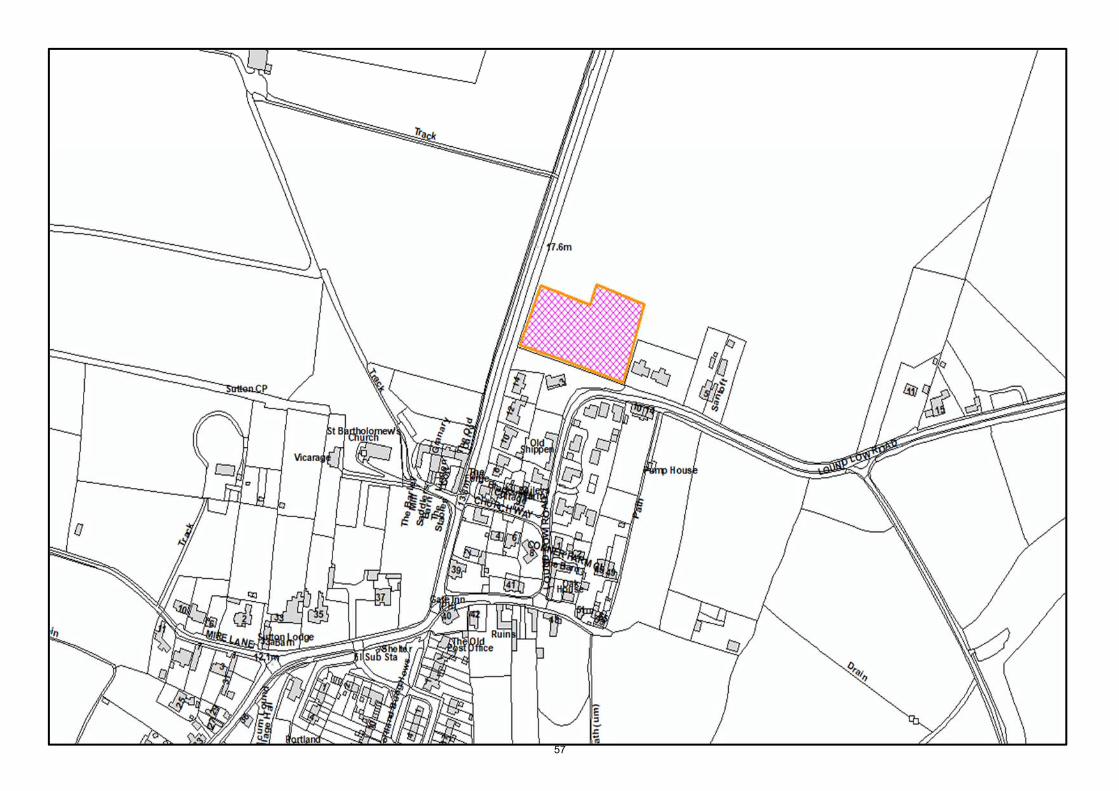
57
BASSETLAW DISTRICT COUNCIL
PLANNING COMMITTEE
01 April 2020
REPORT OF HEAD OF REGENERATION
PROPOSED CONFIRMATION OF ARTICLE 4(1) DIRECTION FOR VICTORIA INSTITUTE, 2 WHARF ROAD, MISTERTON
Cabinet Member: Economic Development
Contact: Michael Tagg Ext: 3427
1. Public Interest Test
1.1 The author of this report, Michael Tagg, has determined that the report is not confidential.
2. Purpose of the Report
2.1 To seek approval for the confirmation of an Article 4 Direction under Paragraphs 2(6), 2(7), 1(9) and 1(10) of Schedule 3, Article 4(1) of the Town and Country Planning (General Permitted Development) (England) Order 2015, as amended, to restrict permitted development rights (for demolition or painting) in respect of The Victoria Institute, Wharf Road, Misterton. This follows the ‘making’ of an immediate Direction in October 2019, which lasts for a total of 6 months and which expires 8th April 2020.
2.2 To seek approval from Planning Committee Members upon such approval, to confer delegated authority to the Head of Regeneration to implement the ‘confirmation’ of the ‘Victoria Institute, Wharf Road, Misterton’ Article 4(1) Direction.
3. Requirements for Article 4 Directions
3.1 An Article 4 Direction (made under Article 4 of the Town and Country Planning (General Permitted Development) (England) Order 2015, as amended) may be made by the Local Planning Authority where the authority is satisfied that it is expedient that development (as specified in the Direction), which would ordinarily be permitted by Schedule 2 of the Order, should not be carried out unless permission is granted pursuant to an express application. Such a Direction effectively withdraws the permitted development rights as set out in the Direction.
3.2 Schedule 3, Part 2, Paragraph 1(a), of the Town and Country Planning (General Permitted Development) (England) Order 2015, as amended, states that Local Planning Authorities should consider making Article 4 Directions only in those circumstances where it considers: “that the development to which the direction relates would be prejudicial to the proper planning of their area or constitute a threat to the amenities of their area”.
58
Agenda Item No. 6c

3.3 The two main types of Article 4 Directions are ‘immediate’ Directions and ‘non-immediate’
Directions:
Immediate Directions – can be made immediately without consultation, although they do require a final confirmation before a 6 month deadline. Immediate Directions only cover development permitted within Parts 1 to 4 and part 11 of Schedule 2 of the 2015 Order (as amended).
Non-immediate Directions – can cover any of the types of development within the 2015 order (as amended), although require consultation before being confirmed by the Local Planning Authority.
4. Development to which the Article 4(1) Direction is proposed to apply (Schedule 1) 4.1 Schedule 1 of the Direction (a copy of which is attached to this report) identifies the types
of development that are covered by the Direction. This relates solely to the demolition of the historic building on the site (coloured red on the map) and the painting of the exterior brickwork and stonework. The Schedule contains the following:
Schedule 2, Part 2 – Minor Works
o Class C – Exterior Painting The painting of any part of the external brickwork or stone dressings.
Schedule 2, Part 11 – Heritage and Demolition
o Class B – Demolition of Buildings Any building operation consisting of the demolition of a building which is coloured red on the attached map.
5. Background to ‘making’ the Immediate Article 4(1) Direction in October 2019 5.1 As the Planning Committee report from the 9th October 2019 states, the Victoria Institute
is regarded as a non-designated heritage asset, identified as such in accordance with the Council’s criteria which were approved at Planning Committee in January 2011. The specific criteria which are attributed to this building are: ‘historic and architectural interest’, ‘aesthetic appeal’, ‘association’, ‘Integrity’ and ‘Representativeness’.
5.2 The building was opened in 1897, to commemorate the Diamond Jubilee of Queen Victoria. A number of similar buildings were constructed across the country on a similar basis, both for the Golden Jubilee (in 1887) and the Diamond Jubilee (in 1897). They were intended to provide a focus for the local community, providing meeting space, leisure and community events. The Institute at Misterton was no exception. The Council’s non-designated heritage asset database gives the following details:
Victoria Institute, opened June 1897, to commemorate Queen Victoria's Diamond Jubilee, T-plan, single storey, red brick (English garden wall bond) with slate roof, gables have mock-Tudor timber work, brick arches, stone cills, brick stacks, foundation stone with inscription "VICTORIA INSTITUTE. ERECTED BY PUBLIC SUBSCRIPTION TO COMMEMORATE QUEEN VICTORIA’S GLORIOUS REIGN OF ???????. THIS STONE WAS LAID BY RICHARD MORRIS ?????? J.P. ON JUNE 22ND 1897”
5.3 In addition to the building’s inherent significance, it also forms an important part of the
setting of several nearby heritage assets, including the former school buildings
59

immediately adjacent (grade II listed), 27 High Street (grade II), the Methodist Church (grade II), Wharf Bridge (grade II) and several non-designated heritage assets. These are all shown on the map below (Listed Buildings in blue, curtilage listed structures in green, non-designated heritage assets in orange):
5.4 The building has been unused and boarded up for a considerable period. It was last used in 2002 as a snooker hall, but was sold by the charitable trust to a private owner in 2014.
5.5 It should also be stated that in 2008, the Temperance Hall (previously located 100m to the north) was demolished. That building was not listed and was prior to the introduction of non-designated heritage asset identification/policy protection in Bassetlaw. The Conservation Team sought to preserve that building, and served a Building Preservation Notice, but it could not be saved. That was a big loss to the historic character of Misterton. The loss of the Victoria Institute would be a greater loss, due to its prominent siting, its historic interest and its contribution to the setting of nearby heritage assets including several Listed Buildings.
5.6 In accordance with Schedule 3, Part 2, Paragraph 1(a), of the Town and Country Planning (General Permitted Development) (England) Order 2015, as amended, it is considered that the loss of this building would cause harm to the amenity of the locality. That amenity includes visual amenity and historic character, which the building contributes to significantly. Its unjustified loss would fail to comply with the aims and objectives of the Bassetlaw Core Strategy and the Revised NPPF. Its loss is also likely to cause a degree of local objection.
5.7 The making of immediate Article 4(1) Directions is common practice across the country with respect to the protection from demolition or alteration of non-designated heritage
60

assets. Amongst the most recent examples are the Council’s making of a Direction for the former North Border school in Bircotes and at Woodend Farmhouse in Shireoaks, or Leicester City Council’s Directions on a range of its non-designated heritage assets in 2016 & 2017.
5.8 There is also a degree of urgency with this report, as the immediate Article 4(1) Direction made on the 10th October 2019 will expire on the 8th April 2020, i.e. exactly 6 months from the date the Direction was ‘made’. If the Direction is not confirmed, then the Council cannot refuse a ‘prior approval’ application for the demolition of the building for heritage reasons. Hence, without the confirmation of the Article 4 Direction, the Local Planning Authority cannot properly consider the demolition of a heritage asset against the relevant national and local planning policies (i.e. paragraphs 192 & 197 of the NPPF and Policy DM8 of the Bassetlaw Core Strategy).
Summary of consultation responses received for the ‘immediate’ Article 4(1) Direction 6.1 Public consultation on the immediate Direction was carried out between 10th October
2019 – 21st November 2019. This consultation comprised the following:
o Two site notices erected adjacent to the site on Wharf Road (10th October 2019) – see Appendix C;
o A notice in the Retford Times (17th October 2019) – see Appendix D; o Letters/emails with copies of the direction and map were sent 10th October
2019 to: The landowner; Misterton Parish Council; The Ministry for Housing, Communities and Local Government; Nottinghamshire County Council; and All local district councillors.
6.2 The outcomes of the consultation, and the Conservation Team’s responses to them,
are set out below: Landowner’s agent 6.3 An estate/marketing agent acting on behalf of the landowner wrote to object to the
Article 4(1) Direction on the following grounds: o No prior consultation had taken place; o The District and County Councils had taken no interest in the building prior
to this; o The building is beyond repair; o Raised land levels are causing damp problems; o A residential redevelopment scheme should be permitted.
6.4 Further questions were asked regarding the decision-making process and key dates.
In a further response, the agent requested the building was beyond economic repair, and demolition and redevelopment should be allowed. A 2012 options appraisal document was referred to, although Conservation has not been presented with this document.
Representative of landowner and potential purchaser 6.5 Further correspondence was received from a Mr Marcroft, also representing the
landowner and a potential purchaser. He stated that the owner’s intention has always been to convert the building. To that end, he has written to Nottinghamshire County Council to seek agreement for a right of way across the adjacent land to access a
61

parking space at the rear, in support of a residential conversion to which his clients are keen for. As yet, no response has been received from Nottinghamshire County Council to Mr Marcroft.
Misterton Parish Council 6.6 The Parish Council made the following comments:
“The Parish Council objects to the said Direction as it is not considered that the building serves any purpose and cannot hope to do so in its current form and position.
The building is derelict and has been so for at least 20 years. Significant efforts
have been made by various groups over many years to make use of the building to no avail. The Parish Council and the Misterton Community Trust (who owned the building) commissioned both a condition report and a feasibility study which concluded that the building was not commercially viable. I have attached the condition report from 2011 which indicated that to restore the building would cost in the region of £186,000. At the time we were advised that if the building was restored it would be worth in the region of £85.000 due to it sitting directly on its own footprint and having no parking or amenity space. In its derelict condition in 2011 it was worth in the region of £15,000. Various groups also considered whether the building could be used for a community hall but it was not of a sufficient size to facilitate this, (nor could it offer any parking for visitors).
Despite the above the Community Trust did find a buyer for the property and it was
sold in or around 2015. The new owner acknowledged they purchased it on a whim. However, they quickly discovered that there was no prospect of developing the existing building and securing a change of use. In particular there was no right of access to the rear of the property to enable some form of parking provision. Equally there was no access to the small front hardstanding area as this couldn't meet highways standards. We understand the highways department advised they would not approve vehicular access as this would require vehicles to reverse into the road to egress from the property. Without access or the ability to meet current parking provision standards no change of use was feasible, even if it was cost efficient to restore the building. Indeed the only option for any owner would be to restore the building and retain it as snooker hall as this was its existing use!
As a result the building remains an eyesore. The condition continues to deteriorate
and has little historic value. The Parish Council has great respect for historic buildings and would support its retention where it is reasonable and practical to do so. However, this building has no feasible or commercial use. Having now been placed on the market again any sale will be dependent on planning permission being granted. The Parish Council objects to the Direction as mechanisms to frustrate development of the site, including demolition will merely condemn the building to indefinitely remain derelict unused and deteriorating.”
Nottinghamshire County Council
6.7 Nottinghamshire County Council’s Senior Practitioner for Historic Buildings supports the Article 4(1) Direction. In addition, he stated that he was involved with a scheme to bring the building back into use in 2011/12, but that process was not successful. He referred to a condition survey carried out by conservation-accredited architect Carl Andrews. A copy of this was received.
District Councillor Brand
6.8 The following response was received from District Councillor Brand:
62

I am totally opposed to this. I know that it is in your remit to protect heritage buildings, but you need to be aware of the history of the Victoria Institute, the efforts that have been made to preserve it - without success - and the community's views on its future. You will be receiving a comment from Misterton Parish Council, representing the community's views.
Not only is the building unused and boarded up, and has been for many years, internally the building was trashed by some former users and now the exterior is in need of repair. Work done some years ago by the Parish Council suggested that to restore the building to functioning use would cost upwards of £100,000 - but that, having done this, the building would be worth considerably less than that. Efforts have been made by various bodies, including the Friends of the Victoria Institute, to find a use for it, and to obtain funding, to no avail.
Meanwhile the building continues to deteriorate and is a blot on the streetscape in the centre of the village.
Even when the building passed into private ownership, a use for it could not be found because its footprint is all there is - no access, no space for parking, no space for a garden, etc.
So this Direction only serves to make it even more difficult for any owner to bring the building into use, or demolish it and make better use of the space. The community has put up with this eyesore for approaching two decades, during which time numerous attempts have been made to find a viable use - lots of ideas, but no-one stepped forward to lead the work or to fund it.
This is a repeat of the saga of the former Temperance Hall in Misterton. The documentation you sent includes incomplete information about it and I attach a paper outlining the chronology and the efforts by the community to preserve this building as well. But changing times mean that both buildings served their useful purpose and, because of their construction and location, are not fit for purpose in the 21st century.
I am happy for you to include my views in your consultation on this site.
6.9 Councillor Brand also provided an overview of the ownership and use history of both
the Temperance Hall site and the Victoria Institute site. County Councillor Taylor 6.10 The following response was received from County Councillor Taylor:
Thank you for the notification. Whilst I acknowledge the Planning Authority’s wish to conserve and protect buildings and features of significant historical or architectural value – and we have worked together on such matters elsewhere - I am concerned over the making of the Article 4(1) Direction in this particular case. As stated in the committee report, the building has been unused and boarded up for some many years; during that time it has fallen into a poor state of disrepair and presents as a sad and unsightly feature in the heart of the village. I am given to understand that before the building passed into private ownership, it was the source of fractious debate within the community and that repairs were either unaffordable or missed; but I’m not aware of any efforts by BDC to seek protective measures through all of those years. Any recent hopes of restoring the building to secure its future seem to have been dashed on the basis that the building’s footprint exactly matches the plot, with no external amenity space for garden or car-parking.
63

The residents of Misterton have recently voted in favour of a Neighbourhood Plan which is now “made”. Whilst the document does make specific reference to the value of named community facilities and listed buildings around the village, it does not seem to reference the Victoria Institute in particular or non-designated heritage assets in general. You may be able to direct me to evidence to the contrary? My concern over the proposed Article 4 Direction is that it will constrain any owner (current or future) such that the property cannot be viably brought into any kind of use. That will be very bad for all concerned. It is not clear why BDC has taken such an interest at this particular time, nor how BDC believe anything positive could be achieved by such a measure at this particular site. I do however have every respect for the preferences of the residents of Misterton, and perhaps you can advise what the collective/community view is over BDC’s current proposal. I would be grateful if you would include my views and reservations as part of the consultation for this site.
Ministry for Housing, Communities and Local Government
6.11 The MHCLG responded by acknowledging receipt of the immediate Direction and asked to be notified whether the Direction was confirmed or otherwise.
7. Conservation Team responses to consultation 7.1 Conservation welcomes the comments from all consultees. The consultation process
has resulted in a range of comments which are responded to below. Landowner’s agent 7.2 The responses to the individual comments are below:
o Consultation with landowners is not required before an immediate Article 4(1) Direction is made. This is because in some circumstances, a landowner might be minded to demolish a building/structure prior to the Direction being brought into force. The General Permitted Development Order sets out the consultation requirements for Article 4s and prior consultation is not included.
o Prior to 2011, non-designated heritage assets were not protected in Bassetlaw, as neither national planning policy (in the form of PPG 15) and local policy (the Bassetlaw Local Plan) gave non-designated heritage assets protection. Therefore, it was outside of the scope of the District Council’s Conservation Team to be involved in this matter (other than in any development proposal due to the proximity of Listed Buildings nearby). However, the County Council’s Conservation Team were involved, as set out in the response from the Senior Practitioner for Historic Buildings.
o The building was not beyond repair in November 2011, as was clearly stated in the condition survey undertake by Carl Andrews. On inspection in late-2019, the exterior masonry and roof structure appear in good condition. Whilst the interior may require repairs, these are not beyond comprehension.
o With regard to the elevated land levels (tarmac) adjacent to the building, this is a private legal matter between the current landowner and the adjacent landowner, Nottinghamshire County Council. No evidence has been presented to suggest remedial works to this (perhaps in the form of a French drain around the building) could not overcome this problem.
o With regard to future development proposals, the Article 4(1) Direction would only mean that Planning Permission is required for the demolition aspect. It does not automatically mean that demolition would not be
64
approved as part of a redevelopment scheme. Such a proposal would be decided on its merits at the time, taken into account the impact on significance, impact on the setting of nearby Listed Buildings and the perceived public benefits. A successful redevelopment scheme might, in theory, also include partial demolition.
o The draft scheme which was referred to in the agent’s letter was considered inappropriate, due to its scale, massing, design and the resulting impact on the setting of the adjacent listed school buildings, in addition to the loss of the heritage asset not being outweighed by any public benefits.
7.4 In response to the questions regarding the decision-making process, the following
answers were given by email: o At the time of the response (11th December 2019), Planning Committee was
not streamed on the internet or video recorded. However, members of the public are welcome to attend, and interested parties are able to speak for a maximum of 3 minutes (as long as it is agreed beforehand);
o Planning Committee are the decision-making body for all Article 4 Directions;
o Planning Committee agendas/reports are released for public viewing well before the committee meeting;
o Conservation confirmed all interested parties would be notified prior to any future Planning Committee.
Representative of landowner and potential purchaser 7.5 Conservation has been in dialogue with Mr Marcroft on several occasions regarding
both the potential future development options for this site and also to update the Council on his discussions with Nottinghamshire County Council over rights of access issues. The latter is a process that can take time, especially given the nature of local authority estate matters and also the current Covid-19 crisis. However, as part of any development proposal that involves demolition, the option of securing rights of access with the County Council, and also the potential for land transfer (amenity space, etc), will need to be explored and this demonstrated.
7.6 With regard to pre-application discussions, Conservation is always available to discuss
historic building repairs without charge to the landowner, whether that building be listed, in a Conservation Area or any other type of heritage asset. Any request for advice regarding redevelopment would require a formal pre-application submission, in accordance with the Council’s pre-application advice protocol.
Misterton Parish Council 7.7 In response to the individual issues raised:
o The building currently has no use. However, this does not mean that it cannot be re-used in the future. Also, it has not been explored as to whether a partial demolition and conversion scheme is feasible. This might be a potential solution and has been an approach used for similar circumstances in the past.
o Whilst the building is currently unused and the interior and roof require repairs, it is not beyond repair. The main stumbling block has always been a lack of funds with which to carry out those repairs.
o The cost of repairs, by keeping the building in its current form, is a consideration. However, this does not have regard for any potential adaptations, partial demolitions or enlargements of the plot, which are the subject of discussions at the moment between the owner’s representative and the County Council.
65

o The access issue could be overcome through an agreement with the County Council. This option is currently being explored by the landowner’s representative.
o It is incorrect to suggest the building has no historic value. It has considerable historic value, as set out in Section 5 of this report.
o The Direction does not mean redevelopment would be unacceptable. As stated previously, the Direction only means that demolition would require Planning Permission. Any application would be dealt with on its merits. From a heritage point of view, this would include the impact on the significance of the building, the impact on the setting of nearby Listed Buildings and the perceived public benefits.
Nottinghamshire County Council 7.8 Conservation acknowledges the views of the County Council’s Senior Practitioner for
Historic Buildings. District Councillor Brand 7.9 Conservation thanks the District Councillor for her comments. These views mirror those
of the Parish Council. However, they relate to past dealings with the site and do not have any bearing on future development proposals. Whilst it is unfortunate that the building has been left empty for a considerable period of time, this is not the fault of the District Council’s Conservation Team and does not preclude the building being identified as a non-designated heritage asset. The criteria for identification were approved at Planning Committee in 2011 by elected members. Further, there are a range of schemes that might be acceptable here, including full retention, partial demolition or even some form of façade retention, but those would be subject to the usual heritage policies as set out in the Bassetlaw Core Strategy and Revised NPPF (and any subsequent replacement policies).
County Councillor Taylor 7.10 Conservation thanks the County Councillor for her comments. Councillor Taylor was
previous a District Councillor on Planning Committee when both the North Border School (Bircotes) and Woodend Farm (Shireoaks) Article 4 Directions were confirmed, so is aware of the purpose of an Article 4 and also its limitations. Again the comments partially relate to the views expressed by the Parish Council and to its earlier dealings with this site (see discussions above).
7.11 With regard to the external appearance of the building, the masonry is in decent
condition. The main issue from a visual point of view is the boarding over of the window/door openings. However, with a suitable re-use/redevelopment scheme, that would be overcome.
7.12 In relation to the neighbourhood plan, it was a conscious decision on behalf of the
neighbourhood plan steering group (as recommended by the Conservation Team and the Neighbourhood Plan Team) that heritage be left out of the plan as much as possible, as it is already covered in detail in both the Bassetlaw Core Strategy and the Revised NPPF. This approach is repeated in several other neighbourhood plans elsewhere in the district.
7.13 Bassetlaw District Council made the immediate Article 4 Direction because an enquiry
had been received which included the demolition of the building. That enquiry also had no regard to heritage whatsoever, both in the loss of the existing building and in the design of the replacement (and the impact this would have on the adjacent listed school
66

buildings). A similar reason was behind the Article 4s at Bircotes and Shireoaks mentioned previously.
Ministry for Housing, Communities and Local Government 7.11 As requested, Conservation will notify the MHCLG, whether the Direction is confirmed
or not. General issues relating to the Article 4(1) Direction 7.12 To summarise, the former Victoria Institute is a heritage asset, identified using a set of
widely-consulted criteria which were approved at planning committee in 2011. The building has been on the non-designated heritage asset list since around 2012, this list being available on the Council’s ‘Bassetlaw Heritage Mapping’ web page. The building clearly complies with the criteria, having both historic and architectural interest, aesthetic appeal, association, integrity and representativeness. In addition, these criteria have been found sound by the Planning Inspectorate in a number of appeals in recent years, including: APP/A3010/D/12/2178976 (BDC reference 43/12/00005), APP/A3010/A/11/2164722 (BDC reference 32/11/00014), APP/A3010/W/15/3067570 (BDC reference 15/00282/FUL) and APP/A3010/W/16/3153702 (BDC reference 15/01546/OUT). The criteria are also acknowledged as best practice by Historic England, appearing as a case study in their ‘Good Practice Guide for Local Listing’ document (2012).
7.13 Part 11 of the GPDO covers the demolition of all types of buildings, other than those
specifically excluded (i.e. Listed Buildings, Conservation Areas, etc). The non-designated heritage asset status of the building has no effect on this part of the GPDO. In other words, Part 11 of the GPDO applies here, unless an Article 4 is made/confirmed. Historic England share this view, their guidance on Article 4s stating that: “Article 4 directions may be used to require planning permission for the demolition of a non-designated heritage asset (such as a locally listed building outside of a conservation area), by removing the demolition rights under part 11 of the GDPO” (see https://historicengland.org.uk/advice/hpg/historic-environment/article4directions/).
7.14 The Article 4 is not considered disproportionate. This is the only mechanism open to
the Council where a non-designated heritage asset is threatened with demolition. The threat to the building is evident here, with a pre-application enquiry having been received for its demolition and replacement.
7.15 The loss of the building would be detrimental to the amenity of the area. The
Government’s own Planning Portal gives a definition of amenity as: “A positive element or elements that contribute to the overall character or enjoyment of an area. For example, open land, trees, historic buildings and the inter-relationship between them, or less tangible factors such as tranquillity.”
7.16 In terms of the use of Article 4s for unlisted buildings outside of Conservation Areas,
the Council confirmed Article 4s recently in Harworth (to retain an important inter-war school from being lost) and Shireoaks (to save an 18th century stone farmhouse). This is also common practice around the country, including at Mansfield (the Fourways building on the A60) and Leicester (see the Leicester City Council website: https://www.leicester.gov.uk/planning-and-building/conservation/heritage-conservation/local-heritage-asset-register/).
7.17 With regard to the Council’s liability to compensation, this is set out in the GPDO. The Government’s Planning Practice Guidance, specifically the section on ‘When is Permission Required?’, reiterates this in Paragraph 42:
67

If a local planning authority makes an article 4 direction, it can be liable to pay compensation to those whose permitted development rights have been withdrawn, but only if it then subsequently:
o refuses planning permission for development which would otherwise
have been permitted development; or
o grants planning permission subject to more limiting conditions than the General Permitted Development Order
The grounds on which compensation can be claimed are limited to
abortive expenditure or other loss or damage directly attributable to the withdrawal of permitted development rights.
The above requirements are somewhat limited, and relate only to either a) abortive expenditure, of which no details have been provided by the developer, this proposal clearly being part of a speculative development to place a further two open-market dwellings on this site; or b) where permission is refused where it would otherwise be permitted development, all within 12 months from the date the Direction is confirmed. The recently refused application has yet to be appealed, and no requests for compensation (or correspondence indicating such a request) have been received. In addition, research published by the Historic Towns Forum in 2008 found that no incidences of claims for compensation had been made to the authorities consulted (72 in total) in relation to the withdrawal of permitted development rights. This research found that: “The only known cases where this has occurred, have been in relation to the withdrawal of permitted development rights for car boot sales and Sunday markets”.
8. Reasons for seeking approval for the ‘Confirmation’ of the Article 4(1) Direction 8.1 As stated previously, the existing building, Victoria Institute, is regarded as a non-
designated heritage asset, identified in line with the Council’s approved criteria. The local heritage significance of the building, as a non-designated heritage asset (and not listed or part of a Conservation Area), is not in doubt. The loss of the building would clearly be contrary to Policy DM8 of the Bassetlaw Core Strategy and Paragraphs 192 & 197 of the Revised NPPF. The recent pre-application enquiry was with regard to the demolition of the building and replacement with new development of an unsympathetic design.
8.2 In the absence of any other planning mechanism, or a separate agreement with the
owner, in these circumstances the Council has little option but to apply an Article 4 Direction on the building. This was also the case at the former school in Harworth and Woodend Farmhouse in Shireoaks.
8.3 In summary, Conservation has considered the consultation responses (and has also
had mind of the detail of the 2011 condition survey) and would recommend that, due to the building’s historic and architectural interest, and its aesthetic appeal, association integrity and representativeness, in addition to support from Nottinghamshire County Council, the site should be protected from demolition or harmful alterations by the confirmation of the Article 4(1) Direction.
9. Implications
a) For service users
68
The number of alterations that may be carried out without planning permission (under permitted development) will be reduced, namely the demolition of the building or the painting of the exterior masonry. However, any planning application made for development subject to the Article 4(1), i.e. demolition or painting, is exempt from a planning fee.
b) Strategic & Policy
With regard to the proposed Article 4(1) Direction, the planning authority would have increased powers with which to control the demolition or inappropriate alteration of this important non-designated heritage asset. Over time, this will help to preserve and enhance the significance of the heritage asset, a key objective of the Bassetlaw Core Strategy and the Revised National Planning Policy Framework. The Article 4(1) Direction will help to achieve broader planning objectives for environmental enhancement and the protection of the District’s heritage assets, as set out in the Bassetlaw Core Strategy. There is also evidence to suggest that conservation and enhancement of environmental assets helps to promote economic prosperity, in support of the Council’s strategic objectives (see recent studies by the Institute of Historic Building Conservation, Historic England and the Heritage Alliance, amongst others).
c) Financial - Ref: ??/??
Printing costs will be met from approved budgets. In terms of staffing levels, it is unlikely that there would be any significant impact from the Article 4(1) as only 1 property would be affected. However, should there be a measured impact in the future, this would be reported to a future Cabinet meeting at that time. Planning Committee should be aware that the withdrawal of permitted development rights by an Article 4 Direction may give rise to a claim for compensation if a planning application submitted within 12 months of the date of the Direction coming into force is either refused, or if an application is granted subject to conditions that would otherwise not have been imposed. However, research published by the Historic Towns Forum in 2008 found that no incidences of claims for compensation had been made to the authorities consulted (72 in total) in relation to the withdrawal of permitted development rights. This research found that: “The only known cases where this has occurred, have been in relation to the withdrawal of permitted development rights for car boot sales and Sunday markets”. In addition, the grounds for compensation are somewhat limited, and relate only to either a) abortive expenditure (e.g. where demolition contractors have already been paid, which is not the case here), or b) where permission is refused where it would otherwise be permitted development, all within 12 months from the date the Direction is confirmed. For part b), the calculation for compensation in the value of the land cleared, minus the value of the land at present, which normally equates to nil. Further, neither of the Council’s recent Article 4s resulted in claims for compensation.
d) Legal – Ref: ???/??/????
69
The making of an Article 4(1) Direction shall be a local land charge in accordance with the 2015 Order, as amended. Schedule 3 (‘Procedures for Article 4 Directions’) of the Town and Country Planning (General Permitted Development Order) 2015, as amended, requires that the Local Planning Authority gives notice to the Secretary of State on the making of any Article 4(1) Direction. After being made, notice of the Direction shall also be made by local advertisement, by site display in no fewer than two locations within the affected area and by serving the notice on the owner/occupier of every part of the land to which the direction relates.
e) Human Resources
The making of an Article 4(1) Direction is likely to result in a small increase in the number of planning applications received, and it is predicted that the work load for Development Management, Enforcement and the Conservation Team could also increase by a small amount as a result. The most significant impact will be upon the Conservation Team’s resources, including the responsibility for carrying out regular surveys of the Article 4(1) Direction and providing advice to the owner/occupier of the building covered by the Article 4(1) Direction.
f) Community Safety, Equalities, Environmental
The proposed Article 4(1) Direction will have no impact on community safety or equal opportunities. The Article 4(1) Direction will help to preserve and enhance the historic and architectural significance and visual, social and cultural amenity of this area.
g) Whether this is a key decision, and if so the reference number. No, this is not a key decision.
7. Options, Risks and Reasons for Recommendations 7.1 Option 1: Approve the confirmation of the ‘Victoria Institute’ Article 4(1) Direction as
set out in this report. This will provide additional planning tools to enable the preservation, conservation and enhancement of the significance of the heritage asset, both in respect to ongoing development proposals, and for the longer term. The Article 4(1) Direction will allow the Local Planning Authority to properly consider the proposed demolition of the heritage asset on the site against local and national planning policies. The Direction will also provide greater control over external alterations to the building.
7.2 Planning Committee should be aware that the withdrawal of permitted development
rights by an Article 4 Direction may give rise to a claim for compensation if a planning application submitted within 12 months of the date of the Direction coming into force is either refused, or if an application is granted subject to conditions. However, research published by the Historic Towns Forum in 2008 found that no incidences of claims for compensation had been made to the authorities consulted (72 in total) in relation to the withdrawal of permitted development rights. This research found that: “The only known cases where this has occurred, have been in relation to the withdrawal of permitted development rights for car boot sales and Sunday markets”. In addition, the value of that compensation for the removal of ‘permitted development’ for demolition is likely to be nil.
70

7.3 Option 2: Do not approve the confirmation of the ‘Victoria Institute’ Article 4(1)
Direction. Failure to make the Article 4(1) Direction carries a risk that the significance of the non-designated heritage asset would be completely lost by the demolition of the building. Not making the Article 4(1) Direction could undermine the distinctive visual, social, historic and cultural amenity of the area.
8. Recommendations 8.1 That Committee approve the confirmation of the ‘Victoria Institute’ Article 4(1) Direction.
8.2 That Committee confer delegated authority to the Head of Regeneration to implement
the confirmation of the ‘Victoria Institute’ Article 4(1) Direction. Please note that following the expiry of the consultation period and after consideration of public responses, a further report shall be brought to a future Planning Committee to authorise confirmation of the Article 4(1) Direction or otherwise.
Appendix A – Draft Confirmed ‘Victoria Institute’ Article 4(1) Direction & Map
71

72

73

74

Appendix B – Draft Notice for confirmed ‘Victoria Institute’ Article 4(1) Direction
75

Appendix C – 2 x Site Notices for ‘Made’ Article 4(1) Direction, Displayed 10th October 2019
76

Appendix D – Retford Times Advertisement – 17th October 2019
77

DEVELOPMENT MANAGEMENT PERFORMANCE REPORT
QUARTER 3 2019- 20
Cabinet Member: Economic Development Contact: John Krawczyk
Ext: 3259
1.0 Public Interest Test
1.1 The author of this report, John Krawczyk has determined that this report is not confidential.
2.0 Purpose of the Report
2.1 To provide Members with a quarterly performance report recorded for the Development Management function for the thirdd quarter of 2019/2020.
3.0 Background and Discussions
3.1 Following agreement at Planning Committee in June 2014 that performance reporting would be presented to Members on a regular basis. This paper provides details of the planning application performance for Quarter 3 of 2019/20.
4.0 Matters for Consideration
4.1 Once a planning application has been validated, the Local Planning Authority should make a decision on the proposal as quickly as possible after the consultation period has ended. The statutory time limit is set nationally and applications should be determined in this time unless a longer period is agreed in writing by the applicant.
4.2 Statutory time limits are usually 13 weeks for applications for major development, and 8 weeks for all other types of development (unless an application is subject to Environmental Impact Assessment, in which case a 16-week time limit applies). These times can be agreed to be extended with the applicant and this must be confirmed in writing.
4.3 Amendments to the Town and Country Planning Act 1990 introduced another measure of performance for major applications. If Local Planning Authorities are not meeting the standards then they will be a designated planning authority, which means applicants can submit planning applications directly to Secretary of State. Two criteria are used for measuring the performance of Local Planning Authorities.
BASSETLAW DISTRICT COUNCIL
PLANNING COMMITTEE
1st April 2020
78
Agenda Item No. 6d

These are timeliness, how many applications can be determined within the statutory timescale and quality, how many of the planning application decisions are overturned at appeal.
4.4 Major applications are defined as those where 10 or more dwellings are to be constructed (or where the number is not given, the site area is more than 0.5ha), or where the commercial floorspace proposed is 1000sqm or the commercial site area is 1000sqm or more.
4.5 The local targets are 70% within time for Majors and 80% for other applications
Quarter 3 Performance; Speed of Determination
Indicator Achievement 2018/19
Local Target
2019/20 Q3 2019/20 YTD
% of “major” applications determined in 13/16 weeks (or authorised extended period)
96.4% 70% 76.4% (13/17)
81.5% (44/54)
% of “non-major” applications determined in 8 weeks
96.5% 80% 93.3% (168/180)
94.8% (586/618)
4.6 The Quarter 3 application determination performance continues the theme of exceeding local or national targets for major applications with only 4 of 17 major applications and 12 of 180 minor applications being determined out of time. This has resulted in both the majors and non-majors returns continuing the 2018/19 trend of very strong performance. In summary, only 16 applications out of 197 were determined out of time in Quarter 3.
Qualitative Measures - Appeals
4.7 During Quarter 3 of 2019/20 a total of 11 appeals were determined by the Planning Inspectorate. Out of these, 3 were allowed and 8 were dismissed by the Planning Inspectorate, equating to a successful performance of 73% of appeals being dismissed.
4.8 Cumulatively, the year as a whole for 2018/19 the rate of dismissed appeals was 73.5%. The second quarter appeals performance continues that of the previous year. Cumulatively for the year to date, 7 appeals have been allowed out of 28 which means 25% of appeals were allowed, slightly above the 20% target However, it must be borne in mind that given the relatively low number of appeal decisions, any allowed will have a significant impact on the percentage returns. In addition to this, the current figure is far below the 40%i allowed which is the national average of appeals allowed.
Costs Appeals
4.9 There were no costs applications determined by the Planning Inspectorate (PINS) during the third quarter of 2019/20.
Whilst only two application for costs have been made to the Inspectorate during the year to date, the relatively large number of cost applications during 18/19 suggest that
79
officers must be vigilant to not leave themselves open to an award of costs for unreasonable behaviour.
Quality of Decision Making 4.11 In the absence of updated thresholds set by the DCLG, it can be reported that overall
3 out of 197 decisions made in Quarter 3 were overturned or 1.5%. This compares favourably with the average 1.9% recorded in 2018/19 as an average of both non-major and major appeals.
4.12 Decisions must be based on the relevant planning policy and the Planning
Inspectorate is now determining appeals based on a recent High Court Decision, which placed more importance on Paragraph 14 of the National Planning Policy Framework. The updated Framework contains this as paragraph 11 and this came into effect on 24th July 2018 (amended February 2019). This paragraph is provided below and needs to be considered in all decisions:
“Plans and decision should apply a presumption in favour of sustainable development, For decision-taking this means: ● approving development proposals that accord with an up-to-date development plan without delay; or ● where there are no relevant plan policies or the policies which are most important for determining the application are out‑of‑date, granting permission unless: ---the application of policies in this Framework that protect areas or assets of particular importance provides a clear reason for refusing the development proposal; or –– any adverse impacts of doing so would significantly and demonstrably outweigh the benefits, when assessed against the policies in this Framework taken as a whole The implication of this for decision making is that includes, for applications involving the provision of housing, situations where the local planning authority cannot demonstrate a five year supply of deliverable housing sites or where there are no up-to-date development plan policies, the ‘titled balance’ is engaged the balance is tilted in favour of sustainable development and granting planning permission except where the benefits are ‘significantly and demonstrably’ outweighed by the adverse impacts of the development.
Planning Enforcement
4.13 Quarter 3 of 2019/20 continued to be a busy time for the Planning Enforcement Team.
The Enforcement Team are responding to complaints much more quickly and are also working through historic non-urgent complaints that have increased due to long-term staff illness. The Development Team are continuing to assist with the management of ongoing cases with the most pressing and expedient matters being given priority. During quarter 3, …… new enforcement cases were opened, ….. cases were closed and ….. Enforcement Notices were served comprising of…………..
5.0 Summary: How are we Performing? 5.1 This report has shown that in the third quarter of 2019/20, the standard of performance
has continued to far exceed the local and national targets for both Majors and Non Major applications.
80
5.2 Overall during Quarter 3 of 2019-20 25% of appeals were allowed. Whilst this fails to meet the local target of 20% it is well below the 40% national average of allowed appeals.
5.4 Despite staffing pressures, the Planning Enforcement service has managed the
caseload well and has had good results with formal enforcement action being taken in instances where it is has been considered expedient to do so. Furthermore, there is a high degree of resolution of alleged planning breaches through negotiation and retrospective planning applications rather than formal action.
6.0 Implications a) For service users
Efficient and effective regular monitoring enables a consistent approach to ensuring a good quality of service delivery which benefits service users.
b) Strategic & Policy
The reporting of the Development Team performance meets with the Council Plan (2019-2023) priorities of increasing the supply of new homes and to work proactively with landowners to redevelop large scale sites. There are no strategic and policy implications arising from this report.
c) Financial
There are no financial implications arising from this report.
d) Legal There are no financial implications arising from this report.
e) Human Resources
There are no human resources implications arising from this report.
f) Community Safety, Equalities, Environmental There are no Community Safety, Equalities or Environmental implications arising from this report.
g) GDPR implications There are no data protection implications arising from this report. h) Whether this is a key decision, and if so the reference number. This is not a key decision. 7.0 Options, Risks and Reasons for Recommendations 7.1 To ensure that appropriate monitoring and performance management procedures are
in place and that the Council continues with its focus on achieving high performance, facilitating development and providing good service to all who use the Planning Service.
8.0 Recommendations 8.1 That the report be received and the Committee notes the current performance data.
Background Papers Location
81

Development Management returns to MHCLG Previous Performance reporting
Planning Services BDC Website / Planning Services
i Planning Inspectorate Appeal Statistics 2018
82