PLANNING COMMITTEE 22 July 2008 - Barrow BC · Page 3 of 57 PLANNING COMMITTEE 22nd July 2008 The...
57
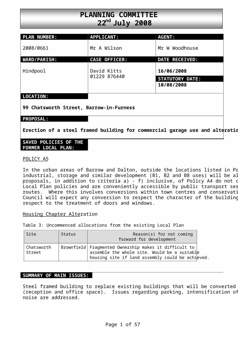
Page 1 of 57 PLANNING COMMITTEE 22 nd July 2008 PLAN NUMBER: APPLICANT: AGENT: 2008/0661 Mr A Wilson Mr W Woodhouse WARD/PARISH: CASE OFFICER: DATE RECEIVED: 16/06/2008 STATUTORY DATE: Hindpool David Kitts 01229 876440 10/08/2008 LOCATION: 99 Chatsworth Street, Barrow-in-Furness PROPOSAL: Erection of a steel framed building for commercial garage use and alteratio SAVED POLICIES OF THE FORMER LOCAL PLAN: POLICY A5 In the urban areas of Barrow and Dalton, outside the locations listed in Po industrial, storage and similar development (B1, B2 and B8 uses) will be al proposals, in addition to criteria a) - f) inclusive, of Policy A4 do not c Local Plan policies and are conveniently accessible by public transport ser routes. Where this involves conversions within town centres and conservati Council will expect any conversion to respect the character of the building respect to the treatment of doors and windows. Housing Chapter Alteration Table 3: Uncommenced allocations from the existing Local Plan Site Status Reason(s) for not coming forward for development Chatsworth Street Brownfield Fragmented Ownership makes it difficult to assemble the whole site. Would be a suitable housing site if land assembly could be achieved. SUMMARY OF MAIN ISSUES: Steel framed building to replace existing buildings that will be converted (reception and office space). Issues regarding parking, intensification of noise are addressed.
Transcript of PLANNING COMMITTEE 22 July 2008 - Barrow BC · Page 3 of 57 PLANNING COMMITTEE 22nd July 2008 The...
Page 1 of 57
PLANNING COMMITTEE 22nd July 2008
PLAN NUMBER: APPLICANT: AGENT: 2008/0661 Mr A Wilson Mr W Woodhouse
WARD/PARISH: CASE OFFICER: DATE RECEIVED:
16/06/2008 STATUTORY DATE:
Hindpool David Kitts 01229 876440
10/08/2008
LOCATION: 99 Chatsworth Street, Barrow-in-Furness PROPOSAL: Erection of a steel framed building for commercial garage use and alterations to site SAVED POLICIES OF THE FORMER LOCAL PLAN:
POLICY A5 In the urban areas of Barrow and Dalton, outside the locations listed in Policies A1 and A2, industrial, storage and similar development (B1, B2 and B8 uses) will be allowed where proposals, in addition to criteria a) - f) inclusive, of Policy A4 do not conflict with other Local Plan policies and are conveniently accessible by public transport services and cycle routes. Where this involves conversions within town centres and conservation areas the Council will expect any conversion to respect the character of the building, particularly with respect to the treatment of doors and windows. Housing Chapter Alteration Table 3: Uncommenced allocations from the existing Local Plan
Site Status Reason(s) for not coming forward for development
Chatsworth Street
Brownfield Fragmented Ownership makes it difficult to assemble the whole site. Would be a suitable housing site if land assembly could be achieved.
SUMMARY OF MAIN ISSUES: Steel framed building to replace existing buildings that will be converted to supporting uses (reception and office space). Issues regarding parking, intensification of use, housing and noise are addressed.

Page 2 of 57
PLANNING COMMITTEE 22nd July 2008
NON MATERIAL CONSIDERATIONS: REPRESENTATIONS: The Occupiers of A & B Services, 72, 74, 76, 78, 80, 82, 84, 86, 90, 92, 94, 96, 98, 97, 99, 100, 102, 104, 106, 108, 110, 112, 114, 115, 116, 117, 119 Chatsworth Street, 170, 172 Hartington Street, Steelview, The Bungalow, Landscape House, Bath Street, Discount Beds, Walney Road, 9/11 Buccleuch Street, Barrow in Furness all informed. The Occupier, 108 Chatsworth Street “It must not be forgotten that Chatsworth Street is also a residential street. My main concern over this application is the increased volume of traffic, pollution and noise extending this business will generate. It is obvious from the size of this proposal the intention is to vastly increase the volume of business, which in this case means increasing the number of cars along Chatsworth Street.” The Occupier, 104 Chatsworth Street, Barrow in Furness “I strongly object to the planning application to build a steel framed building as an extension to pre existing garage workshops @ No 99 Chatsworth St. When I moved into this property in 1967,it was a residential area, not an industrial estate as it is fast becoming. I feel that my quality of life is being affected due to (a) restricted views from my home (a large garage stuck directly in front of my window) and (b)rental vans-recovery vehicles-delivery vehicles-vehicles awaiting service or repair and recently numerous taxi cars presumably linked to the garage, the greater majority of which conveniently parked in front of or in close proximity to my house. I can only envisage a deterioration in my situation if this planning application is granted and an even bigger eyesore blotting out my view from my front window. My final concern would be that if this building was sited as planned, what would the effect be on the future value and saleability of my home”. The Occupier, 115 Chatsworth Street “I am opposing this most strongly the road is already full of van, cars, taxis and lorries to congested levels and I was of the opinion the Council were trying to turn this area into a residential estate with schools and new homes not an industrial estate. I am giving you warning of 99 Chatsworth Street it is given permission to open a garage then I reserve the right to open the garage at the rear of my home for car repairs and welding. I am a welder by trade but have become disabled due to fits due to diabetes but can no longer work as a welder due to fits but because there is no other way for me to make a living, if this person at 99 is permitted to start a business then I, because of my illness will do the same and start a taxi business or garage from my property since I will be living on an industrial estate why not everybody else is.” The Occupier , 104 Chatsworth Street, Barrow in Furness “I would like the opportunity to speak and give my opinions re the proposed erection of a steel framed building in front of my house at the committee meeting”.

Page 3 of 57
PLANNING COMMITTEE 22nd July 2008
The Occupier, 76 Chatsworth Street, Barrow in Furness “In view of planning permission for garage erection in Chatsworth. I strongly oppose it. The firm concerned is already too big for this street with vans, breakdown trucks also cars for repairs and vehicles calling on business, the residents struggle to park their own car. It’s too busy now and close to three schools which should be taken into consideration. I think if it were possible another road running at the back for access would solve a lot of problems. Councillor Anne Burns got one firm use the rear to enter but it changed hands to whitesides and they reverted back to enter from Chatsworth Street. I dont know if they needed planning permission but it also means more big vans up and down the street. I have lived here for twenty plus years and it’s just getting worse. P.S. It used to be a nice quiet street”. The Occupier, 97 Chatsworth Street, Barrow in Furness “The purpose of this letter is to object against a planning proposal to erect a new steel frame building a re-design of existing facilities i.e. B & D Motors, 99 Chatsworth Street. Objections:
1. Size of building 2. Amount of vehicles on site. 3. Plan of improvements does not successfully prove that this site can cope with
present business now never mind if this proposal is passed. 4. Impact on Street and extra traffic generated. 5. Overspill parking which exists now. 6. Safety in the Street reversing from site, traffic flow, children in the Street 7. Nursery School in near vicinity and more traffic vehicles turning round outside
junction. I would also like to take the option to address the meeting to voice my opinion”. The Occupier, 116 Chatsworth Street, Barrow in Furness “I am writing this letter to complain about the expansion of B & D motors. I am not happy at the situation as it is now regarding parking problems in the street without the expansion. The garage has taken over the whole street nearly, so many more vehicles would make it a lot worse”. CONSULTATIONS: Cumbria Highways
“The road side frontage to Chatsworth Street is cluttered with garage traffic this may be an opportunity to tidy up this frontage and provide a safer environment for pedestrians and other others of the public highway in the vicinity of this development by defining a footway and marking parking areas.

Page 4 of 57
PLANNING COMMITTEE 22nd July 2008
Access Drive
The access drive shall be surfaced in bituminous or cement bound materials, or otherwise bound and shall be constructed and completed before the development is brought into use. This surfacing shall extend for a distance of at least 5 metres as measured from the carriageway edge of the adjacent highway. Reason: In the interests of highways safety. Highway Water Drainage System Full details of the surface water drainage system shall be submitted and approved by the Local Planning Authority prior to works commencing on site”. OFFICERS REPORT: The site is an existing commercial garage and car repair workshop on the north west side of Chatsworth Street. The rear of the site backs onto the service areas of Matalan and the MFI and Allied Carpet superstore. The existing site consists of several old and rather dilapidated buildings that are set back approximately 6m from the boundary of Chatsworth Street. The proposal will improve the working conditions within the garage and provide a more modern purpose built facility. The footprint of the building will be approximately 16m width x 21.5m length. Ridge height will be approximately 7m with the eaves at 4.8m. The ridge height of the existing buildings is approximately 5.5m. The land to the north and east of the application site is housing and the site has been previously allocated for housing in the previous Local Plan. Access, parking and intensification of use A Transport Form has been submitted with the application and the consultation from Cumbria Highways (included above) raises no objection. The existing access to the site shall remain. I have noted the concerns that several residents have made regarding the over spilling of parking onto the public highway. Representations from the public are included above. It should be noted that the scheme is proposed to improve and to some degree replace the existing garage facilities that will be used as an office and reception. While the proposal may result in an increase in traffic movements I believe that the improvements to the parking facilities and access to the site will minimise any adverse impact to residents. The area in front of the existing buildings is presently used as a forecourt for parking of vehicles and no formal pavement is present on this side of the street. The existing arrangement will largely remain as part of the proposal although the layout will be improved and formalised.

Page 5 of 57
PLANNING COMMITTEE 22nd July 2008
The scheme will consolidate parking within the site by increasing the available parking from 5 cars at present to 15. Spaces for goods and public service vehicles would also be increased from 3 to 8 and for motorcycles from 7 to 12. I believe this improvement will help to minimise any on street parking. It is also worth noting that the ground is presently surfaced in an unbound material, this will also be improved through surfacing of the area within the site with tarmacadam. Streetscene The proposed building will be set behind the existing garage buildings which will be refurbished as part of the scheme and converted to supporting public reception and office space. While the building will be higher than the existing buildings I do not believe this will result in a detrimental impact to the appearance of the area. It should be noted that the building will be approximately 30m from the front elevations of the residential dwellings. The building will be clad in grey composite sheeting. Potential housing on neighbouring site to the south The area to the north west of Chatsworth Street (which includes the application site) was allocated for housing in the previous Local Plan. This allocation is not included in the present Housing Chapter Alteration 2006 because of the fragmented ownership of the area. It does state however that housing would be appropriate if land assembly could be achieved. I believe that the future of the north side of Chatsworth Street would be more appropriate as a residential area rather than industrial but the fragmented ownership is still a restriction to a successful housing development. Decisions on applications need to be based on their own merits and refusing this application on the basis that the land could be suitably assembled for housing at some point in the future would be I feel inappropriate, especially given that the land could not be assembled while the site was allocated for housing. At this point it would be inappropriate to consider the merits of potential housing schemes and whether they would constitute a comfortable arrangement in between the existing industrial uses. Conclusion Car repair garages are not usually considered appropriate in residential areas. However the application site has historically been for vehicle repairs. Indeed vehicle repairs represents the lawful use of the site. The proposal will bring improvements to parking and due to the new construction, an improvement in sound insulation. Taking account of all of the above factors it would be difficult to justify refusal. Other concerns raised Value and saleability of private dwellings is not a planning consideration. Views from private dwellings are not a planning consideration.

Page 6 of 57
PLANNING COMMITTEE 22nd July 2008
RECOMMENDATION: I recommend that planning permission be GRANTED subject to the Standard Duration Limit and the following conditions: Condition No. 2 Prior to the commencement of development the colour of the cladding and roof materials shall be agreed in writing with the Planning Authority. Reason To ensure a satisfactory appearance of the development. Conditon No. 3 No floodlighting or other form of external lighting shall be installed unless it is in accordance with details that have previously been submitted to and approved in writing by the Planning Authority. Such details shall include location, height, type and direction of light sources and intensity of illumination. Any lighting, which is so installed, shall not thereafter be altered, other than for routine maintenance which does not change its details, without the prior consent in writing of the Planning Authority. Reason To minimise light pollution in accordance with policy D63 of the Barrow Local Plan Review 1996-2006, and in order to protect the amenities of the area. Condition No. 4 No vehicles for sale shall be displayed on the site unless the Planning Authority gives prior written consent to a variation. Reason In order to protect the residential amenities of the area. Conditon No. 5 Notwithstanding the provisions of the Town and Country Planning (General Permitted Development) Order, 1995 (or any Order revoking or re-enacting that Order with or without modifications) no opening of any kind shall be made in the south west facing elevation of the permitted garage without the prior written consent of the Planning Authority. Reason In order to protect the amenities of the neighbouring properties

Page 7 of 57
PLANNING COMMITTEE 22nd July 2008
Condition No. 6 There shall be no external storage of refuse or other waste materials, except within purpose built containers and no external storage of any other materials except within appropriately screened areas, details of which shall be subject to prior written agreement with the Planning Authority. The development shall thereafter be carried out in accordance with the approved details Reason In the interests of the visual amenities of the area. Reason for Approval The plan did not accord with the Development Plan for the area, specifically policies A5 and A4 (critieria a-f) of the Barrow Borough Council Local Plan Review 1996- 2006. However, there were material considerations that made the proposal acceptable, namely the improvements to parking within the site. The Planning Authority considered that these material considerations outweighed the policies and therefore the proposal was acceptable.

Page 8 of 57
PLANNING COMMITTEE 22nd July 2008
PLAN NUMBER: APPLICANT: AGENT: 2008/0816 Mr Paul French Mr Keith Halligan
WARD/PARISH: CASE OFFICER: DATE RECEIVED:
24/06/2008 STATUTORY DATE:
Hawcoat Ian Sim 01229 876384
18/08/2008
LOCATION: 52 Elterwater Crescent, Barrow-in-Furness PROPOSAL: Erection of a two storey side extension forming garage with bedroom above, incorporating dormer to roof and with re-instatement of boundary walls SAVED POLICIES OF THE FORMER LOCAL PLAN:
POLICY B15 Where privacy is to be protected through distance, a minimum of 21 metres will be required between the facing windows of habitable rooms of different homes. Exceptions to this policy may be made for the facing windows of ground floor habitable rooms, where adequate screening exists and also in cases where normal standards of separation cannot be achieved and existing standards will not be eroded by accepting distances of less than 21 metres. The use of obscure glazing in habitable room windows will not be an acceptable measure to overcome the provisions of this policy if this is deemed to provide a sub-standard level of accommodation. POLICY B16 For single or two storey side extensions that would, if repeated in a street, convert a row of properties into a terrace, the Authority will require the design to overcome this effect. POLICY B17 Visually dominating side extensions on corner plots or which otherwise intrude unacceptably on the streetscene will be refused if they are considered to be detrimental to the character or spaciousness of the area. If, however, this effect can be overcome by their re-design with a pitched roof or more matching materials the Authority will require the proposal to be amended accordingly.

Page 9 of 57
PLANNING COMMITTEE 22nd July 2008
POLICY B18 Dormer extensions will only be permitted where they are of a scale and appearance appropriate to the property and do not adversely impact on the overall streetscene. POLICY B19 Applications involving the loss of garages or access thereto will only be permitted where it can be demonstrated that sufficient alternative parking space is available behind the building line or in such other position as will not have an adverse impact on the character of the area. POLICY B20 Applications for garages will be refused unless the proposed garage is located a minimum distance of six metres from the highway. Exceptions to this policy will be allowed only where the safety of people using the highway will not be unduly diminished such as along back streets. SUMMARY OF MAIN ISSUES: The scheme is similar to that approved at 64 Elterwater Crescent (2007/0791) on 14th September 2007 and raises no new issues. NON MATERIAL CONSIDERATIONS: REPRESENTATIONS: The Occupiers of 18-26 (evens) Skelwith Drive, 50-56 (evens) Elterwater Crescent, Barrow in Furness all informed. The Occupier, 50 Elterwater Crescent, Barrow in Furness “I have received notification dated 16 th June 2008 but delivered 24th June 2008 that the proposal to extend 52 Elterwater Crescent, Barrow-in-Furness, previously denoted as Planning Application No. B13/2008/0170 and withdrawn on 8/5/08, is to be submitted once again. I am writing to restate my objections to this proposal. The proposal is to extend number 52 to the furthest extent of the boundary. This would prevent any future extension of my property, number 50, towards the same boundary. The extension would block sunlight to the side of number 50 and the resultant gap, the driveway to number 50, of some two and a half metres between the houses would give the appearance of a darkened alley-way. The higher level at which number 52 sits relative to number 50 would exacerbate such problems. Construction requires the removal of my driveway at number 50 and building work on my land. This would remove pedestrian and vehicular access to my property. An extension which requires the restriction and removal of access to my property is entirely unacceptable.

Page 10 of 57
PLANNING COMMITTEE 22nd July 2008
If the application is to be determined by the Planning Committee I would wish the opportunity to address that meeting”. CONSULTATIONS: OFFICERS REPORT: The proposal is for the erection of a two storey side extension forming garage with first floor above, incorporating dormer to roof and re-instatement of boundary walls. The application site is a semi-detached property on the northern side of Elterwater Crescent with an open grassed area to the front (south) and semi-detached properties to the sides and rear. The property has a detached garage in the rear garden. The scheme allows for the provision of a replacement garage to the side elevation (eastern), having an indicated footprint of approximately 7.5 metres (being almost the full depth of the property) x 3 metres (full width of the driveway). At first floor level a bedroom and dormer bedroom above are proposed. Privacy is protected through design, distance or remains unaltered. The use of matching external materials and the continuation of the ridge line helps to reduce the visual impact upon the street scene. The terracing effect is alleviated by setting back the proposed side extension by 0.5 metres and by the slope of Elterwater Crescent itself. The application site and neighbouring properties have a southerly aspect which is further enhanced by the open grassed area to the front, thereby, allowing for sunlight and natural light levels to be maintained above the minimum 3 hours that Central Government advise as being acceptable. The scheme is similar to that approved (2007/0791) for the nearby 64 Elterwater Crescent which received consent on 14th September 2007 and which is nearing completion. The representation received from the adjacent neighbour to the east (No. 50 Elterwater Crescent) includes references to civil matters i.e. access onto their land, however, the correct certification has been served as indicated on the application. The representation has been considered however a favourable recommendation is warranted. RECOMMENDATION: I recommend that planning permission be GRANTED subject to the Standard Duration Limit and the following conditions: Condition No. 2 The materials to be used in the construction of the external surfaces, including walls, roofs, doors, and windows, of the extension hereby permitted shall be of the same type, colour, and texture as those used in the existing building.

Page 11 of 57
PLANNING COMMITTEE 22nd July 2008
Reason To ensure a satisfactory appearance to the development, and to minimise its impact upon the surrounding area thereby, complying with saved policy D21 of the former Barrow Borough Local Plan Review 1996-2006. Conditon No. 3 Notwithstanding the provisions of the Town and Country Planning (General Permitted Development) Order, 1995 (or any Order revoking or re-enacting that Order with or without modifications) no opening of any kind shall be made in the north eastern facing elevation (facing No. 50 Elterwater Crescent) of the permitted extension without the prior written consent of the Planning Authority. Reason In order to protect the residential amenities ofthe occupier(s) of No.'s 50 and 52 Elterwater Crescent from overlooking or perceived overlooking. Condition No. 4 The garage and access thereto must be reserved for the parking of private motor vehicles and no permanent development, whether permitted by the Town and Country Planning (General Permitted Development) Order, 1995 (or any Order revoking and re-enacting that Order with or without modifications) or not, shall be carried out on that area of land or in such position as to preclude vehicular access to the development hereby permitted. Reason To ensure that proper access and parking provision is made and retained for use associated with the development hereby permitted. Reason for Approval That having regard to the provisions of Section 38(6) of the Planning and Compulsory Purchase Act and all other material considerations, and subject to the proposed conditions, the development as proposed by reason of its location, design and orientation, will not have a detrimental impact upon the neighbouring properties or the visual amenities of the area. As such, the proposal complies with the Development Plan for the area, specifically policies B15, B16, B17, B18, B19, B20.

Page 12 of 57
PLANNING COMMITTEE 22nd July 2008
PLAN NUMBER: APPLICANT: AGENT: 2008/0789 Mr Robert Mills Mr M Gadsden
M & P Gadsden Consulting Engineers
WARD/PARISH: CASE OFFICER: DATE RECEIVED:
17/06/2008 STATUTORY DATE:
Dalton North Askam and Ireleth Parish Council
Leanne Largue 01229 876438
11/08/2008
LOCATION: Land adjoining Cumbria View, Marsh Street, Askam-in-Furness PROPOSAL: Revised application to that approved under reference 2006/1032 for the erection of a 3 bedroom bungalow incorporating a new first floor habitable area with insertion of velux windows at high level to front and rear elevations SAVED POLICIES OF THE FORMER LOCAL PLAN:
POLICY B3 Applications for residential development on unallocated sites will be permitted where they accord with the sequential approach of the Structure Plan and also satisfy the following criteria: i) The site is located within the built up area of existing settlements or the
development cordons identified in Policy B13; and ii) The siting, scale, layout and design (in the materials and form of the buildings) of
the development is sensitive to the local environment, it promotes the principles of ‘Secure by Design’ and adequate parking provision is made; and
iii) Adequate access arrangements can be provided, including servicing the site by
the public transport and by cycle routes; and iv) The development is laid out in a way that maximises energy efficiency; and v) The development will not result in the loss of land which has a recognised or
established nature conservation interest; and vi) The development must not cause an undue increase in traffic passing through
existing residential areas such as to be detrimental to residential amenity or highway safety; and

Page 13 of 57
PLANNING COMMITTEE 22nd July 2008
vii) Adequate water supplies, foul and surface water sewers and sewerage treatment facilities exist or can be provided; and
viii) 'A risk-based approach will be adopted for development in or affecting flood risk
areas to minimise the risk of flooding associated with the site and the potential effect development of the site might have elsewhere through increased run off or a reduction in the capacity of flood plains. This shall be in accordance with the sequential characterisation of flood risk set out in Table 1 of Planning Policy Guidance Note 25 'Development and Flood Risk; and
ix) Where contamination is suspected, a desk study is undertaken and if necessary a
site investigation is undertaken and remediation strategy submitted. POLICY B13 In the following villages, residential development and the conversion of existing buildings for residential purposes will be allowable within the residential cordon, especially if it contributes to the maintenance of that community, subject to conformity with the criteria of Policy B3 and the principles of Structure Plan Policy ST3: Askam & Ireleth, Biggar Village, Lindal, Marton, Newton, North Scale, Rampside, Roa Island. POLICY B15 Where privacy is to be protected through distance, a minimum of 21 metres will be required between the facing windows of habitable rooms of different homes. Exceptions to this policy may be made for the facing windows of ground floor habitable rooms, where adequate screening exists and also in cases where normal standards of separation cannot be achieved and existing standards will not be eroded by accepting distances of less than 21 metres. The use of obscure glazing in habitable room windows will not be an acceptable measure to overcome the provisions of this policy if this is deemed to provide a sub-standard level of accommodation. SUMMARY OF MAIN ISSUES: The principle of the development was agreed under application no. 2006/1032. There should be no significant impact upon the privacy of neighbouring occupiers due to the height of the rooflights. NON MATERIAL CONSIDERATIONS: REPRESENTATIONS: The Occupiers of 23, 25, 27, 29 Estuary Park, Duddon Sands, 13-16, Arch House, Cumbria View, 11, 11a, 12, 13, 14 Marsh Street, 15, 16 The Headlands, Askam in Furness all informed.

Page 14 of 57
PLANNING COMMITTEE 22nd July 2008
The Occupier, 16 The Headlands, Askam-in-Furness “With reference to the above we fail to understand why this revised plan of house not bungalow has been allowed to continue. We strongly object on the grounds previously stated in our letters of objection dated 5th and 8th February. Briefly these were as follows:
• Loss of Trees
Trees enhancing and screening our property were felled without any prior notice. • Roof Lights
Roof Lights installed without Planning permission abusing our privacy rights.. Velux windows set above eye line as since stated have made no difference to the invasion of privacy which we have experienced frequently in our bedroom. This again has abused the POLICY B 15 as the distance between is less than 21 metres, and screening not possible. May we point out that we were assured by your Department that the objection we made concerning our privacy and the abuse of the original plans (which bare no resemblance to the revised ones) would be taken seriously. However since we have had no letters of explanation as to why the above revised plans continued, before being submitted, we feel once again the Planning Department has failed in its responsibilities. Surely if Builders can determine what to build ignoring Approved Plans, i.e. raising ridge from 5.6m (max) to 7m to accommodate Roof Windows etc. Then what is the point of Plans in the first place. We can only assume that Planning Permission is a complete waste of time and a total mockery.” CONSULTATIONS: Askam and Ireleth Parish Council “This application should be refused and the original approved plans adhered to.” OFFICERS REPORT: The application site is a plot of land measuring 14 metres x 25 metres at the southern end of Marsh Street, Askam. The site is surrounded by existing dwellings and is a windfall site by virtue of local plan policy B3. Proposal Planning Permission was granted for a bungalow at the site on 19th September 2006 (06/1032). Originally all proposed living accommodation was on the ground floor. The application before you today is a resubmission of the earlier scheme, but with the inclusion of high level Velux windows to the front and rear elevations, which will serve accommodation within the roof space.

Page 15 of 57
PLANNING COMMITTEE 22nd July 2008
Rooflights can normally be inserted without requiring planning permission, however there are exceptions to the rule. In this case a condition is attached to the bungalow preventing the insertion of rooflights and dormer windows, unless the authority gives its prior consent. The reason for the condition was to allow the authority to control the number and location of any openings, in order to protect the privacy of neighbouring occupiers, particularly those to the rear. The bungalow is currently under construction and the applicant has converted the roof space to provide 2 bedrooms and a bathroom. Representations Comments have been received from the Parish Council, requesting that the application be refused although no reason for this has been given. The occupier of the bungalow to the rear has also objected to the scheme as they are concerned about the impact of the proposal upon their privacy. Issues The general structure of the bungalow remains unchanged from the original application. The plans submitted show that the bungalow has a footprint of 9.5 metres x 12.5 metres and a ridge height of 5.6 metres. The only changes which have been made to the scheme relate to the internal layout and the inclusion of rooflights to the front and rear elevations. The bungalow to the rear is less than 21 metres away and features habitable room windows within the rear elevation which overlook the application site. Privacy between ground floor windows is to be protected by screening and a condition has been attached to ensure this is in place prior to the beneficial occupation of the dwelling. The main issue therefore concerns the additional impact arising from the rooflights. I have visited the site and assessed the impact from both inside and outside the bungalow. The two rooflights already in place are set at a height above standing eye level, the edge of the window box is approximately 1.6 metres from floor level. The additional proposed windows will be at the same level. The view from the rooflights is limited and one can only see the ridge of the neighbour’s roof and the skyline when standing on an object. Assuming normal behaviour, I do not believe the rooflights will result in a significant loss of privacy to the neighbour. The proposal therefore accords with saved policy B15 which states that privacy can be protected through appropriate design if it cannot be protected through distance. The application raises no other issues as the principle of the development was agreed in the original application. RECOMMENDATION: I recommend that planning permission be GRANTED subject to the Standard Duration Limit and the following conditions:

Page 16 of 57
PLANNING COMMITTEE 22nd July 2008
Condition No. 2 Prior to the beneficial occupation of the dwelling hereby approved, two parking spaces must have been formed within the front garden of the application site to cater for the property's off street parking requirements. Reason To provide adequate off street parking in accordance with the Barrow Borough Local Plan Review 1996-2006. Condition No. 3 The parking spaces and access thereto must be reserved for the garaging or parking of private motor vehicles and no permanent development, whether permitted by the Town and Country Planning (General Permitted Development) Order, 1995 (or any Order revoking and re-enacting that Order with or without modifications) or not, shall be carried out on that area of land or in such position as to preclude vehicular access to the development hereby permitted. Reason To ensure that proper access and parking provision for use in relation to the development and to accord with the Barrow Borough Local Plan Review 1996-2006. Condition No. 4 Notwithstanding the provisions of the Town and Country Planning (General Permitted Development) Order, 1995 (or any Order revoking or re-enacting that Order with or without modifications) no additional opening or openings of any kind shall be made in the side elevations of the permitted bungalow without the prior written consent of the Planning Authority. Reason In order to protect the visual amenities of the area and to accord with the Barrow Borough Local Plan Review 1996-2006. Condition No. 6 Prior to the beneficial occupation of the bungalow a screen wall or fence 1.8m high must have been erected along the rear boundary and the application site in accordance with a scheme to be agreed in writing with the Planning Authority. The screening must thereafter be permanently retained. Reason In order to maintain adequate privacy and to accord with Policy B15 of the Barrow Borough Local Plan Review 1996-2006.

Page 17 of 57
PLANNING COMMITTEE 22nd July 2008
Reason for Approval That having regard to the provisions of Section 38(6) of the Planning and Compulsory Purchase Act and all other material considerations, and subject to the proposed conditions, the development as proposed by reason of its location, design and orientation, will not have a detrimental impact upon the neighbouring properties or the visual amenities of the area. As such, the proposal complies with the Development Plan for the area, specifically policies B3, B13 and B15.

Page 18 of 57
PLANNING COMMITTEE 22nd July 2008
PLAN NUMBER: APPLICANT: AGENT: 2008/0663 Mr D Fraser Mr W Woodhouse
WARD/PARISH: CASE OFFICER: DATE RECEIVED:
02/06/2008 STATUTORY DATE:
Newbarns Ian Sim 01229 876384
27/07/2008
LOCATION: 4 Burns Avenue, Barrow-in-Furness PROPOSAL: Ground floor and two storey extensions to front elevation, first floor side extension and a ground floor and two storey extension to rear elevation (resubmission of 2008/0384 in a revised form) SAVED POLICIES OF THE FORMER LOCAL PLAN:
POLICY B14 Extensions to the rear of dwellings will not be permitted where they adversely affect the amenities of neighbouring properties by virtue of loss of sunlight or privacy or by the creation of an overbearing impact or excessive level of enclosure. POLICY B15 Where privacy is to be protected through distance, a minimum of 21 metres will be required between the facing windows of habitable rooms of different homes. Exceptions to this policy may be made for the facing windows of ground floor habitable rooms, where adequate screening exists and also in cases where normal standards of separation cannot be achieved and existing standards will not be eroded by accepting distances of less than 21 metres. The use of obscure glazing in habitable room windows will not be an acceptable measure to overcome the provisions of this policy if this is deemed to provide a sub-standard level of accommodation. POLICY B16 For single or two storey side extensions that would, if repeated in a street, convert a row of properties into a terrace, the Authority will require the design to overcome this effect.

Page 19 of 57
PLANNING COMMITTEE 22nd July 2008
POLICY B17 Visually dominating side extensions on corner plots or which otherwise intrude unacceptably on the streetscene will be refused if they are considered to be detrimental to the character or spaciousness of the area. If, however, this effect can be overcome by their re-design with a pitched roof or more matching materials the Authority will require the proposal to be amended accordingly. POLICY D21 In determining all applications submitted to it the local planning authority will have regard to the General Design Code set out in paragraph 5.4.27 of this plan. In towns and villages, proposals shall relate to the context provided by buildings, street and plot patterns, building frontages, topography, established public views, landmark buildings and other townscape elements. Proposals that do not respect the local context and street pattern or the scale, height, proportions and materials of surrounding buildings and development which constitutes over development of the site by virtue of scale, height or bulk will not be permitted, unless there is specific justification, such as interests of sustainability, energy efficiency or crime prevention. Development proposals in the countryside shall respect the diversity and distinctiveness of local landscape character. New farm buildings will, in general, be required to be sited within or adjacent to an existing farm building complex or in other well screened locations and to be subject to a complementary design and use of materials, with, where necessary, a ‘planting’ scheme. SUMMARY OF MAIN ISSUES: The re-submission, whilst large, would not unduly impact upon the character of the area. The first floor extension to the side/rear elevation has been re-located to a central position on the rear elevation reducing its impact. NON MATERIAL CONSIDERATIONS: REPRESENTATIONS: The Occupiers of 1-6 Burns Avenue, 5, 7, 8 Tennyson Avenue, Barrow in Furness all informed. The Occupier, 6 Burns Avenue, Barrow-in-Furness “We object to the planning application for the proposed extension to 4 Burns Avenue, Barrow. Our objections to this planning application relate principally to the 2 storey extension to the rear of the house, particularly because of the additional length of 2.7 metres coupled with the 2nd storey.

Page 20 of 57
PLANNING COMMITTEE 22nd July 2008
We consider the changes made since the previous application B13/2008/0384 are only a marginal improvement. This improvement being that the 2 storey part of the extension is now 2.7m further away from our garden fence. However, the side elevation viewed from our patio will have similar external dimensions to the previous application. Hence, we consider it still to be over-bearing, out of proportion with the existing property and adversely impacting the amenity of the rear of our property. We are also concerned about the new door in the South side elevation, which we consider to provide potential invasion of our privacy. This will provide a view of our garden and patio over the top of the existing fence, which is only approximately 4' 6"high. The enclosed picture shows a photograph of our current view of the South elevation of 4 Burns Avenue, together with a simulation of roughly how we expect the proposed extension would look. This clearly shows the increase in external dimensions of the proposed extension together with the position of the proposed side door.” CONSULTATIONS: OFFICERS REPORT: Members will re-call that a proposal (2008/0384) for 4 Burns Avenue relating to a ground floor and two storey extensions to the front elevation, first floor side extension and two storey extension to rear elevation was considered at your meeting of 20th May 2008. The application was subsequently withdrawn prior to determination, however at that meeting you were ‘mindful to refuse’ due to concerns over its overbearing impact upon the neighbour. My original report forms appendix A. Whilst the scheme relating to the front elevation remains unchanged the amended scheme retains the bedroom above the garage and the utility room to the rear of the garage, being adjacent to, and north of No. 6 Burns Avenue. However, concern was not raised regarding these elements. The difference between the schemes relates to the rear, first floor extension. This is now occupying a central location on the rear elevation. This has the effect of re-positioning this part of the scheme 3 metres from the side elevation of the property and roughly 4 metres from the boundary with the neighbour to the south (No. 6 Burns Avenue). Privacy would be protected through design although a representation has been received from the adjacent neighbour relating to the impact of a door in the side elevation. The door provides entrance to a utility room and was included in the previous proposal, even so, it would have little impact as boundary screening exists and being to the north of No. 6 Burns Avenue would not impact upon natural light or sunlight unduly. RECOMMENDATION: I recommend that planning permission be GRANTED subject to the Standard Duration Limit and the following conditions:

Page 21 of 57
PLANNING COMMITTEE 22nd July 2008
Condition No. 2 The materials to be used in the construction of the external surfaces, including walls, roofs, doors and windows of the extension hereby permitted shall be of the same type, colour and texture as those used in the existing building. Reason To ensure a satisfactory appearance to the development, and to minimise its impact upon the surrounding area. Condition No. 3 Notwithstanding the provisions of the Town and Country Planning (General Permitted Development ) Order 1995 (or any Order revoking or re-enacting that Order with our without modifications) no opening of any kind shall be made in the southern facing elevation (No. 6 Burns Ave) and northern facing elevation (No. 2 Burns Avenue) at first floor level of the permitted extension without the prior written consent of the Planning Authority. Reason In order to protect the residential amenities of the occupiers of No.'s 4 and 6 Burns Avenue from overlooking or perceived overlooking. Condition No. 4 Notwithstanding the provision of the Town and Country Planning (General Permitted Development) Order 1995 (or any Order revoking and re-enacting that Order with or without modifications), nothing in Article 3, or Schedule 2 to that Order, shall operate so as to permit, within the area subject to this permission, any development comprising of any repositioning of the garage door from its approved position as shown on drawing no. 6 of 11 forming part of this consent. Reason In order to maintain a drive of adequate length thus reducing the need to park on, or obstruct the highway. Reason for Approval That having regard to the provisions of Section 38(6) of the Planning and Compulsory Purchase Act and all other material considerations, and subject to the proposed conditions, the development as proposed by reason of its location, design and orientation, will not have a detrimental impact upon the neighbouring properties or the visual amenities of the area. As such, the proposal complies with the Development Plan for the area, specifically policies B14, B15, B16, B17 and D21.

Page 22 of 57
PLANNING COMMITTEE 22nd July 2008
PLAN NUMBER: APPLICANT: AGENT: 2008/0752 Mr T Rawbone
WARD/PARISH: CASE OFFICER: DATE RECEIVED:
10/06/2008 STATUTORY DATE:
Dalton North David Kitts 01229 876440
04/08/2008
LOCATION: Field off Low Lane, Saves Lane, Ireleth, Askam-in-Furness PROPOSAL: Erection of two stable blocks, one containing four stables, the other six including feed store and tack room. SAVED POLICIES OF THE FORMER LOCAL PLAN:
POLICY D1 The Borough’s countryside will be safeguarded for its own sake and non-renewable and natural resources afforded protection. Development will be permitted in the countryside only where there is a demonstrable need that cannot be met elsewhere. Where necessary development is permitted any adverse effect on the rural character of the surroundings should be minimised subject to the development’s operational requirements. POLICY D2 Development harmful to the distinctive character of designated County Landscapes, as indicated in the Proposals Maps, will not be permitted. Development justified on grounds of need that cannot be located elsewhere will be permitted provided that it is sited to minimise environmental impacts and meets high standards of design. POLICY D9 Proposals for development or land use which may affect a European site, a proposed site or a Ramsar site will be subject to the most rigorous examination. Development or land use change not directly connected with or necessary to the management of the site, that is likely to have significant adverse effects on the site (either individually or in combination with other plans or projects), and which would affect the integrity of the site will not be permitted unless the authority is satisfied that: • There is no alternative solution; and • There are imperative reasons of overriding public interest for the development or
land use change.

Page 23 of 57
PLANNING COMMITTEE 22nd July 2008
POLICY D10 Proposals for development or land use changes affecting nationally important nature conservation interests will be subject to special scrutiny. Where development may have a significant adverse effect on the nature conservation interest or integrity of an SSSI it will not be permitted unless the need for development outweighs both the value of the site itself and considerations of the national policy to safeguard the intrinsic nature conservation value of the national network of such sites. In the National Nature Reserve and Foulney Island Bird Sanctuary particular regard will be paid to the individual site's importance. In exceptional circumstances where development is permitted the council will use planning conditions and obligations to ensure the protection and enhancement of the site’s nature conservation interest. POLICY G13 For the quiet enjoyment of recreation activities such as walking, cycling and horse riding the Borough Council will protect the following designated routes from development taking place on; or in the immediate surroundings where an interesting or visually pleasing view would be adversely affected:- The Cistercian Way Haematite Trail Cumbria Coastal Way Public Footpaths Any existing right of way joining the rights of way network POLICY G15 Change of use from agriculture to leisure related horse grazing and other horse related development such as riding schools and stabling will only be permitted where it can be shown that proposals would not; a) Be visually intrusive or detrimental to the character of the area; b) Use non-traditional or otherwise visually unacceptable buildings or fencing materials
or other semi-permanent equipment; c) Be likely to lead to unacceptable erosion of bridleways, woodlands, commons or
any other ecologically sensitive area; and d) Involve an unacceptable loss of productive farmland, nuisance to residents,
pollution of sub soil or water courses, or conflict with vehicular or pedestrian traffic. In order to assess fully the impact of proposals for riding schools, the Council will require, as part of the planning application, details of the areas and routes that are intended to be used for horse riding activities.
Page 24 of 57
PLANNING COMMITTEE 22nd July 2008
SUMMARY OF MAIN ISSUES: Large stable development would have a significant detrimental impact on the open countryside, county landscape and is served by an unsatisfactory access. NON MATERIAL CONSIDERATIONS: REPRESENTATIONS:
Development advertised on site and in the local press
The Occupiers of High Meddart, Bankfield Hall, Nether Close, Tippins Lane, Furness Cars and Commercials Ltd, Paradise, Ireleth, Askam in Furness all informed. The Occupier, Springbank, 65 Saves Lane, Ireleth, Askam in Furness Low Lane is a public footpath. It is frequently used by walkers, and, aside from the work completed last year by United Utilities, is very infrequently used for vehicular access. This is usually restricted to the 4 people who own various parcels of land for which the lane provides them necessary access onto their land. I am very concerned about the noise and environmental impact that the increase in traffic inherent in this appellant's plans to erect stables will have, not only on the public footpath itself but on Saves Lane and its residents. Saves Lane is particularly narrow at the point where Low Lane is accessed. Not all of the houses in this area have off-road parking. The lane allows for two way traffic however a single vehicle moving in either direction effectively blocks the lane, above and below this point. As there is no pavement in this area pedestrians are particularly vulnerable to the hazards of parked cars and traffic. Low Lane is an unmade field track between mature hedgerows. It is often boggy underfoot as a result of the natural springs fed from the uphill escarpment and is also narrow. Nevertheless it provides a diverse habitat for many forms of wildlife and is much enjoyed by walkers and the local community. New fencing, gateways and tree trimming is not needed in order to enhance use of the paths. The appellant's application makes it clear there are no plans for any improvements to the track. Any such improvements would of course unacceptably alter the qualities of Low Lane. However, at most times of the year the only suitable vehicles that can be used on it are 4x4 or tractors. Such vehicles completely fill the width of the track and leave no room for pedestrians basically, there is nowhere to go. There is no parking available on Saves Lane for the elderly, disabled and children mentioned in the application, who may be using normal cars in order to access the proposed stables. It is also very questionable as to how the elderly and disabled without the benefit of their own 4x4 vehicles and tractors may complete the half-mile walk to the proposed stables, let alone avoid any such vehicles that may be using the track.
Page 25 of 57
PLANNING COMMITTEE 22nd July 2008
With regard to the inference in the application that the appellant is a traditional farmer (part 5: pre-application advice) so far as I am aware this single small parcel of land was purchased by him in 2004 for the express purpose of grazing horses which is what it has in the main been used for since, therefore I do not understand the reference to farming, and would suggest that any guidance relating to farm diversification should not be applied when considering this application. Although the storage of waste has been mentioned, nothing has been said regarding collection. Stables notoriously create a large quantity of waste material and removal would entail yet more traffic on both Saves Lane and Low Lane. In the Design & Access Statement documents the appellant contends that storage on the proposed site will reduce the flow of traffic along Low Lane, both vehicular and pedestrian. This really makes no sense as he seems to be aiming to significantly increase the overall volume of traffic from its current state. A stables sited in this isolated area also gives cause for concern, particularly as the appellant appears to reside in Barrow. If an alarm goes off in error the tranquillity of the area will be immediately disrupted and for a considerable time awaiting a response. In an emergency I consider it very doubtful that a fire engine would be able to access the site. Even ambulances have difficulty in navigating certain parts of Saves Lane due to its narrowness and on street parking”. The Occupier, 75 Saves Lane, Ireleth, Askam in Furness “I object to this planning application on the grounds that; 1). The access via low lane is only a rough track that is frequently used as a footpath for people taking a leisurely stroll in peace & tranquillity, it floods in winter time & their is no room for pedestrians & vehicles to pass also loss of privacy & more traffic noise”. The Occupier, 67 Saves Lane, Askam in Furness “I object to the above application on a number of grounds. In the first place it would alter the whole character of a rural conservation area and secluded footpath. The footpath known as Low Lane is used a lot by local people and there is no room for traffic, as it is a single track with thick hedgerows at either side (some of the few surviving original hedges in the area). I would be particularly worried about the unavoidable increase in traffic on Saves Lane. This lane is also very narrow with a number of bends restricting views of traffic ahead. Since the Lane was surfaced cars travel far too quickly along it despite the fact that the drivers cannot see round bends and children play in the Lane. There are places where there are no footpaths, and when walking down the Lane at night it is often necessary to take refuge in gateways assuming one is near at hand. My dog was killed in the lane by a speeding minibus three years ago and I very much hope that will be the last fatal accident. Whatever the outcome of this application, which I sincerely hope will be refused, I hope consideration can be given to the imposition of a 20mph speed limit in Saves Lane. Agreeing to the setting up of what is effectively a business at the end of Low Lane would make the situation impossible”.

Page 26 of 57
PLANNING COMMITTEE 22nd July 2008
The Occupier, Low Brookside, Saves Lane, Ireleth, Askam in Furness “Let me point out initially that Low Lane which runs right across the bottom of my garden is incorrectly signposted as ‘Public Footpath Nook Lane’ and causes constant bewilderment to the walkers who frequently use it. I assume that planning departments are concerned only in the ‘visual impact’ of buildings and not the subsequent annoyance and inconvenience to residents in the area? because as far as I can establish no one in Saves Lane has been informed of this application and we are the ones most affected by it. If allowed are these proposed stable blocks to be lowered into position fully assembled by helicopter? If not we are going to be subjected to constant wagon loads of building materials to construct them. Low Lane is an un-surfaced public footpath for heavens sake, not a highway for construction vehicles. There is already considerable traffic up and down the lane, the farmers tractors and other agricultural equipment and a large digger once a week, all of which churn up the surface until it is a quagmire in wet weather and the subsequent mud is carried up and down Saves Lane. If and all in this area will do our utmost to prevent it, the stables were built, we will then be subjected to 4 x 4 vehicles, horse boxes wagons with foodstuffs etc. using the footpath at all times, together with more parked vehicles of the horse riders in Saves Lane, which is already congested with residents cars, all of which is totally unacceptable to all how live in the area. This application cannot be allowed”. The Occupier, Belvedere, 82 Saves Lane “I oppose the above application, below are my comments. (1) Access to the site is via an unmade farm track which is a public footpath, with limited places available for passing traffic (2) With the proposed scale of the operation one 32M and 1 x 16m concrete slabs as a foot print.......this is enormous! It will bring significant access, parking and dirt problems to the residents of Saves lane and the junction with Low Lane. This is already difficult at times, even for the few tractors and horseboxes that currently use the lane, and residents who have to use on road parking. Horseboxes would not be able to turn around, and would therefore have to negotiate the very narrowest upper section of Saves Lane, with the risks of the road becoming blocked. (3) Whilst the application looks like a private individual application, the sheer scale of it looks like the start of a commercial operation. The location and very poor access make this totally unsuitable. (4) The potential for high volumes of traffic for this number of horses in terms of feed, manure removal , owners visit to look after them, owners arriving with horse boxes for event, horse riding, and the associated horse muck. Make this location entirely unsuitable.

Page 27 of 57
PLANNING COMMITTEE 22nd July 2008
(5) There is also reference to Handicapped children/Horse riding etc, again vehicular access would probably be needed to support this, again more traffic and parking problems..... (6)The lane and land itself, whilst looking OK at this time of year, drains very badly due the fine clay time material, in the winter the retained water in the lane and in the prosied field (bottom corner) is dreadful, from (a) and animal welfare (b) dirt and mess point of view.” Supporting Statement from the applicant “I am writing to clarify details on the proposed use of the above scheme. It is our intention that stable block No.1 will be the main stable block to keep 6 horses for personal use and not as a commercial venture for public use. Granting planning approval for Stable block No. 2 would give us additional benefits of redundancy, e.g. repair of stable block No.1, and for the welfare of the horses. Horses are gregarious animals and like to be kept together when stabled. If a horse was injured in the second field and needed to be stabled it could be kept near to other horses using that field without moving them all back to stable block No.1. I recognise that 10 stables, plus tack and store room, could look like a commercial venture but the stables will be used by only two owners and my wife. The only additional use to this land is if my wife then buys her own horses. If at any time we feel that there is a need to change the use of these stables then we would consult with the planning office. If you need any further details do not hesitate to contact me. I thank you for your co-operation in this matter”. The Occupier, High Meddart, Kirkby Road, Ireleth, Askam in Furness “I wish to object to this application which raises issues of access, obstruction of the Lane, lack of fencing, lack of adequate grazing and other issues. Access Low Lane is a footpath, it is not a bridleway or a highway. It is used by farm vehicles to give occasional access to adjoining fields. The attached photographs 1-4 show the entrance to Low lane from Saves Lane and three views along the lane. There are no passing places. Horses are apparently supposed to be checked daily. If ten stables are in use, potentially with different owners, there could be up to 10 cars daily along Low Lane giving rise to several thousand vehicular movements per year. Lane Obstruction to Path 602059 There are 3 unauthorised gates across the lane (albeit without locks). These gates have the effect of enclosing the footpath in the field where the stables are proposed. These gates are now effectively stock fences for the field.

Page 28 of 57
PLANNING COMMITTEE 22nd July 2008
Picture Lane gates 1& 2 attached shows two gates across the footpaths (note the footpath signs). Picture Lane gate 3 shows the third gate across the lane. Capita / Highways Authority are requested to investigate this matter Lack of Fencing: Removed Hedges and fences The perimeters of the fields where the stables would be built have had the hegerows, fences and gates between the field and the lane removed. This land grab effectively subsumes the lane into the field. This is shown in "No Fence Picures 1-5". The footpaths will become bridleways Exercise of Horses It is generally recommended that a single horse requires access to ~1 acre. (See extract from http://www.newrider.com/Library/Misc_Tips/land_horse.html below. The fields have a total acreage of 4.86 acres. This means that horses will been ridden along the lanes which will soon get churned up. Myself and my neighbours recently (as a good will gesture) contributed funds to improve the drainage of the lane in the area below Netherclose. There are further issues as follows: Loss of outlook previously unspoilt outlook from High Meddart Noise and disturbance; Smells from spoil of 10 horses; the prevailing wind blows towards High Meddart Health hazard; serious concerns over pollution danger from foul sewage and waste. Application does not address specifically where surface water will drain to and how issues of contamination of ditches and ground water will be addressed. Introduction of rats Floodlighting details are not specified to avoid nuisance. Each horse requires an area 64mtrs x 64mtrs (70yrds x 70yrds) of fence or hedge line, this is equivalent to very slightly more than one square acre. There are however some variable factors:-
• The type of soil.
• The varieties of grass.
• How well the grass is managed.
• How much rest the grass can have between cycles.
• Whether the horse or pony lives out all year or whether they are stabled for part of the year.

Page 29 of 57
PLANNING COMMITTEE 22nd July 2008
• How much food the horse or pony needs to eat in a 24-hour period to sustain him.
• Whether the field is mucked out daily.
Most land used for horse and ponies is of relatively poor quality and will only support one horse per 2.4 acres (one hectare). The grass can be improved with good management, and the average paddock will then support two horses per 2.4 acres (one hectare), this allows 1.2 acres per horse. At this stock rate, it is possible to section up the paddock into three areas one for maintenance and treatments, one for use and one for resting after maintenance has been completed to allow the grass to grow”. The Occupiers, Anvil House, Saves Lane, Askam in Furness “We write to register our objection to the above noted planning application. As residents of Saves Lane with our house situated directly opposite the entrance to Low Lane we were disappointed not to have been notified directly by the Planning office about this proposed development, but had to learn of it through the local paper and through neighbours. Having read the application we have several concerns, which are detailed below. Saves Lane at this point is a narrow road with very limited space for vehicles to pass, especially when there are cars parked near the entrance to Low Lane. This development would lead to a large increase in the number of vehicles parking here, particularly 4x4 vehicles and horseboxes or trailers. This will have a substantial impact on safe passage of residents wishing to pass either in their cars, and particularly those on foot or cycle. In addition to this as residents we already at times have a virtually impossible task getting our cars out of our driveway due to cars parked opposite our gateway in this area, I can only assume that this problem will become more common due to the markedly increased volume of traffic to use this large stable block. The above comments take into note that the application makes no mention of ‘improving’ Low Lane to allow access up the lane all the way to the new stable block. The lane is a public footpath used by many walkers and local children. I cannot see it being safe for those children if large 4x4 vehicles, horse boxes, feed suppliers lorries etc. are allowed up the lane and the lane is too boggy at the end where the proposed block will be sited to allow most ordinary cars or lorries to get close. This therefore brings us back to the congestion in the narrowest parts of Saves Lane which we would consider would at times make it well nigh impossible for emergency vehicles to gain access to some houses, let alone this proposed stable block. The current use of the proposed site is for grazing horses as far as we can tell and it would appear that the expansion of this to have 12 stables suggests that this may be a commercial venture. Has this been investigated with the applicant? The environmental impact of such a development in this area would be very large (not just during the construction phase during which the noise and traffic up the lane would be huge) both in terms of noise and traffic but also potential damage to the mature hedgerows lining Low Lane, which form a valuable part of the local wildlife habitat.

Page 30 of 57
PLANNING COMMITTEE 22nd July 2008
Finally, such a large stable block would produce substantial waste. While the applicant states that the muckheap will be sited away from the footpath and watercourses there is no plan in place for removal of this waste when it is required and this would obviously necessitate further movement of large vehicles up this narrow lane. We accept that in any development there would be impact during the construction phase and whilst this would cause inconvenience to local residents it could be accepted if only temporary. We trust that the above objections are based on the long term environmental and safety concerns that we have as residents of one of the nearest houses to the end of Low Lane”. CONSULTATIONS: Footpath Secretary – Furness Ramblers “I have considered the above application and have no objection.” Natural England “Thank you for consulting Natural England on the above proposal. Your letter was received by this office on 20 June 2008. This letter represents our consultation response under Regulation 48(3) of the Habitats Regulations' 1994. The application is within 800m of the Duddon Estuary SPA and Ramsar sites and Morecambe Bay SAC. The location of the proposal in relation to this European Site means that the application must be determined in accordance with the requirements of the Conservation (Natural Habitats &c) Regulations 1994 (the Habitat Regulations) in particular Regulations 48 and 49. Part I B of ODPM Circular 06/2005 - Biodiversity and Geological Conservation - Statutory Obligations and their Impact within the Planning System describes the procedure for the consideration of plans and projects that may affect European and Ramsar sites. We have attached Figure 1 from this Circular which summarises the procedure. Based on the information provided, Natural England objects to the proposed development as there is insufficient information with the application for us to advise you whether the proposal is likely to have a significant effect on the European site. The supporting statement advises that permission will be sought to connect to the main sewer and for connection to mains water upon granting planning permission. Natural England advises that planning permission should not be granted unless these services are already agreed with united Utilities. Given that a watercourse runs along the edge of the site, there is a risk that contamination of the Duddon Estuary designated site may occur through run-off from the stables and activities such as the soaking of hay prior to feeding. We advise that the views of the Environment Agency be taken in to consideration regarding this proposal. In addition, Natural England is concerned about the stocking rate of the land. There is the potential for 9 horses to be kept on approximately 5 acres of land. Without careful management this could lead to serious deterioration of the pasture. The British Horse Society recommendation for stocking rates for horses is one horse per 1 to 1.5 acres.

Page 31 of 57
PLANNING COMMITTEE 22nd July 2008
Regulation 48 requires your authority, before deciding to give any consent to a project which is (a) likely to have a significant effect on a European site (either alone or in combination with other plans or projects), and (b) not directly connected with or necessary to the management of the site, to make an appropriate assessment of the implications for the site in view of its conservation objectives (see attached). In this case the proposal is not directly connected with or necessary to the management of site but may have a significant effect on a European site. In order to determine the application in accordance with the Habitats Regulations, the planning authority must require the applicant to submit the following information:
. Mains water and sewage connection agreement from United Utilities.
. Reduction of stables to a maximum of 5 and/or
. Pasture management details.
If the application is amended to include this additional information, Natural England should be re-consulted for a further 21 days in accordance with Circular 08/2005. If you have any queries relating to the content of this letter, please contact the author at the above address”. Cumbria Highways “The applicant should complete the attached transport form. I have concerns about suitability of the access track for the use proposed. The rights of users of the public footpath must be protected”. Askam and Ireleth Parish Council “The Parish Council wishes to object to this planning application on the following grounds: This application relates to agricultural land and as equestrian use is not classed as agricultural, this constitutes a change of use and development in the open countryside. The access to this site is completely unsuitable. The land drains on this public footpath (not a bridleway) would be damaged by increased traffic and there would be a danger to pedestrians as the footpath is only single track in width and there is insufficient room for vehicles and pedestrians to pass each other safely. The proposed stables would result in an increase in traffic in Saves Lane which is narrow and without pavements. There are existing problems with parking and any additional traffic would result in increased congestion and additional difficulties for residents. Low Lane footpath is naturally boggy underfoot and there is a possibility that effluent could run off from the stables into the area below which is lower lying and has poor drainage. This could result in problems with odour and hinder pedestrian use of the footpath. Disposal of waste water from the stables would be a problem as the drain is insufficient in size to take further discharges.

Page 32 of 57
PLANNING COMMITTEE 22nd July 2008
We consider the size of the land to be insufficient for the number of stables and there are no bridleways around the site on which to ride horses. There is concern that siting a feed store in such an open area would attract rats. The RDA has special requirements that could not be met because of the remote location and very poor access to the site. A previous application for stabling in a nearby location, with superior access, was refused, setting a precedent. This development would have a detrimental effect on trees and the natural habitat. For all the above reasons, Askam and Ireleth Parish Council considers that the application should be refused.” OFFICERS REPORT: The application is for two stable blocks, one with 6 stables plus a feed store and a tack room, the other, for 4 stables. The larger will be located at the south of the site where the footpath splits. The second, smaller stable will be located at the north western corner and is adjacent to the western footpath. The larger block would be 32m long x 4m wide, the shorter 16m long x 4m wide. Height to ridge would be 3.5m The site levels fall gently from east to west with the A595 elevated to the east and the Duddon Estuary to the west. The area is generally characterised by grazing fields and rolling lowland with few agricultural buildings. A number of objections have been received from statutory consultees and the public, these are reproduced above. An objection has been received from the Natural England relating to the lack of information provided on the potential impact of the proposal on the nationally important nature sites in the Duddon Estuary and Morecambe Bay. Part I B of ODPM Circular 06/2005 - Biodiversity and Geological Conservation - Statutory Obligations and their Impact within the Planning System describes the procedure for the consideration of plans and projects that may affect European and Ramsar sites. The consultation from Natural England states:
Regulation 48 of the Habitats Regulations’ 1994 requires your authority, before deciding to give any consent to a project which is (a) likely to have a significant effect on a European site (either alone or in combination with other plans or projects), and (b) not directly connected with or necessary to the management of the site, to make an appropriate assessment of the implications for the site in view of its conservation objectives (see attached). In this case the proposal is not directly connected with or necessary to the management of site but may have a significant effect on a European site. In order to determine the application in accordance with the Habitats Regulations, the planning authority must require the applicant to submit the following information:

Page 33 of 57
PLANNING COMMITTEE 22nd July 2008
. Mains water and sewage connection agreement from United Utilities. . Reduction of stables to a maximum of 5 and/or . Pasture management details. Based on the information provided, Natural England objects to the proposed development as there is insufficient information with the application for us to advise you whether the proposal is likely to have a significant effect on the European site.
Approval would therefore conflict with the statutory requirement for assessment imposed on the Council by virtue of the Habitats Regulations. Approval would also conflict with local plan policy D9. Policy The area is within the open countryside and is within a designated County Landscape. It must therefore be considered against Local Plan policies D1 and D2. Policy D1 states that the Borough’s countryside will be safeguarded from development for its own sake. Policy D2 states that in County Landscapes priority will be given to landscape conservation and that development detrimental to their distinctive character will be refused. Policy G13 acknowledges the importance of the countryside for quiet enjoyment. Policy G15 acknowledges the popularity of horse riding but recognises the impact that it can have on the environment. The policy is designed to steer horse related proposals to appropriate locations and to ensure minimal impact on the environment. Scale of development The application for 10 stables + 2 store rooms represents a considerable scale of development in this isolated location and a rather larger venture than what one would normally expect of a private hobby. Considering the number and use of the stables, I believe the proposal would result in a significant increase in the vehicular use of the public footpath access track and would be an unacceptable intrusion into the County Landscape. Access A key test of policy G15 is the suitability of the access to the proposed development. In this case the development is isolated and only accessible off a track leading into the countryside from Saves Lane. The track is a public footpath and approximately 500m in length, it is largely covered in loose slate chippings after work carried out by United Utilities in 2007. It provides few passing opportunities and in my opinion would result in conflict between vehicles and other users of the track. I also believe that the track is unsuitable for larger vehicles including vehicles towing horse boxes. I therefore consider the present access to be unsuitable and is a reason for refusal. Furthermore I consider that any significant alteration to the footpath to provide passing places, work to widen the track or intensification of vehicular use would be detrimental to the character of the footpath and detract from the pleasant, quiet character of this remote location. A further point to note is that Saves Lane is not suitable for any significant levels parking.
Page 34 of 57
PLANNING COMMITTEE 22nd July 2008
Impact on the environment The stables have been located within the application site so as to reduce their impact as much as possible. However I believe that due to the isolated nature of the site, the size of the stables and their proximity to the footpaths that their impact would be unacceptable and would have a detrimental impact on the countryside. I have also had regard to the Cumbria Landscape Classification and this site falls into the Coastal Margins category, specifically Duddon Estuaries. The document states that the landscape is sensitive to new development such as intrusive farm buildings. It should also be noted that horse related developments often introduce a large amount of clutter into fields that is often detrimental to the character of the countryside. With respect to these issues I consider the development to represent a sporadic and intrusive form of development in the open countryside and approval would be contrary to Local Plan policies D1, D2 and G15. In addition to these issues, Natural England has also raised concern regarding the stocking rate of the land. It states that in this case the proposal provides the potential for 9 horses (actually 10) to be kept on approximately 5 acres of land. Natural England advises that without careful management this could lead to serious deterioration of the pasture and that the British Horse Society recommend a stocking rates for horses of one horse per 1 to 1.5 acres. RECOMMENDATION: I recommend that planning permisson be REFUSED for the following reasons: Reason No. 1 The application provides insufficient information to assess whether the proposal is likely to have a significant effect on the European sites (Duddon Estuary SPA and Morecambe Bay SAC). Approval of the application would therefore be contrary to the Conservation (Natural Habitats &c) Regulations 1994 (the Habitat Regulations) in particular Regulations 48 and 49. Reason No. 2 The proposal is served by an access that is considered inappropriate for a development of this use and scale. The proposal is therefore contrary to saved policy G15 of the Former Barrow Borough Local Plan Review 1996-2006. Reason No. 3 The proposal would represent a sporadic and intrusive form of development that would be detrimental to the character and amenity of the open countryside and County Landscape. The proposal is therefore contrary to saved policies D1 and D2 of the former Barrow Borough Local Plan Review 1996-2006.
Page 35 of 57
PLANNING COMMITTEE 22nd July 2008
PLAN NUMBER: APPLICANT: AGENT: 2008/0666 Mr R Armstrong Mr W Woodhouse
WARD/PARISH: CASE OFFICER: DATE RECEIVED:
02/06/2008 STATUTORY DATE:
Newbarns David Kitts 01229 876440
27/07/2008
LOCATION: 302 Abbey Road, Barrow-in-Furness PROPOSAL: Insertion of balustrade over existing garage (side elevation) and on rear elevation. SAVED POLICIES OF THE FORMER LOCAL PLAN:
POLICY B21 The creation of patio areas and balconies over house extensions will be refused where they are considered to represent an unacceptable loss of privacy for the occupiers of neighbouring properties or to occupy a prominent position and be a detrimental intrusion into the street scene. POLICY D21 In determining all applications submitted to it the local planning authority will have regard to the General Design Code set out in paragraph 5.4.27 of this plan. In towns and villages, proposals shall relate to the context provided by buildings, street and plot patterns, building frontages, topography, established public views, landmark buildings and other townscape elements. Proposals that do not respect the local context and street pattern or the scale, height, proportions and materials of surrounding buildings and development which constitutes over development of the site by virtue of scale, height or bulk will not be permitted, unless there is specific justification, such as interests of sustainability, energy efficiency or crime prevention. Development proposals in the countryside shall respect the diversity and distinctiveness of local landscape character. New farm buildings will, in general, be required to be sited within or adjacent to an existing farm building complex or in other well screened locations and to be subject to a complementary design and use of materials, with, where necessary, a ‘planting’ scheme.

Page 36 of 57
PLANNING COMMITTEE 22nd July 2008
SUMMARY OF MAIN ISSUES: The application is partly retrospective with the balcony being part completed. The balcony is considered detrimental to the residential amenities of the neighbours. NON MATERIAL CONSIDERATIONS: Property values. REPRESENTATIONS: The Occupiers of 298, 300a, 300, 304, 306 Abbey Road, Barrow in Furness all informed. Representation received from 300 Abbey Road, Barrow-in-Furness “We feel we must object in the strongest possible terms to this application. We have not viewed the plans as the majority of the installation is already in place and we can see first hand the impact it will have on our property and lives. Although the application is described as the insertion of balustrade, the balustrade has been erected as an integral part of a decking area with access from the upper floor of the property which suggests it is to be used as a balcony/seating area. We have included some photographs to help illustrate our points. Our objections are as follows:
1. The balcony dominates the window to our kitchen/dining area and anyone sitting on the decking will have an uninterrupted view into our house. Whilst the workman was in the process of erecting the structure, the sense of being watched was overpowering. The overall impression was like being an exhibit at Dalton Animal Park.
2. The seating area is directly opposite and on the same level as the window of the
bathroom used by our teenage daughters.
3. A key feature of our property which influenced our decision to buy was the private and secluded nature of the garden. With the seating area in place, there is now no part of the garden that can be considered private. Again, the balcony is overbearing and the feeling of being an exhibit is intense. Whilst the workman was in the process of erecting the structure, we went into the garden and the sense of intrusion was intimidating and uncomfortable to the extent we returned to the house and did not re-enter the garden until after the workman had left for that evening.
4. If this application is approved and the decking and balustrade is allowed to
remain in place, we believe it will have a severe and unfair detrimental effect on the sale of our house at a future date. The value of the property will be significantly reduced and any potential buyers will be deterred by having an “observation platform” overlooking the garden.

Page 37 of 57
PLANNING COMMITTEE 22nd July 2008
In summary, we reiterate our objection to this application. We feel the structure is an unfair and inconsiderate intrusion into our lives which will also have a detrimental effect on the value and resale potential of our property. We ask that this application is rejected and an intrusion is issued to remove the existing structure. Should this application be determined by the Planning Committee, we would wish to exercise our option to address that meeting.” Photographs attached as appendix B. Applicants Supporting Statement “You can be assured that the decking and balustrade is a feature only and will not be used for relaxing, activities such as sitting out or sunbathing. I have contacted the neighbours on both sides to advise them that the idea came from the spider house who have a balcony, which they never use (feature only). I can only say that the feature will improve the look of what is one of the first impressions of houses going down Abbey Road.” CONSULTATIONS: None. OFFICERS REPORT: Introduction The application site is a detached property located in spacious grounds on the south side of Abbey Road. The rear garden backs onto Croft Park playing field. A track runs from Abbey Road to the playing field and forms the western side boundary of application site and the eastern boundary of the neighbour at 300 Abbey Road. Whilst partially screened from Abbey Road by mature trees and set back approximately 21m from the highway the balcony is still fairly visible and forms part of the street scene and is a significant feature of the house. The balcony has only been framed in timber to date but would incorporate wrought iron inserts if approved and completed. Timber decking forms the balcony base. The floor level is at approximately 3.5m in height with the top of the balustrade being at 4.5m. The balcony covers the full area above the side garage (2.5m width x 9.5m length) and along the rear (1.3m width x 14.5m length). The area above the garage is extensive and large enough to accommodate a table, chairs and other paraphernalia generally associated with such developments.

Page 38 of 57
PLANNING COMMITTEE 22nd July 2008
Privacy Policy B21 is quoted above and the supporting text to policy B21 states as follows:
“The creation of patio areas with balconies on the roof of house extensions has been found to be unacceptable by the Authority, where they are in close proximity to neighbouring properties and the resultant overlooking of yards and habitable rooms, would represent an unacceptable loss of privacy for the occupiers of those properties. They are also unacceptable where they are in elevated, prominent positions and the paraphernalia associated with them represents an alien and intrusive feature that is detrimental to the street scene”.
The balcony affects the privacy of the houses to either side. Whilst the front gardens are relatively public due to their proximity to Abbey Road the rear gardens benefit from greater protection in that residents are afforded a high degree of privacy. I have noted that the existing property has rear facing bedroom windows that overlook neighbouring gardens to some degree. However use of the balcony would introduce a substantially greater degree of overlooking. The applicant has stated that the balcony will not be used for purposes usually associated with balconies but will instead only be used for decorative purposes and for the maintenance of the dwelling. The applicant has also stated that if he were to move house or, if the (present or future) neighbour were to be unhappy with the development then he would remove it. A letter explaining these points has been submitted alongside the application. I cannot however see a means of enforcing such factors through the planning system. There are balconies at number 308 Abbey Road. These are long standing features of that building and predate current planning policy. As a consequence they have little bearing on the current proposal. A raised decking area at 27 Underwood Terrace, Dalton (reference 2007/1505) was refused at your meeting on 18th March 2008, due to concerns over loss of privacy for neighbours and conflict with policy B21. With respect to the above considerations, I believe that approval of the proposal would be contrary to Barrow Borough Local Plan Policy B21 because of its impact on the privacy of neighbouring properties. Streetscene and impact on the appearance of the dwelling Barrow Borough Local Plan Review 1996-2006 policy D21 requires that all planning applications are assessed against the Council’s General Design Code. The code stresses the importance of harmony within the street scene and the need for development to be visually well mannered towards the neighbours due to its scale, colour and design. The balcony due to its location and height on the side garage could be considered to be prominent within the street scene, and certainly has an impact on the appearance of the dwelling. While I feel the appearance of the structure is in contrast to the property at present, the balcony, (if approved) when stained and finished with steel inserts may appear more appropriate.

Page 39 of 57
PLANNING COMMITTEE 22nd July 2008
The main concern remains the loss of privacy to the adjacent neighbours. RECOMMENDATION: I recommend that A: Planning Permission be REFUSED for the following reason: Reason 1 The development results in an unacceptable loss of privacy for neighbouring properties thereby conflicting with Policy B21 of the Housing Chapter Alteration 2006. B: That the Assistant Director (Regeneration) be authorised to take enforcement action and any other legal action deemed necessary to secure the removal of the balustrade, decking and associated works.

Page 40 of 57
PLANNING COMMITTEE 22nd July 2008
PLAN NUMBER: APPLICANT: AGENT: 2008/0652 Mr B Coulson
WARD/PARISH: CASE OFFICER: DATE RECEIVED:
29/05/2008 STATUTORY DATE:
Dalton North David Kitts 01229 876440
23/07/2008
LOCATION: Fallowfield View, Crossley Street, Askam-in-Furness PROPOSAL: Demolition of existing garage and erection of a conservatory to the side elevation and a detached garage to the front. SAVED POLICIES OF THE FORMER LOCAL PLAN:
POLICY D21 In determining all applications submitted to it the local planning authority will have regard to the General Design Code set out in paragraph 5.4.27 of this plan. In towns and villages, proposals shall relate to the context provided by buildings, street and plot patterns, building frontages, topography, established public views, landmark buildings and other townscape elements. Proposals that do not respect the local context and street pattern or the scale, height, proportions and materials of surrounding buildings and development which constitutes over development of the site by virtue of scale, height or bulk will not be permitted, unless there is specific justification, such as interests of sustainability, energy efficiency or crime prevention. Development proposals in the countryside shall respect the diversity and distinctiveness of local landscape character. New farm buildings will, in general, be required to be sited within or adjacent to an existing farm building complex or in other well screened locations and to be subject to a complementary design and use of materials, with, where necessary, a ‘planting’ scheme. SUMMARY OF MAIN ISSUES: Proposal raises issues regarding siting and design. NON MATERIAL CONSIDERATIONS:

Page 41 of 57
PLANNING COMMITTEE 22nd July 2008
REPRESENTATIONS: The Occupiers of Fallowfield View, 86, 84 Crossley Street, 80, 90, 92, 94, 96, 98 100, 102, 104, 106, 118, 110, 112 Beach Street, 52, 65, 67 John Street, Askam Rugby League Club, Sandy Lane, Askam in Furness all informed. The Occupier, 84 Crossley, Askam “We would like to object to the planning of the garage as it is extremely high and will obscure our view and prevent the sun light getting onto our garden, plus we don’t want the disruption of building work taking place near our property as it is not a adopted highway.” The Occupier, 84 Crossley, Askam “I would like to object to the planning and building of the garage and conservatory, as it blocks my view.” CONSULTATIONS: Cumbria Highways “There must be a minimum of 6 metres between the front face of the garage and the rear of the public highway this is to ensure that vehicles can park clear of the public highway in the interests of highway safety. Access Drive
The access drive shall be surfaced in bituminous or cement bound materials, or otherwise bound and shall be constructed and completed before the development is brought into use. This surfacing shall extend for a distance of at least 5 metres as measured from the carriageway edge of the adjacent highway. Reason: In the interests of highways safety. Highway Water Drainage System Full details of the surface water drainage system shall be submitted and approved by the Local Planning Authority prior to works commencing on site”. Askam and Ireleth Parish Council “No objections.” OFFICERS REPORT: The application is for a side conservatory and replacement detached garage to the south west of the property.

Page 42 of 57
PLANNING COMMITTEE 22nd July 2008
The property is detached with an existing flat roof garage attached to the south elevation. A narrow track cuts in between the residential boundaries of Fallowfield View and the neighbour to the south at 84 Crossley Street. The conservatory would be sited on the area of the existing garage and raises no significant issues. The garage measures 6.1m length x 3.65m width and has a pitched roof with a height of 4.35m that abuts the boundary to 84 Crossley Street. Streetscene Planning Policy Statement 1 highlights the importance of good design. It reminds us that mediocre design which does not improve the character and quality of an area should now not be accepted. Local Plan Policy D21 states that proposals shall respect the local context provided by buildings, street and plot patterns, building frontages and other townscape elements. Proposals that do not respect the local context and street pattern or the scale, height, proportions and materials of surrounding buildings will not be permitted. The section of Crossley Street leading from Beach Street to John Street is an unmade private road and as such owned by the frontagers. Despite the ownership issues the general character of the area is of an open environment with buildings set back from the road. The applicant owns a strip of land that extends into this highway and the garage will protrude approximately 4 metres into this area. The garage would dominate views from John Street where I believe its ridge height of 4.35m would appear awkward and a poor addition to the streetscene, it would therefore be detrimental to the character of the area. I believe therefore that the siting and design of the garage as proposed will have an adverse impact on the streetscene by virtue of it not respecting the existing street pattern, local context, and its excessive height of 4.35m does not respect the existing scale or heights of development. Impact on neighbour The neighbour to the south has objected to the scheme and the representation is reproduced above. The boundary at 84 Crossley Street consists of a wall approximately 2.5m in height, the top section of garage would therefore appear in views from the property. Views are not considered planning considerations and due to the orientation of the properties the garage would not block direct sunlight to the garden. I believe that if an amended scheme were submitted showing the garage set back into the residential curtilage of Fallowfield View and reduced in height then I would raise no objection.

Page 43 of 57
PLANNING COMMITTEE 22nd July 2008
RECOMMENDATION: I recommend that planning permission was REFUSED for the following reason: Reason No. 1 The siting and design of the garage are considered inappropriate and would have a detrimental impact on the streetscene from Crossley Street and John Street. The proposal is contrary to Saved Policy D21 of the former Barrow Borough Council Local Plan Review 1996-2006 as the proposal does not respect the local context and street pattern.

Page 44 of 57
PLANNING COMMITTEE 22nd July 2008
PLAN NUMBER: APPLICANT: AGENT: 2008/0686 Mr D Knight
WARD/PARISH: CASE OFFICER: DATE RECEIVED:
03/06/2008 STATUTORY DATE:
Dalton North David Kitts 01229 876440
28/07/2008
LOCATION: Land at the junction of Lots Road and the A595 Askam-in-Furness PROPOSAL: Erection of a six stall stable block with hard standing area for off road parking. SAVED POLICIES OF THE FORMER LOCAL PLAN:
POLICY D1 The Borough’s countryside will be safeguarded for its own sake and non-renewable and natural resources afforded protection. Development will be permitted in the countryside only where there is a demonstrable need that cannot be met elsewhere. Where necessary development is permitted any adverse effect on the rural character of the surroundings should be minimised subject to the development’s operational requirements. POLICY D3 The following areas are designated as Local Landscapes: a) Furness Abbey and Mill Beck Valley; b) Goldmire and Hagg Gills Valley; and c) Poaka Beck Valley, north of Dalton. In these areas priority will be given to landscape conservation and, therefore, development or land use changes detrimental to their distinctive character as Local Landscapes will not be allowed. Where development proposals are of major economic, social or environmental benefit and cannot be located elsewhere they will be considered, provided the siting minimises adverse environmental impacts and that it meets high standards of design.

Page 45 of 57
PLANNING COMMITTEE 22nd July 2008
POLICY D13 Proposals for developments or land use changes which adversely affect, direct or indirectly, the integrity of wildlife and landscape features such as hedgerows, ponds, woodland or continuity of the Wildlife Corridors will only be approved if the development cannot be accommodated elsewhere and the need for the development clearly outweighs the need to retain that particular section of the wildlife network. Where the development will result in the loss of trees or woodland or other wildlife features, the Authority will require the developer to submit a detailed landscaping scheme with the planning application, which must be completed as part of the development, and which must provide for the replacement of trees or other wildlife features lost as a result of the development. POLICY G13 For the quiet enjoyment of recreation activities such as walking, cycling and horse riding the Borough Council will protect the following designated routes from development taking place on; or in the immediate surroundings where an interesting or visually pleasing view would be adversely affected:- The Cistercian Way Haematite Trail Cumbria Coastal Way Public Footpaths Any existing right of way joining the rights of way network POLICY G15 Change of use from agriculture to leisure related horse grazing and other horse related development such as riding schools and stabling will only be permitted where it can be shown that proposals would not; a) Be visually intrusive or detrimental to the character of the area; b) Use non-traditional or otherwise visually unacceptable buildings or fencing materials
or other semi-permanent equipment; c) Be likely to lead to unacceptable erosion of bridleways, woodlands, commons or
any other ecologically sensitive area; and d) Involve an unacceptable loss of productive farmland, nuisance to residents,
pollution of sub soil or water courses, or conflict with vehicular or pedestrian traffic. In order to assess fully the impact of proposals for riding schools, the Council will require, as part of the planning application, details of the areas and routes that are intended to be used for horse riding activities.

Page 46 of 57
PLANNING COMMITTEE 22nd July 2008
SUMMARY OF MAIN ISSUES: Development would also have a significant detrimental impact on the open countryside. Increased use of the existing access would create a situation detrimental to highway safety given its close proximity to the A595. NON MATERIAL CONSIDERATIONS: REPRESENTATIONS: The occupiers of Greenscoe Lodge, Combe View, Greenscoe Park, North West Corner, Greenscoe House, Ascombe Garth, Delhasfield, Meadow View, Limecombe, Jarl, Greenscoe Farm, Mayfield, West Barn, Ghyll Garth, Barnfield House, Greenscoe, 3, 4, 5, Greenscoe, Low Greenscoe, Lots Road, Furness Brick and Tile Company, Dalton Road, Askam-in-Furness, 94, Market Street, Dalton-in-Furness, all informed. The Occupier, Greenscoe Park, Greenscoe, Askam “I wish to lodge my objection to the above application. It’s difficult to understand how such a large development in an open countryside area with very little agricultural land can be sustainable in a development of the proposed size. I would suggest a site visit be made as I have grave concerns over access and egress to the site, using the current access arrangement or any new access. The erection of a six stall stable block could mean six horses, with visits twice a day by their owners using a number of vehicles and horse box accommodation on what is already a dangerous road given the number of serious accidents and fatalities that sadly have occurred in recent years. Given the fact that there is already a similar facility at the other end of the field near the Brick Works which started out as a three stall stable block and has now grown into a two stable blocks with a static caravan and all associated vehicles. I think another successful application of this nature would be a danger to other road users”. The occupier, Jarl, Greenscoe, Askam “We outline our objections and observations to this planning application. Objections
1. This is already a dangerous main road and junction to and from Askam in Furness, with several accidents already have taken place, as you will be aware.
2. There appears to be no speed restriction or safety measure in place on this
section of the A595 which will only be made worse with more cars and horse boxes coming from these stables if erected.
3. There is already more traffic emerging onto the Lots Road, i.e. diggers and vans
etc. from Mr Steele’s field with all the work he is doing.

Page 47 of 57
PLANNING COMMITTEE 22nd July 2008
Observations
1. Will it only be stables? As with most other stables they add extras.
2. Will it be stables for the owners or is it likely that they will be let out to different people?
3. There is no indication on the plans where the hard-standing or feed store will be,
or how many cars and horse boxes will be coming and going.
4. Surely the tree screening is the wrong side of the stables, as the stables will be facing the main road.
5. In our opinion we think that the Askam residents, especially The Lots area,
should have been notified and allowed their say as this will affect them more as this impacts greatly on their everyday journeys.
We feel it would not be advisable to pass these plans for safety reasons and also that the area is not suitable.” CONSULTATIONS: Askam and Ireleth Parish Council “The Parish Council is concerned that this constitutes development in the open countryside and on land classed as agricultural. The stable block would be highly visible over a wide area. There is also concern that the plan does not show any hard standing area. “ Cumbria Highways “The applicant should complete the attached transport form. The close proximity of the site access to the road junction with the A595 is a poor feature of this application and may be grounds for refusal. Within the site there must be on site provided for the largest vehicle likely to visit the site.” Network Rail – No response received. OFFICERS REPORT: The application is for a block of 6 stables forming an L shape which is approximately 18m x 8.4m along the two longest elevations and has a ridge height of 3m. It will be located in the north eastern corner of the field approximately 13m from the access gate onto Lots Road and 6.5m from the boundary of the A595.

Page 48 of 57
PLANNING COMMITTEE 22nd July 2008
The site is enclosed between the railway line to the west, Lots Road to the North and the A595 to the east. The western side of the field drops steeply down to the boundary with the railway line which reduces the useable area of the field. The area is generally characterised by agricultural and grazing fields and rolling lowland with very few isolated agricultural buildings. Some screening is proposed to the west of the stables. Policy The area is within the open countryside and is within a designated Local Landscape and wildlife corridor. It must therefore be considered against Local Plan policies D1, D3 and D13. Policy D1 states that the boroughs countryside will be safeguarded from development for its own sake. Policy D3 states that in Local Landscapes priority will be given to landscape conservation and that development detrimental to their distinctive character will be refused. Policy D13 states that proposals which adversely affect the integrity of wildlife corridors will only permitted where the development cannot be accommodated elsewhere and if the need outweighs the ecological benefit. Policy G13 acknowledges the importance of the countryside for recreation, including horse riding. Policy G15 acknowledges the popularity of horse riding but recognises the impact that it can have on the environment. The policy is designed to steer horse related proposals to appropriate locations and to ensure minimal impact on the environment. Scale of development The application for 6 stables is a significant development in this area. I believe the proposal would result in an intensification of use of the site and use of the vehicular access from Lots Road. Access A key test of policy G15 is the suitability of the access to the proposed development. In this case the development is served by an access onto Lots Road in very close proximity to the junction with the A595. Visibility of the access from cars turning into Lots Road from the A595 sliproad is particularly poor. The A595 is a high speed road and where serious accidents have occurred. The proposal will lead to an intensification in the use of the existing access. This would be detrimental to highway safety given its context. Impact on the environment The stables have been located within the application site to minimise vehicular movement within the field and to reduce the stables impact on the environment as much as possible. The proposed screening also benefits the application. However I believe that despite the roads and railway line that form the boundaries to the site the area has the feel of the open countryside and is relatively isolated from other built development (approximately 240m to 1 Low Greenscoe and 370 to Greenscoe Lodge). With respect to these issues I consider the development to represent a sporadic and intrusive form of development in the open countryside and approval would be contrary to Local Plan policies D1, D3 and G15. Conclusion

Page 49 of 57
PLANNING COMMITTEE 22nd July 2008
I believe that the proposed location is unacceptable for significant horse related development. The access to the site is also poor and any intensification of use of the site and access would be detrimental to highway safety. There are other locations throughout the Borough where horse related developments such as this might be acceptable and are served by satisfactory accesses. RECOMMENDATION: I recommend that planning permission be REFUSED for the following reasons: Reason No. 1 The proposal is served by an access that is considered inappropriate for a development of this use and scale and the intensification of use would be detrimental to highway safety. The proposal is therefore contrary to Saved Policy G15 of the former Barrow Borough Council Local Plan Review 1996-2006. Reason No. 2 The proposal would represent a sporadic and intrusive form of development in the open countryside and is contrary to Saved Policies D1, D3 and G15 of the former Barrow Borough Council Local Plan Review 1996-2006. _______________________________________________________________________

Page 50 of 57
PLANNING COMMITTEE 22nd July 2008
PLAN NUMBER: APPLICANT: AGENT: 2008/0684 Mr K Armistead &
Ms H Kellett
Mr R Coward
WARD/PARISH: CASE OFFICER: DATE RECEIVED:
02/06/2008 STATUTORY DATE:
Dalton South David Kitts 01229 876440
27/07/2008
LOCATION: Land at Barrow House Farm, Long Lane, Dalton-in-Furness PROPOSAL: Agricultural building for storage of implements, and occasional livestock housing. SAVED POLICIES OF THE FORMER LOCAL PLAN:
POLICY D1 The Borough’s countryside will be safeguarded for its own sake and non-renewable and natural resources afforded protection. Development will be permitted in the countryside only where there is a demonstrable need that cannot be met elsewhere. Where necessary development is permitted any adverse effect on the rural character of the surroundings should be minimised subject to the development’s operational requirements. SUMMARY OF MAIN ISSUES: The proposal relies on a sub-standard access onto Long Lane on the brow of a hill. Increased use of this access would be detrimental to highway safety. The proposed development will represent an isolated, sporadic and intrusive feature in the open countryside. NON MATERIAL CONSIDERATIONS: REPRESENTATIONS:
Development advertised on site
The Occupiers of Halfway House, High Barn, Monk House, Abbotsway, New Holme Farm, Billincote Farm, Meadow View, Newton Road, 1, 3, 5, 7, Tithe Barn, Tithe Barn Nurseries, Long Lane, Dalton-in-Furness, all informed. Barrow House Farm, Avondale, Conifers, Cregneish, Sharnelle, Rockvilla, Four Winds, 2-3 Woodbine Cottages, Woodbine, Newton-in-Furness, all informed. No representations received.

Page 51 of 57
PLANNING COMMITTEE 22nd July 2008
CONSULTATIONS: Footpath Secretary – Furness Ramblers I have no objections to the above planning application on the condition that it causes no restriction of access to Footpath 602004.” Dalton with Newton Town Council “The Town Council has no objections.” Cumbria Highways “The applicant should complete the attached Transport Form. It is unclear from the information provided where the vehicular access joins the public highway will this continue to be from Long Lane, also somewhere the applicant must have access to turning to ensure that vehicles join the public highway in a forward gear”. OFFICERS REPORT: The application is for an agricultural building with a footprint of approximately 18.3m x 9.1m and a ridge height of 4.2m (3m to eaves). It will be located in the south eastern corner of the field approximately 345m from Long Lane. The site has an open rolling lowland character with expansive views towards Barrow and the gas terminal. The public footpath right of way from Newton to Long Lane cuts through the field approximately 60m to the west of the building. The area is generally characterised by agricultural fields and pasture with the few agricultural buildings grouped together in existing farms. Some screening and hedgerow planting is proposed to help reduce the impact of the building from the track and the right of way. Impact on the environment The area is within the open countryside and must therefore be considered against Local Plan policy D1. Policy D1 states that the Boroughs countryside will be safeguarded from development for its own sake. The Council has traditionally supported nationally planning policy by preventing sporadic development in the open countryside. The Council has previously refused development proposals for buildings in this area, notably at the field that forms the boundary with Long Lane to the north of the application site (application reference 2004/0976). I have also had regard to the Cumbria Landscape Classification 1995 and this site falls into Drumlin Field category. The document states that this landscape is sensitive to development pressures.

Page 52 of 57
PLANNING COMMITTEE 22nd July 2008
I have noted the screening and choice of materials that the applicant has proposed to reduce the impact of the development on the character of the countryside. However I believe that the building would be viewed as an isolated structure, unrelated to other buildings and would in my opinion be an alien and incongruous feature in the countryside. It should also be noted that an application for a second agricultural building in the area is also on the agenda today (application reference 2008/0482). Scale of development I have concerns whether the proposed building is excessive in relation to the applicants holding at the site. I have requested more information on this matter which I expect will be available for your meeting. Access The development is served by a track off Long Lane that leads to Barrow House Farm, it exits onto Long Lane at the brow of the hill. Visibility is extremely poor. Permitted development which would result in increased use of this access would create a situation which would be detrimental to highway safety. I have noted the points raised by the supporting statement submitted by the applicants agent. This describes how the building will be used for storage of feed and equipment and this would reduce the number of journeys to the site. However the Design and Access statement states that the applicants have an association with a second area of land off site in Mascalles, South Lakeland which this building will help support. The applicants live at in Eskdale Drive, Dalton so the present location is more convenient from their point of view. However it may be that the applicants second area of land at Mascalles will provide a better location for an agricultural building and may be sited in a location that does not rely on an unsatisfactory access. The Design and Access statement also states that the development will allow for the expansion of the existing sheep enterprise. With regard to these points I believe that the development is likely to result in an intensification in vehicle movements at an access where such movements would be detrimental to highway safety. Cumbria Highways have responded only to request a Transport Form from the applicant. I have therefore had regard to a response issued for the proposed development at Field opposite Halfway House, Newton Road (2008/0482). This application is also on your agenda today and will use the same access track as this proposal. Highways commented:
‘The existing access by which vehicles associated with this proposal would leave and rejoin the county highway is unsatisfactory since the required visibility of 2.4m x 90m cannot be achieved at the junction with the county highway and therefore, in the opinion of the Local Planning Authority, the intensification of use which would result from the proposed development is unacceptable in terms of highway safety.’
Highway safety has been used as a reason to justify refusal of similar proposals (ref. no. 2004/0976)

Page 53 of 57
PLANNING COMMITTEE 22nd July 2008
Conclusion I believe that the location is unacceptable for the proposed development. The access to the site is extremely poor and any intensification of use of the site and the access would be detrimental to highway safety. There are many locations throughout the Borough where developments such as this might be acceptable and are served by satisfactory access. RECOMMENDATION: I recommend that planning permission be REFUSED for the following reasons: Reason No. 1 The proposal is served by an existing access onto Long Lane which suffers from poor visibility and furthermore joins Long Lane close to the brow of a hill. The proposal is considered to represent an intensification in the use of the existing unsatisfactory access to the unacceptable detriment of highway safety. Reason No. 2 The proposal would represent a sporadic and intrusive form of development in the open countryside and is contrary to Saved Policy D1 of the former Barrow Borough Council Local Plan Review 1996-2006. _______________________________________________________________________

Page 54 of 57
PLANNING COMMITTEE 22nd July 2008
PLAN NUMBER: APPLICANT: AGENT: 2008/0482 Mr & Mrs K Chorlton
WARD/PARISH: CASE OFFICER: DATE RECEIVED:
15/04/2008 STATUTORY DATE:
Dalton South Ian Sim 01229 876384
09/06/2008
LOCATION: Field off Long Lane, Dalton in Furness PROPOSAL: Erection of timber stables/storage and creation of hard core area to provide vehicular access and parking SAVED POLICIES OF THE FORMER LOCAL PLAN:
POLICY D1 The Borough’s countryside will be safeguarded for its own sake and non-renewable and natural resources afforded protection. Development will be permitted in the countryside only where there is a demonstrable need that cannot be met elsewhere. Where necessary development is permitted any adverse effect on the rural character of the surroundings should be minimised subject to the development’s operational requirements. SUMMARY OF MAIN ISSUES: Although the proposed stables would occupy a discrete location within the open countryside the resulting increase of use in the access onto Long Lane in close proximity to the brow of a hill is considered detrimental to highway safety. NON MATERIAL CONSIDERATIONS: REPRESENTATIONS:
Development advertised on site
The Occupiers of Halfway house, High Barn, Monk House, Abbotsway, New Holme Farm, Meadow View, Billincote Farm, Newton Road, Barrow House Farm, Dalton in Furness Woodbine, Newton in Furness all informed.

Page 55 of 57
PLANNING COMMITTEE 22nd July 2008
Supporting Statement “With respect to our planning application (ref above), can we please clarify the position regarding traffic at the entrance from Long Lane. The land upon which we wish to develop is used for personal and private use only and is currently in use. The daily usage of this access by vehicle is currently 1-3 times daily in order to carry food, riding tack, and field maintenance equipment. The daily use is actually increased due to the lack of a storage facility. It is envisaged that such a facility would decrease the required vehicular access to less than 1 per day as we live within walking distance of our land. It should be noted that during the winter months, should stabling and storage not be available the required vehicular access will be increased due to the necessity for transporting feed (hay) and rugs and the general increased care which will be necessary to ensure the wellbeing of livestock. I hope this confirms that consent to this development will actually decrease traffic and not increase it as I understand this may be an issue, and I am happy to provide more details/information if required.” Supporting Statement – received 10th July 2008 “Thank you for your letter of 25 June 08 reference IS/2008/0482 regarding the afore mentioned submission in which you state concerns over the access to/from Long Lane and question whether there is an alternative access to the site. Although on paper the lane which provides access runs between Newton and Long Lane, the site is not accessible via a vehicle from the Newton end as it has not been maintained over the years. The Long Lane access point is used by ourselves and by several other land owners and visitors, most notably the Livery Yard business at Barrow House farm. The track providing this access has been in existence for several hundred years and is clearly shown as a public highway marked as `Dalton Fields Lane' on maps of the 1800's, to this end it has always been in use. That said we do understand the concerns raised and always take care when entering/leaving at this junction. The land upon which the development will be sited is currently used to provide grazing for our two horses, which come the winter months will require additional shelter, rugs, feedstuffs and hay to secure their welfare. Currently we visit this land once or twice daily, sometimes in our vehicle but often on foot. It should be noted that we do not run a business, the land is used solely by ourselves. The land will continue to be enjoyed with or without this development, however if the stabling/storage is not allowed it will be necessary to carry the hay, feed and rugs in a vehicle and probably a trailer resulting in an increased vehicular use - which would seem contrary to common sense! We trust that this correspondence will provide assurance that alleviates the concerns raised over the Long Lane access point, however if necessary we would appreciate the opportunity to attend the planning meeting of 22nd July at which this will be discussed in order to answer any further queries”.

Page 56 of 57
PLANNING COMMITTEE 22nd July 2008
CONSULTATIONS: Cumbria Highways – received 28.4.08 “The applicant should complete the attached Transport Form. I have concerns about increase in use of the public footpath and the junction with public highway by vehicles and horses”. Cumbria Highways – dated 9th May 2008 “I refer to your letter of 29th May 2008. My advice is that the applicant should provide more information about the anticipated level of use compared with the existing use of the site, if the vehicular activity will increase then there are highway grounds to refuse this application: Existing Access The existing access by which vehicles associated with this proposal would leave and rejoin the county highway is unsatisfactory since the required visibility of 2.4 metres x 90 metres cannot be achieved at the junction with the county highway and therefore, in the opinion of the Local Planning Authority, the intensification of use which would result from the proposed development is unacceptable in terms of highway safety Cumbria Highways also has concerns about the width of the access and suitability of the track for larger vehicles e.g. horse boxes, carriers etc n.b. this is a public footpath number 602004”. Dalton with Newton Council “The Town council has no objections in principle but would request the committee conduct a site visit to assess the suitability of the site with regard to visual impact and access to highway.” OFFICERS REPORT: The proposed stable has an indicated footprint of roughly 33 metres x 10 metres with the stable itself being approximately 7.2 metres x 7.2 metres with a ridged roof giving it a height of roughly 3.2 metres sited on a concrete base. The essential materials being timber boarding with a dark green roof. It will be located in the north eastern corner of the field (No. 9946) being roughly 525 metres from the access onto Long Lane. The access is via an unmade track with hedgerows either side, it is capable of providing access for a vehicle. Access from Newton in Furness is via an overgrown narrow unmade track of roughly 730 metres in length and is not accessible by motor vehicles. The public footpath (No. 602004) from Newton in Furness to Long Lane is roughly 22 metres to the east of the site. The area is generally characterised by agricultural and grazing fields and rolling lowland with the few agricultural buildings grouped together in existing farms. Stables are located nearby however, these are adjacent to highways and screened by hedgerows. In this respect I am mindful of your decision (2007/0134) relating to a stable block to the south of Newton in Furness which received consent on 11th April 2007.

Page 57 of 57
PLANNING COMMITTEE 22nd July 2008
This area is within open countryside and planning policy for the countryside can be summarised as promoting the rural economy while protecting the natural beauty and undeveloped character of the landscape. This approach results in the promotion of proposals which involve the re-use of existing buildings for appropriate commercial uses while avoiding the countryside being scarred by isolated development. There is little doubt that the proposed building would occupy an isolated location in the open countryside. However, it would also be screened by existing hedgerows and due to the rolling drumlin field character of the area with the diversion of fields primary by thick, mature hedgerows, views tend to be intermittent. In this respect, it would be relatively well screened from general views. Members will have noted that a similar proposal (2008/0384) for an agricultural building is held on your agenda today and access for this proposal is served by the same un-made track off Long Lane. This track exits onto Long Lane a little to the east of the brow of the hill. Long Lane is governed by the national speed limit (60mph) and visibility is extremely poor. The supporting statement from the applicant has been considered and is reproduced above. This relates to the Highway Authority and their request for additional information. However the Cumbria Highways consider: “The existing access by which vehicles associated with this proposal would leave and rejoin the county highway is unsatisfactory since the required visibility of 2.4 metres x 90 metres cannot be achieved at the junction with the county highway and therefore, in the opinion of the Local Planning Authority, the intensification of use which would result from the proposed development is unacceptable in terms of highway safety Cumbria Highways also has concerns about the width of the access and suitability of the track for larger vehicles e.g. horse boxes, carriers etc n.b. this is a public footpath number 602004”. The applicant has put forward arguments that the proposal will actually reduce vehicle movements. However without a building the use of the land is likely to be limited to summer grazing. RECOMMENDATION: I recommend that planning permission be REFUSED for the following reason: Reason No. 1 The proposal is served by an existing access onto Long Lane which suffers from poor visibility and furthermore joins Long Lane close to the brow of a hill. The proposal is considered to represent an intensification in the use of the existing unsatisfactory access to the unacceptable detriment of highway safety.