Planning Assistance Provided by: edar - Cedar Corp. · Planning Assistance Provided by:...
137
Menomonie, Wisconsin edar corp a o o r ti n Prepared by: VILLAGE PLAN COMMISSION Adopted by: CLAYTON VILLAGE BOARD AUGUST 3, 2009 Planning Assistance Provided by: 715-235-9081
Transcript of Planning Assistance Provided by: edar - Cedar Corp. · Planning Assistance Provided by:...

Menomonie, Wisconsin
edarc o r p ao or t i n
Prepared by: VILLAGE PLAN COMMISSION
Adopted by:
CLAYTON VILLAGE BOARD AUGUST 3, 2009
Planning Assistance Provided by:
715-235-9081

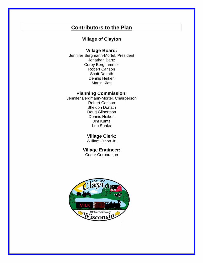
Contributors to the Plan
Village of Clayton
Village Board: Jennifer Bergmann-Mortel, President
Jonathan Bartz Corey Berghammer
Robert Carlson Scott Donath
Dennis Heiken Marlin Klatt
Planning Commission:
Jennifer Bergmann-Mortel, Chairperson Robert Carlson Sheldon Donath Doug Gilbertson Dennis Heiken
Jim Kuntz Leo Sonka
Village Clerk: William Olson Jr.
Village Engineer:
Cedar Corporation

Village of Clayton Vision Statement:
“To enhance small town atmosphere and continue to provide updated, quality
services to support growth and opportunities.”
Village of Clayton Comprehensive Plan 2009-2029
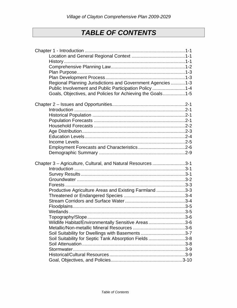
Table of Contents
TABLE OF CONTENTS Chapter 1 - Introduction .............................................................................1-1 Location and General Regional Context .........................................1-1 History .............................................................................................1-1 Comprehensive Planning Law.........................................................1-2 Plan Purpose...................................................................................1-3 Plan Development Process .............................................................1-3 Regional Planning Jurisdictions and Government Agencies ...........1-3 Public Involvement and Public Participation Policy .........................1-4 Goals, Objectives, and Policies for Achieving the Goals.................1-5 Chapter 2 – Issues and Opportunities........................................................2-1 Introduction .....................................................................................2-1 Historical Population .......................................................................2-1 Population Forecasts ......................................................................2-1 Household Forecasts ......................................................................2-2 Age Distribution...............................................................................2-3 Education Levels.............................................................................2-4 Income Levels .................................................................................2-5 Employment Forecasts and Characteristics ....................................2-6 Demographic Summary ..................................................................2-9 Chapter 3 – Agriculture, Cultural, and Natural Resources .........................3-1 Introduction .....................................................................................3-1 Survey Results ................................................................................3-1 Groundwater ...................................................................................3-2 Forests ............................................................................................3-3 Productive Agriculture Areas and Existing Farmland ......................3-3 Threatened or Endangered Species ...............................................3-4 Stream Corridors and Surface Water ..............................................3-4 Floodplains......................................................................................3-5 Wetlands .........................................................................................3-5 Topography/Slope...........................................................................3-6 Wildlife Habitat/Environmentally Sensitive Areas ............................3-6 Metallic/Non-metallic Mineral Resources ........................................3-6 Soil Suitability for Dwellings with Basements ..................................3-7 Soil Suitability for Septic Tank Absorption Fields ............................3-8 Soil Attenuation ...............................................................................3-8 Stormwater......................................................................................3-9 Historical/Cultural Resources ..........................................................3-9 Goal, Objectives, and Policies.......................................................3-10
Village of Clayton Comprehensive Plan 2009-2029
Table of Contents
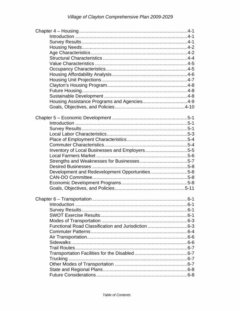
Chapter 4 – Housing ..................................................................................4-1 Introduction .....................................................................................4-1 Survey Results ................................................................................4-1 Housing Needs................................................................................4-2 Age Characteristics .........................................................................4-2 Structural Characteristics ................................................................4-4 Value Characteristics ......................................................................4-5 Occupancy Characteristics..............................................................4-5 Housing Affordability Analysis .........................................................4-6 Housing Unit Projections.................................................................4-7 Clayton’s Housing Program.............................................................4-8 Future Housing................................................................................4-8 Sustainable Development ...............................................................4-8 Housing Assistance Programs and Agencies..................................4-9 Goals, Objectives, and Policies.....................................................4-10 Chapter 5 – Economic Development .........................................................5-1 Introduction .....................................................................................5-1 Survey Results ................................................................................5-1 Local Labor Characteristics.............................................................5-3 Place of Employment Characteristics..............................................5-4 Commuter Characteristics...............................................................5-4 Inventory of Local Businesses and Employers................................5-5 Local Farmers Market .....................................................................5-6 Strengths and Weaknesses for Businesses ....................................5-7 Desired Businesses ........................................................................5-8 Development and Redevelopment Opportunities............................5-8 CAN-DO Committee........................................................................5-8 Economic Development Programs..................................................5-8 Goals, Objectives, and Policies.....................................................5-11 Chapter 6 – Transportation ........................................................................6-1 Introduction .....................................................................................6-1 Survey Results ................................................................................6-1 SWOT Exercise Results..................................................................6-1 Modes of Transportation .................................................................6-3 Functional Road Classification and Jurisdiction ..............................6-3 Commuter Patterns .........................................................................6-4 Air Transportation............................................................................6-6 Sidewalks ........................................................................................6-6 Trail Routes.....................................................................................6-7 Transportation Facilities for the Disabled ........................................6-7 Trucking ..........................................................................................6-7 Other Modes of Transportation .......................................................6-7 State and Regional Plans................................................................6-8 Future Considerations.....................................................................6-8

Village of Clayton Comprehensive Plan 2009-2029
Table of Contents
Future Improvements ......................................................................6-8 Road Maintenance Planning .........................................................6-10 Possible Funding Sources.............................................................6-10 Goals, Objectives, and Policies.....................................................6-10 Chapter 7 – Utilities and Community Facilities...........................................7-1 Introduction .....................................................................................7-1 Survey Results ................................................................................7-1 Community Facilities and Services .................................................7-2 Wastewater Treatment Plant / Sanitary System..............................7-7 Sanitary Sewer Service Area ..........................................................7-8 Water System..................................................................................7-8 Stormwater......................................................................................7-9 Telecommunications Facilities ......................................................7-10 Energy Sources.............................................................................7-11 Future Utility Projects ....................................................................7-11 Goals, Objectives, and Policies.....................................................7-12 Chapter 8 – Intergovernmental Cooperative ..............................................8-1 Introduction .....................................................................................8-1 Survey Results ................................................................................8-1 Considerations for Cooperation.......................................................8-1 Units of Government Influence on Clayton......................................8-2 School Districts ...............................................................................8-2 Indianhead Technical College .........................................................8-2 University of Wisconsin System ......................................................8-2 County and Regional Government Units.........................................8-3 State Agencies ................................................................................8-4 Existing Village Plans......................................................................8-4 Current Agreements........................................................................8-4 Future Cooperative Opportunities ...................................................8-5 Potential Future Cooperative Efforts ...............................................8-6 Benefits to Agreements...................................................................8-6 Possible Conflicts............................................................................8-6 Conflict Resolution ..........................................................................8-6 Goals, Objectives, and Policies.......................................................8-7 Chapter 9 – Land Use................................................................................9-1 Introduction .....................................................................................9-1 Survey Results ................................................................................9-1 Land Use vs. Zoning .......................................................................9-2 Existing Land Use Analysis .............................................................9-3 Existing Land Use Patterns and Influence on Patterns ...................9-4 Land Value ......................................................................................9-5 Limitations for Development............................................................9-5 Redevelopment Opportunities.........................................................9-5

Village of Clayton Comprehensive Plan 2009-2029
Table of Contents
Influences on Land Demand and Supply ........................................9-6 Potential Land Use Conflicts ...........................................................9-7 Future Land Needs Analysis ...........................................................9-7 Smart Growth Areas........................................................................9-8 Future Land Uses............................................................................9-8 Trends in Land Supply and Demand...............................................9-9 Alternatives to Annexation...............................................................9-9 Goals, Objectives, and Policies.......................................................9-9 Chapter 10 – Plan Implementation...........................................................10-1 Introduction ...................................................................................10-1 Survey Results ..............................................................................10-1 Available Implementation Tools ....................................................10-1 Financial Tools ..............................................................................10-4 Existing Implementation Tools ......................................................10-5 Local Action...................................................................................10-5 Potential Implementation Tools .....................................................10-7 Goals, Objectives, and Policies.....................................................10-7 Tables: Table 2-1 – Historical Population ...............................................................2-1 Table 2-2 – Population Forecasts ..............................................................2-2 Table 2-3 – Population Forecasts ..............................................................2-2 Table 2-4 – Housing Forecasts..................................................................2-2 Table 2-5 – Age for the Total Population ...................................................2-3 Table 2-6 – Education Attainment Population 25 and Older ......................2-4 Table 2-7 – High School Graduate of Higher Attainment ...........................2-5 Table 2-8 – Median Household Income .....................................................2-5 Table 4-1 – Year Structure Constructed ....................................................4-3 Table 4-2 – Building Permits Issued ..........................................................4-3 Table 4-3 – Types of House Heating Fuel .................................................4-4 Table 4-4 – Housing Units in a Structure ...................................................4-4 Table 4-5 – Owner-Occupied Housing Value.............................................4-5 Table 4-6 – Occupied Housing Units .........................................................4-6 Table 4-7 – Monthly Housing Costs – Percentage of Household Income..4-6 Table 4-8 – Gross Rent – Percentage of Household Income.....................4-7 Table 4-9 – Housing Forecasts..................................................................4-7 Table 5-1 – Place of Work 16 Years and Over ..........................................5-4 Table 5-2 – Place of Work 16 Years and Over ..........................................5-4 Table 5-3 – Commuting to Work 16 Years and Older ................................5-5 Table 5-4 – Travel Time to Work Workers Who Did Not Work at Home ....5-5 Table 5-5 – Employment Numbers by Occupation.....................................5-6 Table 5-6 – New Commercial Businesses Since 2000 ..............................5-6 Table 6-1 – Commuting to Work 16 Years and Older ................................6-5 Table 6-2 – Place of Work 1 Years and Over ............................................6-5
Village of Clayton Comprehensive Plan 2009-2029
Table of Contents
Table 7-1 – Fire and Rescue Statistics ......................................................7-3 Table 9-1 – Current Land Use ...................................................................9-3 Table 9-2 – 2008 Land Values...................................................................9-5 Table 9-3 – Housing Forecasts..................................................................9-7 Table 9-4 – Future Land Use .....................................................................9-8 Table 9-5 – Projected Land Use Needs in Acres .......................................9-9 Figures: Figure 2-1 – Age of the Total Population ...................................................2-4 Figure 2-2 – Household Income.................................................................2-5 Figure 2-3 – Occupation of Workforce Population .....................................2-6 Figure 2-4 – Occupation by Industry ..........................................................2-7 Figure 2-5 – Prominent Occupations in Prominent Industries....................2-8 Figure 2-6 – Average Annual Wage by Industry ........................................2-8 Figure 6-1 – Travel Time to Work ..............................................................6-5 Figure 9-1 – Contaminated Sites of Completed Cleanups or Ongoing ......9-6 Maps: Map 1-1 – Location Map 3-1 – Groundwater Elevation Map 3-2 – Forests Map 3-3 – Productive Agricultural Soils Map 3-4 – Existing Farmland Map 3-5 – Stream Corridors and Surface Water Map 3-6 – Wetlands Map 3-7 – Topography Map 3-8 – Steep Slopes Map 3-9 – Environmentally Sensitive Areas Map 3-10 – Soils for Dwellings with Basements Map 3-11 – Soils for Septic Tank Absorption Map 3-12 – Soils Attenuation Map 3-13 – Cultural Resources Map 5-1 – Redevelopment Opportunities Map 6-1 – Functional Road Classification Map 6-2 – Sidewalks and Trails Map 6-3 – Future Transportation Map 7-1 – Community Facilities Map 7-2 – Utilities Map 9-1 – Current Land Use Map 9-2 – Smart Growth Areas Map 9-3 – Future Land Use

Village of Clayton Comprehensive Plan 2009-2029
Introduction 1-1
CHAPTER 1 Introduction
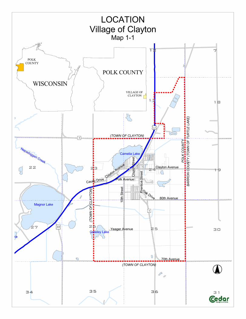
Location and General Regional Context The Village of Clayton is located in the southeast corner of Polk County, Wisconsin and is surrounded by the Towns of Clayton and Turtle Lake (see Map 1-1). Clayton and the surrounding area have an abundance of wildlife, clean air and a variety of natural resources. Clayton is a small but progressive community located in the Lower Chippewa River Watershed. The Village is located on U.S. Highway 63, a major north-south highway corridor connecting Red Wing, Minnesota to Spooner, Wisconsin. This provides the local residents with access to many communities and other major highways. U.S. Highway 8, a major east-west corridor for Northern Wisconsin, lies just 5 miles to the north. State Highway 64, another major east-west route for Western Wisconsin, lies 15 miles to the south. All of these routes provide thoroughfares to employment and goods and services for Village residents. The Village was established in 1909 and will be celebrating its centennial in 2009. Originally, the area primarily prospered from logging, farming, as well as the transporting goods through the railroad, which is no longer there. Much of the Village’s heritage is tied heavily to the logging industry. Every June on Father’s Day Weekend, Clayton has its annual Clayton Cheese Days festival. The Village residents enjoy the “small town” feel they have been able to maintain while still providing jobs and recreational opportunities to many area residents. Clayton has several active organizations such as Lion's Club, church organizations, area fire and first responder volunteers, Clayton Area New Development Organization (CAN-DO), and local scout groups. History Loggers were the first to settle in Clayton. In 1874 the railroad arrived, making its way northward through many logging camps including Clear Lake, Summit, Pineville and Richardson. The end of the line was at the large sawmill located at what is now called Lake Camelia on the west edge of the Village of Clayton. The first school in Clayton was established in 1876. By 1914 the school included a four-year high school and was headed by F.M. Robey who was the principal of our school for fifty years. He retired in 1964. The Clayton School in 2000 dedicated its second major edition in the past ten years. Clayton residents are

Village of Clayton Comprehensive Plan 2009-2029
Introduction 1-2
very proud of the excellent school system and have always been supportive by providing their children with exceptional facilities and programs. In 1909, Clayton became a Village. Following the lumbering era Scandinavian, German and Russian families settled the area and eventually went into dairy farming. The area became known for many small creameries and cheese factories, which served the area. The Clayton Cooperative Creamery, located in the village was purchased by Stella Cheese Company during the 1930s and became a producer of Fancy Italian Cheese which was shipped throughout the whole nation. During the 1960s the factory produced Blue Cheese and became the largest producer of Blue Cheese, not only in the nation, but also the world. The Clayton Lions Club promoted the village by proclaiming it "The Blue Cheese Capital of the World." The Wisconsin Dairies Cooperative purchased the cheese factory during the 1980s. Today it is known as Foremost Farms and is a producer of pizza cheese for our country's most popular "fast food." Source: Village of Clayton Website Comprehensive Planning Law Wisconsin’s Comprehensive Planning Law or “Smart Growth Law” was passed in October 1999 as part of the State’s biennial budget. This law requires that by January 1, 2010 every town, village, and city engaging in land use activities such as official mapping, local or county subdivision ordinances, zoning, or zoning in shorelands and wetlands in shorelands, must be guided by a comprehensive plan. Smart Growth was enacted to encourage long-range planning for communities and provide consistency in land use decision making. Smart Growth planning also calls for public participation throughout the entire planning process. Before 1999, public participation and a public hearing were not required for adoption of a local plan. State statutes require the plans to consist of nine elements, each focusing on an important sector of your community. These elements are:
Issues and Opportunities Agricultural, Natural, and Cultural Resources Housing Economic Development Transportation Utilities and Community Facilities Land Use Intergovernmental Cooperation Implementation
Village of Clayton Comprehensive Plan 2009-2029
Introduction 1-3
The goal of Smart Growth is to ensure that communities look at how all of these elements intertwine and affect each other, creating an awareness and overall cohesive vision for the Village of Clayton. All of the above elements are covered in this Plan. Plan Purpose The purpose of the Village of Clayton’s Comprehensive Plan is to ensure that the qualities of the community that residents enjoy remain and areas that can be improved upon are addressed. The plan will act as a guide to the Village government, as well as local organizations, community residents, and developers. The Plan will look at, not only Clayton, but how the Village fits into the regional context. The Comprehensive Plan can provide a variety of benefits to a community by coordinating community activities, departments, or policies; protecting resources like historic buildings/locations or forest/agricultural/wetlands/etc.; promoting economic development by revitalizing downtowns, developing housing/facilities, and retaining existing businesses; and save the community money through intergovernmental cooperation. Plan Development Process Planning is a comprehensive and continuous process. The Village’s Plan Commission was established for the purpose of developing the Comprehensive Plan. Upon completion of the Plan, the Plan Commission will be the group responsible for updating the Comprehensive Plan. The Village has incorporated all of the nine required elements into their plan. Each chapter was addressed individually before moving on to the next chapter. When all were complete, the Comprehensive Plan was reviewed as a whole, checking for any inconsistencies. Planning is a continuous process and the needs of the Village will continuously change with social, physical, and economic factors. Completing the Comprehensive Plan is just the beginning of planning for the community. Local officials must examine, explain, and revise the plan when necessary. It must be kept current and used often. Regional Planning Jurisdictions and Government Agencies While the Village of Clayton plans for its own future, it also is within multiple planning and government agency districts that do their own planning. Available plans will be reviewed to address any inconsistencies between them. Some of the planning and government agencies that will be contacted include:

Village of Clayton Comprehensive Plan 2009-2029
Introduction 1-4
West Central Wisconsin Regional Planning Commission Wisconsin Department of Natural Resources Wisconsin Department of Transportation Polk County Polk County Economic Development Corporation
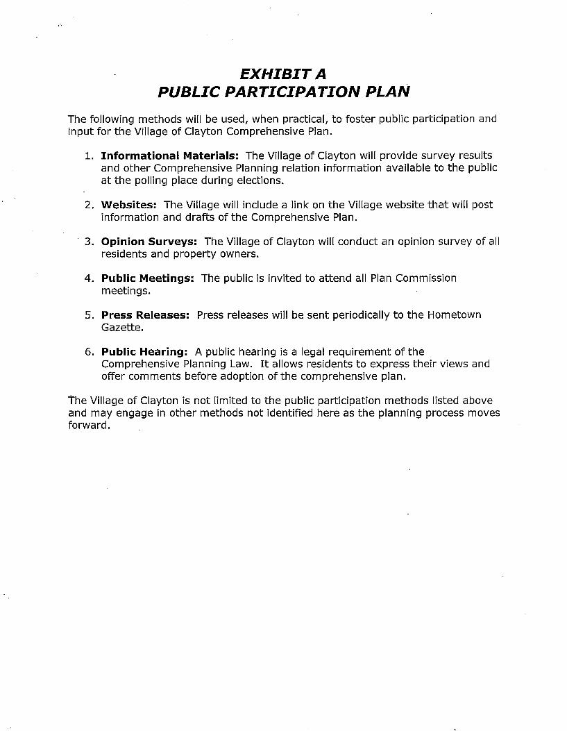
Public Involvement and Public Participation Policy Wisconsin State Statutes Section 66.1001 requires that a public participation plan/policy/procedure be developed for the adoption of a Comprehensive Plan. The plan/policy must address public meeting notices, publications, and open discussions must be written for every stage of the preparation of the Comprehensive Plan. It is required that the local governing body that adopts any comprehensive plan or amendments to a plan must do so with the use of a resolution, passed by a majority vote. Once a comprehensive plan is adopted one copy must be provided to the following: every governing body within the boundaries of the local government unit; the clerk of all adjacent governing bodies; the Wisconsin Land Council; the Wisconsin Department of Administration; the regional planning commission, and the local public library. Wisconsin State Statutes also require that all comprehensive plans must meet the minimum requirements; the resolution shall not be adopted by the regional planning commission if those requirements are not met. The Village of Clayton acknowledges, in order for the Comprehensive Plan to be utilized effectively, it must be created and embraced by local residents. The Village has crafted a Public Participation Plan that helps identify key stakeholders for each element and various methods to generate public involvement. The outline of the Public Participation Plan, along with the Public Participation Resolution passed by the Village Board can be seen in Appendix A. In the fall of 2007, the Village Board established the Village Planning Commission to guide the development of the Comprehensive Plan. The Village also hired Cedar Corporation out of Menomonie, to help facilitate this process and assist with the preparation of the Plan. Initial public involvement was generated through a community wide survey. The Planning Commission thought it was important to send out a community wide survey to gauge how residents would like to see their community in 20 years. The ideas and thoughts generated from this survey were used to develop the Village’s vision statement and goals, objectives and policies for the plan. The Planning Commission also held an open meeting on a monthly basis where citizens could attend and participate in the planning process. A periodic press
Village of Clayton Comprehensive Plan 2009-2029
Introduction 1-5
release was also sent out describing the work that was being completed, issues being discussed, and encouraging those interested in the planning process to attend. Informational materials were also made available in an Open House format at the November 2008 national elections. A public hearing was also held before the Village Board where residents were given time to comment on the draft of the Plan. Goals, Objectives, and Policies for Achieving the Goals Each chapter in the Village of Clayton Comprehensive Plan contains goals, objectives, programs, and policies. These identify the long range vision of the Village in relation to each element. All goals, objectives, programs, and policies may not be attainable for various reasons, therefore, it is important for these to be continuously reviewed and revised. Goals: A general desire or wish of what the Village of Clayton hopes to accomplish related to that chapter. Objectives: What the Village hopes to achieve by addressing the goals. Policies: A policy can include a program, policy, recommendation or action that may consist of a new ordinance, ordinance revision, further planning, community support of an idea, etc. These are considered reasonable methods to use to achieve the goals.
����������� ����������
�������
����������
��� �����
�� ����� ��
� ������ ���� �
����
���
��������
�
��
������
�����
����
��
�������
�
�� ����
������
� �!��" �#
������
��" �#
$� �
�% �&
�� �
��������" �#
� �!�
&�� �
���
����
��
������
��
�� �� ��
��
�
�
��
��
�
�� ����
������
����'�"
�!#�%!�&��
�
��#���'�" $����" �#
( �!��" �#
) �� ���" �#
��������������
���
����
����
���
��������������
���������
�� ��� �����������
����������������

Village of Clayton Comprehensive Plan 2009-2029
Issues and Opportunities 2-1
CHAPTER 2 Issues and Opportunities
Introduction The Issues and Opportunities element analyzes demographic information for the Village of Clayton. The purpose is to identify and understand trends in the Village and surrounding area in order to anticipate future needs and create a plan that addresses them. Most of the demographic information is taken from the U.S. Census Bureau which conducts a census every ten years. The most recent census was completed in 2000. Current information is limited but efforts have been made to incorporate updated data when available. Historical Population The Village of Clayton has seen small increases and decreases in population since 1950 (see Table 2-1). The exception is a 38.9% increase in population between 1970 and 1980. Areas of Polk County have seen large population growth since 1990. In comparison, the Village of Clayton has also had a significant increase in population since 1970. Table 2-1 - Historical Population - Village of Clayton Year 1950 1960 1970 1980 1990 2000 Population 350 324 306 425 450 507 % Change - -7.4% -5.6% 38.9% 5.9% 12.7% Source: West Central Wisconsin Regional Planning Commission
Population Forecasts Population growth influences future land use, housing, transportation, and other characteristics in the Village of Clayton. Growth in surrounding communities will also influence these characteristics. The Wisconsin Department of Administration (WDOA) has created population forecasts for each municipality in the State of Wisconsin. For the Village of Clayton, the population is projected to rise slightly and then gradually decrease. The population is projected to be 608 residents in 2025. This is approximately 100 more residents than the 2000 population of 507 (see Table 2-2).
Village of Clayton Comprehensive Plan 2009-2029
Issues and Opportunities 2-2
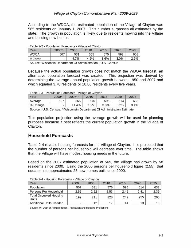
According to the WDOA, the estimated population of the Village of Clayton was 565 residents on January 1, 2007. This number surpasses all estimates by the state. The growth in population is likely due to residents moving into the Village and building new homes. Table 2-2 - Population Forecasts - Village of Clayton Year 2000* 2005 2010 2015 2020 2025 WDOA 507 531 555 575 592 608 % Change - 4.7% 4.5% 3.6% 3.0% 2.7% Source: Wisconsin Department Of Administration, *U.S. Census
Because the actual population growth does not match the WDOA forecast, an alternative population forecast was created. This projection was derived by determining the average annual population growth between 1950 and 2007 and which equaled 3.78 residents or 18.86 residents every five years. Table 2-3 - Population Forecasts - Village of Clayton Year 2000* 2007** 2010 2015 2020 2025 Average 507 565 576 595 614 633 % Change - 11.4% 1.9% 3.3% 3.2% 3.1% Source: *U.S. Census, **Wisconsin Department Of Administration Estimate
This population projection using the average growth will be used for planning purposes because it best reflects the current population growth in the Village of Clayton. Household Forecasts Table 2-4 reveals housing forecasts for the Village of Clayton. It is projected that the number of persons per household will decrease over time. The table shows that the Village will have modest housing needs in the future. Based on the 2007 estimated population of 565, the Village has grown by 58 residents since 2000. Using the 2000 persons per household figure (2.55), that equates into approximated 23 new homes built since 2000. Table 2-4 - Housing Forecasts - Village of Clayton Year 2000 2005 2010 2015 2020 2025 Population 507 531 576 595 614 633Persons Per Household 2.55 2.52 2.53 2.46 2.41 2.39Total Occupied Housing Units 199 211 228 242 255 265
Additional Units Needed - 12 17 14 13 10Source: WI Dept of Administration: Population and Housing Projections

Village of Clayton Comprehensive Plan 2009-2029
Issues and Opportunities 2-3
The average population projection was used with the estimated persons per household to approximate the number of new dwellings by 2025. Using this method, there will be approximately 54 additional dwellings in the Village of Clayton between 2005 and 2025. Age Distribution Age distribution in the Village of Clayton can influence the types of housing, recreational needs, and other aspects of the community. Table 2-5 and Figure 2-1 show a moderate decrease in the number of residents 60 years and older as well as an increase of the number of residents below 55. This signifies the average age is becoming lower. Most of the age groups age 60 and above have dropped from 1990 to 2000. This might be an indication that there are not adequate care providers for the elderly in the Village. Table 2-5 - Age for the Total Population - Village of Clayton
Age 1990 2000 Numerical Change % Change
Under 5 44 43 -1 -2.3%5 to 9 38 42 4 10.5%10 to 14 42 50 8 19.0%15 to 19 37 38 1 2.7%20 to 24 21 38 17 81.0%25 to 29 47 46 -1 -2.1%30 to 34 36 37 1 2.8%35 to 39 37 44 7 18.9%40 to 44 19 40 21 110.5%45 to 49 12 27 15 125.0%50 to 54 13 20 7 53.8%55 to 59 15 15 0 0.0%60 to 64 24 18 -6 -25.0%65 to 69 19 14 -5 -26.3%70 to 74 22 12 -10 -45.5%75 to 79 12 11 -1 -8.3%80 to 84 7 7 0 0.0%85 + 5 5 0 0.0%Total 450 507 57 12.7%Source: 1990 and 2000 U.S. Census

Village of Clayton Comprehensive Plan 2009-2029
Issues and Opportunities 2-4
Figure 2-1 – Age of the Total Population
Age for the Total Population
0
10
20
30
40
50
60Un
der 5
5 to
910
to 1
415
to 1
920
to 2
425
to 2
930
to 3
435
to 3
940
to 4
445
to 4
950
to 5
455
to 5
960
to 6
465
to 6
970
to 7
475
to 7
980
to 8
4
85 +
Age
Pers
ons
19902000
Source: 1990 and 2000 U.S. Census Education Levels Educational attainment can influence a person’s job opportunities, housing preferences, and spending patterns. Table 2-6 and 2-7 reveal that the number of residents who have attained a high school degree or higher has increased from 190 resident in 1990, to 276 in 2000. However, there are fewer residents obtaining a bachelor’s degree or higher in 2000. Table 2-6 - Education Attainment Population 25 and Older - Village of Clayton 1990 % Of
Total 2000 % Of Total
Numerical Change % Change
Population 25 Years and Over 261 100.0% 295 100.0% 34 13.0%
Less than 9th Grade 37 14.2% 19 6.4% -18 -48.6%9th to 12th Grade (No Diploma) 34 13.0% 57 19.3% 23 67.6%
High School Graduation (Includes Equivalency) 118 45.2% 114 38.6% -4 -3.4%
Some College, No Degree 37 14.2% 65 22.0% 28 75.7%
Associate Degree 15 5.7% 24 8.1% 9 60.0%Bachelor’s Degree 15 5.7% 10 3.4% -5 -33.3%Graduate or Professional Degree 5 1.9% 6 2.0% 1 20.0%
Source: 1990 and 2000 U.S. Census

Village of Clayton Comprehensive Plan 2009-2029
Issues and Opportunities 2-5
In 2000, the educational attainment for having a bachelor’s degree or higher in the Village of Clayton is 5.4% compared to 15.6% for Polk County and 22.4% in the State. Table 2-7 - High School Graduate or Higher Attainment - Village of Clayton
1990 % Of Total 2000 % Of
Total Numerical Change % Change
High School Graduate or Higher 190 72.8% 219 74.2% 29 15.3%
Bachelor’s Degree of Higher 20 7.7% 16 5.4% -4 -20.0%
Source: 1990 and 2000 U.S. Census Income Levels Median household incomes in the Village of Clayton have increased by 65% between 1989 and 1999 (see Table 2-8). In 1999, the median household income was $29,135. This compares to $54,930 in Polk County and $43,791 in the State of Wisconsin. Table 2-8 - Median Household Income - Village of Clayton
Year 1989 1999 % Change
Median Household Income $17,656 $29,135 65.0%Source: 1990 and 2000 U.S. Census
Figure 2-2 shows that median household incomes in 1999 of $25,000 and above, have all increased compared to 1989 incomes. Figure 2-2 Household Income
Median Household Income
0
10
20
30
40
50
60
Less
that
$10,0
00
$10,0
00 to
$14,99
9
$15,0
00 to
$24,99
9
$25,0
00 to
$34,99
9
$35,0
00 to
$49,99
9
$50,0
00 to
$74,99
9
$75,0
00 to
$99,99
9
$100
,000 t
o $149
,999
$150
,000 o
r more
Income
Pers
ons
1989
1999
Source: 1990 and 2000 U.S. Census
Village of Clayton Comprehensive Plan 2009-2029
Issues and Opportunities 2-6
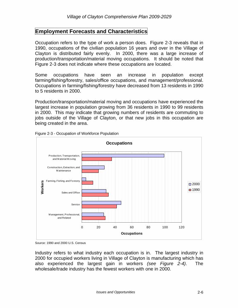
Employment Forecasts and Characteristics Occupation refers to the type of work a person does. Figure 2-3 reveals that in 1990, occupations of the civilian population 16 years and over in the Village of Clayton is distributed fairly evenly. In 2000, there was a large increase of production/transportation/material moving occupations. It should be noted that Figure 2-3 does not indicate where these occupations are located. Some occupations have seen an increase in population except farming/fishing/forestry, sales/office occupations, and management/professional. Occupations in farming/fishing/forestry have decreased from 13 residents in 1990 to 5 residents in 2000. Production/transportation/material moving and occupations have experienced the largest increase in population growing from 36 residents in 1990 to 99 residents in 2000. This may indicate that growing numbers of residents are commuting to jobs outside of the Village of Clayton, or that new jobs in this occupation are being created in the area. Figure 2-3 - Occupation of Workforce Population
Occupations
0 20 40 60 80 100 120
M anagement, Professional,and Related
Service
Sales and Office
Farming, Fishing, and Forestry
Construction, Extraction, andM aintenance
Production, Transportation,and M aterial M oving
Wor
kers
Occupations
20001990
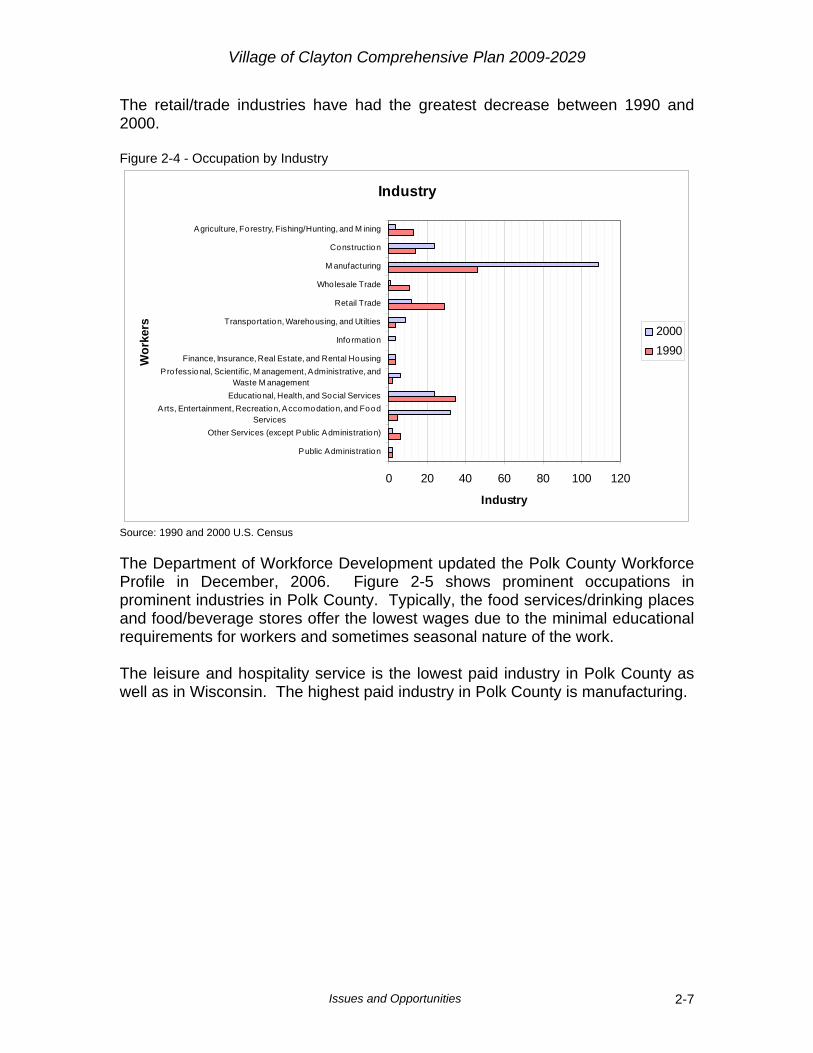
Source: 1990 and 2000 U.S. Census Industry refers to what industry each occupation is in. The largest industry in 2000 for occupied workers living in Village of Clayton is manufacturing which has also experienced the largest gain in workers (see Figure 2-4). The wholesale/trade industry has the fewest workers with one in 2000.
Village of Clayton Comprehensive Plan 2009-2029
Issues and Opportunities 2-7
The retail/trade industries have had the greatest decrease between 1990 and 2000. Figure 2-4 - Occupation by Industry
Industry
0 20 40 60 80 100 120
Public Administration
Other Services (except Public Administration)
Arts, Entertainment, Recreation, Accomodation, and FoodServices
Educational, Health, and Social Services
Pro fessional, Scientific, M anagement, Administrative, andWaste M anagement
Finance, Insurance, Real Estate, and Rental Housing
Info rmation
Transportation, Warehousing, and Utilties
Retail Trade
Wholesale Trade
M anufacturing
Construction
Agriculture, Forestry, Fishing/Hunting, and M ining
Wor
kers
Industry
20001990
Source: 1990 and 2000 U.S. Census The Department of Workforce Development updated the Polk County Workforce Profile in December, 2006. Figure 2-5 shows prominent occupations in prominent industries in Polk County. Typically, the food services/drinking places and food/beverage stores offer the lowest wages due to the minimal educational requirements for workers and sometimes seasonal nature of the work. The leisure and hospitality service is the lowest paid industry in Polk County as well as in Wisconsin. The highest paid industry in Polk County is manufacturing.

Village of Clayton Comprehensive Plan 2009-2029
Issues and Opportunities 2-8
Figure 2-5 - Prominent Occupations in Prominent Industries in Polk County
Figure 2-6 – Average Annual Wage by Industry in Polk County

Village of Clayton Comprehensive Plan 2009-2029
Issues and Opportunities 2-9
Demographic Summary Between 1990 and 2000 the Village of Clayton has seen small numbers of population and household growth. Since then, population growth has continued at a slightly higher rate and is outpacing projections by the Wisconsin Department of Administration. Most population growth is due to in-migration of residents and not an increased birth rate. Median household income is significantly lower in the Village compared to Polk County and the State of Wisconsin and this may be attributed to the Village being a rural area with a lack of job opportunities in the area. Occupation and industries vary for residents 16 years and older but the predominant industry in the Village of Clayton is manufacturing.

Village of Clayton Comprehensive Plan 2009-2029
Agricultural, Cultural, and Natural Resources 3-1
CHAPTER 3 Agriculture, Natural and Cultural Resources
Introduction A review and inventory of the agricultural, cultural, and natural resources in the Village of Clayton will provide a general overview of the Village’s agricultural, cultural, and natural features. Informed decisions can be made when addressing the future physical growth, development, and preservation of the Village’s lands through the identification and analysis of features such as agriculturally productive areas, wetlands, endangered species, soil characteristics, and valued cultural resources. By identifying and analyzing these features, development can be guided to the most appropriate locations, thus protecting the Village of Clayton’s natural areas while identifying potential locations for responsible growth. Survey Results Below are the survey results related to natural and cultural resources: The Village of Clayton should retain its “small town” character? (please check one) Count Percent I strongly agree 8 17.0%I agree 29 61.7%Not sure 5 10.6%I disagree 4 8.5%I strongly disagree 1 2.1%
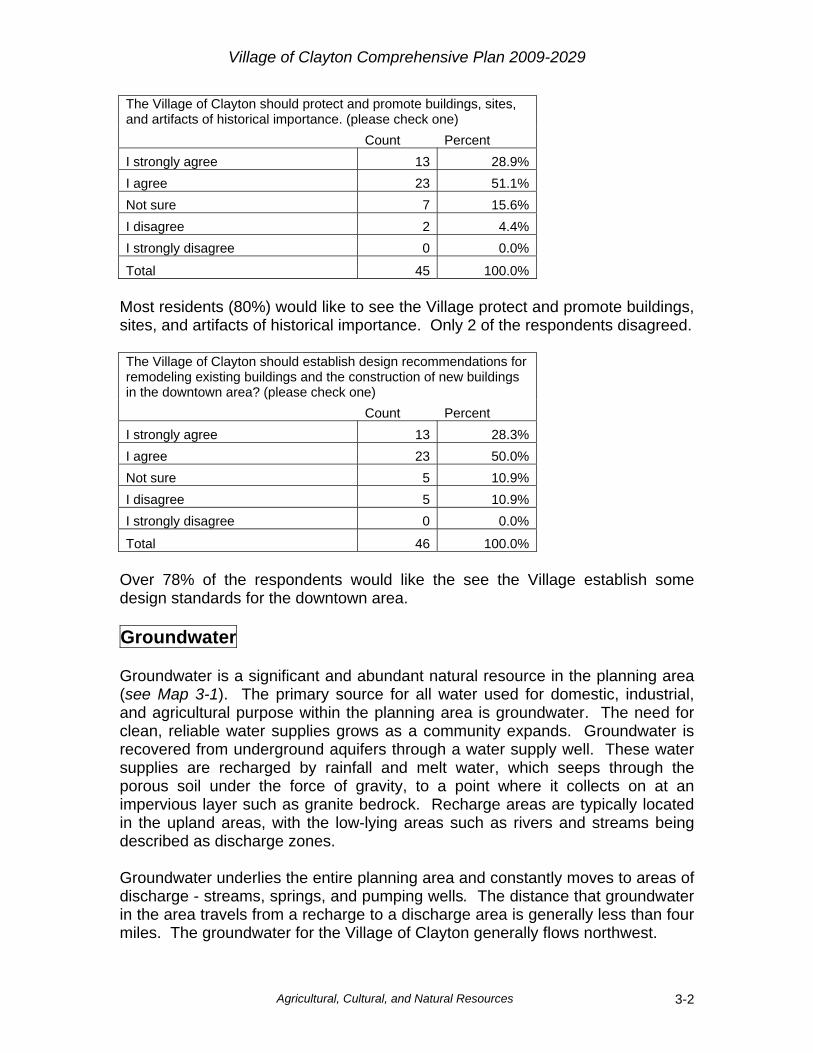
Total 47 100.0% Nearly 80% of the responses would like to see the Village of Clayton maintain its “small town” character. The majority of the residents that answered the survey want to maintain that aspect of the Village.
Village of Clayton Comprehensive Plan 2009-2029
Agricultural, Cultural, and Natural Resources 3-2
The Village of Clayton should protect and promote buildings, sites, and artifacts of historical importance. (please check one) Count Percent I strongly agree 13 28.9%I agree 23 51.1%Not sure 7 15.6%I disagree 2 4.4%I strongly disagree 0 0.0%
Total 45 100.0% Most residents (80%) would like to see the Village protect and promote buildings, sites, and artifacts of historical importance. Only 2 of the respondents disagreed. The Village of Clayton should establish design recommendations for remodeling existing buildings and the construction of new buildings in the downtown area? (please check one) Count Percent I strongly agree 13 28.3%I agree 23 50.0%Not sure 5 10.9%I disagree 5 10.9%I strongly disagree 0 0.0%
Total 46 100.0% Over 78% of the respondents would like the see the Village establish some design standards for the downtown area. Groundwater Groundwater is a significant and abundant natural resource in the planning area (see Map 3-1). The primary source for all water used for domestic, industrial, and agricultural purpose within the planning area is groundwater. The need for clean, reliable water supplies grows as a community expands. Groundwater is recovered from underground aquifers through a water supply well. These water supplies are recharged by rainfall and melt water, which seeps through the porous soil under the force of gravity, to a point where it collects on at an impervious layer such as granite bedrock. Recharge areas are typically located in the upland areas, with the low-lying areas such as rivers and streams being described as discharge zones. Groundwater underlies the entire planning area and constantly moves to areas of discharge - streams, springs, and pumping wells. The distance that groundwater in the area travels from a recharge to a discharge area is generally less than four miles. The groundwater for the Village of Clayton generally flows northwest.
Village of Clayton Comprehensive Plan 2009-2029
Agricultural, Cultural, and Natural Resources 3-3
Groundwater is also an important factor for the drinking water (wells). The Village has two wells and both of them come out of the same aquifer. There have been some studies on the area around the wells and Village is responsible for sampling a certain number of parameters each year. One of the studies is a consumer confidence report which reports the results of the sampling that takes place. Another study is the vulnerability study which inventories the land uses within 300 feet of the well. Forests The Wisconsin Initiative for Statewide Cooperation on Landscape Analysis and Data (WISCLAND) completed a statewide land classification system in 1999. WISCLAND defines a forest as “an upland area of land covered with woody perennial plants, the tree reaching a mature height of at least 6 feet tall with a definite crown.” Large areas of forested lands can be found on the east side of the Village near existing development (see Map 3-2). Forests create a setting for hunting, camping, hiking, and many other forms of recreation. Forests also provide valuable wildlife habitat and are the homes for less visible threatened and endangered plant and wildlife. Forests and trees can help protect other resources too. They can reduce heating and cooling costs of homes and business. Forests and trees offer erosion control for river banks and steep slopes. In urban areas, forests and trees are used for traffic calming, the creation of parks, and add overall aesthetics that enhance the quality of life for residents. A contiguous forest is extremely important. The fragmentation of land can result in the disruption of habitat and can lead to problems between wildlife and humans. The greatest concentration of the contiguous forestland in the Village is to the east between Clayton and 80th Avenues and south of Greeley Lake. There are approximately 360 acres of forestland within the Village Limits. The Village would like to plant more trees in the boulevard as well as utilize trees as a vegetative buffer between incompatible land uses Productive Agriculture Areas and Existing Farmland The Wisconsin Farmland Preservation Act was enacted in 1977 to slow the conversion of land from agricultural to urban usage. This legislation provides for the preparation of county farmland preservation plans, and state income tax credits for the maintenance of farmland in delineated preservation areas. Ultimately, only those farmers owning lands within delineated prime agricultural areas which are zoned for exclusive agricultural use will be eligible for the full state income tax credits provided under the law.
Village of Clayton Comprehensive Plan 2009-2029
Agricultural, Cultural, and Natural Resources 3-4
The Polk County Farmland Preservation Plan considers soils with the classification suitability of I, II, and III to be potentially productive agricultural areas. These are soils that can have few to severe limitations and may require some conservation practices in order to be able to farm (see Map 3-3 & Map 3-4). The Village of Clayton has 1,237 acres of potentially productive agricultural areas and is evenly spread throughout the Village although some of it has already been developed. There are approximately 962 acres of existing agricultural fields within the Village Limits. Nearly 570 acres of those existing agricultural fields are on potentially productive soils. Threatened or Endangered Species According to the U.S. Fish and Wildlife Service, an “endangered” species is one that is in danger of extinction throughout all or significant portion of its range. A “threatened” species is one that is likely to become endangered in the foreseeable future. These species are protected because of their scientific, educational, aesthetic, and ecological importance. The Wisconsin Natural Heritage Inventory Program maintains data on the location and status of natural features, rare species, and natural communities in Wisconsin. These sites are broad in nature and provide a general location for rare, threatened, or endangered species as well as high-quality natural communities. The Wisconsin Department of Natural Resources (DNR) provides maps that depict the sections where endangered or threatened resources have been found and breaks them down by the type of species found, such as aquatic, terrestrial, or both. The DNR does not further identify the locations in order to protect those species. If development were to take place in a section that where endangered or threatened species are listed, the DNR would get involved to ensure the new development would not infringe upon those species. According to the map, there are no identified threatened or endangered resources within the Village Limits. Stream Corridors and Surface Water The Village of Clayton is fortunate to have a number of nearby surface water resources such as lakes and streams. Surface waters provide an excellent source of recreation, as well as habitat for wildlife. Unfortunately, development has the potential to have a negative impact on the quality of water in the surface waters. Areas upstream of lakes and rives impact the waters downstream. That is why it is important that communities and lake groups protect these resources. The Village of Clayton has two lakes within the political boundary of the Village (see Map 3-5). Lake Camelia is in the northwest part of the Village and is
Village of Clayton Comprehensive Plan 2009-2029
Agricultural, Cultural, and Natural Resources 3-5
approximately 63 acres of surface water. Greeley Lake is in the southwest corner of the Village and is just over 20 acres. Lake Camelia isn’t regulated under County Zoning because it falls entirely within the Village Limits and therefore it is important that the Village establish and enforce appropriate regulations to protect the lake. Currently, there are a number of septic systems on the Lake. If sanitary becomes available in to those homes, the Village should consider requiring them to be hooked up. There are also no motorized boats allowed on Lake Camelia. The Village of Clayton also has a few unnamed streams. Stream corridors often have significant vegetative growth and act as habitat for a variety of terrestrial and aquatic species. Many species rely on the cover provided in stream corridors ranging from trees and plants, to water and rocks for their survival. Stream corridors often do not lend themselves to be easily fragmented, however, damaging the water quality and clear cutting the banks can do irreparable damage to the integrity of the habitat. Floodplains Floodplains are areas, which have been, or may become inundated with water during a regional flood. A regional flood is often referred to as a 100-year flood or having a 1% chance of occurring in any given year. Because of danger posed in a flood event, most structural development within a floodway is not allowed. Development within the flood fringe is generally accepted, provided adequate flood proofing measures are taken. The Village of Clayton does not have any mapped floodplains. Wetlands Wetlands act as natural filters, removing sediments and contaminants from water. Wetlands also regulate water levels by containing water during periods of excessive rain or snow melt. These unique environments are host to wide variety of plant and animal communities, including some threatened and endangered species. Wetlands also serve as rest areas for migratory waterfowl during the fall and spring months. Wetlands also serve as major source of groundwater recharge and flood control. In the past decade, however, strict regulation of wetland conversion has slowed the loss of habitat and made conversion to other uses too expensive and impractical. Wetlands are found along most of the surface waters in the Village of Clayton. Most of the larger contiguous wetlands are found in the northern half of the Village (see Map 3-6). Although the wetlands larger than 2 acres have been mapped, that does not mean other wetlands do not exist in the Village. When development or other land disturbing activities take place, it is important that

Village of Clayton Comprehensive Plan 2009-2029
Agricultural, Cultural, and Natural Resources 3-6
each site is assessed to determine if wetlands exist. Even with strict regulations in place, it is important take precautions when developing near wetlands. Topography/Slope Undulating topography offers a picturesque setting for rural areas. Residential areas are often developed on or in view of high points along the terrain. Despite the appeal of topography, areas of severe slopes should be avoided in development. The topography and elevation of Clayton is varied and reaches its highest point in the southeastern part of the Village (see Map 3-7 & 3-8). The Village has an approximate relief of 85 feet from 1,190 feet to 1,270 feet of elevation. The low point occurs along U.S. Highway 63 in the northern part of the Village. Development in areas with severe slopes (described as 20% slope or greater) should be limited. Typically buildings should not be constructed on any slope that is 20% or greater. Roads and driveways are often more restrictive and should be limited to slopes of 12% or less. Wildlife Habitat / Environmentally Sensitive Areas Environmentally sensitive areas and wildlife habitat are extremely important for the protection of aquatic and terrestrial wildlife and plants. The preservation and possible expansion of these areas is vital to maintain a diverse ecosystem. Areas that may be considered environmentally sensitive area or wildlife habitat are forests, lakes, streams, rivers, wetlands, steep slopes, and shoreland buffers. Environmentally sensitive areas, also referred to as corridors, consist of wetlands, floodplains, forestland, slopes of 20% or greater, and buffers around the surface waters (300 feet around streams, and 1,000 feet around lakes and ponds). Each of these features have been described earlier in this chapter however it is important to view them all together in order to identify contiguous environmental corridors. The integrity of these environmental corridors should be protected whenever possible. The Village of Clayton has a variety of environmentally sensitive resources (see Map 3-9). These areas should be factored in when the Village makes future development decisions. Metallic/Non-metallic Mineral Resources Communities now have the right to adopt an ordinance establishing requirements for reclamation of non-metallic mines (NR 135). If a community chooses not to adopt an ordinance, the county or regional planning commission may do so instead for the covered region. The primary reason for these requirements is to

Village of Clayton Comprehensive Plan 2009-2029
Agricultural, Cultural, and Natural Resources 3-7
prevent owners and operators of non-metallic mines from abandoning their operations without proper reclamation of the site. The Village of Clayton does not have any metallic/non-metallic mineral resources being mined at this time. Soil Suitability for Dwellings with Basements Soil properties and characteristics are a major influence in the land use activities that can occur on a given soil type. Soils are grouped into classifications based on their respective properties. It is important to assess the various types of properties that occur within the soils of the Village of Clayton to identify the optimum locations for development and preservation (see Map 3-10). The Natural Resource Conservation Service (NRCS) has developed a limitations rating system for the various soil characteristics discussed in this chapter. Below are the descriptions of those limitations based on the Polk County Land Use Plan:
No to Slight Limitations: Soil properties and site features generally are favorable for the indicated use and the limitations are easy to overcome. Somewhat to Moderate Limitations: Soil properties are not favorable for the indicated use and special planning, design, or maintenance is needed to overcome or minimize the limitations. Severe Limitations: Soil properties or site features are so unfavorable or so difficult to overcome that special design, significant increases in construction costs, and possibly increased maintenance is required. In the case of severe limitations, questions regarding the economic and environmental feasibility of such development should be seriously considered.
An important element of soils is their suitability for dwellings with basements. The soil properties that affect a soil’s suitability are slope, depth to bedrock, moisture, and the content of rocks. These characteristics, when factored together, illustrate which areas will have limitations as well as the degree of limitations. A soil limitation on a person’s property does not necessarily mean a basement cannot be built, but rather there may be an increased cost of construction. The Village of Clayton has an area of 2,157 acres. The soil survey shows that 323.54 acres of soil are not limited and 416.49 acres are somewhat limited when it comes to supporting a dwelling with a basement. The majority of soils (58.8%) are very limited when it comes to supporting dwellings with basements. The areas of the Village that have the most severe limitations are along the lower elevations of the Village.
Village of Clayton Comprehensive Plan 2009-2029
Agricultural, Cultural, and Natural Resources 3-8
Soil Suitability for Septic Tank Absorption Fields Although the Village of Clayton has a municipal water and sanitary district, some of the rural areas still require septic systems. Drainage or absorption fields are connected to the end of the septic tank and allow for the septic effluent to be distributed to the soil over a large area. Soil acts as the filter for the septic systems and if the soils are not suitable for absorption fields, they could contaminate the groundwater. The main properties of soil that affect the soil’s suitability for absorption are soil permeability, soil depth to bedrock, soil depth to the water table, and susceptibility to flooding. The NRCS interpret the various soil types and determine their ability to act as functioning absorption fields by looking at soils ability to maintain a properly functioning septic system but also the soils attenuation ability. The majority of Polk County has severe limitations for septic tank absorption fields (see Map 3-11). The Village of Clayton is no different. Nearly the entire Village has severe soil limitations for septic tanks. This does not mean septic tanks cannot be built on soils with severe limitations however residents should be aware of those areas and make sure their septic systems are designed and maintained properly to protect the areas wells and groundwater. Modern technology can still be used so that septic systems function properly in soils with severe limitations without adversely affecting the groundwater. Soil Attenuation Soil attenuation is defined as the soil’s ability to absorb contaminants. Soils have the ability to attenuate contaminants through a series of complex physical, chemical, and biological processes. Attenuation allows the soil to store needed plant nutrients, restrict the movement of metals, and remove harmful bacteria. Soils that have a high attenuation potential are better at protecting the groundwater from possible contaminants. The attenuation rating was developed by the University of Wisconsin-Extension and Polk County. In order to protect groundwater, development should be limited in areas where soils have poor attenuation. The attenuation category with the largest amount of land in the Village of Clayton is “Marginal.” These areas are not ideal for development as the soils have limited ability to attenuate or capture contaminants. The other category where development should be limited is where the soil has the “Least” ability to attenuate (see Map 3-12). Most of these soils in the Village of Clayton occur along the creeks and adjacent to other surface waters. With modern technology, soils with poor attenuation can still be developed, but additional precautions must be taken to ensure the safety of the groundwater.

Village of Clayton Comprehensive Plan 2009-2029
Agricultural, Cultural, and Natural Resources 3-9
Stormwater With development also comes a responsibility to manage stormwater. Development results in impervious surfaces and increases the volume of water entering streams, creeks, lakes and other surface waters. Stormwater erodes soils and carries the pollutants and sediments to these surface waters causing damage to the water resources. Soil erosion is one of the leading causes of water pollution in the state. There is a wide range of state and federal regulations as well as local programs and actions that local municipalities must implement to appropriately manage the stormwater. The Village of Clayton does have some surface waters they should strive to protect. Implementing erosion control and stormwater management ordinances can go a long way towards protecting these resources. Historical/Cultural Resources The loss of our State’s cultural resources over the past century has been significant. According to the Wisconsin Historical Society, only 30% of historic buildings documented during the Great Depression by the Federal Historic American Building survey program still exist and only 25% of Wisconsin’s Native American mounds remain intact. The State Historical Society’s website hosts the Wisconsin Architecture & History Inventory (AHI). The Architecture and History Inventory (AHI) is a collection of information on historic buildings, structures, sites, objects, and historic districts throughout the Wisconsin. This Inventory is housed at the Wisconsin Historical Society in Madison and is maintained by the Society's Division of Historic Preservation. The AHI is comprised of written text and photographs of each property, which document the property's architecture and history. An architectural inventory was done in communities beginning in the mid-1970s until 1980 with the help of State grant money. Reconnaissance surveys were conducted by summer students and then intensive surveys were conducted by professional historic preservation consultants. These buildings and details may be viewed at www.wisconsinhistory.org. Follow the historical sites link. The AHI has information on one property in the Village of Clayton listed below:
• Immanuel Lutheran Church, 1910 While this building is not necessarily protected, the Village should make every effort to preserve buildings, sites, and structures of historical and architectural significance. Other sites of cultural significance were found on the National Heritage Inventory that provides various archaeological resources (see Map 3-13). The inventory

Village of Clayton Comprehensive Plan 2009-2029
Agricultural, Cultural, and Natural Resources 3-10
lists the type, name, and section of the artifact(s). The Village and surrounding planning boundary has the following archaeological resources listed on the inventory:
• Bethany Church Cemetery, Cemetery Burial, Section 26 • Clayton Cemetery, Cemetery/Burial, Section 24
The Village is also interested in preserving its historical downtown. There are a number of loan programs available to local businesses. The programs include: MicroLoan Fund, Downtown Façade Loan, and the Revolving Loan Fund. These programs offer low interest loans to businesses for activities involving façade improvement and expansion of businesses. Tax Incremental Finance Districts are also available to for the Village to utilize to improve building facades in the downtown. Goal, Objectives, and Policies Goal
1. Protect groundwater/drinking water quality and quantity Objectives
1. Provide safe drinking water to Village residents. 2. Limit development near wetlands – groundwater recharge areas.
Policies
1. Establish guidelines for fertilization and chemical treatment of forests, gardens, and lawns.
2. Support County ordinances in regard to septic system inspections and maintenance.
3. Support County ordinances in regard to sewage treatment hookup when available.
4. Develop and enforce ordinances for erosion control and storm water management.
5. Develop wellhead protection ordinance. 6. Update vulnerability studies as needed.
Goal
2. Protect existing urban forestland
Objectives 1. Enhance and promote preservation of trees within the community. 2. Restore native trees. 3. Increase the tree canopy in the Village.
Policies
1. Develop an Urban Forestry Program.
Village of Clayton Comprehensive Plan 2009-2029
Agricultural, Cultural, and Natural Resources 3-11
2. Seek grant funds to assist with tree maintenance, inventory, and planting. 3. Map out and identify existing trees in the Village and create and maintain
the database. 4. Investigate the becoming a Tree City U.S.A. 5. Investigate opportunities for adding trees to the boulevard. 6. Consider requiring trees for buffering incompatible land uses.
Goal 3. Limit the amount of erosion coming from agricultural lands
Objectives
1. Explore opportunities to ensure that existing agricultural lands continue to be productive.
2. Ensure that soil erosion does not negatively affect local water resources. 3. Ensure fertilizers do not negatively affect local water resources.
Policies
1. Identify programs that assist or provide incentives to farmers to use no till practices and/or leave winter cover crops and provide that information to the local farmers.
2. Encourage farmers to add only needed fertilizer per soil test results. 3. Encourage farmers to fence pastured stream banks so cattle cannot
cause erosion along streambanks. Goal
4. Improve the quality of surface waters Objectives
1. Reduce erosion of soil which increased the amount of sediments that make its way into streams, rivers, and lakes.
2. Protect water that recharges aquifers. 3. Limit land disturbing activities near shorelines of area lakes.
Policies
1. Encourage residents to infiltrate roof water by redirecting roof downspout outlets from an impervious surface to a grassed area.
2. Develop and adopt Stormwater Management and Construction Erosion Control Ordinances for the Village.
3. Identify sources of erosion and degradation and apply for appropriate grants for stormwater runoff to improve these areas where applicable.
4. Develop and enforce shoreline ordinances to protect the lake riparian area.

Village of Clayton Comprehensive Plan 2009-2029
Agricultural, Cultural, and Natural Resources 3-12
Goal 5. Protect and preserve the integrity of the existing wetlands
Objectives
1. Prevent wetlands from filling in due to sediment from development. 2. Prevent development increasing or decreasing the natural flow of water
into wetlands. Policies
1. Investigate ways of restoring wetlands where illegally altered. 2. Develop and enforce shoreline ordinances to protect the lake riparian
area. Goal
6. Protect steep slopes where possible Objectives
1. Reduce erosion coming from steep slopes. 2. Stabilize soils that are on steep slopes. 3. Leave steep slopes vegetated.
Policies
1. Consider limiting development from disturbing slopes over 20%. 2. Restrict roads and driveways to lands with slopes under a 12% grade. 3. Consider developing ordinance that requires steep slopes to be re-
vegetated if disturbed or logged. Goal
7. Preserve sensitive natural resource areas and habitats Objectives
1. Prevent the fragmentation of existing environmental corridors. 2. Utilize corridors for parks, trails, and educational purposes.
Policies
1. Work with neighboring communities to preserve environmental corridors and create a connected trail system.
2. Require developers to work around corridors and replant areas that are damaged during development through developer agreements.
3. Consider requiring new developments to preserve open space and areas for trails.
Village of Clayton Comprehensive Plan 2009-2029
Agricultural, Cultural, and Natural Resources 3-13
Goal 8. Manage stormwater runoff to protect all water resources
Objectives
1. Reduce erosion of soil which makes its way into streams, rivers, and lakes.
2. Protect water that recharges aquifers. Policies
1. Develop and enforce ordinances for erosion control and storm water management.
2. Draft ordinance limiting or banning phosphate fertilizers. 3. Restore shorelines to native vegetative state and leave at least 35 foot
wide shoreline buffer (zoning requirement). 4. Implement proper storm water management on properties by diverting
impervious surface runoff to infiltration basins or other approved devices for treatment before being discharged to area receiving waters.
5. Infiltrate roof water by redirecting roof downspout outlets from an impervious surface to a grassed area. If the grassed area does not allow for much infiltration, create a rain garden to encourage maximized infiltration. Dry wells or French drains can also be used to handle roof water infiltrations. Large volumes of roof water runoff from large buildings should be handled through a properly engineered device. Large infiltration systems require zoning permits and DNR review.
6. Encourage new development to incorporate grass swales. Grass swales are wide grassed lined ditches and are an alternative to standard curb and gutter, and reduce runoff impacts to receiving waters by increased infiltration of runoff. The vegetation in the swale acts as a sediment filter and a runoff velocity reduction device. Swales should be considered as options for storm water conveyance systems.
7. Review and follow recommendations in any of the Village’s Lake Management Plans.
8. Require permitted new construction and additions to have stormwater management plans for development within 1,000’ of shorelands.
9. Review setbacks on all lakes, rivers, and creeks and make recommendations for increases if needed.
10. Apply for appropriate grants for stormwater runoff. Goal
9. Preserve, promote, and rehabilitate cultural resources Objectives
1. Preserve the historic aspects of the community. 2. Increase the Village’s appeal to new businesses and residents. 3. Encourage new development to preserve the architectural integrity of the
structures.

Village of Clayton Comprehensive Plan 2009-2029
Agricultural, Cultural, and Natural Resources 3-14
Policies 1. Update Wisconsin Architecture and Historic Inventory (AHI) findings and
photograph homes and structures for local inventory. 2. Inform property owners of any historical aspect of their property and
inform them of possible local and national incentives for preserving or rehabilitating their property.
3. Develop Centennial book to commemorate the history of the Village. 4. Contact Wisconsin Historical Society for further information gathering and
guidance. 5. Explore the possibility of adding more historical markers within the Village. 6. Develop a local historic/cultural resource preservation plan. 7. Explore opportunities for grant funding which could be utilized for historic
preservation initiatives. 8. Encourage businesses to utilize available low interest loan programs such
as MicroLoan Fund, Downtown Façade Loan, and the Revolving Loan Fund.

����������� ���� �����������������
�������
���
�!
���
�!!
��"
�����#���$�
��%�������$�
�#��������$���$�
����
���
��������
�
��
������
�
��
������
��
�� �� ��
��
�
��
��
�
�
�� ����
�����
���
����
��$��#�(�
�)*#+)�,�#�
��
��*-���#�(�
� �)�
,�#���
���������(��*�
.#��
��+��,
�#���
.��$��(��*��������
��(��*�
� �)��(��*�
/����#��(��*�
�01������&�*�-�#�,�#��%2��$�2.�#+��2���)���������#�*�-3���#���#�+�����#�*�-3���#���(��������-2 ���������%��2,�+���������2
�1 �1 4���
,�*#+�5�����6���2����������#���7�-����#��'������8���-�#���#�

���������
��� �����
�� ����
����
���
��������
�
��
������
�
��
������
�� ��
��
��
�
�
���
����
�������
�����������
����������
���������
� ����������
��������
���
�� ������ �����
�����
���������
���������
�!"�#�$� ����%�� �����
�&'��� �(�������
��������� �!"�#
�����)��)���� )!������%�*��!���)$� ��������)����������)
��+�,-.
�'�� � �'�� �
�����/��*0��������1112���������+
��
��� �����
�� ����
����
���
��������
�
��
������
�
��
����
�� ��
��
��
��
�
���
����
�������
�����������
����������
���������
� ����������
��������
���
�� ������ �����
�����
���������
���������
� ��!�"#$%��� #�!�"! �����#��$� ����&�� �����
�'(��� �)�������
����������� *�����*��* ������&�+������ * ���*$� ��������*����������*
��,�-.-
�(�� � �(�� /�
�����0���� ����������� ������1���������,
���������
��������
���������
�������
����
���
��������
�
��
������
�
��
������
�� ��
��
��
�
�
���
����
�� �����
�����������
����������
���������
������������
��������
���
��� ������������
�����
���������
��������
!"�#"$��%�&���$�'������(��������
�)*�����+�������%������������,�� ,&�����(�-�������,&���,'����������,����������,
��.�/01
�*�� � �*�� %�
�����2��$&��3�4����0������������4���3���������.
���������
��� �����
�� ������������
�����������
������
�� ������
����
�����
������
�
��
������
�
��
������
��
�� �� ��
��
��
���
����
�������
�����������
����������
���������
� ������ ���!�������
���
!� � ���� �����
� ���
"���� ���
#���� ���
�$%& ����%%'��%�� ����(%) �&�* $&%+� ����,�� �����
�-.��� ��������������/��/!��� /%������,�*��%���/+� ��������/����������/
����01.
�.�� � �.�� )�
�����2��!� �������3����������

��
��� �����
�� ����
������
� ������
����
���
��������
�
��
������
�
��
����
�� ��
��
��
��
�
���
����
�������
�����������
����������
���������
� ����������
�������
���
� ������ �����
�����
!��������
"#$�����%� ����&�� �����
�'(��� �)�������
"� ���*�����*��* ��� *+������&�"��+���*%� ��������*����������*
����,-.
���� � ���� /�
�����0�� � �������

��
��� �����
�� ����
����
�������
����
����
����
����
����
����
����
����
����
����
����
����
��� ����
����
����
����
����
����
����
����
���� ����
����
����
����
����
����
����
����
����
����
����
����
����
����
����
����
����
����
����
����
����
����
����
����
����
��
����
�
����
����
����
����
������
�
��� ����
�
��
����
�� ��
��
��
��
�
���
����
�������
�����������
����������
���������
� ������ ���
!�������
���
!� � ���� �����
� ���
����� ���
"���� ���
�#$��� �%�������
�������&$'�����������'��������
�����&��&!��� &(������)�*��(���&+� ��������&����������&
�$�� � �$�� ,�
-�!��( !."+� ����)�� �����
��/�012
�����3���4�5���������/

��
��� �����
�� ����
����
���
��������
�
��
������
�
��
����
�� ��
��
��
��
�
���
����
�������
����
����
���
����������
�����
���
�
� ����������
���
�����
���
�� ������ ����������
���������
���������
� !��� �"�������
� �#$�%�&�%���'(�')*%��+��'(�')*
�����$��$���� $(������,�-��(���$.� ��������$����������$
�!�� � �!�� /�
�*''������'�.� ����,�� �����
��#�0&�
�����1���'�2���������#

���������
��� �����
�� ����
����
���
��������
�
��
������
�
��
������
��
�� �� ��
��
�
��
��
�
�
�� ����
�����
���
����
�������
����������
�
����������
�����
����
� ����������
���
�����
���
�� ������ �����
�����
��������
!��������
�"#��� ����������$���%������&&�'��%���������&&�
(� ���)
���������*�+,�-
� �.)�/�0�/���,+�,1-/��2��,+�,1-
�����)��)���� )+������&�(��+���)3� ��������)����������)
�#�� � �#�� *�
,134+�1�,1-���!��,1�4-43,��+,��3� ����&�� �����
��.�'05
�����6��(4��������555$��������.

���������
��� �����
�� ����
�����������
����
���
��������
�
��
������
�
��
������
��
�� �� ��
��
���
����
�������
����������
�
����������
�����
����
� ����������
���
�����
���
�� ������ �����
�����
��������
!��������
��"���#�$��%&��"����%"'(�)��&�&�'�*� ����+�� �����
�,-��� �)�������
��� .�+����/ ���.�/����)�.���.��'�$�'&���'��"�"'&����&%(�'��"�"'&�*&$!��"�"'&�
�����.��.���� .$������+�%��$���.*� ��������.����������.
����01��
�-�� � �-�� #�
�����2���� ����������� ������3���������
�����.����� ��������������.��� ������4��.������ ���.�����.��,

���������
��� �����
�� ����
�����������
����
���
��������
�
��
������
�
��
������
��
�� �� ��
��
���
����
�������
����������
�
����������
�����
����
� ����������
���
�����
���
�� ������ �����
�����
��������
!��������
��"���#�$��%�&"��&��'��(��$�&"��)� ����*�� �����
�+,��� �(�������
����������-�*�����������-��-��&�$�&%����%./�&��"�"&%�)%$!��"�"&%�
�����-��-���� -$������*�.��$���-)� ��������-����������-
����01��
�,�� � �,�� #�
�����2���� ����������� ������3���������
�����-����� ��������������-��� ������4��-������ ���-�����-��+
���������
��� �����
�� ����
����������
����
���
��������
�
��
������
�
��
������
��
�� �� ��
��
���
����
�������
����������
�
����������
�����
����
� ����������
���
�����
���
�� ������ �����
�����
��������
!��������
��"����##$�%�#"��&� ����'�� �����
�()��� �*�������
��� �����������+$#*$�#�����$��#��,�
�����-��-���� -,������'�+��,���-&� ��������-����������-
����./�0
�)�� � �)�� 1�
�����2���� �������3����������
�
�
����������
��� �����
�� ������������
�����������
����
���
��������
�
��
������
�
�� ����
����
� �����������
������������
�����������
��
������
��
�� �� ��
��
�
�
��
��
�
�� ����
����
���
����
�������
����������
�
����������
!���
����
� ������"���
#��
�����
���
#� �"���� �����
�"���
$!���"���
%����"���
���&�'"��'(���'�(�)� ����*�� �����
+,��� ������������������#��� �'������*�-��'����)� ���������
� �� ���� �'�����������������
����./ .
,!! ! ,!! 0�
�����1��-���������"����������23�������4�������5�������� �3�����4�������5����������

Village of Clayton Comprehensive Plan 2009-2029
Housing 4-1
CHAPTER 4 Housing
Introduction Housing is significant for multiple reasons. First, it is typically the largest expenditure in a person’s life. Second, housing and the land it occupies generates significant tax revenue for the Village of Clayton. Finally, an increase in the demand for housing can result in an increased demand for developable land to meet these needs. Housing in the Village is influenced by the age of the structure, income of the residents, and occupancy characteristics. Housing also can affect the image of a community by the design of subdivisions, housing styles, and property maintenance. The Housing Chapter includes an analysis of the impact of the local government’s policies and regulations on the development of various types of housing. The analysis is intended to take into account the current and projected housing needs in the community and result in policies that provide opportunities for the development of the types and amounts of housing projected for the next 20 years. Housing is also a major source of revenue through property taxes for the Village. These taxes also go to the school district (Clayton School District), vocational technical college (Wisconsin Indianhead Technical College), and county (Polk County). Survey Results Below are the results from the Community Survey: The Village of Clayton needs more…….. Count Single family houses 25Multi-family rental apartments 10Elderly housing 18Low-rent housing 10High-rent housing 2Condominiums 3Mobile homes 0No additional housing 4Not sure 6Total 78

Village of Clayton Comprehensive Plan 2009-2029
Housing 4-2
The category with the highest number of responses as to what type of housing the Village of Clayton needs more of was single-family houses (25 responses). The next highest response was more elderly housing. In general, where should future residential development occur in the Village? Count South side of Village 20West side of Village 16North side of Village 6East side of Village 9No growth is needed 4Not sure 8
Total 63 The survey results showed that 20 respondents want residential development on the south side of the Village. The West side of the Village was the second highest desirable area for future residential. Housing Needs Generalizations can be made concerning the state of housing in the Village of Clayton by analyzing US Census Bureau statistics without doing an extensive housing survey.
• A growing population with increased buying power is driving property values up.
• The cost of single family housing had jumped significantly since the mid 1990s.
• Foreclosures have been increasing throughout the U.S. • Residents need to be aware of programs that assist in housing/rental
costs and repairs. Some important issues to consider when planning the current and future housing needs of the Village of Clayton include: types of housing, amount of housing, and demands of housing within the community. Age Characteristics There is a close correlation between the age of an area’s housing stock and the relative condition of those housing units. If a large percentage of housing falls into the old age categories, there will be a greater need and demand for housing rehabilitation.
Village of Clayton Comprehensive Plan 2009-2029
Housing 4-3
Table 4-1 shows indicators of the age of the housing stock in the Village of Clayton. Just over 75% of all housing units were at least 20 years old in 2000. The Village’s aging housing stock may be in need of significant maintenance such as plumbing, heating, electrical, windows, etc. The age characteristics of structures in the Village of Clayton show that 49% of the structures that stand today were built prior to 1970. This means that 51% of the current structures were built within the past 38 years. Because a large percentage of the housing is over 38 years old, maintenance issues may be a factor when looking at purchasing a home. Having an older age of homes may be one reason that the cost of housing in Clayton is relatively low. Since the Village of Clayton has a number of older homes, efforts should continue to rehabilitate the existing housing stock. Various housing programs exist to address these issues. These programs are addressed later in this chapter. Table 4-1 - Year Structure Constructed Year Built Homes Percent Total 214 100.0%1999 to March 2000 0 0.0%1995 to 1998 12 5.6%1990 to 1994 18 8.4%1980 to 1989 23 10.7%1970 to 1979 57 26.6%1960 to 1969 4 1.9%1940 to 1959 29 13.6%1939 or earlier 71 33.2%Source: U.S. Census Bureau
One way to analyze the quantity of new housing coming in to an area is to look at the number of building permits issued (see Table 4-2) since 2000. Table 4-2 - Building Permits Issued Year Issued Total Housing Units 2000 32001 52002 32003 32004 52005 12006 22007 2
Total 24Source: Village Office
Village of Clayton Comprehensive Plan 2009-2029
Housing 4-4
Over the last seven years, the Village experienced an increase of 24 residential units, an average of 3.4 per year (not including 2008). Structural Characteristics Most of the homes in the Village of Clayton use utility gas (77.3%). The other dominant fuel type used in the Village is electricity, which accounts for just over 14% of the heating fuel (see Table 4-3). Approximately 6% of the homes in Clayton use fuel oil, kerosene or wood as their source for heating fuel. Table 4-3 - Types of House Heating Fuel Fuel Type Number Percent Utility Gas 157 77.3%Bottled, Tank, or LP Gas 4 2.0%
Electricity 29 14.3%Fuel Oil, Kerosene, Etc. 7 3.4%Coal or Coke 0 0.0%Wood 6 3.0%Solar Energy 0 0.0%Other Fuel 0 0.0%No Fuel 0 0.0%Source: 2000 U.S. Census Bureau
In the Village of Clayton, 59% of the existing structures are classified as single family residential (see Table 4-4). Currently, the Village of Clayton offers a wide variety of units per structure for various housing needs and desires. The next most abundant category of housing is Mobile Home with 15% of the total housing stock.
Table 4-4 - Housing Units in a Structure Units Number Percent Total Housing Units 214 100.0%1 Unit, detached 126 58.9%1 Unit, attached 0 0.0%2 Units 8 3.7%3 or 4 Units 22 10.3%5 to 9 Units 10 4.7%10 to 19 Units 16 7.5%20 or more Units 0 0.0%Mobile Home 32 15.0%Boat, RV, Van, etc 0 0.0%Source: 2000 U.S. Census Bureau

Village of Clayton Comprehensive Plan 2009-2029
Housing 4-5
Value Characteristics
Median home values in the Village of Clayton have risen 73% between 1990 and 2000 (see Table 4-5). This is due to two main factors. First, the demand for housing, not only in the Village, but also in Western Wisconsin has pushed up housing prices. Second, the housing values have naturally appreciated over the past decade. Home values have increased dramatically throughout the nation since the early 1990’s. Since 2005, home values have leveled off. Likely, this will be a short-term trend and once the economy rebounds, housing values will again increase, although likely at a slower pace than what took place in the mid-90s and early 2000s.
Table 4-5 - Owner-Occupied Housing Value
Value 1990 2000 Numerical Change % Change
Less than $50,000 49 17 -32 -65.3% $50,000 to $99,999 23 53 30 130.4% $100,000 to $149,999 1 15 14 1400.0% $150,000 to $199,999 0 0 0 - $200,000 to $299,999 0 2 2 - $300,000 or more 0 0 0 - Median Home Value $42,100 $72,700 $30,600 72.7% Source: US Census Bureau 1990, 2000
According to an Economic Development Corp survey of Polk County, since 2000, new housing construction has created over $2.7 million dollars of new value in the Village. Occupancy Characteristics All housing units are classified as either owner-occupied or renter-occupied. A housing unit is owner-occupied if the owner or co-owner lives in the unit even if it is mortgaged or not fully paid for. All occupied housing units, which are not owner-occupied, whether they are rented for cash rent or occupied without payment of cash rent, are classified as renter-occupied. A preferred split between Owner-Occupied and Renter-Occupied Housing Units is 70/30. Meaning 70% of the housing is Owner-Occupied Housing which encourages residents to stay in the area if they own their residence. The Village of Clayton is close to that ratio with a 65/35 (See Table 4-6) split of owner to renter occupied housing units. The number of single family housing is significantly more than half of the housing stock in the Village and the numbers comparing 1990 to 2000 have increased the percent of Owner-Occupied Housing Units. Since 2000, building permits have only been issued for single family housing – likely to be occupied by the owners. If this trend continues, the Village will eventually reach the 70/30 split.
Village of Clayton Comprehensive Plan 2009-2029
Housing 4-6
Table 4-6 - Occupied Housing Units
1990 % of Total 2000 % of Total
Number and % Change
Owner-Occupied Housing Units 112 64.4% 130 65.3% 18
Renter-Occupied Housing Units 62 35.6% 69 34.7% 7
Total 174 100.0% 199 100.0% 25Source: 1990 and 2000 U.S. Census
The overall percent of single family occupied housing increased slightly from 1990 to 2000. While there are only 199 owner-occupied housing units, there are 214 housing units. This signifies that some of the housing units are either vacant or unaccounted for. Housing Affordability Analysis Many government agencies define excessive housing costs as an amount exceeding 30 percent of household income. According to the U.S. Census Bureau, selected monthly owner costs are calculated from the sum of payment for mortgages, real estate taxes, various insurances, utilities, fuels, mobile home costs, and condominium fees. This can be used to measure housing affordability and shelter costs. Table 4-7 - Monthly Housing Costs-Percentage of Household Income Year 1999 Number Percent Less than 15% 40 46.0% 15 to 19% 17 19.5% 20 to 24% 8 9.2% 25 to 29% 5 5.7% 30 to 34% 4 4.6% 35% or more 13 14.9% Not computed 0 0.0% Total 87 100.0% Source: US Census Bureau 2000
Housing affordability is a concern in our society. People with low to moderate levels of income aren’t the only group seeking affordable housing. Young, working families just starting out, elderly or other people on fixed incomes also require housing within their means in a rapidly changing housing market. If housing becomes too expensive in a community, the Village of Clayton will discover that people’s parents, grandparents, or their own children may have a hard time finding affordable housing. A majority of homeowners (85%) in the Village of Clayton are paying less than 30% of their household income towards homeowner costs. This could mean that owners have a smaller mortgage due to a larger down payment or that housing
Village of Clayton Comprehensive Plan 2009-2029
Housing 4-7
costs are not rising as fast as wages and salaries in the area. It could also mean that housing is considered to be affordable (see Table 4-7). Table 4-8 - Gross Rent-Percentage of Household Income Year 1999 Number Percent Less than 15% 14 21.5% 15 to 19% 8 12.3% 20 to 24% 8 12.3% 25 to 29% 14 21.5% 30 to 34% 4 6.2% 35% or more 14 21.5% Not Computed 3 4.6% Total 65 100.0% Source: US Census Bureau 2000
Table 4-8 reveals gross rent in relation to household income. Gross rent is the amount of the contract rent plus the estimated average monthly cost of utilities (electricity, gas, and water and sewer) and fuels if these are paid for by the renter (or paid for the renter by someone else). Although over half of renters (68%) are paying less than 30% of their household income towards renting costs, typically renters are paying a larger percent of their income to rent than what homeowners are paying to buy. Housing Unit Projections The housing projections used for this plan are intended to provide an estimate of housing units that will be developed through the year 2025. Development of the housing projections is helpful in order to estimate the amount of land that may be consumed by future housing development. The projections are based on the Department of Administration’s housing projections from Table 2-4 of the Issues and Opportunities Chapter (See Table 4-9). Table 4-9 - Housing Forecasts Year 2000 2005 2010 2015 2020 2025 Population 507 531 576 595 614 633Persons Per Household 2.55 2.52 2.53 2.46 2.41 2.39Total Occupied Housing Units 199 211 228 242 255 265
Additional Units Needed - 12 17 14 13 10Source: WI Dept of Administration: Population and Housing Projections, and Cedar Corporation
Based on the developed housing projections as shown in Table 4-9, it is estimated that the Village of Clayton will have 265 housing units by the year 2025. This is an increase of 54 housing units since 2005, or 26% over the 20 year period. It is projected that housing units will average an annual increase of approximately 2 to 3 housing units per year for the next 20 years.

Village of Clayton Comprehensive Plan 2009-2029
Housing 4-8
Clayton’s Housing Program In October of 2006, the Village of Clayton applied for and received a $300,000 Community Development Block Grant (CDBG) from the Bureau of Housing, Department of Commerce. This grant has been used to establish a Housing Rehabilitation Loan Program to conserve, rehabilitate, and improve residential property occupied by low- and moderate-income (LMI) residents of the Village of Clayton. The primary objectives of this program are to expand the affordable housing stock for LMI persons, eliminate neighborhood blight and structural deterioration, and eliminate housing conditions that are detrimental to public health, safety and welfare. The assistance is in the form of 0% interest deferred payment home repair loans for LMI occupants, 0% interest loans for repairing units rented to LMI tenants and homebuyer assistance. Eligible projects can include weatherization, siding, roofing, windows, replacement of septic systems, furnaces, and other program approved maintenance. The goal of each project is to make the home Decent, Safe, and Sanitary. As of the summer of 2008, 16 projects have been completed and all the monies have been obligated. The program now becomes a Revolving Loan Fund (RLF) for the Village so as the loans are repaid, that money then becomes available to other home owners for future needs. Future Housing Most of the undeveloped land within the Village is located on the south and west side and consists primarily of farmland. The west side of U.S. Highway 63 would be an ideal location for future housing. Vacant land in both the south and the west will likely be the area for new residential development or platted subdivisions. Sustainable Development Sustainable development practices have gained in popularity as people are more aware of the impacts development can have on the natural environment. Clayton supports the sustainable development practices and will encourage new development to incorporate, when practical, the following practices:
Ü Create subdivisions that preserve open space and valuable natural features.
Ü Survey and consider the environmental features of the site. Ü Minimize soil disturbance and compaction during construction. Ü Control erosion and sedimentation during construction. Ü Protect trees during site clearing and construction.
Village of Clayton Comprehensive Plan 2009-2029
Housing 4-9
Ü Use landscaping, including planting trees, for energy and water efficiency.
Ü Manage stormwater naturally. Ü Promote environmental awareness and stewardship. Ü Design subdivisions that blend in with the natural surroundings.
Another important component of sustainable development is the Green Building Rating System or Leadership in Energy and Environmental Design (LEED) standards. The LEED rating system provides a collection of standards for environmentally sustainable construction and uses a point system based on the following categories:
Ü Sustainable sites Ü Water efficiency Ü Materials and resources Ü Indoor environmental quality Ü Innovation and design process
This is a more site specific effort and focuses more on the actual building and construction materials used. Because of the reduced impact on the environment and the potential benefit the Village supports the construction of LEED certified buildings. Housing Assistance Programs and Agencies The ability to afford or maintain housing can be challenging for some residents. There are several county, state, and federal programs and agencies that assist first time homebuyers, disabled, elderly residents, and low-medium income citizens to meet their rental/home ownership needs.
HUD The U.S. Department of Housing and Urban Development provides subsidized housing through low-income public housing and the Section 8 Program. Under the Section 8 Program, rental subsidies are given to low-income households, including households renting private apartments. HUD is also responsible for providing funds to communities through various grant programs. Rural Development –United States Department of Agriculture The Rural Development Program provides housing opportunities for individuals living in predominantly rural areas (population <10,000). The Rural Development Program provides support for rental housing, mortgage loans for homebuyers, and support for cooperative housing development.
Village of Clayton Comprehensive Plan 2009-2029
Housing 4-10
Wisconsin Housing and Economic Development Authority (WHEDA) This agency finances housing development through the sale of bonds. WHEDA provides mortgage financing to first-time homebuyers, and financing for multi-family housing. West CAP West CAP is a non-profit corporation that works in partnership with local communities to plan and develop good quality, affordable housing for low and moderate-income families and individuals.
Movin’ Out Movin’ Out is a housing organization that provides assistance, housing counseling, information, and gap financing for rehabilitation and purchase to Wisconsin households with a member with a permanent disability.
Habitat for Humanity Habitat for Humanity is a nonprofit organization that builds homes for low-income families. Housing Authority of Polk County Provides low-income families and the elderly with housing.
Community Development Block Grants (CDBG) The CDBG program provides grants to local governments for housing rehabilitation programs for low- and moderate-income households.
Low Income Energy Assistance Program (LIEAP) The LIEAP program provides payments to utility companies or individuals to help pay for home heating costs in the winter.
Housing Cost Reduction Initiative (HCRI) This state program provides funding to local public and non-profit agencies to reduce housing costs for low- and moderate-income households.
Goals, Objectives, and Policies Once an inventory has been taken of the existing housing stock and conditions, the next logical step is to look at what the community hopes to achieve in the near future regarding housing stock, density and conditions. Goal
1. Ensure land is available for future housing needs.
Objectives 1. Maintain steady and planned growth in the Village of Clayton.

Village of Clayton Comprehensive Plan 2009-2029
Housing 4-11
Programs, Policies, and Actions 1. Use proposed land use map to guide residential growth. 2. Explore extra-territorial plat review and zoning with surrounding towns to
avoid land use conflicts.
Goal 2. Provide a balance between single family and multi family housing.
Objectives 1. Increase owner-occupied home ownership. 2. Protect property values.
Programs, Policies, and Actions
1. Help residents locate housing programs and agencies that will help them achieve home ownership.
2. Encourage developers to provide a variety of housing sizes and styles to meet the needs of all residents.
3. Encourage single family residential zoning over the full multiple-family zoning because they are more compatible and are more easily intermixed.
4. Encourage the use of Traditional Neighborhood Development (TND) that is served by a network of paths, streets and lanes suitable for pedestrians as well as vehicles and includes a variety of housing types and land uses in a designated area.
5. Require that not less than 70% of dwelling units in new subdivisions to be single family/owner.
6. Review existing zoning map for rezoning of multiple family areas to single family areas when redevelopment occurs.
7. Investigate the possibility of requiring inspections for rental housing.
Goal 3. Address the aesthetics of new developments and housing.
Objectives 1. Avoid residential development that uses repetitive styles and colors.
Programs, Policies, and Actions
1. Specify housing aesthetics in the developer’s agreement. 2. Encourage the use of Traditional Neighborhood Development (TND) that
is served by a network of paths, streets and lanes suitable for pedestrians as well as vehicles and includes a variety of housing types and land uses in a designated area.
3. Require developments to use a variety of building footprints, colors, windows, etc…
4. Discuss possible ordinances on property maintenance code. 5. Discourage development which is unsightly or costly to the community.

Village of Clayton Comprehensive Plan 2009-2029
Housing 4-12
6. Preserve and improve the quality of existing neighborhoods and assure that the new neighborhoods are well designed.
Goal
4. Encourage infill development on vacant lots within the Village Limits. Objectives
1. Reduce urban sprawl. 2. Lower the cost of infrastructure expansion. 3. Encourage development adjacent to public utilities.
Programs, Policies, and Actions
1. Allow for the extension of utilities to the vacant lots within the Village. 2. Review stormwater ordinance requirements for infill development. 3. Analyze the potential for incentives to lower costs for those building on
infill lots. 4. Promote the housing program to assist lower income families to build. 5. Identify and inventory undeveloped lots served by sewer.
Goal
5. Support and encourage sustainable design of residential development including “Green Building.”
Objectives
1. Reduce energy consumption. 2. Promote environmental sustainability and responsibility.
Programs, Policies, and Actions
1. Work with local contractors to construct a home that meets the Leadership in Energy and Environmental Design (LEED) Standards.
2. Encourage architects and developers to incorporate LEED Standards and promote “green buildings.”
3. Review ordinances to identify opportunities to provide incentives for green building.
4. Develop standards and incentives for promoting green space and walk-ability in residential developments.
Goal
6. Maintain and rehabilitate the Village of Clayton housing stock. Objectives
1. Provide housing opportunities for existing and future residents. Programs, Policies, and Actions
1. Identify local, state, and federal programs to help rehabilitate housing in the Village.
Village of Clayton Comprehensive Plan 2009-2029
Housing 4-13
2. Provide housing program information to residents throughout the Village. 3. Undertake municipal improvement to maintain and improve neighborhood
conditions, including street reconstruction, sidewalk replacement, sewer and water improvements, and park facilities.
4. Continue with the CDBG Grant Housing Program. Goal
7. Promote the availability of land for the development or redevelopment of low-income housing.
Objectives
1. Provide housing opportunities for low-income residents. Programs, Policies, and Actions
1. Identify local, state, and federal programs to help rehabilitate housing in the Village.
2. Provide housing program information to residents throughout the Village. 3. Consider creating blighted TIF District in areas of residential blight. 4. Assist in efforts to provide affordable housing to residents, especially low-
and moderate-income families and elderly.
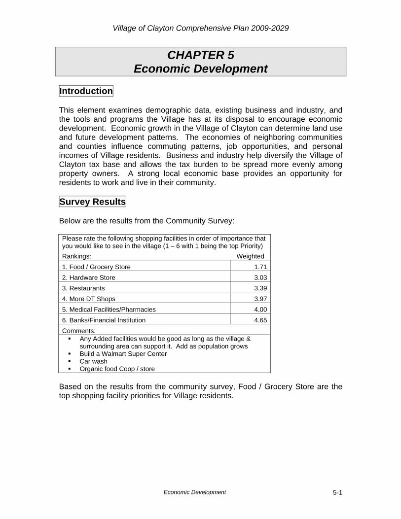
Village of Clayton Comprehensive Plan 2009-2029
Economic Development 5-1
CHAPTER 5 Economic Development Introduction This element examines demographic data, existing business and industry, and the tools and programs the Village has at its disposal to encourage economic development. Economic growth in the Village of Clayton can determine land use and future development patterns. The economies of neighboring communities and counties influence commuting patterns, job opportunities, and personal incomes of Village residents. Business and industry help diversify the Village of Clayton tax base and allows the tax burden to be spread more evenly among property owners. A strong local economic base provides an opportunity for residents to work and live in their community. Survey Results Below are the results from the Community Survey: Please rate the following shopping facilities in order of importance that you would like to see in the village (1 – 6 with 1 being the top Priority) Rankings: Weighted 1. Food / Grocery Store 1.712. Hardware Store 3.033. Restaurants 3.394. More DT Shops 3.975. Medical Facilities/Pharmacies 4.006. Banks/Financial Institution 4.65Comments:
Any Added facilities would be good as long as the village & surrounding area can support it. Add as population grows
Build a Walmart Super Center Car wash Organic food Coop / store
Based on the results from the community survey, Food / Grocery Store are the top shopping facility priorities for Village residents.

Village of Clayton Comprehensive Plan 2009-2029
Economic Development 5-2
There is adequate parking in downtown. (please check one) Count Percent I strongly agree 2 4.8%I agree 28 66.7%Not sure 5 11.9%I disagree 7 16.7%I strongly disagree 0 0.0%
Total 42 100.0% Most of the respondents (71%) felt that parking is not a concern downtown. There is a need to improve the ________in the Village of Clayton’s downtown. (please check all that apply) Count Streets 1Store fronts 23Sidewalks 14Lighting 5Seating (benches) 16Nothing 4Other 3Total 66
More retail, less rental Park lands, shaded areas, trees sidewalks in residential area
Over half of the responses indicate there is a need to improve the store fronts in downtown. The next highest response was benches, closely followed by sidewalks. How important is it to you to see more work opportunities provided in the Clayton area? (please check one) Count Percent Very important 28 65.1%Somewhat important 14 32.6%Not important 0 0.0%No opinion 1 2.3%Not sure 0 0.0%
Total 43 100.0% Over 97% of the responses indicated work opportunities are important in the Village.

Village of Clayton Comprehensive Plan 2009-2029
Economic Development 5-3
Do you think there is a need for more industry in the Village of Clayton? (please check one) Count Percent Yes 36 83.7%No 1 2.3%Maybe 4 9.3%Not sure 2 4.7%
Total 43 100.0% Nearly 84% of the people responding to the survey feel the Village needs more industry. Economic activity in the Village of Clayton is influenced by many factors. Two significant factors are the Village’s proximity and road access to the Twin Cities Metropolitan Area and the ability to attract viable industries to the Village. U.S. Highway 8 and State Highway 64 are in close proximity to the Village and provide a direct route to and from the Twin Cities. The Economic Development element will evaluate labor and economic characteristics and determine what opportunities for economic growth exist. Local Labor Characteristics An analysis of the labor characteristics of the Village of Clayton workforce can help illustrate the relationship between education, income, population, and employment opportunities. The labor characteristics can be used to help assess and plan future economic activities within the Village. A number of labor characteristics were addressed in Issues and Opportunities Chapter. A summary of the 1990 and 2000 Census findings is listed below:
The median household income for Village residents was $29,135 in 1999. This was a 65% increase over the 1989 figure
Approximately 42% of the population 25 and older is employed in Production, Transportation, and Material Moving occupations
Approximately 20% of the population 25 and older is employed in Service related occupations
Approximately 12% of the population 25 and older is employed in the Sales and Office related occupations
Unemployment rates for the Village in 2000 was 10.2%; Polk County 2007 unemployment was 5.9%
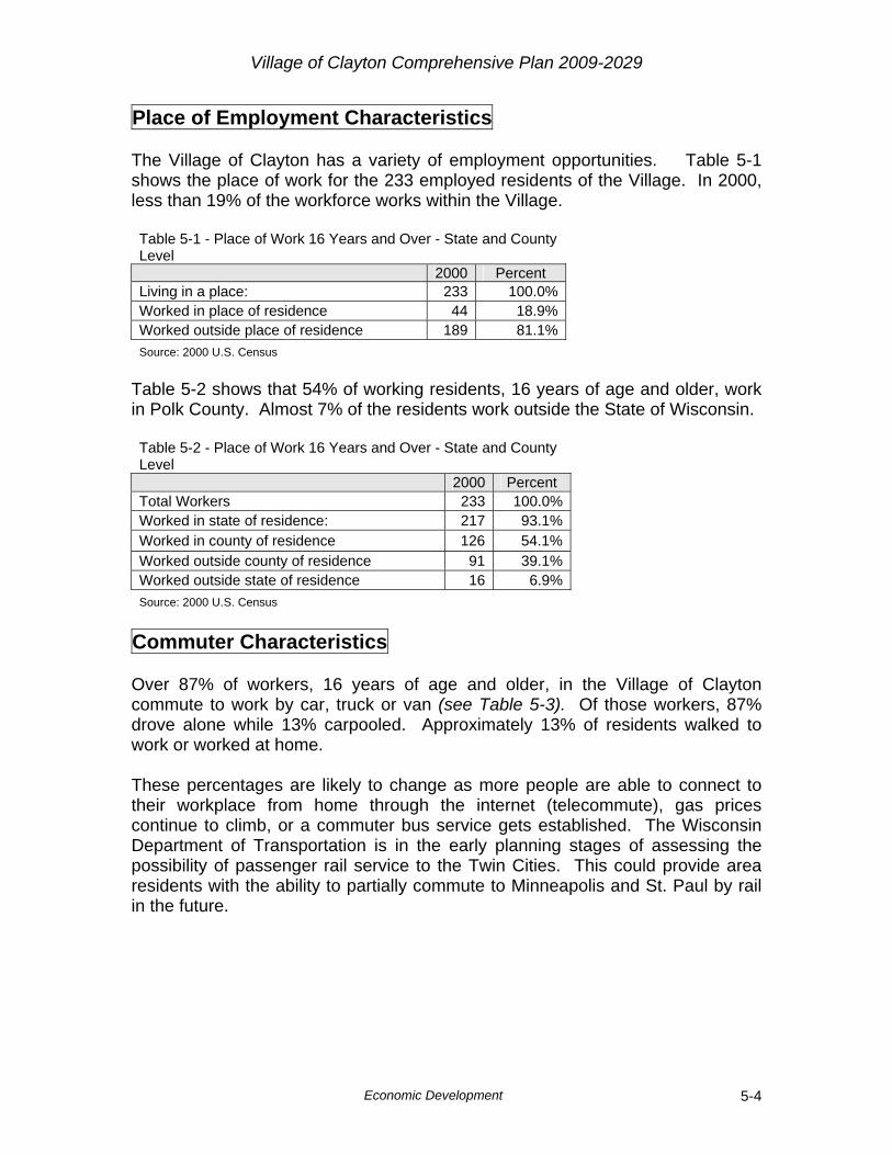
Village of Clayton Comprehensive Plan 2009-2029
Economic Development 5-4
Place of Employment Characteristics The Village of Clayton has a variety of employment opportunities. Table 5-1 shows the place of work for the 233 employed residents of the Village. In 2000, less than 19% of the workforce works within the Village. Table 5-1 - Place of Work 16 Years and Over - State and County Level
2000 Percent Living in a place: 233 100.0%Worked in place of residence 44 18.9%Worked outside place of residence 189 81.1%Source: 2000 U.S. Census
Table 5-2 shows that 54% of working residents, 16 years of age and older, work in Polk County. Almost 7% of the residents work outside the State of Wisconsin. Table 5-2 - Place of Work 16 Years and Over - State and County Level
2000 Percent Total Workers 233 100.0%Worked in state of residence: 217 93.1%Worked in county of residence 126 54.1%Worked outside county of residence 91 39.1%Worked outside state of residence 16 6.9%Source: 2000 U.S. Census
Commuter Characteristics Over 87% of workers, 16 years of age and older, in the Village of Clayton commute to work by car, truck or van (see Table 5-3). Of those workers, 87% drove alone while 13% carpooled. Approximately 13% of residents walked to work or worked at home. These percentages are likely to change as more people are able to connect to their workplace from home through the internet (telecommute), gas prices continue to climb, or a commuter bus service gets established. The Wisconsin Department of Transportation is in the early planning stages of assessing the possibility of passenger rail service to the Twin Cities. This could provide area residents with the ability to partially commute to Minneapolis and St. Paul by rail in the future.
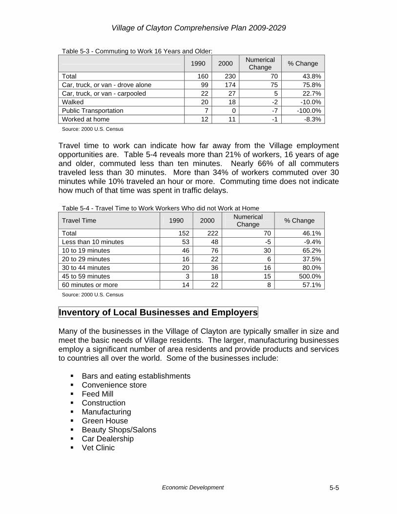
Village of Clayton Comprehensive Plan 2009-2029
Economic Development 5-5
Table 5-3 - Commuting to Work 16 Years and Older:
1990 2000 Numerical
Change % Change
Total 160 230 70 43.8%Car, truck, or van - drove alone 99 174 75 75.8%Car, truck, or van - carpooled 22 27 5 22.7%Walked 20 18 -2 -10.0%Public Transportation 7 0 -7 -100.0%Worked at home 12 11 -1 -8.3%Source: 2000 U.S. Census
Travel time to work can indicate how far away from the Village employment opportunities are. Table 5-4 reveals more than 21% of workers, 16 years of age and older, commuted less than ten minutes. Nearly 66% of all commuters traveled less than 30 minutes. More than 34% of workers commuted over 30 minutes while 10% traveled an hour or more. Commuting time does not indicate how much of that time was spent in traffic delays. Table 5-4 - Travel Time to Work Workers Who did not Work at Home
Travel Time 1990 2000 Numerical Change % Change
Total 152 222 70 46.1%Less than 10 minutes 53 48 -5 -9.4%10 to 19 minutes 46 76 30 65.2%20 to 29 minutes 16 22 6 37.5%30 to 44 minutes 20 36 16 80.0%45 to 59 minutes 3 18 15 500.0%60 minutes or more 14 22 8 57.1%Source: 2000 U.S. Census
Inventory of Local Businesses and Employers Many of the businesses in the Village of Clayton are typically smaller in size and meet the basic needs of Village residents. The larger, manufacturing businesses employ a significant number of area residents and provide products and services to countries all over the world. Some of the businesses include:
Bars and eating establishments Convenience store Feed Mill Construction Manufacturing Green House Beauty Shops/Salons Car Dealership Vet Clinic
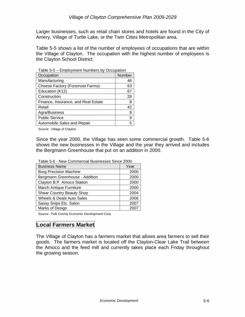
Village of Clayton Comprehensive Plan 2009-2029
Economic Development 5-6
Larger businesses, such as retail chain stores and hotels are found in the City of Amery, Village of Turtle Lake, or the Twin Cities Metropolitan area. Table 5-5 shows a list of the number of employees of occupations that are within the Village of Clayton. The occupation with the highest number of employees is the Clayton School District. Table 5-5 – Employment Numbers by Occupation Occupation NumberManufacturing 46Cheese Factory (Foremost Farms) 63Education (K12) 67Construction 28Finance, Insurance, and Real Estate 8Retail 42Agra/Business 8Public Service 9Automobile Sales and Repair 5Source: Village of Clayton
Since the year 2000, the Village has seen some commercial growth. Table 5-6 shows the new businesses in the Village and the year they arrived and includes the Bergmann Greenhouse that put on an addition in 2000. Table 5-6 - New Commercial Businesses Since 2000 Business Name Year Borg Precision Machine 2000Bergmann Greenhouse - Addition 2000Clayton B.P. Amoco Station 2000March Antique Furniture 2000Shear Country Beauty Shop 2004Wheels & Deals Auto Sales 2006Sassy Snips Etc. Salon 2007Marks of Design 2007Source: Polk County Economic Development Corp.
Local Farmers Market The Village of Clayton has a farmers market that allows area farmers to sell their goods. The farmers market is located off the Clayton-Clear Lake Trail between the Amoco and the feed mill and currently takes place each Friday throughout the growing season.

Village of Clayton Comprehensive Plan 2009-2029
Economic Development 5-7
Strengths and Weaknesses for Businesses To determine, to what extent, the Village of Clayton might grow economically, its strengths, weaknesses, opportunities, and threats for retaining and attracting businesses must be evaluated.
Strengths
Excellent area schools Strong community groups Community loyalty Parks Space available in downtown shops
Weaknesses
Distance from Interstate 94 Lack of available space in the industrial park Unable to attract high paying / technical jobs Need for more downtown shops Nearby communities providing services
Opportunities
Future transportation upgrades such as the Stillwater Bridge and
the expansion of U.S. Highway 63 Available undeveloped land within the Village Limits U.S. Highway 63 Make telecommunications/high speed internet access available Amery medical facilities future expansion that provide jobs in the
area High water capacity Steadily increasing populations Available land Upcoming Centennial
Threats
Rising fuel prices Limited WWTP capacity Young people leaving the area Economy School district consolidation/loss
Location is a major factor when businesses consider where to become established. Locations near major transportation infrastructure are more
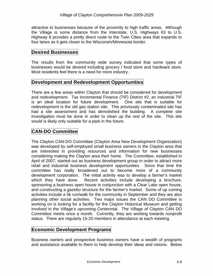
Village of Clayton Comprehensive Plan 2009-2029
Economic Development 5-8
attractive to businesses because of the proximity to high traffic areas. Although the Village is some distance from the Interstate, U.S. Highways 63 to U.S. Highway 8 provides a pretty direct route to the Twin Cities area that expands to four lanes as it gets closer to the Wisconsin/Minnesota border. Desired Businesses The results from the community wide survey indicated that some types of businesses would be desired including grocery / food store and hardware store. Most residents feel there is a need for more industry. Development and Redevelopment Opportunities There are a few areas within Clayton that should be considered for development and redevelopment. Tax Incremental Finance (TIF) District #2, an industrial TIF is an ideal location for future development. One site that is suitable for redevelopment is the old gas station site. This previously contaminated site has had a site assessment and has demolished the building. A complete site investigation must be done in order to clean up the rest of the site. This site would is likely only suitable for a park in the future. CAN-DO Committee The Clayton CAN-DO Committee (Clayton Area New Development Organization) was developed by self-employed small business owners in the Clayton area that are interested in providing resources and information for new businesses considering making the Clayton area their home. The Committee, established in April of 2007, started out as business development group in order to attract more retail and industrial business development opportunities. Since that time the committee has really broadened out to become more of a community development corporation. The initial activity was to develop a farmer’s market which they have done. Recent activities include developing a brochure, sponsoring a business open house in conjunction with a Clear Lake open house, and constructing a gazebo structure for the farmer’s market. Some of up coming activities include a 5k run/walk for the community in September and they are also planning other social activities. Two major issues the CAN DO Committee is working on is looking for a facility for the Clayton Historical Museum and getting involved in the Village’s upcoming Centennial. The Village of Clayton CAN DO Committee meets once a month. Currently, they are working towards nonprofit status. There are regularly 15-20 members in attendance at each meeting. Economic Development Programs Business owners and prospective business owners have a wealth of programs and assistance available to them to help develop their ideas and visions. Below
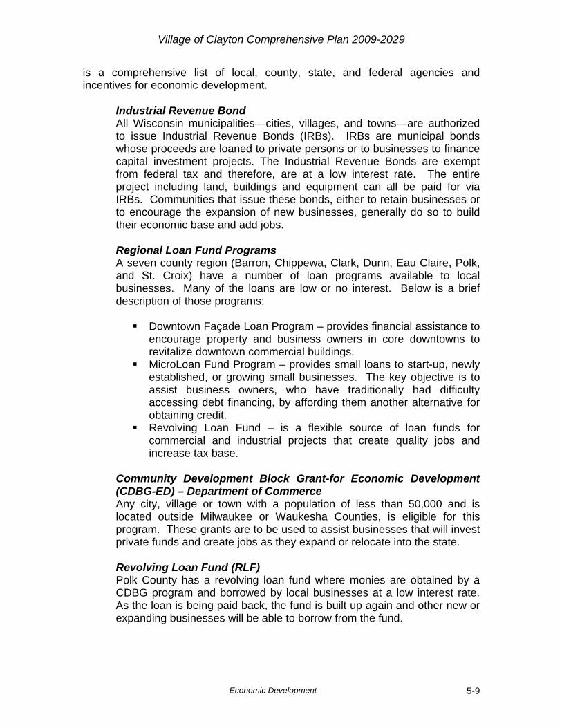
Village of Clayton Comprehensive Plan 2009-2029
Economic Development 5-9
is a comprehensive list of local, county, state, and federal agencies and incentives for economic development.
Industrial Revenue Bond All Wisconsin municipalities—cities, villages, and towns—are authorized to issue Industrial Revenue Bonds (IRBs). IRBs are municipal bonds whose proceeds are loaned to private persons or to businesses to finance capital investment projects. The Industrial Revenue Bonds are exempt from federal tax and therefore, are at a low interest rate. The entire project including land, buildings and equipment can all be paid for via IRBs. Communities that issue these bonds, either to retain businesses or to encourage the expansion of new businesses, generally do so to build their economic base and add jobs. Regional Loan Fund Programs A seven county region (Barron, Chippewa, Clark, Dunn, Eau Claire, Polk, and St. Croix) have a number of loan programs available to local businesses. Many of the loans are low or no interest. Below is a brief description of those programs:
Downtown Façade Loan Program – provides financial assistance to encourage property and business owners in core downtowns to revitalize downtown commercial buildings.
MicroLoan Fund Program – provides small loans to start-up, newly established, or growing small businesses. The key objective is to assist business owners, who have traditionally had difficulty accessing debt financing, by affording them another alternative for obtaining credit.
Revolving Loan Fund – is a flexible source of loan funds for commercial and industrial projects that create quality jobs and increase tax base.
Community Development Block Grant-for Economic Development (CDBG-ED) – Department of Commerce Any city, village or town with a population of less than 50,000 and is located outside Milwaukee or Waukesha Counties, is eligible for this program. These grants are to be used to assist businesses that will invest private funds and create jobs as they expand or relocate into the state. Revolving Loan Fund (RLF) Polk County has a revolving loan fund where monies are obtained by a CDBG program and borrowed by local businesses at a low interest rate. As the loan is being paid back, the fund is built up again and other new or expanding businesses will be able to borrow from the fund.
Village of Clayton Comprehensive Plan 2009-2029
Economic Development 5-10
Tax Incremental Financing (TIF) Tax Increment Financing (TIF) districts are established to improve and revitalize blighted areas or extend new development for industrial purposes. Taxes on the improved value of the land because of redevelopment pay for the extension of the infrastructure and raise the Village’s tax base on an area that would otherwise stay undeveloped.
Business Improvement District (BID) A Business Improvement District (BID) allows business owners to create a BID, develop an operating plan, and assess fees to businesses within the district to implement this plan. At least 61% of the assessed businesses within the district must agree to be part of the BID. Operating plans can be the creation of promotional materials or making aesthetic improvements. The fees that are collected to implement the operating plan can be assessed per business or as a percentage of assessed value. Economic Development Group An Economic Development Group (EDG) assists new and existing businesses. It can be comprised of local business owners, bankers, and citizens that have expertise in an area valuable to the economic development of the community. An EDG is often the first point of contact within a community for a prospective business. UW-Extension Office UW-Extension Offices provide educational tools in land use and economic matters for residents and businesses. They custom fit their knowledge and provide research to communities with whom they are assisting.
http://www.uwex.edu/ces/cty/stcroix/
West Central Wisconsin Regional Planning Commission The Planning Commission is responsible for planning for the physical, social, and economic development of the region. http://www.wwrpc.org Wisconsin Small Business Centers An organization dedicated to assisting businesses in education, training and other initiatives. http://www.uwex.edu/sbdc Forward Wisconsin The State of Wisconsin offers a wide array of financial resources available to businesses. http://www.forwardwi.com/assist/ Department of Workforce Development The Wisconsin Department of Workforce Development (DWD) is the state agency responsible for building and strengthening Wisconsin's workforce. http://www.dwd.state.wi.us

Village of Clayton Comprehensive Plan 2009-2029
Economic Development 5-11
Wisconsin Department of Commerce A number of grants and assistance are available through this state agency. http://www.commerce.state.wi.us/MT/MT-COM-2000.html Wisconsin Department of Transportation The Disadvantaged Business Enterprise (DBE) Program's goal is to increase participation of firms owned by disadvantaged individuals in all federal aid and state transportation facility contracts. http://www.dot.wisconsin.gov/business/engrserv/dbe-main.htm
Interstate 94 Corridor Technology Zone Program The State of Wisconsin has designated a tax credit zone along Interstate 94. The counties included in this zone are: Chippewa, Dunn, Eau Claire, Pierce, Polk, and St. Croix. Eligible businesses within the zone must have the ability to create new jobs and be a new or expanding technology firm. The State has allowed $5 million in tax cuts for these businesses.
Goals, Objectives, and Policies Goal
1. Support and guide future economic growth in the Village of Clayton. Objectives
1. Ensure economic growth and development is compatible with the Village’s desire to retain its small town atmosphere.
2. Increase the Village’s tax base. 3. Support small, locally owned businesses.
Policies
1. Encourage potential business owners to research available resources for financial and professional advice for creating new businesses.
2. Require new commercial and retail construction to fit into neighboring residential areas.
3. Expand the industrial park for future development. 4. Work with the Polk County Information Center on promotion of the
recreational opportunities in the Village. 5. Support Can-Do Committee as well as other efforts to attract new
businesses to the area. 6. Utilize or amend existing Tax Incremental District or create a new one to
provide incentives for new and existing businesses.
Village of Clayton Comprehensive Plan 2009-2029
Economic Development 5-12
Goal 2. Develop aesthetic guidelines for new commercial/retail development
that support the small town feel of the Village. Objectives
1. Create and maintain a unique identity for the Village of Clayton. 2. Preserve the aesthetic qualities of the Village and ensure they are applied
to new development in the community. Policies
1. Create recommendations/guidelines for landscaping, parking, and architecture that would apply to the downtown of the Village.
2. Create a blighted Tax Incremental District to provide funds to existing property owners to fix up their building façades and require design standards in the developer agreement.
3. Encourage businesses to take advantage of the Revolving Loan Fund, Downtown Façade Loan, and Micro Loan Fund Programs.
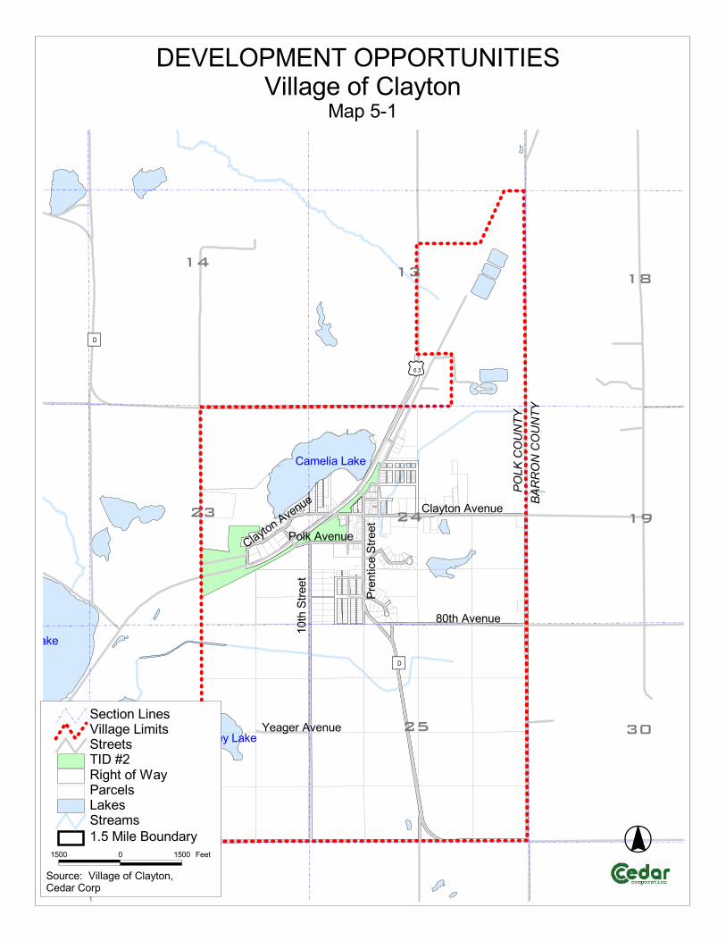
����������������� ������������������
������
����
�� ��������
!����������
����
���
��������
�
��
������
�
��
����
�� ��
��
#$�%&'��(�
�������&'��(�
����&'��(�
������)�������
�������&'��(�
�$�%������
���
����
��
��
�
*�����&'��(�
�+�����,�(�"�������� -����-���)��-���%���.�� �/0������-��������� ��-��)��������-
��$$ $ ��$$ 1���
��(�)�2����������������3��"������

Village of Clayton Comprehensive Plan 2009-2029
Transportation 6-1
CHAPTER 6 Transportation
Introduction A quality transportation system is essential to the development of the Village of Clayton. An excellent road network makes the Village a desirable place to live because it allows residents to have access to other communities, commodities, and job opportunities. High traffic areas, such as highways, provide good locations for industry and businesses. Trail systems provide recreation opportunities for people throughout the area and add to the livability and attractiveness of the Village. The Transportation Element will inventory and evaluate local modes of transportation and identify possibilities for future development and improvement. Survey Results The Community Survey included a question related to different modes of transportation. According to the responses, when asked what the Village should support, “sidewalks to key areas” was the answer with the highest number of responses (28%). The Village of Clayton should support Count Percent Bike lanes/paths 20 23.3%Sidewalks to key areas 24 27.9%Area car pool / park & ride 13 15.1%Foot paths 20 23.3%None 9 10.5%Other * 0 0.0%Total 86 100.0%
'*Public Park * Tunnel or overpass Hwy 63. kids on west side Along with the selected answers, there were also some written responses to this question. Comments include supporting public parks and constructing a tunnel or overpass for U.S. Highway 63 so children on the west side can access the Village safely. SWOT Exercise Results Strengths
• U.S. Highway 63

Village of Clayton Comprehensive Plan 2009-2029
Transportation 6-2
• Rural area – not congested with traffic • ATV and other recreational trails • State, County, and local roads all accessible from the Village • Effective snow removal • Major area gas station located in the Village • Sidewalks and walkways to key areas • Public parking areas available • Low commute times – near to numerous job concentrations • Variety of airports nearby – shipping and air services • Shuttle to major airports available • Sober cap available – Polk County Tavern League
Weaknesses
• Limited employment opportunities in the Village • No major commercial/public transportation • No rail services • Limited handicapped transportation services • Limited bike paths • Need for more sidewalks and improved maintenance of existing • Not enough street lights • No designated “park and ride” facility • Limited amount of off street parking – including space for semi trailers • Numerous dangerous intersections
Opportunities
• Developing an official “park and ride” facility • Fix dangerous intersections • Maintain sidewalks • Add new sidewalks • Extend the Church Street sidewalk on the east side • Extend Olson Street • Develop additional recreational opportunities – non-motorized trails • Trucking or shipping and receiving business • Tunnel or overpass of U.S. Highway 63 for pedestrians • Expansion or widening of U.S. Highway 63
Treats
• Expansion or bypass of U.S. Highway 63 – loss of business • Fuel costs – people relocating • Lack of funding – grant opportunities • Loss of school

Village of Clayton Comprehensive Plan 2009-2029
Transportation 6-3
Modes of Transportation The movement of people and goods is accomplished through a variety of transportation modes. These modes include car, truck, rail, public transportation, ship, air, bicycle and pedestrian. For the most part, each mode fits a particular need. Automobiles function as the dominant mode for the movement of people. Trucking provides for the rapid movement of goods and products over the highway network. Air travel helps to move people and lightweight products quickly over long distances. The railroad functions primarily for the movement of bulk commodities over long distances while bicycle paths and sidewalks provide for the movement of people. The most dominant mode of transportation in the Village of Clayton (and nearly all communities) is the automobile and for that reason the majority of the Transportation Element will focus on local streets and highways. Functional Road Classification and Jurisdiction The road system is composed of four levels of government jurisdiction. These levels include the local road system, and county, state, and federal highways. Each roadway within the county can also be classified by function. The function that the road serves in relation to existing traffic patterns, the adjacent land use, land access needs, and the average daily traffic volumes determine its functional classification. There are both urban and rural classification systems, both of which are detailed below. The Village of Clayton falls in the Rural Functional Road Classification System. The Wisconsin Department of Transportation uses population figures, land uses, spacing between classified roads, and average daily traffic counts to determine the functional classification. Classifications are updated every 10 years after census information becomes available. The Village can request a review of their classifications but would be required to collect the data needed. Functional Road Classification System (Rural <5,000 Population)
Principal Arterials: Serve interstate and interregional trips. These routes generally serve all urban areas greater than 5,000 people. The rural principal arterials are further subdivided into:
Interstate highways. Other principal arterials.
Minor Arterials: In conjunction with the principal arterials, they serve cities, large communities, and other major traffic generators providing intra-regional and inter-area traffic movements.

Village of Clayton Comprehensive Plan 2009-2029
Transportation 6-4
Major Collectors: Provide service to moderate sized communities and other intra-area traffic generators, and link those generators to nearby larger population centers or higher function routes. Minor Collectors: Collect traffic from local roads, and provide links to all remaining smaller communities, locally important traffic generators, and higher function roads. All developed areas should be within a reasonable distance of a collector road. Local Roads: Provide access to adjacent land and provide for travel over relatively short distances. All roads not classified as arterials or collectors are local function roads.
Map 6-1 shows the functional road classifications and jurisdiction of the Village and includes traffic counts for some of the roads. U.S. Highway 63 is classified as a Principal Arterial (other) and serves the West Central Wisconsin Area from Red Wing, Minnesota to Spooner, Wisconsin. Prentice Street, 80th Avenue, and County Trunk Highway PP are classified as a Major Collector and County Trunk Highway D is classified as a Minor Collector. All other roads are considered Local Roads. Traffic volume information is a useful tool in determining transportation needs of the future. The volumes can be used to measure and establish trends, justify expenditures, prioritize street and highway improvements, and measure present use and traffic flow relative to the capacity of the existing system. Of the roads that were used to count traffic volume, U.S. Highway 63 had an increase in traffic volume between 1998 and 2006 and on 7th Avenue (Barron County) between 1998 and 2004. These years were selected because it is the most recent data available at this time. Commuter Patterns An efficient road network is critical to the needs of area residents and economic growth. Table 6-1, reveals that in 2000, 201 workers (87%) in the Village of Clayton, 16 years of age and older, commute to work by car, truck or van. Of those workers, 174 (or 76%) drove alone while 27 carpooled. Over 10% of residents walked to work or worked at home. Between 1990 and 2000 there was a significant drop in the number of residents that chose to take public transportation.
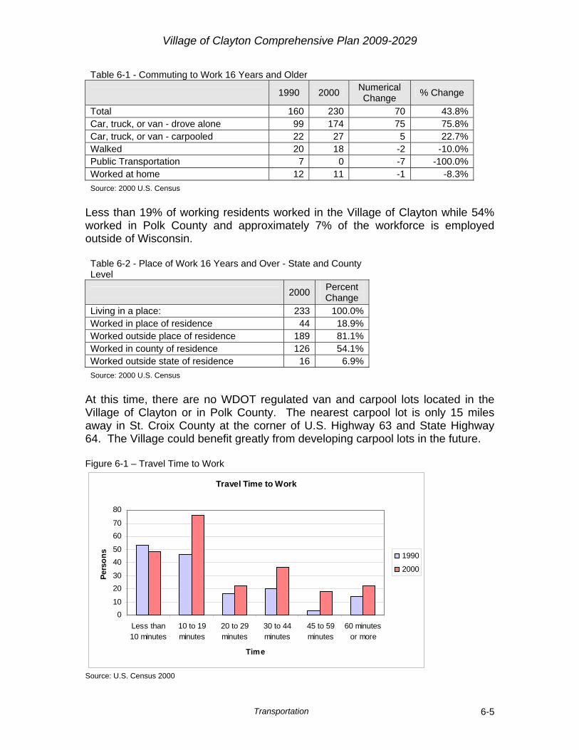
Village of Clayton Comprehensive Plan 2009-2029
Transportation 6-5
Table 6-1 - Commuting to Work 16 Years and Older
1990 2000 Numerical Change % Change
Total 160 230 70 43.8%Car, truck, or van - drove alone 99 174 75 75.8%Car, truck, or van - carpooled 22 27 5 22.7%Walked 20 18 -2 -10.0%Public Transportation 7 0 -7 -100.0%Worked at home 12 11 -1 -8.3%Source: 2000 U.S. Census
Less than 19% of working residents worked in the Village of Clayton while 54% worked in Polk County and approximately 7% of the workforce is employed outside of Wisconsin. Table 6-2 - Place of Work 16 Years and Over - State and County Level
2000 Percent Change
Living in a place: 233 100.0%Worked in place of residence 44 18.9%Worked outside place of residence 189 81.1%Worked in county of residence 126 54.1%Worked outside state of residence 16 6.9%Source: 2000 U.S. Census
At this time, there are no WDOT regulated van and carpool lots located in the Village of Clayton or in Polk County. The nearest carpool lot is only 15 miles away in St. Croix County at the corner of U.S. Highway 63 and State Highway 64. The Village could benefit greatly from developing carpool lots in the future. Figure 6-1 – Travel Time to Work
Travel Time to Work
010
2030
4050
6070
80
Less than10 minutes
10 to 19minutes
20 to 29minutes
30 to 44minutes
45 to 59minutes
60 minutesor more
Time
Pers
ons 1990
2000
Source: U.S. Census 2000
Village of Clayton Comprehensive Plan 2009-2029
Transportation 6-6
The number of residents traveling over 30 minutes to work has increased from 37 to 76 residents from 1990 to 2000 (Figure 6-1). The only decrease happened in the group traveling less then 10 minutes which went from 53 residents to 48. This indicates that more residents are traveling longer distances to their jobs. Air Transportation The Village of Clayton is served by a number of airports, Minneapolis-St. Paul International Airport, Amery Municipal Airport, and the New Richmond Regional Airport. The Minneapolis-St. Paul International Airport, approximately 80 miles away, provides major commercial air service for Western Wisconsin and Village of Clayton residents. The airport consists of the Humphrey and Lindberg Terminals. This airport will continue to be the main provider of passenger and commercial service in the area. The City of Amery has a publicly owned airport that has two runways. Each runway is 4,001’ in length and 75’ in width. The Amery Municipal Airport is located on the southern tip of the City of Amery approximately 10 miles from the Village. The New Richmond Regional Airport (NRRA) is the only public use airport in St. Croix County and is approximately 28 miles from the Village of Clayton. The airport has two runways. Runway 14-32 is 5,507’x75’ and is has an asphalt surface. Runway 4-22 is 2,110’x75’ and has a turf surface. Over 180 aircraft are based in privately owned hangars. NRRA is also home to ten aviation related businesses and several business aircraft. The airport contributes over nine million dollars per year to the New Richmond area economy. NRRA will continue to provide private aircraft service for area residents. Other area airports include Rice Lake, Boyceville, and Cumberland. Each airport provides a variety of services. Some of the services include: flight instruction, aviation fuel, aircraft parking, pilot support services, air charter, and provides local services for package delivery. Sidewalks Sidewalks provide a safe alternative route for people move throughout the community. They connect residential areas to traffic generators such as parks, schools, downtown, churches, and other community facilities. Currently, the Village of Clayton does have some sidewalks, but lacks connectivity with some of the recreational and residential areas. Map 6-2 shows that most of the sidewalks are concentrated near the downtown area and extends north and south along Prentice Street.

Village of Clayton Comprehensive Plan 2009-2029
Transportation 6-7
Trail Routes The Clear Lake - Clayton Trail is on an abandoned railroad bed on the northwestern corner of the Village and is used by ATV and snowmobile riders. According to the survey, many residents would like to see four-wheelers and ATV trails developed within the Village. Although the Village doesn’t have ATV trails, it does have designated routes that the ATV riders can use to get through the Village and connect on to the Clear Lake – Clayton Trail. The Clear Lake – Clayton Trail is within the DOT right of way of U.S. Highway 63 and is maintained by the Polk County Park and Recreation Department along with local ATV and snowmobile clubs. The Clear Lake – Clayton system links the Village of Clayton to Deer Park to the south and Turtle Lake to the north. In Turtle Lake recreational users can get on the Cattail Trail that extends to Amery in the west and Barron in the east. Developing a trail system will take cooperation with surrounding municipalities and local groups to determine location and funding options. When considering trails, it is best to separate motorized and non-motorized trails for safety reasons. Transportation Facilities for the Disabled The Polk County Aging Program provides transportation services for the elderly and handicapped in the Village of Clayton. Transportation services are run by volunteers who will take residents to medical appointments, grocery shopping, or for personal appointments. The services are available to Polk County senior citizens aged 55 and older. Wheelchair bound senior citizens and handicapped residents of any age can contact Polk County Aging Programs to arrange lift-equipped transportation that is provided by Polk County Transportation for the Disabled & Elderly, Inc. Trucking Currently, there are not any trucking transit operations within the Village. Other Modes of Transportation There are no rail (passenger or freight) or water transportation services in the Village of Clayton. It is unlikely that any of these services would be available over the next 10 to 20 years. Barron, Cameron, and New Richmond are the closest available rail lines.

Village of Clayton Comprehensive Plan 2009-2029
Transportation 6-8
State and Regional Plans The Wisconsin Department of Transportation has several state and regional transportation plans that were reviewed to ensure consistency. The plans reviewed are:
Connections 2030 Polk River Crossing Project West Central Regional Freeway System Wisconsin Rail Issues and Opportunities Report Midwest Regional Rail System Wisconsin State Highway Plan 2020 Wisconsin State Airport System Plan 2020 Wisconsin Bicycle Transportation Plan 2020 Wisconsin Statewide Pedestrian Policy Plan 2020
Future Considerations There are a number of things to consider when planning future roads and improvements to the transportation network. When reviewing existing infrastructure and future site plans, the Village should ask the following questions:
Are there existing dead ends and stub roads that proposed roads could be connected to?
Is there a need for a “park and ride” facility? Can a proposed road increase/improve east-west, north-south corridors? Do proposed roads follow and preserve the natural features and
topography of the land? Are there dangerous intersections that could be made safer? Are there existing regulations that cost/policy prohibitive for future road
and trail network projects? Future Improvements As the Village grows, the transportation infrastructure will need to be upgraded and expanded. Below are descriptions of some of the possible future upgrade and expansion projects of the transportation system. Map 6-3 identifies the locations of those future corridors. Intersections Most automobile accidents occur at intersections. If there are visibility speed issues at an intersection, there may be higher accident rates at that location. Steps can be taken to reduce the factors contributing to some of the accidents.
Village of Clayton Comprehensive Plan 2009-2029
Transportation 6-9
Map 6-3 identified five intersections that are considered to be problematic or dangerous, four of which have issues with visibility. Below are the intersections that could be improved and the related concern of why they are considered dangerous:
• Clayton Avenue and U.S. Highway 63 – visibility of southbound traffic on U.S. Highway 63
• Clayton Avenue and Prentice Street – visibility of north and southbound traffic on Prentice Street from both sides of Clayton Avenue
• County Road D and 80th Avenue – visibility of eastbound traffic on 80th Avenue from County Road D intersection
• County Road D, 70th Avenue, and 5th Street – visibility of northbound traffic from County Road D from 5th Street intersection and visibility of southbound traffic from County Road D from 70th Avenue intersection.
• West Clayton Avenue and Polk Avenue – stop sign for east bound traffic should be removed.
Roads Future roads will depend greatly on future development. There is one current location the Village has identified as possible road in the future. This corridor is identified on Map 6-3. Primarily future roads provide transportation to areas likely to be developed as well as provide connectivity to the existing road network. Olson Street will be extended to meet up with the intersection of Polk Avenue and 10th Street. The Village has also been requiring drivable curb to for new roads. Drivable curb allows development to take place without having to rip up the curb for the driveway. Sidewalks and Trails There is one area that the Village would like to connect to the existing sidewalk network. This would be on the east side of Church Street from the school to the gas stations. These future sidewalk and trail routes are identified on Map 6-3. Public Transportation There are currently a couple of unofficial “park and ride” lots in the Village. One is in the bank parking lot, and the other is on Village owned property near the gas station. The Village would prefer to eventually designate an official “park and ride” lot that would be marked and lighted for security. One concern is that semi trailers are parked in a few different areas of the Village. The Village may want to designate suitable location for them to be parked overnight. Potentially, both the “park and ride” lot and an overnight trailer parking lot could be combined in one location and include concrete slabs so the trailers would not sink into the ground.
Village of Clayton Comprehensive Plan 2009-2029
Transportation 6-10
Road Maintenance Planning Road maintenance is vital to keeping the road system safe and functioning properly. Because of the local climate and recent oil prices, road maintenance is a significant cost of a municipality’s budget. A sound transportation plan should be able to foresee and plan for upcoming expenses. The two primary ways of planning for future road projects are by using the Pavement Surface Evaluation and Rating (PASER) program and devising a long-range Capital Improvement Plan (CIP) or road maintenance plan. PASER allows for better allocation of resources by identifying pavement conditions and those areas in need of repair and allows for long term planning. CIPs list, prioritize, and provide cost estimates for public infrastructure improvements over a five-year period. Possible Funding Sources Local multi-modal transportation projects can be funded through different sources. Some of the most common sources that are or could be used are:
State Shared Revenue Local Roads Improvement Program (LRIP) Local General Funds Community Development Block Grants DNR Stewardship Grants Enhancement Grants Private Foundations Corporate Foundations Local Volunteer Groups Local Organizations (Boy/Girl Scouts)
Goals, Objectives, and Policies Goal
1. Create and maintain a safe pedestrian and bicycle network within the Village of Clayton.
Objectives
1. Provide opportunities for residents to move throughout the Village by means other than automobiles or trucks.
2. Encourage walking and biking as ways of experiencing one’s neighborhood and community.
3. Reduce the use of fossil fuels. 4. Promote the health benefits of walking and biking. 5. Provide safe routes for people to enjoy the Village’s parks.

Village of Clayton Comprehensive Plan 2009-2029
Transportation 6-11
Policies 1. Require a Bike/Pedestrian Plan in new subdivisions and redevelopment to
concentrate on connectivity. 2. Visit and evaluate accident sites for signage and visibility. 3. Utilize signs and striping to ensure safe crosswalks for residents. 4. Coordinate with surrounding municipalities, including the Town of Clayton,
Town of Turtle Lake, and Village of Clear Lake in developing a biking and walking trail network.
5. Evaluate street reconstruction projects to see if road widths can be narrowed creating more space between potential sidewalks and resident’s homes.
Goal
2. Support the development of public transportation in the area. Objectives
1. Reduce vehicle traffic. 2. Provide safe conditions for pedestrians and bicyclists. 3. Reduce the use of fossil fuels. 4. Provide transportation options for the elderly and disabled.
Policies
1. Support local transportation options such as bus and carpooling. 2. Participate in local and regional transit planning with surrounding
communities, the Wisconsin Department of Transportation and Polk County.
3. Identify, map, and preserve potential lands in the Village of Clayton that could be used for public transportation in the future.
4. Develop an official “park and ride” lot. 5. Develop an overnight semi trailer parking lot. 6. Encourage the use of local groups, such as the Boy and Girl Scouts, to
help develop walking and bicycle trails. Goal
3. Provide cost effective maintenance and a safe transportation network.
Objectives
1. Reduce the tax burden of Village residents. 2. Maintain safe roads in and around the Village.
Policies
1. Research and apply for grants to offset the costs of sidewalks, trails, and road reconstructions.
2. Utilize the PASER pavement evaluation system to efficiently plan future infrastructure expenditures.

Village of Clayton Comprehensive Plan 2009-2029
Transportation 6-12
3. Continue to require drivable curb for new roads. 4. Use a Capital Improvements Plan (road maintenance plan) to plan and
budget for future road maintenance. 5. Continue to work with Polk County on LRIP committee.
Goal
4. Promote a road system that provides connectivity where possible. Objectives
1. Create transportation that promotes the smooth flow of traffic and preserves road corridors.
Policies
1. Review site plans to ensure future right-of-way space is preserved to extend roads to existing roads if possible in the future.
2. Require multiple access points to subdivisions where possible.
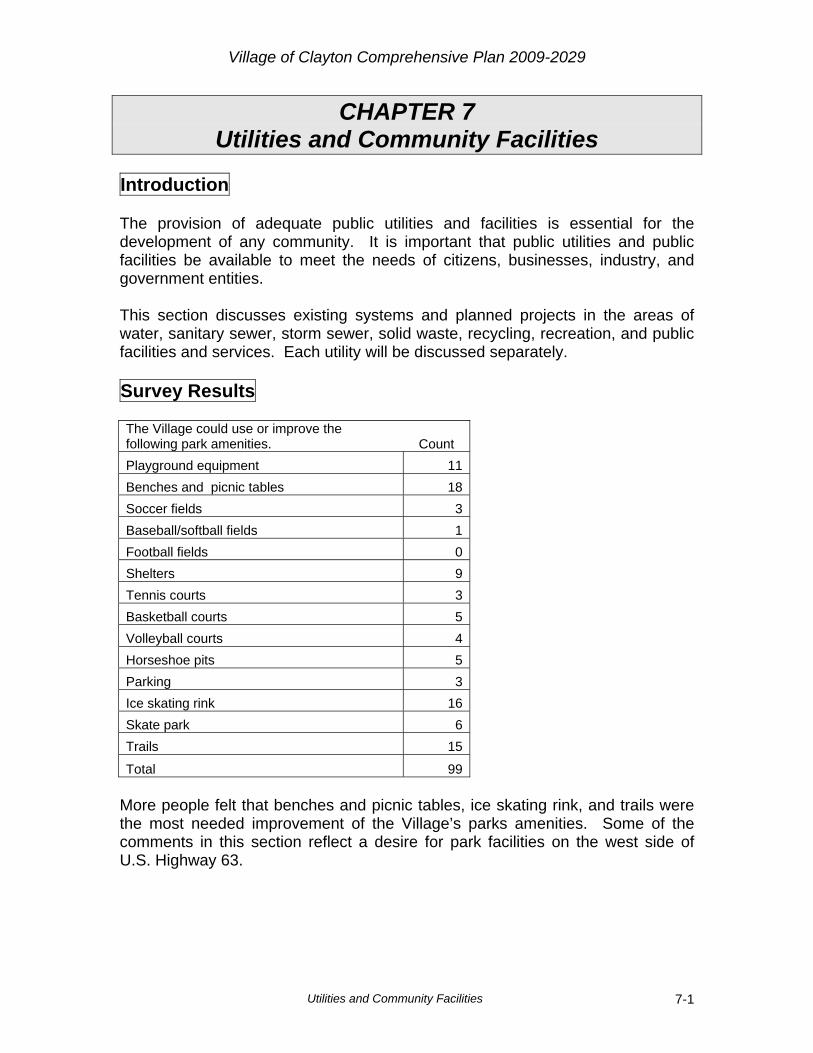
Village of Clayton Comprehensive Plan 2009-2029
Utilities and Community Facilities 7-1
CHAPTER 7 Utilities and Community Facilities
Introduction The provision of adequate public utilities and facilities is essential for the development of any community. It is important that public utilities and public facilities be available to meet the needs of citizens, businesses, industry, and government entities. This section discusses existing systems and planned projects in the areas of water, sanitary sewer, storm sewer, solid waste, recycling, recreation, and public facilities and services. Each utility will be discussed separately. Survey Results The Village could use or improve the following park amenities. Count Playground equipment 11Benches and picnic tables 18Soccer fields 3Baseball/softball fields 1Football fields 0Shelters 9Tennis courts 3Basketball courts 5Volleyball courts 4Horseshoe pits 5Parking 3Ice skating rink 16Skate park 6Trails 15
Total 99 More people felt that benches and picnic tables, ice skating rink, and trails were the most needed improvement of the Village’s parks amenities. Some of the comments in this section reflect a desire for park facilities on the west side of U.S. Highway 63.
Village of Clayton Comprehensive Plan 2009-2029
Utilities and Community Facilities 7-2
Community Facilities and Services The Village of Clayton has a wide variety of community facilities and services. The following services are available within the Village of Clayton or can be found in the vicinity. It is likely the Village and surrounding area will continue to provide these services in the future. Map 7-1 shows the location of most of the facilities found in the Village.
Library The Village of Clayton residents use the Villages of Turtle Lake and Clear Lake Public Libraries. Both libraries are part of the Indianhead Federated Library System. The Turtle Lake Public Library Bi-County Library Collection that shares materials with Cumberland, Barron, Cameron, Bruce, and Rusk County Public Libraries. The Clear Lake Public Library is part of the MORE system which allows the users to browse materials at other libraries within the MORE system and reserve books through an interlibrary loan. On Thursday night, the school does have an “open library” night. At this time there is not a need for the Village of Clayton to have its own public library and will continue to utilize the facilities in nearby communities. Health Care Facilities The only health care facility located in the Village is a chiropractor that is available two times per week. Additional nearby health care facilities are the Amery Regional Medical Center in the City of Amery with clinics located in the Villages of Turtle Lake and Clear Lake and Westfields Hospital in New Richmond. Many residents also use the Cumberland Medical Clinic and Cumberland Memorial Hospital located in Cumberland, approximately 18 miles to the north. It is likely that these facilities, and the many others throughout Polk, Barron, and St. Croix Counties and the Twin Cities Metropolitan Area, will continue to provide health care for residents. There is a desire to have a clinic in the Village, but due to the surrounding area providing medical service and the limited service population, it is unlikely that a clinic will be built in the Village of Clayton in the foreseeable future. Veterinary Service The Village is also fortunate to have a local veterinary clinic to treat and provide health services to area pets and animals. Childcare Facilities There are a few licensed childcare facilities in the Village of Clayton and surrounding Towns that are located in residential homes. There is also a Headstart Program at the school.

Village of Clayton Comprehensive Plan 2009-2029
Utilities and Community Facilities 7-3
At this time, the home childcare facilities are meeting the daycare needs of the community. Fire/Rescue The Clayton Fire Department provides protection for the Village and covers approximately 40 square miles, which consists of the Village of Clayton and the Town of Clayton, and a portion of the Town of Vance Creek, in Barron County. It is a paid volunteer fire department. Table 7-1 shows the Fire and Rescue statistics for 2007 and 2008. Table 7-1 - Fire and Rescue Statistics Year Number of Fire Fighters Fire Calls First Responder Calls
2007 29 18 56 2008 28 9 68 Source: Village of Clayton First Responders Vehicular equipment for the fire department includes:
2 pumper 2 tankers 1 quick attack or rescue truck 1 grass fire pickup Fire education house/training facility
The Clayton Fire Hall is located adjacent to the municipal building a block east of downtown. Future needs include upgrading equipment, such as the SCBA (Self Contained Breathing Apparatus) gear and an outside facelift to the Fire Hall. If the Clayton Fire Department were to add new vehicular equipment, the current facility would have to be expanded. At this time, there are no plans for adding new vehicular equipment and therefore the current size of the Fire Hall meet the space needs of the Fire Department. Emergency Medical Services The Village of Clayton is provided emergency medical service by the Clear Lake Ambulance Service, which service area consists of the Villages of Clear Lake and Clayton and the Towns of Black Brook and Clear Lake, and portions of the Towns of Forest, in St. Croix County, Vance Creek, in Barron County, and New Haven, in Dunn County, provides EMS protection for the Village. The EMS service consists of 15 EMTs and 10 first responders that work on a volunteer basis. The Village of Clayton has, on average, 16 first responders that serve the Village. The Clear Lake Ambulance Service receives an average of 200 calls per year. Currently, they have one ambulance and when that ambulance is out on a call, the City of Amery provides backup services if needed.

Village of Clayton Comprehensive Plan 2009-2029
Utilities and Community Facilities 7-4
Future equipment needs include a computerized reporting system and a new ambulance. At this time there are no plans for having an ambulance stationed in the Village of Clear Lake. Police Department The Clayton Police Department is also located in the Village Municipal building with the Village board room and the Fire Department. The Clayton Police Department consists of two officers: one full time and one part time. Future needs include adding manpower as future growth occurs. The Clayton Police Department does have a new squad car and recently received a grant for new computer equipment to have in the car to print tickets on the spot. Future needs include additional clerical help and eventually make the part-time officer moved to full-time. Post Office Village of Clayton residents use the Clayton Post Office which provides all postal services for Village residents. The Post Office is located downtown at 200 N. Prentice Street and was built in 1997. Cemeteries There is one cemetery in the Village of Clayton named the Clayton Cemetery. The cemetery is located at Clayton Avenue and Polk-Barron Street. The cemetery opened in 1914. The current cemetery will meet the needs of the community for the foreseeable future. Radio The Village of Clayton is within listening distance of a wide variety of radio stations. Internet The Northwest Community Communications provides the Village area with internet including dial-up and DSL. Website The Village of Clayton has a website that can be accessed at the following address: www.villageofclayton.com. This website provides valuable information regarding local businesses, points of interest, and local events. Newspaper Several local and regional newspapers are in circulation in the Village of Clayton including the St. Paul Pioneer Press, Amery Free Press, Hometown Gazette, and Turtle Lake Times. The Amery Free Press is the official newspaper for the Village where legal notices are posted.

Village of Clayton Comprehensive Plan 2009-2029
Utilities and Community Facilities 7-5
Telephone The Northwest Community Communications provides the Village area with local phone, cable TV, cell phone, and internet service. Long distance services are provided by a choice of most major long distance carriers and will continue to do so for the foreseeable future. Cellular Phones The Village of Clayton is within the service area of most major and local area cell phone companies. Solid Waste Disposal Current solid waste disposal needs are handled by Waterman’s Sanitation out of Amery, Wisconsin. They offer weekly curbside pickup on Tuesdays. Recycling Facilities Waterman’s Sanitation also provides recycling curbside pickup on the 2nd and 4th Tuesdays of the month. There is also the Barron County Incinerator, located approximately six miles away in Twin Town just south of Almena, where Village of Clayton residents can take their garbage and recycling for a fee. Both Waterman’s and the Barron County Incinerator provide adequate solid waste and recycling services and there are no plans for providing additional facilities or services to the residents of the Village of Clayton at this time. Parks The Village of Clayton has one official park named the FM Robey Athletic Field. The park is located on Church Street and consists of approximately 6 acres. The southern piece of the park is developed and used by local residents and visitors. Park equipment includes the following:
Football field Baseball field
Tennis courts Sand volley ball
The Village also owns land on U.S. Highway 63 that includes a wayside with restroom facilities and a shelter with picnic tables as well as a five acre area to the north (North Park) that includes a dock and additional picnic tables. Future park related needs and desires of the Village include adding more picnic tables to the parks, developing a Village Park Plan, developing the 12-15 acres of Village owned land north of the Industrial Park as a passive park, and possibly connecting the wayside park area with North Park. The land across from the post office is currently vacant and may provide an opportunity for redevelopment by developing a park on that parcel.

Village of Clayton Comprehensive Plan 2009-2029
Utilities and Community Facilities 7-6
Although the park facilities are adequate, there is a desire for additional parks and open space in new areas of the Village. The development of new parks could take place in the next 1-3 years. One area that was discussed during the planning process for a possible park is a 15 acre piece of land east of 15th Street and North of Caudy Drive. The land is relatively flat and consists of open space and wetlands. The Village currently owns that land and is willing to work with the DNR on developing a passive park on that land.
Municipal Building The current Village Municipal Building was built in 1978 and is located at 133 Clayton Avenue E. The building was recently remodeled and is now handicap accessible. The Board and Plan Commission meetings are held in a board room shared with the police and fire department. Village Office The Clayton Village Office is located at 111 Clayton Avenue West and is where the Village Clerk and Treasurer work. The current facility is adequate to meet the needs of Village residents in the foreseeable future. Public Works The Clayton Public Works Department works on the local utilities in the Village. They Public Works Garage is located at 100 Main Street connected to the Fire Hall/Municipal Building. Some future needs include outside renovation, larger heated storage area, adequate office space, and a building that stays dry during rain events. Schools The Village of Clayton is located in the Clayton School District (Map 7-2). There is one school in the District that contains the elementary, middle, and high schools (grades K-12). The school district has a special needs program, “no child left behind,” after school programs, and Headstart. Due to budget constraints, the Clayton School District will likely need money to upgrade equipment and maintain staff. Food Pantry The Lifeline Food Pantry located in the Village of Clear Lake Community Center, is available to the Village of Clayton residents. The Lifeline Food Pantry provides food to local families in need. The facility is open Mondays from 8:30 a.m. to noon and Thursdays, 2:00 p.m. to 6:00 p.m.

Village of Clayton Comprehensive Plan 2009-2029
Utilities and Community Facilities 7-7
Wastewater Treatment Plant / Sanitary System The sanitary system in the Village of Clayton consists of sanitary sewer mains, lift stations, forcemains, grinder pumps, and a wastewater treatment plant (WWTP). The sanitary sewer system collects wastewater from homes, businesses, and industries and uses gravity mains, grinder pumps, pressurized and forcemains, and lift stations to convey it to the WWTP where it is treated. Sanitary sewer mains within the Village are maintained by the Village. Lift stations and grinder pumps are used when the topography does not allow for gravity mains. The wastewater is pumped to a chamber so it can then either use gravity mains or be pumped to the WWTP. There are three lift stations in the Village of Clayton. Two of the lift stations serve the Lake Magnor Sanitary District and were installed in 1994 when the Lake Magnor Sanitary District was established. The lift station in the Village was originally installed in 1960 and rehabilitated in 1991. In the Lake Magnor Sanitary District there are 57 grinder pumps. The current capacity of the WWTP is 87,000 gallons per day. Currently, the Village is using approximately 45,000 gallons per day of that capacity. At this time, the Village does not have a need to expand the WWTP, but improvements may need to be made due to the treatment plant nearing their ammonia limits. There is also a need to analyze and improve the overall sanitary system to reduce the infiltration and inflow problems. The WWTP is located just off North Prentice Street in the northeast part of the Village. The DNR is requiring an Infiltration and Inflow Study and an Operation and Evaluation Report due by September 1, 2009. Information from these studies should identify how to improve the sanitary system and reduce infiltration and inflow and determine what is causing the high ammonia levels at the waste water treatment plan. There are approximately a dozen Private Onsite Wastewater Treatment Systems (POWTS) in the Village of Clayton. These are primarily located around Lake Camellia in the northern portion of the Village. POWTS are commonly referred to as septic systems and are permitted and monitored by Polk County. Private septic systems must hook up if feasible and/or if the sewer mains run by property. The Lake Magnor Sanitary District will likely expand in the future. Future development in the District will have to be approved by the Village Board and approval of development will be somewhat dependant on WWTP capacity. Until the Infiltration and Inflow study is complete, it is difficult to estimate the available capacity for both the sanitary service capacity for the Village and the Lake Magnor Sanitary District.
Village of Clayton Comprehensive Plan 2009-2029
Utilities and Community Facilities 7-8
Sanitary Sewer Service Area In order to gauge where development can occur within the existing sanitary and water infrastructure, it is important to identify the existing and future extent of the sanitary sewer service area. Map 7-3 shows the areas within the current Village Limits that could be developed without addition of lift stations or significant upgrades to the infrastructure as well as identifying the location of some of major utility components of the Village (Sanitary Smart Growth Area). The Lake Magnor Sanitary District is shown on Map 7-3. However, projections for where future expansion may take place is difficult to make as it is service by force main and lift stations making it difficult to project the limitations of future service based on elevation. Therefore, no projected area for the Magnor Lake Sanitary District is identified. Some of the areas that are currently within the service area, but are undeveloped include finishing out the housing development on Oak Drive and expanding industry in Tax Incremental District #2. Water System The water system of the community is made up of wells, water towers, hydrants, and watermains that help draw, store, maintain pressure, and distribute water to homes, businesses, and industries in the Village. The Village of Clayton is served by two wells. Well #2 is located on South Prentice Street. It has a pumping capacity of 365 gallons per minute and produces 35,000 gallons per day. Only typical maintenance is planned at this time. Well #3 is located near the water tower on Clayton Avenue West. It has a pumping capacity of 570 gallons per minute and produces 25,000 gallons per day. Only typical maintenance is planned at this time. The wells have more than enough capacity to meet the water needs of the Village and both are treated with chlorine and poly-phosphate C-4. Both well are supplied by the same aquifer. The Village has one water tower built in 1990. The water tower is located on Clayton Avenue West in the industrial park and has a capacity of 125,000 gallons and uses 55,000 gallons per day. The tower is used for water storage and to pressurize the water system. The tower adequately meets the needs of the Village. It was last inspected in the fall of 2006. The inspection revealed that the tower is structurally sound.
Village of Clayton Comprehensive Plan 2009-2029
Utilities and Community Facilities 7-9
The Village does not have any booster stations. The Village is responsible for the maintenance of the watermains, hydrants, water tower, water meters, and wells within the Village. There are also a number of private wells in the rural area of the Village. Private wells must comply with all statutes, ordinances, regulations, and rules of the State and Polk County. The Village’s water supply has to meet all specifications set by the Safe Drinking Water Act established by the Environmental Protection Agency in 1974. Copies of the Village’s Consumer Confidence Reports (CCR) are mailed to Village residents each year and are available on the DNR website. Water pressure plays a role in future development. Throughout the Village water pressure is maintained at 55-60 psi in areas that have water service. In areas of low pressure (35 psi or less) a booster station may be needed to provide adequate water pressure. The land within the current Village Limits falls within the elevation range that would provide adequate water pressure.
Current Issues There are a number of private wells abandoned within the water service area. Any property owners that are hooked up to the water system and have private well owners are either required to abandon the wells or obtain a DNR permit that lasts for 5 years. Cross connection inspections are required on each home every 10 years and all industries every 2 years. For industries, the property owner is required have a certified plumber inspect the connection, but the Village must inspect residential connections. One goal related to the water system is to make all watermains looped. This provides clean water and better fire flows for the entire system. Existing Ordinances The Village has a number of ordinances related to the water service of the Village. Below is the list of ordinances:
• #55 Installation of water meters are required to use the back flow prevention systems
• #56 Cross Connection Ordinance • #1998-1 Well Abandonment Ordinance
Stormwater The Village’s stormwater system is made up of outfalls, inlets, and storm sewer pipes. The stormwater system is designed to collect stormwater and snowmelt runoff and move it away from existing development. Today, an emphasis is put
Village of Clayton Comprehensive Plan 2009-2029
Utilities and Community Facilities 7-10
on stormwater quantity, quality, and infiltration in an effort to protect the natural resources within watersheds and basins. The Village used to have a flooding problem near the ball field and nearby homes, but have installed inlets and storm sewer to redirect the stormwater. The Village has three main outlets – at Clayton Avenue East and Main Street (24”), North Prentice Street (18” – 36”), and Clayton Avenue West next to the water tower (16”). They were put in place in 1999 to reduce the flooding issues. The stormwater has now been diverted to wetlands and then to Little Moon Lake. The Village should take serious consideration for stormwater management when future growth and development takes place. Some pre and post-construction standards are already incorporated into the current building code. Telecommunications Facilities
Cellular Service and Towers New technologies are rapidly advancing, and cellular phone service is a vital component to communication in today’s society. While cell towers are a necessary component to this form of communication, there can become an eyesore on the landscape and the environment. Cellular service is available to local residents such as Amery Telecom and Alltel. Currently, there are no cell towers in the Village. Internet The availability of high-speed internet service is an important factor for attracting new business and residents. Many businesses count on reliable services such as high-speed internet in order to be competitive and operate efficiently. Residents, especially those moving from an urban area, are used to amenities such as high-speed internet service. Dial up and DSL internet service is available through Northwest Community Communications.
Phone Local residents can get local and long distance phone service through Northwest Community Communications.
Cable Clayton residents have access to cable and satellite television service. The cable infrastructure exists throughout the central commercial and residential areas of the Village. Cable is not available to the residential areas one the edges of the Village Limits. Northwest Community Communications is the major cable service while the two major satellite service providers are Dish Network and DirecTV.

Village of Clayton Comprehensive Plan 2009-2029
Utilities and Community Facilities 7-11
Energy Sources Transmission / Distribution Lines The Village of Clayton has both distribution lines and transmission lines running throughout the Village. Currently, most power lines in the Village are overhead lines. Electricity The primary electricity provider for the Village is Xcel Energy. Xcel Energy serves areas in 11 states throughout the U.S. and covers most of Northwestern Wisconsin. Residential, business, commercial, and industrial are all sectors that are serviced by Xcel Energy. Xcel Energy generates electric power from a mix of fuel sources, and distributes natural gas and electricity over transmission and distribution lines throughout our service area. The other electricity provider in the Village is Barron Electric that provides electricity service to a handful of residences. There is also an electric substation just north of the Village (Town of Clayton) on County Road D.
Windmills With the cost of energy rising, interest in windmills to supplement electricity is becoming more common. Polk County regulates windmills under its Small Wind System Energy Ordinance. A windmill (small wind energy system) is used to generate electricity. No transmission facilities are allowed in major subdivisions created for residential purposes. Small energy wind systems must be setback an equal distance to 100% of its height, is less than 75 feet tall, and not within 3,000’ of the ordinary high watermark. There are currently no windmills in the Village. Utility Gas Utility gas is available to some residents in the Village of Clayton from We Energies out of Amery, Wisconsin. Utility gas is being used for residential and farm applications. LP service is available to those that are not on utility gas. Also, there is a gas sub station located just east of the Village Limits (Town of Turtle Lake) at Polk-Barron Street and Clayton Avenue E.
Future Utility Projects The Village of Clayton maintains a Capital Improvements Plan (CIP) to identify future utility and facility projects and provide projected costs over the next five years.

Village of Clayton Comprehensive Plan 2009-2029
Utilities and Community Facilities 7-12
Goals, Objectives, and Policies Goal
1. Provide quality community services and facilities at a reasonable cost to taxpayers.
Objectives
1. Make sure the demand doesn’t exceed capacity. Policies
1. Consider designing new community buildings that can accommodate future growth needs.
2. Continue to explore opportunities to share services with the surrounding communities.
3. Develop recommendations or standards for community facility design and aesthetics.
4. Assess the needs of the Police Department for future clerical and officer help.
5. Support grant funding opportunities for emergency services. 6. Investigate opportunities to share services and equipment with
neighboring communities. 7. Upgrade and maintain Village facilities and equipment as needed. 8. Work on maintaining and updating mapping system and keeping up with
scheduled maintenance for hydrants, valves, and water meters and other equipment and infrastructure.
Goal
2. Maintain historical aspects of public buildings. Objectives
1. Preserve the Village’s past. 2. Work on giving the Village its own unique identity. 3. Investigate opportunities of drawing people to the area/make Clayton a
destination. 4. Increase economic activity.
Policies
1. Require additions or remodeling to match the existing structure and materials.
2. Consider renovating outside of the Village Community Hall.

Village of Clayton Comprehensive Plan 2009-2029
Utilities and Community Facilities 7-13
Goal 3. Support and improve the quality of schools, health care, and parks,
etc. Objectives
1. Maintain and improve the quality of life for Village and surrounding residents.
2. Consider ways of making the Village more attractive to business and industry.
3. Continues cooperation between the Clayton School District and the Village of Clayton.
Policies
1. Support adequate funding of local learning institutions. 2. Work to improve communication between the Village, emergency
services, and businesses. 3. Consider supporting a variety of community activities in the local parks. 4. Repair existing fencing, picnic shelters, and restrooms at park facilities
when necessary. 5. Consider developing a Village Park Plan. 6. Identify land for future parks. 7. Explore the opportunity for developing the land east of 15th Street and
North of Caudy Drive as a passive park. 8. Continue to work in cooperation with the Clayton School District on shared
services and facilities such as the community emergency storm shelter (school), public library, and athletic fields (maintenance) in order to provide quality facilities and services to Village and area residents.
Goal
4. Support long-range planning that addresses the existing populations and future growth of local and regional populations.
Objectives
1. Meet the long-term needs of residents. 2. Reduce long-term costs associated with area growth. 3. Analyze facilities to determine expansion needs.
Policies
1. When designing buildings for future expansion consider projects that fit the original design.
2. Consider analyzing trends for facility development and capacity. 3. Work to ensure adequate land for anticipated growth. 4. Update equipment and emergency plans for safety and cost-effectiveness
as appropriate. 5. Consider developing a parks and recreation plan.
Village of Clayton Comprehensive Plan 2009-2029
Utilities and Community Facilities 7-14
6. Consider opportunities for land acquisition that may be necessary for expansion.
Goal
5. Ensure utilities meet the current and future needs of the community. Objectives
1. Make sure the demand doesn’t exceed capacity. 2. Look for ways of minimizing the cost of repairing and replacing existing
utilities and infrastructure. 3. Work to reduce the negative impacts of stormwater runoff to infrastructure
and water quality of surface waters. Policies
1. Update Village plans related to utilities when necessary. 2. Conduct and infiltration and inflow study of sanitary system. 3. Explore grants such as Community Development Block Grants or DOT
Transportation Economic Assistance, DNR Stewardship or create a TIF District to help offset utility improvements.
4. Analyze and assess existing utility infrastructure system and capacities to determine potential “smart growth” areas.
5. Consider future rights-of-way needs when expanding roads and other infrastructure.

������������ ������� ������ �����
������
������
��
��
��
��
���� ������
���� ������
����
���
��������
�
��
������
�
����� ����
� �����
� ����
!���
����"
�����
� ������ ����
����
"�����
��
����
�� ��
��
��
��
�
#��$�� �
������
"���
��
���%�$�� � !� �� ����
����� ����
����
����
����
�����
��� ����������� ����������������� �����������������
&������ ����
"�����������!���� �'������(��'��%��� ���������"�����������
������������ ������� ��������
� )��� ���
"�����*��%�������������
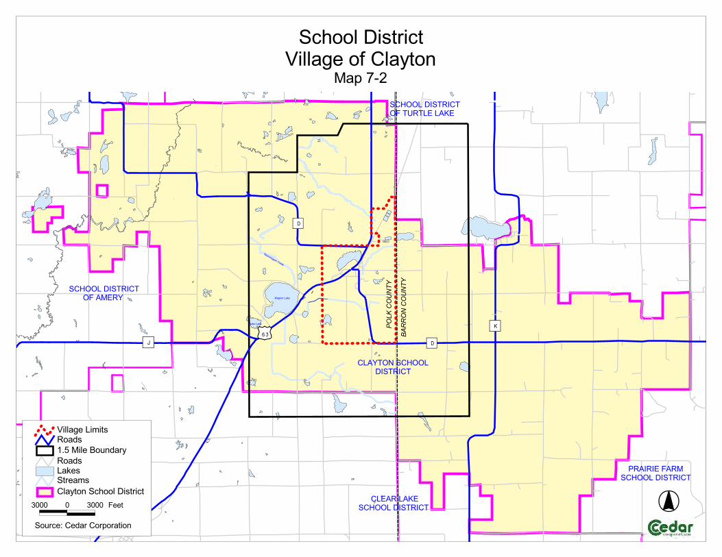
���������������� �������� ���
� �����
� ������ ��
� ����� ��
��� ������������
��������
�
��
������
�
��
���� ������
���
���
��� !�� "���#$$���%�&!%�&�
��#$$���%�&!%�&$'� ��!(�
�� (&$����#$$��%�&!%�&
��#$$���%�&!%�&�$'�&)!&���� "�
*! %!%��' !���#$$���%�&!%�&
�� ������������������� +� ��!� �,-.��������/�� ��!� ����� �����+�
0111 1 0111 '��
��/���2���� �������� ����

����������������� ������
������
��
����
�����������
����������
����������������
�������� ����
�������
�����������
����
���
��������
�
��
������
�
��
������
��
�� �� ��
��
�� ����
���
����
��� ��!�
"��#"$�����
���� ��!�
%&�"$�����
������'!����
(�����#�$
�����
(���'!���� ������
'!����
)&�"'!����
����������
�����
���
�����
*����'!����
������$�������$��!�#�'������������$������� �����#�$�����������(��#���+�"���,��+����
��������-�#��������� ���������
������������$�#���������
%&&& & %&&& -���
$���#�. ���� ����������
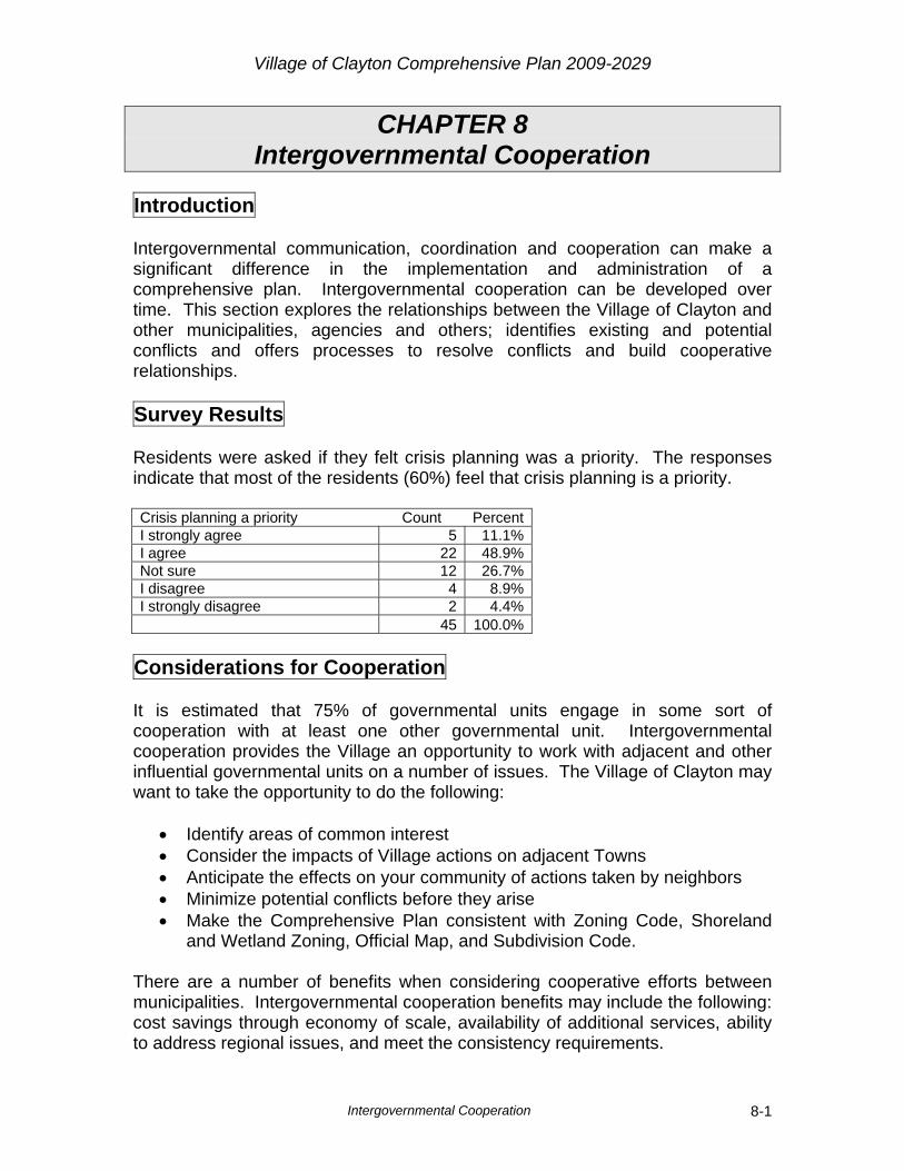
Village of Clayton Comprehensive Plan 2009-2029
Intergovernmental Cooperation 8-1
CHAPTER 8 Intergovernmental Cooperation
Introduction Intergovernmental communication, coordination and cooperation can make a significant difference in the implementation and administration of a comprehensive plan. Intergovernmental cooperation can be developed over time. This section explores the relationships between the Village of Clayton and other municipalities, agencies and others; identifies existing and potential conflicts and offers processes to resolve conflicts and build cooperative relationships. Survey Results Residents were asked if they felt crisis planning was a priority. The responses indicate that most of the residents (60%) feel that crisis planning is a priority. Crisis planning a priority Count PercentI strongly agree 5 11.1%I agree 22 48.9%Not sure 12 26.7%I disagree 4 8.9%I strongly disagree 2 4.4% 45 100.0%
Considerations for Cooperation It is estimated that 75% of governmental units engage in some sort of cooperation with at least one other governmental unit. Intergovernmental cooperation provides the Village an opportunity to work with adjacent and other influential governmental units on a number of issues. The Village of Clayton may want to take the opportunity to do the following:
• Identify areas of common interest • Consider the impacts of Village actions on adjacent Towns • Anticipate the effects on your community of actions taken by neighbors • Minimize potential conflicts before they arise • Make the Comprehensive Plan consistent with Zoning Code, Shoreland
and Wetland Zoning, Official Map, and Subdivision Code. There are a number of benefits when considering cooperative efforts between municipalities. Intergovernmental cooperation benefits may include the following: cost savings through economy of scale, availability of additional services, ability to address regional issues, and meet the consistency requirements.
Village of Clayton Comprehensive Plan 2009-2029
Intergovernmental Cooperation 8-2
Units of Government Influence on Clayton The first step in coordinating cooperation between various municipalities is to identify the adjacent municipalities and some of their existing plans. The Village of Clayton is surrounded by two units of government, the Towns of Clayton and Turtle Lake. The following is a list of adjacent Towns and plans those units of government may have or are working on: Polk County
Town of Clayton o Comprehensive Plan (in progress)
Barron County
Town of Turtle Lake o Comprehensive Plan (in progress)
School Districts The Village of Clayton lies within the Clayton School District (see Map 7-2). Both the District and the schools within the District were discussed in this Comprehensive Plan in the Utility and Community Facilities Chapter. Indianhead Technical College The Wisconsin Indianhead Technical College (WITC) provides educational programs resulting in Associate Degrees and Certificates throughout Polk County and parts Western Wisconsin. The nearest campuses are in New Richmond and Rice Lake. University of Wisconsin System The Village of Clayton is fortunate to have ample higher education opportunities nearby. Both UW – Stout and UW – River Falls are less than 50 miles away and are part of the University of Wisconsin System. University of Wisconsin - Stout UW-Stout was founded as an experiment in industrial education back in 1891. Subjects taught include business, industrial management, technology, education, human development, and art and design. Average class size is 29 students for lecture sessions and 21 for laboratory sessions. Faculty and academic staff teach more than 99% of the course sections. Less than 1% of classes are taught by teaching assistants.

Village of Clayton Comprehensive Plan 2009-2029
Intergovernmental Cooperation 8-3
University of Wisconsin - River Falls The University of Wisconsin – River Falls (UWRF) provides undergraduate, graduate and continuing education courses which support the fine arts, liberal studies, technology, business and industry. University of Wisconsin – Barron County Extension UW-Barron County in Rice Lake offers extensive academic programs for those interested in pursuing two-year degree options, as well as those who wish to transfer to a four-year institution down the road. County and Regional Government Units
Polk County West Central Wisconsin Regional Planning Commission
Polk County has a number of plans that may have an influence on future growth in the Village of Clayton. Some of the plans below were a coordinated effort between Polk County and West Central Wisconsin Regional Planning Commission. The following is a list of the various plans developed by Polk County:
Polk County Land Use Plan o This Plan was written to assist officials with decisions concerning
how the various communities in the County should preserve its desired characteristics and make positive changes in an orderly fashion.
Polk County Land and Water Management Plan
o This Plan was written to identify and rank concerns that affect the County’s Natural Resources as well as identify options for improvement implementations.
Polk County Forest Comprehensive Land Use Plan
o This Plan is intended to serve as a guide for the sustainable use and protection of the County’s Forestlands.
Polk County Outdoor Recreation Plan
Polk County Hazard Mitigation Plan
Village of Clayton Comprehensive Plan 2009-2029
Intergovernmental Cooperation 8-4
State Agencies
Wisconsin Department of Natural Resources Wisconsin Department of Transportation
The Wisconsin DNR is often the regulatory agency that is responsible for the protection and sustained management of woodlands, waterways, animal habitat and other natural resources. The Wisconsin Department of Transportation is responsible for maintaining and improving U.S. Highway 63, the main potential commercial growth corridor in the Village. For this reason, cooperation and communication between the Village of Clayton and the Wisconsin DOT are extremely important for the development of the Village. Existing Village Plans The Village does not have any current plans, but does have an Emergency Operations Plan and emergency response plans for the Water and Sewer Departments. The last update for the Emergency Operations Plan was in 2001 and should be updated on an annual basis. These plans provide proper protocols for the Village in case of a region wide emergency, power outage, or mass casualty situation. The EMS and Fire Departments also have mass casualty plans in place that will direct the various entities (emergency services) that cover the area during an emergency or catastrophic situation. Current Agreements Intergovernmental agreements can be as simple as sharing information to something more complex such as entering into contracts to provide services. The Village of Clayton recognizes the benefits of working with the surrounding communities and government agencies and is currently engaged in the following agreements:
Sanitary District: The Village provides sanitary sewer and water service to the Lake Magnor Sanitary District. School District: The School District of Clayton does provide schooling to the Village of Clayton as well as surround Towns. Polk County Emergency Management Department: The Polk County Emergency Management Department works with communities on emergency response plans and preparedness for emergency situations. In the event of

Village of Clayton Comprehensive Plan 2009-2029
Intergovernmental Cooperation 8-5
an emergency or local disaster, the Village is responsible for responding. The County will be notified and will help coordinate support efforts. The Village currently has an Emergency Operations Plan. This plan was last updated in 2004. The plan will eventually take on the name of an Emergency Response Plan (ERP) that is National Incident Management System (NIMS) compliant. The County will provide the template for the new ERP and work with local municipalities including the Village of Clayton on updating these plans. Emergency Medical Services: The Village of Clayton is provided emergency medical service by the Clear Lake Ambulance Service, which consists of the Villages of Clear Lake and Clayton and the Towns of Black Brook and Clear Lake, and portions of the Towns of Forest, in St. Croix County, Vance Creek, in Barron County, and New Haven, in Dunn County. The EMS service consists of 15 EMTs and 10 first responders that work on a volunteer basis. The Clear Lake Ambulance Service receives an average of 200 calls per year. Currently, they have one ambulance and when that ambulance is out on a call, the City of Amery provides backup services if needed. Fire Department: The Clayton Fire Department provides protection for the Village and covers approximately 40 square miles, which consists of the Village of Clayton and the Town of Clayton, and a portion of the Town of Vance Creek, in Barron County. Library: The Village of Clayton residents use the Villages of Turtle Lake and Clear Lake Public Libraries. Food Pantry: The Lifeline Food Pantry located in the Village of Clear Lake Community Center, is available to the Village of Clayton residents. The Lifeline Food Pantry provides food to local families in need. The facility is open Mondays from 8:30 a.m. to noon and Thursdays, 2:00 p.m. to 6:00 p.m.
Future Cooperative Opportunities Being bordered by the Towns of Clayton (west) and Turtle Lake (east) the Village may want to consider extraterritorial authority for portions of both Towns in the future. The Village has the ability to plan out 1.5 miles from their municipal boundary limits. That is why it is important to work together now so that in the future, if the Village decides to implement extraterritorial zoning and plat review, the foundation will be established for coordination. The Village strives for harmonious relationships with all neighboring communities and has a generally positive relationship with them. The Village may want to consider developing cooperative boundary agreements with both Towns so

Village of Clayton Comprehensive Plan 2009-2029
Intergovernmental Cooperation 8-6
future growth and development can be directed and agreed upon in a cooperative effort. There may be tasks in the future that will require collaboration between the Village of Clayton and its adjacent municipalities. Some of these efforts will cross multiple boundaries because they are related to environmental conditions in the area:
Watershed Studies Snow Plow Agreements Shared Road Maintenance Stormwater Management Plans Farmland Preservation Multi-modal Transportation Planning Natural Resource Plans
The Town of Clayton has expressed interest in sharing services in the future. Potential Future Cooperative Efforts As the Village of Clayton grows, the potential exists to have an impact on the Towns of Clayton and Turtle Lake. It is important for the Village to work with these communities so future development will be acceptable to all entities involved. One way to achieve agreeable results for future planning is to develop a joint committee, consisting of members from each municipality that meet on a quarterly or semi-annual basis to discuss these issues. Any potential future conflicts should be presented at the joint meeting. Benefits to Agreements The Village of Clayton has a lot to gain by being actively involved in intergovernmental cooperation. Some of the benefits are reducing costs, having consistency, reducing litigation, addressing regional issues, and having foresight in understanding future needed services. Possible Conflicts At this time the Village does not foresee any conflicts with either adjacent Town. Conflict Resolution When conflicts arise, it is important to address them in a manner that produces mutual understanding of the issues and creates an atmosphere under which the conflicts can be resolved successfully. The Village should consider holding joint meetings with neighboring governments and agencies to resolve future conflicts. Initial guidance may come from the Village’s Plan Commission or Village Board.
Village of Clayton Comprehensive Plan 2009-2029
Intergovernmental Cooperation 8-7
Goals, Objectives and Policies Goal
1. Encourage adjacent government units to work together to achieve the goals of this Comprehensive Plan.
Objectives
1. Promote open communication with adjacent government units. 2. Share services when it is possible and feasible for both the Village of
Clayton and neighboring municipalities. 3. Establish agreements with adjacent municipalities that will benefit all
parties involved. 4. Encourage adjacent government units to adopt and implement consistent
residential development standards, policies and review practices. 5. Provide services in a cost effective manner.
Policies
1. Promote open communication with adjacent government units. 2. Develop a consistent Park Plan among the neighboring municipalities in
order to get the most efficient use out of the existing facilities. 3. Investigate opportunities for future cooperative agreements. 4. Update and maintain Village of Clayton website. 5. Develop a joint meeting committee with the Towns of Clayton and Turtle
Lake to address Sanitary District issues and shared service agreement opportunities.
6. Consider participation in the Western Wisconsin Intergovernmental Collaborative (WWIC).
7. Provide a copy of this comprehensive plan to all surrounding or nearby local governments.
8. Work to create a cooperative understanding with adjoining towns for road maintenance.
9. Apply for available grants to provide equipment and training to reduce costs of providing Village services.
10. Continue to work with the Magnor Lake Sanitary District on future growth issues related to the sanitary system – consider having a liaison from the Village Board to sit in on Sanitary District meetings.
11. Work with the Polk County Emergency Management Department to update the Village’s Emergency Response Plan.

Village of Clayton Comprehensive Plan 2009-2029
Land Use 9-1
CHAPTER 9 Land Use
Introduction The purpose of the Land Use element is to promote orderly growth by balancing the needs of residents and property owners, while maintaining the Village’s natural resources. The Land Use Chapter is to identify and analyze how land within the Village of Clayton is being used at a specific point in time and to help recommend appropriate uses for the land in the future. The information in the Land Use Chapter act as a guide for future public and private land use decisions. The chapter inventories and maps existing land use patterns and helps in analyzing and understanding the influences on these patterns. A well thought-out land use plan will help the Village to make zoning decisions, evaluate development proposals, and provide a vision that provides the necessary background information for local government, residents, business owners, and developers to make consistent and informed decisions. Survey Results The Village should purchase land for future growth… Count Percent I strongly agree 6 17.1%I agree 10 28.6%Not sure 12 34.3%I disagree 6 17.1%I strongly disagree 1 2.9% 35 100.0% More respondents were in favor (45.7%) of the Village purchasing land for future growth than were against it (20%). Development should be limited to preserve our natural environment… Count Percent I strongly agree 8 19.0%I agree 16 38.1%Not sure 11 26.2%I disagree 6 14.3%I strongly disagree 1 2.4% 42 100.0% Over half (57.1%) of the respondents feel the Village development should be limited to preserve our natural environment.
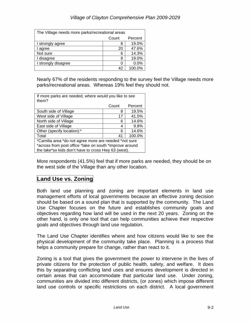
Village of Clayton Comprehensive Plan 2009-2029
Land Use 9-2
The Village needs more parks/recreational areas Count Percent I strongly agree 8 19.0%I agree 20 47.6%Not sure 6 14.3%I disagree 8 19.0%I strongly disagree 0 0.0% 42 100.0% Nearly 67% of the residents responding to the survey feel the Village needs more parks/recreational areas. Whereas 19% feel they should not. If more parks are needed, where would you like to see them? Count Percent South side of Village 8 19.5%West side of Village 17 41.5%North side of Village 6 14.6%East side of Village 4 9.8%Other (specify location):* 6 14.6%Total 41 100.0%*Camilia area *do not agree more are needed *not sure *across from post office *lake on south *improve around the lake*so kids don’t have to cross Hwy 63 (west). More respondents (41.5%) feel that if more parks are needed, they should be on the west side of the Village than any other location. Land Use vs. Zoning Both land use planning and zoning are important elements in land use management efforts of local governments because an effective zoning decision should be based on a sound plan that is supported by the community. The Land Use Chapter focuses on the future and establishes community goals and objectives regarding how land will be used in the next 20 years. Zoning on the other hand, is only one tool that can help communities achieve their respective goals and objectives through land use regulation. The Land Use Chapter identifies where and how citizens would like to see the physical development of the community take place. Planning is a process that helps a community prepare for change, rather than react to it. Zoning is a tool that gives the government the power to intervene in the lives of private citizens for the protection of public health, safety, and welfare. It does this by separating conflicting land uses and ensures development is directed in certain areas that can accommodate that particular land use. Under zoning, communities are divided into different districts, (or zones) which impose different land use controls or specific restrictions on each district. A local government

Village of Clayton Comprehensive Plan 2009-2029
Land Use 9-3
comprehensive plan will likely be more successful if the plan and zoning ordinance are well integrated and if they accommodate the interests and needs of neighboring communities. In summary, zoning is a regulatory tool used to regulate and enforce comprehensive plans. The development of a comprehensive plan ensures effective and consistent zoning decisions at the local level. The Land Use Chapter is a useful tool for decision makers to guide growth and development of the community and should be consistent with future zoning decisions. Existing Land Use Analysis The purpose of the existing land use analysis is to identify existing land uses and land use patterns (see Map 9-1). Creating an existing land use map will help determine future land uses and identify existing and/or potential land use conflicts. Below is a brief description of land use patterns for the following categories. Table 9-1 - Current Land Use Current Land Use Acres Percent Single Family Residential 155.8 8.0%Multiple Family Residential 19.7 1.0%Commercial 26.3 1.4%Industrial 73.3 3.8%Institutional 77.2 4.0%Parks/Recreation 17.8 0.9%Agricultural 928.8 47.9%Undeveloped 641.8 33.1%Total 1,940.7 100.0%Source: Village of Clayton Plan Commission, Cedar Corporation
Single Family Residential: The majority of housing options in the Village of Clayton are single family homes. Single family homes occupy approximately 156 acres (8.0% of total acreage) within the Village and can be found throughout the Village. Multiple Family Residential: The Village of Clayton has 20 acres of land (1.0% of total acreage) devoted to multi-family housing. Multi-family homes consist of apartments, twin homes, and condominiums and typically are higher density developments compared to single family. Most of this type of land can be found in the northern portion of the Village. Commercial: Commercial properties create employment opportunities within the Village and provide residents with goods and services. In general, they are less

Village of Clayton Comprehensive Plan 2009-2029
Land Use 9-4
expensive to provide services for than residential properties. The Village of Clayton has a mix of downtown commercial and highway commercial properties. The Village has 26 acres of commercial businesses (1.4% of total acreage). These properties are mainly located along U.S. Highway 63 as well as Prentice Street. Industrial: Industrial development offers job opportunities and a significant source of tax revenue for municipalities. Like commercial properties, they also require fewer services. The Village of Clayton does have some industry within the Village. Most of the industrial land is located on the west side of the Village. There are approximately 77 acres of industrial land (4.0% of total acreage) in the Village. An Industrial Tax Incremental Finance District has been established by the Village to provide assistance/incentives for industrial businesses within the District. Institutional: Institutions provide valuable services to a community. There are 73 acres of institutional land in the Village of Clayton (3.8% of total acreage). These properties include the schools, churches, Village Hall, Municipal Building - Police and Fire Department, cemetery, and water tower. Typically, institutional land uses are scattered throughout a community. Parks/Recreation: Park and Recreation land provides valuable passive and active recreational opportunities for area residents and is considered a measure of the quality of life a community has to offer. The Village has 18 acres of park land (0.9% of total acreage). The park land consists of open space with lakes, ballpark, parking, restrooms, and a dock and picnic area that is located in the northwestern part of the Village. Agricultural: Agricultural land is land that is being actively farmed. The Village has 929 acres of agricultural land (47.9% of total acreage). Most of this land occupies a good portion of the southern and western portion of the Village. Undeveloped: There are approximately 642 acres of undeveloped parcels (33.1% of total acreage) within the Village. Undeveloped lands are important to a community as they provide a “land bank” for future growth needs. Most of the undeveloped properties in the Village of Clayton are lands that would be considered open space and aren’t used for farming, but may include wetlands, slopes, or other undevelopable lands. Existing Land Use Patterns and Influence on Patterns Land use patterns in the Village of Clayton have been influenced by two main conditions. First, the railroad tracks (now abandoned) that used to go through the Village provided a transportation system in the past for goods and services. This was a major influence on how the Village grew. This has allowed a number of industries such as canning and logging to start up in the area.

Village of Clayton Comprehensive Plan 2009-2029
Land Use 9-5
Second, the Village is split by U.S. Highway 63, a main north and south transportation corridor in Northwestern Wisconsin. This provides a transportation route for the Village to attract workers that can commute to the Village and for industries and businesses for shipping their goods. Land Value One of the most important costs associated with development is the price of land. Land values vary greatly depending on the current use that they have or use that it may have in the future. Generally, an acre of rural farmland won’t have the same value as an acre of commercial land in the Village. An analysis of price per acre based on how it is taxed is done by the Wisconsin Department of Revenue each year (Statement of Assessment). The latest that this information is available is 2008. Table 9-2 2008 Land Values
Land Use Category
2008 Land Value per Acre
2008 Improvement
Value per Acre
2008 Total Value per Acre
2008 Total Land and Improvements Value of the Entire
Village Residential $28,342 $189,256 $217,598 $14,361,500Commercial $27,175 $154,963 $182,138 $4,371,300Manufacturing $737 $12,919 $13,657 $1,543,200Agricultural $151 $0 $151 $139,200Undeveloped $446 $0 $446 $110,500Ag Forest $845 $0 $845 $159,700Forest $1,755 $0 $1,755 $184,300Source: 2008 Statement of Assessment - Wisconsin Dept. of Revenue
In the Village of Clayton, the highest land values are for Residential at $28,342 per acre. The Commercial land values per acre is just slightly less at $27,175. Limitations for Development The primary issues that could impact further growth and development of the Village of Clayton are natural limitations such as topography, slopes, wetlands, and floodplains. These natural limitations can restrict some areas in and around the Village, making them unbuildable. Redevelopment Opportunities Redevelopment opportunities typically occur in Brownfield areas or locations that have been previously contaminated. The Village of Clayton has a few known sites that have some environmental groundwater or soil contamination, often caused by underground storage tanks. For those property owners that are interested in cleaning up their property there are a number of Brownfield cleanup grants available through the DNR and EPA.
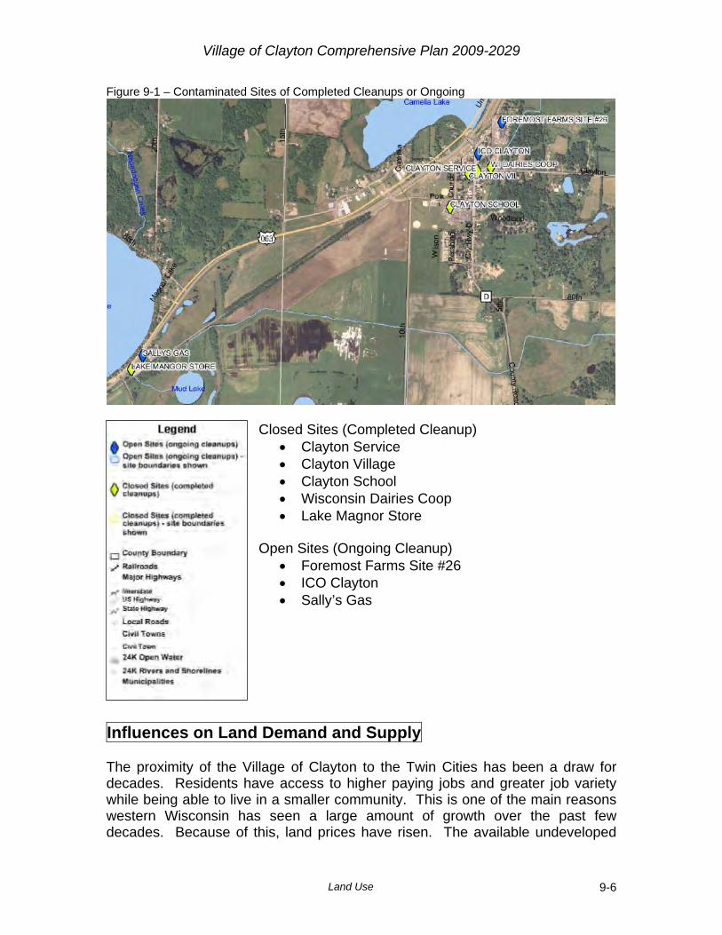
Village of Clayton Comprehensive Plan 2009-2029
Land Use 9-6
Figure 9-1 – Contaminated Sites of Completed Cleanups or Ongoing
Closed Sites (Completed Cleanup)
• Clayton Service • Clayton Village • Clayton School • Wisconsin Dairies Coop • Lake Magnor Store
Open Sites (Ongoing Cleanup)
• Foremost Farms Site #26 • ICO Clayton • Sally’s Gas
Influences on Land Demand and Supply The proximity of the Village of Clayton to the Twin Cities has been a draw for decades. Residents have access to higher paying jobs and greater job variety while being able to live in a smaller community. This is one of the main reasons western Wisconsin has seen a large amount of growth over the past few decades. Because of this, land prices have risen. The available undeveloped

Village of Clayton Comprehensive Plan 2009-2029
Land Use 9-7
land in the Village offers a variety of opportunities for future residential and other commercial development. Potential Land Use Conflicts Land use conflicts occur when incompatible land uses cause a negative effect. Currently, there are a few areas of incompatible land uses in the Village. This was the result of commercial land use being across from residential land uses and using the commercial property for outside storage. The Village is working to address these issues to protect property owners in the future by revising their zoning code. One potential land use conflict for the Village is future development taking up available capacity of the Waste Water Treatment Plan. If not planned for properly, some types of development could take up a significant portion of the treatment plant’s capacity limiting the Village’s ability to grow in other areas. Future Land Needs Analysis The Village of Clayton future land needs analysis will be based on potential residential needs. Table 9-3 shows the amount of additional households which would be needed based on population and household projections by the Wisconsin Department of Administration. If the projections are accurate, the Village will have an additional 54 households between 2005 and 2025. Table 9-3 - Housing Forecasts Year 2000 2005 2010 2015 2020 2025 Population 507 531 576 595 614 633Persons Per Household 2.55 2.52 2.53 2.46 2.41 2.39Total Occupied Housing Units 199 211 228 242 255 265
Additional Units Needed - 12 17 14 13 10Source: WI Dept of Administration
For our projections we will assume a half acre per lot (factoring in roads, parks, etc.). So if 54 lots or households are needed, 27 additional acres of residential land will be needed. Currently, the Village has about 635 acres of undeveloped land plus 944 acres of agricultural land. Some of this undeveloped and agricultural land is unbuildable due to natural limitations, being located on a closed landfill, or not being zoned for residential development.
Village of Clayton Comprehensive Plan 2009-2029
Land Use 9-8
Smart Growth Areas The term Smart Growth Areas means “an area that will enable the development and redevelopment of lands with existing infrastructure and municipal, state, and utility services, where practicable, or that will encourage efficient development patterns that are both contiguous to existing development and at densities which have relatively low municipal, state governmental and utility costs.” (WI Statute: 16.965) It is important for the Village of Clayton to consider areas that are ideal for growth. One way to do that is to look at factors such as wetlands and steep slopes that limit where growth can go and areas that are cost effective for expanding infrastructure. Map 9-2 shows the areas that should be protected as well as areas that would require a lift station. Due to these conditions and availability of land, there is not a need to annex land in the foreseeable future, but there will likely be a need to expand the sanitary service area especially in the southern portion of the Village. Future Land Uses Table 9-4 projects the future land use acres based on the zoning at full build-out within the current Village Limits (see Map 9-3). The future land use map should be consulted when addressing future rezoning requests and land use issues. It is not meant to be a tool for a mass rezoning of Village properties in order to match the Future Land Use map. Based on the available land within the Village Limits, there is plenty of land to take on growth for the foreseeable future Table 9-4 - Future Land Use Future Land Use Acres Percent Single Family Residential 282.4 14.6%Multiple Family Residential 19.7 1.0%Commercial 36 1.9%Industrial 84.8 4.4%Institutional 77.2 4.0%Parks 30.1 1.6%Agricultural 863.4 44.5%Undeveloped 547.7 28.2%Total 1,940.7 100.0%Source: Clayton Plan Commission and Cedar Corporation

Village of Clayton Comprehensive Plan 2009-2029
Land Use 9-9
Trends in Land Supply and Demand Table 9-5 shows projected land use needs in five year increments in the Village of Clayton. Overall, there is plenty of vacant land available for future growth in the Village. The largest need for land in the future will be for residential development. The Village will need roughly 8 acres of land every 5 years for residential use based on the Household Forecasts in Table 9-3 and assuming the lot sizes will average approximately one-half acre. Table 9-5 - Projected Land Use Needs in Acres Year *2008 2010 2015 2020 2025 Total
Residential 176 178 185 194 203
• Acres 2 7 9 9 27
Commercial 26 26 27 29 30
• Acres 0 1 2 1 4
Industrial 73 74 77 80 84
• Acres 1 3 3 4 11
Agricultural/Undeveloped 1,571 1,568 1,557 1,543 1,529
• Acres -3 -11 -14 -14 -42
Source: * 2008 is Existing Land Use calculations. Alternatives to Annexation Although unlikely, it is possible that the Towns of Clayton and Turtle Lake could be developed up to the Village of Clayton’s legal boundary. This would greatly decrease the chance that land would be annexed in the future. The Village could support two actions that would increase the amount of residential land in the Village if desired. First, the Village could create a residential zoning classification that reduces the minimum lot size. Second, the Village may encourage redevelopment of some areas to accommodate higher residential densities. Goals, Objectives, and Policies Goal
1. Ensure orderly growth within the Village of Clayton.
Objectives 1. Avoid land use conflicts that may decrease the value of properties. 2. Preserve neighborhoods.
Village of Clayton Comprehensive Plan 2009-2029
Land Use 9-10
Policies 1. Use the Village’s Land Use Plan as a guide for decision making. 2. Utilize “Smart Growth” areas for cost efficient growth when feasible. 3. Consider redeveloping areas of cleaned up contaminated sites where
feasible. 4. Consider the utility capacities such as water tower, WWTP, wells, and
other infrastructure when approving future developments and subdivisions.
5. Consider designating land for future parks.

�����������
����������
����
���
��������
�
��
������
�
��
����
�� ��
��
����������
�������
�������
����������
����
������
�����
��������������
�����
������
��
��
�
�����������
������
�����
��
��������
�������������
�������������� �!��������"��������
#�$�%&�
�������������� ��������'������(� ��������#����$���'������(� ������������������)��� �����)� ������������������������� *(�����������������$��
������ ��� ������ (������"�+��(��� !������������ ������������
���� � ���� '���
������,����������$��������

�����������
����������
����
���
��������
�
��
������
�
��
����
�� ��
��
����������
�������
�������
����������
����
������
�����
��������������
�����
������
��
��
�
�����������
������
�����
��
��������
�������������
���������������� !��������"��������
#�$�%&'
(�����������) ��������(������*� ��������#����$���(������*� ������������������+��� �����+� ������������������������� ,*���������)�������$��
������
-������
���$� �'�&�'���.*�./0'��1��.*�./0
��� ������ *������"�-��*��� !����������������������������!������������ ������������
���� � ���� (���
������2����������$��������
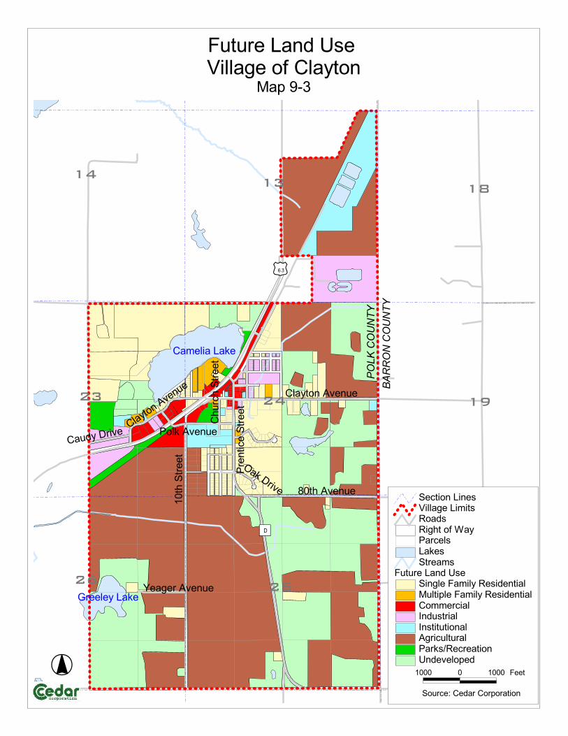
�����������
����������
����
���
��������
�
��
������
�
��
����
�� ��
��
����������
�������
�������
����������
����������
�����
��������������
�����������
��
��
�
�����������
�������������
��������
�������������
������������ !�"��������#��������
$�%�&'(
������������ !���������������)�!��������$����%����������)�!������������������*���!�����*�!�������������������������!+)��������� �������%��
������!���!������!)������#�,��)���!"������������!������������!
���� � ���� ����
������-����������%��������

Village of Clayton Comprehensive Plan 2009-2029
Plan Implementation 10-1
CHAPTER 10 Plan Implementation
Introduction The development and adoption of a Comprehensive Plan becomes meaningful only if the Plan is implemented. The Plan is best implemented when it is used as a guide for future decisions and kept current with new information, as it becomes available. Beyond the maintenance of the Plan itself, the Plan can be used to guide the Village’s development decisions for zoning, subdivision regulations and intergovernmental relations. Survey Results Nearly half (48.8%) of the respondents felt that the Village communicates adequately with Village residents. Communication from the Village is adequate Count PercentI strongly agree 1 2.3%I agree 20 46.5%Not sure 11 25.6%I disagree 8 18.6%I strongly disagree 3 7.0% 43 100.0%
The top preferred method of communication from the Village is a newsletter (33). Best way to communicate Count Website 11E-mail announcements 5Newsletters 33Newspaper notices 21Public meetings 19Other (NARRATIVE)*
*Word of mouth, open meetings, door to door Available Implementation Tools Zoning Ordinances Zoning Ordinances control the use of the land. They are used to ensure that land uses are compatible with one another with regard to type and spatial layout. Zoning can also direct growth in appropriate areas and protect existing property against zoning conflicts.
Village of Clayton Comprehensive Plan 2009-2029
Plan Implementation 10-2
Subdivision Ordinances Subdivision Ordinances control the development of land. They enable a community to control the subdivision of land by a developer. A community can specify lot sizes, density, design features, infrastructure, etc. They can also help guarantee that sufficient existing and planned public utilities and facilities such as schools, parks and emergency services will be there for future growth. Building and Housing Codes Building codes control the construction of buildings. The codes are put in place so that newly constructed and remodeled buildings conform to state building, plumbing, and electrical codes. Housing codes are passed to discourage housing from becoming dilapidated and blighted. Official Map Ordinances The official map is a legal document. It shows existing and future streets, right-of-ways, parks, school sites, and other public facilities. It ensures that future development does not infringe on planned streets and public facilities. In conjunction with the Comprehensive Plan, the Official Map can be a very effective implementation tool. Sign Ordinances A sign ordinance controls the placement of signs within a community and contributes to the community’s aesthetics and character. The ordinance restricts the size, location, and types of signs. As well as the material a sign can be made of. Site Plan Review A Site Plan Review is mostly concerned with residential land use, commercial and industrial properties. It is in place to make sure storm drainage, parking, and setback requirements are met. Stormwater Management Ordinances Stormwater management ordinances or plans are designed to address the quality and quantity of stormwater runoff and its impact on water resources. Communities can adopt stormwater management plans or ordinances. The plans or ordinances are used to address erosion and stormwater runoff during construction and post-constructions phases of development. Communities also use these to address the quantity and quality of stormwater runoff and its impact on water resources. They can also be used to address flooding issues. Historic Preservation Ordinances A Historic Preservation Ordinance aims to protect historic buildings, structures, and districts. The Village may address historical accuracy when designated buildings, structures, or districts are rehabilitated or redeveloped. It is designed to protect communities from development that would detract from its appearance and character.

Village of Clayton Comprehensive Plan 2009-2029
Plan Implementation 10-3
Access Control Ordinances An Access Control Ordinance provides for safe and efficient movement of traffic and provides safe access to land adjacent to roadways. Through this, land development along roadways can be managed. State, county, and local governments often use this to implement roadway traffic, access, and development issues. Floodplain Ordinances Floodplain Ordinances control the use of land within a floodplain. This type of ordinance is used to minimize expenditures for flood control projects, business interruptions, and damage to public facilities as well as to insure the proper management and development of the shoreland of all navigable lakes, ponds, flowages, rivers and streams and the surrounding floodplain. The Floodplain Ordinance can also be used as a tool to discourage the victimization of unwary land and homebuyers. Transportation Plans A transportation plan is the document to follow when new subdivisions are developed. Existing and future road corridors are mapped and should be followed to form continuity between existing and future development. The State requires that a PASER Study be completed every three years. Updating the PASER Study would be a component of a Transportation Plan. Code of Ordinances A Code of Ordinances covers a wide variety of regulations to help protect the Village. Some of the issues covered in the Code include: Building Construction, Citations, Emergency Management, Impact Fees, Parks, Subdivision of Land, and Zoning. Transfer of Development Rights (TDR) A TDR Program allows land owners to transfer development rights from a sending area (area to be protected in perpetuity) to a receiving area (land to be developed). This program would allow the land owners in the Village to permanently preserve the best farmland and still be able to get an equitable value for the development rights on their land. Design Review Ordinance A Design Review Ordinance protects property rights and values, enhances important environmental features of the Village and ensures that the general appearance of buildings and site improvements are consistent with the goals of the Village. A Design Review Ordinance could achieve the following: require adequate landscaping, ensure proper circulation within parking areas, provide sidewalks to meet pedestrian needs, and encouraging architecture that responds to the needs of the users and presents an attractive exterior to the public and adjoining property owners.

Village of Clayton Comprehensive Plan 2009-2029
Plan Implementation 10-4
Driveway Ordinance Driveway Ordinance provides for safe and efficient movement of traffic and provides safe access to land adjacent to roadways. The Village of Clayton does have a Driveway Ordinance in place as part of their Code of Ordinances. Financial Tools Capital Improvements Program (CIP) A CIP allows you to prioritize and budget monies for future improvements to public buildings, roads, parks, and utilities. It examines available tax dollars and future revenues to predict expenditures for the future. Tax Increment Financing (TIF) A TIF program allows the Village to use the taxes collected on the increase in the value of taxable property for financing additional property improvements. This tool is used by communities to capture future increases in property tax revenue and make these dollars available as a development incentive, subsidy or investment. Villages can create TIF districts to encourage economic development in distressed or underdeveloped areas where development would not otherwise occur. Community Development Block Grants (CDBG) CDBGs are used to improve local housing and public buildings. Several state and federal programs are available for various housing needs. Impact Fees Impact Fees can be used to offset the cost of infrastructure needs in a community. New developments will be charged impact fees per dwelling. In turn, that money is used to upgrade wastewater treatment plants, libraries, parks, police departments, utilities, and roads. This shifts much of the financial burden of these upgrades to the people that initiate them. Regional Loan Fund Programs Once the Village creates a committee to locally review requests for grant dollars, they can participate in the Regional Loan Fund Program. Funds from this program can be used to help local businesses improve their facades, startup, and create more jobs. Below is a brief description of those programs:
Downtown Façade Loan Program – provides financial assistance to encourage property and business owners in core downtowns to revitalize downtown commercial buildings.
MicroLoan Fund Program – provides small loans to start-up, newly established, or growing small businesses. The key objective is to assist business owners, who have traditionally had difficulty accessing debt financing, by affording them another alternative for obtaining credit.
Revolving Loan Fund – is a flexible source of loan funds for commercial and industrial projects that create quality jobs and increase tax base.

Village of Clayton Comprehensive Plan 2009-2029
Plan Implementation 10-5
Existing Implementation Tools The Village does have number of adopted ordinances and is currently working on their zoning and subdivision ordinance at the time the Comprehensive Plan was adopted. Below is a summary of those implementation tools: Comprehensive Plan The Plan is meant to be a guide for all types of community development decisions. With adoption by the Village Board and County Board, the Plan becomes the official policy of the Village for planning and development issues in Clayton. Development of a community happens incrementally, one development, and sometimes, one parcel at a time. In addition, decision-making committees and boards responsible for making development decisions change over time. Therefore, using the Plan as a guide for overall development decisions will build consistency, continuity and legal protections into the development process. Zoning Code The Village of Clayton is in the process of rewriting their Zoning Code and revising their Zoning Map. Zoning classifications are currently in place to generally carry out the land use provisions of the Plan. Once again, the Village should use the goals, objectives and policies of the Plan as a guide for decisions for rezonings, special exceptions and variances under the Zoning Ordinance. Currently, the Future Land Use map is consistent with the revised Zoning Map. This does not mean that rezonings cannot take place, but should make the following considerations when reviewing a potential rezoning:
A rezoning would make the use of the property more compatible to adjacent uses.
Not rezoning would cause an unnecessary hardship on the property owner.
A variance or conditional use is not permitted under the requirements of the existing zone of the land of the property owner requesting the rezoning.
Local Action Local Citizens The Village of Clayton encourages ideas from its citizens that will result in the betterment of the community. Throughout the planning process, public participation has been encouraged through several means including a Community Development Survey, newspaper notices, and monthly Planning Commission meetings. This process does not end with the adoption of the Comprehensive Plan. Situations change and new ideas evolve and with this, the Comprehensive Plan will need to be updated. Therefore, public participation will always be needed and welcomed.
Village of Clayton Comprehensive Plan 2009-2029
Plan Implementation 10-6
Planning Commission The Village of Clayton’s Plan Commission’s role in the planning process is to review all pertinent information, give input, and act as advisory to the Village Board. The recommendations of the Plan Commission that are presented in this Comprehensive Plan will guide the future direction of growth and development in the Village of Clayton in a manner which benefits its citizens and minimizes the Village’s costs. Village Board In order for the Comprehensive Plan to be implemented, the Village Board must formally adopt the Plan. Upon this happening, the Comprehensive Plan becomes the official guide for decision-making by Village officials. As chief policy makers, the board is also responsible for establishing and actively supporting a continuing planning program. Element Integration/Consistency Any inconsistencies among Elements of this Comprehensive Plan have been addressed during the development of said Plan. All of the goals, objectives and policies within this Comprehensive Plan as well as any maps, analysis and appendices have been presented and reviewed by members of the Village of Clayton’s Plan Commission. Policies from each element were assessed to ensure they would address the goals and objectives of each element. Future revisions of this Plan shall take the same considerations during the updating process. Plan Amendments and Updates Comprehensive Plans are meant to be very dynamic. The Village of Clayton will also require updates and changes when it is necessary. Wisconsin State Statute section 66.1001(2)(i), states that the comprehensive plan shall be updated no less than once every 10 years. Because this plan was adopted in 2009, a complete update will be required of all nine elements in 2019. Revisions or amendments to the plan can be addressed at any time by following the procedures for adopting a comprehensive plan under Wisconsin Statutes and the adapted public participation procedures. It is recommended that the Comprehensive Plan be reviewed yearly. Village Board members should be willing to address minor changes at any time when the situation is warranted. On-going evaluation and monitoring is important to maintain the integrity of the Comprehensive Plan. The needs of the community today may not match the needs 20 years from now. Therefore, the Plan Commission will need to monitor the progress of the Plan implementation. A potentially large update may be needed after reviewing 2010 census data. Communication The Village does strive to communicate with local residents on community activities, Village Board and Plan Commission activities, and provide easy
Village of Clayton Comprehensive Plan 2009-2029
Plan Implementation 10-7
access to information. The Village does have a website that can be viewed at www.villageofclayton.com/. Typically, all meetings held by the Village Board and Plan Commission are open to the public. Potential Implementation Tools
Transportation Plan Comprehensive Zoning Code Subdivision Ordinance CIP Program Park Plan Sidewalk/Trail Ordinance Historic Preservation Official Map TDR Program Regional Loan Fund Programs
Goals, Objectives, and Policies Goal
1. Continue the ongoing implementation of the Village’s Plans including the Comprehensive Plan and make sure it is updated accordingly.
Objectives 1. Establish a set schedule of when to review and update each plan. 2. Upon review of each Plan, amend them when necessary. 3. Look at other possible types of plans that could be beneficial to the
Village.
Policies 1. Update Comprehensive Plan every five years. Compare data such as
housing and demographics information to make sure they follow the Plan; if not, adjust the Comprehensive Plan to coincide with the new data.
2. Develop an Official Village of Clayton Map. Goal
2. Consider new implementation tools to guide future growth.
Objectives 1. Look at other possible types of plans that could be beneficial to the
Village. 2. Consider other possible types of ordinances that could be implemented.
Village of Clayton Comprehensive Plan 2009-2029
Plan Implementation 10-8
Policies 1. Maintain existing committee to review Downtown Façade Loan Program,
MicroLoan Fund Program, and Regional Loan Fund requests. 2. Develop Implementation Task List and Schedule.

APPENDIX A Public Participation Plan