Planning Application - Washington Savage/Application/Updated Application May...Planning Application...
95
Planning Application PRE-APPLICATION, PRE-APP WAIVER, PRE-APP CRITICAL AREAS (PIR) CITY OF VANCOUVER Submit to: 415 W 6 th ST ~ Vancouver, WA 98660 PO Box 1995 ~ Vancouver, WA 98668 Phone (360) 487-7800 Fax (360) 487-7808 www.cityofvancouver.us COMMERCIAL, INDUSTRIAL & MULTI-FAMILY *ONLY* Do you anticipate managing/storing any chemicals, petroleum products or automotive fluids on the site? If yes, please describe: Will this facility process wastewater to the sanitary sewer system? If yes, please describe: Which NAICS classification(s) in VMC 20.440.030 (Table 20.440-2) best describes your proposed use? (Industrial only) PROJECT QUESTIONS Please list specific questions and/or issues you wish to have answered at the Pre-Application conference: 1. 2. 3. 4. NOTICE I/we understand that per VMC 20.210.090 (Review for Counter Complete Status), if it is determined that the application is not complete, the City shall immediately reject and return the application. I/we agree that City of Vancouver staff may enter upon the subject property at any reasonable time to consider the merits of the application, to take photographs and to post public notices. REQUIRED SIGNATURES Applicant Signature: Print Name: Date: Property Owner Signature: Print Name: Date: See following page for minimum submittal requirements OCCUPANCY TYPE Single-Family Commercial Multi-Family Industrial Critical Area WORK TYPE Pre-Application Pre-Application Waiver Request ADDITIONAL INFORMATION Infill Project: Yes No If yes, tier level: Tier I Tier II Lot Acreage/sf: # of lots: (if applicable) Comp Plan: Zoning Designation: PROJECT SITE INFORMATION AND LOCATION Project site address: Suite/bldg./apt #: Project name: Job #: Tax Assessor Serial Number: PROJECT DESCRIPTION Briefly describe the proposed project including the general physical features of the site and current uses. (Provide a more detailed description in the project narrative) APPLICANT CONTACT PERSON Business name: Contact name: Address: City/State/Zip: Phone: Fax: E-mail (required): PROPERTY OWNER TENANT Name: Address: City/State/Zip: Phone: Fax: Page 1 of 2
Transcript of Planning Application - Washington Savage/Application/Updated Application May...Planning Application...

Planning Application PRE-APPLICATION, PRE-APP WAIVER, PRE-APP CRITICAL AREAS (PIR)
CITY OF VANCOUVER Submit to: 415 W 6th ST ~ Vancouver, WA 98660 PO Box 1995 ~ Vancouver, WA 98668 Phone (360) 487-7800 Fax (360) 487-7808 www.cityofvancouver.us
COMMERCIAL, INDUSTRIAL & MULTI-FAMILY *ONLY*
Do you anticipate managing/storing any chemicals, petroleum products or automotive fluids on the site? If yes, please describe:
Will this facility process wastewater to the sanitary sewer system? If yes, please describe:
Which NAICS classification(s) in VMC 20.440.030 (Table 20.440-2) best describes your proposed use? (Industrial only)
PROJECT QUESTIONS Please list specific questions and/or issues you wish to have answered at the
Pre-Application conference: 1.
2.
3.
4.
NOTICE
I/we understand that per VMC 20.210.090 (Review for Counter Complete Status), if it is determined that the application is not complete, the City shall
immediately reject and return the application. I/we agree that City of Vancouver staff may enter upon the subject property at any reasonable time to consider the merits of the application, to take photographs and to post public
notices.
REQUIRED SIGNATURES Applicant Signature:
Print Name: Date:
Property Owner Signature:
Print Name: Date:
See following page for minimum submittal requirements
OCCUPANCY TYPE
Single-Family Commercial Multi-Family
Industrial Critical Area
WORK TYPE
Pre-Application Pre-Application Waiver Request
ADDITIONAL INFORMATION
Infill Project: Yes No If yes, tier level: Tier I Tier II
Lot Acreage/sf: # of lots: (if applicable)
Comp Plan: Zoning Designation:
PROJECT SITE INFORMATION AND LOCATION
Project site address:
Suite/bldg./apt #:
Project name:
Job #:
Tax Assessor Serial Number:
PROJECT DESCRIPTION Briefly describe the proposed project including the general physical features of the site and current uses. (Provide a more detailed description in the project narrative)
APPLICANT CONTACT PERSON
Business name:
Contact name:
Address:
City/State/Zip:
Phone: Fax:
E-mail (required):
PROPERTY OWNER TENANT
Name:
Address:
City/State/Zip:
Phone: Fax: Page 1 of 2
Updated 4/17/2013
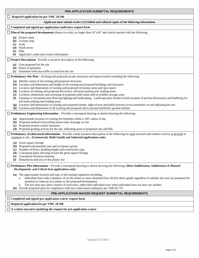
PRE-APPLICATION SUBMITTAL REQUIREMENTS
Required application fee per VMC 20.180
Applicant must submit twelve (12) folded and collated copies of the following information
Completed and signed pre-application conference request form
Plan of the proposed development (drawn to scale), no larger than 24”x36” and clearly marked with the following:
(a) Project name (b) Vicinity map (c) Scale (d) North arrow (e) Date (f) Applicant’s name and contact information
Project Description: Provide a narrative description of the following:
(a) Uses proposed for the site (b) Hours of operation (c) Estimated vehicular traffic to and from the site
Preliminary Site Plan – Existing and proposed on-site structures and improvements including the following: (a) Identify use(s) of all existing and proposed structures (b) Location and dimensions and height of all existing and proposed buildings and structures (c) Location and dimensions of existing and proposed recreation areas and open space (d) Location of existing and proposed driveways, off-street parking and loading areas. (e) Location, dimensions and screening of proposed solid waste and recyclables storage areas (f) Existing or conceptual plan showing lighting and landscaping. Landscape plan should include location of private driveway(s) and buffering for
off-street parking and loading areas (g) Location and dimensions of existing and proposed streets, right-of-way and public/private access easements on and adjoining the site (h) Location and dimensions of all existing and proposed above ground and below ground utilities
Preliminary Engineering Information - Provide a conceptual drawing or sketch showing the following:
(a) Approximate location of existing fire hydrants within a 100’ radius of site (b) Proposed method of providing storm-water drainage on site (c) Proposed erosion control measures (d) Proposed grading activity for the site, indicating areas of proposed cuts and fills
Preliminary Architectural Information – Provide a brief narrative description of the following for each structure and outdoor activity to be built or retained on site: (Commercial, Multi-Family and Industrial applications only)
(a) Gross square footage (b) Proposed and potential uses and occupancy group (c) Number of floors, building height and construction type (d) Conceptual plans showing at least the gross square footage (e) Conceptual elevation drawing (f) Dimensions and area of the project site
Preliminary Plat Information – Provide a conceptual drawing or sketch showing the following: (Short Subdivisions, Subdivisions & Planned Developments and Critical Area applications only)
(a) The approximate location and type of all existing vegetation including; a. Individual trees with a diameter of six (6) inches or more measured four (4) feet above grade regardless of whether the trees are proposed for
retention or removal as it relates to the proposed development b. The tree plan may show clusters of such trees, rather than individual trees when individual trees are near one another
(b) Provide proposed plan for compliance with tree conservation ordinance per VMC20.770
PRE-APPLICATION WAIVER REQUEST SUBMITTAL REQUIREMENTS
Completed and signed pre-application waiver request form
Required application fee per VMC 20.180
A written narrative justifying the request for pre-application waiver
Page 2 of 2
Pre-Application Conference Request Tesoro Savage Petroleum Terminal LLC Vancouver, Washington Submitted to City of Vancouver Land Use Planning 415 West Sixth Street Vancouver, Washington 98660 June 2013 Submitted by BergerABAM 1111 Main Street, Suite 300 Vancouver, Washington 98660 Job No. A13.0267.00

Tesoro Savage Petroleum Terminal LLC BergerABAM A13.0267
Pre‐Application Conference Request June 2013
Vancouver, Washington Page i
PRE-APPLICATION CONFERENCE REQUEST
Tesoro Savage Petroleum Terminal LLC Vancouver, Washington
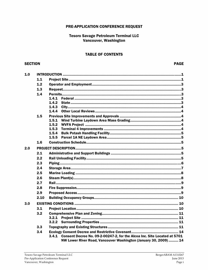
TABLE OF CONTENTS SECTION PAGE
1.0 INTRODUCTION .........................................................................................................................1 1.1 Project Site ...................................................................................................................1 1.2 Operator and Employment ...........................................................................................3 1.3 Request .........................................................................................................................3 1.4 Permits..........................................................................................................................3
1.4.1 Federal .............................................................................................................3 1.4.2 State .................................................................................................................3 1.4.3 City ....................................................................................................................4 1.4.4 Other Local Reviews ........................................................................................4
1.5 Previous Site Improvements and Approvals ...............................................................4 1.5.1 Wind Turbine Laydown Area Mass Grading ....................................................4 1.5.2 WVFA Project ..................................................................................................4 1.5.3 Terminal 4 Improvements ...............................................................................4 1.5.4 Bulk Potash Handling Facility .........................................................................5 1.5.5 Parcel 1A NE Laydown Area ............................................................................5
1.6 Construction Schedule .................................................................................................5
2.0 PROJECT DESCRIPTION ............................................................................................................5 2.1 Administrative and Support Buildings ........................................................................5 2.2 Rail Unloading Facility .................................................................................................5 2.3 Piping ............................................................................................................................6 2.4 Storage Area .................................................................................................................7 2.5 Marine Loading ............................................................................................................8 2.6 Steam Plant(s) ..............................................................................................................8 2.7 Rail ................................................................................................................................9 2.8 Fire Suppression...........................................................................................................9 2.9 Proposed Access ..........................................................................................................9 2.10 Building Occupancy Groups ...................................................................................... 10
3.0 EXISTING CONDITIONS .......................................................................................................... 10 3.1 Project Location ........................................................................................................ 10 3.2 Comprehensive Plan and Zoning .............................................................................. 11
3.2.1 Project Site ................................................................................................... 11 3.2.2 Surrounding Properties ................................................................................ 11
3.3 Topography and Existing Structures ........................................................................ 11 3.4 Ecology Consent Decree and Restrictive Covenant ................................................ 14
3.4.1 Consent Decree No. 09-2-00247-2, for the Alcoa Inc. Site Located at 5701 NW Lower River Road, Vancouver Washington (January 30, 2009) .......... 14

Tesoro Savage Petroleum Terminal LLC BergerABAM A13.0267
Pre‐Application Conference Request June 2013
Vancouver, Washington Page ii
3.4.2 Restrictive Environmental Covenant (December 31, 2008); Grantor: Evergreen Aluminum LLC & Grantor: State of Washington, Department of Ecology .......................................................................................................... 15
3.5 Surrounding Uses ...................................................................................................... 15 3.6 Natural Conditions .................................................................................................... 16
3.6.1 Geology .......................................................................................................... 16 3.6.2 Vegetation ..................................................................................................... 16 3.6.3 100-Year Floodplain ..................................................................................... 16 3.6.4 Wetlands ....................................................................................................... 16 3.6.5 Archaeology .................................................................................................. 19
3.7 Storm Water/Erosion Control ................................................................................... 19 3.8 Utilities ...................................................................................................................... 19
4.0 REGULATORY COMPLIANCE .................................................................................................. 19 4.1 Trip Generation (VMC 11.95) .................................................................................... 19 4.2 State Environmental Policy Act ................................................................................ 20 4.3 Critical Areas Ordinance (VMC 20.740) ................................................................... 20
4.3.1 Fish and Wildlife Habitat Conservation Areas (VMC.20.740.110) ............ 20 4.3.2 Frequently Flooded Areas (VMC 20.740.120)............................................. 20 4.3.3 Geologic & Seismic Hazards (VMC 20.740.130) ........................................ 20 4.3.4 Wetlands (VMC 20.740.140......................................................................... 21
4.4 Shoreline Management Master Program (VMC 20.760) ........................................ 21 4.5 Land Use (VMC 20.440.030) .................................................................................... 22 4.6 Tree Ordinance (VMC 20.770) .................................................................................. 23 4.7 Landscaping (VMC 20.925) ...................................................................................... 23 4.8 Parking and Loading (VMC 20.945) ......................................................................... 23 4.9 Archeological Resources .......................................................................................... 23 4.10 Storm Water/Erosion Control ................................................................................... 24 4.11 Utilities ...................................................................................................................... 24
5.0 QUESTIONS/ITEMS FOR PRE-APPLICATION DISCUSSION .................................................. 25 LIST OF TABLES Table 1 - Occupancy Groups ...............................................................................................................10 Table 2 - SMMP Policies and Regulations .........................................................................................22 Table 3 - Development Standards (VMC Table 20.440.040-1) .........................................................23 LIST OF FIGURES Figure 1 - Vicinity Map .......................................................................................................................... 2 Figure 2 - Parcels ................................................................................................................................12 Figure 3 - Zoning Map .........................................................................................................................13 Figure 4 - Soils .....................................................................................................................................17 Figure 5 - FEMA 100-Year Floodplain Areas ......................................................................................18

Tesoro Savage Petroleum Terminal LLC BergerABAM A13.0267
Pre‐Application Conference Request June 2013
Vancouver, Washington Page 1
PRE-APPLICATION CONFERENCE REQUEST TESORO SAVAGE PETROLEUM TERMINAL
1.0 INTRODUCTION Tesoro Savage Petroleum Terminal LLC (the applicant) is proposing to construct a
facility to receive crude oil by rail, store it on site, and ship it by the Columbia River to
various consumers and end users primarily on the West Coast (the proposed project).
This narrative describes the proposed project and the City of Vancouver (City) standards
that are likely to apply to it.
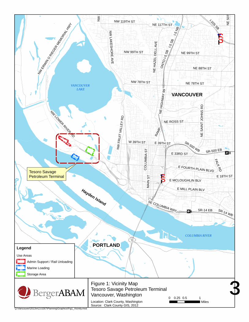
1.1 Project Site The proposed project is located within the Port of Vancouver (port) and involves three
separate locations that will be linked by project elements: Terminal 5, Parcel 1A, and
Berths 13 and 14 (Figures 1 and 2).
Administrative functions, support services, a boiler/steam plant, additional rail lines and
rail unloading will be located at 5701 NW Lower River Road in Vancouver, Washington
(see Drawing Sheet 0100‐SP‐001). This site is the former location of aluminum processing
facilities owned and operated by Evergreen Aluminum LLC (Evergreen) and the
Aluminum Company of America (Alcoa). This area of the port is generally defined as
Terminal 5.
The site has been the location of intensive historic industrial use, dating back to 1940
when Alcoa first developed the site for aluminum smelting operations through the early
2000s when aluminum processing activities on the property ended. The port completed
the purchase of the Evergreen and Alcoa properties in 2009 and, with the exception of
the on‐site water tower and the dock structure in the Columbia River, all structures of
the defunct aluminum processing plants have been removed.
The Terminal 5 site is currently developed for the outdoor storage of wind turbine
components and other cargoes and contains multiple rail lines for port operations. The
rail on the site represents the westernmost segment of the West Vancouver Freight
Access (WVFA) project, a rail improvement project that is under construction at the port
and will expand and improve rail access.
As part of the proposed project, crude oil storage tanks will be located on the port’s
Parcel 1A on the south side of NW Lower River Road just east of Farwest Steel (3703
NW Gateway Avenue). This site was developed by the port for general cargo laydown
and is currently partially occupied temporarily by a steel scrap storage yard.
Ship or barge loading will occur at existing Berths 13 and 14 on the Columbia River
south of the current Subaru facility. These berths were developed by the port and have
most recently been used as layberths.
§̈¦I-5
£¤500
£¤14
§̈¦I-205
COLUMBIA RIVER
PORTLAND
VANCOUVERVANCOUVER
LAKE
Hayden Island
Tesoro Savage Petroleum Terminal
NE
SA
INT
JOH
NS
RD
E MILL PLAIN BLV
NE
50T
H A
VE
E 33RD ST
NW
LAKESH
OR
E AVE
E MCLOUGHLIN BLV
NW
36T
H A
VE
NE ROSS ST
I-5 S
BI-5
NB
SR-14 EB SR-14 WB
MA
IN S
T
NW LOW
ER RIVER RD
NE
HIG
HW
AY 9
9
NE 78TH ST
SR-500 EB
SR-500 WB
NE 99TH ST
I-205 SB
NE 88TH ST
NE
HAZ
EL D
ELL
AVE
CO
LUM
BIA
ST
NW 119TH ST
NW 99TH ST
E FOURTH PLAIN BLVD
E 18TH ST
NE 117TH ST
W 39TH ST
NW 78TH ST
NW
FR
UIT
VAL
LEY
RD
E 39TH ST
FALK RD
NW E
RWIN
O R
IEGER
MEM
ORIAL
HW
Y
SE COLUMBIA WAY
ON
TO I-
5 SB
RAM
P
³Location: Clark County, WashingtonSource: Clark County GIS, 2012
0 0.5 10.25Miles
Q:\Vancouver\2013\A13.0267\Planning\Graphics\Fig1_Vicinity.mxd
Figure 1: Vicinity MapTesoro Savage Petroleum TerminalVancouver, Washington
LegendUse Areas
Admin Support / Rail Unloading
Marine Loading
Storage Area
Tesoro Savage Petroleum Terminal LLC BergerABAM A13.0267
Pre‐Application Conference Request June 2013
Vancouver, Washington Page 3
1.2 Operator and Employment Tesoro Savage Petroleum Terminal LLC will own and operate the facility on the site
which will be leased from the port.
It is anticipated that at full build‐out, the proposed project will result in the full‐time
employment of approximately 110 operations and administrative personnel and will
operate on a continuous basis. The proposed project also includes substantial capital
improvements representing a significant investment at the port and in the Portland‐
Vancouver regional economy.
1.3 Request The applicant is requesting a pre‐application conference with the City to discuss the
proposed crude oil terminal. The facility will be designed to receive bulk shipments of
crude oil via freight rail, store it temporarily, and pipe it to marine vessels for shipment.
1.4 Permits The proposed project is designed to receive approximately 360,000 barrels per day of
crude oil by rail and ship it via marine waters. Pursuant to the Revised Code of
Washington (RCW) 80.50, the proposed project is subject to the jurisdiction of the
Washington State Energy Facility Site Evaluation Council (EFSEC) because it involves
over 50,000 barrels per day shipped over marine waters. EFSEC is a state agency with
jurisdiction over certain of the state’s energy facilities and is responsible for considering
project compliance with substantive state and local permitting requirements, including
the federal regulatory programs that have been delegated to the state. The state and local
laws that apply to a project are considered through EFSEC’s site certification process. In
addition, federal permits may be required for potential work on Berths 13 and 14.
The following permits or environmental reviews may apply to the proposed project and,
with the exception of federal requirements, will be considered by EFSEC through its site
certification process.
1.4.1 Federal1 U.S. Army Corps of Engineers (USACE) Rivers and Harbor Act Section 10 permit
Endangered Species Act (ESA) Section 7 consultation
Section 106 of the National Historic Preservation Act (NHPA) consultation
1.4.2 State Washington Department of Fish and Wildlife (WDFW) Hydraulic Project Approval
(HPA)
Conformance with the Model Toxics Control Act (MTCA) consent decree
National Pollutant Discharge Elimination System (NPDES) storm water permitting
and compliance
1 The need for and scope of federal permits and associated environmental review (if any) will be
determined based on the final project design.
Tesoro Savage Petroleum Terminal LLC BergerABAM A13.0267
Pre‐Application Conference Request June 2013
Vancouver, Washington Page 4
1.4.3 City Critical areas permit (frequently flooded areas, fish and wildlife habitat conservation
areas, and geologic hazard area)
Tree conservation
Site plan review (SPR)
Shoreline substantial development permit (SSDP)
Major grading permit
Archaeological review
Building, fire, plumbing, mechanical, and other construction permits
Industrial wastewater discharge permit
1.4.4 Other Local Reviews Additional local review will include an air discharge permit and participation in State
Environmental Policy Act (SEPA) compliance, for which EFSEC will act as lead agency.
1.5 Previous Site Improvements and Approvals The project site has been the subject of multiple recent development activities and these
are listed below.
1.5.1 Wind Turbine Laydown Area Mass Grading Grading permit approvals were received in 2009 for fill on the site for leveling and base
rock compaction for the outdoor storage of wind turbine components at Terminal 5.
Grading permits for this work were completed in both the City (PRJ2008‐01911) and
Clark County (County) (GRD2009‐00002) because, at the time, portions of the Terminal 5
site remained in the County. They have since been annexed into the City and grading in
conjunction with these approvals is now complete. In addition to these approvals, the
City approved a grading permit (GRD2009‐00030) for a temporary access drive to the
wind turbine area.
1.5.2 WVFA Project The port completed the installation of a loop track providing direct and expanded rail
access to Terminal 5 and a route for rail traffic to circulate and return east to exit the
port. All federal, state, and local permits were obtained for that separate rail
improvement project. Local permit approvals for the WVFA project were obtained in
April of 2008 (PRJ2007‐0032) and modified through a post‐decision review approval in
2009 (PRJ2007‐00322/PST2009‐00003). Modifications to the original approval have also
been approved.
1.5.3 Terminal 4 Improvements On October 1, 2009, the port received SPR, SSDP, and grading permit approvals
(PRJ2009‐01134/PSR2009‐00050/SHL2009‐0008/GRD2009‐00064) for the expansion of its
existing auto storage area at Terminal 4. While most of the newly proposed auto storage
was within Terminal 4, proposed grading activities extended to the southeastern
extreme of the site of this proposed project on Terminal 5 parcels 152798‐000, 152166‐000
and 152905‐000.

Tesoro Savage Petroleum Terminal LLC BergerABAM A13.0267
Pre‐Application Conference Request June 2013
Vancouver, Washington Page 5
1.5.4 Bulk Potash Handling Facility On June 16, 2011, the port received SPR, SSDP, and other approvals (PRJ2010‐
01305/SHL2010‐00001/ARC2011‐00005/CAP2011‐00008/ENG2011‐00008/GRD2011‐
00010/PSR 2011‐00004/TRE2011‐000023) to construct a new marine terminal on the south
half of Terminal 5.
1.5.5 Parcel 1A NE Laydown Area On April 18, 2012 the port received approval to fill an isolated wetland on Parcel 1A
(PRJ2011‐01308/ARC2012‐00004/CAP2012‐0006/TRE2012‐00043) for use as general cargo
laydown. Wetland impacts were mitigated through the purchase of credits from the
Columbia River Wetland Mitigation Bank.
1.6 Construction Schedule Per its enabling statute (RCW 80.50.100 (1)(a)), the EFSEC is to make a recommendation
to the Governor regarding approval of the proposed project within 12 months of receipt
of an application. It is anticipated that construction will occur over 9 to 12 months
beginning as soon as permits are issued.
2.0 PROJECT DESCRIPTION The proposed project is designed to receive crude oil by rail from various sources in
North America and pipe it to storage tanks where it will be held until it is loaded onto
ships or barges for transport to end users, which are expected primarily to be West
Coast refineries. It is anticipated that this crude oil will replace a portion of the crude oil
shipped to the refineries from existing Alaskan and foreign sources by marine waters.
The attached set of drawings identifies the location of the proposed project elements
described below.
2.1 Administrative and Support Buildings The proposed project will require an approximately 3,400‐square‐foot office building for
administrative functions and two buildings to house lockers, restrooms, and other
employee support facilities of approximately 3,400 square feet and 2,500 square feet.
These elements will be located on the north side of the Terminal‐5 Loop south of Old
Lower River Road (see Drawing Sheet 0200‐SP‐0002). Parking and landscaping will be
provided per City standards.
2.2 Rail Unloading Facility The rail unloading facility will be located south of the administrative and support
facilities and is designed to handle unit trains consisting of approximately 120 double‐
walled tank cars, each up to 62 feet in length and powered by three locomotives for a
total length of approximately 7,661 feet (see Drawing Sheet 0200‐SP‐0200). At full build‐
out, approximately four unit trains, carrying up to a total of approximately 360,000
barrels of crude oil per day, will arrive via Class I railroad lines for staging on existing
and planned tracks at the port. Trains will arrive at Terminal‐5 and travel in a clockwise
direction to the unloading building on the north side of the Terminal 5 rail loop. The
design will accommodate complete unit trains, eliminating the need to break trains into
smaller segments during the unloading process.
Tesoro Savage Petroleum Terminal LLC BergerABAM A13.0267
Pre‐Application Conference Request June 2013
Vancouver, Washington Page 6
The rail cars will be unloaded in a building that will be approximately 1,850 feet by
91 feet in size, with a maximum height of approximately 50 feet. A typical cross section
of the unloading building is shown in Drawing Sheet 0200‐SP‐001. The building is
designed to accommodate three parallel tracks. Each track will include 30 unloading
stations for a total of 90 stations. Each station will accommodate 1 tank car.
Each unloading station will include the following elements:
Spill pans between rails that will lead to a common containment trench and holding
tanks.
Concrete containment trenches approximately 5‐feet deep to accommodate the
collection pipe and conduits for electrical and data lines.
Walkway gratings for the work platform and mezzanine to access the top of the cars.
Unloading will be accomplished with a closed‐loop system that includes dry fit
connectors and automatic shut‐offs. Hoses will be connected to the valves on the cars
using dry fit connectors, and the crude oil will gravity‐drain from the cars to the
collection pipe and then to pump vaults in the building, from which the crude oil will be
pumped to the storage tanks.
Thirty of the unloading stations will be equipped with steam fittings to heat heavier oils
to facilitate oil transfer from the tank car. Pre‐steaming stations may be included in
advance of the unloading building to allow heating to occur prior to reaching the
unloading stations. Steam will be provided from natural gas boilers housed in an
associated approximately 3,000‐square‐foot building. Each of the pump vaults will
house a series of pumps that will push the crude oil to the storage tanks on Parcel 1A.
Pedestrian bridges at each end of the building will allow workers to pass over the unit
trains during operations. Additional pedestrian bridges will allow access to the
administrative and support buildings over the existing Terminal 5 rail loops and to the
interior of the rail loop.
2.3 Piping A combination of above‐ and below‐ground steel pipes will convey crude oil from the
rail unloading facility to the tanks and from the tanks to Berths 13 and 14. At full build‐
out the system may include the following (Drawing Sheet 0100‐SP‐001):
Up to three approximately 24–inch‐diameter, 1,800‐foot‐long pipes will collect the
crude oil unloaded at the rail unloading stations.
Three approximately 24‐inch‐diameter, 5,500‐foot‐long pipes will connect the
unloading facility to the storage tanks.
Two approximately 24‐30 inch‐diameter, 5,300‐foot‐long pipe will connect the
storage tanks with Berths 13 and 14.

Tesoro Savage Petroleum Terminal LLC BergerABAM A13.0267
Pre‐Application Conference Request June 2013
Vancouver, Washington Page 7
One approximately 6‐inch‐diameter, 5,300‐foot‐long pipe will return crude oil from
Berths 13 and 14 to the storage tanks in the event of loading process shutdowns and
to prevent over pressure and hammering in the pipe conveyance system.
One approximately 16‐ to 22‐inch‐diameter, 600‐foot‐long pipe will deliver
hydrocarbon vapor generated during loading of vessels to the vapor
combustion/recovery unit (described in Section 2.5 Marine Loading, below)
Piping will be supported above ground except where necessary to cross roadways,
access points, and similar surface features. Where road or rail crossings occur, the piping
will be housed in underground steel casings or raised above ground for standard
American Railway Engineering and Maintenance‐of‐Way Association (AREMA)
clearances.
2.4 Storage Area The crude oil will be stored in up to six double‐bottom, above‐ground steel tanks located
on 22 acres on Parcel 1A, approximately 1,600 feet north of the Columbia River and
approximately 5,200 feet southeast of Vancouver Lake (see Drawing Sheet 0300‐SP‐003).
These tanks will be approximately 48 feet in height and 240 feet in diameter, with a shell
capacity of 380,000 barrels each. Each tank will have a fixed roof to keep precipitation
from reaching the inside of the tank and an internal floating roof to control tank vapor
emissions to the atmosphere. The double‐bottomed tanks will include a leak detection
system between the tank floors. Two of the proposed tanks may include steam heating
coils in their bases to maintain temperatures for heavier crude oil grades.
The tanks will be enclosed by a containment berm approximately 6 feet in height. The
containment area will be designed with a capacity at least equal to 110 percent of the
volume of the largest tank plus precipitation from a 24‐hour, 25‐year storm event. The
entire tank containment area will be lined with an impervious membrane to prevent any
spills from leaving the containment area via the ground. A sump will collect storm water
from the containment area; the sump will be designed to prevent crude oil‐contaminated
water from being pumped to the storm water disposal system in the event of a spill.
To convey the stored crude oil to the dock for transfer to a ship or barge, a pump pit
containing up to six pumps will be located on the west side of containment area. An
approximately 3,000‐square‐foot building will house natural gas boilers that will
provide heat for the two tanks equipped with heating coils. In addition, smaller
buildings will be located in the same area for the control equipment, motor control
centers, fire suppression equipment, and fire pumps.
Access to the storage area will be from an existing shared driveway from Lower River
Road located at the northwest corner of the site. This driveway currently provides access
to the site and Farwest Steel. The driveway will extend to the site and lead to a small
parking area containing five spaces for maintenance vehicles.
Tesoro Savage Petroleum Terminal LLC BergerABAM A13.0267
Pre‐Application Conference Request June 2013
Vancouver, Washington Page 8
2.5 Marine Loading As described above, crude oil will be pumped into a 24‐30 inch above‐ and below‐
ground pipe to existing port Berths 13 and 14 (Sheet 0100‐SP‐001). Piping, jib cranes, a
moveable gangway, an observation and control platform, dock safety unit, pipe trays,
and lighting will be installed on the existing dock that serves Berths 13 and 14. The dock
will be able to accommodate vessels with a capacity of up to 600,000 barrels and loading
rates of up to 40,000 barrels per hour. The loading system will incorporate automatic
shutoff valves with a maximum 30‐second shutoff time. As described above, a return
line will allow oil to return to the storage tanks in case of a shutdown of the ship loading
system.
The existing berth layout provides sufficient clearances from existing berth structures
and the space that is required for vessel maneuvering during berthing and departure.
Minor changes to the existing catwalks and mooring system may be required, but the
need for new structural elements is not anticipated. A ramp and float or davit system
will be added to accommodate mooring of a 24‐foot‐long skiff for booming and spill
response.
The marine vessels will generally arrive at the berth empty. While they are being loaded,
vapors from the vessel tanks will be collected and either recovered or combusted to
control the emissions released to the air. Piping from the dock will convey the vapors to
an enclosed vapor combustion or recovery unit just west of the CalPortland facility.
Depending on the selected method, this unit will consist of a 50‐ by 50‐foot concrete slab
housing equipment and up to two 10‐ to 15‐foot‐diameter steel stacks approximately 45‐
50 feet in height.
During loading operations vessels will be partially encircled by booms to contain any
accidental releases of crude oil and prevent it from migrating downstream. Temporary
floating booms will be placed around the vessel by a small skiff before any loading
begins. A fence‐type floating boom may be placed between the berth and the shoreline
in place of the floating boom. This would remain in place and would not require
placement by the skiff during each vessel call.
2.6 Steam Plant(s) Certain grades of crude oil must be heated to flow freely during the transfer and loading
process. The proposed project includes natural gas boilers housed in buildings at the
eastern entrance to Terminal 5 and at the storage area. It is anticipated that generating
the necessary steam will require a boiler with a peak capacity of 300 Million British
thermal units per hour (MMBtu/hr). Steam will be supplied to the rail unloading facility
and storage tank area via insulated pipelines. Depending on market conditions, the
Applicant may choose to construct the steam plant as a subsequent phase, or during the
initial construction phase.
Tesoro Savage Petroleum Terminal LLC BergerABAM A13.0267
Pre‐Application Conference Request June 2013
Vancouver, Washington Page 9
Natural gas will be supplied to the steam plants from the existing pipeline serving the
area. There is an existing gas line in Old Lower River Road that will provide service to
the site.
The steam plant will generate up to 30 gallons per minute of wastewater from
condensate and blow down. This wastewater will be pretreated to meet City discharge
limitations prior to discharge into the City sanitary system.
2.7 Rail Up to two additional lines will be added to the Terminal 5 loop to accommodate the rail
unloading facility. The additional lines will form two complete loops inside of the
existing rail loops and will begin and end near the Gateway Avenue grade separation.
The additional rail facilities may require modifications or relocations to existing surface
and below ground features, such as utilities, within the rail alignment.
2.8 Fire Suppression Several systems will be installed to provide fire suppression to the proposed project
elements. The rail unloading area will be served by a closed foam and water system
designed to activate as necessary in five segment areas. The storage tanks will also be
covered by a fire foam system. Each storage tank will have permanent nozzles installed
to allow injection of fire suppression foam inside the top of the tank. Automatic fire
sprinklers will be provided for the steam plant buildings. A fire monitor will be installed
at the marine loading dock, with a water cannon connected to a hydrant or other
available water supply. Fire suppression systems will be designed to National Fire
Protection Association and American Petroleum Institute requirements, as well as the
more stringent Factory Mutual Global insurance requirements. All fire suppression
systems will be designed to activate automatically, and will be equipped with manual
trip stations.
2.9 Proposed Access Primary vehicular access to the proposed project will be to the administration building
on Old Lower River Road, a private road owned and maintained by the port. Old Lower
River Road connects with Lower River Road approximately 1,000 feet west of the
proposed office building. The storage tank area will be accessed from a shared drive
with Farwest Steel from NW Lower River Road. The storage tank area is not anticipated
to require full‐time staffing and parking will be provided for routine maintenance needs.
The marine loading area will be accessed by Gateway Avenue and port‐maintained
access roads. An existing asphalted area at the berths will be used by project personnel
during ship loading operations. Although the boiler/steam plant at the rail unloading
facility ordinarily will not be occupied full time, parking for maintenance vehicles will
be provided.
The extended road network includes NW Lower River Road (State Route 501), which is
a state highway and a major truck route with a 50‐mile per hour (mph) speed limit.
Approximately 1.5 miles east of the site, NW Lower River Road connects to the Mill
Tesoro Savage Petroleum Terminal LLC BergerABAM A13.0267
Pre‐Application Conference Request June 2013
Vancouver, Washington Page 10
Plain Extension (a principal arterial with a 35‐mph speed limit) and West Fourth Plain
Boulevard (a primary arterial and state route with a 35‐mph speed limit). West Mill
Plain and West Fourth Plain boulevards connect to I‐5, SR 14, and points beyond.
Traffic during operations will consist primarily of privately owned employee vehicles as
well as limited deliveries by tractor trailers. Construction traffic will vary during the 9‐
to 12‐month construction period, depending on the work element and number of
construction employees on‐site and deliveries.
Public transit does not serve the site. C‐TRAN (the area’s public transit provider) Route
No. 25 is the transit route closest to the site. It travels on West Mill Plain and Fruit Valley
Road, approximately 1.5 miles east of the site.
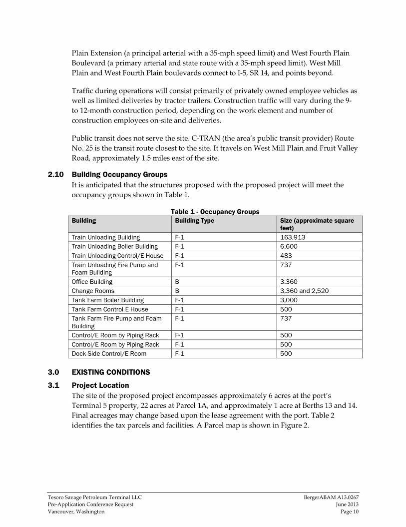
2.10 Building Occupancy Groups It is anticipated that the structures proposed with the proposed project will meet the
occupancy groups shown in Table 1.
Table 1 - Occupancy Groups Building Building Type Size (approximate square
feet) Train Unloading Building F-1 163,913 Train Unloading Boiler Building F-1 6,600 Train Unloading Control/E House F-1 483 Train Unloading Fire Pump and Foam Building
F-1 737
Office Building B 3.360 Change Rooms B 3,360 and 2,520 Tank Farm Boiler Building F-1 3,000 Tank Farm Control E House F-1 500 Tank Farm Fire Pump and Foam Building
F-1 737
Control/E Room by Piping Rack F-1 500 Control/E Room by Piping Rack F-1 500 Dock Side Control/E Room F-1 500
3.0 EXISTING CONDITIONS
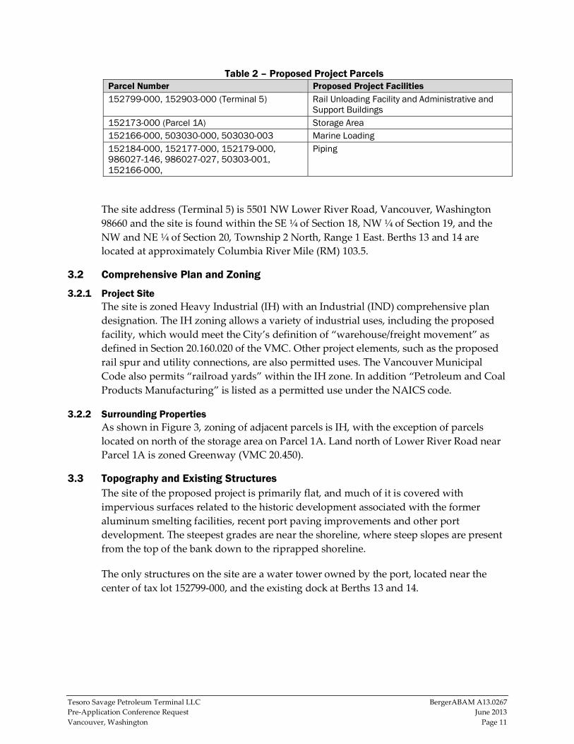
3.1 Project Location The site of the proposed project encompasses approximately 6 acres at the port’s
Terminal 5 property, 22 acres at Parcel 1A, and approximately 1 acre at Berths 13 and 14.
Final acreages may change based upon the lease agreement with the port. Table 2
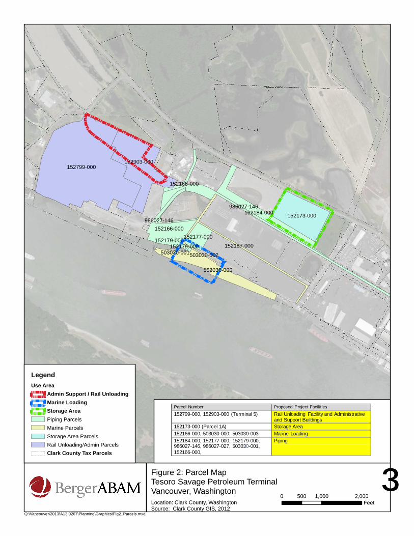
identifies the tax parcels and facilities. A Parcel map is shown in Figure 2.
Tesoro Savage Petroleum Terminal LLC BergerABAM A13.0267
Pre‐Application Conference Request June 2013
Vancouver, Washington Page 11
Table 2 – Proposed Project Parcels Parcel Number Proposed Project Facilities 152799-000, 152903-000 (Terminal 5) Rail Unloading Facility and Administrative and
Support Buildings 152173-000 (Parcel 1A) Storage Area 152166-000, 503030-000, 503030-003 Marine Loading 152184-000, 152177-000, 152179-000, 986027-146, 986027-027, 50303-001, 152166-000,
Piping
The site address (Terminal 5) is 5501 NW Lower River Road, Vancouver, Washington
98660 and the site is found within the SE ¼ of Section 18, NW ¼ of Section 19, and the
NW and NE ¼ of Section 20, Township 2 North, Range 1 East. Berths 13 and 14 are
located at approximately Columbia River Mile (RM) 103.5.
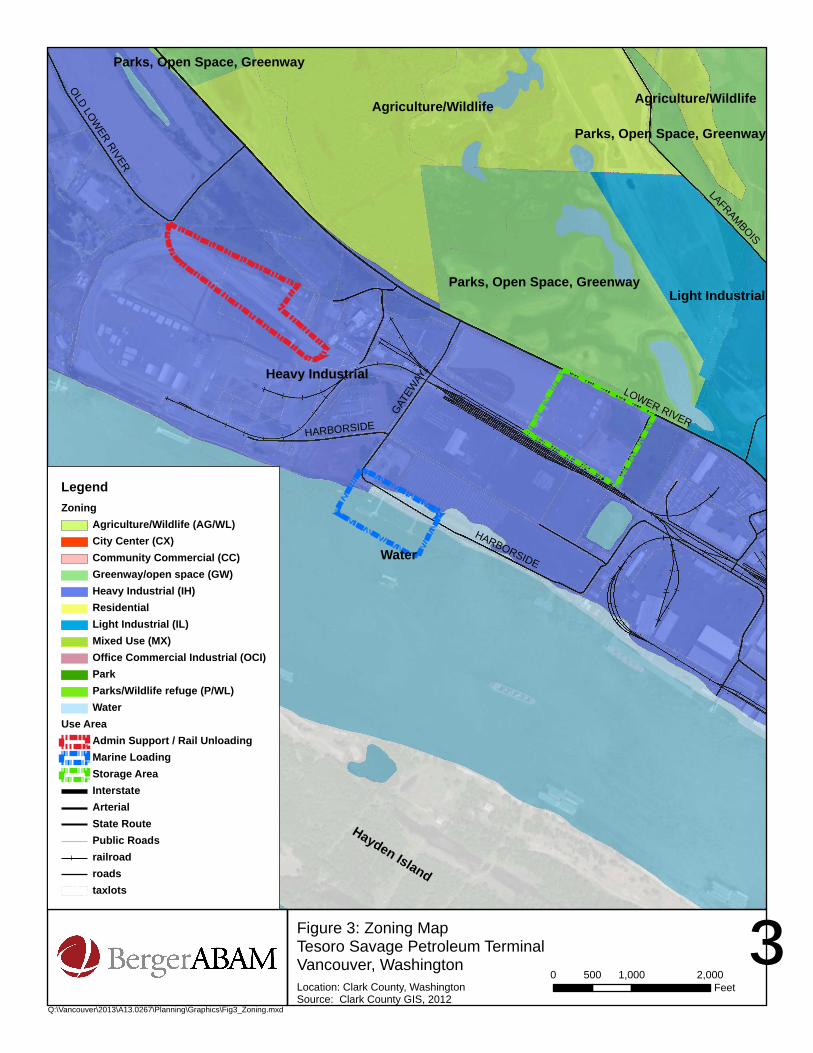
3.2 Comprehensive Plan and Zoning
3.2.1 Project Site The site is zoned Heavy Industrial (IH) with an Industrial (IND) comprehensive plan
designation. The IH zoning allows a variety of industrial uses, including the proposed
facility, which would meet the City’s definition of “warehouse/freight movement” as
defined in Section 20.160.020 of the VMC. Other project elements, such as the proposed
rail spur and utility connections, are also permitted uses. The Vancouver Municipal
Code also permits “railroad yards” within the IH zone. In addition “Petroleum and Coal
Products Manufacturing” is listed as a permitted use under the NAICS code.
3.2.2 Surrounding Properties As shown in Figure 3, zoning of adjacent parcels is IH, with the exception of parcels
located on north of the storage area on Parcel 1A. Land north of Lower River Road near
Parcel 1A is zoned Greenway (VMC 20.450).
3.3 Topography and Existing Structures The site of the proposed project is primarily flat, and much of it is covered with
impervious surfaces related to the historic development associated with the former
aluminum smelting facilities, recent port paving improvements and other port
development. The steepest grades are near the shoreline, where steep slopes are present
from the top of the bank down to the riprapped shoreline.
The only structures on the site are a water tower owned by the port, located near the
center of tax lot 152799‐000, and the existing dock at Berths 13 and 14.
Hayden Island
152799-000152903-000
152173-000
503030-000
152187-000152179-000503030-002503030-001
152166-000
152184-000986027-146
152177-000
152166-000
986027-146
152179-000
³Location: Clark County, WashingtonSource: Clark County GIS, 2012
0 1,000 2,000500Feet
LegendUse Area
Admin Support / Rail UnloadingMarine LoadingStorage AreaPiping ParcelsMarine ParcelsStorage Area ParcelsRail Unloading/Admin ParcelsClark County Tax Parcels
Q:\Vancouver\2013\A13.0267\Planning\Graphics\Fig2_Parcels.mxd
Figure 2: Parcel MapTesoro Savage Petroleum TerminalVancouver, Washington
Parcel Number Proposed Project Facilities 152799-000, 152903-000 (Terminal 5) Rail Unloading Facility and Administrative
and Support Buildings 152173-000 (Parcel 1A) Storage Area 152166-000, 503030-000, 503030-003 Marine Loading 152184-000, 152177-000, 152179-000, 986027-146, 986027-027, 503030-001, 152166-000,
Piping
Hayden Island
Heavy Industrial
Water
Agriculture/Wildlife
Light IndustrialParks, Open Space, Greenway
Parks, Open Space, Greenway
Agriculture/Wildlife
Parks, Open Space, Greenway
LOWER RIVER
HARBORSIDE
LAFRAMBOIS
GATEW
AY
OLD LOWER RIVER
HARBORSIDE
³Location: Clark County, WashingtonSource: Clark County GIS, 2012
0 1,000 2,000500Feet
LegendZoning
Agriculture/Wildlife (AG/WL)City Center (CX)Community Commercial (CC)Greenway/open space (GW)Heavy Industrial (IH)ResidentialLight Industrial (IL)Mixed Use (MX)Office Commercial Industrial (OCI)ParkParks/Wildlife refuge (P/WL)Water
Use AreaAdmin Support / Rail UnloadingMarine LoadingStorage AreaInterstateArterialState RoutePublic Roadsrailroadroadstaxlots
Q:\Vancouver\2013\A13.0267\Planning\Graphics\Fig3_Zoning.mxd
Figure 3: Zoning MapTesoro Savage Petroleum TerminalVancouver, Washington
Tesoro Savage Petroleum Terminal LLC BergerABAM A13.0267
Pre‐Application Conference Request June 2013
Vancouver, Washington Page 14
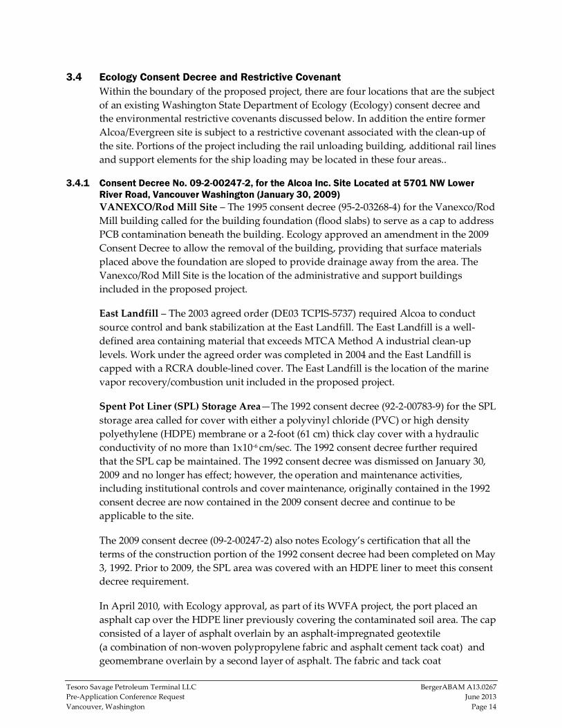
3.4 Ecology Consent Decree and Restrictive Covenant Within the boundary of the proposed project, there are four locations that are the subject
of an existing Washington State Department of Ecology (Ecology) consent decree and
the environmental restrictive covenants discussed below. In addition the entire former
Alcoa/Evergreen site is subject to a restrictive covenant associated with the clean‐up of
the site. Portions of the project including the rail unloading building, additional rail lines
and support elements for the ship loading may be located in these four areas..
3.4.1 Consent Decree No. 09-2-00247-2, for the Alcoa Inc. Site Located at 5701 NW Lower River Road, Vancouver Washington (January 30, 2009) VANEXCO/Rod Mill Site – The 1995 consent decree (95‐2‐03268‐4) for the Vanexco/Rod
Mill building called for the building foundation (flood slabs) to serve as a cap to address
PCB contamination beneath the building. Ecology approved an amendment in the 2009
Consent Decree to allow the removal of the building, providing that surface materials
placed above the foundation are sloped to provide drainage away from the area. The
Vanexco/Rod Mill Site is the location of the administrative and support buildings
included in the proposed project.
East Landfill – The 2003 agreed order (DE03 TCPIS‐5737) required Alcoa to conduct
source control and bank stabilization at the East Landfill. The East Landfill is a well‐
defined area containing material that exceeds MTCA Method A industrial clean‐up
levels. Work under the agreed order was completed in 2004 and the East Landfill is
capped with a RCRA double‐lined cover. The East Landfill is the location of the marine
vapor recovery/combustion unit included in the proposed project.
Spent Pot Liner (SPL) Storage Area—The 1992 consent decree (92‐2‐00783‐9) for the SPL
storage area called for cover with either a polyvinyl chloride (PVC) or high density
polyethylene (HDPE) membrane or a 2‐foot (61 cm) thick clay cover with a hydraulic
conductivity of no more than 1x10‐6 cm/sec. The 1992 consent decree further required
that the SPL cap be maintained. The 1992 consent decree was dismissed on January 30,
2009 and no longer has effect; however, the operation and maintenance activities,
including institutional controls and cover maintenance, originally contained in the 1992
consent decree are now contained in the 2009 consent decree and continue to be
applicable to the site.
The 2009 consent decree (09‐2‐00247‐2) also notes Ecology’s certification that all the
terms of the construction portion of the 1992 consent decree had been completed on May
3, 1992. Prior to 2009, the SPL area was covered with an HDPE liner to meet this consent
decree requirement.
In April 2010, with Ecology approval, as part of its WVFA project, the port placed an
asphalt cap over the HDPE liner previously covering the contaminated soil area. The cap
consisted of a layer of asphalt overlain by an asphalt‐impregnated geotextile
(a combination of non‐woven polypropylene fabric and asphalt cement tack coat) and
geomembrane overlain by a second layer of asphalt. The fabric and tack coat
Tesoro Savage Petroleum Terminal LLC BergerABAM A13.0267
Pre‐Application Conference Request June 2013
Vancouver, Washington Page 15
combination form an asphalt membrane interlayer within the pavement section. This
cap remains in complete form today.
North/North 2 Cap – On March 26, 2009, former landowner Alcoa, Inc. entered into an
environmental restrictive covenant in favour of Ecology pursuant to its consent decree
with Ecology effective January 30, 2009 restricting activity in the North and North 2 (NN2)
landfills. This restrictive covenant was necessary because of the residual concentration of
contaminants on the properties that exceeded cleanup levels for soil and/or groundwater
established in the MTCA under Washington Administrative Code (WAC) 173‐340‐720 and
740. These materials are presently covered by a 1‐foot layer of clean sand. Per the
restrictive covenant, these materials may be reused on site with Ecology’s permission. This
area is located in the rail loop that is proposed with this project.
3.4.2 Restrictive Environmental Covenant (December 31, 2008); Grantor: Evergreen Aluminum LLC & Grantor: State of Washington, Department of Ecology Ingot Plant Cap – The previous site of ingot processing on the property has been the
subject of remediation and containment and is governed by an existing Ecology
restrictive covenant. This site is located immediately south of the southwest corner of
Terminal 5 and additional rail construction could occur in this area. The contamination
is covered with 12 inches of crushed concrete.
3.5 Surrounding Uses Uses surrounding the proposed project are primarily industrial. Bordering uses of the
rail unloading and administration buildings are as follows: the Clark County Jail Work
Center is approximately 600 feet to the east, the CPU River Road Generating Plant is
approximately 100 feet to the northeast, and the Tidewater Barge Company is
approximately 100 feet to the west. The port’s bulk potash handling facility is planned
for the area immediately south. The area immediately to the north of the proposed
project is used for propane storage and distribution and includes Old Lower River Road.
The storage area is bordered to the south by the port’s rail system and the Subaru
facility. The site is bordered to the east by the port’s Parcel 1A wetland, to the west by
Farwest Steel and by Lower River Road and open space to the north.
The marine loading area is surrounded by port facilities including Subaru and
CalPortland.
The nearest residence is an isolated rural house owned by the port and located at 6818
NW Old Lower River Road approximately 3,100 feet (0.6 mile) northwest of the
proposed location of the boiler/steam plant for the rail unloading facility. The nearest
residential neighborhood is the Fruit Valley Neighborhood, approximately 3,200 feet
(0.6 mile) east of the storage area. In addition, the Clark County Jail Work Center is
located off Gateway Avenue between the elements of the proposed project. This facility
includes 224 beds in a minimum security setting.

Tesoro Savage Petroleum Terminal LLC BergerABAM A13.0267
Pre‐Application Conference Request June 2013
Vancouver, Washington Page 16
3.6 Natural Conditions
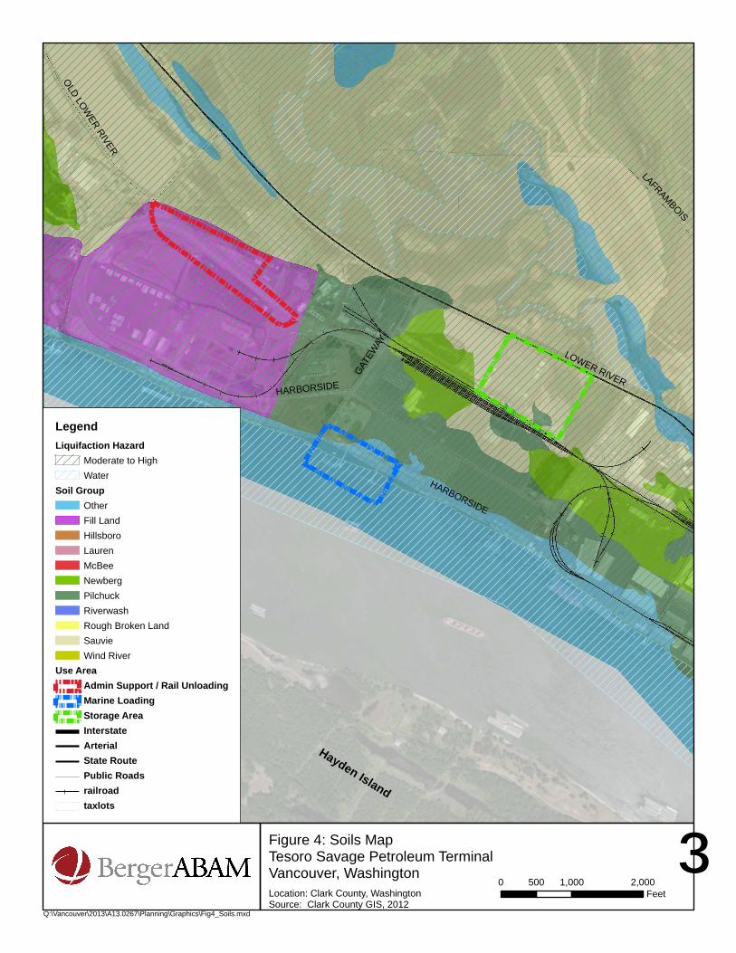
3.6.1 Geology County Assessor’s data identifies the following soil types on the site (as show in
Figure 4).
Water (WAT), for areas mapped below the ordinary high water mark (OHWM)
Sauvie silty clay loam, 0 to 8 percent slopes (SpB)
Newberg silt loam, 0 to 3 percent (NbA)
Fill land (Fn)
Sauvie silt loam, 0 to 3 percent slopes (SmA)
Pilchuck fine sand, 0 to 8 percent slopes (PhB)
As noted below, the site has been mapped by the City as being susceptible to soils
liquefaction, a geologic hazard area per Section 20.740.130 of the critical areas protection
provisions of the VMC (see Figure 4, Soils Map).
3.6.2 Vegetation Previous development and remediation activities filled, paved, and/or capped the entire
site of the proposed project. As a result, vegetation on the site is primarily limited to
grasses, non‐native weedy herbaceous vegetation, and shrubs located between the top of
the bank of the Columbia River and the riprap at the water’s edge. Additionally, a
number of trees are located along the shoreline at Berths 13 and 14.
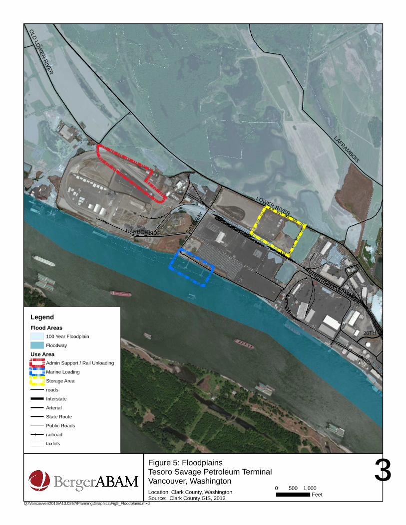
3.6.3 100-Year Floodplain The 100‐year floodplain and floodway of the Columbia River are located at 30 feet
NAVD 88 and extends generally to the top of the bank along Berths 13 and 14 (FEMA
Map #53011C0363D). In addition, there is an isolated floodplain located on Parcel 1A as
shown on FEMA Map Number 53011C0364D. The port filled this area as authorized by
GRD2012‐00025. Figure 5 indicates the mapped floodplain.
3.6.4 Wetlands There are no mapped wetlands on the site of the proposed project. Parcel 1A previously
contained an isolated wetland that was filled (see section 1.5.5).
There are wetland mitigation sites located east of the access road on the east side of the
Parcel 1A site and north of Old Lower River Road in the vicinity of the proposed
administration building. In addition, the Columbia River Wetland Bank is located north
of NW Lower River Road north of the Parcel 1A site.
Hayden Island
LOWER RIVER
HARBORSIDE
LAFRAMBOIS
GATEW
AY
OLD LOWER RIVER
HARBORSIDE
³Location: Clark County, WashingtonSource: Clark County GIS, 2012
0 1,000 2,000500Feet
LegendLiquifaction Hazard
Moderate to HighWater
Soil GroupOtherFill LandHillsboroLaurenMcBeeNewbergPilchuckRiverwashRough Broken LandSauvieWind River
Use AreaAdmin Support / Rail UnloadingMarine LoadingStorage AreaInterstateArterialState RoutePublic Roadsrailroadtaxlots
Q:\Vancouver\2013\A13.0267\Planning\Graphics\Fig4_Soils.mxd
Figure 4: Soils MapTesoro Savage Petroleum TerminalVancouver, Washington
Hayden Island
LOWER RIVER
HARBORSIDE
LAFRAMBOIS
GATEW
AY
OLD LO
WER RIVER
26TH
HARBORSIDE
³Figure 5: FloodplainsTesoro Savage Petroleum TerminalVancouver, Washington
Q:\Vancouver\2013\A13.0267\Planning\Graphics\Fig5_Floodplains.mxd
Location: Clark County, WashingtonSource: Clark County GIS, 2012
0 1,000500Feet
LegendFlood Areas
100 Year Floodplain
Floodway
Use AreaAdmin Support / Rail Unloading
Marine Loading
Storage Area
roads
Interstate
Arterial
State Route
Public Roads
railroad
taxlots
Tesoro Savage Petroleum Terminal LLC BergerABAM A13.0267
Pre‐Application Conference Request June 2013
Vancouver, Washington Page 19
3.6.5 Archaeology According to the Clark County Archaeological Predictive Model, the site is within Level
A and/or high (80‐100%) areas. There are no mapping indicators of archaeological site
buffers. Most of the area of the proposed project was surveyed previously for various
development projects, including the port’s WVFA project. An archaeological study was
performed by Archaeological Investigations Northwest, Inc. (AINW) in February 2009
for a project area that included portions of the site.2 Additionally, a cultural resources
survey was performed by Jones & Stokes (now IFC International) in December 2007 for a
project area that included portions of the site. Neither study found evidence of intact
prehistoric or historic‐era archaeological sites on the project site or of structures eligible
for listing in the National Register of Historic Places (NRHP).
3.7 Storm Water/Erosion Control The rail unloading facility and administration building are located within the
boundaries of the Terminal 5 expansion project, and the storm water contributions were
factored into the design and sizing of the existing conveyance system.
The storage area (Parcel 1A) is located within the planning boundaries of the completed
Terminal 4 pond improvements.
3.8 Utilities The port is currently served with City water and sanitary sewer facilities. The port
additionally operates a private water system and maintains storm water facilities on site.
Potable water and existing fire hydrants are currently available on or adjacent to all of
the locations involved in the proposed project. Sanitary sewer service is available along
the south side of the storage area, and the nearest connection point westward for the rail
unloading facility, offices, boiler/steam plant, and berth is a manhole located just south
of the Clark Public Utilities Generating Plant.
Electrical service to the proposed project site is available from the existing Clark County
Public Utilities distribution system.
4.0 REGULATORY COMPLIANCE
4.1 Trip Generation (VMC 11.95) It is estimated that, at full project build‐out, the project as proposed will result in
approximately 410 average daily trips (ADT), with approximately 60 trips occurring in
the AM peak hour and 57 trips occurring in the PM peak hour. Traffic generation is
based on the anticipation that approximately 110 full‐time staff will be employed by the
facility at full build‐out. The trip estimates are based on trip rates from Trip Generation,
9th Edition published by the Institute of Transportation Engineers using data for General
2 The Port of Vancouver’s Proposed Alcoa/Evergreen Development Project, Clark County, Washington,
Archaeological Study, Archaeological Investigations Northwest, Inc., Report No. 2257, February 19,
2009.
Tesoro Savage Petroleum Terminal LLC BergerABAM A13.0267
Pre‐Application Conference Request June 2013
Vancouver, Washington Page 20
Light Industrial (land use code 110). The facility will operate 24 hours a day, 7 days a
week with personnel on weekends and staggered shifts.
The trip estimates identified above are preliminary estimates for pre‐application
purposes only and additional trip data based on the nature of the use may be included
in the traffic impact study that will be prepared for the project.
4.2 State Environmental Policy Act Pursuant to WAC 463‐47, EFSEC will act as lead agency for SEPA compliance. RCW
80.50.180 provides that all actions undertaken by the City are exempt from compliance
with SEPA, RCW 43.21C.030.
4.3 Critical Areas Ordinance (VMC 20.740) The critical areas found on the site include frequently flooded areas, geologic hazard
areas (seismic hazard), and fish and wildlife habitat conservation areas. Development is
proposed, to some extent, in each of these areas and therefore it is anticipated that a
critical areas report will be submitted to address project compliance with the applicable
provisions of VMC Chapter 20.740, Critical Areas Protection.
4.3.1 Fish and Wildlife Habitat Conservation Areas (VMC.20.740.110) Project activities at Berths 13 and 14 are located within the riparian management area
(RMA) and riparian buffer (RB) area of the Columbia River. The riparian boundaries are
measured landward from the biological OHWM and are limited by existing impervious
surfaces. The existing riparian habitat is of lower value due to historical industrial land
uses which have functionally isolated the riparian area from the Columbia River. The
riparian area within the proposed project site is mostly devoid of vegetation with the
exception of scattered trees and vegetation below the top of the bank. Impervious
surfaces include existing roadways, material laydown areas, compacted soil, access
trestles, and storm water facilities. A critical areas report addressing the issue will be
provided during preliminary review to satisfy the requirements of VMC.20.740.110.
4.3.2 Frequently Flooded Areas (VMC 20.740.120) Current plans include utilization of the existing dock. Therefore, it is anticipated that the
critical areas report will include a review under the frequently flooded area provisions
of Section 20.740.120 of the VMC. It is not anticipated that any fill will be placed in the
flood fringe or floodway. Further, to ensure any in‐water structures included in the
proposed project will withstand elevated river levels in flood events, the structures will
be approved by a structural engineer licensed in Washington.
A portion of the tank area on Parcel 1A is identified as an isolated floodplain (see section
3.6.3) previously approved for fill.
4.3.3 Geologic & Seismic Hazards (VMC 20.740.130) County GIS data indicate moderate‐to‐high potential for liquefaction or dynamic
settlement within the site area of the proposed project. A geotechnical report will be
provided to address the liquefaction potential on the site and recommending

Tesoro Savage Petroleum Terminal LLC BergerABAM A13.0267
Pre‐Application Conference Request June 2013
Vancouver, Washington Page 21
construction techniques to address any identified potential soils instability and seismic
issues.
4.3.4 Wetlands (VMC 20.740.140 As indicated in section 3.6.4, portions of the proposed project site were designated as
wetlands but were filled and land to the east is a forested wetland. No activity or
impacts are proposed within the Parcel 1A wetland area. According to VMC Table
20.740.140‐5, the wetland buffer for a Category 3 wetland with a low habitat function is
between 40 and 80 feet based on the land use intensity. However, according to VMC
20.740. (C)(1)(b)(1)(e), areas within buffers that are completely functionally separated
from a wetland and do not protect the wetland from adverse impacts may be excluded
from the buffer. Because the site of the proposed project is completely developed and an
existing access road separates it from the Parcel 1A wetland, the buffer will not affect the
project site.
4.4 Shoreline Management Master Program (VMC 20.760) Ship loading elements are the only anticipated project elements that will require
construction within the jurisdiction of the City’s Shoreline Management Master Program
(SMMP) (within 200 feet of the OHWM). The SMMP designates the shoreline
environment of the upland areas on the site as High Intensity and the areas of the site
below the OHWM of the river as Aquatic.
Within the High Intensity and Aquatic designations, water‐dependent industrial uses
are permitted activities. The SMMP defines a water‐dependent use as follows: “a use or
a portion of a use which requires direct contact with the water and cannot exist at a non‐
water location due to the intrinsic nature of its operations.” The purpose of the proposed
project is to transfer crude oil from railcars to ships. Consequently, the proposed facility
activities clearly meet the definition of a water‐dependent use. Further, per Policy
4.3.5.1, the purpose of the High Intensity designation is “to provide for high‐intensity
water‐oriented commercial, transportation, and industrial uses….” Table 6‐1 lists Water‐
dependent industrial uses as permitted in the High Intensity and Aquatic shoreline
designations with no setback or height limits.

Tesoro Savage Petroleum Terminal LLC BergerABAM A13.0267
Pre‐Application Conference Request June 2013
Vancouver, Washington Page 22
It is anticipated that the proposed project would be subject to the SMMP policies and
regulations shown in Table 2.
Table 2 - SMMP Policies and Regulations Section Associated Regulation(s)
5.1 1-2, 4-6, 9, 11, 15 5.2 All 5.3 All 5.4 2
5.6.1 All 5.6.2 1-5 5.6.3 All 5.7 All
5.8.1 All 5.9 1-7 5A All
Table 6-1 All 6.3.3.5 1, 4-5 6.3.6 1, 5-6
4.5 Land Use (VMC 20.440.030) The proposed project is permitted in the IH zone. The proposed project is consistent
with the City’s definition in VMC 20.160.020 of a warehouse/freight movement use, a
permitted use. This definition is as follows:
Uses involved in the storage and movement of large quantities of materials or
products indoors and/or outdoors; associated with significant truck and/or rail
traffic. Examples include free‐standing warehouses associated with retail
furniture or appliance outlets; household moving and general freight storage;
cold storage plants/frozen food lockers; weapon and ammunition storage; major
wholesale distribution centers; truck, marine and air freight terminals and
dispatch centers; bus barns; grain terminals; and stockpiling of sand, gravel, bark
dust or other aggregate and landscaping materials.
Table 3 below shows how the proposal is consistent with the City’s development
standards for the IH zone.
Tesoro Savage Petroleum Terminal LLC BergerABAM A13.0267
Pre‐Application Conference Request June 2013
Vancouver, Washington Page 23
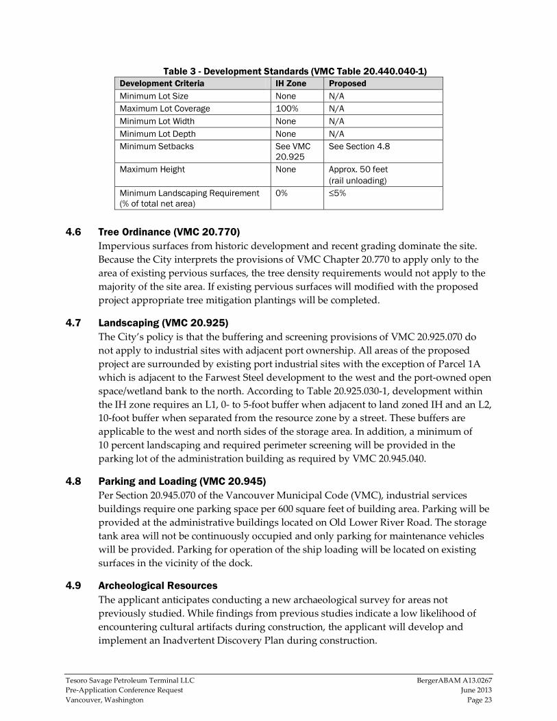
Table 3 - Development Standards (VMC Table 20.440.040-1) Development Criteria IH Zone Proposed Minimum Lot Size None N/A Maximum Lot Coverage 100% N/A Minimum Lot Width None N/A Minimum Lot Depth None N/A Minimum Setbacks See VMC
20.925 See Section 4.8
Maximum Height None Approx. 50 feet (rail unloading)
Minimum Landscaping Requirement (% of total net area)
0% ≤5%
4.6 Tree Ordinance (VMC 20.770) Impervious surfaces from historic development and recent grading dominate the site.
Because the City interprets the provisions of VMC Chapter 20.770 to apply only to the
area of existing pervious surfaces, the tree density requirements would not apply to the
majority of the site area. If existing pervious surfaces will modified with the proposed
project appropriate tree mitigation plantings will be completed.
4.7 Landscaping (VMC 20.925) The City’s policy is that the buffering and screening provisions of VMC 20.925.070 do
not apply to industrial sites with adjacent port ownership. All areas of the proposed
project are surrounded by existing port industrial sites with the exception of Parcel 1A
which is adjacent to the Farwest Steel development to the west and the port‐owned open
space/wetland bank to the north. According to Table 20.925.030‐1, development within
the IH zone requires an L1, 0‐ to 5‐foot buffer when adjacent to land zoned IH and an L2,
10‐foot buffer when separated from the resource zone by a street. These buffers are
applicable to the west and north sides of the storage area. In addition, a minimum of
10 percent landscaping and required perimeter screening will be provided in the
parking lot of the administration building as required by VMC 20.945.040.
4.8 Parking and Loading (VMC 20.945) Per Section 20.945.070 of the Vancouver Municipal Code (VMC), industrial services
buildings require one parking space per 600 square feet of building area. Parking will be
provided at the administrative buildings located on Old Lower River Road. The storage
tank area will not be continuously occupied and only parking for maintenance vehicles
will be provided. Parking for operation of the ship loading will be located on existing
surfaces in the vicinity of the dock.
4.9 Archeological Resources The applicant anticipates conducting a new archaeological survey for areas not
previously studied. While findings from previous studies indicate a low likelihood of
encountering cultural artifacts during construction, the applicant will develop and
implement an Inadvertent Discovery Plan during construction.

Tesoro Savage Petroleum Terminal LLC BergerABAM A13.0267
Pre‐Application Conference Request June 2013
Vancouver, Washington Page 24
4.10 Storm Water/Erosion Control Storm water improvements will be analyzed and designed in accordance with City
development standards and Ecology’s Stormwater Management Manual for Western
Washington. Storm water from the site will be discharged through manmade
conveyances to the Columbia River; therefore, the proposed project is exempt from the
flow control minimum requirement. Storm water treatment technologies will be
implemented to treat and monitor storm water quality in accordance with the required
Industrial NPDES General Storm water Permit.
Storm water from the boiler/steam plant and the area of the administration building
north of the existing rail loop will be treated on site in accordance with current
regulations and discharged through existing casings underneath the railroad tracks.
Flow contributions from the rail unloading facility will be treated through oil/water
separators prior to discharge into the existing port storm water system.
Storm water for the storage area (Parcel 1A) will be treated on site using oil/water
separators prior to its discharge to the existing storm water system. No pollution
generating surfaces will be constructed with the storage area. Accesses in/out of the area
are for periodic sampling and maintenance.
There are no modifications to the impervious surfaces at the existing shipping berths
and therefore no storm water improvements are proposed at this time.
4.11 Utilities Electrical service will be obtained by interconnection to the local distribution system.
Potable water demands are anticipated to be fairly minor. The largest process demand is
the boiler/steam plant which at build‐out may require approximately 30 gallons per
minute of process water. Fire flow is the largest water demand and design criteria for
the water system. The project team is currently conducting hydrant flow tests to
determine system adequacy at the storage area, rail unloading facility, boiler/steam
plant, and ship loading berth. Fire protection systems including additional hydrants and
chemical suppression systems are proposed at the storage tank area and rail unloading
facility.
Based on the present level of design, it is anticipated that water supply for fire
suppression at the storage tank area can be obtained either from the port or from the
City of Vancouver. All other water needs at the proposed project would be supplied by
the City of Vancouver.
The anticipated sanitary sewer discharges include domestic sewerage from the
administration and support buildings, and treated boiler blow‐down water (wastewater
generated from solids left behind during the steam generation process), and interior
drains from the rail unloading facility, including rail car drip pans. A water treatment
facility is planned in the building housing the steam plant to provide pre‐treatment for
the boiler blow‐down water before discharge to the City sanitary sewer system.
Tesoro Savage Petroleum Terminal LLC BergerABAM A13.0267
Pre‐Application Conference Request June 2013
Vancouver, Washington Page 25
Oil/water separators will be used in all other areas of the site where hydrocarbons could
enter into the sanitary sewer drains.
5.0 QUESTIONS/ITEMS FOR PRE-APPLICATION DISCUSSION a. VMC 14.010.050, Prohibited Discharge Standards, states that petroleum oil, non‐
biodegradable cutting oil, or products of mineral oil origin, in amounts that will
cause Pass Through or Interference are prohibited from sanitary sewer discharges.
Section 14.010.080, Local Limits, states a threshold of 50 mg/L. Please confirm the
performance criteria for crude oil in wastewater.
b. VMC 14.010.050 Prohibited Discharge Standards requires that discharges shall not
cause the temperature at the treatment plant to exceed 104‐degrees. For this
proposed site, what is an acceptable maximum discharge temperature at the
proposed discharge location? Where is this located?
c. The previous staff report for PRJ2010‐01305 indicates that the downstream sanitary
sewer pump station #4516, XB732 may not have sufficient capacity for additional
wastewater discharges. Please confirm the existing pump station capacity,
requirements for connection, and limits of necessary improvements if any?
d. Farwest Steel was required to construct frontage improvements with their recent
development. Please provide detailed requirements for frontage improvements at
the Tank Farm site on NW Lower River Road, SR‐501.
e. The current development plan for the Tank Farm includes sharing the existing access
road east of Farwest Steel. This will be for occasional maintenance only. Are there
any intersection or access improvements required?
f. It is our understanding from discussions with City staff the determinations of
required fire flow and locations for fire protection equipment will be determined by
a 3rd party consultant who specializes in fire protection for flammable/combustible
liquid tank farms. Can the City provide an estimate of required fire flows at this
time? Please additionally provide a description of how the 3rd party review may
impact review schedules and coordination.
g. Please confirm that frontage improvements along NW Old Lower River Road will
not be required in the vicinity of the proposed office building. Other recent
development in this area has been exempted from frontage improvements.
h. To the extent possible, please provide all as‐built reference drawings for public
utilities located on or adjacent to the project locations.
i. We understand that the 2012 codes (IFC, IBC, IECC, etc.) will become effective in
July and will apply to this project.

Tesoro Savage Petroleum Terminal LLC BergerABAM A13.0267
Pre‐Application Conference Request June 2013
Vancouver, Washington Page 26
j. What is the required building separation where no barrier is provided for fire
protection?
k. Would the City identify the study intersections required in the traffic study?
l. Would the City identify any planned transportation improvements affecting the
study intersections?
m. We request that the City help identify all in‐process developments in the study area
that need to be accounted for at the study intersections.
n. The general site lighting design for each area will consist of several 480V, 400 watt,
LED type fixtures. The fixture quantities and heights will be designed to provide an
average of 3‐5 foot‐candles near grade or working area. Will this comply with the
city’s current lighting standards and light pollution criteria? If not, please provide
the acceptable site lighting criteria and/or standards.
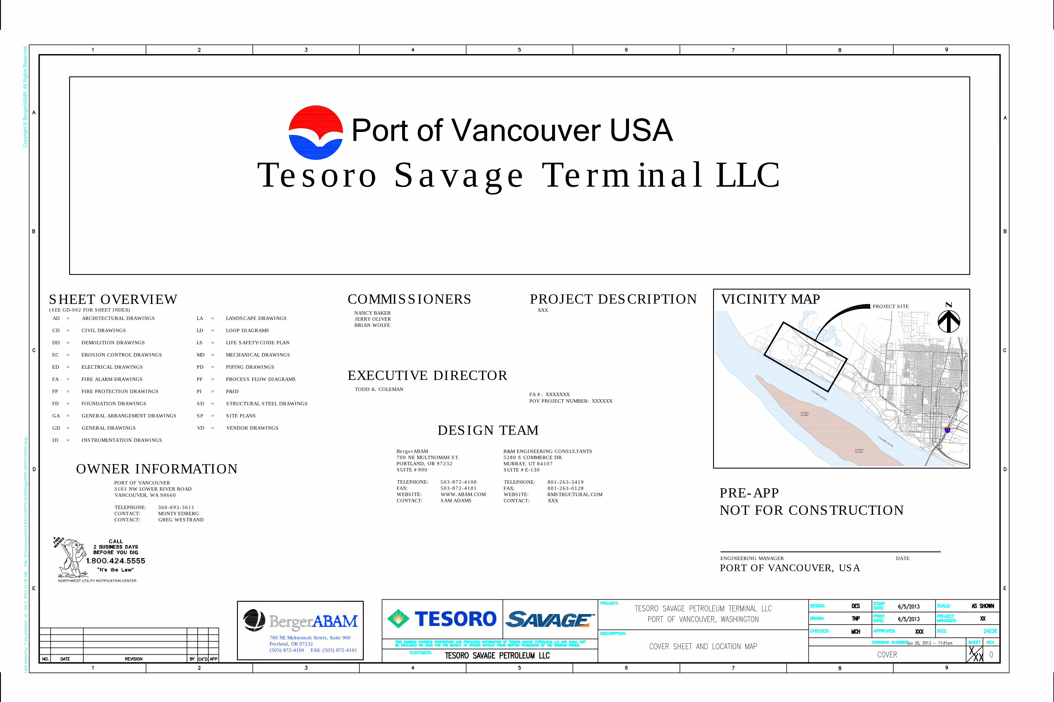
I-5
501
C
O
L
U
M
B
I
A
R
I
V
E
R
HAYDEN
ISLAND
P
o
r
tW
ay
W
M
i
l
l
P
l
a
i
n
B
l
v
d
W
2
6
t
h
W 8th Street
W 15th Street
W Fourth Plain Blvd
501
Franklin Street
Main Street
L
o
w
e
r
R
i
v
e
r
R
o
a
d
C
O
L
U
M
B
I
A
R
I
V
E
R
HAYDEN
ISLAND
Last S
aved by: T
ony.pritchett on: Jun 5, 2013 11:38 A
M F
ile: Q
:\V
ancouver\2013\A
13.0267\C
AD
D\D
wgs\P
RE
-A
PP
\C
OV
ER
.dw
gCopyright © BergerABAM. All Rights Reserved.
700 NE Multnomah Street, Suite 900
Portland, OR 97232
(503) 872-4100 FAX: (503) 872-4101
COMMISSIONERS
EXECUTIVE DIRECTOR
TODD K. COLEMAN
DESIGN TEAM
NANCY BAKER
JERRY OLIVER
BRIAN WOLFE
OWNER INFORMATION
BergerABAM
700 NE MULTNOMAH ST.
PORTLAND, OR 97232
SUITE #900
TELEPHONE: 503-872-4100
FAX: 503-872-4101
WEBSITE: WWW.ABAM.COM
CONTACT: SAM ADAMS
PORT OF VANCOUVER
3103 NW LOWER RIVER ROAD
VANCOUVER, WA 98660
TELEPHONE: 360-693-3611
CONTACT: MONTY EDBERG
CONTACT: GREG WESTRAND
Port of Vancouver USA
VICINITY MAPVICINITY MAP
PROJECT SITE
Tesoro Savage Terminal LLC
PRE-APP
NOT FOR CONSTRUCTION
AD = ARCHITECTURAL DRAWINGS
CD = CIVIL DRAWINGS
DD = DEMOLITION DRAWINGS
EC = EROSION CONTROL DRAWINGS
ED = ELECTRICAL DRAWINGS
FA = FIRE ALARM DRAWINGS
FP = FIRE PROTECTION DRAWINGS
FD = FOUNDATION DRAWINGS
GA = GENERAL ARRANGEMENT DRAWINGS
GD = GENERAL DRAWINGS
ID = INSTRUMENTATION DRAWINGS
LA = LANDSCAPE DRAWINGS
LD = LOOP DIAGRAMS
LS = LIFE SAFETY/CODE PLAN
MD = MECHANICAL DRAWINGS
PD = PIPING DRAWINGS
PF = PROCESS FLOW DIAGRAMS
PI = P&ID
SD = STRUCTURAL STEEL DRAWINGS
SP = SITE PLANS
VD = VENDOR DRAWINGS
SHEET OVERVIEW
(SEE GD-002 FOR SHEET INDEX)
PROJECT DESCRIPTION
POV PROJECT NUMBER: XXXXXX
FA #: XXXXXXX
XXX
ENGINEERING MANAGER DATE
PORT OF VANCOUVER, USA
R&M ENGINEERING CONSULTANTS
5280 S COMMERCE DR.
MURRAY, UT 84107
SUITE #E-130
TELEPHONE: 801-263-3419
FAX: 801-263-0128
WEBSITE: RMSTRUCTURAL.COM
CONTACT: XXX


RR
S
RR
S
RR
S
RR
S
RR
S
RR
S
RR
S
RR
S
RR
S
RR
S
RR
S
RR
S
RR
S
RR
S
RR
S
RR
S
RR
S
RR
S
RR
S
RR
S
RR
S
B
RR
S
RR
S
RR
S
RR
S
RR
S
RR
S
RR
S
RR
S
RR
S
RR
S
RR
S
B
B
D
D
D
D
D
D
WV
WV
WV
HB
HB
HB
HB
WV
D
D
D
60
" C
PP
54" CPP
PER PLAN 27" CPP
"Q
W D
UC
T"
D
W
W
WV
WV
WV
D
D
D
GF
GF
ICV
ICV
DDDDDD
HB
D
RD
D
WV
ICV
D
D
D
D
WV
WV
WV
D
D
D
WV
D
D
WV
WV
D
WV
HB
WV
WV
WV
WV
WW
ICVIC
V
ICV
ICV
D
D
D
D
D
CO
WV
WV
WV
WV
ICV
ICV
ICV
ICV
WV
ICV
ICV
ICV
ICV
ICV
WV
ICV
ICVIC
V
WV
WV
WV
W
WV
WV
ICV
D
D
D
D
ICV
ICV
ICV
ICV
WVWV
WV
WV
ICV
ICVICV
ICV
ICV
WV
WV
WV
WV
WV
WV
WV
WV
WV
WV
WV
W
WV
WV
WV
WV
D
GT
P
D
MW M
W
MW
D
GL
R
S
D
D
D
D
D
DD
D
D
D
D
D
D
ICV
GT
P
GT
P
D
D
D
D
S
S
S
D
E
E
E E E
E
EE E
E
E
E
E
Last S
aved by: T
ony.pritchett on: Jun 4, 2013 2:42 P
M F
ile: Q
:\V
ancouver\2013\A
13.0267\C
AD
D\D
wgs\P
RE
-A
PP
\K
EY
M
AP
.dw
gCopyright © BergerABAM. All Rights Reserved.
700 NE Multnomah Street, Suite 900
Portland, OR 97232
(503) 872-4100 FAX: (503) 872-4101

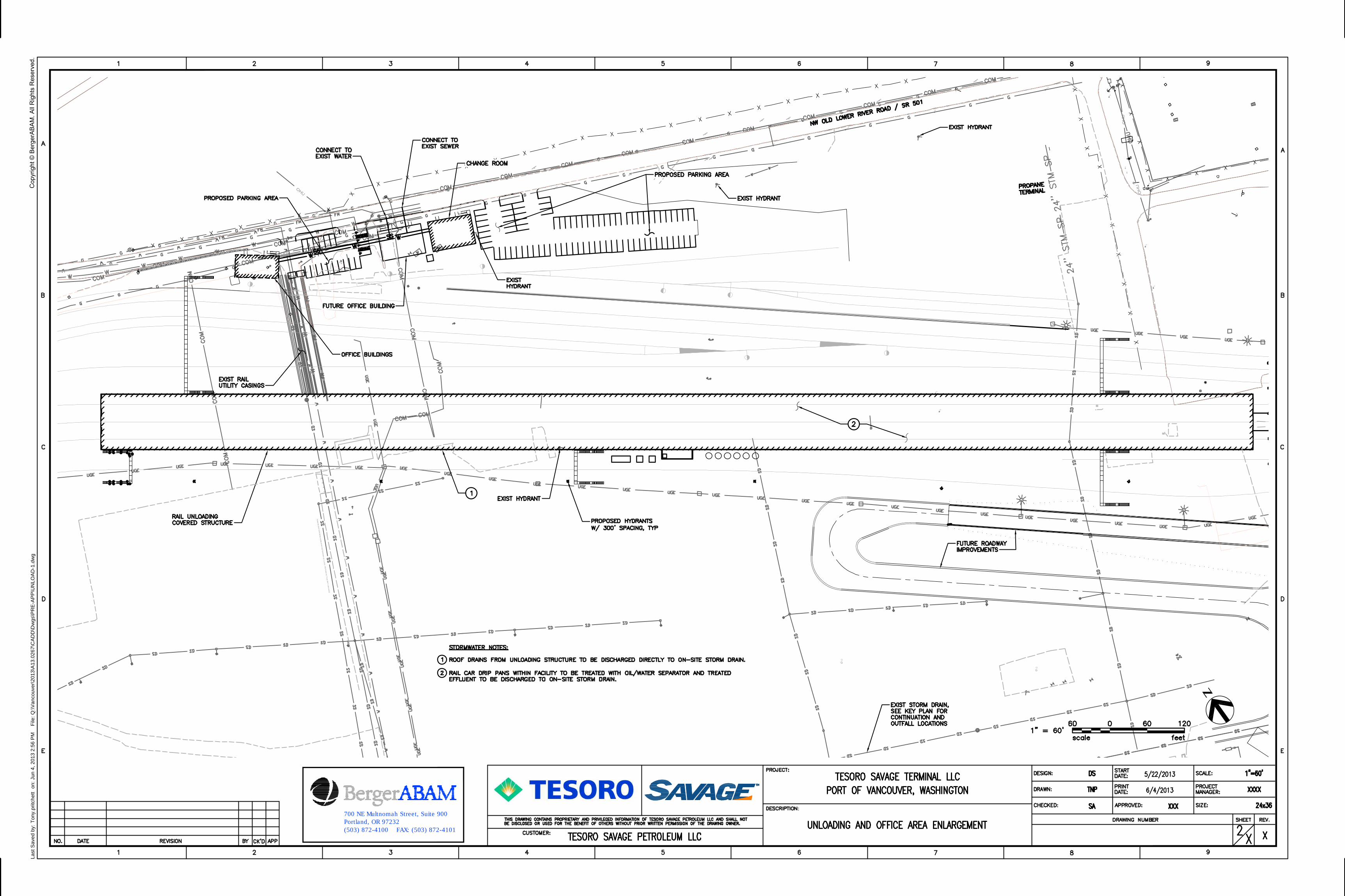
D
CO
S
D
D
CO
CO
OHU
OHU
OHU
OH
U
TR
CO
TR
TR
CO
OH
U
OH
U
GL
R
D
D
D
D
D
D
D
D
D
D
D
D
SA
NIT
AR
Y L
INE
ST
ILL
IN
GR
OU
ND
. T
OP
3'
OF
MA
NH
OL
ES
HA
VE
BE
EN
RE
MO
VE
D A
ND
BU
RIE
D.
S
S
BB
B
B
B
RR
S
B
B
B
B
B
B
Last S
aved by: T
ony.pritchett on: Jun 4, 2013 2:56 P
M F
ile: Q
:\V
ancouver\2013\A
13.0267\C
AD
D\D
wgs\P
RE
-A
PP
\U
NLO
AD
-1.dw
gCopyright © BergerABAM. All Rights Reserved.
700 NE Multnomah Street, Suite 900
Portland, OR 97232
(503) 872-4100 FAX: (503) 872-4101


B
B
RR
S
RR
S
B
B
B
B
B
RR
S
B
S
ICV
DHB
EB
EB
WV
E
E
E
E
E
E
E
E E EE E E E E E E E E E E E
EE
E E E E
Last S
aved by: T
ony.pritchett on: Jun 4, 2013 12:40 P
M F
ile: Q
:\V
ancouver\2013\A
13.0267\C
AD
D\D
wgs\P
RE
-A
PP
\T
AN
K-1.dw
gCopyright © BergerABAM. All Rights Reserved.
700 NE Multnomah Street, Suite 900
Portland, OR 97232
(503) 872-4100 FAX: (503) 872-4101

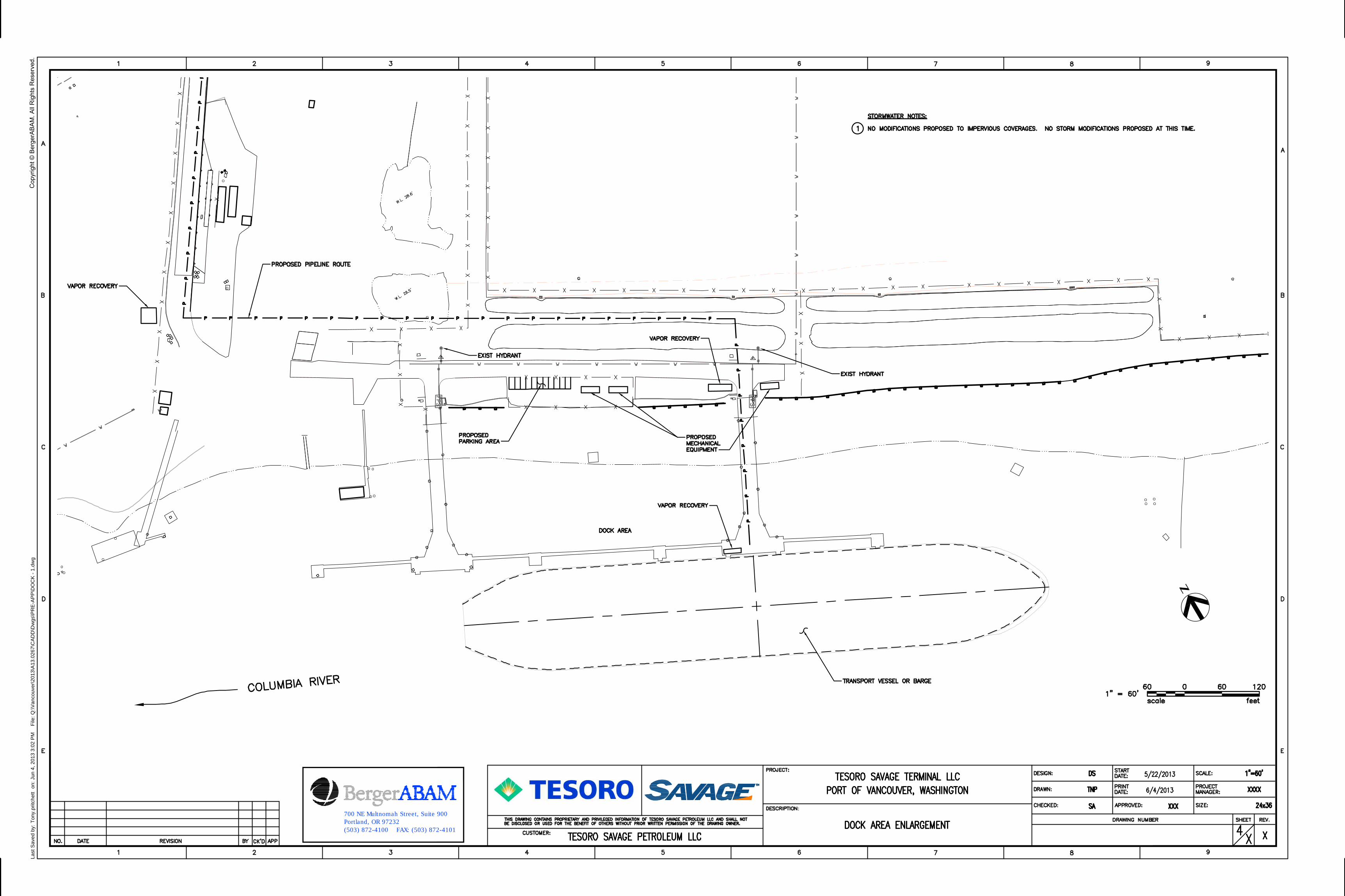
EX
IST
ING
JA
IL
BO
UN
DA
RY
Last S
aved by: T
ony.pritchett on: Jun 4, 2013 3:02 P
M F
ile: Q
:\V
ancouver\2013\A
13.0267\C
AD
D\D
wgs\P
RE
-A
PP
\D
OC
K - 1.dw
gCopyright © BergerABAM. All Rights Reserved.
700 NE Multnomah Street, Suite 900
Portland, OR 97232
(503) 872-4100 FAX: (503) 872-4101

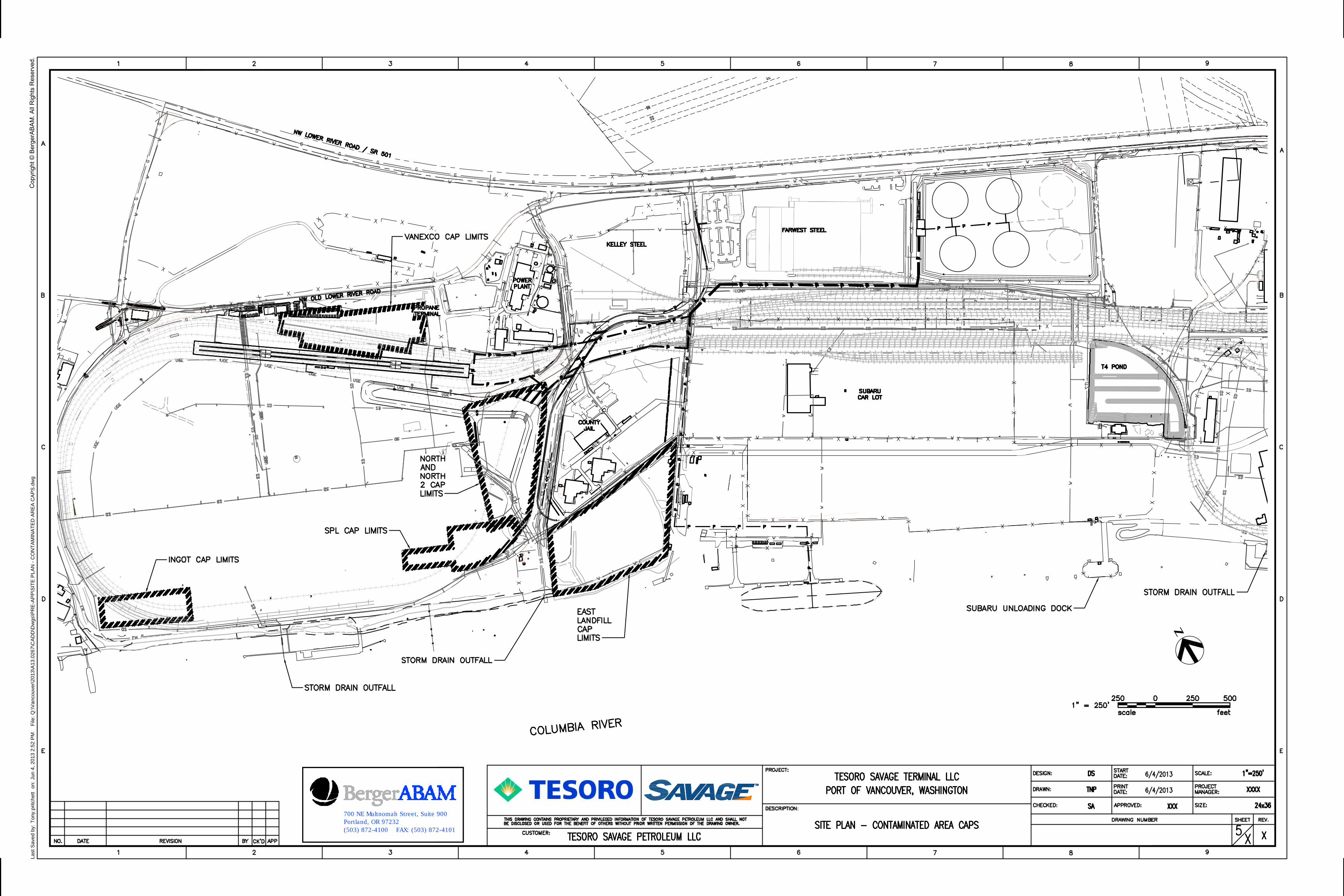
RR
S
RR
S
RR
S
RR
S
RR
S
RR
S
RR
S
RR
S
RR
S
RR
S
RR
S
RR
S
RR
S
RR
S
RR
S
RR
S
RR
S
RR
S
RR
S
RR
S
RR
S
B
RR
S
RR
S
RR
S
RR
S
RR
S
RR
S
RR
S
RR
S
RR
S
RR
S
RR
S
B
B
D
D
D
D
D
D
WV
WV
WV
HB
HB
HB
HB
WV
D
D
D
60
" C
PP
54" CPP
PER PLAN 27" CPP
"Q
W D
UC
T"
D
W
W
WV
WV
WV
D
D
D
GF
GF
ICV
ICV
DDDDDD
HB
D
RD
D
WV
ICV
D
D
D
D
WV
WV
WV
D
D
D
WV
D
D
WV
WV
D
WV
HB
WV
WV
WV
WV
WW
ICVIC
V
ICV
ICV
D
D
D
D
D
CO
WV
WV
WV
WV
ICV
ICV
ICV
ICV
WV
ICV
ICV
ICV
ICV
ICV
WV
ICV
ICVIC
V
WV
WV
WV
W
WV
WV
ICV
D
D
D
D
ICV
ICV
ICV
ICV
WVWV
WV
WV
ICV
ICVICV
ICV
ICV
WV
WV
WV
WV
WV
WV
WV
WV
WV
WV
WV
W
WV
WV
WV
WV
D
GT
P
D
MW M
W
MW
D
GL
R
S
D
D
D
D
D
DD
D
D
D
D
D
D
ICV
GT
P
GT
P
D
D
D
D
S
S
S
D
E
E
E E E
E
EE E
E
E
E
E
Last S
aved by: T
ony.pritchett on: Jun 4, 2013 2:52 P
M F
ile: Q
:\V
ancouver\2013\A
13.0267\C
AD
D\D
wgs\P
RE
-A
PP
\S
IT
E P
LA
N - C
ON
TA
MIN
AT
ED
A
RE
A C
AP
S.dw
gCopyright © BergerABAM. All Rights Reserved.
700 NE Multnomah Street, Suite 900
Portland, OR 97232
(503) 872-4100 FAX: (503) 872-4101

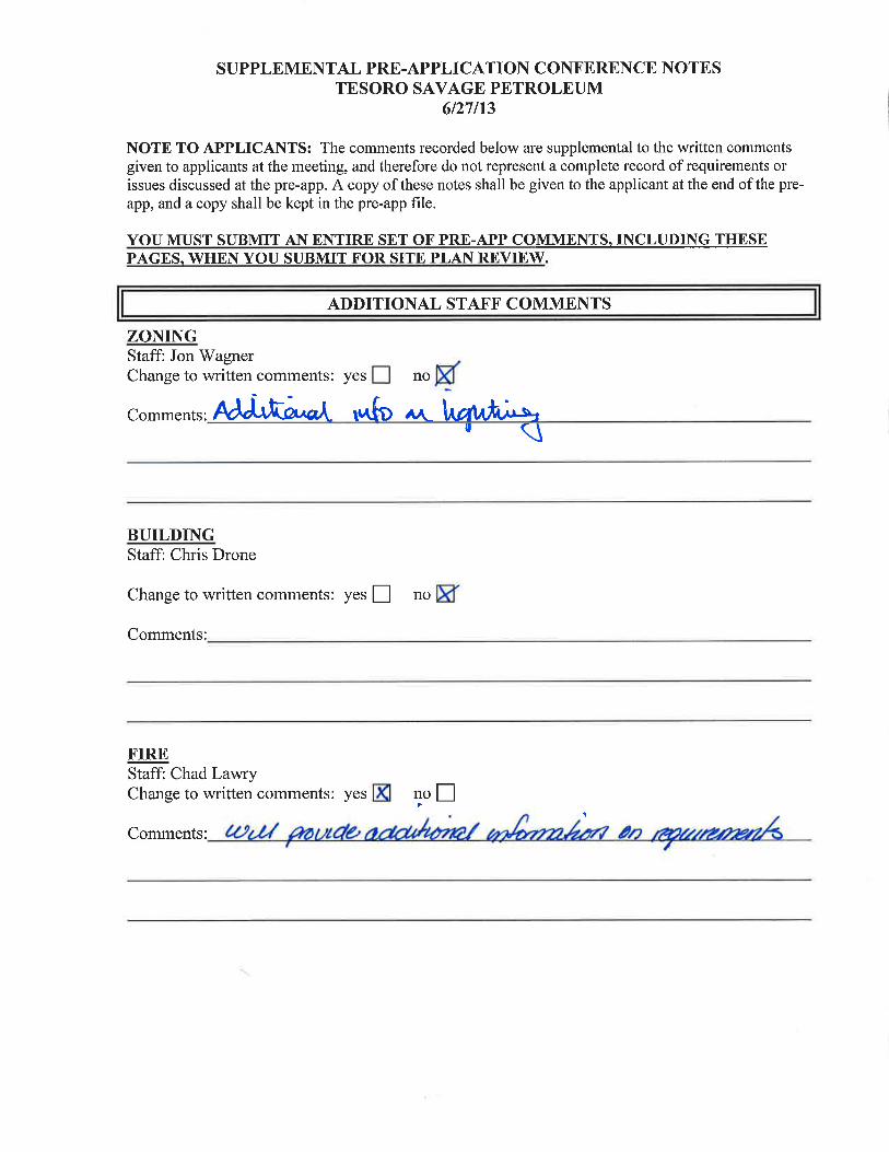
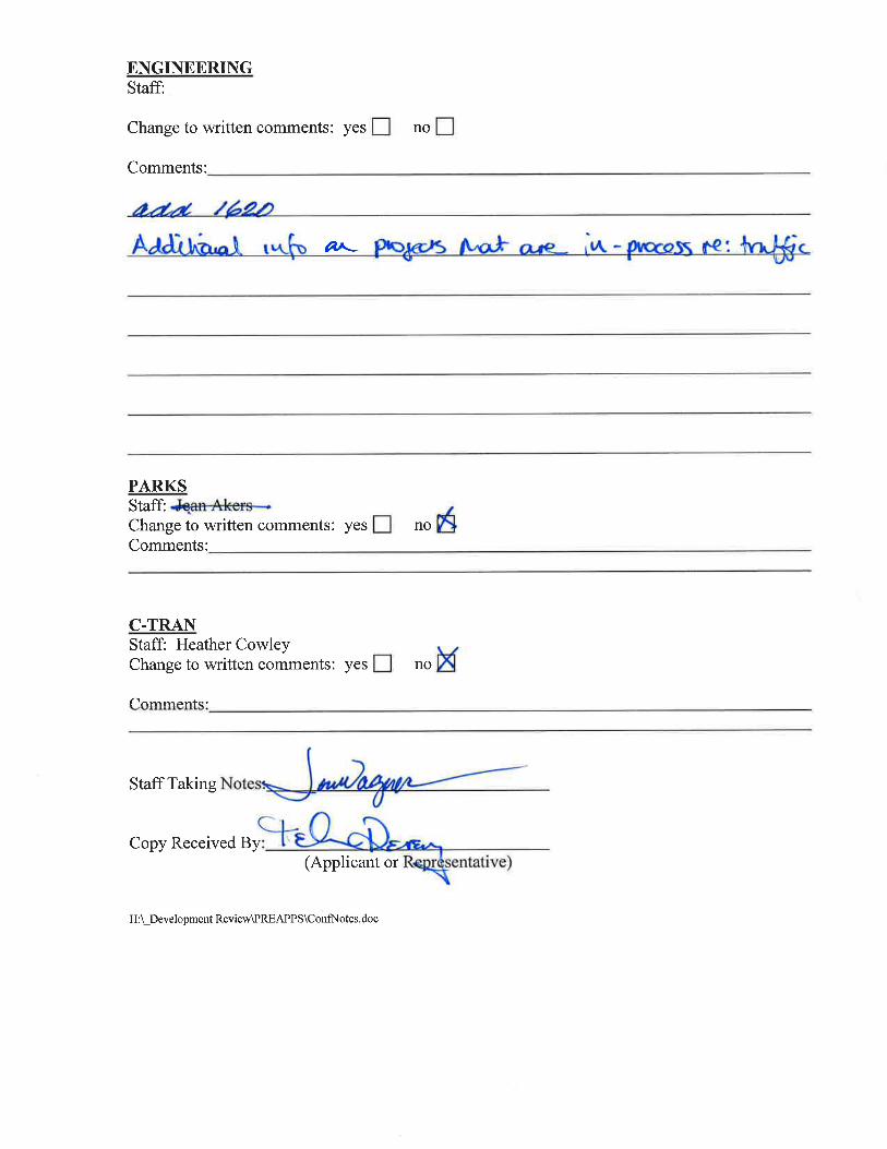
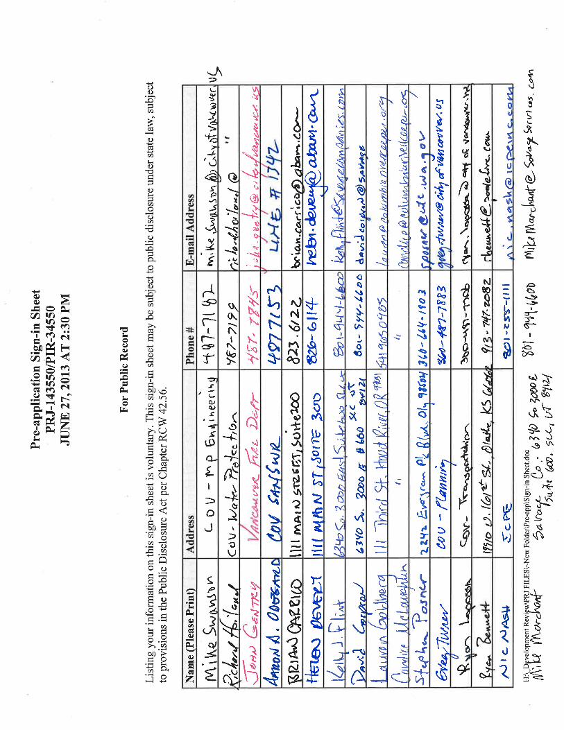
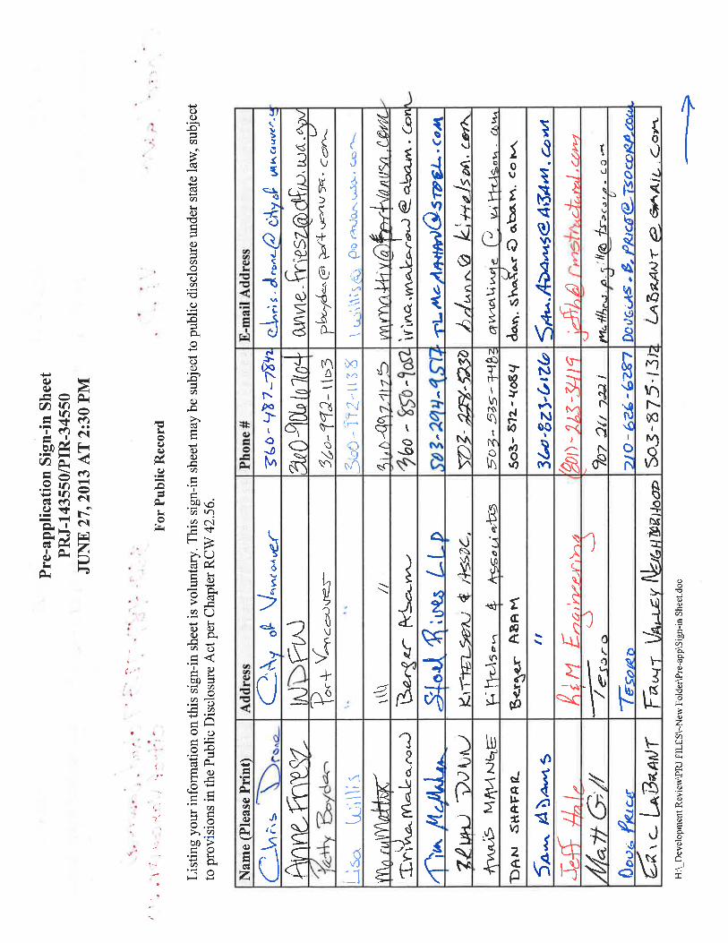
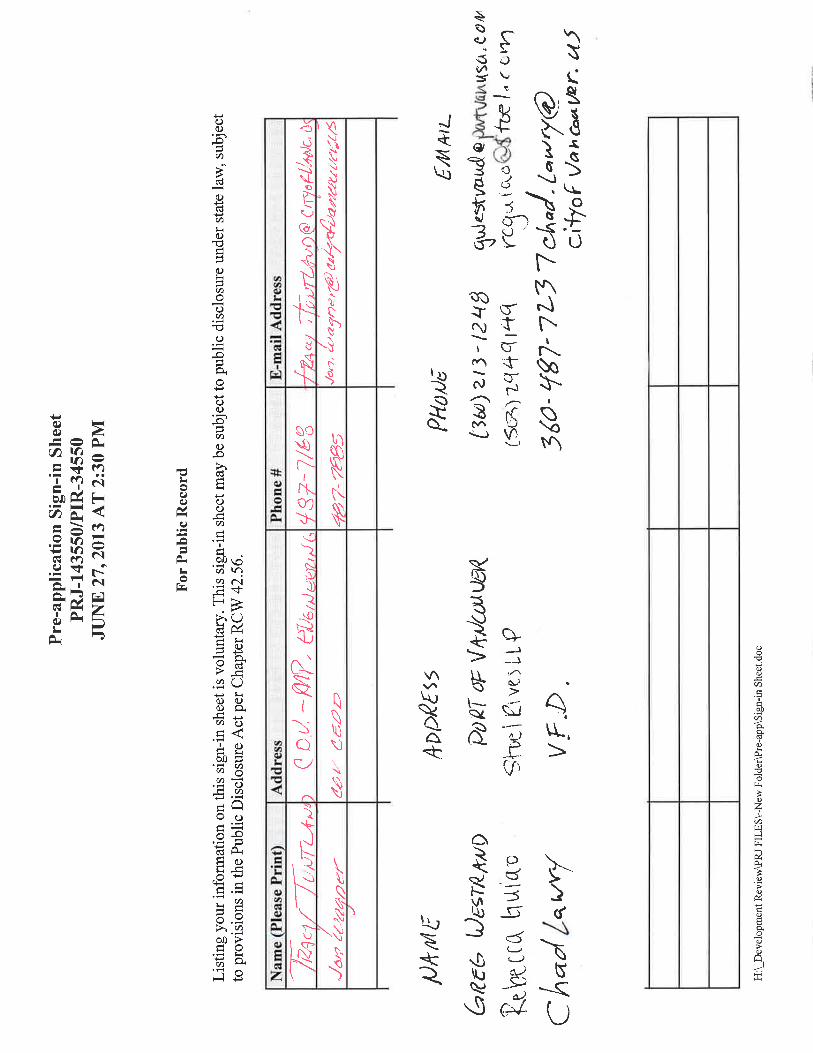


1 2
P.O. Box 1995 Vancouver, WA 98668-1995 3 www.cityofvancouver.us 4
5 6 7
Pre-Application Conference 8
Community & Economic Development Department 9
10 Conference Date: 6/27/13 at 2:30 pm 11 12 Case File: Tesoro Savage Petroleum PRJ-143550/PIR-34550 13
14
Description: The project is designed to receive crude oil by rail, transfer it to 15 storage tanks then load the oil onto ships or barges for transport to 16 end users. The proposal includes constructing administrative and 17 support buildings, rail unloading facility, piping, 6 tanks that can 18 store up to 380,000 barrels each, marine loading facility that will 19 include pipelines, cranes, observation/control platform and lighting 20 for the existing dock structure. A boiler/steam plant will be built 21 on the site and an additional two rail lines will be added to the rail 22 infrastructure at the Terminal 5 loop. 23
24 Site Location: 5501 NW Lower River Rd 25 26 Legal Description: Tax Lots 152903000, located in the NE Quarter of Section 19, 27
Township 2N, Range 1E of the Willamette Meridian 28 29
Contact Helen Devery 30 Berger/ABAM 31 1111 Main St. Ste 300 32 Vancouver, WA 98660 33 360-823-6100 34 35
Applicant: Tesoro Savage Petroleum Terminal LLC 36 Kelly Flint 37 6340 South 3000 East 38 Suite 600 39 Salt Lake City, UT 84121 40 41 42
43

PRJ-143550/PIR-34550 Tesoro Savage Petroleum Page 2
Property Owner: Port of Vancouver, USA 44 3103 NW Lower River Rd. 45 Vancouver, WA 98660 46 360-693-3611 47
48 Comprehensive Plan: Industrial 49
50 Zoning Designation: IH (Heavy Industrial) 51
52 Case Manager: Jon Wagner, Senior Planner 53
54 Neighborhood Assoc(s): Fruit Valley, Chair: Eric LaBrant 55

PRJ-143550/PIR-34550 Tesoro Savage Petroleum Page 3
PROCEDURAL NOTE 56
RCW 80.50 establishes the Energy Facility Site Evaluation Council. RCW 80.50.040 ‘enumerates 57 the powers of the council, including review of energy plants. 58 59 RCW 80.50.020 (12) (d) defines energy plant as including the following; 60
Facilities which will have the capacity to receive more than an average of fifty 61 thousand barrels per day of crude or refined petroleum or liquefied petroleum gas 62 which has been or will be transported over marine waters, except that the provisions 63 of this chapter shall not apply to storage facilities unless occasioned by such new 64 facility construction. 65 66
As this proposal meets the definition of energy plant, it will be reviewed by the Washington State 67 Energy Facility Site Evaluation Council. 68 69 RCW 80.50.120 addresses the effect of certification as follows: 70 (1) Subject to the conditions set forth therein any certification shall bind the state and each of its 71
departments, agencies, divisions, bureaus, commissions, boards, and political subdivisions, 72 whether a member of the council or not, as to the approval of the site and the construction 73 and operation of the proposed energy facility. 74
75 (2) The certification shall authorize the person named therein to construct and operate the 76
proposed energy facility subject only to the conditions set forth in such certification. 77 78 (3) The issuance of a certification shall be in lieu of any permit, certificate or similar 79
document required by any department, agency, division, bureau, commission, board, 80 or political subdivision of this state, whether a member of the council or not. [Emphasis 81 added] 82
83 Although the state will have the overall review authority for the proposal, the following 84 preapplication conference report indicates the regulations and standards that would be applicable if 85 the city were charged with the review authority . 86 87
APPLICABLE STANDARDS 88
The application shall include a comprehensive narrative addressing how the development 89 complies with the standards outlined below, including a description of the uses proposed for the 90 site, and a construction schedule. 91 92 VMC Title 11: Streets and Sidewalks 93 VMC Title 11.95: Concurrency 94 VMC Title 12: Trees and Vegetation 95 VMC Title 14.04, 14.10, and 14.16: Water and Sewers 96 VMC Title 14.24: Erosion Control 97 VMC Title 14.25: Stormwater 98 VMC Title 14.26: Water Resource Protection 99 VMC Title 16: Fire Code 100 VMC Title 17: Building and Construction 101
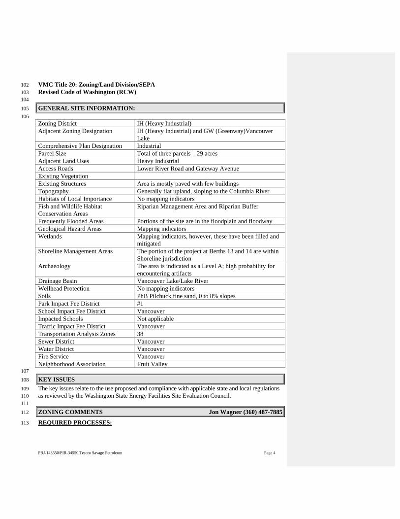
PRJ-143550/PIR-34550 Tesoro Savage Petroleum Page 4
VMC Title 20: Zoning/Land Division/SEPA 102 Revised Code of Washington (RCW) 103 104
GENERAL SITE INFORMATION: 105 106 Zoning District IH (Heavy Industrial)Adjacent Zoning Designation IH (Heavy Industrial) and GW (Greenway)Vancouver
Lake Comprehensive Plan Designation IndustrialParcel Size Total of three parcels – 29 acres Adjacent Land Uses Heavy Industrial Access Roads Lower River Road and Gateway AvenueExisting Vegetation Existing Structures Area is mostly paved with few buildingsTopography Generally flat upland, sloping to the Columbia RiverHabitats of Local Importance No mapping indicatorsFish and Wildlife Habitat Conservation Areas
Riparian Management Area and Riparian Buffer
Frequently Flooded Areas Portions of the site are in the floodplain and floodwayGeological Hazard Areas Mapping indicatorsWetlands Mapping indicators, however, these have been filled and
mitigated Shoreline Management Areas The portion of the project at Berths 13 and 14 are within
Shoreline jurisdictionArchaeology The area is indicated as a Level A; high probability for
encountering artifactsDrainage Basin Vancouver Lake/Lake RiverWellhead Protection No mapping indicatorsSoils PhB Pilchuck fine sand, 0 to 8% slopesPark Impact Fee District #1 School Impact Fee District Vancouver Impacted Schools Not applicableTraffic Impact Fee District Vancouver Transportation Analysis Zones 38 Sewer District VancouverWater District VancouverFire Service VancouverNeighborhood Association Fruit Valley 107
KEY ISSUES 108
The key issues relate to the use proposed and compliance with applicable state and local regulations 109 as reviewed by the Washington State Energy Facilities Site Evaluation Council. 110 111
ZONING COMMENTS Jon Wagner (360) 487-7885 112
REQUIRED PROCESSES: 113
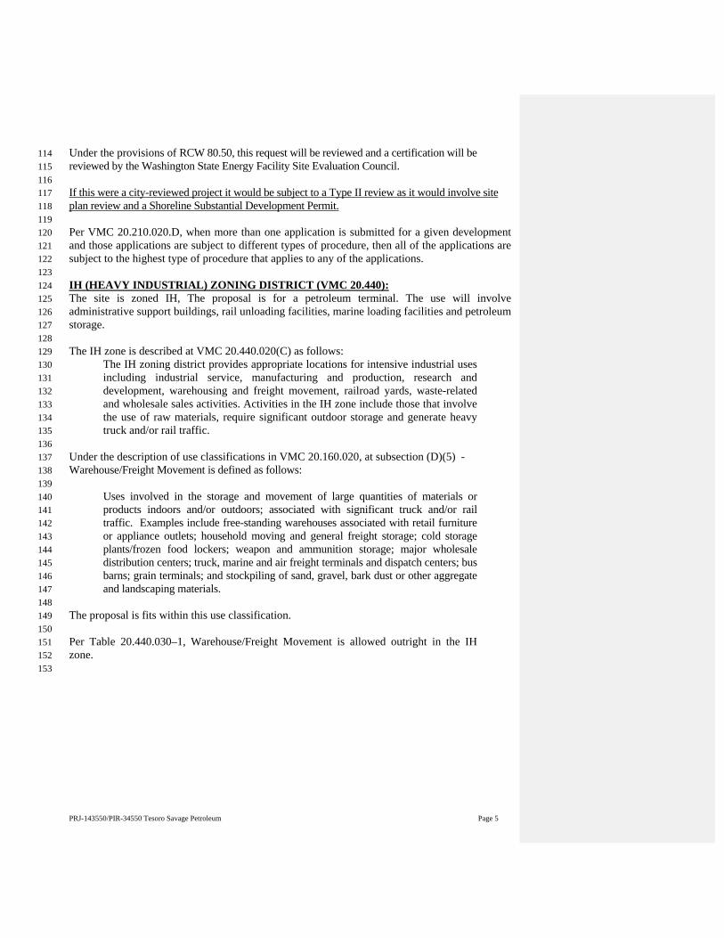
PRJ-143550/PIR-34550 Tesoro Savage Petroleum Page 5
Under the provisions of RCW 80.50, this request will be reviewed and a certification will be 114 reviewed by the Washington State Energy Facility Site Evaluation Council. 115 116 If this were a city-reviewed project it would be subject to a Type II review as it would involve site 117 plan review and a Shoreline Substantial Development Permit. 118 119 Per VMC 20.210.020.D, when more than one application is submitted for a given development 120 and those applications are subject to different types of procedure, then all of the applications are 121 subject to the highest type of procedure that applies to any of the applications. 122 123 IH (HEAVY INDUSTRIAL) ZONING DISTRICT (VMC 20.440): 124 The site is zoned IH, The proposal is for a petroleum terminal. The use will involve 125 administrative support buildings, rail unloading facilities, marine loading facilities and petroleum 126 storage. 127 128 The IH zone is described at VMC 20.440.020(C) as follows: 129
The IH zoning district provides appropriate locations for intensive industrial uses 130 including industrial service, manufacturing and production, research and 131 development, warehousing and freight movement, railroad yards, waste-related 132 and wholesale sales activities. Activities in the IH zone include those that involve 133 the use of raw materials, require significant outdoor storage and generate heavy 134 truck and/or rail traffic. 135
136 Under the description of use classifications in VMC 20.160.020, at subsection (D)(5) - 137 Warehouse/Freight Movement is defined as follows: 138 139
Uses involved in the storage and movement of large quantities of materials or 140 products indoors and/or outdoors; associated with significant truck and/or rail 141 traffic. Examples include free-standing warehouses associated with retail furniture 142 or appliance outlets; household moving and general freight storage; cold storage 143 plants/frozen food lockers; weapon and ammunition storage; major wholesale 144 distribution centers; truck, marine and air freight terminals and dispatch centers; bus 145 barns; grain terminals; and stockpiling of sand, gravel, bark dust or other aggregate 146 and landscaping materials. 147 148
The proposal is fits within this use classification. 149 150 Per Table 20.440.030–1, Warehouse/Freight Movement is allowed outright in the IH 151 zone. 152
153

PRJ-143550/PIR-34550 Tesoro Savage Petroleum Page 6
154 DEVELOPMENT STANDARDS (VMC 20.440) 155
Table 20.440.040-1 sets out the development standards in the IH zone as follows: 156
Standard Required Existing/Proposed Minimum lot size none Not applicableMaximum lot coverage 100% Not applicableMinimum lot width None Not applicableMinimum lot depth None Not applicableMinimum setbacks*
Separated from site by a street
Pursuant to buffering and screening standards contained in VMC Tables 20.925.030-1 and 20.925.030-2.
Not indicated, see provisions relating to landscaping below
Not separated from site by a street feet
Not indicated, see provisions relating to landscaping below
Maximum height None Not applicableMinimum landscaping requirement (percentage of total net area)
0 Pursuant to buffering and screening standards contained in VMC Tables 20.925.030-1 and 20.925.030-2.
157 * Staff has reviewed these standards and has determined they are not appropriate to development 158 within the Port of Vancouver. Staff has previously issued a determination that no setbacks are 159 required adjoining Harborside Drive (see Minor Adjustment for Port of Vancouver Terminal 4 160 Setback, PRJ2009-01134/MZR2009-00378 dated Dec.22, 2009). However, those portions of the 161 proposal that border on property not owned by the Port of Vancouver, or have frontage on a public 162 street will be required to meet the landscaping/setback requirements. The landscaping standards 163 will apply to the proposed development on Parcel 1A for the boundary along Lower River Road 164 and the boundary between Parcel 1A and the Farwest Steel facility to the west. 165 166 ARCHAEOLOGICAL RESOURCE PROTECTION (VMC 20.710): 167 The purpose of this ordinance is to encourage the identification and preservation of cultural, 168 archaeological, and historic resources consistent with the Growth Management Act of 1990 as 169 well as the Vancouver Comprehensive Plan. This project is located within an area of high 170 probability for discovery of archaeological resources; therefore, a predetermination would be 171 required. The archaeological predetermination shall be prepared by a profession archaeologist as 172 defined by the state of Washington in RCW 27.53.030(8). However, if any cultural or historical 173 resources are discovered during construction activity, construction shall cease until a qualified 174 archaeologist assesses the find. This application will contact all applicable authorities. 175 176 CRITICAL AREAS PROTECTION (VMC 20.740): 177 Projects requiring Critical Area Permits are required to submit the critical area boundary 178 locations in digital format. The digital submittal can be in a CAD file or a GIS shapefile. The 179 digital data must be on the same coordinate system as the Clark County GIS database: State 180 plane coordinates using NAD 1983 datum and the Washington State zone (also referred to as the 181 FIPS zone 4602). 182 183
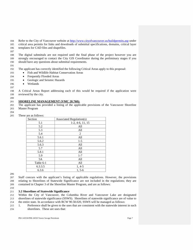
PRJ-143550/PIR-34550 Tesoro Savage Petroleum Page 7
Refer to the City of Vancouver website at http://www.cityofvancouver.us/buildpermits.asp under 184 critical area permits for links and downloads of submittal specifications, domains, critical layer 185 templates for CAD files and shapefiles. 186 187 The digital submittals are not required until the final phase of the project however you are 188 strongly encouraged to contact the City GIS Coordinator during the preliminary stages if you 189 should have any questions about submittal requirements. 190 191 The applicant has correctly identified the following Critical Areas apply to this proposal: 192
Fish and Wildlife Habitat Conservation Areas 193 Frequently Flooded Areas 194 Geologic and Seismic Hazards 195 Wetlands 196
197 A Critical Areas Report addressing each of this would be required if the application were 198 reviewed by the city. 199 200 SHORELINE MANAGEMENT (VMC 20.760): 201 The applicant has provided a listing of the applicable provisions of the Vancouver Shoreline 202 Master Program 203 204 These are as follows: 205
Section Associated Regulation(s)5.1 1-2, 4-6, 11, 155.2 All5.3 All5.4 2
5.6.1 All5.6.2 1-55.6.3 All5.7 All
5.8.1 All5.9 1-75A All
Table 6-1 All6.3.3.5 1, 4-56.3.6 1, 5-6
206 Staff concurs with the applicant’s listing of applicable regulations. However, the provisions 207 relating to Shorelines of Statewide Significance are not included in the regulations; they are 208 contained in Chapter 3 of the Shoreline Master Program, and are as follows: 209 210 3.2 Shorelines of Statewide Significance 211 Within the City of Vancouver, the Columbia River and Vancouver Lake are designated 212 shorelines of statewide significance (SSWS). Shorelines of statewide significance are of value to 213 the entire state. In accordance with RCW 90.58.020, SSWS will be managed as follows: 214 1. Preference shall be given to the uses that are consistent with the statewide interest in such 215
shorelines. These are uses that: 216

PRJ-143550/PIR-34550 Tesoro Savage Petroleum Page 8
a. Recognize and protect the statewide interest over local interest; 217 b. Preserve the natural character of the shoreline; 218 c. Result in long term over short term benefit; 219 d. Protect the resources and ecological function of the shoreline; 220 e. Increase public access to publicly-owned areas of the shorelines; 221 f. Increase recreational opportunities for the public in the shoreline; and 222 g. Provide for any other element as defined in RCW 90.58.100 deemed appropriate or 223
necessary. 224 2. Uses that are not consistent with these policies should not be permitted on SSWS. 225 3. Those limited shorelines containing unique, scarce and/or sensitive resources should be 226
protected. 227 4. Implementation of restoration projects on shorelines of statewide significance should take 228
precedence over implementation of restoration projects on other shorelines of the state. 229 5. Development should be focused in already developed shoreline areas to reduce adverse 230
environmental impacts and to preserve undeveloped shoreline areas. In general, SSWS 231 should be preserved for future generations by 1) restricting or prohibiting development 232 that would irretrievably damage shoreline resources, and 2) evaluating the short-term 233 economic gain or convenience of developments relative to the long-term and potentially 234 costly impairments to the natural shoreline. 235
236 Staff customarily requires the applicant to address these provisions. 237 238 TREE CONSERVATION (VMC 20.770): 239 The purpose of this ordinance is to establish a process and standards to provide for the protection, 240 preservation, replacement, proper maintenance and use of trees, associated vegetation and 241 woodlands located within the City of Vancouver. 242 243 Unless otherwise exempted in Section 20.770.030, any site subject to a development, as defined in 244 Section 20.150, within the City of Vancouver, shall be required to develop a Tree Plan and shall be 245 required to meet the minimum tree density. (VMC 20.770.080). 246 247 Departmental policy is that if the area of a proposed building or other construction is in an area 248 that is currently covered by impervious surfaces, the provisions of VMC 20.770 do not apply. To 249 meet this standard the applicant must demonstrate the existing site is covered by impervious 250 surfaces. For the pervious areas, the applicant is required to show compliance with the 30 tree 251 units per acre requirement. 252 253 Per VMC 20.770.100.C, the tree maintenance requirements shall apply in perpetuity to 254 developments that are multi-family residential developments in excess of four units, commercial 255 and industrial. The applicant shall execute a covenant in a form agreeable to the City which shall 256 require that the applicant and his successors comply with the maintenance requirement imposed 257 by this section. The covenant shall be binding on successor property owners and owners’ 258 associations. The covenant shall be recorded by the county auditor. 259 260 261 262 SEPA REGULATIONS (VMC 20.790): 263

PRJ-143550/PIR-34550 Tesoro Savage Petroleum Page 9
The State Environmental Policy Act, Chapter 43.21C RCW, is intended to ensure that 264 environmental values are considered by state and local government officials when making 265 decisions. The primary purpose of SEPA is to evaluate the environmental impacts of a proposed 266 project and identify methods to reduce the impacts. A SEPA review of this proposal will be 267 required as the proposal exceeds several of the categorical exemption thresholds. 268 269 GATED ACCESS STANDARDS (VMC 20.914): 270 If the proposed development includes provisions for gated access, this section contains 271 regulations and other design standards for approval. Describe how the issues are satisfied in the 272 project narrative. 273 274 Stacking area. Each access point shall show an area of sufficient length and width to safely stack 275 traffic coming onto the property from the adjacent roadway. Transportation Services shall 276 determine the length of the stacking area based on the adjacent roadway type and design 277 configuration. A parking area shall be provided to the right of the entry lane to 278 accommodate visitors not able to open the gate. 279 280 Entrance/Exit Design. Adequate vision clearance shall be provided so that motorists leaving a 281 gated community have a clear view of the sidewalk on either side of the exit, and so that 282 approaching pedestrians have a clear view of any approaching vehicle. Gated community 283 entrances and exits shall be designed to achieve travel speeds not to exceed 5 miles per hour, and 284 shall require a vehicle stop directly prior to crossing the street sidewalk. Entrance and exit areas 285 shall be designed so that vehicles approaching or leaving the gated community can queue to 286 enter/exit the traffic stream without blocking the sidewalk. 287 288 Turnaround feature. Each gate access point shall have an area that allows traffic to safely 289 maneuver a turnaround when the gate is in closed position. 290 291 Lane width inside the gate. Fire and emergency access vehicles require passing room within the 292 development. Twenty feet of unobstructed driving surface is required on the interior side of the 293 access point and gate. 294 295 Emergency vehicle access required. Each project will require the applicant to produce a 296 confirmation of approval from the Fire Marshal that indicates that the design of the gate(s) meets 297 the Fire Marshal’s requirements for emergency entry. The Fire Marshal’s written approval shall 298 be submitted with this application. 299 300 No encroachment into publicly owned right-of-way. The gates, operating equipment and fencing 301 shall be located wholly within the private portion of the property. The property line shall be 302 clearly indicated on the site plan. Swing gates are not allowed to encroach into the public right-303 of-way. The drives, streets and lanes inside a gated community are to remain private. 304 305 Pedestrian Access. Separate pedestrian access from driving lanes. Each access point shall have a 306 pedestrian access and walkway that is separate from the driving lanes and links directly to the 307 public sidewalk. Pedestrian walkways shall meet all standards for accessibility required by the 308 Americans with Disability Act. 309 310

PRJ-143550/PIR-34550 Tesoro Savage Petroleum Page 10
Lighting. Lighting fixtures shall be established and maintained at the access points to provide 311 vehicle and pedestrian safety. The required lighting shall be automatically controlled to turn on 312 during the hours of darkness. 313 314 Vision Clearance. Each access point shall demonstrate vision clearance as per 20.985 VMC. 315 316 Gate Material. The moving portion of the gate shall be constructed of material that is at least 80 317 percent open. Typically, wrought iron or other decorative material is used. 318 319 Gate opening width. Each gate must open to a minimum width of 15 feet or as required by the 320 Fire Marshal. 321 322 IMPACT FEES (VMC 20.915): 323 Impact fees are calculated at the time of project approval not pre-application. Currently impact fees 324 are calculated as follows: 325 326 Transportation impact fees will be required prior to issuance of building permits. The project is 327 located within the Vancouver Subarea which requires $139 per trip. Transportation impact fees will 328 be determined based on the trip generation report submitted with the application. The following is 329 the formula for calculating the transportation impact fee: 330
TIF = Average Daily Trips x $139 x .85 331 332 School Impact Fees and Park Impact Fees are not required as no residential uses are being 333 proposed. 334 335 LANDSCAPING (VMC 20.925): 336 VMC Table 20.925.030-1 indicates the required landscaping and setback between various uses. The chart 337 is based on the zoning of the subject property, the zoning of the adjacent properties and whether there is 338 an intervening street. 339 340 As the city has agreed that landscaping between interior lots within the port is not required, the following 341 setbacks and landscaping apply only to the development of Parcel 1A: 342 343 For the north boundary; along NW Lower River Road, the adjacent property, to the north of NW Lower 344 River Road is zoned GW (Greenway, Vancouver Lake). As the subject property is separated from the GW 345 zone by a street, the L2 standard with a 10 foot setback is required. 346 347 For the west boundary, abutting the Farwest Steel site, an IH zoned parcel, the required minimum setback 348 is either 5 feet or 0 feet (If building is to be built on the property line there is no required buffer 349 for that portion of the site). The building constructed must meet all standards for zero lot line 350 development. The level of landscaping, if required, is L1. 351
352 The specific landscaping standards relating to the L1, and L2 standards are indicated below: 353 354 VMC Table 20.925.030-2 Landscaping and Screening Design Standards1 355 356 Type Name Description Minimum Shrubs
Based on Buffer DepthMinimum Trees Wall or Berm or
Fence Required - Standards

PRJ-143550/PIR-34550 Tesoro Savage Petroleum Page 11
L1 General (for open
areas)
Used where distance is primary means of separating uses or development, and landscaping enhances area between them
a. 10 ft or less = None b. Over 10 ft = 2 high or 3 low shrubs per 400 sq. ft. landscaped area
a. One tree per 30 lineal ft b. One tree per 800 sq. ft.
None
L2 Low Screen
Distance and low-level screening intended to separate uses or development. Applied where low level screening sufficiently reduces the impact of a use or development, or where visibility between areas is more important than a greater visual screen.
Continuous screen 3 ft high, 95% opaque year-round. 3+ gallon containers or equivalent with spread 18+ inches.
One tree per 30 lineal ft of landscaped area or as needed to provide a tree canopy over the landscaped area
3 ft high masonry wall or F2 fence or a berm may substitute for shrubs
357 1 Additional Requirements: 358
L1, L2, L3, L4, L5 - Groundcover plants, grass lawn or approved flowers must fully cover the 359 landscaped area not in shrubs or trees. 360 361 L2, L3 - When applied along street lot lines, the screen or wall is to be placed along the interior side 362 of the landscaped area. 363 364 L4 - When abutting another property, the wall shall abut the property line. When abutting a street or 365 road right-of-way, the wall shall be on the interior side of the landscaped area. 366 367 L1 - Within the commercial districts where a building is to be placed at the buffer line for a front 368 setback, concrete or brick pavers may be used in place of the required groundcover for the length of 369 the building for the front setback only; provided, the required trees are still supplied, the paved area is 370 connected to the public sidewalk, and pedestrian amenities are provided such as benches or pedestrian 371 plazas. Building need not be placed at the required buffer line to utilize this section if the area 372 between the buffer line and the building is devoted entirely to pedestrian only areas. 373 374 L1, L2, L3, L4, L5 – Groundcover plants to be placed not more than thirty (30) inches on center and 375 thirty (30) inches between rows. Rows of plants shall be staggered for a more effective covering. 376 Groundcover shall be supplied in a minimum four (4) inch size container or a two and one-quarter (2 377 1/4) inch container or equivalent if planted eighteen (18) inches on center. 378
379 PARKING and LOADING (VMC 20.945): 380 Per Table 20.945.070-2, the Warehouse/Freight Movement use must provide one parking space per 381 each 2,000 square feet of floor area. 382 383 The parking lot development standards are contained in VMC 20.945.040 as follows: 384 385 A. Review Authority. Parking lot design and drainage shall be subject to review and 386 approval of the City Transportation Manager. 387 388
PRJ-143550/PIR-34550 Tesoro Savage Petroleum Page 12
B. Maintenance of parking areas. All parking lots shall be kept clean and in good repair 389 at all times. Breaks in paved surfaces shall be repaired promptly. Broken or splintered 390 wheel stops shall be replaced so that their function will not be impaired. 391 392 C. All signing and striping, including that for private parking lots, shall conform to the 393 Manual of Uniform Traffic Control Devices (MUTCD). Individual spaces shall be 394 marked with painted stripes. 395 396 D. Location. Parking spaces shall not be permitted in any setback except as otherwise 397 specified in this title. For single-family and duplex dwellings, passenger vehicle parking 398 in excess of required parking is permitted in the front yard setback provided it is: located 399 on a legally established driveway; located out of sight triangles as per 20.895 VMC; and 400 does not extend into City right-of-way. Parking in the front yard setback otherwise 401 allowed by this Chapter shall not include the storage of motor homes, trailers or 402 recreational vehicles, including boats. Parking of motor homes, trailers recreational 403 vehicles and boats is allowed in one side or rear setback on an impervious surface and 404 served by a paved driveway. Such parking must be screened from the street and adjoining 405 properties by a 6’ sight obscuring fence or hedge. 406 407 E. No parking space shall be located where backing maneuvers from such a space would 408 interfere with traffic flow to/from a public street to the parking area, generally within 20’ 409 of a circulation aisle-way near a public street access point. 410 411 F. Driveways. Driveways which provide access to off-street parking or loading from 412 public streets shall comply with the following: 413 414
1. Driveways from the street to off-street parking or loading areas shall be designed 415 and constructed to facilitate the flow of traffic and provide maximum safety for 416 pedestrians. At a minimum all driveways shall meet arterial access spacing standards; on 417 arterial roadways shared driveways and cross-access easements may be required to 418 improve arterial efficiency and safety consistent with access management practices 419 detailed in NCHRP Report 420. 420
421 2. Where driveways are gated, even temporarily, the driveway approach shall be 422
designed such that vehicles approaching or leaving the gated drive can queue to enter/exit 423 the traffic stream without blocking the sidewalk or the street traffic, and shall not impede 424 internal site circulation. Design of gated driveways shall be subject to review and 425 approval by the City Transportation Manager. 426
427 3. Driveways shall be improved with a permanent surface including but not limited 428
to asphalt, concrete, brick or masonry or other material approved by the Planning 429 Official. Applicants are encouraged to use City and Department of Ecology alternative 430 paving Best Management Practices to enhance on-site water quality where appropriate 431 based on anticipated use. 432
433 4. Except for single-family and duplex residences, groups of more than two parking 434
spaces shall be served by a driveway so that no backing movements or other 435 maneuvering within a street or other public right-of-way is necessary. 436
PRJ-143550/PIR-34550 Tesoro Savage Petroleum Page 13
437 5. Loading/unloading driveways. If an on-site drop-off is provided, the driveway 438
shall be designed for continuous forward flow of passenger vehicles. 439 440 G. On-site vehicle stacking for drive-through use 441
No drive through lanes are proposed. 442 443 H. Pedestrian access, circulation and connections. The following standards apply to 444 multi-family, commercial, industrial and institutional uses in all zones: 445 446
1. The applicant shall extend pedestrian circulation routes to sidewalks and transit 447 stops along streets abutting the site, to pedestrian facilities that extend to the edge of the 448 site from off-site, and to the edge of the site in the direction of existing, approved or 449 proposed off-site pedestrian and transit facilities. 450
451 2. Pedestrian circulation routes shall also connect structures and uses on the site, 452
such as buildings, vehicle and bicycle parking areas, children’s play areas, required 453 outdoor areas, open spaces, plazas, resting areas and viewpoints. 454
455 3. To the extent practicable, the pedestrian circulation system shall be designed to 456
minimize the distance a pedestrian needs to walk between typical origins and destinations 457 of and off the site, including transit stops, public sidewalks and building entrances. 458 Circuitous routes generally should be avoided except for an appropriate purpose given 459 the use or setting. 460
461 4. Where pedestrian or bicycle routes cross access, maneuvering, parking or loading 462
areas, the crossing must be clearly identified by using elevation changes, speed bumps, a 463 different paving material, and other method that effectively alerts drivers, pedestrians and 464 cyclists of the location and nature of the crossing. Striping is strongly discouraged as the 465 only method of identification of pedestrian crossings. When striping is used, it must be 466 continuously maintained in perpetuity in an effective manner by the property owner. 467
468 5. Where a pedestrian or bicycle route is parallel and adjacent to an auto travel lane 469
or parking area, the pedestrian or bicycle route must be safely separated from the auto 470 travel lane by using a raised path, a raised curb, bollards, landscaping or other physical 471 barrier. 472
473 6. Lighting. The on-site pedestrian circulation system must be lighted to a level of 474
0.5 foot candle, except for handicapped accessible areas which must be lighted to 1.0 foot 475 candle. Such lighting shall be directed in a manner to prevent glare on nearby residential 476 areas. 477
478 7. Pedestrian route dimensions. In all commercial zones, the primary pedestrian 479
connection between the main entrance and the fronting arterial shall be a minimum of 8’ 480 unobstructed width. All other pedestrian connections shall be a minimum of 6’ 481 unobstructed width. The Planning Official may modify these standards for minor 482 expansions of existing uses that face site-specific challenges. 483
484
PRJ-143550/PIR-34550 Tesoro Savage Petroleum Page 14
8. Required pedestrian circulation routes shall be improved with an asphalt, concrete 485 or other approved all-weather surface; provided, pedestrian circulation routes through 486 recreational or open space areas may be improved with a material consistent with their 487 purpose and the characteristics of their location. 488
489 9. Connections. The pedestrian system must be connected to site and adjacent 490
streets and nearby transit stops. The pedestrian system must also connect public open 491 space or parks, commercial, office and institutional developments when existing 492 development does not preclude such connection. Development patterns must not preclude 493 eventual site-to-site connections, even if an adjacent site is not planned for development 494 at the time of the applicant’s development. Connections between buildings and the street 495 shall be no greater than 200’ apart. 496 497 I. Parking lot landscaping. 498 499
1. Purpose: The following landscaping standards are intended to improve and soften 500 the appearance of parking areas; reduce the visual impact of parking areas from 501 sidewalks, streets, and especially from adjacent residential zones; shade and cool parking 502 areas; reduce the amount and rate of stormwater runoff from vehicle areas; and improve 503 air quality. 504
505 2. Perimeter Landscaping: Any off-street parking area, other than for a single-family 506
or duplex dwelling, shall be effectively screened by a sight-obscuring fence, wall or 507 evergreen planting on each side which adjoins property situated in a residential zone, the 508 premises of any school or like institution, or a public or private street. Screening along a 509 common property line shall be 6’ high. Landscape screening shall be capable of attaining 510 a height of 6’ within 2 years of planting. Screening along all public or private streets shall 511 be a minimum of 3’ high. 512
513 3. Interior Landscaping: Interior landscaping must be provided for sites containing 514
more than 20 parking spaces. At least 10% of the parking and maneuvering areas, not 515 including driveway areas, must be landscaped. 516
517 a. Standards: The landscape materials must meet the general standards below: 518
519 1. The landscaping must be dispersed throughout the parking area. All of the 520
required landscape area may be in the parking area, or some may be in the loading areas. 521 522 2. Perimeter landscaping may not substitute for interior landscaping. 523
However, interior landscaping may join perimeter landscaping as long as it extends at 524 least four’ into the parking areas from the perimeter landscape line. 525 526
b. Individual tree-planting spaces. Where an individual tree is planted in a space 527 surrounded by pavement, the planting area must have a minimum dimension of six’ with 528 each tree placed in the middle. 529
530 c. Required landscape materials for parking lot landscaping. Landscape 531
materials for parking lot interior and perimeter landscaping must be provided as follows: 532
PRJ-143550/PIR-34550 Tesoro Savage Petroleum Page 15
533 1. Tree required. At least one tree must be provided for every 10 parking 534
stalls. Existing trees may be used to meet this standard. At lease one tree shall be planted 535 in each landscape island. Broadleaf trees must be at least 2 caliper inches at the time of 536 planting and conifer trees must be at least 5’ tall at the time of planting. Trees must be 537 dispersed throughout the parking area to provide shade for the parking area. Some trees 538 may be grouped, but the groups must be dispersed. 539
540 2. Shrubs required. At least one shrub must be provided for every 30 sq. ft. 541
of required landscaped area. Shrubs must be at least the one-gallon container size. 542 543
3. Ground cover required. All of the landscaped areas that is not planted 544 with trees and shrubs must be planted in ground cover plants, which may include grasses. 545 Paths made of paving stones, flagstones, bricks, pavement, or similar materials may 546 provide access across landscaped areas, but the surface area of impermeable materials 547 does not count toward the required landscaped area. 548
549 4. Native Species. Planting of native species is encouraged. 550
551 J. Parking lot surfacing 552
553 1. All areas used for the parking or storage or maneuvering of any vehicle shall be 554
improved with asphalt, concrete or other permanent surface approved by the Planning 555 Official; The Planning Official may approve the use of City and Department of Ecology 556 alternative paving Best Management Practices to enhance on-site water quality where 557 determined to be appropriate based on type and frequency of anticipated use. 558
559 2. Parking areas to be used primarily for temporary staging of construction 560
equipment and temporary parking for the facility during construction may be surfaced in 561 gravel when authorized by the approval authority at the time the site development 562 approval is given. The Planning Official may require the property owner to remove the 563 gravel immediately following construction or enter into an agreement to pave the parking 564 area: (1) within a specified period of time after its establishment; or (2) if there is a 565 change in the types or weights of vehicles utilizing the parking area; or (3) if there is 566 evidence of adverse effects upon adjacent roadways, water courses or properties. Such 567 an agreement shall be executed as a condition of approval of the plan to establish the 568 gravel parking area 569 570 K. Parking lot and access striping. 571
572 1. Except for single-family and duplex residences, any area intended to be used to 573
meet the off-street vehicle parking requirements as contained in this chapter shall have all 574 parking spaces clearly marked; and 575
576 2. All interior drives and access aisles shall be clearly marked and signed to show 577
direction of flow and maintain vehicular and pedestrian safety. 578 579

PRJ-143550/PIR-34550 Tesoro Savage Petroleum Page 16
L. Wheel stops. Parking spaces along the boundaries of a parking lot or adjacent to 580 interior landscaped areas or sidewalks shall be provided with a wheel stop or bumper rail 581 at least 6” high located 2’ back from the front of the parking stall. The front 2’ of the 582 parking stall may be concrete, asphalt or low- lying landscape material that does not 583 exceed the height of the wheel stop, provided sidewalks or other pedestrian paths are not 584 obstructed. 585 586 M. Drainage. Off-street parking and loading areas shall be sloped to drain in accordance 587 with specifications approved by the Director of Public Works. These areas shall be 588 drained to prevent the flow of water onto the right-of-way, across pedestrian facilities, or 589 onto adjacent properties unless specifically authorized by the Director of Public Works. 590 591 N. Lighting. All off-street parking areas larger than 5,550 sq. ft. shall be illuminated. 592 Public parks that close at dusk are exempted from this provision. All lighting shall be 593 directed away from any adjacent residential zone. 594 595 O. Space and aisle dimensions. Table 20.945.040–2 596 597
Table 20.945.040–2 Space and Aisle Dimensions Standard Stall
Dimension Compact Stall Dimension
Aisle Width Dimension
Angle (degrees)
Stall Width (feet)
Stall Depth (feet)
Stall Width (feet)
Stall Depth (feet)
1-Way Aisle Width
2-Way Aisle Width
0 20 8 8 18 12 2045 9 17 8 15 14 2060 9 17 8 15 16 2290 9 17 8 15 22 22
598 1. Designated disabled parking stalls which meet minimum dimensional 599
requirements shall be counted as standard size parking stalls and shall be provided as 600 required by applicable State of Washington and the City Adopted Building Code, as 601 amended for disabled person parking spaces. 602
603 2. The width of each parking space includes a stripe that separates each space. 604 605 3. Up to 50% of all required on-site vehicular parking spaces may be compact 606
spaces. Such spaces shall be marked as “compact” or “C”. 607 608 4. Clustering: No more than an average of 10 parking spaces shall be placed side by 609
side without an intervening break provided by a circulation aisleway, pedestrian 610 walkway, or landscaping. If an average of no more than 10 side-by-side stalls is 611 maintained overall, up to 15 stalls may be located side-by-side. Where landscaping 612 provides a break in the group of spaces, the landscape island shall extend at least 1’ into 613 the circulation aisleway to provide a visual narrowing of the circulation aisleway. 614
615 5. A portion of a parking space may be landscaped instead of paved as follows: 616
617

PRJ-143550/PIR-34550 Tesoro Savage Petroleum Page 17
a. The landscaped area may be up to 2’ of the front of the space as measured 618 from a line parallel to the direction of the bumper of a vehicle using the space. 619
620 b. Landscaping must be ground cover plants; and 621 622 c. The landscaped area counts towards parking lot interior landscaping 623
requirements, but not perimeter landscaping requirements, and shall not obstruct the 624 minimum width requirements for pedestrian circulation. 625 626
6. Other parking angles, such as but not limited to 30 degrees or 75 degrees may be 627 approved by the Planning Official, with dimensional requirements consistent with those 628 illustrated in Table 20.945.040–2. 629 630 7. Minimum standards for a standard pa 631 Per VMC 20.945.040, the minimum parking space dimensions are as follows: 632
1. Standard Size: Width = 9 feet, Depth = 17 feet 633 2. Compact Size: Width = 8 feet, Depth = 15 feet. 634
(Up to one half of required spaces may be compact sizes with the exception of temporary 635 lots, in which case there is no limit as to the proportion of compact size spaces.) 636
637 No parking shall be allowed within setbacks or required yards unless otherwise specified in the 638 Zoning Code. 639 640 The required number of accessible and van accessible parking spaces shall comply with IBC 641 Section 1106 and WAC 51-50-1106. 642 643 Per VMC 20.945.080, off-street loading is required. The following table indicates the minimum 644 required loading areas: 645
646
Table 20.945.080–1 Minimum Loading Berths Number of Berths Gross Floor Area 1 5,000 sq. ft. up to 25,000 sq. ft. 2 25,000 sq. ft. up to 50,000 sq. ft. 3 50,000 sq. ft. up to 100,000 sq. ft. 1 additional for each 50,000 sq. ft. in excess of 100,000 sq. ft.
647 Berths shall be a minimum of 10’ wide, 45’ long and 14’ high. 648 649 SIGNS (VMC 20.960): 650 No signs are proposed at this time. Future proposals must adhere to the standards found at 651 VMC 20.960. 652 653 SOLID WASTE DISPOSAL AND RECYCING (VMC. 20.970) 654 The following comments were received from Elsie Deatherage, of the city’s Solid Waste Services 655 [(360) 619-4122] 656 657

PRJ-143550/PIR-34550 Tesoro Savage Petroleum Page 18
The proposed plans appear to show a garbage and recycling enclosure in the parking lot next to the 658 office building. This would offer good truck access and be conveniently located for the office and 659 change room. 660 661
GENERAL ENGINEERING 662
Public improvements are typically required for a new development. One or more engineering 663 disciplines usually require Civil Plans. Preliminary and Full Civil Plans are to be 22 inches x 34 664 inches (ANSI D) or 24 inches x 36 inches (ARCH D), and stamped by a Washington State 665 licensed civil engineer. 666
667 In the standard permit review process, the land use approval usually precedes the civil plan 668 review process. Streamlined projects in the alternative 90-day review process require Full 669 Civil Plans with the initial land use application to start the civil plan review process. For 670 land use approval only, Preliminary Civil Plans are sufficient to show whether it is feasible for a 671 project to meet engineering requirements. Preliminary Civil Plans to be submitted to the City 672 include conceptual drawings and preliminary engineering reports. Depending on the project, 673 Preliminary Civil Plans may or may not need all the items listed below for Civil Plans. The 674 purpose of Preliminary Civil Plans is to provide City engineers enough information to make a 675 fully complete determination, meaning the application contains sufficient information to make a 676 land use decision of approval, approved with conditions or denial. It does not mean that the 677 application meets applicable standards. Refer to each engineering discipline’s section within this 678 document and, if needed, contact the engineer assigned to determine Preliminary Civil Plan 679 requirements for a fully complete application. The engineer assigned for each discipline is listed 680 at the top of each section. 681 682 After the fully complete review process, City staff documents findings and requirements for the 683 proposed project within a staff report. The applicant’s next step is to follow the staff report 684 requirements and if required start the civil plan review process by submitting Full Civil Plans 685 with engineering reports. Full Civil Plans shall provide an engineering design which is 90% 686 complete with all necessary plans, profiles, cut sections, details and reports. 687 688 The civil plan review process is a comprehensive engineering review process in which Full Civil 689 Plans are submitted to the City, redlined by City staff and returned to the applicant for revision. 690 Civil Plans for a typical development include the following: 691
692 Cover Sheet 693 Existing Conditions Plan 694 Site Plan and/or Plat Plan 695 Grading and Erosion Control Plan 696 Stormwater Plan 697 Street Plan (per Transportation’s Standard Drafting Requirements) 698 Utility Plan 699 Signing and Striping Plan 700 Lighting Plan 701 Landscape/Planting Plan 702 Stormwater Report 703 Traffic Study 704 Request for Certificate of Concurrency 705
706
Comment [meh1]: Modify this section for handout with Type I application. ‘Contact who (case manager, engineering counter?) to determine engineering requirements for the proposed project?
PRJ-143550/PIR-34550 Tesoro Savage Petroleum Page 19
The civil plan review process is repeated until the Civil Plans meet all applicable standards upon 707 which Final Civil Plans are requested. Final Civil Plans receive conditional approval for 708 construction. Conditions of approval for the proposed project will be determined by City staff 709 and thoroughly outlined in a ‘Plan Approval Letter (PAL)’ addressed to the applicant. After 710 Final Civil Plan approval occurs, the conditions outlined in the ‘PAL’ must be met by the 711 applicant in order to obtain final acceptance, occupancy and/or final plat approval. Conditions 712 for a typical development are listed below: 713
Obtain all construction permits such as a grading permit, right of way permit, and an 714 approved traffic control plan prior to the start of construction. 715
Schedule and attend a preconstruction meeting with Construction Services. 716 Construct the civil improvements and obtain a written ‘Completion of Construction’ 717
from City inspection. 718 Ensure erosion control measures are in place and functioning properly. 719 Submit engineering stamped as-built drawings and CAD file of utilities and 720
transportation improvements for review and approval. 721 Submit a utility costs and quantities breakdown. 722 Execute and submit all necessary documents for recording such as; public utility 723
easements, utility covenants, deeds of dedication, and bills of sale. 724 Obtain and submit street and stormwater maintenance bonds. 725 Pay all applicable sewer and/or water main fees. 726 Other conditions will apply depending on the project. 727
728 Written ‘Final Acceptance’ of the constructed public improvements will be granted only after all 729 conditions listed in the ‘Plan Approval Letter’ are met. 730 731 Sanitary sewer and water System Development Charges (SDC) are collected prior to issuing a 732 water meter and building occupancy. Sewer and water connection fee estimates are provided by 733 the engineering counter upon request, (360) 487-7804. 734 735 References: 736
The design and construction of water, sewer, erosion control and stormwater systems shall be in 737 accordance with the current City’s General Requirements and Details for the Design and 738 Construction of Water, Sanitary Sewer, and Surface Water Systems; available online at 739 www.cityofvancouver.us on the Building, Planning & Environment tab under Engineering 740 Review. 741
Transportation development information and details are available online at 742 www.cityofvancouver.us on the Building, Planning, & Environment tab under Transportation 743 Development Review. 744
The standard detail sheets may be omitted from the design plans by referencing the General 745 Requirements on the civil plan cover sheet, using the ‘Standard Detail Waiver Note’ found on 746 the City website under the same headings as the General Requirements listed above. 747
The Vancouver Municipal Code is available online at www.cityofvancouver.us on the City 748 Government tab under Municipal Code. 749
750

PRJ-143550/PIR-34550 Tesoro Savage Petroleum Page 20
751
TRANSPORTATION ENGINEERING COMMENTS Ryan Lopossa 487-7706 752
The City of Vancouver recently completed an update to the Vancouver Municipal Code, 753 Title 11, Streets and Sidewalks. These changes took effect as of November 15, 2012 and 754 will be applied to all new applications submitted thereafter. 755 756 The revised Title 11 sections can be found at the following link: 757 http://www.cityofvancouver.us/vmc?tid=325 758
NW Old Lower River Road (SR-501) 759
NW Old Lower River Road is designated as a State Highway Route (SR-501) and City of 760 Vancouver Principal Arterial. Any frontage improvement requirements for Lower River 761 Road will be subject to comments from the Washington State Department of Transportation. 762 The applicant is required to submit a copy of the civil plans to WSDOT for review and 763 approval. For WSDOT requirements contact Jeff Barsness at (360) 905-2059 or 764 [email protected]. The applicant shall ensure that the right-of-way is sufficient to 765 encompass all required improvements. If the existing right-of-way is substandard, right-of-766 way dedication will be required. Showing the right-of-way dimension on the preliminary 767 and civil plans is a Fully Complete item. 768 769
The existing road along the property frontage of Lower River Road includes asphalt 770 roadway, curb around the radius at Gateway Avenue and storm drainage. The roadway 771 configuration is one travel lane in each direction, a center turn lane and bike lanes. 772
The City of Vancouver Parks Department’s Master Paths and Trails Plan includes a segment 773 along the proposed property development, ie. Segment 4A: Lower River Road. This 774 segment runs from Fourth Plain Boulevard to the Flushing channel along Lower River Road. 775 Per the Master Plan, typical treatment would be a new shared-use path and bike lanes 776 Roadside Trail as on Mill Plain Boulevard. The best trail option would be a trail separated 777 from traffic along the road within a 15 feet easement with a 12’ wide path, in addition to 778 paved shoulders. The applicant should work with the City’s Parks Department for any right-779 of-way or trail easement requirements that may change the location or configuration of 780 stormwater treatment facilities along the property frontage. 781
782 The applicant shall install City of Vancouver standard frontage improvements along Lower 783
River Road including the trail, enhanced crosswalks at all street crossings, truncated domes 784 at the termination points of the trail, traffic control devices as warranted and storm drainage 785 (as required by the City Stormwater Ordinance). 786
787 Full-width and half-width street sections are required with all civil plan submittals. 788
The sections shall reference the standard plan number and include site specific soil types. 789 The sections shall indicate full-width right-of-way and pavement dimensions in addition to 790 the proposed improvements. 791
792 Control Density Fill (CDF) is required for street cuts along Lower River Road, a Principal 793
Arterial per VMC 11.80.040(E) and City Standard Plan T05-04, T05-06A, T05-06B, T05-07 794 and T05-01B for trench restoration. Main trench restoration shall match the full depth of 795
PRJ-143550/PIR-34550 Tesoro Savage Petroleum Page 21
the asphalt. T05-01B requires pavement restoration to extend through to the next travel 796 lane, at a minimum. Trenches shall be grouped together when possible. 797
798 Street Cut Permits shall be required anytime street cut work is performed in the right-of-way. 799
Street Cut Permits shall be obtained from Engineering Services at Development Review at 800 487-7804. 801 802
Street lighting is required public streets per VMC 11.80.090. Some infill developments may 803 be granted relief from this requirement per VMC 11.80.060. The applicant will need to 804 ensure that the street lighting for the site meets the requirements of city standard plan T21-805 01A & B. Any substandard street lighting shall be required to be upgraded to current city 806 standards as part of this project. 807
808 Showing existing and proposed street lighting on the preliminary and/or civil plans is a 809 Fully Complete item for project submittal. Submittals shall include a lighting analysis 810 with AGI software, light type, size, height, wattage and station and offsets (for both 811 existing and proposed street lighting). 812 813 Per City of Vancouver Street Lighting Policy; where existing street lights are mounted on 814 Clark Public Utilities wood poles, the street lights shall be changed to current standards. 815 However, when no roadway or sidewalk improvements are being installed within an existing 816 neighborhood, the use of an aerial design with a Type W standard (wood pole mounting) 817 may be approved by the City’s Transportation Services Manager. 818
819 Access from Lower River Road shall be utilized via the existing access point on the west end 820
of the proposed tank farm site. No other direct access to Lower Road shall be allowed 821 pursuant to VMC 11.80.110(A) 822
823 Minimum driveway spacing from the property line is 20 feet on a Principal Arterial street per 824
VMC 11.80.110(A). 825 826 Minimum driveway spacing from the back-of-curb-return is 115 feet on a Principal Arterial 827
street per VMC 11.80.110(A). 828 829 Commercial driveway width off a an arterial is 25 feet to 40 feet at the bottom of the ramp 830
per VMC 11.80.110(A)(3). 831 832 The applicant shall be required to remove all existing driveways not utilized as access to the 833
proposed development. Driveway removals shall be replaced with, but not limited to, 834 pavement restoration, curb & gutter, sidewalk, planter strip and any necessary street 835 improvements germane to the site street frontage classification and applicable Standard 836 Details. 837
838
The applicant shall provide a shared access and maintenance agreement to cover the cost of 839 maintaining and operating street surface, signs and markings, street lights, and drainage 840 system, as it applies to private streets and shared driveways. Any shared accesses shall be 841 called out on the plat. The agreement shall be recorded on all parcels that are party to 842
PRJ-143550/PIR-34550 Tesoro Savage Petroleum Page 22
the private roadway. Shared access and maintenance agreements shall be provided 843 prior to civil plan approval. 844
845 NW Old Lower River Road 846
The portion of Ne Old Lower River Road fronting the subject proposal is designated a 847 Private Street. Showing the right-of-way dimension on the preliminary and civil plans is 848 a Fully Complete item. 849
850 The existing road along the property frontage of NW Old Lower River Road includes asphalt 851
roadway only. 852 853 The applicant shall install City of Vancouver standard frontage improvements along NW Old 854
Lower River Road including driveway approaches, traffic control devices as warranted, and 855 storm drainage (as required by the City Stormwater Ordinance). 856
857 Access 858 859 Commercial driveway width off a non-arterial street is 20 feet to 40 feet at the bottom of the 860
ramp per VMC 11.80.110.B. 861 862 The applicant shall be required to remove all existing driveways not utilized as access to the 863
proposed development. Driveway removals shall be replaced with, but not limited to, 864 pavement restoration, curb & gutter, sidewalk, planter strip and any necessary street 865 improvements germane to the site street frontage classification and applicable Standard 866 Details. 867
868 The City of Vancouver may revise, limit or prohibit street or driveway access movements 869
where such movements may create dangerous or hazardous conditions. Such restrictions 870 may include, but are not limited to driveway removal or relocation, installation of medians or 871 curbing, and access restricting driveway design. 872
873
Per VMC 11.80.050 (J), the city will not maintain streets, signs, street lights, or drainage 874 improvements associated with a private street. Prior to final inspection and approval of a 875 private street, a maintenance agreement must be recorded with the Clark County Auditor as a 876 covenant running with the land for any and all parcels served, or potentially served. The 877 agreement must set forth the terms and conditions of responsibility for liability, maintenance, 878 maintenance methods, standards, distribution of expenses, remedies for noncompliance with 879 the terms of the agreement, right of use easements, and other considerations. The agreement 880 also must include the creation of a private street maintenance fund and the annual 881 assessment. 882
883 The curb radii at all other intersections in the development must be a minimum of 20 feet. 884
Right-of-way dedication may be required. 885 886 Termination points of sidewalks shall have a temporary asphalt pedestrian ramp per City 887
Standard Plan T02-10, for transition to the street pavement. 888
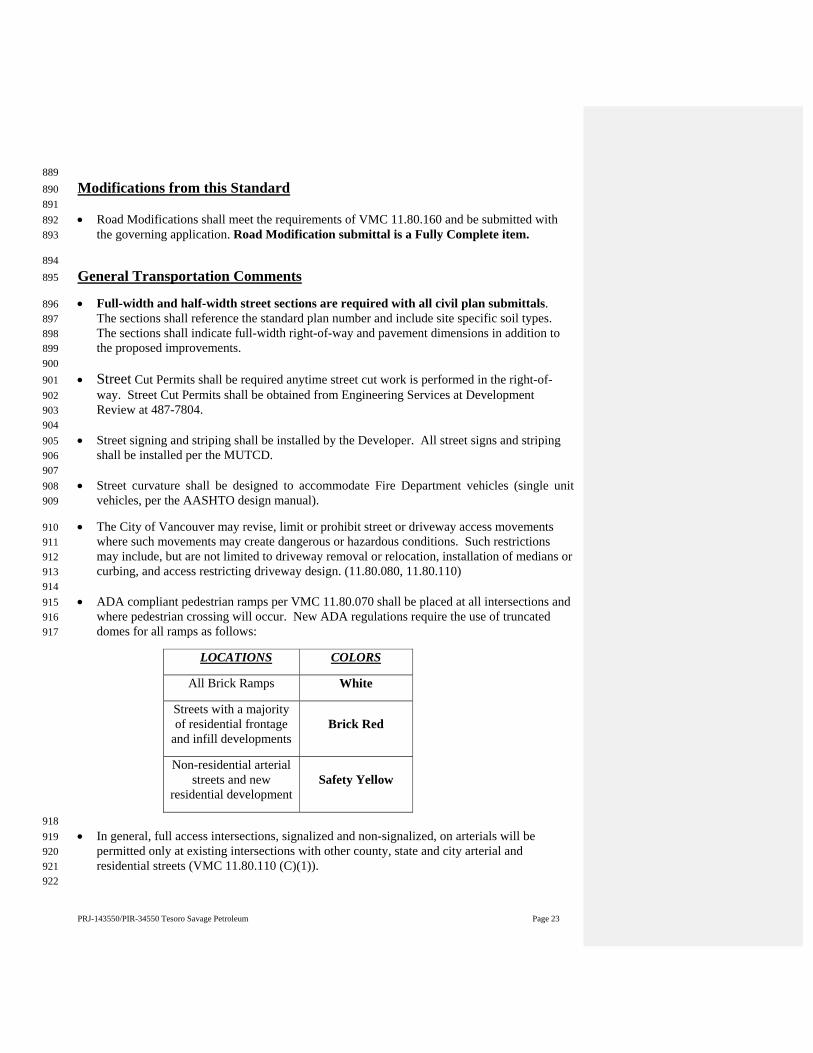
PRJ-143550/PIR-34550 Tesoro Savage Petroleum Page 23
889 Modifications from this Standard 890 891 Road Modifications shall meet the requirements of VMC 11.80.160 and be submitted with 892
the governing application. Road Modification submittal is a Fully Complete item. 893
894 General Transportation Comments 895
Full-width and half-width street sections are required with all civil plan submittals. 896 The sections shall reference the standard plan number and include site specific soil types. 897 The sections shall indicate full-width right-of-way and pavement dimensions in addition to 898 the proposed improvements. 899
900 Street Cut Permits shall be required anytime street cut work is performed in the right-of-901
way. Street Cut Permits shall be obtained from Engineering Services at Development 902 Review at 487-7804. 903
904 Street signing and striping shall be installed by the Developer. All street signs and striping 905
shall be installed per the MUTCD. 906 907 Street curvature shall be designed to accommodate Fire Department vehicles (single unit 908
vehicles, per the AASHTO design manual). 909
The City of Vancouver may revise, limit or prohibit street or driveway access movements 910 where such movements may create dangerous or hazardous conditions. Such restrictions 911 may include, but are not limited to driveway removal or relocation, installation of medians or 912 curbing, and access restricting driveway design. (11.80.080, 11.80.110) 913
914 ADA compliant pedestrian ramps per VMC 11.80.070 shall be placed at all intersections and 915
where pedestrian crossing will occur. New ADA regulations require the use of truncated 916 domes for all ramps as follows: 917
LOCATIONS COLORS
All Brick Ramps White
Streets with a majority of residential frontage
and infill developments Brick Red
Non-residential arterial streets and new
residential development Safety Yellow
918 In general, full access intersections, signalized and non-signalized, on arterials will be 919
permitted only at existing intersections with other county, state and city arterial and 920 residential streets (VMC 11.80.110 (C)(1)). 921
922

PRJ-143550/PIR-34550 Tesoro Savage Petroleum Page 24
Per the International Fire Code, Section 503, a minimum 20 feet of unobstructed width is 923 required for Fire Department apparatus access on all streets more than 150 feet in length. 924 For all streets between 36 feet and 28 feet curb-to-curb paved width, “No Parking” signs 925 shall be posted on one side, per City Standards, at the Developer’s expense. For all streets 926 less than 28 feet curb-to-curb paved width, “No Parking” signs shall be posted on both sides, 927 per City Standards, at the Developer’s expense. 928
929 To prevent any conflict with existing underground utilities, overhead utilities and their pole 930
or related structure locations, a survey and base map shall be prepared and included with the 931 civil plans for any traffic related project (e.g. signals, striping, etc.) to show all utility and 932 underground features. 933
934 Mailbox location placement shall meet current ADA requirements and City Standard T07-01, 935
and be shown on the civil plans. 936
Transportation review and inspection fees will be collected prior to civil engineering plan 937 approval. 938
939 Sight Distance and Vision Clearance Triangles 940
Public and private streets, public alleyways, controlled and uncontrolled intersections and 941 driveways shall comply with the sight distance requirements of VMC 11.80.140 and the 942 current version of A Policy on Geometric Design of Highways and Streets (AASHTO). A 943 sight distance analysis shall be provided in the applicant’s traffic study or in a document for 944 projects that do not require a traffic study. 945
946 Vision clearance requirements shall be met per VMC 20.985 and City Standard Plan T04‐04. 947 948 Vision clearance shall also be demonstrated on the site plan, plat, landscape plans and civil 949
plans. 950 951
Street Lighting 952
Street lighting plans shall be coordinated with Clark Public Utilities (CPU). New contactor 953 cabinets and service may be required. For additional information, contact CPU directly at 954 360-992-3000. 955
956
Design Considerations and Opportunities 957
The City of Vancouver views bicycle use as a viable mode of transportation. The city 958 requests the incorporation of bicycle parking into site design. Bicycle parking design 959 standards are outlined in VMC 20.945.050. All bicycle parking shall meet the requirements 960 found on the city’s website. 961 http://www.cityofvancouver.us/ced/page/bicycle-parking-program-0 962 963
PRJ-143550/PIR-34550 Tesoro Savage Petroleum Page 25
City staff welcomes the opportunity to work with the applicant to provide bicycle parking 964 with this project. A bicycle parking design guidelines booklet which illustrates the standards 965 is available free of charge. For more information on bicycle facilities, please contact Long 966 Range Planning at 487-7728. 967 968
It is recommended that the applicant provide surface treatment across the access from NW 969 Lower River Road to clearly call attention to the pedestrian trail crossing. The applicant’s 970 design considerations will need to include high visibility, texture and structural integrity. 971
972 Neighborhood Traffic Management Devices and Streetscape Treatments 973
All existing and proposed traffic management devices and streetscape treatments shall be 974 indicated on the site, plat and civil plans. These may include but are not limited to traffic 975 circles, speed humps and cushions, curb extensions, medians and raised crosswalks. 976 Preliminary and final plans shall include full dimensioning, details or detail callouts and 977 associated pavement markings and signing. Existing offsite devices and treatments shall be 978 indicated if located within 50 feet of the project limits, or within offsite utility extension 979 areas. 980
981 Traffic Signal and Interconnect Design 982
Traffic signal and interconnect design plans shall utilize current City of Vancouver traffic 983 signal and interconnect design specifications and drafting standards. The applicant shall 984 contact shall Chris Christofferson, Senior Traffic Engineer, at 360-487-7716, for the current 985 submittal and review requirements. 986
987 The developer shall consider measures that provide un-interrupted and full operation of the 988
traffic signal(s) located the intersection of ???? and ???? at all times during the construction 989 of the project. These measures shall include vehicle detections and pedestrian movements on 990 all approaches in a way that normal operation continues; for instance installation of video 991 detection before loop detections are severed. The developer shall coordinate with City of 992 Vancouver’s inspectors for traffic signal modifications and/or any other activity that would 993 impact the normal operation of the City’s traffic system as part of the temporary traffic 994 control. All damaged loop detections shall be replaced within 48 hours unless otherwise 995 approved by the City of Vancouver’s inspector or traffic engineer. 996
997 998 Parking and Circulation 999
Per VMC 20.945.40(A). Review Authority. Parking lot design and drainage shall be subject 1000 to review and approval of the City Transportation Manager. 1001
1002 At the time of application, the applicant shall submit turning movement diagrams to and 1003
through all access points, drive aisles and turnarounds utilizing the largest vehicle template 1004 anticipated. 1005
1006 Pedestrian access to the fronting arterial roadway shall meet the requirements of VMC 1007
20.945.040 (H) and VMC 20.914.020 (7). 1008 1009
PRJ-143550/PIR-34550 Tesoro Savage Petroleum Page 26
Gated Access 1010
All subsequent submittals shall dimension existing and proposed gates and indicate gate 1011 swing. 1012
1013 The gate entrance design shall provide for a queuing area to accommodate the largest 1014
anticipated vehicle to queue out of the right-of-way. A queuing analysis to determine the 1015 maximum back of queue may be required. A turnaround shall be provided to allow the 1016 largest anticipated vehicle to maneuver a turnaround outside the gate. No backing 1017 movements within the right-of-way will be permitted per VMC 20.945.040. 1018
1019 Contact 1020 1021 For additional information or questions, please contact Ryan Lopossa at (360) 487-7706 or 1022
via email at [email protected]. 1023
Standard Details and Procedural information 1024
Effective June 1, 2008 Transportation Services has implemented Transportation 1025 Development Review Services (TDRS) Drafting Standards for transportation 1026 improvement civil plan submittals. By setting expectations on submittal requirements 1027 the Drafting Standards will provide mutual benefits to the City and to the development 1028 in reducing review times and the number of reviews. 1029
1030 Local civil engineering firms have been notified of the implementation and have been 1031 provided with a copy of the standards. The standards are also available on the web at: 1032 http://www.cityofvancouver.us/transreview.asp?menuid=10463&submenuID=17481&it1033 emID=19572. 1034
Per the Transportation Services Development Review Drafting Standards dated June 2007, 1035 page 4, the applicant is required to submit a base map for the proposed project at as-built 1036 stage to be designed on the City of Vancouver coordinate system. In order to ensure the 1037 accuracy of the proposed design at an earlier stage in the review process, the applicant 1038 shall submit a preliminary layout in .dwg format at FC submittal or at the pre-1039 submittal meeting for Streamlined projects. If the applicant elects to submit the layout 1040 via e-mail, please send to Roger Waters, [email protected]. For 1041 questions, please call Roger Waters at (360) 487-7712. 1042
The City of Vancouver has revised standard details effective August 15, 2008. New details 1043 are available at Transportation Development Review. The electronic files are available from 1044 Transportation Services in AutoCAD release 2000 and Adobe Acrobat PDF file formats. 1045 The latest standard details may be referenced as part of the Transportation General 1046 Notes; with the exception of street standard plan cross-sections. Standard plan cross-1047 sections must appear on the civil plans. The files are also available on the City of 1048 Vancouver web site: http://www.cityofvancouver.us/publicworks/page/transportation-1049 development-review-and-capital-standard-plans-details. 1050
1051 Estimated Transportation Review Fees (Site Plan) 1052
1053
PRJ-143550/PIR-34550 Tesoro Savage Petroleum Page 27
Plan Review Fee (includes preliminary and final) 1054 1055 General Case $3,084.99 1056 1057
CONCURRENCY ENGINEERING COMMENTS Ryan Lopossa 487-7706 1058
(VMC 11.70) 1059 1060 The proposed development is within the following Transportation Management Zone (TMZ) 1061
and Transportation Analysis Zone (TAZ): 1062 1063
TAZ # 26 1064 1065
Corridor/TMZ Limits of Corridor 1066
Fourth Plain Blvd Port of Vancouver to I-5 1067 1068 Using the Institute of Transportation Engineers (ITE) Trip Generation Manual, 9th Edition, 1069
the following example is an estimation of trips that would be generated by the proposal, 1070 provided by the City as a courtesy to the applicant. Final trip generation figures will be 1071 based on the applicant’s trip generation report, as scoped later in this report. 1072
1073
Land Use ITE Code Trip Rate Units ADT
AMPK
PMPk
Proposed
General Light Industrial 110
6.97/1000 sf –ADT 0.92/1000 sf – AM Pk0.97/1000 sf – PM Pk
186,710sf 1,301
171 181 Total 1,301 171 181
1074 The City of Vancouver has adopted the 9th Edition of the ITE Manual. The applicant 1075
should utilize the 9th Edition for the trip generation in the Trip Generation and 1076 Distribution Report and/or Traffic Study. 1077 1078
The City of Vancouver has approved a new Concurrency Ordinance that was adopted 1079 on January 5th, 2012. Consequently, the new concurrency requirements are currently 1080 in effect. 1081
1082 Based on the initial information, the proposed project would need to meet the Traffic Study 1083
requirements of VMC 11.70 and 11.80.130. A Traffic Study is a Fully Complete item for 1084 project submittal. 1085
1086 A traffic impact analysis (TIA) is required pursuant to VMC 11.70, 11.80.130 and 1087
11.80.080. A copy of the City of Vancouver Traffic Study methodology/checklist can be 1088 found on the City of Vancouver website at 1089 http://www.cityofvancouver.us/publicworks/page/concurrency 1090
PRJ-143550/PIR-34550 Tesoro Savage Petroleum Page 28
1091 General TIA Requirements: 1092
1093 For developments generating 5 or more net new PM peak hour trips, the applicant is 1094
required to submit trip generation and distribution for the proposed development and to 1095 list the number of PM peak trips entering each of the concurrency corridors in table 1096 format. See Table 1 below for the list of corridors. 1097
1098 Additionally, for developments generating 20 or more PM peak hour trips, the analysis 1099
shall encompass all intersections specified by the traffic engineer for LOS analysis that 1100 fall within the limits identified in 11.80.130. The analysis may also include intersections 1101 beyond the thresholds listed in 11.80.130 where significant traffic hazards would be 1102 caused or materially aggravated by the proposed development. 1103
1104 Trip distribution shall use the Regional Transportation Council select link assignment for 1105
the project TAZ. 1106 1107
Transportation Concurrency is evaluated according to the Corridor Classification. The 1108 Director may require additional information or modeling if an impacted corridor is 1109 operating close to the adopted level of service. Generally, where a proposed development 1110 sends trips to a Category 1 or Category 2 corridor, the Director shall track those trips and 1111 presume concurrency between LOS measurements pursuant to VMC 11.70.100. 1112
1113 Table 1: Concurrency Corridors and Current Classifications 1114
Arterial Concurrency Corridor
Extent
LOS Standard Avg. PM Peak Speed
(MPH)
2012 Corridor
Classification
Mill Plain Blvd.
Fourth Plain to I-5 10 Category 1 I-5 to Andresen 12 Category 1
Andresen to I-205 12 Category 1 I-205 to 136th Ave. 10 Category 1
136th Ave. to 164th Ave. 10 Category 1 164th Ave. to 192nd Ave. 10 Category 1
St. Johns / Ft. Van Way Mill Plain to 63rd St. 12 Category 1
Fourth Plain Blvd.
Mill Plain to I-5 12 Category 1 I-5 to Andresen 10 Category 1
Andresen to I-205 10 Category 1 I-205 to 162nd Ave. 10 Category 1
Andresen Road Mill Plain to SR500 11 Category 1 SR500 to 78th St. 15 Category 1
112th Avenue Mill Plain to 28th St. 11 Category 1 28th St. to 51st St. 15 Category 1
164th/162nd Avenue SR14 to SE 1st St. 10 Category 1 SE 1st St. to Fourth Plain 10 Category 1
Burton Road / 28th Street
18th St. to 112th Ave. 12 Category 1 112th Ave. to 138th Ave. 10 Category 1 138th Ave. to 162nd Ave. 12 Category 1
18th Street 112th Ave. to 138th Ave. 12 Category 1 138th Ave. to 164th Ave. 12 Category 1
136th/137th Avenue Mill Plain to 28th St. 12 Category 1
PRJ-143550/PIR-34550 Tesoro Savage Petroleum Page 29
28th St. to Fourth Plain 12 Category 1 192nd Avenue SR14 to NE 18th St. 10 Category 1
Per-trip monitoring fees shall be charged for trips sent to every corridor, up to a maximum 1115 monitoring fee of $1500 for any single development (VMC 20.180.070). 1116
1117 Below are a few items that shall be included in the traffic impact analysis. All other 1118
requirements can be found on the City of Vancouver website at 1119 http://www.cityofvancouver.us/publicworks/page/concurrency 1120 1121 Safety – Crash history and mitigations - Provide a five year crash history, crash rate per 1122
mev, and proposed mitigations for intersections with crash rate exceeding 1.0 per mev. 1123 Copies of the crash reports shall be included in the TIA. (VMC 11.80.130 and 11.70) 1124 Please contact Bill Gilchrist, city Traffic Engineer, at (360) 487‐7717 or 1125
[email protected] for a list of intersections to study. 1126
1127 Safety and operations – Queue analysis - Provide peak hour queue analysis. (VMC 1128
11.80.130, 11.80.080, 11.70) 1129 Please contact Bill Gilchrist, city Traffic Engineer, at (360) 487-7717 or 1130
[email protected] for a list of intersections to study. 1131 1132 Warrant analysis – Signals and Turn lanes - Provide traffic signal / turn lane warrants as 1133
defined by the Manual on Uniform Traffic Control Devices. (VMC 11.80.080) 1134 Please contact Bill Gilchrist, city Traffic Engineer, at (360) 487-7717 or 1135
[email protected] for a list of intersections to study. 1136 1137
Contact 1138 1139
For additional information or questions, please contact Ryan Lopossa at (360) 487-7706 1140 or via email at [email protected]. 1141
Estimated Concurrency Fees due at time of application 1142 1143 Concurrency Evaluation (always charge) $151.27 1144
Traffic Study Review (20+ PM peak trips only) $301.45 1145 1146 1147
FIRE COMMENTS Chad Lawry 487-7237 1148
VMC 16.04.010 FIRE CODE: 1149 As required by RCW Chapter 19.27, the city of Vancouver hereby adopts by reference the 2012 1150 edition of the International Fire Code (IFC), including appendices B and E, as amended by RCW 1151 Chapter 19.27, WAC Chapter 51-54 and the provisions of this chapter. The approval of plans 1152 and specifications does not permit the violation of any section of the IFC or any federal, state, or 1153 local regulations. 1154 1155

PRJ-143550/PIR-34550 Tesoro Savage Petroleum Page 30
Prior to making any decisions regarding its approval, the Vancouver Fire Department (VFD) 1156 must consider the impact the proposed facility may have on public safety, including the VFD’s 1157 ability to provide sufficient fire protection services. 1158 The VFD will conduct a detailed impact assessment to determine if any hazards or risks 1159 associated with the proposed facility and its operation will result in an increased need for fire 1160 protection services and what measures will be required to mitigate the impact. 1161 The VFD will coordinate closely with the applicant’s representatives, project contractors, the 1162 Vancouver Fire Marshal’s Offices, and other key stakeholders to complete the impact assessment 1163 within 45 days from the date final plans for the project have been received by the VFD. 1164 1165 Fire Protection Services Impact Assessment - Scope of Work: 1166 a) Assess fire and hazardous materials related risks associated with the proposed facility and its 1167 operation. 1168 1169 b) Assess risks associated with the proposed system(s) for transportation of any hazardous 1170 materials. Assessment to include: 1171 Truck transportation over local roadways and loading operations 1172 Rail transportation over local railways and loading operations 1173 Marine transportation over local waterways and loading operations 1174 Pipeline transportation 1175 1176 c) Evaluate VFD’s capability to provide fire protection services to the proposed facility and 1177 related transportation systems. The evaluation shall identify any anticipated deficiencies in 1178 service capability. Evaluation to include: 1179 1. Emergency response plans 1180 2. Firefighting capability 1181 3. Rescue capability, including confined space rescue 1182 4. Hazardous material response capability 1183 5. Potential off site consequences of a hazardous material release 1184 6. Training 1185 7. Equipment 1186 8. Other resources 1187 1188 d) Evaluate proposed fire and spill protection systems for the facility. 1189 1190 e) Evaluate proposed physical security systems for the facility. 1191 1192 f) Recommend measures and estimated costs to mitigate any impact the proposed facility or 1193 related transportation systems may have on VFD’s ability to provide sufficient fire protection 1194 services. Recommendations to include: 1195 1. Emergency response plans 1196 2. Firefighting capability 1197 3. Rescue capability, including confined space rescue 1198 4. Hazardous material response capability 1199 5. Potential off site consequences of a hazardous material release 1200 6. Training 1201 7. Equipment 1202 8. Other resources 1203

PRJ-143550/PIR-34550 Tesoro Savage Petroleum Page 31
1204 For additional information contact: 1205 Steve Eldred 1206 Division Chief 1207 Vancouver Fire Department 1208 7110 NE 63rd Street 1209 Vancouver, WA 98661 1210 (360) 487-7304 1211 [email protected] 1212 1213 IFC 104.7.2 TECHNICAL ASSISTANCE 1214 The fire code official is authorized to require the owner or agent to provide, without charge to 1215 the jurisdiction, a technical opinion and report from a qualified engineer, specialist, laboratory or 1216 fire safety specialty organization acceptable to the fire code official and to require the stamp of a 1217 registered design professional. 1218 1219 IFC 105.6 FIRE CODE OPERATIONAL PERMITS 1220 Applicable fire code operational permits required by this section and related to the project at the 1221 time of construction permit application are issued at no additional charge during the construction 1222 permit review and approval. These permits remain valid until the next Fire Marshal’s Office 1223 inspection which is a generally more than a year after the issuance of the certificate of 1224 occupancy. 1225 1226 IFC CHAPTER 50 HAZARDOUS MATERIALS 1227 The storage, dispensing, handling and use of hazardous materials shall comply with the 1228 requirements of Chapter 50 of the International Fire Code. 1229 1230 5001.5.1 The permit applicant shall submit a Hazardous Materials Management Plan (HMMP). 1231 The HMMP shall identify the following: 1232 1. Storage and use areas. 1233 2. Maximum amount of each material stored or used in each area. 1234 3. Range of container sizes. 1235 4. Locations of emergency isolation and mitigation valves and devices. 1236 5. Product conveying piping containing liquids or gases, other than utility-owned fuel gas lines 1237 and low-pressure fuel gas lines. 1238 6. On and off positions of valves for valves that are of the self-indicating type. 1239 7. Storage plan showing the intended storage arrangement, including the location and dimensions 1240 of aisles. 1241 8. The location and type of emergency equipment. The plans shall be legible and drawn 1242 approximately to scale. Separate distribution systems are allowed to be shown on separate pages. 1243 1244 5001.5.2 The permit applicant shall submit a Hazardous Materials Inventory Statement (HMIS). 1245 The HMIS shall include the following: 1246 1. Manufacturer’s name. 1247 2. Chemical name, trade names, hazardous ingredients. 1248 3. Hazard classification. 1249 4. MSDS or equivalent. 1250
PRJ-143550/PIR-34550 Tesoro Savage Petroleum Page 32
5. United Nations (UN), North America (NA) or the Chemical Abstract Service (CAS) 1251 identification number. 1252 6. Maximum quantity stored or used on-site at one time. 1253 7. Storage conditions related to the storage type, temperature and pressure. 1254 1255 Building and Fire code requirements will be reviewed at the time of the construction permit 1256 submittal and will include documentation that the equipment, machinery, and alarms associated 1257 with the use, dispensing, storage and handling of hazardous materials is listed or its use. 5003.2.3 1258 1259 IFC CHAPTER 57 FLAMMABLE & COMBUSTIBLE LIQUIDS 1260 The storage, dispensing, handling and flammable and combustible liquids shall comply with the 1261 requirements of Chapter 57 of the International Fire Code. 1262 1263 VMC 16.04.040 HAZMAT REGULATORY FEE: 1264 This ordinance affects certain existing and proposed occupancies that store and/or handle 1265 hazardous materials. Your proposed facility may have to comply with this ordinance. Hazardous 1266 materials regulatory fees are determined by a fee schedule. The ordinance and fee schedule can 1267 be found in the Vancouver Municipal Code, Title 16, Chapter 16:40. You can find a copy of the 1268 ordinance on the City’s website www.cityofvancouver.us. 1269 1270 Fire Plan Reviewer: Chad Lawry, Deputy Fire Marshal 1271 [email protected], Office: (360) 487-7237 1272 1273 IFC 503 FIRE APPARATUS ACCESS (VMC 16.04.150): 1274 Standard Text: Fire apparatus access shall be provided, by an approved route, to within 150’ of 1275 any point of the facility and any point on the exterior wall of the first story of the building as 1276 measured by an approved route around the exterior of the building. Fire apparatus roads shall 1277 have a minimum clear width of 20’ and clear height of 13’6”. The required width of a fire 1278 apparatus access road shall not be obstructed in any manner, including parking of vehicles, 1279 signage and mailboxes. Minimum required widths and clearance dimensions shall be maintained 1280 at all times. Fire department required access lanes exceeding 200’ in length shall be provided 1281 with an approved fire apparatus turn-around or with drive through provisions. Temporary or 1282 permanent fire apparatus emergency access lanes shall be established and maintained clear to 1283 within 150 feet of any portion of a structure on the project site. 1284 Buildings four or more stories in height shall be provided with approved aerial fire apparatus 1285 access roads. Aerial fire apparatus access roads shall be provided within 25 feet of the building, 1286 but not less than 15 feet from the building, along the length of one side of the building. 1287 1288 Where electronically supervised fire protection systems are installed, a Knox box shall be 1289 installed at the structure and shall contain keys/codes for night time emergency fire access 1290 (Potential exception: 24 hour/365 day on site staff). 1291 1292 “NO PARKING FIRE LANE” signage with directional arrows or red curb paint with white 1293 stenciled lettering (4” high block lettering/ ½” stroke) shall be posted wherever parking could 1294 obstruct the required 20’ fire apparatus access lane. 1295 Fire lane marking standards: 1296 No on-street parking is allowed on access routes less than 28 feet wide. 1297 Parking is allowed on one side only for access routes 28 feet to 36 feet wide. 1298
PRJ-143550/PIR-34550 Tesoro Savage Petroleum Page 33
Parking is allowed on both sides for access routes 36 feet wide and greater. 1299 No on-street parking is allowed on cul-de-sacs that are specifically required by the fire 1300 department for apparatus turn-around with a radius of less than 43’. Where rolled curb/thickened 1301 sidewalks are approved as part of the apparatus turning radius signage shall be installed behind 1302 the sidewalks so that the radius remains unobstructed. 1303 No parking in other types of required fire apparatus turn-around provisions. 1304 1305 SIGNAGE ON PLANS: Graphic example of an acceptable fire lane indication on plans and a 1306 detail sheet on fire lane markings are available for download via the internet. Clearly indicate 1307 sign locations and details on the final site plan. Where street improvements are involved, fire 1308 lane details and locations shall additionally be shown on the engineering plans. 1309 Specific to this project: 1310 The Fire Department requests a plan specifically showing fire apparatus access lanes throughout 1311 the facility. It is unclear if the open spaces between tracks, buildings and facilities are driving 1312 surfaces or not. 1313 Fire lane signage is required and the locations can be identified during the civil engineering 1314 review. 1315 0 Submittal is fully complete (FC) for Fire if checked 1316 1 Required for FC: 1317 Please provide a vehicle access plan featuring roadways and drivable surfaces for emergency 1318 vehicle access. 1319 1320 IFC 505 PREMISE IDENTIFICATION: 1321 Standard text: Premise address/identification shall be visible and legible from the fire lane 1322 approach. 1323 Specific to this project: 1324 During construction a temporary or permanent address signs and street identification signs shall 1325 be erected so that they are visible and legible from the road fronting the property for emergency 1326 response. 1327 Prior to occupancy the addresses shall be visible and legible from the street fronting the property. 1328 Street signs shall be installed and approved. 1329 1 Submittal is fully complete (FC) for Fire if checked 1330 0 Required for FC: 1331 Nothing 1332 1333 1334 IFC 508 WATER SUPPLY & FIRE HYDRANTS (VMC 16.04.160): 1335 Standard text: FIRE HYDRANTS: The maximum hydrant spacing in commercial and multi-1336 family residential developments shall be 400 feet between hydrants measured along a fire 1337 apparatus access lane. The distance from the most remote first floor exterior wall of structures 1338 shall not be more than 350 feet from a fire hydrant and not more than 150 feet from a fire lane. 1339 Where the buildings are protected by an approved fire sprinkler system, the maximum spacing 1340 between fire hydrants shall be 600 feet and the most remote first floor exterior wall of structures 1341 shall not be more than 450 feet from a fire hydrant and not more than 150 feet from a fire lane. 1342 Where structure placement is not yet proposed, measurement shall be taken from the most 1343 remote location on the lots. 1344 The maximum hydrant spacing in one and two family residential developments shall be 600 1345 feet between hydrants measured along a fire apparatus access lane. The distance from the most 1346
PRJ-143550/PIR-34550 Tesoro Savage Petroleum Page 34
remote exterior first floor wall of any structure shall not be more than 450 feet from a fire 1347 hydrant. Where structure placement is not yet proposed, measurement shall be taken from the 1348 most remote location on the lots. 1349 Fire hydrants on the opposite side of principal arterial or larger streets shall not be considered for 1350 new projects. The first 1,500 gallons per minute of required fire flow may be taken from one fire 1351 hydrant. An additional fire hydrant shall be required for each additional 1,000 gallons per minute 1352 or fraction thereof. 1353 Specific to this project: 1354 Existing fire hydrants are shown and proposed new fire hydrant locations are shown. 1355 For this project the Fire Department will rely on a 3rd party to consult with VFD based on VFD 1356 capabilities and tactics to approve fire hydrant locations and water supply provisions. 1357 Final approval of fire hydrants and water supply can take place during civil plan review. 1358 1 Submittal is fully complete (FC) for Fire if checked 1359 0 Required for FC: 1360 Nothing 1361 1362 IFC CHAPTER 9 FIRE PROTECTION SYSTEMS (VMC 16.04. 170 – 16.04.210): 1363 Standard text: An approved fire sprinkler extinguishing system shall be installed and maintained 1364 in operable condition in buildings: 1365 containing a floor area of over 12,000 square feet or 36’ in height. Each portion of a building 1366 separated from other portions by one or more four-hour rated fire barrier assembly(ies) may be 1367 considered a separate building if such four-hour rated fire barrier walls meet the requirements of 1368 International Building Code Section 706. 1369 where access is restricted or unreliable. 1370 where minimum fire flow can only be achieved with credit for a fire sprinkler system 1371 where occupancy type/use based requirements apply. 1372 Monitoring. Alarm, supervisory and trouble signals shall be distinctly different and shall be 1373 automatically transmitted to an approved supervising station or, when approved by the fire code 1374 official, shall sound an audible signal at a constantly attended location. IFC 904.3.5 1375 Separate permit required for required or voluntary fire protection systems. Submit plans and 1376 specifications for review and approval prior to installation. Separate permit and plan approval is 1377 required for on-site underground fire protection water piping. 1378 All fire protection contractors who work in the Vancouver City Limits shall possess a City of 1379 Vancouver Fire Protection Contractor Endorsement. VMC 16.04.095 1380 Specific to this project: 1381 Fire protection is required and shall be electronically supervised. 1382 Add a note to the proposed civil water utility plans stating “Underground fire water lines are 1383 shown for reference only. A separate permit issued contractor with licensure in accordance with 1384 WAC 212-80 is required for this work.” 1385 Add a note to the proposed civil water utility plans stating, “All fire protection system 1386 components shall be installed under separate permits to contractors holding a City of Vancouver 1387 Endorsement in accordance with VMC16.04.040.” 1388 Fire department connection(s) shall be shown to be within 150 feet of a fire hydrant. 1389 1 Submittal is fully complete (FC) for Fire if checked 1390 0 Required for FC: 1391 Nothing 1392 Chad Lawry (360) 487-7237 [email protected] 1393 1394
PRJ-143550/PIR-34550 Tesoro Savage Petroleum Page 35
WATER ENGINEERING COMMENTS Debi Davis 487-7173 1395
EXISTING CONDITIONS: 1396 City records show an existing 12” 14” & 16” DI NW Old Lower River Road, and a 16” DI in 1397 HWY (501), and a 10” DI in NW Harborside Drive (P) in the dock area. 1398 1399 FIRE PROTECTION: 1400 It is estimated that at least 3500 gpm fire flow is currently available from hydrants in the 1401 proposed project area. Records show hydrants in the area The proposed project is within the City 1402 of Vancouver service area, therefore service can be provided if the conditions listed below are 1403 met. 1404 1405 REQUIREMENTS: 1406 (?”) = Size of pipe depends on the fire flow required by the Fire Marshal. 1407 1408 Area 600: Connect a new (?”) water main to the existing 14” or 16” in Old Lower River Road 1409 extend on site to serve new water services, fire protection systems, and any required fire hydrant. 1410 1411 Area 200: Connect a new (?”) water main to the existing 16” water main south of the tracks 1412 extend on site to serve new water services, fire protection systems, and any required fire 1413 hydrants. 1414 1415 Area 300: Connect a new (?”) water main to the existing 16” water main in HWY(501) 1416 Extend on site as needed loop the main back to HWY(501) or connect to the existing 12” water 1417 main on the east side. Connect new water services fire protection systems, and any required fire 1418 hydrants to the new water main. 1419 1420 Area 400: Connect to the existing 12” water main in NW Harborside Drive (P), extend on site to 1421 serve new water services, fire protection systems, and any required fire hydrants. 1422 1423 Looping the water mains thru the Areas may be required depending on fire flow needed. All 1424 water mains, fire hydrants, and water meters will require an easement dedicated to the City of 1425 Vancouver. 1426 1427 Further requirements may be necessary depending on the final project configuration and will be 1428 determined through the engineering review process. If there are any questions, please contact 1429 Debi Davis via telephone @ 360-487-7173, or via email at [email protected]. 1430 1431 WATER SYSTEM STANDARDS: 1432 All water lines, services, and hydrants constructed shall conform to the most current “City of 1433 Vancouver General Requirements and Details” for Water System design and construction along 1434 with the following: 1435 1436 The standard for main extensions is 8-inch diameter, or larger as master-planned or needed per 1437 hydraulic analysis and fire flow. 1438 1439 Fire hydrant locations are to be specified by the Fire Marshal. If new hydrants are required, they 1440 shall be served by water mains with a minimum of 8-inch diameter, except that a 6-inch main 1441 can be used for a dead-end run shorter than 50 feet to a hydrant. 1442
PRJ-143550/PIR-34550 Tesoro Savage Petroleum Page 36
1443 Separate water services are required for each building. Water meters shall be located in a non-1444 paved area, centered along the property frontage. 1445 1446 Back Flow Assemblies are required on irrigation systems, services larger than 2-inch, fire 1447 protection lines and if there is a potential for cross connection. Back Flow Assemblies must be 1448 constructed and installed per City of Vancouver "Standard Backflow Prevention Details." 1449 1450
SEWER ENGINEERING COMMENTS Aaron Odegard 487-7153 1451
Two existing public sewers traverse the area from northwest to southeast. 1452 1453 Area 200 Unloading and Office: Existing private (Port) casings travel under the railroad tracks 1454 in the area. The casings were constructed in about 2010 with the Port of Vancouver West 1455 Vancouver Freight Access project (ENG2007-00173). The casings are shown on Sheet U-7 of 1456 the design drawings. Record drawings are not available. 1457 1458 ENG2010-00009: Public gravity sewer is located north of the proposed unload area in Old NW 1459 Lower River Road (P). Manhole #21025 marks the headwaters of the 18-inch gravity that flows 1460 southeast. The manhole also receives a private six-inch (6”) HDPE force main from its the 1461 casing to the southwest. This sewer was constructed in 2010 with POV T5 Industrial 1462 Improvements. The area is shown on Sheets C3.1 and C3.2 of the record drawings. 1463 1464 ENG2010-00064: Southern portions of the force main were constructed in 2012 by the Port of 1465 Vancouver Terminal 5 Marine Cargo Laydown project. Piping is shown on sheet C4.0 of the 1466 record drawings (E10064021.tif). 1467 1468 Existing Private Sewer: A private sewer and a manhole is located in the access road near the 1469 CPU cooling towers. This sewer was built in 2003 with the CPU Warehouse project (ENG2002-1470 00006). A plan view is shown on sheet C3.1 of the record drawings (E0200604.tiff) and the 1471 profile is shown on C3.2. A private utility easement is described in AF #4607523 and shown in 1472 its Exhibit D. 1473 1474 Area 300 Tanks: Public gravity sewer and several manholes front the south side of the site north 1475 of the rails. This sewer was constructed in 2012 with WVFA #9 (ENG2011-00026). Record 1476 drawings and other remaining file closure items have not yet been submitted. A plan view is 1477 shown on sheets U-04B and U-05B of the design drawings and the profile view is shown on 1478 Sheet U-16. An existing six-inch (6”) service lateral extends north to the site from MH P9-7. 1479 1480 Area 400 Dock: An existing public gravity sewer is located north of the site and at the 1481 intersection of Gateway and Harborside and Vapor Option #2. A existing manhole (#14411) 1482 receives a private pressure sewer from the west and turns the sewer from the northeast to 1483 southeast. Sewers continue southeast within an existing public sewer easement. 1484 1485 SB1729: This sewer was constructed in 1999 with the Clark County Jail Work Center. A plan 1486 view is shown on C1.5 of the record drawings (WB203505.tif) and the profile is shown on Sheet 1487 C1.6. 1488 1489
PRJ-143550/PIR-34550 Tesoro Savage Petroleum Page 37
Area 600 Boiler Building is located about 800 feet northwest of MH #21025 described for Area 1490 200 above. 1491 1492 RUS-34550: A utility review has been prepared to accompany this pre-app report. Comments 1493 here are nearly identical to those in the review. 1494 1495 General Condition Requirements: Public sewer construction is not required. Install new 1496 service laterals to existing manholes, secure a pretreatment permit, pay fees, and connect 1497 building sewers. 1498 1499 S-1.4: Construct new service laterals to existing manholes using the methods and materials in the 1500 standard plans. 1501 1502 Proposed connection to the existing private sewer will require a private shared access and 1503 maintenance agreement. 1504 1505 IPP: Typically only domestic waste is allowed. Discharge of non-domestic or process water 1506 requires an Industrial Pretreatment permit and a related engineering report. Contact the 1507 pretreatment workgroup early in the process. Call or email Johnny Leuthold at 487-7192 or 1508 [email protected]. 1509 1510 Application: Acknowledge the public sewer requirements in the narrative. Include a preliminary 1511 utility plan. Show existing and proposed sewers and connections. 1512 1513 Conditions: These and other conditions will appear in the staff report. Final civil project 1514 acceptance will be contingent on final for ENG2011-00026 WVFA #9. 1515 1516 Permits and Fees: Right-of-way, pretreatment, and sewer connection permits will all be 1517 required. Sewer connection fees will based on water meter size. Sewer main fees are not owing 1518 on any of the existing sewers in the area. 1519 1520 UPC: All onsite building sewers and connections are governed by the Plumbing Code. Permits 1521 and inspections will be required. Incorporate required pretreatment fixtures into the building 1522 plans and secure additional required pretreatment inspections. 1523 1524 Questions about these general conditions can be sent to Aaron A. Odegard at 487-7153 or 1525 [email protected]. 1526 1527
DRAINAGE ENGINEERING COMMENTS Mike Swanson 487-7182 1528
EROSION PREVENTION AND SEDIMENT CONTROL (VMC 14.24): 1529
A separate Erosion/Sedimentation Control Plan in conformance with VMC 14.24, the City’s 1530 General Requirements and Details and the Stormwater Management Manual for Western 1531 Washington Volume II shall be submitted and approved prior to demolition, street cuts, clearing, 1532 grading, filling or issuance of City permits. 1533
PRJ-143550/PIR-34550 Tesoro Savage Petroleum Page 38
The plan shall show detailed existing and proposed topography of the site. The plan shall 1534 include measures to insure sediment and sediment laden runoff does not leave the site. 1535 Additional measures are required for offsite utility trenching. 1536
Department of Ecology Construction Stormwater General Permit - A permit is required for 1537 all soil disturbing activities (including grading, stump removal, demolition) where 1 or more 1538 acres will be disturbed, and stormwater will be discharged to a receiving water directly (e.g., 1539 wetlands, creeks, unnamed creeks, rivers, marine waters, ditches, estuaries), or to storm 1540 drains that discharge to a receiving water. If all stormwater is retained on-site and cannot 1541 enter waters of the state under any condition, you do not need permit coverage. Construction 1542 site operators must obtain a permit 60 days prior to discharging stormwater. Information 1543 about the permit requirements is available at the DOE website: 1544 http://www.ecy.wa.gov/programs/wq/stormwater/construction/. 1545
The following items signified with the * are required for the project submittal to be fully 1546 complete. 1547
The plan shall show detailed existing and proposed topography of the site including a 1548 minimum of 25 feet of adjacent properties. 1549
The plan shall show site specific erosion prevention BMPs. 1550
The plan shall include measures to insure sediment and sediment laden runoff does not 1551 leave the site. 1552
The proposed project sites are flat with predominately fill soils and silt, clay, sand mixtures. 1553 The rail and tank areas are currently undeveloped. Erosion hazard is low provided the 1554 contractor follows standard erosion control practices. 1555
A sediment pond will be required during construction if the contributing drainage area is 3 1556 acres or more. The pond shall be sized per the stormwater manual. For projects with a 1557 contributing drainage area less than 3 acres, a sediment trap may be required. 1558
A sediment trap may be required for projects with a contributing drainage area less than 3 1559 acres. 1560
STORMWATER CONTROL (VMC 14.25): 1561
The proposed project must meet the runoff treatment (water quality) and flow control (water 1562 quantity) requirements as outlined in the city’s NPDES Phase II Permit and the Surface 1563 Water General Requirement. 1564
The project will be subject to the provisions of the Stormwater Control ordinance because 1565 more than 2,500 square feet of impervious surfaces will be created (See figure 4.1 Surface 1566 Water General Requirements). 1567
The project will drain directly to the Columbia River which is a flow control exempt water 1568 body. No detention will be required. 1569
The project shall address the water quality storm event as defined in the 2005 1570 Stormwater Management Manual for Western Washington (Stormwater Manual) and shall 1571 provide water quality treatment of stormwater runoff from Pollution Generating Impervious 1572 and Pervious Surfaces (PGIS & PGPS) through the use of approved BMP’s. Water quality 1573 treatment BMPs shall be designed in accordance with VMC 14.25.210 and the City’s 1574 General Requirements and Details. 1575
PRJ-143550/PIR-34550 Tesoro Savage Petroleum Page 39
Water quality treatment facilities shall be selected, designed, and maintained in accordance 1576 with the Stormwater Manual and the General Requirements. Acceptable basic water quality 1577 BMP’s include but are not limited to the following; WQ infiltration basin, WQ infiltration 1578 trench, wet pond, biofiltration swale, bio-infiltration swale, vegetative filter strip, linear sand 1579 filter, and StormFilter. 1580
The use of “Emerging Stormwater Treatment Technologies” and other alternative treatment 1581 BMP’s must have Department of Ecology and city approval. 1582
LID practices shall refer to the Low Impact Development Technical Guidance Manual for 1583 Puget Sound (LID Manual) and Appendix III-C of the Stormwater Manual for design 1584 recommendations. All uses of LID practices shall meet applicable regulations and 1585 requirements, and may require specific approval from other City departments (for example 1586 Transportation or Building). 1587
If the proposed water quality facility is private, it shall have an access and inspection 1588 easement to the City of Vancouver. Refer to section 4-2.06 in the General Requirements. 1589
The applicant has indicated that drainage from the tank containment area will include a 1590 shutoff device to prevent spills from leaving the containment. This system shall be shown in 1591 detail and described in the hydrolic report. 1592
The applicant shall provide a stormwater report that outlines all aspects of the site hydrology, 1593 assumptions, and water quality design calculations. The applicant shall demonstrate in the 1594 hydrology report how stormwater from newly created impervious surfaces will be treated and 1595 disposed of in accordance with VMC 14.25 and VMC14.26. The report shall include details 1596 for existing stormwater facilities that the project will drain to showing that there is capacity 1597 for the additional flow from the site. The report should be formatted as outlined in the City’s 1598 General Requirements and Details Section 4-2. 1599
An infiltration test and detailed soils report are required where infiltration is proposed. 1600 Infiltration testing and soil report shall be in accordance with the City’s General 1601 Requirements and Details Section 4-5.07. 1602
Infiltration systems must be designed for a 100-year storm event in accordance with the 1603 City’s General Requirements and Details Section 4-5.09. 1604
New infiltration wells (drywells, infiltration trenches) proposed are required to meet 1605 Washington Department of Ecology Underground Injection Control (UIC) requirements 1606 (WAC 173-218) and be registered with the Department of Ecology. For requirements and 1607 registration forms, see: http://www.ecy.wa.gov/programs/wq/grndwtr/uic/ 1608
Conveyance system shall be designed for the 10-year storm event in accordance with the 1609 City’s General Requirements and Details Section 4-3. 1610
An access and inspection easement dedicated to the City of Vancouver is required for private 1611 water quality facilities. 1612
If there are any questions, contact Mike Swanson at 360-487-7182 or email at 1613 [email protected]. 1614
WATER RESOURCES PROTECTION (VMC 14.26): 1615 Since the proposed facility will store petroleum products in large quantities it will be 1616
considered a “classified operation” and will be subject to the Greater Standards of the City’s 1617
PRJ-143550/PIR-34550 Tesoro Savage Petroleum Page 40
Water Resources Protection Ordinance, VMC 14.26. The ordinance is available for review 1618 and downloading on the City’s website: www.cityofvancouver.us/waterprotection 1619
To comply with the ordinance, a classified facility shall implement best management 1620 practices (BMP’s) listed in the Greater Standards provisions of the ordinance - section 1621 14.26.130. 1622
Above-ground tank storage (AST) areas shall include secondary containment systems 1623 capable of collecting and holding 110% of the largest tank or 10% of the aggregate tank 1624 volumes. Smaller containers of chemicals shall be stored inside or under a cover and will 1625 also require secondary containment capable of collecting and holding spills and leaks. 1626
Loading areas shall be designed, constructed and operated to contain spills and leaks that 1627 might occur during loading and unloading. 1628
A comprehensive Spill and Emergency Response Plan (SERP) shall be prepared within 90 1629 days of occupancy and updated at least every 5 years. The SERP shall include the following 1630 details on the ASTs: 1) The tank inspection scope and schedule; 2) Where written inspection 1631 records will be stored at the site; 3) How tank leaks or leaks in the secondary containment 1632 will be detected; 4) The measures to be taken in the event of a tank leak; 5) A description and 1633 schedule of planned staff training for tank maintenance, leak detection and spill response. 1634
If a portion of an AST will be set below the ground surface then that portion should be 1635 coated to extend tank life. Or, the above-ground tank should be raised onto some type of 1636 support structure. 1637
The City does not allow the installation of floor or trench drains inside a work area unless 1638 approved by Industrial Pretreatment for connection to sanitary sewer. For approval to install 1639 and connect floor drains to the sanitary sewer system contact Pretreatment at 487-7130. 1640
All facilities and operations in Vancouver are also subject to the Minimum Standards of the 1641 City’s Water Resources Protection Ordinance, VMC 14.26.120. These standards include 1642 maintenance of all stormwater treatment facilities and best management practices according 1643 the Stormwater Management Manual for Western Washington. 1644
The EPA has designated the Troutdale Aquifer underlying Vancouver as a “Sole Source 1645 Aquifer” (SSA). If this project design and construction incorporates federal funding, an SSA 1646 Report must be prepared and submitted to the EPA for review. 1647
For additional information on compliance with the ordinance contact Richard Hoiland in 1648 Water Protection at (360) 487-7130. 1649
1650
BUILDING COMMENTS Chris Drone 487-7842 1651
Title 17 Building and Construction 1652

PRJ-143550/PIR-34550 Tesoro Savage Petroleum Page 41
Scope of review: A complete building code review of plans is not performed during Pre-1653 application or Site Plan review. Filing of building permit application with required fees and 1654 review material is required for a complete building code review. At this time, plans and 1655 information necessary to verify compliance with all applicable building code provisions is 1656 neither required nor provided. 1657
1658 Applicable codes: For building permit to be issued, the project must comply with building codes 1659 applicable at the time of building permit application. Title 17 of the Vancouver Municipal Code 1660 contains rules and regulations for the technical codes as they regulate site preparation and 1661 construction, alteration, moving, demolition, repair, use and occupancy of buildings, structures 1662 and building service equipment. In order to receive a building permit, the proposal must meet the 1663 minimum standards of the technical codes referred to in Title 17 with applicable state and local 1664 amendments. These include: 1665
2009 International Building Code w/Washington Amendments 1666 2009 International Residential Code w/Washington Amendments 1667 2009 International Mechanical Code w/Washington Amendments 1668 2009 Uniform Plumbing Code w/Washington Amendments 1669 2008 National Electrical Code w/Washington Amendments- effective January 1, 2009 1670 2009 Washington State Energy Code-effective January 1, 2011 1671 ICC/ANSI A117.1-2003 Accessibility 1672 2009 International Fuel Gas Code 1673 WAC 51-50 Washington State Amendments 1674 2009 Washington State Energy Code 1675 Vancouver Municipal Code Title 17 1676
1677 The Washington State Codes and Amendments may be accessed at 1678 http://www.sbcc.wa.gov/sbccindx.html. 1679 1680 Within the City of Vancouver design data noted on structural plans and calculations engineers 1681 will be required to indicate 105mph 3 sec gust wind speed, seismic zone D1, exposure B unless 1682 in the Columbia River corridor. The 2012 I-Codes will be officially adopted effective July 1, 1683 2013 in the State of Washington. All building permit applications submitted on or after that date 1684 are subject to review under those codes and associated Washington Amendments. 1685 1686 Site Plan Review process and related submittals are separate from the Building Permit 1687 application and related submittals. Approval of the Site Plan is a prerequisite to approval of the 1688 building plans but does not assure approval of the building plans or effect the necessary review 1689 time for the building plans. 1690 1691 Accessible routes within the site shall be provided from public transportation stops, accessible 1692 parking and accessible passenger loading zones and public streets or sidewalks to the accessible 1693 building entrance served. 1694 1695 Accessible parking spaces shall be required in accordance with IBC Chapter 11. 1696 1697 Allowable building height and area shall be based on occupancy group and type of construction 1698 in accordance with IBC Table 503. 1699 1700
PRJ-143550/PIR-34550 Tesoro Savage Petroleum Page 42
All building plans for structures, tanks, and buildings shall require corresponding structural 1701 engineering and calculations. 1702 1703 Information on current codes can be obtained at www.cityofvancouver.us or by contacting 1704 building division staff. 1705 1706
ADDRESSING COMMENTS Patti McEllrath 487-7893 1707
Building numbers can be assigned in the final site plan process. 1708 1709
C-TRAN COMMENTS Tom Shook 906-7452 1710
No comments received 1711 1712
PARKS COMMENTS 1713
No comments received 1714 1715
VESTING OF APPLICATIONS 1716
Type I, Type II, and Type III applications (other than zone change proposals) shall be considered 1717 under the subdivision, zoning, and other land development codes in effect at the time a fully 1718 complete application is filed: PROVIDED, an application which is subject to pre-application 1719 review shall contingently vest on the date a pre-application is filed, which contingent vesting 1720 shall become final if a fully complete application for substantially the same proposal is filed 1721 within one-hundred eighty (180) calendar days of the issuance of the pre-application report. 1722 1723
SUBMITTAL OF DEVELOPMENT APPLICATIONS 1724
Current applications are at: 1725 http://www.cityofvancouver.us/developmentreview/applications.html 1726 1727 Current Vancouver Municipal Codes are at: 1728 http://www.cityofvancouver.us/vmc/default.shtm 1729 1730 Type II and Type III applications will be accepted by appointment only. Please telephone 1731 (360) 487-7802 to schedule an appointment. Application materials can be submitted at the 1732 Community Development Department Permit Center– 415 W. 6th Street. Permit center hours are 1733 8 a.m.–12:30 p.m. and 1:30 p.m.–4 p.m., except Wednesday, when permit center hours begin at 1734 9 a.m. Applications for large projects must be submitted by 3 p.m. 1735
1736
PRJ-143550/PIR-34550 Tesoro Savage Petroleum Page 43
1737
FEE ESTIMATE 1738
The following fees are required at time of application submittal: 1739 Site Plan Review: 1740 Planning: (total of 3 buildings encompassing 9,300 square feet) $3,836.18 1741 Fire: (major) $696.50 1742 Stormwater: $1,209.06 + $0.04 per square foot of impervious surfaces up to .99 acres 1743
+$0.02 per square foot of impervious surfaces between 1 and 5 acres 1744 +$0.004 per square foot of impervious surfaces over 5 acres. TBD 1745
Transportation: (general case) $3,084.99 1746 1747 Grading Permit: (Separate Grading permit required. Grading permit fee will be based TBD 1748 on total cubic yards of cut and fill. Grading permit plan review is due at time of project 1749 submittal. Please call (360) 487-7802 to obtain a fee quote.) 1750 1751 SEPA: prepared by the Port of Vancouver $0 1752 1753 Level II Tree Plan Review: $197.52 1754 1755 Archaeological Predetermination: Base Fee $389.06 + $65.84/acre greater than 5 acres 1756 1757 Critical Areas Permits $1,795.65 1758 1759 Shoreline Substantial Development Permit $4,189.84 1760 1761 Concurrency: 1762 Concurrency Evaluation Review: $151.27 1763 Traffic Study Review: $301.45 1764 1765 1766 Additional fees required after PRELIMINARY approval will be addressed in the preliminary 1767 approval staff report as conditions. This includes the impact fees (outlined in zoning section of 1768 this report), system development charges, latecomer fees and inspection fees. 1769 1770 ALL FEE QUOTES ARE AS OF THE DATE OF THIS REPORT AND ARE SUBJECT TO CHANGE BY 1771 CITY COUNCIL. FEES MAY BE DIFFERENT AT THE TIME OF ACTUAL APPLICATION AND 1772 ADDITIONAL FEES MAY BE ASSESSED BASED ON REVIEW OF PLANS SUBMITTED. 1773 1774 1775 1776
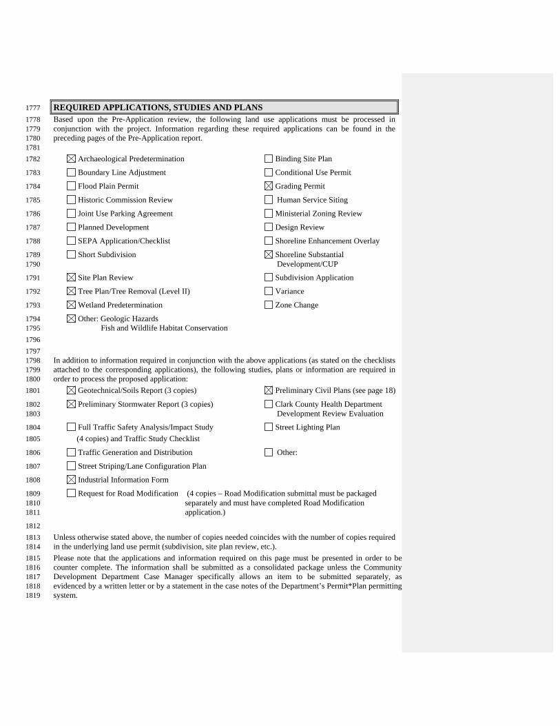
REQUIRED APPLICATIONS, STUDIES AND PLANS 1777 Based upon the Pre-Application review, the following land use applications must be processed in 1778 conjunction with the project. Information regarding these required applications can be found in the 1779 preceding pages of the Pre-Application report. 1780
1781 Archaeological Predetermination Binding Site Plan 1782
Boundary Line Adjustment Conditional Use Permit 1783
Flood Plain Permit Grading Permit 1784
Historic Commission Review Human Service Siting 1785
Joint Use Parking Agreement Ministerial Zoning Review 1786
Planned Development Design Review 1787
SEPA Application/Checklist Shoreline Enhancement Overlay 1788
Short Subdivision Shoreline Substantial 1789 Development/CUP 1790
Site Plan Review Subdivision Application 1791
Tree Plan/Tree Removal (Level II) Variance 1792
Wetland Predetermination Zone Change 1793
Other: Geologic Hazards 1794 Fish and Wildlife Habitat Conservation 1795 1796
1797 In addition to information required in conjunction with the above applications (as stated on the checklists 1798 attached to the corresponding applications), the following studies, plans or information are required in 1799 order to process the proposed application: 1800
Geotechnical/Soils Report (3 copies) Preliminary Civil Plans (see page 18) 1801
Preliminary Stormwater Report (3 copies) Clark County Health Department 1802 Development Review Evaluation 1803
Full Traffic Safety Analysis/Impact Study Street Lighting Plan 1804 (4 copies) and Traffic Study Checklist 1805
Traffic Generation and Distribution Other: 1806
Street Striping/Lane Configuration Plan 1807
Industrial Information Form 1808
Request for Road Modification (4 copies – Road Modification submittal must be packaged 1809 separately and must have completed Road Modification 1810 application.) 1811
1812 Unless otherwise stated above, the number of copies needed coincides with the number of copies required 1813 in the underlying land use permit (subdivision, site plan review, etc.). 1814 Please note that the applications and information required on this page must be presented in order to be 1815 counter complete. The information shall be submitted as a consolidated package unless the Community 1816 Development Department Case Manager specifically allows an item to be submitted separately, as 1817 evidenced by a written letter or by a statement in the case notes of the Department’s Permit*Plan permitting 1818 system. 1819
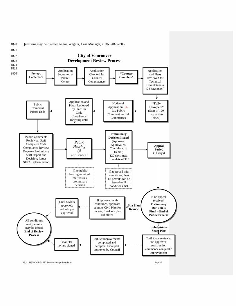
PRJ-143550/PIR-34550 Tesoro Savage Petroleum Page 45
Questions may be directed to Jon Wagner, Case Manager, at 360-487-7885. 1820
1821
City of Vancouver 1822 Development Review Process 1823
1824 1825
1826
Public Comment
Period Ends
Public Comments Reviewed; Staff Completes Code
Compliance Review; Prepares Preliminary
Staff Report and Decision; Issues
SEPA Determination
Public Hearing
(if applicable)
Preliminary Decision Issued
(Approval, Approval w/
Conditions, or Denial)
120 days max. from date of TC
Appeal Period
(14 days)
If approved with conditions, then
no permits can be issued until
conditions met
If no appeal received,
Preliminary Decision is
Final – End of Public Process
If approved with conditions, applicant submits Civil Plan for review; Final site plan
submitted
If no public hearing required,
staff issues preliminary
decision
All conditions met; permits
may be issued End of Review
Process
Application Submitted at
Permit Center
Application Checked for
Counter Completeness
“Counter Complete”
Application and Plans
Reviewed for Technical
Completeness (28 days max.)
“Fully Complete”
(Start of 120- day review
clock)
Notice of Application; 14-
day Public Comment Period
Commences
Application and Plans Reviewed
by Staff for Code
Compliance (ongoing until
decision)
Pre-app Conference
Civil Mylars approved;
final site plan approved
Civil Plans reviewed and approved; construction
commences on public improvements
Public improvements completed and
accepted; Final plat approved by Council
Final Plat mylars signed
Site Plan Review
Subdivisions Short Plats