Top-down Biomanipulation and the Restoration of Eutrophied Lakes

MAY 2021
Plan for the Restoration of the Four Lakes
of Gladwin County and Midland County
FOUR LAKES TASK FORCE

Page Intentionally Blank

| 3
Table of ContentsCHAPTER 1: Executive Summary . . . . . . . . . . . . . . . . . . . . . . . . . . . . . . . . . . . . . . . . . . . . . . . . . . . . . . . . . . . . . . . . . . . . . . . .5
CHAPTER 2: Introduction and Background . . . . . . . . . . . . . . . . . . . . . . . . . . . . . . . . . . . . . . . . . . . . . . . . . . . . . . . . . . . . . . . .13
2a . Introduction and Background . . . . . . . . . . . . . . . . . . . . . . . . . . . . . . . . . . . . . . . . . . . . . . . . . . . . . . . . . . . . . . . . . . . .13
2b . Summary Legal and Regulatory Framework . . . . . . . . . . . . . . . . . . . . . . . . . . . . . . . . . . . . . . . . . . . . . . . . . . . . . . . . .13
CHAPTER 3: County Ownership of Dams, Bottomlands and Flowage Rights . . . . . . . . . . . . . . . . . . . . . . . . . . . . . . . . . . . . .17
CHAPTER 4: Future Use and Function of the Lakes . . . . . . . . . . . . . . . . . . . . . . . . . . . . . . . . . . . . . . . . . . . . . . . . . . . . . . . . .19
CHAPTER 5: Lake Community Survey . . . . . . . . . . . . . . . . . . . . . . . . . . . . . . . . . . . . . . . . . . . . . . . . . . . . . . . . . . . . . . . . . . . .21
CHAPTER 6: Flood Management . . . . . . . . . . . . . . . . . . . . . . . . . . . . . . . . . . . . . . . . . . . . . . . . . . . . . . . . . . . . . . . . . . . . . . . .29
CHAPTER 7: Dam Safety Design Criteria . . . . . . . . . . . . . . . . . . . . . . . . . . . . . . . . . . . . . . . . . . . . . . . . . . . . . . . . . . . . . . . . . .31
7a . Introduction and Background . . . . . . . . . . . . . . . . . . . . . . . . . . . . . . . . . . . . . . . . . . . . . . . . . . . . . . . . . . . . . . . . . . . .31
7b . Flood Study of the Tittabawassee River from Secord Dam to Sanford Dam . . . . . . . . . . . . . . . . . . . . . . . . . . . . . . . .33
7c . Updated Flood Study Results . . . . . . . . . . . . . . . . . . . . . . . . . . . . . . . . . . . . . . . . . . . . . . . . . . . . . . . . . . . . . . . . . . . .34
7d . Discussion of Inflow Design Flood (IDF) . . . . . . . . . . . . . . . . . . . . . . . . . . . . . . . . . . . . . . . . . . . . . . . . . . . . . . . . . . . .35
7e . Development of Conceptual Designs to Restore Legal Lake Levels . . . . . . . . . . . . . . . . . . . . . . . . . . . . . . . . . . . . . .36
7f . Proposed Repairs to Restore Legal Lake Levels . . . . . . . . . . . . . . . . . . . . . . . . . . . . . . . . . . . . . . . . . . . . . . . . . . . . . .37
CHAPTER 8: Environmental Restoration Planning . . . . . . . . . . . . . . . . . . . . . . . . . . . . . . . . . . . . . . . . . . . . . . . . . . . . . . . . . . .59
8a . Introduction . . . . . . . . . . . . . . . . . . . . . . . . . . . . . . . . . . . . . . . . . . . . . . . . . . . . . . . . . . . . . . . . . . . . . . . . . . . . . . . . . .59
8b . Secord and Smallwood Dams . . . . . . . . . . . . . . . . . . . . . . . . . . . . . . . . . . . . . . . . . . . . . . . . . . . . . . . . . . . . . . . . . . .60
8c . Edenville and Sanford Dams . . . . . . . . . . . . . . . . . . . . . . . . . . . . . . . . . . . . . . . . . . . . . . . . . . . . . . . . . . . . . . . . . . . . .60
8d . Wixom and Sanford Lake Restoration Planning Summary . . . . . . . . . . . . . . . . . . . . . . . . . . . . . . . . . . . . . . . . . . . . . .60
8e . Vegetation Management Plan . . . . . . . . . . . . . . . . . . . . . . . . . . . . . . . . . . . . . . . . . . . . . . . . . . . . . . . . . . . . . . . . . . . .67
8f . Recreational Planning . . . . . . . . . . . . . . . . . . . . . . . . . . . . . . . . . . . . . . . . . . . . . . . . . . . . . . . . . . . . . . . . . . . . . . . . . .68
8g . Environmental Permitting . . . . . . . . . . . . . . . . . . . . . . . . . . . . . . . . . . . . . . . . . . . . . . . . . . . . . . . . . . . . . . . . . . . . . . .69
CHAPTER 9: Operations Excellence . . . . . . . . . . . . . . . . . . . . . . . . . . . . . . . . . . . . . . . . . . . . . . . . . . . . . . . . . . . . . . . . . . . . .73
CHAPTER 10: Funding and Financing . . . . . . . . . . . . . . . . . . . . . . . . . . . . . . . . . . . . . . . . . . . . . . . . . . . . . . . . . . . . . . . . . . . .75
10a . Operations . . . . . . . . . . . . . . . . . . . . . . . . . . . . . . . . . . . . . . . . . . . . . . . . . . . . . . . . . . . . . . . . . . . . . . . . . . . . . . . . . .75
10b . Capital Improvements . . . . . . . . . . . . . . . . . . . . . . . . . . . . . . . . . . . . . . . . . . . . . . . . . . . . . . . . . . . . . . . . . . . . . . . . .75
10c . Grants and Donations . . . . . . . . . . . . . . . . . . . . . . . . . . . . . . . . . . . . . . . . . . . . . . . . . . . . . . . . . . . . . . . . . . . . . . . . .76
10d . Lake Level Special Assessment . . . . . . . . . . . . . . . . . . . . . . . . . . . . . . . . . . . . . . . . . . . . . . . . . . . . . . . . . . . . . . . . .76
10e . Use of Special Assessment District for Financing . . . . . . . . . . . . . . . . . . . . . . . . . . . . . . . . . . . . . . . . . . . . . . . . . . .79
10f . Financing Conclusion . . . . . . . . . . . . . . . . . . . . . . . . . . . . . . . . . . . . . . . . . . . . . . . . . . . . . . . . . . . . . . . . . . . . . . . . . .80
CHAPTER 11: Special Assessment District, Property Benefits and Affordability Analysis . . . . . . . . . . . . . . . . . . . . . . . . . . . .81
11a . Introduction . . . . . . . . . . . . . . . . . . . . . . . . . . . . . . . . . . . . . . . . . . . . . . . . . . . . . . . . . . . . . . . . . . . . . . . . . . . . . . . . .81
11b . Operations, Capital Improvement and Transition Assessment . . . . . . . . . . . . . . . . . . . . . . . . . . . . . . . . . . . . . . . . . .82
11c . Assessments for the Four Lakes Special Assessment District . . . . . . . . . . . . . . . . . . . . . . . . . . . . . . . . . . . . . . . . . .83
11d . Part 307 Special Assessment . . . . . . . . . . . . . . . . . . . . . . . . . . . . . . . . . . . . . . . . . . . . . . . . . . . . . . . . . . . . . . . . . . .83
11e . Revisiting Benefits Factors . . . . . . . . . . . . . . . . . . . . . . . . . . . . . . . . . . . . . . . . . . . . . . . . . . . . . . . . . . . . . . . . . . . . .84
11f . Capacity to Pay (Affordability) . . . . . . . . . . . . . . . . . . . . . . . . . . . . . . . . . . . . . . . . . . . . . . . . . . . . . . . . . . . . . . . . . . .85
11g . Lowering the Cost of the Assessment . . . . . . . . . . . . . . . . . . . . . . . . . . . . . . . . . . . . . . . . . . . . . . . . . . . . . . . . . . . .86
11h . Lake-by-Lake Evaluation . . . . . . . . . . . . . . . . . . . . . . . . . . . . . . . . . . . . . . . . . . . . . . . . . . . . . . . . . . . . . . . . . . . . . . .86
11i . Midland and Gladwin Lake Community Economics . . . . . . . . . . . . . . . . . . . . . . . . . . . . . . . . . . . . . . . . . . . . . . . . . .91
CHAPTER 12: Project Implementation — Risks and Conclusion . . . . . . . . . . . . . . . . . . . . . . . . . . . . . . . . . . . . . . . . . . . . . . .97
12a . Critical Factors by Lake . . . . . . . . . . . . . . . . . . . . . . . . . . . . . . . . . . . . . . . . . . . . . . . . . . . . . . . . . . . . . . . . . . . . . . .97
12b . Risk Analysis . . . . . . . . . . . . . . . . . . . . . . . . . . . . . . . . . . . . . . . . . . . . . . . . . . . . . . . . . . . . . . . . . . . . . . . . . . . . . . . .98
CHAPTER 13: Conclusion . . . . . . . . . . . . . . . . . . . . . . . . . . . . . . . . . . . . . . . . . . . . . . . . . . . . . . . . . . . . . . . . . . . . . . . . . . . .101
ACRONYMS . . . . . . . . . . . . . . . . . . . . . . . . . . . . . . . . . . . . . . . . . . . . . . . . . . . . . . . . . . . . . . . . . . . . . . . . . . . . . . . . . . . . . . .103
FIGURES . . . . . . . . . . . . . . . . . . . . . . . . . . . . . . . . . . . . . . . . . . . . . . . . . . . . . . . . . . . . . . . . . . . . . . . . . . . . . . . . . . . . . . . . .104
APPENDIX . . . . . . . . . . . . . . . . . . . . . . . . . . . . . . . . . . . . . . . . . . . . . . . . . . . . . . . . . . . . . . . . . . . . . . . . . . . . . . . . . . . . . . . .106

| 4
Page Intentionally Blank

| 5
CHAPTER 1: EXECUTIVE SUMMARY
§1 — Chapter 1: Executive Summary
IntroductionOn May 19, 2020, and after days of steady rain, the Edenville Dam in Gladwin County, Michigan, failed . The resulting surge overwhelmed the Sanford Dam in Midland County, causing it to fail . The upstream Secord and Smallwood dams were also damaged by the flood and the Federal Energy Regulatory Commission (FERC) ordered the private dam owner, Boyce Hydro Power (Boyce), to fully lower both lakes for inspection and repair . Ten thousand people were evacuated, the area was declared a national disaster by the president of the United States and the community was left with extensive economic, environmental and property damage .
The recovery (i .e ., interim stabilization) and restoration of the four dams (Secord, Smallwood, Edenville and Sanford), and the four lakes (Secord, Smallwood, Wixom and Sanford) (Four Lakes) along with their ecosystems is estimated to cost between $250 and $300 million .1 The Four Lakes communities consist of more than 8,400 properties, with an average home value of approximately $117,909 .2 If the lakes are not restored, the cost for dam removal and environmental mitigation alone could cost $125 million .3 The impact on the economy of the four communities that have lost their lakes is incalculable . Amidst this tragedy, Boyce filed for bankruptcy protection and is insolvent .
The only path forward to protect the safety, welfare and environment of the lake communities was for Gladwin and Midland counties to take the properties through their eminent domain authority under Part 307, inland lakes of the Natural Resource and Environmental Protection Act 451 of 1994 (Part 307) . Through this authority, Four Lakes Task Force (FLTF), as the counties’ delegated authority, performed emergency repairs and continues to manage the recovery and restoration of the Four Lakes System and make plans to restore the lakes to their Part 307 legal levels as defined .
FLTF published its Recovery and Restoration Plan in September of 2020 . In it, FLTF committed to having a feasible plan for the restoration of the lakes by May of 2021 . In December 2020, the counties obtained the title of the dams, gaining control of the properties, and making it possible to begin work in earnest to restore the lakes .
Engineering and financing to fund the capital improvements to restore the four dams are underway . FLTF is committed to restoring Secord and Smallwood legal lake levels by 2024, Sanford by 2025 and Wixom by 2026 . FLTF’s plan to accomplish this is summarized below .
Public Sector Consultants SurveyFLTF hired Public Sector Consultants (PSC)4 to survey all property owners within the Four Lakes Special Assessment District (SAD) . FLTF was interested in understanding property owners’ willingness to pay an assessment to rebuild the dams to restore the lakes, as well as understand property owners’ preferences and concerns as it relates to the dams . Several key takeaways are highlighted below and discussed in greater detail in the report findings .
1 Estimated costs of recovery, engineering, design and construction .2 See Public Sector Consultants Demographic Report in Chapter 1 Appendix .3 See Decommissioning Report for Secord, Smallwood, Edenville and Sanford Dams in Chapter 1 Appendix . 4 Results of the Public Sector Consultants community survey are shared in detail in Chapter 5 .

| 6
CHAPTER 1: EXECUTIVE SUMMARY
• Survey respondents were overwhelmingly in favor of rebuilding and restoring the dams torestore their lake .
• Respondents who owned lakefront property were more in favor of rebuilding the dams .
• Property owners on Secord Lake were willing to pay at least $500 annually to support therepair of the dam on Secord Lake . This was the highest level of support for paying somethingto repair and rebuild the lakes and may indicate the property owners on Secord Lake are themost comfortable with current assessment estimates .
• The lakes are incredibly important to property owners within the SAD .
• Most property owners have owned their property for 10 years or more, indicating a strongconnection to the property . Given the length of ownership, it was interesting that 50% ofrespondents indicated they would consider selling their property if the lakes were not restored .
• Property owners across all four lakes agreed that people outside the SAD should becontributing to the cost of rebuilding and repairing the dams, in particular, the state and federalgovernment should be contributing more .
Legal Structure for the Four Lakes Failed System of Federally Regulated Hydroelectric Dams: Four privately-owned dams and lakes that existed for almost 100 years ended in an avoidable disaster in May 2020 . This group of dams included perpetually deeded lake properties and access for adjacent properties . After years of non-compliance and neglect by the dam owner, a worst-case scenario occurred . Neither FERC nor the Michigan Department of Natural Resources (MDNR) was able to enforce Boyce to maintain its facilities, comply with emergency orders, or provide any recovery support . Boyce did not comply with FERC or State of Michigan orders and escaped its obligation through bankruptcy .
Incredibly, there is no emergency power for FERC to assume control of a failed dam, or funding recourse to restore the property or environmental damages if the owner of the dam is unable or refuses to do so . FERC revoked Boyce’s Edenville Dam license in 2018 and will likely rule that an implied surrender occurred by Boyce for the remaining three FERC licensed dams, putting all four lakes and their dams under the jurisdiction of the Michigan Department of Environment, Great Lakes and Energy (EGLE) .
Michigan Legal and Regulatory Governance of Lakes or Dams: There are 2,5005 dams in Michigan . If a private owner chooses or cannot operate a dam safely, or if a dam fails, EGLE has emergency authority to order the owner of a high hazard dam to make necessary safety improvements . Although, as demonstrated by the Edenville case, once it assumes jurisdiction of a dam it must seek funding to accomplish what it ordered the owner to do . The only recourse for a community to save the lakes and their associated ecosystems is to acquire the property, repair the dams and maintain the lakes under Part 307 .
The Four Lakes Situation: After the FERC revocation of the Edenville license, the counties petitioned the Gladwin and Midland Circuit Courts, which subsequently issued orders, with EGLE and the MDNR’s concurrence, to establish legal lake levels for the four lakes and the Four Lakes
5 https://www .michigan .gov/egle/0,9429,7-135-3313_3684_3723-9515--,00 .html .

| 7
CHAPTER 1: EXECUTIVE SUMMARY
SAD . FLTF was contracted as the counties’ delegated authority under Part 307, and an affordable $35 million6 plan was developed to acquire all four lakes and maintain the legal lake levels into the future, with an estimated average assessment of $350 for a waterfront owner . That plan, along with the opportunity to offset costs to operate the dams with hydropower revenues, was extinguished by the May 2020 failures .
Recovery: Without the Part 307 legal lake level order, or had the counties not exercised their authority of eminent domain under Part 307 after the dam failures, the property would have remained in dispute through bankruptcy for years . Conditions for public safety would have continued to deteriorate, and damage to the ecosystems would amass, with no regulatory or legal path to resolve the situation .
Using its authority under Part 307, and FLTF as its agent, the counties acquired the properties from bankruptcy and sponsored a coordinated recovery . With private support, funds from the State of Michigan and matching grants from the U .S . Department of Agriculture (USDA) Natural Resources Conservation Service (NRCS), approximately $40 million was raised to stabilize the damaged dams, abate shoreline erosion and remove tons of debris from the dry lake beds . It is costing approximately $600,000 this year just to manage these lakes in their lowered state until the dams are rebuilt, and the legal lake levels are reestablished . Fifteen million dollars is being spent on studies and engineering to prepare for the restoration of the Four Lakes .
Public Policy: This disaster sounded an alarm throughout the United States on the issue of aging dams under private ownership . FERC asked for input on the need for financial considerations, and FLTF responded .7 Michigan’s governor formed a Dam Safety Task Force, and FLTF provided input .8 FLTF’s position on public policy simply stated is:
• Infrastructure that can impact the public and the environment cannot be allowed to “age” tofailure . It must be managed safely on a lifecycle basis and improved in response to changingenvironmental conditions and evolving dam safety requirements .
• Federal and state governments need to establish reserve funds to take emergency action orrestore damage to natural resources .
• Part 307 of the Michigan Natural Resources and Environmental Protection Act 451 of 1994is the appropriate framework for the transition of lake ownership from private to public andrestoration of the lakes .
• FLTF supports the general recommendations of the Michigan Dam Safety Task Force forreform .9 However, Four Lakes cannot simply be the poster child for what should be done forfuture dams and lakes . Going forward, this must be a private-public partnership to restorethese lakes . FLTF is encouraged since the failure that the State of Michigan has funded $17 .5million for initial recovery . EGLE and FLTF have been working together in partnership forrecovery with a long-term plan for the region in mind .10
6 $35 million was the “not to exceed estimate” for financing that was approved by the counties prior to the dam failures .
7 FLTF letter to FERC: https://www .four-lakes-taskforce-mi .com/uploads/1/2/3/1/123199575/fltf_to_ferc_re ._taking_of_properties_and_ comments_and_requests_related_to_fercs_dec ._7_order_1 .5 .21 .pdf .
8 FLTF Comments on Recommendations of Dam Safety Task Force, January 27, 2021: https://www .four-lakes-taskforce-mi .com/updates/fltf-comments-on-dam-safety-task-force-recommendations .
9 Michigan Dam Safety Task Force Report, February 12, 2021 .10 https://www .michigan .gov/documents/egle/egle-EdenvilleDamPreliminaryReport_700997_7 .pdf .
| 8
CHAPTER 1: EXECUTIVE SUMMARY
FLTF will restore the system using current best practices for safety and ecosystem restoration . It will take the next two years to develop a financeable construction path forward for each dam . During that time, FLTF will advocate for regulatory and legislative intervention to lower the burden of the cost of restoration to the lake community and seek support for the failures of a regulatory system that not only failed to protect but left the financial burden of recovery on those that the regulations were intended to protect .
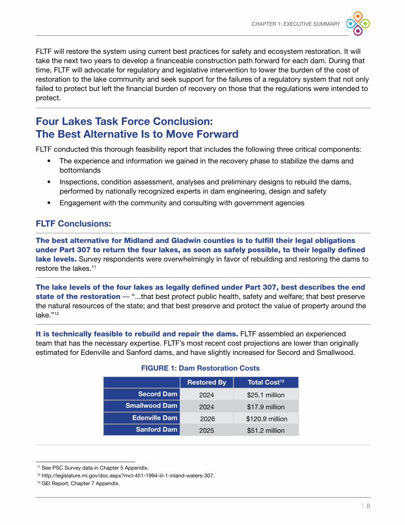
Four Lakes Task Force Conclusion: The Best Alternative Is to Move ForwardFLTF conducted this thorough feasibility report that includes the following three critical components:
• The experience and information we gained in the recovery phase to stabilize the dams andbottomlands
• Inspections, condition assessment, analyses and preliminary designs to rebuild the dams,performed by nationally recognized experts in dam engineering, design and safety
• Engagement with the community and consulting with government agencies
FLTF Conclusions:
The best alternative for Midland and Gladwin counties is to fulfill their legal obligations under Part 307 to return the four lakes, as soon as safely possible, to their legally defined lake levels. Survey respondents were overwhelmingly in favor of rebuilding and restoring the dams to restore the lakes .11
The lake levels of the four lakes as legally defined under Part 307, best describes the end state of the restoration — “ . . .that best protect public health, safety and welfare; that best preserve the natural resources of the state; and that best preserve and protect the value of property around the lake .”12
It is technically feasible to rebuild and repair the dams. FLTF assembled an experienced team that has the necessary expertise . FLTF’s most recent cost projections are lower than originally estimated for Edenville and Sanford dams, and have slightly increased for Secord and Smallwood .
11 See PSC Survey data in Chapter 5 Appendix .12 http://legislature .mi .gov/doc .aspx?mcl-451-1994-iii-1-inland-waters-307 .13 GEI Report, Chapter 7 Appendix .
Restored By Total Cost13
Secord Dam 2024 $25.1 million Smallwood Dam 2024 $17.9 million
Edenville Dam 2026 $120.9 million Sanford Dam 2025 $51.2 million
FIGURE 1: Dam Restoration Costs
| 9
CHAPTER 1: EXECUTIVE SUMMARY
Restoration of the four hydroelectric facilities is not financially feasible.14 The hydroelectric facilities were marginally economic before the May 2020 failures . The additional costs to repair the damage and restore the power-generating facilities make hydropower impractical under current conditions .
Historical flooding would still exist without the dams. Flooding that occurred downstream in May 2020 was already in progress because of heavy rains before the dam failures . Forty percent of the water that flows into the City of Midland is from the Tittabawassee River watershed . The remaining 60% is from the Pine, Chippewa and other smaller rivers . Midland is a known flood zone that has been problematic for over a century and FLTF is working with the Midland and Gladwin communities, National Weather Service, U .S . Geologic Service, and other agencies to better understand the historic causes of flooding and collaborate to find solutions throughout the watersheds .
FLTF must be committed to being a responsible operator of the dams and a good steward of the public trust. While the independent investigation team has not completed its report, it has become clear to FLTF that these dams should not have failed if they were managed on a lifecycle basis, kept compliant, maintained to respond to changing conditions and received necessary improvements to maintain a high degree of public safety .
Critical Actions Underway:
Hydraulic modeling is being performed with and without the dams to establish flood depths, flow rates and water surface elevations at critical locations upstream and downstream of FLTF dams. Inundation maps and flood profiles are being developed upstream and downstream of FLTF dams to establish the floodplain inundation limits at critical locations . The inundation mapping also identifies roads, highways, bridges and other critical infrastructure impacted by the floods including major roads expected to be overtopped . The flood inundation limits and discharges downstream of Sanford Dam for the dam removed and dam reconstructed scenarios will be compared to ascertain the incremental impacts of reconstructing the four dams .
Towards this end, FLTF is conducting new extreme precipitation, hydrology and flood studies to establish the design criteria and proposed dam configurations to safely pass the inflow design flood per EGLE requirements . The scope of the new studies includes the total watershed from the headwaters above the Secord Dam to just downstream of Sanford Dam . In other words, this will include the total rainfall and runoff in the Tittabawassee River system upstream of the Sanford Dam . The extreme precipitation study will provide calibrated rainfall totals observed during historic flood events (including May 2020) and an estimation of the probable maximum precipitation (PMP) . The hydrology study will include new estimates of recurrence interval flood events such as the 100-, 200- and 500-year storm events up to the probable maximum flood (PMF) .
The design storm criteria on all FLTF dams will be based on an Inflow Design Flood (IDF) per the Federal Emergency Management Agency (FEMA) Dam Safety Guidelines15 as recommended by the Michigan Dam Safety Task Force.16 The selected design storm will likely exceed the current EGLE dam safety requirements for each of the FLTF dams .
14 See Chapter 1 Appendix for Update to Hydropower Feasibility . 15 https://www .fema .gov/sites/default/files/2020-08/fema_dam-safety_inflow-designs_P-94 .pdf .16 https://www .michigan .gov/documents/egle/2021-02-25-MI-Dam-Safety-Task-Force-Report-to-Governor-Whitmer_717510_7 .pdf .

| 10
FLTF has a primary focus on the management of the system for public safety, preserving the environment and ecosystem services and proactively working with the counties on strategic flood mitigation and improved flood management during historical storms. To help address the regional flood issue, FLTF expanded the scope of the PMP study to include the entire Tittabawassee watershed upstream of Midland . FLTF will share the precipitation study results with other stakeholders and proactively work with public officials on strategies for flood mitigation and improved flood management during storms . The above studies are expected to be completed this year .
Short-term funding is needed to develop a financeable plan for all four dams to avoid delaying the project:
• An assessment will be needed by the winter of 2022 if additional funds are not received .
• Approximately $10 million will be needed by early 2022 for the recovery phase, to complete the engineering and design to rebuild the dams and to avoid a year delay on Sanford and Wixom lakes’ restoration . FLTF is working on this issue and believes it can be resolved . Twenty-five million dollars or more would significantly reduce the risk to project timing by addressing long lead time items .
An environmental framework has been established and will be implemented. This includes the environmental permitting requirements to repair or reconstruct each dam . Wetlands and other environmental resources directly impacted by reconstruction activities of the four dams will be addressed and mitigated . Secord and Smallwood, while in need of major repair, are still in serviceable condition, and EGLE has agreed these two dams will be treated as “drawdown and repair .” Environmental restoration efforts at Wixom and Sanford lakes will focus on the ecosystems that will exist after the lakes are brought back up . FLTF and EGLE are cooperatively in dialogue to ensure all parties are aligned on an environmental restoration plan to restore all four lakes to their legal lake levels .
An assessment of property owners in the Four Lakes SAD needs to be in place by the end of 2022 to attract funding and assure there are financial means for long-term operations and maintenance. The Four Lakes system is complex based on its geographic reach, multiple communities and diversity of waterways . Benefit factors in connection with the apportionment of costs will be refined by the end of 2021 .
If the cost to rebuild the dams cannot be significantly lowered, if additional public funds do not become available, or if there is not sufficient public support, property owners’ ability to pay will be challenged. Property values and demographic data suggest most of the lake property owners can afford moving forward . Unfortunately, there would be many who could not . For those property owners, FLTF is working with the counties to identify options to support primary homeowners who risk being displaced because of the assessment if more state or federal funding does not become available .
Community advocacy is needed to support FLTF in its efforts. This disaster occurred under a private owner regulated by a federal agency that had no clear remedy for the affected communities . FLTF must find a way to lower the cost and impacts of this disaster . Approximately $150 million in funding is needed to get close to the estimated assessment values to pre-failure and significant grants will be needed for much of the environmental restoration plans .
CHAPTER 1: EXECUTIVE SUMMARY

| 11
Status on Each Lake:
Secord has an estimated assessment that most of the property owners can financially manage and there are funds to finish the engineering and financing for the restoration of the lake level .
Smallwood has an estimated assessment roll that most lake owners would likely accept compared to not having a lake . There would be a moderate churn of ownership, most likely in vacation homes, without government support . There are funds to complete engineering and finance the restoration of the lake level .
Wixom has an estimated assessment that would have an economic impact on almost half of the lake homeowners and backlot owners, without state or federal funding . A total of $4 million in funding is needed to complete engineering without delaying the 2026 timeline of the project .
Sanford, while its estimated assessment is high for waterfront property owners, the value of the homes on Sanford and the economic demographics suggest most can afford and will accept an assessment . Backlots are a different story, and more investigation of lake benefits and economic impact needs to be completed . Approximately $4 million of funding is needed to complete engineering without delaying the 2025 timeline of the project .
Critical Success FactorsThere are four key issues on which FLTF needs to make progress in 2021:
1 . FLTF needs to acquire at least $10 million from outside the SAD by early 2022 . In the next three years, approximately $150 million would bring the funding to the level of assessment estimated prior the dam failure and would be in the means of almost all property owners .
CHAPTER 1: EXECUTIVE SUMMARY
2 . Environmental recovery on Wixom and Sanford lakes is significant, and FLTF is engaged with EGLE to get state acceptance of the restoration plan, and then identify funding sources .
3 . A fair and consistent methodology for the assessment of property owners of the Four Lakes SAD needs to be put in place to attract funding and assure that there are financial means for long-term operations and maintenance .
4 . Flood studies must be completed, and capacity designs must be acceptable to the state to move forward with the completion of engineering .
FIGURE 2: Funds Needed to Achieve Lower Assessment
Secord Smallwood Edenville Sanford Total
Funds Needed to Achieve Below $500/Year Assessment
$317,000 $10 million $90 million $37 million $137.3 million
Funds Needed to Achieve Below $1,000/Year Assessment
$0 $1.6 million $53 million $21 million $75.6 million
FLTF and the counties, under Part 307, have the authority and legal obligation to restore the lakes. With the implementation of this Four Lakes restoration plan, and through continued collaboration between the lake communities, the State of Michigan and the federal government, the lakes can all be returned by 2026.

| 12
Page Intentionally Blank

| 13
CHAPTER 2: INTRODUCTION AND BACKGROUND
§2 — Chapter 2: Introduction and Background
§2a. Introduction and BackgroundSecord, Smallwood, Wixom and Sanford lakes (Four Lakes) are in Midland and Gladwin counties in central Michigan and were created by the impoundment of the Tittabawassee and Tobacco rivers by four hydroelectric dams . The hydroelectric dams have been in place for nearly 100 years and regulated by the Federal Energy Regulatory Commission (FERC) .
Looking for the long-term stability of the Four Lakes, in 2018 representatives from lake associations began the process of transitioning the four hydroelectric dams from private ownership to public ownership . The counties of Midland and Gladwin requested this citizen task force to explore the process of acquiring, financing and managing the dams and lake levels per Part 307 “Inland Lake Levels” of the Michigan Natural Resources and Environmental Protection Act .
In 2019, legal or normal levels were established, and Four Lakes Task Force (FLTF) was appointed by the counties to pursue acquisition, financing and repairs of the four dams . FLTF is a Michigan nonprofit IRS 501(c)(3) organization . As the counties’ Part 307 delegated authority, FLTF represents the lake property owners within the Four Lakes Special Assessment District .
In December 2019, FLTF and Boyce Hydro Power, LLC (and various Boyce entities) entered into a purchase agreement for the acquisition of dams and flowage rights . However, before making the first installment and option payment, on May 19, 2020, the dam on Wixom Lake (Edenville Dam) failed, resulting in a surge of floodwaters causing the dam at Sanford Lake to fail; the upstream dams at Secord and Smallwood lakes were also damaged . Catastrophic flooding occurred throughout the region, destroying and damaging homes and businesses . The transaction to purchase the dams did not go forward .
In the aftermath of the catastrophic May 19th flood, FLTF became a sponsor for matching grants with the United States Department of Agriculture (USDA) Natural Resources and Conservation Services (NRCS), the State of Michigan, the counties, local municipalities and most importantly, the Four Lakes community to address the immediate emergency concerns that included dam stabilization, shoreline erosion, restoration and debris removal . This effort is ongoing and is estimated to cost over $40 million . The long-term goal is to restore and repair the four dams, without hydroelectric power generation . The recovery and restoration effort is estimated to cost between $250 million and $300 million .
§2b. Summary Legal and Regulatory Framework
Four Lakes System Built to Produce Hydroelectric Power
The four hydroelectric dams have been in place since the 1920s . Most of the original properties required for hydroelectric generation were acquired in 1923 when the Wolverine Power Company, a Delaware corporation, purchased land from the Riverdale Farms Company, a Michigan corporation . A warranty deed dated May 30, 1923 (and recorded on July 23, 1923) in Gladwin County conveyed “forever, all the certain pieces or parcels of land situated and being in the Townships of Tobacco, Billings, Hay, Secord and Clement in the County of Gladwin…” and further provided “and [W]henever

| 14
CHAPTER 2: INTRODUCTION AND BACKGROUND
in the following descriptions or any parcel part or parts thereof, referenced is made to ‘elevation above said level’ or ‘elevation above the mean tide of the Atlantic Ocean’ such elevation is and shall be determined from the benchmark heretofore established at Sanford, in the Township of Jerome, County of Midland… which benchmark will be transferred by” the Riverdale Farms Company “[to] a permanent location on its property at the Sanford dam site…”17
In connection with flowage rights, the warranty deed from Riverdale Farms stated the following:
“[i]n addition to the right title and interest here and conveyed by this indenture by said party of the first part [Riverdale Farms Company] to said party of the second part (Wolverine Power Company] in and to the above-described land, property and rights and not in limitation thereof, said party of the first part of itself, it’s successors or assigns, hereby grants, bargains, sells, conveys and sets over unto said party of the second part, it’s successors and assigns forever, the exclusive and perpetual right to overflow any and all of the above-described property and any and all of the property which said party of the first part now owns or is possessed in said Townships of Tobacco, Billings, Hay, Secord and Clement, County of Gladwin, State of Michigan, by the construction and operation of a dam across the Tittabawassee and Tobacco Rivers…”18
In connection with the operation of the dams, the Riverdale Farms Company granted to Wolverine Power Company the right and the authority to raise and lower the water of the Tittabawassee and Tobacco rivers in the “constriction, maintenance, and operation of any such dam or dams”, but also reserved an inferior right for purposes of boating, hunting and fishing:
“… .Said party of the first part [Riverdale Farms Company] hereby expressly reserves to itself, its successors and assigns forever, the perpetual nonexclusive right but at its on their own risk, to use the waters of the Tittabawassee River and its tributaries impounded by the dams and the water power developments contemplated by the party of the second part [Wolverine Power Company], for domestic and farm purposes, the same to be taken under conditions satisfactory to said party of the second part and for purposes of boating, hunting and fishing, and the right to ingress and egress for such purposes from adjacent land owned or possessed by said party of the first part to said waters over and across the lands hereby conveyed to said party of the second part which are not submerged by said waters, but such rights also reserved shall at no time nor under any circumstances be used to interfere with or obstruct the full use and enjoyment of the property and rights are conveyed by said party of the first part for any use or uses to which said party of the second part may use or desire to use said property and the waters of the Tittabawassee and Tobacco Rivers and their tributaries so impounded for the operation of or in connection with said water power plants or developments in any and rights reserved by said party of the first part, its successors and assigns shall be subject to and inferior to the rights of second part, its successors and assigns, and said party of the second part, its successors and assigns, shall not be liable of any injury, damage, cost and expense which said party of the first part, its successors and assigns…”19
17 Warranty Deed, Dated May 30, 1923 recorded Liber 60, Pages 507-533, July 23, 1923: p507 .
18 Id . at p529 .19 Id . at p531 .

| 15
CHAPTER 2: INTRODUCTION AND BACKGROUND
Thus, historically the purpose of the hydroelectric dams was to generate electricity, but a second, inferior right was reserved for utilization of the reservoirs created for the purpose of development, “boating, hunting and fishing.”
From the 1920s until about 2004, the dams continued to be owned by Wolverine Power Company, until they were transferred to the Boyce Trusts (and eventually, to other entities affiliated with Boyce Hydro Power, LLC; Boyce Hydro) . Each of the dams includes a reservoir (i .e ., lake) and a powerhouse . The Four Lakes occupy about 39 river miles of the Tittabawassee River, with the tailwater of each dam being the headwater of the next downstream dam . Meaning that the Four Lakes are hydraulically and hydrologically interrelated . From Sanford Dam, the most downstream dam, the river flows 35 miles to its confluence with the Shiawassee River where it forms the Saginaw River .
Regulatory Considerations
In 1976, the FERC determined that the Tittabawassee River was a navigable waterway of the United States and issued a jurisdictional order requiring the four projects to be licensed under the Federal Power Act (FPA), 55 FPC 673 . In 1983, then-owner Wolverine Power applied for a license for the Sanford, and in 1987, a license was issued . Similarly, in 1989 Wolverine submitted license applications for the Edenville, Smallwood and Secord projects, and licenses were issued in 1998 . All four licenses were transferred to Boyce Hydro Power, LLC in 2004 . From the onset, Boyce’s compliance record was uneven, at best . Issues ranged from failing to comply with environmental and recreational conditions of the licenses to serious issues involving the safety of the dams . The situation culminated at Edenville on September 18, 2018, when FERC issued an order revoking the license for failure to provide adequate spillway capacity . Water levels at Wixom Lake were lowered, hydroelectric generation ceased and jurisdiction over the project, including dam safety, was transferred to the State of Michigan’s Department of Environment, Great Lakes and Energy (EGLE) .
Less than two years later, in May 2020, storms brought heavy rainfall across the area causing flooding . The Edenville and Sanford dams failed, completely draining both lakes . The Secord and Smallwood dams were severely damaged . FERC ordered the Secord and Smallwood impoundments to be drawn down for safety inspections and repair . This brought an end to hydroelectric generation at the remaining three licensed projects, Sanford, Smallwood and Secord . On July 31, 2020, Boyce filed for bankruptcy protection in the U .S . District Court . In February 2021, Boyce filed an application with FERC for the Unconditional Surrender of the three licensed projects . If and when FERC approves the surrender application, the jurisdiction of the Sanford, Smallwood and Secord projects will be transferred to EGLE .
Legal Lake Levels Established Under Part 307
Part 307 (and prior Michigan law dating back to the early 1900s) provides a public solution for preserving lakes that were created by the artificial impoundment of water . The purpose of Part 307 is to provide for the control and maintenance of inland lake levels for the benefit and welfare of the public . Part 307 essentially authorizes counties to make policy decisions as to the levels of their inland lakes, to finance, build and maintain dams as necessary to maintain the legally established lake levels . The entity responsible for operating and maintaining the normal levels established by the circuit court is the entity or “delegated authority” appointed by the county board of commissioners .

| 16
CHAPTER 2: INTRODUCTION AND BACKGROUND
Court Ordered Part 307 Normal Levels for the Four Lakes
In October 2018, the counties of Midland and Gladwin (counties) adopted resolutions finding that in “order to protect the public’s health, safety, and welfare, to best preserve the natural resources of the state and to preserve and protect the value of property around the lakes” that it was necessary to establish the normal levels for all four lakes . In addition, the resolutions provided that all costs in connection with the maintenance of the normal levels of the Four Lakes “shall be defrayed by special assessments on both public and privately owned property for the benefits derived from the lakes . FLTF was appointed the counties’ delegated authority, and to act on behalf of the Board of Commissioners to oversee the lake level project .
In late 2018, and per the counties’ resolutions, a petition was filed in both the circuit courts of Midland and Gladwin counties . The State Court Administrator assigned Midland County Judge Stephen Carras to hear both cases, including the case filed in the Gladwin County Circuit Court . The hearing was conducted in May 2019 . Judge Carras received information supporting the petition, the Four Lakes Lake Level Report and testimony . After providing an opportunity for all those present at the hearing and taking into consideration the factors set forth in Part 307, on May 28, 2019, Judge Carras established the normal levels for each of the Four Lakes . The levels established for each of the Four Lakes were based on the historical water levels and conditions set forth in the FERC licenses . Judge Carras also approved the formation of the Four Lakes Special Assessment District (SAD) .
Four Lakes Task Force
The primary purpose of FLTF is to lessen the burden of local government in managing the lake levels of the dams and to ensure the sustainable future for all Four Lakes for the benefit of property owners around the lakes, the environment, local business, recreational lake users and the general economic welfare of Midland and Gladwin counties .
The FLTF board of directors is comprised of a representative from each of the counties and representatives from each of the lake associations representing the Four Lakes . As the counties’ Part 307 delegated authority, FLTF represents the lake property owners within the Four Lakes Special Assessment District . FLTF was authorized to acquire, administer, construct, operate, maintain, repair and improve the dams as required to maintain the legal levels established by the Midland County Circuit Court . Specifically, FLTF is responsible for the Four Lakes Special Assessment District (SAD) .
Four Lakes Special Assessment District
The Four Lakes SAD is an established boundary of lakefront properties along or near the four lakes, and backlot properties with dedicated (private easement) access . The properties within the SAD share financial responsibility by paying an annual assessment on the property’s tax bill . The SAD offers a method of financing the acquisition, operation, maintenance, repairs and improvements to the dams to ensure that they meet State of Michigan dam safety standards, per Part 315 Dam Safety of NREPA, MCL 324 .31501 et seq . (Part 315) .

| 17
CHAPTER 3: COUNTY OWNERSHIP OF DAMS, BOTTOMLANDS AND FLOWAGE RIGHTS
§3 — Chapter 3: County Ownership of Dams,Bottomlands and Flowage Rights
In December 2019, Four Lakes Task Force (FLTF) and Boyce Hydro Power, LLC (and various Boyce entities) entered into a purchase agreement that contemplated a series of installment payments beginning in June 2020 and a final closing and transfer of the dams, bottomlands, flowage rights and power generation facilities by January 2022 . However, before making the first installment and option payment, on May 19, 2020, the Edenville and Sanford dams failed .
After the dam failures, the purchase agreement with Boyce Trusts did not take place . Pursuant to Part 307, FLTF, as the legally delegated authority, began the process of recovery and restoration . In June 2020, the counties authorized the condemnation and taking of the properties from Boyce Hydro . The counties also appointed FLTF as its delegated authority for all federal and state coordination and funding in connection with the recovery and restoration of the Four Lakes . At this time, Boyce Hydro filed for bankruptcy protection . On December 7, 2020, Judge Daniel Opperman of the U .S . Bankruptcy Court for the Eastern District of Michigan approved a settlement in connection with the condemnation . On December 23, 2020, the circuit courts in both Midland and Gladwin counties entered a “Consent Judgment Vesting Title and Awarding Compensation .” More than 6,000 acres of former Boyce-owned properties were transferred to the counties .
Boyce had lost the bottomlands of Sanford Lake when Midland County took the property from Boyce in tax dispute . To comply with the FERC license, the Sanford Lake Preservation Association purchased the land and granted flowage rights . This land has now been reassigned to Midland County .
The counties of Midland and Gladwin have taken the lead and moved forward with acquiring the dams, bottomlands and flowage rights necessary to restore the Four Lakes . All the property under the Boyce entities that are required to maintain a legal lake level have been acquired and are owned by the property the county the property resides in .
FLTF has also acquired the county properties needed or is obtaining the needed easements to reconstruct or repair the dams .

| 18
Page Intentionally Blank

| 19
CHAPTER 4: FUTURE USE AND FUNCTION OF THE LAKES
§4 — Chapter 4: Future Use and Functionof the Lakes
The dams were constructed a century ago to impound water to produce hydroelectric power and, at that time, the adjacent properties were deeded access to the Four Lakes . The inland lakes formed by the dams created rich, diverse ecosystems which also gave rise to recreation opportunities . Homes were built, businesses sprang up to meet the needs of boaters and sportsmen, and communities formed .
While the value of hydropower generation diminished to the point where continued operation was no longer economically viable, the environmental, societal and economic functions of the lakes were thriving . The lakes became an integral part of the communities and were a vital part of their economy . More than 8,400 properties, seven townships, a village, two counties and the State of Michigan directly benefit from the maintenance of lake levels created by dams on each lake .
The counties recognized this and created the Four Lakes Special Assessment District (SAD) as the primary source of funding to preserve the lakes . The lakes, once restored from the May 2020 dam failures, will again return to their primary use to support the valuable ecosystems and recreational opportunities, and contribute to the quality of life and economic vitality of the region .
Economic ImpactThe failure of the Edenville and Sanford dams, and the Federal Energy Regulatory Commission (FERC)-ordered drawdown of the Secord and Smallwood impoundments, severely challenged the purpose and benefits of the lakes . Boating, water sports and angling are no longer possible and premium lakefront property now overlooks a dry lake bottom with some areas at risk of erosion due to the unstable exposed sediments . The lakes also benefited the local economy and brought in additional monies through tourism, but also through increased home values and annual property tax revenues .
The Sanford Lake Association and Sanford Lake Preservation Association commissioned an economic impact study for Midland County on the value of the lake . The study found that $4 .47 million a year was added to the economy from the lake, including $1 .4 million in household income and $153,912 in sales tax . Sanford Lake County Park alone estimated to receive 105,963 visits per year by vehicle . Another approximately 4,000 visitors enter the park on foot, as reported by staff . It was estimated that 2,316 boating parties and 13,124 non-boating parties from outside Midland County visit Sanford Lake Park per year . These groups were estimated to spend $54 to $57 per party per visit .20
Public Sector Consultants (PSC) compiled a summary of the demographics of the townships and communities within the SAD .21 The combined average income of the 11 townships in the SAD is $48,820, which is less than the statewide average . The average median home value within the SAD is $117,909, which is less than the statewide figure of $154,900 . Though fewer homes in the SAD have a mortgage, 60 .1% compared to statewide 50 .9% in the SAD .
20 See Chapter 4 Appendix .
21 See Chapter 4 Appendix .

| 20
CHAPTER 4: FUTURE USE AND FUNCTION OF THE LAKES
Streamside Ecological Services staff completed an analysis of the economic benefits of the Four Lakes fisheries . Based on this dataset, it would be reasonable to estimate total economic expenditures for fishing activity on the four impoundments would be approximately $3 .4 million annually .22 This value does not take into account of people using the lake for recreation other than fishing .
Not only has the failure and drawdown had a social and economic impact, but there were also substantial environmental impacts . High-quality wetlands have been drained and the previously thriving fisheries and other aquatic life are mostly gone . The true economic value of the lakes is difficult to accurately quantify and a study to further understand the economic loss resulting from the loss of the lakes is outside of the scope of the feasibility study .
But it’s the cultural engagement that a community has with nature that has been broken . Part of the Pure Michigan Promise23 should be restored to the Four Lakes communities and counties .
Moving Forward with RestorationThe goal of Four Lakes Task Force (FLTF) and its community partners is to restore the lakes and re-establish the Part 307 lake levels that provide the most benefits to the public, best preserve the natural resources of the state and preserve and protect property values . This will require developing an affordable solution for each lake that accomplishes the following .
Rebuild the Dams: FLTF will employ state-of-the art technology to rebuild the dams to meet or exceed industry standards for structural integrity, stability and adequacy . The structures will be designed to provide 75 years of usable service life . Spillways will be sized using the Federal Emergency Management Agency’s risk-based guidelines to provide ample capacity for public safety without overbuilding . Additional detail is provided in Chapter 7 .
Environmental Restoration: FLTF will work with the Michigan Department of Natural Resources, the US Fish and Wildlife Service and other agencies to restore the ecosystem to pre-May 2020 conditions . This may include restocking fisheries, re-establishing shellfish populations and monitoring the re-establishment of wetlands . Further detail on environmental restoration planning can be found in Chapter 8 .
Implement an O&M Program to Sustain the Lakes for Future Generations: This will involve developing a business model that not only funds routine ongoing operations and maintenance, but provides for major maintenance, capital replacements and improvements that will be required to sustain the dams and lakes indefinitely for future generations . The plan for operations moving forward can be found in Chapter 9 .
Hydroelectric Power: Redeveloping hydroelectric generation is not economic under current market conditions . FLTF will re-evaluate the feasibility of hydropower as market conditions and other factors warrant .
22 See Public Sector Consultants Demographic Report now in Chapter 1 Appendix .
23 Breathtaking landscapes, starry skies, family fun, outdoor adventures and places to shop, eat and stay local–everyone can experience it all in Pure Michigan . https://www .michigan .org/ .

| 21
CHAPTER 5: LAKE COMMUNITY SURVEY
§5 — Chapter 5: Lake Community Survey
Four Lakes Task Force (FLTF) hired Public Sector Consultants (PSC) to survey24 all property owners within the Four Lakes Special Assessment District (SAD) . PSC used data provided by FLTF in determining the properties located with the assessment district .
FLTF was interested in understanding property owners’ willingness to pay an assessment to rebuild the dams to restore the lakes, as well as understand property owners’ preferences and concerns as it relates to the dams .
The remaining of this chapter is extracted from the PSC report .
Fast Facts:• 6,546 surveys were mailed to property owners using the addresses on file with the county
assessors’ offices in Gladwin and Midland counties .
• 3,226 surveys were returned (49% response rate) .
• The survey was open from January 17-March 10, 2021 .
Survey results provided the following key takeaways:
• Survey respondents were overwhelming in favor of rebuilding and restoring the dams torestore their lake .
• Respondents who owned lakefront property were more in favor of rebuilding the dams .
• Property owners on Secord Lake were willing to pay at least $500 annually to supportthe repair of the dam on Secord Lake . This was the highest level of support for payingsomething to repair and rebuild the lakes and may indicate the property owners on SecordLake are the most comfortable with current assessment estimates .
• It was more important to property owners that rebuilding the dams preserves or increasestheir property values compared to if they could afford the assessment .
• The lakes are incredibly important to property owners within the SAD .
• Most property owners have owned their property for 10 years or more, indicating a strongconnection to the property . Given the length of ownership, it was interesting that 50%of respondents indicated they would consider selling their property if the lakes were notrestored .
• Property owners across all four lakes agreed that people outside the SAD should becontributing to the cost of rebuilding and repairing the dams, in particular, that the stateand federal government should be contributing more .
• There was mixed reaction towards the need for a special assessment . Respondents werefairly split between agreeing, disagreeing and not having an opinion . This may indicatethat many of them are waiting for more concrete assessment costs before selecting theircomfort level with the needs for an assessment .
24 See Chapter 5 Appendix for the full survey report or visit https://www .four-lakes-taskforce-mi .com/document-library-21/category/feasibility-study .

| 22
CHAPTER 5: LAKE COMMUNITY SURVEY
DemographicsA total of 3,226 property owners responded to the survey . By lake, responses came from:
Of the total 3,226 responses, 8% were backlot parcels, with the remaining having lake frontage . A majority of those with lake frontage own between 51-100 feet of frontage . See Figure 2 for additional data as follows:
• By county, 71% of respondents ownedproperty in Gladwin County, and 27%owned property in Midland . The remaining2% did not select a county .
• Fifty percent of respondents indicatedtheir property was mostly used as theirprimary residence .
• Forty-four percent utilized the property asa vacation home, and 1% utilized it as arental property .
• Respondents to the surveyoverwhelmingly indicated they had ownedtheir property more than 10 years .
Survey Responses by QuestionSurvey respondents were asked to indicate their level of agreement to a series of questions related to the lake, their willingness to pay an assessment, and what factored into their decision . The percentage of total respondents agreeing or disagreeing with the statements is provided below with the graphs illustrating the cumulative respondents’ answers . For responses by lake, responses by property use type (homestead or second home/rental), and responses by lakefront or backlot ownership, see Appendix 5 .
Years of Ownership Frequency Percent (%)
Less than 1 year 88 2.7 1-2 years 251 7.8 3-5 years 402 12.5 6-8 years 317 9.8
9-10 years 122 3.8More than 10 years 1,993 61.8Multiple responses 7 0.2
Blank 46 1.4Total 3,226 100.0
FIGURE 3: Years of Ownership
Secord:
742 responses
Smallwood:
278 responses
Wixom:
1,335 responses
Sanford:
745 responses

| 23
CHAPTER 5: PUBLIC ENGAGEMENT
FIGURE 4: Importance of Lakes
Strongly agree
Agree
Neither agree nor disagree
Disagree
Strongly disagree
Blank
70%
16%
6%
3%4% 1%
The lake my property provides access to is important to me .
Question 1: The lake my property provides access to is important to me.Respondents overwhelmingly answered that their lake was important to them, with 86% agreeing or strongly agreeing with the statement . While property owners across all four lakes strongly agreed with the statement, property owners on Secord Lake had the highest level of agreement at 95% .
FIGURE 5: Confidence in Recovery
Strongly agree
Agree
Neither agree nor disagree
Disagree
Strongly disagree
15%
20%
30%
23%
12%
In five years, I am confident the community will have recovered from the dam failures .
Question 2: In five years, I am confident the community will have recovered from the dam failure.Respondents were more evenly split on the response to this question, with the largest number of respondents selecting “neither agree nor disagree” to the statement . Respondents on Secord Lake were more confident than property owners on other lakes . Wixom in particular, while nearly evenly split across agree, neither agree nor disagree, and disagree, slightly leaned towards disagree that the community will have recovered from the dam failures .
Rebuilding the DamsQuestions three, four and five were all related to property owners’ thoughts on rebuilding and restoring the dams .

| 24
FIGURE 6: Selling Property
Strongly agree
Agree
Neither agree nor disagree
Disagree
Strongly disagree
11%
20%
22%
36%
11%
I would consider selling my property if my lake is not restored .
Question 3. I would consider selling my property if my lake is not restored.Fifty-seven percent of the respondents agreed with the statement they would consider selling their property if the dams were not restored . This is compared to only 21% of the respondents disagreeing with the statements . Across all four lakes, over 50% of property owners agreed they would consider selling their property if the lake was not restored . Property owners on Sanford Lake disagreed 29% of the time with the statement, the highest level amongst the Four Lakes .
FIGURE 7: Rebuilding the Dams
Strongly agree
Agree
Neither agree nor disagree
Disagree
Strongly disagree
6%
17%
71%
4%2%
I believe the dams should be rebuilt or restored .
Question 4: I believe the dams should be rebuilt or restored.Property owners who completed the survey responded 83% of the time that they believed the dams should be rebuilt or restored . Only 5 .6% selected they disagree or strongly disagree with the statement . While not a complete outlier, 9% of Sanford Lake property owners did not believe the dams should be rebuilt, which was a four times higher response rate than Secord and almost double Wixom .

| 25
CHAPTER 5: PUBLIC ENGAGEMENT
FIGURE 8: Need for Special Assessment
Strongly agree
Agree
Neither agree nor disagree
Disagree
Strongly disagree
Blank
14%
25%
23%
14%
22%
2%
A special assessment is needed to rebuild or restore the dams .
Question 5: A special assessment is needed to rebuild or restore the dams.Respondents were more evenly split on the question of whether a special assessment was needed to rebuild and restore the dams . Forty percent of respondents agreed to the statement, while 36% of the respondents disagreed . Twenty-three percent selected neither agree nor disagree, indicating a high level of uncertainty about the assessment . Respondents on Secord and Smallwood were more likely to support the need for a special assessment, while 40% of property owners on Sanford Lake disagreed with the statement (the highest amongst the four lakes) .
Assessment QuestionsQuestions six, seven and eight asked respondents to indicate their level of agreement on if the dams are going to be rebuilt, how and who should pay for the repair and rebuilding of the dams .
Question 6: Property owners within the SAD should be responsible for paying the full cost of repairing and/or replacing the dams.Respondents to the survey overwhelmingly disagreed with this statement with 87% of property owners selecting strongly disagree or disagree . Similar to responses to other questions, property owners on Secord were more supportive of the need for the assessment with 7% agreeing to the statement, compared with 4% on the other lakes .
Question 7: The cost should be shared with people outside the SAD.Seventy-one percent of survey respondents agreed with the statement that people outside the SAD should share in the cost of restoring the dams . The responses across the Four Lakes were very similar with no notable outliers .

| 26
CHAPTER 5: PUBLIC ENGAGEMENT
FIGURE 9: Paying for the Dams
Strongly agree
Agree
Neither agree nor disagree
Strongly disagree
14%
83%
1%2%
30%
13%
5%7%
44%
1%
Strongly agree
Agree
Neither agree nor disagree
Disagree
Strongly disagree
Blank
62%
8%
25%
4%1%
Strongly agree
Agree
Neither agree nor disagree
Disagree
Strongly disagree
Blank
The state and/or federal government should provide more funding for replacing and restoring the dams .
The costs should be shared with people outside of the SAD .
Property owners within the SAD should be responsible for paying the full cost of repairing and/or
replacing the dams
Question 8: The state and/or federal government should provide more funding for replacing and restoring the dams.An overwhelming 97% of respondents agreed that the state or federal government should provide more funding for replacing and restoring the dams . Many respondents provided comments that they felt the dam failure was a result of a lack of proper regulatory oversight from state and federal officials, and therefore they should be responsible for paying for the repairs .
Strongly agree
Agree
Neither agree nor disagree
Disagree
Strongly disagree
Blank
14%
25%
23%
14%
22%
2%
Strongly agree
Agree
Neither agree nor disagree
Disagree
Strongly disagree
Blank
14%
25%
23%
14%
22%
2%
Strongly agree
Agree
Neither agree nor disagree
Disagree
Strongly disagree
Blank
14%
25%
23%
14%
22%
2%

| 27
CHAPTER 5: PUBLIC ENGAGEMENT
FOUR LAKES TASK FORCE | FEASIBILITY STUDY | 27
Question 9: To support rebuilding the dams, I would be willing to pay an annual assessment of up to:Respondents were able to select from choices ranging from “willing to pay nothing” to “willing to pay more than $2,500” annually in an assessment to repair and rebuild the dams . Thirty-one percent were not willing to pay anything, while 27% were willing to pay $1,000 or more annually . A larger percentage (7%) than other questions, had nonresponses to the question . Interestingly, 62% of property owners on Secord Lake were willing to pay at least $500 annually, indicating a strong level of support for the currently proposed assessment .
FIGURE 10: Willingness to Pay
FIGURE 11: Property Values Compared to the Assessment Amount
To support rebuilding the dams, I would be willingly to pay an annual assessment of up to:
If an assessment were to be enacted, the following is more important to me:
40.0
35.0
30.0
25.0
20.0
15.0
10.0
5.0
0.0
31.0
I would not be willing to pay
anythingDollar Amount
Per
cent
$500 $1,000 $1,500 $2,500 More than$2,500
Blank
34.8
13.9
7.5
3.21.5
7.3
60.0%
50.0%
40.0%
30.0%
20.0%
10.0%
0.0%I can afford to pay the annual assessment. Rebuilding the dams preserves or increases
my property value by more than the total assessment will cost.
47.9%
29.4%

| 28
Page Intentionally Blank

| 29
CHAPTER 6: FLOOD MANAGEMENT
§6 — Chapter 6: Flood Management
The Tittabawassee River is the largest tributary to the Saginaw River . The main stem of the Tittabawassee River is 91 miles long with a network of contributing tributaries totaling 621 miles . The river generally flows in a southerly and southeasterly direction to its confluence with the Shiawassee River to form the Saginaw River .
The Tittabawassee River has a tributary watershed of 2,471 square miles, the fifth largest in Michigan . The river has a long history of flooding and damaging communities located in the middle and lower portions of the basin . A 1932 United States Army Corps of Engineers (USACE) study attributed the flooding to the relatively impervious soils, high water table and steep slopes in the headwaters, resulting in a “rapid concentration of run-off” and concluded that “substantial damage is inevitable .”
Facts and figures in the 1932 USACE Report suggest it would take the equivalent of more than nine Wixom Lakes, operated as flood storage reservoirs with 9 .5 feet of drawdown, to control flooding in the middle and lower portions of the watershed . In addition to the flood storage limitations, the Four Lakes watershed represents only 40% of the tributary drainage area to the City of Midland . It is simply not possible for the Four Lakes to eliminate flooding in Midland and other communities downstream .
Federal agencies, including the Federal Energy Regulatory Commission (FERC) and the USACE, recognized the limited flood control capabilities of the Four Lakes . The regulatory focus was on ensuring that operation of the dams did not contribute to downstream flooding, pose a risk to public
FIGURE 12: Four Lakes Watershed

| 30
CHAPTER 6: FLOOD MANAGEMENT
safety, or fail . Under FERC criteria, all four dams are classified as high hazard potential because of the risk that failure poses to life and property . High-hazard dams are required to meet stringent requirements for structural adequacy, integrity and spillway capacity . Unfortunately, under the previous owner, the four dams did not meet these requirements and were unable to safely pass the May 2020 flood .
As the dams transition to state jurisdiction, they will be required to meet the dam safety requirements of the Michigan Department of Environment, Great Lakes and Energy (EGLE) . Following the dam failures, EGLE formed a 19-member Michigan Dam Safety Task Force to thoroughly review Michigan’s existing dam safety program and recommend policy, legislative, budgetary and enforcement reforms “to prevent a catastrophe of this kind from happening again .”
The Dam Safety Task Force’s findings are summarized in their February 12, 2021 report, which recommends revising or adopting laws and/or rules to meet Federal Emergency Management Agency’s (FEMA’s) Model Dam Safety Program (MDSP) . The MDSP is a forward-looking program that provides sound guidance for dam safety that is consistent with the latest national and international industry standards . FLTF is committed to working with EGLE to rebuild the four dams per FEMA’s Model Dam Safety Program .
To this end, Four Lakes Task Force (FLTF) is undertaking flood studies to establish design criteria for dam safety and spillway capacity and to better understand the impacts of restoration in the floodplains and shorelines . FLTF has also prepared updated Emergency Action Plans (EAPs) that reflect the current state for each of the Four Lakes dams . These plans provide a communication network and instructions for responsible parties during emergency events, such as extreme high river flows and/or dam failures . FLTF will also share the results of the studies and work with downstream partners, the State of Michigan, USACE and FEMA to support the development of a basin-wide plan to control flooding .
Multiple communities within the Tittabawassee River watershed, including the City of Midland, participate in the National Flood Insurance Program (NFIP) . The NFIP was established in the National Flood Insurance Act of 1968 and is operated under FEMA . The NFIP allows communities to establish actuarial flood insurance rates for areas located within defined Special Flood Hazard Areas (SFHAs) representing the 1% annual chance floodplain . Properties located within the SFHA are required to be covered under a flood insurance policy when the property is financed by a federally backed mortgage . Properties within the SFHA without a federally backed mortgage, or properties outside of the SFHA, still have the option to be covered under a flood insurance policy, although it is not required .
FLTF’S flood studies include a Probable Maximum Precipitation (PMP) study of the entire Tittabawassee River basin . FLTF will share the results of the PMP study to allow FEMA and downstream stakeholders to update their flood studies and refine the magnitude and frequency of flood events . Further detailed information on FLTF’s flood studies is provided in Chapter 7 .

| 31
CHAPTER 7: DAM SAFETY DESIGN CRITERIA
FOUR LAKES TASK FORCE | FEASIBILITY STUDY | 31
§7 — Chapter 7: Dam Safety Design Criteria Chapter provided by GEI Consulting
§7a. Introduction and BackgroundFollowing the May 19, 2020, storm event that resulted in minor downstream erosion damage to Secord Dam, severe downstream erosion damage to Smallwood Dam, and a catastrophic failure (breach) of the Edenville and Sanford dams, Four Lakes Task Force (FLTF) requested GEI Consultants of Michigan, P .C . (GEI) provide planning-level opinions of probable construction costs to reconstruct and/or rehabilitate the four dams, formerly owned by Boyce Hydro, and licensed for hydro generation by the Federal Energy Regulatory Commission (FERC) .
GEI submitted high-level construction cost estimates to repair or reconstruct the damaged structures and increase the spillway capacity to pass one-half of the Probable Maximum Flood (½ PMF) as well as the full PMF . The ½ PMF is the current State of Michigan Department of Environment, Great Lakes and Energy (EGLE) requirement for high hazard dams, and the full PMF is FERC’s requirement for high hazard dams .
Restoration of hydropower generation was considered by FLTF and its consultants, including GEI, to be uneconomical and would significantly delay reconstruction and restoration of the lake levels to pre-failure water levels and was, therefore, not considered . These high-level cost estimates were provided in a GEI technical memorandum to FLTF President David Kepler dated July 13, 2020 .
As a follow-up to the GEI July 2020 Planning Level Cost Study, FLTF requested two additional engineering studies be undertaken .
1. A hydrologic and hydraulic flood study of the Tobacco River and Tittabawassee River watersheds to update and finalize the design storms at each of the four dams and determine the additional minimum spillway capacity required to safely pass the ½ PMF . That study was a collaborative effort between GEI, Ayres Associates (Ayres) and the Spicer Group, Inc . (SGI) . The results of the flood study are provided in GEI’s March 2021 study titled Flood Study of the Tittabawassee River from Secord to Sanford Dam.
2. An engineering study to further develop the conceptual designs for dam rehabilitation and reconstruction to the 30% schematic level based on:
• Updated spillway capacity requirements determined during the 2021 flood study .
• GEI’s external inspections of the four dams completed in October 2020 and internal inspections conducted in January 2021 at Secord and Smallwood dams .
• “Value engineering” completed by the design team, to improve the design details and constructability, compressing the construction schedule and reducing overall project costs .
• Design and construction of interim stabilization measures currently underway at the Tobacco spillway to stabilize the riverbed and restore flow into the Tobacco River channel and planned interim stabilization measures at the Edenville Dam and Sanford Dam which may also be eligible for Natural Resources Conservation Service (NRCS) Emergency Watershed Protection Program funding .

| 32
The results of these engineering studies and inspections are provided in GEI’s Conceptual Design Basis and Inspection Reports dated March 2021 for Secord, Smallwood, Edenville and Sanford dams . The results of these studies and current conceptual-level opinions of probable construction costs are summarized below .
A location map of FLTF dams and their respective lakes is shown on Figure 11 .
Note that all references to left and right are looking in a downstream direction. All elevations listed herein are referenced to the National Geodetic Vertical Datum of 1929 (NGVD29).
Dam Design and Regional FloodsNew extreme precipitation, hydrology and flood studies are being completed this year to establish the design criteria and proposed dam configurations to safely pass the Inflow Design Flood (IDF) per EGLE requirements . The scope of the new studies includes the total watershed from the Secord Dam to just downstream of Sanford Dam . This will include the total rainfall and runoff in the Tittabawassee River System north of the Sanford Dam .
The extreme precipitation study will provide calibrated rainfall totals observed during historic flood events (including May 2020) and an estimation up to the Probable Maximum Precipitation (PMP) . The hydrology study will include new estimates of recurrence interval flood events such as the 100-, 200- and 500-year storm events up to the PMF .
Hydraulic Modeling: Hydraulic modeling will be performed with and without the dams, to establish flood depths, flow rates and water surface elevations at critical locations upstream and downstream of the FLTF dams . FLTF is developing inundation maps and flood profiles upstream and downstream of the FLTF dams to illustrate the floodplain inundation limits at critical locations . The inundation mapping also identifies roads, highways, bridges and other critical infrastructure impacted by floods including major roads expected to be overtopped . The results will compare the flood inundation limits and discharges downstream of Sanford Dam for “dam removed” and “dam reconstructed” scenarios to compare the incremental impacts of reconstructing the FLTF projects .
Dam Failure and Floods: The design storm criteria on all FLTF’s dams will be based on an IDF per Federal Emergency Management Agency Dam Safety guidelines as recommended by the Michigan Dam Safety Task Force . The selected design storm will likely greatly exceed the current EGLE dam safety requirements for each of FLTF’s dams .
CHAPTER 7: DAM SAFETY DESIGN CRITERIA
FIGURE 13: Map of FLTF Dams and Lakes

| 33
CHAPTER 7: DAM SAFETY DESIGN CRITERIA
Operations and Strategic Management of Regional Floods: FLTF has a primary focus on the management of the system for public safety, preserving the environment and ecosystem services and proactively working with the counties on strategic flood mitigation and improved flood management during historical storms .
§7b. Flood Study of the Tittabawassee River from Secord Dam to Sanford DamAs highlighted by the May 2020 flood event, all four dams had insufficient spillway capacity to safely pass the design flood (by either State of Michigan or FERC criteria), in addition to several other safety deficiencies with the earthen and concrete water retaining structures .
Furthermore, the May 2020 flood brought into question both the existing spillway discharge rating curves (i .e ., how much flow each dam can pass before overtopping) and the river inflow at each dam associated with storm events (e .g ., 100-year, 500-year, 1,000-year, ½ PMF) up to the PMF . The March 2021 Flood Study was undertaken to achieve the following goals in support of the preliminary design of the required flood capacity upgrades:
• Determine the existing spillway capacity of each dam .
• Update the PMF Inflow Hydrographs (still in progress by Ayres) .
• Develop a hydraulic computer model to establish flood elevations from the Secord Dam to just downstream of Sanford Dam for the proposed spillway configurations to pass at a minimum the ½ PMF per State of Michigan EGLE requirements .
• Evaluate spillway configurations to pass the ½ PMF plus some additional contingency amount as a hedge against a possible future increase in either the PMF or the minimum spillway capacity required by the State of Michigan .
• Develop floodplain inundation mapping to identify roads, highways, habitable structures and other critical infrastructure impacted from the proposed spillway configurations for a range of design storm events .
Final design and permitting of proposed dam repairs with the State of Michigan will require completion of a risk-based IDF study to determine the final spillway design capacity criteria . We anticipate this will require the completion of the following:
• Completion of a site-specific PMP study (currently in progress by Applied Weather Associates [AWA] to be completed in June 2021) and a probability assessment of various design storm rainfall depths for the Tittabawassee River basin .
• AWA will provide the updated rainfall depths and distributions to Ayres to develop site-specific ½ PMF and full PMF inflow hydrographs . The ongoing PMP and PMF studies by AWA and Ayres are expected to be completed in June 2021 .
• Once the site-specific PMP and PMF studies are completed, GEI will perform an incremental consequence analysis to determine downstream consequences of dam failure for a range of flood flows up to the PMF . Based on the results of the incremental analysis (i .e ., the flood at which there is little to no increase in downstream hazard or consequence), the design flood event – IDF – will be established . This approach aligns with FEMA guidelines and recommendations of the Michigan Dam Safety Task Force .

| 34
CHAPTER 7: DAM SAFETY DESIGN CRITERIA
§7c. Updated Flood Study Results Figure 12 summarizes the existing (pre-flood) spillway capacity at each of the four dams, the current ½ PMF and full PMF inflow at each dam, corresponding freeboard (i .e ., remaining dam height before the reservoir begins overtopping the dam) and the recommended ½ PMF plus contingency (1/2 PMF + design storm) based on the results of the flood study:
ParameterSecord Project
Smallwood Project
Edenville ProjectSanford ProjectEdenville
DamTobacco
Dam
Total Existing Spillway Capacity (cfs*) 7,695(1) 10,185(2) 10,750 9,920 29,690(3)
½ PMF Inflow (cfs) 18,075 19,065 41,260 37,695½ PMF Freeboard (feet)(4) 0.0 2.4 -2.1 -0.4PMF Inflow (cfs) 43,020 58,640 116,525 116,065PMF Freeboard (feet)(4) -1.9 -2.7 -4.7 -7.5Recommended Spillway Design Flood (cfs)
21,150 24,550 52,275 47,470
FIGURE 14: Summary of Existing and Required Spillway Discharge Capacity
1 . Does not include the peak outflow to the Tea Creek Ridgeline or left embankment overtopping .2 . Does not include the overtopping of the left embankment .3 . Not including the fuse plug emergency spillway, which was intended to add 6,485 cfs of capacity but did not trigger during the
May 2020 flood .4 . Negative number indicates flow overtopping the dam .* Cubic feet per second (cfs)

| 35
CHAPTER 7: DAM SAFETY DESIGN CRITERIA
§7d. Discussion of Inflow Design Flood (IDF) Considering the schedule of the site-specific PMP and PMF study by AWA and Ayres, an interim IDF was selected for this flood study to develop 30% design plans and budgetary costs for the FLTF projects . The current EGLE spillway requirement for high hazard dams is the ½ PMF . However, the project team (GEI, SGI, Essex and FLTF) collaboratively selected a more conservative design criteria considering the uncertainty of the EGLE spillway capacity requirements and the upcoming results of the site-specific PMP and PMF studies .
The Secord Dam ½ PMF is estimated to be the approximate 2,000-year storm event and the Smallwood Dam ½ PMF is estimated to be the approximate 1,200-year storm event . The design team acknowledges the limitations of these flood frequency curves and elected to increase the design flood at both Secord and Smallwood to the 5,000-year flood event (calculated by Ayres) or 1/5,000 (0 .0002 Annual Exceedance Probability) . This resulted in a peak inflow increase of approximately 17% at Secord Dam and 29% at Smallwood Dam . The flood frequency curves at downstream Edenville and Sanford dams were considered to be overly conservative and an unrealistic representation of the flood frequency at those dams . Therefore, for this analysis, a 15% increase in the U .S . Army Corps of Engineers Hydrologic Engineering Center-Hydrologic Modeling System discharge ratio was applied for the Edenville and Sanford dams . This 15% discharge ratio increase resulted in a ½ PMF peak inflow increase of 26% at Edenville and Sanford dams . For this study, the selected IDF is the ½ PMF + design storm, where the incremental increase in peak inflow ranges from 17% to 26%, depending on the dam site, as summarized in Figure 13 below . Once the site-specific PMP, PMF and flood recurrence studies are complete, the IDF will be re-evaluated using the techniques prescribed in FEMA P-94 .
Dam½ PMF
(cfs)PMF(cfs)
½ PMF +1
(cfs)Notes
Annual Exceedance
Probability (AEP)
Secord Dam 18,075 43,020 21,150 ½ PMF + 17% Peak Inflow 1/5000 or 0.0002Smallwood Dam 19,065 58,640 24,550 ½ PMF + 28% Peak Inflow 1/5000 or 0.0002Edenville Total 41,260 116,525 52,275 ½ PMF + 26% Peak Inflow TBDSanford Dam 37,695 116,065 47,470 ½ PMF + 26% Peak Inflow TBD
FIGURE 15: Summary of Inflow Design Flood (1/2 PMF + Design Storm)
1 . The current IDF for the FLTF Projects is the ½ PMF + design storm .
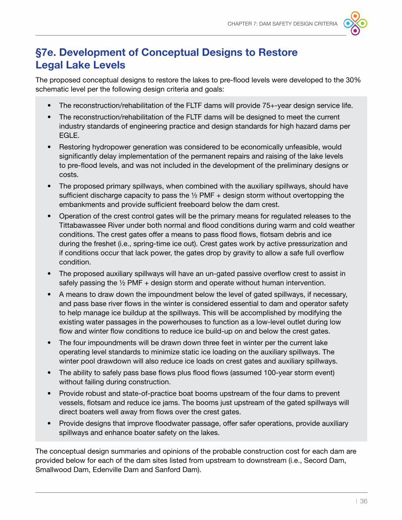
| 36
CHAPTER 7: DAM SAFETY DESIGN CRITERIA
§7e. Development of Conceptual Designs to Restore Legal Lake Levels The proposed conceptual designs to restore the lakes to pre-flood levels were developed to the 30% schematic level per the following design criteria and goals:
• The reconstruction/rehabilitation of the FLTF dams will provide 75+-year design service life .
• The reconstruction/rehabilitation of the FLTF dams will be designed to meet the current industry standards of engineering practice and design standards for high hazard dams per EGLE .
• Restoring hydropower generation was considered to be economically unfeasible, would significantly delay implementation of the permanent repairs and raising of the lake levels to pre-flood levels, and was not included in the development of the preliminary designs or costs .
• The proposed primary spillways, when combined with the auxiliary spillways, should have sufficient discharge capacity to pass the ½ PMF + design storm without overtopping the embankments and provide sufficient freeboard below the dam crest .
• Operation of the crest control gates will be the primary means for regulated releases to the Tittabawassee River under both normal and flood conditions during warm and cold weather conditions . The crest gates offer a means to pass flood flows, flotsam debris and ice during the freshet (i .e ., spring-time ice out) . Crest gates work by active pressurization and if conditions occur that lack power, the gates drop by gravity to allow a safe full overflow condition .
• The proposed auxiliary spillways will have an un-gated passive overflow crest to assist in safely passing the ½ PMF + design storm and operate without human intervention .
• A means to draw down the impoundment below the level of gated spillways, if necessary, and pass base river flows in the winter is considered essential to dam and operator safety to help manage ice buildup at the spillways . This will be accomplished by modifying the existing water passages in the powerhouses to function as a low-level outlet during low flow and winter flow conditions to reduce ice build-up on and below the crest gates .
• The four impoundments will be drawn down three feet in winter per the current lake operating level standards to minimize static ice loading on the auxiliary spillways . The winter pool drawdown will also reduce ice loads on crest gates and auxiliary spillways .
• The ability to safely pass base flows plus flood flows (assumed 100-year storm event) without failing during construction .
• Provide robust and state-of-practice boat booms upstream of the four dams to prevent vessels, flotsam and reduce ice jams . The booms just upstream of the gated spillways will direct boaters well away from flows over the crest gates .
• Provide designs that improve floodwater passage, offer safer operations, provide auxiliary spillways and enhance boater safety on the lakes .
The conceptual design summaries and opinions of the probable construction cost for each dam are provided below for each of the dam sites listed from upstream to downstream (i .e ., Secord Dam, Smallwood Dam, Edenville Dam and Sanford Dam) .

| 37
CHAPTER 7: DAM SAFETY DESIGN CRITERIA
§7f. Proposed Repairs to Restore Legal Lake Levels
Secord Dam
FIGURE 16: Aerial View of Secord Dam Spillway and Non-Operational Powerhouse
Several fundamental dam safety issues must be addressed before the water levels can be permanently raised:
• Insufficient spillway discharge capacity to meet regulatory criteria, including EGLE requirements .
• Inadequate downstream embankment slope and seepage stability .
• Inadequate height and length of the downstream spillway training walls to prevent overtopping and reduce erosion during high flow events .
• Embankments leak excessively and lack internal filters and drains to protect against seepage-induced internal erosion .
• Inadequate embankment slope armoring to prevent damage from erosion and back cutting during floods .
• Areas of structurally unsound concrete at spillway and powerhouse that need repair and stabilization .
• Restore dam to have a permanent low-level outlet to base pass flows during winter and provide a means to draw down the impoundment below the spillway sill elevation .
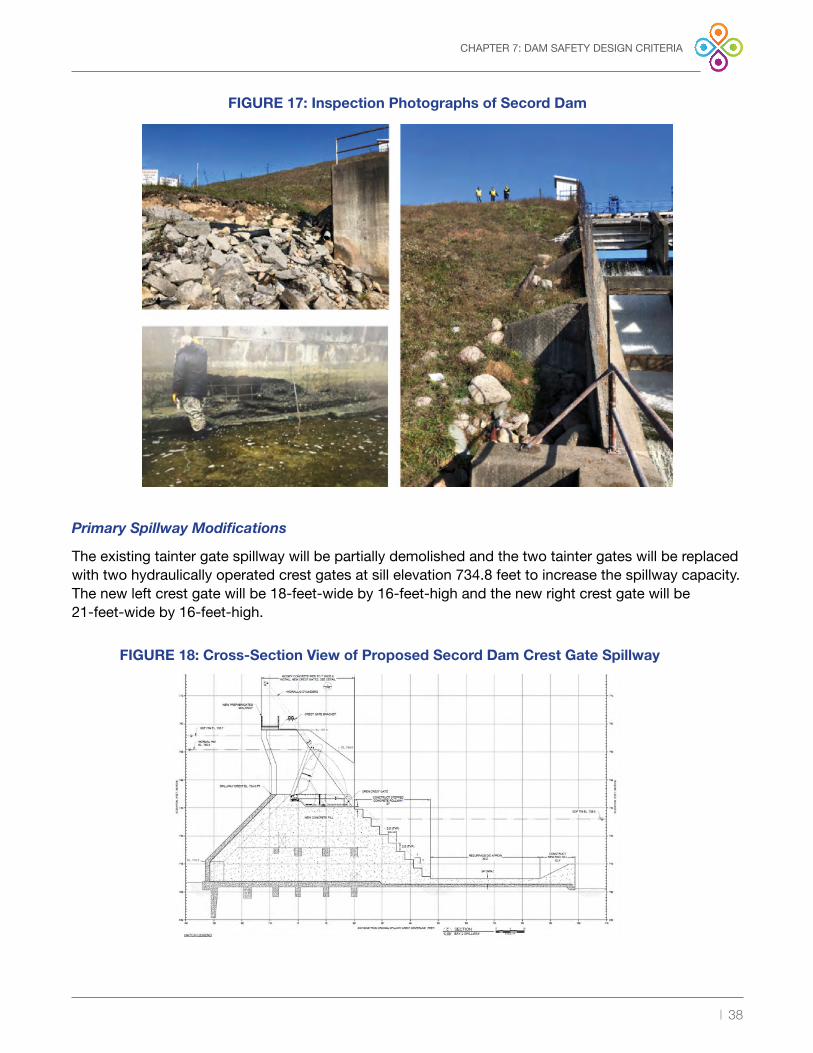
| 38
FIGURE 17: Inspection Photographs of Secord Dam
CHAPTER 7: DAM SAFETY DESIGN CRITERIA
Primary Spillway Modifications
The existing tainter gate spillway will be partially demolished and the two tainter gates will be replaced with two hydraulically operated crest gates at sill elevation 734 .8 feet to increase the spillway capacity . The new left crest gate will be 18-feet-wide by 16-feet-high and the new right crest gate will be 21-feet-wide by 16-feet-high .
FIGURE 18: Cross-Section View of Proposed Secord Dam Crest Gate Spillway

| 39
CHAPTER 7: DAM SAFETY DESIGN CRITERIA
New Auxiliary Spillway
A new, 130-foot-wide pin flashboard overflow spillway will be constructed across the top of the left embankment at elevation 748 .5 feet . Fusible steel pipe stanchions embedded in the concrete floor slab will support 42-inch-tall timber flashboards to maintain the normal summer pool at elevation 750 .8 feet . The flashboard and pipe stanchions will be designed to fail by bending over downstream when flood flows exceed what the gated spillway can pass and overflow 12-inches to 18-inches over the top of the flashboards . These types of spillways have been used successfully at other dams for over 100 years .
FIGURE 19: Plan View of Proposed Secord Dam Auxiliary Spillway

| 40
CHAPTER 7: DAM SAFETY DESIGN CRITERIA
FIGURE 20: Cross-Section View of Secord Dam Embankment Repairs
Embankment Repairs
The downstream slope will be flattened to improve stability and an upstream sheet pile seepage cutoff from the dam crest into the clay hardpan foundation will be installed across right and left embankment dams . The downstream overlay fill will include an internal filter and drainage layers will be installed to protect against seepage-induced internal erosion . The drainage systems will discharge to a weir to allow monitor seepage rates .
Powerhouse Modifications
To help manage ice on the crest gates, a reliable low-level outlet will be developed by retrofitting the existing powerhouse to pass base flows during the winter (100 to 200 cubic feet per second (cfs)) at a reduced winter pool three feet below the summer pool . This will be accomplished by removing the existing generator, turbine shaft, wicket gates, ancillary mechanical and electrical equipment, installing a bulkhead over the runner pit and fixing the runner into place . A new upstream slide gate will be used to control flows at the intake and provided with protective trash racks .

| 41
CHAPTER 7: DAM SAFETY DESIGN CRITERIA
Item Description Estimated Cost
0 .00 General Conditions $1,236,000 1 .00 Site Preparation and Cofferdams $1,470,000 2 .00 Site Demolition (Spillway and Powerhouse) $826,000 3 .00 Left Embankment Repair and Stabilization $2,723,0004 .00 Right Embankment Repair and Stabilization $1,648,0005 .00 New Crest Gate Spillway and Outlet Works $4,542,0006 .00 Powerhouse Rehabilitation $1,000,0007 .00 Auxiliary Spillway Structure $1,415,0008 .00 Discharge Channel $3,739,000
9 .00 Site Restoration $150,000
Subtotal $18,749,000
Contingency (25%, possible micropile underpinning) $4,687,000
Construction Subtotal $23,436,000
Site Investigations, Engineering, Permitting and Construction Management
$1,700,000
Total Estimated Cost $25,136,000
FIGURE 21: Secord Summary of Opinion of Probable Construction Costs Based on the 30% Design
Summary of Opinion of Probable Construction Costs for Secord Dam
An engineer’s opinion of probable construction cost (OPCC) was developed to pass the ½ PMF + design storm with contingency based on the proposed preliminary design . The OPCC includes 25% contingency for all construction items and includes an allowance for site investigations, engineering design, permitting and construction engineering/management costs . The total OPCC for Secord Dam to pass the ½ PMF + design storm is approximately $25 million and is summarized as follows:

| 42
CHAPTER 7: DAM SAFETY DESIGN CRITERIA
Smallwood Dam
FIGURE 22: Inspection Photographs of Smallwood Dam Spillway and Powerhouse
Several fundamental dam safety issues must be addressed before the lake levels may be permanently raised:
• Insufficient spillway discharge capacity to meet regulatory criteria, including ELGE requirements .
• Structurally unsound spillway rollway and deteriorated training wall concrete due to age and freeze-thaw damage .
• Lack of height and length of the downstream spillway training walls to reduce dam toe erosions during high tailwater .
• Embankment lacks filters and drains to protect against seepage-induced internal erosion .
• Inadequate embankment slope armoring to prevent damage from erosion and back cutting during floods .
• Restore dam to have a permanent low-level outlet .

| 43
CHAPTER 7: DAM SAFETY DESIGN CRITERIA
Primary Spillway Modifications
The existing tainter gate spillway will be partially demolished and the two tainter gates will be replaced with two hydraulically operated crest gates at sill elevation 688 .8 feet to increase the spillway capacity . The left crest gate and the right gate will be 22 .6-feet-wide by 16-feet-high .
FIGURE 23: Cross-Section View of Smallwood Dam Crest Gate Spillway

| 44
CHAPTER 7: DAM SAFETY DESIGN CRITERIA
New Auxiliary Spillway
A new, 150-foot-wide ungated pin flashboard overflow spillway will be constructed across the left embankment adjacent (east) to the steel sheet pile section of the left embankment at elevation 706 .0 feet . Fusible steel pipe stanchions embedded in the concrete floor slab will support 48-inch-tall timber flashboards . The flashboards and stanchion piles will be designed to fail by bending over downstream when flood flows beyond what the gated spillway can pass, or overflow 12 inches to 18 inches over the top of the flashboards .
FIGURE 24: Plan View of Smallwood Dam Auxiliary Spillway

| 45
CHAPTER 7: DAM SAFETY DESIGN CRITERIA
Embankment Repairs
The upstream and downstream embankment slopes will be flattened, and the crest widened to at least 15 feet of the downstream slope to provide adequate stability . There will be a filter sand and gravel drain blanket under the downstream slope to protect the dam from potential future internal erosion . The overflow section of the left embankment will be raised to elevation 715 .0 feet and extended approximately 700 feet to the east to “tie in” to high ground at the left abutment . A new steel sheet pile cutoff will be installed starting at the left end of the existing steel sheet pile cutoff from the dam crest into the hardpan foundation . Clay will extend to the left under the new auxiliary spillway and 100 feet left (east) of the new spillway .
Powerhouse Modifications
To help manage ice on the crest gates, a reliable low-level outlet will be developed by retrofitting the existing powerhouse to pass base flows during the winter (100 to 200 cfs) at a reduced winter pool three feet below the summer pool, like Secord Dam . This will be accomplished by removing the existing generator, turbine shaft, wicket gates, ancillary mechanical and electrical equipment, installing a bulkhead over the runner pit and fixing the runner into place . A new upstream slide gate will be used to control flows at the intake with protective trash racks .
FIGURE 25: Cross-Section View of Smallwood Dam Embankment Repairs

| 46
CHAPTER 7: DAM SAFETY DESIGN CRITERIA
Item Description Estimated Cost
0 .00 General Conditions $867,000 1 .00 Site Preparation and Cofferdams $1,470,000 2 .00 Site Demolition (Spillway and Powerhouse) $560,000 3 .00 Left Embankment Repair and Stabilization $1,222,0004 .00 Right Embankment Repair and Stabilization $201,0005 .00 New Crest Gate Spillway and Outlet Works $3,817,0006 .00 Powerhouse Rehabilitation $1,500,0007 .00 Auxiliary Spillway Structure $1,262,0008 .00 Discharge Channel $2,060,000
9 .00 Site Restoration $150,000
Subtotal $13,109,000
Contingency (25%) $3,280,000
Construction Subtotal $16,389,000
Site Investigations, Engineering, Permitting and Construction Management
$1,550,000
Total Estimated Cost $17,939,000
FIGURE 26: Smallwood Summary of Opinion of Probable Construction Costs Based on the 30% Design
Summary of Opinion of Probable Construction Costs for Smallwood Dam
An engineer’s OPCC was developed to pass the ½ PMF + design storm with contingency based on the proposed preliminary design . The OPCC includes 25% contingency for all construction items and includes an allowance for site investigations, engineering design, permitting and construction engineering/management costs . The total OPCC for the Smallwood Dam to pass the ½ PMF + design storm is approximately $18.0 million and is summarized as follows:

| 47
CHAPTER 7: DAM SAFETY DESIGN CRITERIA
Edenville Dam
FIGURE 27: Aerial View of Edenville Dam Failure
The May 2020 flood caused catastrophic damage Edenville Dam, including:
• Left embankment breached .
• Powerhouse and equipment damaged .
• Both the Tobacco and Tittabawassee tainter gated spillways were damaged .
• Inadequate height and length of the downstream spillway training walls to prevent overtopping and reduce erosion at the dam toe during high flow events .
• Upstream slope of embankments heel area scoured and undermined due to M-30 breach channel flows .
• M-30 bridge and causeway between the rivers was washed out .
• No low-level outlets .

| 48
CHAPTER 7: DAM SAFETY DESIGN CRITERIA
Interim Stabilization Measures
Interim repairs are being implemented under an FLTF Memorandum of Understanding with the State of Michigan and NRCS at both the Tobacco spillway and the Tittabawassee spillway . The objective is to restore flow into the original Tobacco River and Tittabawassee River channels and reduce ongoing erosion .
Construction of the interim measures is currently underway at the Tobacco spillway . Lowering the Tittabawassee spillway down to the base slab with the two powerhouse units left-in-place and constructing a dam across the left embankment breach area is planned for 2021 . The goal is to incorporate the major elements of these interim repairs into the permanent, long-term design .
Proposed Permanent Repairs to Restore Lake Level
The following major repairs/reconstruction activities are planned to permanently restore pre-flood lake levels:
• Construct new primary (gated) spillways at the Edenville Dam .
• Construction of a new labyrinth-type (ungated) auxiliary spillway at the north embankment breach .
• Reconstruct/repair damaged embankments .
• Stabilize and raise remaining embankments .
• Develop a new low-level outlet at the existing powerhouse location .

| 49
Primary Spillway Modifications
At Edenville, the gated spillway and the leftmost powerhouse bay will be demolished and the three tainter gate spillway bays will be replaced with three hydraulically operated crest gates at sill elevation 659 .8 feet to increase the spillway capacity . The leftmost powerhouse bay will also be converted into a fourth crest gate bay . Each gate will be 24-feet-wide by 16-feet-high . The hydraulic gate operators will be supported on new, reinforced concrete piers .
The Tobacco River tainter gate spillway will be partially demolished and the three tainter gates will be replaced with three automated hydraulically operated crest gates at elevation 659 .8 feet to increase spillway capacity . The left and right crest gates will be 18 .3-feet wide by 16-feet-high and the center crest gate will be 15 .5-feet-wide by 16-feet-high .
CHAPTER 7: DAM SAFETY DESIGN CRITERIA
FIGURE 28: Cross-Section View of Edenville Dam Three-Bay Crest Gate Spillway
FIGURE 29: Elevation View of Proposed Tobacco Spillway Three-Bay Crest Gates

| 50
CHAPTER 7: DAM SAFETY DESIGN CRITERIA
New Auxiliary Spillway
A new, reinforced concrete 250-foot-wide, 12-cycle labyrinth auxiliary spillway will be constructed at weir elevation 678 .0 feet within the former left embankment of the Tittabawassee River Spillway to provide additional spillway capacity during the ½ PMF + design storm . The proposed spillway structure will discharge through a 250-foot-wide concrete spillway chute into the United States Bureau of Reclamation (USBR) Type III stilling basin to dissipate energy before entering the discharge channel . To protect the reinforced concrete labyrinth spillway weir walls, the pool will be lowered three feet during the winter months .
FIGURE 30: Plan View of Edenville Dam Auxiliary Spillway Left of Tittabawassee Spillway
FIGURE 31: Cross-Section View of Tittabawassee Auxiliary Spillway

| 51
CHAPTER 7: DAM SAFETY DESIGN CRITERIA
Embankment Repairs
The former left embankment will be re-constructed with a minimum 15-foot crest width at elevation 685 .5 feet and minimum 2 .5H:1V upstream and downstream slopes to provide adequate stability .
A steel sheet pile cutoff will be provided along the upstream edge of the crest and be founded in the clay glacial till to provide a continuous seepage cutoff . Proper internal filter and drainage layers will be provided under the downstream embankment shell to provide additional seepage conveyance and protection against seepage-induced internal erosion .
All remaining embankments will be raised to elevation 685 .5 feet and the crest widened to at least 15 feet . The upstream and downstream slopes will be flattened to improve stability, an upstream steel sheet pile seepage cutoff wall extended into foundation hardpan till and provide an internal filter and drainage chimney and blanket drain layers will be provided to protect against seepage-induced internal erosion .
Powerhouse Modifications
The rightmost draft tube bay will be converted to a low-level outlet to pass base flows in the winter . This will be accomplished by removing the existing generator, turbine shaft, wicket gates, ancillary mechanical and electrical equipment, installing a bulkhead over the runner pit and fixing the runner into place . A new upstream slide gate will be used to control flows at the intake . Remaining sections of hollow bays and water passages will be filled with mass concrete .
FIGURE 32: Cross-Section View Edenville Dam Left Embankment Reconstruction

| 52
CHAPTER 7: DAM SAFETY DESIGN CRITERIA
Item Description Estimated Cost
0 .00 General Conditions $6,163,000 1 .00 Site Preparation, Cofferdams & 70 feet wide Edenville
Bypass Channel $33,250,000
2 .00 Site Demolition (Spillway and Powerhouse) $3,418,000 3 .00 Edenville Left Embankment Repair and Stabilization $3,489,0004 .00 Edenville Right Embankment Repair and Stabilization $14,535,0005 .00 Tobacco Embankment Repair and Stabilization $12,137,0006 .00 Edenville Crest Gate Spillway and Outlet Works $7,958,0007 .00 Tobacco Crest Gate Spillway and Outlet Works $4,695,0008 .00 Powerhouse Rehabilitation $2,250,000
9 .00 Labyrinth Auxiliary Spillway Structure $3,213,000
10 .00 Discharge Channel $170,000
11 .00 Site Restoration $1,500,000
Subtotal $92,778,000
Contingency (25%) $23,195,000
Construction Subtotal $15,973,000
Site Investigations, Engineering, Permitting and Construction Management
$5,000,000
Total Estimated Cost $120,973,000
FIGURE 33: Edenville Summary of Opinion of Probable Construction Costs Based on the 30% Design
Summary of Opinion of Probable Construction Costs for Edenville and Tobacco Dams
An engineer’s OPCC was developed to pass the ½ PMF + design storm with contingency based on the proposed preliminary design . The OPCC includes 25% contingency for all construction items and includes an allowance for site investigations, engineering design, permitting and construction engineering/management costs . The total OPCC for the Edenville Dam spillways to pass the ½ PMF + design storm was approximately $121 million and is summarized as follows .

| 53
CHAPTER 7: DAM SAFETY DESIGN CRITERIA
Sanford Dam
FIGURE 34: Aerial View of Sanford Dam Failure
The breaching of Edenville Dam during the May 2020 flood resulted in a cascading breach failure of downstream Sanford Dam . Major damage includes:
• Left and right embankments overtopped .
• Right embankment breached .
• Powerhouse and equipment damaged .
• Fuse plug auxiliary spillway failed .
• Tittabawassee River flows through the breach channel (former right embankment) .

| 54
FIGURE 35: Plan View of Proposed Sanford Repairs
CHAPTER 7: DAM SAFETY DESIGN CRITERIA
Interim Stabilization Measures
NRCS has identified that interim repairs, stabilization and sediment removal at Sanford Dam may also be eligible for NRCS Emergency Watershed Protection (EWP) Program funding . The design of interim repairs is planned for 2021 . FLTF’s goal is to incorporate the majority of the interim stabilization repairs into the permanent, long-term repairs .
Proposed Permanent Repairs to Restore Lake Levels
The following major repairs/reconstruction activities are planned to permanently restore pre-flood lake levels:
• Construct new primary (gated) spillways at the existing spillway location .
• Construction of a new labyrinth-type (ungated) auxiliary spillway at the right embankment breach .
• Reconstruct breached embankments .
• Stabilize and repair remaining embankments .
• Develop a new low-level outlet at the existing powerhouse location .

| 55
CHAPTER 7: DAM SAFETY DESIGN CRITERIA
Primary Spillway Modifications
The existing tainter gate spillway and powerhouse will be partially demolished and the six tainter gates will be replaced with eight hydraulically operated crest gates at sill elevation 614 .8 feet to increase the spillway capacity . The crest gates would range from 16 .5-feet-wide to 23-feet-wide by 16-feet-high .
The hydraulic gate operators will be supported on new, reinforced concrete piers . The upstream portions of the barrel arches below elevation 614 .8 feet will remain, and the crest gates and their anchorage embedment will be founded on new mass concrete . The gates will discharge onto a short section of concrete rollway and into a new reinforced concrete stilling basin . The two rightmost powerhouse bays will be converted into an additional crest gate bay and the leftmost draft tube bay converted to a low-level outlet . Remaining sections of hollow bays and water passages will be filled with mass concrete .
FIGURE 36: Plan View of Sanford Dam Primary Spillway Upgrades
FIGURE 37: Cross-Section View of Sanford Dam Crest Gates

| 56
CHAPTER 7: DAM SAFETY DESIGN CRITERIA
New Auxiliary Spillway
A new reinforced concrete 250-foot-wide, 12-cycle labyrinth auxiliary spillway will be constructed at weir elevation 632 .5 feet within the former right embankment of the Sanford Dam to provide additional spillway capacity during the ½ PMF + design storm . The proposed spillway structure will discharge through a 250-foot-wide concrete spillway chute into the USBR Type III stilling basin to dissipate energy before entering the discharge channel . To protect the reinforced concrete labyrinth spillway weir walls, the pool will be lowered three feet during the winter months .
FIGURE 38: Plan View of Sanford Dam Auxiliary Spillway
FIGURE 39: Cross-Section View of Sanford Dam Auxiliary Spillway

| 57
CHAPTER 7: DAM SAFETY DESIGN CRITERIA
Embankment Repairs
The former right embankment will be re-constructed with a minimum 15-foot crest width at elevation 638 .0 feet and minimum 2 .5H:1V upstream and downstream slopes to provide adequate stability . A steel sheet pile cutoff will be provided along the upstream edge of the crest and be founded in the clay glacial till to provide a continuous seepage cutoff . Proper internal filter and drainage layers will be provided under the downstream embankment shell to provide additional seepage conveyance and protection against seepage-induced internal erosion .
The left embankment slopes will be raised to elevation 638 .0 feet and the crest widened to at least 15 feet . The upstream and downstream slopes will be flattened to improve stability, an upstream sheet pile seepage cutoff and provide internal filter and drainage chimney and blanket layers will be provided to protect against seepage-induced internal erosion .
Powerhouse Modifications
The leftmost draft tube bay converted to a low-level outlet to pass base flows in the winter . This will be accomplished by removing the existing generator, turbine shaft, wicket gates, ancillary mechanical and electrical equipment, installing a bulkhead over the runner pit and fixing the runner into place . A new upstream slide gate will be used to control flows at the intake . Remaining sections of hollow bays and water passages will be filled with mass concrete .
FIGURE 40: Cross-Section View Sanford Dam Right Embankment Reconstruction

| 58
CHAPTER 7: DAM SAFETY DESIGN CRITERIA
Item Description Estimated Cost
0 .00 General Conditions $2,532,000 1 .00 Site Preparation and Cofferdams $7,830,000 2 .00 Site Demolition (Spillway and Powerhouse) $3,873,000 3 .00 Left Embankment Repair and Stabilization $378,0004 .00 Right Embankment Repair and Stabilization $2,887,0005 .00 New Crest Gate Spillway and Outlet Works $13,305,0006 .00 Powerhouse Rehabilitation $2,250,0007 .00 Auxiliary Spillway Structure $3,415,0008 .00 Discharge Channel $1,940,000
9 .00 Site Restoration $150,000
Subtotal $38,560,000
Contingency (25%) $9,640,000
Construction Subtotal $48,200,000
Site Investigations, Engineering, Permitting and Construction Management
$3,000,000
Total Estimated Cost $51,200,000
FIGURE 41: Sanford Summary of Opinion of Probable Construction Costs Based on the 30% Design
Summary of Opinion of Probable Construction Costs for Sanford Dam
An engineer’s OPCC was developed to pass the ½ PMF + design storm with contingency based on the proposed preliminary design . The OPCC includes 25% contingency for all construction items and includes an allowance for site investigations, engineering design, permitting and construction engineering/management costs . The total OPCC for the Sanford Dam to pass the ½ PMF + design storm is approximately $51 million and is summarized as follows:
FIGURE 42: Summary of Probable Costs for Each Dam Site
DamTotal Estimated Cost
(Present Worth)
Secord $25,136,000Smallwood $17,939,000
Edenville (includes Tobacco) $120,973,000 Sanford $51,200,000
Estimated Total: $215,248,000

| 59
CHAPTER 8: ENVIRONMENTAL RESTORATION PLANNING
§8 — Chapter 8: Environmental Restoration Planning
§8a. IntroductionGiven the May 2020 disaster, the focus is now shifted to restoration . The key factors for restoration include enhancing public safety, preserving property values, preserving the local economy and restoring the lake ecosystems, including the environment, natural resources and recreation of the lake system provided . There are four specific actions that Four Lakes Task Force (FLTF) is moving forward with to develop environmental restoration planning . These involve:
• Lake restoration planning for Sanford and Wixom lakes
• Interim vegetation and debris management actions
• Recreation planning for four lakes region
• Planning for regulatory construction permitting
The Lake Restoration Plan for Wixom and Sanford lakes will be finalized in 2022 . The scope, funding and implementation of the plan will be coordinated with Michigan Department of Environment, Great Lakes and Energy (EGLE), Michigan Department of Natural Resources (MDNR), U .S . Fish and Wildlife Service (USFWS) and other stakeholders before finalization . FLTF plans to implement a pilot restoration project in summer of 2021 and to gather data on the lake bottom in 2021 . The data collected and the pilot project will be used as a basis for the final lake restoration plan, to be completed in 2022 . The lake restoration plan is intended to offset environmental impacts through restoration planning . These efforts will enhance the lakebed, shoreline and adjacent wetlands, to aid in the recovery and restoration of the ecosystem which existed before the dam failure . Many aspects of the plan will be best achieved by implementing before lake levels are restored .
FLTF will implement vegetation and debris management actions immediately . This will be coordinated with EGLE, Natural Resources Conservation Service (NRCS), MDNR and USFWS . Input from these agencies will be sought and construction permits will be requested, as applicable, per the Natural Resources and Environmental Protection Act (NREPA) .
FLTF will coordinate with local municipalities and MDNR to develop a recreation plan that anticipates the lakes being restored, along with interim measures addressing recreation given current conditions . The recreation plan will be finalized in 2022 .
FLTF will apply to EGLE for construction permits, on a dam-by-dam basis, for impacts to regulated resources within the limits of the dam construction area . It is expected that permits will be needed for construction activities within regulated wetlands, streams, floodplains, lakes and as well as on dams .
Stakeholder engagement is expected as the environmental restoration planning efforts continue to evolve. FLTF will require early acceptance of the plan’s template from regulatory agencies, followed by a funding plan for the resources to study and implement. This section provides a general outline of the objectives and approach for the development of the environmental restoration plan.
| 60
CHAPTER 8: ENVIRONMENTAL RESTORATION PLANNING
§8b. Secord and Smallwood DamsThese dams constitute serviceable structures; for purposes of environmental restoration planning and permitting . The lakes are currently in temporary drawdown status as ordered by dam safety regulators to allow for engineering inspections and implementation of dam safety measures . The lakes are not completely drained and will be restored in 2024 . EGLE and FLTF have determined a lake restoration planning report is not required specific to these lakes . Once the lake levels are restored, the previously thriving lake ecosystem is anticipated to return, and these lakes will once again be able to provide benefits to the community .
As outlined in Chapter 7, FLTF is planning for a $43 million investment to improve the safety of these dams, reduce flood damage risk, introduce run-of-river operations, preserve property values and restore the lake ecosystem and recreational opportunities .
FLTF will submit for environmental permits to complete construction activities in regulated wetlands, streams, lakes and floodplains per NREPA 451 of 1994 (PA 451) . FLTF will offset impacts to regulated natural resources located within the construction footprint .
§8c. Edenville and Sanford DamsThese dams failed and the communities of Wixom and Sanford lakes will not return to normal conditions until the drained lakes are refilled . The disrupted natural resources and environment are on the path of restoration .
FLTF, as outlined in Chapter 7, is planning for a $172 million investment to improve the safety of these dams . The dam failure devastated a nearly 100-year established ecosystem . The highly populated lake community developed based on the existence of this lake ecosystem . Given the magnitude of environmental damage and the scope of reconstruction of the dams, FLTF environmental restoration planning efforts for Edenville and Sanford dams include the development of lake restoration, vegetation, debris management, recreation and permitting of construction activities per PA 451 plans .
§8d. Wixom and Sanford Lake Restoration Planning SummaryDevelopment of a comprehensive lake restoration plan is critical for the community to understand how recreational and natural resource value is being restored . The scope and magnitude of the lake restoration plan will be developed by FLTF with input from EGLE, USFWS, MDNR and other stakeholders . FLTF will work to finalize the plan in 2022 . The base components of the lake restoration plan will include planning measures for natural resource management, erosion management, debris, and sediment management, habitat creation, restoration of hydrology to wetlands, threatened and endangered species management, invasive species management, vegetation management, floodplain management, lake level management and recreation .

| 61
CHAPTER 8: ENVIRONMENTAL RESTORATION PLANNING
Safely Restoring the Dams
Chapter 7 provides detail on the dam restoration plan and summarizes key factors for dam safety permitting . The design storm criteria for all dams will be based on an Inflow Design Flood (IDF) per the Federal Emergency Management Agency (FEMA) Dam Safety Guidelines as recommended by the Michigan Dam Safety Task Force . The selected design storm significantly exceeds the current EGLE dam safety requirements for each of the dams . This restoration plan provides an opportunity for EGLE and FLTF to work together on dam safety advocacy .
Dam Operations
Upon restoration of the dams, operation of lake levels will shift to a run-of-river mode . The dams were originally constructed to create impoundments to support hydroelectric generation . Historically these dams were operated on a “pond and release” basis within 0 .7-feet of the normal level to maximize on-peak generation, with flow requirements outlined in the Federal Energy Regulatory Commission (FERC) licenses . Post-construction there will be no hydroelectric generation and the impoundments will be maintained at their legal lake levels via run-of-river operations .
Run-of-river operations will benefit aquatic life in the littoral zone and improve the recreation experience . From a dam safety perspective, spillway gate operations will be vastly improved post-construction . The existing radial gates will be replaced by hydraulically operated crest gates resulting in improved flow capacity and operational control allowing for the lake level to be maintained with less fluctuation and decreasing the risk of flood damage to properties along the lakes, thus adding no harmful interference . The 100-year floodplain will not be increased and with the increased gate capacity, there will be an opportunity to lower the 100-year floodplain, however, revising the FEMA floodplain is not part the of FLTF restoration plan .
Each dam will also be equipped with an auxiliary spillway to pass additional water during significantly high flow events . The auxiliary spillways will be “passive” overflow structures that are ungated, do not require power, nor require operator intervention . The passive design will ensure spillway capacity during high flow events .
Natural Resource Management Before the dam failure, Wixom and Sanford lakes provided access to recreation and natural resources for thousands of property owners . The lakes are highly developed, primarily residential homes, along with public access provided by the DNR, counties and townships . The primary function of the lakes, from FLTF’s point of view, is the recreation and propagation of natural resources . These are key for protecting property values, local economy and local governmental services . Restoring the dams will restore the water to lakes; however, additional measures are needed to restore natural resources .
The historic fish community within Wixom and Sanford lakes, before the dam failures of 2020, contained a diversity of native cool-to warm-water fishes, as described in the Tittabawassee River Assessment .25 Sunfishes, including black and white crappie, bluegill, pumpkinseed, green sunfish and rock bass dominated the fish community . Top predators in these systems were black bass (largemouth and smallmouth), northern pike, muskellunge (northern strain), walleye and channel catfish . Sanford
25 Schrouder et al . 2009 .

| 62
CHAPTER 8: ENVIRONMENTAL RESTORATION PLANNING
Lake also supported a resident white bass population . Both impoundments also had sizable populations of a variety of redhorse sucker species, white sucker, carp, and black, brown and yellow bullhead . In Sanford Lake, age distributions for the predator species were balanced with good survival to older ages, resulting in desirable numbers of large individuals to attract fishing activity . Periodic stocking of walleye and muskellunge by MDNR supported the fisheries for those predatory species . These lakes were also home to an array of freshwater mussel species, reptiles, amphibians, birds and mammals .
The lakes also provided hydrology to support wetland complexes adjacent to the lakes and impacted groundwater . The dams provide barriers for invasive species, the shorelines were, for the most part, stable and the lake bottom, when originally flooded, had many standing trees in deeper portions that provided habitats . In general, these lakes were a great resource and utilized extensively for recreation and natural resources .
Shoreline Stabilization and Erosion Management
Sediment is a primary pollutant to watercourses everywhere and uncontrolled lakeshore erosion is a major cause of turbid water and excessive sedimentation in Wixom and Sanford lakes . Since the failure of the dams, Wixom Lake and Sanford Lake now have miles of eroded lakeshore banks and eroded lakebeds . In general, the failure of the dams created instability resulting in a condition where excessive erosion and sedimentation will continue to occur . To move towards stabilization, the FLTF restoration plan includes shoreline stabilization and lakebed stabilization . Restoration of the dams will restore the lake ecosystem, which will minimize much of the erosion and sedimentation impacts occurring with the current dam conditions . In the interim, until the dams are restored, FLTF will implement shoreline and dam stabilization to manage erosion .
FLTF is investing over $40 million on shoreline stabilization and erosion control, including interim stabilization measures on the Edenville and Sanford dams and stabilization of approximately three miles of critically eroded shorelines . Some of this work has been completed to date, with the majority to be complete in 2021 and 2022 and will be beneficial in reducing erosion and sedimentation into the system . The current shoreline stabilization efforts will also provide diverse habitat upon restoration of the lakes .
FIGURE 43: Donald Drive Site on Sanford Lake — Before vs. After Stabilization Project

| 63
CHAPTER 8: ENVIRONMENTAL RESTORATION PLANNING
Also, in 2021, FLTF will assess shoreline erosion and will determine how non-critical erosion will be addressed . FTLF is facilitating a do-it-yourself program to provide education and materials to homeowners to assist with the stabilization of non-critical shoreline areas . There are approximately 87,500 cubic yards of sediment to be addressed .
The Lake Restoration Plan will look to identify areas where bioengineering principles can be used to create a natural and resilient shoreline . Bioengineered shorelines will provide many benefits to the landowners and lake ecosystems by absorbing wave and wake energy, reducing erosion, providing habitat for fish and wildlife and filtering out nutrients from surface runoff . FLTF plans to assess and map the shorelines of Wixom and Sanford lakes to illustrate the areas of hardened and natural shorelines, identifying areas where natural shorelines can be protected or improved, or where there is the potential for improving the land/water interface .
Nutrient Loading
Nutrient loading can negatively impact water quality and cause excessive algal growth . Sources of nutrient loading to inland lakes include sediment/soils, wildlife and pet waste, fertilizers, detergents, stormwater runoff and many others .
FLTF plans to work with stakeholders, including The Nature Conservancy, to prioritize and implement agricultural best management practices that improve soil health and reduce sediment and nutrient loading .26 Beneficial practices include vegetated buffer strips, grassed waterways, prairie strips, constructed wetlands, saturated buffers and two stage ditches, all of which will act to reduce peak flows and filter nutrients and sediments prior to entering the lake systems . Additionally, FLTF will support the necessary policies and programs, including outreach, that incentivize these actions .
FLTF plans to work with stakeholders, including The Nature Conservancy to implement best management practices and regional planning efforts to address healthy soils and nutrient loading within the watershed . Potential best management practices to implement include increase public education and outreach events, planting native plants and creating vegetated buffers .
Interim Management of Lake Bottom
FLTF has determined that management of the bottomlands in the interim is necessary to prevent a terrestrial ecosystem from forming and to ensure the lake will be able to be utilized for recreation once the water levels are restored . Grasses will be encouraged as they do not impact the plans to refill the lakes and will prevent erosion . A tree management program will be put in place to ensure tree height in the lake allows for boating and swimming but also provides the necessary habitat for fish . Additional detail can be found in the Vegetation Management Plan section of this chapter .
26 www .nature .org/EdgeofField
www .nature .org/en-us/about-us/where-we-work/united-states/michigan/stories-in-michigan/soil-health-in-saginaw-bay/
www .nature .org/content/dam/tnc/nature/en/documents/rethink-soil-executive-summary .pdf

| 64
CHAPTER 8: ENVIRONMENTAL RESTORATION PLANNING
FIGURE 44: Pre- and Post-Disaster Wetland and Surface Water Analysis Results for Wixom and Sanford Lakes
Wetlands
Pre-Disaster (Acres) Post-Disaster (Acres) Post-Disaster Created (Acres) Δ* (Acres)
9,726 6,564 to 7,679 389 -1,658 to -2,773
Surface Water
Pre-Disaster (Acres) Post-Disaster (Acres) Δ* (Acres)3,756 1,148 -2,608
* ‘Δ’ represents net change from pre-disaster to post-disaster .
Rehydration of Wetlands
A detailed wetland report27 identified that the failure of the Edenville and Sanford dams resulted in the loss of existing wetlands and the development of new wetlands . The development of wetlands will be in the drained lakebeds, in the interim period until lakes are restored, and will mostly consist of low-quality wetland . The loss of wetlands will be in the forests and other natural communities adjacent to lakes . Much of the wetland lost due to the draining of the lake was of the highest quality and value to the lake ecosystem . Upon restoration of the lakes, the high-quality wetlands adjacent to the lake will be rehydrated .
EGLE has indicated that wetlands developing in the drained lakebeds, although not expected to develop into high-quality systems, may require to be mitigated as regulations for drained lakebeds are not clear, before lakes being restored . They have also indicated the wetlands which will be rehydrated can offset the impacts once the hydrology is restored .
Based on a detailed desktop analysis including a review of a variety of data resources such as Light Detection and Ranging (LiDAR) derivatives, imagery, watershed connectivity modeling and previously wetland mapping, an estimation of pre-and post-disaster wetlands limits and pre- and post-disaster water surface limits was completed . In total, 43,458 acres were reviewed which encompass the Wixom and Sanford lake flowage areas . These areas experienced a significant decline in wetland and surface water acreages following the disaster as summarized in Figure 42 .
Although approximately 389 acres of wetland are expected to develop within the Sanford and Wixom lake bottoms, over 2,000 acres of wetland are estimated to have been impacted by the loss of approximately 2,608 acres of surface water associated with the lakes . It is expected that these wetlands will have their hydrology, ecological function and integrity restored once the lakes are re-established . In addition, shallow water wetlands are planned to be restored and created as a part of the lake restoration plan . These efforts, including the return of the lake water levels, will be considered a part of the wetland mitigation process .
FLTF plans to enhance its understanding of wetland hydration by conducting additional analyses of the dehydrated wetlands in 2021 and 2022 .
27 See Chapter 8 Appendix .

| 65
CHAPTER 8: ENVIRONMENTAL RESTORATION PLANNING
Fish Community
The restoration of the dam will result in the restoration of aquatic conditions that approximate those from pre-failure, therefore a restoration target of fish communities like those present before May 2020 appears logical and reasonable . While it is anticipated that all the species naturally present before dam failure will repopulate the lakes at some point in time, strategies for a more controlled repopulation may be considered . Ultimately, the Fisheries Division of MDNR is the agency charged with overseeing the management of the fishery resources in the Tittabawassee River, Wixom and Sanford lakes . Any management activities such as fish stocking or habitat improvement should be led and endorsed by MDNR Fisheries Division .
Walleyes are one of the most popular sport fish species in the state and are widely stocked in Michigan inland lakes and impoundments . Walleye stocking has been an important component of fishery management activities by the MDNR in all four of the Tittabawassee River lakes for many years . To successfully spawn and survive to maturity, walleye require specific conditions that are not found in most Michigan lakes and rivers, thus the need for the ongoing statewide stocking program .
Fish passage at Edenville and Sanford dams is not considered part of dam restoration planning . This conclusion was developed with consideration for the height of the dam and the desire to not change the ecosystem of the lakes through the potential introduction of new invasive species .
FLTF will develop a detailed restoration plan documenting and mapping existing habitats, which is crucial to understand how much potential exists for improvement . Habitat management is advisable if existing habitats are limiting the productivity of the fishery . The need for “improvement” work must be determined based upon the amount, type and distribution of existing habitats . Understanding limiting factors associated with species of interest, such as walleye, will allow for the lakes to support a thriving fish population . The plan will also identify areas for improving success for anglers and providing maps of enhanced fishing areas, for both boat and shore-bound anglers .
Reptiles, Amphibians, Mussels and Waterfowl Communities
Many other animals rely on the lakes for all or a portion of their life cycle . Amphibians and reptiles rely on the aquatic environment for habitat, reproduction and food . The lakes provide an important food source for a variety of mammals (mink, otters, foxes, raccoons, skunks, shrews) and birds (herons, bitterns, eagles, hawks) . FLTF is aware of a general concern about the decline of native freshwater mussel populations . The populations in Wixom and Sanford lakes were significantly impacted by the dam failures and FLTF has contracted with Central Michigan University to complete a mollusk survey to better understand how to restore the community . Often for these animals, habitat is a limiting factor for the success of these communities . FLTF lake restoration planning efforts will have a focus on providing quality habitat in key locations around the lakes for the future success of the species after the lakes have been restored and the animals naturally return .

| 66
CHAPTER 8: ENVIRONMENTAL RESTORATION PLANNING
Habitat Creation The lakes provided habitat for more than just the resident fish community . They also supported reptiles, amphibians, waterfowl and mussels . The lake transition plan aims to restore and improve the habitats for these animals . For the reptile and amphibian communities, the re-inundation of riparian wetlands with the restoration of the lake levels will restore critical breeding habitats . The plan will also look at identifying and mapping existing habitats and determining ways to expand or improve these areas . The lakes provided a food source and the surrounding area home to waterfowl and birds of prey . Potential for new nesting platforms as well as improvements to the natural shoreline are proposed . FLTF will implement a pilot habitat restoration/creation project in 2021 and will work with stakeholders to implement additional enhancements in 2022 and 2023 .
Threatened and Endangered Species
Impacts on threatened and endangered species are currently being studied . FLTF has initiated consultation with the Michigan Natural Features Inventory (MNFI) and the USFWS . Consultation has provided a list of species to be considered potentially present within and nearby Wixom and Sanford lakes . The MNFI noted there were no concerns relating to impacts on state-threatened and endangered species in the project area . USFWS identified four potential threatened and/or endangered species present within the area . These species include the northern long-eared bat (threatened), eastern massasauga rattlesnake (threatened), snuffbox mussel (endangered) and the red knot (threatened) . A consultation request has been submitted to the USFWS to discuss potential ways to avoid and minimize impacts to these species .
Invasive Species Invasive plant species have been observed along the exposed lakebeds . Additional information on the management of invasive plants can be found in the following Vegetation Management Plan section . Invasive submergent vegetation, including Eurasian watermilfoil, curly-leaf pondweed, starry stonewort and others, are typically addressed through survey and mapping of macrophyte communities and annual herbicide treatments . Ultimately, management of the submerged invasive vegetation will be associated with the lake associations after the lakes are restored .

| 67
Sea lamprey are a continual concern for managers of the Great Lakes fisheries; however, restoration of the dams and lakes will result in a permanent and effective barrier to block upstream passage of this destructive species . As part of interim stabilization efforts, FLTF will coordinate with Great Lakes Fish Commission (GLFC), USFWS and DNR to implement sea lamprey control measures and to coordinate access for these agencies to monitor and manage invasive species .
Cultural Resources
Impacts on cultural resources are currently being studied related to obtaining federal funding for the project . Historic properties are any prehistoric or historic districts, sites, buildings, structures, or objects that are eligible for or already listed in the National Register of Historic Places . They include any artifacts, records and remains (surface and subsurface) that are related to and located within historic properties and the properties of traditional religious and cultural importance to Tribes . In April 2021, Merjent, Inc . began archaeological field investigations . Surveys are being conducted following guidance from the Michigan SHPO Archaeological Field and Reporting Standards and Secretary of the Interior’s Standards and Guidelines for Archaeology and Historic Preservation .28 Archaeological field investigations are underway at the Edenville and Sanford dams and a findings report will be developed for each dam .
§8e. Vegetation Management Plan
Grasses and Annual Weeds
Grasses and annual weeds have root systems that will stabilize the exposed lake bottomlands against erosion . Grasses will not adversely impact plans to refill the lakes . FLTF has advised lakefront property owners to plant grasses to stabilize sloping lake shoreline areas in front of their properties and the major erosion protection projects performed on the lakes also use grasses to protect newly rebuilt shoreline slopes .
Tree Management
EGLE suggested FLTF allow the trees to grow on the exposed lake bottoms, as trees will help hold the soils in place, therefore, helping to prevent erosion and provide habitat for terrestrial animals . The lakes have average depths ranging from eight to 15 feet . Given that Edenville and Sanford dams are scheduled to be rebuilt from 2024 to 2026, respectively, the tree saplings would have time to grow to a significant size before the lakes are refilled . FLTF has chosen to manage the exposed lake bottomlands to avoid complications once lake levels are restored .
Cottonwoods and willows are commonly found sprouting on recently cleared ground, particularly if the ground has plentiful moisture . Both tree species are beneficial to terrestrial animals, providing both
CHAPTER 8: ENVIRONMENTAL RESTORATION PLANNING
28 https://www .nps .gov/history/local-law/arch_stnds_0 .htm
| 68
CHAPTER 8: ENVIRONMENTAL RESTORATION PLANNING
cover and a food source . However, FLTF wants to avoid creating habitat for terrestrial animals and these species have low value as lumber or firewood . Submerged trees can create beneficial aquatic habitat . Allowing trees to grow to a limited height in deep water areas will provide good fishing while keeping the trees small enough that they will not be a hazard to boaters or swimmers .
The current plan for managing cottonwoods and willows on the lake bottoms is to employ a three-zone control strategy . The main part of the lake bottomland area can be treated by aerial spraying with an herbicide suitable for controlling woody shrubs without harming grasses . To minimize damage to trees and other desirable landscape plants, aerial spraying will be done at least 100 feet from shore . In the zone from 100 feet to 40 feet from the shoreline, trees can be mowed mechanically or sprayed with ground-based equipment . Shoreline property owners will be encouraged to manage trees on the lake bottom within 40 feet of their shoreline . This will reduce conflict between professional applicators and most homeowner property that remains on the lake bottoms, such as docks and boat lifts . In some parts of the lakes, tree growth within 40 feet of the shoreline is minimal . FLTF will choose control methods that are best suited to meet the needs of the lake community .
Invasive Plant Control
Purple loosestrife has been seen growing on the lake bottoms, intermingled with the tree seedlings . It is expected that the tree seedling control work will also control purple loosestrife . Phragmites are not currently abundant on the lake bottoms, but small stands may be found on the bottomlands and land areas around the shores . This invasive plant is not well-controlled by the herbicides that will be chosen for tree control . Repeated mechanical mowing three to five times during the growing season is an option but does not kill the rhizomes that can sprout new reeds . Professional applicators will choose an appropriate herbicide and apply it appropriately . Such application may require a permit from EGLE . For large stands of phragmites, controlled burning may be an effective control measure . Phragmites control methods will be selected on a case-by-case basis . The Gladwin County and Midland County conservation offices will be consulted for assistance with invasive plant species control .
§8f. Recreational PlanningFERC licenses for Secord, Smallwood, Edenville and Sanford dams include conditions requiring the development and implementation of a recreation plan for each project . Each license detailed the recreation amenities that were to be provided at each site which generally includes fishing access, canoe portage, restrooms, signage, parking and certain components of the plan to be compliant or barrier-free per the Americans with Disabilities Act (ADA) . Before the dam failures, very few of these required recreation components were in place . With Boyce Hydro’s February 2021 Application for Unconditional License Surrender, Sanford, Smallwood and Secord dams are expected to transition to EGLE jurisdiction, which does not include any recreation requirements .
Nonetheless, FLTF is willing to help coordinate and plan for future recreation opportunities within the system . FLTF will assess the existing recreational facilities for damage and seek input from the counties and local municipalities on current needs and future interests . There are five recreational plans recorded at the state of Michigan for Gladwin County and eight recreational plans are on record at the state for Midland County . Based on the review, FLTF will assist with the development of a regional recreational master plan, in accord with the counties’ objectives .

| 69
§8g. Environmental PermittingFor the dams to be reconstructed, EGLE is the governing body regulating specific activities which take place within regulated wetlands, floodplains, dams and inland lakes and streams . Work that results in temporary or permanent impacts to these environmental features requires permits to be issued from EGLE before any work commences . Extensive conversations and discussions between EGLE and FLTF have been conducted over the past year to determine the potential permitting needs for the environmental impacts, as they are related to construction of the dams . FLTF intends to submit a comprehensive permit application to address each of these requirements for the construction of all four dams .
In addition to environmental permitting through EGLE, all construction activities which result in over an acre of disturbance or are within 500 feet of an inland lake or stream will require soil erosion and sedimentation control (SESC) permits from the respective county . Sites that disturb greater than five acres require coverage under EGLE’s National Pollutant Discharge Elimination System via a Notice of Coverage . SESC permits require that the applicant design the project to protect natural watercourses, inland lakes, wetlands and offsite properties from sediment deposition due to construction activities .
EGLE and county regulations have a corresponding part within PA 451, specifically Part 315 (dam safety), Part 301 (wetlands), Part 303 (lakes and streams), Part 31 (floodplains) and Part 91 (SESC) . Summaries of each part as they relate to the dam construction project can be found in Appendix 8 .
Permitting Summary for Secord Dam
Secord Dam did not fail, rather was ordered by FERC to be lowered . EGLE views the proposed construction activities at Secord Dam as maintenance and improvement of an existing structure . This simplifies the environmental permitting requirements for construction . The proposed restoration schedule of the dam has construction beginning in early 2023 . As part of this schedule, environmental permit applications would be submitted in 2022 . To aid and expedite EGLE’s review of the application, EGLE permitting staff is involved in design progress meetings .
Concerning Part 301 (Inland Lakes and Streams), impacts are anticipated during construction . These impacts would primarily be the placement of fill below the ordinary high water mark (OHWM) . Likely impacts under Part 301 would include placement of riprap on the upstream face of the earthen embankment, riprap placement downstream of the dam and at the outlet of the proposed auxiliary spillway .
Regarding Part 303 (wetlands), temporary and permanent impacts are expected . To quantify the amount and type of existing wetlands on the Secord Dam property, a formal wetland delineation was completed . Wetland impacts are estimated to be 0 .71-acre, which exceeds the limit set by EGLE of 0 .3-acre disturbance, mitigation will likely be required . These impacts are associated with re-sloping of the embankment, construction of an access road and construction of the auxiliary spillway . The available space on the Secord Dam property is limited . FLTF anticipates mitigating for the construction impacts at the Smallwood Dam site, where FLTF has access to more property .
CHAPTER 8: ENVIRONMENTAL RESTORATION PLANNING
An annual grant cycle is available for communities to submit for available funding if they have an approved and active recreation plan on file with the state . Planning assistance will be provided to help communities organize grant applications or understand the process for getting or updating a recreation plan through the state .

| 70
CHAPTER 8: ENVIRONMENTAL RESTORATION PLANNING
Construction activities will take place within the Part 31 regulated 100-year floodplain . Impacts are expected in the area immediately downstream of the dam . These impact volumes have yet to be calculated; however, if compensating excavation this will be in the construction plans .
FERC is in the process of terminating the active FERC license at the Secord Dam hydropower facility . Upon termination of the license, regulatory jurisdiction will shift from the federal government to EGLE . The Dam Safety Unit within EGLE would need to provide a permit for any construction activities on the dam features including work to the embankments, spillway, tailrace area and powerhouse . As the design progresses, EGLE will continue to be actively involved to ensure all activities are permittable .
Lastly, the construction activities at Secord Dam will require an SESC permit . The Gladwin County Soil Conservation District will be the governing office to issue the permit . Typically, SESC permits are the responsibility of the contractor and this permit will be acquired once the project is bid, and the contract has been awarded .
Permitting Summary for Smallwood Dam
Smallwood Dam did not fail because of the May 19, 2020, storm event, however, sustained significant damage to the downstream embankment from severe erosion which occurred . Since Smallwood Dam did not fail, EGLE views the proposed construction activities like maintenance and improvement of an existing structure . This simplifies the environmental permitting requirements . The Smallwood Dam restoration proposed construction activities are planned to begin in early 2023 . Environmental permit applications would be submitted in 2022 . To aid and expedite EGLE’s review of the application, EGLE permitting staff is involved in design progress meetings .
Concerning Part 301, impacts are anticipated during construction; these being the placement of riprap on the upstream face of the earthen embankment, riprap placement downstream of the dam and at the outlet of the improved auxiliary spillway for erosion protection, all below the OHWM .
Regarding Part 303, permanent impacts are expected within regulated wetlands . A formal wetland delineation on the Smallwood Dam property was completed . Of the total wetlands which exist on the site, 1 .0-acres are expected to be impacted, which exceeds 0 .3-acres of disturbance, meaning mitigation will likely be required . Wetland impacts are expected to be associated with the construction of the new berm on the north side of the property, re-sloping of the embankment, construction of the potential access road and improvement of the existing auxiliary spillway . The Smallwood Dam property may allow for on-site mitigation to take place . This mitigation may include the creation of new wetlands or the improvement of existing wetlands that are on the site . FLTF and its environmental consultants are further evaluating options related to mitigation and the amount of mitigation required .
Construction activities will take place within the Part 31 regulated 100-year floodplain . These impacts are expected in the area downstream of the dam . These impact volumes are yet to be calculated; however, if compensating excavation is required, that information will be included in the construction plans .
FERC is in the process of terminating the active FERC license at the Smallwood Dam hydropower facility . Upon termination of the license, regulatory jurisdiction would shift from the federal government to EGLE, and the dam safety unit would need to issue a permit for any construction activities on the dam features . EGLE dam safety engineers have been engaged with the preliminary design and will continue to be involved to ensure a permit under Part 315 is obtained .

| 71
CHAPTER 8: ENVIRONMENTAL RESTORATION PLANNING
Permitting Summary for Edenville Dam
A section of the Tittabawassee embankment failed during the May 19, 2020, storm event, and areas near the Tobacco spillway were significantly damaged . Extensive environmental permitting will be required to rebuild the Edenville Dam due to the failure . EGLE may not consider this an improvement or construction to an existing dam, and conversations with EGLE are underway to understand the scope of permitting that will be needed . Construction activities are planned to begin in 2024, with environmental permitting applied for and issued in 2023 .
Impacts on all the environmental features are expected . Inland lakes and streams (Part 301) will be impacted by fill below the OHWM . It is unclear what will be interpreted as the OHWM and those discussions with EGLE are also in process . Fill will be placed within the 100-year floodplain (Part 31) . Interpretation and direction from EGLE will also be required to establish a baseline condition so quantities can be calculated and to determine the extent of potential floodplain impacts . Regarding Part 303, permanent impacts are expected within regulated wetlands, which have been delineated on the Edenville Dam property . The extent of the wetland impacts has yet to be determined but is anticipated to be associated with embankment reconstruction and construction of the auxiliary spillway . Once the impact area has been quantified, mitigation options will be evaluated, if needed, purchase of credits at Potato Creek Wetland Mitigation Bank is likely an option .
Edenville Dam is not regulated by FERC since the termination of the license to generate hydropower in 2018 . EGLE Dam Safety has regulatory jurisdiction and all plans for construction and improvement will be reviewed and ultimately permitted under Part 315 . EGLE Dam Safety engineers have been engaged with the preliminary design and will continue to be involved to ensure a permit under Part 315 is obtained .
As the Edenville Dam is located within two counties, likely two soil erosion permits will be needed – one from the Gladwin County Soil Conservation District office and the other from the Midland County Drain Commissioner’s office .
Before the dam failures, EGLE and Boyce Hydro had consent orders (see Appendix 8) related to wetlands permitting . FLTF agreed to implement the consent order, upon transfer of the property to the counties . With the dam failure, some items of the consent order naturally have changed .
Permitting Summary for Sanford Dam
Sanford Dam failed during the May 19, 2020, storm event . Extensive environmental permitting will be required to rebuild Sanford Dam due to the failure . EGLE may not consider this as improvement or construction to an existing dam, and conversations with EGLE are ongoing to understand the scope of permitting needed . Construction activities are planned to begin in 2024, with environmental permitting applied for and issued in 2023 .
Impacts to inland lakes and streams (Part 301) with fill below the OHWM are expected . It is unclear what will be interpreted as the OHWM and those discussions with EGLE are in progress . There will also be fill placed within the 100-year floodplain (Part 31) . Interpretation and direction from EGLE are
Construction activities at the Smallwood site will require an SESC permit . SESC best management practices will be included in the construction design plans . These plans will be the basis to obtain the SESC permit through the Gladwin County Soil Conservation District office .

| 72
CHAPTER 8: ENVIRONMENTAL RESTORATION PLANNING
required to establish a baseline condition so quantities can be calculated and the extent to which the potential floodplain impacts can be determined . Permanent impacts are expected within Part 303 regulated wetlands . A professional wetland delineation has been completed for the Sanford Dam site, however, the extent of the impacts has yet to be determined . Wetland impacts are anticipated to be associated with the construction of the auxiliary spillway . Once the impact area has been quantified, mitigation options will be evaluated, if needed, purchase of credits at Potato Creek Wetland Mitigation Bank is likely an option .
FERC is in the process of terminating the active FERC license at the Sanford Dam hydropower plant . Upon termination of the license, regulatory jurisdiction will shift from the federal government to EGLE, and the Dam Safety unit will be responsible for issuing a permit under Part 315 . EGLE Dam Safety engineers have been engaged with the preliminary design and will continue to be involved to ensure a permit is obtained .
The SESC permit for the Sanford dam would be issued by the Midland County Drain Commissioner’s office . SESC BMPs will be included in the construction design plans and will be the basis for securing the SESC permit once the project has been bid and the contract awarded to a contractor .

| 73
CHAPTER 9: OPERATIONS EXCELLENCE
§9 — Chapter 9: Operations Excellence
Four Lakes Task Force (FLTF) is committed to demonstrating excellence in all facets of its operations for the benefit of its stakeholders . Operations excellence is achieved through the execution of well-thought-out objectives that were created from the organization’s shared vision, one that reflects its stakeholder interests .
There are three key principles associated with excellent operations: 1) Safe operations for both the public and FLTF employees; 2) regulatory compliant operations to meet public performance standards; and 3) environmental excellence as stewards of the natural resources at hand . These principles form the path forward for FLTF in its operations and are further described below .
1 . Safe Dams/Safe Public: FLTF is developing a state-of-the-art Dam Safety Program (DSP)consistent with the dam safety requirements of the Michigan Department of Environment,Great Lakes and Energy (EGLE) and following the guidelines of the Federal EmergencyManagement Agency’s (FEMA) Model Dam Safety Program (MDSP) . The MDSP is aforward-looking program that provides sound guidance for dam safety that is consistentwith the latest national and international industry standards . FLTF will create a well-foundedset of processes to ensure its dam and public safety programs are successful . ThoroughPublic Safety Plans (PSP) have been created to take actions that protect the public fromfacility hazards; these include but are not limited to new barrier floats upstream of thespillway intakes, safety signage in and around dams and emergency alert systems . TheDSP and PSPs will be reviewed annually for improvements .
2 . Emergency Action Plans: FLTF worked with Gladwin and Midland counties’ emergencydirectors to create new Emergency Action Plans (EAPs) for notifying the public ofemergency conditions from abnormally high river flows, impending dam failures, oractual dam failures . The new EAPs are organized to give FLTF operations personnel clearinstructions for responding to emergency conditions at the sites and provides additionalneeded information that they can refer to during emergencies and for training purposes . The EAPs have been tailored to consider the current physical state of each of the fourdams . EAP implementation drills will be conducted on an annual basis with agencies andother entities that would be key participants during actual emergencies . A more in-depthfunctional test of the EAPs will be done on a frequency as determined by FLTF, the twocounties and Michigan EGLE . The EAPs will be updated on an annual basis .
3 . River Operations & Gauging: FLTF reviewed the extent of available river flow andweather information for the Four Lakes and found that additional equipment is needed toproperly operate the river system . This information is not only critical to FLTF operations,but also for better flood flow prediction, early notification of impending high river flows andevacuation of residents . FLTF worked with United States Geographical Survey (USGS),the National Weather Service, Gladwin and Midland counties and others to identify keylocations for river flow gauges and weather stations (rainfall, barometric pressure, etc .) . FLTF has worked to secure funding for the installation of the equipment that is expected tobe installed in 2021 .

| 74
CHAPTER 9: OPERATIONS EXCELLENCE
Additionally, FLTF has developed a Supervisory Control and Data Acquisition (SCADA) system to provide real-time and historical data to the dam operators, site security, as well as important information about the maintenance of lake levels . Operations staff has access to this information on a real-time basis, thereby enabling them to understand evolving flood, security, or dam safety situations and while maintaining compliance with monitoring, reporting, regulatory and operating requirements .
4 . Employee Safety: A quality safety program is essential to the well-being of FLTF employees . Therefore, a safety consultant worked with FLTF operations to develop critical safety procedures and is assisting with the development of a complete training system . Weekly training sessions and monthly safety committee meetings are being regularly conducted . Facility safety assessments and upgrades have been made to protect employees from hazards . A quality safety program will lead to a valued safety-based culture and good working practices .
5 . Regulatory Compliance: FLTF operations is developing a Commitments Management System to ensure compliance with all regulatory requirements including dam safety, environmental monitoring, operations monitoring, equipment, facilities maintenance management and administrative requirements . Achieving complete and timely compliance with its requirements is essential in maintaining good relations with the regulatory agencies and helps them to meet their regulatory program objectives .
6 . Cost Management: FLTF is sensitive to its operating costs being borne by the Special Assessment District and works to minimize its costs . The use of technology to organize and improve work process efficiencies allows FLTF to achieve operations excellence . The use of contractors to perform peak or specialized work instead of bringing on additional specific full-time staff also helps to minimize costs .
FLTF and its stakeholders are best served by one centralized operations entity that carries out the responsibilities of each of the four individual lakes and facilities . A single management team can operate efficiently, creating cost savings by avoiding the duplication of efforts that would occur if there were four independent lakes with their own management structures and resources . The aggregation of management responsibilities better assures consistent and thorough policies, procedures and performance across the four lakes system . Specifically, operations staff can assist one another to complete work issues and betterment projects without having to rely on outside contractors for frequent assistance . Also, having one management team allows for a broader watershed perspective of situations, opportunities and abilities to address them more optimally (e .g ., the Tittabawassee Watershed probable maximum precipitation/flood study that is underway) .
A detailed description of FLTF’s transition to present operations, their development of an operations and monitoring organization, interim operations and future operations are presented in Appendix 9 .

| 75
CHAPTER 10: FUNDING AND FINANCING
§10 — Chapter 10: Funding and Financing
§10a. Operations
Four Lakes Task Force (FLTF) intends to use special assessment as the funding mechanism for operations costs and capital improvements costs . The operations costs account for the operations and management of the lakes during the transition to their normal levels, emergency repairs, the development of operational plans and long-term, ongoing operations . Using a Special Assessment District (SAD) for acquiring the funds needed for operation and maintenance has been part of the financing plan since the projects beginning pre-failure .
§10b. Capital Improvements
The capital improvement costs will cover a portion of the construction and repair costs, and property owners will not be assessed for these costs until the engineering design is final, all permits have been received and construction bids have been received .
Successful reconstruction will require multiple and varied sources of funding . This includes property owners, private funds, federal, state, county and township monies . Approximately $6 million is needed by the end of 2021 to keep Edenville Dam on schedule, which is in addition to the proposed assessment . Likely $10 million needs to be raised by 2024 to support those that live on the lake who are lower income and may not have the disposable income to afford such an assessment . Wixom and Smallwood lake property owners will need significant financial support .
To date, FLTF has received approximately $5 million in donations and what will likely be over $40 million from the State of Michigan and the Natural Resources Conservation Service (NRCS) . Because of the work FLTF has done to secure grants and donations, property owners have not yet paid anything towards recovery and restoration efforts . FLTF is continuing to seek other grant opportunities to minimize the costs that fall to lake property owners .
FLTF will use the SAD to provide funding for the project and is evaluating options for different loans/bonds . For those familiar with the special assessment process in the Michigan Drain Code of 1956, ACT 40, as amended, the development of the SAD for the Four Lakes follows a similar process .
Local units of governments, such as a county, city, township, village, or other statutory authorities (e .g ., lake level special assessment district), cannot borrow money from conventional lenders under loan agreements, or pledge municipal property or assets as collateral to secure loans unless expressly provided by law . Therefore, a municipal bond, which is debt security used to finance the construction of public infrastructure such as roads, bridges, water systems and sewer systems, would be one way the Four Lakes SAD could obtain funding . Conventional bonds are one of the fastest ways for a county to obtain funding for a project . These bonds typically have a 20-year duration and would require the county to assume the risk of borrowing money on behalf of the SAD .
FLTF is working closely with the United States Department of Agriculture (USDA) to secure long-term, low-interest loans to finance this project . The preferred financing alternative is to obtain a USDA Rural Development Loan . The USDA is the only program that assesses project affordability and can supplement a loan with some grant funding if the project is eligible . On October 16, 2020, the USDA issued a response indicating that all four dam reconstruction projects are eligible for loans .
| 76
CHAPTER 10: FUNDING AND FINANCING
§10c. Grants and Donations
To date, FLTF has received approximately $5 million in private grants and donations and an additional $22 .5 million in grant funding from the State of Michigan . Erosion, debris removal and dam stabilization work have been funded through a $20 to $30 million of 75% match funds from the NRCS . Because of the work FLTF has done to secure grants and donations, property owners have not yet paid anything towards recovery and restoration efforts . The funding has been used to advocate for 40-year financing of the project and helped to secure pre-approval for USDA financing . Additionally,most of the engineering and design studies have been funded through grants and donations .
FLTF is continuing to seek other grant opportunities to minimize the costs that fall to lake property owners . FLTF is regularly reviewing grants and communicating with local foundations to seek funding wherever it may be available and when an organization’s purpose matches the goals of FLTF . In addition, FLTF is engaged in an active advocacy program and seeking federal and state grants and funding to reduce the overall burden to the county and the lake property owners .
§10d. Lake Level Special Assessment
The use of a SAD is a way that counties can assess property owners that will be impacted by a project in helping to pay for the cost over a given time frame . The Four Lakes SAD is an established boundary of lakefront properties along or near the four lakes, and backlot properties with dedicated (private easement) access . The original intent was for properties within the SAD to share financial responsibility by paying an annual assessment on the property’s tax bill . The SAD offers a method of financing the acquisition, operation, maintenance, repairs and improvements to the dams to ensure that they meet State of Michigan dam safety standards, per Part 315 “Dam Safety” of NREPA, MCL 324 .31501 et seq . (Part 315) .
Special Assessment Legal Process
Part 307, also referred to as inland lake levels, is a part of the Natural Resources and Environmental Protection Act 451 of 1994 . Part 307 authorizes the counties to defray the costs of acquiring, design, construction, improvement, repair and maintenance of lake-level projects by special assessments . Specifically, Section 30711 (MCL 324 .30711) provides:
(1) The county board may determine by resolution that the whole or a part of the cost ofa project to establish and maintain a normal level for an inland lake shall be defrayedby special assessments against the following that are benefited by the project:privately owned parcels of land, political subdivisions of the state and state-owned lands under the jurisdiction and control of the department. If the countyboard determines that a special assessment district is to be established, the delegatedauthority shall compute the cost of the project and prepare a special assessment roll .

| 77
CHAPTER 10: FUNDING AND FINANCING
(2) If the revenues raised pursuant to the special assessment are insufficient to meet thecomputation of cost included in section 30712, or if these revenues are insufficient tomeet bond obligations, the special assessment district may be reassessed withouthearing using the same apportioned percentage used for the original assessment .
(1) MCL 324 .30714 governs the procedural aspects of a special assessment, includingnotice, and states the following: A special assessment roll shall describe the parcelsof land to be assessed, the name of the owner of each parcel if known and the dollaramount of the assessment against each parcel .
(1) The notice of hearing shall include a statement that appearance and protest at thehearing in the special assessment proceedings is required to appeal the amount of thespecial assessment to the state tax tribunal and shall describe the manner in which anappearance and protest shall be made .
(2) The delegated authority shall set a time and place for a public hearing or hearings on theproject cost and the special assessment roll . Notice of a hearing shall be by both of thefollowing:
(a) By publication of notice at least twice before the hearing in a newspaper thatcirculates in the special assessment district, the first publication to be at least 10days before the hearing .
(b) As provided in Act No . 162 of the Public Acts of 1962, being sections 211 .41 to211 .746 of the Michigan Compiled Laws .
(3) At or after a public hearing, the delegated authority may approve or revise the cost of theproject or the special assessment roll . Before the construction of a project, the countyboard shall approve the cost and the special assessment roll by resolution .
(4) The special assessment roll with the assessments listed shall be final and conclusiveunless appealed in a court within 15 days after county board approval .
The use of special assessment has been a part of the plan for funding and financing the maintenance of the Four Lakes since work began on the Four Lakes project as all stakeholders seek to benefit from the levels being maintained .
Section 211 .741(2) imposes additional notice requirements for governmental authorities that make a special assessment:

| 78
CHAPTER 10: FUNDING AND FINANCING
FLTF has worked to be transparent with the SAD process . Publications and information on the SAD are readily available on the FLTF website . For those familiar with the special assessment process in the Michigan Drain Code of 1956, ACT 40, as amended, the development of the SAD for the Four Lakes follows a similar process .
However, despite the above-referenced provision, Part 307 provides a less elaborate mechanism for review (i .e ., appeal) of a lake level special assessment appeal . Appellate review of lake level special assessments is handled by the county circuit court and not the Michigan Tax Tribunal .29 As noted above, MCL 324 .30714(4) provides, “[T]he special assessment roll with the assessments listed shall be final and conclusive unless appealed in a court within 15 days after county board approval .”
Generally, the creation of a SAD through the power established under Part 307, enjoys a presumption of validity .30 A property owner challenging a special assessment carries a heavy burden of proof since there is a presumption that the special assessment levy is valid . That said, in 1986, the Michigan Supreme Court reviewed a case where property owners challenged a special assessment levied against their properties for road improvements .31 The property owners argued that the special assessment against their properties was invalid because the cost of the improvements exceeded the increase in value of the properties and that there was no special benefit conferred on their properties beyond that of the community at large . The Michigan Supreme Court held that municipal decisions regarding special assessments are presumed to be valid and that special assessment against properties should be upheld by the courts unless there is substantial or unreasonable disproportionality between the amount assessed and the value that accrues to the land because of the improvements made .
As it relates to the Four Lakes special assessments, to decide whether substantial or unreasonable disproportionality exists between the special assessment and value that accrues to the properties within the SAD because of the improvements, it is necessary to evaluate pre- and post-improvement property values . It is not necessary that there be a “rigid dollar-for-dollar balance” between the amount of the special assessment and the amount of the benefit (increased value) to the property .
Municipal Bonds and Notes
Local units of governments, such as a county, city, township, village, or other statutory authorities (e .g ., lake level SAD), do not have the authority to borrow money from conventional lenders under loan agreements, or pledge municipal property or assets as collateral to secure loans unless expressly provided by law .32 This follows the basic understanding that local units of government have only those powers to borrow as expressly granted by Michigan law . The power to raise revenue and incur debt depends on the statutory powers granted to the specific governmental unit .
A municipal bond is a debt security used to finance the construction of public infrastructure such as roads, bridges, water systems and sewer systems . Most governmental units and many non-profit organizations are authorized to issue municipal securities in the form of a bond or note to raise funds for capital improvements . Municipal securities are generally issued on a tax-exempt basis, which means that the interest on the security paid by a governmental unit is tax-free, making the bonds attractive to investors .
29 In re Project Cost & Special Assessment Roll for Chappel Dam, 282 Mich . App . 142, 147, 762 NW2d 192, 195-96 (2009) .30 Crompton v Royal Oak, 362 Mich 503, 514, 108 NW2d 16 (1961) .31 Dixon Road Group v Novi, 426 Mich 390, 395 NW2d 211 (1986) .32 MCL 141 .2301 .

| 79
CHAPTER 10: FUNDING AND FINANCING
The Four Lakes SAD must operate within a restrictive set of rules in financing specific projects . Part 307 authorizes this district to issue bonds, notes, or lake level order in anticipation of the collection of special assessments .33 Bonds and notes issued by a lake level SAD must comply with Michigan’s Revised Municipal Finance Act34 and may have a final maturity date not exceeding 40 years . As additional and secondary security, the county board of commissioners by a vote of two-thirds of its members may pledge the full faith and credit of the county for payment of the bonds or notes issued by the SAD .35 Finally, proceedings relating to the making, levying and collection of special assessments authorized by Part 307 and “the issuance of bonds, notes, or lake level orders in anticipation of the collection of the special assessments shall conform as nearly as possible to the proceedings for levying special assessments and issuing special assessment bonds as outlined in the drain code of 1956, 1956 PA 40, MCL 280 .1 to 280 .630 .”36
§10e. Use of Special Assessment District for Financing
FLTF intends to use the special assessment funding mechanism for operations costs and capital improvements costs . The operations costs account for the operations and management of the lakes during the transition to their normal levels, emergency repairs, the development of operational plans and long-term, ongoing operations . Using a SAD for acquiring the funds needed for operation and maintenance has been part of the financing plan since the projects beginning pre-failure . The capital improvement costs will cover a portion of the construction and repairs costs and property owners will not be assessed for these costs until the engineering design is final, all permits have been received and construction bids have been received .
Conventional Bonds
Conventional bonds can be sold through the counties, at current market interest rates of approximately 3-3 .5% . A 20-year loan is a typical duration that can be expected on the market . Conventional bonding is the fastest way to obtain money for the construction of a project which can happen in a few months . With this alternative, the counties need to be willing to assume the risk associated with borrowing the money for the SAD, as well as having an adequate bond approval rating to do so .
USDA Rural Development Loan
The USDA Office of Rural Development (RD) is an agency that runs programs intended to improve the economy and quality of life in rural America . RD financing offers up to 40-year loan terms and possible partial grants for the construction of community facility projects at low, intermediate and market interest rates (2-3%), based on the median household income of the service district . The application for this program is extensive and while RD financing is an attractive alternative for those communities that cannot afford larger payments, the project will ultimately cost more in the long run due to a longer loan period .
33 MCL 324 .30705 .34 2001 PA 34, MCL 141 .2101 to 141 .2821 .35 MCL 324 .30705(4) .36 MCL 324 .30705(3) .

| 80
CHAPTER 10: FUNDING AND FINANCING
The RD application process is extensive, including requiring a Preliminary Engineering Report (PER) which is an extension and elaboration of the Feasibility Report and an environmental report (ER) . While Spicer Group, Inc . prepares the PER, there is an agency called Rural Communities Assistance Program (RCAP) that can complete the ER for no charge . The application preparation and funding approval process typically takes approximately six-nine months to complete and obtain a funding obligation, not including any land acquisition or easements that may need to be secured .
RD receives its funding from the federal government on the state’s fiscal year cycle (October 1st – September 30th) . However, applications can be submitted at any time of the year and are on afirst-come, first-served basis; there is no scoring system . Also, there are no Qualifications BasedSelection Process (QBS) selection process requirements for selecting a consultant . The constructionwork is not subject to prevailing wage rates, but the materials are subject to American Iron andSteel requirements . When an application is submitted and approved, RD will “obligate” the money . Assuming work begins on the RD application in summer 2021 and is submitted in summer 2021, RDmay be able to obligate money by early 2022 .
RD will not include financing if any work is needed by individual homeowners . There are separate programs through USDA that can provide financial assistance for a private construction portion of a project for eligible elderly and/or low-income residents . This would need to be applied for and reviewed on an individual homeowner basis .
§10f. Financing Conclusion
FLTF has selected the alternative is to obtain a USDA Rural Development loan . The USDA loan comparison to conventional bonds:
Advantages
• Lower interest rate
• More flexibility in terms (up to 40 years,versus 20 to 30 years)
• Principal can be paid down withoutpenalty
Disadvantages
• More reporting and process topaperwork
• Early commitment to absolute loannumber
USDA’s goal is to provide as much financial assistance as possible to as many communities as possible . They are the only program that assesses project affordability and can supplement a loan with some grant funding if the project is eligible . FLTF is proactively managing costs and schedules .
In fall 2020, the FLTF-SAD authorized an RD Pre-Application to be submitted to determine funding eligibility . On October 16, 2020, RD issued a response letter (Appendix 10), indicating that all four dam reconstruction projects are eligible for loans .

| 81
CHAPTER 11: SPECIAL ASSESSMENT DISTRICT, PROPERTY BENEFITS AND AFFORDABILITY ANALYSIS
§11 — Chapter 11: Special Assessment District, Property Benefits and Affordability Analysis
§11a. Introduction
An assessment of property owners of the Four Lakes Special Assessment District (SAD) must be put in place to restore and maintain the lakes . This assessment will not be the sole source of funding for the recovery and restoration but is the foundation of funding to restore the lakes and attract supplemental funding . It assures there is a financial means for long-term sustainability for operating and maintaining the lakes .
To understand the public opinion on restoring the lakes along with the impact an assessment will have on property owners, and especially the acute situations where an individual property owner may not have the capability to pay the assessment, Four Lakes Task Force (FLTF) contracted Public Sector Consultants (PSCs) to conduct a public opinion survey, as well as provide a quantitative and qualitative analysis on the current estimated benefit factors and assessment cost calculations .
It is important to have a fair and consistent methodology for assessment of benefits to restore and maintain the lakes . FLTF has presented initial methodologies for establishing benefit factors on the website and during informational webinars . FLTF implemented substantial outreach programs, which have been effective, as it has received a substantial amount of input from property owners regarding the SAD benefit factors . FLTF is continuing to update the factors and anticipates the benefit factor methodology, including additional benefit factors for undevelopable lots, to be developed . This includes water frontage, water widths and water depths at each lakefront lot .
This assessment is personal to everyone on the lake . Based on the FLTF project team’s analysis, studying the ability of property owners to pay based on the economic demographics of the communities on an individual lake, the following conclusions were reached .
Secord Lake has an estimated assessment that most of the property owners can financially manage .
Smallwood Lake has an estimated assessment that most lake owners would likely accept compared to not having a lake . There would be a moderate churn of ownership, likely mostly in vacation homes, if there ultimately is no government support .
Wixom Lake estimated assessments would have an economic impact to approximately half of the lake homeowners and backlot owners, without state or federal funding .
Sanford Lake, while its estimate assessment is high, for lakefront property owners the value of the homes on Sanford and the economic demographics and survey, suggest most can afford and will accept an assessment . The backlots have a different story, and more investigation of lake benefits and economic impact needs to be completed .

| 82
CHAPTER 11: SPECIAL ASSESSMENT DISTRICT, PROPERTY BENEFITS AND AFFORDABILITY ANALYSIS
See Appendix 11 for the complete economic summary provided by PSCs . See Appendix 5 for complete PSC survey results . With funding for the next 18 months secured, FLTF will enhance restoration plans to provide more clarity regarding assessments and advocate based on the updated planning estimates . There will be a clear focus on project execution, state and federal funding support and support for environmental restoration .
§11b. Operations, Capital Improvement and TransitionAssessment
There will be five separate assessment rolls to restore and sustain the lakes . Each lake/dam restoration project will have a capital improvement assessment specific to the properties on that lake, therefore, there will be four capital improvement assessments . Each lake and dam will be restored as a standalone project, meaning a property owner will only receive a capital improvement assessment for the lake the property fronts or has deeded access to . It is anticipated that the capital improvement assessment will be for 40 years . Property owners have the option to pay the assessment off in less than 40 years, should they choose .
The fifth assessment will include all property owners from all lakes and will be for the operation and maintenance of the Four Lakes system . This assessment will be updated frequently and will fund operations and maintenance (O&M) . There will be an initial O&M assessment before the dams are reconstructed, which is referred to as the “transition assessment .” As the dams and lakes are restored, the assessment will be updated to reflect post-restoration O&M .
An annual operations assessment for each parcel is calculated by:
• Percentage of benefit: The factors assigned to the property divided by the total factors for allthe properties in the Four Lakes SAD . This is multiplied by the total computation of costs forannual operations .
A capital assessment for each parcel is not expected until after 2023 and will be calculated lake-by-lake by:
• Apportioning benefit: The benefit factors assigned to the property on a lake divided by the totalfactors for all the properties on or with access to each lake will be used to apportion costs on apercentage basis . This will be multiplied by the total computation of costs for the constructionand restoration to the legal lake level to create the principal calculation of the loan, which willbe a levy by the county against the parcel .
• Multiplying the percentage of benefit by the total loan value of the lake will be the parcelowner’s annual capital assessment .
• A parcel owner may pay the principal upfront or the remaining principal off in any year . The levyremains with the property . Annual numbers reduce over time until the principle of the loan ispaid off . The principal is paid down in equal proportions each year of the term of the loan (e .g .,1/40 for a 40-year loan) . Interest is applied each year on the remaining principle .
• Total annual assessment is the total of the operational assessment plus the annual capitalassessment .

| 83
CHAPTER 11: SPECIAL ASSESSMENT DISTRICT, PROPERTY BENEFITS AND AFFORDABILITY ANALYSIS
A transitional operations assessment will be needed and is projected for the 2022 and 2023 tax bills to cover the costs to operate the dams even before the dams are restored . There will be an operational assessment in 2022 . The operational assessment will be allocated among all four lake properties based on the benefit derived .
As a prerequisite, the following must occur:
• There must be a system in place across the two counties to manage the special assessment .
• There must be a certainty of project costs and a robust analysis of benefit factors .
§11c. Assessments for the Four Lakes Special Assessment District
FLTF has updated the average assessment for a base unit property by lake, which is illustrated in Figure 43 below . This is with state or federal funding expected in the $10 million range, but no future funding beyond that .
§11d. Part 307 Special Assessment
The Part 307 special assessment to return the Four Lakes to normal lake levels is not a tax . Rather, it is a specific levy to recover the costs of improvements that confer or preserve benefits, relieve a burden, or create special adaptability upon the land (not a person) within the Four Lakes SAD . It is not the present use of the property that determines the benefit it receives from an improvement, but its available use . This includes a use that may be rendered more feasible by the carrying out of a project in connection with the assessment that is levied . A Part 307 special assessment is not based on the tax assessment of your property or whether a landowner chooses to use the benefit . Rather, the special assessment is based on an approved computation of costs and apportioned to each property based on benefits derived for that property.
Before a special assessment can be imposed, the delegated authority is required to prepare a computation of the cost of the project . This also applies to operational costs . The special assessments are necessary to defray the costs outlined in the computation of cost (or project costs) . Initially, it is the role of the delegated authority (FLTF) to prepare the computation of cost, apportion those costs and prepare an assessment roll . In addition, the delegated authority is responsible for providing notice to all property owners and public entities of a hearing to consider objections to the project costs and assessment roll, before presenting the project cost and assessment roll to the Midland and Gladwin county boards of commissioners for their approval . The special assessment cannot be imposed without undertaking the procedures outlined in Part 307 .
FIGURE 45: Planning Level Assessments Without State or Federal Funding
Secord Smallwood Edenville Sanford
Total Property Assessment Amount $11,353 $26,570 $43,139 $40,482
Annual Assessment Front lot >300ft (1) $505 $1,086 $1,720 $1,637
Backlot parcel ( .25) $126 $272 $430 $409

| 84
CHAPTER 11: SPECIAL ASSESSMENT DISTRICT, PROPERTY BENEFITS AND AFFORDABILITY ANALYSIS
The Four Lakes system is complex because of its geographic reach, multiple plot configurations and diversity of waterways . Benefit factors in connection with the apportionment of costs will be developed and considered to apply uniformly across the properties within the SAD . Significant analysis is underway to develop a fair system of benefit factors for apportioning costs to properties in the district .
This analysis, using existing current project cost estimates with current benefit factors, will be used to determine and estimate future assessments . This is a living document and model, as costs are refined and as FLTF does lot-by-lot evaluations . FLTF encouraged landowners to bring their concerns to FLTF so it may determine if the benefit factors have been accurately applied to the property when costs are apportioned .
§11e. Revisiting Benefits Factors
The law requires the delegated authority to act in good faith in apportioning benefits and that the assessment should equal the costs apportioned against properties . Property owners want the benefit calculation to be fair, as does FLTF, and it is required by law . A benefit model was created and is available on the FLTF website .37 This model was derived based on the existing weed district assessments for the Four Lakes .
It is clear that a simple model considering standard lots and backlots, as illustrated, works well when there is consistency with uniform lots and backlots with clear and similar access points . (See Figure 44)
This is not the situation with the Four Lakes, which are complex and have a great amount of variability in function, shape and navigation .
Lakefront properties have a wide variation in frontage, access, navigation, zoning and other relevant factors . Apportionment models are still valid using a defined base unit, but there will likely be benefit factors that will apply that will increase or reduce apportionment of cost to properties and by extension the amount of the assessment . With weed assessments, the benefit is the improvement of the overall lake in removing the weeds . Frontage and navigation are being considered as we modify the model, as most of the homes are below 300 feet .
FIGURE 46: Lot Map
FIGURE 47: Sample Lake Map
37 FLTF SAD website: https://www .four-lakes-taskforce-mi .com/special-assessment-district .html .

| 85
CHAPTER 11: SPECIAL ASSESSMENT DISTRICT, PROPERTY BENEFITS AND AFFORDABILITY ANALYSIS
Backlot properties are properties without water frontage and have a factor of 25% of front lots . However, in FLTF review of the properties, it is clear that subdivisions and communities have a diverse variation benefit . Some properties have access to enough property to provide docking facilities, beaches and boat ramps, while at the other ends, backlot owners have a road end that they can walk and only enjoy a view; this is an area FLTF believes that there is more spread in the benefits assigned .
§11f. Capacity to Pay (Affordability)
The Four Lakes SAD covers eight townships, with great economic diversity in lake owners’ household incomes and home values . The economic diversity includes:
• Income from poverty levels to households earning in the top 1% of the country .
• Home structures ranging from undeveloped cottages to homes over 6,000 square feet .
• Homestead percentages of less than 50% to greater than 80% .
This chapter provides an assessment based on a census of the economic demographics of the counties and lake communities . The median household income for each township and the total population was captured . This was compared to the lake population . Poverty rates and Asset Limited, Income Constrained and Employed (ALICE) population rates are documented as well . This is primarily used to compare the homestead properties for houses below $60,000 to determine if the assessment will create a critical cost of living issue .
Assessment as a Percentage of Market Value
The 2019 State Equalized Value (SEV)38 was doubled to calculate the “market value” of the property before the Edenville Dam failure . This was used as the market value of the property with the lake at its legal lake level . There has been a lot of volatility and speculation in the year after the disaster . In its modeling, FLTF assumed a property owner could afford a 30% assessment as a percentage of the market value of the property, to maintain the market value if a lake was returned . This is reported in the following section .
The ability to pay is generally irrelevant in the context of apportioning costs and imposing a special assessment . Nonetheless, in addressing the restoration of the Four Lakes system, FLTF and the counties are mindful that there will be significant costs that will impact landowners, leaving them with difficult choices . FLTF believes that it is important to assist landowners in the SAD who (because of a variety of reasons) are economically disadvantaged or disabled veterans .
FLTF is committed to developing a plan outside the context of its role as delegated authority, to assist those living with an income below the basic cost of living to be able to afford the assessments . Based on the information that is known to date, the townships within the Four Lakes SAD have 13 .5% poverty and 22 .5% ALICE populations . While benefits cannot be adjusted based on the owner’s income or capability, FLTF is exploring ways through local charitable foundations or other similar means to assist landowners . For example, state law in the past was established that allows for the deferment of assessments until the time of sale of a property for certain economically disadvantaged populations . We will be advocating for the reinstatement of this benefit .
38 State Equalized Value - One half (1/2) of your property’s true cash value see: https://www .michigan .gov/taxtrib/0,4677,7-187-25923-126336--,00 .html .

| 86
CHAPTER 11: SPECIAL ASSESSMENT DISTRICT, PROPERTY BENEFITS AND AFFORDABILITY ANALYSIS
§11g. Lowering the Cost of the Assessment
With obvious recognition, much of the property owners’ concerns in connection with the restoration costs, could be resolved by securing funds outside the Four Lakes SAD . FLTF and almost all property owners believe the federal and state governments will need to commit significant funds to the restoration .
Obtaining government funds from outside the counties will certainly help the overall economy for the communities and counties and lower the number of people significantly impacted . This must and will be a major focus of advocacy in the coming years . Figure 45 assumes limited funding available from the state and federal governments to achieve an annual capital special assessment of approximately $500/year and $1,000/year for a property with a base unit factor . This would require over the next three years $75-$140 million to reach an assessment that is close to what a majority of property owners can afford .
§11h. Lake-by-Lake Evaluation
FLTF has evaluated each of the lake’s properties for benefit factors and assessments, and there is still work to do to define the final benefit factors based on the property configurations and discussion with homeowners that will occur throughout 2021 .
• Figures below a line of “undeveloped/to be resolved .” These are parcels that FLTF hasidentified as unusual situations that require further investigation and ultimately may notbe assessable or have a reduced assessment . For this exercise, they have been excludedfrom their further analysis in the charts including the range, average and parcels under 30%assessment/market value .
• Undeveloped properties will be assessed but excluded from evaluation as the analysiswas for home ownership . To be resolved are parcels with situations that require furtherinvestigation to determine assessment .
• Assessable parcels are fewer than total contiguous lots because it was assumed that theproperty owner could combine them . This might not be true in all cases .
• The figures look at both homesteaded (meaning primary homes) and non-homesteaded orsecondary homes .
There are two figures below for each lake, one for front lot parcels and one for backlot parcels . These figures identify a variety of statistics about the front and backlot parcels of each lake .
FIGURE 48: Funds Needed to Achieve Lower Assessment
Secord Smallwood Edenville Sanford Total
Funds Needed to Achieve Below $500/Year Assessment
$317,000 $10 million $90 million $37 million $137.3 million
Funds Needed to Achieve Below $1,000/Year Assessment
$0 $1.6 million $53 million $21 million $75.6 million

| 87
CHAPTER 11: SPECIAL ASSESSMENT DISTRICT, PROPERTY BENEFITS AND AFFORDABILITY ANALYSIS
Secord Lake
Estimated assessment based on current planning estimates:
Secord Lake has 1,995 front lot parcels and 120 backlot parcels, for a total of 2,115 parcels . Of those parcels, FLTF has determined that 1,973 of these parcels will likely be assessable . Approximately 51% of the parcels on Secord are homesteaded, with nearly as many secondary homes as there are primary homes on Secord Lake . Based on the current assessment numbers and the below data which compares market value to assessment principal, Secord Lake has an assessment that a significant majority of the lake has an ability and willingness to pay . There is still more investigation on lake benefit to complete .
$11,353 principal to payoff and $505/year for a lakefront parcel
$2,838 principal to payoff and $126/year for a backlot parcel
Number Percentage
Total Parcels 1,995 N/ATotal Assessable Parcels 1,881 100% Undeveloped/To be Resolved 71 4% Parcels under 30% Assessment/Market Value 1,711 95%Homestead Claimed 918 51%Homesteads under 30% Assessment/Market Value 918 100%Average Market Value for Assessable Parcels $154,054.00 N/AMarket Value at 30% Assessment $37,844.88 30%Market Value Range for Assessable Parcels $2,800 to $741,200 N/A
Second Quartile (Median Home Value) $137,600 .00 50%
Number Percentage
Total Parcels 120 N/ATotal Assessable Parcels 92 100% Undeveloped/To be Resolved 3 3% Parcels under 30% Assessment/Market Value 76 85%Homestead Claimed 40 45%Homesteads under 30% Assessment/Market Value 40 100%Average Market Value for Assessable Parcels $48,137.08 N/AMarket Value at 30% Assessment $9,461.22 30%Market Value Range for Assessable Parcels $2,800 to $218,400 N/A
Second Quartile (Median) $27,600 .00 50%
FIGURE 49: Secord Front Lot Homestead and Non-Homestead Parcels
FIGURE 50: Secord Backlot Homestead and Non-Homestead Parcels
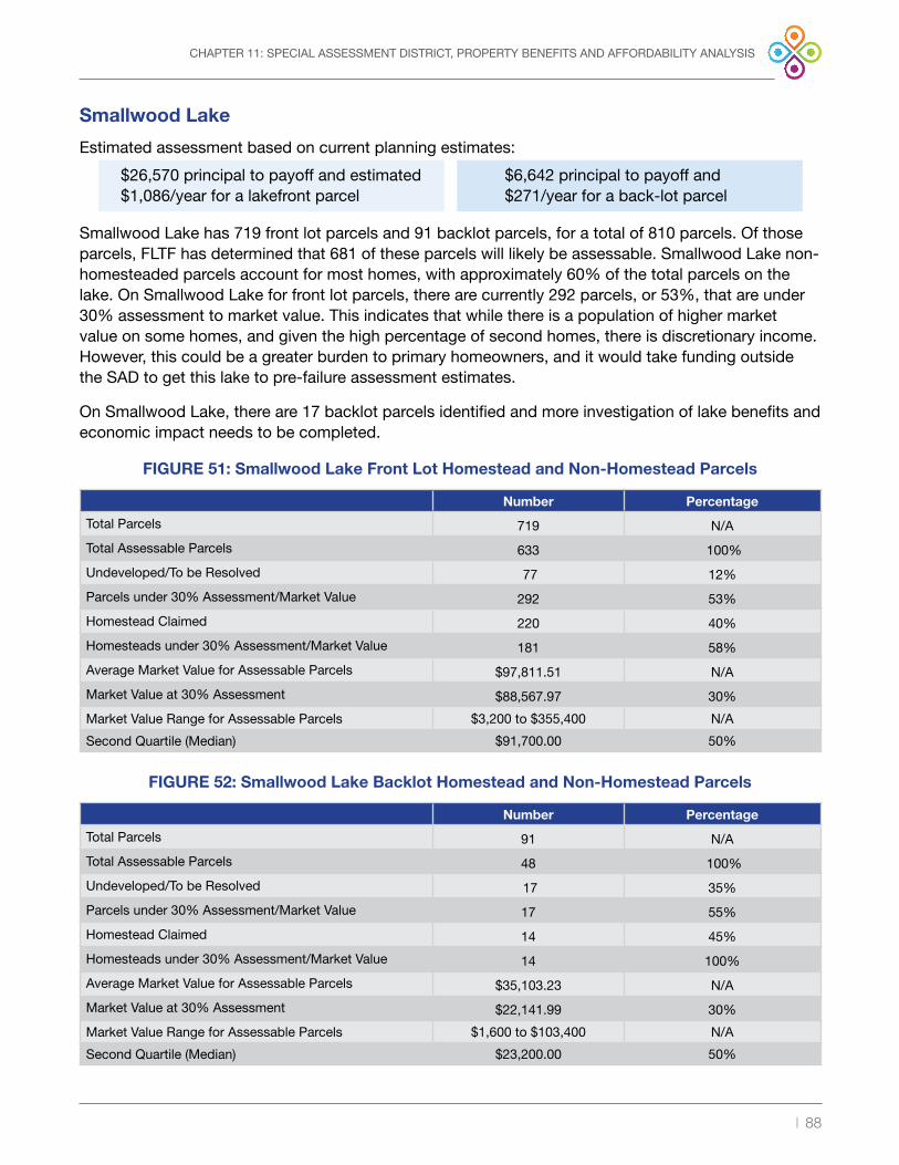
| 88
CHAPTER 11: SPECIAL ASSESSMENT DISTRICT, PROPERTY BENEFITS AND AFFORDABILITY ANALYSIS
Smallwood Lake
Estimated assessment based on current planning estimates:
Smallwood Lake has 719 front lot parcels and 91 backlot parcels, for a total of 810 parcels . Of those parcels, FLTF has determined that 681 of these parcels will likely be assessable . Smallwood Lake non-homesteaded parcels account for most homes, with approximately 60% of the total parcels on the lake . On Smallwood Lake for front lot parcels, there are currently 292 parcels, or 53%, that are under 30% assessment to market value . This indicates that while there is a population of higher market value on some homes, and given the high percentage of second homes, there is discretionary income . However, this could be a greater burden to primary homeowners, and it would take funding outside the SAD to get this lake to pre-failure assessment estimates .
On Smallwood Lake, there are 17 backlot parcels identified and more investigation of lake benefits and economic impact needs to be completed .
$26,570 principal to payoff and estimated $1,086/year for a lakefront parcel
$6,642 principal to payoff and $271/year for a back-lot parcel
Number Percentage
Total Parcels 719 N/ATotal Assessable Parcels 633 100% Undeveloped/To be Resolved 77 12% Parcels under 30% Assessment/Market Value 292 53%Homestead Claimed 220 40%Homesteads under 30% Assessment/Market Value 181 58%Average Market Value for Assessable Parcels $97,811.51 N/AMarket Value at 30% Assessment $88,567.97 30%Market Value Range for Assessable Parcels $3,200 to $355,400 N/A
Second Quartile (Median) $91,700 .00 50%
Number Percentage
Total Parcels 91 N/ATotal Assessable Parcels 48 100% Undeveloped/To be Resolved 17 35%Parcels under 30% Assessment/Market Value 17 55%Homestead Claimed 14 45%Homesteads under 30% Assessment/Market Value 14 100%Average Market Value for Assessable Parcels $35,103.23 N/AMarket Value at 30% Assessment $22,141.99 30%Market Value Range for Assessable Parcels $1,600 to $103,400 N/A
Second Quartile (Median) $23,200 .00 50%
FIGURE 51: Smallwood Lake Front Lot Homestead and Non-Homestead Parcels
FIGURE 52: Smallwood Lake Backlot Homestead and Non-Homestead Parcels

| 89
CHAPTER 11: SPECIAL ASSESSMENT DISTRICT, PROPERTY BENEFITS AND AFFORDABILITY ANALYSIS
Wixom Lake
Estimated assessment based on current planning estimates:
Wixom Lake has 2,859 front lot parcels and 816 backlot parcels, for a total of 3,675 parcels . Of those parcels, FLTF has determined that 3,052 of these parcels will likely be assessable . Wixom homesteaded parcels account for approximately 62% of the total parcels on the lake .
On Wixom Lake for front lot parcels, there are currently 971 parcels, or 40%, that are under 30% assessment to market value . While there is a population of higher market value homes on Wixom Lake, for much of the front lot homeowners the current assessment principal would be a burden as compared to market value, as it relates to the economic options the property owner may have . The backlots have a similar story, and more investigation of lake benefits and economic impact needs to be completed .
This lake community needs significant funding to get to pre-failure assessment estimates .
$43,159 principal to payoff and $1,720/year for a lakefront parcel
$10,789 principal to payoff and $429/year for a back-lot parcel
Number Percentage
Total Parcels 2,859 N/ATotal Assessable Parcels 2,523 100% Undeveloped/To be Resolved 88 3% Parcels under 30% Assessment/Market Value 971 40%Homestead Claimed 1,501 62%Homesteads under 30% Assessment/Market Value 800 53%Average Market Value for Assessable Parcels $146,476.48 N/AMarket Value at 30% Assessment $143,863.91 30%Market Value Range for Assessable Parcels $400 to $1,147,600 N/A
Second Quartile (Median) $126,600 .00 50%
Number Percentage
Total Parcels 816 N/ATotal Assessable Parcels 529 100% Undeveloped/To be Resolved 155 29%Parcels under 30% Assessment/Market Value 189 51%Homestead Claimed 139 37%Homesteads under 30% Assessment/Market Value 136 98%Average Market Value for Assessable Parcels $41,166.31 N/AMarket Value at 30% Assessment $35,965.98 30%Market Value Range for Assessable Parcels $2,200 to $193,400 N/A
Second Quartile (Median) $36,000 .00 50%
FIGURE 53: Wixom Front Lot Homestead and Non-Homestead Parcels
FIGURE 54: Wixom Backlot Homestead and Non-Homestead Parcels

| 90
CHAPTER 11: SPECIAL ASSESSMENT DISTRICT, PROPERTY BENEFITS AND AFFORDABILITY ANALYSIS
Sanford Lake
Estimated assessment based on current planning estimates:
Sanford Lake has 861 front lot parcels and 914 backlot parcels, for a total of 1,775 parcels . Of those parcels, FLTF has determined that 1,522 of these parcels will likely be assessable . Sanford Lake has over 80% of the lake ownership as primary homes, with few cottages on Sanford Lake compared to the other lakes . On Sanford Lake for front lot parcels, there are currently 569 parcels, or 73%, that are under 30% assessment to market value . There seems to be an ability to pay and a willingness to pay by a large majority . However, the property owners of the remaining small homes will likely be challenged, without some government support .
On Sanford Lake for backlot parcels, there are currently 442 parcels, or 64%, that are under 30% assessment to market value . More investigation of lake benefits and economic impact needs to be completed .
$40,982 principal to payoff and annual assessment $1,637/year for a lakefront parcel
$10,245 principal to payoff and annual assessment $409/year for a back-lot parcel
Number Percentage
Total Parcels 861 N/ATotal Assessable Parcels 816 100% Undeveloped/To be Resolved 40 5% Parcels under 30% Assessment/Market Value 569 73%Homestead Claimed 647 83%Homesteads under 30% Assessment/Market Value 567 79%Average Market Value for Assessable Parcels $230,243.56 N/AMarket Value at 30% Assessment $136,607.10 30%Market Value Range for Assessable Parcels $800 to $1,034,200 N/A
Second Quartile (Median) $207,800 .00 50%
Number Percentage
Total Parcels 914 N/ATotal Assessable Parcels 706 100% Undeveloped/To be Resolved 13 2%Parcels under 30% Assessment/Market Value 442 64%Homestead Claimed 492 71%Homesteads under 30% Assessment/Market Value 416 85%Average Market Value for Assessable Parcels $83,107.36 N/AMarket Value at 30% Assessment $34,151.78 30%Market Value Range for Assessable Parcels $800 to $531,600 N/A
Second Quartile (Median) $61,200 .00 50%
FIGURE 55: Sanford Lake Homestead and Non-Homestead Parcels
FIGURE 56: Sanford Backlot Homestead and Non-Homestead Parcels

| 91
CHAPTER 11: SPECIAL ASSESSMENT DISTRICT, PROPERTY BENEFITS AND AFFORDABILITY ANALYSIS
§11i. Midland and Gladwin Lake Community Economics
In response to flooding that devastated the community, Four Lakes Task Force surveyed property owners within the Four Lakes Special Assessment District (SAD) to better understand their preferences for rebuilding and replacing the dams and how restoring the lakes may impact their decisions . Public Sector Consultants was tasked with drafting this accompanying report to provide additional demographic information for Gladwin and Midland counties as well as the townships in those counties within the Four Lakes Special Assessment District (SAD) to provide comparison data for survey results .39
Demographic Analysis
The following sections analyze employment, housing, and income data for Gladwin and Midland counties at the county and township levels . The following information is from the 2019 American Community Survey, an ongoing, annual survey conducted by the U .S . Census Bureau that provides information about the U .S . and its residents .40
County Summary
Employment Information
Figure 57 identifies the population, unemployment rate, and labor force participation rate for both counties as well as the state of Michigan . The labor force participation rate measures the total number of people in the workforce, while the unemployment rate measures the number of people in the workforce who are actively seeking employment . While Gladwin and Midland Counties represent 0 .3 percent and 0 .8 percent of Michigan’s total population, respectively, Midland County contains more than three times the number of residents as Gladwin County . However, their unemployment rates are almost identical, with a difference of approximately 0 .7 percentage points, and align with Michigan’s 5 .9 percent total unemployment rate . Each county’s labor force participation rate—the percentage of all working-age people who are employed or actively seeking work—was lower than statewide figures . For Gladwin County, 45 percent of eligible workers are currently employed or are seeking employment . Participation rates are often reported with unemployment rates for a more comprehensive view of a region’s economy .
39 PSC analyzed Billings, Bourret, Buckeye, Clement, Gladwin, Hay, Secord, and Tobacco Townships in Gladwin County and Edenville, Hope, and Jerome Townships in Midland County .
40 More information about this survey is available on the U .S . Census Bureau’s website: https://www .census .gov/programs-surveys/acs/about .html .
FIGURE 57: Gladwin and Midland Counties’ Employment Information
County Population Unemployment Rate Labor Force Participation Rate
Gladwin 25,279 5.9% 45.0%
Midland 83,355 5.2% 59.6%
Michigan 9,965,265 5.9% 61.5%Source: U .S . Census Bureau 2020a; U .S . Census Bureau 2020b

| 92
CHAPTER 11: SPECIAL ASSESSMENT DISTRICT, PROPERTY BENEFITS AND AFFORDABILITY ANALYSIS
Housing Characteristics
Midland County has more than twice the number of housing units than Gladwin County, and its median home value is also $31,700 higher . While Gladwin and Midland Counties represent 0 .4 percent and 0 .8 percent of Michigan’s total housing units, respectively, each has a lower median home value than the state; however, the total number of units with a mortgage in both counties is lower when compared to the statewide figure . Midland County figures more closely align with Michigan as a whole, while Gladwin County ranks lower, according to the selected indicators in Figure 58 .
Income
Figure 59 summarizes the percentage of Gladwin and Midland County residents within a particular income bracket . It also lists the median household income for each county and the state . Gladwin County’s median household income is 22 percent below Michigan’s, while Midland County’s is 10 percent higher . Midland County’s income range is more proportional to the state breakdown, while Gladwin County has a higher percentage of residents with incomes below $50,000 . Of Michigan residents, 43 .9 percent earn less than $50,000 compared to 55 .8 percent and 39 .7 percent in Gladwin and Midland Counties, respectively . These factors indicate that Gladwin County residents generally earn less than their Midland County and state counterparts .
FIGURE 58: County Housing Characteristics
County Total Housing Units *Median Home Value *Housing Units with a Mortgage
Gladwin 17,923 $110,000 51.4%Midland 36,973 $141,700 57.3%Michigan 4,596,198 $154,900 60.1%
* For owner-occupied units Source: U .S . Census Bureau 2020d
FIGURE 59: Gladwin and Midland County Residents’ Income Ranges
Income Range Gladwin County Midland County Michigan
Less than $10,000 8.7% 5.1% 6.6%$10,000 to $14,999 5.4% 3.8% 4.4%$15,000 to $24,999 13.5% 9.5% 9.6%$25,000 to $34,999 10.8% 8.6% 9.8%$35,000 to $49,999 17.4% 12.7% 13.5%$50,000 to $74,999 19.9% 19.3% 18.3%$75,000 to $99,999 11.0% 14.0% 12.7%$100,000 to $149,999 8.3% 14.1% 14.2%$150,000 to $199,999 3.2% 5.8% 5.6%$200,000 or more 1.6% 7.3% 5.2%Median household income $44,619 $62,625 $57,144
Source: U .S . Census Bureau 2020c

| 93
CHAPTER 11: SPECIAL ASSESSMENT DISTRICT, PROPERTY BENEFITS AND AFFORDABILITY ANALYSIS
Township Summary
Employment Information
Of the 31 townships in Gladwin and Midland Counties, 11 are located within the SAD . These townships vary drastically in terms of population and employment . For example, population figures range from 355 residents in Bourret Township to 4,693 in Jerome Township; unemployment rates range from 1 .3 percent in Secord Township to 12 .9 percent in Hay Township; and labor force participation rates range from 30 .8 percent in Secord Township to 59 .1 percent in Hope Township . This variance is likely due to underlying socioeconomic and demographic factors, such as income level and age .
The average township unemployment rate is 5 .5 percent compared to Michigan’s 5 .9 percent . However, the average labor participation rate was 15 .9 percentage points lower than the statewide labor force participation rate; this means, on average, that fewer eligible individuals within the SAD are employed or seeking employment . This may be due to an increased number of retirement-age individuals within the district . Figure 60 compares the population, unemployment, and labor force participation rates for townships within the SAD .
FIGURE 60: Township Employment Information
County Township Population Unemployment RateLabor Force
Participation Rate
Gladwin Billings 2,045 4.3% 38.8%
Gladwin Bourret 355 4.2% 35.9%
Gladwin Buckeye 1,311 5.7% 49.9%
Gladwin Clement 932 10.6% 35.7%
Gladwin Gladwin 1,152 3.3% 50.2%
Gladwin Hay 1,328 12.9% 42.9%
Gladwin Secord 1,107 1.3% 30.8%
Gladwin Tobacco 2,541 3.5% 51.1%
Midland Edenville 2,533 5.4% 50.2%
Midland Hope 1,442 2.8% 59.1%
Midland Jerome 4,693 6.1% 56.5%
Township average N/A 1,767 5.5% 45.6%
Michigan N/A 9,965,265 5.9% 61.5%Source: U .S . Census Bureau 2020a; U .S . Census Bureau 2020b

| 94
CHAPTER 11: SPECIAL ASSESSMENT DISTRICT, PROPERTY BENEFITS AND AFFORDABILITY ANALYSIS
Housing Characteristics
Much like employment figures, housing characteristics vary drastically by township . The total number of housing units ranges from 503 in Gladwin Township to 2,097 in Billings Township; median home value ranges from $88,500 in Bourret Township to $163,000 in Secord Township; and the percentage of housing units with a mortgage ranges from 42 .2 percent in Gladwin Township to 60 percent in Jerome Township . The average number of housing units in the townships is 0 .03 percent of the statewide count and 2 .2 percent of the combined county figure . The average median home value ($117,909) is 24 percent less than the state’s ($154,900), though fewer homes in the SAD have a mortgage—50 percent compared to 60 .1 percent statewide . Figure 61 compares the total number of housing units, median home values, and the percentage of units with a mortgage .
FIGURE 61: Housing Characteristics
County Township Total Housing Units *Median Home Value*Housing Units with
a Mortgage
Gladwin Billings 2,097 $118,400 50.3%
Gladwin Bourret 524 $88,500 44.3%
Gladwin Buckeye 711 $103,900 51.7%
Gladwin Clement 1,179 $99,300 50.4%
Gladwin Gladwin 503 $112,800 42.2%
Gladwin Hay 1,340 $90,000 48.4%
Gladwin Secord 1,442 $163,500 51.2%
Gladwin Tobacco 1,632 $140,900 55.4%
Midland Edenville 1,322 $118,500 46.9%
Midland Hope 671 $127,900 59.0%
Midland Jerome 2,074 $133,300 60.0%
Township average N/A 1,227 $117,909 50.9%
Michigan N/A 4,596,198 $154,900 60.1%
* For owner-occupied units Source: U .S . Census Bureau 2020d
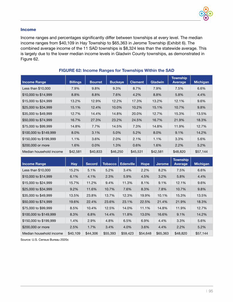
| 95
Income
Income ranges and percentages significantly differ between townships at every level . The median income ranges from $40,109 in Hay Township to $65,363 in Jerome Township (Exhibit 6) . The combined average income of the 11 SAD townships is $8,324 less than the statewide average . This is largely due to the lower median income levels in Gladwin County townships, as demonstrated in Figure 62 .
FIGURE 62: Income Ranges for Townships Within the SAD
Income Range Billings Bourret Buckeye Clement GladwinTownship Average Michigan
Less than $10,000 7.9% 9.8% 9.3% 8.7% 7.9% 7.5% 6.6%
$10,000 to $14,999 8.8% 8.8% 7.6% 4.2% 8.8% 5.8% 4.4%
$15,000 to $24,999 13.2% 12.9% 12.2% 17.3% 13.2% 12.1% 9.6%
$25,000 to $34,999 15.1% 12.4% 10.0% 10.2% 15.1% 10.7% 9.8%
$35,000 to $49,999 12.7% 14.4% 14.8% 20.0% 12.7% 15.3% 13.5%
$50,000 to $74,999 16.7% 27.3% 23.2% 24.5% 16.7% 21.9% 18.3%
$75,000 to $99,999 14.8% 7.7% 14.5% 7.3% 14.8% 11.9% 12.7%
$100,000 to $149,999 8.0% 3.1% 5.0% 5.2% 8.0% 9.1% 14.2%
$150,000 to $199,999 1.1% 3.6% 2.0% 2.1% 1.1% 3.3% 5.6%
$200,000 or more 1.6% 0.0% 1.3% 0.6% 1.6% 2.2% 5.2%
Median household income $42,581 $40,833 $46,250 $45,531 $42,581 $48,820 $57,144
Income Range Hay Secord Tobacco Edenville Hope JeromeTownship Average Michigan
Less than $10,000 15.2% 5.1% 5.2% 3.4% 2.2% 8.2% 7.5% 6.6%
$10,000 to $14,999 6.1% 4.1% 2.3% 5.9% 4.5% 3.2% 5.8% 4.4%
$15,000 to $24,999 15.7% 11.2% 9.4% 11.3% 8.1% 9.1% 12.1% 9.6%
$25,000 to $34,999 9.2% 11.6% 10.7% 7.6% 8.3% 7.8% 10.7% 9.8%
$35,000 to $49,999 13.5% 23.8% 13.7% 12.3% 19.9% 10.1% 15.3% 13.5%
$50,000 to $74,999 19.6% 22.4% 23.6% 23.1% 22.5% 21.4% 21.9% 18.3%
$75,000 to $99,999 8.5% 10.4% 12.5% 14.0% 11.1% 14.8% 11.9% 12.7%
$100,000 to $149,999 8.3% 6.8% 14.4% 11.8% 13.0% 16.6% 9.1% 14.2%
$150,000 to $199,999 1.4% 2.9% 4.8% 6.5% 6.9% 4.4% 3.3% 5.6%
$200,000 or more 2.5% 1.7% 3.4% 4.0% 3.6% 4.4% 2.2% 5.2%
Median household income $40,109 $44,306 $55,393 $59,423 $54,648 $65,363 $48,820 $57,144
Source: U .S . Census Bureau 2020c

| 96
Page Intentionally Blank

| 97
§12 — Chapter 12: Project Implementation — Risks and Conclusion
Each lake faces risks that could negatively impact Four Lakes Task Force’s ability to implement a capital improvement project that is needed to restore the lake . Furthermore, each lake has risks that the lakes will be restored but the schedule to implement may be delayed . At this stage of the project, this initial report is based on 30% developed engineering concepts and provided a construction estimate of $215 million with a +/- 25% confidence level . FLTF is moving forward with final engineering and permitting, and once final engineering is completed, our confidence level in the overall project cost, as well as an overall understanding of needed assistance with project costs, will increase .
Risks that can impact project cost and overall implementation and schedule do exist . The risks include issues ranging from spillway capacity requirements to the ability to finance the project . FLTF has conducted a risk analysis assessment to identify areas of risk and develop a corresponding mitigation plan to address the risk .
§12a. Critical Factors by Lake
Tabulated below are the critical factors for success that were identified in this Feasibility Report .
CHAPTER 12: PROJECT IMPLEMENTATION — RISKS AND CONCLUSION
Critical Success Factor
Criteria Sanford Edenville Smallwood Secord
Recovery Completion Year 2023 2022 2021 2021Projected Rebuild Completion Date Year 2025 2026 2024 2024
EnvironmentalRestoration PlanFor Permitting
Required YES YES NO NO
Funded thru Start of Construction
Funds Needed$$ Millions $4 million $4 million $0 $0
Projected Cost to Rebuild
Required Funds
$$ Millions$51 million $121 million $18 million $25 million
Ability to FinanceMultiple Paths
USDA OnlyChallenged
USDAChallenged w/o Grants or other
sourcesMultiple Multiple
FIGURE 63: Critical Factors by Lake

| 98
CHAPTER 12: PROJECT IMPLEMENTATION — RISKS AND CONCLUSION
Probability – Low Probability – Med Probability -High
Impact - High
Flood while still in Recovery
Inflow Flood Design
No additional State or Federal Funds Available
Project Construction Costs
All Citizens ability to pay
Environment Restoration plan not accepted by Regulators
M30 Bridge timing and financing
USDA Financing Timing
Impact- Medium
Non-acceptance of 30% design concept
by Regulator
Flood - Upstream
Changes in Insurance Markets
Threatened or Endangered Species
Project Execution Schedule
Impact- Low
Alignment of all local government entities Interest Rates
Secord Lake has an estimated assessment that most of the property owners can financially manage and there are funds to finish engineering and financing for the restoration of the lake level .
Smallwood Lake has an estimated assessment roll that most lake owners would likely accept compared to not having a lake . There would be a moderate churn of ownership, likely mostly in vacation homes, without government support . There are funds to complete engineering and finance the restoration of the lake levels .
Wixom Lake estimated assessments would have an economic impact to almost half of the lake homeowners and backlot owners, without state or federal funding . A total of $4 million of funding is needed to complete engineering without delaying the 2026 timeline of the project .
Sanford Lake while its estimated assessment is high for lakefront property owners, the value of the homes on Sanford and the economic demographics suggest most can afford and will accept an assessment . Backlots have a different story, and more investigation of lake benefits and economic impact needs to be completed . Approximately $4 million of funding is needed to complete engineering without delaying the 2025 timeline of the project .
§12b. Risk Analysis
Risks are events that may happen in the future, which, if they occur, would result in an inability to meet the program objectives, and would negatively affect scope, timeline and/or costs .
FLTF’s Program Management Board regularly reviews risks to project costs, schedule, completion, safety and probability . Mitigation plans are concurrently reviewed to ensure pre-emptive strategies are progressing, so risks are not realized .
FIGURE 64: Risk Analysis

| 99
CHAPTER 12: PROJECT IMPLEMENTATION — RISKS AND CONCLUSION
Risk Response Plan
Each risk is monitored and managed to achieve an acceptable range of probability and impact . Standard risk management responses are employed to avoid, mitigate, or transfer the risk . Project viability requires having alternatives or response plans to manage the risks .
There is a 25% contingency built into the project plan costs; there is no contingency in the schedule . Assessment costs have similar ranges with issues driven by costs, financing and benefits .

| 100
Page Intentionally Blank

| 101
CHAPTER 13: CONCLUSION
§13 — Chapter 13: Conclusion
It is technically feasible to restore the Four Lakes and their associated ecosystems by rebuilding the four dams . The effort is estimated to cost $215 million, plus or minus 25% . Given the above risks, an upper planning estimate is set at $250 million for restoration and with recovery and an approximate total for recovery and restoration at $300 million . Therefore, an overall range of $250-$300 million for recovery and restoration is estimated .
Critical Success Factors
A major challenge will be to make the cost of restoration more affordable for property owners . FLTF, the counties’ delegated authority, will earnestly work over the next three years to secure additional public funding and develop a financeable plan that is affordable to as many property owners as possible .
Existing state and federal regulatory frameworks are primarily geared to new construction and repair activities . They do not envision a recovery effort of the magnitude that will be required following the May 2020 disaster, nor was there a response plan by the government to intervene or respond to this circumstance . A successful restoration effort will require a partnership between the counties, state and federal regulators for funding and permitting to reconstruct the dams and restore the lake ecosystems to their pre-disaster conditions .
An assessment of property owners of the Four Lakes SAD must be put in place to restore and maintain the lakes . This assessment will not be the sole source of funding for the recovery and restoration but is the foundation of funding for the restoration and attracting supplemental funding . The assessment ensures there is a financial means for long-term sustainability for operating and maintaining the lakes .
At least $10 million of funding from outside the Special Assessment District (SAD) is needed by early 2022. In the next three years, approximately $150 million would bring the funding to the pre-failure level of assessments.
Environmental recovery on Wixom and Sanford lakes is significant, and FLTF is engaged with EGLE to get acceptance of the restoration plan, and then identify funding sources.
A fair and consistent methodology for the assessment of property owners of the Four Lakes SAD needs to be put in place, to attract funding and assure there is a financial means for long-term operations and maintenance.

| 102
CHAPTER 13: CONCLUSION
The dams will be reconstructed using Federal Emergency Management Agency dam safety design guidelines and industry standards to meet Michigan Department of Environment, Great Lakes and Energy dam safety requirements . Substantial improvements will be made to spillway capacity, embankment stability and operational safety . The rebuilt dams will have substantially more spillway capacity to pass flows much greater than the May 2020 flood event, with a margin of safety .
Flood studies must be completed, and capacity designs must be acceptable to the state, to move forward with the completion of engineering.

| 103
ACRONYMS
Acronyms
ALICE: Asset Limited, Income Constrained and Employed
Ayres: Ayres Associates
BMP: best management practice
Boyce: Boyce Hydro Power
EAP: emergency action plan
EGLE: Michigan Department of Environment, Great Lakes and Energy
ER: environmental report
EWP: Emergency Watershed Protection (program)
FEMA: Federal Emergency Management Agency
FERC: Federal Energy Regulatory Commission
FIRM: flood insurance rate map
FIS: flood insurance study
FLTF: Four Lakes Task Force
FPA: Federal Power Act
GEI: GEI Consultants of Michigan
GLFC: Great Lakes Fish Commission
IDF: inflow design flood
LiDAR: Light Detection and Ranging
LOMC: letter of map change
MDHHS: Michigan Department of Health and Human Services
MDNR: Michigan Department of Natural Resources
MDSP: Model Dam Safety Program
MNFI: Michigan Natural Features Inventory
NFIP: National Flood Insurance Program
NRCS: Natural Resources Conservation Services
NREPA: Natural Resources and Environmental Protection Act
O&M: operations and maintenance
OHWM: ordinary high-water mark
OPCC: opinion of probable construction costs
Part 307: State of Michigan inland lakes of the Natural Resource and Environmental Protection Act 451 of 1994
PER: preliminary engineering report
PMF: probable maximum flood
PMP: probable maximum precipitation
PSC: Public Sector Consultants
QBS: qualifications-based selection
RCAP: Rural Communities Assistance Program
RD: rural development
SAD: Four Lakes Special Assessment District
SCADA: Supervisory Control and Data Acquisition
SESC: soil erosion and sedimentation control
SEV: state equalized value
SFHA: special flood hazard area
SGI: Spicer Group, Inc .
T&E: threatened and endangered (species)
USACE: United States Army Corps of Engineers
USBR: United States Bureau of Reclamation
USDA: United States Department of Agriculture

| 104
FIGURES
FIGURE 1: Dam Restoration Costs . . . . . . . . . . . . . . . . . . . . . . . . . . . . . . . . . . . . . . . . . . . . . . . . . . . . . . . . . . . . . . . . . . . . . . .8
FIGURE 2: Funds Needed to Achieve Lower Assessment . . . . . . . . . . . . . . . . . . . . . . . . . . . . . . . . . . . . . . . . . . . . . . . . . . . .11
FIGURE 3: Years of Ownership . . . . . . . . . . . . . . . . . . . . . . . . . . . . . . . . . . . . . . . . . . . . . . . . . . . . . . . . . . . . . . . . . . . . . . . . .22
FIGURE 4: Importance of Lakes . . . . . . . . . . . . . . . . . . . . . . . . . . . . . . . . . . . . . . . . . . . . . . . . . . . . . . . . . . . . . . . . . . . . . . . . .23
FIGURE 5: Confidence in Recovery . . . . . . . . . . . . . . . . . . . . . . . . . . . . . . . . . . . . . . . . . . . . . . . . . . . . . . . . . . . . . . . . . . . . . .23
FIGURE 6: Selling Property . . . . . . . . . . . . . . . . . . . . . . . . . . . . . . . . . . . . . . . . . . . . . . . . . . . . . . . . . . . . . . . . . . . . . . . . . . . .24
FIGURE 7: Rebuilding the Dams . . . . . . . . . . . . . . . . . . . . . . . . . . . . . . . . . . . . . . . . . . . . . . . . . . . . . . . . . . . . . . . . . . . . . . . .24
FIGURE 8: Need for Special Assessment . . . . . . . . . . . . . . . . . . . . . . . . . . . . . . . . . . . . . . . . . . . . . . . . . . . . . . . . . . . . . . . . .25
FIGURE 9: Paying for the Dams . . . . . . . . . . . . . . . . . . . . . . . . . . . . . . . . . . . . . . . . . . . . . . . . . . . . . . . . . . . . . . . . . . . . . . . . .26
FIGURE 10: Willingness to Pay . . . . . . . . . . . . . . . . . . . . . . . . . . . . . . . . . . . . . . . . . . . . . . . . . . . . . . . . . . . . . . . . . . . . . . . . .27
FIGURE 11: Property Values Compared to the Assessment Amount . . . . . . . . . . . . . . . . . . . . . . . . . . . . . . . . . . . . . . . . . . . .27
FIGURE 12: Four Lakes Watershed . . . . . . . . . . . . . . . . . . . . . . . . . . . . . . . . . . . . . . . . . . . . . . . . . . . . . . . . . . . . . . . . . . . . . .29
FIGURE 13: Map of FLTF Dams and Lakes . . . . . . . . . . . . . . . . . . . . . . . . . . . . . . . . . . . . . . . . . . . . . . . . . . . . . . . . . . . . . . . .32
FIGURE 14: Summary of Existing and Required Spillway Discharge Capacity . . . . . . . . . . . . . . . . . . . . . . . . . . . . . . . . . . . . .34
FIGURE 15: Summary of Inflow Design Flood (1/2 PMF + Design Storm) . . . . . . . . . . . . . . . . . . . . . . . . . . . . . . . . . . . . . . . . .35
FIGURE 16: Aerial View of Secord Dam Spillway and Non-Operational Powerhouse . . . . . . . . . . . . . . . . . . . . . . . . . . . . . . . .37
FIGURE 17: Inspection Photographs of Secord Dam . . . . . . . . . . . . . . . . . . . . . . . . . . . . . . . . . . . . . . . . . . . . . . . . . . . . . . . .38
FIGURE 18: Cross-Section View of Proposed Secord Dam Crest Gate Spillway . . . . . . . . . . . . . . . . . . . . . . . . . . . . . . . . . . .38
FIGURE 19: Plan View of Proposed Secord Dam Auxiliary Spillway . . . . . . . . . . . . . . . . . . . . . . . . . . . . . . . . . . . . . . . . . . . . .39
FIGURE 20: Cross-Section View of Secord Dam Embankment Repairs . . . . . . . . . . . . . . . . . . . . . . . . . . . . . . . . . . . . . . . . . .40
FIGURE 21: Secord Summary of Opinion of Probable Construction Costs Based on the 30 Percent Design . . . . . . . . . . . . .41
FIGURE 22: Inspection Photographs of Smallwood Dam Spillway and Powerhouse . . . . . . . . . . . . . . . . . . . . . . . . . . . . . . . .42
FIGURE 23: Cross-Section View of Smallwood Dam Crest Gate Spillway . . . . . . . . . . . . . . . . . . . . . . . . . . . . . . . . . . . . . . . .43
FIGURE 24: Plan View of Smallwood Dam Auxiliary Spillway . . . . . . . . . . . . . . . . . . . . . . . . . . . . . . . . . . . . . . . . . . . . . . . . . .44
FIGURE 25: Cross-Section View of Smallwood Dam Embankment Repairs . . . . . . . . . . . . . . . . . . . . . . . . . . . . . . . . . . . . . . .45
FIGURE 26: Smallwood Summary of Opinion of Probable Construction Costs Based on the 30 Percent Design . . . . . . . . . .46
FIGURE 27: Aerial View of Edenville Dam Failure . . . . . . . . . . . . . . . . . . . . . . . . . . . . . . . . . . . . . . . . . . . . . . . . . . . . . . . . . . .47
FIGURE 28: Cross-Section View of Edenville Dam Three-Bay Crest Gate Spillway . . . . . . . . . . . . . . . . . . . . . . . . . . . . . . . . .49
FIGURE 29: Elevation View of Proposed Tobacco Spillway Three-Bay Crest Gates . . . . . . . . . . . . . . . . . . . . . . . . . . . . . . . . .49
FIGURE 30: Plan View of Edenville Dam Auxiliary Spillway Left of Tittabawassee Spillway . . . . . . . . . . . . . . . . . . . . . . . . . . .50
FIGURE 31: Cross-Section View of Tittabawassee Auxiliary Spillway . . . . . . . . . . . . . . . . . . . . . . . . . . . . . . . . . . . . . . . . . . . .50
FIGURE 32: Cross-Section View Edenville Dam Left Embankment Reconstruction . . . . . . . . . . . . . . . . . . . . . . . . . . . . . . . . .51
FIGURE 33: Edenville Summary of Opinion of Probable Construction Costs Based on the 30 Percent Design . . . . . . . . . . . .52
FIGURE 34: Aerial View of Sanford Dam Failure . . . . . . . . . . . . . . . . . . . . . . . . . . . . . . . . . . . . . . . . . . . . . . . . . . . . . . . . . . . .53
FIGURE 35: Plan View of Proposed Sanford Repairs . . . . . . . . . . . . . . . . . . . . . . . . . . . . . . . . . . . . . . . . . . . . . . . . . . . . . . . .54
FIGURE 36: Plan View of Sanford Dam Primary Spillway Upgrades . . . . . . . . . . . . . . . . . . . . . . . . . . . . . . . . . . . . . . . . . . . . .55
FIGURE 37: Cross-Section View of Sanford Dam Crest Gates . . . . . . . . . . . . . . . . . . . . . . . . . . . . . . . . . . . . . . . . . . . . . . . . .55
FIGURE 38: Plan View of Sanford Dam Auxiliary Spillway . . . . . . . . . . . . . . . . . . . . . . . . . . . . . . . . . . . . . . . . . . . . . . . . . . . . .56
FIGURE 39: Cross-Section View of Sanford Dam Auxiliary Spillway . . . . . . . . . . . . . . . . . . . . . . . . . . . . . . . . . . . . . . . . . . . . .56
FIGURE 40: Cross-Section View Sanford Dam Right Embankment Reconstruction . . . . . . . . . . . . . . . . . . . . . . . . . . . . . . . . .57
FIGURE 41: Sanford Summary of Opinion of Probable Construction Costs Based on the 30 Percent Design . . . . . . . . . . . .58
FIGURE 42: Summary of Probable Costs for Each Dam Site . . . . . . . . . . . . . . . . . . . . . . . . . . . . . . . . . . . . . . . . . . . . . . . . . .58
Figures

| 105
FIGURES
FIGURE 43: Donald Drive Site on Sanford Lake — Before vs . After Stabilization Project . . . . . . . . . . . . . . . . . . . . . . . . . . . . .62
FIGURE 44: Pre- and Post-Disaster Wetland and Surface Water Analysis Results for Wixom and Sanford Lakes . . . . . . . . .64
FIGURE 45: Planning Level Assessments Without State or Federal Funding . . . . . . . . . . . . . . . . . . . . . . . . . . . . . . . . . . . . . .83
FIGURE 46: Lot Map . . . . . . . . . . . . . . . . . . . . . . . . . . . . . . . . . . . . . . . . . . . . . . . . . . . . . . . . . . . . . . . . . . . . . . . . . . . . . . . . .84
FIGURE 47: Sample Lake Map . . . . . . . . . . . . . . . . . . . . . . . . . . . . . . . . . . . . . . . . . . . . . . . . . . . . . . . . . . . . . . . . . . . . . . . . .84
FIGURE 48: Funds Needed to Achieve Lower Assessment . . . . . . . . . . . . . . . . . . . . . . . . . . . . . . . . . . . . . . . . . . . . . . . . . . .86
FIGURE 49: Secord Front Lot Homestead and Non-Homestead Parcels . . . . . . . . . . . . . . . . . . . . . . . . . . . . . . . . . . . . . . . . .87
FIGURE 50: Secord Backlot Homestead and Non-Homestead Parcels . . . . . . . . . . . . . . . . . . . . . . . . . . . . . . . . . . . . . . . . . .87
FIGURE 51: Smallwood Lake Front Lot Homestead and Non-Homestead Parcels . . . . . . . . . . . . . . . . . . . . . . . . . . . . . . . . .88
FIGURE 52: Smallwood Lake Backlot Homestead and Non-Homestead Parcels . . . . . . . . . . . . . . . . . . . . . . . . . . . . . . . . . . .88
FIGURE 53: Wixom Front Lot Homestead and Non-Homestead Parcels . . . . . . . . . . . . . . . . . . . . . . . . . . . . . . . . . . . . . . . . .89
FIGURE 54: Wixom Backlot Homestead and Non-Homestead Parcels . . . . . . . . . . . . . . . . . . . . . . . . . . . . . . . . . . . . . . . . . .89
FIGURE 55: Sanford Lake Homestead and Non-Homestead Parcels . . . . . . . . . . . . . . . . . . . . . . . . . . . . . . . . . . . . . . . . . . . .90
FIGURE 56: Sanford Backlot Homestead and Non-Homestead Parcels . . . . . . . . . . . . . . . . . . . . . . . . . . . . . . . . . . . . . . . . . .90
FIGURE 57: Gladwin and Midland Counties’ Employment Information . . . . . . . . . . . . . . . . . . . . . . . . . . . . . . . . . . . . . . . . . . .91
FIGURE 58: County Housing Characteristics . . . . . . . . . . . . . . . . . . . . . . . . . . . . . . . . . . . . . . . . . . . . . . . . . . . . . . . . . . . . . . .92
FIGURE 59: Gladwin and Midland County Residents’ Income Ranges . . . . . . . . . . . . . . . . . . . . . . . . . . . . . . . . . . . . . . . . . . .92
FIGURE 60: Township Employment Information . . . . . . . . . . . . . . . . . . . . . . . . . . . . . . . . . . . . . . . . . . . . . . . . . . . . . . . . . . . .93
FIGURE 61: Housing Characteristics . . . . . . . . . . . . . . . . . . . . . . . . . . . . . . . . . . . . . . . . . . . . . . . . . . . . . . . . . . . . . . . . . . . . .94
FIGURE 62: Income Ranges for Townships Within the SAD . . . . . . . . . . . . . . . . . . . . . . . . . . . . . . . . . . . . . . . . . . . . . . . . . . .95
FIGURE 63: Critical Factors by Lake . . . . . . . . . . . . . . . . . . . . . . . . . . . . . . . . . . . . . . . . . . . . . . . . . . . . . . . . . . . . . . . . . . . . .97
FIGURE 64: Risk Analysis . . . . . . . . . . . . . . . . . . . . . . . . . . . . . . . . . . . . . . . . . . . . . . . . . . . . . . . . . . . . . . . . . . . . . . . . . . . . .98
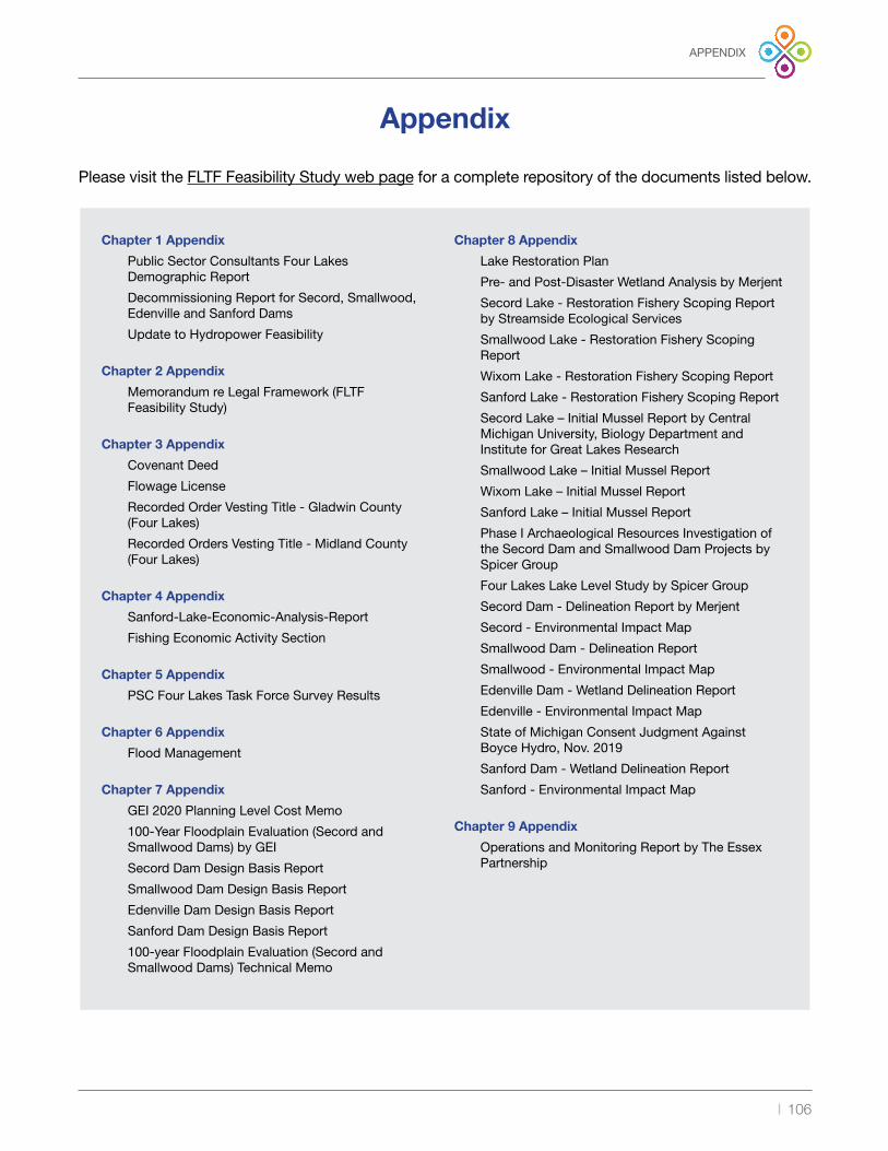
| 106
Appendix
Please visit the FLTF Feasibility Study web page for a complete repository of the documents listed below .
Chapter 1 Appendix
Public Sector Consultants Four Lakes Demographic Report
Decommissioning Report for Secord, Smallwood, Edenville and Sanford Dams
Update to Hydropower Feasibility
Chapter 2 Appendix
Memorandum re Legal Framework (FLTF Feasibility Study)
Chapter 3 Appendix
Covenant Deed
Flowage License
Recorded Order Vesting Title - Gladwin County (Four Lakes)
Recorded Orders Vesting Title - Midland County (Four Lakes)
Chapter 4 Appendix
Sanford-Lake-Economic-Analysis-Report
Fishing Economic Activity Section
Chapter 5 Appendix
PSC Four Lakes Task Force Survey Results
Chapter 6 Appendix
Flood Management
Chapter 7 Appendix
GEI 2020 Planning Level Cost Memo
100-Year Floodplain Evaluation (Secord andSmallwood Dams) by GEI
Secord Dam Design Basis Report
Smallwood Dam Design Basis Report
Edenville Dam Design Basis Report
Sanford Dam Design Basis Report
100-year Floodplain Evaluation (Secord andSmallwood Dams) Technical Memo
Chapter 8 Appendix
Lake Restoration Plan
Pre- and Post-Disaster Wetland Analysis by Merjent
Secord Lake - Restoration Fishery Scoping Report by Streamside Ecological Services
Smallwood Lake - Restoration Fishery Scoping Report
Wixom Lake - Restoration Fishery Scoping Report
Sanford Lake - Restoration Fishery Scoping Report
Secord Lake – Initial Mussel Report by Central Michigan University, Biology Department and Institute for Great Lakes Research
Smallwood Lake – Initial Mussel Report
Wixom Lake – Initial Mussel Report
Sanford Lake – Initial Mussel Report
Phase I Archaeological Resources Investigation of the Secord Dam and Smallwood Dam Projects by Spicer Group
Four Lakes Lake Level Study by Spicer Group
Secord Dam - Delineation Report by Merjent
Secord - Environmental Impact Map
Smallwood Dam - Delineation Report
Smallwood - Environmental Impact Map
Edenville Dam - Wetland Delineation Report
Edenville - Environmental Impact Map
State of Michigan Consent Judgment Against Boyce Hydro, Nov . 2019
Sanford Dam - Wetland Delineation Report
Sanford - Environmental Impact Map
Chapter 9 Appendix
Operations and Monitoring Report by The Essex Partnership
APPENDIX

Page Intentionally Blank

2021 FLTF BOARD OF DIRECTORS The FLTF board is chartered to lessen the burden of government and improve and operate the dams on behalf of the counties and the owners in the Special Assessment District .
The board of directors is made up of nominated representatives from each lake association and two commissioners, one each from Gladwin and Midland counties . Lake associations nominate and approve board members . Lake association members may serve up to two, 3-year terms . Individual county commissioners will serve at the county’s desire .
• David Kepler, Chair, Sanford Lake, 2020-2022
• Adam Beebe, Sanford Lake, 2020-2021
• Don Zakett, Wixom Lake, 2020-2022
• Dave Rothman, Wixom Lake, 2020-2023
• Mark Mudge, Smallwood Lake, 2020-2021
• Phil Dast, Secord Lake, 2020-2023
• Chuck Sikora, Secord Lake, 2021-2024
• Karen Moore, Gladwin County
• Mark Bone, Midland County
FLTF Officers• David Kepler, President
• Dave Rothman, Vice President and Board Secretary
• Tamara McGovern, Treasurer
• Kayla Stryker, Administrative Secretary
• Joe Colaianne, Clark Hill, PLC, General Counsel
Get in Touch
Website: four-lakes-taskforce-mi .com
Facebook: facebook .com/FourLakesTaskForce/
YouTube: bit .ly/YT-FLTF
Email: info@fourlakestaskforce .org