Pistol River Watershed Analysis (1998)
38
PISTOL RIVER WATERSHED ANALYSIS ITERATION 1.0 September 15, 1998 I have read this analysis and find that it meets the Standards and Guidelines for watershed analysis re- quired by the Northwest Forest Plan Record of Decision dated April 1994. SIGNED DATE_ District Ranger Chetco Ranger District Siskiyou National Forest
Transcript of Pistol River Watershed Analysis (1998)

DOCUMENTA 13.66/2:
P 58x
PISTOL RIVER WATERSHED ANALYSIS
ITERATION 1.0
September 15, 1998
I have read this analysis and find that it meets the Standards and Guidelines for watershed analysis re-quired by the Northwest Forest Plan Record of Decision dated April 1994.
SIGNED DATE_
District RangerChetco Ranger DistrictSiskiyou National Forest

PISTOL RIVER WATERSHED ANALYSISIteration 1.0
September 15, 1998
Introduction
The Pistol River Watershed Analysis, Version 1.0, was initiated to obtain and document information onthe aquatic, terrestrial, and social resources of the watershed. The information gathered and analyzedwill be used to guide future resource management. It will also be used to ensure that Aquatic Conserva-tion Strategy objectives and other Standards and Guidelines contained in the Record of Decision forAmendments to Forest Service and Bureau of Land Management Planning Documents Within the Rangeof the Northern Spotted Owl (ROD, 1994) will be met.
The watershed analysis was completed by an interdisciplinary team using the six step process outlined inEcosystem Analysis at the Watershed Scale (Version 2.2, August 1995). The analysis is documented insections: the Aquatic Ecosystem, the Terrestrial Ecosystem, and the Social Aspects of the Watershed.
Pistol River Watershed
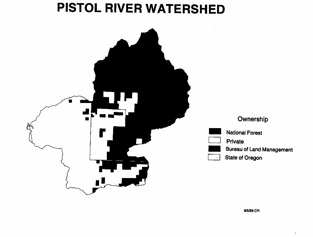
The Pistol River is located in the Klamath Mountain Province in southwestern Oregon (see VicinityMap). The Pistol River drains into the Pacific Ocean, with the mouth of the river located betweenBrookings and Gold Beach. The watershed has 67,172 acres, 52% of which is on the Chetco RangerDistrict of the Siskiyou National Forest. The remaining 48% is divided among the Bureau of Land Man-agement, the State of Oregon, and private landowners (see Ownership Map).
Table 1: Land Ownership_Ownership Acres Percent of WatershedUSDA Forest Service 35,097 52Private 28,869 43USDI Bureau of Land Management 3,060 5State of Oregon 147 0.2Total 67,172 100
The Siskiyou National Forest land management direction is provided by the Siskiyou Land and Re-source Management Plan (Forest Plan, 1989) as amended by the Record of Decision and Standards andGuidelines for Management of Habitat for Late-Successional and Old-Growth Forest Related SpeciesWithin the Range of the Northern Spotted Owl (ROD, 1994). Allocations for the National Forest Sys-tem lands within the Pistol River watershed are listed in Table 2. The definitions and management strat-egy for these allocations can be found in the ROD and in the Forest Plan (see Management Area Map).
Table 2: Management AllocationsAllocation Acres Percent of NF LandBotanical 473 1Unique Interest 43 0.1Backcountry Recreation 2,245 6Late Successional Reserves 11,298 32Special Wildlife Site 654 2Riparian Reserves 4,122 12Matrix 16,264 46Total 35,097 100
Pistol River Watershed Analysis, Iteration 1.0, page I of 17

AQUATIC ECOSYSTEM NARRATIVE
Geologic Characterization
The Pistol River is part of the Klamath Mountains geologic province and includes a mixture of igneous,metamorphic, and sedimentary formations (Irwin 1966, Dott 1971, Jones and Ferrero 1990, quoted inRussell 1994). Primary geologic units include Dothan and Colebrook formations (see Geology Map,from 1991 Geologic Map of Oregon). The Dothan formation dominates the basin and consists of mud-stones, sandstones, shales, and undifferentiated volcanics from the Jurassic period. They are similar tothe California Franciscan formation. Soils in mudstone, siltstone and shale units tend to be deep (> 1in), silty and clayey, and poorly drained. Soils on sandstone tend to be sandy and well drained and ofmedium depth (0.5 to 1 m) on slopes and thin (0 to 0.5 m) on ridges. Dothan volcanics form outcrops orthin, rocky soils. The Colebrook formation, also Jurassic, consists of low-grade metasediments andmetavolcanics, predominantly schist and phyllite with abundant quartz. Soils are generally thick onmoderate hillslopes and thin in steeper inner gorge and stream-adjacent slopes. Colebrook soils are gen-erally resistant to erosion on gentle slopes but are highly erodible on the steep inner gorges of streamchannels. Cretaceous sediments have been mapped in the eastern part of the basin around Windy Valleyand Windy Creek. Serpentinized peridotite dominates the upper slopes of the North Fork Pistol land-scape although Colebrook schists make up the inner gorges.
What erosion processes are dominant within the watershed?
Natural Processes
Several major fault zones have been mapped in the Pistol River watershed and include north-southtrending, high angle reverse, and low angle thrust faults. These faults form contact shear zones whichsubsequently act as groundwater conduits and form deep, sheared saturated soils. These areas are un-stable when combined with steep slopes, and are an important source of sediment to Pistol River.
Mass movements in the watershed are concentrated in the inner gorges and tributary headwalls underlainby Colebrook schist and Dothan mudstone, siltstone, and sandstone units and in contact zones. Lands-liding is most prevalent in these over-steepened areas due to saturation as well as groundwater outflowalong faults and contact zones. According to Jones and Ferrero (1990), saturation by groundwater is amajor cause of mass movement in all rock types, soils, and slopes within the watershed.
Human activities affecting erosion processes
Numerous studies have shown that road construction and timber harvest can increase sediment deliveryto streams. A master's thesis (Russell, 1994) examined sediment production and delivery rates specifi-cally in the Pistol River watershed. The estimated sediment production included all lands (private, Stateof Oregon, Bureau of Land Management, and National Forest) within the watershed for the period 1940-1991. The thesis found that roads within the watershed produce sediment at a rate 32 times that of sur-rounding undisturbed forest lands.
Pistol River Watershed Analysis, Iteration 1.0, page 2 of 17

-- _-�_- -, - - I
The thesis also found that timber harvest had increased sediment production rates by 2.8 times that ofsurrounding undisturbed forest lands. Typically, riparian buffers were not used in harvest areas on Na-tional Forest System lands until the mid 1980's. Within the Pistol River watershed, landslide sedimentdelivery is highest along slopes adjacent to streams (Jones and Ferrero, 1990), particularly when theyhave been harvested.
Information Needs Sites of specific management-related sediment sources.
Management Opportunities Stormproof or decommission roads that have a high potential for sedimentdelivery.
What are the dominant hydrologic characteristics and processes?
The Pistol River watershed receives an average annual precipitation ranging from 90 inches near themouth to 130 inches near the headwaters at Snow Camp. Most of the watershed is within the rain-dominated zone, much of it is within the transient snow zone, and a small portion in the vicinity of SnowCamp (elevation 4221 feet) is within the snowpack zone. Winter storms bring high flows and the tran-sient snow zone contributes to even higher peak flows when warm rains melt an existing snow pack. Insharp contrast to high winter flows, early autumn brings low flows at the end of a dry summer. Many ofthe upper slope streams do not have surface flow during this time. Small springs are scattered across thebasin but do not provide enough surface flow during the dry season to be significant at the watershedscale. However, where they occur they provide significant local relief from the otherwise dry summerenvironment.
There is no streamflow gage on the Pistol River, but a staff gage can be seen on the abandoned bridgeabutments in the lower channel. It is unknown whether or not there are records of stages or correspond-ing flows at this spot. Flood events on the Pistol River were reported in December 1861, February 1890,February 1927, December 1955, December 1964, December 1965, January 1971, (Floodplain Manage-ment Study, SCS, March 1982), and November 1996.
What are the basic morphological characteristics of stream channels and the general sedimenttransport and deposition processes?
Pistol River streams generally flow through narrow, steeply incised inner gorges. As a result, floodplain development and depositional areas in the active channel are limited to the lower South Fork andthe mainstem below South Fork. Well-developed flood plains are only in the first 3.4 miles above themouth.
Longitudinal profiles of the Pistol River and named tributaries, based on 7.5 minute series USGS topo-graphic maps with 40 foot contours give broad scale information on deposition and transport reaches.See annotated profiles, Appendix A.
Timber harvest and roads can increase sediment production and peak flow, affecting bank and channelstability. The condition of the lower Pistol River will remain uncertain as continued timber harvest androad construction on private lands could delay the system's recovery from excessive sediment producedin past decades. Sediment production has been decreasing since it reached a peak between 1970 and1986. The lower Pistol mainstem and South Fork received the majority of the sediment and have experi-enced the greatest effects to the aquatic system.
Pistol River Watershed Analysis, Iteration 1.0, page 3 of 17

Sources of LarRe Wood to Channels
Large wood in streams is important for fish habitat and channel stability. Wood is delivered to streamstwo ways. Trees tall enough to reach a stream can fall into the channel, or trees growing in unstable ar-eas directly uphill of a stream enter the channel when a landslide or debris flow is triggered along theunstable area.
The high levels of clearcut harvest in the overall Pistol River watershed have probably depleted futuresupplies of large wood to the mainstem.
Management Opportunities
Increase the restoration rate of the large wood supply within riparian areas on National Forest Systemlands within the watershed by planting conifers in understocked areas, thinning conifers in overstockedareas, and manual release.
What beneficial uses dependent on aquatic resources occur in the watershed? Which water qual-ity parameters are critical to these uses?
Throughout the watershed, the primary beneficial use is the anadromous fishery. In the residential andagricultural areas of the lower watershed, water is used for domestic and irrigation purposes. There arealso several popular swimming holes in the lower mainstem for summer recreation.
Water quality factors that affect all of these uses are temperature and turbidity.
Stream Temperature
Temperature is affected by streamside shade and channel morphology. It is believed that summerstream temperatures in the lower Pistol River have risen significantly, beginning in the 1950's. This isdue to the amount of streamside harvest and road construction in the watershed which reduced stream-side shade and increased sediment delivery. The increased amount of sediment filled pools and createdbroader, flatter channels in low gradient sections which heat more quickly. In recent years, stream shadeand stream channels have been recovering in the upper Pistol mainstem, reducing stream temperature.Stream surveys in 1979 found only 29% stream shade. Comparison of the same area in a 1989 surveyfound the stream shade had recovered to 55%.
Harvest of conifers and hardwoods continues on private land, maintaining the warmer stream tempera-tures in downstream sections. Aquatic species dependent on cooler water are known to be decreasing innumbers, and stream temperature may be a factor in this decrease (ODFW, 1991). Maintaining coolerstream temperature in the tributaries feeding the downstream sections of the river is important.
Stream temperatures were monitored in a cooperative effort between the US Forest Service, ODFW, andOSU as part of the Pistol River Study 1991-1993. This data shows a range of average 7-day maximumtemperatures from 620 to 750 F. Monitoring by USFS and ODFW began again in 1997.
Pistol River Watershed Analysis, Iteration 1.0, page 4 of 17

Table 4: Average 7-day Maximum Stream TerStream Site Name 1997Pistol River above East Fork 66.6North Fork Pistol r.m.3. 1
bridge 69.0East Fork Pistol mouth 65.2
Turbidity
Turbidity is caused by the portion of sediment with small enough particles to be suspended in the watercolumn, rather than transported along the streambed or carried short distances and deposited, as are the"coarse" cobbles and gravels and "fine" sands. Typically, streams in the Pistol River system are turbidduring storms and clear quickly. Frequency and duration of turbidity may have increased followingmanagement activities that increased peak flows, erosion, or mass failures. Higher turbidity duringstorms has been anecdotally observed in major tributaries with recent high levels of harvest.
Management Opportunities
Increase the growth of shading vegetation within riparian areas on National Forest System lands withinthe watershed by planting conifers in understocked areas, thinning conifers in overstocked areas, andmanual release.
What is the character of fish habitat in the watershed?
The mainstem of the Pistol River provides both spawning and rearing habitat for fall chinook and wintersteelhead. The fall chinook migrate up the mainstem to the confluence with the East Fork. Fall chinookhave also been seen in the first 0.5 mile of the East Fork. The winter steelhead migrate up the mainstemto river mile 17.5 where passage is blocked by a 15 foot waterfall. The first 4.0 miles of the East Forkprovide spawning and rearing habitat for the winter steelhead, as well as the first 0.1 mile of MeadowCreek. Resident rainbow and cutthroat trout are also present in the streams listed above and several oftheir tributaries.
The mainstem of the Pistol River below the East Fork has historically provided high quality habitat foranadromous fish (oral histories on file at Chetco Ranger Station). However, extensive road building andlogging from 1955 to present along the mainstem of the river and the major tributaries has led to a se-vere loss of pools and increase in water temperatures. Slopes of several tributaries and stretches of themainstem are currently major sediment sources for fish habitat (Russell, 1994). Peak summer streamtemperatures range from 70-75 degrees Fahrenheit, which is marginal for the survival of salmonids(ODFW, 199 1).
On National Forest System lands, timber harvest and road building occurred in the upper mainstem andthe North Fork Pistol drainages in the 1960's and 1970's. Stream surveys and aerial photos from the1970's reveal localized heavy impacts including loss of shading vegetation and increased sediment de-livery. The 1980's brought a decline in both rates and intensity of timber harvest, allowing these areasto recover. Recent stream surveys reveal high quality fish habitat. The streams are again shaded andhave been flushed of excess sediment. Peak summer temperatures at the Forest Boundary are below 70degrees.
Pistol River Watershed Analysis, Iteration 1.0, page 5 of 17

What is the distribution of fish in the watershed?
The anadromous fish species the Pistol River supports are fall chinook salmon, winter steelhead and sea-run cutthroat trout. (See Map of Fish Distribution) Resident species present are rainbow and cutthroattrout. The fall chinook population is classified as depressed by Oregon Department of Fish and Wildlife(ODFW, 1972) and the American Fisheries Society (Nehlson, 1991). According to ODFW, the chinookrun has declined about 70% since the late 1970's and has never rebounded. The winter steelhead run isjust one component of the overall Klamath Mountains Province steelhead population which has been re-cently proposed for listing as threatened by the National Marine Fisheries Service (NMFS, 1995).
What are the vegetative types of riparian areas in the watershed?
About 12 percent of National Forest lands in the Pistol River watershed have been allocated to RiparianReserves. These riparian areas can be grouped into four categories of vegetative characteristics: coni-fer forest, hardwood forest, meadow, and ultramafic riparian areas.
The most common category, conifer forest riparian is generally located on more productive soils whereavailability of water is not growth limiting. Because tall conifers such as Douglas-fir, western hemlockand Port-Orford-cedar dominate these areas, more land use activities have taken place in this ripariantype. Hardwoods are an important component of these multilayer, generally closed, canopies. Whereriparians have not been disturbed by harvest activities, large wood in the form of limbs and boles is con-tinuously delivered to the stream channel.
Hardwood-forested riparian stands tend to replace conifer-riparian stands where either water is limitingor fires have disturbed the riparian zone. These stands are dominated by tanoak trees, with madrone,myrtle, chinquapin, knobcone and sugar pine often present. Scattered Douglas-fir will often grow di-rectly out of the stream channel where there is more water. These stands are generally closed canopy,single-storied structure with low ground cover that do not have the insulating qualities of conifer forest.
Meadow riparian areas occur on dry sites with high fire frequency and wetland soils. Most meadowsoutside National Forest lands have been homesteaded and grazing of cattle still occurs. A reduction infire frequency over the past century has increased the forest encroachment on dry site meadows.
The ultramafic riparian areas are primarily located in the Windy Creek and North Fork Pistol drainages.Although they have fewer trees than the conifer and hardwood forest riparian areas, they have a largercomponent of Port-Orford-cedar. Port-Orford-cedar provides long term structure to the stream channeldue to its slow rate of decomposition. The open canopy provides less shade, so stream temperatures arenormally warmer than in conifer and hardwood forest riparian areas. Because water provides a naturalvector for Phytophthora lateralis to infect Port-Orford-cedar, mortality rates in riparian areas are greaterthan in upland areas.
Management Opportunities
Accelerate the development of large wood and maintain forest health through planting of desired spe-cies, release and precommercial thinning of young managed stands. Slow the spread of Phytophthoralateralis through road repair, seasonal closures and decommissioning, and trail design and maintenance.
Pistol River Watershed Analysis, Iteration 1.0, page 6 of 17

TERRESTRIAL ECOSYSTEM NARRATIVE
Vegetative Characterization
The Pistol River watershed extends from the Pacific Ocean approximately 15 air miles east and to an el-evation of 4221 feet. Its coastal exposure and inland areas of ultramafic soils provide growing sites for avariety of vegetation types.
Ultramafic soils found in the North Fork Pistol and Windy Creek drainages support a wide variety of co-nifers, including Jeffrey pine, western white pine, knobcone pine and scattered sugar pine on drier upperslopes, and Port-Orford-cedar and incense cedar in wet areas. Brewer spruce have been found in the vi-cinity of Snow Camp Mountain and a stand of lodgepole pine can be found at Flycatcher spring. Cali-fornia pitcher plant (Darlingtonia California) is found in many locations in association with ultramaficplant communities.
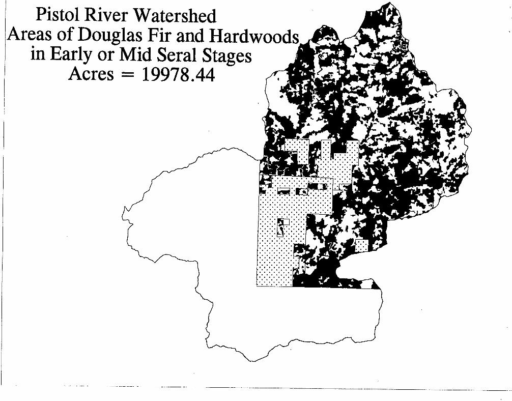
The condition of the seral stages within the watershed has been influenced considerably by past andpresent management activities on public and private lands. On National Forest lands late-seral habitataccounts for roughly 15 percent of the watershed. The acreage allocated to Late-Successional Reserve is11,298, about 17 percent of the watershed. About 40 percent of the watershed is comprised of Douglas-fir and mixed hardwoods in an early to mid seral stage. Harvest unit and hardwood conversion regen-eration efforts throughout the watershed have been successful and managed stands are thrifty. Hard-wood competition with conifers and overstocking due to natural reseeding continue to cause the need torelease and precommercial thinning in young managed stands.
There are more than 1700 acres of meadow in the Pistol River Watershed. The most notable meadowsare: Windy Valley, Snow Camp meadow, Fairview meadow, Crockett's Prairie and Gardner Ranch.Snow Camp Botanical Area is located in the Pistol River and Lawson Creek watersheds. It includes thetop of Snowcamp Mountain, Snow Camp Meadow, and Fairview Meadow in the Pistol watershed. Theflora is quite varied and the area is home to at least six sensitive plant species. Wet sites are inhabitedby species such as Carex scabriuscula and Lilium vollmeri; and dry sites by species such as Liliumbolanderi and Cypripedium californicum.
Infonnation Needs
Public and private lands outside the National Forest boundary should be inventoried to determine thecurrent vegetation composition and condition.
What are the special and unique habitats in the watershed and how are they changing?
The Pistol River watershed provides wide variety of important wildlife habitats such as old-growth,meadow, rock outcrop, pond, and riparian.
The late-successional habitat in the watershed provides important nesting habitat for the threatenednorthern spotted owl. The Southwest Oregon Late-Successional Reserve Assessment determined that 29percent of the North Chetco LSR is in a late-successional condition and 5 percent is interior LSR habitat.Roughly 27 percent of the watershed is currently suitable owl habitat and there are from 4 to 6 occupiedsites. Due to the extensive harvest activities on private land in the lower Pistol basin, old-growth stands
Pistol River Watershed Analysis, Iteration 1.0, page 7 of 17

_- __ -'- - - 1, ____ __ � _ --- _. ,
on National Forest lands are the first habitat encountered by nesting marbled murrelets. Within 6 airmiles of the Pacific ocean the late-successional habitat is the location for at least 12 known occupiedmarbled murrelet sites.
Pioneer successional habitat (grass/forb/low shrub) in the watershed is found in recent (less than 15years old) clearcut areas, meadows, open woodland areas and brushfield areas. About 22 percent (7,800acres) of the watershed on National Forest lands is currently in this habitat. The majority- of the existingclearcut areas that are functioning as pioneer habitat will grow out of this condition within the next 15years.
Within National Forest land there are about 590 acres of meadow habitat. Meadows are important areasfor native grass species and permanent forage for wildlife. Meadows provide rearing habitat forRoosevelt elk, black-tail deer, grouse, quail and neotropical birds. Nearly all the meadows in the water-shed have been grazed by cattle. Cattle still graze meadows on private land in the lower basin.The majority of sensitive plants within the watershed are in areas with serpentine soils. These soils areinhabited by a large number of fruit bearing plants such as coffeeberry, red huckleberry and indian plum,important to wildlife for forage.
Open meadow areas are being reduced in size by tree encroachment. Bogs, springs, ponds, and lakes arebeing encroached at a slower rate; some ponds and lakes are filling in with silt and vegetation. Openserpentine areas are being encroached by conifers and hardwoods.
Information Needs
Identify areas of talus habitat for Del Norte salamander that need protection. Identify and buffer largerock outcrops that may be peregrine falcon nest habitat.
Management Opportunities
Maintain and restore open meadows, open serpentine areas, and pond sites. Treatment options includegirdling or cutting and removing encroaching trees in bogs, springs, and meadows; cutting encroachingtrees in serpentine areas; burning meadows and open serpentine areas; cleaning out pond sites by re-moving silt and overgrown vegetation; and conducting protocol surveys for talus habitat in all proposedproject areas.
Table 5: Priority Habitat Treatment AreasHabitat Type LocationMeadows Snow Camp Meadow, Windy Valley Meadow, Derringer Meadows, Crockett Prairie,
Meadow Creek Meadow, Sunrise Creek Meadows, Hazel Camp Meadows, NorthFork Pistol Meadows
Open serpentine areas Snow Camp Mountain and Botanical Area, North Fork Pistol, Upper East Fork PistolBogs and springs Flycatcher Springs, Snow Camp Mountain, North Fork, Upper East ForkPonds and lakes Panther Lake, Snow Camp Meadow Area, Elko Pond, and unnamed ponds near Forest
Roads 1407210, 1503030, 1503037, 3680360, and 3680361Large rock outcrops Snow Camp Mountain, Windy Valley, Upper East Fork, Upper Pistol, Forth Fork Pis-
tol, Stack Yards, Hog MountainTalus habitat Throughout all Matrix Land Allocation
Pistol River Watershed Analysis, Iteration 1.0, page 8 of 17

Where are snags and large down wood lacking in the watershed?
Large hardwoods and conifers, snags, and large down wood are at reduced levels in managed standsthroughout the watershed on federally owned as well as privately owned land. Agricultural and residen-tial areas that have been cleared also have reduced levels of these components.
Management Opportunities
Treat stands to retain and develop large trees, down wood, and snags throughout the watershed. De-velop snags in areas adjacent to managed stands lacking snag and large woody material habitat. Recruitsnags and large down wood in natural stands lacking this habitat component. Priority locations arethroughout the watershed, especially in the lower Pistol, South Fork Pistol, Upper Pistol, and areas adja-cent to privately owned land.
Treatments could include:. Creating snags and down wood in areas adjacent to managed stands in the short term, and within
managed stands in the long term, by selecting trees with larger or faster growth, or defect.. Thinning in managed stands to grow larger trees for snag recruitment.* Identifying green tree retention areas which provide protection for existing snags.
How is road density affecting habitat capability for deer and elk?
Road density in the Upper Pistol portion of the watershed is 4.24 miles per square mile. Road density inthe Meadow Creek portion of the watershed is 2.80 miles per square mile. The East Fork subwatershedis mostly near or below 2.0 miles per square mile. Other subwatersheds contain road densities greaterthan the desired 2.0 miles per square mile.
Management Opportunities
Maintain or reduce road density to 2.0 miles per square mile or below to reduce harassment or distur-bance to elk by vehicular traffic. This could be accomplished by closing existing and newly constructedroads to vehicle traffic. Priority locations are Upper Pistol, Meadow Creek, North and South Fork Pistolsubwatersheds.
What proposed, endangered, threatened or sensitive (PETS) species, both flora and fauna, arepresent?
Several species of sensitive wildlife are present throughout the watershed. PETS plant species are lim-ited in the watershed mainly to Botanical Areas and serpentine habitat, and isolated sites. Spotted owlshave been recorded for eight know sites. Murrelets occupy 12 known stands and have been detectedwithin the watershed at other locations. Del Norte salamander sites (and habitat) are common through-out the watershed. Red-legged frogs and pond turtles have been documented. Plecotus (big-eared bats)are suspected. Habitat for peregrine falcon is present; none have been documented. Kingsnakes havebeen documented on the 3680 road and may occur elsewhere in the watershed. Other PETS wildlifespecies are not expected to occur in the watershed. The East Fork and Meadow Creek portions of thewatershed are a Late-Successional Reserve for northern spotted owl and late-successional related spe-cies.
Pistol River Watershed Analysis, Iteration 1.0, page 9 of 17

The East Fork Pistol and areas in the North Fork Pistol are important areas of habitat for both spottedowl and marbled murrelet due to the lack of habitat for these two species on adjacent private lands, andclose proximity to the ocean (murrelets).
Management Opportunities
Maintain or increase populations of sensitive plant and animal species within the watershed. Increasehabitat capability for some species (i.e. spotted owl) within the late successional reserve by developingpotential habitat into suitable habitat. Maintain known sensitive plant sites and Del Norte salamandersites. Avoid disturbance to sensitive species sites and individuals. Priority locations are known sensi-
tive species sites in the watershed, and potential habitat areas for spotted owls, marbled murrelets, Del
Norte salamanders, and peregrine falcon.
What stands need treatment for forest health and late-successional habitat?
Some stands, both managed and natural, are overstocked. Competition from hardwoods and conifers iscausing slower development of younger stands. Older forest and interior forest habitat is fragmentedinto small patch sizes. Some older forest habitat is not functioning as interior forest habitat because ofsmall patch size and edge effect.
Management Opportunities
Accelerate growth and development of early and mid seral stands into late seral stands. Increase patchsizes of older forest and interior forest habitat by developing adjacent early and mid seral stands into late
seral stands. This could be accomplished by thinning and manual release of younger stands, and pre-scribed underburning in areas adjacent to older stands to reduce competition and fuels. Priority loca-tions are:. Areas in close proximity to older forest and interior forest habitat patches in the North Fork Pistol
and Sunrise Creek drainages* Managed and overstocked natural stands
. Late successional reserve in the East Fork and Meadow Creek portions of the watershed.
Are habitat connections between watersheds and late-successional reserves being maintained?
Habitat connection corridors have been identified for some of the subwatersheds (Upper Pistol, NorthFork Pistol, Sunrise Creek, Meadow Creek, East Fork Pistol). Connection corridors are still needed forthe remaining subwatersheds and with private and BLM lands. Both current and future proposed con-nections need identification, development, and maintenance.
Information Needs
Identify and establish current connections using suitable habitat types. Identify and establish future pro-posed connections using potential and suitable habitat types. Identify areas for improvement of theseconnections.
Pistol River Watershed Analysis, Iteration 1.0, page 10 of 17

Management Opportunities
Establish a network of habitat connection corridors, both current and future, between all subwatershedsand land ownerships, by developing current habitat conditions into suitable habitat connections contain-ing mid to late seral vegetation. Priority areas for connections are:* Between private and federal lands* Between North Fork, Sunrise, South Fork and Lower Pistol subwatersheds and their adjacent subwa-
tersheds* Between the North Chetco LSR and the North Coast LSR.
How are non-native species affecting the watershed?
Noxious Weeds
Noxious weed species are not abundant in the watershed. Gorse plants once found in the watershedhave been eradicated and no new plants have been seen for several years. Tansy ragwort, pampas grass,Scotch broom, French broom, and thistles are found along mainline roads. Some sites are spreadingalong spur roads. Meadows have a higher susceptibility to some weeds.
Management Opportunities
Reduce the spread of noxious weeds by cutting, pulling, or burning plants along roads; closing spurroads not currently needed for management; and cleaning heavy equipment before entering the Forest.
Port-Orford-cedar Root Disease
The Pistol River watershed, along with the adjacent Collier Creek, Lawson Creek, Hunter Creek andChetco River watersheds, contains Port-Orford-Cedar stands that are infected with Phytophthora latera-lis. Sites infected are; the East Fork Pistol and Cedar Creek, beginning in a small tributary off road1407; the North Fork Pistol and many of it tributaries that originate near road 1703 and its spurs; themainstem of the Pistol River below the National Forest Boundary; and two isolated sites near roads3680.340 and 3680.360 near Snow Camp Meadow. In addition to seasonal and permanent road closureswithin the watershed, portions of roads 1376 and 3680 have been sanitized to reduce the risk of furtherinfection.
Management Opportunities
Reduce the risk of spread, and maintain or restore healthy Port-Orford-cedar in riparian reserves. Prior-ity locations for protection are Windy Valley, Snow Camp Mountain and Meadow, Road 1376, and theupper mainstem. Treatment options include:
* Cut Port-Orford-cedar from edges of roads.* Close roads not in current use.
* Clean heavy equipment before entering these areas.* Restrict road use to dry season.* Use uninfested water for firefighting and other uses.
Pistol River Watershed Analysis, Iteration 1.0, page 11 of 17
* Place surface rock on segments of infested roadways.* Plant and release Port-Orford-cedar on lower risk riparian microsites.
White Pine Blister Rust
Blister rust, a non-native disease affecting five-needle pines, was introduced into North America in1911. Locally it affects western white pine and sugar pine. On Snow Camp Mountain humidity levelsfavorable to the disease have caused heavy white pine mortality. The limited, scattered sugar pine in thewatershed is being killed by competition, blister rust, and mountain pine beetle.
Management Opportunities
Reduce the rate of spread of the disease, and maintain healthy stand components of five-needle pines bycutting dense hardwoods and conifers around sugar pine and white pine, underburning to reduce the riskof fire damage from dense fuels, and planting resistant stock. Priority locations are Snow Camp Moun-tain and scattered sugar pine sites.
SOCIAL ASPECTS NARRATIVE
What were the prehistoric uses of the watershed?
Known human uses of the Pistol River watershed began with Chetleshin band of the Tututni. Generally,Tututni bands lived in large, permanent winter villages established along coastal areas and rivers. Sea-sonally, inhabitants would leave the lowland villages for the upland areas to procure a variety of plantfoods, other plant products and material for the production of stone tools. Big game hunting, possiblyincluding drives using fire and pit traps, was also an upland occupation. Seasonal upland camps havebeen found in the watershed. Archeological evaluation has determined that upland sites were used ap-proximately 4000 to 2000 years before present.
What were the historic uses of the watershed?
The first euroamerican settlers were miners who came to the area in the 1850's. Following or ac-companying the miners were early settlers, farming in the flat lands along the rivers and major creeksand grazing cattle and sheep in the surrounding hills. Primary settlement was near the mouth of PistolRiver, just as the Tututni had settled previously. Two meadow complexes have been used historicallyand currently for grazing. These areas are in private ownership and called Gardner Ranch and MillerRanch (also known as Crockett's Meadow). Some of the earliest maps (1919) show Gardner and Millerin the Pistol watershed. The Pistol River Cattle Allotment has 34 cow/calf pairs and has been underpermit since 1984.
Currently the flat lands near the mouth of the Pistol River are occupied by residences and ranches. Themiddle portion of the watershed is primarily owned by private timber companies. The upper portion ofthe watershed is primarily National Forest ownership. Timber commodity production has been an im-portant human use of the middle and upper portions of the watershed since World War II.
Pistol River Watershed Analysis, Iteration 1.0, page 12 of 17

---
What are the major recreational uses and where do they occur in the watershed?
The primary recreational activities which occur at this time are hunting and dispersed camping, fishing,sight-seeing, firewood gathering, and hiking, with swimming along the lower mainstem. The level ofrecreational use is not known.
Which roads are needed for future access in the watershed and which roads need treatment toprotect the resources of the watershed?
Roads under Forest Service jurisdiction are listed in the Appendix. An interdisciplinary team catego-rized these roads according to the level of access they provide. Primary and Secondary roads are neededfor future access in the watershed. Candidate roads do not provide access needed for administration ormanagement of the forest, and may be eligible for decommissioning if an access need does not surfaceduring public scoping.
Roads and stream crossings have not been inventoried to determine potential resource risks.
No data are available on the year the roads were built. Some private roads could have been built forhomesteads in 1900. Public roads were built between 1950 and 1975.
Table 6: Pistol River Watershed Road Summary (FS Jurisdiction)Number of Roads Total Miles Closed Miles Miles to be Closed Total Closed Miles
89 111.65 1.68 9.60 11.28 (10%)
Information Needs
Identify roads that are high priority for stormproofing or decommissioning.
Management Opportunities
One watershed restoraton opportunity identified for aquatic resources is stormproofing Road 1703101.
Pistol River Watershed Analysis, Iteration 1.0, page 13 of 17

References
Dott, R.H., Jr., 1971. Geology of the Southwestern Oregon Coast West of the 124th Meridian. Univer-sity of Wisconsin, Madison, Wisconsin.
Fillmore, Mathew. In Press. Curry County National Cooperative Soil Survey.
Harr, R. D. 1976. Forest Practices and Streamflow in Western Oregon. USDA Forest Service GeneralTechnical Report 49. Pacific Northwest Research Station.
Irwin, William P., 1966. Geology of the Klamath Mountain Province. Geology of Northern California,California Division of Mines and Geology. Bulletin 190, E.H. Bailey, ed.
Jones, R. and T. Ferrero. 1990. Slope Stability, Soil and Geology, Upper Pistol Project Area, CurryCounty, Oregon. Contract mapping and report for Siskiyou National Forest.
Nehlson, Willa, Jack E. Williams, and James A. Lichatowich. 1991. Pacific Salmon at the Crossroads:Stocks at Risk from California, Oregon, Idaho, and Washington. Fisheries 16:2.
ODFW. 1991. Summer water temperature data on Pistol River. Gold Beach District Office.
ODFW. 1992. Status of Anadromous Salmonids in Oregon Coastal Basins.
Russell, Periann. 1994. Sediment Production and Delivery in Pistol River, Oregon and its Effect on PoolMorphology. Masters Thesis, Oregon State University.
USDC National Marine Fisheries Service. 1995. Endangered and Threatened Species, Proposed Statusfor Southern Oregon and Northern California Steelhead. Federal Register 60(51):14253.
Walker, George W. and Norman S. MacLeod. 1991. Geologic Map of Oregon, USDI, USGS.
Pistol River Watershed Analysis, Iteration 1.0, page 14 of 17

Pistol River Watershed Road ListRoad No. Segment Length Maintenance Classification
Level1600070 2.43 * 2 S1703000 from Forest boundary to 1503 6.00 * 2 S
100 from pvt to 1703 2.32 * 2 S108 0.83 * 2 S101 1.62 * 2 S102 0.26 * 2 C103 0.13* 2 C110 1.61* 2 S114 0.80* 2 S115 0.08* 2 Cspur-I 0.20* 2 C120 0.76* 2 S122 0.12* 2 C150 2.00* 2 S156 1.09* 2 S158 0.16* 2 C159 0.11* 2 C190 1.73* 2 S
1601010 1.12 * 2 S1503030 8.03* 2 S
030 1.35* 1 C031 0.10* 2 C032 2.81* 2 Sspur-2 0.20* 2 C033 0.36* 2 C035 1.93 * 2 S036 0.34 * 2 S037 0.28 * 2 C038 0.41 * 2 S039 0.33* 1 C931 0.19 * 2 5
1503050 6.61* 2 S052 1.48 * 2 S525 0.20 * 2 C053 1.12 * 2 C055 0.46 * 2 C056 0.14 * 2 C057 1.52 * 2 S058 1.00* 2 C059 0.20 * 2 S
1503000 from 070 to 3680 1.00 * 3 P070 1.65 * 2 S072 0.50 * 2 C073 0.11 * 2 S
3680300 0.55 * 2 S=0.3C=0.25
310 4.74 * 2 S=4.45C=0.29
311 0.58 * 2 S312 0.84 * 2 S313 0.62 * 2 S314 0.83 * 2 S316 1.70 * 2 S
Pistol River Watershed Analysis, Iteration 1.0, page 15 of 17
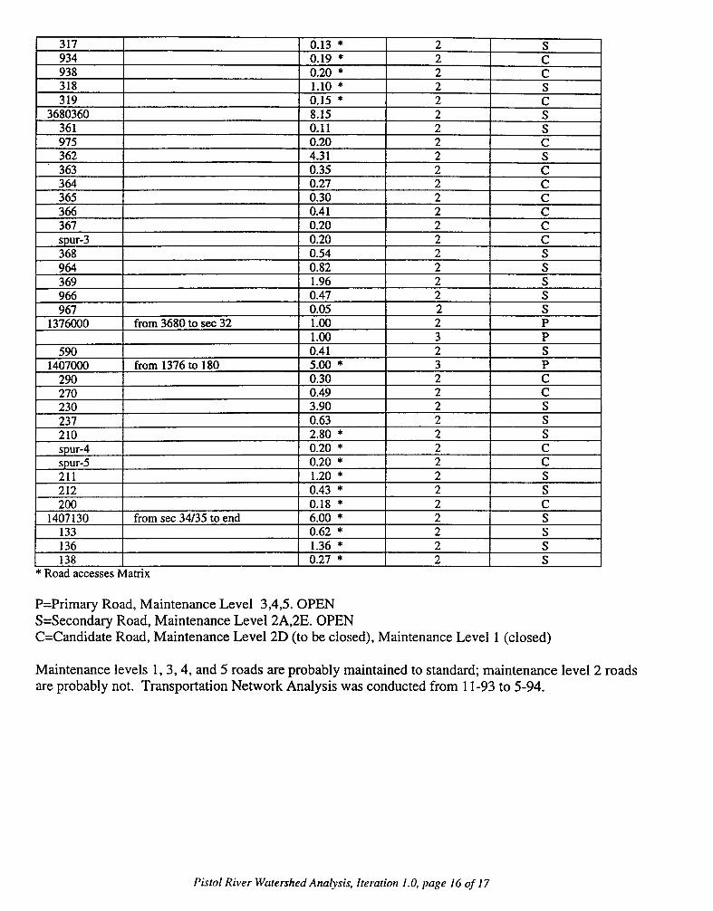
317 0.13 * 2 S934 0.19 * 2 C938 _________ 0.20 * 2 C
318 _ _ _ _ _ _ _ _ _ 1.10 * 2 S
319 _ _ _ _ _ _ _ _ _ 0.15 * 2 C
3680360 _ _ _ _ _ _ _ _ _ _ _ __ 8.15 2 S
361 __ _ _ _ _ _ _ _ _ _ _ _ 0.11 2 S
975 0.20 2 C362 4.31 2 S363 0.35 2C364 0.27 2 C365 0.30 2 C366 0.41 2 C367 0.20 2 Cspur-3 0.20 2C368 0.54 2 S964 0.82 2 S369 1.96 2 S966 0.47 2 S967 0.05 2 5
1376000 from 3680 to sec 32 1.00 2 P__________ ~~~~~~~~1.00 3 P
590 0.41 2 S1407000 from 1376 to 180 5.00 *3 P
290 0.30 2 C270 0.49 2 C230 3.90 2 S237 0.63 2 S210 2.80* 2 Sspur-4 0.20* 2 Cspur-5 0.20 * 2 C211 1.20 * 2 S212 0.43 * 2 S200 0.18 * 2 C
1407130 from sec 34/35 to end 6.00 * 2 S133 0.62 * 2S136 _ _ _ _ _ _ _ _ _ 1.36 * 2 S
138 0.27 * 2 5*Road accesses Matrix
P=Primary Road, Maintenance Level 3,4,5. OPENS=Secondary Road, Maintenance Level 2A,2E. OPENC=Candidate Road, Maintenance Level 2D (to be closed), Maintenance Level 1 (closed)
Maintenance levels 1, 3, 4, and 5 roads are probably maintained to standard; maintenance level 2 roadsare probably not. Transportation Network Analysis was conducted from 1 1-93 to 5 -94.
Pistol River Watershed Analysis, Iteration 1.0, page 16 of 17

Port Orford
I
PISTOL RIVER WATERSHED
KPow rin
Vicinity Map
Goid BOfh RD 01M
Chft~o Ro/
bus a_ ~~~~~~~~~~~~~~~~0 10 20 MilesL 6=mmmmmml
8/5/98 CR
PISTOL RIVER WATERSHED
Ownership
LIEl
National Forest
PrivateBureau of Land ManagementState of Oregon
8/598 CR

PISTOL RIVER WATERSHED
Management Area
m1 F
BotanicalUnique InterestBackcountry RecreationLate Successional ReserveSpecial Wildlife SiteRiparian ReserveMatrixnot National Forest
LiEli
8/5/98 CR

PISTOL RIVER WATERSHED
Geologyintrusive IgneousOtter Point sedimentsultramafics
z] Dothan sedimentaryDothan volcanicsMyrtle sedimentaryCretaceous sedimentary
z Quaternary alluvium1 dune sand
Liii landslide depositsz Colebrooke schist
8/5/98 CR

ffi -o k- , - - - - --- -1-.---.--
PISTOL RIVER WATERSHED
Fish Distribution/ ) &J A FFall Chinook, Searun cutthroat,
Winter steelhead, and Residents
Winter steelhead, Searun cutthroat,/ V t Am t w and Residents
Resident cutthroat and rainbow
8/5/98 CR

PISTOL RIVER WATERSHED
Streams(streams in SW portionof watershed not shown)
Roads
Managed Standson National Forest lands
........... National Forest lands
8/5/98 CR

Pistol River WatershedSuitable Owl HabitatAcres
Note: Data derived from PMR polygon data.Codes 15-19, 22,25,26,28,29,31,32,34 and 39in the cdc sizest field were consideredsuitable habitat.Ultramafic Soils were not considered suitable habitat.
7-
Pistol River WatershedAreas of Douglas Fir and Hardw
in Early or Mid Seral StagesAcres =
---

I I
Pistol River WatershedSpecial Wildlife Sites
a.24
_ .
X klugfs0 4.20
R YIUe tt 041 .1Xtop ad 2$ ~~'."0
I' s_ ___Oo1
_ Rock Bluffs_ Lakes and Ponds_ Swamps, Springs, Waterholes
I

Pistol River W~atershedVegetation Types inRiparian Reserves
conifer 4298.3500 56.871hardwoods 1394.2000 18.451meadow 76.5500 1.011other 1756.7100 23.241ultramafic 31.8300 0.4--O.
Vegetation Types=Conifer
Hardwoods=Meadow
OtherUltramnafic areas
=ZI Private Land withinForest Boundary

PISTOL RIVERM.P. 0 TO 12
2000
.i
1500
LU]LL
z
0
LU
LI
I.
1000
500 j t ~~~~~~~~~~~~-j I I
I T "lA Iq~
I 4°
_ 0o10l 0, o3q0
0 2 4 6 8 10 12
DISTANCE (MILES)
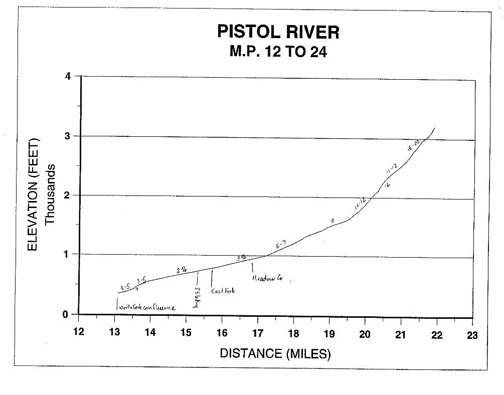
PISTOL RIVERM.P. 12 TO 24
4
3
LU
z0
LUJ-I
LU
M,
a
Cl)
02
1
0
12 13 14 15 16 17 18 19 20 21 22 23
DISTANCE (MILES)

PISTOL RIVER4
3
wwLL
z0
w
Cl)
CZU)
0
F-
2
1
0
0 5 10 15 20 25
DISTANCE (MILES)

GLADE CREEK2000
1500
ILU-z0
ww
1000
500
0
0 0.5 1 1.5 2 2.5 3
DISTANCE (MILES)

DEEP CREEK2000
ILwwLL
z0
w-jw
1500
1000
500
0
0 0.5 1 1.5 2 2.5 3
LENGTH (MILES)

SOUTH FORK PISTOL4
3
Rw
z0
-ju
2)
-0a?
F-
2
1
0
0 2 4 6 8 10 12
DISTANCE (MILES)
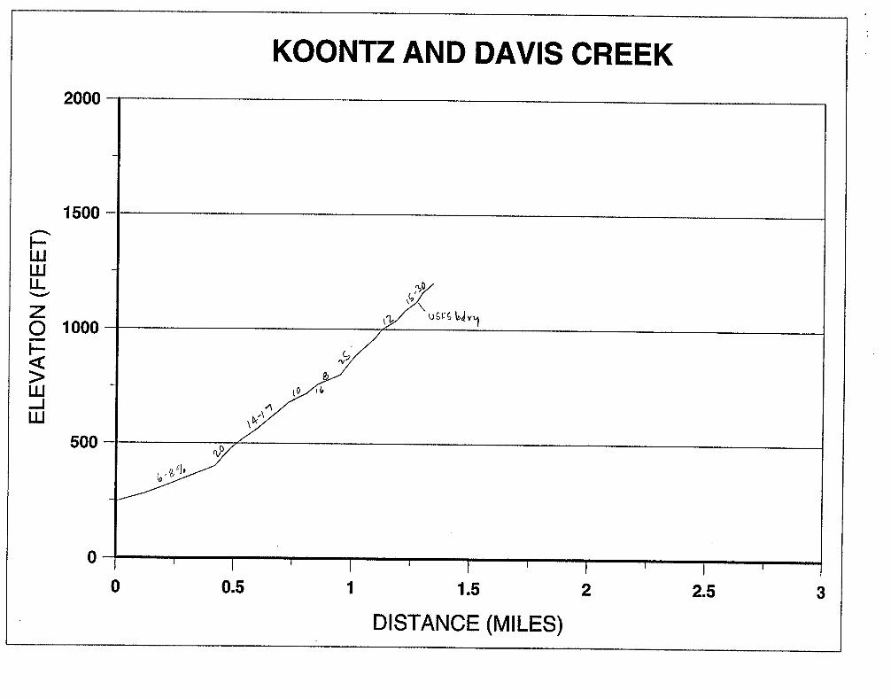
KOONTZ AND DAVIS CREEK2000
1500
LU
LL
z0
uj
1000
500
0
0 0.5 1 1.5 2 2.5 3
DISTANCE (MILES)

SUNRISE CREEK4
3
LLJLuLL
z0
-2uj
ciC
0F-
2
1
0
0 1 2 3 4 5 6
DISTANCE (MILES)

NORTH FORK PISTOL4
3
F-PLUILLL
z0
F-
LU
en
"o
V
U)
02
1
0
0 1 2 3 4 5 6 7 8 9
DISTANCE (MILES)

ELE
VA
TIO
N (
FEE
T)Th
ousa
nds
r X
-~
~~
~~
~~
~~
~-
m 4~
~~~~
h~
z
A
% ~~
~~~z
rn)
zl
A~
~~
~M
C)
CD
-L 0D

MEADOW CREEK4000
3500
ILU-z0
wUJ
To
3000
2500
2000
1500
1000
500
0 0.5 1 1.5 2 2.5 3
DISTANCE (MILES)