Pingkan Peggy Egam - saga-u.ac.jpportal.dl.saga-u.ac.jp/.../1/youshi_summary_pingkan.pdfCOMMUNITY...
161
COMMUNITY REHABILITATION SCENARIO PLANNING FOR AN ETHNIC SETTLEMENT PRESSURED BY CITY DEVELOPMENT September 2014 Department of Science and Advanced Technology Graduate School of Science and Engineering Saga University JAPAN Pingkan Peggy Egam
Transcript of Pingkan Peggy Egam - saga-u.ac.jpportal.dl.saga-u.ac.jp/.../1/youshi_summary_pingkan.pdfCOMMUNITY...
COMMUNITY REHABILITATION SCENARIO
PLANNING FOR AN ETHNIC SETTLEMENT
PRESSURED BY CITY DEVELOPMENT
September 2014
Department of Science and Advanced Technology
Graduate School of Science and Engineering
Saga University
JAPAN
Pingkan Peggy Egam

COMMUNITY REHABILITATION SCENARIO
PLANNING FOR AN ETHNIC SETTLEMENT
PRESSURED BY CITY DEVELOPMENT
By
Pingkan Peggy Egam
A Dissertation submitted in partial fulfillment of the requirements
for the degree of Doctor of Architecture and Urban Design
Department of Science and Advanced Technology
Graduate School of Science and Engineering
Saga University
JAPAN
September 2014

EXAMINATION COMMITTEE
Prof. Nobuo MISHIMA (Chairman)
Graduate School of Science and Engineering
Saga University, JAPAN
Prof. Masaru KIYOTA
Graduate School of Science and Engineering
Saga University, JAPAN
Assoc. Prof. Ryutaro GOTO
Graduate School of Science and Engineering
Saga University, JAPAN
Assoc. Prof. Yoko TAGUCHI
Graduate School of Science and Engineering
Saga University, JAPAN

ACKNOWLEDGMENT
All praise and respect I give to Lord Jesus Christ, because of His Blessings to me,
especially to give me the opportunity to continue my study until the end of this research.
Highest appreciation I give to the supervisor Prof. Dr. Eng. Nobuo Mishima. With a
sincere heart he guided, supported, and gave attention in the proccess of my study, so I can
finish this dissertation. I also give my gratitude to the examination comitee of this
dissertation: Prof. Masura Kyota, Assoc. Prof. Ryutaro Goto, and Assoc. Prof. Yoko Taguchi.
Special thanks to Sam Ratulangi University and to the Faculty of Civil Engineering
especially for Architecture Department that let me to continue my study in the level of
Doctoral Program at Saga University, Japan.
In this opportunity I give my appreciation to the Government of Indonesia for giving me
DIKTI scholarship, because without that financial support, it would be impossible for me to
continue my study. Thanks to Dr. Petter Assa to introduced me to my supervisor. Thanks to
all friends from Mishima laboratory since 2011 – 2014, for their kindness and friendliness
during study especially to Naomi Miamoto, Anai Suoichiro, and all friends.
Thank you to the Bantik residents in Malalayang, Indonesia, Organization of Bantik
custom, custom leader, and the government of Malalayang District, Malalayang 1 East,
Malalayang 1 West, and Malalayang 2, for giving me permission to conduct research at the
location from 2011 – 2014. I also do not forget to give my thanks to Kohei Takayama as
partner in my research from August– September 2014, and to everyone that have helped me.
With respect and greatitude I give my thanks to my lovely mother, Neltje Moray and my
lovely father, Jotje Egam even though he is not with me right now because he has been in
Heaven. Because of you, I exist in this world and in my mother’s prayer, my name is always
mentioned. Also to all of my sister, Joice, my brother, Maxi, and my big family that always
support me.
Thank you to my husband, Arthur Harris Thambas. With love, I say thank you to my
sweetheart three daughters: Tasya, Tabita, and Tesa. My daughthers are my inspiration and
my spirit, because of you I can be survive until today.

ABSTRACT
Recently, many of the tribal communities in the world are influenced by urbanization and
their unique cultures are changing. Indonesia is a multi-tribal country with approximately
13.480 island and 740 ethnics (Hanifah, 2013). Most of inhabited islands in Indonesia are
composed by tribal, except in Java Island. Therefore, the diversity of cultures become the
essence of Indonesia. Nevertheless, it as a challenge to keep the unique cultures because of
immigration and blood mixing caused by urbanization.
This study clarifies and proposes a scenario planning, useful for a community
rehabilitation in tribal settlement facing urbanization, considering its cultural, social and
spatial issues. A model tribal settlement this study is Bantik tribal settlement which in along
the coast in Malalayang district Manado city, in the North Sulawesi, Indonesia.
The Bantik tribal community is under pressure influenced by city development,
particularly the influx of immigrants occupying the settlement area. Scenario planning is
completed through a series of analysis consists of; 1) the social dynamics include the impact
of urban development with the population changes, 2) the traditional activity and cultural
heritage. This analysis covers the distribution of cultural heritage in the implementation of
their activities, distance of culture heritage element to the main street and residential
surrounding, and 3) the community perception, includes understanding the public perception
of the existing and aspiration of the Bantik community and their continuity.
Primary data were obtained through field surveys, and secondary data were obtained
from relevant source of maps. Field surveys were carried out in 3 stages: pre-survey in
August 2011, to get an idea of the initial location of the study. The first field survey is
conducted from March to April 2012, to see the details of the problems in the field. The
second field survey is conducted from August to September 2013. Last stage is correspondent
survey conducting from January to April 2014. The data consist of: 24 samples of residents
moving; 32 samples of houses to establish community space; 105 interviewed respondents of
Bantik residents based on category, physical settlement surrounding, and culture heritage site.
Based on the analysis results this study concludes that:

1) The effect of high growth of population is based on the city policy causing a shift in
the settlement function into commercial function. This study also proves there are some
conditions that the local Bantik community experience which are: a) The growth of non-
Bantik community are significantly high whereas the Bantik community tends to be b) The
life needs of the residents, which become a boosting factor to the physical change. c) Attitude
conversion base on local culture.
2) Traditional activity. Development of traditional activity has relation to the effect of the
city and housing development. Traditional activity development comes from the change of
traditional house from stage (rumah panggung) to non-stage house form.
3) Cultural space is created from the relationship between physical space and objects,
cultural activities, and the surrounding space. Three approaches to cultural planning are
needed in the ethnic community that is: 1) planning of three cultural heritage zones, a
promotion zone, a core zone, and a buffer zone; 2) optimizing the relationship between the
society and the indigenous organization to promote cultural respect; and 3) strengthening the
coastal zone.
4) Community perception interprets that change phenomenon that are divided into three
themes, as follows: a) Life style change, b) social-mix and the loss of culture, particularly the
Bantik language, c) perception of physical change of settlement through the conversion of
religion function. The Analysis shows around 62.88% of society agreed with the change and
about 20% are disagreed. Pillar of sustainability is possibly to be done by maintaining the
traditional role through neighborhood activity, because the role of external factor such as
government interference, the influx of non-Bantik residents or other factors are possible to be
anticipated by the internal Bantik community as long as there is openness of adaptation
without leaving the local identity.
Scenario planning strategy is rooted in neighborhood units through the boundaries of
social, cultural and physical. While social relations perspective is a referral strategy that will
unite the community as a counter traditional planning effectiveness in maintaining local
community. There are three reasons to create neighborhood relations unit, namely: 1) Family
relationships, 2) proximity of neighborhood units, and 3) family interest. Terrace surrounding
spaces are very close relationship with the boundaries of space, time and activity that forming
gathering spaces.

In detail, community rehabilitation scenario planning can be described as follows:
1). Keep the ethnic community through social planning, activity planning and culture
heritage site planning base on local population by using street development strategy, house
development process strategy, family activity strategy and community perception strategy.
2). Scenario planning is achieved through the aspect of unity between the community
condition, residential surrounding, and commercial function. Through the movement steps of
non-Bantik resident that come into the settlement location, the perception of the local society
is changing.
3). In the relation with the community and social interaction, scenario planning is
directed to the inter neighborhood unit distance in the settlement with classification: Inter
neighborhood unit distance < 250 m as a neighborhood zone, 250–500 m as a community
zone, and >500 m as a custom zone.
4). Community rehabilitation scenario planning is made through the relation with the
culture heritage site with the classification: a) Core zone historical-base of the Minanga Street
surrounding location, b) core zone community-base of the Krida Street surrounding location,
c) buffer zone of the out of Minanga and Krida Street surrounding location and d) promotion
zone in the location of the main street of Wolter Mongisidi Street.
5). Related to the community-base, scenario planning is directed to the local
community’s support to appreciate more to the local culture towards attitudes and also to
group community organization based on family group location, local organization, and
custom with the spirit of Bantik philosophy.
Scenario planning is a strategy that is needed in maintaining the continuity of ethnic
community through the community rehabilitation with the concept of custom activities,
cultural zone, and neighborhood space continuity. The methodology that I made for a
scenario planning is useful for implementing community rehabilitation for a tribe settlement.
I, therefore, conclude that the scenario planning will be very useful to the Bantik community.
Although scenario planning maybe can not applied to the other ethnic community because
there is a limitation caused that I conducted only one model community, but at least this
method can be applied to the other ethnics that possess similar problem.

CONTENT
CHAPTER TITLE PAGE TITLE PAGE
ACKNOWLEDGEMENT
ABSTRACT
LIST OF CONTENTS
LIST OF FIGURES
LIST OF TABLES
CHAPTER 1 INTRODUCTION 1
1.1 Background 1
1.2 Problem statement 3 1.3 Objectives 4 1.4 Method 5 1.5 Scope of study and research contributions 8 1.6 Literature review 8 1.6.1 History of Bantik Tribal 7 1.6.2 History of Malalayang 9 1.6.3 Government system 12 1.6.4 Livelihood 12 1.6.5 Culture and religion 12 1.6.6 Ethnic Community 13 1.6.7 Community rehabilitation 14 1.6.8 Scenario Planning 14
1.6.8.1 Community Planning 14 1.6.8.2 Social-Mix 15 1.6.8.3 Neighborhood relationship 15 1.6.8.4 Family activity planning 15 1.6.8.5 Custom participatory planning 17 1.7 Dissertation outline 17
CHAPTER 2 OUTLINE OF MODEL AREA 19 2.1 Location of study area 19 2.2 Existence of settlement 24 2.2.1 Settlement surrounding 24 2.2.2 Area Function 28 2.3 Social-Culture 28 2.3.1 Population 28 2.3.2 Leadership system 31 2.3.3 Community activity 31

2.3.4 Local language and philosophy
32
CHAPTER 3 RESIDENTS PERCEPTION 33
3.1 Background 33 3.2 Method 33 3.3 Sense of neighborhood condition 34 3.4 Understanding of community change 35
3.5 Pillar of Bantik community likes 37
3.6 Bantik needs construction 38 3.7 Discussion 46 3.8 Conclusion 48
CHAPTER 4 ANALYSIS OF CULTURE HERITAGE 49
4.1 Background 49
4.2 Method 51 4.3 Period of culture heritage in the Bantik community 52 4.3.1 Culture heritage of the Bantik as an Alifuru
community
52
4.3.2 Culture heritage after the influence of
christianity
53
4.3.3 Culture heritage under the influence of urban
pressure
53
4.4 Condition of culture heritage influence of W.
Mongisidi Street
54
4.4.1 Distance of W. Mongisidi Street from the
culture heritage site
54
4.4.2 Position of culture heritage in the settlement 56
4.4.3 Effectiveness culture heritage site 56 4.4.4 Distance culture heritage site from the main
street
57
4.4.5 Culture heritage value 58 4.5 Discussion 59
4.6 Conclusion
60
CHAPTER 5 ANALYSIS OF USUAL COMMUNITY
SPACE
62
5.1 BACKGROUND 62 5.2 Method 63 5.3 Issue of Bantik people changes 64 5.3.1 Bantik population growth 64 5.3.2 Bantik community view to the city
development
65
5.3.3 Variety of people 66 5.4 Issue of settlement changes 67

5.4.1 Process of Bantik settlement changes 67 5.4.2 Location of residential moving 69 5.4.3 The changes of regional function 72 5.5 Traditional life of the Bantik community 74 5.5.1 Bantik family development 75 5.5.2 Characteristic activities of Bantik family 78 5.5.3 History of land ownership 78 5.5.4 House composition 81 5.5.5 House characteristic 81
5.6 Neighborhood activity 85 5.6.1 Activity in the terrace surrounding 86 5.6.2 Activity in the little shop surrounding 87
5.7 Discussion 90 5.8 Conclusion
91
CHAPTER 6 DEVELOPMENT OF COMMUNITY
REHABILITATION SCENARIO
PLANNING
92
6.1 Background 92 6.2 Method 92 6.3 Family activity planning approach 94 6.3.1 Group family development 94 6.3.2 Local access in the neighborhood unit 99 6.4 Culture heritage site planning approach 109 6.4.1 Relationship between culture space with the
Bantik community
108
6.4.2 Structure of culture heritage objects zone 108
6.5 Custom planning approach 110 6.5.1 Bantik’s philosophy as a as a unifying
community
111
6.5.2 Strengthen of community participatory 113 6.6 The Concept community rehabilitation scenario
planning
113
6.7 Community space planning 115 6.7.1 Neighborhood space planning 115 6.7.2 Terrace surrounding planning 119 6.8 Culture heritage planning 124 6.8.1 Relationship culture heritage planning with
the Bantik community
124
6.8.2 Zone of culture heritage site planning 125 6.8.3 Strengthening of culture heritage planning 126
6.9 Custom planning 127 6.9.1 Ethnic community participation planning 129

6.9.2 Custom group planning 129 6.9.3 Custom participation planning 131 6.10 Conclusion
132
CHAPTER 7 CONCLUSION 135
REFERENCES

LIST OF FIGURES
NUMBER TITLE PAGE
Figure 1.1 Framework of research 6
Figure 1.2 Framework of scenario planning 7
Figure 1.3 Framework of scenario planning strategy 7
Figure 1.4 Framework of Bantik community changes 8
Figure 1.5 Map of Minahasa region 9
Figure 1.6 Some standard step of scenario planning 14
Figure 1.7 Amphawa’s Selected Participation Techniques 16
Figure 2.1 Map of Manado City 19
Figure 2.2 Commercial area surrounding / Boulevard area 20
Figure 2.3 Downtown surroundings 21
Figure 2.4 Map of Sub-District Malalayang I 22
Figure 2.5 Map of Sub-District Malalayang I East 22
Figure 2.6 Map of Sub-District Malalayang I West 23
Figure 2.7 Map of Sub-District Malalayang 2 23
Figure 2.8 Wide of sub-district Malalayang in the study area 24
Figure 2.9 Costal surrounding 25
Figure 2.10 Settlement performance 26
Figure 2.11 Street condition in the settlement 27
Figure 2.12 Commercial building in the W. Mongisidi Street location 29
Figure 2.13 Population in the Malalayang surrounding 30
Figure 2.14 Population in the study area 30
Figure 3.1 Framework of residents perception 34
Figure 3.2 Bantik community sense 35
Figure 3.3 Bantik community attitudes toward physical settlement
changes
36
Figure 3.4 Bantik community attitudes toward culture changes 37
Figure 3.5 Bantik community attitudes toward the Bantik population
changes
37

NUMBER
Figure 3.6
TITLE
Bantik people wants to housing surrounding
PAGE
39
Figure 3.7 Bantik people wants to settlement surrounding 40
Figure 3.8 Bantik people wants to culture heritage 41
Figure 3.9 Bantik people wants to custom organization 41
Figure 3.10 Bantik people wants to culture identity 42
Figure 3.11 Bantik people wants to neighborhood conditions 43
Figure 3.12 Bantik community perception 48
Figure 4.1 Bantik cultural heritage sites and their locations 50
Figure 4.2 Framework research of culture heritage 52
Figure 4.3 Cultural heritage objects around the coast 57
Figure 5.1 Framework research of community space 63
Figure 5.2 Distribution of Bantik population in the study area 65
Figure 5.3 Adjustment of local communities against environmental
situation
67
Figure 5.4 The process of settlement establish 68
Figure 5.5 Process of settlement development 69
Figure 5.6 Locations of Bantik house moving 70
Figure 5.7 Proximity distribution of Bantik families 71
Figure 5.8 Influence regional wroth to the settlement 72
Figure 5.9 Process of change in building function 73
Figure 5.10 Type of building function 73
Figure 5.11 Model of changes in buildings 74
Figure 5.12 Framework of neighborhood characteristic analysis 75
Figure 5.13 Family houses location 76
Figure 5.14 Structure of family number 77
Figure 5.15 Characteristics of land ownership change 79
Figure 5.16 The process of ownership and house style changes 80
Figure 5.17 Housing composition 82
Figure 5.18 Settlement composition 82
Figure 5.19 Bantik house style development 83
Figure 5.20 House style process 84

NUMBER
TITLE
PAGE
Figure 5.21 Neighborhood performance 85
Figure 5.22 Historical of terrace growth 87
Figure 5.23 Type of commercial function 88
Figure 5.24 Type of little shop base on position 89
Figure 5.25 Relationship little shop with the house 90
Figure 6.1 Framework of community rehabilitation scenario planning 93
Figure 6.2 Residential group location 94
Figure 6.3 Group family composition 97
Figure 6.4 Community activities base on neighborhood 98
Figure 6.5 Type and location of community activity 99
Figure 6.6 Resident with the additional economic function location 99
Figure 6.7 Relationship between yard with street 101
Figure 6.8 Little shop (warung) locations 102
Figure 6.9 Relationship between little shop (warung) with street 103
Figure 6.10 Relationship between terrace with street 104
Figure 6.11 Neighborhood interest aspects 105
Figure 6.12 Open access for multi direction (four houses) 106
Figure 6.13 Open access for 2 direction (three houses) 106
Figure 6.14 Open access for one direction (two houses) 107
Figure 6.15 H3 Philosophy in Bantik community 111
Figure 6.16 Custom activities 111
Figure 6.17 Bantik community responses to cultural aspects 112
Figure 6.18 Community rehabilitation concept 114
Figure 6.19 Construction of scenario planning 114
Figure 6.20 Group family location in the Minanga Street surrounding 116
Figure 6.21 Group family location in the cemetery street surrounding 116
Figure 6.22 Group family location in the Krida Street surrounding 117
Figure 6.23 Group family location in the outside in the settlement 117
Figure 6.24 Neighborhood space planning base on resident location 118
Figure 6.25 Relationship planning based on family locations 118

NUMBER
TITLE
PAGE
Figure 6.26 Relationship terrace with the sea location 120
Figure 6.27 Relationship between terrace, main street, local street with
sea location
120
Figure 6.28 Neighborhood space planning influences of warung 121
Figure 6.29 Neighborhood space and local activities 123
Figure 6.30 Structure of neighborhood relationship space planning 124
Figure 6.31 Conceptual distribution of zone considering the distance
from the main street
126
Figure 6.32 Character improvement of cultural heritage 127
Figure 6.33 Construction philosophy in the activities implementation 128
Figure 6.34 Bantik community attitude planning 128
Figure 6.35 Model of community participation 129
Figure 6.36 Custom participation planning 130
Figure 6.37 Bantik custom planning 132

LIST OF TABLES
Number TITLE PAGE
Table 1.1 History of Malalayang Village 11
Table 3.1 Sustainable pillar of the Bantik community 38
Table 3.2 Sustainable detail aspect of living traditional 41
Table 3.3 Sustainable detail aspect of neighborhood and culture
aspects
46
Table 4.1 List of cultural heritage objects 51
Table 4.2 Development of Bantik community 54
Table 4.3 Influence of the development along W. Mongisidi Street on
culture heritage sites
55
Table 4.4 Categories of culture heritage zone based on distance 56
Table 5.1 Sense of Bantik couple 78
Table 6.1 Characteristic of residential location 95
Table 6.2 Location group family theme 96
Table 6.3 Neighborhood interest 105
Table 6.4 Construction of culture heritage values 109
Table 6.5 Characteristic of custom organization 112
Table 6.6 Strengthen of community participation 113
Table 6.7 Construction of family activity 115
Table 6.8 Terrace space planning 119
Table 6.9 Neighborhood space planning 122
Table 6.10 Custom group participation planning 130

1
CHAPTER 1
INTRODUCTION
1.1. BACKGROUND
In the last few decades, sustainable is quite a popular issue. This issue develops as a
reaction to the condition that the world experiences globally, also as a form of concern and
awareness to a more substantive level. Sustainable development, which is defined as
"development that meets the needs of the presents without compromising the ability of future
generation to meet their own needs (World commission on sustainable development, 1987).
Various arguments over the meaning of sustainable development constitutes the politics of
sustainable development policymaking and draws out implication that as a term sustainable
development plays a range of analytical and rhetorical roles (Conelly, 2007). Changes in the
structure of space is often affected by government agencies and corporations in shaping and
changing capitalist urban space (Feagin & Parker, 1990; Logan & Molotch, 1987) as well as
the impact of globalization (Smith & Feagin, 1987). From an urban standpoint, understood as
a form of sustainable development of urban conservation. In the past more urban
conservation policies aimed at the protection of historic buildings, monuments and the like in
terms of physical setting (Peerapun, 2012). Currently, the term urban regeneration and social
dimensions are used to express the corresponding breath principles of the Washington
Charter (ICOSMOS, 2003). A review of the social dimension has a close relation with the
development of the city. Various potential and problems accumulated in the urban dimension
high population growth, especially in developing countries such as Indonesia.
United nations records that there are more than 370 million indigenous people in70
countries across the world. Indonesia is a country that has the largest number of people to
four of the world (CIA World Factbook 2013). Meanwhile, Indonesia diverse island nation
marked by numerous large and small islands as much as 13,480 islands. There are 740 tribes
with 583 languages and dialects (Hanifah, 2013). The protection of these tribes is not an easy
thing for the government. Large population of 250 million in 2013 (CIA World Factbook
2013) is a major problem experienced by people of Indonesia. The traditional approach is

2
crucial in optimizing the use of natural resources, (Saleh, 2004). The unbalanced ability
between human resource and acceleration of city development cause social problem in local
level. Many traditional settlements is fading while city development keeps occur with
residents growth that is hard to handle. So many tribes possessed even an indigenous people
like the Bedouins in Java island, Poenan Dayaks in Borneo island, Kubu tribe in Sumatra
island, Korowali tribe in Papua island as well as many other tribes made the issue of ethnicity
to be one important issue. Ethnicity is a combination of culture, identity and group
membership (Keefe. 1992) is at the local level, but there is occupying the central location of
residence within the limits. Ethnicity has become a prominent issue in the world in the last
four or five decades of this (Fenster, 1996). Ethnic movement is regarded as a reaction to
imperialism in the third world country (Howitz, 1985). Therefore diversity of cultures is a
essence of Indonesia.
The quantity of owned tribes causes general problem. In context of week institutional
neighborhood, resource and authority rearrangement is a challenge to the existing importance.
Phenomenon values that stick in the building process can cause social tension and conflict
that, in cases, cause violence (Bates, 2000). General situation ethnic in Indonesia happens
with some problems: different economic status, religious differences, stigmatism differences
between migrants and indigenous people and government policy. Not infrequently that the
difference is to sharp to the economic factor, with positive correlation between poverty and
violence conflict, difference, and variables measuring economic development (Barron. Et al.
2009) causing some frictions like Indonesia experienced in 1998. That time, there was a
conflict between tribes in some areas: Maluku province, west Sulawesi province exactly
around Palu and Poso city, and in Papua province. Some studies had been done to some tribes
in Indonesia like Badui tribe in java island (Asian Good ED Practice Project, 2006), studying
about continuing life of Badui tribe in finding the tribe characteristic. Generally, this study is
connected to settlement and life procedures connected to spacing and values. Even though
they are different in residence location, but as a whole, this society has similarity in character
as tribe that lives in secluded place, far from hustle and isolation tendency. So many tribes in
Indonesia that it is not a thing that is not easy to get continuity model of local ethnic
community. Settlement location of the ethnics varies. There are some in highlands, coast,
archipelago area, secluded places that is hard to reach and even in the city. Every ethnic has
own characteristic through life procedure or physical settlement setting.

3
Variety of ethnic condition causes it hard to be accommodated as a whole in a study.
But at least, settlement location uniqueness, society social structure and local problems,
scenario planning is useful to local society as method in finishing the problems with wanted
purpose. Next, this method is expected to be applied in ethnic community with same
character and problem. Among the tribes in Indonesia, there is the Bantik tribe located in
North Sulawesi Province, exactly in Manado city (Grafland, 1991), that still exists and can be
found until now. Bantik tribe in Malalayang as one of the district in Manado city (Sumolang.
2010). The Proximity between the central business district and the settlement has led to many
changes in the Bantik community (Egam, 2014). This settlement receives direct effect of city
development. This is a pressure for ethnic community comes from pressure of population
development, mixes in the settlement through marriage with the Bantik people, and even
non-Bantik people that stay around in the settlement location. Until now, the Bantik tribe
residents survive in the middle of city development but has experienced some changes that
tend to weaken the local community continuance. Uniqueness in this study are: 1) The Bantik
tribe settlement in Malalayang, Indonesia is local settlement in urban location setting, based
on the close distance with city commercial area center, 2) The Bantik community is local
society and not newcomers (Sumolang, 2010) that stays in Manado city. Strength that is
owned in this study are: 1) based on literature, this research related to the focus of the Bantik
residents in Malalayang with suppression of sustainability aspect of community in receiving
city pressure as the first research is conducted. Study with focus of the Bantik tribe residents
in Malalayang had been done by researcher in 2002-2003, with suppression of spatial aspect
change based on building function change, 2) study method strength by taking settlement
location uniqueness as specificity. Some Bantik residents lives in the coast because
settlement location is in front of the Manado bay and directly adjacent to the center of city
commercial area, passed by province road and surrounded by facilities in province scale.
1.2. PROBLEM STATEMENT
Naturally, close distance of settlement location with city business and center area brings
effect to the settlement existence. City development pressure especially unbalanced residents
between Bantik residents and non-Bantik residents are felt clearly. Impact of particular local
community (Turcu, 2012) is a pressure for Bantik community. City development pressure as

4
local community problem that is experienced are: Unbalances responsive between the Bantik
people with the city development, minority in population level, limited space because it is the
settlement in front of Manado bay, the high quantity of non-Bantik residents in the settlement,
economic differences and urban life style. As the residents grow so fast because of
government policy that directed the settlement development to the Malalayang area, making
Bantik people as minority (29.9%) in the aspect of population to the wholeness of residents in
those four sub-districts. Moreover, original Bantik tribe based on lineage also shows
weakening, because there is quite high percentage between family with husband-wife
composition comes from Bantik tribe and family with mix composition between Bantik tribe
and non-Bantik tribe. This thing affects the activity pattern and life procedure of the
community, so traditional life of the community tends to weaken. Bantik community
degraded not only in population but are degradation in terms of location of residence,
ownership of land degradation, cultural activities and culture heritage degradation.
This study has uniqueness because it is about local characteristic based on settlement
location and traditional life as the basic of planning direction. Other uniqueness is the focus
of study is not only as local settlement that merges whit city center based on settlement
location, but as indigenous community (Grafland, 1991) that exist until now even though
degradation socially, culturally, and spatially. If this thing stays like this, the possibility in the
future, the settlement will be disappeared with faded physical trail. Therefore, community
rehabilitation is an action that needs to be done in finding back the traditional life, at least for
the continuity of local community with focus of family activity as entry point.
1.3. OBJECTIVE OF RESEARCH
Based on the problem formulations, there is main objective and some sub-objective in
this study. The main objective is: To clarify and purpose a scenario planning to community
rehabilitation for such a tribal settlement facing to urbanization. The Sub-objectives are:
1) To define the problem and identify alternative that will solve the problem
2) To define the traditional living role based on local character

5
3) To analyze planning strategy of living environment for continuity of ethnic
community through community rehabilitation.
Fundamental target that will be achieved to the Bantik community in facing the city
development pressure is: To realize traditional living environment in the city development.
1.4. METHOD
Location and focus of the study become the method to finish the problem and answer the
purpose of this study. This thing is done, considering that there are so many tribes with each
characteristic, so it is hard to take it up in big scale. Because of that, there is limitation by
taking case study of one ethnic community in local characteristic that is owned. Therefor,
community rehabilitation becomes so important because it takes case study model with basic
consideration of local community as case study model always develops and receiving
pressure from city development like the case study in this research.
Based on the beginning issue of local community, Bantik tribe society is chosen as case
study and study focus as method to resolve the problem. To find the scenario planning to the
Bantik community, started by looking at the local community social condition and the
changes because of city development pressure. The data are collected through several stages
of the survey, namely: pre-field survey in June 2011, the first field survey in March-April
2013, the second field survey on August-September 2013, and correspondent survey on
January-March 2014. In a survey conducted field observations, structured interviews and
distributing questionnaires. To get a more detailed picture of the condition of good physical
and social settlement, based on the sample selected in accordance purpose theme study to be
lifted. The data comes from a sample that has been obtained then compiled with other
relevant data obtained through surveys of existing circuits.
Next analysis based on local character according to the condition is conducted. Analysis
is based by doing literature study, and the data is collected through observation and field
survey. Analysis is conducted through 3 steps such as: 1) analysis of residents perception, 2)
analysis of culture heritage site in the relation of settlement development and culture activity,

6
3) analysis of community space focusing on the family and neighborhood activity. The
framework of the research as show in Figure 1.1
Figure 1.1 Framework of research
Scenario planning method described is based on several stages, namely: 1) Starting with
research issues, 2) identify conditions ethnic Bantik community as a model of the case study
area, 3) conducting a review of the desires of the community, and 4) find the idea to
determine the strategy planning for continuity of Bantik community, as described in Figure
1.2. Furthermore, to explain how the ethnic Bantik communities changed, conducted a review
of the influence of government policy toward ethnic community that focuses on the area
function changes, physical changes in the settlement, and Bantik populations. It can be seen
in Figure 1.3. Furthermore, scenario planning methods continued to find a strategy that
matches the problem. The scenario planning strategy in addressing this can be seen in Figure
1.4.
Population
Issue:
City development pressure
Ethnic community
Loss of ethic community
Model of case
study area
Community rehabilitation
Government effect
Population effect
Analysis of residents
perception
Perception
Scenario planning:
Resident‟s perception
Culture heritage
Usual community space
Analysis of culture
heritage:
Analysis of usual
community space:
Community activity
House surrounding space
Culture activity
Culture zone

7
Figure 1.2 Framework of scenario planning
Figure 1.4 Framework of scenario planning strategy
City development Bantik community (BC)
What is
happens in
the BC?
What is
owned by the
BC?
How to
develop the
BC?
What is the BC likes?
What is the BC needs?
How to
PROTECT of
BC?
IDEA for the BC
Strategy
planning for
BC continuity CONDITION of the BC
Changing traditional life
Planning
base
Bantik
community
planning
Community
space
Culture
heritage
Residents
perception
Development goal
and objectives
BC
sustainability
Guiding
development
through the:
Traditional
life role
Community
space role
Neighborhood
space
Cultural
activity
Changes
determinant
s
Influenced by city development
Population
House
Residential
location
moving
Traditional
activity
Development
strategies
Resident
perception
strategy
Distribution of
Bantik family
Location of
Bantik house
change
Distance between
main street and
residential
Distance between
main street and
cultural elements
Usual
community
space
strategy
Culture
heritage
strategy
Connecting space
by activity:
Outside activity
Culture and
custom activity
Details
strategies
City
development
review
Bantik
community
pressure issue
BC
Situation BC
characteristic
Suggestions through strategy planning of BC continuity
BC continuity
planning

8
Figure 1.4 Framework of the Bantik community changes
1.5. SCOPE OF STUDY AND RESEARCH CONTRIBUTIONS
The study of a primary use of data from a field survey of spatial changes from urban
development of the Bantik community in Malalayang, Indonesia include the cultural
heritage site in Bantik settlement by survey and questionnaire.
The economic data will not be included for this study.
Contribution of this study is intended for local community sustainability roommate`s
city has developed.
Provide input to the government for consideration in the determination of urban
planning policy based on local wisdom.
1.6. LITERATURE REVIEW
1.6.1 History of Bantik Tribe
Physical aspect
Housing surrounding:
Terrace
Yard
Little shop
Street Resident location
Social, cultural aspect
Culture heritage
Life culture:
Traditional activity
Culture activity
Custom organization
The BC own
How to develop of
the BC?
Review
City development:
Street development
Growth population
Neighborhood activity
Government effect
Manado as a
waterfront city
The presence of
the Boulevard
on Business
area
Malalayang
district as a
residential
development area
Impact in the BC
Malalayang district
being a developing
area:
Changes of the
area function along
the main street
Increase of the new
residential
Increases of
population but
minority for Bantik
population
Changing traditional
life influenced by
city development
Original house role
Local activity
Cultural heritage

9
Residents of North Sulawesi Province consists of three main ethnic groupings based on
language, they are:
Minahasa tribe (Tolour, Tombulu, Tonsea, Tontemboan, Bantik, Tonsawang, dan
Ponosakan).
Sangihe and Talaud tribe (Sangihe Besar, Siau, and Talaud).
Bolaang Mongondow tribe (Mongondow, Bolaang, Bintauna, and Kaidipang).
The location of Minahasa tribe covers the entire city of Manado and Minahasa district,
Tomohon and Bitung, as described in Figure 1.5. Ethnic Minahasa has nine sub-ethnics. One
of the sub-ethnic is Bantik ethnic (Grafland, 1991).
Figure 1.5 Map of Minahasa region (Source: Grafland, 1991)
Bantik tribe are descendants of Toda Boirluminutu who are migrated to the island called
Panimbulrang. It is the island is not known with certainty because some say the island is
around Sangir Talaud island but there are also said to be around the Philippine archipelago.
In the course of people's lives Bantik tribe group of people who live to move from one place
to another. Communities in the area moved to the Pineleng area which are located far from
the original. After some time they lived the summer has passed and there is no smallpox

10
outbreak some people return to their hometown in Mandolang partially towards the
Panimbulrang island led by a man named Bantik. After the long lived group of people refer
to themselves as the Bantik community.
As a result of a natural disaster Panimbulrang island sink. According to local belief that
event is a catastrophe for the people for having violated customs there. People who survived
using the big boat landing to the coast at Cape Mandarlang which located around the village
of Tanawangko. The trip was led by Gudangne Gohung, Gudangne Domosili, and Gudangne
Kapapehe. From the village of Tanawangko they move where, and settled on a place in the
hills. The hilly area has a mountain called Mount of Bantik. In the Bantik language of
Kantang called top of Bantik Mountain or Karluntungune. Over time later a change in the
course of several successive Bantik public life. Of Mount Bantik them down to the Campus
area is south of the city of Manado and occupy the road ahead toward Bahu, Malalayang.
They occupy the coastal areas. From this location they moved forward, precisely around the
first bridge is around the Boki River got to the second bridge that is around Ranoasu River.
In the course of his life there were about 40 heads of families moving to the area of Kalasey
and occupy in the area. Before the arrival of the Portuguese around 1570, son Bantik tribe
live scattered in seven different locations, namely
Bineheyan (near Tomohon city), Led by Humopa, which in Bantik language called
Magudang.
Balatantakan (near Kasuratan and Parepei village), which is led by a Magudang named
Boyoh.
Tumatenden, located in Kanto mountains, Tonsea area, which is led by Magudang
named Angkoro.
Muung Maalangen, which is close to the Paslaten and Matani Tomohon area, led by
Magudang named Tumpeheng.
Bukidi, which is close Darunu area, led by Magudang named Mokosoroy. These people
who is later founded the Talawaan Bantik area.
Somoit (Bolmong area), which are led by two men named Magudang Pontosumbirang
and Mahadia. Most of those who are later founded the country Tanamon present in
South Minahasa.
In Mountains Pure (Amurang), led by Magudang Monaga is called Mount of Bantik.

11
1.6.2 History of Malalayang
In the course of a long life some Bantik people came in Malalayang formerly known as
Minanga. The location of this settlement was founded by the son Bantik tribe who is lived in
Mount of Bantik during Gudangne Kasiaha as a leadership. Location settlements bordering
the Manado bay, so the settlement is also known as coastal settlements. Minanga land along
the coast they plant a tree sort that leaves a light yellow color, called Wood of Bulrang, or
commonly called the current Wood of Moon. This tree looks very striking when viewed
from a distance, because the leaves color contrasts with the color of the other timber trees
that grow along the coast.
The Malalayang area was originally called the Minanga area which are includes Kalasey,
Sea, and Bahu. The village has existed since hundreds years ago, before the colonists arrived
in Indonesia. Around the 1570, the Portuguese came and did cooperation with the Bantik
community in the form of exchange of agricultural products. Although the location of
settlements located on the coast but the community also has a very extensive plantations that
they worked on the farm and plantation sectors. Furthermore, the Dutch came and made
reforms in governance structures that exist in Bantik settlements. It is not known exactly
when it name change occurred, but as a benchmark in Mandarlaeng bridge is written
MALALAYANG ANNO 1886. Approach taken here is to explain the transition period of
Minanga to Malalayang. History of Malalayang developments can be seen in Table 1.1.
Table 1.1 History of Malalayang Village
No Year Description
1 1570 Cooperation with the Portuguese community in the form of an exchange
Bantik crops, and established a brick-making business.
2 1685 Dutch entry into the area where people live Bantik, and drove out the
Portuguese.
3 1788 The Dutch make reforms to the structure of people's lives by changing the
name of the rank Bantik for community leaders Bantik (gudangne) with the
name of the Kepala Balak.
4 1886 Minanga village change to Malalayang village
5 1901 Malalayang village government formed as Hukum Tua is a head of village.

12
1.6.3 Government system
Bantik tribal adopts a tribal government as a leader in the community. Kapala is a tribal
leader chosen by the community based on mutual agreement. Was a chieftain who has a very
big influence in the community, especially by his perseverance in defending and maintaining
the community when under attack from the outside. Customary system of government
headed by a chief to switch to a system of government are called Kepala Desa or Hukum tua
as a head of the village. In this system the incoming government intervention in regulating
the administrative territorial division. Hukum Tua elected by the people by a majority vote.
Base on government decision (Surat Keputusan Peraturan Daerah Kota Manado Nomor 15
Tahun 2000), Malalayang region have been changed to some sub-district. Hukum Tua
syatem was changed to Kepala Kelurahan or Lurah and sub-district name changed to
Kelurahan.
1.6.4 Livelihood
Although the settlements are on the coast, history records that the society is the main
livelihood of farmers. This is supported by the extent of plantation land around settlements,
thus providing the opportunity for people to grow crops on the land. Alternative fishing job is
a job that is done at night. Besides traditional home design community has a storage space of
plantation tools placed under the house, because the design of the house with a pit at the
bottom of the house. In residential developments, in particular livelihoods, there have been
considerable changes. In the settlement there is no agricultural land, and no fishing activity.
Community work individually on a variety of employment sectors.
1.6.5 Culture and religion
Traditional community has cultural systems that are implemented in daily life, in work
farm / plantation, and in a variety of arts activities and rituals. Mutual aid or called mapalus
is one of the traditional culture that is implemented in the event of joy and sorrow. Mahamba

13
dance attractions, inauguration of a new home or called Manahumama dance, and war dances
or called Kabasaran dance. In addition there are also rituals performed in a limited activity.
In the traditional culture has associated with particular places that are in the location of
settlements in the supervision of traditional institutions, or certain groups that meet specific
criteria for it. Bantik tribe is known as alifuru community (Grafland, 1896).
Alifuru is a term for people who trusts the power possessed by certain physical objects.
Of confidence alifuru turn to the Christian faith that was introduced by the zending. In the
history of the Minahasa people is a tribe of Bantik most recently embraced the Gospel in the
land of the entry begins Bantik Malalayang on May 12, 1888.
1.6.6 Ethnic community
The issues of ethnicity and integration have become prominent worldwide in the last four
or five decades, as is clear from the many articles published on the subject in the relevant
literature. Ethnicity, the feeling of belonging to, and of solidarity with, cultural units wider
than families (Horowitz, 1785), has engendered as wide a spectrum of research as the many
spheres of human life it affects. Ethnic needs concern the national, racial, cultural and
religious identities of people in society (Fenster, 1996).
In addition to understanding is indigenous often referring to people. Basically, there is no
standard definition of indigenous people. The reason for the diversity of indigenous people
around the world. United Nations noted that there are over 370 million indigenous people
spread across 70 countries worldwide. Nevertheless, the United Nations identified the
indigenous term interpreted by some countries as ethnic, aboriginal, first community ethnic
groups, etc. Indigenous is also often associated with the activity and geographical terms such
as hunting-farming, nomadic, farming, living on mountain slopes, etc. (Moniaga, 2004).
1.6.7 Community rehabilitation
Rehabilitation is a process that begins with nature, as well as the reality of human life to
the culture as a fad pattern (Tang, 2011). The goal of rehabilitation is to improve the situation

14
through the process. The rehabilitation process will vary from one site to the other site
characteristics of the appropriate individual (Pope and Sloan, 1984).
1.6.8 Scenario Planning
Primary purpose of scenario planning is to develop strategy (Wack, 1985). In particular,
the scenario planning process may be a means of building networks and initiating
collaboration. Further said that scenario planning is a strategy without having to be accurate
in predicting a future ideal, main goal is to develop strategy (Zegras, 2012). Key local factors
refer to aspects of the local context that impact the issue in question. These factors should be
important and uncertain; that is, they should have an expected significant impact on the focal
issue and their direction of evolution should be uncertain (Zegras, 2004). One strategy that
was developed is standard in some scenario planning are described in Figure 1.6.
Figure 1.6 Some standard step of scenario planning (Source: Wack, 1985)
1.6.8.1 Community planning
Three role of planning, namely: 1) Protecting their interesting by engaging with the
planning activities of the state, 2) using planning to help their successful acquisition land
through legal land claim process, 3) using community-base planning to help realize
community development goals, (Lane, 2004). The central characteristics of community base
planning is that planning activity is instigated, controlled and conducted at the local
community level (Li, 2002).
Define of focal issue and scope
Identify key local factor
Driving forces
Local context that impact
the issue
Driving forces are macro-level forces
which influence the local factors, and
should also be important and uncertain.

15
1.6.8.2 Social-Mix
Residential segmentation is generally thought to reflect a lack of social interaction in
mixed neighborhoods (Lelevrier, 2013). Social mix strategies are supposed to encourage a
profitable interaction between the inhabitants of disadvantaged neighborhoods and the new
social groups coming from outside the area. Mechanisms and intensity of negative
„„neighborhood effects‟‟ due to concentration are hotly disputed, there is considerable doubt
that social mix strategies actually benefit the lower-income groups (Atkinson, 2008).
Mechanisms and intensity of negative neighborhood effects due to concentration are hotly
disputed, there is considerable doubt that social mix strategies actually benefit the lower-
income groups (Arthurson, 2011).
1.6.8.3 Neighborhood Relationship
Emphasis the blurring of neighborhood ties and propose distinguishing three categories
of community (including neighborhood community) in a big city (Wellman and Leighton,
1979):
A lost community, in which individuals maintain very few, weakening social ties with
persons from the neighborhood or from outside.
A saved community, in which individuals maintain social ties primarily in the
immediate, nearest neighborhood, and
A liberated community, in which individuals mostly decide to maintain social ties with
persons from outside the neighborhood.
1.6.8.4 Family activity planning
Participatory planning is a set of processes through which diverse groups and interests
engage together in reaching for a consensus on a plan and its implementation (Peerapun,
2012). Participatory planning can be initiated by any of the parties and the forms it will take
and the timetables are likely to be negotiated and agreed amongst participants (see Figure
1.7).

16
Increasing level of public
INFORM CONSULT INVOLVE CALLABORATE ENPOWER
Publication
Public address
system
Newsletters
Culture heritage
Exhibitions
Open houses
Information
center
Workshop
Surveys
Public meeting
Workshop
Awareness
raising
Children camps
Students
volunteers
Culture heritage
survey
Training
Field trips
Workshop
Citizen advisory
Consensus
building
Participatory
decision-making
Demonstration
projects
Delegated
decisions
Figure 1.7 Amphawa‟s Selected Participation Techniques (Source: Peerapun, 2011)
Local communities is a force that is owned by a settlement. Community participation is
seen as an alternative and ideas in implementing sustainable development at a city (Jenks,
1996) in Roychansyah, (2006). Interest in participatory approaches by LA21 initiatives has
grown dramatically (Tuxworth, 1996), especially in the area of local environmental planning
such as in water shed and waste management, in development of community and local-area
economic strategies (Healey, 1998). Through the process LA21 has supported the
development of innovative methods for working with and for the community (Freeman,
Littlewood, & Whitney, 1996).
1.6.8.5 Custom participation planning
Local participatory development is one of the capital amid the government as a
collaboration between policy makers and the community as a core or community-based
planning. A participatory process does not necessarily mean that every stakeholder will
participate in every phase of the decision process (Joerin, 2009), whereas participatory

17
requirements for a successful participatory decision making process depend on the type of
effect primarily desired (Rosentrom, 2007).
1.6.8.6 Culture heritage planning
Cultural heritage is often expressed as either intangible or tangible things cultural
heritage (ICOMOS, 2002) and in the concept of the spirit of place (ICOMOS, 2008). A basic
requirement (Bertolini et al. 2005) for a cultural heritage site is that it can be used as a source
of potential the local site, even when there is strong pressure for other uses of the site, or
pressure for urban development in the local vicinity. Cultural heritage planning continuity
planning requires support for social, institutional, and human society, as well as non-human
environment (Chang, 2007).
1.7. DISSERTATION OUTLINE
This dissertation was composed of seven chapters, which are briefly outline below.
Chapter 1: Discusses the introduction of this study. It mentions the problem statement,
scope of research, the expected outcome of this research and outline of the dissertation. It
also show the literature study. It is describes about theory and models that will be used in this
research and describes about the history of Bantik tribe.
Chapter 2: Outline of model area. This chapter describe about the study are especially the
settlement location, and settlement position in Manado City. It also show about the physically
settlement, social and culture community.
Chapter 3: Analysis of residents perception. Base on settlement and community change,
this chapter show how to attitudes of Bantik community, and what they want to likes and
needs the condition that exists. The aim of this chapter to find the form of the desire of the
Bantik communities to the existence of its community.
Chapter 4: Analysis of culture heritage. This chapter describe about the culture heritage
site, and a cultural potential. Based on the influence of the distance to the main corridor and

18
influenced for the Bantik community. The aim of this chapter to analyze the spatial
characteristics of neighborhoods activity based on a wealth of culture heritage.
Chapter 5: Analysis of usual community space. This chapter describe about the city
development effect and impact to the Bantik community regarding social impact, culture
impact and physically impact and describe how to local Bantik community change.
Settlement characteristics will be discussion through settlement location, housing and
activities. The aim of this chapter to analyze community space through settlement changes
doe to pressure on the city.
Chapter 6: This chapter show about strategy of scenario planning though community
rehabilitation. Based on the analysis of residents perception, analysis of culture heritage and
analysis of usual community space, this chapter discussed strategy of scenario planning for
the Bantik community. The aim of this chapter to establish method of scenario planning for
rehabilitation of ethnic community.
Chapter 7: Summarize and discusses the finding from the previous chapters. It also
highlights the implications of this study.
19
CHAPTER 2
OUTLINE OF MODEL AREA
2.1. LOCATION OF STUDY AREA
Bantik tribal communities located are around of Malalayang districts. In the
administration of Bantik community in the Malalayang district consists of four sub-district,
namely: Sub-district of Malalayang 1, Malalayang 1 East, Malalayang 1 West, and
Malalayang 2. Bantik community settlement are located to the south of the city of Manado
as show in Figure 2.1. In detail, this location is continuous with the central commercial area
of the city is situated on the Piere Tendean Street more know as Boulevard named, as show in
Figures 2.2 and 2.3. The Bantik tribal settlements as research areas consist of: the north is
bordered by the Bay of Manado, south of the districts of Pineleng, west bordering the
Minahasa region and east to the Malalayang River. Malalayang 1 Village, Malalayang 1 East,
Malalayang 1 West and Malalayang 2 are location as show in Figures 2.4, 2.5, 2.6, and 2.7.
Figure 2.1 Map of Manado city (Source: Bappeda, Manado City, 2013)

20
Figure 2.2 Commercial area surrounding (Boulevard area)
Figure 2.2 Commercial area surrounding / Boulevard area (Source: Author. 2014)
Boulevard in
Boulevard area
Study area 3
3
2
1
2
1
Boulevard in the night
Boulevard in the night
Boulevard

21
Figure 2.3 Down town surrounding (Source: Author, 2014)
Zero point of Manado
city
Downtown
Study area
Manado City station Manado City station
H.V Worang sculpture
TKB open space surrounding Building commercial function
Public activities Building commercial function
22
Figure 2.4 Map of Sub-District Malalayang I (Source: Bappeda, Manado City, 2013)
Figure 2.5 Map of Sub-District Malalayang I East (Source: Bappeda, Manado City, 2013)

23
Figure 2.6 Map of Sub-District Malalayang I West (Source: Bappeda, Manado City, 2013)
Figure 2.7 Map of Sub-District Malalayang 2 (Source: Bappeda, Manado City, 2013)

24
Wide of Malalayang District as 2975.9 Ha consist of 9 sub-district (Kecamatan in figures,
2011). Study area consist of 4 sub-district with details of the area of each sub-district as show
in Figure 2.8. The number of population in 2011 as 7372 household, and around 25.328
people (Malalayang district office, 2013). The details number of population consist of: Sub-
district of Malalyang 1 are 8697 people, sub-district of Malalayang 1 east are 5540 people,
sub-district of Malalayang 1 West are 4672 people and Malalayang 2 are 3275 people.
Figure 2.8 Wide of sub-district the study area (Source: Malalayang in figure, 2011)
2.2. EXIXTENCE OF SETTLEMENT
2.2.1 Settlement surrounding
Wolter Mongisidi Street as a provincial street status. The street runs from east to west,
splitting into two neighborhoods are north and south. A part of Bantik people tribe occupying
the coastal areas, because settlements directly adjacent to the Manado Bay. In the settlements
there are some streams while included in the study site there are only two rivers which Boki
Rivers and Ranoasu River. There are 2 local street, namely: 1) Minanga Street which are
located around the coast. This street is a local street as a neighborhood street and connecting
to the W. Mongisisdi Street as a main street. 2) The Krida street is located in the southern of
W. Mongisidi Street. Krida Street as a neighborhood street, connects between the Bantik
settlements with pockets of new settlements in the south of existing Bantik settlements.
Bantik tribal settlements in Malalayang directly adjacent to the existing central business
districts in North Sulawesi Province named Boulevard on Business (B on B). W. Mongisidi
Street directly adjacent to the Piere Tendean street known by the name of Boulevard street
Malalayang 1 East: 9.0%
Malalayang 2: 23.2%
Malalayang 1 West:
22.2%
Malalayang 1: 29.8%
25
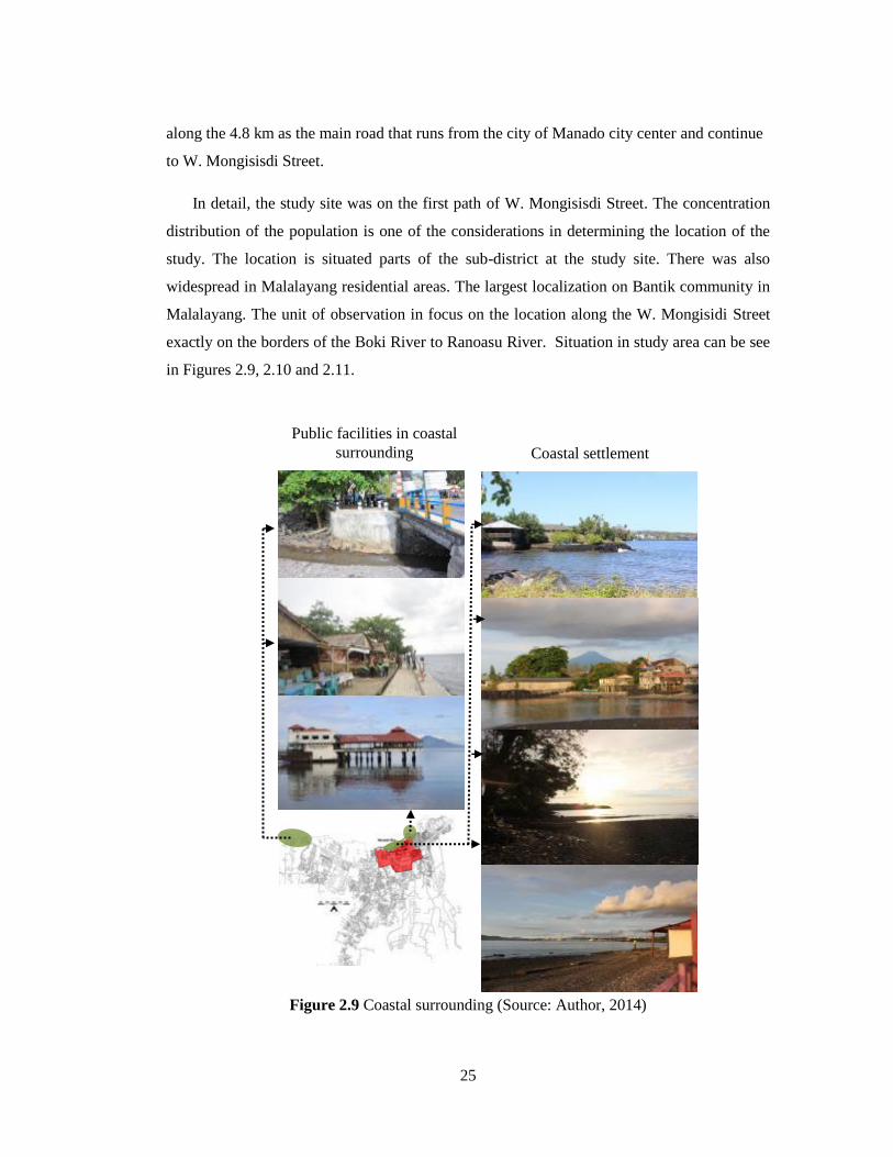
along the 4.8 km as the main road that runs from the city of Manado city center and continue
to W. Mongisisdi Street.
In detail, the study site was on the first path of W. Mongisisdi Street. The concentration
distribution of the population is one of the considerations in determining the location of the
study. The location is situated parts of the sub-district at the study site. There was also
widespread in Malalayang residential areas. The largest localization on Bantik community in
Malalayang. The unit of observation in focus on the location along the W. Mongisidi Street
exactly on the borders of the Boki River to Ranoasu River. Situation in study area can be see
in Figures 2.9, 2.10 and 2.11.
Figure 2.9 Coastal surrounding (Source: Author, 2014)
Coastal settlement surroundings
Public facilities in coastal
surrounding

26
Figure 2.10 Settlement performance (Source: Author, 2014)
Cemetery
Niopo stone surrounding
Ranoasu River Boki River
Bantik Field

27
Figure 2.11 Street condition in the settlement (Source: Author, 2014)
W. Mongisidi Street
Minanga Street
Krida Street
1
2
3
1
1
2
1

28
2.2.2 Function of area
The composition of the buildings along W. Mongisidi Street especially those included in
the study area is dominated by commercial building that serves as the shop, and ruko (Mix
function between house and shop) as shown in Figure 2.12. The first part on the W.
Mongisidi Street there are about 90 buildings, consist of 12.2% of resident function, 7.78% as
a social and religious buildings function (churches, village office, and school), 1.1% as open
space in the form field, and 78.92% of the building serves as a place large and small
businesses such as stores, shops, and little shops (field surveys, 2012, 2013). Distribution of
Bantik housing cluster in two major locations, namely: around Minaga Street and Krida
Street. There are also groups of Bantik people with smaller capacity around the cemetery. In
addition there is also the distribution of housing is spreading in southern and western
settlements, beyond the location of settlements.
2.3. SOCIO-CULTURE
2.3.1 Population
Population growth in the Manado city, especially in the area of Malalayang shows high
rate of growth when compared with the Bantik population in the area (seen in Figure 2.13).
This is a significant issue for the Bantik community, especially in defending the settlements
of the influx of immigrants in the settlement. Until now, Bantik people can not do much
against the influx of immigrants because it is more because of the zoning policy of the
government towards the development of residential areas, commercial areas and city
development policies. Awareness and sensitivity in the Bantik communities see the
phenomenon that are very necessary for retaining the status of the settlement of the town,
especially the development pressures of population growth.

29
Figure 2.12 Commercial building in W. Mongisidi Street location (Source: Author, 2014)

30
0
2000
4000
6000
8000
10000
12000
14000
16000
18000
19
90
19
92
19
94
19
96
19
98
20
00
20
02
20
04
20
06
20
08
20
10
Population in
Malalayang
area
Population in
the study
area
Bantik
people in the
study area
Figure 2.13 Population in Malalayang surrounding (Source: Manado in figures, 2009,
2010, 2011, Malalayang in figures, 2011, Author, 2014)
The composition of the population between the Bantik community and non-Bantik
community existing in Malalayang especially unbalanced study area. Bantik population are
very small when compared to the population in residential areas. In the approach to the
calculation of the Bantik community's population was 29.9% only when compared with the
total population in the study area, whereas when compared with non-Bantik community in
Malalayang region, this figure was only 5.9% as shown in Figure 2.14. Authors recognize
that this figure numeric approach because of data unavailability formal population. This
approach is based on data owned by the author beginning in the 1990s as adjusted by the
North Sulawesi Province of Statistics data and then compile the data back to the residents of
the district office Malalayang and data from Manado in Figures 2009, 2010, and 2011.
Figure 2.14 Population in study area (Source: Manado in figures, 2009, 2010, 2011,
Malalayang in Figures, 2011, Author, 2014)
-
100,000
200,000
300,000
400,000
500,000
19
90
19
92
19
94
19
96
19
98
20
00
20
02
20
04
20
06
20
08
20
10
Population in
Manado
Population in
Malalayang
District

31
2.3.2 System of leadership
As settlements were formed by the tribal groups, the leadership of the existing system has
slight differences with the leadership system with other regions. There are three forms of
leadership consist of:
1) Leadership based system of government. The system is based on the official rules
issued by the local government in stages that are governed by laws. As an example
for the study area consists of 4 sub-districts, namely Sub-district of Malalayang 1,
Malalayang 1 East, Malalayang 1 West and Malalayang 2, they are each headed by a
chief of kelurahan area called Lurah.
2) Leadership by the tribe. This system does not separate settlements Bantik rate based
administration area. Thus, Bantik community knows only one leader who is
considered to protect its people. Leadership is implemented based on kinship systems
without formal rules.
3) Leadership religious based. In this system a more defined leadership as service. The
system is not limited by administration territory, or tribal areas, but the scale range
base church services based on territorial location of residence.
2.3.3 Community activity
Bantik tribal has some cultural assets, both physical (tangible) and non-physical
(intangible). Physical cultural assets are scattered inside and outside the residential location
of settlement location, but still within the borders of the Bantik tribal ownership. Physical
assets such as: customary land used by the community together with indigenous
organizations such as plantation setting, field, and graveyard. In addition there are bullae
physical relics relating to the history of settlement and rituals.
There are also cultural assets such as trees naturally or Bulrang yellow trees, as well as
natural asset located around the coast. These assets are more meaningful because that are
associated with a variety of norms and rules that govern Bantik people's lives in a cultural
context. In addition to the physical assets are also a variety of cultural arts events staged such
colossal Mahamba dance, war dance, dance pick up the guests, Maengket and others.

32
2.3.4 Bantik language and philosophy
Bantik tribal has local language is called Bantik language. This language is used in
general social interaction without being limited by age, sex and social status. In addition to
community language also has Bantik philosophy with name: Hintakinang (the juice),
Hintalunang (mutual help), and Hinggiridang (love one another). This is philosophy norms
that will govern the lives of the Bantik people in social interaction among Bantik Bantik or
interaction with other people in general.
Bantik tribe is very strict in applying the norms as rules in the social order. People really
uphold the existing norms as they relate to penalties if violated. The penalty is a punishment
that will run social low or directly given by the leader of the tribe according to the rules in the
community.

33
CHAPTER 3
RESIDENTS PERCEPTION
3.1. BACKGROUND
In human interactions the activity driven by the setting of the physical environment,
giving rise to positive emotions (Kotus, 2013) as well as negative reactions. Often the
condition is a compulsion or helplessness to avoid so as to create a new condition. The
involvement of local community in this condition is often overlooked, so that the desire is not
realized. Sometime character is not portrayed in a traditional environment while
neighborhoods actually have to represent the community as a place to live so that settlements
are of good quality. Problems arise once the question of whether a person can be involved in
built of settlements, not only created by outside influences, so that the local community is
just a helpless person in a residential environment (Jacob, 2010).
Creative environment has a remarkable quality of life, especially relationships are formed
based on the neighborhood and culture activity without pressure. Community has a
connectivity, accessibility and openness, with the leader region by local community-based, so
respected and trusted by the community (Landry, 2011). Society has various needs and
desires as the hope for the survival of local community although not based on the level of
awareness on encouraging. The objective in this chapter to find the form of the desire to the
existence of Bantik community. At least this desire can be made into a framework to be able
to give advice in future planning for the local community
3.2 METHOD
Bantik likes analysis are a series of interrelated between settlement characteristics,
perceptions and desires of the Bantik community. Residents perception and response are
taken as a parameter to determine the needs and desires of the business community towards
sustainability in residential neighborhoods. To find out the needs of the Bantik community,
obtained through the distribution of questionnaires containing responses to the changes that

34
occur. This approach allows to obtain 'issues relating to the wishes of the Bantik people, then
categorized based on the group's needs and desires ends with the identification of the findings.
Samples of data obtained through questionnaires and individual household level relating
to the social and cultural aspects. A total of samples of 105 respondents which are from
distributed of questionnaire. Period of questionnaire distributed on August-September 2013.
Questionnaire contents consist of: Bantik people attitude which are toward the changes of
physical settlement, culture activities, culture heritage condition, and Bantik population
condition. Additional information obtained from structured interviews and free-interview
according to the situation. Analysis are categorized conducted into three dimensional needs
of the Bantik community based on existing conditions. Fame work of residents perception as
describe in Figure 3.1.
Figure 3.1 Framework of residents perception
3.3. SENSE OF NEIGHBORHOOD CONDITION
The attitude of people see the environment change is very important to understand how it
responds to changes which translates as the impact experienced. Rooted in social and
cultural context, perception of environmental change has a very close relationship of the
Bantik community condition
Community perception
Bantik community like analysis
Categorization of the Bantik
community needs
Settlement condition
Population condition
Culture heritage condition
Custom condition
What is should be maintain?
What is should be adjust?
What is should be change?

35
social character of their culture (Wildavsky and Dake, 1990; Proctor, 1998). Based on socio-
cultural approach of Bantik community, the public relations impact of a change in the social
constructionist paradigm in risk perception that all are equally valid, including the local
community setting (Tulloch and Lupton, 2003). Bantik community construct that perceptions
rooted of adjustment to the development of the city therefore, community perception are
divided into three aspects, namely: Physical aspects, social aspect and culture aspect.
Physical settlement changes can be display through the changes of settlements mainly along
the main corridor of settlement. This condition is well understood by the Bantik community,
where as much as 63.81% community justify the situation through the recapitulation
questionnaire as describe in Figure 3.2
Figure 3.2 Bantik community sense (Source: Author, 2014)
3.4. UNDERSTANDING OF COMMUNITY CHANGE
Respondents interpret that phenomenon of settlement changes was occur through a
variety of ways. The phenomenon of changes are divided into four themes, namely: 1) Bantik
population change, 2) culture activity and custom change 3) culture heritage change, and 4)
settlement changes include the area function changes. It is clear that the picture of the
changes are based on physical changes, followed by limited cultural change daily activities.
Bantik people believe that the role of the development is a influence of city development very
0 10 20 30 40 50 60 70 80
Change
Slightly change
No change
Number of people
Inte
nsi
tas
of
chan
ge
63.81%
24.14%
13.33%

36
strong. The other reason Bantik community gives an appreciation of various government
policies, especially the effect on the physical development of the community.
Recapitulation of the various changes in the physical aspects, that Bantik community
turned out to agree with the changes. Amounting 62.86% of the Bantik people is approve
changes of functional areas as described in Figure 3.3. Of the four aspects of the changes as
well as the percentage of a sense of doubt also shadowing. Related perception of Bantik
community sense of hesitation is more likely to be interpreted as an affiliate agrees to the
attitude of social-culture perception, reinforced with lace percentage of people who do not
agree below the 10% level.
Figure 3.3 Bantik community attitudes toward physical settlement changes (Source:
Author, 2014)
The same thing also described the Bantik community through social and cultural changes.
As the physical changes, social and cultural aspects get a good response from the Bantik
community. Bantik community is really understand that the change of cultural aspect also
occurred in the loss of the use of language Bantik, loss of traditional roles and traditional
activity. For these cases there was a decrease about 50% as described in Figure 3.4. For
social change, community agreed about 53.3% that compositional changes in the Bantik
population as described in Figure 3.5.
0 20 40 60 80
Function area
Area performance
Residential performance
Resident location
Number of people
Ph
ysi
cal
ch
an
ge Doubtful
Not Agree
Agree
62.86%
48.56%
61.90%
58.10%

37
Figure 3.4 Bantik community attitudes toward culture changes (Source: Author,
2014)
Figure 3.5 Bantik community attitudes toward the Bantik population changes
(Source: Author, 2014)
3.5 PILLAR OF BANTIK COMMUNITY LIKES
Bantik community wishes to maintain a real settlement occurred despite various changes
showed a commendable effort. Very strong influence by city development coupled with
allusions to the interests of individuals, families, and groups to be one problem to be
0 20 40 60 80
Lost of traditional activity
Lost of Bantik language
Cultural event
Cultural role
Lost of Bantik philosophy
Number of people
Cu
ltu
re c
ha
ng
e Doubtful
Not agree
Agree
0 10 20 30 40 50 60
Population grwoth
Number of non-Bantik people
Increase of non-Bantik people
Number of people
So
cia
l ch
an
ges
Doubtful
Not agree
Agree
63.81%
69.52%
38.1%
51.43%
45.71%
45.71%
53.30%
18.09%

38
completed by the cultural approach. Pillar of sustainable development based on physical
condition, and craving as a basic framework by considering a variety of potential that can be
developed as traditional life, traditional roles and culture heritage site and element. Pillar of
sustainable construction begins with the general conditions and desires, then propagate
through the boundary into the activities, relationships, community and neighborhood units
are described in Table 3.1
Table 3.1 Sustainable pillar of the Bantik community (Source: Author, 2014)
Pillar of sustainable Target Detail target
Social sustainable
Community
Dominant local population
Sense of community
Social-mix
Cultural sustainable
Culture activity
Community
participation
Bantik language
Bantik philosophy
Culture heritage site /element
Cultural event
Local organization
Partnership
Community space
sustainable
Neighborhood identity
Communal space
Neighborhood space
Custom activity
Outside activity
Street activity
Yard activity
Terrace activity
3.6. BANTIK NEEDS CONSTRUCTION
Bantik community needs are described as a cultured community needs in response to
physical and socio-cultural neighborhoods. This approach was taken as a reference in the
planning stages of the confirmation of the Bantik community sustainability. This analysis is
done entirely by a community problem, the real situation and compiled with the wishes of the
people. Community desire is a powerful force for community planning based on the

39
characteristics and needs. This construction is based on statistical desire of Bantik
community which is divided into three criteria such as: should be maintain, change or modify.
Community like this is simply the determination of criteria tailored to the social
characteristics of the community in the hope that people can easily understand of conditions.
A number of 54.29% Bantik community wants but maintain the traditional housing style of
the building needs to be adapted to the modern style of the building. Temporal for housing
elements such as fences, able to get the community to adaptation (41.9%) against relative
height with material remains. As much as 56.19% Bantik community want to maintain the
distance between the fence with the home and the fence to the road (63.80%) were maintain.
It is strongly associated with neighborhood activity based on traditional roles. Similarly, the
existence of pages retained. For housing and support space element, which are requires
adjustment only terrace as much as 47.62% as illustrated in Figure 3.6. It is influenced by the
function of socialization terrace space to the effectiveness of space by function as storage
space motorcycle during daylight.
Figure 3.6 Bantik people wants to housing surrounding (Source: Author, 2014)
Bantik community wants to maintain the location around the W. Mongisidi, Minanga
Street, and Krida Street. Adjustment as much as 46.67% is needed for coastal locations.
0 20 40 60 80
Border
Distance with street
Distance with house
Terrace
Yard
Number of people
Hp
usi
ng
ele
me
nt
Adapt
Modify
Maintain
65.71%
9.52%
56.19%
63.80%
19.05%

40
Locations around the coast at least adapted to be returned to the initial function as a public
space, so there is no limitation for Bantik community to use the site. As much as 79.05% the
Bantik people want to maintain of lay out settlements as the current condition, equipped with
a communal space for the community. Desire for culture heritage site varies between want to
adjustments with maintain accordance with the environmental conditions, the condition of
society and the development of the city. The locations are very striking to maintain consist
of: Bantik field as much as 88.78% and cemetery by 80.95% as described in Figures 3.7 and
3.8.
The highest desire of 90.48% on the in W. Mongisidi Street as the main corridor in the
settlement. Bantik community appreciate the condition of the road, because the road has
brought many influences on settlements. While the surrounding costal expected to not recycle
those locations.
Figure 3.7 Bantik people wants to settlement surrounding (Source: Author, 2014)
0 20 40 60 80 100
Main corridor
Minanga street
Krida street
Coastal surrounding
Number ofpeople
Sett
lem
en
t su
rro
un
din
g Adapt
Modify
Maintain
46.67%
63.81%
60.78%
90.48%

41
Figure 3.8 Bantik people wants to culture heritage (Source: Author, 2014)
In terms of culture, at 64.76% Bantik community wants to maintain the family group
called rukun, whereas for custom organizations want to adjust the social conditions of
community by 50.47% as described in Figure 3.9.
Figure 3.9 Bantik people wants to custom organization (Source: Author, 2014)
0 20 40 60 80 100
Lay out settlement
Communal space
Cultural heritage site
Nioopo stone
Crocodile stone
Lrana stone
Kuangang stone
Bantik fied
Cemetery
Ake Minanga
Kakukudang
W. Mongisisdi
Number of people
Cu
ltu
re h
eri
tage
sit
e
Adapt
Modify
Maintain
88.78%
80.95%
79.05
0 20 40 60 80
Maintain
Modify
Adapt
Number of people
Ca
tag
ori
zati
on
Group custom
Group family65.76%
50.47%

42
Custom organizational is actually the implementation of the culture activity. The
real implementation of custom rooted of Bantik philosophy, followed by Bantik
language as culture identity. The fact, the aspects are decline in the level of
implementation as discussed in the next chapter. Regardless existing conditions of Bantik
community has a desire to keep the Bantik language as much as 50.48% in everyday life, as
well as maintaining of Bantik philosophy as much as 80.95%. as described in Figure 3.10.
Figure 3.10 Bantik people wants to culture identity (Source: Author, 2014)
Activity with neighborhood units approach in the community is quite dominant, although
done in groups according neighborhood locality. People still put hope and strong desire to
maintain traditional neighborhood-based traditional role that has been established, although it
has been modified to suit the conditions and existing development. Based on the four aspects
of the neighborhood unit, all eager to defend it is above 60%, except for local access as
described in Figure 3.11. Little doubt of the existence of local access based approach to
security, but it can be anticipated to maintain the relationship between the family housing
units as reinforcement. In the case of traditional living includes several aspects such as: Form
and function of the house, house elements, and the house surrounding, Bantik people's desire
0 20 40 60 80 100
Maintain
Modify
Adapt
Number of people
Cu
ltu
re a
spec
ts
Culture event
Bantik philosophy
Bantik language
50.48
80.95

43
are varies according to the needs of. In a more detailed aspect the desire is more dominated
by the desire to maintain or make adjustments to the environment surrounding, as described
in Table 3.2. Neighborhood and cultural aspects are referral of Bantik community by a
common desire to do maintenance including to the sub-aspects various as described
in Table 3.3
Figure 3.11 Bantik people wants to neighborhood conditions (Source: Author, 2014)
0 20 40 60 80
Neighborhood gathering space
Street activity
Neighborhood acces
Neighborhood relationship
Number ofpeople
Asp
ect
s
Adapt
Modify
Maintain

44
Table 3.2 Sustainable detail aspect of living traditional
Aspects
Maintain Change Adjust
House traditional
Housing style
Stage to not-stage
style
Change to modern
facade style
House
function
Adding the
commercial function
by renting one of the
rooms to the non-
Bantik people.
Rent houses to non-
Bantik people
Adding a little shop
for family businesses.
Housing
material
Replaced with
suitable material with
the development such
as: 1) on the ground
floor / tiled floor
boards.
2) Wall: from bamboo
to concrete wall
Customized color trend
/ appropriate
development of the city
Housing surrounding
Fence:
Distance with
the street
Distance with
the yard
High altitude
passes are not
human or <200 m
Around 2 m
Around 4-5 m
Provided yard for a
shared room
Terrace
As a semi-public
space to hangout
fellow neighbors
From the terrace
house that does not
have be having terrace
From the reception
room into a storage area
on a motorcycle during
the day.
Yard Function of public
space:
Family space
Economic space
Refreshing space

45
Continue table
Aspects Maintain Change Adjust
Traditional space
Street in the
settlement:
1). Minanga
Street
2) Krida Street
The road condition
is maintained
As a traditional
space beside a
transportation
function
Not be a public
road.
Alternative
functions as a space
of socialization
temporary road
Terrace As a space of
socialization
neighborhood.
As a space of
family interaction.
As a transition
space
Build a terrace Multifunction space
Yard As a gathering
space for fellow
neighbors.
The family room
As a space
refreshing
Square :
Bantik field
As a community
space
As a custom space
Kind of activity.
Improve of management

46
Table 3.3 Sustainable detail aspect of neighborhood and culture aspects (Source:
Author, 2014)
3.7 DISCUSSION
Rooted from community adaptation to city development, the perception of Bantik
community constructs in created in three aspects such as: physical aspect, social aspect, and
culture aspect. Based on tribal group, Bantik community still believes that Malalayang
settlement is Bantik community settlement even though in real condition, that perception is
no longer compatible because in other aspect. Bantik community realizes that there is occurs
Maintain Change Adapt
Neighborhood and culture
Settlement
layout
Current condition
Gathering space Bantik field, local
street, terrace, yard
Activities
Niopo stone Culture heritage
Privat community
space
Management
Lrana,
Crocodile, and
Kuanga stone
Culture heritage
Public space
Ake
minanga,and
kakukudang
Culture heritage
Strengthening for the
culture zone around
cost
Cemetery Function
Custom ownership
Cultural event Existence Pattern of
event
Collaborated with the
city government
Local language In the daily activity
Internal access
connection
customized services
H3 philosophy More reactivated
Local
organization
Management
Activities adaptation
in the cultural
education
General custom
organization
Needs

47
culture change and physical settlement changes. This thing is based on recapitulation of
questionnaire about 63.81% of Bantik community stated that there is change. Change is
divided into 4 themes consist of: 1) lifestyle change, 2) social-mix and the loss of culture
especially Bantik language, 3) house surrounding appearance change and 4) neighborhood
activity change. About 54.29% Bantik community wants that traditional housing needs to be
maintain but building style is adapted to the modern building style and about 72.38% wants
to maintain of building function. While for housing element like as fence, about 41.9% of
Bantik community wants to adaptation of materials but the fence height is relatively
maintained. About 56.19% of Bantik community wants to maintain the distance between
fence and house and about 63.8% wants to maintain distance between fence and street.
About more than 60% Bantik community wants to maintain the location around Minanga
Street and Krida Street, but for location around the coast, about 47.62% of Bantik community
wants to adaptation back to the condition like before, at least can make them easy to access
the beach location freely. The striking location that needs to be maintained are field and
cemetery. About 88.78% wants to maintain the field and 80.95% wants to maintain the
cemetery. This desire gives picture that cultural pillar is still possible to be maintained even
though limited to aspect that directly related to the activity that the society feels.
In relation with culture, Bantik community wants to maintain group family called rukun.
Apart from the existing condition, Bantik community wants to maintain of Bantik language
(50.48%) in daily life, and maintain Bantik philosophy about 80.95% even though in reality,
Bantik language degradation quiet greatly. Family-based activity, Bantik community wants to
maintain group family called rukun. In the relation with culture, Bantik language can be
implemented in the rukun activity, because both of them has connection in culture.
Activity with neighborhood unit approach is quiet dominant in society even though in
groups based on locality of neighborhood location. Society still has hope and strong desire to
maintain neighborhood atmosphere based on traditional role that had been formed long ago
even though it is modified according to the condition development. Little doubt about the
local access existence that is felt by security factor approach. This doubt is repressed by
family relation between houses units so there is strengthening intrinsically. Beside local
access, traditional atmosphere has chance to be developed maximally in term of internal
relation in neighborhood based on jointly activity.

48
3.8 CONCLUSION
Even though Bantik community has pressure in culture, population, and physical aspect,
but Bantik community has desire to maintainthe community. Biggest preservation that needs
to be done by community is to implement the desire with effort which is rooted from
neighborhood group to the family group. Sustainability pillar that is most possible to be done
by society is maintaining traditional role through neighborhood activity, because of external
factor involvement like intervention from government, non-Bantik residents, or other factors
that can be anticipated by internal Bantik community. This situation will be different from
the physical aspect, because of physical changes such as changes in regional function, the
function of buildings and other physical aspects strongly influenced by external factors.
The main thing that needs to be captured and maintained such as pride and community
awareness as a manifestation of Bantik philosophy, as this will affect any decision taken on
the changes that will occur. Bantik people's desire to maintain traditional neighborhood will
become a pillar of cultural activities, not just limited to the social aspect, it would be
implemented in traditional living by neighborhood and culture space maintaining. Bantik
community perception as described in Figure 3.12.
Figure 3.12 Bantik community perception (Source: Author, 2014)
City development as
a modern attitude
Bantik people as a
original owner of
Bantik settlement
Bantik tribe has an
important role in the
formation of Manado city
Settlement development Bantik population
condition
Neighborhoods and culture space
Cultural heritage
Settlement
changes Space of traditional
activity
culture activity based on
custom
Culture identity
(Bantik language,
cultural attraction,
Bantik Philosophy)
Bantik residential
location and land
custom
Bantik perception
Community problem

49
CHAPTER 4
ANALYSIS OF CULTURE HERITAGE
4.1. BACKGROUND
Spatial planning involves the coordination or integration of various parties including the
spatial dimension of sector policies through a territorial-based strategy (UN, 2008). Therefore
the planning turned into a very productive activity and proactive. (Albrechts, 2004; Tewdwr-
Jones et al, 2010), which is supported by surveillance as part of the spatial planning model that
needs to be planned (Wegener, 2001). Over the past half century, more conservation based
approach has been developed in urban planning; process extended in the historic town in the
post-war, intensified during the 1960s, and then later re-ordered following the rejection of
modernism architecture. Due to the expansion of the scope of planning, approaches to
conservation objectives must be increasingly articulated on a very different scale in quantity in
the hierarchy such as: town, village, or smaller regions within this (Larkham, 2003;
Pendlebury, 2003). Translated into the arena built cultural heritage, innovation in cultural
heritage needs to be understood further by the city government to provide space for new urban
development discourse (Nyseth, 2012) and activity routines and management governance
( Healey , 2006).
Degradation of a common cultural heritage sites because of urban development,
including site access issues. Urban development has a strong effect on two aspects: the spatial
and social, and this situation affects ethnic communities, such as the phenomena of
degradation of society (Egam et al., 2012) in the ethnic community. An ethnic community is a
stable group of people who have historically evolved according to its existence as an ethnic or
national group, with the same language and / or region. Members of ethnic communities come
from the same background. Community can be defined as a group of people who are
geographical area, have a bond together by a common culture, values, race, or social class
(Pacione, 2001). Communities examined in this study is considered as a locality-based society
hence, they are referred to the local community (Jimura, 2011).
In this paper, we look at one such ethnic communities, Bantik tribal settlement, which is
located on the beach near Malalayang Manado in Indonesia. There are several objects of

50
cultural heritage sites in the in Malalayang district related to this particular ethnic community
(Egam, 2014), which is shown in Figure 4.1. Sites are dominated by objects around 1-2 m3 of
stone, but they are not developed (as show in Table 4.1). History of Culture heritage period, as
show in Table 4.1. Bantik cultural heritage tends to be obscured, and even hidden, by urban
developments recently. These include attacks on citizens of non-Bantik to residential, family
displacement Bantik to the edge or outside of settlement.
Figure 4.1 Bantik cultural heritage sites and their locations (Source: Author, 2014)
❹
❻ ❽
❶ ❸
❼ ❺
❷
Legend:
❶ : Pananayangeng
❷: Palaribingang
❸: Niopo Stone
❹: Tulrada of W. Mongisidi
❺: Ake Minanga
❻: Lrana Stone
❼: Kuangang Stone
❽: Crocodile Stone
❶ ❷ ❸ ❹
❺ ❻ ❼ ❽
❶
❼
❷ ❸
❹
❺ ❻
❽
Manado Bay
❶~❽: Heritage site
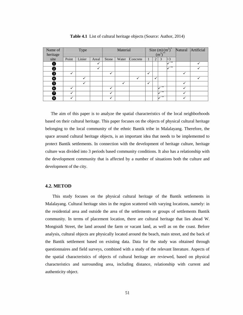
51
Table 4.1 List of cultural heritage objects (Source: Author, 2014)
The aim of this paper is to analyze the spatial characteristics of the local neighborhoods
based on their cultural heritage. This paper focuses on the objects of physical cultural heritage
belonging to the local community of the ethnic Bantik tribe in Malalayang. Therefore, the
space around cultural heritage objects, is an important idea that needs to be implemented to
protect Bantik settlements. In connection with the development of heritage culture, heritage
culture was divided into 3 periods based community conditions. It also has a relationship with
the development community that is affected by a number of situations both the culture and
development of the city.
4.2. METOD
This study focuses on the physical cultural heritage of the Bantik settlements in
Malalayang. Cultural heritage sites in the region scattered with varying locations, namely: in
the residential area and outside the area of the settlements or groups of settlements Bantik
community. In terms of placement location, there are cultural heritage that lies ahead W.
Mongisidi Street, the land around the farm or vacant land, as well as on the coast. Before
analysis, cultural objects are physically located around the beach, main street, and the back of
the Bantik settlement based on existing data. Data for the study was obtained through
questionnaires and field surveys, combined with a study of the relevant literature. Aspects of
the spatial characteristics of objects of cultural heritage are reviewed, based on physical
characteristics and surrounding area, including distance, relationship with current and
authenticity object.
Name of
heritage
site
Type Material Size (m) (m
2)
*
(m3)
** Natural Artificial
Point Linier Areal Stone Water Concrete 1 2 3 >3
❶ **
❷ **
❸
❹
❺
❻ **
❼ **
❽ **

52
Therefore, in this study considering the spatial analysis based on three factors related to
the physical condition of cultural heritage sites in settlements Bantik: 1) the circumstances of
the physical objects of cultural heritage, based on the distance from the main road; 2) the
physical position of cultural heritage objects and locations in the settlement; and 3) the
structure of objects of cultural heritage zone, which consists of distribution zones, based on the
distance from the main road. In this analysis be understood that the influence of globalization
has become increasingly evident at the local level (Fernandes, 2012). Therefore, there is a
clear need to strengthen local cultural heritage and identity. Finally, these factors are analyzed
to describe the scenario planning for community based rehabilitation approach to culture
heritage. Research stream is shown in Figure 4.2.
Figure 4.2 Framework of research (Source: Author, 2014)
4.3. PERIOD OF CULTURE HARITAGE IN THE BANTIK COMMUNITY
4.3.1 Cultural Heritage of the Bantik as an Alifuru Community
History of culture heritage in the
Bantik community
Community development
Condition of culture heritage
Zone of culture heritage
Relationship between culture heritage objects
with traditional activity
Strengthening planning of culture heritage site
to the culture activity
Analysis
Position and the
distance from the
main street
Zone classification of
culture heritage site
Distance
Value
Relationship
Coast surroundings
53
Alifuru is a local term used to refer to the Indonesian native society (Grafland, 1991),
particularly, in this case, the indigenous people of northern Sulawesi. In such a society,
cultural heritage objects exist as a representation of the community‟s belief system and may
have mystical value. In Bantik community, rocks, objects, and the space that surrounds them
are used as sacred places with magical powers, and there is a relationship between the objects.
The space around objects is a sacred buffer, and the value of the objects and surrounding space
is considered in terms of abstract mystical beliefs.
4.3.2. Cultural heritage after the influence of christianity
The Christian religion became a source of influence in the region after the arrival of the
Dutch approximately 1700 (Sumolang, 2010, Naas, 2007). Their arrival led to changes in the
meanings given to Bantik cultural heritage. New meanings were given to old objects, and
meanings also became mixed-up. For example, there were changes in the meanings of the
space surrounding some cultural objects, such as the Crocodile Stone, the Niopo Stone and so
on. Previously, people believed that this site had magical power, but after the influence of the
Christian religion, it is no longer considered a place with supernatural powers. However, in the
culture of the native Bantik community in Malalayang, sacred and private spaces remain
strongly connected to territory. Despite this, private space exists without the communal rituals
that it was once connected to.
4.3.3. Culture heritage under the influence of urban pressure
The biggest changes to cultural heritage sites are brought about by market forces (Simmie
and Martin, 2010), which lead to development pressure on the areas surrounding cultural
objects. Therefore, the spaces around cultural objects, such as the Lrana Stone, the Kuangang
Stone, the Crocodile Stone, and Ake Minanga (fresh water in the costal), have come under
pressure. The expansion of non-Bantik settlements and lifestyle influences have led to the loss
of both the cultural spaces around these heritage objects and the meanings associated with
them (as is shown in Table 4.1). The three biggest changes to cultural heritage sites that have
been brought about by city development are as follows: 1) changes in meaning, 2) changes in
activity, and 3) changes in space. The period of Bantik community history is shown in Table
4.2.

54
Table 4.2. Development of Bantik community history (Source: Author, 2015)
4.4. CONDITION OF CULTURE HERITAGE INFLUENCES OF W. MONGISISDI
STREET
4.4.1 Distance of W. Mongisidi Street from cultural heritage site
Influence W. Mongisidi Street distance to cultural heritage site base on analysis carried
out showed that there was an important influence on the way people interact with the site's
cultural heritage. Moreover, this analysis shows that, the distance from W. Mongisidi Street
also has a strong impact on the quality of the space. Therefore, there are several categories
related to the distance of the cultural heritage site from W. Mongisidi Street impact on the
quality of the space. Therefore, there are several categories related to the distance of the
cultural heritage site from W. Mongisidi Street. First, to promote people‟s interaction with the
physical object, a distance of less than 100 m is the most effective because it encourages direct
contact with cultural heritage objects. Accordingly, people that pass along the main street
come into close proximity with the cultural heritage objects. Second, the sites that lie within a
distance of 100–200 m have the greatest cultural activities and relationships with the Bantik
community. This is caused by three factors, namely: (a) the lack of intervention by non-Bantik
people inside the settlements; (b) the impact of the hustle that results from high traffic density
at sites that are closer to the main street; and (c) the increased privacy of the spaces that are
100–200 m away. Third, we found that at sites farther than 200 m away, there is no significant
Bantik community
period
Meaning of cultural heritage Description
Object itself Surroundings
Alifuru Community
(before 1700s)
Mystical:
Secret and
hidden
Understood by
a particular
person or entity
Sacred space:
Highly
respected
space
Direct relationship between
humans and nature
Buffer space surrounding objects
Territory in the context of culture
Temporary barrier
Christian Religion
Community
(1700s-1990s)
Mystical
Non-mystical
Sacred and
private space
Causal link between man and nature
There is a space between object and
surroundings
Territory in the context of culture
Temporary barrier
Influences of urban
pressure (1990 ~)
Cultural
Loss of sacred
and private space
Cultural space
Ambiguity of territory

55
factor that encourages people to interact with these cultural heritage objects. This is because
road function is dominant over the need to access the object.
Our analysis of the street development and the distances between the main street and each
heritage site are shown in Table 4.3. From this, we argue that there are three ways in which
space has an influence, based on the distance between the main street and the cultural heritage
site: (1) a distance less than 100 m is categorized as promotion space; (2) a distance between
100 m and 200 m is most likely to be cultural space; and (3) a distance of more than 200 m has
limited promotion of cultural heritage (See Table 4.4). This effect increases for distances
greater than 300 m. Although these sites are still considered cultural spaces, they can only be
identified at a distance because of their lack of proximity to physical cultural heritage sites.
Table 4.3 Influence of the development along W. Mongisidi Street on culture heritage sites
(Source: Author, 2014)
Condition
and
Distance
Analysis
Before the 1990s After the 1990s
General
conditions The width of the road: 8 m
Lack of limiting lane road
The width of the road 16 m equipped with a roadblock
Addition of an alternative path for direct access to
residential areas
Increased density
Distance
(m)
<100
No direct access to the object
except through a field
No direct contact with the public,
unless through the court
Located in a residential area
In a private space
There are two categories of relationships with culture
heritage:
1) Direct relationship with an object:
Can see it directly from the main road Located on a
public access to the city and a main corridor
Conveniently located in a commercial area
Less private space
2) Indirect link with the object:
In a residential environment with a dominant Bantik
community
Less private space
100 – 200 No direct relationship with the
object
Several buildings block the object
No contact with the hustle of the
main street
Does not have a direct relationship with the object
200 – 300 No relationship with the object
No effect on the object
Located outside the residential center
No effect on the object
>300 Does not have a relationship with
the object
Located outside the residential center
No effect on the object

56
Table. 4.4 Categories of culture heritage zone based on distance (Source: Author. 2014)
4.4.2. Position of cultural heritage in the settlement
Based on the available data, the physical cultural heritage objects can take various forms,
but are mainly stones (40%) that are large in size (>1- 2 m3). As the number of Bantik in the
community diminishes due to the growth of the non-Bantik population and the outward
movement of the Bantik people the significance of each object is further weakened. These
objects, and their sites, have a history of cultural value in the community, even though they
tend to go unnoticed by Bantik people. Cultural heritage sites are not concentrated in one
location, but are scattered across the settlements. Based on the analysis, it is possible that the
greatest weakening of attachments to these objects occurs at sites that are not close to the
main Bantik population.
The relative position of these cultural heritage objects can be a classified into three
groups: 1) Minanga Street surroundings; 2) east of Minanga Street and parallel to it; and 3)
surrounding the cemetery to the east of the settlement. Although several of these have
historical and cultural value and unique physical trace evidence, the Kuangang Stone,
Crocodile Stone, and Lrana Stone have no effect on Bantik culture because the culture of a
these physical objects is a considerable distance from the Bantik settlement and they are
located apart from the largest Bantik community settlement.
4.4.3 Effectiveness culture heritage site
Further analysis is directed at the physical cultural heritage objects around the coast that are
in danger of disappearing altogether due to neglect, as shown in Figure. 4.3. Most Bantik
community do not realize that these objects have significance to the Bantik people and their
settlement in Malalayang. In their responses to our questionnaire, approximately 60% of the
Distance
(m)
Space categories
<100 Promotion space
100-200 Cultural space
> 200 Low cultural space

57
respondents were only aware of the Boki River and the Ranoasu River as physical objects
without significant cultural meaning to them. However, the initial historical Bantik settlement
in Malalayang was located between these two rivers. Furthermore, the two rivers are the main
sources of water in the settlement. The springs of Kakukudang (freshwater in the coastal),
located near the coast, are even more neglected in the public consciousness. Approximately by
95% of the respondents had no knowledge of these springs.
Figure 4.3 Cultural heritage objects around the coast (Source: Author, 2014)
4.4.4 Position culture heritage in the settlement
The Boki River and the Ranoasu River are located on sites that we categorize as
promotion spaces. Furthermore, the Lrana Stone is in a position promotion space because it is
located less than 100 m from the main road. Although these objects are in prominent spaces,
this is not sufficient to designate either of the rivers or the Lrana Stone as promotion zones
❾ ❿ ➀
❶
❼
❷ ❸
❹
❺
❻
❽
Manado
Bay
❶~❽ :Heritage
site
❾ : Boki River
❿ : Ranoasu River
⓫ : Kakukudang
⓫ ❿
❾

58
because they all have low cultural value for Bantik community in Malalayang at present.
Therefore, the Lrana Stone is positioned far from the largest concentration of the Bantik
residential community in Malalayang. Furthermore, based on the data from the questionnaires
and interviews on Bantik community, 90% of respondents did not know that the Lrana Stone
is part of the Bantik community's heritage. Further action needs to be taken for the Lrana
Stone to be transformed into the core zone. The situation is different for the Crocodile Stone
and the Kuanga Stone. Both stones are located away from the main road and the Bantik
residential areas, and both stones are in isolated locations. The objects have no meaning for
the Bantik community therefore, by analyzing the locations of these objects, we can see that
their isolation makes them unlikely to be viewed as significant culture heritage sites.
Therefore, our spatial analysis needs to take into account, in particular, the arrangement of
surrounding locations.
4.4.5 Culture heritage value
Bantik field and the cemetery have a high potential for cultural and social significance
because they are within a strategic distance, and they are in direct contact with the main
transport lines. In our spatial analysis, images of the cemetery were identified as a social space,
and secondly, as a cultural space. This is because the function of the cemetery is focused on
one of the primary social needs. However, the cultural space started to decline in importance
when the object‟s lost direct contact with the main transport routes and Bantik settlements.
Based on the spatial analysis, we suspect that the Niopo Stone and cemetery had a fairly close
relationship in the past because the two objects are very close to each other. The Niopo Stone
has a high value for community safety, whereas the cemetery is in the outer settlements that
are valued for tranquility.This has considerable potential, because the community views the
site in positive cultural terms and as part of the settlements. However, in this case there has
been a shift in the understanding of the object due to the influence of Christianity. This
changes the meaning, along with the understanding of the development of the city and is given
significance by the community.

59
4.5 DISCUSSION
The situation and conditions of cultural heritage were analyzed based on the distance
between the physical objects of cultural heritage, the main roads, and the largest
concentrations of Bantik housing. The residential locations are the sites of the early
settlements that were established by the Bantik people in Malalayang. One part of this analysis
is the cultural atmosphere, which generates categories of cultural space. The categories of this
cultural space were further analyzed to produce the structures of the space. Planning methods
are needed to sharpen and develop the structures of this space. The method of planning related
to this spatial layout involves the arrangement of cultural heritage into three zones: the
promotion zone, the core zone, and the buffer zone. If a location has cultural heritage
associated with it, then the distance usually has a profound influence on the category of the
cultural space. Looking at the distance between the object and the main road, we found that a
distance of less than 100 m has the potential to render the site as a core zone because it is
directly proximate to the main road.
A distance of less than 100 m does not fully delimit the core zone because the significance
of cultural heritage objects is not in itself enough to establish a spatial image. A strong cultural
heritage spatial image occurs at a distance of 100–200 m, which remains at a sufficient
distance for the object to serve as the focus of a core zone. Physically, the strengthening of the
cultural heritage image is reinforced by inserting physical cultural heritage objects into
residential locations with the largest concentrations of people such as in the coastal area, as
well as in the vicinity of the main road.
However, these locations do not always strengthen the spatial images of cultural heritage
sites. This is demonstrated by the neglect of some objects, from public indifference, and the
lack of a role for indigenous organizations in maintaining heritage for the community. One
problem for maintaining the integrity of the cultural heritage sites as a whole is the variety
among the existing objects and sites. The application of culture zone division could address
this holistically through the categorization of spaces into several zones; that is, the promotion
zone, the core zone and the buffer zone. One of the main reasons that people engage in
planning for a community is to protect what they value about it (Kelly, 2009). Therefore,
strengthening the quality of the space and its facilities, coupled with the establishment of
relationships between the objects within the community, need to be taken into account; this
will lead to the strengthening of community identity. Consequently, repairing and

60
strengthening sites is a priority, in accordance with the specifics of each location, and the
objects and activities associated with them. There is a strong necessity to obtain planning
method specifications for such developments.
The strengthening and effectiveness of cultural zone is associated with three aspects: (1)
the cultural heritage and the location of surrounding objects related to the site‟s significance;
(2) the natural fascination about coastal areas (in the study of cultural heritage, coastal areas
are often associated with objects of cultural value); and (3) the need to improve the
relationship between communities and indigenous organizations. Residents‟ feelings about
their relationships with their neighbors have a strong influence on the formation of
communities. Therefore, it is important to include performance criteria and physical elements
in planning detached housing areas in communities (Kwack, 2004). Based on a literature
review and an analysis of social relationships, especially of relationships based on cultural
heritage objects within the Bantik community, it is clear that forming social relationships
between the communities and the indigenous organizations is one means of achieving cultural
reinforcement and maximizing space. Therefore, the issue of distance is not a significant
barrier to achieving the optimization of cultural heritage in the community. Based on the level
of cultural space, recommendations can be made about the spacing of objects, thereby creating
relationships between objects that are intact and with other objects that require preservation.
4.6 CONCLUSION
Cultural space is created from the relationship between physical space and objects,
cultural activities, and the surrounding space. Although the Bantik community in Malalayang
possesses a rich cultural heritage, its local potential is not optimized. This results in the
blurring, and even the loss of cultural practices and identification. This process is influenced
by distance, the position of cultural heritage sites, the low level of activity of the Bantik people,
and the diminishment of cultural activities due to urban development. The greater the distance
between the people, and the diminishment of cultural activities due to object, the areas of
highest Bantik population concentrations, and the main road, the more undermining of the
original cultural space occurs. Conversely, when objects are in close proximity to the main
road, this will reduce the originality of the cultural atmosphere. The core zone for the creation
of a cultural space can be found at a distance of 100–200 m from the main road, with locations

61
around Minanga Street. This corresponds to early settlement locations of Bantik community.
To this day, these areas have the largest concentration of Bantik people in the settlement. A
distance of less than 100 m serves as the promotion zone, whereas the other locations with
physical cultural heritage are used as a buffer zone.
When strengthening cultural space, it is not enough to just rely on the existence of a
physical object. It is necessary to create a close relationship between the community and the
support and optimization of indigenous organizations. Therefore, cultural heritage images
require the support of ethnic Bantik organizations as a social power base, so integration
between objects, the placement of settlements, and indigenous organizations will be stronger
than the simple physical arrangement of objects. The unique characteristics of a community
can be embodied in objects with a physical identity, and these objects contribute to
maintaining continuity within local settlements. This, in turn, contributes to the wealth of a
city as a whole. Zone establish of cultural heritage with a zoning approach that incorporates a
core zone and buffer zone, along with customized, neighborhood-based spatial planning is
necessary to achieve this. Therefore, although a considerable distance may affect the
achievement of cultural space, it is not a major obstacle to achieving the optimization of
cultural space in public housing because the promotion zone, the core zone, and the buffer
zone are based on cultural values, which are based on the location of the ethnic community‟s
early settlement area. In conclusion, three approaches to cultural zone are needed in the ethnic
community in Malalayang: 1) Three cultural heritage zones, namely: a promotion zone, a core
zone, and a buffer zone; 2) optimizing the relationship between the community and the
indigenous organizations to promote cultural respect; and 3) strengthening the coastal zone.

62
CHAPTER 5
ANALYSIS OF USUAL COMMUNITY SPACE
5.1. BACKGROUND
By the year 2030, more than 60% of the world‟s population will live in urban areas
(Chen, 2014). Structural characteristics of the people who live in urban areas due to the
impact of urban development. In about the year 1970 several studies conducted to identify
and explore variations in collective action and collective identity of the local community, its
causes and consequences (Gittell, 1980; Warren, 1975). In another study on the location of
the urban growth indicate that exurban areas, which are located well outside the limits of
urban and suburban, have witnessed a disproportionate amount in terms of population growth
and new settlements in recent decades (Heimlich, 2001). Urban regeneration is one strategy
that is pursued through adequate supervision as a core mechanism for sustainable urban.
Neighborhood management (Turcu, 2012) is one strategy to consider in exploring the
characteristics of the local settlements so that sustainability can be achieved. It is a major
challenge for urban settlements, especially against ethnic community including Bantik
community located in Malalayang. Without realizing this condition affects their ability to
mobilize its resources. Local communities experiencing the challenges of the situation, so it
tends to be difficult to find again characterize as local communities.
The influence of the existence of certain ethnic communities are often termed as local
comes from various aspects including development pressures of the city. Identity as a local
community is lost because of the strong influence of urban development that can not be
blocked by the local community. Reciprocal relationship that exists between culture, land use
and activities spawned a new adjustment to the physical environment. New understanding
arose as a form of community tolerance for urban development that blurs the traditional
characteristics that have been established. There are a change in the composition of the
family through intermarriage between Bantik communities with non-Bantik community and
social-mix occurred in the social aspects of society. Physical changes settlements, lifestyle
changes and changing views of the Bantik community are also changing.

63
This research is a study of the local settlements in the actualization of settlements with
population pressures that impact on community space. The purpose of this study is to analyze
separately the space community through changes in housing because of the pressure of urban
development. Further research is to find the characteristics of community activity space
through the neighborhood as well as the development of society in the form of emotional
bonding activity adjustment.
5.2. METHOD
The method used in this section begins with the Bantik population conditions that exist
within the study area. Further analysis of the process of settlement development, and
community activity. Community activity is reviewed in two aspects, namely family activity
and neighborhood activity. Based on these activities, then identified the location of the use of
space that is focused on the housing surrounding housing and settlement surrounding. The
data obtained through field surveys were conducted in the period on August-September 2013.
In the field survey were selected homes sampled with the sample classification consist of: 1)
The sample associated with the displacement dwelling as many as 24 samples, and 2) a total
of 32 house sampled to identify the location of community activities. For more information,
structured interviews were conducted at the family house owner who used samples.
Framework of research methods can be seen in Figure 5.1.
Figure 5.1 Framework research of community space (Source: Author, 2014)
Bantik population
Process of settlement development
Community activity
Community space
development
Family activity change
Neighborhood activity
Housing surrounding
Settlement surrounding
Bantik family movement
Analysis

64
5.3. ISSUE OF BANTIK PEOPLE CHANGES
5.3.1 Bantik population growth
The result of urban development in the human population is concentrated in residential
and industrial settings substantially alter the original habitat. Points out that renovation,
reconstruction or re-use of urban land scape of the past has Become an almost universal
aspect of the contemporary urban scan. An urban location So also in demand by many people
associated with the location of the workplace, and public facilities with varied purposes.
Uncontrolled population growth urged the local community in a situation that is difficult to
avoid, even should accept the risks experienced. In this study, the local community is defined
as a group of people WHO share a geographic area and are bound together by a common
culture, values, race or social class (Pacione 2001). The growth of population in the Manado
city, especially in Malalayang area showed high rate when compared with the growth of
Bantik community (see Figure 3.1). This is a significant issue for the community, especially
in maintaining Bantik settlements against the immigration.
Specifically, Bantik population showed is no significant changes. The condition of
Bantik population would greatly changed when compared to the number of non-Bantik
population in the study area. Percentage of the overall population of the Bantik community in
the study area: 1990 amounted to 50.29%, In 2000 was 39.29%, and in 2010's. was 29.90%.
But when compared to the number of Bantik people Bantik in Malalayang which include:
Sub-districts of Malalayang 1, Malalayang 1 West and Malalayang I East are: the number of
people Bantik in 1990 by 8.31%, 6.52% in 2000 was, and in 2010 amounted to 5.81%. This
figure shows a very small percentage, and tend to decrease due to the high population as a
whole.
From the distribution of Bantik population in the settlements, Bantik community
concentrated around Mianga Street, and Krida Street. Distribution of Bantik people in Krida
Street more than the Bantik people in Minanga Street. This is due to land constraints.
Locations around the Minanga bounded by the bay of Manado, thus not allowing the
expansion of residential land towards the coast, while in the vicinity of the Krida Steeta flat
residential location, and is not limited by natural factors, can be seen in Figure 5.2.

65
0
200
400
600
800
1000
1200
19901992199419961998200020022004200620082010
Minanga street
Krida Street
Studi area
Figure 5.2 Distribution of Bantik population in study area (Source: Author, 2014)
5.3.2 Bantik community view of the city development
Bantik people understand that the city development bring a fortune to the community. It
is the high percentage of public appreciation of city development. 59.05% communities that
this makes the local community to become more modern, 56.19% of people said that this
helps in terms of economy. But the high percentage of which have turned out this was a form
submission from the public as much as 74.29% of people said that this all happened because
people can not do anything about it. This tendentious tone occurs because people are at the
receiving end. In they actually save a great concern to the local culture owned community. It
proved 70.48% of the people felt that it was in a fairly large degradation of the local cultural
community. Connected with the physical changes that occur in the settlement, it turns out
people do not fully understand the whole. Society focused on physical changes along the W.
Mongisidi Street or on the main corridor settlements. It is very possible as a commercial city
permeation area. In the area of commercial development, commercial development area not
only on a large scale, but to the retail development resulting in the transformation and
restructuring of retail has shifted retail security issues to the fore.

66
5.3.3 Variety of people
Amounting to 45.71% of respondents agreed that the city changes development brings
changes to the local community by population growth. But the numbers are still unbeaten is
49.52% of respondents hesitated to say that population growth affects the physical changes
settlements. Besides, as much as 60.95% of the public agreed that the variation Bantik
society and non-Bantik also affects the mixing activity, resulting in a shift of traditional
activity. Variations people also bring a change in the traditional activity. This view is
evidenced by 51.43% of respondents chose that lifestyle changes to the traditional lifestyle of
the city. The reason is quite strong due to the influence of non-Bantik quite large, with a view
of the city lifestyle and the assumption is that the customization options on the environment
can be a group identity.
Local people think that the change is actually a natural thing, and a dynamic development
of the city. But this has not been proven completely, because there are many people
unconsciously trapped in the city without knowing development of the local community
influences both positive and negative influences. One social happens that the increase of non-
Bantik in settlements widely. This is the most far-reaching as many as 30.48%, so Bantik
community chose this aspect is a major aspect of change. Actual variation in terms of the
expansion of people benefit local insight. But local people are not prepared in terms of
community resources and openness, so that this condition will weaken the social and cultural
conditions. Responses unbalances between the public and non-Bantik are not laid out so
backfire for Bantik people in terms of the role and existence of the settlements. The attitude
of local people also affect the resulting situation, whether negative or positive. It is possible
to predict that the changes caused by the absence of mutual agreement of the local
community. Creation of the local communities is needed in the adjustment to the settlement
of migrants who enter (see Figure 5.3).

67
Figure 5.3 Adjustment of local communities against environmental situation (Source:
Author, 2014)
5.4. ISSUE OF SETTLEMENT CHANGES
5.4.1 Process of Bantik settlement changes
The phenomenon of population movements within the region and between regions, is
essentially a form of human mobility by individuals or groups, while the movement of
population mobility can be distinguished between the movement of people moving
permanently called migration and not permanent. According to Lee (1995), migration is a
change of residence permanently or semi-permanent, which is not constrained either by
distance or displacement which is voluntary in nature, forced. Boki River, Ranoasu River and
coastal areas is an important point that needs to be a factor in analyzing the process of
establishing settlements. The location of the river associated with the presence of water as a
source of life in the hold of life, while the coastal areas are important locations for the
defense and the easiest access in the event of evacuation in case of social upheaval.
Residential location elongated east-west direction, following the shoreline to form parallel
lines as a consequence of the linear pattern of urban design along the coast. Housing
developments on the east settlement is based on the work site in the eastern part of the
settlement. Linearly elongated housing, concentrated in a single layer along the road and ends
at the cemetery south directed settlement to mark the end of the settlement. Presence of the
Local
Peopl
Attitude
Resource
Creation

68
Portuguese and the Dutch had a hand in the formation settlement process addition to physical
factors naturally. This relates to aspects of cooperation in the exchange of agricultural
products between the nations with the local community, supported by the location of coastal
settlements making it easier in terms of transporting agricultural products to be distributed
through marine transportation. The process of setting settlements can be seen in Figure 5.4.
Figure 5.4 The process of settlement establlish (Source: Author, 2014)
Number of Bantik people is showed a decline. Until the year 2011, the number of people
Bantik of 29.90% of the number of people who exist in a residential location. The decline in
population in the Bantik settlements caused by two factors: the inclusion of non Bantik in
settlements called permanent migration, and the migration of Bantik people out the location
of settlements.
There are several development process of settlements, namely: 1) Early settlements
located around the coast, exactly around the Minanga Street. 2) Furthermore, the settlement
1886~
Portuguese arrival in the country
Dutch arrival in the country
~1570
Legend:
Cemetery Street House orientation
River Field

69
extends to the south is limited by the cemetery location as the end of the housing. In addition,
the displacement of people living in coastal areas and then move to the Krida Street
surrounding location of the nearest local roads because of the disaster that befell the tide that
location. 3) Due to the Bantik community need for space, residential location towards the
south extends past the location of the cemetery. 4) Pressure of urban development continues
to be felt Bantik community, including the displacement of Bantik community residential of
locations around the beginning of the main road, move to the south of the settlement exactly
behind the cemetery, even the locations are out of the location of settlements. The settlement
development process can be see in Figure 5.5.
Figure 5.5 Process of settlement development (Source: Author, 2014)
1
4 3
2

70
5.4.2 Location of residential moving
The composition of the new dwellings spread making it difficult to coordinate. Social
relations perspective is a referral strategy that will unite the community as a counter
effectiveness in family planning group differences in location. There are multiple paths and
transfer forms, namely: 1) Displacement in terms of the location consists of: a) From the
front to the back of the main road settlement, b) From the main road outside the settlements.
2) In terms of land ownership: a) moving to private land, b) Purchase of other lands that have
a relatively cheap price. Judging from the direction and distance of displacement: a) <1 km,
the distance is still in the environment, either towards the coast, and south towards the
settlement, b) 1-5 km towards the back of the settlement, c) >5 km in outside settlements.
Based on the distance and intervention needs of society, it is difficult to avoid displacement.
As for the direction and location of the displacement can be seen in Figure 5.6. Location
largest displacement towards the south and west neighborhoods dominated by distance > 500
m from dwelling place of origin.
Figure 5.6 Bantik house moving locations (Source: Author, 2014)
0
5
10
15
Nu
mb
er o
f h
ou
ses
Direction of displacement
0
5
10
15
100-250 250-500 >500
(m)
Nu
mb
er o
f h
ou
ses Distance of displacement

71
The population of Manado has grown by 0.9% in the last 10 years. This growth is not in
line with the growth of Bantik communities in the study area, the which has decreased when
compared with the overall population at the study site. Up until 2011, the Bantik population
made up 25% of the total population of 1062 individuals. Decrease This is visible on the
Bantik family distribution map of the 1980s, 1990s and 2000s as show in Figure 5.7. The
Bantik population decline was accompanied by migration out of Manado to the settlements.
Most of the decrease in Bantik family distribution occurred on the edges of the settlement's
main roads. This is related to the accessibility of the functional fabric circulation, the which
in turn relates to the weakening power of the minority population.
Figure 5.7 Proximity distribution of Bantik families (Source: Author, 2014)
Boki River
Map of 1980s
Map of 1990s
Map of 2000s
Legend
: Exclusive space : Cemetery : Field
: Bantik family : Non Bantik family
Approximate Number of Bantik family buildings
1980s : 86 1990s : 65 2000s : 58
A B D

72
Settlement changes can not be separated from the influence of regional development
based on the change of spatial functions associated with changes in the function of the
building. Changes in the building functions occur in a single city function that extends to the
strategic urban area is shown in Figure 5.8. In connection with the study site, changes in this
function is a series of public transfer to another location, relates to the initial location and
time displacement. The biggest change occurred before 2000 with a new access policy in the
area of the Boulevard as a commercial area. Branching relationship changes occur in city
policy regarding the development of a commercial area on the Boulevard, which is located in
the central business district (CBD) which can be accessed easily. Branching also occurs in a
residential location in the back of the cemetery. The area that was once a wasteland that
function as plantation area of Bantik community changed into a new residential area for non-
migrant
Figure 5.8 Influence regional wroth to the settlement (Source: Author, 2014)
5.4.3 The change of regional functions
The Based on statistical data from samples taken under the category of transfer of land
ownership along Mongisidi Street, 37.14% of the structures were turned into commercial
buildings, 5.14% to social functions, and 57.14% a combination of commercial and
residential functions. Changes in building function occurred through the transfer of
ownership from the Bantik owner to non-Bantik owner. The data indicate several categories
of regional changes. First the building function changed residential buildings were turned
Downtown
and CBD area Coastal recreation
development
Resident
developmen
t area

73
into commercial ones. This change was accompanied by a change of ownership and structural
shape as shown in Figures 5.9 and 5.10. The model consists of different building functions,
including residential mixed with commercial, residential with occasional commercial and
entirely commercial as shown in Figure 5.11
Figure 5.9 Process of change in building function (Souirce: Author 2014
Figure 5.10 Type of building function (Source: Author 2014)
Building Bantik‟s Building Non Bantik‟s Building
Form
Size 45 – 80 m2
> 80 m2
W. Mongisidi Street
Store
Garage
Storage
Sold to non-Bantik people
House
House
Layout not to scale
Bantik-owned
Mixed function:
Store and house
Housing typology
Function: residence Commercial building typology
Function: residence and store
Store
Residential Residential

74
Figure 5.11 Model of changes in buildings (Source: Author, 2014)
Secondly there is a change of ownership of land. The expansion of land ownership change
meant that public access along the coast was interrupted by the building‟s presence so that
free movement along the coast was lost The third change involved space. Private space was
transformed into public space in the western settlements, while public space was turned into
private space in the eastern part.
5.5 TRADITIONAL LIFE OF BANTIK COMMUNITY
Social interaction, spatial area and the common bond is an important point as one
approach in the review of the relationship among the neighbors (Kwack, 2004). Many studies
were conducted on separate residential areas are planned. For example, some studies focus on
the physical aspects by examining the correlation between neighboring relations and the use
of public space (Inui, 1999), the effect on the community layout (Saito 2001). Some studies
focus on the non-physical aspects of examining the influence of cooperative ownership on
society from the viewpoint of a particular space (Saito 1999), as well as conditions against
the promotion management (Inui, et al. 2000). There are also several research studies by
B
F
CF
RF
RF CF
CF BF: Building Function
FR: Residential function
CF: Commercial function

75
analyzing the devaluation of the common space in a separate housing area planned
(Nishimura, Imai and Kubo 1986; Endoh et al., 1983).
Characteristic of the Bantik community condition is reviewed based on the location of
settlements located in the central business district continue in the city. Further analysis of
neighborhood characteristics through three aspects consist of: 1) Neighborhood development,
2) living traditional role, and 3) Housing and activity relationship. In this connection, the
analysis carried out within the framework of people's daily activities and family-based
activities as described in Figure 5.12
Figure 5.12 Framework of neighborhood characteristic analysis (Source: Author, 2014)
5.5.1 Local family development
Effect of urban development occurs in a variety of sectors. One of them is the urban
regeneration of the local housing and the built environment with a positive impact due to the
improvement in the quality of physical settlement, the physical appearance of the area as a
standard external appearance (Beekam, 2001; Jupp, 1999; Page & Boughton, 1997). Greatly
influenced the character of the physical environment if social conditions. Significant
population growth occurred. It is based on the high population growth of non-Bantik located
in residential areas and surrounding areas. Linkage to the city policy is the underlying trigger
of high population growth, through the growth of new settlements pockets around settlements
beginning since the end of 1980s. Based on a survey was conducted in August – September
Outside
activities
Neighborhood characteristic
Traditional
living role
Neighborhood
development
Position
and growth
Population
Housing
development
Terrace, yard, little shop
Street House composition
Ownership Local family development

76
2013, selected 32 houses were used as sample data to analyze the ususal community space.
The samples locations are show in Figure 5.13.
Figure 3.13 Family houses location (Source: Author 2014)
By 19% house occupied by one family, 34.38% house occupied by two families with a
parent and child relationship, as well as 6.25% in family bonding relationship between the
brothers. The close relationships within the family ties are one reason to live together in one
house. In addition, the dependence of the parents is also an underlying reason for this
decision. The age structure of 31.13% household heads aged 60-70 years were shown in
Figure 3.14. In this age of the head of the family has interacted with socio-cultural
environment, as well as being involved in environmental changes that are influenced by the
development of the city. Composition of the number of family members as much as 37.5%
for 4-5 people. This composition is relatively small, and balanced with a small population
increase.

77
Figure 3.14 Structure of family number (Source: Author 2014)
In the case of the Bantik community in the research sites, family structures are divided
into two compositions, namely: 1) As much as 28.13% of husband and wife are from ethnic
Bantik, 2) As much as 71.88% of husband and wife are mix between non-Bantik ethnic with
Bantik ethnic. The high percentage of mixed couple composition, bring affect the perception
of ethnicity, way of life, and traditional activity. Families with a mixed couple composition
requires a large adjustment to the environment, habits and culture compared to the
composition of the husband and wife are from the same tribe. By 40.63% people showed that
ordinary perception of the ethnic tribe and only 29.67% feel proud with this situation, as
shown in Table 5.1. Thus the traditional life especially in finding traditional characteristic
happen because they have difficulty mixing socially. This becomes very important because
the family is the fundamental unit of the smallest and social aspects of the settlement.
Family number in house Family number in house
and relationship
56.25% 43.37% 59.38%
34.38%
6.25%

78
Table 5.1 Sense of Bantik couple (Source: Author, 2014)
Structure of Bantik couple
Account Sense of couple
Proud Anxious Normal Proud
but
Anxious
Proud
but
Normal
Bantik ethnic couple 28.13% 29.67
%
10.39% 40.63% 10.94% 1.81%
Mix-couple: Bantik ethnic
with non-Bantik ethnic
71.88%
5.5.2 Characteristic activities of Bantik family
Interviewed households have the same profile though have a slight difference in structure
between family households are married couples who both come from Bantik people and
families are mixed between Bantik and non-Bantik people. Absence of a binding custom in
every family activity, especially in gathering together every day. In an interview conducted
only 15.63% are held together with family at dinner although not done every day. This also
illustrates that the percentage of togetherness are created within the family do not only in
formal activities in the family setting.
Social interaction with neighbors carried out in response to the daily needs in the form of
get-togethers with the neighbors. Three patterns of social interactions that occur in the lives
of neighbors, namely: 1) Interaction free. The interaction takes the form together by the
neighbors gathered especially for adults with free discussion topic, 2) interaction is limited.
This interaction is done by sex and age group, 3) Interaction has a specific purpose. This is
done for a specific purpose such as the limited discussion or to find specific information.
5.5.3 History of land ownership
The relationship between indigenous peoples and city development sometimes be a strain
on the control of indigenous ownership, access and resources (Lane, 2006). While the control
of customary ownership, especially family owned entirely the responsibility of the family in
full. The division of family ownership is determined by the parents. A total of 78 125%
ownership of hereditary land acquired by the consensus of the nuclear family in the family
lineage.

79
Based on the analysis of ownership associated with the time change, there are 3 types
process of land ownership transfer, which is a legacy parents to children, namely: 1) Land
will be divided equally based on the number of children who is will inherit the land, 2) Most
of the land will be given to the child, while the original building is still standing, 3) Overall
land will fully passed on to the child.
The process of applying the concept of inheritance that live together in one land, size of
land became an important factor in the decision to be taken. In the period of 1990-2000 there
were 35.71% of the families who inherit land ownership to children by applying live together
in a land that is usually called kintal, as show in Figure 5.15. Substitution make changes in
the composition of home ownership based on the wants and needs of the new owner.
Figure 5.15 Characteristics of land ownership change
Type Character Year established a new building
1970 -
1990
1990-
2000
2000 ~
The building is located in the middle of
the site.
In the next generation, made the division
of the land to the children by their
parents.
The building that was once located in the
middle of the site, dismantled and then 2
pieces of the buildings constructed by the
children based on the division of property
of the parents.
35.71 %
Old buildings still exist, then a new
building constructed by the child based
on the division of property.
3.57 % 7.14 %
Old buildings demolished and new
buildings constructed after land / house
given to children as a result of the
division of property.
10.74 % 21.43 % 21.40 %

80
Abstraction change ownership and occupancy changes based on the heritage land process
as show in Figure 5.16.
Figure 5.16 The process of ownership and house style changes (Source: Author, 2014
Original house
Site/kintal
New house
~1993
2000 2013
Parent owner:
Yakobus Pantow family
Children owner:
1. Mamitoho –Pantow
2. Pantow-
Taroreh family

81
5.5.4 Housing composition
City development aspect interpreted as the potential in the economy, resulting in the
adjustment of building function. Traditionally housing composition occurs naturally in a
standard room based on the needs of the family with the composition of the receiving room,
gathering room, bedrooms and service. The front of the house is formed within 2 functions
Based on the existing sample, the orientation of the building facing the north-south direction
by 74.72%. These data illustrate that the number of buildings at the same time with the north-
south orientation more than the number of buildings with an east-west orientation as in
Figure 5.17. This is a form of compositional adjustments to the existing settlement pattern.
Settlement patterns formed in the form of a grid that divides the settlements in some parts of
dwellings connected by straight roads that penetrate each other. This form is created due to
the limited area in the northern part of the settlement because the settlement bordering the by
Manado bay. This condition creates settlements follow the shoreline, then divide towards the
south to follow the pattern that has formed before a case is described in Figure 5.18. While
the housing composition process occurs in response to interaction with the environment
through additional expansion functions. This expansion occurs in the form of additional
building area and additional space.
5.5.5 Living house characteristic
Bantik house original style resembles a traditional house of Minahasa, where Bantik tribal
is one of the tribal in Minahasa region. The house-shaped initial stage, then morphed with
time, needs, and environment.. Since the late 19th century or around the end of the 1980s, the
houses were built around 1850 and has been amended as shown in Figure 3.19. Renovation
begins with the replacement of the material that has been weathered, then changed the shape
of the building.

82
Figure 5.17 Housing composition (Source: Author, 2014)
Figure 5.18 Settlement composition (Source: Author, 2014)
House composition
House
orientation
Open space orientation
Yard and terrace position in site Free space
beside in
house
Free space in
front and
beside in
house
Free
space in
front of
house
No have
free
space
North
37.5%
18.75%
21.88%
2 House
5 House
2 House
2 House
East
25%
6.25% 3.25% 6.25%
6.25%
3.25%
1 House
2 House
2 House
4 House
South
37.48%
15.03% 3.25% 16.25%
: House
:Terrace
: Yard
1 House
1 House
5 House
West
15.62%
3.25% 6.25% 6.26%
5 House
1 House
Space is limited
since it borders the
sea
Short distance
between the main
street to the cemetery
Traditional views:
Cemetery is behind
the settlement space
Space is limited
with regard to other
functions around
Grid of settlement
patterns
Bantik house Public facilities

83
-
Figure 5.19 Bantik house style development (Source: Author, 2014)
By 32 samples units was selected with criteria consist of: Bantik people ownership and
is still occupied by Bantik family. From the sample is obtained that contained 56.25% houses
above the 70 year. Based on interviews had conducted to homeowners, since around the 1979
the building has undergone at least 2 times of renovation. Renovation had conducted
especially the replacement of rotten material, such as wall and roof frame made of bamboo,
Minahasa style
Bantik‟s house ~1990s
Bantik‟s house ~2005
Bantik‟s house ~2013
Change style from stage to not-stage
house style
House stage style
Bantik‟s house 2013 Bantik‟s house 1985~
Bantik‟s house 1993~
Bantik‟s house 2005~
Bantik‟s house 1993~
Current style
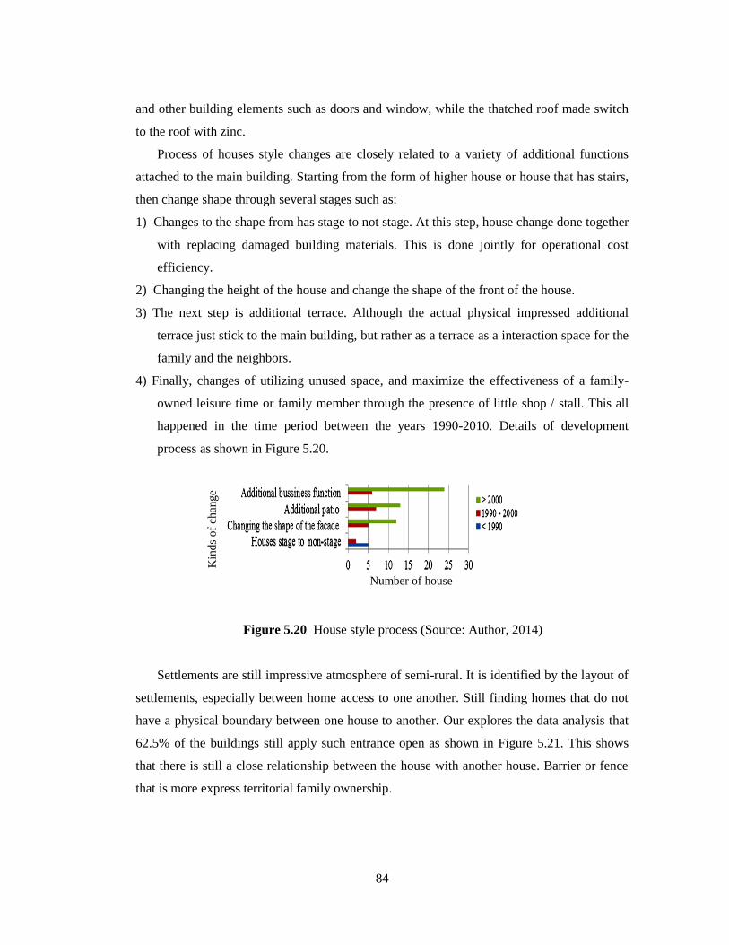
84
and other building elements such as doors and window, while the thatched roof made switch
to the roof with zinc.
Process of houses style changes are closely related to a variety of additional functions
attached to the main building. Starting from the form of higher house or house that has stairs,
then change shape through several stages such as:
1) Changes to the shape from has stage to not stage. At this step, house change done together
with replacing damaged building materials. This is done jointly for operational cost
efficiency.
2) Changing the height of the house and change the shape of the front of the house.
3) The next step is additional terrace. Although the actual physical impressed additional
terrace just stick to the main building, but rather as a terrace as a interaction space for the
family and the neighbors.
4) Finally, changes of utilizing unused space, and maximize the effectiveness of a family-
owned leisure time or family member through the presence of little shop / stall. This all
happened in the time period between the years 1990-2010. Details of development
process as shown in Figure 5.20.
Figure 5.20 House style process (Source: Author, 2014)
Settlements are still impressive atmosphere of semi-rural. It is identified by the layout of
settlements, especially between home access to one another. Still finding homes that do not
have a physical boundary between one house to another. Our explores the data analysis that
62.5% of the buildings still apply such entrance open as shown in Figure 5.21. This shows
that there is still a close relationship between the house with another house. Barrier or fence
that is more express territorial family ownership.
Number of house
Kin
ds
of
change

85
Figure 5.21 Fence performance (Source: Author, 2014)
5.6 NEIGHBORHOOD ACTIVITY
5.6.1 Terrace development
One aspect of the neighborhood that became characteristic aspect is the analysis of
family activity that is focused on the outside activities surrounding. Based on these aspects,
the family activities are analyzed by connecting neighborhood activity with the space
surrounding. In a sequence of outdoor spaces that exist around the home, space science
activities that occur in the street, yard, terrace and other supporting space like a little shop
which is located at the front of the house.
Terrace is a phenomenon that appeared in Bantik house began as a response to social
interests to interact against each other. This process occurs in a fairly long period of time,
based on the needs of the community. In the corresponding period of the development and
influence of the urban, the terrace is present or transitional space between inside with out side
based hierarchy. In this function the patio to be a place for temporary storage of the
motorcycle at any time during the day. It is closely related to family activities as well as
transportation facilities.
0 5 10 15 20 25
Close entranceOpen entrance
Without entranceEntrance
Number of house
Fen
ces
con
dit
ion
53.13%
62.51% 37.49%
9.38%
86
Development of terrace are occurred in the three growth, namely:
1) Terrace is a culture growth
In a cultural link, a transitional space terrace semi-formal in structure space and
social interaction. It occurs spontaneously, by adjusting the environment and nature.
2) Terrace is a activity growth.
It is rooted in the needs of families in adjusting to the environmental and physical
needs. Terrace interpreted as a space of socialization with swelling of the activity in
the family structure.
3) Terrace is a lifestyle growth
Adjustments to the environment is one of the business community achievement.
Change gradually occurs in the context of adjustment based on economic
considerations. The addition of a function room in the house is one of the
determinants terrace development in the context of the necessities of life. Terrace
growth process is described in Figure 5.22.
Terrace experiencing various types of growth. Identification of traditional house is used
as a reference shape, somewhat difficult to find a link between the stage as a traditional house
with a terrace where existence. As a traditional house, the house has a patio stage, but from a
variety of data used as a reference sample, found it rather the opposite, because there is a
21.88% house initially did not have a porch. Of suspicion that is based on the analysis of the
development of space, the possibility of having a relationship, but it should be referred to the
data far backward that is not reviewed in this study.

87
Figure 5.22 Historical of terrace growth (Source: Author, 2014)
5.6.2 Little house / Warung development
Position of commercial varies through different phasing process either based on growth
and development needs of the time. As one of the impacts of urban development, commercial
function does not only occur at locations along the main road in the settlement, but the
commercial function of moving into the settlements. This additional function started in the
<1990 1990 - 2000 >2000
1800 - 1900 1900 – 1970s
Social interaction is done in
exactly the home page
under the tree, either at
home or on the front side of
the house.
There is a set of people
started to make terrace the
interaction space
Terrace used as a
reception room.
Terrace used
socialization space
between neighbors
People are starting
to build a patio to
complement the
core building
Terrace became the
repository for the
motor
No have
terrace
Terrace as s structure
Yard as a common space of the
neighborhood
1970 - 1990
Culture Social interaction Life style

88
mid 1990s by adding rent one part of the house to the public or non Bantik who worked on
the Boulevard commercial area at the site, or who are studying in a location that does away
with the settlement. This process can be shown in Figure 5.23. Besides adding the front of the
house into a little shop.
Figure 3.23 Type of commercial function (Source: Author, 2014)
Figure 5.23 Type of commercial function (Source: Author, 2014)
Seepage through additional function spaces occur in the composition of which varies
according to the time change. Rental room occurs as the utilization of opportunities
commercial area, while the stalls were arrested with background activity in addition to
maximizing the opportunities of economic support.
Additional function
The warung position in
the left of house
Warung has a strong
relationship with the
road although divided
on the e-way
achievement
Based on the
Position of the main
building
Separately with the
main
buildingbuilding
Fused with the
main building

89
House composition is formed through the process and then switch to a private function
commercial by composition:
1) It blends with the main building,
2) Separating from the main building but have overall integrity
3) Separate the main building, as shown in Figure 5.24.
Figure 5.24 Type of little shop base on position (Source: Author, 2014)
Indeed the existence of pure stalls are independently family's needs, but the presence of
stalls can affect the activity of the people in the neighborhood. Developments in the local
shop physically Bantik community has linkages with other functions such as roads and
surrounding yard. The main relationship stalls with other facilities that become the main
House
Commercial
function 1
2 3

90
contact between the stalls with the community is the position. Based on its position, then
there are several classifications relationship with stalls around the location described in
Figure 5.25.
Figure 5.25 Relationship little shop with the house (Source: Author, 2014)
5.7 DISCUSSION
The analysis shows that spatial change dynamics becomes hard to avoid, because related
to many factors like city economy zone development, urban policy, and local society needs.
Indeed, layout change in the Bantik settlement started with the influx of the non-Bantik
residents as result of housing area, urban policy and commercialization in strategic settlement
area. This thing causes unbalanced growth between the Bantik residents and non bantik
residents. Besides, CBD has strong effect to many changes in the Bantik society, like bantik
residence location shift through land ownership from the Bantik residents to the non-Bantik
residents. This factor accelerate the increase of non bantik residents in the settlement location,
followed by building function change from housing to commercial, while there is decrease in
Little shop / Warung position
Without yard in front of
street
Located in front of main
house
Located inside the house
Two houses
Three houses
1 house
(temporary warung)
Warung relationship with the other function
: Site
: Terrace
: House
: Little shop /
warung
Not all stalls need for achievement page
point directly related to road
point that is not in direct contact with the road
going through the pages, but not always for the
achievement of going through the porch to stall.

91
Bantik residents number in the settlement. This condition triggers view change and lifestyle
of the Bantik residents.
Area commercialization is done for the importance of the Bantik residents‟ economy but
not followed by increase of internal resource yet, like increase of skill and education level.
This thing is related work opportunity that affects the increase of economy of the Bantik
society and affects the residence of the Bantik residents, that is starting to shift to the rear part
of the settlement. Indeed, area settlement characteristic based on culture factor can still be
found but that condition is not strong enough to hold the change. This is caused by strong
effect from city development. Uniqueness of settlement location and activity based on culture
will be strengthened in local housing character. Wealth as potency of society needs to be
guarded.
5.8 CONCLUSION
Spatial change happens in the Bantik tribe residents in Malalayang as result of society
factor combination, including urban development, commercialization and its effect to CBD
area, and lack of internal resource in the society. 2 main spatial changes happen in this
community: 1) change in physical visualization, especially settlement main corridor. This
change is started by the shift of ownership of land from the Bantik residents to non-Bantik
residents. There is building function change from housing to commercial change. This
change is affected by factors like commercial space continuance, accessibility, and economy
value of the area, 2) sosio-culture change that is affected by urban life factors. From the
aspect of population, society becomes minority, so buildings ownership in the strategic
location is owned by non- bantik residents, while the Bantik residents tend to be marginalized.
Adaptation to many changes can be done by maintaining the kinship in the local society,
maintaining potential location based on culture and basic skill increase supported by
economy. This thing is also necessary to adapt whit life needs and paradigm of society. So,
future layout change can be anticipated so housing location with local character and bantik
society existence can be maintained. Traditional life change is started by the mix of non-
Bantik residents in the settlement, especially mix in the family of bantik society. This thing at
least gives weakening in finding the traditional life, even though can be muted by the lack in
Bantik family neighborhood structure

92
CHAPTER 6
DEVELOPMENT OF COMMUNITY REHABILITATION
SCENARIO PLANNING
6.1 BACKGROUND
Basically the development can not be separated from the growth and growth requires
structuring. Society is one important factor in the arrangement. The diversity of ethnic
community with each characteristic makes the difficulty in planning. Therefore, one approach
to scenario planning is done through community rehabilitation. In line with this
understanding, the community rehabilitation is one strategy which is used in the development
of strategies for the sustainability of the local community.
Another approach to scenario planning is to build a plausible scenario, giving way to
develop a strategy despite the uncertainty (Zegras, 2012). Historical of Bantik community
experienced three stages of development. The first was manifest in the tribal-based
community where rituals, cultural, and environmental. The second transition condition over
the last of 19 century. The traditional settlement in this second stage were friction traditional
atmosphere. The implication focused mainly the urban perspective. The third was by city
development through modernization of increase of population and urbanization. The situation
especially urbanization provide a new role for local communities (Calthorpe, 1993). Scenario
planning associated with the local community and the society quoting the character
development aspect of the local community, which reflects the traditional role of public life
(Saleh, 2004).
6.2 METHOD
The ethnic Bantik community is the target set in this study. In an effort to find a
scenario planning, community rehabilitation is an entry point in the scenario planning for
continuity of ethnic community. This part is the planning stage therefore, the necessary data
in this section is a collection of data that have been used in the previous sections, obtained

93
through a series of field surveys. The additional data is a clarification of the data that has
been used in previous analyzes. This data was obtained through correspondence survey
conducted on January-March 2014.
Through the framework of society-community (Shiffman, 2002), the study was
modified based on the simplification of the traditional life aspects of the Bantik community.
The analysis is done in three aspects consist of: 1) socio-cultural interaction that is created by
the activity and physical aspects of the neighborhood, based on the social conditions that
focus on family activity that occurs under conditions-social mix between Bantik and non-
Bantik 2) cultural heritage effect on the local community, and 3) community perception.
Based on the above aspect, the analysis is done using the unit neighborhood strategy
include: demography analysis, activity and residential neighborhood composition. The next
strategy is done through a neighborhood relationship grew with the approach consists of: the
analysis of the relationship between house surrounding that focuses on the terrace
surrounding with street, local access analysis as a liaison with various functions, and analysis
of space including culture heritage site. Final analysis using community perception technique
include: the views and wishes of the people of the existing conditions. To get a more in-depth
perception, conducted follow-up interviews to several communities chosen based on the
criteria of age and its role in indigenous communities, because not all respondents are willing
to do the interview, so divided that some respondents considered representative data to be
extracted. Frame work of this scenario planning as shoe in Figure 6.1.
Figure 6.1 Framework of community rehabilitation scenario planning (Author, 2014)
Analysis
Data
pre Residents
perception Culture heritage site
and traditional activity
Community
space
Scenario planning Neighborhood
gathering Culture space
planning Relationship between community
space with the sea
Local population
Resident location changes
Settlement development
Neighborhood activity
Community perception

94
6.3 APPROACH OF TRADITIONAL ACTIVITY PLANNING
6.3.1 Group family development
In essence, the uniqueness of the Bantik community that is built on a family relationship
may provide the possibility for the reinvention of traditional life. Lineage is marked with
family names attached internally to the Bantik people. Resident location formed with the
merger of housing units that have a relationship based on lineage. Generally divided into 3
groups of residential location as show in Figure 6.2.
Figure. 6.2 Residential group location (Source: Author, 2014)
Based on the residential location, there are some differences in the three locations in
terms of physical characteristics, family composition and family activity as described in
Table 6.1. Naturally around Minaga Street location is a location that space is limited and
under naturally pressure because most of the settlements occupy in coastal areas. The
composition of non-Bantik most are in the vicinity of the cemetery. This condition is caused
by the historical settlement that was initially concentrated in two locations, namely: the
Minanga and Krida Streets surrounding. Thus providing convenience to the non-Bantik to
expand the land at that location. When it is connected to the family composition, the strong
Manado Bay
Minanga street
surrounding
Krida street
surrounding
Cemetery
surrounding
Manado Bay

95
relationship activity is created on location around Mianaga Street enough to give an idea that
has the potential locations for the development of traditional community life as long as
Bantik community can provide powerful protection against the entry of non-Bantik people in
that location.
Table 6.1 Characteristic of residential location (Source: Author, 2014)
No Aspects Minanga Street
surrounding
Krida Street
surrounding
Cemetery
surrounding
1 Detail location Northern part of the
housing bordering with
the Manado bay.
East of the housing
bordering with the non –
Bantik settlement
This zone has a field
East of the
housing bordering
with the non –
Bantik settlement
This location has
a cemetery
This location
has a cemetery
2 Population
approach
About 100 household
About 200
household
About 120
household
3 Neighborhood
composition
akctivity
Consist of 3-4 houses Consist of 3-4
houses
Spread
4 The level of
population mixing
between Bantik
people with non-
Bantik people
Dominated by Bantik
people about 80%
Dominated by
Bantik people
about 79.55%
Dominated by
Bantik people
about 61.8%
5 Zone service Coastal zone:
Rural-urban performance
Main corridor:
Commercial performance
Rural – urban
performance
Natural
residential
6 Family size Small composition (4-5
member in family)
Small
composition (4-5
member in
family)
Mid
composition (4–
6 family in
member)
7 Family
composition
Mix non-Bantik people as
temporary stay about
23.3%
Mix non-Bantik
people as
temporary stay
about 14.29%
Mix non-Bantik
people as
temporary stay
about 55.5%
8 Traditional
activity
Middle traditional activity Strong traditional
activity
Low traditional
activity
Grouping based on the location of the family group is very firmly in the physical
boundaries, and activities. The strong character of main street experiencing huge growth in
physical terms, functions, and the intensity of the crowd. This is the construction division of

96
group physical location of settlements. Pooling strategy based on group residential location
and various interest groups allows for translating into family planning group location. The
division of the group is done by developing the theme of family groups based on the location
and activity, namely: Social-cultural, historical-social, and social-religion as described in
Table 6 2.
Table 6.2 Location group family theme (Source: Author, 2014)
In addition there are also Bantik people who are live spread beyond the three locations.
These locations are categorized as a group of masked groups as they are distributed at
locations spaced far apart and varied. This condition is created from the movement of the
outside Bantik settlements. A total of 66.67% of the 30 samples of Bantik families who are
moved out of the location occurred before 2000 and amounted to 33.33% moved around the
year 2000-2010. Much as 54.17% displacement distance > 500 m from dwelling location
towards the south and west of the initial Bantik settlement. Years of displacement and
displacement distance has close links with the city development that began in the early of
1990s.
The number of families at three locations are vary. The largest number are in locations
Krida Street surrounding. Family group composition is formed not only by location of
residence, but also formed by family name and his descendants were called harmonious
without being limited by the location of settlements. The uniqueness of the settlement
contained in Parts Bantik are mostly family name and his descendants are in a neighborhood.
Aspect Details aspect Activities Potential
Location
Minanga
Street
Custom activity
Family
Social activity
Tribal historical
Cultural activities
Sub-group family
Krida Street Family
Social activity
Social interaction
Sub group family
Cemetery
surrounding
Custom activity
Family
Cultural element
Cultural activities
Family
composition
Family name
and decadence
Family activities
Social activities
Religious activities
Fundamental group
Neighborhood
unit location
Social-cultural group

97
Therefore, the pooling strategy has a close relationship with the location. Family group
composition can see in Figure. 6.3.
Figure 6.3 Group family composition (Source: Author, 2014)
Neighborhood activity occurred in several locations, namely setting around the local
streets in residential, yard, terrace, and home. The intensity of the use of space will depend on
the type and time of use. Activity is highly dependent neighbors gathered with the previous
activity. Mothers gathered after finished cooking by the time the morning with an hour of
cooking time 08:00 to 11:00 AM. This habit has been done in a long span of time, so that has
been entrenched in the community. Furthermore, they gathered at a neighbor's house that has
a space to hangout like: porch, under a tree on the side or front of the house, and the house
which has a place of business like a little shop. Utilization of time for the activity with adult
men and women mothers are similar at around 13:00 to 16:00 o'clock AM. As for the
children there are variations in time in accordance with the character of the age (see Figure
6.4).

98
Figure 6.4 Community activities base on neighborhood (Source: Author, 2014)
Formed social transformation through community activity occurs in various forms of
activities. Community-shaped small compositional activity involving community between 5-
10 units of home with a location adjacent to each other. Activities carried out in accordance
community interest that is affected by the location of the gathering place. Community activity
at the neighborhood level will be concentrated on a limited basis by type of activity, but is
open to the neighborhood people (see Figure 6.5). In a more concrete analysis, communal
activities take place via gathered together, with specific objectives, together with the daily
activities and play activities for children. This joint activity occurred outside the home or
around the house. Most activities can not be separated from the binder functions such as stalls,
street and terrace houses.
Power stalls so strong binder to form a common activity on the local roads in the
settlements, on a street corner, or directly on the road. The house has a shop facility will be a
point of gathering neighbors, not just for shopping, but the purpose of forming socialize
social interaction (see Figure 6.6). Role stall through the boundaries of social, cultural and
personal pleasure manifested in social interaction.
0
10
20
30
40
50
Father Mother Child: 1 -
5
Child: 5 -
12
Child: 12
- 17
Child: 17
- 23
Nu
mb
er p
f p
eop
le
People (age)
07.00 - 10.0010.00 - 13.0013.00 - 16.0016.00 - 18.00

99
010203040
Playing Sharing
information
Talking
about
something
Daily
activity
Num
ber
of
peo
ple
Activities
The highest activity
Father
Mother
Child: 1 - 5
Child: 5 - 12
Figure 6.5 Type and location of community activity (Source: Author, 2014)
Figure 6.6 Resident with the additional economic function location (Source: Author, 2014)
6.3.2 Local access in neighborhood unit
According to its function the street f as a transportation function. Habits by Bantik
community, the road has an important role because it serves as a public space in the context
traditional activity. Thus, created three close relations with the interplay between the
01020304050
Num
ber
of
peo
ple
Locations
Neighborhood people meeting
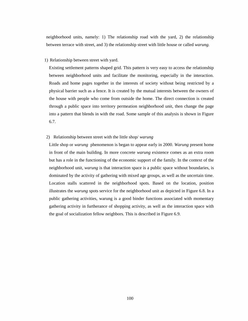
100
neighborhood units, namely: 1) The relationship road with the yard, 2) the relationship
between terrace with street, and 3) the relationship street with little house or called warung.
1) Relationship between street with yard.
Existing settlement patterns shaped grid. This pattern is very easy to access the relationship
between neighborhood units and facilitate the monitoring, especially in the interaction.
Roads and home pages together in the interests of society without being restricted by a
physical barrier such as a fence. It is created by the mutual interests between the owners of
the house with people who come from outside the home. The direct connection is created
through a public space into territory permeation neighborhood unit, then change the page
into a pattern that blends in with the road. Some sample of this analysis is shown in Figure
6.7.
2) Relationship between street with the little shop/ warung
Little shop or warung phenomenon is began to appear early in 2000. Warung present home
in front of the main building. In more concrete warung existence comes as an extra room
but has a role in the functioning of the economic support of the family. In the context of the
neighborhood unit, warung is that interaction space is a public space without boundaries, is
dominated by the activity of gathering with mixed age groups, as well as the uncertain time.
Location stalls scattered in the neighborhood spots. Based on the location, position
illustrates the warung spots service for the neighborhood unit as depicted in Figure 6.8. In a
public gathering activities, warung is a good binder functions associated with momentary
gathering activity in furtherance of shopping activity, as well as the interaction space with
the goal of socialization fellow neighbors. This is described in Figure 6.9.

101
Figure 6.7 Relationship between yard with street (Source: Author, 2014)
Min
an
ga s
tree
t
Yard without fence
Direct access

102
Figure 6.8 Little shop / warung location in the settlement
Figure 6.8 Little shop (warung) locations (Source: Author, 2014)
3) The relationship street with terrace
Linkage street with terraces can not be separated from the role of neighborhood activity.
Thus, terrace can not stand alone. During its development the terrace is an extra room that
started to develop since the early 1990s. In the process of development not only as a
terrace connecting space between the outer space with space inside, but it is also an
important area to support public activities as described in Figure 6.10. The terrace has a
direct relationship with warung and street activity as well as creating a public space for
support functions and semi-public activities supporting.
Manado Bay

103
CHAPTER 6
COMMUNITY REHABILITATION SCENARIO PLANNING
Figure 6.9 Relationship between little shop (warung) with street (Source: Author, 2014)
Min
anga
stre
et
Direct relationship with
the street in front of main
house
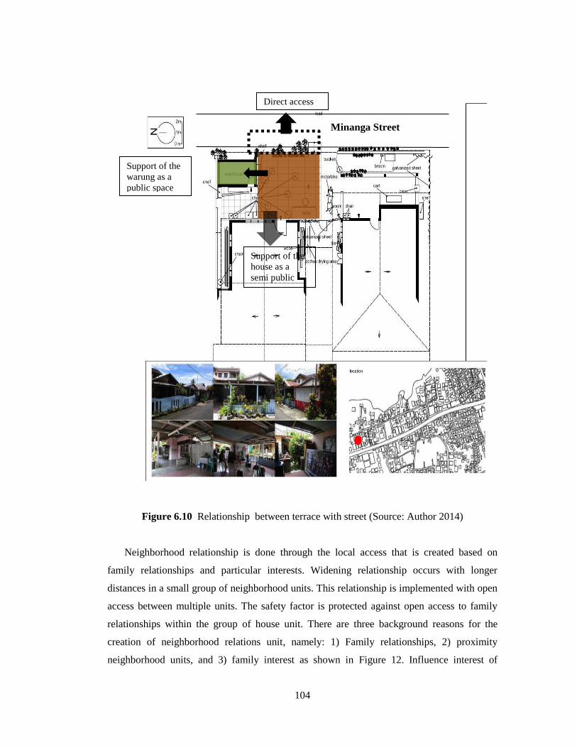
104
Figure 9.11 Relationship between terrace with street
Figure 6.10 Relationship between terrace with street (Source: Author 2014)
Neighborhood relationship is done through the local access that is created based on
family relationships and particular interests. Widening relationship occurs with longer
distances in a small group of neighborhood units. This relationship is implemented with open
access between multiple units. The safety factor is protected against open access to family
relationships within the group of house unit. There are three background reasons for the
creation of neighborhood relations unit, namely: 1) Family relationships, 2) proximity
neighborhood units, and 3) family interest as shown in Figure 12. Influence interest of
Minanga Street
Direct access
Support of the
warung as a
public space
Support of the
house as a
semi public
space

105
57.15% could be so strong, but still within the framework of family relationships as a
fundament open access occurs (see Figure 6.11).
Figure 6.11 Neighborhood interest aspects (Source: Author, 2014)
Neighborhood real interest does not stand alone, because in addition to family
relationships, it is not highly correlated with the presence of stalls around the neighborhood
so as to form groups of 3 units formations such relationships in Table 6.3 and Figures 6.12,
6.13, and 6.14.
Table 6.3 Neighborhood interest (Source: Author, 2014)
Factor Detail factor Type of
relationship
Pattern of
relationship growth
Neighborhood
Interests
Family relationship
Neighborhood relationship
Proximity location distance
Family needs::
Warung relationship with the family
needs
Open access for
1 direction
Linier
Open access for
two direction
Linier branched
Open access for
multi direction
Spread
0
5
10
15
20
Family
relationship
Proximity of
residential
Family interests
Fact
or
of
inte
rest
Number of family
53.57% 57.16% 46.43%
Neighborhood access
Aspect:
Family
Distance
Family interest

106
Figure 6.12 Open access for multi direction (four houses) (Source: Author, 2014)
Figure 6.13 Open access for 2 direction (three houses) (Source: Author, 2014
Min
an
ga s
tree
t
Entrance
Open access
Entrance
Alternative door
Connecting door
Connecting roof
Open access
Minanga street

107
Figure 6.14 Open access for one direction (two houses) (Source: Author, 2014)
6.4 APPROACH OF CULTURE HARITAGE ZONE PLANNING
6.4.1 Relationship between cultural spaces with the Bantik community
It is possible to improve the quality and position of the cultural heritage by improving the
connection between existing cultural heritage sites and the community. This can be achieved
by taking a more holistic planning approach and by promoting spatial planning methods that
strengthen the community‟s physical and social support structures. One of the obstacles
encountered in the planning, based on the above conditions, is the separation between cultural
heritage locations and the Bantik residential areas. The issue of spatial distance can be solved
by strengthening the relationships within Bantik society with the power of indigenous
organizations.
It would also be useful, at a later stage, to encourage the development of a close
relationship between the three planned zones, that is, the core zone with the promotion zone,
the core zone with the buffer zone, and the buffer zone with the promotion zone. This
relationship is created by spatial and social activities, which need to be strengthened by
addressing the issue of distance and the spatial characteristics of the location. This should lead
to an increase in local activity-based culture, and should lead to an improvement in the quality
of the physical objects. Overall, this increase should be based on local identity.
Entrance
Connecting door
Minaga street

108
6.4.3 Structure of the cultural heritage objects zones
The heritage sites are divided into several zones. These are: around the coast, near
residential locations, and apart from residential locations. An analysis of the cultural heritage
site positions and their distances from each other reveals that the Bantik cultural space is
created by individuals‟ activities, and, in particular, their physical and social relationships
(Higgins, 2007). A meaningful cultural space is created within distances of up to 200 m
because at this distance it is very likely that cultural activities will occur. Cultural spaces
beyond that distance are more defined by their physical heritage than their meaning, as there
is a much lower probability of cultural activities occurring more than 200 m from the largest
concentrations of Bantik people. This distance is better understood as cultural space with a
category and symbolic meaning, as shown in Table 6.4. What is needed is a close relationship
between the physical culture and the cultural activity because there are some physical objects
outside the zone of greatest concentration of the Bantik people in the settlements.
Table 6.4. Construction of culture heritage values (Source: Author, 2014)
Distance (m)
Cultural
Heritage
Spatial
Theme Cultural Social Old
Religion
<100
1
Cultural
promotion 10
6
11
2 Cultural basic
and
development 100-200 3
4
200-300 5
Hidden of
cultural 9
>300 7
8
Criteria
Good Has a strong relationship with the community
> 60% of the people know the object
Middle Has a regular relationship with the community
31-60% of people know that object
Low
Does not have a direct relationship with the community
Separated away from residential communities
<30% of the people know the object

109
Factors of space, time, and distance reduce the quality of family relationships in the
settlements, resulting in the cultural space becoming ambiguous. The distance between the
location of cultural heritage objects, the main road, and the concentration of dispersed
residential locations of the Bantik society affects the structure of cultural space zones. As
such, care must be taken when zoning cultural space, in particular by involving communities
and indigenous organizations to delineate the physical cultural heritage. Appropriate zoning
is needed to strengthen local identity and to improve the quality of relationships in the ethnic
community. Furthermore, to strengthen local identity, quality relationships are needed to
strengthen the relationship to cultural spaces. Based on questionnaires, 90.9% of individuals
chose Bantik field as being representative of cultural activity. These results are based on
activities that involve the whole Bantik community because the field is one of the focal
spaces of Bantik tribal life in Malalayang. Many activities can take place in Bantik field.
Furthermore, the court has publicly ruled that cultural activities are the right of the Bantik
settlements and that tribal communities have the right of permanent residence in this area.
However, based on a location analysis, the field is a public space and has a high value for
Bantik society. Based on these results, a field is a prestigious representation of Bantik
cultural space. Zoning of the cultural space extends northward from Minanga Street in an
area bounded by the coast. The location is the site most likely to serve as the core zone of
cultural space. Cultural spaces are also seeping into the southern settlements, especially
around the cemetery, although these have different services and activities associated with
them. The field is also used as the central unifying space for the Bantik communities in
Malalayang. In recent years, heritage has enjoyed increasing attention from policymakers and
is now seen as an important resource for economic growth (Vaz, 2011). Therefore, this
location has social importance and meets the basic needs of the settlement.
6.5 CUSTOM PLANNING APPROACH
6.5.1 Bantik’s philosophy as a as a unifying communit
Based on in-depth analysis has been done in the previous chapter with regard to
community participation found that Bantik philosophy are fundamental aspects that can affect
the respect and appreciation of traditional role-based. The most important component of the
Bantik community are customary tribal stakeholders, and Bantik society. Bantik tribe has a

110
philosophy are Hinggiridang, Hintakinang, and Hintalunang (H3) who has a sense of mutual
love, bad destiny, and help each other. In the social order of Bantik community, H3 are social
force that is capable of being a binder for the community in a variety of conditions
experienced. This is the basis of custom rules that bound in the spirit of community unity.
Compounding of H3 philosophy as shown in Figure. 6.15. Actually this philosophy has been
there from the past, but philosophy as missing and began to be revived in the end 1990s. This
revival was initiated by young people of Bantik community are becoming aware tendency of
loss of vigor and fellow public relations, began physically homeless and lost a role in social
life.
Figure 6.15. H3 Philosophy in Bantik community (Source: Author, 2014)
6.5.3 Custom activities
There are several types of Bantik custom activities owned by the community. Custom
packages are divided into several groups such as: arts, rituals, and rules that govern the lives
of Bantik people both joy and sorrow activity (see Figure 6.16). Low the Bantik community
composition affected the Bantik culture, so it tends to destroy the traditional habit (ed.al
Henley, 2010) so, there are mixing occurs between the traditional and modern culture.
H3 Philosophy
Community
Group / local
organization
Custom
activity
Cultural activity
Daily activity
Ceremony or
custom activity
Social activity
Religion activity

111
05
10152025303540
Lost of
traditional
activity
Lost of
Bantik
language
Cultural
event
Cultural
role
Lost of
Bantik
philosophy
Figure 6.16 Custom activities (Source: Author, 2014)
Custom activity is still visible in several cultural activities, although in its modern form
accordance with the city development. In social interaction more custom activities are
implemented in colossal art activities such as Mahamba dance or other similar arts attractions.
Based on the cultural aspect, indicating the Bantik community understanding and
appreciation of the custom activity is relatively low as described in Figure 6.17 and Table 6.5.
Figure 6.17 Bantik community responses to cultural aspects (Source: Author, 2014)
27.62% 35.24%
11.43%
5.71%
20.00 %
In summary questionnaire about
the public response to the
cultural aspect and it is not
appropriate to the present
context, because just as much as
35.24% of the Bantik people
know the language of Bantik.
Cultural events and traditional
role only be understood as
ceremonial activity.
Bantik‟s dance
Bantik people meeting
meeting Bantik‟s coordination
Yuyu and Yodo Bantik‟s
dance festival

112
Table 6.5 Characteristic of custom organization
Aspect Group base on
religion / group
worship
Group base on family / rukun Group base on
tribal
Member Bantik and non-Bantik
people
Limited member of
group (20 -30 family)
Bantik people base on family lineage
Unlimited members
All of the Bantik
community in the
settlement
Time of
meeting
Every week Every month Temporary
Location Neighborhood Not limited to a distance of residence Bantik settlement
Description Focus on religion
activities
More intensive meetings
Specific member
More privacy
Focus on the social, religious, and
family relationships
Wider activities
6.5.2.3 Strengthen of residents participation
Based on the analysis of the level of implementation shows that the role of participation
is still low. This is caused by the lack of public awareness as well as a lack of understanding
of the culture. All of this stems from the lack of public awareness of local sustainability for
community. Required internal reinforcement through family-based association called rukun.
While based on ethnic group is needed for a wider range, which is intended as an external
amplifier. In addition, this ethnic group has the potential to strengthen the cultural aspects
through education and promotion of culture as shown in Tables 6.6.
Table 6.6. Strengthen of community participation (Source: Author, 2014)
Aspects Community group
Group base on
tribal
Group base on family (rukun) Group base on
religion
Participati
on activity
Improvement
public participation
Strengthen of relationship
through family activity
Strengthen
collaboration
through religion
activities
Education Improvement
cultural activity
Improvement of family
sharing
Improvement of
relationship
People
attitude
Improvement of
people attitude
Improvement of people
attitude
Improvement of
people attitude

113
6.6 THE CONCEPT OF COMMUNITY REHABILITATION SCENARIO PLANNING
Community rehabilitation is a reference scenario planning concept for Bantik community
sustainability Community rehabilitation scenario planning concept is a blend of traditional
life, perception of Bantik community, communal space-based activities and culture heritage
site. Based on the analysis produced for community rehabilitation concept consist of: spatial
growth, social growth and cultural growth. Furthermore, this concept will be implemented in
scenario planning based on Bantik community needs. Scenario planning will refer to the
concept, resulting in a strategic plan for continuity of Bantik community. The concept of
community rehabilitation as described in Figure 6.18
Figure 6.18 Community rehabilitation concept (Source: Author, 2014)
In the Bantik community sustainability, strategic scenario planning is an integral part of
the concept of community rehabilitation. Compounding these two aspects will give birth to a
planning strategy that is rooted in community space, a custom activity and culture heritage
site. This plan will detail relating to the needs and perceptions Bantik community. Based on
the analysis of resident perception including community needs, concept of scenario planning
will lead to specific locations based on need assessment. Scenario planning concepts
described in Figure 6.19.
Community
rehabilitation
Traditional
activity
Culture
heritage
Community
space
Traditional
life
Neighborhood space
growth
Custom growth
Culture space growth
Continuity
of Bantik
community
Culture
heritage site

114
Figure 6.19 Construction of scenario planning (Source: Author, 2014)
6.7 COMMUNITY SPACE PLANNING
6.7.1 Neighborhood space planning
Based on the traditional life analysis with a family group location approach there are
three aspects planning technique based on the location of settlements, namely: family group,
neighborhood units, and neighborhood focus on activity space. Overall these aspects into
account local collaborate with potential cultural, historical and character Bantik local
community with an overview of the influence of city development, as described in Table 6.7
Community space
planning
Culture heritage
planning
Custom planning
Neighborhood
space planning
Custom space
planning
Terrace space
planning
Street space
planning
Field space
planning
Custom
relationship
planning
Pillar of custom
planning
Culture zone
planning
core zone
Buffer zone
Promotion zone

115
Table 6.7. Construction of family activity (Source: Author, 2014)
Family space aspect Space analysis Implication in the
community
Neighborhood unit
Relationship street with the yard
Structure of support
space
Relationship street with the terrace
Relationship street with the little
shop (Warung)
Neighborhood access Family access Connecting access
Commercial access
Neighborhood space
Type Location
Connecting space Neighborhood
gather
Street
Yard
Terrace
Commercial
gather
Little shop
Community gather Street
Field
Predominantly, family group concentrated on one location and then divide irregularly to
locations around the intersect between one group with another group based on lineage
relationships. Location family planning groups described in some localities Based on the
historical and familial ties that Minanga Street surrounding location (see Figure 6.20),
cemetery surrounding location (see Figure 6.21) and subgroups Street surrounding location
(see Figure 6.22) and family group outside settlements (see Figure 6.23).

116
Figure 6.20 Group family location in the Minanga Street surrounding (Source: Author, 2014)
Figure 6.21 Group family location in the cemetery street surrounding (Source: Author,
2014)
Limited family number
Spread to the other
location of family group.
Bantik family
in the spread
position.
Manado Bay
Limited household family /
small group
Have a clear boundary
location with a limited area
Have close family
relationships.
Sub-group family Important street
Historical location.

117
Figure 6.22 Group family location in the Krida Street surrounding (Source: Author, 2014)
Figure 6.23 Group family location in the outside in the settlement (Source: Author, 2014)
Group family in one location bound with sub-family group in that location then fused
with other locations in the settlement. There are some family who reside outside the study
site, then joined in the sub-group or family group. This process formed in a small capacity, so
the family is more inclined to merge freely with the larger group. By combining the locations
that are outside of the settlement, then the sub-group became a buffer group united by ties of
family-based culture. Minanga Street surrounding and Krida Street surrounding into the core
while the cemetery surrounding location serves as a buffer, as shown in Figure 6.24. The
Sub-group
Sub-group
Krida street

118
farther the distance from the family basic location, the smaller the influence of traditional life,
and so we need relationships in family-based aspects of culture (see Figure 6.25).
Figure 6.24 Neighborhood space planning based on location
Figure 6.25 Relationship planning based on family locations
Manado Bay
W. Mongisidi street
Minanga and Krida
Street surrounding: as
a basic family group
location
Cemetery
surrounding Support
for family group
location
Belt family
group location

119
6.7.2 Terrace surrounding planning
Based on the traditional role in the community Bantik, the terrace is a space within the
development provide a platform for transition activities, as well as support activities between
outside and inside activities. Therefore, the patio is not just a family meeting, but the meeting
space and the space of interaction among neighbors who are nearby. As a meeting room, a
terrace not stand alone, but is based on a series of activities. Therefore, the terrace is a
connecting space, a space of interaction and socialization spaces as described in Table 6.7.
Table 6.8 Terrace space planning
Planning Location Function Time use Space
character
Terrace space
planning
Terrace
Connecting space in the site.
Gathering space.
Interaction space
Tends to be
limited by
the interests
of the
family.
Semi public
Based on the analysis of the activity, the terrace has a role as a connecting space.
Therefore, as a connecting space at least terrace can be a connection between
neighborhood activities focus on the coastal environment. The terrace is a shared
space among several neighborhood units, then from the neighborhood gathering
space of this spread to the coastal location. Costal orientation is created through open
access between the neighborhood unit and the open space around the coast as
described in Figure 6.26.
House
Terrace
Yard
Little shop (warung)
Shoulder
120
Figure 6.26 Relationship terrace with the sea location
In creating wider access in the context of settlement, terrace will establish a
relationship with the main street through local access, so as to create a relationship
between the main street with the coast. This plan is based on the history of ethnic
community that has a direct connection with the coast through traditional activity.
This plan as described in Figure 6.27.
Figure 6.27 Relationship between terrace, main street, local street with sea location
Free space: gathering activity
Sea
Open access
Sea
Mai
n s
tree
t Open access
Free space: gathering activity
Local access
Lo
cal
stre
et
House
Terrace
Yard
Little shop (warung)
Legend:
House
Terrace
Yard
Little shop (warung)
Legend:

121
Street corner becomes a potential space for the neighborhood activity because it is
associated with the other function space such as little shop function. Warung has a range of
activities not only at the shop, but spread to the yard and the existing street in front of the
warung. Effect of stalls will reach some houses and the surrounding space, thus forming a
bubble chamber as described in Figure 6.28.
Figure 6.28 Neighborhood space planning influences of warung (Source: Author, 2014)
The neighborhood space planning is not separated from the development to the above
three aspects, namely terrace, yard and street, through development activities as described in
Table 6.9. Street activity is influenced by the presence of warung, and forming street corner

122
activity. While the neighborhood relationship focus on local access is also influenced by the
presence of warung role, so as to create local access among neighbors.
Table 6.9 Structure of neighborhood space planning (Source: Author, 2014)
Structure Planning Condition Application
House Human settlements Semi-permanent
Open space
Transition space
Formed by itself
(spontaneous)
Vegetation area
Small gardens for spices
Free space
Formed by itself
(spontaneous)
Street Circulation
Neighborhood street
Dirt street without pavement
Width: about 4m
Common space Gather on the street
Structure Planning Condition Application
House Human settlements Semi-permanent
Open space
Transition space
Formed by itself
(spontaneous)
Vegetation area
Small gardens for spices
Free space
Formed by itself
(spontaneous)
Street
Circulation Neighborhood street
Dirt street with pavement
Width: about 4m
Common space Gather on the shoulder
street
Structure Planning Condition Application
House Human settlements Permanent
Open space
Transition space
Created by owner
Vegetation area
Small gardens for spices
Small garden for flower
Yard Interaction space
Street
Median Circulation
Common space
Neighborhood street
Hot-mix asphalt
Width: about 6m
Shoulder Common space Gather on the street
Gather on the shoulder street
Interaction space
House
Open space
Street
Free space House
Open space
Street
Free space House
Open space
Street
Little shop
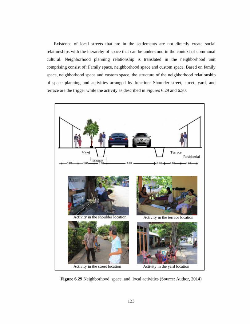
123
Existence of local streets that are in the settlements are not directly create social
relationships with the hierarchy of space that can be understood in the context of communal
cultural. Neighborhood planning relationship is translated in the neighborhood unit
comprising consist of: Family space, neighborhood space and custom space. Based on family
space, neighborhood space and custom space, the structure of the neighborhood relationship
of space planning and activities arranged by function: Shoulder street, street, yard, and
terrace are the trigger while the activity as described in Figures 6.29 and 6.30.
Figure 6.29 Neighborhood space and local activities (Source: Author, 2014)
Activity in the terrace location
Terrace
Residential Yard
Activity in the shoulder location
Activity in the yard location Activity in the street location
Activity in the terrace location

124
Str
eet
❹
❸
❷
House
Terrace
Yard
Little shop
(warung)
Shoulder
Street in the neighborhood
❶
Figure 6.30 Structure of neighborhood relationship space planning (Source: Author, 2014)
6.8 CULTURE HERITAGE SITE PLANNING
6.8.1 Relationship cultural heritage planning with the Bantik community
The notions of urban sustainability and “living cities” are characterized by their
possession of unique historic heritage (Vaz, 2011). Cultural frameworks and socio-economic
contexts provide an understanding of traditions, value systems, and symbols that are common
to a given society (Landman, 2009). This understanding is in contrast to the existing situation
in the local community. The development of the city has changed the collective local memory;
therefore, the existing cultural heritage has almost no meaning. In contrast, the cultural
heritage activities are themselves symbols that can be used to create an identity for local
communities. The wealth of cultural heritage is the dominant factor, and this is connected with
cultural planning. Therefore, coastal locations produce a grouping effect, acting as an
attraction for residents by possessing value associated with early historical settlements located
around the coast. The planning needs to be supported by local attitudes. The 1990s generation,
in particular, expressed poor attitudes (only 15% of respondents) toward viewing cultural
heritage as important. This contrasts with the older generation (aged 40 years and above), who
had fairly positive attitudes (45.7% of respondents) about cultural heritage. This shows that
there is still hope for developing higher levels of respect towards cultural heritage in the

125
younger generation through the optimization of existing indigenous organizations. These
include the “Young Generation of Bantik Tribes,” the “Institute of Indigenous Stakeholders of
the Bantik Minanga Tribe in Malalayang,” the “Alliance of the Bantik Tribal Society,” and the
“Social Organizations of the Bantik family” such as: Tontey family, Bangkang family,
Rumansi family, Rumansi family, Sege family, Pokatong family, Mongisidi family, None
family, and so on.
6.8.2 Zone of culture heritage site planning
Spatial planning is defined as a method used largely by the public sector to influence the
future distribution of activities on a landscape (European Commission, 1997). Several
problems underlie cultural planning in this context. These include a variety of cultural heritage
object types differentiated between the two locations that are separated by a main road and the
coastal areas that contain a high concentration of Bantik community members. Three zones
must be considered for planning cultural space in the Bantik settlement: (1) a promotion zone;
(2) a core zone; and (3) a buffer zone. The arrangement of space, especially with respect to the
stones object, is what causes low public awareness of cultural heritage sites. The distance from
the main street is an important factor when objects are positioned in the center of the
settlement. The conceptual distribution of spatial and physical objects needs to take into
account their distance from areas with the highest concentration of Bantik community
members and their distance from the main street, as show in Figure 6.31.
Planning details need to be adjusted to suit the characteristics of the location, in particular
the existing division of cultural space. Planning involves not only the physical arrangement of
space but also surrounding community activities, cultural activities, rules and policies, as well
as the maintenance of cultural heritage objects and the spaces around them. This is shown in
Table 6.9. The loss of cultural identity tends to be caused by the erosion of cultural activities,
the influence of W. Mongisidi Street, and the distances between objects that are located in
prime locations in relation to the Bantik settlements. Government cooperation and support are
essential for the establishment of zoning laws and to assist in the maintenance of the objects
and the area that surrounds them.

126
Figure 6.31 Conceptual distribution of zone considering the distance from the main street
6.8.3 Strengthen of cultural heritage zone planning
It is possible to improve the quality and position of the cultural heritage by improving the
connection between existing cultural heritage sites and the community. This can be achieved
by taking a more holistic planning approach and by promoting spatial planning methods that
strengthen the community‟s physical and social support structures. One of the obstacles
encountered in the planning, based on the above conditions, is the separation between cultural
heritage locations and the Bantik residential areas. The issue of spatial distance can be solved
by strengthening the relationships within Bantik society with the power of indigenous
organizations.
It would also be useful, at a later stage, to encourage the development of a close
relationship between the three planned zones, that is, the core zone with the promotion zone,
the core zone with the buffer zone, and the buffer zone with the promotion zone. This
relationship is created by spatial and social activities, which need to be strengthened by
addressing the issue of distance and the spatial characteristics of the location. This should lead
to an increase in local activity-based culture, and should lead to an improvement in the quality
❶
❼
❷ ❸
❹
❺
❻
❽
Manado Bay
❶~❽ : Heritage
site
: Core zone
: Buffer zone
: Promotion zone

127
of the physical objects, as shown in Figure. 6.32. Overall, this increase should be based on
local identity.
Fig. 6.32 Character improvement of cultural heritage
6.9 CUSTOM PLANNING
Traditional life of Bantik community brought under the influence of urban development
so, that confidence in the traditional life almost difficult to be grown back. Referring to the
community localization that is predominantly concentrated or dispersed in another location,
at least need to find a frame-based culture as the foundation. The implications of this
framework will be realized in the socio-cultural activities are free with the coordination of the
family or family group locations both within and outside the residential location shown in the
Figure 6.33.
Cultural heritage improvement
Core zone
Buffer zone
Core zone
Promotion zone
Buffer zone
Promotion zone
Create relationship of cultural heritage site
Unity of cultural heritage
Character improvement:
Spatial improvement
Activity improvement
Quality physic improvement
Strengthen local people

128
Figure 6.33 Construction philosophy in the activities implementation.
Custom activity planning stems from the pillar of sustainable consisting of three main
pillars: traditional activity, cultural activity and neighborhood activity sustainable. These
three pillars will collaborate with the community's internal capabilities, external influences,
and time. This combination determines the attitude of the community in the face of a
situation like that shown in Figure 6.34
Figure 6.34 Bantik community attitude planning
Activity
Bantik people
In the settlement area
area
Family
Custom
organization
Outside of settlement
area
Non-family
Group-family
Mutual aid
(Mapalus)
Bantik’s sloganphylosophi:
Hintakinang,
(love each other)
Hintalunang,
(mutual aid)
Hinggiridang
(a feeling of
togetherness)
Base on residential location Base on activity Base on philosophy
Traditional activity sustainable
Culture activity sustainable Neighborhood activity sustainable
Attitude
adaptation

129
6.9.1 Ethnic community participation planning
Based on the analysis of the level of implementation shows that the role of participation
is still low due to the lack of a clear vision of the group so that the group it flow, and lack of
cultural understanding by the public. All of this stems from the lack of public awareness of
Bantik community sustainability. Required internal reinforcement through the rukun to the
Bantik community, while the base on tribal group to a wider range aimed as external
reinforcement while the tribal groups on the base for a wider range of geared as external
reinforcement. In addition this group has potential to strengthening the cultural aspect
through cultural education and promotion as shown and the model of community
participation as shown in Figure. 6.35.
Figure 6.35 Model of community participation
6.9.2. Group custom planning
Planning a custom group technique through participation can not be separated from an
understanding of hintakinang, hintarunang, and hinggiridang as the communities Bantik
philosophy rate even in this condition Bantik less appreciated by the public. In a basket less
than 30 years, as a cultural association norms embodied in activity, social interaction and
implementation of activities with reduced spatial orientation gray hair. Family as the basic
organization of the smallest are less able to counter this, so widening the existing custom
group in the settlements. It is weakened by the spread of off-site public housing, there tends
Improvement
awareness
Appreciate of local
heritage site
Strengthen of basic group
community
Strengthen of internal
relationship
Development of
community cultural
promotion
Ethnic
community
sustainable

130
to be considerable differences in perspective between people inside and outside the
settlements.
To strengthen the socio-cultural power of a community-based, required a custom required
technical dimensions maintain orientation, and awareness to reduce internal friction due to
differences of opinion.
Implementation of custom activities that need to be prepared considering the presence of
a variety of cultural activities such as a variety of attractions such as dance mahamba dance,
dance colossal war conducted in the form of cultural events, and has culture elements that
still exist in society. The development of participatory techniques through local community
involvement, empowerment custom and community-based organizations are expected to
further solidify the existence of a custom is not only limited to the organization but extends to
tribal-based local community group (see Table 6.9)
Table 6.10 Custom group participation planning
Inform Involve Collaborate Empower
Culture calendar
event
Brochure publication
Sign and billboard
Cultural gate
All Bantik member
Custom organization
Family group
City government
Independent donors
Culture foundation
Independent culture
education
Culture event
management
Empower custom
organization
Custom management
By combining Custom participatory planning mechanism, custom technic group
participation, and planning based strategy that has been previously the custom group
participation planning described by 3 identity include: Social identity, culture, identity, and
spatial identity as described in Figure 6.33

131
Figure 6.36 Custom participation planning
6.9.3 Custom participation planning
Community planning is a perception among Bantik compounding needs participatory
planning and community planning. Community perception develops joint planning between
community interaction is encouraged by setting the physical environment and external
influences. This plan involves the local community to the fullest so that not only subjectively
rooted in the desire of the local community that is rooted in the cultural and social context of
the local character. Community planning perception displayed image (see Figure 6.37).
Custom participation
Culture
identity
Daily activity
Group
organization
Neighborhood unit
location
Culture orientation
Culture element in the
settlement lay out Culture aspects:
Tribal philosophy
Community attitude
Strengthen of culture element

132
Figure 6.37 Bantik custom planning
6.10 CONCLUSION
Community rehabilitation scenario planning is rooted in the local community conditions
that pivots on a family activity then transcend social, cultural and physical. While the
perspective of social relationships is a referral strategy that will unite the community in
carrying the effectiveness of traditional planning counter in keeping the local community.
There are three reasons that the background for the creation of neighborhood relations unit,
namely: 1) family relationships, 2) proximity environment, and 3) family interest.
Street, yard, patio and stalls form a very close relationship through the boundaries of
space, time and activity. Location traditional meeting space, as well as connect to the social
and cultural access through communal interaction and time with no age limit. While public
relations will be maximized by the role of the cultural pillars through community perception,
community participation and the role of organizational culture. Minanga Street and
surrounding the core zone with environmental groups as the basic unit of social interaction
and culture acquired through distance <100m as environmental zones, 250-500 as a public
zone, and> 500 as a custom zone. Growth applying traditional life outside through a
Continuity
Condition
Adaptation
Implementation
Identity
Attitude
External
influences
Internal
capabilities
Residents
perception Culture Community
space

133
connecting activity. Street, yard and patio is a communal space that is bound by family ties
and culture as a unifier.
There are three important aspects of scenario planning related to community
rehabilitation, namely: 1) Spatial location that focuses on family planning group. This
scenario planning will focus on traditional life echoes influenced by the jerk. The farther jerk
settlements with settlement core, the less traditional life that may have formed. Therefore, the
role of relationships and culture will be increasingly necessary belt 2) Scenario-based
planning culture heritage site. Core zone located around the road Minanga locations that have
historical value, while the Road subgroups as developing core zone that is affected by
compositional Bantik family. Buffer zone is a culture heritage site locations around the
cemetery and settlement site beyond the reach of jerk in the neighborhood zone, 3)
Community perception. Pillars of culture, internal upon ability, and the effect of external
factors that affect a community perception. Therefore, through an attitude adjustment and
internal capabilities, which will be pursed to form the identity of the local community
continuity strategy.

134
CHAPTER 7
CONCLUSION
Traditional life changes experienced by the Bantik tribal communities in Malalayang,
Indonesia is difficult to avoid because it has a close relation with the development of the city,
the high number of immigrants in the residential location and proximity to the city's
commercial district. Degradation of spatial, social, and cultural is negative impact
experienced by the people, although in terms of economic opportunity additional income
through additional commercial functions in residences is considered a positive opportunity
captured by the community.
Community degradation are felt mainly on traditional activity, and tribal perspective
because the mixing of non-Bantik in settlements either through intermarriage and the influx
of immigrants who live permanently in the settlement. Especially physical characteristics of
settlement houses are very difficult to find, because it changes the function of the building, so
it is quite possible to do that is through family activity approach.
Find continuity in local community, then community rehabilitation becomes an entry
point in the scenario planning strategy to find the local community. Scenario planning as
developing through certain aspects of the unique character of the local community-based
lifestyle through the development of family activities include a terrace and the surrounding
area.
An analysis of 62.86% of the people agree with the changes, and about 20% undecided.
The decision to choose a more hesitant attitude tends to be interpreted in the affiliate agrees
as social-culture perception, reinforced with lace percentage of people who do not agree
below the 10% level. Behind resignation public attitudes towards existing conditions, people
actually still have the desire to maintain traditional life through the physical setting and
traditional activity. Amounting to 79.05% of the people want to retain the layout of
settlements based on culture heritage owned. Thus the attitude of social adjustment, culture,
and spatial is absolutely a must Bantik held by the public.

135
Minanga street surrounding a core zone includes both culture heritage site, traditional
activity, and historical settlement. Krida Street is followed by a buffer zone surrounding
cemetery.
Community rehabilitation rooted in neighborhood planning units through the boundaries
of social, cultural and physical. While social relations perspective is a referral strategy that
will unite the community as a counter traditional planning effectiveness in maintaining local
community. There are three reasons that background the creation of neighborhood relations
unit: 1) Family relationships, 2) proximity neighborhood units, and 3) family interest. Street,
yard, terrace and little shop/warung form a very close relationship through the boundaries of
space, time and activity, for a gathering space, as well as connecting to the social and cultural
access through communal interaction without being limited to age and time.
In detail, community rehabilitation scenario planning can be described as follows:
1). Keep the ethnic community through social planning, activity planning and culture
heritage site planning base on local population by using street development strategy, house
development process strategy, family activity strategy and community perception strategy.
2). Scenario planning is achieved through the aspect of unity between the community
condition, residential surrounding, and commercial function. Through the movement steps of
non-Bantik resident that come into the settlement location, the perception of the local society
is changing. Hence, there is a function unity between residential and commercial, not only to
the main street but penetrates the residential surrounding with the focus on family activity.
3). In the relation with the community and social interaction, scenario planning is
directed to the inter neighborhood unit distance in the settlement with classification: Inter
neighborhood unit distance < 250 m as a neighborhood zone, 250–500 m as a community
zone, and >500 m as a custom zone.
4). Community rehabilitation scenario planning is made through the relation with the
culture heritage site with the classification: a) Core zone historical-base of the Minanga Street
surrounding location, b) Core zone community-base of the Krida Street surrounding location,
c) buffer zone of the out of Minanga and Krida Street surrounding location and d) promotion
zone in the location of the main street of Wolter Mongisidi Street.

136
5). Related to the community-base, scenario planning is directed to the local
community‟s support to appreciate more to the local culture towards attitudes and also to
group community organization based on family group location, local organization, and
custom with the spirit of Bantik philosophy.
The conclusion that scenario planning is a strategy that is needed in maintaining the
continuity of local community through the community rehabilitation with the concept of
custom activities, cultural zone, and neighborhood space continuity. Community
rehabilitation scenario planning to be very useful for Bantik ethnic community. Although
scenario planning may be can not applied to the other ethnic community because limitation
only one ethnic community for case study, and different characteristic of each ethnic
community, but through its analysis this method can be applied to the other community that
has same problem.

REFERENCES
1. Albrechts, L. (2004). Strategic (spatial) planning reexamined. Environment and Planning
B: Planning and Design, 31, 743-758.
2. Arthurson, K. (2011). Social mix and the city: Challenging the mix communities
consensus in housing and urban planning policies. Collingwood, Victoria: CSIRO.
3. Atkinson, R. (2008). European urban policies and the neighborhood. An review. Urban
Design and Planning. 161, 115-122.
4. Bates, R. H. (2000). Prosperity and violence: The political economy of development.
New York: W.W. Norton & Co.
5. Beekam, T., Lyons, F., & Scott. J. (2001). Improving the understanding of the influence
of owner occupiers in mixed tenure neighborhoods. Edinburgh: Scottish Homes.
6. Bertolini. L. (1999). Spatial development patterns and public transport: The application
of an analytical model in the Netherlands. Planning Practice and Research, 14(2), 199-
210.
7. Chang, C. Y., Chio, S. C. (2007). Environmental sustainability and the rebirth of cultural
heritage: A case study of the Old Neihu Quarry in Taipei, Taiwan. Journal of Asian
Architecture and Engineering, 6(1), 17-24.
8. Christensen, F. (2014). Understanding value changes in the urban development process
and the impact of municipal planning. Journal of Land Use Policy, 36, 113-121. doi:
10.1016/j.landusepol.2013.07.005. Retrieved from http://www.sciencedirect.com on
January 12, 2014.
9. CIA World Factbook, (2013). http://ilmupengetahuanumum.com/10-negara-dengan-
jumlah-penduduk-populasi-terbanyak-di-dunia. May 13. 2014.
10. Coates, Ken. S., (2004). A Global History of Indigenous People: Strangle and Survival.
New York: Palgrave Maccmilland.
11. Cohen, I. A. (2004). Synergy between urban planning, conservation of the cultural built
heritage and functional changes in the old urban center: The case of Tel Aviv. Journal of
Land Use Policy, 22, 291-300. doi: 10. 1016/J.landusepol.2004.03.06. Retrieved from
http://www.sciencedirect.com on December 12, 2013.

12. Conelly, S. (2007). Sustainable development as a contested concept. Local environment,
12(3), 259-279.
13. Djunaidi, A., Basuki. M. N. (2005). Coastal Development Planning, Journal of
Environment Technology, 3 (3), 225-231.
14. Dong-wha Kwack. (2004). The Aspect of Residents’ Evaluation and Community
Forming in Planned Detached Housing Areas. Journal of Asian Architecture and
Building Engineering/, 3(1). 311-318.
15. Egam, P., Mishima, N. (2014) Spatial development of local Bantik community in
Malalayang, Indonesia. Journal of Civil Engineering and Architecture 8(3). 354-354.
16. Egam, P., Mishima, N., Subroto, W. S. (2012). Impact of Urban Development to Coastal
Bantik Settlement in Malalayang, Indonesia. Proceedings of the 8th International
Symposium , ILT, Indonesia, 554-560.
17. Egam. P., Mishima, N. (2012). A Planning Approach of Population Movement for Local
Coastal Bantik Community. Proceedings ICCC, Japan, 10(2), 101-102.
18. Egam, P., Mishima, N. (2014). Local cultural heritage site and spatial planning for the
Bantik ethnic community in Indonesia, Journal of EPPM, 4(2), 60-73.
19. European Commission. (1997). Compendium of European Planning Systems. Regional
Development Studies Report 28. Office for Official Publications of the European
Communities, Luxembourg. In: United Nation (2008). Spatial Planning. Key Instrument
for Development and Effective Governance with Special Reference to Countries in
Transition. Geneva, Switzerland, 1-6. Retrieved from http://www.sciencedirect.com on
January 12, 2014.
20. Feagin, J. R., Parker, R. (1990). Building American cities: The urban real estate game.
Englewood Cliffs, NJ: Prentice-Hall.
21. Fenster, T. (1996). Ethnicity and citizen identity in planning and development for
minority groups. Journal of Political Geography 15(5). 405-418. Doi.0962-
6298(95)00067-4
22. Fernandes, J. R., Chamusca, P. (2014). Urban policies, planning and retail resilience.
Journal of Cities, 36, 170-177. doi. 10.1016/j.cities.2012.11.006.
23. Freeman. C., Littlewood, S. & Whitney, D. (1996) Local Government and Emerging
Models of Participation in the Local Agenda 21 Process, Journal of Environmental
Planning and Management, pp. 65-78

24. Gittell, Marilyn. (1980). Limirs of Citizen Participation: The Decline of Community
Organization. Beverly
25. Graham, B., Ashworth, G. J., Tunbridge, J. E. (2000). A Geography of Heritage: Power,
Culture and Economy. London: Hodder Arnold. In: Jimura, T. (2011). The impact of
world heritage site designation on local communities: A case study of Ogimachi,
Shirakawa-mura, Japan. Journal of Tourism Management, 32(2), 288-296. doi:
10.1016/j.tourman.2010.02.2005
26. Grafland, N. (1991). Minahasa, Yayasan Parahita, Jakarta. 502-509.
27. Hanifah. M. (2013). Kenali negeri sendiri sebelum jelajahi negeri orang. Retrieved from
http://travel.okezone.com/read/2013/01/04/408/741602/kenali-negeri-sendiri-sebelum-
jelajahi-negeri-orang-i. on March 10, 2014.
28. Healey, P. (2006). Transforming governance: Challenges of institutional adaption and a
new politics of space. European Planning Studies, (14) 3, 299-320.
29. Heimlich, R.E., Anderson, W.D., (2001). Development at the Urban Fringe and Beyond
(AER-803). US Department of Agriculture, Economic Research
Service,Washington, DC.
30. Hejazi, M. (2008). The risks of cultural heritage in Western and Central Asia. Journal of
Asian Architecture and Engineering, 7(8), 239-245.
31. Henley., David., Davidson. J., & Moniaga, S. (2010). Adat dalam politik Indonesia.
Jakarta: YOI.
32. Hewison, R. (1987). The heritage industry: Britain in a climate of decline. London:
Methuen. In: Jimura, T. (2011). The impact of world heritage site designation on local
communities.: A case study of Ogimachi, Shirakawa-mura, Japan. Journal of Tourism
Management, 32(2), 288-296. doi: 10.1016/j.tourman.2010.02.2005.
33. Higgins, M. (2007) The Cultural Space. ECCM Symposium “Productivity of Culture” in
Athens. Retrieved from http://productivityofculture.org June 11, 2013.
34. Hui’s, E. C. H., Lia. S. M., Wong. F. K. W., Yu, Z. Y. K. H. (2012). Ethnicity, cultural
disparity and residential mobility: Empirical analysis of Hong Kong. Journal of Habitat
International, 36(1), 1-10. doi: 10.1016/j.hanitatint.2011.08.003.
35. Hunter, Albert. (1974). Symbolic Communities. Chicago: University of Chicago Press.
36. Horowizt, D.L. (1985). Ethnic groups in conflict. Berkeley. University of California
Press.

37. ICOMOS. (2002). International Cultural Tourism Charter. Principles and Guidelines for
Managing Tourism at Places of Cultural and Heritage Significance. ICOMOS
International Cultural Tourism Committee. Retrieved from http://www.esicomos.org. on
June 10, 2013.
38. ICOMOS. (2008). Quebec Declaration on the Preservation of the Spirit of Place.
ICOMOS, Paris. 1-6. Retrieved from http://www.international.icomos.org on June 15,
2013.
39. International Association of Public Participation, (2007). IAP2 Spectrum of Public
Participation. [WWW page]. URL
http://www.iap2.org/associations/4748/files/spectrum.pdf.
40. Inui. Y., Kajiura, T. Fujita. S., and Takahashi. A. (1999) A Study on Spatial Composition
and Actual Conditions of Common Space Use at Detached Housing Areas. Journal of
Architecture, Planning and Environmental Engineering (Transactions of AIJ), No.518,
205212. (in Japanese)
41. Jakob, D. (2010). Constructing the creative neighborhood: Hopes and limitations of
creative city policies in Berlin. City, Culture and Society, 1 (4), 193–198.
42. Jimura, T. (2011). The impact of world heritage site designation on local communities: A
case study of Ogimachi, Shirakawa-mura, Japan. Journal of Tourism Management, 32(2),
288-296. doi: 10.1016/j.tourman.2010.02.2005.
43. Joerin. F., Desthieux. G., Beuze, S. B. Aurore Nembrini, A. (2009) Participatory
Diagnosis in Urban Planning: Proposal for a learning process based on geographical
information, Journal of Environmental Management, 202–211.
44. John, S.H. (2010). Spatial analysis of urban structure changes in Korean Mega-Cities,
Journal of Asian Architecture and Engineering 9 (1) 201-206.
45. JUMLAH PENDUDUK INDONESIA TAHUN 2013 Retrieved from
http://health.liputan6.com/read/521272/bkkbn-tahun-ini-penduduk-indonesia-capai-250-
juta-jiwa. On May 5, 2014.
46. Jupp, B., (1999). Living together: Community life on mixed tenure estates. London:
DEMOS.
47. Keef, S. E., (1992). Ethnicity Identity. The domain of perceptions of an attachment to
ethnic group and cultures human organization, 51(1) 35-43.
48. Kelly, E. D., Becker, B. (2009). Community Planning: An Introduction to the
Comprehensive Plan. Washington, DC, 133-142.
49. Kotus, J., Rzeszewski. (2013). Between disorder and livability. Case of one street in post-
socialist city. Journal of Cities. 23, 123-234.
50. Kwack, D. (2004). The aspect of residents’ evaluation and community forming. Journal
of Asian Architecture and Engineering, 3(2), 311-318.
51. Landman. T., Robinsin, N. (2009). The SAGE Handbook of Comparative Politics. SAGE
Publications Ltd. In: Fernandes, J.R., Chamusca. P. (2014). Urban policies, planning and
retail resilience. Journal of Cities, 36, 170-177. doi. 10.1016/j.cities.2012.11.006.
52. Landry, Ch. (2011). The creativity city index. City, Culture and Society, 2 (3), 173–176.
53. Lane, M., B. (2006). The role of planning in achieving indigenous land justice and
community goals, Journal of Land Use Policy, 23, 385-394.
54. Larkham, P. J. (2003). The place of urban conservation in the UK reconstruction plans of
1942-1952. Planning Perspectives, 18(3), 295-324.
55. Lelévrier, C. (2013). Journal of Cities. 35, 409-414.
56. Li, T. L. (2007). A study of ethnic influence on the facades of colonial shop houses in
Singapore: A case study of Telok Ayer in Chinatown. Journal of Asian Architecture and
Engineering, 6 (1), 41-48.
57. Logan, J., & Molotch, H. (1987). Urban fortunes: The political economy of place.
Berkeley: University of California Press.
58. Madhav, M.R. and Miura, N. (1994). Introduction. In: Miura, N., Madahav, M.R. and
Koga, K.(Editors), Lowlands, Development and Management. A.A. Balkema,
Netherlands and U.S.A.: 31-37.
59. Menkokesra, (2013). Di Indonesia ada 13466 pulau bukan 17808, Retrieved from
http://www.menkokesra.go.id/content/di-indonesia-ada-13-466-pulau-bukan-17508-
pulau on May 2, 2014.
60. Moniaga. S. (2004). Emerging Indigenous People Movement in Indonesia. Focus, 36. 1-
4.
61. Nas, P. J. M. (2007). Kota-Kota Indonesia. Gadjah Mada University Press, Jogyakarta,
640-658.
62. Nishimura, I., Imai, N., and Kubo, T. (1986). A Study on the Evaluation of the Housing
Environment at Detached Housing Estate with Common Space-Case study of Garden
House Mamigaoka Estate (Part 1, 2 and 3). Summaries of the Technical Papers of Annual
Meeting Architectural Institute of Japan, 1-6. (in Japanese).

63. Nyseth, N., Sognnaes, J. (2013). Preservation of old towns in Norway: Heritage
discources, community processes and the new cultural economyc. Journal of Cities, 31,
69-75. doi: 10.1016/j.cities.2012.05.014
64. Pacione, M. (2001). Urban Geography: A Global Perspective. London: Routledge. In:
Jimura, T., (2011). The impact of world heritage site designation on local communities: a
case study of Ogimachi, Shir akawa mur a, Japan. Journal of Tourism Management,
32(2) 288-296. doi: 10.1016/j.tourman.2010.02.2005.
65. Page, D., & Boughton, R. (1997). Mixed tenure report: Improving the design and
management of mixed tenure estates in London. London: Notting Hill Home Ownership.
66. Palar H., B., (2009). Minahasa Old Face, Yayasan Gibon, Jakarta.
67. Barron. P., Kaiser. K., Pradhan. M. (2009). Understanding Variations in Local Conflict:
Evidence and Implications from Indonesia. Vol. 37, No. 3, pp. 698–713, 2009.
doi:10.1016/j.worlddev.2008.08.007.
68. Peerapun, (2012). Participatory planning in Urban Conservation and Regeneration A
Case Study of Amphawa Community. Procedia-Social and Behavioral Science, 36. 243-
252
69. Pendlebury, J.,. (2003). Planning the historic city: 1940s reconstruction plans in Britain.
Town Planning Review, 74(4), 371-393.
70. Pope, H.A., Sloan, J.R. (1984). Pit & Quarry Rehabilitation: The State of the Art in
Ontario. Ministry of Natural Resources, Ontario, Canada.
71. Prinder, D. (2003). Seaport decline and cultural heritage sustainability issue in the UK
coastal zone. Journal of Cultural Heritage, 4(1), 35-47. doi: 1016/S1296-2074(03)00006-
2
72. Proctor, J.D. (1998). The meaning of global environmental change: Retheorizing culture
in human dimensions research. Global Environmental Change 8 (3), 227–248.
73. Roychansyah, M. S. (2006) Paradigma Kota Kompak: Solusi Masa Depan Tata Ruang
Kota? Journal of Inovasi, 19-27.
74. Rumi. O. (2011). Deterioration of heritage by urbanization in Mekelle, Ethiopia, Journal
of Asian Architecture and Engineering 10 (2), 335-342.
75. Saito, H. (2001). The Study on Impact of Street Layout Affecting Community
Development in the Planned Detached-Houses Area. City Planning Review, No.32, 475-
480 (in Japanese)

76. Saito, H., and Yagisawa, S. (1999). The study on landscaping and community
development by utilizing common spaces in detached houses areas-Residents’ evaluation
on planning and management of the detached houses areas which have common space for
parking. Urban Housing sciences, No.26, 117-126 (in Japanese)
77. Saleh. M. A. E. (2004). Learning from tradition: the planning of resident neighborhood in
a changing world. Habitat International 28 (2004) 625–639. doi:10.1016/S0197-
3975(03)00031-6.
78. Shiffman, J. (2002). The construction of community participation: village family
79. Simmie, J., Martin, R. (2010). The economic resilience of regions: Towards an
evolutionary approach. Cambridge. Journal of Regions, Economy and Society, 3(1), 27-
34.
80. Smith, M. P., & Feagin, J. R. (Eds.). (1987). The capitalist city: Global restructuring and
community politics. New York: Basil Blackwell.
81. Sumolang, S. (2010). History of Bantik, KURE. 5 (5), 51-56.
82. Suryadinata., Leo., Arifin, E., N., Anado, A., (2003). Indonesia Popolatuon’s: Ethnicity
and Religion in Changing Political Landsecap. Singapore: Institute of Southeast Asia
Studies.
83. Ombeni, A. Deguchi. (2010). Transformation of residential units into commercial spaces
in the central business district of Dar es Salaam, Tanzania, Journal of Asian Architecture
and Engineering 9 (2) (2010) 403-407.
84. Tewdwr-Jones, M., Morphet, J., & Allmendinger, P., (2006). The contested strategies of
local governance: Community strategies, development plans, and local government
modernization. Environment and Planning A, 38, 533-551.
85. Tulloch, J., Lupton, D. (2003). Risk and Every day Life. Sage Publications, London.
86. Turcu, Catalina, (2012). Local experiences of urban sustainability: Researching Housing
Market Renewal Intervention in three English neighborhood. Progress in Planning 78
(2012) 101–150. Retrieved from: http://dx.doi.org/10.1016/j.progress.2012.04.002. On
January 10, 2014.
87. United Nations, (2008). Spatial Planning. Key Instruments for Development and Active
Governance with Special Reference to Countries in Transition. Geneva, Switzerland, 1-6.
Retrieved from http://www.sciencedirect.com on January 12, 2014.

88. Tanga. Y., Hai-feng Jiaa., Qi-gui Jiang, Wang. J. (2011). Comprehensive rehabilitation
planning of deserted pits and the case study in plain area of Beijing, China. Journal of
Landscape and urban planning. 99. 123-132.
89. Thanousorn. V. (2010). Spatial Development of lao urban dwelling along the Mekong
river, Journal of Asian Architecture and Engineering 9 (2) 403-407.
90. Vaz, E., Cabral, P., Caeno, M., Nijkamp, P., Painho, M., (2012). Urban heritage
endangerment at the interface of future cities and past heritage: A spatial vulnerability
assessment. Journal of Habitat International, 36(2), 287-294. doi:
10.1016/j.habitatint.2011.10.007.
91. Wack. P. (1985) Scenarios: uncharted waters ahead, Harvard Bus. Rev. (63) 73–89.
92. Warren, Donald I. (1975). Black Neighborhoods: An Assessment of Community Pou’er.
Ann Arbor: University of Michigan Press.
93. Wegener, M. (2001). New spatial planning models. Journal of Applied Earth Observation
and Geo information, 3, 224-237.
94. Wellman, B and Leighton, B. (1979) Networks, neighborhoods and communities. Urban
Affairs Quarterly 14 (3), 363–390.
95. Wildavsky, A., Dake, K. (1990). Theories of risk perception: Who fears what and why?
Daedalus 119 (4), 4 1 – 60.
96. Wongphyat W., Suzuki, H. (2008). Spatial Analysis of Traditional Thai Dwellings in the
Phrapradaeng District. Journal of Asian Architecture and Building Engineering, 7(2),
225-232.
97. Yunus, H. S. (2005). Manajemen Kota. Pustaka Pelajar, 55-59.
98. Yunus, H. S. (2006). Megapolitan: Konsep, Problematika dan Prospek. Pustaka Pelajar,
70-74.
99. Zegras, C., Sussman. J., Conklin, C. (2004). Scenario planning for strategic regional
transportation planning, Journal of .Urban Plan. Dev. 130 (2004) 2–13.
100. Zegras, C., Rayle, L. (2012), Testing the rhetoric: An approach into assess scenario
planning’s role as a catalys for urban policy integration. Journal of Futures, 44, 303-318.