Pinellas county housing authority pinellas heights senior apartments - 2014

Web Address: www.pinellascounty.org/mpo Friend Us on Facebook
Pinellas County Metropolitan Planning Organization 310 Court Street, 2
nd Floor, Clearwater, Florida 33756 ● (727)464-8200; Fax (727)464-8201
600
AGENDA
INTELLIGENT TRANSPORTATION SYSTEM (ITS) ADVISORY COMMITTEE
WEDNESDAY, FEBRUARY 4, 2015
1:30 P.M.
Pinellas County Planning Department Conference Room 310 Court Street, 1st Floor
Clearwater, FL 33756
(Road work is underway near our building and some roadways/intersections will be closed during the coming weeks – please see attached map
I. CALL TO ORDER
II. APPROVAL OF MINUTES – SEPTEMBER 15, 2014
III. PRESENTATIONS A. U.S. Highway 19 Corridor Study B. Congestion Management Process (CMP) Tracking Chart (State and Non-
State Roads)
IV. UPDATES/OTHER BUSINESS A. ITS Projects/ATMS Update (County and FDOT) B. ITS Advisory Committee Name Change and Vision/Mission Statement C. Update on Red Light Enforcement Cameras
V. INFORMATIONAL ITEMS A. Traffic Fatalities Map B. Tentative Future Agenda Topics C. Next Meeting - Wednesday, September 2, 2015
VI. ADJOURNMENT Public participation is solicited without regard to race, color, national origin, age, sex, religion, disability, or family status. Persons who require special accommodations under the Americans with Disabilities Act or persons who require translation services (free of charge) should contact the Office of Human Rights, 400 South Fort Harrison Avenue, Suite 300, Clearwater, Florida 33756; [(727) 464-4062 (V/TDD)] at least seven days prior to the meeting. h:\users\cendocs\mpo\ITSAgenda.doc

310440
315
PARKINGGARAGE
8/4-9/10
6/20-8/5
9/11-10/28
8/28-10/9
8/14-9/24
N/A
10/29-12/15
11/12-1/9
10/29-11/11
9/18-10/28
12/17-1/27
11/11-12/16
12/17-1/6
10/22-12/2
10/3-11/4
N/A

ITS AGENDA ITEM II.
APPROVAL OF MINUTES
The minutes of the September 15, 2014 ITS Advisory Committee meeting are
attached for review and approval.
ATTACHMENT: ITS Advisory Committee Minutes of September 15, 2014 ACTION: Approval of Minutes ITS: 02/04/15

INTELLIGENT TRANSPORTATION SYSTEMS (ITS) ADVISORY COMMITTEE MEETING MINUTES
SEPTEMBER 15, 2014 1:30 p.m.
The meeting was held on Monday, September 15, 2014, in the Planning Department Conference Room. Those in attendance were: Members Present: Karen Seel, Chairman MPO/BCC Harriet Crozier MPO/Largo Jim Kennedy MPO/St. Petersburg Joan Rice City of Dunedin Engineering Tom Washburn (representing Ken Jacobs) Pinellas County Public Works – Traffic Cory Martens (representing Paul Bertels) Clearwater Traffic Tim Funderburk City of St. Petersburg Traffic Operations Tom Whalen St. Petersburg – Traffic/TCC Jerry Karp Citizen Nick Fritsch Citizen Michael Welch Citizens Advisory Committee Technical Support: Greg Reynolds (representing Chester Chandler) FDOT District 7 Members Absent: Gary Thompson FDOT Julio Ayon City of Largo Engineering Joe Falanga Citizens Advisory Committee Stanley Deckert St. Petersburg Police Department Cleven L. Wyatt St. Petersburg Police Department Others Present: Chelsea Favero MPO staff Robert Feigel MPO staff Sarah Ward MPO staff Carolyn Kuntz MPO Staff I. CALL TO ORDER
Chairman Seel called the meeting to order at 1:32 p.m. II. APPROVAL OF MINUTES – February 5, 2014
Commissioner Crozier moved, Mr. Fritsch seconded, and motion carried to approve the minutes. Chairman Seel asked everyone to introduce themselves.
III. 2040 COST FEASIBLE LONG RANGE TRANSPORTATION PLAN (LRTP) A. Overview of the Draft 2040 Cost Feasible Long Range Transportation Plan
Chelsea Favero, MPO, reviewed a PowerPoint presentation that provided an overview of the 2040 Cost Feasible Long Range Transportation Plan that noted Pinellas County is almost built out with a well developed and constrained road network, looking at alternative modes and the operations of the existing system. She reviewed the projected growth, land use and transportation coordination, the draft Cost Feasible Plan – revenue summary, management and operations, trail and bike facilities, first steps and the

ITS Advisory Committee Meeting September 15, 2014 Page 2
complete plan for the transit component, planned roadway projects, project prioritization criteria for both State and County projects, committed roadway projects by 2019, and the remaining projects to be completed by 2040, as well as unfunded projects. The next steps include a public comment period that the MPO opened up at their September meeting, ongoing public involvement, inclusion of the other components of the plan, and final MPO adoption of the Plan in December. Mr. Fritsch noted the corridors weren’t in order. Ms. Ward responded the projects are in sequential order based on the prioritization criteria and to provide equity regarding funding allocation. Ms. Favero added that they also are required to follow FDOT’s plan. Mr. Karp noted the LRTP includes revenue for the transit projects included in the Greenlight Plan based on passage of the sales tax referendum; however, the referendum will occur in November and the adoption of the LRTP will occur in December. He asked whether staff had enough time to develop a contingency plan in case the tax referendum isn’t approved. Ms. Ward responded that MPO staff is working with PSTA and FDOT to develop alternate plans based on earlier discussions. After the LRTP is adopted in December, MPO staff will continue to develop and complete the documentation working within the schedule. Mr. Karp asked what projects would be eliminated if the sales tax referendum doesn’t pass. Ms. Ward responded that most of the projects that would be eliminated would be the enhancements to the existing bus network that were proposed to occur in the early years, such as more frequent service and evening and weekend service. Ms. Favero added that the transit projects would be considered cost feasible since PSTA plans to go for a sales tax referendum in five years if this year’s sales tax referendum doesn’t pass; however, the phases would be impacted if the referendum isn’t approved this year. Ms. Ward noted the MPO staff is meeting with PSTA and they are looking at other funding sources such as the Transportation Regional Incentive Program (TRIP) that requires a local match.
B. Surface Transportation Program and Congestion Management Process (Non-State Roads) Priority Lists Ms. Ward noted there were previous studies looking at capacity and management on constrained roadways. MPO staff has had discussions with FDOT as to how to advance congestion management projects located on the State Highway System. FDOT suggested that the congestion management projects be included on the Surface Transportation Project (STP) Priority List. Once the projects are on the priority list, the MPO staff would look at using a portion of their allocated STP funds for the congestion management projects. The MPO staff is reserving between $1 and $5 million per year in the MPO’s Long Range Transportation Plan for the congestion management projects, which is approximately 3% to 6% of the total STP funds. Ms. Ward reviewed the capacity projects that are currently underway and those programmed in the LRTP. She noted that, as part of the ongoing improvements on U.S. 19, FDOT recently closed the intersection of Harn Boulevard and U.S. 19 and this closure has significantly impacted the pedestrian and transit users in this area. The improvement projects for U.S. 19 do not include provisions to get pedestrians or transit users across U.S. 19 other than signalized intersections. PSTA has looked at several options to assist with the transit users who need to ride the bus in the opposite direction. Currently, the solutions are for the transit user to ride the bus and get off at a bus stop and then cross the street access the bus stop on the other side of the road or the transit user would walk to the signalized intersection and cross the road to access the bus stop. Regarding the next intersection on U.S. 19 to be improvement (Curlew Road), FDOT will be doing pedestrian counts prior to the completion of the design so they know the pedestrian

ITS Advisory Committee Meeting September 15, 2014 Page 3
activity that is occurring at that location. The MPO staff has asked FDOT to participate with the MPO, PSTA, and other local agencies in a pilot study on U.S. 19 looking at segments already built and those yet to be built to try to develop a prototype that can be applied throughout the corridor. FDOT agreed to participate in the funding. This effort includes participation from the local governments in the area, PSTA, the Pinellas Planning Council, and the MPO. They are in the process of developing a scope for the project and the limits are from the Roosevelt/East Bay Drive area to Nebraska Avenue. The MPO staff wants to ensure there is funding for any management, operational, and safety projects that might come out of this effort; which is part of the reason the MPO staff has set aside funding between $1 and $5 million per year in the LRTP. Ms. Ward continued to highlight other areas that need some type of management, operational and safety improvement (a PG&E Study for U.S. 19 and Gandy/Park Boulevard from Bryan Dairy Road to 70th Avenue; freight improvements needed at a few locations; Alternate U.S. 19 from Park Street to the Pasco County Line; downtown Palm Harbor area looking at feasibility study for possible roundabout). The MPO staff will be recommending that the MPO approve a portion of the capacity funds be used for operational improvements. Ms. Ward indicated that the County is looking at operational improvements on a number of County roads that need to be improved to urban standards, which is expensive. Due to the high costs of these projects and the funding that is available, the County is deferring some of their projects. Some of the MPO members felt these issues need to be brought before the County Commission so they are aware of the outstanding needs on the County system and that some of the road improvements might need to be moved to a higher priority, such as 22nd Avenue South, 62nd Avenue North, and 102nd Avenue North. URS did look at some of these roads as part of their study and identified some operational improvements. The MPO staff will assist the County staff with whatever help they might need in order to advance some of the projects. In response to Mr. Whalen, Ms. Ward indicated that the funding associated with STP is flexible and its use is determined by the policy makers in the local areas. (Action was taken after Item C was reviewed and discussed).
C. Safety and Security Elements Susan Miller, MPO, reviewed a PowerPoint presentation on the Safety Element. She noted the difference between safety and security is that safety is freedom from danger and security is freedom from manmade or natural disaster. She reviewed the emphasis areas, the crashes by age group and vulnerable users, the 4 E’s (engineering, education, enforcement, emergency), safety partners, and the summary and conclusion. She requested anyone with comments to let her know. Mr. Welch commented that the last sentence in the paragraph “Pedestrians in Crosswalks” is not worded very well since the motorist should remain stopped until the pedestrian is clear whether or not the pedestrian has a green signal. Mr. Fritsch commented that they need to figure out why there’s a 67% fatality rate for vulnerable users and develop countermeasures. Ms. Miller responded that there are a lot of safety programs in place and pedestrian safety is being looked at from a federal and state perspective. There’s a coalition in the Orlando area called Best Food Forward where some of the strategies and awareness will be brought to the Tampa Bay area.

ITS Advisory Committee Meeting September 15, 2014 Page 4
Cory Martens noted that the statistics don’t always provide adequate information since crash data varies from year to year and department to department based on how it’s collected, the different programs, and the focus areas. Following discussion, Mr. Fritsch moved, Commissioner Crozier seconded, and motion carried to recommend approval of the STP and CMP Priority Lists (Item B) and the Safety and Security Elements (Item C). Ms. Miller continued with the PowerPoint presentation highlighting the Security Element including the stakeholders, transportation system vulnerability, protection of the transportation system, and the site specific focus areas. She requested anyone with comments to let her know. Mr. Karp noted there wasn’t information included regarding FDOT’s procedures for one-way Interstates during evacuations. FDOT has procedures in place for such occurrences as a bio-terrorism where they would not evacuate the area so that other areas would not be contaminated. Ms. Miller responded that she would check into this. Ms. Ward added that they will check with FDOT and make sure it’s included by reference. Upon further query by Mr. Karp, Ms. Ward responded that comments can be sent to her or Sue Miller so they can be incorporated into the document. Upon further comment by Mr. Karp as to how projects go from this document into the Transportation Improvement Program (TIP), Ms. Ward responded that the Security Element identifies primary public facilities where security would be a concern to make sure that security plans are in place. The Security Element is the most challenging since the information is general and not infrastructure based leading to projects in the TIP. They need to make sure the programs, policies, and procedures are in place to secure the transportation infrastructure.
IV. AMENDMENT TO THE ITS MAP Ms. Ward indicated they received a request from the City of St. Petersburg that they are looking at adding ITS projects in their downtown area and, in order to implement them, they need to add the facilities to the ITS map. Tim Funderburk, City of St. Petersburg, summarized the request that was included in the agenda packet. The proposal is to allow for dynamic message signs, trail blazer signs, closed circuit television cameras, and network count stations to better serve St. Petersburg’s downtown ingress and egress. The City is requesting an amendment to the ITS map. The proposal also includes LED lighted street name signs. Chairman Seel indicated the LED lighted street name signs aren’t part of the Committee’s responsibilities. She noted she discussed the items with Ken Jacobs to make sure there is enough funding and he indicated that there was. Chairman Seel added there wouldn’t be enough funding for the LED lighted street name signs. Commissioner Crozier moved, Mr. Whalen seconded, and motion carried to approve the amendment to the ITS map.
V. FDOT DISTRICT SEVEN SUNGUIDE PROGRAM Greg Reynolds, FDOT, noted the quarterly progress report was FDOT’s performance measures so everyone is aware of what they’re doing. Mr. Reynolds reported there is an ITS element included on the Gateway Express for full facilitation; next year, there will be an ITS project on the

ITS Advisory Committee Meeting September 15, 2014 Page 5
Bayway Bridge for cameras at a couple locations on the bridge from S.R. 682 south to Bayway E since it’s the only evacuation off the island; a project on U.S. 19 has recently been awarded where I-275 and U.S. 19 split on the Sunshine Skyway Bridge; and a project in 2017/18 for Courtney Campbell Causeway to place cameras and vehicle detectors on the bridge. Ms. Ward wanted to ensure the map was properly color coded and that the Interstate and Courtney Campbell Causeway were part of FDOT’s Freeway Management System and the remainder would be part of the ITS ATMS corridor. Mr. Reynolds added there currently isn’t a single source document for the ITS map to include the arterials so FDOT is working with their consultant to initiate one document that includes all the information.
VI. PRESENTATION ON CRASH DATA Sandra Knoebel, MPO staff, provided an overview of the MPO’s Crash Data Report that identifies the trends and analysis, noting they can pull information such as whether a motorcyclist involved in a crash was wearing a helmet or whether a motorist was wearing a seatbelt. Ms. Ward added that she would like to start working with the MPO’s advisory committees and the partner agencies to develop strategies and countermeasures to address the vulnerable user issues. The MPO staff will come back to the ITS Committee. Mr. Fritsch asked that the smiley face holding a bottle be removed as a visual for the impaired driver information.
VII. UPDATES/OTHER BUSINESS A. Vision Statement and Renaming of Committee
Ms. Ward indicated that staff will bring back the Committee’s vision and mission and renaming at the next meeting.
B. Primary Control Center (PCC) Advisory Committee There was nothing to report.
C. Next Meeting – February 4, 2015 The next meeting is scheduled for February 4, 2015.
D. Other Business Mr. Welch announced a discussion on Greellight Pinellas will be held on September 25, at 4:00 p.m., at the Eckerd College.
VIII. ADJOURNMENT There being no further business, the meeting was adjourned at 2:56 p.m.
h:\uers\cendocs\min\ITS/ITS Minutes – 2014/9-September 2014.ck.
ITS AGENDA ITEM III A.
PRESENTATIONS
A. U.S. Highway 19 Corridor Study
In September 2014, MPO staff presented the ITS Advisory Committee with
information on the Surface Transportation Program (STP) and Congestion Management
Process (CMP) Priority Lists. During that discussion, it was noted that there have been
significant mobility and safety impacts to pedestrians and transit users as part of ongoing
improvements on U.S. Highway 19. The aim of this corridor study is to develop mechanisms
that will mitigate the unintended consequences of changing the roadway into a grade
separated arterial throughout mid and northern Pinellas County. Although the scope of work
has yet to be finalized, some of the project tasks, including data collection and research on
safety and mobility initiatives applied in other areas, began last year. The project is being
jointly funded by the MPO and the Florida Department of Transportation (FDOT) District 7
Office. The final scope includes two parts, one includes tasks that will be funded by the
MPO and the other includes FDOT funded tasks. These two parts are attached.
The study area will include U.S. Highway 19 from Gandy Boulevard in Pinellas Park
to the Pinellas/Pasco County line. The study will identify short-term improvements and long-
term strategies that will be incorporated into future FDOT design plans and safety initiatives
along the corridor. The MPO-funded portion of the scope includes public outreach for the
project, which will include workshop discussions as well as a project webpage to collect
feedback from citizens and stakeholders. This portion of the project will also consist of the
collection and summary of data along the corridor and previously completed plans and
studies.
The FDOT-funded portion of the scope includes conducting bicycle and pedestrian
counts, analyzing socioeconomic data, conducting bus rider surveys, identifying crossing
needs and strategies, and identifying and summarizing long term options for safety and
access features. The MPO’s advisory committees, including the ITS Advisory Committee,
will have an opportunity to review the findings and recommendations of the study and
provide comments at a future meeting. Representatives of the local governments with
jurisdiction along the study corridor as well as the Pinellas Planning Council, FDOT and the
MPO will provide oversight and input throughout the project. The entire project is estimated
to be completed by January 2016.
ATTACHMENTS: MPO-Funded Section of U.S. Highway 19 Scope
FDOT-funded section of the U.S. Highway 19 Scope
ACTION: None required, informational item ITS: 02/04/15

Attachment A Tindale-Oliver & Associates, Inc. ARA87 – FPN: 402514-1-14-14
NOTE: CONSULTANT HAS 5-DAYS TO SIGN WORK ORDER AND RETURN TO PROFESSIONAL SERVICES.
Task Elements US Highway 19 (US 19) is a regional highway and the most heavily traveled arterial road in Pinellas County. The corridor also carries PSTA Route 19, the busiest route on the bus network in Pinellas County. The cross-section of this roadway, designed to maximize motor-vehicle capacity, combined with relatively broad spacing between traffic signals, limits opportunities for non-motorized users to safely cross the road. Because of long-standing safety and congestion issues, the Florida Department of Transportation District 7 (FDOT D7) has been making improvements to the corridor over time. Consistent with the Pinellas County Metropolitan Planning Organization’s (MPO’s) Long Range Transportation Plan, FDOT is in the process of adding lanes and reconstructing the roadway into a grade separated arterial throughout northern Pinellas County, with the segments from the Anclote River to the south included in the cost-feasible plan, and the remaining segment northward to the county line included as an unfunded need. Reconstruction has occurred in phases, with segments between 49th St in Pinellas Park and SR 580 in Clearwater either completed or under heavy construction. The segments currently under construction stretch from Whitney Rd to Drew St and from Sunset Point Rd to Countryside Blvd. Design for the next segment to go into construction from north of SR 580 to north of Curlew Rd is currently underway. For the remaining segments of US 19 from north of Curlew Rd to the Anclote River/Pinellas Trail, design and construction will occur in phases between 2020 through 2040, with the next design phase including the segment from north of Curlew Rd to north of Nebraska Ave. Concurrently, PSTA has put forward plans that include transit service improvements along the corridor. Transit improvements would increase the use of the corridor by bikes and pedestrians as premium service draws more transit customers to the corridor. However, there are several areas that continue to pose a perceived safety concern for bicycle and pedestrian users that may discourage transit and other multimodal users along the corridor. There is a strong relationship between safe transportation access and resulting land use patterns. With these infrastructure improvements, local jurisdictions have anticipated changes to the land use pattern along the corridor and are planning accordingly. The City of Clearwater has recently completed its US 19 Corridor Redevelopment Study and is in the process of revising its land use codes to allow more intensive development at specific locations along the corridor. Largo has also done some planning to incorporate multimodal elements and densification into key activity centers, such as at East Bay Drive and US 19. The cities of Pinellas Park, Dunedin, and Tarpon Springs, as well as unincorporated areas of Pinellas County, may also anticipate changes to the land use pattern as the roadway is reconstructed through their jurisdictions. Additionally the Pinellas Planning Council (PPC) includes mixed use zoning for future land use designations along US 19 in the Countywide Future Land Use Map. These anticipated changes to the land use pattern will create opportunities for safety improvements that can enable safe access to transit.

Attachment A Tindale-Oliver & Associates, Inc. ARA87 – FPN: 402514-1-14-14
Various mobility demands along the corridor often require that compromises be made to ensure safety for all users. Given the pending reconstruction of portions of the corridor, and the long-term plan for transit improvements, there is a need to ensure that safety and multimodal missions of the Florida Department of Transportation and the Pinellas Metropolitan Planning Organization are addressed through this urban area. The purpose of this task work order will be to demonstrate how the current and future corridor can be configured to provide safe access for planned bus rapid transit, bicycle, and pedestrian access, as well as how safety improvements can be coordinated to incrementally enhance constructability of the planned ultimate US 19 configuration. The study will work within the designs that have already been completed or substantially progressed to ensure that the reconstruction of US 19 proceeds as scheduled. This task is part of a larger district-wide effort to improve the safety of transit access. Previous task work orders associated with this effort have included safety studies at specific, discrete locations, and case studies of corridors around the nation that have accommodated capacity improvement and transit, while possibly maintaining lower crash rates than are currently present on US 19 and other major roadway corridors that are served by transit. This task will build on these case studies, and may identify additional locations for safety studies regarding a specific location or issue. The corridor limits of the study for this task will include that portion of US 19 in Pinellas County north of the Transit Center at the Shoppes at Park Place in Pinellas Park to the Pinellas/Pasco county line. This location is a logical break point south of where the highway begins to change in characteristic from at-grade urban arterial to grade-separated highway, and allows the study to include data from segments where reconstruction has been complete for some time. Between this point and the Pinellas County line, the characteristics of the highway become more challenging for transit operations, particularly as grade separations begin to affect safe pedestrian crossing for the highway. Given the passenger and operator amenities proposed for the Shoppes at Park Place, it is also a logical location for a time-point for both current and future bus service. This study will examine possible configurations in several scenarios. These scenarios include short-term improvements that can enhance safety and work with both the existing and proposed configuration, as well as long-term strategies for accommodating safe access to improved transit along the corridor as part of the planned reconstruction to a grade-separated facility. This study will also look at the existing and proposed conditions in comparison to case studies of safety improvements previously developed for similar regional corridors that serve a heavy volume of traffic and also have a substantial transit service. Characteristics of these case study comparisons will be considered for segments of US 19 where they are consistent with the existing or proposed roadway configuration and could be expected to provide a safety benefit. Information from this study shall be construed so as to consider information as available from other FDOT studies, such as those ongoing studies for the intersection of US 19 and Gandy Blvd. Land use characteristics and potential or desired changes in land use will also be considered by this study where they are already documented in a completed study or have been incorporated or are pending incorporation into local legislation, as advised by staff from the PPC. These land use changes could indicate

Attachment A Tindale-Oliver & Associates, Inc. ARA87 – FPN: 402514-1-14-14
where opportunities exist for safety improvements that could enhance safe access to transit and to adjacent land uses. This effort will be performed in conjunction with ongoing work through FDOT D-7. The tasks being conducted by FDOT on this corridor include demographic research and mapping, safety studies, and identification of appropriate characteristics for crossing treatments and transit access areas. These efforts provided by FDOT D-7 have an approximate value of $147,554. The project team will coordinate periodically with a project advisory committee that includes FDOT, MPO, PSTA, and other local and regional public agency staff. Task 1: Miscellaneous Public Outreach Efforts Task 1.01: Existing Transit Conditions and Projected Baseline Trend. The highest ridership route in the current PSTA network is Route 19. Running from Tarpon Springs to St. Petersburg, it is also the longest route in the system and the only one to traverse nearly the length of Pinellas County. This route is also a priority for operational improvements if funding becomes available to expand transit in the county and is a core-network route for PSTA. The nature of transit along US 19 will continue to change as access along the corridor is modified, particularly for the northern segments. As such, it is useful to develop a clearer understanding of transit operations in the corridor for all stakeholders, including the Pinellas MPO, PSTA, FDOT, and governing entities along the corridor, in order to understand the conditions under which safe access will be needed. The purpose of this task will be to ensure that recommendations for safety improvements are consistent with and build on previously completed plans and studies that affect the US 19 corridor. a) Data Collection and Summary
i) A summary table in matrix format will be compiled by staff from the MPO and PPC in conjunction with cities along the corridor that details relevant policy information for land uses along the corridor, including land development regulations and comprehensive plans. The consultant will review this summary to become familiar with desired and allowable land use characteristics along the corridor. This summary table will include the Comprehensive Plans for transit supportive land use policies of jurisdictions for Pinellas County, and the Cities of Pinellas Park, Largo, Clearwater, Dunedin, and Tarpon Springs.
b) Review previously completed plans and studies, as well as design plans to date, as relevant to
the current alignment for US 19. Documents include those reviewed in Task 1, and include: i) Preferred design alternatives for US 19 ii) Environmental documentation for US 19 expansion iii) The latest iteration of design plans for roadway reconstruction iv) PSTA’s Transit Development Plan Update v) TIGER grant application for ITS operational improvements to benefit transit along US 19 vi) Clearwater US 19 redevelopment plan transit oriented development component vii) Incorporate review from Pinellas County future land use map and comprehensive plan viii) Clearwater future land use map and comprehensive plan

Attachment A Tindale-Oliver & Associates, Inc. ARA87 – FPN: 402514-1-14-14
ix) Adopted TBARTA Master Plan x) Land use plans and studies for other jurisdictions along the study corridor
c) Review maps created for Task 1.01.
i) For the top 5 most active stops on Route 19 (not including the transfer point at Pinellas Park), analyze the number of transfers using data from the most recent on-board survey of ridership.
ii) For stops where transfer activity is not driving high ridership, conduct a field review to determine the most active trip generators within 1 mile of the stop.
d) Review ridership projections for Route 19 from the most recent TDP baseline scenario.
Evaluate this estimate against observations from current ridership and ridership data collected for the case studies from a previous task.
Deliverables:
• Plans review matrix detailing previously completed plans and studies relevant to US 19 corridor
• Table showing the top 5 most active stops, an analysis of possible transfer activity at these stops, and a brief report summarizing observations from the field review regarding transit trip generators
• Report summarizing ridership evaluation from TDP baseline scenario Task 1.02: Small Discussion Group Workshops: Conduct workshops with discussion groups where participants can be interviewed to facilitate collection of public input regarding safety issues for access to the corridor, including bicycles, pedestrians, and transit users. The discussion groups will be identified by the MPO in coordination with local governments along the study corridor. Individual discussion groups shall consist of no more than six individuals. a) Workshops invitations will also be extended to other stakeholders, such as elected or
appointed local officials, landowners, and business owners. Deliverables:
• List of discussion group workshop invited participants • Four discussion group workshops • Summary table of group workshop input for each group conducted
Task 1.03: Project Advisory Committee: A project advisory committee will be utilized to monitor and review the project throughout its duration. This advisory committee will be facilitated and hosted by MPO staff and will consist of representatives of the MPO, PSTA, PPC, FDOT District 7, Pinellas County, and the cities of Tarpon Springs, Dunedin, Clearwater, Largo, Pinellas Park, and the Pinellas County School System. MPO staff will provide monthly updates on the project and will schedule committee meetings to provide an opportunity for the members to review the consultant

Attachment A Tindale-Oliver & Associates, Inc. ARA87 – FPN: 402514-1-14-14
findings and recommendations. Monthly updates on the project will also be presented by MPO staff to the MPO Technical Coordinating Committee (TCC). a) Create up to four PowerPoint presentations and attend up to four corresponding advisory
committee meetings to provide project updates and respond to requests previously made by members of the committee.
Deliverables:
• Up to four PowerPoint presentations for project updates to the technical advisory committee and corresponding attendance at up to four meetings, including presentation of final findings if desired.
Task 1.04: Project Website: Create a project website as part of tampabaytrafficsafety.com. a) Including four website updates (with the intent of issuing one update per quarter) and creation
of social media content on a quarterly basis designed to drive web traffic to the project site. b) Create a feature in the site to act as a single point of dissemination of project information to
interested groups. c) Create social media content for key project milestones
i) Social media content consists of tweets, Facebook posts, or linked-in group discussions. Social media content generated by the consultant shall be intended for dissemination from accounts owned or maintained by FDOT or MPO staff, and shall be written accordingly. This content may also be used in conjunction with a Mind Mixer site as maintained by the MPO.
Deliverables:
• Project webpage for inclusion in tampabaytrafficsafety.com • Four sets of tweets, Facebook posts, photos, or linked-in messages for each quarter • A set of tweets, Facebook posts, photos, or linked-in messages for the following project
milestones: Project kickoff, creation of renderings, and project completion Task 1.05: Meetings: Attend up to six meetings for project updates or other informational items a) One project update presentation given to the PSTA board and one advisory committee, at the
discretion of PSTA. b) One project update presentation to be given to the MPO board and the following committees:
TCC, CAC, and BPAC. Deliverables:
• Project update PowerPoint presentation and attendance at two PSTA board or

Attachment A Tindale-Oliver & Associates, Inc. ARA87 – FPN: 402514-1-14-14
committee meetings, and at four MPO board or committee meetings ______________________________________________________________________________ PROJECT MANAGEMENT: TOA will meet with the MPO Designated Project Manager to review the proposed schedule and deliverables. SCHEDULE: A detailed task schedule will be updated as part of the Task Kick-Off Meeting. The overall task will be completed within 52 weeks of notice to proceed.
______________________________________________________________________________

Attachment B: Task Budget 1 of 1
Tindale-Oliver & Associates, Inc. ARA87 – FPN: 402514-1-14-14
Tindale-Oliver & Associates
Chief
Planner
Project
Manager
Senior
Engineer
Senior
Planner Engineer
CADD/
Computer
Tech Planner
Public
Information
Officer
Designer/
Graphic
Artist
Sr Spec B.
Enterprise
Data Expert
Secretary/
Clerical
MH By
Activity
Salary
Cost By
Activity
Average
Rate Per
Task Cost per Task
Tasks 64.22$ 55.90$ 46.13$ 38.72$ 32.94$ 26.61$ 25.70$ 32.19$ 21.13$ 49.50$ 19.80$
1.01 Existing Conditions and Projected Baseline Trend 5 5 5 10 30 60 20 5 5 40 185 $5,537.60 $29.93 17,180.29$
1.02 Group Discussion Workshops 5 25 40 69 40 80 20 50 10 40 379 $11,647.96 $30.73 36,137.56$
1.03 Advisory Committee 10 10 40 40 40 40 50 10 240 $7,637.70 $31.82 23,695.81$
1.04 Project Website 10 20 20 20 20 10 100 $3,327.40 $33.27 10,323.19$
1.05 Meetings 5 5 20 40 20 15 15 120 $3,986.45 $33.22 12,367.88$
Total Hours 25 55 5 110 179 40 220 115 125 35 115 1024
Total Salary 1,605.50$ 3,074.50$ 230.65$ 4,259.20$ 5,896.26$ 1,064.40$ 5,654.00$ 3,701.85$ 2,641.25$ 1,732.50$ 2,277.00$ $32,137.11 31.38$ 99,704.74$
SALARY RELATED COSTS: $32,137.11
OVERHEAD: 170.380% $54,755.21
SUBTOTAL: $0.00
OPERATING MARGIN: 30.000% $9,641.13
FCCM (Facilities Capital Cost M oney): 0.218% $70.06
EXPENSES: 9.650% $3,101.23
TOTAL SALARY MULTIPLIER 310.248% $99,704.74
AUTHORIZATION TOTAL $99,704.74

M E M O R A N D U M Florida Department of Transportation District Seven Traffic Operations ‐ MS 7‐1300
DATE: December 9, 2014 TO: Jose Vazquez, Professional Services Contract Administrator (M.S. 7‐700) FROM: Elba Lopez, Project Manager COPIES: Mahmmud Yousef, Linda Allen, Philip Bello, Khoa Nguyen, Steve Drum, Stephen
Benson, Ping Hsu, Safety Files SUBJECT: FDOT Financial ID No. 254 553‐1‐32‐95 FAP No. 8886‐318 A
Contract No. C‐9B41 District Wide Bicycle/Pedestrian Access to Transit Safety Assessment & Improvement Plan Authorization Assignment Number 12 – Tindale‐Oliver & Associates Inc. Bicycle/Pedestrian Access to Transit Safety Assessment for Existing and Planned Sections of US 19. (Study Type IV – Misc. DW Safety Studies)
Please find attached a scope of services and agreed man‐hours for the above referenced task assignment. This task will be performed in conjunction with the Pinellas MPO, which has assigned $99,704.74 to provide an inventory of local policy context, a baseline summary of transit operations for the US 19 corridor, as well as public outreach that includes group discussions, committee meetings, and supporting website and social media materials. The efforts provided by the Pinellas MPO have been developed in consultation with FDOT so as to complement and support this task assignment. Please issue a work order for this task assignment. Thank you for your assistance in this matter. EL Attachments
DRAFT

Attachment A Tindale‐Oliver & Associates, Inc. Contract No.: C‐9B41 FAP No.: 8886‐318‐A FPN: 254 553‐1‐32‐95 AUTHORIZATION NO. 12
NOTE: CONSULTANT HAS 5‐DAYS TO SIGN WORK ORDER AND RETURN TO PROFESSIONAL SERVICES.
Task Elements US Highway 19 (US 19) is a regional highway and the most heavily traveled arterial road in Pinellas County. The corridor also carries PSTA Route 19, the busiest route on the bus network in Pinellas County. The cross‐section of this roadway, designed to maximize motor‐vehicle capacity, combined with relatively broad spacing between traffic signals, limits opportunities for non‐motorized users to safely cross the road. Because of long‐standing safety and congestion issues, the Florida Department of Transportation District 7 has been making improvements to the corridor over time. Consistent with the Pinellas MPO’s Long Range Transportation Plan, FDOT is in the process of adding lanes and reconstructing the roadway into a grade separated arterial throughout northern Pinellas County, with the segments from the Anclote River to the south included in the cost‐feasible plan, and the remaining segment northward to the county line included as an unfunded need. Reconstruction has occurred in phases, with segments between 49th St in Pinellas Park and SR 580 in Clearwater either completed or under heavy construction. The segments currently under construction stretch from Whitney Rd to Drew St and from Sunset Point Rd to Countryside Blvd. Design for the next segment to go into construction from north of SR 580 to north of Curlew Rd is currently underway. For the remaining segments of US 19 from north of Curlew Rd to the Anclote River/Pinellas Trail, design and construction will occur in phases between 2020 through 2040, with the next design phase including the segment from north of Curlew Rd to north of Nebraska Ave. Concurrently, PSTA has put forward plans that include transit service improvements along the corridor, including bus rapid transit service. Transit improvements would increase the use of the corridor by bikes and pedestrians as premium service draws more transit customers to the corridor. However, there are several areas that continue to pose a perceived safety concern for bicycle and pedestrian users that may discourage transit and other multimodal users along the corridor. There is a strong relationship between safe transportation access and resulting land use patterns. With these infrastructure improvements, local jurisdictions have anticipated changes to the land use pattern along the corridor and are planning accordingly. The City of Clearwater has recently completed its US 19 Corridor Redevelopment Study and is in the process of revising its land use codes to allow more intensive development at specific locations along the corridor. Largo has also done some planning to incorporate multimodal elements and densification into key activity centers, such as at East Bay Drive and US 19. The cities of Pinellas Park, Dunedin, and Tarpon Springs, as well as unincorporated areas of Pinellas County, may also anticipate changes to the land use pattern as the roadway is reconstructed through their jurisdictions. Additionally the Pinellas Planning Council has included mixed use zoning for future land use designations along US 19 in the
DRAFT

Attachment A Tindale‐Oliver & Associates, Inc. Contract No.: C‐9B41 FAP No.: 8886‐318‐A FPN: 254 553‐1‐32‐95 AUTHORIZATION NO. 12
Pinellas County Comprehensive Plan’s Future Land Use Map, adopted in October, 2013. These anticipated changes to the land use pattern will create opportunities for safety improvements that can enable safe access to transit. Various mobility demands along the corridor often require that compromises be made to ensure safety for all users. Given the pending reconstruction of portions of the corridor, and the long‐term plan for transit improvements, there is a need to ensure that safety and multimodal missions of the Florida Department of Transportation are addressed through this urban area. The purpose of this task work order will be to demonstrate how the current and future corridor can be configured to provide safe access for planned bus rapid transit, bicycle, and pedestrian access, as well as how safety improvements can be coordinated to incrementally enhance constructability of the planned ultimate US 19 configuration. The study will work within the designs that have already been completed or substantially progressed to ensure that the reconstruction of US 19 proceeds as scheduled. This task is part of a larger district‐wide effort to improve the safety of transit access. Previous task work orders associated with this effort have included safety studies at specific, discrete locations, and case studies of corridors around the nation that have accommodated capacity improvement and transit, while possibly maintaining lower crash rates than are currently present on US 19 and other major roadway corridors that are served by transit. This task will build on these case studies, and may identify additional locations for safety studies regarding a specific location or issue. The corridor limits of the study for this task will include that portion of US 19 in Pinellas County north of the Transit Center at the Shoppes at Park Place in Pinellas Park to the Pinellas/Pasco county line. This location is a logical break point south of where the highway begins to change in characteristic from at‐grade urban arterial to grade‐separated highway, and allows the study to include data from segments where reconstruction has been complete for some time. Between this point and the Pinellas County line, the characteristics of the highway become more challenging for transit operations, particularly as grade separations begin to affect safe pedestrian crossing for the highway. Given the passenger and operator amenities proposed for the Shoppes at Park Place, it is also a logical location for a time‐point for both current and future bus service. This study will examine possible configurations in several scenarios. These scenarios include short‐term improvements that can enhance safety and work with both the existing and proposed configuration, as well as long‐term strategies for accommodating safe access to improved transit along the corridor as part of the planned reconstruction to a grade‐separated facility. This study will also look at the existing and proposed conditions in comparison to case studies of safety improvements previously developed for similar regional corridors that serve a heavy volume of traffic and also have a substantial transit service. Characteristics of these case study comparisons will be considered for segments of US 19 where they are consistent with the existing or proposed roadway configuration and could be expected to provide a safety benefit. Information from this study shall be construed so as to consider information as available from other FDOT studies, such
DRAFT
Attachment A Tindale‐Oliver & Associates, Inc. Contract No.: C‐9B41 FAP No.: 8886‐318‐A FPN: 254 553‐1‐32‐95 AUTHORIZATION NO. 12
as those ongoing studies for the intersection of US 19 and Gandy Blvd. Land use characteristics and potential or desired changes in land use will also be considered by this study where they are already documented in a completed study or have been incorporated or are pending incorporation into local legislation, as advised by staff from the Pinellas Planning Council. These land use changes could indicate where opportunities exist for safety improvements that could enhance safe access to transit and to adjacent land uses. This effort will be performed in conjunction with the Pinellas MPO, which has allocated funding to provide a summary matrix of local policy context, a baseline summary of transit operations for the US 19 corridor, as well as public outreach that includes group discussions, committee meetings, and supporting website and social media materials. The project team will coordinate periodically with a project advisory committee that includes FDOT, MPO, PSTA, and other local and regional public agency staff. Task 01: Evaluating Short‐Term, Mid‐Term, and Long‐Term Pedestrian and Bicycle Crossing Issues Task 1.01 – Inventory of Existing Conditions and Summary of Data – The existing roadway layout and surrounding land uses along US 19 will be inventoried to serve as a baseline condition. Additionally, proposed configurations from ongoing design efforts or previously completed planning and design efforts will be reviewed and summarized. This information will be compiled for the purpose of establishing the conditions that proposed solutions will work within, along with identifying existing and potential markets needing safe access to transit. Pedestrian traffic and transit usage along the corridor will also be observed and analyzed to prioritize needs for safety improvements providing cross‐access for transit users and other bicyclist and pedestrian demands. These data will be compiled in a map series and analyzed with a resultant map that summarizes potential transit access and crossing improvements that may be needed. a) Data Collection and Summary
i) Conduct pedestrian counts at up to 10 at grade signalized locations along the corridor, as well as up to 5 locations estimated to have high transit or pedestrian activity to complement transit ridership data and identify the extent to which the crossing demand is primarily transit related, non‐transit related, or both. Pedestrian counts at intersections will note when a pedestrian is observed to be going to or coming from a bus stop. Counts will consider and build on previously conducted counts where applicable.
b) Perform analysis on land use and socioeconomic data and create a map series that summarizes
potential transit access, land use issues, and needed safety improvements for crossing improvement opportunities.
c) Conduct an on‐board survey of ridership on Route 19 related to bus stop access and
origins/destinations i) Create a 1‐page questionnaire in English and Spanish for distribution on‐board the route. ii) Position an interviewer on‐board Route 19 for one morning and one evening peak period or
DRAFT

Attachment A Tindale‐Oliver & Associates, Inc. Contract No.: C‐9B41 FAP No.: 8886‐318‐A FPN: 254 553‐1‐32‐95 AUTHORIZATION NO. 12
as necessary for 50 surveys to collect information from riders on their experiences in accessing the route.
d) Coordinate with PSTA supervisors to meet individually with operators who frequently drive
Route 19 to discuss their observations of riders and rider habits along the route. e) Perform bike/pedestrian counts at locations for existing bike/pedestrian overpasses or
underpasses. Locations such as the Pinellas Trail, the Ream Wilson Trail, and the Duke Energy Trail will be included. i) Where bike/pedestrian counts are performed for overpasses or underpasses, observe users
and make recommendations for each location regarding how connectivity to surrounding land uses or bike/pedestrian corridors could be improved.
ii) Compare counts to previously conducted counts from nearby areas with similar demographics.
Deliverables:
• Map exhibit showing previous crossing locations, including formerly signalized locations • Map exhibit for existing sanctioned crossing locations that fall into the following
categories: at‐grade signal, interchange, non‐interchange overpass/underpass, pedestrian overpass/underpass
• Map exhibit for proposed sanctioned crossing locations that fall into the following categories: at‐grade signal, interchange, non‐interchange overpass/underpass, pedestrian overpass/underpass
• Map exhibit showing the existing and any planned transit transfer points along the corridor
• Map exhibit showing average daily boarding and alighting activity by stop and bus load factor through the corridor
• Map exhibit for existing land use within 1 mile of corridor • Map exhibit for socioeconomic data within 1 mile of corridor, inclusive of factors
associated with environmental justice, such as income and age • Map exhibit showing existing and proposed population and employment density along
the corridor • Map exhibit showing recommended locations to provide safe crossing infrastructure
based on analysis of collected crossing, socioeconomic, and ridership data • Map exhibit showing pedestrian and bicycle crashes that have occurred along the corridor
for the past 15 years • Map exhibit showing auto crashes that have occurred along the corridor for the past 5
years • Review of summary table of transit supportive land use provisions and plans for agencies
having jurisdiction over a portion of US 19 or its surrounding land uses • Survey form in English and Spanish
DRAFT

Attachment A Tindale‐Oliver & Associates, Inc. Contract No.: C‐9B41 FAP No.: 8886‐318‐A FPN: 254 553‐1‐32‐95 AUTHORIZATION NO. 12
• Summary notes of intercept surveys for Route 19 • Summary notes of operator interviews • Report summarizing the findings of pedestrian counts and observations as to how these
crossings can improve connectivity to the surrounding land uses • Technical Memorandum summarizing data/analysis inputs and methodology and
preliminary conclusions Task 1.02: Identify Short‐Term Bicycle/Pedestrian Safety Enhancements for Transit Access: In parts of the corridor where reconstruction is more than five years out or where reconstruction has already been completed, short‐term solutions that can improve safety and enhance transit access may be warranted. This task will identify locations to be analyzed by future task work orders for transit roadway safety audits for sections where the start of reconstruction is more than five years out, or where reconstruction has already been completed into a grade‐separated highway. a) Review transit ridership, crash data, and previously completed bike and pedestrian counts.
i) Create exhibits showing crash diagrams for locations where more than five crashes have occurred within 1000 feet of each other in the past five years.
ii) Locations where there may be a regular desire for bikes and pedestrians to cross US 19 to access transit include current signalized intersections, as well as pairs of bus stops where crossing the highway is necessary to access transit for one direction of the trip. There are more than 76 of these locations along US 19 between the Pinellas County Line and 70th Ave in Pinellas Park, near PSTA’s transfer center. To facilitate efficient use of resources, these locations will be identified and ranked based on crash data and transit ridership data. Locations will be identified for possible review based on this ranking. The possible types of locations to be analyzed may include: (1) Signalized highway interchange (single point urban interchange or other types of
interchanges) (2) Bus stop pairs at unsignalized locations (3) Bus stop pairs on opposite sides of a limited‐access, grade‐separated highway (where
there is a physical barrier that prevents crossing) (4) Signalized locations with a drop lane (where continuous right turn lanes end) (5) Signalized location without drop lanes (6) Signalized locations for local roads or shopping center driveways
Deliverables:
• Written report summarizing identified need for safe crossing locations and data for determination of level of risk/potential usage for each location
• Crash diagram exhibits
DRAFT
Attachment A Tindale‐Oliver & Associates, Inc. Contract No.: C‐9B41 FAP No.: 8886‐318‐A FPN: 254 553‐1‐32‐95 AUTHORIZATION NO. 12
Task 1.03: Identify Crossing Needs and Strategies for Segments where Reconstruction is Complete or Pending: The timing, segments, and phasing of the US 19 reconstruction will be reviewed to determine which segments may still be subject to design modification. Other alternatives to grade‐separated crossings, signals, or other crossing treatments such as local circulator service will also be considered and evaluated. Segments where design or scoping for future projects are pending will be identified. a) Based on data and maps produced in Task 1.01, identify locations that may require additional
crossing treatments for roadway segments currently under design to improve crossing safety. Referencing case studies of similar corridors, outline crossing options and cost/benefit for these locations. i) Include consideration of feasibility for nearby crossing points (if any) ii) If nearby crossings are not feasible (too far), then identify crossing options, costs, and
determine whether (for planned closures) these can be incorporated into the planned roadway projects designs for the following scenarios: (1) No‐Build (2) Bridge (3) Tunnel (4) Pedestrian overpass/underpass
iii) Include consideration of existing ridership, pedestrian activity, and typical spacing for premium transit service.
b) Identify crossing options that may be appropriate for retrofits to facilitate safety improvements
for access to transit for segments where reconstruction is complete c) Identify locations where a circulator service may provide connectivity for crossings and bus
stops between interchanges. i) Document the operating cost assumptions ii) Evaluate the constructability of a grade‐separated crossing to generate a planning level cost
estimate. iii) Calculate the present value of operating costs compared to the normal useful life of
alternative infrastructure. iv) Calculate the cost benefit of the circulator for comparison to other alternative crossing
solutions. Include additional benefits of infrastructure, such as longevity and general pedestrian circulation/connectivity issues, and anticipated operating hours of circulator.
d) Hold a meeting to evaluate potential solutions for crossings at locations identified. Invite
representatives from FDOT, the Pinellas MPO, PSTA, and the local city or county having jurisdiction at each location to this meeting. Present the proposed solutions for these locations to the group, including constructability issues, cost/benefit information, and timeline regarding all proposed solutions including tie‐ins for land development, circulator services, pedestrian
DRAFT

Attachment A Tindale‐Oliver & Associates, Inc. Contract No.: C‐9B41 FAP No.: 8886‐318‐A FPN: 254 553‐1‐32‐95 AUTHORIZATION NO. 12
overpasses, pedestrian underpasses, and other solutions that may be generated by the recommendation process.
Deliverables:
• Agenda, attendance, and facilitation for working group meeting • Written report summarizing prioritized recommendations for crossings and cost‐benefit
calculations for circulator and other crossing options • Summary table and maps showing locations that may require additional crossing
treatments. Include an outline of the crossing options at each location Task 02: Document Transit Operating Assumptions Task 2.01: Projected Transit Conditions along the Corridor. This task is concerned with identifying desirable transit alternatives for future consideration along US 19 and what impact each of these alternatives mean for safety treatments that facilitate crossings. A preferred transit alternative will not be identified by this process, but rather a set of alternatives based on observations on the corridor as well as information gathered in a previous task for various case studies of transit along major highways. Implications of these alternatives for safe crossings will be identified to aid in evaluation of safe crossing alternatives for transit. A purpose and need statement will be developed for transit and highway operations, as well as a summary of desired land use changes where they have already been determined by an agency having jurisdiction over land use along the corridor. a) Based on the results of Task 01, create a more detailed work plan, project schedule, and outline
for deliverables for this task. Meet with the FDOT Project Manager and MPO staff to reach agreement on the work plan, deliverables, and schedule for the task.
b) Conduct a workshop with PSTA, FDOT, the Pinellas Planning Council and the Pinellas MPO to
create a purpose and need statement for US 19 that outlines specific desires for safety, traffic operations, transit operations, bikes, and pedestrians. i) Present map series created in earlier tasks ii) Facilitate the discussion with specific exercises regarding desired safety improvements,
mode shift, land use change, safety, and capacity improvements, if applicable. iii) Create comparison table for short‐ and long‐term alternatives that outlines safe access
alternatives for: (1) Local bus on frontage roads or limited stop (express) and local bus on frontage roads (2) Rapid bus on highway with stations at interchanges (3) Bus Rapid Transit operating on outside highway lane with stops at or between
interchanges or overpasses (4) Bus Rapid Transit operating on inside highway lane with stops at or between
interchanges or overpasses
DRAFT

Attachment A Tindale‐Oliver & Associates, Inc. Contract No.: C‐9B41 FAP No.: 8886‐318‐A FPN: 254 553‐1‐32‐95 AUTHORIZATION NO. 12
iv) Discuss and compare alternatives at the workshop based on socioeconomic data and trends from Task 1 and seek consensus on the appropriate assumptions for safety, transit operations, desired land use changes, and long term planning.
v) Refine the general purpose and need statement to capture the desired functionality of the corridor using the input gathered at the workshop.
c) Summarize desired land use changes for US 19 through the corridor
i) Create a map exhibit showing proposed land use changes. Identify areas that are envisioned for redevelopment by the Countywide Future Land Use/Comprehensive Plan and local comprehensive plans as summarized in Task 01, as well as corridor specific plans from cities having jurisdiction along the corridor. Identify implications to future crossing and transit operations in this scenario. Identify and summarize components for transit supportive land use changes in the land development codes, comprehensive plans, and future land use plans for agencies having jurisdiction along the corridor. Provide the opportunity for staff from the Pinellas Planning Council to review this map and suggest corrections prior to finalization of the map to ensure consistency with previously adopted plans and the Pinellas Comprehensive Plan.
ii) Identify opportunities for partnerships or triggers for capital investments that can provide safe crossing treatments for adjacent segments of US 19 and for transit operations.
Deliverables:
• Brief purpose and need statement • Summary Report for desired land use changes through the corridor including implications
for crossing treatment retrofits • Agenda, attendance, and facilitation for workshop meeting
Task 2.02 Identify and Summarize Long Term Options for Safety and Access Features: Coordination of future roadway expansion with proposed safety and transit improvements will enable both FDOT and PSTA to lower capital costs and improve operations and safety in the long run. This task will look at long‐term transit operating alternatives and create a selection of possible alternatives based on safety data, case studies, the purpose and needs statement, the proposed design of the reconstruction, and desired multimodal access. Having several alternatives defined in advance of upcoming design projects can allow FDOT, with the help of the designer, to make strategic design choices regarding the future highway layout. Based on previously collected data, it is also possible to outline desired functionality and safe access strategies for possible station types and locations. a) Summarize long term options
i) Identify longer‐term safety, crossing and co‐located stop/station operation characteristics based on results from workshop and from results of case studies task. Identify three specific examples of these stations or crossings and how they may be affected by possible
DRAFT

Attachment A Tindale‐Oliver & Associates, Inc. Contract No.: C‐9B41 FAP No.: 8886‐318‐A FPN: 254 553‐1‐32‐95 AUTHORIZATION NO. 12
safety improvements. ii) Create graphics packages for possible safety improvements to potential station types
identified above that consist of renderings generated for a typical section and plan/birds‐eye view showing access characteristics for transit along the highway. Graphics will be created for the three locations identified above that include the short‐ and long‐term alternatives and safety improvements outlined in Task 2.01 deemed suitable based on the revised purpose and need statement.
iii) Create a strategy for phasing and incorporation of safety improvements for current design plans: (1) Describe a hypothetical phasing plan in general conceptual terms for safe access to
transit improvements for the scenarios resulting from the workshop as they would relate to elements currently under design or proposed for design.
iv) Recommend how proposed short‐term or intermediate safety improvements, such as bike/pedestrian‐only overpasses or underpasses, could be designed or modified to accommodate the necessary footprint for transit and highway features outlined for each scenario. Note: This task is aimed at demonstrating how to give proposed safety solutions the ability to accommodate for future operations along the corridor without recurring reconstruction, and specifically excludes a NEPA‐level analysis/study that will be necessary to construct capital infrastructure for transit using federal funds. It is presumed that the safety alternatives presented in this plan could be included in future environmental decision‐making processes required for transit improvements, if desired.
b) Create a summary cost/benefit analysis methodology
i) Document a statement of methodology for the cost/benefit evaluation procedure on safe access to transit improvements for long‐term alternatives and concurrence from major stakeholders on key points.
ii) Include high‐level cost assumptions for order‐of‐magnitude opinion of costs for both capital and transit operations.
Deliverables:
• Summary document in outline format detailing stop/station operation characteristics and safe access strategies
• Brief report and one page executive summary detailing strategy for phasing transit and access safety improvements into current design plans and future roadway reconstruction
• Summary document for cost/benefit evaluation methodology and summary table for assumptions, including values assigned for a person’s time, and potential safety issues
• Renderings detailing the long‐term or ultimate configuration of the highway or station areas, with graphics depicting possible configurations for safe access improvements for each of three locations
______________________________________________________________________________
DRAFT

Attachment A Tindale‐Oliver & Associates, Inc. Contract No.: C‐9B41 FAP No.: 8886‐318‐A FPN: 254 553‐1‐32‐95 AUTHORIZATION NO. 12
PROJECT MANAGEMENT: TOA will meet with the District Project Manager to review the proposed schedule and deliverables. SCHEDULE: A detailed task schedule will be updated as part of the Task Kick‐Off Meeting. The overall task will be completed within 52 weeks of notice to proceed.
______________________________________________________________________________ Study Type IV, “Miscellaneous District Wide Safety Studies” is shown in the approved contract C‐9B41 page A‐18. The contract scope for this study type is attached here.
DRAFT

ITS AGENDA ITEM III B.
PRESENTATIONS
B. Congestion Management Process (CMP) Tracking Chart (State and Non-State Roads) The Surface Transportation Program (STP) priority list within the Transportation
Improvement Program (TIP) includes management, operations and safety programs for
the State Highway System. This Congestion Management, Operations and Safety
Project Priorities for State Roads List has been updated with the status of each project
(see Attachment 1). The Congestion Management, Operations and Safety Project
Priorities for Non-State Roads List has also been updated with the status of each
project (see Attachment 2). Management and operations projects off the state highway
system may be funded through a variety of sources including local funds, state safety
funds and various federal and state grants.
Many of the County’s management and operations projects will be addressed
utilizing local funds through the County’s Capital Improvement Program. The County’s
resources are not sufficient to meet all of its transportation needs; and, therefore, where
possible the County uses its local funds to provide the required local match for certain
state grants (e.g., County Incentive Grant Program and the Transportation Regional
Incentive Program). Local safety projects may also qualify for state safety funds. The
MPO works with its state and local partners to identify other resources that can be
utilized to advance management and operations projects. Other resources include
roadway/school safety audits, commuter assistance programs, developer contributions,
etc. A CMP Project Priorities Map is included as Attachment 3.
ATTACHMENTS: STP Project Priority List; Congestion Management, Operations and Safety Projects for State Roads
Congestion Management, Operations and Safety Projects for Non-State Road Lists
CMP Project Priorities Map for State and Non-State Roads
ACTION: None required, informational item ITS: 02/04/15

PRIORITY PROJECT FROM TO STATUS
US 19 54TH Avenue South Pasco County LineUS 19 (intersection improvements) at 54
th Avenue South N/A Tentative Work Program, FPN:
4348391 PE FY 15/16 (resurfacing SR
682/54th Ave S from US 19 to 41st St
S)
US 19 (signal timing improvements) at 22nd
Avenue North N/A No update
US 19 (freight improvements) at 54th and 64
th Avenues
North
N/A No update
US 19 (intersection improvements) at Park Boulevard N/A Tentative Work Program, FPN:
4359142 PE FY 16/17 (US 19 from
70th Ave to SR 590/118th Ave).
Tentative Work Program, FPN:
4359141 PDE FY 15/16 (US 19 from
70th Ave to SR 590/118th Ave)
US 19 (pedestrian/transit access
improvements)54
th Avenue North Pasco County Line Scope in progress. Study authorization
pending
Alternate US 19 Park Street Pasco County LineAlternate US 19 (bicycle/pedestrian
connection to Gulf Boulevard)
Park Street Seminole Boulevard Tentative Work Program, FPN:
4359091 PDE FY 16/17 (Study from
Park St N to Belleair Road) Note:
bicycle/pedestrian connection to Gulf
Boulevard to be reviewed
Alternate US 19 (pedestrian/transit
access)
Downtown Palm Harbor N/A Coordination underway with Pinellas
County/FDOT. Tentative Work
Program, FPN: 4359092 PDE FY
16/17 (Study from Belleair Rd to
Pinellas/Pasco County Line)
3
East Bay Drive US 19 Belcher 2011 RSA completed on East Bay at
Belcher Rd (DEI). 2012 RSA
completed on East Bay Dr and US 19
(FDOT)
4Park Boulevard (pedestrian/transit access improvements)
49th Street 66th Street Potential FDOT Transit/Pedestrian
Access Study at 49th Street
5
NE Coachman (intersection and bicycle/pedestrian improvements)
Drew Street McMullen Booth Road FDOT/MPO Corridor Study planned.
Tentative Work Program, FPN:
4370431, PE FY 15/16 (intersection
improvement and widening)
6Drew Street (eastbound left turn storage lanes)
at Betty Lane N/A No update
Notes: FPN = Financial Project Number; PE = Preliminary Engineering
LRTP = Long Range Transportation Plan; RSA = Roadway Safety Audit; FY=Fiscal Year; PD&E=Project Development and Environment
2
CONGESTION MANAGEMENT, OPERATIONS AND SAFETY PROJECT PRIORITIES FOR STATE ROADS
1
PINELLAS COUNTY MPO FY 2015/16 - 2019/20 SURFACE TRANSPORTATION PROGRAM (STP)
Project Priority List

PRIORITY PROJECT FROM TO STATUS
1Park Blvd (safety and
intersection improvements)113
th St N Seminole Blvd Request for RSA submitted
2
22nd
Ave N (intersection and
corridor improvements)
34th St N I-275 Programmed in TIP, FPN: 4331111,
CST FY 14/15 (I-275 from 22nd St N
to 19th St N interchange
improvement)
3
54th Ave S (intersection
improvements)
28th St 41st St Programmed in TIP, FPN: 4337871,
CST FY 13/14 (54th Ave S at 31st St
intersection improvements)
4 McMullen Booth Rd Gulf-to-Bay Blvd Tampa Rd Monitoring
5
East Lake Rd Tarpon Woods Keystone Rd Need to determine status of
recommendations from previous
studies and RSAs
6Belleair Rd US 19 Keene Rd Study planned pending opening of
interchange on U.S. 19
7102nd Ave N (develop a Corridor
Plan)
Seminole Blvd 113th
St LRTP unfunded project
8Indian Rocks Rd (RSA to be
conducted)
Walsingham Rd West Bay Dr LRTP unfunded project
9 62 Ave N 49th St 66
th St LRTP unfunded project
10Nursery Rd (bring corridor up to
urban standards)
Highland Ave US 19 LRTP unfunded project
11Starkey Rd (intersection
improvements)
at Park Boulevard N/A Tentative Work Program, FPN:
4371381, CST FY 15/16
Notes: FPN = Financial Project Number; PE = Preliminary Engineering ; CST = Construction; TIP = Transportation Improvement Program
LRTP = Long Range Transportation Plan; RSA = Roadway Safety Audit; FY=Fiscal Year; PD&E=Project Development and Environment
CONGESTION MANAGEMENT, OPERATIONS AND SAFETY PROJECT PRIORITIES FOR NON-STATE ROADS
PINELLAS COUNTY MPO FY 2015/16 - 2019/20

BLIND PASS RD
US 19
GULF BLVD
I-275
4TH ST N
66TH ST N
BELCHER RD
PARK BLVD
5TH AVE N
9TH AVE N
KEENE RD
62ND AVE N
DREW ST
PARK ST
54TH AVE N
22ND AVE N
1ST AVE S
38TH AVE N
1ST AVE N
1ST ST N
SR 580
GANDY
BLVD
16TH ST N
TAMPA RD
EAST LAKE RD
CENTRAL AVE
SR 688 | ULMERTON RD
CR 1
31ST ST S
DRUID RD
CURLEW RD
30TH AVE N
STARKEY RD
5TH AVE S
CR 39
22ND AVE S
RI DGE RD
46TH AVE N
KEYSTONE RD
VONN RD
HIGHLAND AVE
18TH AVE S
BELLEAIR RD
13TH AVE N
LAKE AVE
GULF BLVD S
MCMULLEN BOOTH RD
US 19 | 34TH ST S
11TH AV S
142ND AVE N
I-175
INDIAN ROCKS RD
MLK JR AVE
BRYAN DAIRY RD
70TH AVE N
ALT US 19 | SEMINOLE BLVD
UNION ST
28TH ST N
62ND ST N
26TH AVE S
78TH AVE N
HERCULES AVE
15TH AVE S
58TH ST S
PINELLAS BAYWAY | SR 679
54TH AVE S
I-375
49TH ST S
SUNSET POINT RD
ENTERPRISE RD
82ND AVE N
ALDERMAN RD
NURSERY RD
LAKEVIEW RD
58TH ST N
60TH ST N
OAKHURST RD
CR 1 | OMAHA ST
DR MARTI N LUTHER KING JR ST N
150TH AVE N
16TH ST S
113TH ST N
COURTNEY CA
MPBELL CSWY
126TH AVE N
DUHME RD | 113TH ST
62ND AVE S
FT HARRISON AVE
GANDY
BRIDGE
SR 686 | EAST BAY DR
SR 580 | MAIN ST
49TH ST N
SR 584 | TAMPA RD
DOUGLAS AVE
125TH ST N
MAIN ST
NE COACHMAN RD
PHILLIPPE PKWY
4TH ST S
PALMETTO ST
ANDERSON
BLVD
FLORIDA AVE
VIRGINIA ST
BEACH DR
ALT US 19 | PINELLAS AVE
BAYSHORE BLVD
HAINES RD
52ND ST S
14TH AVE S
WEST BAY DR
ALT US 19 | TYR
ONE BLVD
LIME ST
PINELLAS POINT DR
102ND AVE N
TRINIT
Y BLVD
15TH ST
SHORE DR
40TH AVE NE
ALT US 19 | MISSOURI AVE
MANDALAY AVE
KLOSTERMAN RD
OLD COACHMAN RD
TAYLOR AVE | 8TH AV S
CURLEW PL
HAMLIN BLVD
MARSHALL ST
PINELL
AS BAY
WAY | SR
682
SR 686 | RO
OSEVELT BLVD
ALT US 19 | BAYSHORE BLVD
98TH ST N
34TH ST N
37TH ST S
40TH ST N
GULFPORT BLVD
TROTTER RD
GULF RD
119TH ST N
137TH ST N
HARN BLVD
BRYAN LN
SATURN AVE
PINEHURST RD
SOLON AVE
WHITNEY RD
I-275 | HO
WARD FR
ANKLA
ND BR
IDGE
EVANS RD
19TH ST N
72ND ST N
COURT ST
ST PETERSBURG DR
HIGHLA
ND AV
E N
W LAKE RD
MEMORIAL C
SWY
ALT US 19 | MYRTLE AVE
MILWAUKEE AVE
WEST LAKE DR
FAIRWAY AVE
3RD ST N
GATEWAY BLVD
HIGHPOINT DR
71ST ST N
DONEGAN RD
37TH ST N
100TH WAY
NORTHSIDE DR
OAK LEAF BLVD
OVERLOOK DR
118TH AVE N
REPUBLIC DR
45TH AVE S
16TH AVE SW
22ND AVE NE
BECKETT WAY
PALOMA DR
VIRGINIA AVE S
20TH ST S
BRADY DR
28TH ST N71ST ST N
BELCHER RD
58TH ST N
37TH ST S
I-275
49TH ST N
62ND AVE N
4TH ST S
19TH ST N
126TH AVE N
15TH ST
³January 28, 2015
H:\USERS\Autocadd\AppsSandra_MPO & PLN\sk CMP information files\
Info CMP other
Gulfof
Mexico
Tampa Bay
Old Tampa Bay
MAJOR ROAD NETWORK
Congestion Management Process (CMP)
Operations and Safety Project Priorities
FY 2015/16 - 2019/20
Priorities for Non-State Roads
Legend
Operations & Safety Projects
State Intersection Improvements
State Roads
State Project Corridors
Non - State Roads
Non - StateIntersection Improvements
State Signal TimingImprovementsState Freight Improvements
Alt US 19 in Downtown Palm Harbor Pedestrian/Transit Access. (Coordination underway with Pinellas County/FDOT. Tentative Work Program, FPN:4359092 PDE FY 16/17 Study from Belleair Rd to Pinellas/Pasco County Line)
US 19 from Pasco County Line to 54th Ave N Pedestrian/Transit Access Improvements. (Scope in progress. Study authorization pending)
Alt US 19 (bicycle/pedestrian connection to Gulf Blvd from Park St to Seminole Blvd. (Tentative Work Program, FPN:4359091 PDE FY 16/17 Study from Park St N to Belleair Road. Note: bicycle/pedestrian connection to Gulf Blvd to be reviewed)
Park Blvd from 49th St N to 66th St N Pedestrian/TransitAccess Improvements. (Potential FDOT Transit/Pedestrian Access Study at 49th St)
Park Blvd from 113th St N to Seminole Blvd.Safety and Intersection Improvements (Request fo RSA submitted)
Starkey Rd Intersection Improvement at Park Blvd. (Tentative Work Program, FPN: 4371381, CST FY 15/16)
22nd Ave N from 34th St to I-275 Corridor and Intersection Improvement (Programmed in TIP, FPN: 4331111, CST FY 14/15 I-275 at 19th St / 22nd St N Interchange Improvement)
East Bay Dr from US 19 to Belcher Rd (2011 RSA completed on East Bay at Belcher Rd (DEI). 2012 RSA completed on East Bay Dr and US 19 (FDOT))
East Lake Rd from Tarpon Woods Blvd to Tampa Rd (Need to determine status of recommendation from previous studies and RSA's)
McMullen Booth Rd from Gulf to Bay Blvd to Tampa Rd (Monitoring)
US 19 at Park Blvd Intersection Improvements (Tentative Work Program, FPN: 4359142 PE FY 16/17 (US 19 from 70th Ave to SR 590/118th Ave). Tentative Work Program, FPN: 4359141 PE FY 15/16 (US 19 from 70th Ave to SR 590/118th Ave).
NE Coachman from Drew St to McMullen Booth RdIntersection and Bicycle/Pedestrian Improvements (FDOT/MPO Corridor Study planned. Tentative Work Program, FPN: 4370431, PE FY 15/16 intersection improvement and widening)
54th Ave S from 28th St S to 41st St S Corridor and Intersection Improvements. (Programmed in TIP, FPN: 4337871, CST FY 13/14 54th Ave S at 31st St Intersection improvement)
US 19 Intersection Improvement at 54th Ave S
(Tentative Work Program, FPN: 4348391 PE FY 15/16 resurfacing SR 682/54th Ave S from US 19 to 41st St S)
62nd Ave N from 49th St N to 66th St N (LRTP Unfunded Project)
Belleair Rd from US 19 to Keene Rd (Study planned pending opening of interchange on US 19)
102nd Ave N from Seminole Blvd to 113th St N. Develop a Corridor Plan (LRTP Unfunded Project)
Indian Rocks Rd from Walsingham Rd to West Bay Dr. RSA to be Conducted. (LRTP Unfunded Project)
Nursery Rd from Highland Ave to US 19Bring Corridor up to Urban Standards. (LRTP Unfunded Project)

ITS AGENDA ITEM IV A-B.
UPDATES/OTHER BUSINESS
A. ITS Projects/ATMS Update (County and FDOT) County and FDOT staff will provide a brief verbal update on recent ITS/ATMS projects.
B. ITS Advisory Committee Name Change and Vision/Mission Statement
In February 2014, MPO staff presented the ITS Advisory Committee with several examples of names that were used by similar committees in other communities. FDOT then went on to describe how they are moving towards using “Transportation Systems Management and Operations” (TSM&O) to describe their work group. Below is a list of different name options for the committee to consider adopting.
ITS/Operations Committee
ITS/Planning & Operations Committee
Operations and ITS Committee
Management, Operations and ITS Committee (Washington, D.C. MPO)
Transportation Systems Management & Operations (TSM&O) Committee
(FDOT)
Management and Operations Committee (Metroplan Orlando)
● Congestion Management System/Intelligent Transportation System
Committee (Collier MPO)
Traffic Management Operations Committee (Lee County MPO)
Mobility Management Advisory Committee
It was further discussed that staff develop a vision and mission statement that adequately covers the purpose and goals of the committee. With that in mind, MPO staff has developed the following for consideration and approval. Vision: To improve traffic safety, reduce congestion and provide for proactive transportation systems management. Mission: Providing policy direction for traffic safety, operational efficiency and multimodal mobility through the use of technology, innovative implementation strategies and best management practices.
ACTION: Approve a new name for the ITS Advisory Committee Approve the proposed Vision and Mission Statements
ITS: 02/04/15

ITS AGENDA ITEM IV C.
UPDATES/OTHER BUSINESS
C. Update on Red Light Enforcement Cameras 2015 Florida Legislature No new bills related to red light enforcement cameras have been filed for the current Legislative Session.
Pinellas County Update MPO staff conducted an informal survey in January and February and can report the following for communities that have red light enforcement cameras:
City of Clearwater – 3 cameras in operation at 2 intersections;
City of Gulfport – 3 cameras in operation at 3 intersections;
Kenneth City – 7 cameras in operation at 4 intersections;
City of Oldsmar – 4 cameras in operation however, the Pinellas County Sherriff’s Office is not processing any tickets because of ongoing litigation; and
City of St. Petersburg – 0 cameras in operation. System was de-activated and all cameras were removed effective September 30, 2014.
City of South Pasadena - 5 cameras are installed at 5 intersections.
ITS: 02/04/15

ITS AGENDA ITEM V.
INFORMATIONAL ITEMS
The following items are included as ongoing topics that require short status reports: A. Traffic Fatalities Map
MPO staff will provide the Traffic Fatalities Map for the latest available data. ATTACHMENT: Traffic Fatalities Map – Thru December 31, 2014 B. Tentative Future Agenda Topics
The following topics are tentatively scheduled to appear as items on future ITS Advisory Committee agendas:
Tampa Bay SunGuide
Gateway Express
TSM&O Travel Time Monitoring Deployment
Crash Data Annual Report
U.S. Highway 19 Corridor Study Update C. Next Meeting - Wednesday, September 2, 2015
Continuing with the current schedule, the next ITS Advisory Committee meeting is scheduled for September 2, 2015.
ITS: 02/04/15
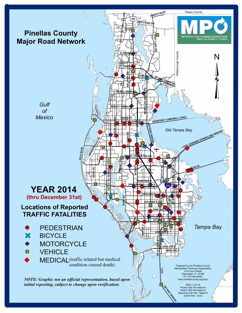
Prepared by the Pinellas CountyMetropolitan Planning Organization
310 Court StreetClearwater, Fl. 33756
Ph. 727-464-8200www.pinellascounty.org/mpo
WDH 1-16-15Project GIS File fatals14Parent GIS File fatals14
Depicting GIS File - fatals14Joined File - none
US
19
GU
LF
BLV
DI-2
75
4T
H S
T N
66
TH
ST
N
BE
LC
HE
R R
D
PARK BLVD
5TH AVE N
DREW ST
54TH AVE N
PA
RK
ST
22ND AVE N
38TH AVE N
1ST AVE N
16
TH
ST
NGANDY BLVD
TAMPA RD
EA
ST
LA
KE
RD
SR 688 | ULMERTON RD
CR
1
CURLEW RD
ST
AR
KE
Y R
D
22ND AVE S
VO
NN
RD
KEYSTONE RD
HIG
HL
AN
D A
VE
MC
MU
LL
EN
BO
OT
H R
D
70TH AVE N
US
19
| 3
4T
H S
T S
IND
IAN
RO
CK
S R
D
82ND AVE N
28
TH
ST
N
ALT
US
19
| S
EM
INO
LE
BLV
D
GULF-TO-BAY BLVD
58
TH
ST
S
54TH AVE S
SUNSET POINT RD
ALDERMAN RD
BA
YS
IDE
BR
IDG
E
DR
MA
RT
IN L
UT
HE
R K
ING
JR
ST
N
COURTNEY CAMPBELL CSWY
62ND AVE S
SR 580 | MAIN ST
49
TH
ST
N
SR 584 | TAMPA RD
ALT
US
19 |
PIN
EL
LA
S A
VE
TRINITY BLVD
PA
SA
DE
NA
AV
E
I-275 | HOWARD FRANKLAND BRIDGE
I-275
54TH AVE N
28
TH
ST
N
BE
LC
HE
R R
D
Pasco County
Hill
sb
oro
ug
h C
ou
nty
Tampa Bay
SK
YW
AY B
RID
GE
³
Pinellas CountyMajor Road Network
(thru December 31st)
Old Tampa Bay
Gulfof
Mexico
§̈¦275
£¤19
YEAR 2014
Locations of ReportedTRAFFIC FATALITIES
MOTORCYCLE
MEDICAL
PEDESTRIAN
VEHICLE(traffic related but medical
condition caused death)
NOTE: Graphic not an official representation, based upon
initial reporting, subject to change upon verification.
SR 686
BICYCLE

CRASHES DATAID ROADWAY LOCATION DESC_ DATE FATAL
1 004F14 31ST ST S 35TH AVE S BIC 2/10/2014 1
1 041F14 TAMPA RD 3689 TAMPA RD (W of Forest Lakes Blvd) BIC 5/16/2014 1
1 065F14 McMULLEN BOOTH RD CURLEW RD BIC 7/28/2014 1
1 070F14 SR686 | ROOSEVELT BLVD 58TH ST N BIC 9/3/2014 1
1 075F14 SEMINOLE BLVD 53RD AVE N BIC 9/20/2014 1
1 113F14 US19HW BELLEAIR RD BIC 10/2/2014 1
1 109F14 GANDY BLVD W OF I-275 BIC 12/19/2014 1
1 005F14 49TH ST N 78TH AVE N MC 2/19/2014 1
1 006F14 BELCHER RD 118TH AVE N MC 2/20/2014 1
1 007F14 US19HW NEAR 150TH AVE N MC 2/20/2014 2
1 066F14 102ND AVE N RIDGE RD MC 3/26/2014 1
1 024F14 SR580 LANDMARK DR MC 3/30/2014 1
1 028F14 9TH AVE N 52ND ST N MC 4/6/2014 1
1 029F14 BELCHER RD 118TH AVE N MC 4/9/2014 1
1 031F14 S MISSOURI AVE BELLEAIR RD MC 4/14/2014 1
1 038F14 66TH ST N FRONTAGE RD TO US19HW MC 4/27/2014 1
1 039F14 US19HW N OF ALDERMAN RD MC 5/1/2014 1
1 012F14 BAYSIDE BRIDGE N OF ROOSEVELT BLVD MC 5/17/2014 1
1 052F14 US19HW TOOKES RD MC 6/25/2014 1
1 055F14 CR 1 COUNTRYSHIRE LANE MC 7/8/2014 1
1 059F14 ROOSEVELT BLVD 28TH ST N MC 7/13/2014 1
1 060F14 BELCHER RD NEAR LAKE ARBOR BLVD MC 7/13/2014 1
1 062F14 4TH ST N 88TH AVE N MC 7/30/2014 1
1 063F14 BAYSHORE BLVD 7TH ST S MC 8/8/2014 1
1 084F14 BLIND PASS RD 75TH AVE MC 8/17/2014 1
1 073F14 DR ML KING JR ST N 73RD AVE N MC 9/4/2014 1
1 078F14 54TH AVE N 37TH ST N MC 9/26/2014 1
1 081F14 83RD AVE NE 400 BLOCK MC 10/18/2014 1
1 088F14 PARK BLVD BELCHER RD MC 10/31/2014 1
1 095F14 16TH ST N 18TH AVE N (MC scooter) MC 11/13/2014 1
1 098F14 I-275 N OF 22ND AVE N MC 11/16/2014 1
1 099F14 GULF-TO-BAY BLVD HAMPTON RD MC 11/20/2014 1
1 101F14 54TH AVE N 15TH ST N MC 11/22/2014 1
1 103F14 SR688 | ULMERTON RD CORAL WAY MC 11/24/2014 1
1 108F14 ROOSEVELT BLVD I-275 (southbound entry ramp) MC 12/18/2014 1
1 048F14 8 BELLEVIEW BLVD PARKING LOT MED 2/14/2014 1
1 040F14 66TH ST N 18TH AVE N MED 5/13/2014 1
1 061F14 7405 STARKEY RD CVS STORE PARKING LOT (died 6 weeks later) MED 5/27/2014 1
1 056F14 I-275 ON HOWARD FRANKLAND BRIDGE MED 7/9/2014 1
1 087F14 PHILIPPE PARKWAY NEAR CHURCH ST MED 10/9/2014 1
1 114F14 BELCHER RD 1500 BLOCK (Clearwater) PED 1/9/2014 1
1 009F14 4TH ST N 6800 BLOCK PED 2/23/2014 1
1 008F14 GANDY BLVD SNUG HARBOR RD PED 2/23/2014 1
1 011F14 CURLEW RD US19HW PED 2/25/2014 1
1 014F14 SEMINOLE BLVD S OF WALSINGHAM RD PED 2/27/2014 1
1 016F14 4TH ST S DALI BLVD S PED 3/2/2014 1
1 064F14 GULF BLVD 164TH AVE PED 3/5/2014 1
1 017F14 5TH AVE N 11TH ST N (mid-block near St Anthony's) PED 3/7/2014 1
1 020F14 GULF BLVD 4900 BLOCK PED 3/22/2014 1
1 021F14 GULF BLVD 173RD AVE N PED 3/23/2014 1
1 033F14 66TH ST N 3700 BLOCK PED 4/15/2014 1
1 036F14 49TH ST N S OF CREEKSIDE DR PED 4/23/2014 1
1 037F14 GANDY BLVD 13040 PED 4/26/2014 1
1 043F14 GULF TO BAY BLVD BELCHER RD (crossing guard) PED 5/20/2014 1
1 044F14 US19HW N OF ROOSEVELT BLVD PED 5/22/2014 1
1 046F14 66TH ST N 42ND AVE N PED 6/1/2014 1
1 047F14 GULF TO BAY BLVD SKYVIEW AVE PED 6/4/2014 1
1 049F14 58TH ST CENTRAL AVE PED 6/7/2014 1
1 053F14 54TH AVE N 28TH ST N PED 6/27/2014 1
1 057F14 5372 4TH ST N PALM GARDEN CONDOMINIUM COMPLEX PED 7/9/2014 1
1 058F14 US19HW N OF TAMPA RD PED 7/11/2014 1
1 068F14 EAST BAY DR 2480 (east of CR1) PED 8/23/2014 1
1 071F14 PARK BLVD 5900 BLOCK PED 9/4/2014 1
1 074F14 US19HW 150TH AVE N (scooter) PED 9/20/2014 1
1 077F14 13TH AVE S 600 BLOCK (driveway) PED 9/25/2014 1
1 115F14 54TH AVE N 37TH ST N PED 9/26/2014 1
1 079F14 66TH ST N 126TH AVE N PED 10/4/2014 2
1 080F14 GULF-TO-BAY BLVD METEOR AVE PED 10/9/2014 1
1 083F14 62ND AVE N 6500 BLOCK PED 10/15/2014 1
1 082F14 66TH ST N 126TH AVE N PED 10/18/2014 1
1 085F14 US19 | 34TH ST N 1200 BLOCK PED 10/25/2014 1
1 100F14 4TH ST N 20TH AVE N PED 11/5/2014 1
1 091F14 49TH ST N 22ND AVE N PED 11/7/2014 1
1 092F14 US19HW ROYAL BLVD PED 11/7/2014 1
1 093F14 MISSOURI AVE COMMERCE DR S PED 11/10/2014 1
1 094F14 ALT19HW ORANGE ST (scooter) PED 11/13/2014 1
1 097F14 ULMERTON RD 3600 BLOCK PED 11/15/2014 1
1 102F14 S HIGHLAND AVE 1600 BLOCK PED 11/21/2014 1
1 104F14 GULF BLVD NEAR 147TH AVE PED 11/30/2014 1
1 106F14 US 19HW 150TH AVE N PED 12/3/2014 1
1 116F14 30TH AVE N 26TH ST N PED 12/5/2014 1
1 110F14 ULMERTON RD 121ST ST N PED 12/22/2014 1
1 112F14 PASADENA AVE S 300 BLOCK PED 12/27/2014 1
1 002F14 FEATHER SOUND DR W OF PELICAN LANDING BLVD VEH 2/3/2014 1
1 003F14 PARK BLVD BELCHER RD VEH 2/7/2014 1
1 010F14 WOLFORD RD WHITNEY RD VEH 2/26/2014 1
1 013F14 66TH ST N 142ND AVE N VEH 2/27/2014 1
1 015F14 US19HW DR MLK VEH 3/1/2014 2
1 018F14 28TH ST N 118TH AVE N & ROOSEVELT BLVD VEH 3/10/2014 1
1 022F14 49TH ST N 34TH AVE N VEH 3/25/2014 1
1 023F14 US19HW | 34TH ST N 38TH AVE N VEH 3/27/2014 1
1 025F14 STARKEY RD ULMERTON RD VEH 3/30/2014 1
1 027F14 I-275 GANDY BLVD VEH 4/6/2014 1
1 034F14 I-275 118TH AVE N VEH 4/16/2014 1
1 035F14 SB SUNSHINE SKYWAY 3 MI S OF PINELLAS PT DR VEH 4/22/2014 1
1 042F14 PINELLAS BAYWAY | SR682 GRANADA ST VEH 5/17/2014 2
1 048F14 8TH ST S 3RD AVE S VEH 5/19/2014 1
1 045F14 LARGO MEDICAL CENTER PARKING LOT VEH 5/28/2014 1
1 048F14 25TH ST S 15TH AVE S VEH 6/4/2014 1
1 050F14 CENTRAL AVE 6400 BLOCK VEH 6/9/2014 1
1 051F14 SR 580 SUMMERDALE DR VEH 6/13/2014 1
1 054F14 16TH ST S 9TH AVE S VEH 6/26/2014 3
1 069F14 BAY PINES BLVD JUST WEST OF 95TH ST VEH 8/24/2014 1
1 072F14 5TH AVE S 25TH ST S VEH 9/5/2014 1
1 086F14 US19HW NORTH OF BILGORE GROVE BLVD VEH 10/26/2014 1
1 089F14 US19 | 34TH ST N 34TH AVE N VEH 10/31/2014 2
1 096F14 FORELOCK RD W OF MISTWOOD DR VEH 11/15/2014 1
1 105F14 US19HW | 34 ST CENTRAL AVE VEH 11/27/2014 2
1 107F14 GULF BLVD BAYWAY BLVD (in intercoastal waterway) VEH 12/17/2014 1
1 111F14 PARK BLVD NEAR 131ST ST N VEH 12/26/2014 3
115
PINELLAS COUNTY
INITIAL REPORTING
of Traffic Fatalities
thru December 31st, 2014
FATALITIES INCLUDING MEDICALS120
FATALITIES EXCLUDING MEDICALS
Table not an official representation,
27
29
CRASHES INCLUDING MEDICALS
CRASHES EXCLUDING MEDICALS
VEHICLE (auto) FATALITIES
VEHICLE (auto) CRASHES
80
70%
78
110
105
35
VULNERABLE ROAD USERS
MOTORCYCLE FATALITIES
(medical crashes not included)
VULNERABLE USER FATALITIES
VULNERABLE USER CRASHES
Vulnerable/total fatalities
28
7
MOTORCYCLE CRASHES
BICYCLE FATALITIES
BICYCLE CRASHES
subject to change upon verification.
NOTE
7
44 PEDESTRIAN FATALITIES
PEDESTRIAN CRASHES
based upon initial reporting,
43
Pinellas County MPO